The Bear Lake Valley Blueprint. Rural Transportation Conference Washington, D.C.
|
|
|
- Janel Shaw
- 5 years ago
- Views:
Transcription

1 The Bear Lake Valley Blueprint Rural Transportation Conference Washington, D.C.

2 Location

3 What is the Bear Lake Valley Blueprint? It s about our region not one size fits all. The future is not some place we re going to, but a place we are creating. The paths to it are not found, they are made. Jane Garvey Let s prepare now for the future that we want to create.

4 It s about our legacy to future generations.
5 Bear Lake Valley Blueprint Steering Committee Bear Lake Valley Executive Committee Lori Haddock, Co-Chair Duane Robinson, Co-Chair Claudia Cottle Bill Cox Carolyn Nebeker Reed Peterson Mitch Poulsen Vaughn Rassmussen John Spuhler Bear Lake Valley Steering Committee Amy Bishop Roy Bunderson Martha Burbidge Mary Ann Cassell Randee Cornia David Cottle Claudia Cottle Zac Covington Bill Cox Greg Critchfield Evan Curtis Marcy DeMillion Jack Draxler Dennis Duehren Art Fanconi Nancy Florence Marc Gibbs Lori Haddock Kerry Haddock Travis Hobbs Judy Holbrook Bill Hopkin Brian House Dana Jacobson Christy Jensen Jordan Jensen Krista Klein Montain Kunz Dan Kurek Brent Lewis Gary Mckee Norm Mecham Ronda Menlove Gene Merrick Alan Michaelson Stuart Wamsley Diane Miskin Jessica Ward Rosa Moosman Gene Watson Kip Motta Paul Webb Carolyn Nebeker Norm Weston Bryce Nielson Sim Weston Bret Oxborrow Anita Weston Dan Peart Clark Willis Reed Peterson Charlie Winder Marden Phelps George Winquistm Mitch Poulsen Les Prall Vaughn Rassmussen Cathy Rey Duane Robinson Eldon Robinson Demar Romrell Alan Schwab Craig Showalter Kent Sorenson John Spuhler Craig Thomas Bob VanCleave
6 Modest Population Growth
7 2060 Baseline Scenario Current Condition 2060 Baseline Scenario A picture of what the future might be like, if trends ( ) were to continue Where? How much? What kind? (lot size, primary/secondary) Projects building trends out 50 years 40,000 acres 13,300 new housing units Doesn t speculate about demographic shifts, the economy, changes to land use plans, etc. Provides a point of reference for comparison Existing Development Existing Development Projected Development
8 Significant Growth in Housing Region-wide Share of Housing


9 Increasing Share in Second Homes Region-wide Share of Housing

10 Montpelier Paris Garden City Laketown Randolph Woodruff Looking NNE, Rich/Bear Lake Region Existing Structures Projected Structures
11 Montpelier Paris Garden City Laketown Randolph Woodruff Looking NNE, Rich/Bear Lake Region Existing Structures Projected Structures
12 Looking NNW, Woodruff Existing Structures Projected Structures

13 Looking NNW, Woodruff Existing Structures Projected Structures
14 Looking NNW, Randolph Existing Structures Projected Structures

15 Looking NNW, Randolph Existing Structures Projected Structures
16 Looking SW, Bear Lake Area Existing Structures Projected Structures

17 Looking SW, Bear Lake Area Existing Structures Projected Structures

18 Looking S, Laketown Existing Structures Projected Structures
19 Looking S, Laketown Existing Structures Projected Structures
20 Looking SW, Garden City Existing Structures Projected Structures
21 Looking SW, Garden City Existing Structures Projected Structures

22 Looking SW, Fish Haven Existing Structures Projected Structures
23 Looking SW, Fish Haven Existing Structures Projected Structures

24 Looking NNW, St. Charles Existing Structures Projected Structures
25 Looking NNW, St. Charles Existing Structures Projected Structures
26 Looking NW, Western Shore (Idaho) Existing Structures Projected Structures

27 Looking NW, Western Shore (Idaho) Existing Structures Projected Structures

28 Looking NW, Bloomington/Paris Existing Structures Projected Structures
29 Looking NW, Bloomington/Paris Existing Structures Projected Structures

30 Looking NNW, Ovid/Hwy 36 Corridor Existing Structures Projected Structures
31 Looking NNW, Ovid/Hwy 36 Corridor Existing Structures Projected Structures

32 Looking NNE, Montpelier Existing Structures Projected Structures
33 Looking NNE, Montpelier Existing Structures Projected Structures

34 Looking N, Bennington Existing Structures Projected Structures
35 Looking N, Bennington Existing Structures Projected Structures
36 Looking N, Georgetown Existing Structures Projected Structures

37 Looking N, Georgetown Existing Structures Projected Structures

38 Looking N, Dingle Existing Structures Projected Structures
39 Looking N, Dingle Existing Structures Projected Structures

40 Looking NNE, Eastern Shore Existing Structures Projected Structures
41 Looking NNE, Eastern Shore Existing Structures Projected Structures

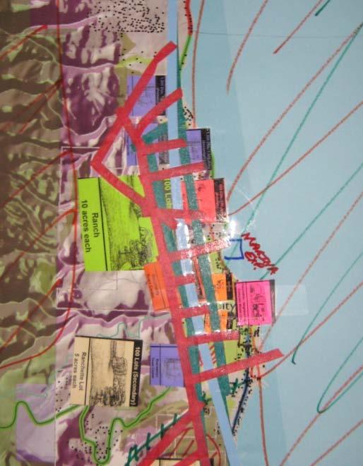
42 Looking NW, Western Shore (Utah) Existing Structures Projected Structures
43 Looking NW, Western Shore (Utah) Existing Structures Projected Structures
44 Looking SW, Garden City Existing Structures Projected Structures

45 Looking SW, Garden City Existing Structures Projected Structures
46 The Roadmap: A Public Process 1. Public Workshops (Brainstorm) Analysis/Scenario Development 2. Town Hall Meetings (Test: This, Not This) Draft Vision Development 3. Vision Summit (Consensus) Vision Document 4. Implementation (Ready, Set, Action!) General Plans, Ordinances, Etc.


47 Workshops: Brainstorm the Ideal Future (a game of markers, colored tape, and a chips) Focused problem solving, not philosophizing Recognition of competing goals Mixed groups must reconcile differences Long time horizon helps find common ground Imagine the future for your children and grandchildren How shall we accommodate anticipated growth?


48 Workshop Brainstorm 1. Land Conservation Which lands should be conserved for future generations? 2. Growth and Place Making What kinds of places should be created? Where should people live and work? 2. Transportation How will people get around? CLUSTE R TOWN


49 32 Maps Created by Bear Lake Valley Citizens
50 The Roadmap: A Public Process 1. Public Workshops (Brainstorm) Analysis/Scenario Development 2. Town Hall Meetings (Test: This, Not This) Draft Vision Development 3. Vision Summit (Consensus) Vision Document 4. Implementation (Ready, Set, Action!) General Plans, Ordinances, Etc.

51 Scenarios Contrast Choices and Consequences Land Area Developed Growth Transportation Conservation Recreation Conservation Public Transportation Housing Choices Water Use Your Ideas 2060 Scenario What If?... Miles of Driving Services Proximity Housing Proximity Policy

52 Scenario A: Baseline Land Use Dispersed development Conservation Values Federal lands Transportation Public Transportation: No additions Roads: Dingle Road Trails: No additions
53 Scenario B: Estate Lots Land Use Some mixed use development in towns Dispersed hillside/corridor development Emphasis on light industry, some office parks and retail/commercial strips Conservation Values Federal lands Water quality areas Agricultural land outside lake area Transportation Public Transportation: No additions Roads: Dingle Road, major bypass, Hwy 89/30 expand to 4 lanes, Logan Canyon to Georgetown Trails: Paved trail adjacent to road around Bear Lake
54 Scenario C: Farm Towns/ Recreation Villages Land Use Mostly mixed use Centers and services in all towns and on east side of lake Hillside clusters Light industrial parks; more office, retail, and commercial integrated into town and neighborhood centers Conservation Values Federal lands Water quality areas Agricultural land outside lake area and some along the lake Views (many along state roads, some along the lake) Transportation Public Transportation: Laketown/Montpelier Roads: Dingle Road, Garden City street grid with minor bypass, Hwy 89/30 to add turn lanes and some center lanes Trails: Paved trail adjacent to road around east side of Bear Lake, separated paved trail around west side of Bear Lake Other Sewer system on east side of Bear Lake New marina on north or east side of Bear Lake
55 Scenario D: Resort Town/Main Street, USA Land Use Mostly mixed use Mostly in Garden City and Montpelier Montpelier: recreation center., senior housing, community college extension Light industrial parks; most office, retail, and commercial integrated into town and neighborhood centers Conservation Values Federal lands Water quality areas Agricultural land outside lake area and more along the lake Views (many along state roads, many along the lake) Transportation Public Transportation: Laketown/Montpelier, Montpelier/Soda Springs, Garden City/Beaver Mountain/Logan Roads: Dingle Road, Garden City street grid with minor bypass, Hwy 89/30 to add turn lanes and some center lanes, enhanced access to airport Trails: Separated paved trail around Bear Lake, paved trail adjacent to road region-wide beyond the lake (Hwy 89, Hwy 30, Hwy 16) Other Existing marina improved/expanded Night sky protection


56 Bear Lake Valley Scenarios Scenario A: Baseline Scenario B: Estate Lots Scenario C: Farm Towns & Recreation Villages Scenario D: Resort Town & Main Street, USA
57 Scenarios Compare Outcomes of Various Choices Our Future Land Area Developed Conservation Public Transportation Housing Choices Water Use Miles of Driving Services Proximity Housing Proximity Policy
58 Land Conservation
59 New Housing
60 Water Quality and New Water Consumption
61 Local and Regional Transportation
62 New Local Infrastructure Costs

63 Scenario Shopping Like Selecting Ingredients to Make a Meal (Not a Prepackaged Dinner)
64 What Did People Say? (a sampling of responses to 40 questions) 5% Citizens preferring baseline 95% Citizens preferring alternatives created from public input
65 What Did People Say? (a sampling of responses to 40 questions) Strong preference for focused growth in/near existing communities Strong support for policy change (incentives, codes, etc.)
 90% Think cooperation is very")
66 What Did People Say? (a sampling of responses to 40 questions) 90% Think cooperation is very important/important Keeping both local and regional goals in mind, let s work together!
67 The Roadmap: A Public Process 1. Public Workshops (Brainstorm) Analysis/Scenario Development 2. Town Hall Meetings (Test: This, Not This) Draft Vision Development 3. Vision Summit (Consensus) Vision Document 4. Implementation (Ready, Set, Action!) General Plans, Ordinances, Etc.


68 The Vision
69 Neighborly communities. Matchless recreation. Agricultural heritage. Unparalleled natural resources. Together, we grow our legacy.

70 General Growth 1. Focus growth. Encourage focused growth within existing communities. 2. Be proactive. Implement tools to foster quality growth within our existing communities while safeguarding our natural resources and working lands.

71 Housing & Economy 3. Cultivate variety. Encourage mixed-use neighborhoods and town centers that provide housing and convenient access to shopping, recreation, services, schools, and jobs. 4. Provide housing choices. Support a range of housing options to accommodate people of all ages and stages of life. 5. Develop our strengths. Cultivate innovation that makes the most of our unique regional assets. 6. Develop job centers. Focus compatible employment in existing town centers and new mixed-use neighborhoods while encouraging nearby industry.


72 Transportation & Infrastructure 7. Be efficient. Invest in efficient infrastructure systems to serve existing communities and future growth. These systems manage such services as transportation, water, wastewater, energy, and communications. 8. Encourage transportation choices. Support limited regional road network expansion, enhanced local road networks, public transportation, bicycle routes, and pedestrian pathways.


73 Natural Resources & Agriculture 9. Safeguard natural resources. Preserve and protect water quality, wildlife habitat, and the scenic beauty of Bear Lake and the Bear Lake Valley. 10. Sustain agriculture. Support innovative practices and policies that keep agriculture viable.


74 Recreation & Trails 11. Play more. Expand access to and opportunities for recreation for local residents, second home owners, and to support our growing tourism industry.

75 Coordination 12. Work Together. Empower local governments, agencies and citizens to support the Bear Lake Valley Blueprint and to meet regional and local goals.


76 A Potential Picture Housing, Employment and Transportation Natural resources, agriculture and recreation vision map here


77 A Potential Picture Natural Resources, Agriculture and Recreation


78 Neighborly communities. Matchless recreation. Agricultural heritage. Unparalleled natural resources. How does the vision measure up?
79 Land Conservation


80 Greenfield Development/Redevelopment: Percent of Total Acres Built New Housing
81 Water Quality and New Water Consumption
82 Local and Regional Transportation $18.6 Million Grid-based minor bypass included in local roads cost
83 New Local Infrastructure Costs
 Draft Vision Development 3. Vision Summit (Consensus) Vision Document 4.")
84 The Roadmap: A Public Process 1. Public Workshops (Brainstorm) Analysis/Scenario Development 2. Town Hall Meetings (Test: This, Not This) Draft Vision Development 3. Vision Summit (Consensus) Vision Document 4. Implementation (Ready, Set, Action!) General Plans, Ordinances, Etc.
85 What s next?
86 Implementation Local mayors meetings Completion of bike/pedestrian pathway masterplan Revisions to local plans and ordinances Planning charettes
North Salt Lake General Plan Update 2013
 North Salt Lake General Plan Update 2013 Acknowledgements Updating the North Salt Lake General Plan was a process that would not have been possible without the support of elected officials and the general
VILLAGE & TOWN OF BERGEN: COMPREHENSIVE PLAN
 VILLAGE & TOWN OF BERGEN: COMPREHENSIVE PLAN CPC Public Hearing April 21, 2016 History 1996 Comprehensive Plan Comprehensive Plan Update Committee Consultant (LaBella Associates): December 2014 Residents
Wasatch CHOICE for 2040
 Wasatch CHOICE for 2040 Economic Opportunities We Can Choose a Better Future We enjoy an unparalleled quality of life along the Wasatch Front. People from all over the world are drawn to our stunning scenery,
ELK GROVE GENERAL PLAN VISION
 2-1 CHAPTER 2: 2-2 CREATING OUR The Community Vision for Elk Grove, expressed through a Vision Statement and a series of Supporting Principles, is a declaration of the kind of community that Elk Grove
Town of Peru Comprehensive Plan Executive Summary
 Town of Peru Comprehensive Plan Executive Communities that plan grow by choice, not by chance. A plan makes growth thoughtful, understandable, and predictable. A plan shows that a community is managing
SALISBURY TOMORROW Our Vision
 SALISBURY TOMORROW Our Vision Salisbury is committed to supporting a high quality of life and sense of community for all residents. These commitments need to be reflected in our community programs, services
7Page 1 CLEMMONS COMMUNITY COMPASS 1 PLAN OVERVIEW
 1 Plan Overview WHAT IS I THE CLEMMONS COMMUNITY COMPASS? The Clemmons Community Compass is our community s comprehensive plan. It serves as our blueprint and provides direction for the future of the Village
Gary & Regional Investment Project. October 27, Creating Tomorrow Today Comprehensive Regional Plan - NIRPC
 Creating Tomorrow Today 2040 Comprehensive Regional Plan Gary & Regional Investment Project October 27, 2010 Creating Tomorrow Today - 2040 Comprehensive Regional Plan - NIRPC What is NIRPC? - Northwestern
Prepared for the Citizens of Forsyth County by the City-County Planning Board
 Prepared for the Citizens of Forsyth County by the City-County Planning Board Bryce A. Stuart Municipal Building 100 East First Street, Winston-Salem, NC 27101 336.727.8000 www.cityofws.org/planning www.legacy2030.com
GENERAL PLAN AND ENVIRONMENTAL IMPACT REPORT
 City of Menifee HEARING DRAFT GENERAL PLAN AND ENVIRONMENTAL IMPACT REPORT City Council November 2013 PURPOSE OF MEETING Overview of GP Process Overview of required and optional GP elements Receive direction
REGIONAL ACTIVITY CENTER
 DRAFT REGIONAL ACTIVITY CENTER 70 EAST BENCH MASTER PLAN DRAFT 06 Introduction The East Bench Regional Activity center is comprised of large educational, research, medical, and employment centers. These
Comprehensive Blueprint for Our Future. Adopted 4/2/18
 Comprehensive Blueprint for Our Future. Adopted 4/2/18 Cities have the capability of providing something for everybody, only because, and only when, they are created by everybody. Jane Jacobs, The Death
Secrest Short Cut and Monroe Expressway Small Area Plan AUGUST 29, 2018
 Secrest Short Cut and Monroe Expressway Small Area Plan AUGUST 29, 2018 Background and Process Monroe Expressway will be open by the end of 2018 Union County and Indian Trail identified a need to revisit
Please read the entire document
 projects impacting the waterfront revitalization area. The waterfront revitalization area of the town will have to subareas to the west and east of the village. Page 6 of 6 Wayfinding master plan create
4-Town Comprehensive Plan DRAFT 7/30/07
 4-Town Comprehensive Plan DRAFT 7/30/07 Acknowledgements ning Committee Town of Harrisburg Norman Roof Randy Nicol Town of Martinsburg Terry Thisse Paul Kelly Town of Montague Jan Bagdanowicz Wendy Perry
Growth Management Planning in the Central Puget Sound Region. Today s Presentation. Puget Sound Region. New Partners for Smart Growth
 Growth Management Planning in the Central Puget Sound Region New Partners for Smart Growth Denver, CO January 2006 Today s Presentation Regional growth management in central Puget Sound, WA Regional geographies
Tri-County Transportation & Land Use Study. Steering Committee Meeting May 14, 2009
 Tri-County Transportation & Land Use Study Steering Committee Meeting May 14, 2009 Agenda Recap of Study Goals and Objectives Update on CV Land Use Model: Business as Usual (BAU) Growth Scenario Pros vs
Sacramento Area Council of Governments (SACOG)
") Sacramento Area Council of Governments (SACOG) The Blueprint Vision The SACOG Board of Directors adopted the Preferred Blueprint Scenario in December 2004, a bold vision for growth that promotes compact,
Sacramento Area Council of Governments (SACOG) The Blueprint Vision The SACOG Board of Directors adopted the Preferred Blueprint Scenario in December 2004, a bold vision for growth that promotes compact,
Land Use & Transportation Primer
 Land Use & Transportation Primer Presented By Smitha Vijayan Center for Urban Transportation Studies University of Wisconsin-Milwaukee Role of Local Government Land use decision-making power mostly given
THE COMMUNITY-DRIVEN DESIGN PROCESS
 THE COMMUNITY-DRIVEN DESIGN PROCESS A PUBLIC DRIVEN PROCESS STEERING COMMITEE THE COMPREHENSIVE PLAN OPPORTUNITIES AND CONSTRAINTS THE COMMUNITY DRIVEN DESIGN PROCESS A Public Driven Process Beginning
Ten Mile Creek Planning Area
 PLANNING AREA POLICIES TEN MILE CREEK Ten Mile Creek Planning Area Location and Context The Ten Mile Creek Planning Area ( Ten Mile Creek area ) is located south of the current Boise AOCI, generally south
South Davis County COMMUNITY SPOTLIGHT
 South Davis County COMMUNITY SPOTLIGHT Davis/SLC Community Connector Bus Rapid Transit line connecting SLC & Davis County RTP Phase 1 Project Generate 3,100 average weekday riders Relieve congestion on
Municipal Plan*Assessment
 Municipal Plan*Assessment This tool was developed to assist in reviewing municipal master plans and in determining if these plans are consistent with smart growth principles, neighboring municipal plans,
Zoning and Development Considerations in the Boothbay Harbor Maritime/Water Dependent District
 Zoning and Development Considerations in the Boothbay Harbor Maritime/Water Dependent District Bob Faunce Lincoln County Planner Lincoln County Regional Planning Commission Board of Selectmen and Planning
Office of Greenways & Trails Providing Statewide Leadership and Coordination. Southeast Greenways and Trails Summit October 1-3, 2017
 Office of Greenways & Trails Providing Statewide Leadership and Coordination Southeast Greenways and Trails Summit October 1-3, 2017 1 Office of Greenways and Trails The Office of Greenways and Trails
Rural Land Use Designations Kittitas County December 6, 2007 Draft
 KITTITAS COUNTY COMMUNITY DEVELOPMENT SERVICES 411 N. Ruby St., Suite 2, Ellensburg, WA 98926 CDS@CO.KITTITAS.WA.US Office (509) 962-7506 Fax (509) 962-7682 Rural Land Use Designations Kittitas County
The Floyds Fork Area Study A Framework for Growth
 The Floyds Fork Area Study A Framework for Growth Planning Committee 7/8/10 City of Parks 2 Growth Pattern REZONINGS (1976 2007) 1976 1983 1984 1991 1992 1999 2000 2007 1976-1983 3 Growth Pattern REZONINGS
2010 Plan of Conservation and Development
 2010 Plan of Conservation and Development Wilton Planning and Zoning Commission Adopted November 2, 2009 Effective January 1, 2010 WILTON 2010 PLAN OF CONSERVATION & DEVELOPMENT PARTICIPANTS Planning &
It Takes A Village.. Preserving Rural Character In Standish
 It Takes A Village.. Preserving Rural Character In Standish A Public Workshop Hosted by Conservation and Open Space Plan Committee & Standish Corner Village Implementation Committee June 12, 2008 Desired
MAYFIELD WEST SECONDARY PLAN PHASE 2
 MAYFIELD WEST SECONDARY PLAN PHASE 2 Public Open House #3 February 25, 2010 Draft Preferred Land Use Scenario TOWN OF CALEDON PLANNING & DEVELOPMENT DEPARTMENT Open House Agenda TOWN OF CALEDON 1. Welcome
Selected Area Study. Vision Plan Draft
 East Polk County Selected Area Study Draft 10.30.08 Contents Guiding Principles...4 Context Conclusions...5 Current Context...8 Scenarios...9 Scenario: Status Quo...10 Scenario: Connected & Directed Growth...12
Lewisville Lake Master Plan Revision Public Information Meeting May 2 & 4, 2017
 Lewisville Lake Master Plan Revision Public Information Meeting May 2 & 4, 2017 Presented By Rob Jordan Lake Manager U.S. Army Corps of Engineers Fort Worth District US Army Corps of Engineers Purpose
TOWN OF BETHLEHEM MEETING SUMMARY LOCAL WATERFRONT REVITALIZATION PROGRAM UPDATE
 TOWN OF BETHLEHEM LOCAL WATERFRONT REVITALIZATION PROGRAM UPDATE MEETING SUMMARY Purpose: LWRP Update Public Workshop #3 Date and Time: October 24, 2017, 6:00 pm - 8:00 pm Location: Town Hall, 445 Delaware
DRAFT Amsterdam/Churchill Community Plan (4/17/08) Adopted By the Gallatin County Commission
 Adopted By the Gallatin County Commission") DRAFT Amsterdam/Churchill Community Plan (4/17/08) Adopted By the Gallatin County Commission Table of Contents Acknowledgements Chapter 1: Introduction A Brief History What s Next Authority Organization
DRAFT Amsterdam/Churchill Community Plan (4/17/08) Adopted By the Gallatin County Commission Table of Contents Acknowledgements Chapter 1: Introduction A Brief History What s Next Authority Organization
Isabel Neighborhood Plan: Alternatives
 Isabel Neighborhood Plan: Alternatives Presented by: Lori Parks, Associate Planner February 2, 2015 Agenda 1. Background on BART to Livermore 2. Isabel Neighborhood Plan 3. Alternative Scenarios 4. General
CHAPTER 3 VISION, GOALS, & PLANNING PRINCIPLES. City of Greensburg Comprehensive Plan. Introduction. Vision Statement. Growth Management Goals.
 CHAPTER 3 VISION, GOALS, & PLANNING PRINCIPLES Introduction The Greensburg Comprehensive Plan is intended as a working community document. A combination of long and short-term goals, this document is intended
South Meridian. Vision. Action
 South Meridian Vision Action Table of Contents Introduction... 1 Goal of the Vision Process...1 This is a really big deal!...1 A foreword thought...2 The Process... 2 Description of the Workshop Game...3
Village of Fair Haven Goals & Objectives
 Village of Fair Haven Goals & Objectives 1 Natural Environmental Quality & Aesthetics Embrace policies and programs that preserve and enhance the Village s natural resources, environment, water quality,
S A C R A M E N T O C O U N T Y JACKSON HIGHWAY & GRANT LINE EAST VISIONING STUDY
 JACKSON HIGHWAY & GRANT LINE EAST S A C R A M E N T O C O U N T Y P L A N N I N G D E P A R T M E N T SUMMARY AND WORKBOOK November 19, 2008 History of the Visioning Study Sacramento County has two growth
CHAPTER 1 Introduction
 CHAPTER 1 Introduction From sea to summit, Lane County covers almost 4,800 square miles of diverse Oregon landscape. Stretching from the Pacific Ocean through the Coastal Range, the Willamette Valley to
Glenborough at Easton Land Use Master Plan
 Vision Statement Sunrise Blvd. Hazel Ave. Prairie City Rd. Gencorp Property Lincoln Regional Airport 1.0 VISION STATEMENT The identifies City of the principles, goals, policies, and standards Lincoln that
Canyon Lake Master Plan Revision Public Information Meeting March 18, 2016
 Canyon Lake Master Plan Revision Public Information Meeting March 18, 2016 Marcus Schimank Canyon Lake Manager Capital Regional Office U.S. Army Corps of Engineers Fort Worth District US Army Corps of
Cultivate Hopkins: Built Environment. Comprehensive Plan Advisory Committee September 13, 2017
 Cultivate Hopkins: Built Environment Comprehensive Plan Advisory Committee September 13, 2017 Four Dimensions of a Sustainable Plan Land Use Urban Design Housing Transportation Resilience Water Resources
NACCED/NACo CONFERENCE JULY 10, 2015
 NACCED/NACo CONFERENCE JULY 10, 2015 Regional Growth Framework 2 Regional Growth Framework Regional Priorities Preferred Growth Concept Tools to Support Local Governments 3 Top Priorities for the CONNECT
Visioning Statement and Guiding Principles
 Visioning Statement and Guiding Principles Planning for the Future The General Plan The General Plan represents Woodland's shared vision of the future and defines a path to lead the community toward its
TOWN COUNCIL / PLANNING COMMISSION
 Workshop #3 TOWN COUNCIL / PLANNING COMMISSION January 20, 2011 Consultant Team In Attendance Tonight BMS Design Group Nevada City and San Francisco Michael Smiley, AICP, ASLA Partner-in-Charge Nancy L.
A Growing Community Rural Settlement Areas
 Town of Huntsville Official Plan Review - POLICY BACKGROUND PAPER A Growing Community Rural Settlement Areas BACKGROUND: In addition to the fully municipally-serviced Urban Settlement Area and the Hidden
REVIEW AND EVALUATION OF REGIONAL LAND USE
 REVIEW AND EVALUATION OF REGIONAL LAND USE AND TRANSPORTATION SCENARIOS #220831 Environmental Justice Task Force October 7, 2014 VISION 2050 Process Development of Guiding Vision for Land Use and Transportation
West Ocala Vision & Community Plan City Council Work Session. Presented by West Ocala Community Plan Steering Committee
 West Ocala Vision & Community Plan City Council Work Session Presented by West Ocala Community Plan Steering Committee November 29,2011 Ocala 2035 Vision West Ocala Community Vision & Master Plan West
A BLUEPRINT FOR BROCKTON A CITY-WIDE COMPREHENSIVE PLAN
 A BLUEPRINT FOR BROCKTON A CITY-WIDE COMPREHENSIVE PLAN Public Meeting October 2016 1 Plan Summary and Discussion Public Meeting May 4 2017 City of Brockton Bill Carpenter, Mayor Department of Planning
CHAPTER 4 FUTURE LAND USE AND URBAN SERVICES DISTRICTS
 CHAPTER 4 FUTURE LAND USE AND URBAN SERVICES DISTRICTS Introduction This chapter discusses how Benzie County should grow and change in the future. A community can grow and change in many different ways.
SUSSEX COUNTY COMPREHENSIVE PLAN COUNTY PLANNING AND ZONING COMMISSION WORKSHOP
 SUSSEX COUNTY COMPREHENSIVE PLAN COUNTY PLANNING AND ZONING COMMISSION WORKSHOP August 21, 2017 TODAY S WORKSHOP Public Comment Utilities Update Economic Development Update Future Land Use Discussion Public
OVERVIEW OF PLANS FOR THE JEFFERSON COUNTY COUNTRYSIDE FARM In the Context of Quality Place Characteristics
 OVERVIEW OF PLANS FOR THE JEFFERSON COUNTY COUNTRYSIDE FARM In the Context of Quality Place Characteristics By Steve Grabow, Professor and Community Development Educator University of Wisconsin-Extension,
Blueprint Denver Task Force Meeting #
 Blueprint Denver Task Force Meeting #1 6.23.16 1. Welcome and Introductions Your name and affiliation Name 1 thing you love about Denver Name 1 thing you d change about Denver All in 30 seconds! Ready,
TRANSPORTATION AND LAND USE
 CHAPTER 10 TRANSPORTATION AND LAND USE Transportation and land use are intimately linked. The expansion of a highway typically spurs housing, employment growth and land development in the communities that
6 Growth Management Challenges and Opportunities
 6 Growth Management Challenges and Opportunities The Town has established a goal of attaining a 50% participation rate with respect to employment opportunities versus residential population. The Town s
VILLAGE OF ROMEOVILLE
 VILLAGE OF ROMEOVILLE COMPREHENSIVE PLAN FRAMEWORK PLAN, KEY STRATEGIES & GUIDING PRINCIPLES December 8, 2016 KEY PLANNING THEMES 2 KEY PLANNING THEME #1 ADVANCING A BALANCED ECONOMIC BASE KEY PLANNING
DALY CITY VISIONING PROCESS COMMUNITY WORKSHOP 3 MAY 8, 2008
 DALY CITY VISIONING PROCESS COMMUNITY WORKSHOP 3 MAY 8, 2008 PROCESS General Plan - a statement of the community s values, vision and aspirations for now and into the future... Timeframe LONG TERM - 2030
3. VISION AND GOALS. Vision Statement. Goals, Objectives and Policies
 Vision Statement Queen Creek s interconnected network of parks, trails, open spaces and recreation opportunities provide safe and diverse activities and programs that sustain its unique, small town, equestrian
CHAPTER 7: VISION AND ACTION STATEMENTS. Noble 2025 Vision Statement
 CHAPTER 7: VISION AND ACTION STATEMENTS This chapter presents the vision, policy and action statements that transform the comprehensive planning study, an analysis of Noble s past, future trends and community
Chair and Members of the Planning, Public Works and Transportation Committee. Tara Buonpensiero, Senior Planner Policy, MCIP, RPP
 REPORT TO: REPORT FROM: Chair and Members of the Planning, Public Works and Transportation Committee Tara Buonpensiero, Senior Planner Policy, MCIP, RPP DATE: April 9, 2018 REPORT NO.: RE: PLS-2018-0027
CHAPTER 7: Transportation, Mobility and Circulation
 AGLE AREA COMMUNITY Plan CHAPTER 7 CHAPTER 7: Transportation, Mobility and Circulation Transportation, Mobility and Circulation The purpose of the Transportation, Mobility and Circulation Chapter is to
Planning Commission Workshop. November 29, 2018
 Planning Commission Workshop November 29, 2018 Composition of Committee Steven Neeves, Chair Marvin Heyd, Vice-Chair Joe Burch Pam Creech Ruth Anne Ellis Rick Elliott Christy Everett Chris Hennigan Kimberly
THE 355/270 CORRIDOR:
 THE 355/270 CORRIDOR: Strategic Ideas for Sustaining a Livable Work Place Project Summary ACCESS LIFE DESIGN HEALTH WORK Montgomery County Planning Department The Maryland-National Capital Park and Planning
DRAFT FOR PUBLIC REVIEW. Game Plan for a Healthy City
 DRAFT FOR PUBLIC REVIEW 2018 Game Plan for a Healthy City 2 Denveright. Parks & Recreation Game Plan Draft for Public Review Draft for Public Review Executive Summary Game Plan Overview Executive Summary
Metro Vancouver. Regional Growth. Strategy. Optimizing the Urban Footprint
 Metro Vancouver Regional Growth Metro Vancouver Fraser Valley Regional District Strategy USA Victoria Bellingham Optimizing the Urban Footprint 2011 Salish Sea Ecosystem Conference October 25, 2011 Terry
DRAFT BELLEVUE COMMUNITY PLAN
 DRAFT BELLEVUE COMMUNITY PLAN City of Merced Planning Commission October 22, 2014 General Plan Amendment #14-02 Plan Adoption PROJECT LOCATION Bellevue Road UC Merced PROJECT LOCATION CONSIDERATIONS Advisory
Official Plan Review
 Official Plan Review Summary Report - The Built Environment August 2014 Part 1: Introduction Planning for a healthy, prosperous and sustainable community is an important goal for our municipality. From
Onondaga County Sustainable Streets Project. Onondaga County Planning Federation June 7, Onondaga County Sustainable Streets Project 1
 Onondaga County Sustainable Streets Project Onondaga County Planning Federation June 7, 2012 Onondaga County Sustainable Streets Project 1 Sustainable Streets 1. Introduction to the SMTC 2. Sustainable
Heart of the Triad A Dynamic Plan for the Future. Steering and Technical Meeting April 27, 2006
 Heart of the Triad A Dynamic Plan for the Future Steering and Technical Meeting April 27, 2006 The Week in Review Specific Group Findings There Was Uniform Agreement the Time Was Right Growth is Imminent
Portage County Parks, Trails and Greenways Plan
 Portage County Parks, Trails and Greenways Plan Agenda for Local Planning Meeting Introductory Presentation Why we need a Plan Plan project goals and process Benefits Overview of local planning region
Broken Arrow Comprehensive Plan Update Public Workshop Meeting #3 January 23,
 Broken Arrow Comprehensive Plan Update Public Workshop Meeting #3 January 23, September 25,2018 2018 26 April 2016 AGENDA 1. Status Presentation - Charrette Recap - Proposed Vision Framework - Preliminary
Urban Development Areas Frederick County
 18 Urban Development Areas Frederick County UDA Needs Profile: All UDAs Frederick County, Virginia's northernmost county has two UDA s, surrounded by the City of Winchester and located adjacent to the
CITY OF UNION CITY MINUTES GENERAL PLAN ADVISORY COMMITTEE
 CITY OF UNION CITY MINUTES GENERAL PLAN ADVISORY COMMITTEE WEDNESDAY, MARCH 4, 2015, 6:30 P.M. IN THE CITY COUNCIL CONFERENCE ROOM OF CITY HALL 34009 ALVARADO-NILES BLVD., UNION CITY, CALIFORNIA Attachment
Further input invited as Colchester Growth Strategy nears final phase
 IUE 3 / NOVEMBER 2015 Further input invited as Colchester Growth trategy nears final phase trathcona County is seeking public feedback as it enters the final phase of work on a Growth Management trategy
Niagara Region Official Plan. Table of Contents
 Niagara Region Official Plan Table of Contents This page has been intentionally left blank. Table of Contents ii Niagara Region Official Plan Niagara Region Official Plan - Table of Contents Chapter 1
Chapter 9: Economic Development
 Chapter 9 Economic Development Goal To embrace a stable, prosperous business environment focused on industry diversity, yielding family income sufficient to support education, recreation, social and cultural
Date: April 10, 2017 City Council Work Session April 24, 2017: Status Report on the Comprehensive Plan Update and Transportation Master Plan
 AGENDA REPORT To: From: By: Honorable Mayor and City Council Members Warren Hutmacher, City Manager Sharon Ebert, Director Community Development Date: April 10, 2017 Agenda: City Council Work Session April
CHAPTER 4: LAND USE & TRANSPORTATION PLAN
 CHAPTER 4: LAND USE & TRANSPORTATION PLAN Insert picture of Goodyear An awesome quote from someone saying something cool about Goodyear goes here. Katie Wilken, Goodyear Planner Land Use and Transportation
Plano Tomorrow Vision and Policies
 Plano Tomorrow Vision and Policies PLANO TOMORROW PILLARS The Built Environment The Social Environment The Natural Environment The Economic Environment Land Use and Urban Design Transportation Housing
DRAFT BELLEVUE COMMUNITY PLAN. City Council Study Session February 17, 2015
 DRAFT BELLEVUE COMMUNITY PLAN City Council Study Session February 17, 2015 PROJECT LOCATION Bellevue Road UC Merced PROJECT LOCATION CONSIDERATIONS Advisory Committee and public input Merced Vision 2030
3.10 LAND USE SETTING PROJECT SITE EXISTING LAND USE DESIGNATIONS AND ZONING. General Plan Land Use Designations.
 This section of the Draft EIR addresses the existing land uses on and adjacent to the project site and discusses the potential impacts of the proposed project on existing land uses. Key issues addressed
Public Information Meeting
 Lavon Lake Master Plan Revision Public Information Meeting March 10, 2015 Presented By Michael Kinard Lake Manager U.S. Army Corps of Engineers Fort Worth District US Army Corps of Engineers Purpose of
Preliminary Plan Framework: Vision and Goals
 Preliminary Plan Framework: Vision and Goals Draft: May 2015 Introduction Since the Town of Milliken s comprehensive plan was last updated in 2010, the community was heavily impacted by the 2013 flood,
WAC #7 3/14/14. Coachella General Plan Update
 WAC #7 3/14/14 Coachella General Plan Update Agenda 2 Introductions Public Draft General Plan Overview and Discussion of Next Steps Implementation and Evaluation Health Element Process Evaluation (discussion)
GREENBANK DEVELOPMENT MASTERPLAN
 DEVELOPMENT MASTERPLAN POTENTIAL TRAIN STATION COMMUNITY CENTRE Greenbank will be a connected masterplanned community providing easy access to local and surrounding amenity. Affordable quality homes, green
Special Joint Meeting. Emerald Isle Planning Board. Emerald Isle Board of Commissioners. January 18, 2017
 Special Joint Meeting Emerald Isle Planning Board Emerald Isle Board of Commissioners January 18, 2017 STEERING COMMITTEE: Jim Normile Town Commissioner Ken Sullivan Planning Board Larry Watson Retail
Danvers High Street I-1 District Study
 Danvers High Street I-1 District Study Presentation of Final Recommendations Planning Board Presentation June 26 th, 2018 1 Introductions Metropolitan Area Planning Council Sam Cleaves AICP, Principal
Town of Washington Master Plan & Regulatory Audit: Interim Results
 Town of Washington Master Plan & Regulatory Audit: Interim Results May 20, 2008 Presented by: 30 Bank Street Lebanon, NH 03766 www.uvlsrpc.org Introduction & Purpose Compare the Master Plan to the regulations
TABLE OF CONTENTS INTRODUCTION PLAN CONCEPT... 3
 TABLE OF CONTENTS BY-LAW NO. Z-1 INTRODUCTION... 1 1.0 PLAN CONCEPT... 3 1.1 Mission... 3 1.2 A Future Vision for Fredericton... 3 1.3 Growth Strategy Goals... 5 National Context... 5 Provincial Context...
Branch Avenue Corridor
 Approved Branch Avenue Corridor Sector Plan Prince George s County Planning Department The Maryland-National Capital Park and Planning Commission September 2008 Abstract TITLE: AUTHOR: SUBJECT: The Maryland-National
Implementation Guide Comprehensive Plan City of Allen
 Implementation Guide 2030 Comprehensive Plan City of Allen DRAFT 2015 Implementation Guide Allen 2030 Comprehensive Plan INTRODUCTION The Comprehensive Plan serves as a guide for the growth and development
Welcome! to Keller Town Hall
 Welcome! to Keller Town Hall Keller Town Center Planning a New Downtown What is Keller Town Center? A new, growing downtown district planned as an urban village A combination of retail and office spaces,
Nassau County Cultivating Opportunities for Sustainable Development Nassau County Infill Redevelopment Feasibility Study
 Nassau County Cultivating Opportunities for Sustainable Development Nassau County Infill Redevelopment Feasibility Study NY-CT Sustainable Communities Steering Committee Meeting March 14, 2014 Project
Workshop. Valley Vision Stanislaus. Our Schedule. Help Shape Our Region s Future! The Scenarios. Who is StanCOG? How Do I Select a Scenario?
 Valley Vision Stanislaus Workshop Help Shape Our Region s Future! Valley Vision Stanislaus is a long-range planning process that will link future land use with a framework for investment in roads, freeways,
Sherri Ferguson. President/CEO Portland Chamber of Commerce. Tennessee Certified Economic Developer Capstone Project
 Sherri Ferguson President/CEO Portland Chamber of Commerce Tennessee Certified Economic Developer Capstone Project Strategic Plan Development for the North Gateway of Portland, Tennessee The New Gateway
Hillsborough County MPO Transit Study. Citizens Team Workshop Wednesday, February 28 th, 2006 Hillsborough Community College - Brandon
 Hillsborough County MPO Transit Study Citizens Team Workshop Wednesday, February 28 th, 2006 Hillsborough Community College - Brandon What is the MPO Transit Study? An effort to look at the full range
Town of New Scotland. Public Workshop. Visioning / Planning the Future of this Hamlet. New Scotland Hamlet Master Plan.
 Public Workshop Visioning / Planning the Future of this Hamlet December 1, 2011 Voorheesville High School Commons Agenda I. Presentation Project Introduction The Study Area Existing Conditions Outcomes
EXECUTIVE SUMMARY. Introduction
 EXECUTIVE SUMMARY Introduction State Route 68 is a designated scenic route that connects the world-renowned Monterey Peninsula to US Highway 101 and the Salinas Valley. SR 68 is a key route for bicycle,
Inspiring Technovation
 1 2 Table of content List of table and figures... Executive summary... 1. Introduction... 2. Material and methods... 3. Results... 3.1 Today s facts about Versailles: a diagnostic approach... 3.1 Vision