Notes. Schedule of Uses. Explanatory Statement
|
|
|
- Leo Parks
- 5 years ago
- Views:
Transcription
1 HONG KONG PLANNING AREA NO.25 DRAFT WAN CHAI NORTH OUTLINE ZONING PLAN NO. Notes Schedule of Uses Explanatory Statement
2 HONG KONG PLANNING AREA NO.25 DRAFT WAN CHAI NORTH OUTLINE ZONING PLAN NO. (Being a Draft Plan for the Purposes of the Town Planning Ordinance) NOTES (N.B. These form part of the Plan) (1) These Notes show the uses or developments which are permitted at all times in the various zones on the Plan and the uses or developments which may be permitted by the Town Planning Board, with or without conditions on application. Where the permission of the Town Planning Board for a use or development is necessary, the application for such permission should be addressed to the Secretary of the Town Planning Board, from whom the appropriate application forms may be obtained. (2) Any use or development which may be permitted in accordance with these Notes must also conform to any other relevant legislation and to the conditions of the Government lease concerned. (3) (a) No action is required to make the existing use of any land or building conform to this Plan until there is a change of use or the building is redeveloped. (b) Any change of use, and any other development (except minor alteration) or redevelopment, in respect of the land or building must be permitted in terms of the Plan or, if permission is required, is in accordance with the permission granted by the Town Planning Board. (c) For the purposes of subparagraph (a) above, existing use of any land or building includes - (i) before the publication in the Gazette of the notice of the first statutory plan covering the land or building (hereafter referred as the first plan ), a use in existence before the publication of the first plan and that use has continued since it came into existence; or a use approved under the Buildings Ordinance; and (ii) after the publication of the first plan, a use permitted under a plan and was effected during the effective period of that plan and the use has continued since it was effected; or a use approved under the Buildings Ordinance and permitted under a plan prevailing at the time when the use was approved under the Buildings Ordinance. (4) Except as otherwise specified by the Town Planning Board, when a use or change of use is effected or a development or redevelopment is undertaken as permitted in terms of the Plan or is in accordance with a permission granted by the Town Planning Board, all
3 permissions granted by the Town Planning Board in respect of the site of the use or change of use or development or redevelopment shall lapse. (5) Road junctions, alignments of roads, mass transit railway and tram tracks, and boundaries between zones may be subject to minor alterations as detailed planning proceeds. (6) Temporary uses (expected to be 5 years or less) of any land or buildings are permitted in all zones as long as they comply with other Government requirements and there is no need for these to conform to the zoned use or these Notes. For temporary uses expected to be over 5 years, the uses must conform to the zoned use or these Notes. (7) In all zones, the following uses are always permitted: Amenity Area, Bus/Tram/Public Light Bus Stop or Layby, Cycle Track, Footbridge, Footpath, Mass Transit Railway Station Entrance, Mass Transit Railway Structure below Ground Level, Nullah, Open Space, Pedestrian Area, Pedestrian Subway, Promenade, Public Utility Pipeline Reserve, Service Lane, Street, Taxi Rank. (8) In the area shown as Road, uses except those listed in paragraph (7) above and those listed below require permission of the Town Planning Board: Central Divider, Drive Way, Elevated Road, On-street Car Park, Rail Track, Road Tunnel, Tram Track. (9) Unless otherwise specified, all uses, including storage and caretakers quarters, directly related and ancillary to the permitted use are always permitted and no separate planning permission is required.
4 HONG KONG PLANNING AREA NO.25 DRAFT WAN CHAI NORTH OUTLINE ZONING PLAN NO. Schedule of Uses Page COMMERCIAL 1 COMPREHENSIVE DEVELOPMENT AREA 3 GOVERNMENT, INSTITUTION OR COMMUNITY 5 OPEN SPACE 9 OTHER SPECIFIED USES 11
5 - 1 - COMMERCIAL Column 1 Uses always permitted Ambulance Depot Ancillary Car Park Bank Barber Shop Beauty Parlour Canteen Clinic/Polyclinic Commercial Bathhouse Educational Institution Exhibition or Convention Hall Fast Food Shop Government Use (not elsewhere specified) Hotel Massage Establishment Money Exchange Off-course Betting Centre Office Pawn Shop Photographic Studio Place of Public Entertainment Police Reporting Centre Post Office Private Club Private Swimming Pool Public Car Park Public Library Public Utility Installation Restaurant Retail Shop School Service Trades Showroom excluding Motor-vehicle Showroom Social Welfare Facility Utility Installation for Private Project Column 2 Uses that may be permitted with or without conditions on application to the Town Planning Board Broadcasting, Television and/or Film Studio Flat Government Refuse Collection Point Mass Transit Vent Shaft and/or Other Structure above Ground Level other than Entrances Motor-vehicle Showroom Petrol Filling Station Place of Recreation, Sports or Culture Public Convenience Public Transport Terminus or Station Religious Institution Residential Institution Staff Quarters Remarks (Please see next page)
6 - 2 - COMMERCIAL (Cont d) Remarks (1) On land designated Commercial (1), no new development or addition, alteration and/or modification to the existing building(s) shall result in a total development or redevelopment in excess of a maximum building height of 60 metres above Principal Datum. (2) Minor relaxation of the stated restriction in paragraph (1) above, based on the merits of individual development or redevelopment proposal, may be considered by the Town Planning Board on application under section 16 of the Town Planning Ordinance.
7 - 3 - COMPREHENSIVE DEVELOPMENT AREA Column 1 Uses always permitted Column 2 Uses that may be permitted with or without conditions on application to the Town Planning Board Ancillary Car Park Bank Barber Shop Beauty Parlour Clinic Commercial Bathhouse Educational Institution Exhibition or Convention Hall Fast Food Shop Government Refuse Collection Point Government Use (not elsewhere specified) Hotel Mass Transit Vent Shaft and/or Other Structure above Ground Level other than Entrances Massage Establishment Money Exchange Off-course Betting Centre Office Photographic Studio Place of Public Entertainment Place of Recreation, Sports or Culture Police Reporting Centre Post Office Private Club Private Swimming Pool Public Car Park Public Convenience Public Library Public Transport Terminus or Station Public Utility Installation Religious Institution Restaurant Retail Shop Service Trades Showroom excluding Motor-vehicle Showroom Staff Quarters Utility Installation for Private Project Remarks (Please see next page)
8 - 4 - COMPREHENSIVE DEVELOPMENT AREA (Cont d) Remarks (1) Pursuant to section 4A(2) of the Town Planning Ordinance, an applicant for planning permission for development on land designated Comprehensive Development Area shall prepare a Master Layout Plan for the approval of the Town Planning Board and include therein the following information: (i) the areas of proposed land uses, the nature, position, dimensions and height of all buildings to be erected on the area; (ii) the proposed total gross floor areas for various uses; (iii) the details and extent of Government, institution or community (GIC), recreational and public transport facilities, parking spaces, and open space to be provided within the area; (iv) the alignment, widths and levels of any roads proposed to be constructed within the area; (v) the landscaping proposals within the area; (vi) programmes of development in detail; (vii) an urban design study report to explain the urban design concept; (viii) an environmental assessment report to examine any possible environmental problems that may be caused to or by the proposed development and the proposed mitigation, monitoring and audit measures to tackle them; (ix) a traffic impact assessment report to show that the development mix/intensity is sustainable by the capacity of the transport and road proposals; and (x) such other information as may be required by the Town Planning Board. (2) The Master Layout Plan should be supported by an explanatory statement which should contain an adequate explanation of the development proposal including such basic information as land tenure, relevant lease conditions, existing condition of the site, the character of the site in relation to the surrounding areas, principles of the layout design, assumptions, design population, type of GIC, recreational and open space facilities. (3) On land designated Comprehensive Development Area, no new development or addition, alteration and/or modification to the existing building(s) shall result in a total development or redevelopment in excess of a maximum non-domestic gross floor area of 128,100m 2 and a maximum building height of 100 metres (including roof-top structures, projections and advertisement signs) above Principal Datum. (4) In determining the relevant maximum gross floor areas for the purposes of paragraph (3) above, any space that is constructed or intended for use solely as car/motorcycle park(s), loading/unloading bay(s), plant room(s), caretaker s quarters, provided that such use and facilities are ancillary and directly related to the development or redevelopment, or any space that is constructed or intended for use solely as public transport interchange and GIC facilities as required by the Government, may be disregarded. (5) Minor relaxation of the stated restrictions in paragraph (3) above, based on the merits of individual development or redevelopment proposal, may be considered by the Town Planning Board on application under section 16 of the Town Planning Ordinance.
9 - 5 - GOVERNMENT, INSTITUTION OR COMMUNITY Column 1 Uses always permitted Ambulance Depot Ancillary Car/Lorry Park Broadcasting, Television and/or Film Studio Cable Car Route and Terminal Building Canteen Clinic/Polyclinic Cooked Food Centre Driving Test Centre Educational Institution Exhibition or Convention Hall Fire Station Government Refuse Collection Point Government Staff Quarters Government Use (not elsewhere specified) Hawker Centre Hospital Judicial Facility Market Pier Place of Recreation, Sports or Culture Plant Nursery Police Reporting Centre Police Station Post Office Private Swimming Pool Public Bathhouse Public Car/Lorry Park Public Convenience Public Library Public Swimming Pool Public Transport Terminus or Station Public Utility Installation Religious Institution School (in free-standing purpose-designed school building only) Service Reservoir Social Welfare Facility Vehicle Pound Wholesale Food Market Column 2 Uses that may be permitted with or without conditions on application to the Town Planning Board Abattoir Animal Pound Aviary Bank Columbarium Correctional Institution Crematorium Dangerous Goods Godown Fast Food Shop Flat Funeral Depot Funeral Parlour Funeral Services Centre Garden of Remembrance Holiday Camp Hotel House Marine Fuelling Station Mass Transit Vent Shaft and/or Other Structure above Ground Level other than Entrances Off-course Betting Centre Office (other than Government Office) Petrol Filling Station Photographic Studio Place of Public Entertainment Private Club Quarantine Station and Quarantine Lairage for Animals Radar, Telecommunications Electronic Microwave Repeater, Television and/or Radio Transmitter Installation Refuse Disposal Installation Residential Institution Restaurant Retail Shop Sand Depot School (other than in free-standing purposedesigned school building) Service Trades Sewage Treatment/Screening Plant Showroom excluding Motor-vehicle Showroom Staff Quarters Utility Installation for Private Project Warehouse/Godown Zoo Remarks (please see next page)
10 - 6 - GOVERNMENT, INSTITUTION OR COMMUNITY (Cont d) Remarks (1) On land designated Government, Institution or Community (1) ( G/IC(1) ), no new development or addition, alteration and/or modification to the existing building(s) shall result in a total development or redevelopment in excess of a maximum building height of 35 metres above Principal Datum. (2) Minor relaxation of the stated restriction in paragraph (1) above, based on the merits of individual development or redevelopment proposal, may be considered by the Town Planning Board on application under section 16 of the Town Planning Ordinance.
11 - 7 - GOVERNMENT, INSTITUTION OR COMMUNITY (2) Column 1 Uses always permitted Column 2 Uses that may be permitted with or without conditions on application to the Town Planning Board Bank Exhibition or Convention Hall Fast Food Shop Government Use Mass Transit Vent Shaft and/or Other Structure above Ground Level other than Entrances Place of Public Entertainment Place of Recreation, Sports or Culture Police Reporting Centre Public Convenience Public Utility Installation Restaurant Retail Shop Service Trades Showroom excluding Motor-vehicle Showroom Utility Installation not ancillary to the Specified Use Remarks (Please see next page)
12 - 8 - GOVERNMENT, INSTITUTION OR COMMUNITY (2) (Cont d) Remarks (1) An applicant for planning permission for development on land designated Government, Institution or Community (2) ( G/IC(2) ) shall include in the submission the following information:- (i) (ii) (iii) (iv) (v) (vi) the areas of proposed land uses, the nature, design, disposition and height of all buildings/structures to be erected on the area; the proposed total gross floor areas for various uses; the landscaping proposals within the area; the colour scheme and external finishing of all buildings/structures to be erected on the area; a visual and landscape impact assessment report to examine any possible adverse visual and landscape impacts that may be caused to or by the proposed development and the proposed mitigation measures to tackle them; such other information as may be required by the Town Planning Board. (2) On land designated G/IC(2), no new development or addition, alteration, and/or modification to the existing building(s) shall result in a total development or redevelopment in excess of a maximum building height of 25 metres above Principal Datum. (3) Minor relaxation of the stated restriction in paragraph (2) above, based on the merits of individual development or redevelopment proposal, may be considered by the Town Planning Board on application under section 16 of the Town Planning Ordinance.
13 - 9 - OPEN SPACE Column 1 Uses always permitted Ancillary Car Park Changing Room Park and Garden Playground/Playing Field Public Convenience Refreshment Kiosk Underground Pumphouse Column 2 Uses that may be permitted with or without conditions on application to the Town Planning Board Exhibition or Convention Hall Fast Food Shop Government Refuse Collection Point Government Use (not elsewhere specified) Mass Transit Vent Shaft and/or Other Structure above Ground Level other than Entrances Pier Place of Public Entertainment Place of Recreation, Sports or Culture Public Vehicle Park Public Transport Terminus or Station Public Utility Installation Restaurant Road Vent Shaft and/or Other Structure above Ground Level other than Entrances Underground Exhibition Hall with Supporting Facilities (for O(1) only) Utility Installation for Private Project Remarks (Please see next page)
14 OPEN SPACE (Cont d) On land designated Open Space (1) ( O(1) ), an applicant for planning permission for development of Underground Exhibition Hall with Supporting Facilities shall include in the submission the following information: (i) (ii) (iii) (iv) (v) (vi) the areas of proposed land uses, the nature, position, dimensions and height of all buildings and underground structures to be erected on the area; the proposed total gross floor areas for various uses; the details and extent of public transport facilities, parking spaces, and open space to be provided within the area; the alignment, widths and levels of any roads proposed to be constructed within the area; the landscaping proposals within the area; programmes of development in detail; (vii) an urban design study report to explain the urban design concept and the principles of the layout design; (viii) a visual and landscape impact assessment report to examine any adverse visual and landscape impacts that may be caused to or by the proposed development and the proposed mitigation measures to tackle them; (ix) (x) a traffic impact assessment report to show that the development mix/intensity is sustainable by the capacity of the transport and road proposals; and such other information as may be required by the Town Planning Board.
15 OTHER SPECIFIED USES Column 1 Uses always permitted Column 2 Uses that may be permitted with or without conditions on application to the Town Planning Board For Elevated Walkway Only As Specified on the Plan Bank Exhibition Hall Fast Food Shop Restaurant Retail Shop Service Trades Utility Installation not ancillary to the Specified Use For Exhibition Centre Only Ancillary and Public Car Park Bank Canteen Clinic Exhibition or Convention Hall Fast Food Shop Money Exchange Place of Public Entertainment Place of Recreation, Sports or Culture Private Club Private Swimming Pool Public Utility Installation Restaurant Retail Shop Showroom Utility Installation for Private Project Educational Institution Government Use School (other than in free-standing purposedesigned school building)
16 OTHER SPECIFIED USES (Cont d) Column 1 Uses always permitted Column 2 Uses that may be permitted with or without conditions on application to the Town Planning Board For Exhibition Centre with Commercial Development Only Ancillary and Public Car Park Bank Canteen Clinic Exhibition or Convention Hall Fast Food Shop Flat Hotel Money Exchange Office Place of Public Entertainment Place of Recreation, Sports or Culture Private Club Private Swimming Pool Public Utility Installation Restaurant Retail Shop Showroom Social Welfare Facility Staff Quarters Utility Installation for Private Project Educational Institution Government Use School (other than in free-standing purposedesigned school building)
17 OTHER SPECIFIED USES (Cont d) Column 1 Uses always permitted Column 2 Uses that may be permitted with or without conditions on application to the Town Planning Board For Leisure and Entertainment Complex and Elevated Walkway Only Remarks (Please see next page) Bank Barber Shop Beauty Parlour Commercial Bathhouse Educational Institution Exhibition or Convention Hall Fast Food Shop Government Use (not elsewhere specified) Hotel Mass Transit Vent Shaft and/or Other Structure above Ground Level other than Entrances Massage Establishment Money Exchange Off-course Betting Centre Photographic Studio Place of Public Entertainment Place of Recreation, Sports or Culture Police Reporting Centre Post Office Private Club Public Car Park Public Convenience Public Library Public Transport Terminus or Station Public Utility Installation Restaurant Retail Shop Service Trades Showroom excluding Motor-Vehicle Showroom Utility Installation for Private Project
18 OTHER SPECIFIED USES (Cont d) Remarks (1) An applicant for planning permission for development on land designated Other Specified Uses annotated Leisure and Entertainment Complex and Elevated Walkway shall include in the submission the following information:- (i) (ii) (iii) (iv) (v) (vi) (vii) the areas of proposed land uses, the nature, position, dimensions, and heights of all buildings to be erected on the area; the proposed total gross floor areas for various uses; the details and extent of Government, institution or community (GIC) and public transport facilities, parking spaces and open space to be provided within the area; the alignment, widths and levels of any roads proposed to be constructed within the area; the landscaping proposals within the area including a landscaped pedestrian deck connecting the Victoria Park to the new waterfront; programmes of building development in detail; a detailed layout plan to illustrate the urban design concept and the design of the landscaped pedestrian deck; (viii) an environmental assessment report to examine any possible environmental problems that may be caused to or by the proposed development and the proposed mitigation measures to tackle them; and (ix) such other information as may be required by the Town Planning Board. (2) On land designated Other Specified Uses annotated Leisure and Entertainment Complex and Elevated Walkway, no new development or addition, alteration, and/ or modification to the existing building(s) shall result in a total development or redevelopment in excess of a maximum gross floor area of 46,420m 2. (3) In determining the relevant maximum gross floor areas for the purposes of paragraph (2) above, any space that is constructed or intended for use solely as car/motorcycle park(s), loading/unloading bay(s), plant room(s), caretaker s quarters, provided that such use and facilities are ancillary and directly related to the development or redevelopment, or any space that is constructed or intended for use solely as GIC facilities as required by the Government, may be disregarded.
19 OTHER SPECIFIED USES (Cont d) Column 1 Uses always permitted Column 2 Uses that may be permitted with or without conditions on application to the Town Planning Board For Pier Only As Specified on the Plan Government Use Bank Exhibition or Convention Hall Fast Food Shop Marine Fuelling Station Public Car Park Restaurant Retail Shop (not elsewhere specified) Service Trades (not elsewhere specified) Showroom excluding Motor-Vehicle Showroom Remarks (1) On land designated Other Specified Uses annotated Pier, no new development or addition, alteration and/or modification to the existing building(s)/structure(s) including roof-top structures, projections and advertisement signs shall result in a total development or redevelopment in excess of a maximum building height of 20 metres above Principal Datum or the height of the existing buildings(s)/structure(s) whichever is the greater. (2) Kiosks not greater than 10m 2 each in area and not more than 10 in number for use as retail shop and service trades are considered as ancillary to Pier use. (3) Mobile communication radio base station(s), with an equipment cabinet not bigger than 4.5 metres x 4.5 metres x 3.2 metres (length x width x height) within or on the roof-top of a pier, and antenna(e) not bigger than 0.6 metre x 0.6 metre x 2.5 metres (length x width x height) at the side or on the roof-top of a pier, are always permitted. (4) Minor relaxation of the stated restriction as stated in paragraph (1) above, based on the merits of individual development or redevelopment proposals, may be considered by the Town Planning Board on application under section 16 of the Town Planning Ordinance.
20 OTHER SPECIFIED USES (Cont d) Column 1 Uses always permitted Column 2 Uses that may be permitted with or without conditions on application to the Town Planning Board For Railway Vent Shafts Only As Specified on the Plan Government Use (not elsewhere specified) Staff Quarters Utility Installation not ancillary to the Specified Use For Railway Vent Building and Landscaped Open Space Only As Specified on the Plan Government Use (not elsewhere specified) Staff Quarters Utility Installation not ancillary to the Specified Use
21 OTHER SPECIFIED USES (Cont d) Column 1 Uses always permitted Column 2 Uses that may be permitted with or without conditions on application to the Town Planning Board For Sports and Recreation Club Only Ancillary Car Park Barber Shop Beauty Parlour Canteen Commercial Bathhouse Massage Establishment Place of Public Entertainment Place of Recreation, Sports and Culture Playground/Playing Field Private Club Private Swimming Pool Utility Installation for Private Project Government Refuse Collection Point Government Use (not elsewhere specified) Mass Transit Vent Shaft and/or Other Structure above Ground Level other than Entrances Public Car Park Religious Institution Restaurant Retail Shop Social Welfare Facility Staff Quarters Utility Installation not ancillary to the Specified Use Remarks (1) On land designated Other Specified Uses ( OU ) annotated Sports and Recreation Club, no new development or addition, alteration and/or modification to the existing building(s) shall result in a total development or redevelopment in excess of a maximum building height for each sub-area set out below: Sub-area OU(4) OU(5) Restriction A maximum building height of 20 metres above Principal Datum A maximum building height of 25 metres above Principal Datum (2) Minor relaxation of the stated restrictions in paragraph (1) above, based on the merits of individual development or redevelopment proposal, may be considered by the Town Planning Board on application under section 16 of the Town Planning Ordinance.
22 OTHER SPECIFIED USES (Cont d) Column 1 Uses always permitted Column 2 Uses that may be permitted with or without conditions on application to the Town Planning Board For Temple Only As Specified on the Plan Exhibition or Convention Hall Fast Food Shop Government Use (not elsewhere specified) Public Convenience Restaurant Retail Shop Service Trades Staff Quarters Underground Pumphouse Utility Installation not ancillary to the Specified Use Remarks (1) On land designated Other Specified Uses ( OU ) annotated Temple, no new development or addition, alteration, and/or modification to the existing building(s) shall result in a total development or redevelopment in excess of a maximum building height of 15 metres above Principal Datum. (2) Minor relaxation of the stated restriction in paragraph (1) above, based on the merits of individual development or redevelopment proposal, may be considered by the Town Planning Board on application under section 16 of the Town Planning Ordinance.
23 OTHER SPECIFIED USES (Cont d) Column 1 Uses always permitted Column 2 Uses that may be permitted with or without conditions on application to the Town Planning Board For Waterfront Related Commercial and Leisure Uses Only As Specified on the Plan Government Use (not elsewhere specified) Mass Transit Vent Shaft and/or Other Structure above Ground Level other than Entrances Public Car Park Road Vent Shaft and/or Other Structure above Ground Level Utility Installation not ancillary to the Specified Use Remarks On land designated Other Specified Uses ( OU ) annotated Waterfront Related Commercial and Leisure Uses, no new development or addition, alteration and/or modification to the existing building(s) shall result in a total development or redevelopment in excess of a maximum building height for each sub-area as set out below: Sub-area OU(1) OU(2) OU(3) Restriction A maximum building height of 20 metres above Principal Datum A maximum building height of 15 metres above Principal Datum A maximum building height of 10 metres above Principal Datum For All Other Sites (Not Listed Above) As Specified on the Plan Government Use (not elsewhere specified) Mass Transit Vent Shaft and/or Other Structure above Ground Level other than Entrances Staff Quarters Utility Installation not ancillary to the Specified Use
24 HONG KONG PLANNING AREA NO. 25 DRAFT WAN CHAI NORTH OUTLINE ZONING PLAN NO. EXPLANATORY STATEMENT
25 HONG KONG PLANNING AREA NO. 25 DRAFT WAN CHAI NORTH OUTLINE ZONING PLAN NO. EXPLANATORY STATEMENT Contents Page 1. Introduction 1 2. Authority for the Plan and Procedures 1 3. Object of the Plan 2 4. Notes of the Plan 3 5. The Planning Scheme Area 3 6. Population 3 7. Urban Design Framework 4 8. Land Use Zonings 8.1 Commercial Comprehensive Development Area Government, Institution or Community Open Space Other Specified Uses Environment Communications Utility Services Cultural Heritage Implementation of Reclamation Implementation of the Plan 15 Index of Figures 16
26 HONG KONG PLANNING AREA NO. 25 DRAFT WAN CHAI NORTH OUTLINE ZONING PLAN NO. (Being a Draft Plan for the Purposes of the Town Planning Ordinance) EXPLANATORY STATEMENT (Note: For the purposes of the Town Planning Ordinance, this statement shall not be deemed to constitute a part of the draft plan.) 1 INTRODUCTION This explanatory statement is intended to assist an understanding of the Draft Wan Chai North Outline Zoning Plan (OZP) No.. It reflects the planning intention and objectives of the Town Planning Board (the Board) for the various land use zonings of the Plan. 2 AUTHORITY FOR THE PLAN AND PROCEDURES 2.1 The need for reclamation in Central and Wan Chai was first identified in the Study on Harbour Reclamations and Urban Growth (SHRUG) (1983) and later reconfirmed in various major planning development studies. 2.2 In 1987, the Central and Wan Chai Reclamation Feasibility Study (CWRFS) was commissioned to examine the planning, engineering and financial viability of the reclamation in Central and Wan Chai. A Recommended Outline Development Plan (RODP) was prepared to guide the development of the reclamation area. The RODP was later developed into a more detailed development masterplan in a further consultancy study, namely The Central and Wan Chai Reclamation Development Development of Urban Design Parameters Study (DUDPS). This study was completed in The CWRFS proposed development to be carried out in five stages. Central Reclamation Phase I (CRI), for accommodating the Hong Kong Station of the Airport Railway, was completed in June Central Reclamation Phase II (CRII), at the previous Tamar Basin, was completed in September Wan Chai Reclamation Phase I (WDI), for the extension to the Hong Kong Convention and Exhibition Centre (HKCEC), was completed in July Detailed design for Central Reclamation Phase III (CRIII) is currently in progress and reclamation works are scheduled to commence in The Wan Chai Development Phase II (WDII) project (formerly known as Wan Chai Reclamation Phase II) is the fifth phase in the implementation of the Central and Wan Chai Reclamation.
27 On , the then Legislative Council enacted the Protection of the Harbour Ordinance (Harbour Ordinance). The Harbour Ordinance was later amended by the Protection of the Harbour (Amendment) Ordinance enacted on , which extended its scope to cover the whole Victoria Harbour. Under the Harbour Ordinance, the harbour is to be protected and preserved as a special public asset and a natural heritage of Hong Kong people. Due regard should be taken to assess the public benefits of any necessary reclamation projects against the preservation of the harbour. 2.5 On , the Government reviewed the requirements for the remaining CRIII and WDII proposed in the CWRFS. Having had regard to the Harbour Ordinance and having evaluated the implications for the provision of key transport infrastructure and land for expansion of the Central Business District (CBD), the Executive Council (ExCo) agreed that there was a need for further reclamation in both Central and Wan Chai. 2.6 In June 1999, the Territory Development Department commissioned a Comprehensive Feasibility Study (the Study) to further review the WDII project. The main objectives of the Study are to provide land for key transport infrastructure, including the Central-Wan Chai Bypass (CWB), the Island Eastern Corridor Link (IECL), the North Hong Kong Island Line (NIL) and the proposed Fourth Rail Harbour Crossing, and for reprovisioning of existing waterfront facilities, as well as to offer opportunities for the development of an attractive waterfront of international standard for the enjoyment of the public. In formulating the recommended development and land use proposals for WDII, due regard has been given to the Harbour Ordinance and the Board s Vision Statement for Victoria Harbour. The Study findings and the RODP were endorsed by the Government s Committee on Planning and Land Development (CPLD) on On , the Chief Executive, under section 3(1)(a) of the Town Planning Ordinance (the Ordinance), directed the Board to prepare an OZP for the WDII area which will be a new Planning Area No. 25. It includes new reclamation along the Wan Chai and Causeway Bay waterfront and existing areas to the north of Gloucester Road excised from the draft Wan Chai OZP No. S/H5/20 and the draft North Point OZP No. S/H8/ On , the draft Wan Chai North OZP No. (the Plan) was exhibited for public inspection under section 5 of the Ordinance. 3. OBJECT OF THE PLAN 3.1 The object of the Plan is to indicate the broad land use zonings and major transport networks so that development and redevelopment within the Planning Scheme Area (the Area) can be put under statutory planning control.
28 It is intended that the Plan should integrate, as far as possible, various major proposals which are likely to be carried out in the Area. 3.3 The Plan is intended to illustrate only the broad principles of development within the Area. It is a small-scale plan and the transport alignments and boundaries between the land use zones may be subject to minor alterations as detailed planning proceeds. 4. NOTES OF THE PLAN 4.1 Attached to the Plan is a set of Notes indicating uses which are always permitted in a particular zone and other uses for which the permission of the Board must be sought. The provision for application for planning permission under section 16 of the Ordinance allows greater flexibility in land use planning and better control of development to meet changing needs. 4.2 For the guidance of the general public, a set of definitions that explains some of the terms used in the Notes may be obtained from the Technical Services Division of the Planning Department and can be downloaded from the Board s website at 5. THE PLANNING SCHEME AREA 5.1 The Area is bounded by Hing Fat Street to the east, Victoria Park Road and Gloucester Road to the south and Expo Drive to the west. It includes the existing Wan Chai area to the north of Gloucester Road and Island Eastern Corridor and the proposed reclamation area to the north of the existing seawall. The Area covers approximately hectares. 5.2 The extent of reclamation has been determined by the minimum extent of land requirement to accommodate essential infrastructure requirements, as well as the flexibility to permit the design and development of a waterfront promenade of international standard. The resultant reclaimed land within the Area amounts to about 26 hectares. 5.3 The Area provides land for important transport infrastructure including the proposed CWB, IECL and NIL, as well as land for commercial office developments and government office buildings in Wan Chai District. 6. POPULATION The population of the Area in 2000 was about 2,400. Other than the existing residential development, no additional land has been designated for residential purposes under the Plan. However, the size of working population employed in this area will be significant. Upon full development of the Area, the employment figure is expected to be in the region of 48,300 persons.
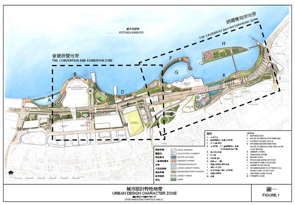
29 URBAN DESIGN FRAMEWORK 7.1 An urban design framework for the reclamation area has been established to achieve coherent and legible developments, urban form and open space that is appropriate to the unique development context of the waterfront. It seeks to optimise opportunities afforded by the reclamation for restructuring the existing waterfront and for creating development within a new world class waterfront district that could not otherwise be easily accommodated within the existing urban area. Wan Chai Reclamation is intended to provide an expansion area for the hinterland, and to integrate sites appropriate to meet Hong Kong s future needs for public buildings, tourism and leisure orientated developments. 7.2 One of the major design components of WDII is to promote the marine theme. It also aims to enhance connectivity between the urban area and the waterfront and to provide a continuous waterfront promenade extending from the CRIII, to the Causeway Bay Typhoon Shelter at the eastern end of the Area. This generally reflects one of the objectives formulated in the Board s Vision Statement for Victoria Harbour to bring the people to the Harbour and the Harbour to the people. 7.3 The urban design context for WDII has been divided into two major zones namely the Convention and Exhibition Zone and the Causeway Bay Waterfront Zone (Figure 1). 7.4 The Convention and Exhibition Zone This zone consists of the area extending from the Marine Basin up to the western edge of the new boundary of the Royal Hong Kong Yacht Club (RHKYC). It includes the HKCEC Extension and the new waterfront promenade running in east-west direction. A proposed plaza to the east of the HKCEC Extension is intended as an event space. It could host open-air entertainment or be used as a temporary open-air exhibition venue. Underground exhibition hall with supporting facilities are proposed underneath this plaza area subject to approval by the Board on application The existing Public Transport Interchange (PTI) to the north of Harbour Centre will be integrated with the proposed NIL station development. It will be a key site for a new waterfront precinct and the existing Wan Chai North hinterland. Design parameters would take into account the nodal connections (at various levels) and desire lines linked to the new uses along the waterfront. Planned pedestrian connections will promote public access to the new waterfront Principal elements envisaged between the HKCEC Extension and the RHKYC comprise a gateway zone which includes an activity area associated with the ferry pier and a new civic/ceremonial plaza. This will be linked to a themed dining area along the seaward perimeter of the HKCEC Extension.
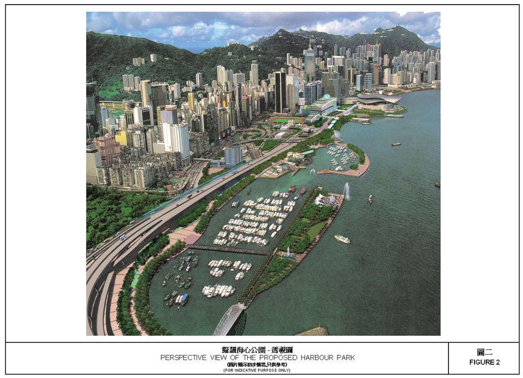
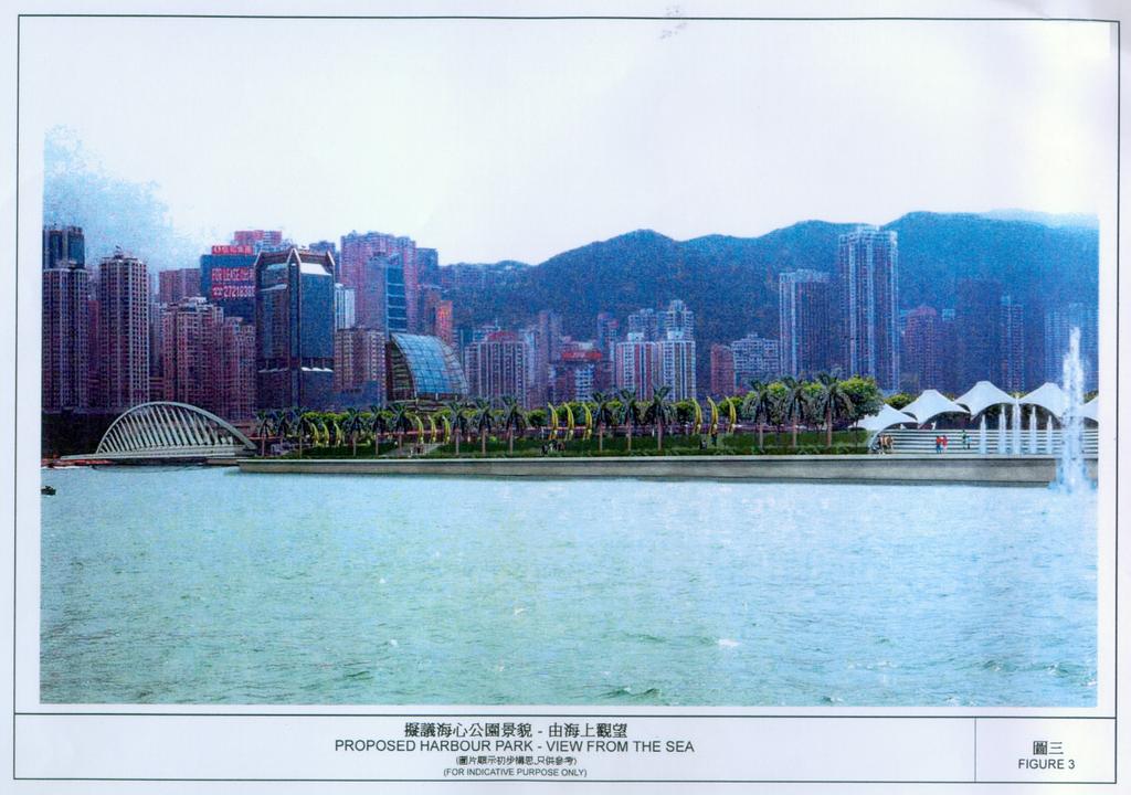
30 - 5 - A secondary node is envisaged which provides a landscape, visual and physical focal point at the intersection of pedestrian desire lines to the east of the HKCEC Extension. A third principal element envisaged between the HKCEC Extension and the RHKYC is a tourist and recreational node on the waterfront to the north of the existing Wan Chai Sports Ground and athletic facilities. This tourist node is intended to form a passive recreational resource extending from the proposed consolidated sports facility centered on the Wan Chai Sports Ground. 7.5 The Causeway Bay Waterfront Zone This zone includes the RHKYC, the Police Officers Club (POC), the Causeway Bay Typhoon Shelter and the new waterfront to the North Point Breakwater. The reprovisioning of the RHKYC provides an opportunity to restructure the waterfront and to promote the marine functions associated with the club as a public resource. A new 30 metre wide breakwater will be accessible by the public and will provide dramatic views across the harbour and to Kellett Island Marina. The eastern end of the breakwater will become the base for the reprovisioning of the Noon-Day Gun. This will provide a more accessible and tourist friendly location than the present site at the edge of Gloucester Road. It is proposed that the natural coastline along the north-western edge of Kellett Island will be preserved. This is the last remaining piece of natural coastline at the edge of the central harbour Another striking feature provided by the new waterfront proposals is the incorporation of a Harbour Park along the existing Causeway Bay Typhoon Shelter breakwater, which adds an innovative element to the waterfront. It will enhance access to the waterfront which will become a major recreational resource for the public. (Figures 2 & 3) The Harbour Park responds to the need for waterfront recreational development by: providing a unique public waterfront open space which would not be affected by any adverse environmental impacts arising from the heavy road traffic in the area; enhancing public access to the waterfront which is currently inaccessible and unusable, and providing new vantage points for public enjoyment of the unrivalled spectacular views of Victoria Harbour and the activities of the RHKYC and the typhoon shelter; shaping the edge of the harbour to provide more effective wave protection to the sheltered anchorages within the modified typhoon shelter and the new Kellett Island Marina; and integrating the typhoon shelter with the recreational facilities of the waterfront.
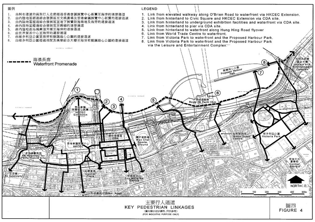
31 Other historic elements of the harbour include a temple site located at the extreme eastern edge of the waterfront. It is planned for the relocation of the existing floating Tin Hau Temple currently moored within the Causeway Bay Typhoon Shelter. This will provide a cultural focus at the edge of the waterfront. Given the prominence of the location, it is important that the temple should be well designed and constructed. The quality of the development should not detract from the objective to create a waterfront of international quality A Leisure and Entertainment Complex has been proposed at the eastern end of the Area. Because of its strategic location, it can be developed as a district landmark and will form a new attraction/activity node along the waterfront for the locals and tourists. It would also serve as a strategic link by providing a wide landscaped deck, preferably 30m in width with a view of reconnecting the Victoria Park through this development onto the waterfront. 7.6 Pedestrian Connections (Figure 4) The proposed waterfront promenade within the Area will form part of the continuous waterfront pedestrian link from the CRIII through the Area to the eastern end of the Causeway Bay Typhoon Shelter In order to ensure that the new waterfront will be easily accessible by the general public, a total of eight pedestrian linkages have been identified within the Area to connect the existing hinterland with the waterfront. The pedestrian linkages are running along north-south direction. Landscaping and/or retail facilities would be provided at the pedestrian links where appropriate. Among the eight identified linkages, six of them aim at enhancing the connectivity between the existing urban area and the waterfront while the other two links would enhance the connectivity from the Victoria Park to the waterfront and the Harbour Park. Connecting the Urban Area to the Waterfront A total of six pedestrian linkages have been identified to connect the existing urban area to the waterfront. Link 1 is an extension of the existing elevated walkway along O Brien Road to the waterfront and Link 5 is an elevated walkway along Hung Hing Road flyover. Apart from these, one pedestrian elevated walkway is proposed to connect the existing World Trade Centre with the new commercial site located to the east of the existing POC at Gloucester Road. It is expected that this pedestrian link can help to draw the public from the heart of the Causeway Bay area to the waterfront via the proposed retail precinct in the new commercial site at podium level (Link 6).
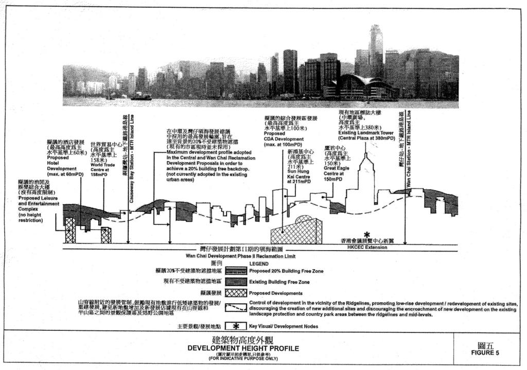
32 Another three pedestrian links are identified to connect the existing hinterland in Wan Chai area to the waterfront via the future developments at the Comprehensive Development Area (CDA) site located at the Harbour Road (Links 2, 3 & 4). Link 3 is an underground connection. It is expected that Links 2 & 4 can help to draw the public from the existing Wan Chai area to the waterfront via the retail precinct within the CDA site. Connecting the Victoria Park to the Waterfront and the Harbour Park Two pedestrian linkages are proposed within the Area which aims at connecting the Victoria Park with the new waterfront and the Harbour Park. One of the proposed elevated walkways intends to connect the western part of the Victoria Park to the new waterfront and the Harbour Park (Link 7). Another pedestrian link will make use of the proposed leisure and entertainment complex at the existing A-King Shipyard site as it would serve as a strategic link by providing a wide landscaped deck, preferably 30m in width from the Victoria Park through this development onto the waterfront area and the Harbour Park (Link 8). 7.7 Development Height Strategy (Figure 5) It is intended to preserve a minimum of 20% building-free area to protect the ridgeline of the Victoria Peak as recommended under the Metroplan and to maintain a clear view towards the harbour as far as possible. A stepped development height profile is adopted between the existing built-up area to the south and the new waterfront development area. Low-rise developments (ranging from metres above Principal Datum) are proposed in the vicinity of the waterfront promenade which are in keeping with the pedestrian environment along the waterfront and maintaining the integrity of the Victoria Peak. Another guiding principle adopted is to give emphasis to the HKCEC Extension and maintain its prominence as a harbour landmark New commercial site, CDA site, a number of waterfront-related commercial and leisure uses, the government site for the possible development of a Harbour Museum, the Temple site for the relocation of the existing floating Tin Hau Temple, the ferry pier, the new reprovisioning site for the Harbour Road Indoor Games Hall and Training Pool as well as the existing Sports and Recreation Clubs within the Area are subject to building height restrictions. Such control is stipulated with due regard to the development scale of the waterfront and the existing building heights of the nearby developments.
33 LAND USE ZONINGS 8.1 Commercial ( C ) - Total Area 3.93 hectares This zoning is intended for commercial development. The existing commercial/office developments are concentrated around the Central Plaza and Sun Hung Kai Centre to the north of Gloucester Road. They are well linked with the Hong Kong Convention and Exhibition Centre and the adjacent Government buildings by integrated walkways and forms one of the major commercial centres in the district. This zoning is also intended to provide an opportunity for residential development subject to the environmental acceptability upon application to the Board The Commercial (1) zone is located on the reclaimed land to the north of the World Trade Centre. It is proposed for hotel use which will be compatible to the adjacent waterfront leisure and tourist related developments. In order to maintain reasonable views to the Peak ridgeline from selected vantage points, a maximum building height of 60mPD is stipulated for the proposed commercial development. It will also allow a gradation in building height from the hinterland to the waterfront, and maintain high level prestige views from the World Trade Centre and Excelsior Hotel. 8.2 Comprehensive Development Area ( CDA ) - Total Area 2.56 hectares A site located to the north of Harbour Road and west of Wan Chai Sports Ground is zoned CDA to facilitate comprehensive development. It is intended for exhibition and entertainment development with the incorporation of the proposed NIL Exhibition Station, a public transport interchange and the ventilation structures serving the NIL. The proposed exhibition development will cater for future demand for in-town exhibition facilities, while the entertainment uses will enhance the development of the future Wan Chai waterfront as a tourist, cultural and recreational attraction. In order to ensure its compatibility with the surrounding developments, the CDA development is subject to a maximum non-domestic gross floor area of 128,100m 2 with a plot ratio of about 5 and a maximum building height of 100mPD (including architectural features). Footbridges and underground link to the waterfront promenade and the adjacent developments will also be provided in the CDA development. In order to minimize traffic impacts on the local road network, access for exhibition trucks and other service vehicles for the CDA development will be provided at Expo Drive East into an underground marshalling area, under the Open Space (1) ( O(1) ) zone to the north of the CDA site. A vehicular subway is proposed linking this underground marshalling area with the CDA site. A planning brief will be prepared by the Government to guide the development within the zone.
34 Pursuant to section 4A(2) of the Ordinance, development/redevelopment of the CDA site requires submission of planning application to the Board in the form of a Master Layout Plan containing detailed information as set out in the Notes. 8.3 Government, Institution or Community ( G/IC ) - Total Area hectares Land zoned for this purpose is intended for the provision of a wide range of Government, institution or community (GIC) facilities. Within the Area, there are a number of existing GIC buildings such as the Hong Kong Academy for Performing Arts, Hong Kong Arts Centre, Harbour View International House, Telecom House, Revenue Tower, Wanchai Tower, Immigration Tower, Kwong Wan Fire Station, Society for Prevention of Cruelty to Animals (SPCA) Headquarters, Wan Chai Sports Ground, and an electricity sub-station (ESS) A number of GIC facilities are proposed under the WDII project. These include the reprovisioning site for the Harbour Road Indoor Games Hall (IGH) and Wan Chai Training Pool (TP) to the north of the Wan Chai Sports Ground, the Wan Chai East Sewerage Screening Plant, and sites for the reprovisioning of the salt water pumping station and the water-selling kiosk. In order to ensure its compatibility with the waterfront setting, the reprovisioning site for the IGH and TP which is zoned G/IC(1) is subject to a maximum building height of 35mPD. The proposed receiving station for electricity located to the east of Wan Chai Sports Ground is required to serve the Hong Kong Island North area. A number of pumping station transformers are located on the eastern edge of the Area and north of the existing Wan Chai Zone Electricity Sub-Station site, to serve the pumphouses along the waterfront A site at the northern tip of the waterfront promenade and opposite to the proposed ventilation building and administrative building for the CWB is zoned G/IC(2). It is planned for developments with cultural or recreational theme which will enhance the character and composition of the waterfront. Possible development includes a Harbour Museum which will be subject to further investigation. This proposed development will form a unique landmark at the promenade and provide an important activity node along the waterfront. The maximum permitted building height at the site is 25mPD and any development within this zone requires planning permission from the Board. This is to ensure that the proposed development within this prominent location will be of high quality architectural design to become a landmark in the waterfront environment. Innovative design with special architectural roof features is also encouraged to be implemented subject to the consideration of the Board.
35 Open Space ( O ) - Total Area 16.6 hectares This zoning is intended to provide an attractive setting for civic events and land for both active and passive recreational activities Major existing open spaces in the Area include Convention Centre Park, Harbour Road Garden and Promenade of Convention Centre The Area has provided the opportunity for the provision of a continuous waterfront promenade extending all the way from CRIII in the west to the eastern end of the Causeway Bay Typhoon Shelter. This promenade will connect with Victoria Park through the landscaped pedestrian deck beneath major roads. The promenade together with the large outdoor event space to the east of the HKCEC Extension would become a major tourist attraction and focus for the local community. The reprovisioned Noon-Day Gun, to be located at the end of the new Kellett Island Marina breakwater, will become part of the design of the future open space at that locality The Area has incorporated a Harbour Park along the existing Causeway Bay Typhoon Shelter breakwater. The Harbour Park will be connected with the Victoria Park and the waterfront promenade via two elevated walkways. The Harbour Park will be a unique, interesting, dynamic and usable public space at a prominent location in the Victoria Harbour and will provide unrivalled spectacular views of the Harbour and of Hong Kong Island. This Harbour Park will be subject to a more detailed feasibility study prior to implementation The O(1) zone to the north of Road P2 and adjacent to the HKCEC Extension is intended to incorporate underground exhibition hall with supporting facilities and public vehicle park with the open space development above. This will assist in meeting long-term demand for exhibition and supporting facilities and optimise land utilization in this prime location. Development for underground exhibition hall and supporting facilities within the O(1) zone requires planning permission from the Board. This is to ensure that the proposed underground facilities will not compromise the design of a quality waterfront open space development and will be in harmony with the surrounding land uses. 8.5 Other Specified Uses ( OU ) - Total Area hectares This zoning denotes land allocated for various specific uses including the following:- (a) the existing HKCEC is zoned OU annotated Exhibition Centre with Commercial Development. The HKCEC Extension is zoned OU annotated Exhibition Centre which accommodates convention and exhibition facilities except for some limited ancillary commercial uses. No significant commercial development is proposed in the Extension. The pedestrian walkway linking the existing HKCEC with the Extension
36 is zoned OU annotated Pedestrian Walkway with Ancillary Exhibition Facilities. The walkway is for pedestrian circulation with some secondary exhibition areas; (b) a new pier at the waterfront is zoned OU annotated Pier to reprovide for the existing Wan Chai Pier. The maximum permitted building height, including the roof-top architectural features at the site is 20mPD. This is to ensure that it will be comparable in building height to the adjacent waterfront related commercial and leisure uses and compatible with the waterfront setting; (c) three areas bordering the waterfront promenade are zoned OU annotated Waterfront Related Commercial and Leisure Uses. It is the planning intention that these commercial and leisure facilities, including café, restaurants and retail shops will add variety and vibrancy to the waterfront. These waterfront developments are intended to be low-rise structures with the maximum permitted building heights ranging from 10 to 20mPD; (d) the existing RHKYC and the POC are both zoned OU annotated Sports and Recreation Club. The maximum permitted building heights for these two developments upon redevelopment are 20mPD and 25mPD respectively. This is to ensure that they will be low-rise developments and compatible with the waterfront setting. It also seeks to promote a progressive gradation in height from the existing urban hinterland to the waterfront. Maintaining a relatively low development height will also avoid promoting the creation of development canyons and promote variations in development height within the Area; (e) (f) a site at the eastern end of the Area is zoned OU annotated Temple. The planning intention is for the relocation of the existing floating Tin Hau Temple currently moored within the Causeway Bay Typhoon Shelter. The site will be developed into a land-based facility at the eastern end of the waterfront promenade. It will also act as a focal point of attraction along the waterfront. A maximum building height of 15mPD is imposed to ensure that the proposed Temple will be a low-rise development which is compatible with the waterfront setting and in harmony with the surrounding environment; a site at the eastern edge of the Area is zoned OU annotated Leisure and Entertainment Complex and Elevated Walkway. The planning intention is to develop this area into indoor leisure and entertainment uses with shops, restaurants and provision of coach parking facilities. It will form a unique district landmark and provide an important activity node along the waterfront. The site will also serve as a strategic link connecting the Victoria Park, the waterfront promenade and the Harbour Park. A maximum GFA of 46,420m 2 is imposed on this site but it is not subject to any specific height restriction in order to provide opportunities for a wide range of innovative design at this strategic location. Although no building height restriction is imposed, the proposed development on the site should be compatible in scale with the
37 waterfront and the surrounding developments. Any development within this zone requires planning permission from the Board; (g) a site located to the north-east of the HKCEC Extension is zoned OU annotated Helipad on the Plan while a site located to the east of the Wan Chai Sports Ground is zoned OU annotated Petrol Filling Station ; (h) (i) a site near the tunnel portal of the CWB is designated for the development of ventilation building and administrative building for the operation of the CWB. Two sites located to the north of the existing HKCEC and west of Fleming Road, and to the east of the existing POC are reserved for the provision of railway vent shafts/building for the operation of the NIL. Landscaped open space will be provided within the OU site to the east of the POC. This open space will be well connected to the waterfront via the hotel retail podium. Another site at the northern tip of the existing RHKYC is also zoned OU which is currently occupied by the Cross Harbour Tunnel Vent Shaft; and a number of Elevated Walkways are designated on the Plan. They will form part of the comprehensive pedestrian network providing connection between individual developments as well as connection with the existing urban area. 9. ENVIRONMENT 9.1 To provide information on the nature and extent of potential environmental impacts associated with the proposed development, Environmental Impact Assessment (EIA) studies for the WDII, CWB and IECL have been carried out. The EIA has quantitatively assessed the scale, extent and severity of the cumulative environmental impacts arising from the construction and operation of the WDII, CWB and IECL. The EIA studies concluded that with the implementation of all recommended mitigation measures, the cumulative residual environmental impacts would be kept within the appropriate statutory and established environmental standards. The proposed reclamation, the CWB and IECL are the Designated Projects under the EIA Ordinance (Chapter 499) and environmental permits are required for the construction and operation of the projects. The WDII EIA Report covering the Area, other than the Harbour Park, has been approved under the EIA Ordinance. As for the Harbour Park, a detailed feasibility study will be carried out to examine the engineering and environmental viability. A supplement to the WDII EIA report will be prepared, if appropriate, to address the cumulative impacts. The EIA findings will be taken into account in the detailed design of the projects. 9.2 Environmental monitoring and audit programmes will be formulated to verify the effectiveness of the recommended mitigation measures and to ensure full compliance with the stipulated requirements.
38 COMMUNICATIONS 10.1 Road Gloucester Road is the existing principal east-west route through the Area and is observed to be presently overloaded. Other key east-west roads include Convention Avenue, Harbour Road and Hung Hing Road. The proposed CWB and IECL are anticipated to provide relief to these existing east-west links. Without the new Trunk Road, the existing east-west links would not be able to accommodate the increasing traffic demand The Area will also provide a ground level road network system to complement the Trunk Road. The road network comprises existing roads which need to be modified and the provision of some new roads and junctions. In general, a primary distributor Road P2 will be formed to the north of the existing Hung Hing Road in the east-west direction The area shown as Road includes substantial area reserved for roadside planting and footpaths. Provision of street tree planting, amenity planting strip and street furniture is encouraged to improve the streetscape quality and pedestrian environment Railway The Wan Chai District adjoining the Area is currently served by the existing MTR Island Line. The future NIL and the proposed Sha Tin to Central Link (SCL) will provide further direct rail access to the Wan Chai area Road Transport In addition to rail service, a sufficient number franchised bus routes serve the Area Ferry Services The Wan Chai Ferry Pier currently provides ferry services between Wan Chai and Tsim Sha Tsui and between Wan Chai and Hung Hom. The service will be re-provided in the new pier. A number of public landing steps will be reprovisioned along the new waterfront Public Transport Interchange A public transport interchange will be incorporated within the CDA development to cater for future operational need as well as to reprovide for the existing bus terminus located to the north of the Harbour Centre and the terminal facilities at ExPo Drive East. The extent of this provision will be determined at the detailed design stage of the CDA development.
39 Pedestrian Connection 11. UTILITY SERVICES The proposed waterfront promenade and their elevated walkway system will provide safe and convenient pedestrian linkages along the waterfront and between individual developments as well as connections with the existing urban areas to various developments in the reclamation area A number of major drainage reserves dissect the Area. They are required for extensions of the existing drainage systems within the existing Wan Chai area New sewerage systems have been designed for the WDII development, which will feed into the trunk sewer system. Assessments indicate that the additional flows will not have any adverse impact to the trunk sewer system. Sewage will discharge through the Wan Chai East Sewage Screening Plant and the Wan Chai East sewage outfall, which has adequate capacity to handle the additional flows from the new WDII developments Current planning intentions are to decommission the Wan Chai West Sewage Screening Plant once flows have been diverted to the Wan Chai East Sewage Screening Plant. The Wan Chai East Sewage Screening Plant will have adequate capacity in the short to medium term to handle these flows. However, in the longer term, the existing Wan Chai East sewage outfall will need to be upgraded to handle future design flows. A new sewage outfall will be constructed under the WDII project to replace the existing Wan Chai East sewage outfall. 12. CULTURAL HERITAGE The Kellett Island Archaeological Site, the Noon-Day Gun and the floating Tin Hau Temple which are of special historical interest are located within the Area. Prior consultation with the Antiquities and Monuments Office should be made if any development or rezoning proposals may affect these sites. 13. IMPLEMENTATION OF RECLAMATION The reclamation works under the Plan are proposed to commence in early 2004 for completion around early Such timing of implementation is important to alleviate traffic congestion in Wan Chai and Causeway Bay by providing reclaimed land for the timely construction of the CWB, the IECL and the associated connecting roads and to meet the construction of the NIL.
40 IMPLEMENTATION OF THE PLAN 14.1 Although existing uses non-conforming to the statutory zonings are tolerated, any change of use and any other development/redevelopment must conform to the zonings on the Plan. The Board has published a set of guidelines for the interpretation of existing use in the urban and new town areas. Any person who intends to claim an existing use right should refer to the guidelines and will need to provide sufficient evidence to support his claim. The enforcement of the zonings mainly rests with the Buildings Department, the Lands Department and the various licensing authorities The Plan provides a broad land use framework within which more detailed non-statutory plans for the area are prepared by the Planning Department. These detailed plans are used as the basis for public works planning and site reservations within Government departments. Disposal of sites is undertaken by the Lands Department. Public works projects are co-ordinated by the Territory Development Department in conjunction with the client departments and the works department, such as the Civil Engineering Department, the Architectural Services Department and the Highways Department. In the course of implementation of the Plan, the Wan Chai District Council and the Eastern District Council would also be consulted as appropriate Planning applications to the Board will be assessed on individual merits. In general, the Board s consideration of the planning applications will take into account all relevant planning considerations which may include the departmental outline development plans/layout plans and the guidelines published by the Board. The outline development plans and layout plans are available for public inspection at the Planning Department. Guidelines published by the Board are available from the Board s website, the Secretariat of the Board and the Technical Services Division of the Planning Department. Application forms and guidance notes for planning applications can be downloaded from the Board s website and are available from the Secretariat of the Board, the Technical Services Division and the relevant District Planning Office of the Planning Department. Applications should be supported by such materials as the Board thinks appropriate to enable it to consider the applications.
41 Index of Figures (All figures are for indicative purpose only) Figure 1 - Figure 2 - Figure 3 - Figure 4 - Figure 5 - Urban Design Character Zones Perspective View of the Proposed Harbour Park Proposed Harbour Park View from the Sea Key Pedestrian Linkages Development Height Profile TOWN PLANNING BOARD APRIL 2002
42
43
44
45
46
Harbour-front Enhancement Committee. Wan Chai Development Phase II. Planning and Engineering Review
 Paper No. 4/2004 For discussion on 6 May 2004 Harbour-front Enhancement Committee Wan Chai Development Phase II Planning and Engineering Review PURPOSE This paper briefs Members on the scope, approach,
Overview of Land Use Framework for Victoria Harbourfront. Planning Department February 2011
 Overview of Land Use Framework for Victoria Harbourfront Planning Department February 2011 Background TPB set out Vision Statement for the Victoria Harbour in 1999 To make Victoria Harbour attractive,
URBAN DESIGN STUDY FOR THE WAN CHAI NORTH AND NORTH POINT HARBOURFRONT AREAS FEASIBILITY STUDY
 Agreement No. CE 54/2014 (TP) Meeting with Task Force on Harbourfront Developments on HK Island 10 Feb 2015 2 CONTENTS STUDY TEAM STUDY METHODOLOGY & APPROACH STUDY PROGRAMME KEY ISSUES Study Team Organization
Sub-committee on Harbour Plan Review of Harbour-front Enhancement Committee. Ninth Meeting
 Sub-committee on Harbour Plan Review of Harbour-front Enhancement Committee Ninth Meeting Date: 5 October 2005 Time: 3:30pm Venue: Conference Room 15/F, North Point Government Offices, 333 Java Road, North
Harbour-front Enhancement Committee. Urban Design Study for the New Central Harbourfront Revised Planning and Urban Design Concepts
 Harbour-front Enhancement Committee Paper No. 5/2010 For discussion on 18 February 2010 Urban Design Study for the New Central Harbourfront Revised Planning and Urban Design Concepts Purpose 1. This Paper
Wan Chai Development Phase II Planning and Engineering Review
 Annex A to Paper No. 4/2004 Supplemental Agreement No. 1 to Agreement No. CE 54/2001 (CE) Wan Chai Development Phase II INCEPTION REPORT April 2004 MAUNSELL CONSULTANTS ASIA LTD Wan Chai Development Phase
HARBOUR-FRONT ENHANCEMENT REVIEW WAN CHAI, CAUSEWAY BAY & ADJOINING AREAS REALIZATION STAGE
 HARBOUR-FRONT ENHANCEMENT REVIEW WAN CHAI, CAUSEWAY BAY & ADJOINING AREAS REALIZATION STAGE SUPPLEMENTARY DOCUMENT October 2006 MAUNSELL CONSULTANTS ASIA LTD HARBOUR-FRONT ENHANCEMENT REVIEW WAN CHAI,
Task Force on Harbourfront Developments in Kowloon, Tsuen Wan and Kwai Tsing
 Task Force on Harbourfront Developments in Kowloon, Tsuen Wan and Kwai Tsing For discussion on 2 June 2016 TFK/03/2016 AMENDMENTS TO THE APPROVED TSUEN WAN OUTLINE ZONING PLAN NO. S/TW/31 PURPOSE This
Task Force on Kai Tak Harbourfront Development
 Task Force on Kai Tak Harbourfront Development For discussion on 1 September 2014 TFKT/08/2014 Kai Tak Development Proposal of Increasing Development Intensity and Findings of Technical Study PURPOSE This
Kai Tak Development Proposal of Increasing Development Intensity and Findings of Technical Study. PlanD CEDD GPA IRD ArchSD
 Kai Tak Development Proposal of Increasing Development Intensity and Findings of Technical Study PlanD CEDD GPA IRD ArchSD Overview of Kai Tak Former North Apron Kai Tak Land Use Plan Kowloon Bay To Kwa
Task Force on Harbourfront Developments on Hong Kong Island. Hong Kong Island East Harbour-front Study
 For discussion on 30 August 2011 Hong Kong Island East Harbour-front Study PURPOSE The purpose of this paper is to seek Members views on the recommended enhancement proposals formulated under the Hong
Harbour-front Enhancement Committee Sub-committee on Harbour Plan Review
 Paper No.13/2009 For discussion on 22 July 2009 Harbour-front Enhancement Committee Sub-committee on Harbour Plan Review Draft Planning Brief for Comprehensive Development Area (1) Site at the Guangzhou
Final Master Plan and Development Control Regulations
 1. INTRODUCTION CHECK LIST a. Introduction b. Table of contents c. Definitions. d. scope of works. 2. FINAL OVERALL MASTER PLAN a. SITE ANALYSIS and OVERVIEW: i. Existing and Proposed Site Plan Levels.
I615. Westgate Precinct
 I615. Westgate Precinct I615.1. Precinct Description The Westgate Precinct is located approximately 18km west of the Auckland city centre. There are seven Sub-precincts in the Westgate Precinct: Sub-precinct
Newcourt Masterplan. November Exeter Local Development Framework
 Newcourt Masterplan November 2010 Exeter Local Development Framework Background The Exeter Core Strategy Proposed Submission sets out the vision, objectives and strategy for the development of Exeter up
and services The protection and conservation of environmentally significant and sensitive natural heritage features and functions.
 6. Land Use 6.0 Preamble A healthy and livable city is one in which people can enjoy a vibrant economy and a sustainable healthy environment in safe, caring and diverse neighbourhoods. In order to ensure
Preliminary Land Use Proposal for the Western Part of Kennedy Town Task Force on Harbourfront Developments on Hong Kong Island
 Preliminary Land Use Proposal for the Western Part of Kennedy Town Task Force on Harbourfront Developments on Hong Kong Island 2013.6.7 Planning Department Review Area Review Area WIL s works area Bus
CENTRAL HARBOURFRONT AND ME (CHarM) DESIGN BRIEF
 DESIGN BRIEF") CENTRAL HARBOURFRONT AND ME (CHarM) DESIGN BRIEF March 2006 Design Brief for the Central Ferry Piers and Adjoining Areas Enhancement PURPOSE OF THE BRIEF 1. The Central Ferry Pier and adjoining areas (named
CENTRAL HARBOURFRONT AND ME (CHarM) DESIGN BRIEF March 2006 Design Brief for the Central Ferry Piers and Adjoining Areas Enhancement PURPOSE OF THE BRIEF 1. The Central Ferry Pier and adjoining areas (named
AMENDMENTS. Date Effective. Amendment No. Council. DCP 14 Davidson St, Greenacre Page 2
 AMENDMENTS Amendment No. Description Adopted by Council Date Effective DCP 14 Davidson St, Greenacre Page 2 TABLE OF CONTENTS 1.0 INTRODUCTION... 4 1.1 NAME OF THIS PLAN... 4 1.2 COMMENCEMENT OF DEVELOPMENT
Task Force on Harbourfront Developments on Hong Kong Island
 Task Force on Harbourfront Developments on Hong Kong Island For discussion on 10 May 2012 TFHK/04/2012 Proposed Composite Hotel, Residential and Public Open Space Development In Comprehensive Development
Mark-up of the effect of the proposed Bronte Village Growth Area OPA No.18 on the text of section 24, Bronte Village, of the Livable Oakville Plan
 Mark-up of the effect of the proposed Bronte Village Growth Area OPA No.18 on the text of section 24, Bronte Village, of the Livable Oakville Plan Notes: This document is provided for information purposes
heuston gateway: sections heuston gateway: regeneration strategy and development framework plan
 B B1 A B1 B C A heuston gateway: sections B B1 C 117 4.3.3 Zoning The station is the central hub of the area and this function must be preserved and developed. However large areas of the Heuston Station
Contents of Part 6. Part 6 Zones
 Contents of Part 6 Part 6 Zones... 6-1 6.1 Preliminary... 6-1 6.2 Zone codes... 6-3 6.2.1 Low density residential zone code... 6-3 6.2.1.1 Application... 6-3 6.2.1.2 Purpose and overall outcomes... 6-3
PHASE III: Reserved Matters Submission
 Statement of Compliance with the outline approval for the proposed residential development of land at: BURGES LANE, WIVELISCOMBE PHASE III: Reserved Matters Submission Foreword Contents: This Statement
YONGE STEELES CORRIDOR SECONDARY PLAN. Young + Wright / IBI Group Architects Dillon Consulting Ltd. GHK International (Canada) Ltd.
 Ltd.") PART A: PREAMBLE 1.0 PURPOSE The purpose of this Secondary Plan is to provide a development framework for intensification of the Yonge/ Steeles corridor including the north side of Steeles Avenue West
PART A: PREAMBLE 1.0 PURPOSE The purpose of this Secondary Plan is to provide a development framework for intensification of the Yonge/ Steeles corridor including the north side of Steeles Avenue West
Table 8-4: Road Classification Local Roads, second table, of Chapter 8 Create a Multi-Modal City, be amended by adding the following:
 1 Port Street East Official Plan Amendment APPENDIX 3 Amendments to Mississauga Official Plan Table 8-4: Road Classification Local Roads, second table, of Chapter 8 Create a Multi-Modal City, be amended
Task Force on Harbourfront Developments on Hong Kong Island
 Task Force on Harbourfront Developments on Hong Kong Island For discussion TFHK/10/2016 On 25 May 2016 PURPOSE This paper seeks Members views on the reprovisioning of Tin Chiu Street Playground (TCSP)
Task Force on Kai Tak Harbourfront Development. Station Square at Kai Tak
 For discussion on 24 February 2017 Station Square at Kai Tak PURPOSE This paper seeks Members views on the design of the Station Square at Kai Tak. BACKGROUND 2. Upon the relocation of the Hong Kong International
4.11 Town Centre Secondary Plan (Former City of Cumberland)
") 4.11 Town Centre Secondary Plan (Former City of Cumberland) 4.11.1 Town Centre Objectives 4.11.1.1 Introduction The reason for the preparation of this Secondary Plan for the Town Centre is as follows:
4.11 Town Centre Secondary Plan (Former City of Cumberland) 4.11.1 Town Centre Objectives 4.11.1.1 Introduction The reason for the preparation of this Secondary Plan for the Town Centre is as follows:
[PLANNING RATIONALE] For Site Plan Control and Lifting of Holding Zone By-Law 101 Champagne Avenue. May 23, 2014
![[PLANNING RATIONALE] For Site Plan Control and Lifting of Holding Zone By-Law 101 Champagne Avenue. May 23, 2014](/thumbs/75/71599615.jpg "[PLANNING RATIONALE] For Site Plan Control and Lifting of Holding Zone By-Law 101 Champagne Avenue. May 23, 2014") [PLANNING RATIONALE] For Site Plan Control and Lifting of Holding Zone By-Law 101 Champagne Avenue May 23, 2014 Contents 1.0 Introduction... 2 2.0 Site Context... 2 2.1 Adjacent Uses... 2 Figure 1: Site
[PLANNING RATIONALE] For Site Plan Control and Lifting of Holding Zone By-Law 101 Champagne Avenue May 23, 2014 Contents 1.0 Introduction... 2 2.0 Site Context... 2 2.1 Adjacent Uses... 2 Figure 1: Site
Task Force on Harbourfront Developments in Kowloon, Tsuen Wan and Kwai Tsing
 Task Force on Harbourfront Developments in Kowloon, Tsuen Wan and Kwai Tsing For discussion on 19 October 2011 TFK/14/2011 Proposed District Revitalisation with Minor Relaxation of Building Height and
AMENDMENT NO. 42 TO THE OFFICIAL PLAN OF THE TOWN OF GRIMSBY
 AMENDMENT NO. 42 TO THE OFFICIAL PLAN OF THE TOWN OF GRIMSBY INITIATED BY TOWN OF GRIMSBY TABLE OF CONTENTS PART I: THE CERTIFICATION Certification Page Adopting By-law of the Town of Grimsby PART II:
Figure 1- Site Plan Concept
 Figure 1- Site Plan Concept Parking will be provided underground on three levels at rate of 1.0 space/ unit; this rate includes all visitors parking. MMM Group has prepared a parking assessment (April,
DAREBIN PLANNING SCHEME AMENDMENT C137
 Who is the planning authority? Planning and Environment Act 1987 DAREBIN PLANNING SCHEME AMENDMENT C137 EXPLANATORY REPORT This amendment has been prepared by the Darebin City Council, who is the planning
Land Use Amendment in Southwood (Ward 11) at and Elbow Drive SW, LOC
 at and Elbow Drive SW, LOC") 2018 November 15 Page 1 of 10 EXECUTIVE SUMMARY This land use amendment application was submitted by Rick Balbi Architect on 2017 August 31 on behalf of Sable Developments Ltd, and with authorization from
2018 November 15 Page 1 of 10 EXECUTIVE SUMMARY This land use amendment application was submitted by Rick Balbi Architect on 2017 August 31 on behalf of Sable Developments Ltd, and with authorization from
Division 13 Local Business and Industry Buffer Zone: Assessment Criteria and Assessment Tables
 Division 13 Local Business and Industry Buffer Zone: Assessment Criteria and Assessment Tables 4.13.1 Local Business and Industry Buffer Zone The provisions in this division relate to the Local Business
6. REGIONAL AND COMMUNITY FACILITIES DESIGNATIONS 6.1. OBJECTIVES FOR REGIONAL AND COMMUNITY FACILITIES LAND USE DESIGNATIONS
 6. REGIONAL AND COMMUNITY FACILITIES DESIGNATIONS INTRODUCTION The Regional and land use designations provide the primary locations for uses which satisfy the health, education and other service needs
Task Force on Kai Tak Harbourfront Development
 Task Force on Kai Tak Harbourfront Development For discussion on 29 March 2018 TFKT/04/2018 Study of Kai Tak Promenade Design Control and Guidelines Conceptual design scheme for Promenade at Runway Precinct
Welcome. Walk Around. Talk to Us. Write Down Your Comments
 Welcome This is an information meeting introducing the applications for proposed redevelopment of the Yorkdale Shopping Centre site at 3401 Dufferin Street and 1 Yorkdale Road over the next 20+ years,
Sawtell Town Centre Development Control Plan
 Sawtell Town Centre Development Control Plan ABN 79 126 214 487 CONTENTS INTRODUCTION... 1 PREAMBLE... 1 HOW TO USE THIS DCP... 1 LAND TO WHICH THIS PLAN APPLIES... 1 MASTERPLAN... 2 VISION... 2 CHARACTER
Chapter 2: OUTLINE PLANNING APPLICATION PROPOSALS. A New Garden Neighbourhood Matford Barton 17
 Chapter 2: OUTLINE PLANNING APPLICATION PROPOSALS A New Garden Neighbourhood Matford Barton 17 2.1. SUMMARY AND STATUS OF THE PROPOSALS 2.1.1. The parameter plans and associated wording in this chapter
GREENFORD HALL & ADJOINING LAND
 GREENFORD HALL & ADJOINING LAND CONTENTS 1. Introduction 1. Introduction 2. Urban Context 2.1 The Site and Surroundings 2.2 Urban Context Map 2.3 Access and Movement 3. Planning Context 3.1 Planning History
FORMER CANADIAN FORCES BASE (CFB) ROCKCLIFFE SECONDARY PLAN. Official Plan Amendment XX to the Official Plan for the City of Ottawa
 ROCKCLIFFE SECONDARY PLAN. Official Plan Amendment XX to the Official Plan for the City of Ottawa") FORMER CANADIAN FORCES BASE (CFB) ROCKCLIFFE SECONDARY PLAN Official Plan Amendment XX to the Official Plan for the City of Ottawa 1 INDEX THE STATEMENT OF COMPONENTS PART A THE PREAMBLE PAGE Purpose...
FORMER CANADIAN FORCES BASE (CFB) ROCKCLIFFE SECONDARY PLAN Official Plan Amendment XX to the Official Plan for the City of Ottawa 1 INDEX THE STATEMENT OF COMPONENTS PART A THE PREAMBLE PAGE Purpose...
Keystone Business Park Precinct Structure Plan North East Industrial Precinct. Part 2 Design Principles
 Keystone Business Park Precinct Structure Plan North East Industrial Precinct Part 2 Design Principles Context Issues Services Landform Issues Geotech and contamination Ecology Traffic and access Issues
DAVENPORT VILLAGE SECONDARY PLAN
 27 DAVENPORT VILLAGE SECONDARY PLAN 27. DAVENPORT VILLAGE SECONDARY PLAN 1. VISION FOR THE DAVENPORT VILLAGE SECONDARY PLAN Davenport Village, municipally known as 830, 940, 980 and 1100 Lansdowne Avenue,
Colchester Northern Gateway Master Plan Vision Review Draft. July 2016
 Colchester Northern Gateway Master Plan Vision Review Draft July 2016 Contents Introduction 4 Context 8 Purpose of the Report 8 Strategic Position 9 Overview of the Process 11 2012 Master Plan Vision 12
HBF Marine Study: Victoria Harbour: Water dependent and water related uses and associated land/water interface implications
 HBF Marine Study: Victoria Harbour: Water dependent and water related uses and associated land/water interface implications Presentation on the Initial Findings 9 February 2011 Harbour Business Forum Background
6.0 Development of Amenities,
 6.0 Development of Amenities, conservation of architectural heritage and other features This chapter outlines the Area's significant potential to provide for amenities of city wide and local importance
ELMVALE ACRES SHOPPING CENTRE MASTER PLAN
 ELMVALE ACRES SHOPPING CENTRE MASTER PLAN Contents 1.0 INTRODUCTION... 2 2.0 LOCATION... 2 3.0 EXISTING CONTEXT... 2 4.0 VISION & GUIDING PRINCIPLES... 2 5.0 LAND USE AND BUILT FORM... 4 5.1 St. Laurent
Cardiff International Sports Village Waterfront Development Volume IV : Non-Technical Summary of the Environmental Statement
 Greenbank Partnerships Ltd October 2012 Cardiff International Sports Village Waterfront Development Volume IV : Non-Technical Summary of the Environmental Statement Environmental Statement - Non Technical
11.3 SPECIAL CHARACTER ZONE HAWKE S BAY REGIONAL SPORTS PARK
 11.3 SPECIAL CHARACTER ZONE HAWKE S BAY REGIONAL SPORTS PARK 11.3.1 INTRODUCTION The availability of sports and recreation activities and facilities is important for the maintenance and enhancement of
PART AOTEA PRECINCT
 CONTENTS... PAGE AOTEA PRECINCT...4 14.5.1 INTRODUCTION...4 14.5.2 RESOURCE MANAGEMENT ISSUES...4 14.5.3 RESOURCE MANAGEMENT OBJECTIVES AND POLICIES... 4 14.5.4 RESOURCE MANAGEMENT STRATEGY...5 14.5.5
3 Summary of Major Views and Responses
 3 Summary of Major Views and Responses 3.1 Major Views 3.1.1 The comments and suggestions received from various channels and parties during the two-month Stage 1 PE on the Study, which have been discussed
Division 7 Character Areas Housing Zone: Assessment Criteria and Assessment Tables
 Division 7 Character Areas Housing Zone: Assessment Criteria and Assessment Tables 4.7.1 Character Areas Housing Zone The provisions in this division relate to the Character Areas Housing Zone as follows
5.2 LAND USE AND ZONING
 5.2 LAND USE AND ZONING This section describes the land use and zoning of the project site and surrounding area, followed by an analysis of the potential for incompatibility or adverse impact on prevailing
Vision for East Cowes
 Vision for East Cowes A better East Cowes for now and the future The East Cowes Regeneration project is a major regeneration scheme on the Isle of Wight. It will create a vibrant community with a long-term
Page 1 of 19 URBAN DESIGN FRAMEWORK FOR BOLTON STREET WATERFORD
 Page 1 of 19 URBAN DESIGN FRAMEWORK FOR BOLTON STREET WATERFORD 1.0 Introduction: The relocation of the City Council stores and depot from Bolton Street creates an exciting opportunity for development
George Hotel application STAFF REVIEW COMMITTEE OF THE WHOLE JANUARY 14, 2014
 George Hotel application STAFF REVIEW COMMITTEE OF THE WHOLE JANUARY 14, 2014 1 Presentation outline Purpose: to seek Council direction for next steps in the review process Application process to date
INTRODUCTION NORTH HEYBRIDGE GARDEN SUBURB
 INTRODUCTION This event is being hosted by the promoters of the proposed North Heybridge Garden Suburb who are working with Maldon District Council and other key stakeholders on the preparation of a comprehensive
List of Policies. SESPlan. None applicable. Consolidated Scottish Borders Local Plan 2011: POLICY G1 - QUALITY STANDARDS FOR NEW DEVELOPMENT
 List of Policies Local Review Reference: 15/00021/RREF Planning Application Reference: 15/00616/FUL Development Proposal: Installation of 16no solar photovoltaic (PV) panels to roof Location: Raebank,
THE CORPORATION OF THE TOWN OF OAKVILLE BY-LAW NUMBER
 THE CORPORATION OF THE TOWN OF OAKVILLE BY-LAW NUMBER 2017-120 A by-law to adopt an amendment to the Livable Oakville Plan, Official Plan Amendment Number 20 (Downtown Oakville Growth Area) WHEREAS the
SCARBOROUGH SUBWAY EXTENSION. Scarborough Subway Extension. Final Terms of Reference
 Scarborough Subway Extension Final Terms of Reference 1 1.0 Introduction and Background 1.1 Introduction Toronto City Council recently confirmed support for an extension of the Bloor-Danforth Subway from
City of Welland Commercial Policies. Public Information Centre March 25 th, 2009
 City of Welland Commercial Policies Public Information Centre March 25 th, 2009 Presentation Outline Presentation will address the following four areas: Purpose of this Public Information Centre? Why does
Edenderry Local Area Plan
 Edenderry Local Area Plan 2017-2023 MATERIAL ALTERATIONS TO DRAFT EDENDERRY LOCAL AREA PLAN Public Display Document Section 1: Introduction 1.1 Introduction This report focuses on the proposed material
CONTENTS 8.0 LAND USE 8.1 GENERAL LAND USE 8.2 RESIDENTIAL 8.3 MIXED USE 8.4 COMMERCIAL 8.5 EMPLOYMENT LANDS
 8-2 Land Use 8.0 LAND USE CONTENTS 8.1 GENERAL LAND USE 8.1.1 Uses provided for in all Land Use Designations 8.1.2 Uses prohibited in Hazardous Lands, Hazardous Sites and Special Policy Areas 8.1.3 Uses
CITY OF FREMANTLE LOCAL PLANNING SCHEME NO. 4 AMENDMENT NO. 68 SCHEME AMENDMENT REPORT
 CITY OF FREMANTLE LOCAL PLANNING SCHEME NO. 4 AMENDMENT NO. 68 SCHEME AMENDMENT REPORT CITY OF FREMANTLE PLANNING AND DEVELOPMENT SERVICES 8 WILLIAM STREET FREMANTLE WA 6160 PLANNING AND DEVELOPMENT ACT
AGINCOURT SECONDARY PLAN
 1 AGINCOURT SECONDARY PLAN 1. AGINCOURT SECONDARY PLAN The following policies and principles apply to the area herein referred to as Agincourt, as outlined on Map 1-1. 1. GENERAL POLICIES 1.1 This Secondary
Strategic Planning in the Making: Legacy and Vision for Hong Kong. Mr. K. K. LING, JP, FHKIP, RPP Director of Planning
 The Hong Kong Institute of Surveyors Planning & Development Conference 2016 Planning and Development, Past Present & Future (22 October 2016) Strategic Planning in the Making: Legacy and Vision for Hong
KANATA CENTRUM 255 KANATA AVENUE OFFICIAL PLAN AMENDMENT ZONING BY-LAW AMENDMENT
 KANATA CENTRUM 255 KANATA AVENUE OFFICIAL PLAN AMENDMENT ZONING BY-LAW AMENDMENT JUNE 2015 PREPARED BY: FOTENN Consultants Inc. 223 Mcleod Street Ottawa, ON K2P OZ8 (613) 730-5709 PREPARED FOR: Kanata
6 PORT SYDNEY SETTLEMENT AREA
 Section 6 Port Sydney Page 61 6 PORT SYDNEY SETTLEMENT AREA 6.1 Basis and Principles Village of Port Sydney Waterfront Community Existing Services 6.1.1 Port Sydney is an historic settlement that has developed
North Somerset Council Local Development Framework
 North Somerset Council Local Development Framework Sites and Policies Development Plan Document Evidence Paper Re-opening Portishead Railway Line and Options for the Location of Portishead Railway Station
13 THORNHILL YONGE STREET STUDY IMPLEMENTATION CITY OF VAUGHAN OPA 669 AND TOWN OF MARKHAM OPA 154
 13 THORNHILL YONGE STREET STUDY IMPLEMENTATION CITY OF VAUGHAN OPA 669 AND TOWN OF MARKHAM OPA 154 The Planning and Economic Development Committee recommends the adoption of the recommendations contained
3.1 The hybrid planning application proposes the following description of development:
 CHAPTER 3: PROPOSED DEVELOPMENT 3.1 The hybrid planning application proposes the following description of development: Hybrid (part-outline/part-full) planning application for a single composite development
SPECIAL 35 (HIBISCUS COAST GATEWAY) ZONE
 ZONE") `` 12.8.35 SPECIAL 35 (HIBISCUS COAST GATEWAY) ZONE 12.8.35.1 Issues The following provisions relate to the Hibiscus Coast Gateway Zone. This zone is located at Silverdale in the area bounded by State
`` 12.8.35 SPECIAL 35 (HIBISCUS COAST GATEWAY) ZONE 12.8.35.1 Issues The following provisions relate to the Hibiscus Coast Gateway Zone. This zone is located at Silverdale in the area bounded by State
UDF PLANS AND GUIDELINES
 UDF PLANS AND GUIDELINES 5 Land Use Land Use Development Plan Plan no. 3 Land Use Development Mixed Use Retail / Leisure Residential Civic and Institutional Proposed Zoning Table Development Edges Plan
Chapter Master Planned Communities (MPC) District
 District") Sections 14.53.010 Purpose and Intent 14.53.020 Applicability 14.53.030 Procedure 14.53.040 MPC Standards 14.53.050 Required Findings 14.53.010 Purpose and Intent Chapter 14.53 Master Planned Communities
Sections 14.53.010 Purpose and Intent 14.53.020 Applicability 14.53.030 Procedure 14.53.040 MPC Standards 14.53.050 Required Findings 14.53.010 Purpose and Intent Chapter 14.53 Master Planned Communities
Planning and Growth Management Committee. Chief Planner and Executive Director, City Planning Division. Pg12013 (File No NNY 34 OZ)
") 865 York Mills Road Official Plan Amendment Application Preliminary Report STAFF REPORT ACTION REQUIRED Date: February 28, 2012 To: From: Wards: Reference Number: Planning and Growth Management Committee
865 York Mills Road Official Plan Amendment Application Preliminary Report STAFF REPORT ACTION REQUIRED Date: February 28, 2012 To: From: Wards: Reference Number: Planning and Growth Management Committee
Development Control Plan
 Development Control Plan Liberty Grove Development Control Plan Date of Adoption: 4 September 2007 Effective Date: 7 March 2008 Index 1 INTRODUCTION... 3 1.1 NAME OF PLAN... 3 1.2 AREA TO WHICH THIS PLAN
WELCOME TO THE NEW WILTON PARK
 WELCOME TO THE NEW WILTON PARK VISION HISTORY OF WILTON PARK TOWARDS A PLANNING APPLICATION Our objective is to create a truly outstanding environment at Wilton Park. At the heart of our proposals is a
The Proposed Auckland Unitary Plan (notified 30 September 2013)
") 3 Business zones Introduction There are 10 business zones in the Unitary Plan: City Centre Metropolitan Centre Town Centre Local Centre Neighbourhood Centre Mixed Use General Business Business Park Light
3 Business zones Introduction There are 10 business zones in the Unitary Plan: City Centre Metropolitan Centre Town Centre Local Centre Neighbourhood Centre Mixed Use General Business Business Park Light
RAILWAY LANDS EAST SECONDARY PLAN
 17 RAILWAY LANDS EAST SECONDARY PLAN 17. RAILWAY LANDS EAST SECONDARY PLAN 1. INTERPRETATION 1.1 The lands affected by the Railway Lands East Secondary Plan are shown on Map 17-1. 1.2 The boundaries of
Eastbourne Borough Council. Summary Proof of Evidence Of Barry John Cansfield BA (Hons), BTP, MRTPI on behalf of PRLP
, BTP, MRTPI on behalf of PRLP") Eastbourne Borough Council (Arndale Centre and surrounding Land at Terminus Road, Sutton Road and Ashford Road) (Compulsory Purchase Order 2015) Section 226 (1)(a) of the Town and Country Planning Act
Eastbourne Borough Council (Arndale Centre and surrounding Land at Terminus Road, Sutton Road and Ashford Road) (Compulsory Purchase Order 2015) Section 226 (1)(a) of the Town and Country Planning Act
1. Creating a liveable, vibrant, safe and inclusive city centre for the benefit of people of all ages to live, work, learn and enjoy.
 City Centre Framework - Summary Bristol City Council has produced a draft City Centre Framework document. The Framework is a planning and transport document that outlines what the city centre could be
Official Community Plan Bylaw No. 4360, 2004, Amendment Bylaw No. 4897, 2016 (Sewell s Landing)
") District of West Vancouver Official Community Plan Bylaw No. 4360, 2004, Amendment Bylaw No. 4897, 2016 (Sewell s Landing) Effective Date: 1089612v1 District of West Vancouver Official Community Plan Bylaw
District of West Vancouver Official Community Plan Bylaw No. 4360, 2004, Amendment Bylaw No. 4897, 2016 (Sewell s Landing) Effective Date: 1089612v1 District of West Vancouver Official Community Plan Bylaw
PUBLIC. Ai + Architecture LLC., 90 Belknap Street, Concord, MA 01742, USA (t) (f)
 (f)") PUBLIC Ai + Architecture LLC., 90 Belknap Street, Concord, MA 01742, USA www.ai-architecture.com +1 978 369 2730 (t) +1 978 369 2731 (f) 2004 Olympic Sailing Center & Marina Village Agios Kosmas, Athens,
PUBLIC Ai + Architecture LLC., 90 Belknap Street, Concord, MA 01742, USA www.ai-architecture.com +1 978 369 2730 (t) +1 978 369 2731 (f) 2004 Olympic Sailing Center & Marina Village Agios Kosmas, Athens,
Division 10 Local Retail and Commercial Zone: Assessment Criteria and Assessment Tables
 Division 10 Local Retail and Commercial Zone: Assessment Criteria and Assessment Tables 4.10.1 Local Retail and Commercial Zone The provisions in this division relate to the Local Retail and Commercial
Palm Jebel Ali - Dubai, United Arab Emirates
 Palm Jebel Ali - Dubai, United Arab Emirates LOCATION: CLIENT: Dubai Tony Perrin Senior Development Manager Dubai Waterfront Co LLC PROJECT SIZE: 1000 acres SCOPE OF WORK: Urban Design and Landscape Architecture
The broad range of permitted and special uses allowed in the district remain, but some descriptions have been clarified.
 Memorandum To: Emily Fultz, AICP City Planner, City of Edwardsville From: Michael Blue, FAICP Principal, Teska Associates Date: January 24, 2019 RE: B-1 Zoning District Update A draft, updated B-1 Central
Former North Works, Lickey Road, Longbridge, Birmingham
 Committee Date: 14/11/2013 Application Number: 2013/06431/PA Accepted: 27/08/2013 Application Type: Full Planning Target Date: 26/11/2013 Ward: Longbridge Former North Works, Lickey Road, Longbridge, Birmingham
The West Vaughan Employment Area Secondary Plan Policies
 Part 2: The West Vaughan Employment Area Secondary Plan Policies 2.1 General Policies It is the policy of Council: 2.1.1. That the West Vaughan Employment Area (the WVEA), identified on Schedule 1, will
Landscape Act. (Act No. 110 of June 18, 2004)
") Landscape Act (Act No. 110 of June 18, 2004) INDEX Chapter I General Provisions (Articles 1 to 7) Chapter II Landscape Plans and Measures Based on Them Section 1 Formulation, etc. of Landscape Plans (Articles
Landscape Act (Act No. 110 of June 18, 2004) INDEX Chapter I General Provisions (Articles 1 to 7) Chapter II Landscape Plans and Measures Based on Them Section 1 Formulation, etc. of Landscape Plans (Articles
Highest & Best Use Study Marina Park Lands
 Executive Summary of Report MARCH 2006 TABLE OF CONTENTS 1. Introduction...1 2. Study Process...2 3. Highest And Best Use Program...3 4. Concept Plan...8 5. Public Area Animation...9 6. Marina Park Implementation
Edward R. Sajecki Commissioner of Planning and Building
 Corporate Report Clerk s Files Originator s Files CD.03.POR DATE: TO: FROM: SUBJECT: Chair and Members of Planning and Development Committee Meeting Date: February 27, 2012 Edward R. Sajecki Commissioner
14.5 HOPEFIELD: (REFER PLAN 39 AND PLAN 40)
") URBAN DYNAMICS WESTERN CAPE INC. 248 14.5 HOPEFIELD: (REFER PLAN 39 AND PLAN 40) FIGURE 83: LOCALITY - HOPEFIELD Within the context of the Saldanha Bay Municipal area, Hopefield, an historical agricultural
URBAN DYNAMICS WESTERN CAPE INC. 248 14.5 HOPEFIELD: (REFER PLAN 39 AND PLAN 40) FIGURE 83: LOCALITY - HOPEFIELD Within the context of the Saldanha Bay Municipal area, Hopefield, an historical agricultural
9 CITY OF VAUGHAN OFFICIAL PLAN AMENDMENT NO BOCA EAST INVESTMENTS LIMITED
 9 CITY OF VAUGHAN OFFICIAL PLAN AMENDMENT NO. 631 - BOCA EAST INVESTMENTS LIMITED The Planning and Economic Development Committee recommends the adoption of the recommendations contained in the following
17.11 Establishment of Land Use Districts
 17.11 Establishment of Land Use Districts 17.11.010 Purpose. To promote the health, safety, and general welfare of City residents and those who come to South Salt Lake to work, exchange commerce and recreate.
Site 2 Development Brief
 a South Marketgait Site 2 b Union Street c Site 2 Development Brief Thomson Avenue (Northern Boulevard) Dundee Riverside Drive Discovery Plaza South Union Street Station Earl Grey Place West Site 5 Site
1.0 Purpose of a Secondary Plan for the Masonville Transit Village
 Report to Planning and Environment Committee To: Chair and Members Planning & Environment Committee From: John M. Fleming Managing Director, Planning and City Planner Subject: Masonville Transit Village
Chelsea Creek Municipal Harbor Plan
 Chelsea Creek Municipal Harbor Plan Public Meeting #1 June 11th, 2018 1 Presentation outline I. Introduction: Why are we doing this plan? II. Evolution of Chelsea Creek III. State of Chelsea Creek IV.
*** DRAFT 2 FOR PUBLIC REVIEW ***
 6.7 The area is generally bounded by the Red Hill Valley Parkway to the west, Lake Avenue to the east, the Queen Elizabeth Way (QEW) to the north, and by the properties just south of Queenston Road to