CENTRAL HARBOURFRONT AND ME (CHarM) DESIGN BRIEF
|
|
|
- Sharleen Nichols
- 6 years ago
- Views:
Transcription
 DESIGN BRIEF March")
1 CENTRAL HARBOURFRONT AND ME (CHarM) DESIGN BRIEF March 2006
2 Design Brief for the Central Ferry Piers and Adjoining Areas Enhancement PURPOSE OF THE BRIEF 1. The Central Ferry Pier and adjoining areas (named as the Study Area thereafter), is one of the key harbour-front areas selected by Harbour-front Enhancement Committee (HEC) for enhancement purpose. The map of the Study Area is in Attachment I. 2. HEC sets out the design and planning contexts and formulates a design brief for establishing the overall requirements and framework for guiding the planning and design of the Area. 3. The design brief is formulated for the Government to consider possible subsequent enhancement projects in the Study Area. The implementation of such subsequent projects should take into account the principles and guidelines stated in this brief. BACKGROUND 4. In April 2005, HEC launched a public engagement programme named Central Harbourfront and me (CHarM) to collect and consolidate public opinions and views on the future design and development of the Study Area. 5. HEC upholds the eight harbour planning principles which comprise: Principle 1: Preserving Victoria Harbour Victoria Harbour must be protected and preserved for Hong Kong people and visitors as a special public asset, a natural and cultural heritage asset, and a driver for the creation of economic and social values. Principle 2: Stakeholder Engagement All sectors of the community must be engaged at an early stage and on an ongoing basis in the planning, development and management of Victoria Harbour and its harbour-front areas through transparent and inclusive consensus building processes. 1
3 Principle 3:Sustainable Development The planning, development and management of Victoria Harbour and its harbourfront areas should embrace the principles of sustainable development to balance and cater for the economic, social and environmental needs of all sectors of the present generation, without compromising the needs of future generations. Principle 4: Integrated Planning Integrated and long-term planning, development and management of infrastructure, land and marine uses, and water quality is essential to ensure that Victoria Harbour and its harbour-front areas support and enhance the economic, environmental and social aspirations of Hong Kong. Principle 5: Proactive Harbour Enhancement The planning, development and management of Victoria Harbour must proactively enhance the harbour and its harbour-front areas as Hong Kong s symbol of urban design excellence and Hong Kong s brand identity to the international community. Principle 6: Vibrant Harbour It is essential to balance the use of the harbour to provide both a maritime and logistics hub for the safe and efficient passage of people and goods, and as a cultural and leisure facility. Both marine and land-side activities must cater to and balance with the aspirations of all sectors of the community. Principle 7: Accessible Harbour Victoria Harbour must integrate with the hinterland in a comprehensive manner, including ample unrestricted and convenient visual and physical access for pedestrians, preferably at grade, to and along the Harbour as well as the harbourfront areas. Principle 8: Public Enjoyment The planning, development and management of Victoria Harbour and its harbourfront areas should maximize opportunities for public enjoyment. Land required for and the impact from infrastructure developments, utility installations and land uses incompatible with the harbour planning principles should be minimized. 2
4 6. The public engagement programme undertaken in 2005 comprised five major activities; namely a brainstorming session in May, questionnaire survey and interviews during the period from July to August, a workshop session in October, an exhibition and a public forum in November. OBJECTIVE OF THE DESIGN BRIEF 7. The primary objective of the brief is to establish a framework for the future planning and design of the Study Area, so as to incorporate the various visions of leisure, tourism, transportation, shopping and dining facilities in the Study Area. Secondly, the brief serves as a set of recommendations for the Government to further consider the strategy formulation for the Study Area. Thirdly, it also serves as a reference, which integrates the principles of HEC, and public views on facilities derived from the public engagement process, for future implementation. THE STUDY AREA AND ITS SURROUNDINGS 8. The Study Area is situated at a prominent location of the transportation interchange between the land and water at the Central s waterfront area. It faces the harbour on two sides; the north and west. The eastern coastline is under reclamation which is known as Central Reclamation III (CRIII) and will be subject to further development. The streets around the site are the nearby Man Fai Street on the west side, Man Yiu Street on the east side, Man Kwong Street along the north side and Finance Street on the south side. 9. To the immediate south of the Study Area is the commercial cluster of IFC I and II, and its associated hotel developments. Other Adjacent premises are the Exchange Square, Jardine House and the CBD area of Central in the hinterland. The major transportation node of Hong Kong Station of the Airport Railway and the Central Station of the MTR provides major links to various parts of the city. 10. The west neighbourhood of the Study Area is Wing On Centre and Shun Tak Centre. The latter houses HK-Macau Terminal, Helipads and bus terminals, which has similar function of the Study Area. The future integration of various functions and a better connection among various parts, nodes and destinies of the Study Area are a top priority for future design considerations. 3
5 CURRENT PLANNING AND DEVLOPMENT OF THE STUDY AREA 11. The Study Area is covered by a statutory land use plan, the Central Outline Zoning Plan (OZP) No. S/H4/12, Hong Kong Planning Area No. 4. On the OZP, the harbour-front strip is designated for open space use. Other fragmented parcels are zoned as GIC, OU and C. The area currently occupied by a green lawn is reserved for the west-end portal of the Central Wanchai Bypass. A bus terminal occupies an area to the east and minibus and taxi stand can be found along the roadside. A two storey temporary building, which holds the site office and ancillary storage area, can also be found adjoining the bus terminal. 12. The existing planning intention of the Study Area, in principle, aims at providing for further expansion of business activities, such as the integration of the Airport Railway Hong Kong Station and the West-end portal of the proposed waterfront trunk road tunnel (i.e Central Wan Chai Bypass). 13. The Study Area is currently primarily functioned as a transportation node, supplement to a lesser extent by some leisure facilities, such as a waterfront promenade and a roof-top restaurant. 14. There are several obvious drawbacks of the existing Study Area. The future westend portal of the Central Wanchai Bypass will likely obstruct the pedestrian flow from IFC complex to the Ferry Piers at the ground level. Also, it is envisaged that 4
6 the intensification of commercial development will mainly form the trend. However, the emphasis upon a transportation node, leisure and tourism functions has not been elaborated. A lack of commercial facilities for supporting tourism and leisure activities is imminent. 15. Temporary light bus and taxi stands are in operations and they improve the convenience of commuters and tourists. There are no adverse comments on their functions but concerns over their existing locations were collected during the public engagement process. EXISTING PROBLEMS The existing unsatisfactory facilities identified are listed below. 16. Inadequate Leisure Facilities Existing leisure facilities are the unattractive promenade, rushing atmosphere, insufficient, unsatisfactory green areas and monotonous landscape, the lack of open space, such as parks and plazas for gathering, performance and enjoyment. Noise and air pollution are generated from helicopters, water and land traffic vehicles. Shelter protections in the form of walkways, footbridges and shelters for resting are inadequately provided. Open spaces for various leisure and tourism activities 17. Lack of Tourism Facilities Apart from a semi-open magazine stall, some benches in the open air and a roof top restaurant at Pier No. 3, there are limited tourist attractions and facilities provided in the Area, such as a variety of featured restaurants, open cafeterias, district landmark, street furnishings, observation lookouts, exhibition galleries and souvenir shops. Toilet facilities are available and are located in inconvenient locations at the east and west side of the Area, instead of placing along the way to IFC Complex. 5

7 Pedestrian linkage and tourism activities may be generated by means of enhancement projects. 18. Unfriendly Pedestrian Transportation Facilities The area is dominated by traffic roads for motor vehicles and is functioned as a bus terminus, taxi and light bus stands, ferry services and a few ancillary, essential facilities, such as the generator room, ventilation building and refuse collection point. There is no covered walkways and pedestrian footbridges directly connected to Shun Tak Centre at the west side, the Central s Central Business District on the east side, MTR Hong Kong Station and Central Station on the south side. Barrierfree access facilities and vertical transportation at various strategic nodes are also lacking. Improving accessibility and better linkages with the adjoining areas are critical. 19. Inadequate Shopping and Dining Facilities Existing supporting commercial activities are limited, in a variety of forms which are to support the above-themes, in order to provide the necessary functions and generate an attractive setting for users. Without a series of complementary and supportive functions, it is difficult and not attractive enough to draw tourists and leisure users to the Area. 6
8 Supporting shopping and dining facilities with local design landmarks and sculpture may enhance vitality and robustness of the place. DEVELOPMENT OPPORTUNITIES AND CONSTRAINTS 20. The Study Area, with its prominent, strategic waterfront location, is the major urban gateway to outlying islands, and it supports tourism and daily commuting functions for islanders and tourists. The opportunities of the Study Area are to enhance the leisure, tourism, transportation and supporting functions of shopping and dining, as indicated in the public engagement process and in the Final Report. 21. The Study Area, with its proximity of the Study Area to Airport Railway Station and IFC I and II, is easily accessible and there is an opportunity to develop the Area to form a future extension of the existing commercial core of the Central Business District. 22. The history of Central may be recollected, captured and displayed in the Study Area by means of future design considerations. It offers opportunities to develop a vibrant and attractive waterfront through the future implementations of this design brief. 23. Pedestrian connections and a dialogue with the new Star Ferry area and the future development of CRIII shall initiate a more integrated pedestrian network. In addition, there are opportunities to complete the comprehensive elevated pedestrian bridge system and connect to various inland historical and heritage buildings and places. 24. In view of the existing key transportation facilities, the current bus terminus, light bus and taxi station are assumed to be retained. It is recommended that future design may provide the multi-layering approach of integrating various transportation functions. Secondly, the proposed Central-Wanchai Bypass Tunnel Portal will occupy the ground level in the Study Area. The future design should 7
9 fully consider this technical constraint and minimise the noise and visual impact and massive traffic outflow from the proposed underground Bypass. 25. Existing utility facilities, such as Electricity Sub-Station, pumping house, Hong Kong Station Ventilation building and Refuse Collection Point, which might be too costly or impractical to be relocated, should be taken as constraints in the design of the Study Area. PUBLIC VIEWS 26. The common themes identified during the brainstorming session were categorised into four areas: (1) accessibility, (2) the role of financial centre, (3) environmental setting and ambience, and (4) a diversified mix of users. The participants in the brainstorming session generally commented that the Area did not have integrated planning, sufficient facilities, attractions to visitors, provision of an enjoyable environment and convenient transportation network, especially between the Central MTR Station and ferry piers. Better vertical accessibility and connections of multilevel are top priorities. 27. As indicated throughout from the survey findings to the Exhibition session, the four main topics of (1) leisure, (2) tourism, (3) transportation, and (4) shopping and dining facilities, had been thoroughly discussed during the Workshop session and were displayed and reinforced in later stages of Exhibition and Public Forum. These four themes were seen as not mutually exclusive but complementary to each other. PRIORITY OF PROPOSED LAND USE AND FACILITY 28. The facilities stated below, are summarised and refined after the workshop, exhibition and public forum sessions. The quality and further details of these facilities are addressed in the section of Design Principles and Guidelines. Leisure Facilities/ Structures mostly needed Leisure Facilities which may be Considered - Tree-lined and continuous promenade; - Stylish landmark and sculpture; - Special pier design with outer 8
10 - Performance space; Islands' cultural characteristics - Flexible, sheltered open structures; - Special street furnishing and lighting features; and - Quality landscaped area of a - variety of species; and Noise mitigating measures for Helicopters and sea traffic; - Layers (partial decks) of open structures for viewing the harbour Tourism Facilities mostly needed Tourism Facilities which may be Considered - Exhibition gallery; - Romantic corridors; - A tourist information centre; - Arts and specialty shops; and - Observation lookouts; - Conveniently located toilets. - Featured restaurants; - Open Cafeterias; Facilities considered to be relocated - Interesting and varied paving - patterns and planters; and Refuse Collection Point. - Holiday fair. Transportation Facilities mostly Transportation Facilities which may needed be considered - Maintaining existing facilities; - Possible underground - A number of covered transportation hub and walkways; footbridge/walkways/decks - Monorail connecting the linking the IFC2 with the Piers; harbour-front with Central; - Vertical transportation devices - Extension of a tram line and/or at key points; monorail to the water-front to - Underground connections from assist circulation; and the Central MTR to the waterfront; - Minimizing the inconveniences and time required to change - Barrier-free access routes; between the various transport - Clear displays of ferry services. information at convenient locations; - Connections to existing pier tops; and 9
11 - Provision of levels for segregating pedestrians and vehicles. Shopping and Dining Facilities mostly needed Shopping and Dining Facilities which may be considered - Ancillary, supporting facilities in small scale and low rise nature; - Featured café on roof-tops of existing and future piers; - kiosks, integrated transport and shopping facilities; and - Specialty shops, specialty food stalls and holiday market. - Weekend flea market; - Arts fair; and - Leisure and daily shopping facilities DESIGN PRINCIPLES AND GUIDELINES 29. In line with the overall planning intentions envisaged on the current OZP, the guidelines described are intended to encourage future, innovative design concepts and to enhance the Study Area for an integrative leisure, tourism, transportation, shopping and dining functions. Design Principles 30. It is recommended that the following guiding principles of design formulated from CHarM are observed: No reclamation of the Victoria Harbour; Policy and strategy formulated in accordance with Harbour Planning Principles; In compliance with the principles of Sustainable Development-the future development of the Area shall take into consideration the principles of sustainable development to balance social, economic and environmental needs for present and future generations; In accordance with the statutory Outline Zoning Plans (OZP) with the possibility to review the building height and density of future 10

12 developments to commensurate with the waterfront environment; To promote integration with surrounding areas a comprehensive pedestrian and traffic network should be provided to enhance the connections with nearby areas; To enhance and promote the function of the Study Area as a major transportation hub, integrated with attractive and rich tourism, leisure, shopping and dining facilities; and To allow the Study Area become a place of identity and a place for public enjoyment, with the least obstruct views towards and around the harbour. Design Guidelines 31. Planning Parameters and Built Form (i) (ii) (iii) In planning for the Study Area, the land use framework stipulated on the Central District OZP should be taken as a basis. Opportunities can be taken to review the plot ratios, heights and other limitations mentioned above of future developments in the Study Area to commensurate with the waterfront environment. Besides, all pertinent ordinances and regulations with respect to development shall apply. Guidelines and standards of relevant government bodies, such as the Hong Kong Planning Standards and Guidelines, traffic and road matters, Emergency Vehicular Access and other fire services, drainage and their management and maintenance shall be conformed. The future development should take a human scale approach and provide a user-friendly and intimate environment. Humanistic approach to provide a convenient access system and comfortable environment 11
13 (iv) (v) (vi) (vii) (viii) Innovative development ideas and a plausible vision for the future use of the Area that would optimise the development opportunities of the area are encouraged. The future design development shall possess high quality of aesthetic and functional attributes for an attractive harbour front. In drawing up the conceptual proposals, participants should take into account the following planning and urban design considerations. An urban, harbour gateway image shall be projected and to be integrated with existing and future harbour-front structures. Height variations shall be considered to enhance diversity and variety with a coherent unity. Any proposed structure should achieve cohesive and harmonious built form(s) with appropriate scale and mass, which are to support ancillary business functions for leisure, tourist and transportation activities and facilities. They should support and enrich the harbour-front atmosphere. The proposed massing of structure(s) shall take a stepped-form approach with the least obstruction of harbour views. Environmentally-friendly structures and energy-efficient facilities are encouraged. Environmentally-friendly approaches including those for promoting energy conservation, optimization of microclimate should be introduced where appropriate. Transportation Facilities (ix) (x) (xi) Transportation is one of the major and vital functions. The reinforcement and upholding the Area as a transportation node is crucial. The current piers, bus terminals and taxi stations should all be retained or consolidated where possible. A partial decking over the current terminus and stations or incorporation of the terminus into future development can be explored and investigated, provided that there is no adverse impacts on air quality. Maintaining an efficient traffic network and support of existing traffic modes is necessary. Existing and future provisions could further be developed to facilitate a smoother transition for connecting various transport modes. This will help minimising the inconveniences and time required to change between the various transport services. The design shall also include suitable mitigating measures in the forms of screens and barriers for reducing noise and air pollution. Passengers waiting areas for transportation vehicles shall be adequate, ample enough to provide seating areas if feasible and not obstruct normal pedestrian movements. 12
14 (xii) The Study Area should be well integrated and connected with its surrounding areas, in particular with the new Star Ferry, IFC II, Central business district and Shun Tak Centre. Extension of a tram line, light rail system, trolley buses and/or monorail to the waterfront may be considered to assist better circulation and improve connectivity. Pedestrian Connections (xiii) (xiv) (xv) (xvi) (xvii) A comprehensive network for pedestrian circulation serving as linkages, both vertically and horizontally, at ground, underground and elevated levels, where appropriate should be provided from the Piers to and from various transportation nodes, especially the Central MTR, to enhance accessibility. A provision of a few more convenient and direct pedestrian bridges between the Study Area and IFC Complex and central business district should be established. Interface between pedestrians and vehicles should be minimised as far as possible by providing pedestrianized areas where appropriate including pedestrian precincts, observation points, decks, and footbridges. Ramps with railing shall be provided where appropriate. To protect pedestrian from rain and summer heat, covered walkways, pedestrian bridges and decks shall be provided, yet without obstructing natural ventilation and views to open space and the harbour. With a view to maximising views to the harbour and offering leisure experiences, transparent building materials which meet building safety requirements should be used for vertical barriers in walkways, footbridges, roof-top gardens and other open space areas. Open Space (xviii) (xix) It is recommended to increase the provision of open space as far as possible and in any event, not less than that reserved on the existing OZP as far as possible. The proposed open spaces may take different forms, such as promenades, plazas, pocket parks, observation points, covered walkways and roof-top gardens which are to be provided at various levels and should be functional and aesthetically attractive. A flexible, partially covered, gathering area allowing for tourism-related activities and performance should be provided. 13
15 (xx) (xxi) (xxii) (xxiii) A continuous, paved, waterfront promenade should be provided with ingenious design, good-quality landscaping and easy access to the piers and functional areas. Its width should be at least the same as the existing condition or wider where possible. The paved materials should be safe, non-slip, of authentic colour and decorated with a harbour theme pattern. The various kinds of open space should take advantage of the existing topography of the area which may permit diversified and less obstructed views towards the harbour. All public open spaces should be designed to cater for multi-user needs including the disabled. They should be clearly visible, safe and easily accessible. Hence, appropriate vertical transportation systems, signs, guiding floor patterns and artificial lighting shall be incorporated into the proposal. Where possible, these open spaces should be linked with the primary pedestrian circulations to form an integrated open space/pedestrian network. View corridors and ventilation corridors are highly recommended to optimise the leisure opportunities and provide pleasure. Sufficient amount of public spaces shall be provided to accommodate diversified and complementary functions as much as possible. Landscaping (xxiv) (xxv) As existing greening is not satisfactory, comprehensive and interesting, a high quality landscape setting should be optimized, wherever possible, for the Area. A greening strategy including landscaping proposals to plant trees, preferably mature trees, on the ground in appropriate locations, particularly along the harbour shoreline, should be formulated. The plantings and landscaping composition should reflect the local climatic identities. Appropriate species, height and size of trees, planters, ground covers and flower beds shall be considered for aesthetic, functional requirements with the considerations of effective greening cover and of the ease of maintenance. These also promote the uniqueness of local context and provide greening for a pleasant pedestrian environment. Landscape plantings are employed in main circulation routes, major gathering spaces, parks and informal plantings shall be used in other resting areas and open spaces for achieving both general and specific functions. Reference may be made to the Greening Master Plan commissioned by the Civil Engineering and Development Department for consideration. 14
16 Street Furniture (xxvi) Seating in the form of stair steps, chairs, and benches shall be provided. One-person, two-person seats and long benches are to be considered for flexibility of use. (xxvii) Materials and accessories used for street furniture shall be user-friendly, easy for maintenance and in softer forms which may provide pedestrian better comfort. Different types of artificial lighting fixtures shall be used to address different functions in the Study Areas. Light posts, signs and directories may be custom-designed to reflect the unique character of Central water-front. (xxviii) Adequate signage and directories which could become parts of unique street furnishing may be employed to provide pedestrian nodes and directions. (xxix) Design of lighting and its provision shall avoid any negative effect. 15


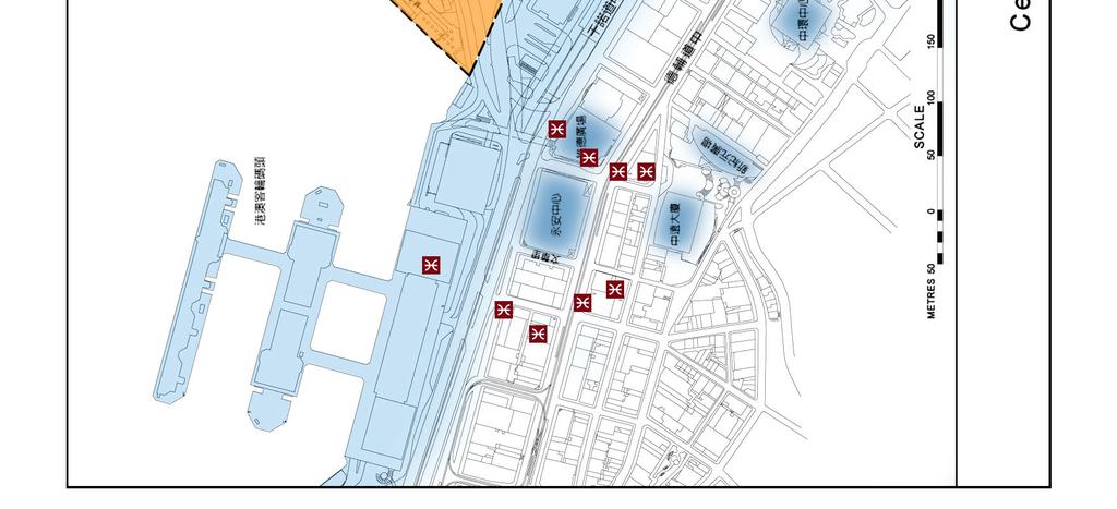
17 Appendix I Map of Study Area 16
Sub-committee on Harbour Plan Review of Harbour-front Enhancement Committee. Ninth Meeting
 Sub-committee on Harbour Plan Review of Harbour-front Enhancement Committee Ninth Meeting Date: 5 October 2005 Time: 3:30pm Venue: Conference Room 15/F, North Point Government Offices, 333 Java Road, North
Overview of Land Use Framework for Victoria Harbourfront. Planning Department February 2011
 Overview of Land Use Framework for Victoria Harbourfront Planning Department February 2011 Background TPB set out Vision Statement for the Victoria Harbour in 1999 To make Victoria Harbour attractive,
Task Force on Kai Tak Harbourfront Development
 Task Force on Kai Tak Harbourfront Development For discussion on 29 March 2018 TFKT/04/2018 Study of Kai Tak Promenade Design Control and Guidelines Conceptual design scheme for Promenade at Runway Precinct
Task Force on Harbourfront Developments in Kowloon, Tsuen Wan and Kwai Tsing
 Task Force on Harbourfront Developments in Kowloon, Tsuen Wan and Kwai Tsing For discussion on 2 June 2016 TFK/03/2016 AMENDMENTS TO THE APPROVED TSUEN WAN OUTLINE ZONING PLAN NO. S/TW/31 PURPOSE This
Harbour-front Enhancement Committee. Urban Design Study for the New Central Harbourfront Revised Planning and Urban Design Concepts
 Harbour-front Enhancement Committee Paper No. 5/2010 For discussion on 18 February 2010 Urban Design Study for the New Central Harbourfront Revised Planning and Urban Design Concepts Purpose 1. This Paper
Task Force on Harbourfront Developments on Hong Kong Island. Hong Kong Island East Harbour-front Study
 For discussion on 30 August 2011 Hong Kong Island East Harbour-front Study PURPOSE The purpose of this paper is to seek Members views on the recommended enhancement proposals formulated under the Hong
Task Force on Kai Tak Harbourfront Development. Station Square at Kai Tak
 For discussion on 24 February 2017 Station Square at Kai Tak PURPOSE This paper seeks Members views on the design of the Station Square at Kai Tak. BACKGROUND 2. Upon the relocation of the Hong Kong International
Task Force on Kai Tak Harbourfront Development
 Task Force on Kai Tak Harbourfront Development For discussion on 1 September 2014 TFKT/08/2014 Kai Tak Development Proposal of Increasing Development Intensity and Findings of Technical Study PURPOSE This
Harbour-front Enhancement Committee. Wan Chai Development Phase II. Planning and Engineering Review
 Paper No. 4/2004 For discussion on 6 May 2004 Harbour-front Enhancement Committee Wan Chai Development Phase II Planning and Engineering Review PURPOSE This paper briefs Members on the scope, approach,
WELLINGTON STREET WEST COMMUNITY DESIGN PLAN
 36 3.CDP POLICIES 37 Wellington Street West CDP Vision Statement 38 3.1 Introduction 3.1.1 Purpose The development of buildings and public spaces is influenced by a variety of factors over time. City of
HBF Marine Study: Victoria Harbour: Water dependent and water related uses and associated land/water interface implications
 HBF Marine Study: Victoria Harbour: Water dependent and water related uses and associated land/water interface implications Presentation on the Initial Findings 9 February 2011 Harbour Business Forum Background
TABLE OF CONTENTS CHAPTER TITLE PAGE DECLARATION DEDICATION ACKNOWLEDGEMENTS ABSTRACT ABSTRAK
 vii TABLE OF CONTENTS CHAPTER TITLE PAGE DECLARATION DEDICATION ACKNOWLEDGEMENTS ABSTRACT ABSTRAK TABLE OF CONTENTS LIST OF FIGURES LIST OF TABLES LIST OF ACROYMS LIST OF APPENDIXES ii iii iv v vi vii
The Proposed Auckland Unitary Plan (notified 30 September 2013)
") 3 Business zones Introduction There are 10 business zones in the Unitary Plan: City Centre Metropolitan Centre Town Centre Local Centre Neighbourhood Centre Mixed Use General Business Business Park Light
3 Business zones Introduction There are 10 business zones in the Unitary Plan: City Centre Metropolitan Centre Town Centre Local Centre Neighbourhood Centre Mixed Use General Business Business Park Light
Final Master Plan and Development Control Regulations
 1. INTRODUCTION CHECK LIST a. Introduction b. Table of contents c. Definitions. d. scope of works. 2. FINAL OVERALL MASTER PLAN a. SITE ANALYSIS and OVERVIEW: i. Existing and Proposed Site Plan Levels.
AMENDMENT NO. 42 TO THE OFFICIAL PLAN OF THE TOWN OF GRIMSBY
 AMENDMENT NO. 42 TO THE OFFICIAL PLAN OF THE TOWN OF GRIMSBY INITIATED BY TOWN OF GRIMSBY TABLE OF CONTENTS PART I: THE CERTIFICATION Certification Page Adopting By-law of the Town of Grimsby PART II:
URBAN DESIGN STUDY FOR THE WAN CHAI NORTH AND NORTH POINT HARBOURFRONT AREAS FEASIBILITY STUDY
 Agreement No. CE 54/2014 (TP) Meeting with Task Force on Harbourfront Developments on HK Island 10 Feb 2015 2 CONTENTS STUDY TEAM STUDY METHODOLOGY & APPROACH STUDY PROGRAMME KEY ISSUES Study Team Organization
Policies and Code Intent Sections Related to Town Center
 Policies and Code Intent Sections Related to Town Center The Town Center Vision is scattered throughout the Comprehensive Plan, development code and the 1994 Town Center Plan. What follows are sections
Wan Chai Development Phase II Planning and Engineering Review
 Annex A to Paper No. 4/2004 Supplemental Agreement No. 1 to Agreement No. CE 54/2001 (CE) Wan Chai Development Phase II INCEPTION REPORT April 2004 MAUNSELL CONSULTANTS ASIA LTD Wan Chai Development Phase
Page 1 of 19 URBAN DESIGN FRAMEWORK FOR BOLTON STREET WATERFORD
 Page 1 of 19 URBAN DESIGN FRAMEWORK FOR BOLTON STREET WATERFORD 1.0 Introduction: The relocation of the City Council stores and depot from Bolton Street creates an exciting opportunity for development
Welcome. Community Consultation Meeting November 28, Review and discuss the Bathurst Quay Neighbourhood Plan Framework
 Welcome Community Consultation Meeting November 28, 2016 Why Are We Here Today? Review and discuss the Bathurst Quay Neighbourhood Plan Framework Review and discuss an Action Plan for Implementation Next
Market Place Bythell Place Queen Street Park Riverside Park. Public Spaces. Blenheim CBD Streetscape Final Report 36
 37 39 41 43 Market Place Bythell Place Queen Street Park Riverside Park Final Report 36 Market Place Market Place is a key space for Blenheim s street life, it is a meeting place, retail edge and pedestrian
Mark-up of the effect of the proposed Bronte Village Growth Area OPA No.18 on the text of section 24, Bronte Village, of the Livable Oakville Plan
 Mark-up of the effect of the proposed Bronte Village Growth Area OPA No.18 on the text of section 24, Bronte Village, of the Livable Oakville Plan Notes: This document is provided for information purposes
Colchester Northern Gateway Master Plan Vision Review Draft. July 2016
 Colchester Northern Gateway Master Plan Vision Review Draft July 2016 Contents Introduction 4 Context 8 Purpose of the Report 8 Strategic Position 9 Overview of the Process 11 2012 Master Plan Vision 12
The Chinese University of Hong Kong Campus Master Plan Stage 3 Stakeholders' Engagement Report
 The Chinese University of Hong Kong Campus Master Plan Stage 3 Stakeholders' Engagement Report CONTENTS 1.0 OVERVIEW... 2 2.0 KEY FINDINGS... 3 2.1 Conserving Places of Value... 3 2.2 Places for Academic
Chapter 2: OUTLINE PLANNING APPLICATION PROPOSALS. A New Garden Neighbourhood Matford Barton 17
 Chapter 2: OUTLINE PLANNING APPLICATION PROPOSALS A New Garden Neighbourhood Matford Barton 17 2.1. SUMMARY AND STATUS OF THE PROPOSALS 2.1.1. The parameter plans and associated wording in this chapter
4.0 Design Guidelines For The Village Centre. South fields Community Architectural Design Guidelines Town of Caledon
 4.0 Design Guidelines For The Village Centre 4.0 Design Guidelines for the Village Centre The Village Centre is the focal point of the entire South Fields Community and is designed as a traditional commercial
4 RESIDENTIAL ZONE. 4.1 Background
 4 RESIDENTIAL ZONE 4.1 Background The residential areas within the City are characterised by mainly lowrise dwellings sited on individual allotments. Past architectural styles, settlement patterns and
Task Force on Kai Tak Harbourfront Development. Update on Implementation of Public Creatives in Kai Tak Development
 Task Force on Kai Tak Harbourfront Development For information on 24 February 2017 TFKT/05/2017 Update on Implementation of Public Creatives in Kai Tak Development PURPOSE This paper updates Members on
Task Force on Harbourfront Developments on Hong Kong Island
 Task Force on Harbourfront Developments on Hong Kong Island For discussion TFHK/10/2016 On 25 May 2016 PURPOSE This paper seeks Members views on the reprovisioning of Tin Chiu Street Playground (TCSP)
Chapter 5 Urban Design and Public Realm
 5.1 Introduction Public realm is all areas of the urban fabric to which the public have access. It is where physical interaction takes place between people. It therefore, includes buildings and their design,
Urban Design Brief 1576 Richmond Street City of London
 Urban Design Brief City of London Treadstone Developments October 31, 2014 Urban Design Brief October 31, 2014 TABLE OF CONTENTS Page No. INTRODUCTION... 1 SECTION 1 LAND USE PLANNING CONCEPT... 1 1.1
Urban Design Brief December 23, 2015 Southside Construction Group Official Plan & Zoning By-Law Amendment
 Urban Design Brief Proposed Official Plan & Zoning By-Law Amendment 3244, 3263 and 3274 Wonderland Road South Southside Group December 23, 2015 TABLE OF CONTENTS Page No. INTRODUCTION... 1 SECTION 1 LAND
Complete Neighbourhood Guidelines Review Tool
 Complete Neighbourhood Guidelines Review Tool Prepared By: City of Regina Planning Department October 2014 Page 1 of 14 Community Development Review Checklist for Secondary Plans and Concept Plans The
Workshop 3. City of Burlington Waterfront Hotel Planning Study. September 14, The Planning Partnership
 Workshop 3 City of Burlington Waterfront Hotel Planning Study September 14, 2017 The Planning Partnership The Waterfront Hotel Planning Study 01 The Brant & Lakeshore Planning Study will establish a Strategic
SUBJECT: Waterfront Hotel Planning Study Update TO: Planning and Development Committee FROM: Department of City Building. Recommendation: Purpose:
 Page 1 of Report PB-23-18 SUBJECT: Waterfront Hotel Planning Study Update TO: Planning and Development Committee FROM: Department of City Building Report Number: PB-23-18 Wards Affected: 2 File Numbers:
Port Lavaca Future Land Use
 Port Lavaca Future Land Use Introduction The City of Port Lavaca is beginning to see sustained growth, after many years of relative stable population. New single family homes, apartments, and businesses
HARBOUR-FRONT ENHANCEMENT REVIEW WAN CHAI, CAUSEWAY BAY & ADJOINING AREAS REALIZATION STAGE
 HARBOUR-FRONT ENHANCEMENT REVIEW WAN CHAI, CAUSEWAY BAY & ADJOINING AREAS REALIZATION STAGE SUPPLEMENTARY DOCUMENT October 2006 MAUNSELL CONSULTANTS ASIA LTD HARBOUR-FRONT ENHANCEMENT REVIEW WAN CHAI,
I615. Westgate Precinct
 I615. Westgate Precinct I615.1. Precinct Description The Westgate Precinct is located approximately 18km west of the Auckland city centre. There are seven Sub-precincts in the Westgate Precinct: Sub-precinct
Task Force on Harbourfront Developments on Hong Kong Island
 Task Force on Harbourfront Developments on Hong Kong Island For discussion on 10 May 2012 TFHK/04/2012 Proposed Composite Hotel, Residential and Public Open Space Development In Comprehensive Development
Urban Design Manual PLANNING AROUND RAPID TRANSIT STATIONS (PARTS) Introduction. Station Study Areas
 Introduction. Station Study Areas") 111111 PLANNING AROUND RAPID TRANSIT STATIONS (PARTS) Introduction The ION rapid transit system will link Waterloo, Kitchener and Cambridge through a central transit corridor (CTC). There are a number
111111 PLANNING AROUND RAPID TRANSIT STATIONS (PARTS) Introduction The ION rapid transit system will link Waterloo, Kitchener and Cambridge through a central transit corridor (CTC). There are a number
SECTION 7A: WHAKARONGO RESIDENTIAL AREA
 SECTION 7A: WHAKARONGO RESIDENTIAL AREA CONTENTS 7A.1 Introduction 1 7A.2 Resource Management Issues 1 7A.3 Objectives and Policies 1 7A.4 Methods 4 7A.5 Residential Zone 4 7A.5.1 Rules: Controlled Activities
141 GEORGE STREET PLANNING RATIONALE
 141 GEORGE STREET PLANNING RATIONALE MINOR ZONING BY-LAW AMENDMENT NOVEMBER 2, 2016 PLANNING RATIONALE 223 McLeod Street Ottawa, ON K2P 0Z8 613.730.5709 fotenn.com INTRODUCTION FOTENN Consultants is acting
City of Farmington. Downtown Plan. Amendment to the 1998 Master Plan Adopted October 11, 2004
 City of Farmington Amendment to the 1998 Master Plan Adopted October 11, 2004 Introduction Planning Background 1 Scope and Components of the Plan Amendment 2 Concept Introduction 3 Plan Concepts 3 Conceptual
PUBLIC HEARING May 18, 2010 SUMMARY AND RECOMMENDATION
 PUBLIC HEARING May 18, 2010 SUMMARY AND RECOMMENDATION 7. REZONING: 5912-5970 Oak Street Summary: To rezone from RS-1 (single-family) to Comprehensive Development (CD-1) District to permit a 27-unit townhouse
THE GARDEN CITY PLAN. City of St. Catharines Official Plan. City of St. Catharines
 THE GARDEN CITY PLAN City of St. Catharines Official Plan City of St. Catharines August 2010 APPROVAL INFORMATION This Official Plan of the City of St. Catharines Planning Area, known as the Garden City
ELMVALE ACRES SHOPPING CENTRE MASTER PLAN
 ELMVALE ACRES SHOPPING CENTRE MASTER PLAN Contents 1.0 INTRODUCTION... 2 2.0 LOCATION... 2 3.0 EXISTING CONTEXT... 2 4.0 VISION & GUIDING PRINCIPLES... 2 5.0 LAND USE AND BUILT FORM... 4 5.1 St. Laurent
Courthouse Square Planning & Urban Design Study. Courthouse Square Working Group #13 October 15, 2014
 Courthouse Square Planning & Urban Design Study Courthouse Square Working Group #13 October 15, 2014 1 Courthouse Square Process Working Group Community Courthouse Square Advisory Groups & Civic Associations
Design Guidance. Introduction, Approach and Design Principles. Mauritius. November Ministry of Housing and Lands. .. a
 sig evelo r D Mauritius s. Utilities.. Individu a s. er itects.to ls chpers.po e Public. T. h rban D Sc U e me Promot e h ners. A Design Guidance o.h Planne rs n w iticians r l useholde National Development
New-Cast Mixed-use Development Proposal King Street West, Newcastle, Ontario
 URBAN DESIGN BRIEF New-Cast Mixed-use Development Proposal King Street West, Newcastle, Ontario TABLE OF CONTENTS: 1.0 Executive Summary 2.0 Creating Vibrant and Sustainable Urban Places: Excerpts from
EXISTING COMPREHENSIVE PLAN
 EXISTING COMPREHENSIVE PLAN Town Center Land Use Element: V. LAND USE POLICIES Town Center Mercer Island's business district vision as described in "Your Mercer Island Citizen-Designed Downtown" was an
Contents of Part 6. Part 6 Zones
 Contents of Part 6 Part 6 Zones... 6-1 6.1 Preliminary... 6-1 6.2 Zone codes... 6-3 6.2.1 Low density residential zone code... 6-3 6.2.1.1 Application... 6-3 6.2.1.2 Purpose and overall outcomes... 6-3
Vision for East Cowes
 Vision for East Cowes A better East Cowes for now and the future The East Cowes Regeneration project is a major regeneration scheme on the Isle of Wight. It will create a vibrant community with a long-term
Hockessin Community Redevelopment Plan
 Hockessin Community Redevelopment Plan 3.1 Introduction The Community Redevelopment Plan for the Village of Hockessin is the result of the people s vision for a distinct village center that serves as the
URBAN DESIGN BRIEF URBAN DESIGN BRIEF 721 FRANKLIN BLVD, CAMBRIDGE August 2018
 URBAN DESIGN BRIEF URBAN DESIGN BRIEF 721 FRANKLIN BLVD, CAMBRIDGE August 2018 DESIGN BRIEF CONTENTS PART A 1.0 INTRODUCTION 2.0 DESCRIPTION & ANALYSIS OF SITE CONTEXT 3.0 DESIGN CONSTRAINTS AND OPPORTUNITIES
Task Force on Water-land Interface
 Task Force on Water-land Interface For discussion on 2 June 2016 TFWL/02/2016 An Overview of Railing Design along Victoria Harbourfront PURPOSE This paper gives Members an overview of the design of existing
JACKsON STREET PIER CONCEPTUAL DESIGN PACKAGE SEPTEMBER 21, 2017
 JACKsON STREET PIER CONCEPTUAL DESIGN PACKAGE SEPTEMBER 21, 2017 JACKsON STREET PIER Process outline DESIGN PROCESS OVERVIEW: Sandusky s Jackson Street Pier Conceptual Design process included input from
Preliminary Land Use Proposal for the Western Part of Kennedy Town Task Force on Harbourfront Developments on Hong Kong Island
 Preliminary Land Use Proposal for the Western Part of Kennedy Town Task Force on Harbourfront Developments on Hong Kong Island 2013.6.7 Planning Department Review Area Review Area WIL s works area Bus
APPENDIX C. Architectural and Environmental Design Standards. Environmentally sensitive areas should be protected.
 APPENDIX C Architectural and Environmental Design Standards Environmentally Sensitive Areas Goal A. Environmentally sensitive areas should be protected. Development, such as roads, houses, and other structures,
VEHICULAR AND PEDESTRIAN CIRCULATION
 This perspective sketch communicates the intended character and quality of a proposed streetscape design. Locate benches near a major intersection where people tend to gather. Seating and lighting provide
MAGALIESBURG DEVELOPMENT INITIATIVE (MDI)
") INTRODUCTION The recently launched Magaliesburg Development Initiative (MDI) is a combination of technical and professional input based on an approved municipal precinct plan, a deliberate emphasis on
INTRODUCTION The recently launched Magaliesburg Development Initiative (MDI) is a combination of technical and professional input based on an approved municipal precinct plan, a deliberate emphasis on
10.0 Open Space and Public Realm
 10.0 Open Space and Public Realm 10.0 Open Space and Public Realm The Public Open Space System is comprised of: outdoor spaces available for public use that are either publicly owned (e.g., parks and
Tauranga City Centre Spatial Framework
 Tauranga City Centre Spatial Framework Stakeholder Engagement Workshop 15 October 2015 Project Design Team Beca & LandLAB Our team Henry Crothers (LandLab) Landscape Architect/Urban Designer Urban and
Denton. A. Downtown Task Force
 2 Public Involvement Early and ongoing public involvement was solicited so that the public had ample opportunity to help direct the DTIP s concepts and implementation strategies. The residents of Denton
FLORIN ROAD CORRIDOR Site Plan and Design Review Guidelines Checklist
 FLORIN ROAD CORRIDOR Site Plan and Design Review Guidelines Checklist Applicant s Name: Project Address: Phone: Email: Applicant shall fill out the design guidelines checklist for all guidelines applicable
Kai Tak Development Proposal of Increasing Development Intensity and Findings of Technical Study. PlanD CEDD GPA IRD ArchSD
 Kai Tak Development Proposal of Increasing Development Intensity and Findings of Technical Study PlanD CEDD GPA IRD ArchSD Overview of Kai Tak Former North Apron Kai Tak Land Use Plan Kowloon Bay To Kwa
Courthouse East vision and policy plan
 August 2017 Courthouse East vision and policy plan Virginia Beach, Virginia 2017 URBAN DESIGN ASSOCIATES SITE PLANNING APPROACH 10-minunte walk from the Courthouse COURTHOUSE EAST IN THE ITA VICINITY Site
Sheridan Boulevard S TAT I O N A R E A P L A N S H E R I D A N B O U L E VA R D S TAT I O N A R E A P L A N
 Sheridan Boulevard S TAT I O N A R E A P L A N 1 City of Lakewood Adopted November, 2006 S H E R I D A N B O U L E VA R D S TAT I O N A R E A P L A N The Vision The City of Lakewood s overall vision is
PHASE ONE. A summary report: What the community told Alcoa during Phase One of the community engagement program for Point Henry 575.
 PHASE ONE A summary report: What the community told Alcoa during Phase One of the community engagement program for Point Henry 575. DECEMBER 2015 FEBRUARY 2016 INTRODUCTION In 2014 Alcoa closed its Point
Town Center (part of the Comprehensive Plan)
") Town Center (part of the Comprehensive Plan) Mercer Island Town Center Looking North (2014) In 1994, a year-long process culminated in a set of design guidelines and code requirements for the Town Center
Town Center (part of the Comprehensive Plan) Mercer Island Town Center Looking North (2014) In 1994, a year-long process culminated in a set of design guidelines and code requirements for the Town Center
Clairtrell Area Context Plan
 Clairtrell Area Context Plan March 2005 Urban Development Services City Planning Contents 1. Introduction... 4 2. Development Structure... 6 2.1 Streets... 7 2.1.1 Sheppard Avenue and Bayview Avenue...
VANCOUVER CONVENTION AND EXHIBITION CENTRE (VCEC) CD-1 GUIDELINES THURLOW STREET. Adopted by City Council November 5, 2002
 CD-1 GUIDELINES THURLOW STREET. Adopted by City Council November 5, 2002") $2 Land Use and Development Policies and Guidelines Community Services, 453 W. 12th Ave Vancouver, BC V5Y 1V4 F 604.873.7344 fax 873.7060 planning@city.vancouver.bc.ca VANCOUVER CONVENTION AND EXHIBITION
$2 Land Use and Development Policies and Guidelines Community Services, 453 W. 12th Ave Vancouver, BC V5Y 1V4 F 604.873.7344 fax 873.7060 planning@city.vancouver.bc.ca VANCOUVER CONVENTION AND EXHIBITION
Woodbrook - Shanganagh
 Section 4: Key Sites Framework Strategy Woodbrook - Shanganagh Local Area Plan 2017-2023 4. Site Framework Strategies The Master Plans shall have regard to the thematic objectives under the LAP Development
URBAN DESIGN BRIEF REPORT
 URBAN DESIGN BRIEF REPORT PREPARED FOR 2568401 ONTARIO INC NEW GASBAR, CONVENIENCE STORE & CARWASH DEVELOPMENT @ 1509 FANSHAWE PARK ROAD WEST LONDON, ONTARIO GAMA ENGINEERING INC. PROJECT NUMBER 1669 PREPARED
Notes. Schedule of Uses. Explanatory Statement
 HONG KONG PLANNING AREA NO.25 DRAFT WAN CHAI NORTH OUTLINE ZONING PLAN NO. Notes Schedule of Uses Explanatory Statement HONG KONG PLANNING AREA NO.25 DRAFT WAN CHAI NORTH OUTLINE ZONING PLAN NO. (Being
Executive Summary. NY 7 / NY 2 Corridor
 Executive Summary NY 7 / NY 2 Corridor Transportation and Land Use Study December 2005 Prepared for: Town of Colonie Capital District Transportation Committee Prepared by: Introduction: Land use decisions
Pedestrian and Bike Bridge LOGO
 6.2.2 Pedestrian and Bike Bridge The proposed pedestrian and bike crossing re-envisions the existing bridge at Pismo Creek on Cypress Street. The bridge is currently underutilized by vehicular through
5.1 Site Plan Guidelines
 5. Community Core Guidelines Development of the Community Core will take place by plan of subdivision and site plan approval. It will occur in a phased manner that will reflect the timing of residential
Westwind Developments Ltd. PIONEER LANDS AREA STRUCTURE PLAN - PROPOSED AMENDMENT
 FEBRUARY 2013 TABLE OF CONTENTS 1.0 BACKGROUND... 1 1.1 Amendment... 1 2.0 LOCATION & CONTEXT... 2 2.1 Land Ownership... 2 3.0 POLICY CONTEXT... 3 3.1 Municipal Development Plan... 3 3.2 Capital Region
Task Force on Harbourfront Developments in Kowloon, Tsuen Wan and Kwai Tsing. Renovation of the Hong Kong Museum of Art
 For discussion on 16 May 2013 Renovation of the Hong Kong Museum of Art I. PURPOSE This paper seeks Members comments on and support for the renovation plan for the Hong Kong Museum of Art (HKMA), which
WELLINGTON HOSPITAL DESIGN GUIDE TABLE OF CONTENTS
 WELLINGTON HOSPITAL DESIGN GUIDE TABLE OF CONTENTS 1.0 Introduction Page 2 The Place of Wellington Hospital 2 The Future of the Hospital 2 2.0 The Intention of the Design Guide 3 3.0 Analysis 4 General
Town of Cobourg Heritage Master Plan. Statutory Public Meeting
 Town of Cobourg Heritage Master Plan Statutory Public Meeting April 25 th 2016 Presentation Overview 1. Introduction 2. Project background and schedule overview 3. Review of strategic direction content
Strategic Environmental Assessment Screening Report. Dublin Port Masterplan Review 2017
 Strategic Environmental Assessment Screening Report Dublin Port Masterplan Review 2017 Table of Contents 1 Introduction... 1 2 Purpose of the Masterplan... 2 3 Task 1.1 Pre-Screening Check... 5 4 Task
Table 8-4: Road Classification Local Roads, second table, of Chapter 8 Create a Multi-Modal City, be amended by adding the following:
 1 Port Street East Official Plan Amendment APPENDIX 3 Amendments to Mississauga Official Plan Table 8-4: Road Classification Local Roads, second table, of Chapter 8 Create a Multi-Modal City, be amended
3 Summary of Major Views and Responses
 3 Summary of Major Views and Responses 3.1 Major Views 3.1.1 The comments and suggestions received from various channels and parties during the two-month Stage 1 PE on the Study, which have been discussed
TABLE OF CONTENTS 1.0 INTRODUCTION... 3
 TABLE OF CONTENTS 1.0 INTRODUCTION... 3 1.1. BACKGROUND... 3 1.2. THE PROPOSAL... 5 2.0 EXISTING POLICY FRAMEWORK... 5 2.1. PROVINCIAL POLICY STATEMENT (PPS)... 5 2.2. CITY OF LONDON OFFICIAL PLAN (OP)...
section THREE: DISTRICTS districts
 section THREE: DISTRICTS districts 3 INTRODUCTION The Downtown Core Area Plan establishes five Downtown Core Area Districts. As stated in the Introduction, these new Districts do not replace existing neighbourhood
REMARKABLES PARK ZONE
 .10 Remarkables Park Zone.10.1 Resources, Activities and Values The Remarkables Park Area comprises approximately 150 hectares of perimeter urban land in the vicinity of Frankton and occupies a strategic
2017 STRATEGIC PLAN CITY OF ST. AUGUSTINE
 2017 STRATEGIC PLAN CITY OF ST. AUGUSTINE WHO WE ARE CITY OF ST. AUGUSTINE VISION St. Augustine will be a diverse, livable, authentic waterfront city that builds upon its rich history and environment to
THAT the attached Terms of Reference for the Thornhill Centre Street Study be approved.
 COMMITTEE OF THE WHOLE AUGUST 18, 2003 THORNHILL CENTRE STREET STUDY PLANNING FILE: 15.92 Recommendation The Commissioner of Planning recommends: THAT the attached Terms of Reference for the Thornhill
SUBJECT: Proposed Downtown Mobility Hub Precinct Plan and Proposed Official Plan Policies
 Page 1 of Report PB-81-17 SUBJECT: Proposed Downtown Mobility Hub Precinct Plan and Proposed Official Plan Policies TO: FROM: Committee of the Whole Planning and Building Department Report Number: PB-81-17
V. Vision and Guiding Principles
 V. Vision and Guiding Principles The Master Plan for the Powers Ferry Corridor seeks a foundation in the desires of the community. At times, various elements of the community offered opposing viewpoints,
EVALUATION OF MASTER PLAN ALTERNATIVES
 7 The Environmental Report is required to identify, describe and evaluate reasonable alternatives, taking into account the objectives and geographical scope of the Master Plan 2008. Three plan alternatives
LUNDY S LANE COMMUNITY IMPROVEMENT PLAN STUDY
 PUBLIC INFORMATION MEETING #2 October 12, 2016 LUNDY S LANE COMMUNITY IMPROVEMENT PLAN STUDY AGENDA 5:00 to 5:30pm: Open House 5:30 to 6:15pm: Presentation 6:15 to 7:00pm: Individual paced workshop with
DRAFT Northeast Quadrant of Kipling Avenue and Highway 7 DRAFT AUGUST 29, Goals Land Use. The goals of this Plan are to:
 AUGUST 29, 2017 12.15 Northeast Quadrant of Kipling Avenue and Highway 7 12.15.1 Goals 12.15.2 Land Use The goals of this Plan are to: 12.15.2.1 General Provisions: a) Ensure the development of a compact
Midtown Greenway Land Use and Development Plan Executive Summary
 Midtown Greenway Land Use and Development Plan Executive Summary Introduction The Midtown Greenway Land Use and Development Plan sets policy direction for land use and development in the Midtown Greenway
2A District-wide Policies
 2A Introduction This Chapter contains policies which are relevant to subdivision, use and development activities occurring across all zones and areas of the District. The policies in this Chapter implement
2.1 Location and Size
 2.0 Context 7 2.1 Location and Size The Saanich Penninsula The study area is centrally located within the Town boundaries on the east side of Highway 17, which runs through Sidney in a north-south direction.
Welcome. Walk Around. Talk to Us. Write Down Your Comments
 Welcome This is an information meeting introducing the applications for proposed redevelopment of the Yorkdale Shopping Centre site at 3401 Dufferin Street and 1 Yorkdale Road over the next 20+ years,
ANCHOR TO ANCHOR. Rescale the street to create an iconic boulevard.
 ANCHOR TO ANCHOR Rescale the street to create an iconic boulevard. UR NE ER UV GO NE LA OBJECTIVES 1. Maintain appropriate traffic flow and prioritize commercial curb access 2. Mark gateways at the street
Appendix D: Rockbank Major Town Centre key design principles
 Appendix D: Rockbank Major Town Centre key design principles ATTRACTING INVESTMENT & SUPPORTING THE COMMUNITY Principle 1 Create a focal point for a diverse range of uses within the town centre that are