West 38th Avenue Alternative Concept Streetscape Design Summary Booklet
|
|
|
- Myron Ferguson
- 5 years ago
- Views:
Transcription

1 West 38th Avenue Alternative Concept Streetscape Design Summary Booklet Wheat Ridge, CO November th Avenue Streetscape Concept Design 1
2 2
3 Acknowledgements City of Wheat Ridge The following departments were involved with the process: Public Works Community Development Economic Development Parks and Recreation Consultants Entelechy - Denver, CO Table of Contents Introduction 1 Public Input Process 2 Design Inspiration 10 Alternative Kit-of-Parts 14 Alternative Concept Designs 17 Signage 37 Public Art 39 Parking 40 Thanks to the Ridge at 38 Leadership Committee, property and business owners, Wheat Ridge 2020, and the general public for their input through this process. 38th Avenue Streetscape Concept Design 3
4 4


 since summer of 2012.")
5 Introduction Purpose The West 38th Avenue Streetscape Concept Design Project (Project) is intended to refine the ideas presented in the 38th Avenue Corridor Plan adopted by the City of Wheat Ridge in The Project focuses on 38th Avenue between Pierce Street on the east and Upham Street on the West within the Main Street Sub-District identified in the Corridor Plan. The Project provides alternative conceptual streetscape designs for full rebuild of this section of 38th Avenue to support the continued renewal along this street as the hub of the community s downtown. The Project s starting point was the preferred street sections identified in the Corridor Plan. These preferred street sections presumed a three-lane roadway section and significantly improved back of curb environment that accommodated a continuous sidewalk and provided for an amenity zone along the street. The three-lane roadway section has been in place in a retrofit condition (restriping of the street without moving the curbs) since summer of Right-of-Way Preferred Section from the Corridor Plan West 38th Avenue Corridor Plan 70 Right-of-Way Preferred Section from the Corridor Plan 38th Avenue Corridor Plan Adopted October th Avenue Streetscape Concept Design 1

6 The West 38th Avenue Main Street Commercial District Brand and Marketing Strategy process completed in 2012, and recommended in the Corridor Plan, resulted in the Ridge at 38 brand, which was acknowledged and utilized in this design process. Final Logo from the Brand and Marketing Strategy Process The design process began in July of 2013 and was a partnership between a consulting firm (Consultant) and City staff, led by the Public Works department and in collaboration with the Community Development, Parks and Recreation and Economic Development departments. The process included a public meeting, an online image preference survey, several work sessions with City staff, blockby-block meetings with property and business owners, and a presentation and discussion with the Ridge at 38 Leadership Committee. The alternative streetscape designs, related design concepts (such as signage) and input from this process will be considered by City Council for determination of next steps. When a preferred design direction and schedule for desired implementation is established, a formal civil survey of the Project area needs to be completed. This survey will provide the detailed existing conditions base from which schematic design, design development and construction documentation of the street and streetscape design can take place. Public Input Process Public Meeting Approximately 41 individuals attended a public meeting held on Thursday, July 25th, 2013 from 5-7 pm at the Wheat Ridge Recreation Center. At the meeting. City staff provided an overview of mobility and economic statistics of the corridor since the retrofit road diet (street restriping) and other improvements such as retrofit amenity zones (temporary patios in front of the curb) have been installed. Next, City staff and the Consultant provided an overview of the purpose and focus of this Conceptual Streetscape Design Project, solicited questions from the audience, and provided answers. More one-on-one conversations with participants also took place and attendees were asked to complete an image preference survey (see next section). Generally, the verbal feedback included both attendees that were supportive of the changes and direction for 38th Avenue, and attendees that were not. The following written comments were received during the public meeting: I like the plan as it is now on 38th best. The prototypical plan for 60 and 70 w/ parallel on 1 side is better than the old 5 lane 38th. The old 38th 5 lane was worst. Love the bike lanes! Go by bike! Make it and they will come: more bike/ped facilities. No congestion, no pollution. Health = wealth. Bike lanes are awesome. I like the revitalization I am seeing on 38th. However it is extremely difficult crossing 38th on foot. I cross at Newland St. I support current change on 38th. Bike lanes are critical to what is trying to be accomplished. Make them a permanent part of 38th Ave. Connect them to Pierce. Encourage walkability / bikeability. I use the bike lanes on 38th twice per day and would love them to stay, but realize the amenity zones are a higher priority. Regarding the butterfly bench (image from image preference survey), which was my least favorite I actually like the idea of unique benches, which could be a trademark of a new 38th Ave., but not that butterfly. Maybe leaves or wheat on an artsy bench. It seems what we are lacking a fundamental anchor for the main street corridor no public gathering areas. Surely the huge parking lot at the middle school could be used as a public area? Food check. Shopping check. Free community fun lacking (Park? Water features for kids? Gazebo/town square?) In general love the concept. Please change the back-in parking! Eliminate pop-up cafes where it is actually dangerous. Only concern is how to make 38th a consistent cohesive corridor not the same all thru but consistent. We need available parking for business. What turns me off is when I can t find a place to park to go to a business so at times I will skip that shop. More advance notice for the meeting would be nice. Starting at 5pm is more difficult for working people. Thanks! 2


, rather than to select specific fixtures.")
 preferred parallel parking.")
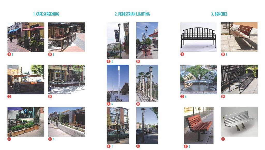
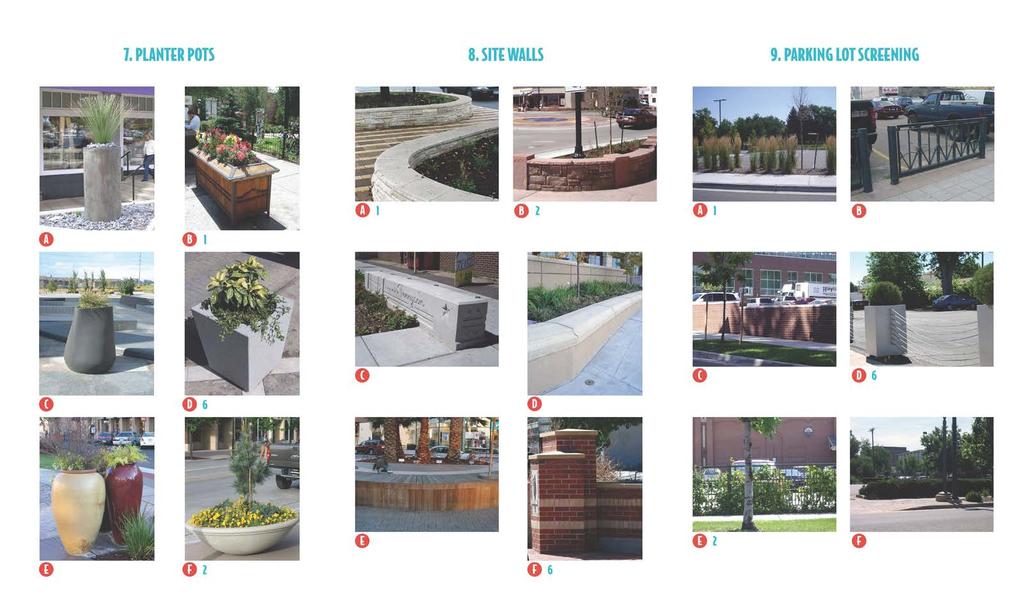
7 Image Preference Survey As a follow-up to the public meeting, the same image preference survey was available for 17 days, from July 25th to August 11th, In addition to the online survey, the information was made also available in hard-copy format. Of the 360 participants who started the online survey, 330 people completed it. The first nine questions related to kit-of-parts images - the components typically seen in a streetscape, such as pedestrian lighting or benches. Participants were asked to rank the images in each category from most to least desirable. The survey results were utilized to identify preferred themes for conceptual designs (e.g. traditional v modern), rather than to select specific fixtures. The last question in the survey related to parking preferences, and asked if respondents preferred back-in angled parking on one side of the street or parallel parking on both sides. Sixty-six percent (66%) preferred parallel parking. The following pages show the kit-of-part images that were included in the image preference survey. The ranking results are indicated by the blue numbers; 1 and 2 represent the first and second highest preferred element within a category, while number 6 represents the least preferred. 38th Avenue Streetscape Concept Design 3
8 4

9 38th Avenue Streetscape Concept Design 5
10 6

11 Block-by-Block Meetings Block-by-block property owner and tenant meetings were held on Thursday, September 5th, Four sessions were scheduled to provide more intimate conversations between participants, City staff and the Consultant. Over 25 participants attended. Comments/questions from the block-by-block meetings included: Question about bike lanes being removed. Question about moving banner poles west in the future to attract traffic from Wadsworth. Thinks the curb cut consolidation at (their) property is a good idea; noted that there is a lot going on in that area and it was better/ cleaner/less confusing with fewer distractions/options. Wanted to maximize the sidewalk area in front of 7200 to allow outdoor cafes, including potentially removing parallel parking. Question about how existing trees will be handled. Wanted to ensure that new trees don t block businesses. Hates cutting mature/healthy trees, but sees there may be merit in removing older trees in order to achieve the desired aesthetic and cadence. Supports the design and wants to make sure the pedestrian crossings are as safe as possible (sees kids using the new beacon). Question about the timeline for the project. Question about pre-striping parking counts compared to proposed parking counts. Question regarding snow plowing. Treasure Trunk has donations that come in the east entrance and go to the east side of the building; she s okay with the reconfigured parking lot if the donation truck can still navigate; current striping in the parking lot is unusual. Comment about liking the Aspen Grove planters in Littleton. Comment regarding Dave s Auto; tow trucks come into the site so the proposed curb cut consolidation may not work as shown. Compass likes the parking/curb reconfiguration in front of their property. Richard Squire wants to know if the reduction in vehicular traffic affected business; The City acknowledged a minor reduction largely in through traffic; City staff further addressed offline Invitation Created for the Block-by-Block Meetings Save the Date: 38 th Avenue Block-by-block Meetings You are receiving this invitation because you are a property owner or business owner on the Ridge at 38 between Upham and Pierce Streets. The City of Wheat Ridge Public Works Department invites you to join us to discuss the next phase of the 38 th Avenue plan implementation and the potential improvements to the street frontage at your property. Over the course of the morning, we will focus on one block at a time to review initial design concepts adjacent to your property. Please consider attending in order to provide input related to the parking, sidewalk, amenity zone, and potential opportunities for curb cut consolidation. Please refer to the schedule below for your appropriate meeting time: MEETING LOCATION * Where Vectra Bank (the NEW office location of Wheat Ridge 2020) 7391 W. 38 th Avenue, Suite 130 When Thursday, September 5, 2013 Meeting time based on property/business location: Address Meeting Time W. 38 th Ave 8:00 am 9:00 am W. 38 th Ave 9:00 am 10:00 am W. 38 th Ave 10:00 am 11:00 am W. 38 th Ave 11:00 am 12:00 pm If you are unable to attend during your scheduled time slot, we have a few 15-minute time slots that can be reserved between 12 and 1 pm. 8-9 AM 9-10 AM RSVP Requested Please RSVP to Mark Westberg or Lauren Mikulak Public Works, Project Supervisor mwestberg@ci.wheatridge.co.us phone: AM PM Community Development, Planner II lmikulak@ci.wheatridge.co.us phone: th Avenue Streetscape Concept Design 7


12 Question about bike lanes; if they are removed can the sidewalk be treated more like a multi-use trail to allow bikes? Similar to how multiuse trails around lakes are striped to separate bikes and peds. A-1 needs loading spaces; feeling frustrated that his parking spaces are used by customers of other businesses (eg Right Coast) and the spaces are full all day. Could they be signed 30min loading zone during the day? Likes the back-in spaces for loading. Russ asked about getting on-street spaces on High Court. The Bartas have two vacant store fronts and residents above; residents park in back, businesses used four spaces in the front. Request from both parties to redesign the parking to preserve more spaces along the front of the building. The reason for curb cut consolidation is to minimize conflicts with pedestrians; comment was made that the senior population doesn t prioritize walkability and wants better vehicular access to parking area. Wants to reconsider the road diet; return to four lanes? Question about emergency vehicle response times; they like having the middle turn lane which has helped with response times. Tom uses the eastern curb cut on 38th for tow trucks who pull in then out on Pierce; he is okay with an entrance only there, but doesn t want it closed permanently. Isabel would welcome a reconfiguration of her parking since there are safety issues with her clients backing into the street. Open to considering shared drive access if it improves circulation/parking. 8
13 Ridge at 38 Leadership Committee A meeting with the Ridge at 38 Leadership Committee, which was created after adoption of the Corridor Plan, was held on Wednesday, September 11th, In order to obtain feedback from this important group, the City provided an overview of the purpose of the Project and this meeting, and then the Consultant provided details on each of the two alternative conceptual streetscape designs and related design materials. Specific questions asked during the meeting are listed below along with a written answer provided by the City after the meeting: Q: Do business owners know they will be losing parking on the south side of the street? A: The block-by-block meetings held to review the conceptual designs in detail with owners/ tenants revealed parking impacts. Q: Will there be a plaza or public area? Does the plan show a public park or green space? Does it show the school as a gathering space? We need a gathering space. A: This project is focusing on the existing public right-ofway and easement along 38th Avenue. The Corridor Plan does recognize the need for gathering areas on private property, but that is outside the scope of this streetscape project. Q: Can we provide parking reservoir signage? Will the middle school parking lot be public parking? A: Parking signage and wayfinding will be part of a final streetscape design. Some shared use of the school parking lot has occurred to-date. Generally, shared use agreements are needed between the affected agencies that stipulate conditions surrounding use of parking. Q: Comment that bicyclists spend more money; can a parking space be dedicated to bike parking? A: Since there is minimal on-street parking opportunities it is probably better in this context to provide bicycle parking back of curb. Can the sidewalk be a multi-use trail? A: It is not appropriate in this context to have the sidewalk zone treated as a multi-use trail. Q: Can bike wayfinding be improved? If bike routes end at 38th can there be signs to connect bikers to parking, downtown, routes? A: Signage and wayfinding as well as bike parking reservoirs at the points where a bike facility connects with 38th will be addressed as part of the final design. Q: Is the plan discouraging cycling? A: No the alternatives are not discouraging cycling. While the City has experimented with bike lanes on 38th during the restriping pilot project, there is limited right-of-way width, and the results of the Corridor Plan prioritized sidewalk amenity zones and onstreet parking over bike facilities. Q: Is the plan showing bike reservoirs? A: Bike parking will be accommodated. Q: Is the plan showing preferred locations for public art? A: A diagram illustrating potential locations for public art is included in this document. Q: Is the plan showing bus pullouts? A: Bus pullouts are accommodated at all locations in this sub-district except at the eastbound stop at Reed Street. Q: Is the plan proposing curb cut consolidations? A: Yes. Q: Can the proposed improvements take place within existing right-of-way? A: Based on the non-survey base information utilized for this conceptual planning process, it appears that nearly all elements of the preferred street section will be accommodated within either the existing right-of-way and/or existing easements. Q: Will the flexible design result in theft or vandalism of street furniture? A: Any streetscape design/elements in the public realm are susceptible to vandalism. The flexible seating idea doesn t necessarily mean they are totally loose and movable - they could be secured. Additional comments made during this meeting and submitted afterwards by attendees included: Prefers raised planter beds. Prefers pots to planter beds. It s a shame they are doing away with them (bike lanes) on 38th Avenue. I would strongly encourage you to consider maintenance and upkeep costs and risks of theft and vandalism. While I did like the look of the flexible option, I think there are risks of it costing more long term....i like the raised planters, they are different than the grates that everyone already has, and allows landscaping under the trees. I also think the fixed furniture would be a better idea, they would stay organized and would not be stolen. Any event that I can think of can work around the fixed pieces. I like the eclectic design of the (mid) modern and the old mixed together. I am VERY excited about what they put together. They are on the right track for sure! Wants to preserve bike friendliness if bike lanes are being removed; cited example of Denver s new 15th Street Bikeway. 38th Avenue Streetscape Concept Design 9

14 Design Inspiration Design Inspiration: Shapes and Angles The creative design process began with a review of the Ridge at 38 Brand summary book, the 38th Avenue Corridor Plan, the City s Streetscape Design Manual, and other relevant documents. These processes resulted in the following five key design goals that the Consultant utilized for this Project: 1. Modern/contemporary 2. Recall Mid-Century 3. Forward thinking 4. More welcoming to younger people/families 5. Unique like no other place in Wheat Ridge and no other main street As a starting point, the Consultant focused on the first two points and collected images that represent or evoke mid-century modern design. Some of those inspiration images are shown here and on the following pages. 10

15 Design Inspiration: Colors, Patterns and Shapes 38th Avenue Streetscape Concept Design 11

16 Design Inspiration: Furniture and Fixtures - Color, Materials and Shapes 12

17 Design Inspiration: Lighting Fixtures - Style, Color and Materials 38th Avenue Streetscape Concept Design 13
18 Alternative Kit-of-Parts Based on public input and the five design goals, two alternative kit-of-parts were compiled. They both focus on recalling mid-century design themes and have a modern/contemporary and forward thinking flavor. The kits explore items such as different finishes, color palettes and approaches to lighting. The images in the kits represent a general family or character of streetscape features being considered for the street. Final fixtures, materials, colors, and finishes will be determined in the next phase of the project. 14

19 Alternative A Kit-of-Parts: A Focus on Sloping Lines, Use of Wood, Lighter Toned or Saturated Paving Colors, and More Streamlined Detailing 38th Avenue Streetscape Concept Design 15

20 Alternative B Kit-of-Parts: A Focus on Angular Lines, Use of Metal, Darker Toned or More Saturated Paving Colors, and More Embellished Detailing 16
21 Alternative Streetscape Concept Designs Overview Two Alternative Streetscape Concept Designs were completed for 38th Avenue. Both designs share the following fundamental similarities: 1. Address access enhancement Existing conditions on the corridor include a poorly defined sidewalk and a substantial number of curb cuts, some of which are very wide. Access enhancements would be mainly accomplished by sharing driveways between properties and reconfiguring off-street parking to eliminate backing into the street and across the sidewalk. This would also improve the pedestrian environment. The proposed access enhancement strategy: Provides for a continuous sidewalk Accommodates an amenity zone for nearly the entire length of the Project area Provides greater predictability for drivers entering and exiting private parking areas 2. Identify conceptual changes to on- and off-street parking configurations On-street parking is only feasible west of approximately 7060 W. 38th Avenue (approximately two parcels east of High Court), where a wider right-of-way exists. East of this point the available rightof-way narrows prohibiting the provision of on-street parking. 3. Enhance and highlight bus stop locations The following street layout plans (pages 18-20) illustrate the common elements between the alternative concept designs. The major differences between the two Alternative Concept Designs include: The differences between the two alternatives are illustrated with plans, sections and threedimensional renderings beginning on page 21. These alternatives are not mutually exclusive, specific elements within one design may be combined with an element of the other to reach a preferred direction. Conceptual level cost estimates show that to complete full street reconstruction and streetscape improvements of West 38th Avenue from Upham to Pierce would cost an estimated $5.3 to $5.6 million. 38th Avenue Streetscape Concept Design 17

22 Conceptual Layout - West Segment: 7400 to 7100 West 38th Avenue (Approximately Upham Street to High Court) Existing Condition (pre-restriping) 2010 Aerial Showing Previous Lane Configuration Proposed Street Layout Note: This segment has the wider right-of-way. The west limits of the project are at Upham Street. 18

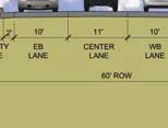
23 Conceptual Layout - Central Segment: 7100 to 6980 West 38th Avenue (approximately High Court to Reed Street) Existing Condition (pre-restriping) 2010 Aerial Showing Previous Lane Configuration Proposed Street Layout Note: This segment has the narrower right-of-way starting just east of High Court. On-street parking is not included from this point to the east. 38th Avenue Streetscape Concept Design 19

24 Conceptual Layout - East Segment: 6980 to 6790 West 38th Avenue (approximately Reed Street to Pierce Street) Existing Condition (pre-restriping) 2010 Aerial Showing Previous Lane Configuration Proposed Street Layout Note: This segment has the narrower right-of-way. The east limits of the project are at Pierce Street. 20

25 Alternative A: Flexible Pages include plans, sections and threedimensional renderings of Alternative A. The imagery illustrates the following elements. Common Elements: the proposed continuous sidewalk and amenity zone special crosswalk treatments at High Court and Pierce and Upham Streets special informational signage the location of the existing over-the-street banner how outdoor cafes can be accommodated locations for bicycle parking the concept of an additional special paving band crossing the sidewalk (in plan view only) regularly placed street trees locations for bulb outs that provide for: seating, landscaping, signage/wayfinding, art, and other amenities the narrower and wider road sections Looking East Near Upham Street Looking West at Pierce Street Unique to Alternative A: the more flexible approach to seating and landscaping via a combination of chairs and benches and a variety of planter pots the amenity zone treated with a lighter toned, elongated, running bond paver street trees in grates a curvilinear pedestrian and high level light pole with a rounded or oval luminaire 38th Avenue Streetscape Concept Design 21


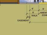
26 Alternative A: Flexible These Prototypical Plans and Sections Show Alternative A Kit-of-Parts Applied in the Existing Wider and Narrower Right-of-Way Sections Prototypical 70 ROW Previously planned over-the-street banner location Bulb-outs at intersections - allow for seating, planting, information kiosk, etc. (This Alt. - special paving with more living room feel to the furniture, chairs, tables, and numerous pots with plantings than can be adjusted) Special crosswalk Sidewalk zone - ideally minimum of 8 wide Amenity zone - ideally minimum of 6 wide (special paving and trees in grates in this alternative) On-street parallel parking Outdoor cafe areas where feasible Prototypical ROW Benches Pedestrian scaled lighting Bike racks Trash/recycling RTD bus stops will need special attention - provide shelter, bench, possibly a concrete pad back of sidewalk to accommodate the amenities 22
27 Alternative A: Flexible Looking East at Upham Street This view highlights parallel parking along both sides of the street, flexible seating and planting options within the amenity zones, and kiosk signage. 38th Avenue Streetscape Concept Design 23
28 Alternative A: Flexible Looking West Near Teller Street This view shows how a wider sidewalk can accommodate an outdoor cafe and hardscape amenity zone. This alternative includes grates around the street trees. 24

29 Alternative A: Flexible Looking East at High Court This view highlights the intersection treatment with special paving in the crosswalk. 38th Avenue Streetscape Concept Design 25

30 Alternative A: Flexible Looking East Near Reed Street This view shows possible elements within the hardscape amenity zone, such as planters, bike racks, and seating. 26
31 Alternative A: Flexible Looking West Near Quay Street This view also highlights amenity zone elements and shows an example of parking lot screening across the street. 38th Avenue Streetscape Concept Design 27

32 Alternative A: Flexible Looking West at Teller Street This view highlights the flexible seating and planting options at the bulb outs. 28

33 Alternative B: Fixed Pages include plans, sections and threedimensional renderings of Alternative B. The imagery illustrates: Common Elements: the proposed continuous sidewalk and amenity zone special crosswalk treatments at High Court and Pierce and Upham Streets special informational signage the location of the existing over-the-street banner how outdoor cafes can be accommodated locations for bicycle parking the concept of an additional special paving band crossing the sidewalk (in plan view only) regularly placed street trees locations for bulb outs that provide for: seating, landscaping, signage/wayfinding, art, and other amenities the narrower and wider road sections Looking East Near Upham Street Looking West Near at Pierce Street Unique to Alternative B: the amenity zone treated with a darker toned, elongated, running bond paver the more fixed approach to seating and landscaping via benches and partially raised planter beds street trees in partially raised planter beds a perpendicular pedestrian and high level light pole with a rectangular luminaire 38th Avenue Streetscape Concept Design 29


 Special crosswalk Sidewalk")


 On-street")


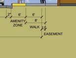
34 Alternative B: Fixed These Prototypical Plans and Sections Show Alternative B Kit-of-Parts Applied in the Existing Wider and Narrower Right-of-Way Sections Prototypical 70 ROW Previously planned over-the-street banner location Bulb-outs at intersections - allow for seating, planting, information kiosk, etc. (This Alt. - special paving just under benches with raised curb planting area surrounding.) Special crosswalk Sidewalk zone - ideally minimum of 8 wide Amenity zone - ideally minimum of 6 wide (special paving with raised planters under trees in this alternative) On-street parallel parking Outdoor cafe areas where feasible Prototypical ROW Bike racks Benches Pedestrian scaled lighting Trash/recycling RTD bus stops will need special attention - provide shelter, bench, possibly a concrete pad back of sidewalk to accommodate the amenities 30

35 Alternative B: Fixed Looking East at Upham Street This view highlights parallel parking along both sides of the street and fixed seating, raised planting beds, and a different style of kiosk signage within the amenity zones. 38th Avenue Streetscape Concept Design 31

36 Alternative B: Fixed Looking West Near Teller Street This view shows how a wider sidewalk can accommodate an outdoor cafe and hardscape amenity zone. This alternative includes raised planting beds around the street trees. 32
37 Alternative B: Fixed Looking East at High Court This view highlights the intersection treatment with special paving in the crosswalk. 38th Avenue Streetscape Concept Design 33
38 Alternative B: Fixed Looking East Near Reed Street This view shows possible elements within the hardscape amenity zone, such as raised planting beds, bike racks, and seating. 34

39 Alternative B: Fixed Looking West Near Quay Street This view also highlights amenity zone elements and shows an example of parking lot screening across the street. 38th Avenue Streetscape Concept Design 35
40 Alternative B: Fixed Looking West at Teller Street This view highlights the fixed seating and raised planting beds at the bulb outs. 36

41 Signage Conceptual designs for branding and local wayfinding signage on the corridor was provided as part of this process. The concepts do not address directional signage to the corridor. The options could work with either of the Alternative Concept Designs, however some elements might be more appropriate to be integrated into one design over another. For instance, integration of a low wall with ingrained lettering may be more appropriate for Streetscape Concept Design Alternative B. Existing Signage Along 38th Avenue The conceptual signage was cognizant of the Ridge at 38 Brand, including existing light pole banners, planter banners and over the street banners that have previously been designed and implemented on the corridor. 38th Avenue Streetscape Concept Design 37


42 Conceptual Signage Ideas for 38th Avenue Note: Simple concrete finish Note: Deviates from Brand Guidelines Note: Individual panels could be angled 38
43 Public Art The image below identifies possible locations for public art within the right-of-way. Opportunities to collaborate with private property owners may allow for larger art installations than would otherwise be able to fit within the current right-of-way. Potential Locations for Public Art in the Right-of-Way 38th Avenue Streetscape Concept Design 39
44 Parking The conceptual streetscape design shown on pages does have an impact on parking within the study area. The diagram below illustrates those areas that could be affected. Compared to the previous conditions, the proposed streetscape design will have 12 additional onstreet spaces. This increase is largely attributed to the additional on-street parking proposed on the north side of the street between Upham and High Court in front of the school. The blue bubbles show the public, on-street parking counts at three points in time: Previous The parallel on-street parking spaces prior to 2012 Current The back-in diagonal and parallel parking spaces that currently exist Proposed The proposed parallel parking spaces that are shown in the conceptual design The orange bubbles indicate the potential impact to private, off-street parking lots. The two numbers indicate the current and proposed parking counts. The conceptual streetscape design proposes access enhancements which would reduce the size and number of curb cuts. The design would result in the loss of 7 off-street parking spaces. These parking impacts were discussed at the block-by-block meetings. City staff will continue to work with the affected property owners during the subsequent phases of design to resolve any issues and minimize impacts High Ct Teller Upham Pierce Quay Reed Upham High Ct Parking Impact Analysis
COMPLETE GREEN STREET CHECKLIST
 COMPLETE GREEN STREET CHECKLIST This document was developed to dissect the structure of an urban street and explore opportunities to make our streets more complete while also integrating green street strategies.
open house 3 CITY OF SALEM Downtown Streetscape Plan
 open house 3 Streetscape concepts CITY OF SALEM Downtown Streetscape Plan analysis concepts we are here refined concepts & document Feb 13th 1 2 3 apr 18th KICKOFF OPEN HOUSE Streetscape Work Group Walking
VISION AND GUIDING DESIGN PRINCIPLES
 pleasure point commercial corridor VISION AND GUIDING DESIGN PRINCIPLES Public Draft November 26, 2018 County of Santa Cruz with assistance from MIG CONTENTS PART I: INTRODUCTION AND VISION... 3 Community
City of Plattsburgh DRI: Downtown Streetscapes & Riverfront Access. Downtown Streetscape and Riverfront Access Design
 City of Plattsburgh DRI: Downtown Streetscapes & Riverfront Access Welcome Thank you for coming this evening. Agenda PART I - Project Context The Downtown Revitalization Program Our DRI Projects Other
Public input has been an important part of the plan development process.
 Lakewood s Comprehensive Plan recognizes that transportation helps shape the community, and that the way the community provides for the safe and efficient movement of people affects the character of the
Main Street Reconstruction From Ninth Line to Stouffer Street. Town of Whitchurch-Stouffville. Public Information Centre
 Main Street Reconstruction From Ninth Line to Stouffer Street Town of Whitchurch-Stouffville Public Information Centre November 23, 2016 4:30 to 6:00 pm & 7:00 to 8:00 pm 6240 Main Street, Stouffville
Maplewood Avenue Downtown Complete Street Project
 Maplewood Avenue Downtown Complete Street Project Second Public Meeting January 24, 2018 Welcome and Introduction of Project Team City Planning and Public Works Staff City of Portsmouth Juliet Walker Planning
Urban Design 9Identity
 Urban Design 9Identity URBAN DESIGN IDENTITY Urban design is about connecting people to their places through the built environment, nature, and overall urban form. Done well, it creates a memorable space
Mississippi Drive Corridor Revitalization. A DestinationTransportation Project...
 Mississippi Drive Corridor Revitalization A DestinationTransportation Project... Mississippi Drive Corridor Revitalization Welcome! Tonight s Agenda: Further define the Scope of the Project Discuss the
Tonight s Agenda. Summary Presentation Open House. Group Discussion Next Steps: online community wide survey
 Community Open House February 22, 2018 Tonight s Agenda Summary Presentation Open House Station 1: Project Overview and Community Input Station 2: Draft Vision and Guiding Principles Station 3: Western,
Fifth and Detroit Street Design May 2017 Capital Improvements Committee. DOWNTOWN Street Design
 1 Fifth and Detroit Street Design May 2017 Capital Improvements Committee Agenda 2 Review Street Configuration Prior Meeting Review Outreach Synopsis Functional Street Design Refinements Curb Edge, Turning
Don Mills Crossing Study and Celestica Lands Development Application Community Meeting, Open House, and Breakout Discussions
 Consultation Summary Don Mills Crossing Study and Celestica Lands Development Application Community Meeting, Open House, and Breakout Discussions This report is not intended to provide a verbatim transcript
Pedestrian and Bike Bridge LOGO
 6.2.2 Pedestrian and Bike Bridge The proposed pedestrian and bike crossing re-envisions the existing bridge at Pismo Creek on Cypress Street. The bridge is currently underutilized by vehicular through
The transportation system in a community is an
 7 TRANSPORTATION The transportation system in a community is an important factor contributing to the quality of life of the residents. Without a sound transportation system to bring both goods and patrons
Blood Alley Square/Trounce Alley Redesign
 June 216 Kick-Off Events Questionnaire and Engagement Summary Background The City of Vancouver is redesigning Blood Alley Square and Trounce Alley, important public spaces in the heart of Gastown, which
City of Burlington Downtown Street Design & Construction Standards
 City of Burlington Downtown Street Design & Construction Standards Adopted April 16, 2018 b City of Burlington Downtown Street Design Standards CITY OF BURLINGTON, VT The Great Streets Initiative is a
West Dennis Center: Bass River to Old Main Street. West Dennis Business District: Old Main Street to Dennis Commons
 West Dennis Center: Bass River to Old Main Street West Dennis Business District: Old Main Street to Dennis Commons Dennisport Center: Dennis Commons to Division Street Main Street Project Goals Project
SDOT DPD. SDOT Director s Rule DPD Director s Rule DCLU DR SED DR of 7 CITY OF SEATTLE
 SDOT SDOT Director s Rule 2-07 DPD Applicant: CITY OF SEATTLE Page 1 of 7 Supersedes: DCLU DR 11-93 SED DR 93-4 Seattle Department of Transportation (SDOT) Department of Planning and Development (DPD)
PUBLIC RIGHT-OF-WAY IN THIS CHAPTER PUBLIC REALM
 PUBLIC RIGHT-OF-WAY This section provides design guidelines for improvements in the public right-of-way. The public right-of-way refers to streets, sidewalks, non-vehicular thoroughfares, parks and greenways
Ballston Station Multimodal Study. Stakeholder Meeting October 5, 2010
 Ballston Station Multimodal Study Stakeholder Meeting October 5, 2010 Agenda Welcome and Introductions Update on Short Term Improvements Update on the Multimodal Study Recap of Goals and Key Issues Working
The Lower SaLuda Greenway
 The Lower SaLuda Greenway InITIaTIve a FLourIShInG Greenway. a hub For economic GrowTh. a ConneCTIon BeTween CoMMunITIeS. In April 2017 the Michael J. Mungo Foundation and Lexington County commissioned
MAIN STREET DESIGN GUIDELINES CONTEXT
 MAIN STREET DESIGN GUIDELINES CONTEXT VISION The re-imagining of Main Street offers an unparalleled opportunity to strengthen and link Fredericton North through the integration of local neighbourhoods,
Hamilton Road Corridor Streetscape Master Plan. Open House October 4 th, 2017
 Hamilton Road Corridor Streetscape Master Plan Open House October 4 th, 2017 Agenda 1. Introductions Agenda Overview 2. Project Background 3. Existing Conditions 4. Strengths, Weaknesses, Opportunities
Sheridan Boulevard S TAT I O N A R E A P L A N S H E R I D A N B O U L E VA R D S TAT I O N A R E A P L A N
 Sheridan Boulevard S TAT I O N A R E A P L A N 1 City of Lakewood Adopted November, 2006 S H E R I D A N B O U L E VA R D S TAT I O N A R E A P L A N The Vision The City of Lakewood s overall vision is
P A R K L E T 2016 PILOT PROJECT
 GRAND FORKS, NORTH DAKOTA P A R K L E T 2016 PILOT PROJECT City of Grand Forks Planning & Community Development Department LIVE, LEARN, WORK, PLAY, AND STAY The purpose of the Grand Forks Parklet Application
Workshop 3. City of Burlington Waterfront Hotel Planning Study. September 14, The Planning Partnership
 Workshop 3 City of Burlington Waterfront Hotel Planning Study September 14, 2017 The Planning Partnership The Waterfront Hotel Planning Study 01 The Brant & Lakeshore Planning Study will establish a Strategic
Please see attached for more detailed project information. Project Schedule Designer Award by SBC Executive Sub-Committee December 21, 2015
 Project Title Campus Beautification Projects Volunteer Blvd Ph 1 540/009-08-2015 Institution Description UT Knoxville This project will improve Volunteer Boulevard from West Cumberland Ave. to East Cumberland
Johnson Street Bridge Public Realm Update
 Johnson Street Bridge Public Realm Update August 20, 2015 Background Johnson Street Bridge Replacement Project impacts a diverse range of stakeholders In addition to a new bridge, the project also includes
RESEDA - WEST VAN NUYS COMMUNITY PLAN
 RESEDA - WEST VAN NUYS COMMUNITY PLAN Executive Summary As part of the initial outreach effort, the Department of City Planning hosted two workshops for the Reseda-West Van Nuys Community Plan Area during
SOUTH UNIVERSITY Street Design Setting a Direction for Schematic Design
 1 SOUTH UNIVERSITY Street Design Setting a Direction for Schematic Design Meeting Agenda 2 1. Project Scope 2. Design Direction 3. Design Details 4. Schedule and Construction Logistics 3 SOUTH UNIVERSITY
North Downtown Specific Plan MEMORANDUM
 North Downtown Specific Plan MEMORANDUM MEETING DATE: November 13, 2017 TO: Members of the North Downtown Specific Plan Advisory Committee FROM: Jeanine Cavalli, Senior Planner SUBJECT: Materials for the
FROM DUPONT CIRCLE NORTH TO CALIFORNIA STREET, NW. Welcome!
 FROM DUPONT CIRCLE NORTH TO CALIFORNIA STREET, NW Welcome! Meeting Agenda 6:00 PM Open House 6:30 PM Presentation 7:00 PM Open House / Q&A at the Boards Project Design Team Connecticut Avenue, NW Project
Property Owners Association. Annual Meeting Notice July 26, :00pm - 7:00pm Park City Marriott 1895 Sidewinder Drive Park City, Utah
 Property Owners Association Annual Meeting Notice July 26, 2016 5:00pm - 7:00pm Park City Marriott 1895 Sidewinder Drive Park City, Utah Annual Meeting Agenda Welcome Approval of Minutes Introduction of
GREENING THE BOULEVARD Master Plan Concepts for Venice Boulevard between Lincoln and Sawtelle
 GREENING THE BOULEVARD Katherine Spitz Associates Inc. 4212½ Glencoe Avenue Marina Del Rey, CA 90292 310 574 4460 Fax 574 4462 January 2008 Table of Contents Overview Proposed Design Improvements Illustration
BUSINESS DISTRICT DESIGN GUIDELINES
 Des Plaines, Illinois Prepared for the City of Des Plaines by: The Lakota Group Laurie Marston, AICP March 2005 Section 5: Streetscape Elements Business District Design Guidelines STREETSCAPE ELEMENTS
Route 1 Corridor Study
 Route 1 Corridor Study Westbrook, Connecticut A Vision for the Connecticut Shoreline Public Informational Meeting July 28, 2015 Lower Connecticut River Valley Council of Governments Fitzgerald & Halliday,
Building Great Neighbourhoods. Strathcona
 Building Great Neighbourhoods Strathcona March 21, 2018 Becky Redford Project Manager, Planning & Design Building Great Neighbourhoods Integrated Infrastructure Services Welcome and Purpose To provide
Introduction. Chapter 1. Purpose of the Comprehensive Plan Plan Organization Planning Process & Community Input 1-1
 Chapter 1 Introduction Lakewood 2025: Moving Forward Together Purpose of the Comprehensive Plan Plan Organization Planning Process & Community Input 1-1 Purpose of the Comprehensive Plan The Comprehensive
SOUTH UNIVERSITY Street Design Alternatives in Progress
 1 Alternatives in Progress 2016.01.20 Meeting Agenda 2 1. Progress & Schedule 2. Utilizing the Street Design Manual 3. Site Characteristics and Input Received 4. Street Geometry What can we accomplish
R STREET CORRIDOR NEIGHBORHOOD Site Plan and Design Review Supplemental Guidelines Checklist
 R STREET CORRIDOR NEIGHBORHOOD Site Plan and Design Review Supplemental Guidelines Checklist Applicant s Name: Project Address: Phone: Email: Applicant shall fill out the design guidelines checklist for
PLAN ELEMENTS WORKSHOP. April 5, 2016
 PLAN ELEMENTS WORKSHOP April 5, 2016 needs more housing. But there is no one-size fits-all solution. Every neighborhood has its own character. In some places, density is not only appropriate it is badly
Roanoke Rapids Streetscape Master Plan. City Council Presentation
 SCHEDULE: Stakeholder Meeting/Kick off November,2016 Master Planning Phase (November March 2017) Public Meeting #1 December 13, 2016 Review Meeting with Key Stakeholders Refine Concepts Based on Input
New York Avenue Streetscape and Trail Project Public Meeting #1 Summary
 New York Avenue Streetscape and Trail Project Public Meeting #1 Summary I. King Jordan Student Academic Center (SAC) Gallaudet University, Washington, DC February 23, 2017 Table of Contents 1.0 Introduction...
Executive Summary. NY 7 / NY 2 Corridor
 Executive Summary NY 7 / NY 2 Corridor Transportation and Land Use Study December 2005 Prepared for: Town of Colonie Capital District Transportation Committee Prepared by: Introduction: Land use decisions
The Project. In 2013, construction was completed between 100 Street and 102 Street.
 The Project Jasper Avenue New Vision (JANV) is a major catalyst project identified in the Capital City Downtown Plan (2010) between 92 Street and 109 Street, including the streets half a block north and
Planning Board Briefing
 Planning Board Briefing Why Now? The Sector Plan Implementation Chapter States: Before Stage 1 begins, the following must occur: Approval of the Sectional Map Amendment. Approval of the Greater Lyttonsville
Establish a network of streetscaped vehicle and pedestrian routes that connect within and outside the Plan area.
 This Plan s urban design goals are to create an urban scale, walkable community with connections to transit, parks, and services and with amenities and facilities for residents and employees. The 1992
Wadsworth Boulevard S TAT I O N A R E A P L A N
 Wadsworth Boulevard S TAT I O N A R E A P L A N City of Lakewood Adopted November, 2006 The Vision The City of Lakewood s overall vision is to transform the area around the light rail station into a mixed-use
A. Background Summary of Existing Challenges and Potential Possibilities. 1. Summary of Existing Assets and Potential Opportunities
 A. Background 1 A Main Street Master Plan Study was performed and completed in October of 2007. The study was initiated to review current land uses and development patterns along Main Street, from Parrish
This Review Is Divided Into Two Phases:
 Semiahmoo Town Centre Review The purpose of this review: To review the Semiahmoo Town Centre Concept Plan, originally approved in 1993, to ensure that this centre will continue to serve the needs of South
Town Center (part of the Comprehensive Plan)
") Town Center (part of the Comprehensive Plan) Mercer Island Town Center Looking North (2014) In 1994, a year-long process culminated in a set of design guidelines and code requirements for the Town Center
Town Center (part of the Comprehensive Plan) Mercer Island Town Center Looking North (2014) In 1994, a year-long process culminated in a set of design guidelines and code requirements for the Town Center
FDOT D4 Complete Streets
 FDOT D4 Complete Streets Context Sensitive Solutions Directs that complete street solutions will complement the context of the community. Collaborative approach to decision making, project development,
Wayfinding. North Gateway: Integrate a vertical gateway marker on the west side of Ward Street at the south corner of Vernon Street.
 3.3.6.2 Wayfinding Existing Conditions Wayfinding signage is important to direct visitors and tourists to different locations in the downtown. A significant part of the wayfinding signage in the downtown
VILLAGE OF SKOKIE Design Guidelines for Mixed-Use Districts NX Neighborhood Mixed-Use TX Transit Mixed-Use CX Core Mixed-Use
 VILLAGE OF SKOKIE Design Guidelines for Mixed-Use Districts NX Neighborhood Mixed-Use TX Transit Mixed-Use CX Core Mixed-Use TABLE OF CONTENTS CHAPTER 1 SITE DESIGN Purpose 1 CHAPTER 2 SITE DESIGN Streetscape
Jewel. Platte. of the. Plattsmouth Main Street Landscape Architecture by HDR
 Jewel of the Platte Plattsmouth Main Street Landscape Architecture by HDR Plattsmouth, Nebraska is a historic community of 6,500 residents located along the west bank of the Missouri River, just south
Figure 3-1: Public Realm Plan
 3 Public Realm Figure 3-1: Public Realm Plan 3.1 Public Realm Concept The public realm concept for the Little Mountain site integrates a clear and accessible movement network with public spaces for social
Rio/29 Small Area Plan. Design Plan & Implementation Framework Open House - January 25, 2018
 Rio/29 Small Area Plan Design Plan & Implementation Framework Open House - January 25, 2018 MEETING PURPOSE PRESENTATION 1. Orient to the updated design plans 2. Introduce implementing options 3. Explain
Small Area Plan. South Gateway
 Small Area Plan Adopted May 12, 2008 South Gateway Purpose. The South Gateway Small Area Plan defines the City s expectations for the future of the southern entrance to the City at Interstate 85 and Highway
The Auburn Plan Designing the Future of Auburn February 28, 2005
 The Auburn Plan Designing the Future of Auburn February 28, 2005 Block-by-Block Bicycle Tour Aerial survey Focus Group Meetings September 7 and 8 Design Workshops October 11, 14, and 21 Revitalization
Courthouse Square Planning & Urban Design Study Working Group Meeting #11 September 2, 2014
 Courthouse Square Planning & Urban Design Study Working Group Meeting #11 September 2, 2014 1 Study Area Courthouse Square DRAFT Design Concepts A B C 3 Public Feedback July 23 Workshop & Online Survey
July 12, Columbus City Council City Hall 90 West Broad Street Columbus, OH RE: I-70/71 Columbus Crossroads Project
 OHIO DEPARTMENT OF TRANSPORTATION DISTRICT 6 400 EAST WILLIAM STREET DELAWARE, OHIO 43015 800.372.7714 Columbus City Council City Hall 90 West Broad Street Columbus, OH 43215-9015 RE: I-70/71 Columbus
PIKE PINE RENAISSANCE: ACT ONE. October 19, 2017
 PIKE PINE RENAISSANCE: ACT ONE October 19, 2017 WATERFRONT SEATTLE PROGRAM PROJECT INTRODUCTION Pike and Pine streets, between First and Melrose avenues Pedestrian and streetscape improvements Budget:
Streets Vision
 streets 86 2.9 Vision : The Most Prevalent and Important Public Spaces Fixed routes of human travel have served as corridors for commerce and places for human interaction from the earliest trails and foot
Scope of Services. River Oaks Boulevard (SH 183) Corridor Master Plan
 Corridor Master Plan") Scope of Services River Oaks Boulevard (SH 183) Corridor Master Plan PROJECT AREA The project area consists of the River Oaks Boulevard (SH 183) corridor bounded by SH 199 at the northern end and the Trinity
Scope of Services River Oaks Boulevard (SH 183) Corridor Master Plan PROJECT AREA The project area consists of the River Oaks Boulevard (SH 183) corridor bounded by SH 199 at the northern end and the Trinity
The Illinois Department of Transportation and Lake County Division of Transportation. Route 173, including the Millburn Bypass
 The Illinois Department of Transportation and Lake County Division of Transportation welcome you to this Public Hearing for U.S. Route 45 from Illinois Route 132 to Illinois Route 173, including the Millburn
WEST LOOP DESIGN GUIDELINES CHECKLIST
 WEST LOOP DESIGN GUIDELINES CHECKLIST Section 1.0 General Strategies 1.1 DESIGN EXCELLENCE: ENCOURAGE HIGH QUALITY AND INNOVATIVE DESIGN OF NEW BUILDINGS WITHIN THE WEST LOOP WITHOUT BEING PRESCRIPTIVE
VIRGINIA / LAKE HIGHLAND TRANSPORTATION AND LAND USE STUDY
 VIRGINIA / LAKE HIGHLAND TRANSPORTATION AND LAND USE STUDY COMMUNITY MEETING #2 - PRESENTATION OVERVIEW 1 INTRODUCTION 2 CONTEXT STUDIES 3 VISION FRAMEWORK 4 DEVELOPMENT SCENARIOS 2 1 INTRODUCTION Project
Carson Street Streetscape Improvements. Request for Proposals
 Carson Street Streetscape Improvements Request for Proposals Complete Design Services for a Landscape/Streetscape Plan for Carson Street (Pioneer Boulevard to Norwalk Boulevard) Submittal Deadline: October
The Lincoln Neighborhood Corridor Plan. The LiNC
 October 1, 2014 Planning Commission Study Session The Lincoln Neighborhood Corridor Plan The LiNC Purpose of Tonight s Meeting Introduction to The LiNC Review of Existing Conditions and Community Identified
38 Queen s University Campus Master Plan Part 1
 38 Queen s University Campus Master Plan Part 1 46 The Campus at the City Scale Chapter 4 The Campus at the City Scale 39 Queen s is an urban University centrally located in Kingston. Decisions made by
SFMTA PHELAN LOOP AND PUBLIC PLAZA PHELAN OCEAN AVENUE
 SFMTA Municipal Transportation Agency Image: a bus in front of the Palace of the Legion of honor SFMTA PHELAN LOOP AND PUBLIC PLAZA PHELAN AVENUE @ OCEAN AVENUE Community Meeting May 23, 2012 San Francisco,
FRONT STREET STREETSCAPE
 FRONT STREET STREETSCAPE DESIGN DEVELOPMENT UPDATE & MARTIN PLAZA ALTERNATIVE REVIEW JUNE 26, 2017 PREPARED BY DESIGN DEVELOPMENT REVISIONS REVISIONS APPLIED AFTER 4/24/2017 COUNCIL PRESENTATION 1. Lane
City of Farmington. Downtown Plan. Amendment to the 1998 Master Plan Adopted October 11, 2004
 City of Farmington Amendment to the 1998 Master Plan Adopted October 11, 2004 Introduction Planning Background 1 Scope and Components of the Plan Amendment 2 Concept Introduction 3 Plan Concepts 3 Conceptual
Chapter 14 Streetscape Improvements
 This chapter presents streetscape design concepts for key streets and gateways in the Downtown Specific Plan area. This chapter is organized as follows: 14 Streetscape Improvements 14.1 Streetscape Treatments
Section4 Design Vision & Implementation Plan
 Section4 Design Vision & Implementation Plan W Woodschurch Rd 4.1 Design Focus Areas The Framework Plan is simply the starting point for directing the design and implementation of a wide range of transportation
MISSION STREETSCAPE PLAN. Neighborhood Commercial Streets handle continuous activity. Neighborhood Commercial STREET ROW: Main Design Treatments
 Neighborhood Commercial STREET ROW: 64-80 Main Design Treatments CORNER reduce crossing distance for pedestrians, create entrances to a residential area and slow cars down. help widen sidewalk allocating
Study Area. Capitol Way. Greening America s Capitals 11/13/2014. A Greening America s Capitals Project
 Olympia, WA: Greening Capitol Way Supporting Communities move towards sustainability is a priority for the federal government. A Greening America s Capitals Project Office of Sustainable Communities U.S.
Denton. A. Downtown Task Force
 2 Public Involvement Early and ongoing public involvement was solicited so that the public had ample opportunity to help direct the DTIP s concepts and implementation strategies. The residents of Denton
Denver Moves: Transit Task Force
 Insert transit picture Denver Moves: Transit Task Force Meeting #8 October 5, 2017 1. Welcome & Introductions Opening remarks and housekeeping Task Force and audience introductions Upcoming events and
Potential Green Infrastructure Strategies May 6, 2015 Workshop
 Potential Green Infrastructure Strategies May 6, 2015 Workshop Background The City of Cortland is developing the Tioughnioga Urban Headwaters Green Infrastructure Action Plan with funding from the National
Sewanee Village + Request for Builder/Developer Proposals
 Sewanee Village + Request for Builder/Developer Proposals Contact: Frank X. Gladu Special Assistant to the Vice Chancellor University of the South 735 University Ave Version 3 Sewanee TN 37383 Released:
Planning Commission Staff Report June 5, 2008
 Owner/Applicant Taylor Village Sacramento Investments Partners, LP c/o Kim Whitney 1792 Tribute Road #270 Sacramento, CA 95815 Staff Recommendation Planning Commission Staff Report Project: File: Request:
Conceptual Design. Main Street Enhancement and Extension Project. Bothell, Washington. June 11, 2009
 Conceptual Design Main Street Enhancement and Extension Project Bothell, Washington June 11, 2009 Berger/ABAM Engineers and Cascade Design Collaborative, Inc For Main Street Bothell to succeed it must
LUNDY S LANE COMMUNITY IMPROVEMENT PLAN STUDY
 PUBLIC INFORMATION MEETING #2 October 12, 2016 LUNDY S LANE COMMUNITY IMPROVEMENT PLAN STUDY AGENDA 5:00 to 5:30pm: Open House 5:30 to 6:15pm: Presentation 6:15 to 7:00pm: Individual paced workshop with
Table of Contents. Elm Avenue Improvement Plan City of Waco, Texas. Introduction 1. Existing Context 1 Figure 1 2.
 Table of Contents Introduction 1 Existing Context 1 Figure 1 2 Plan Guidelines 3 Future Urban Form 4 The West-End 4 Main Street 6 The East-End 7 Figure 2 9 Public Improvement Recommendations 7 General
City of Dallas Complete Streets Program. SAME Infrastructure Forum February 2, 2018
 City of Dallas Complete Streets Program SAME Infrastructure Forum February 2, 2018 Complete Streets Design Manual Adopted by City Council January 27, 2016 JANUARY 27, 2016 2 What are Complete Streets?
VEHICULAR AND PEDESTRIAN CIRCULATION
 This perspective sketch communicates the intended character and quality of a proposed streetscape design. Locate benches near a major intersection where people tend to gather. Seating and lighting provide
Blueprint Denver Task Force Meeting #
 Blueprint Denver Task Force Meeting #1 6.23.16 1. Welcome and Introductions Your name and affiliation Name 1 thing you love about Denver Name 1 thing you d change about Denver All in 30 seconds! Ready,
Policies and Code Intent Sections Related to Town Center
 Policies and Code Intent Sections Related to Town Center The Town Center Vision is scattered throughout the Comprehensive Plan, development code and the 1994 Town Center Plan. What follows are sections
TRANSPORTATION ELEMENT
 TRANSPORTATION ELEMENT GOAL I: To create and maintain a safe, efficient and aesthetic transportation system that encourages multi-modal transportation and promotes the mobility strategies of the Ocala
9/19/2018 TODAY S WEBINAR AGENDA CONTINUING EDUCATION UPCOMING TRAINING FROM APBP
 TODAY S WEBINAR AGENDA 3:00 pm: Introduction 3:05 pm: Presentation 3:45 pm: Questions 4:00 pm: Webinar Ends For technical assistance during the webinar: 1-800-263-6317 Choose these prompts: 1, 1, 1 CONTINUING
Lehigh Acres Land Development Regulations Community Planning Project
 Lehigh Acres Land Development Regulations Planning Effort Summary In July, 2010 Commissioner Frank Mann invited the Lehigh Acres community to start discussing how to achieve their recently adopted community
Public may provide comments on the GDP within the next two weeks (December 24)
") 25/70 General Development Plan (GDP) Public Meeting Wednesday, December 10, 2014 6:00 8:00 P.M. District 1 Police Station Community Room 1311 W 46th Ave, Denver, CO 80211 Council Woman Montero: This particular
25/70 General Development Plan (GDP) Public Meeting Wednesday, December 10, 2014 6:00 8:00 P.M. District 1 Police Station Community Room 1311 W 46th Ave, Denver, CO 80211 Council Woman Montero: This particular
Gold Line Bus Rapid Transit Transit Oriented Development (BRTOD) Helmo Station Area Plan
 Helmo Station Area Plan") Appendix F Gold Line Bus Rapid Transit Transit Oriented Development (BRTOD) Helmo Station Area Plan Introduction and Purpose of the Plan The Gold Line Bus Rapid Transit facility is an eleven-mile dedicated
Appendix F Gold Line Bus Rapid Transit Transit Oriented Development (BRTOD) Helmo Station Area Plan Introduction and Purpose of the Plan The Gold Line Bus Rapid Transit facility is an eleven-mile dedicated
Old Town Neighborhoods Plan. Choices Event Wednesday, December 9, 2015
 Old Town Neighborhoods Plan Choices Event Wednesday, December 9, 2015 Agenda 6:00 6:10 p.m. Welcome + Sign In 6:10 6:30 p.m. Presentation 6:30 8:00 p.m. Workshop + Open House Seeking your input on: Neighborhood
Long Lost Allies? Walking Advocates & Business District Organizations. Matt Kazinka Lake Street Council. Shaina Brassard Seward Redesign
 Long Lost Allies? Walking Advocates & Business District Organizations Shaina Brassard Seward Redesign Rob Hanson West Broadway Business and Area Coalition Matt Kazinka Lake Street Council Jamie Schumacher
PROPOSED REDEVELOPMENT OF THE GLEN ABBEY GOLF CLUB. STREETSCAPE DESIGN STUDY (excerpt from the Urban Design Brief) TOWN OF OAKVILLE.
 TOWN OF OAKVILLE.") PROPOSED REDEVELOPMENT OF THE GLEN ABBEY GOLF CLUB STREETSCAPE DESIGN STUDY (excerpt from the Urban Design Brief) TOWN OF OAKVILLE OCTOBER, 2016 for 2.4.2 STREETS Streets are the single largest component
PROPOSED REDEVELOPMENT OF THE GLEN ABBEY GOLF CLUB STREETSCAPE DESIGN STUDY (excerpt from the Urban Design Brief) TOWN OF OAKVILLE OCTOBER, 2016 for 2.4.2 STREETS Streets are the single largest component
City Plan Commission Briefing #2
 City Plan Commission Briefing #2 August 2, 2016 Image Source City of Richardson Agenda Project Overview / Progress to Date Property and Business Owner Meeting Series 2 Community Workshop 2 Belt Line Road
BUILDING SCALE AND SETBACKS 5 ELEMENTS:... 5 FAÇADES (COMMERCIAL/RESIDENTIAL) 5
 5") VISION STATEMENT 3 UTILIZATION OF THE GUIDELINES 3 IMPLEMENTATION 3 PROCEDURES FOR DESIGN REVIEW 3 LAND USE AND ZONING 4 LAND USE 4 ELEMENTS:... 4 ZONING 4 ELEMENTS:... 4 BUILDING SCALE AND SETBACKS 5
VISION STATEMENT 3 UTILIZATION OF THE GUIDELINES 3 IMPLEMENTATION 3 PROCEDURES FOR DESIGN REVIEW 3 LAND USE AND ZONING 4 LAND USE 4 ELEMENTS:... 4 ZONING 4 ELEMENTS:... 4 BUILDING SCALE AND SETBACKS 5
Lower Merion Commercial Districts Issues and Characteristics Handbook November 2013
 Lower Merion Commercial Districts Issues and Characteristics Handbook November 2013 DRAFT TOWNSHIP-WIDE VISION: To maintain and enhance commercial areas to complement the surrounding high-quality residential