RICHARDSON RIDGE INC RICHARDSON RIDGE PHASE TERRY FOX DRIVE KANATA
|
|
|
- Lester Pitts
- 5 years ago
- Views:
Transcription
1 RICHARDSON RIDGE INC RICHARDSON RIDGE PHASE TERRY FOX DRIVE KANATA PLANNING RATIONALE AND INTEGRATED ENVIRONMENTAL REVIEW IN SUPPORT OF A DRAFT PLAN OF SUBDIVISION AND ZONING BY-LAW AMENDMENT Prepared By: NOVATECH Suite 200, 240 Michael Cowpland Drive Ottawa, Ontario K2M 1P6 August 24 rd, 2016 Novatech File: Ref: R
2 Table of Contents 1.0 INTRODUCTION SITE LOCATION AND CONTEXT PLANNING CONTEXT City of Ottawa Official Plan Existing Zoning (City of Ottawa Zoning By-Law ) PROPOSED DEVELOPMENT OVERVIEW OF TECHNICAL STUDIES Archaeological Assessment Environmental Impact Statement & Tree Conservation Report Phase 1 Environmental Site Assessment Hydrogeological Report Geotechnical Investigation Noise Control Feasibility Study Servicing Brief Community Transportation Study PLANNING POLICY REVIEW PROVINCIAL POLICY STATEMENT CITY OF OTTAWA OFFICIAL PLAN PROPOSED ZONING BY-LAW AMENDMENT CONCLUSION Appendices Appendix A: Draft Plan Appendix B: Concept Plan Appendix C: Zoning Schedule i
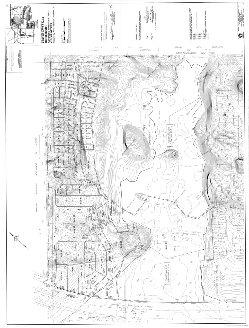
3 1.0 INTRODUCTION Novatech has been retained by Regional Group to prepare a Planning Rationale & Integrated Environmental Review in support of a Draft Plan of Subdivision and Zoning By- Law Amendment Application for Phase 4 of the Richardson Ridge Subdivision in Kanata. The Phase 4 lands are located on Block 454 and part of Block 453 on the original Richardson Ridge Subdivision (Original File No. D ), which received draft approval in 2010 and was most recently extended in April 2016 to April 30, 2019 (D ). The lands are owned as a co-tenancy between Braebury Homes, Cardel Homes, and Uniform Urban Developments with the planning and project management coordinated by Regional Group. The proposed subdivision includes a total of 197 residential units consisting of 41 single detached dwellings and 156 townhouse units organized around four public streets. Street one, providing access from Terry Fox Drive, will be shared with a future Richcraft residential development to the north. The proposed subdivision also includes a 0.7 hectare public park (Block 53), a stormwater management block (Block 55), pathway connections (Blocks 42, 43 and 44) and several environmental blocks contributing to the Kizzel Provincially Significant Wetland (KPSW) and Blanding s Turtle compensation (Blocks 54, 65 and 66). A copy of the Draft Plan is provided as Appendix A. The subject property consists of lands along the northern boundary of the KPSW. A 30 metre setback from the wetland edge was established and mapped in consultation with Dr. Nick Stow of the City of Ottawa and the Ontario Ministry of Natural Resources and Forestry (OMNRF) in The eastern portion of the Natural Environment Area (NEA) lands is currently owned by the City. The block of land between Terry Fox Drive and the City owned NEA lands is Block 54 on the proposed Draft Plan and is currently part of the Richardson Ridge Subdivision. Following registration of the development, Block 54 will be dedicated to the City. This will effectively create a corridor of protected habitat from Goulbourn Forced Road west to Terry Fox Drive and the Carp River. This Planning Rationale will outline the various aspects of the proposal and illustrate that the proposed development is consistent with relevant provincial and municipal policies. An Integrated Environmental Review has been prepared as part of this report as required under Section 4.7 of the Official Plan. The purpose of an Integrated Environmental Review is to demonstrate how supporting studies influenced the design of the development with respect to effects on the environment and compliance with the appropriate policies of Section 4 of the Official Plan. 1

4 1.1 Site Location and Context The subject site is located at 467 Terry Fox Drive in Kanata and has a total of hectares. It is legally described as Part of Lot 7, Concession 1, Geographic Township of March, now City of Ottawa. The land is currently vacant and consists of a combination of open fields and treed areas and includes a portion of the Kizzel Provincially Significant Wetland (KPSW) adjacent to Terry Fox Drive. No development is proposed within 30m of the KPSW. The proposed development area north of the KPSW has an area of 10.2 hectares with approximately 210m of frontage along Terry Fox Drive. Block 54, which contains a portion of the KPSW has an area of 6.15 hectares and will be dedicated to the City as part of the Natural Environment Area (NEA). The site is located north of the existing developed area of Kanata, across the KPSW from Phases 1, 2 and 3 of the Richardson Ridge Subdivision. The eastern boundary of the site is formed by the untraveled road allowance between Concessions 1 and 2. Terry Fox Drive is the limit of the Urban Boundary in this location, and the lands west of the subject site are in the Rural Area. The Carp River flows roughly parallel to Terry Fox Drive in this location and is approximately 175 metres west of the subject site. N Figure 1: Site Location and Context 2

5 The adjacent lands north of the subject site are currently undeveloped. Richcraft owns the site directly to the north and intends to develop a residential subdivision that will be integrated with the road network of the proposed development. Further to the north and east of the site, the land is owned by Kanata North Land Development (KNL). The area was Draft Plan approved in 2005 and is zoned as per the approved residential subdivision to permit low rise residential development. 1.2 Planning Context City of Ottawa Official Plan Figure 2 is an extract of Official Plan Urban Area Schedule B that shows the subject property is designated as General Urban Area, with the easterly portion designated Major Open Space. To the south and southeast of the site, the KPSW is designated Significant Wetland with the surrounding lands designated as Urban Natural Feature. Figure 2: Excerpt from Official Plan Schedule B - Urban The General Urban Area designation permits a wide range of uses, including housing with a variety of densities, employment, retail, service, cultural, leisure, entertainment and institutional uses. The proposed residential uses are permitted in the General Urban Area. 3

6 The Major Open Space designation is intended for large parks, open space corridors along the Ottawa and Rideau Rivers and the Rideau Canal, parkway corridors and corridors reserved for rapid-transit and major roads. The corridor north and east of the site follows the un-travelled road allowance between Concessions 1 and 2 and incorporates a portion on the Environmentally Protected Area surrounding the KPSW. Terry Fox Drive is the limit of the Urban Boundary in this location and the lands to the west are located outside the Urban Boundary. As shown on an extract of Official Plan Schedule A shown as Figure 3, across Terry Fox Drive to the West the area is designated as General Rural Area and Urban Expansion Study Area. North of Terry Fox Drive, the South March Highlands are designated as a Natural Environment Area. Figure 3: Excerpt from Official Plan Schedule A - Rural Terry Fox Drive is designated as spine route of the cycling network on Schedule C, which also shows major pathway connections south of the subject site and along both edges of the wetland complex. East of the site the proposed realigned Goulbourn Forced Road is shown as part of a cross-town bikeway. An excerpt from Schedule C is provided as Figure 4. 4


7 Figure 4: Excerpt from Official Plan Schedule C Terry Fox Drive is designated as an Arterial Road on Schedule E, as shown on Figure 5. A planned collector road through the KNL Developments lands is shown north of the subject site and south of the railway tracks, linking Terry Fox Drive to the realigned Goulbourn Forced Road. Figure 5: Excerpt from Official Plan Schedule E The KPSW is shown as an area of organic soils, as described in Schedule K, 'Environmental Constraints'. 5

8 1.2.2 Existing Zoning (City of Ottawa Zoning By-Law ) Figure 6: Existing Zoning The subject site is currently zoned Development Reserve (DR), Environmental Protection (EP), and Open Space O1. The existing zoning is shown on Figure 6. The purpose of the Development Reserve Zone is to recognize lands intended for future urban development in areas designated as General Urban Area and Developing Community in the Official Plan. The DR zone is essentially a placeholder to prevent development before studies have been completed and approved. These studies are being completed through the subdivision process and the site will be rezoned to support the proposed residential and open space land uses. The existing zoning map also shows floodplain surrounding the Carp River, including an area of floodplain extending to the KPSW and over the southwest corner of the subject site. This area within the floodplain will be part of a stormwater management block. Block 454 of the Richardson Ridge Subdivision was established as the limit of development adjacent to the NEA Lands. The existing zoning boundary for the EP zone will be revised to match the property line and the boundary between the subdivision lands and Block 54 which corresponds to the 30m setback from the NEA. 6
.")
9 2.0 PROPOSED DEVELOPMENT Figure 7: Proposed Development The proposed development includes a total of 197 residential units, with 41 single detached lots (Lots 1-41) and 156 proposed townhouse units (Blocks and 56-63). A neighbourhood park (Block 53), pathway blocks (Blocks 42, 43 and 44), stormwater management block (Block 55), block for Blanding s Turtle compensation (Blocks 65) and open space block (Block 66) are also proposed. Block 54, south of the proposed development, contains floodplain and part of the KPSW and will be dedicated to the City following registration of the subdivision. A larger version of the Concept Plan is provided as Appendix B. The primary access to the subdivision from Terry Fox Drive, Street 1, will be shared with the future Richcraft development to the north. Two direct vehicular connections to the Richcraft 7

10 subdivision are also proposed to integrate the two communities and create a cohesive neighbourhood north of the KPSW. The proposed 0.7 hectare park has been located on Block 53 to take advantage of the natural topography and incorporate an existing landform feature with views over the wetland. Park area adjacent to the street will be graded level to permit a playing field and other facilities, as shown on the preliminary Park Fit plan provided as Figure 8. The existing treed rock outcrop overlooking the wetland will be preserved and will provide passive recreation space. Figure 8: Preliminary Park Fit Plan Blocks 65 at the northeast end of the site will be preserved to protect an existing pond known to function as Blanding s Turtle habitat. Turtle fencing around this block and along the boundary of the wetland form part of the Blandings Turtle compensation discussed further in section 3.2 of this rationale. Fencing will include a combination of chain link fencing at the back of lots with plastic privacy inserts, angled one-way wildlife exclusion fencing, and rock wall turtle movement barriers. 8

11 A 6 metre pathway block (Block 43) along the edge of the 30m buffer to the wetland will contain a pathway extending from the park along the edge of Natural Environmental Area and connecting back on to the internal street network between Blocks 48 and 49. A second pathway block (Block 42) adjacent to the turtle conservation lands will connect back to the NEA lands where a pathway will connect across the wetland into Richardson Ridge Phase 3. As shown on Figure 9, this pathway system will form a looping trail integrated with the existing trail system through Phases 1, 2 and 3 of the Richardson Ridge Subdivision and the City trail network. Figure 9: Conceptual Integrated Pathway Network Block 55 in the southeast corner of the site will accommodate an oil/grit separator required for stormwater management. 3.0 OVERVIEW OF TECHNICAL STUDIES 3.1. Archaeological Assessment Section of the Official Plan states that an Archaeological Assessment is required when development is proposed on lands identified as having archaeological potential on the City s 9
12 Archaeological Resource Potential Mapping. Northeastern Archaeological Associates Limited conducted a Stage 1 and 2 Archaeological Assessment (August 2012) of the subject site during the spring and summer of Stage 1 research indicated that the property is of high archaeological potential, as outlined by the Ministry of Tourism, Culture and Sport, due to its proximity to registered archaeological sites, areas of historic development, existing watercourses and historic transportation corridors. All Stage 2 testing on this property therefore took place at a high potential (5 meter) interval. The development area of the property was assessed using pedestrian survey and test-pit survey in accordance with MTCS 2011 Standards & Guidelines for Consultant Archaeologists. This survey did not result in the discovery of any material of cultural significance. Given this result it was the recommendation of Northeastern Archaeological Associates Ltd. that no further archaeological work be required on the subject property Environmental Impact Statement & Tree Conservation Report An Environmental Impact Statement and Tree Conservation Report was prepared by McKinley Environmental Solutions (July 2016) following the City of Ottawa Tree Conservation Report Guidelines and Section of the Official Plan. Existing Conditions Under existing conditions, approximately 60% of the site consists of predominantly open areas with sparse tree cover. The remainder of the site includes a mixture of Cultural Woodland and forest habitats, including several vernal pools. Most of the site has been cleared for farming within the last 40 years and historic air photos indicate that only the eastern part of the site and portions of the lands south of the Site have forest older than approximately 40 years. Existing conditions are shown on the Ecological Land Classification Overview provided as Figure
.")
13 Figure 10: Ecological Land Classification Overview Kizzel Provincially Significant Wetland The lands south of the subject site represent a westward extension of the Kizell Provincially Significant Wetland (KPSW). Following registration of the development, the block of land between Terry Fox Drive and the City-owned Natural Environmental Area (NEA) (Block 54) 11
14 will be dedicated to the City. Block 54 includes both the western extension of the KPSW and a 30 metres buffer of terrestrial habitat around the wetland. The eastern portion of the NEA is currently owned by the City. Once Block 54 is conveyed to the City, this will effectively create a corridor of protected habitat from Goulbourn Forced Road west to Terry Fox Drive. The preservation of Block 54 and the remainder of the NEA lands ensures protection of the highest quality forest in the area and protection of the KPSW. Species at Risk Butternut Trees and Blanding s Turtle Species at Risk that occur within the Site. It is anticipated that a total of nine (9) retainable Butternut Trees will be removed by the proposed development. Areas of Category 2 and 3 Blanding s Turtle habitat will also be removed. Extensive consultation has been undertaken with the Ontario Ministry of Resources and Forestry (OMNRF) through the application process for an Overall Benefit Permit under clause 17(2)(c) of the Endangered Species Act (ESA). An application to address potential impacts on the habitat of threatened Blanding s Turtles and endangered Butternut Trees was submitted to OMNRF in May 2015, followed by a second submission in November Compensation for the removal of Butternut Trees will include archiving of a Category 3 Tree and a contribution to help expand the capacity of the Eastern Ontario Butternut archiving effort. Compensation for the loss of Blanding s Turtle habitat will include construction of a new wetland on a portion of the Block 54 lands and an expansion of the existing Terry Fox Drive Wildlife Passage system to reduce turtle road mortality risks. As shown on Figure 11, within the Richardson Ridge Phase 4 subdivision boundary, Blocks 65 and 66 will also be preserved at the eastern edge of the development. Block 65 was designated as open space in consultation with the OMNRF in order to protect the most important vernal pools that serve as Blanding s Turtle habitat. Block 65 also includes the majority of older forest within the Site. Block 65 will connect to the adjacent NEA lands and will effectively increase the size of the NEA conservation lands. 12

15 Figure 11: Blanding s Turtle Compensation Plan prepared for Overall Benefit Permit The preservation of the KPSW and the maintenance of Species at Risk habitat have been addressed through the measures outlined above, which include a combination of habitat retention, mitigation, and habitat compensation measures. With the appropriate implementation of these measures, it is anticipated that the proposed development will not have a significant negative effect on the natural features and functions Phase 1 Environmental Site Assessment A Phase I Environmental Site Assessment was prepared by Paterson Group (January , PE3704-1) to investigate potential site contamination by current or past uses. The results of the historical research, personal interviews, and the site inspection did not identify any potential environmental concerns with respect to the subject site or within the Phase I ESA study area. Based on the results of the assessment the report concludes that a Phase II Environmental Site Assessment is not required for the property. 13
16 3.4. Hydrogeological Report A Hydrogeological Study was prepared by Paterson Group (July 5, 2016, PG3823-1) at the request of the City of Ottawa and the Mississippi Valley Conservation Authority (MVCA) to address potential impacts from the proposed development on the adjacent Provincially Significant Kizzel Wetland. The pre-development water budget analysis conducted at the subject site determined that an estimated 8,201 m³/year of surplus water currently infiltrates the surface soils. The remaining estimated 21,300 m³/year of surplus leaves the site as runoff, a large portion of which is anticipated to flow towards the KPSW adjacent to the site. The post-development water budget analysis alternatively determined that an estimated 10,485 m³/year of surplus water will infiltrate the surface soils and 23,136 m³/year will leave the site as runoff. These values equate to approximate increases in both infiltration and runoff of 28% and 9% respectively. While this may result in an increase in water levels within the KPSW, it is expected to be negligible given the increase in runoff volume relative to the area of the wetland. The EIS prepared by McKinley Environmental indicates that a slight increase in water level would have minimal potential to impact the overall vegetative composition or functionality of the wetland. The anticipated increase in flow contributions under post-development conditions is expected to be much smaller in scale when compared to the potential annual fluctuations that occur naturally. The EIS notes that from a biological perspective, impacts from changes in water level of the magnitude anticipated under post-development conditions are negligible, as they are likely to fall within the range of existing natural variability. In terms of biological activity in the KPSW, the most significant feature is the presence of a population of Blanding's turtles. The EIS prepared by McKinley Environmental notes that currently existing habitat for the Blanding's turtle is poor quality due to the hydroperiod that exists at the subject site. As such, the anticipated neutral or minimal increase in water levels and/or hydroperiod under post-development conditions will either have no substantial effect on the turtle population, or will represent a marginal improvement to habitat quality Geotechnical Investigation A geotechnical investigation was undertaken by Paterson Group (April 2016, PG3695-1) to determine the subsurface soil and groundwater conditions and provide geotechnical recommendations for the design of the proposed development. Generally, the subsurface profile encountered at the test hole locations consists of topsoil over a silty clay deposit and glacial till and/or bedrock. From a geotechnical perspective, the subject site is adequate for the proposed residential development. Due to the presence of the sensitive silty clay layer within the west portion of the Phase 4 site, some areas will be 14
17 subjected to grade raise restrictions. Existing slopes within the site are considered stable and no setbacks are required from a slope stability perspective. The report recommends that trees placed within 4.5 m of foundation walls consist of low water demanding trees with shallow roots systems that extend less than 1.5 m below ground surface. Trees placed greater than 4.5 m from the foundation wall may consist of typical street trees. According to the geotechnical reports produced to date, the site was determined to be suitable for the proposed development Noise Control Feasibility Study The Serviceability Report prepared by IBI Group in July 2016 briefly addresses Roads and Noise Attenuation Measures. A full environmental noise impact assessment will be prepared as part of the detailed design to assess the noise impact from traffic along adjacent roads. The Draft Plan has been designed to minimize requirements for noise attenuation measures by incorporating window streets and open space toward Terry Fox Drive. There will, however, need to be a short length of noise wall for the sideyards of the units fronting Street 1 and 3. Typical indoor noise is expected to be exceeded and special noise clauses will be determined by the environmental noise impact assessment Servicing Brief Section of the Official Plan requires development applications to be supported by an assessment of the adequacy of public services. IBI Group prepared a Serviceability Report (July 2016) for the subject property. In addition to the above noted report specifically for Richardson Ridge Phase 4, IBI also prepared and submitted servicing reports for Phases 1, 2 and 3 of the Richardson Ridge development, the detailed design report for the sanitary and watermain to be constructed within Terry Fox Drive, and updates to the Signature Ridge Pump Station Hydraulic Grade Line Analysis for Minto Communities Arcadia Stage 2, dated September Stormwater The proposed Phase 4 site is a part of the overall Richardson Ridge Development, but will have a separate stormwater system to Phases 1 to 3. Minor system flows from the proposed Phase 4 storm sewer system will be conveyed to two new Oil Grit Separators, one at each the East and West limits of the development. Treated stormwater will then be released back into the KPSW. Due to the proximity to the PSW, enhanced level of treatment (level 11) will be provided at each outlet. 15
18 The balance of the surface flow not captured by the minor system will be conveyed via the major system. Where possible, storage will be provided in street sags or low points within the roadway and once the maximum storage is utilized, the excess flow will cascade to the next downstream street sag. Major flow from the proposed Phase 4 development is conveyed to the Natural Environment Area (NEA) via dedicated overland spillways using the pathway network. Potable Water As part of the development of Phase 1 and the Terry Fox Drive extension, a 300 mm diameter watermain was constructed on Huntsville Drive to Terry Fox Drive. The 300 mm main was extended northwest along Terry Fox adjacent to the Phase 4 site. Stantec Consulting recently completed the Kanata North Potable Water Servicing Analysis for the City of Ottawa and Urbandale Corporation for adjacent KNL Lands. A 300 mm watermain is shown on Terry Fox extending through the Phase 4 site to connect to a proposed 300 mm watermain on future Walden Drive in the KNL lands to the east. A combination of 200 and 250 mm mains are required for the remainder of Phase 4 in order to meet the fire flow requirement. Sanitary The City of Ottawa commissioned a Master Sanitary Sewer Plan for the Kanata Lakes, Broughton & Interstitial Lands (Stantec Report, December 2007). This report reviewed the potential servicing of these development areas and reviewed the adequacy of the downstream sanitary sewers to service the area including the sanitary sewers along Terry Fox Drive and the Kanata Lakes Trunk. The Stantec report used projected population data available at the time including a population of 2455 for the Richardson Lands to the Terry Fox Drive trunk sewer, and a population of for the Richardson Lands to the Kanata Lakes trunk sewer. Since that report, the Richardson Ridge development has been fine-tuned and the Broughton lands have been fully constructed. The design population for the currently approved phases in Richardson Ridge is A residual population of is allocated for Phases 3C, Phase 4 and an allocation for Richcraft Homes development adjacent to the site. To this end, the downstream sewers were designed and constructed to accommodate a larger population and are of sufficient size to accommodate the population design flows from the proposed development Community Transportation Study A Community Transportation Study (CTS) is required by Section 4.3 of the Official Plan when a subdivision or rezoning application is submitted and may have an impact of the transportation network in the surrounding area. 16
19 IBI Group prepared a Community Transportation Study (August 2016) for the proposed development and evaluated the potential impact of the surrounding area in combination with several other planned developments occurring in the study area, including Richardson Ridge phases 1 to 3. Both Phases 1 to 3 and the proposed Phase 4 development were assumed to be fully built out by This was considered a conservative assumption. Vehicular access to Phase 4 is provided by a single connection to Terry Fox Drive (Street 1). All roads within Phase 4 are to be constructed within 18 metres ROW, with the exception of where Street No. 1 connects to Terry Fox Drive where the ROW will be 20 metres to accommodate auxiliary lanes at the intersection. The 18.0m local road right-of-way can accommodate a sidewalk on one side of the road. No dedicated bicycle lanes or facilities are planned within the proposed development at this time, however appropriate connections, both internal and to the regional network, have been provided to accommodate active transportation. A more detailed review of active transportation facilities will be completed at the detailed design stage. Transit service is provided along Terry Fox Drive, which can service the site. If a bus stop were located at the Terry Fox Drive and Street 1 intersection, a 400m straight line distance would accommodate approximately 85% of households in the proposed development. Community impacts as a result of the proposed development were considered minimal. 4.0 PLANNING POLICY REVIEW 4.1 Provincial Policy Statement The 2014 Provincial Policy Statement (PPS) provides policy direction on land use planning and development matters of provincial interest, as set out in section 2 of the Planning Act. All decisions affecting planning matters are required to be consistent with policies of the PPS. Section 1.1 of the PPS speaks to managing and directing land use to achieve efficient and resilient development and land use land patterns. Policy states that healthy, liveable and safe communities are sustained by promoting efficient land use patterns with a range and mix of uses arranged as to minimize land consumption and servicing costs. Further, development patterns should avoid environmental or public health and safety concerns, conserve biodiversity, and consider the impacts of a changing climate. The proposed development consists of a mix of single detached and townhouse dwellings as well as recreational parkland and protected environmental land. The site is long and narrow, limiting street layout options, however as much as possible the development is arranged as a modified grid street with planned pedestrian and road connections to future adjacent development, creating an integrated neighbourhood north of the KPSW and making efficient use of the land available. Pathway connections to and through the KPSW 17
20 and NEA will connect to the wider pathway system, integrating Phase 4 with the Phases 1 to 3 of Richardson Ridge and promoting active transportation. Health and safety concerns have been addressed through the Phase 1 ESA, discussed in Section 3.3, which determined there is no soil contamination or hazardous materials on the site. The proposed development is located within the Urban Boundary on lands designated by the City of Ottawa as settlement area. The boundary of the KPSW and appropriate buffer area was determined through consultation with the City and MVCA based in analysis of environmental impacts. Policy requires land use patterns within settlement areas to be based on: b) densities and a mix of land uses which: 1. efficiently use land and resources; 2. are appropriate for, and efficiently use, the infrastructure and public service facilities which are planned or available, and avoid the need for their unjustified and/or uneconomical expansion; 3. minimize negative impacts to air quality and climate change, and promote energy efficiency; 4. support active transportation; 5. are transit-supportive, where transit is planned, exists or may be developed, and; 6. are freight-supportive. The proposed development is Phase 4 of the Richardson Ridge Subdivision, which has been planned and designed as a cohesive development making efficient use of land while preserving and featuring the natural distinctive topography. Infrastructure, including stormwater management, road patterns, parkland and pathway systems have been coordinated with Phases 1-3 of the Richardson Ridge Development. The development is well integrated with transit along Terry Fox Drive. A bus stop at the Terry Fox Drive and the Street 1 intersection would be within a 400m straight line distance from approximately 85% of households. Terry Fox Drive is a Spine cycling route and has 2 metre wide paved shoulders on both sides of the road signed as bicycle lanes. Concrete Sidewalks have been provided at the intersection with Huntsville Drive as well as at Richardson Side Road. South of Richardson Side Road, concrete sidewalks are on provided on the east side of Terry Fox Drive. A 3 metre wide multi-use pathway provides pedestrian connectivity along Terry Fox north of Richardson Side Road as March Road. As discussed in Section 3.7 of this report, servicing and stormwater management has been coordinated with the servicing strategy for the overall Richardson Ridge Development. The intended population for Richardson Ridge Phase 4 is less than the projected population used for the initial calculations and there are no issues with capacity. No servicing 18
21 constraints were identified that could not be addressed through normal engineering practices and in-line with intended servicing strategy for the area. Section of the PPS states that new development should occur adjacent to the existing built-up area and allow for the efficient use of land. The proposed development is located within the City of Ottawa s designated Urban Area and is occurring as Phase 4 of Richardson Ridge. The site will be fully integrated with planned adjacent development to the north. Public Spaces, Recreation, Parks, Trails and Open Space Policy states that healthy, active communities should be promoted by planning public streets, spaces and facilities to be safe, meet the needs of pedestrians, foster social interaction and facilitate active transportation and community connectivity. The CTS prepared by IBI Group addresses the required road, transit, pedestrian, and cycling facilities necessary to support the proposed subdivision. Appropriate connections, both internal and to the regional network, have been provided to accommodate active transportation. Streets and pathways have been arranged in a modified grid pattern which will extend to the north to connect into the planned Richcraft development. The 18.0m local road right-of-way can accommodate a sidewalk on one side of the road. A pathway connection through the park block and from Street 4 through to the park and a second connection adjacent to Block 65 will complete a circular pathway system through the NEA lands and connected to Richardson Ridge Phases 1 to 3 and to the wider recreational pathway system. The proposed development will have adequate provisions for transit and active modes of transportation, including easy access to local pedestrian, bicycle, and transit systems as identified in the City of Ottawa Pedestrian Plan and Cycling Plan (2013). The proposed development includes a centrally located neighbourhood park that is within 400m of all proposed dwellings. Infrastructure and Public Service Facilities Section 1.6 of the PPS states that infrastructure shall be provided in a coordinated, efficient and cost-effective manner to accommodate projected needs. The proposed development will be wholly on municipal services. The Servicing Brief, discussed under Section 3.6 of this report, demonstrates that there is adequate infrastructure to support the proposed subdivision. 19
22 Transportation Systems Section of the PPS promotes safe, energy efficient transportation systems that facilitate the movement of people and goods. The CTS prepared by IBI addresses impacts on the adjacent community and confirms that community impacts as a result of the proposed development are expected to be minimal and that the proposed subdivision can be safely and adequately accommodated. Additional detail is provided in this Planning Rationale under Section 3.8. Wise Use and Management of Resources Section 2.0 of the PPS - Wise Use and Management of Resources speaks to protecting natural heritage, water, agriculture, mineral aggregate, petroleum, cultural heritage and archaeological resources. As discussed in Section 3 of this Rationale, and EIS/TCR was prepared by McKinley Environmental, the development has been designed to respect the KPSW, and Overall Benefit Permits for Blanding s Turtle and Butternut have been prepared to offset any impact on the species as a result of the development. The Water Balance prepared as part of the Hydrogeological report confirms that increases to post-development water levels within the PSW are expected to be negligible given the increase in runoff volume relative to the area of the wetland. There are no cultural heritage or archaeological resources identified on the property. The Stage 1 and 2 Archaeological Assessment conducted by Northeastern Archaeological Associates Limited recovered no archaeological materials and concluded that there are no archaeological concerns for this area. Health and Safety Section 3.0 of the PPS - Protecting Human Health and Safety focuses on reducing the potential for public cost or risk to residents from natural or human-made disasters. There are no erosion or dynamic beach hazards on or adjacent to the site, and no past mineral resource extraction, aggregate operations, or petroleum resource operations are known to have occurred. As discussed in Section 3.3 of this Rationale, a Phase 1 Environmental Site Assessment was prepared by Paterson Group. The Phase 1 ESA did not identify any evidence to suggest past or present soil contamination and further assessment was not recommended. 20
23 4.2 City of Ottawa Official Plan As previously discussed, the subject property is designated General Urban Area and Major Open Space on Schedule B of the City of Ottawa Official Plan. The proposed residential, park and environmental uses are permitted within the General Urban Area. The turtle compensation Block 65 and open space Block 66 are within the Major Open Space designation and will contribute to providing a continuous north-south linkage between the KPSW and the South March Highlands Wetland Complex. Policy 2 of Section which address the Major Open Space Designation states that The boundaries of Major Open Space are based upon a variety of maps and sources. When more detailed information is obtained from Federal, Provincial or Municipal studies, or through development agreements, this information may warrant minor adjustments to the interpretation of the boundary. The City's Zoning By-law will reflect the most up-to-date and accurate information for these boundaries, and therefore any changes will require an amendment to the Zoning By-law. However, minor changes to the boundaries will not require an amendment to the Official Plan. The proposed Draft Plan maintains the Major Open Space corridor through Blocks 65 and 66.The exact boundary of the Major Open Space designation will be established through the zoning proposed for the subdivision, following the lot line along the rear yard of Lots Section of the Official Plan provides policy for directing development within the General Urban Area designation. Policy 2 of Section of the Official Plan states that the evaluation of development applications, studies, other plans and public works undertaken by the City in the General Urban Area will be in accordance with Section and Section 4.11, Urban Design and Compatibility. Policy 1 of Section 4.11 states that when evaluating compatibility of development applications, the City will have regard for the policies of the site s land use designation, and all applicable site specific plans, policies and urban design guidelines. Section 4.11, Urban Design and Compatible Development, discusses the relationship between new and existing development and provides policies to evaluate the compatibility of a development with regard to Views, Building Design, Massing and Scale, and Design Priority Areas. Views: no significant viewsheds were identified on the subject property. The park location was selected to preserve an existing rocky outcropping with mature trees and the potential to create an unique amenity with views overlooking the wetland. 21
24 Building Design: Good building design contributes to successful neighbourhood integration and the compatibility of new development with the existing or planned character of its surroundings. The proposed single-detached and townhouse dwellings are oriented to the street and will display strong architectural design elements. Massing and Scale: All proposed development is low-rise, with a maximum of two storeys, and is compatible and is complementary in scale to the existing surrounding development. Massing and scale are regulated through zoning which is further discussed in Section 6 of this Rationale. High-Rise Buildings: No high-rise buildings are being considered as part of this proposed development. Outdoor Amenity Areas: All units will have access to private rear yard amenity areas and residents will have access to an extensive public trail system through the KPSW and NEA lands and Richardson Phases 1 to 3. The proposed park block highlights the unique amenity provided by the adjacent wetland complex while protecting the wetland from encroachment. Design Priority Area: the subject property is not located in a design priority area. We find that the proposed development is generally consistent with Section 4.11 of the Official Plan. Section 2.5.1, provides specific design objectives qualifying how the City of Ottawa wants to influence the built environment. These design objectives are addressed below: 1. To enhance the sense of community by creating and maintaining places with their own distinct identity. The proposed subdivision has been designed to feature the adjacent wetland by locating the park on an existing high point with views over the wetland, and by creating pathway connections to an extensive trail system through the NEA and surrounding area. 2. To define quality public and private spaces through development. Street oriented dwellings will help to frame the public realm and create a consistent setback to define private amenity spaces. Townhouse dwellings facing the neighbourhood park on Block 58 will provide passive surveillance and eyes on the park. 3. To create places that are safe, accessible and are easy to get to, and move through. The subdivision is designed with an integrated road network connecting to Terry Fox Drive and with two direct road connections to future development to the north. Pathway connections through the longer residential blocks will provide direct pedestrian routes to the park and pathway system along the KPSW. 22
25 The Community Transportation Study prepared by Parsons demonstrates that the proposed development can proceed from a transportation perspective. Transit service is provided along Terry Fox Drive, which can service the site. A bus stop located at the Terry Fox Drive and Street 1 intersection would place approximately 85% of households in the proposed development within a 400m straight line distance of transit. 4. To ensure that new development respects the character of existing areas. The development is Phase 4 of the Richardson Ridge Subdivision and will be designed with a similar character to the existing and planned development of Phased 1 to 3 south of the KPSW. The entire Richardson Ridge development has a naturalized character emphasizing the natural topography and bedrock outcroppings. Phase 4 has been designed with a similar character, with the park location selected to feature and preserve an existing rocky promontory. 5. To consider adaptability and diversity by creating places that can adapt and evolve easily over time and that are characterized by variety and choice. The mix of single detached and townhouse dwellings in Phase 4 will contribute to the full range of housing options throughout the Richardson Ridge subdivision. 6. To understand and respect natural processes and features in development design. The subdivision has been designed to respect the adjacent KPSW and NEA, with the wetland boundary determined through extensive consultation with the City and Conservation Authority. Stormwater will be treated to an enhanced level to endure the quality of water released back into the wetland. An Overall Benefit Permit for Blanding s Turtle and Butternut has been prepared to offset any impact on the species as a result of the development. The Water Balance prepared as part of the Hydrogeological report confirms that increases to post-development water levels within the PSW are expected to be negligible given the increase in runoff volume relative to the area of the wetland. 7. To maximize energy-efficiency and promote sustainable design to reduce the resource consumption, energy use, and carbon footprint of the built environment. The development will be well connected to transit routes along Terry Fox Drive with the possibility of a future transit route through the community once areas to the north develop. A network of sidewalks and multi-use pathways will encourage active transportation. The Richardson Ridge subdivision complies with the City s Transportation Demand Management (TDM) policy by providing easy access to non-auto modes of travel in terms of connections to adjacent pedestrian and transit facilities 23

26 5.0 PROPOSED ZONING BY-LAW AMENDMENT A zoning amendment application will be required to amend the subject property from DR Development Reserve Zone and EP Environmental Protection Zone to implement residential zones for the development parcels, O1 Park Zone for the proposed park block, and modifications to the EP Zone to reflect the portions adjacent to the KPSW. A proposed zoning schedule is provided as Appendix C. Figure 12: Blanding s Turtle Compensation Plan prepared for Overall Benefit Permit In order to permit the proposed development as described, the following zoning is proposed. Proposed Zoning: Proposed Land Use Block/Lot on Draft Plan Proposed Zoning Single Detached Lots 1-41, Pathway Blocks 42 and 44 R1 Townhouse Dwellings Blocks 45-52, 56-63, Pathway Block 43 R3 Neighbourhood Park Blocks 53 O1 Stormwater Management Block 55 O1 Turtle Conservation Blocks 65 and 66 EP 6.0 CONCLUSION As demonstrated by this Rationale, the proposed development is consistent with the Provincial Policy Statement and conforms to the City of Ottawa Official Plan. The prosed subdivision is compatible with existing and planned surrounding uses, has been designed to respect the adjacent natural area. 24
27 Appendix A: Draft Plan 26
28
29 Appendix B: Concept Plan 27
30 APPROVED UNDER SECTION 51 OF THE PLANNING ACT BY THE CITY OF OTTAWA. THIS DAY OF, MICHAEL MIZZI, MCIP RPP, ACTING GENERAL MANAGER PLANNING AND GROWTH MANAGEMENT DEPARTMENT PLANNING AND INFRASTRUCTURE PORTFOLIO CITY OF OTTAWA PLAN 4M- I CERTIFY THAT THIS PLAN IS REGISTERED IN THE LAND REGISTRY OFFICE FOR THE LAND TITLES DIVISION OF OTTAWA-CARLETON NO. 4 AT _ O'CLOCK ON THE DAY OF _, AND ENTERED IN THE PARCEL REGISTER FOR PROPERTY IDENTIFIERS AND THE REQUIRED CONSENTS ARE REGISTERED AS PLAN DOCUMENT NO. LAND REGISTRAR This plan comprises all of the land identified by PIN. Future Residential Development by Richcraft PLAN OF SUBDIVISION OF PART OF LOTS 7 And 8 CONCESSION 1 Geographic Township of March CITY OF OTTAWA Surveyed by Annis, O'Sullivan, Vollebekk Ltd. Scale 1 : Metres Terry Fox Drive Townhouse Blocks Turtle Conservation Metric DISTANCES AND COORDINATES SHOWN ON THIS PLAN ARE IN METRES AND CAN BE CONVERTED TO FEET BY DIVIDING BY SURVEYOR'S CERTIFICATE I CERTIFY THAT : 1. This survey and plan are correct and in accordance with the Surveys Act, the Surveyors Act and the Land Titles Act and the regulations made under them. 2. The Survey was completed on the _ day of _,2016. SWM Date Edward M. Lancaster Ontario Land Surveyor Park OWNER'S CERTIFICATE THIS IS TO CERTIFY THAT : 1. Lots 1 to 41, both inclusive, Blocks 42 to 63, both inclusive, Blocks 65 and 66, the Streets, namely Streets 1 to 4 and the Reserve, namely, Block 64 have been laid out in accordance with our instructions. City Owned NEA 2. The Streets are dedicated as public highways. Dated the day _ of _,2016 XXX, President XXXXXX. I have authority to bind the corporation. Block 54 to be transfered to City Kizzel Provincially Significant Wetland NOTES AND LEGEND denotes Survey Monument Planted. Survey Monument Found SIB Standard Iron Bar. SSIB Short Standard Iron Bar. CC Cut Cross. IB Iron Bar. CLF Chain Link Fence BF Board Fence (AOG) Annis, O'Sullivan, Vollebekk Ltd. (P1) (P2) Plan Plan All planted survey monuments are IB's unless otherwise noted. Distances shown on curved limits are Arc distances unless otherwise noted. Distances shown on this plan are ground distances and can be converted to grid distances by multiplying by the combined scale factor of xx. Bearings are grid, derived from Can-Net 3.0 Real Time Network GPS observations on reference points A and B, shown hereon, having a bearing of Nxx xx'xxw and are referenced to Specified Control Points and , MTM Zone 9 ( 76 30' West Longitude ) NAD-83 (original). Coordinates are derived from Can-Net 3.0 Real Time Network GPS observations referenced to Specified Control Points and , MTM Zone 9 (76 30' West Longitude) NAD-83 (original). Coordinate values are to urban accuracy in accordance with O. Reg. 216/10. Y:\REGIONAL GROUP\ Richardson Ridge Sub\Drawings\ Regional Pt Lts 7 8 C1 MA ph4 SUB D6.dwg, 10/05/2016 2:32:59 PM Richarson Ridge Phase Northing Easting Northing Easting Point A Northing Easting. Point B Northing Easting Caution: Coordinates cannot, in themselves, be used to re-establish corners or boundaries shown on this plan. 14 Concourse Gate, Suite 500 Nepean, Ont. K2E 7S6 Phone: (613) / Fax: (613) Nepean@aovltd.com 12
31 Appendix C: ZBLA Schedule 28
32 APPROVED UNDER SECTION 51 OF THE PLANNING ACT BY THE CITY OF OTTAWA. THIS DAY OF, MICHAEL MIZZI, MCIP RPP, ACTING GENERAL MANAGER PLANNING AND GROWTH MANAGEMENT DEPARTMENT PLANNING AND INFRASTRUCTURE PORTFOLIO CITY OF OTTAWA PLAN 4M- I CERTIFY THAT THIS PLAN IS REGISTERED IN THE LAND REGISTRY OFFICE FOR THE LAND TITLES DIVISION OF OTTAWA-CARLETON NO. 4 AT _ O'CLOCK ON THE DAY OF _, AND ENTERED IN THE PARCEL REGISTER FOR PROPERTY IDENTIFIERS AND THE REQUIRED CONSENTS ARE REGISTERED AS PLAN DOCUMENT NO. LAND REGISTRAR This plan comprises all of the land identified by PIN. PLAN OF SUBDIVISION OF PART OF LOTS 7 And 8 CONCESSION 1 Geographic Township of March CITY OF OTTAWA Surveyed by Annis, O'Sullivan, Vollebekk Ltd. Scale 1 : Metres R3 R1 O1 Metric DISTANCES AND COORDINATES SHOWN ON THIS PLAN ARE IN METRES AND CAN BE CONVERTED TO FEET BY DIVIDING BY EP SURVEYOR'S CERTIFICATE I CERTIFY THAT : 1. This survey and plan are correct and in accordance with the Surveys Act, the Surveyors Act and the Land Titles Act and the regulations made under them. 2. The Survey was completed on the _ day of _,2016. Date Edward M. Lancaster Ontario Land Surveyor O1 OWNER'S CERTIFICATE THIS IS TO CERTIFY THAT : 1. Lots 1 to 41, both inclusive, Blocks 42 to 63, both inclusive, Blocks 65 and 66, the Streets, namely Streets 1 to 4 and the Reserve, namely, Block 64 have been laid out in accordance with our instructions. 2. The Streets are dedicated as public highways. Dated the day _ of _,2016 XXX, President XXXXXX. I have authority to bind the corporation. NOTES AND LEGEND denotes Survey Monument Planted. Survey Monument Found SIB Standard Iron Bar. SSIB Short Standard Iron Bar. CC Cut Cross. IB Iron Bar. CLF Chain Link Fence BF Board Fence (AOG) Annis, O'Sullivan, Vollebekk Ltd. (P1) Plan (P2) Plan All planted survey monuments are IB's unless otherwise noted. Distances shown on curved limits are Arc distances unless otherwise noted. Distances shown on this plan are ground distances and can be converted to grid distances by multiplying by the combined scale factor of xx. Bearings are grid, derived from Can-Net 3.0 Real Time Network GPS observations on reference points A and B, shown hereon, having a bearing of Nxx xx'xxw and are referenced to Specified Control Points and , MTM Zone 9 ( 76 30' West Longitude ) NAD-83 (original). Coordinates are derived from Can-Net 3.0 Real Time Network GPS observations referenced to Specified Control Points and , MTM Zone 9 (76 30' West Longitude) NAD-83 (original). Coordinate values are to urban accuracy in accordance with O. Reg. 216/10. Y:\REGIONAL GROUP\ Richardson Ridge Sub\Drawings\ Regional Pt Lts 7 8 C1 MA ph4 SUB D6.dwg, 10/05/2016 2:32:59 PM Northing Easting Northing Easting Point A Northing Easting. Point B Northing Easting Caution: Coordinates cannot, in themselves, be used to re-establish corners or boundaries shown on this plan. 14 Concourse Gate, Suite 500 Nepean, Ont. K2E 7S6 Phone: (613) / Fax: (613) Nepean@aovltd.com 12
MANOTICK MAIN REGIONAL INC. 5721, 5731 AND 5741 MANOTICK MAIN STREET OTTAWA, ON
 MANOTICK MAIN REGIONAL INC. 5721, 5731 AND 5741 MANOTICK MAIN STREET OTTAWA, ON PLANNING RATIONALE AND INTEGRATED REVIEW STATEMENT IN SUPPORT OF A DRAFT PLAN OF SUBDIVISION AND ZONING BY-LAW AMENDMENT
Van Gaal Lands Terry Fox Drive & 5331 Fernbank Road. Planning Rationale and Integrated Environmental Review Statement. Engineering.
 Engineering Land / Site Development Municipal Infrastructure Environmental / Water Resources Traffic / Transportation Structural Recreational Planning Land / Site Development Planning Application Management
DRAFT PLAN OF SUBDIVISION PLANNING RATIONALE 5100 KANATA AVENUE CITY OF OTTAWA. Hawthorn Retirement Group MALONE GIVEN PARSONS LTD.
 DRAFT PLAN OF SUBDIVISION PLANNING RATIONALE 5100 KANATA AVENUE CITY OF OTTAWA Prepared By: MALONE GIVEN PARSONS LTD. Prepared For: Hawthorn Retirement Group July 2015 Draft Plan of Subdivision 5100 Kanata
Prepared for: Ontario Limited
 Application for Zoning By-law Amendment and Plan of Subdivision 1353 Scharfgate Drive Planning Rationale Report Prepared for: 1384341 Ontario Limited November 28, 2014 Revised August 18, 2015 Planning
MINTO COMMUNITIES INC. HARMONY STAGE II 4025 STRANDHERD DRIVE CITY OF OTTAWA
 MINTO COMMUNITIES INC. HARMONY STAGE II 4025 STRANDHERD DRIVE CITY OF OTTAWA PLANNING RATIONALE AND INTEGRATED ENVIRONMENTAL REVIEW STATEMENT IN SUPPORT OF A DRAFT PLAN OF SUBDIVISION, OFFICIAL PLAN AMENDMENT
20 & 30 Frank Nighbor Place
 Engineering Land / Site Development Municipal Infrastructure Environmental / Water Resources Traffic / Transportation Structural Recreational Planning Land / Site Development Planning Application Management
UNIFORM URBAN DEVELOPMENTS RICHARDSON FLATS PLANNING RATIONALE IN SUPPORT OF A SITE PLAN CONTROL APPLICATION
 UNIFORM URBAN DEVELOPMENTS RICHARDSON FLATS PLANNING RATIONALE IN SUPPORT OF A SITE PLAN CONTROL APPLICATION Prepared By: NOVATECH Suite 200, 240 Michael Cowpland Drive Ottawa, Ontario K2M 1P6 August 28,
MAPLE GROVE SUBDIVISION 1981 MAPLE GROVE ROAD OTTAWA, ON. Planning Rationale & Integrated Environmental Review Study
 MAPLE GROVE SUBDIVISION 1981 MAPLE GROVE ROAD OTTAWA, ON Planning Rationale & Integrated Environmental Review Study In Support Of A Draft Plan of Subdivision And Zoning By-Law Amendment Prepared For: Claridge
PORT WHITBY COMMUNITY
 PORT WHITBY COMMUNITY SECONDARY PLAN UPDATE COMMUNITY IMPROVEMENT PLAN URBAN DESIGN GUIDELINES September 2015 DRAFT PROPOSED AMENDMENT NUMBER # to the Whitby Official Plan PURPOSE: The intent of this Amendment
Planning Rationale &Integrated Environmental Review In Support of a Draft Plan of Subdivision and Zoning By-Law Amendment 1053, 1075 and 1145 March
 Planning Rationale &Integrated Environmental Review In Support of a Draft Plan of Subdivision and Zoning By-Law Amendment 1053, 1075 and 1145 March Road City of Ottawa This planning rationale and integrated
HURON COMMUNITY PLAN
 CITY OF KITCHENER DEPARTMENT OF DEVELOPMENT AND TECHNICAL SERVICES PD 94/7 HURON COMMUNITY PLAN Recommended by Planning and Economic Development Committee: October 31, 1994 Adopted by Kitchener City Council:
FORMER CANADIAN FORCES BASE (CFB) ROCKCLIFFE SECONDARY PLAN. Official Plan Amendment XX to the Official Plan for the City of Ottawa
 ROCKCLIFFE SECONDARY PLAN. Official Plan Amendment XX to the Official Plan for the City of Ottawa") FORMER CANADIAN FORCES BASE (CFB) ROCKCLIFFE SECONDARY PLAN Official Plan Amendment XX to the Official Plan for the City of Ottawa 1 INDEX THE STATEMENT OF COMPONENTS PART A THE PREAMBLE PAGE Purpose...
FORMER CANADIAN FORCES BASE (CFB) ROCKCLIFFE SECONDARY PLAN Official Plan Amendment XX to the Official Plan for the City of Ottawa 1 INDEX THE STATEMENT OF COMPONENTS PART A THE PREAMBLE PAGE Purpose...
A Growing Community Rural Settlement Areas
 Town of Huntsville Official Plan Review - POLICY BACKGROUND PAPER A Growing Community Rural Settlement Areas BACKGROUND: In addition to the fully municipally-serviced Urban Settlement Area and the Hidden
PLANNING RATIONALE. Shadow Ridge Estates Subdivision, Phase Two. In Support of a Proposed Zoning By-Law Amendment. Report Number: R
 PLANNING RATIONALE Shadow Ridge Estates Subdivision, Phase Two In Support of a Proposed Zoning By-Law Amendment Report Number: R-2011-222 Prepared for: Donwel Land Inc. Prepared by: Novatech Engineering
PLANNING RATIONALE FOR ZONING BY-LAW AMENDMENT MINTO COMMUNITIES INC. ARCADIA RESIDENTIAL STAGES 3 & 4 ARCADIA COMMERCIAL STAGE 2 CITY OF OTTAWA
 PLANNING RATIONALE FOR ZONING BY-LAW AMENDMENT MINTO COMMUNITIES INC. ARCADIA RESIDENTIAL STAGES 3 & 4 ARCADIA COMMERCIAL STAGE 2 CITY OF OTTAWA Prepared for: MINTO COMMUNITIES INC. 180 Kent Street, Suite
C ity of Grande Prairie Development Services Department
 C ity of Grande Prairie Development Services Department FAIRWAY DEVELOPMENT OUTLINE PLAN OP 08 09 Approved April 6, 2009 Prepared by: Focus Corporation Table of Contents 1.0. Introduction 2 3 1.1. Plan
Design Brief and Planning Rationale. for Site Plan Control Application. Harmony Subdivision, Stage 1, Block 104
 Design Brief and Planning Rationale for Site Plan Control Application Harmony Subdivision, Stage 1, Block 104 4025 Strandherd Drive, Minto Communities Inc. Prepared By: NOVATECH Suite 200, 240 Michael
URBAN DESIGN BRIEF. 2136&2148 Trafalgar Road. Town of Oakville
 URBAN DESIGN BRIEF 2136&2148 Trafalgar Road Town of Oakville Prepared By: METROPOLITAN CONSULTING INC For 2500674 Ontario Inc November 2016 TABLE OF CONTENTS Page No. 1.0 Introduction/Description of Subject
2136 & 2148 Trafalgar Road Town of Oakville Region of Halton
 PLANNING JUSTIFICATION REPORT 2136 & 2148 Trafalgar Road Town of Oakville Region of Halton Zoning By-Law Amendment Application 2500674 Ontario Inc. November 2016 Table of Contents Page 1.0 Location/Summary
OP Council Resolution June 16, Planning and Development Services
 OP-08-01 Council Resolution June 16, 2008 Planning and Development Services Kingsgate Landing Outline Plan Table of Contents 1.0 Introduction 1 1.1 Purpose of Plan 1 1.2 Plan Area Location 1 1.3 Ownership
A Guide to Open Space Design Development in Halifax Regional Municipality
 A uide to Open Space Design Development in Halifax Regional Municipality May 2007 1 Introduction Pursuant to Section 3.5 of the Regional Municipal Planning Strategy (RMPS), subdivision of land may proceed
URBAN DESIGN BRIEF URBAN DESIGN BRIEF 721 FRANKLIN BLVD, CAMBRIDGE August 2018
 URBAN DESIGN BRIEF URBAN DESIGN BRIEF 721 FRANKLIN BLVD, CAMBRIDGE August 2018 DESIGN BRIEF CONTENTS PART A 1.0 INTRODUCTION 2.0 DESCRIPTION & ANALYSIS OF SITE CONTEXT 3.0 DESIGN CONSTRAINTS AND OPPORTUNITIES
RIVERSIDE SOUTH DEVELOPMENT PHASE 8 (980 Earl Armstrong Road) REVISED PLANNING RATIONALE FOR ZONING BY-LAW AMENDMENT (D# )
 REVISED PLANNING RATIONALE FOR ZONING BY-LAW AMENDMENT (D# )") RIVERSIDE SOUTH DEVELOPMENT PHASE 8 (980 Earl Armstrong Road) REVISED PLANNING RATIONALE FOR ZONING BY-LAW AMENDMENT (D#02-02-09-0060) July 2009 Revised August 2015 Prepared for: RIVERSIDE SOUTH DEVELOPMENT
RIVERSIDE SOUTH DEVELOPMENT PHASE 8 (980 Earl Armstrong Road) REVISED PLANNING RATIONALE FOR ZONING BY-LAW AMENDMENT (D#02-02-09-0060) July 2009 Revised August 2015 Prepared for: RIVERSIDE SOUTH DEVELOPMENT
The West Vaughan Employment Area Secondary Plan Policies
 Part 2: The West Vaughan Employment Area Secondary Plan Policies 2.1 General Policies It is the policy of Council: 2.1.1. That the West Vaughan Employment Area (the WVEA), identified on Schedule 1, will
City of Grande Prairie Development Services Department
 City of Grande Prairie Development Services Department ROYAL OAKS NORTH OUTLINE PLAN OP-07-03 NW 35-71-6 W6M May 7, 2007 Royal Oaks North Outline Plan TABLE OF CONTENTS 1.0 INTRODUCTION........ 3 1.1 Purpose
DAVENPORT VILLAGE SECONDARY PLAN
 27 DAVENPORT VILLAGE SECONDARY PLAN 27. DAVENPORT VILLAGE SECONDARY PLAN 1. VISION FOR THE DAVENPORT VILLAGE SECONDARY PLAN Davenport Village, municipally known as 830, 940, 980 and 1100 Lansdowne Avenue,
Bressa Developments Limited. Planning Justification Report. Revised Draft Plan of Subdivision and Zoning By-Law Amendment
 Bressa Developments Limited Revised Draft Plan of Subdivision and Zoning By-Law Amendment Planning Justification Report Part of Lots 7 & 8 Concession 1, North of Dundas Street Town of Oakville September,
6 PORT SYDNEY SETTLEMENT AREA
 Section 6 Port Sydney Page 61 6 PORT SYDNEY SETTLEMENT AREA 6.1 Basis and Principles Village of Port Sydney Waterfront Community Existing Services 6.1.1 Port Sydney is an historic settlement that has developed
City of Grande Prairie Development Services Department KENNEDY DEVELOPMENTS LTD. OUTLINE PLAN OP-09-01
 City of Grande Prairie Development Services Department KENNEDY DEVELOPMENTS LTD. OUTLINE PLAN OP-09-01 July 27, 2009 TABLE OF CONTENTS 1.0 Introduction... 1 1.1 Plan Area Location & Context... 1 1.2 Ownership
Leduc Industrial Outline Plan SE W4
 Leduc Industrial Outline Plan SE 1-50-25-W4 Within the North Leduc Industrial ASP Prepared for: Leduc Energy Park Ltd. Prepared by: Stantec Consulting Ltd. File No. 1161 104655 V5 Table of Contents 1.0
Re: Hazeldean Road - Minto Potters Key Subdivision Responses to Resident Concerns
 November 28, 2015 D07-16-14-0013 Councillor Shad Qadri 110 Laurier avenue west Ottawa, Ontario K1P 1J1 Dear Councillor Qadri, Re: 6111 6141 Hazeldean Road - Minto Potters Key Subdivision Responses to Resident
4780 Eglinton Avenue West - Zoning By-law Amendment and Draft Plan of Subdivision Applications - Preliminary Report
 STAFF REPORT ACTION REQUIRED 4780 Eglinton Avenue West - Zoning By-law Amendment and Draft Plan of Subdivision Applications - Preliminary Report Date: May 29, 2014 To: From: Wards: Reference Number: Etobicoke
Mixed-Use Development 1250 Maritime Way
 Engineering Land / Site Development Municipal Infrastructure Environmental / Water Resources Traffic / Transportation Structural Recreational Mixed-Use Development 1250 Maritime Way Planning Rationale
Planning Rationale Fernbank Road, Ottawa. Major Zoning By-law Amendment and Site Plan Control Application Ontario Inc.
 Planning Rationale Major Zoning By-law Amendment and Site Plan Control Application 5264 Fernbank Road, Ottawa 1872089 Ontario Inc. March 2014 Planning Rationale Major Zoning By-law Amendment and Site Plan
PLANNING REPORT. Part of Lot 227, Concession 2, SWTSR Geographic Township of Proton Township of Southgate County of Grey
 PLANNING REPORT Proposed Zoning By-law Amendment and Draft Plan of Subdivision Part of Lot 227, Concession 2, SWTSR Geographic Township of Proton Township of Southgate County of Grey Prepared for: Stan
Commercial Development Proposal Tenth Line Road. Planning Rationale Report. Minto Developments Inc.
 Commercial Development Proposal 2168 Tenth Line Road Report September 2015 Prepared for Minto Developments Inc. Paquette Planning Associates Ltd. 56 Hutchison Avenue Ottawa, Ontario K1Y 4A3 PH: 613-722-7217
URBAN DESIGN BRIEF 181 Burloak Drive, Oakville
 URBAN DESIGN BRIEF 181 Burloak Drive, Oakville February 2017 Our File: 1730B 230-7050 WESTON ROAD / WOODBRIDGE / ONTARIO / L4L 8G7 / T: 905 761 5588/ F: 905 761 5589/WWW.MHBCPLAN.COM TABLE OF CONTENTS
Planning Rationale: Draft Plan of Subdivision and Rezoning
 Prepared for: GLENVIEW HOMES (CEDARVIEW) LTD. 190 O Connor Street, 11 th Floor Ottawa, ON K2P 2R3 Prepared by: J.L. RICHARDS & ASSOCIATES LIMITED 864 Lady Ellen Place Ottawa, Ontario K1Z 5M2 JLR 27190
178 Carruthers Properties Inc.
 178 Carruthers Properties Inc. Planning Rationale for 178 Carruthers Avenue Site Plan Control Application June 2014 Table of Contents 1.0 Introduction 2.0 Overview of Subject Property 3.0 Current Zoning
10 COPE DRIVE. May 08, 2018 Planning Rationale and Design Brief. Site Plan Control
 10 COPE DRIVE May 08, 2018 Planning Rationale and Design Brief Site Plan Control Prepared for: Taggart Realty Management 225 Metcalfe Street, Suite 708 Ottawa, ON K2P 1P9 taggart.ca Prepared by: Fotenn
Planning Rationale in Support of an Application for Site Plan Control 8015 Russell Road Ottawa, ON
 Planning Rationale in Support of an Application for Site Plan Control 8015 Russell Road Ottawa, ON Prepared by: Holzman Consultants Inc. Land Development Consultants March 18, 2018 TABLE OF CONTENTS 1.0
Planning Justification Report
 Planning Justification Report Application for Draft Plan of Subdivision, Official Plan Amendment and Zoning Bylaw Amendment for Lift of Hold Proposed Residential Development Part of Lots 34 & 35, Concession
Complete Neighbourhood Guidelines Review Tool
 Complete Neighbourhood Guidelines Review Tool Prepared By: City of Regina Planning Department October 2014 Page 1 of 14 Community Development Review Checklist for Secondary Plans and Concept Plans The
280 Manse Road - Official Plan Amendment, Zoning Amendment, Draft Plan of Subdivision Applications - Preliminary Report
 STAFF REPORT ACTION REQUIRED 280 Manse Road - Official Plan Amendment, Zoning Amendment, Draft Plan of Subdivision Applications - Preliminary Report Date: March 11, 2014 To: From: Wards: Reference Number:
6 Growth Management Challenges and Opportunities
 6 Growth Management Challenges and Opportunities The Town has established a goal of attaining a 50% participation rate with respect to employment opportunities versus residential population. The Town s
5.0 Community Design Plan
 5.0 Community Design Plan The Community Design Plan for the Mer Bleue area is a composite of three plans: Land Use Plan Transportation Plan Municipal Servicing Plan Read together, these Plans and associated
Greystone Village Main Street. Terraces at Greystone. City of Ottawa. Planning Rationale
 Greystone Village - 175 Main Street Terraces at Greystone City of Ottawa Planning Rationale Prepared By: NOVATECH Suite 200, 240 Michael Cowpland Drive Ottawa, Ontario K2M 1P6 August / 7 / 2015 Novatech
URBAN DESIGN BRIEF Gordon Street City of Guelph. Prepared on behalf of Ontario Inc. March 25, Project No. 1507
 URBAN DESIGN BRIEF 1131 Gordon Street City of Guelph Prepared on behalf of 1876698 Ontario Inc. March 25, 2016 Project No. 1507 423 Woolwich Street, Suite 201, Guelph, Ontario, N1H 3X3 Phone (519) 836-7526
PLANNING RATIONALE 3843 INNES ROAD, ORLEANS 78 UNITS CONDOMINIUM PROJECT MELKART DEVELOPMENTS Inc.
 78 UNITS CONDOMINIUM PROJECT MELKART DEVELOPMENTS Inc. 2 PLANNING RATIONALE 78 UNITS CONDOMINIUM PROJECT Proposed at 3843 Innes Road Orleans, Ontario Report Prepared for: Melkart Developments Inc. 3497
PLANNING JUSTIFICATION REPORT
 PLANNING JUSTIFICATION REPORT 556, 560 and 576 Conservation Drive 2115881 Ontario Limited City of Waterloo, Regional Municipality of Waterloo Zoning By-law Amendment Draft Plan of Subdivision July 2016
13. VANDORF-PRESTON LAKE SECONDARY PLAN 13.1 INTRODUCTION
 13. VANDORF-PRESTON LAKE SECONDARY PLAN 13.1.1 Purpose 13.1 INTRODUCTION The Vandorf-Preston Lake Secondary Plan establishes the principles, objectives and general policies, as well as specific strategies
150 Eighth Street Zoning By-law Amendment Application Preliminary Report
 REPORT FOR ACTION 150 Eighth Street Zoning By-law Amendment Application Preliminary Report Date: March 27, 2019 To: Etobicoke York Community Council From: Director, Community Planning, Etobicoke York District
SITE PLAN APPLICATION
 SITE PLAN APPLICATION Planning Rationale 1375 Trim Road Prepared for : Harden Realties La Maison D Or Jewellers 110 Place D Orleans Shopping Centre Ottawa, ON K1C 2L9 Prepared by: Lloyd Phillips & Associates
Design Specifications & Requirements Manual
 11 PARKS & OPEN SPACES 11.1 DEFINITIONS... 1 11.1.1 Neighbourhood Parks... 1 11.1.2 District Parks... 1 11.1.3. Sport Parks... 1 11.1.4 Urban Parks... 1 11.1.5 Civic Spaces... 1 11.1.6 Open Space System...
776 and 784 St. Laurent Boulevard City of Ottawa
 Engineering Land / Site Development Municipal Infrastructure Environmental / Water Resources Traffic / Transportation Structural Recreational 776 and 784 St. Laurent Boulevard City of Ottawa Planning Rationale
Leonard s Beach Secondary Plan (Alcona North) Official Plan Amendment
 Official Plan Amendment") Leonard s Beach Secondary Plan (Alcona North) Official Plan Amendment Public Meeting Presentation August 14, 2013 Note: This document is for presentation purposes only. Please see Staff Report DSR-135-13
Leonard s Beach Secondary Plan (Alcona North) Official Plan Amendment Public Meeting Presentation August 14, 2013 Note: This document is for presentation purposes only. Please see Staff Report DSR-135-13
2701 LONGFIELDS DRIVE STONEBRIDGE PHASE 16 PLAN OF SUBDIVISION + ZONING BY-LAW AMENDMENT
 2701 LONGFIELDS DRIVE STONEBRIDGE PHASE 16 PLAN OF SUBDIVISION + ZONING BY-LAW AMENDMENT June 21, 2018 Planning Rationale Prepared for: Mattamy Homes 50 Hines Road, Suite 100 Ottawa, ON K2K 2M5 mattamyhomes.com
Further input invited as Colchester Growth Strategy nears final phase
 IUE 3 / NOVEMBER 2015 Further input invited as Colchester Growth trategy nears final phase trathcona County is seeking public feedback as it enters the final phase of work on a Growth Management trategy
Design Specifications & Requirements Manual
 11 PARKS & OPEN SPACES 11.1 DEFINITIONS... 1 11.1.1 Neighbourhood Parks... 1 11.1.2 District Parks... 1 11.1.3. Sport Parks... 1 11.1.4 Urban Parks... 1 11.1.5 Civic Spaces... 1 11.1.6 Open Space System...
Edward R. Sajecki Commissioner of Planning and Building. Land Use Review- Former Parkway Belt West Lands- Fieldgate Drive and Audubon Boulevard
 Corporate Report Clerk s Files Originator s Files CD.04.FOR DATE: November 15, 2011 TO: FROM: SUBJECT: Chair and Members of Planning and Development Committee Meeting Date: December 5, 2011 Edward R. Sajecki
Request for Decision. Recommendation. Presented: Monday, Jul 07, Report Date Friday, Jun 20, Type: Public Hearings
 Presented To: Planning Committee Request for Decision Application for rezoning in order to permit a place of worship on a vacant lot zoned for C1, Local Commercial uses, Cam Street, Sudbury Sitiri Investments
Bel-Air Lexus Automobile Service Station
 Bel-Air Lexus Automobile Service Station Design Brief 443-447 McArthur Avenue Ottawa April 30, 2015 14-1299-MCA Site Details Application: Site Plan Control Legal Description and Municipal Addresses: 443
The Corporation of the TOWN OF MILTON
 Report to: From: Chair & Members of the Administration & Planning Standing Committee W.F. Mann, Director of Planning and Development Date: April 16, 2012 PD 022-12 (Z19/11) Subject: Technical Report Proposed
Bylaw C-1186 Adopted November 5, Planning and Development Services
 Bylaw C-1186 Adopted November 5, 2007 Planning and Development Services CITY OF GRANDE PRAIRIE OFFICE CONSOLIDATION BYLAW C-1186 A Bylaw to adopt the Westgate Area Structure Plan (As Amended by Bylaw C-1186-1,
Master Environmental Servicing Plan & Secondary Plan
 East Side Lands Stage 2 1 Master Environmental Servicing Plan & Secondary Plan Public Information Centre #1 June 16, 2016 Welcome! Today s Agenda Please sign in at the front desk. 5:30 pm 6:30 pm: Open
8 Oak Street - Official Plan and Zoning By-law Amendment Application - Preliminary Report
 STAFF REPORT ACTION REQUIRED 8 Oak Street - Official Plan and Zoning By-law Amendment Application - Preliminary Report Date: March 17, 2014 To: From: Wards: Reference Number: Planning and Growth Management
2983 NAVAN ROAD ZONING BY-LAW AMENDMENT
 2983 NAVAN ROAD ZONING BY-LAW AMENDMENT June 29, 2018 Planning Rationale Zoning By-law Amendment Prepared for: Taggart Realty Management 225 Metcalfe, Suite 708 Ottawa, ON, K2P 1P9 taggart.ca Prepared
ONTARIO MUNICIPAL BOARD
 PL 120483 ONTARIO MUNICIPAL BOARD Applicant/Appellant: 2124123 Ontario Limited Subject: OPA, Rezoning and Draft Plan of Subdivision Municipal Address: 3940 Highway 7 East Municipality: City of Markham
EXHIBIT B PROJECT NARRATIVE POULSBO MEADOWS
 EXHIBIT B PROJECT NARRATIVE POULSBO MEADOWS Name of Project: Poulsbo Meadows; A Planned Residential Development (PRD)/Plat Applicants Name: PBH Group LLC/Byron Harris PO Box 1010 Silverdale, WA 98038 Description
Urban Design Brief Woodland Cemetery Funeral Home 493 Springbank Drive
 Urban Design Brief Woodland Cemetery Funeral Home The Incorporated Synod of the Diocese of Huron April 15, 2016 Urban Design Brief April 15, 2016 TABLE OF CONTENTS Page No. INTRODUCTION... 1 SECTION 1
QUEEN-RIVER SECONDARY PLAN
 34 QUEEN-RIVER SECONDARY PLAN 34. QUEEN RIVER SECONDARY PLAN 1. INTRODUCTION The Queen-River area is approximately 6.4 hectares and is located at the eastern edge of the Downtown as shown on Map 34-1.
Urban Design Brief. Watson Parkway North & Watson Road North Guelph, Ontario. Prepared by Coletara Development
 Urban Design Brief Watson Parkway North & Watson Road North Guelph, Ontario Prepared by Coletara Development December, 2013 Urban Design Brief, Coletara Development 1 Introduction This Urban Design Brief
2.5 Roads. Loading and service areas adjacent to Highway 401 should be screened through architectural walls and/or landscape buffer planting.
 N HIGHWAY OFF RAMP 2.5 Roads A legible road network with a clear hierarchy will help create a connected community, both within and surrounding the Milton Heights. The following section outlines the proposed
Description of Preferred Alternative
 Chapter 2 Description of Preferred Alternative 2.1 Introduction This chapter of the programmatic Sammamish Town Center Sub-area Plan Final EIS provides a more detailed description of the Preferred Alternative
CONTENTS 8.0 LAND USE 8.1 GENERAL LAND USE 8.2 RESIDENTIAL 8.3 MIXED USE 8.4 COMMERCIAL 8.5 EMPLOYMENT LANDS
 8-2 Land Use 8.0 LAND USE CONTENTS 8.1 GENERAL LAND USE 8.1.1 Uses provided for in all Land Use Designations 8.1.2 Uses prohibited in Hazardous Lands, Hazardous Sites and Special Policy Areas 8.1.3 Uses
Planning & Development. Background. Subject Lands
 Planning & Development APPLICATION BRIEFING Prepared For: Planning Advisory Committee Submitted by: Jason Fox, Director of Planning & Development Date: Subject: Development Agreement Application by Brentwood
PLANNED UNIT DEVELOPMENT & SUBDIVISION STAFF REPORT Date: May 18, 2017
 & PUD-0000102-2017 PLANNED UNIT DEVELOPMENT & SUBDIVISION STAFF REPORT Date: May 18, 2017 NAME SUBDIVISION NAME Dauphin Creek Estates Subdivision Dauphin Creek Estates Subdivision LOCATION CITY COUNCIL
URBAN DESIGN BRIEF 305, 309, & 315 SOUTHDALE ROAD WEST LONDON ONTARIO
 URBAN DESIGN BRIEF 305, 309, & 315 SOUTHDALE ROAD WEST LONDON ONTARIO CARVEST PROPERTIES LTD. December 2013 Section 1 - Land Use Planning Context 1.1 Subject Lands The subject lands are located immediately
Master Environmental Servicing Plan & Secondary Plan
 1 East Side Lands Stage 2 Master Environmental Servicing Plan & Secondary Plan Public Consultation Centre #4 March 20, 2018 Welcome! Today s Agenda Please sign in at the registration table. 6:00 pm 6:30
Development Permit Application Form. Property Owner Information as Registered on Legal Title Property Owner Name: Phone:
 Development Application Requirements 1 1926 Tsawwassen Drive Tel: 604-943-2112 Tsawwassen, BC V4M 4G2 www.tsawwassenfirstnation.com Canada Development Permit Application Form Name of Applicant: Address:
Mark-up of the effect of the proposed Bronte Village Growth Area OPA No.18 on the text of section 24, Bronte Village, of the Livable Oakville Plan
 Mark-up of the effect of the proposed Bronte Village Growth Area OPA No.18 on the text of section 24, Bronte Village, of the Livable Oakville Plan Notes: This document is provided for information purposes
URBANDALE CONSTRUCTION PHASE 4B 4450 LIMEBANK ROAD PLANNING RATIONALE FOR SITE PLAN CONTROL. May Prepared for:
 URBANDALE CONSTRUCTION PHASE 4B 4450 LIMEBANK ROAD PLANNING RATIONALE FOR SITE PLAN CONTROL Prepared for: URBANDALE CONSTUCTION 2193 Arch Street Ottawa, Ontario K1G 2H5 Prepared by: J.L. RICHARDS & ASSOCIATES
PLANNING JUSTIFICATION REPORT
 PLANNING JUSTIFICATION REPORT 55 DELHI STREET CITY OF GUELPH PREPARED FOR: VESTERRA PROPERTY MANAGEMENT PREPARED BY: LABRECHE PATTERSON & ASSOCIATES INC. SCOTT PATTERSON, BA, CPT, MCIP, RPP PRINCIPAL,
11. BALLANTRAE-MUSSELMAN LAKE AND ENVIRONS SECONDARY PLAN
 11. BALLANTRAE-MUSSELMAN LAKE AND ENVIRONS SECONDARY PLAN 11.1 PURPOSE The Ballantrae-Musselman Lake and Environs Secondary Plan Area includes two small existing settlement areas, Ballantrae and Musselman
1120 Haist Street - Pelham Arena Community Co-Design Recommendation Report Haist Street - Pelham Arena Community Co-Design Recommendation Report
 1120 Haist Street - Pelham Arena Community Co-Design Executive Summary: In May, 2017 the Town retained the services of The Planning Partnership to undertake a community design charrette process to determine
HEALTH SCIENCES BUILDING
 HEALTH SCIENCES BUILDING DESIGN BRIEF AND PLANNING RATIONALE June 30, 2015 Montgomery Sisam / NXL / Bryden Martel Architects 1066 Somerset Street West, Ottawa, Ontario K1Y 4T3 Voice: 613-724-9914 Electronic:
Derry Green Corporate Business Park
 Town of Milton Derry Green Corporate Business Park Urban Design Guidelines BMI/Pace - June 2010 Draft 3 Prepared by: Brook McIlroy Planning + Urban Design / Pace Architects Suite 300-51 Camden Street Toronto,
[PLANNING RATIONALE] For Site Plan Control and Lifting of Holding Zone By-Law 101 Champagne Avenue. May 23, 2014
![[PLANNING RATIONALE] For Site Plan Control and Lifting of Holding Zone By-Law 101 Champagne Avenue. May 23, 2014](/thumbs/75/71599615.jpg "[PLANNING RATIONALE] For Site Plan Control and Lifting of Holding Zone By-Law 101 Champagne Avenue. May 23, 2014") [PLANNING RATIONALE] For Site Plan Control and Lifting of Holding Zone By-Law 101 Champagne Avenue May 23, 2014 Contents 1.0 Introduction... 2 2.0 Site Context... 2 2.1 Adjacent Uses... 2 Figure 1: Site
[PLANNING RATIONALE] For Site Plan Control and Lifting of Holding Zone By-Law 101 Champagne Avenue May 23, 2014 Contents 1.0 Introduction... 2 2.0 Site Context... 2 2.1 Adjacent Uses... 2 Figure 1: Site
*** DRAFT 2 FOR PUBLIC REVIEW ***
 6.7 The area is generally bounded by the Red Hill Valley Parkway to the west, Lake Avenue to the east, the Queen Elizabeth Way (QEW) to the north, and by the properties just south of Queenston Road to
YONGE STEELES CORRIDOR SECONDARY PLAN. Young + Wright / IBI Group Architects Dillon Consulting Ltd. GHK International (Canada) Ltd.
 Ltd.") PART A: PREAMBLE 1.0 PURPOSE The purpose of this Secondary Plan is to provide a development framework for intensification of the Yonge/ Steeles corridor including the north side of Steeles Avenue West
PART A: PREAMBLE 1.0 PURPOSE The purpose of this Secondary Plan is to provide a development framework for intensification of the Yonge/ Steeles corridor including the north side of Steeles Avenue West
Central and East Neighbourhoods - Hermitage Outline Plan
 Central and East Neighbourhoods - Hermitage Outline Plan Office Consolidation September 2013 Prepared by: Planning and Policy Services Branch Planning and Development Department City of Edmonton The Central
GREENBANK DEVELOPMENT MASTERPLAN
 DEVELOPMENT MASTERPLAN POTENTIAL TRAIN STATION COMMUNITY CENTRE Greenbank will be a connected masterplanned community providing easy access to local and surrounding amenity. Affordable quality homes, green
Figure 1- Site Plan Concept
 Figure 1- Site Plan Concept Parking will be provided underground on three levels at rate of 1.0 space/ unit; this rate includes all visitors parking. MMM Group has prepared a parking assessment (April,
ZONING BY-LAW AMENDMENT
 ZONING BY-LAW AMENDMENT Proposed Assembly Hall Hindu Temple of Ottawa-Carleton PLANNING RATIONALE 4835 Bank Street, Ottawa Prepared for: Hindu Temple of Ottawa-Carleton Inc. 4835 Bank Street, Ottawa ON
Summary of Changes for the Comprehensive Draft Proposed Official Plan Amendment
 Summary of Changes for the Comprehensive Draft Proposed Official Plan Amendment Note: Due to the broad scope of the Official Plan Review, this list is not exhaustive of the extent of changes in the comprehensive
646 Kingston Road - Official Plan Amendment and Zoning Amendment Applications - Preliminary Report
 STAFF REPORT ACTION REQUIRED 646 Kingston Road - Official Plan Amendment and Zoning Amendment Applications - Preliminary Report Date: December 8, 2014 To: From: Wards: Reference Number: Toronto and East
Director, Community Planning, North York District
 STAFF REPORT ACTION REQUIRED 36 and 37 Jane Osler Boulevard and 42 and 44 Cartwright Avenue Zoning By-law Amendment and Draft Plan of Subdivision Approval Applications - Preliminary Report Date: May 22,
LAND USE AMENDMENT CORNERSTONE (WARD 3) 60 STREET NE AND COUNTRY HILLS BOULEVARD NE MAP 26NE BYLAW 22D2017
 60 STREET NE AND COUNTRY HILLS BOULEVARD NE MAP 26NE BYLAW 22D2017") Page 1 of 14 EXECUTIVE SUMMARY This Land Use Amendment application covers an area of 43.76 hectares ± (108.14 acres ±) located in northeast Calgary, bound by Country Hills Boulevard NE to the south and
Page 1 of 14 EXECUTIVE SUMMARY This Land Use Amendment application covers an area of 43.76 hectares ± (108.14 acres ±) located in northeast Calgary, bound by Country Hills Boulevard NE to the south and
Corporation of the City of Cambridge Planning and Development Committee Meeting No
 Corporation of the City of Cambridge Planning and Development Committee Meeting No. 02-19 Historic City Hall - 46 Dickson Street Tuesday, January 29, 2019 7:00 p.m. AGENDA Meeting Called to Order Disclosure
141 GEORGE STREET PLANNING RATIONALE
 141 GEORGE STREET PLANNING RATIONALE MINOR ZONING BY-LAW AMENDMENT NOVEMBER 2, 2016 PLANNING RATIONALE 223 McLeod Street Ottawa, ON K2P 0Z8 613.730.5709 fotenn.com INTRODUCTION FOTENN Consultants is acting