UNIFORM URBAN DEVELOPMENTS RICHARDSON FLATS PLANNING RATIONALE IN SUPPORT OF A SITE PLAN CONTROL APPLICATION
|
|
|
- Cory Miles
- 5 years ago
- Views:
Transcription
1 UNIFORM URBAN DEVELOPMENTS RICHARDSON FLATS PLANNING RATIONALE IN SUPPORT OF A SITE PLAN CONTROL APPLICATION Prepared By: NOVATECH Suite 200, 240 Michael Cowpland Drive Ottawa, Ontario K2M 1P6 August 28, 2015 Novatech File: Ref: R
2 Table of Contents 1.0 INTRODUCTION SITE LOCATION AND CONTEXT PROPOSED DEVELOPMENT PLANNING POLICY AND REGULATORY FRAMEWORK OFFICIAL PLAN DESIGNATION AND ZONING City of Ottawa Official Plan (OPA 150) Existing Zoning (City of Ottawa Zoning By-Law ) PLANNING POLICY REVIEW Provincial Policy Statement City of Ottawa Official Plan (OPA 150) Urban Design Guidelines for Greenfield Development Zoning By-Law CONCLUSION Appendices Appendix A: Proposed Site Plan Appendix B: Proposed Landscape Plan i

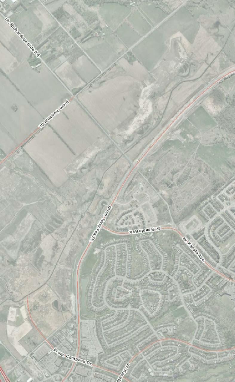
3 1.0 INTRODUCTION Novatech has been retained by Uniform Urban Developments to prepare a Planning Rationale in support of a Site Plan Control Application for the residential development on Terry Fox Drive in Kanata. This seeks to demonstrate that the proposed development is consistent with the Provincial Policy Statement, conforms to the City of Ottawa Official Plan, respects the City s urban design guidelines, is consistent with Zoning By-Law , and represents good planning. 1.1 Site Location and Context The subject site is part of the Richardson Ridge subdivision (D ) and is a portion of the property municipally known as 1425 Richardson Side Road. It is legally described as Part of Lot 6, Concession 1, Geographic Township of March, now City of Ottawa. The subject site is Block 217, 218 and 219 on the Richardson Ridge preliminary 4M Plan. The subject lands were draft approved in 2010, and a zoning was approved on March 25, 2015 to permit the proposed low rise apartment dwellings (ZBL ). N Figure 1: Site Location and Context The subject property was formerly land belonging to the Richardson family farm, and contains the original stone farmhouse which was designated under Part IV of the Ontario Heritage Act on December 9, The farmhouse is located on a hill on the northwestern Novatech Page 1

4 portion of the site near the now closed road allowance of Richardson Side Road. As part of the proposed development this building is to be retained and converted to a community amenity building for residents. The property has an area of 23,666 square metres (2.3 hectares), with approximately 340 metres of frontage wrapping around the cul-de-sac of Boundstone Way, and approximately 300 metres of rear yard along Terry Fox Drive. The following describes the adjacent existing or proposed land uses as illustrated on Figure 1. North: North of the site are additional lands owned by Uniform Developments which are currently under development as Phase 2B of the Richardson Ridge Subdivision. Directly across Boundstone Way there will be semi-detached and townhouse dwellings facing the subject site. Beyond these dwellings is an open space block along the slope of the ridge, with lots for single detached dwellings around Grand Manan Circle as part of Phase 1 on top of the ridge. Figure 2: Excerpt of the Richardson Ridge Draft 4M-Plan showing lot pattern north and west of the subject site. East: East of the subject site is the closed road allowance of Richardson Side Road, which is being converted to a recreational pathway and linear park. Across Richardson Side Road Novatech Page 2


5 there is a similar development to the subject proposal consisting of eight low-rise apartment condominium buildings lined up along Terry Fox Drive. These are shown in Figure 3. Figure 3: Adjacent development under construction as seen looking east along Terry Fox Drive from the intersection of Richardson Side Road. South: In this location, Terry Fox Drive marks the Urban Boundary for the City of Ottawa. South of Terry Fox Drive there is open space within the floodplain of the Carp River which runs roughly parallel to Terry Fox Drive approximately 50 to 100m south of the road. Beyond the river, the land is primarily used for agricultural fields with some rural commercial, industrial and institutional uses. Figure 4: Farm fields and the Carp River across Terry Fox Drive to the South Novatech Page 3

6 West: West of the site will be developed with townhouses as shown by the block pattern of the preliminary 4M plan provided as Figure 2. The townhouses will back onto the subject site and front of Gabriola way. 1.2 Proposed Development Figure 5: Renderings of proposed three-storey condominiums Novatech Page 4
 of 599 square metres.")

7 Figure 6: Proposed Development The development consists of eight three-storey low-rise apartment style condominium buildings, shown in Figure 5 and 6, with underground parking accessed via five private approaches off of Boundstone Way. The residential buildings each contain 14 apartment units and have a Gross Floor Area (GFA) of 599 square metres. Two centrally located utility buildings will contain garbage and recycling facilities, as well as provide sheltered outdoor bicycle parking. The heritage designated Richardson Farmhouse, pictured in Figure 7, is being restored and is incorporated into the site design as a community centre and amenity area, accessed by a separate driveway from the Boundstone Way cul-de-sac. In addition to the 112 underground parking spaces, 68 surface parking spaces will be provided for residents and visitors. A larger version of the proposed Site Plan is included as Appendix A. Figure 7: Heritage designated Richardson Farmhouse as seen from Terry Fox Drive Novatech Page 5

8 2.0 PLANNING POLICY AND REGULATORY FRAMEWORK 2.1 Official Plan Designation and Zoning City of Ottawa Official Plan (OPA 150) The subject property is designated as General Urban Area on Schedule B of the City of Ottawa Official Plan, as shown on Figure 8 below. The site has frontage on Boundstone Way, a local street, and on Terry Fox Drive, which is designated as an Arterial Road on schedule E. The General Urban Area designation permits a wide range of uses, including housing with a variety of densities, employment, retail, service, cultural, leisure, entertainment and institutional uses. Terry Fox Drive is the limit of the Urban Boundary in this location, and to the west, the area is designated as General Rural Area and Agricultural Resource Area. Subject Site Figure 8: Official Plan Schedule B The subject lands are located along Terry Fox Drive which is designated as a spine route of the cycling network and becomes a cross-town bikeway south of the site, as described Novatech Page 6

9 on Schedule C, the Primary Urban Cycling Network plan. The site has have been planned to allow for two direct connections to the Terry Fox cycling route. The subject lands are adjacent to the Carp River Floodplain, as described in Schedule K, 'Environmental Constraints', of the Official Plan, separated by Terry Fox Drive Existing Zoning (City of Ottawa Zoning By-Law ) Zoning Amendment , passed on March 25 th 2015, implemented the R4M [2227] H (15) Residential Fourth Density Subzone M, Special Exception 2227 zoning for the site. Urban exception 2227 specifies that the lot line abutting Boundstone Way is the front lot line, and the H suffix sets the maximum building height at 15 metres. The purpose of the Residential Fourth Density zone is to allow a wide mix of residential building forms ranging from detached to low-rise apartment dwellings in no case more than four storeys. The planned unit development consisting of three-storey condominiums is permitted within the RM4 exception 2227 zone, as is the accessory community centre located on the lot. Subject Site Figure 9: Existing Zoning Novatech Page 7
10 3.0 PLANNING POLICY REVIEW Provincial Policy Statement The 2014 Provincial Policy Statement (PPS) provides policy direction on land use planning and development matters of provincial interest, as set out in section 2 of the Planning Act. All decisions affecting planning matters are required to be consistent with policies of the PPS. To the extent that the proposed uses conform to the intent of General Urban Area designation of the City of Ottawa Official Plan, and are permitted in Zoning By-Law , the discussion relating to specific policies of the PPS will be limited to Section 1.1.1, section 2.0 and section 3.0. Section 1.1 of the PPS speaks to managing and directing land use to achieve efficient and resilient development and land use land patterns Healthy, liveable and safe communities are sustained by: a) promoting efficient development and land use patterns which sustain the financial well-being of the Province and municipalities over the long term; b) accommodating an appropriate range and mix of residential (including second units, affordable housing and housing for older persons), employment (including industrial and commercial), institutional (including places of worship, cemeteries and long-term care homes), recreation, park and open space, and other uses to meet long-term needs; c) avoiding development and land use patterns which may cause environmental or public health and safety concerns; d) avoiding development and land use patterns that would prevent the efficient expansion of settlement areas in those areas which are adjacent or close to settlement areas; e) promoting cost-effective development patterns and standards to minimize land consumption and servicing costs; f) improving accessibility for persons with disabilities and older persons by identifying, preventing and removing land use barriers which restrict their full participation in society; g) ensuring that necessary infrastructure, electricity generation facilities and transmission and distribution systems, and public service facilities are or will be available to meet current and projected needs; and h) promoting development and land use patterns that conserve biodiversity and consider the impacts of a changing climate. Novatech Page 8
11 The proposed development is located on a block always intended for medium density residential use within the Richardson Ridge subdivision. The apartment condominiums proposed will add to the mix of residential options in the area, which is primarily composed of single, semi-detached and townhouse dwellings. The condominium flats will provide affordable housing options for younger and mature people and those with smaller family size. Terry Fox Drive is an Arterial Road and the proposed apartment buildings will provide a transition to the lower density residential within the Richardson Ridge community. The proposed development is located on the edge of the urban boundary of the City of Ottawa and is surrounded on three sides by existing or planned development. Servicing and stormwater management were planned through master servicing studies for the entire Richardson Ridge subdivision, including a Master Sanitary Sewer Plan for the Kanata Lakes, Broughton & Interstitial Lands, commissioned by the City of Ottawa and prepared by Stantec in December IBI Group has prepared a site specific Richardson Ridge Flats Phase 2C Servicing Report ( , July 2015) setting out the detailed design for the development. Paterson Group prepared a geotechnical report (PG1845-3R) revised March 19, 2015 as an update to the preliminary 2002 Geotechnical Report for the subdivision, which provides details on the existing sub-soil and groundwater conditions within the development. The report concludes that the site is suitable for the construction of the residential uses proposed, and the subject site does not require pre-loading. As set out in the engineering reports, the development will not create public health and safety concerns. We find that the proposed development is consistent with Section 1.1 of the PPS. Section 2.0 of the PPS - Wise Use and Management of Resources speaks to protecting natural heritage, water, agriculture, mineral aggregate, petroleum, cultural heritage and archaeological resources. The subject property was formerly part of the Richardson Farm and is the location of the original farmhouse, which is a heritage designated building. According to the City of Ottawa GeoOttawa online mapping, the subject lands are recognized as having archeological potential. A Phase 1 and 2 site assessment of the Richardson Ridge subdivision lands was undertaken in 2009 by Northeastern Archeological Associates. The entire subdivision, including these lands, was cleared of any further need for inspection by the Ministry of Culture in Evidence of this was provided to the City as part of the Subdivision registration process. An Environmental Impact Statement and Final Tree Preservation Plan was prepared for the Richardson Lands Subdivision by Muncaster Environmental Planning in September Tree removal permission was granted by the City on November 4, 2011 for the trees identified for removal in the above noted report. All butternuts within the subdivision proposed for removal were assessed by a certified Butternut Health Assessor and Novatech Page 9
12 compensated for through an agreement with the Ministry of Natural Resources. None were located on the subject site. There are no significant wetlands, valleylands or areas of natural and scientific interest on or adjacent to the subject property. The Carp River is located approximately 100m southwest of the site, across Terry Fox Drive, and will not be negatively impacted by the proposed development. We find that the proposed development is consistent with Section 2.0 of the PPS. Section 3.0 of the PPS - Protecting Human Health and Safety focuses on reducing the potential for public cost or risk to residents from natural or human-made disasters. There are no flood hazards, erosion hazard, or dynamic beach hazards on or adjacent to the site, and no past mineral resource extraction, aggregate operations, or petroleum resource operations are known to have occurred. A Phase 1 Environmental Site Assessment (E2504-1) was prepared by John D. Paterson and Associates Ltd. in 2002 for the Proposed Residential Subdivision at Richardson Side Road East of the Carp River. The Phase 1 ESA did not identify any evidence to suggest past or present soil contamination and further assessment was not recommended. We find that the proposed development is consistent with Section 3.0 of the PPS City of Ottawa Official Plan (OPA 150) As previously stated, the subject property is designated General Urban Area on Schedule B of the City of Ottawa Official Plan. Section of the Official Plan provides policy for directing development within the General Urban Area designation. Policy 2 of Section of the Official Plan states that the evaluation of development applications, studies, other plans and public works undertaken by the City in the General Urban Area will be in accordance with Section and Section Section (Designing Ottawa) sets out design objectives qualifying how the City wants to influence the built environment as Ottawa matures and evolves. Section 4.11 (Urban Design and Compatible Development) discusses the relationship between new and existing development and provides policies to evaluate the compatibility of a development with regard to Views, Building Design, Massing and Scale, and Design Priority Areas. Section provides specific design objectives of how the City of Ottawa wants to influence the built environment. These design objectives are addressed below: To enhance the sense of community by creating and maintaining places with their own distinct identity. The Richardson Ridge subdivision is primarily comprised of low density residential land use with single detached, semi-detached and townhouse dwellings. The medium density condominiums provided by the proposed development will bring some variety in housing choice while maintaining a low rise built form. Novatech Page 10

13 Restoring and repurposing the Richardson Farmhouse as a community centre will showcase the unique historical context of the site and highlight the heritage value of the area. The lowrise form of the proposed development and the dramatic topography of the ridge allows single detached and townhouses planned for north of the proposed development to maintain views across the Carp River and the agricultural land beyond. Landscaping will continue the naturalized approach taken throughout the Richardson Ridge Subdivision with extensive landscaping and reforestation along Terry Fox Drive and naturalized treatment around the heritage building. To define quality public and private spaces through development. The proposed form of low-rise apartment is an attractive and contemporary design which has been well received in several previous developments, including the similarly designed site directly adjacent along Terry Fox Drive. As shown in Figure 10, this built form creates an animated streetscape with no blank walls facing wither the arterial road or the internal residential streets. Landscaping and tree planting throughout the development and along Terry Fox Drive will soften the transition between the residential development and arterial road. Figure 10: The low-rise apartments will create visual continuity along Terry Fox Drive and provide an animated street presence. To create places that are safe, accessible and are easy to get to, and move through. Access to the development is from Boundstone Way, via Arcrose Street from Huntsville Drive. Internal driveways will lead to surface parking and underground parking garages, as well as to the community building in the former Richardson Farmhouse. Pedestrian walkways will connect from the main entrances of each building to a public sidewalk or the recreational pathway along Richardson Side Road and multi-use pathway along Terry Fox Drive. Except for the building in the northwest corner of the site, all others will have a pathway connecting the front door to a public sidewalk or pathway without requiring pedestrians to cross a single drive aisle. Walkways will also connect with the garbage and recycling buildings. Novatech Page 11
14 As requested during pre-consultation meeting with the City, an emergency access will be maintained from Terry Fox Drive to speed up emergency response times and to provide a second access in case Boundstone Way is ever blocked. The access is to connect through to Boundstone Circle with an easement, and will be equipped with removable bollards. This easement will also provide a necessary watermain loop to Boundstone Way. Maintenance will be provided by the condominium corporation for the lands. To ensure that new development respects the character of existing areas. Richardson Ridge has been designed to showcase the natural spaces within and surrounding the development, and is characterized by preserved natural elements with granite outcroppings, rich landscaping and dramatic grade transitions. This theme is carried through the subject site with naturalised landscaping throughout and grading to showcase the heritage farmhouse. The topography of the surrounding area will help minimize the impact of the multi-unit buildings, allowing two storey single and semi-detached dwellings above the ridge fronting on Grand Manan Circle to maintain views over the roofline of the proposed three storey condominium buildings. The residential use and low-rise built form are in keeping with the character of the existing development in surrounding areas. To consider adaptability and diversity by creating places that can adapt and evolve easily over time and that are characterized by variety and choice. The proposed condominium flats will offer an alternative form of housing in an area predominantly composed of street oriented dwellings. The flats will create opportunities for economic and demographic diversity by providing smaller units for small families, singles and seniors. To understand and respect natural processes and features in development design. The subdivision was designed to integrate with the natural topography of the site with development below and above the ridge and a swath of open space along the slope. The site is located across Terry Fox Drive from the Carp River, and the stormwater from the development will be directed through a series of pipes and ditches along Terry Fox Road to a SWM facility for quality control before being released to the Carp River. Extensive naturalized landscaping throughout the development and reforestation along Terry Fox Drive provides an opportunity to re-create lost natural habitat with native heritage species planted throughout the development. Several of the mature trees around the heritage building are to be retained, as permitted by grading, to preserve their environmental and heritage value. To maximize energy-efficiency and promote sustainable design to reduce the resource consumption, energy use, and carbon footprint of the built environment. The higher density residential development will help to achieve density and intensification targets in the suburban area. Bus routes may be extended along Terry Fox Drive as development progresses to the north. Richardson Ridge has been designed with an Novatech Page 12

15 extensive network of walking and cycling trails, and the recreational pathway on Richardson Side Road and cross-town bikeway along Terry Fox Drive will promote active transportation and an overall reduction in carbon footprint/emissions. Bicycle parking for each unit is provided in the underground parking garages. An additional 18 outdoor bicycle parking spaces are provided for visitors or short term use with 9 spaces located under a roof overhang at each of the two garbage and recycling buildings. Section 4.11, Urban Design and Compatible Development, discusses the relationship between new and existing development and provides policies to evaluate the compatibility of a development with regard to Views, Building Design, Massing and Scale, and Design Priority Areas. Views - The proposed development is not within any of the view shed areas directly addressed in Policy 4.11 (Central Area, Beechwood Cemetery etc.), however the low-rise apartments along Terry Fox Drive will become a prominent landmark in the area as the edge of the built up area of the City of Ottawa and the entrance to the Richardson Ridge neighbourhood. The proposed three storey buildings will be lower than the existing dwellings above the ridge and views for existing residents will be preserved. Figure 11: View of the subject site from the intersection of Terry Fox Drive and Richardson Side Road, showing the topography of the area and houses above the ridge. Building Design - Good building design contributes to successful neighbourhood integration and the compatibility of new development with the existing or planned character of its surroundings. Policy 5 of section 4.11 requires that proponents of new development demonstrate how the design of their development fits with the existing desirable character and planned function of the surrounding area in the context of: a. Setbacks, heights and transition; b. Façade and roofline articulation; c. Colours and materials; d. Architectural elements, including windows, doors and projections; e. Pre- and post-construction grades on site; and f. Incorporating elements and details of common characteristics of the area. Novatech Page 13

16 The three storey low-rise condominiums are compatible with the existing low-rise residential development in the surrounding area. The placement of the buildings is staggered across the property to create a varied but continuous streetscape without giving the impression of a wall of buildings. A minimum of a 3.3m setback from Boundstone Way, plus the 16.5m rightof way provides a sufficient setback for the townhomes to be built across the street. The buildings at the northwest end of the site are set back a minimum of 7.5m from the rear lot line of the adjacent townhouse block. As shown on the architectural renderings provided as Figure 12, a strength of the product is that the proposed buildings have windows, balconies and terraces on all sides and present a finished and animated façade from all directions. The development addresses both Boundstone Way and Terry Fox drive, as well as the Richardson Side Road pathway. This design will provide animation and visual interest to the Arterial Road, rather than creating a streetscape lined with rear yards and noise barrier fencing. The buildings are set back from Terry Fox Drive to accommodate a drainage feature which will be heavily landscaped to create an attractive buffer between the arterial road and the residential use. Figure 12: Architectural Rendering View from Boundstone Way looking south Grading throughout the subdivision has been designed to respect and feature the natural topography of the ridge. The heritage farmhouse, which is located partway up the slope, will be featured by creating a naturalized slope using a granite rubble reinforced rock cut Novatech Page 14
 of main building(s) to the street.")
17 enhanced with native heritage species landscaping to provide an attractive foreground for the community building. Policy 6 of section 4.11 requires that all applications for new development: a. Orient the principal façade and entrance(s) of main building(s) to the street. Where a building abuts more than one street, the building façade and entrances will be oriented in order of priority to the arterial, collector and local street; b. Include windows on the building elevations that are visible from public spaces; c. Use architectural elements, massing, and landscaping to accentuate main building entrances. The site design is a planned unit development with buildings set back from the street to accommodate drive aisles, parking and landscaping. Buildings are staggered on the lot and situated so that the main entrance to each building is visible and accessible to Boundstone Way, with many entrances also visible from Terry Fox Drive. While the majority of buildings have entrances that do not directly face Boundstone way, except for those situated around the cul-de-sac, walkways leading directly to the public sidewalk connect the buildings to the street and make the entrances prominently visible and accessible. The placement of building entrances also permits a fully accessible site design with ramps providing access to every building. Landscaping will be used to accentuate the entrances and walkways. Policy 8 of section 4.11 discusses loading facilities, service areas, mechanical equipment (including roof-top), vents and metering devices. No loading space is required for a residential building. Garbage and recycling facilities will be provided in two centrally located buildings easily accessible to all residents. Roof vents and mechanical will be shielded by the sloping roof design. Massing and Scale - Massing and scale describes the form of the building, how tall it is, how much of the lot it occupies and how it is positioned in relation to the street and surrounding buildings. The proposed design is consistent with the scale and massing of surrounding development. As shown in Figure 13, the buildings create a human scale streetscape for pedestrians along Terry Fox Drive. The three storey buildings are compatible with the surrounding single and semi-detached dwellings and provide a transition from the edge of the community to internal streets. Figure 13: Rendering of buildings in context of Terry Fox Drive and Richardson Side Road intersection Novatech Page 15
18 Outdoor Amenity Areas - Outdoor amenity areas are the private and communal areas of a property that are designed to accommodate a variety of leisure activities. Private outdoor amenity space will be provided through balconies for all units, while the converted Richardson Farmhouse will provide a communal amenity space for the development. Landscaping will create a pleasant and attractive environment along walkways throughout the development. The three storey buildings are set back a minimum of 7.5m from the rear yards of the townhomes along Gabriola Street and will not overshadow the rear yard amenity space. Privacy fencing will be provided to separate the private yards from the subject site. Design Priority Areas - The site is not located in a designated design priority area. We find that the proposed development is generally consistent with the criteria of Policy 2 and therefore conforms to Section 4.11 of the Official Plan. More generally, Section 4 deals with the review of Development Applications and provides direction on when specific studies are required to ensure adequate consideration of all aspects of development including water and wastewater servicing, stormwater management, cultural heritage resources, environmental protection, and protection of health and safety. Relating to Section 4.4 Water and Wastewater Servicing: Servicing is set out in IBI Group s Richardson Ridge Flats Phase 2C Servicing Report ( , July 2015). Water will be provided by an existing watermain at the south corner of the development on Richardson Side Road adjacent to Terry Fox Drive. The watermain will be looped to the Boundstone Way cul-de-sac through an easement over the fire route to Terry Fox Drive. The downstream sewers were designed and constructed to accommodate a larger population than what has been constructed and are of sufficient size to accommodate the population design flows from the draft approval areas of Richardson Ridge. Relating to Section 4.6 Cultural Heritage Resources and Section Archaeological Resources: The heritage designated Richardson Farmhouse has been incorporated into the development as a community amenity space and will highlight the legacy of the Richardson Family as early settlers of the area. A Phase 1 and 2 site assessment of the Richardson Ridge subdivision lands was undertaken in 2009 by Northeastern Archeological Associates. The entire subdivision, including these lands, was cleared of any further need for inspection by the Ministry of Culture in2009. Evidence of this was provided to the City as part of the Subdivision registration process. Novatech Page 16
19 Relating to Section 4.7 Environmental Protection: An Environmental Impact Statement and Final Tree Preservation Plan was prepared for the Richardson Subdivision by Muncaster Environmental Planning and revised September There are no significant wetlands, valleylands or areas of natural and scientific interest on or adjacent to the subject property. All butternuts within the Richardson Subdivision were assessed by a certified Butternut Health Assessor and those proposed for removal were compensated for through an agreement with the Ministry of Natural Resources. None were located on the subject site. The Carp River is located approximately 100m southwest of the site, across Terry Fox Drive and will not be negatively impacted by the proposed development. Post development storm drainage will be directed to a SWM facility for treatment before being released into the Carp River. Landscaping will consist of native species and a reforestation policy to increase natural cover within the development. The mature trees in the northeast corner of the side near the heritage farmhouse are to be retained. Relating to Section Stormwater Management: The stormwater management design is described in IBI Group s Richardson Ridge Flats Phase 2C Servicing Report ( , July 2015) and consists on an interim and ultimate stormwater solution. The interim solution consists of an existing stormwater facility located northwest of the initial phases of the Richardson Ridge development. The ultimate drainage solution will involve a new storm pond located adjacent to the Carp River east of Terry Fox Drive, servicing approximately 80 ha including both the Richardson Ridge and the future Phase 4 development. The facility will provide water quality control before outletting to the Carp River. The site has been graded to direct all minor system and major system overflow into a drainage system running parallel to Terry Fox Drive. The drainage system consists of a combination of ditches and pipes to allow for series of landscaped and forested berms along Terry Fox Drive. An existing culvert crossing Terry Fox Drive directs existing runoff from the subject site directly to the Carp River. This culvert will continue to provide conveyance of infrequent major system flows during the 100 year storm event. Relating to Section 4.8 Protection of Health and Safety: There are no flood hazards, erosion hazard, or dynamic beach hazards on or adjacent to the site, and no past mineral resource extraction, aggregate operations, or petroleum resource operations are known to have occurred. A Phase 1 Environmental Site Assessment (E2504-1) was prepared by John D. Paterson and Associates Ltd. in 2002 for the Proposed Residential Subdivision at Richardson Side Road East of the Carp River. The Phase 1 ESA did not identify any Novatech Page 17
20 evidence to suggest past or present soil contamination and did not recommend further assessment. Paterson Group prepared a geotechnical report (PG1845-3R) revised March 19, 2015 which provides details on the existing subsoil and groundwater conditions within the development. The report concludes that the site is suitable for the construction of the residential uses proposed, and the subject site does not require preloading. As demonstrated above, the proposed development conforms to the City of Ottawa Official Plan relating to the General Urban Area designation and to policies guiding Urban Design and Compatibility Urban Design Guidelines for Greenfield Development The site is part of a larger greenfield development and while some of the guidelines relate more to the layout of the larger subdivision, aspects of the City s Urban Design Guidelines for Greenfield Development apply to the subject development. In particular, it is worth addressing how the development fits within the guidelines for structuring layout, and achieves many of the guidelines for Residential Building and Site Design. Structuring Layout Guideline 1: Plan and build new communities based on the inherent capacity of the natural landscape to sustain the community over time. Consider soils, landforms, natural and cultural features, habitats, watercourses and climate. Geotechnical, Servicing and Environmental studies for the subdivision and for the subject site have provided recommendations for creating a safe and environmentally sensitive site. Stormwater management features have been designed with regard for extensive naturalized landscaping along Terry Fox Drive. Guideline 2: Create a connected network of parks, greenspaces and public lands that is structured by existing natural features and connected by pathways and sidewalks. Make this network easily accessible on foot or bike from homes throughout the neighbourhood. There is an extensive network of parks and pathways throughout the Richardson Ridge, Broughton and Kanata lakes subdivisions, including the recreational pathway and linear park along the closed road allowance of Richardson Side road, and cycling route along Terry Fox Drive, both directly adjacent to the subject site. Multiple connections are provided through the subject site to increase walkability, including a connection to the pathway along the slope north of the site between the lots along the north side of Boundstone Way. Guideline 6: Incorporate landform features and topography in the design of road and block patterns to maximize vistas and visual interest and reduce extensive earth movement requirements. The subdivision has been designed to feature the dramatic topography of the ridge, offering unique views and greenspace opportunities. The low-rise nature of the subject development Novatech Page 18


21 at the bottom of the slope ensures that these views are preserves for existing and planned development. Grading on the site itself will feature the Richardson Farmhouse through a naturalized slope and landscaped rock cut planted to resemble a natural granite outcropping. Guideline 7: Locate stormwater management areas to be an integral part of the overall greenspace and pedestrian network within the neighbourhood. The stormwater conveyance block along Terry Fox Drive will be extensively landscaped to provide a buffer from traffic and create an amenity. The storm water block has been designed to function through a combination of pipes and open ditches in order to allow for a combination of wetland type planting and reforestation over berms covering the piped sections. Figures 14 below provide a sample of the type of naturalized landscaping proposed for the site. The stormwater management pond across Terry Fox Drive is bordered by a service road/pathway accessible to the public. Figure 14: Flavour of landscaping proposed along Terry Fox Drive Guideline 8: Incorporate existing cultural heritage features, such as hedgerows, bridges, stone walls, ruins, archaeological sites and buildings when establishing the location of roads, parks, and public and institutional lands. The Richardson Farmhouse, located on the subject property is a Gothic Revival style one and a half story central gable stone farmhouse with a one storey stone addition, built circa The Richardson family was one of the earliest pioneer families to settle in March Township in the early 19th Century and was a prominent family in the area thorough the 19th and 20th centuries. The Farmhouse is being restored and will be featured as a community amenity building for residents of the development. Guideline 9: Concentrate higher density residential units around neighbourhood focal points that include transit stops, commercial areas, schools, community facilities, parks and multiuse pathways. The proposed higher density residential built form is concentrated along the arterial road at the edge of the subdivision, and adjacent to a recreational pathway and a cross-town cycling route. Novatech Page 19
 highlights the extensive network of parks and greenspace connected by walkways and recreational pathways.")
22 Guideline 10: Create a walkable neighbourhood with pathways, trails and sidewalks that are accessible year round and that connect destinations such as transit stops, commercial areas, schools, community facilities and parks. The promotional site plan for Richardson Ridge (Figure 15) highlights the extensive network of parks and greenspace connected by walkways and recreational pathways. The Kanata Lakes and Richardson Ridge communities are known for the walking, cycling and ski trails accessible to residents. Subject Site Figure 15: Promotional Site Plan for the Richardson Ridge highlighting parks and pathway connections Guideline 13: Layout local street patterns so that development blocks are easily walkable between 150 and 250 metres in length. It is approximately 350 metres from Gabriola Street north of the site to the pathway on Richardson Side Road south of the site. To improve walkability, a mid-block pathway connection is provided from Boundstone Way to Terry Fox Drive, as well as a pathway along the emergency access road from the Boundstone way cul-de sac to Terry Fox Drive. Two walkway connections will also lead to the recreational pathway on Richardson Side Road, one from the residential end of the site and one from the community heritage building. A pathway block is also provided on the north side of Boundstone way to facilitate access to the trail along the slope of the ridge. Guideline 14: Maximize opportunities for passive energy conservation and south facing exposure through street orientation, block pattern, building location and heights. Use vegetation and architectural detailing for shading and wind protection. Novatech Page 20

23 The buildings have been staggered and spaced to maximize sun exposure and are designed with large windows to allow for natural lighting. The roof overhang and balconies provide offer shade protection and natural cooling. Vegetation planted along Terry Fox Drive will allow benefits of the south facing sun exposure while providing a wind break from the open fields west of the site. Figure 16: Large windows and architectural detail such as roof and balcony overhangs will promote natural lighting while providing shade to keep rooms cooler Guideline 15: Create a transition in height from taller buildings to adjacent lower buildings, particularly when connecting to an adjacent development or neighbourhood. The three storey buildings are compatible with planned adjacent low rise development and provide a transition from the perimeter of the subdivision to the interior residential areas. Residential Building and Site Design Guideline 34: Locate residential buildings close to the property line with their primary face addressing the street, while making room for trees and utilities. Provide visual interest along the streetscape with a variety in setbacks and projections. The property is a through lot and residential buildings have been located on the lot so as to address both Boundstone Way and Terry Fox Drive while accommodating internal parking areas and drive aisles and leaving space for landscaping and stormwater conveyance. Four of the eight buildings have been located close to Boundstone way with the other four closer to Terry Fox Drive. The 6 metre drainage block along Terry Fox Drive provides space for landscaping to provide a buffer along the arterial road. This staggered building placement will create an interesting and varied streetscape from along both roads. Guideline 36: Design buildings at key intersections as landmark buildings, with enhanced height, massing, building projections, architectural elements, and public space. Novatech Page 21
24 The Foxwood Condominium development across Richardson Side road and the proposed low-rise condominium development are complementary and create a distinctive landmark streetscape along Terry Fox Drive to define the entrance to the community. In both developments, the buildings are designed in a contemporary urban style set within a landscaped park-like setting. Architectural detail, building articulation, balconies, terraces and large windows on all sides of the buildings ensure the development will be visually attractive and interesting from all directions of travel and from all surrounding streets. Guideline 37: Design building façades so that windows and doors are prominent features that address the streets they front. The buildings are designed so as to have prominent windows and balconies facing all sides. This is particularly desirable for this site which has frontage on two roads and two recreational pathways. Guideline 38: Site and design residential buildings on corner lots so that both the front and the side of the building are oriented to the public street and are detailed with similar quality and style. As discussed above, the proposed design provides similar detailing on all sides of the building to create an attractive streetscape from all viewpoints. Guideline 42: Locate surface parking areas of multi-unit residential buildings away from public view and not between the public street and the building. Design and landscape parking areas so they do not detract from any rear yard amenity space. The majority of parking is provided underground with additional surface parking throughout the development in small groupings so as not to create a sense of any area being dominated by parking. Landscaping will be provided between parking areas and the street and separate adjacent parking areas and walkways. A 1.8m high privacy fence will be provided between the site and the rear yards of the townhomes along Gabriola Street. Guideline 43: Provide a landscape buffer along the edges of multi-unit residential parking areas, in situations where they are along a public street. Provide breaks in the buffers to connect the sidewalk to walkways on the site. Buffers may include low shrubs, trees, and decorative fences. Extensive planting along Terry fox drive will provide a buffer between traffic and residential areas and will create an attractive streetscape for pedestrians and vehicles travelling along Terry Fox Drive. Breaks in the landscaping will be provided to ensure good sightlines from walkways to the street in accordance with CEPTED principles. Guideline 44: Design residential buildings so that garages do not dominate the width of the front façade and do not project past the front wall. Design driveways so that they are not wider than the garage. The buildings have been designed with balconies overhanging the entrances to the underground parking garages to screen the garage door. Landscaping within the drainage Novatech Page 22
25 block and in the City right-of-way between the property line and the multi-use pathway on Terry Fox will screen parking garage entrances. Guideline 46: Incorporate mid-block walkways to make walking more direct and convenient where long blocks cannot be avoided. Ensure that landscaping, fencing, and facing windows support a safe and attractive environment. As discussed under Guideline 13, several midblock connections have been provided to create direct connections between Boundstone Way and Terry Fox Drive and to the recreational pathway and trail system Zoning By-Law As previously noted, the subject property is zoned R4M [2227] H (15) Residential Fourth Density Subzone M, Special Exception The proposed planned unit development with low-rise apartment condominiums is permitted in the R4M [2227] zone. As such, this section will be limited to addressing the R4M [2227] zone provisions, which are summarised in Table 1 below. Table 1: Residential Fourth Density Subzone M, Special Exception 2227 Zone Provisions R4M [2227] Zone (Planned Unit Development) Provision Requirement Uniform Site Minimum lot area 1,400 m² 23,666m² Minimum lot width N/A N/A Maximum lot coverage 50% 22% Minimum front yard setback 3m 3.3m Minimum rear yard setback 7.5m 8.3m Interior side yard setback 7.5m 7.5m Minimum setback from Richardson Side Road R-O-W 3m 3.4m Corner side yard 3 m 3.4m Maximum building height 15m 15m Maximum cumulative floor area of all accessory buildings (garbage and recycling) 150m² 72 m² Lot coverage (maximum) 50% 14.5 % Section 101 of the zoning By-Law provides minimum parking space requirements for each use. With regards to the proposed residential apartments, Table 101 b) Apartment Building, Mid High Rise and Low Rise requires a minimum 1.2 spaces per dwelling unit in the suburban Area (Area C on Schedule 1). The development consists of 112 units, which requires a minimum of 334 parking spaces for residents. One underground parking space has been allocated for each, and an additional 46 surface parking spaces are provided to account for second vehicles. A total of 158 spaces will be provided which exceeds the minimum requirement. Novatech Page 23
26 Section 102 provides minimum visitor parking space rates. Table 102 (a) specifies that 0.2 visitor spaces are required per dwelling unit. 22 surface parking spaces are provided to meet this requirement. Section 111 sets out Bicycle Parking Space Rates and provisions. Table 111A b) requires a minimum of 0.5 bicycle parking space per dwelling unit. The development exceeds this minimum requirement by providing one underground bicycle parking space for each unit, located in the underground parking garages of each building. An additional 18 outdoor spaces provided for visitors or short term parking are located under a roof overhang of the two garbage and recycling enclosures. A total of 130 bicycle parking spaces will be provided. The requirements of Part 4 of the Zoning By-law Parking, Queuing and Loading Provisions are summarised in Table 2. As demonstrated above, the proposed Table 2: Parking Provisions Provision Requirement Uniform Site Minimum residential parking rate (1.2 spaces/dwelling unit) Minimum visitor parking (0.2 spaces/dwelling unit) Barrier free parking Bicycle parking (0.5 spaces/dwelling unit) Underground: 112 Surface: 46 Indoor: 112 Outdoor: 18 Parking lot landscape area (minimum) 15% As demonstrated above, the proposed development conforms to zoning by-law CONCLUSION The proposed development is consistent with the Provincial Policy Statement, conforms to the City of Ottawa Official Plan, City of Ottawa Urban Design Guidelines for Greenfield Neighbourhoods, and conforms to Zoning By-Law The proposed development is an appropriate and desirable addition to the community and represents good planning. NOVATECH Prepared By: Reviewed by: Anna Froehlich, M.Pl Planner Greg Winters, MCIP, RPP Project Manager Novatech Page 24
27 Appendix A: Site Plan

28
29 Appendix B: Landscape Plan

30
Design Brief and Planning Rationale. for Site Plan Control Application. Harmony Subdivision, Stage 1, Block 104
 Design Brief and Planning Rationale for Site Plan Control Application Harmony Subdivision, Stage 1, Block 104 4025 Strandherd Drive, Minto Communities Inc. Prepared By: NOVATECH Suite 200, 240 Michael
URBAN DESIGN BRIEF URBAN DESIGN BRIEF 721 FRANKLIN BLVD, CAMBRIDGE August 2018
 URBAN DESIGN BRIEF URBAN DESIGN BRIEF 721 FRANKLIN BLVD, CAMBRIDGE August 2018 DESIGN BRIEF CONTENTS PART A 1.0 INTRODUCTION 2.0 DESCRIPTION & ANALYSIS OF SITE CONTEXT 3.0 DESIGN CONSTRAINTS AND OPPORTUNITIES
178 Carruthers Properties Inc.
 178 Carruthers Properties Inc. Planning Rationale for 178 Carruthers Avenue Site Plan Control Application June 2014 Table of Contents 1.0 Introduction 2.0 Overview of Subject Property 3.0 Current Zoning
20 & 30 Frank Nighbor Place
 Engineering Land / Site Development Municipal Infrastructure Environmental / Water Resources Traffic / Transportation Structural Recreational Planning Land / Site Development Planning Application Management
CONTENTS 8.0 LAND USE 8.1 GENERAL LAND USE 8.2 RESIDENTIAL 8.3 MIXED USE 8.4 COMMERCIAL 8.5 EMPLOYMENT LANDS
 8-2 Land Use 8.0 LAND USE CONTENTS 8.1 GENERAL LAND USE 8.1.1 Uses provided for in all Land Use Designations 8.1.2 Uses prohibited in Hazardous Lands, Hazardous Sites and Special Policy Areas 8.1.3 Uses
Complete Neighbourhood Guidelines Review Tool
 Complete Neighbourhood Guidelines Review Tool Prepared By: City of Regina Planning Department October 2014 Page 1 of 14 Community Development Review Checklist for Secondary Plans and Concept Plans The
URBAN DESIGN BRIEF. 2136&2148 Trafalgar Road. Town of Oakville
 URBAN DESIGN BRIEF 2136&2148 Trafalgar Road Town of Oakville Prepared By: METROPOLITAN CONSULTING INC For 2500674 Ontario Inc November 2016 TABLE OF CONTENTS Page No. 1.0 Introduction/Description of Subject
776 and 784 St. Laurent Boulevard City of Ottawa
 Engineering Land / Site Development Municipal Infrastructure Environmental / Water Resources Traffic / Transportation Structural Recreational 776 and 784 St. Laurent Boulevard City of Ottawa Planning Rationale
DRAFT Northeast Quadrant of Kipling Avenue and Highway 7 DRAFT AUGUST 29, Goals Land Use. The goals of this Plan are to:
 AUGUST 29, 2017 12.15 Northeast Quadrant of Kipling Avenue and Highway 7 12.15.1 Goals 12.15.2 Land Use The goals of this Plan are to: 12.15.2.1 General Provisions: a) Ensure the development of a compact
PLANNING JUSTIFICATION REPORT
 PLANNING JUSTIFICATION REPORT 55 DELHI STREET CITY OF GUELPH PREPARED FOR: VESTERRA PROPERTY MANAGEMENT PREPARED BY: LABRECHE PATTERSON & ASSOCIATES INC. SCOTT PATTERSON, BA, CPT, MCIP, RPP PRINCIPAL,
URBAN DESIGN BRIEF Gordon Street City of Guelph. Prepared on behalf of Ontario Inc. March 25, Project No. 1507
 URBAN DESIGN BRIEF 1131 Gordon Street City of Guelph Prepared on behalf of 1876698 Ontario Inc. March 25, 2016 Project No. 1507 423 Woolwich Street, Suite 201, Guelph, Ontario, N1H 3X3 Phone (519) 836-7526
2136 & 2148 Trafalgar Road Town of Oakville Region of Halton
 PLANNING JUSTIFICATION REPORT 2136 & 2148 Trafalgar Road Town of Oakville Region of Halton Zoning By-Law Amendment Application 2500674 Ontario Inc. November 2016 Table of Contents Page 1.0 Location/Summary
280 Manse Road - Official Plan Amendment, Zoning Amendment, Draft Plan of Subdivision Applications - Preliminary Report
 STAFF REPORT ACTION REQUIRED 280 Manse Road - Official Plan Amendment, Zoning Amendment, Draft Plan of Subdivision Applications - Preliminary Report Date: March 11, 2014 To: From: Wards: Reference Number:
5.1 Site Plan Guidelines
 5. Community Core Guidelines Development of the Community Core will take place by plan of subdivision and site plan approval. It will occur in a phased manner that will reflect the timing of residential
Planning Rationale Fernbank Road, Ottawa. Major Zoning By-law Amendment and Site Plan Control Application Ontario Inc.
 Planning Rationale Major Zoning By-law Amendment and Site Plan Control Application 5264 Fernbank Road, Ottawa 1872089 Ontario Inc. March 2014 Planning Rationale Major Zoning By-law Amendment and Site Plan
KANATA CENTRUM 255 KANATA AVENUE OFFICIAL PLAN AMENDMENT ZONING BY-LAW AMENDMENT
 KANATA CENTRUM 255 KANATA AVENUE OFFICIAL PLAN AMENDMENT ZONING BY-LAW AMENDMENT JUNE 2015 PREPARED BY: FOTENN Consultants Inc. 223 Mcleod Street Ottawa, ON K2P OZ8 (613) 730-5709 PREPARED FOR: Kanata
URBAN DESIGN BRIEF 181 Burloak Drive, Oakville
 URBAN DESIGN BRIEF 181 Burloak Drive, Oakville February 2017 Our File: 1730B 230-7050 WESTON ROAD / WOODBRIDGE / ONTARIO / L4L 8G7 / T: 905 761 5588/ F: 905 761 5589/WWW.MHBCPLAN.COM TABLE OF CONTENTS
Van Gaal Lands Terry Fox Drive & 5331 Fernbank Road. Planning Rationale and Integrated Environmental Review Statement. Engineering.
 Engineering Land / Site Development Municipal Infrastructure Environmental / Water Resources Traffic / Transportation Structural Recreational Planning Land / Site Development Planning Application Management
PORT WHITBY COMMUNITY
 PORT WHITBY COMMUNITY SECONDARY PLAN UPDATE COMMUNITY IMPROVEMENT PLAN URBAN DESIGN GUIDELINES September 2015 DRAFT PROPOSED AMENDMENT NUMBER # to the Whitby Official Plan PURPOSE: The intent of this Amendment
15 HUNTMAR DRIVE, KANATA PLANNING RATIONALE AND DESIGN STATEMENT IN SUPPORT OF A SITE PLAN CONTROL APPLICATION
 15 HUNTMAR DRIVE, KANATA PLANNING RATIONALE AND DESIGN STATEMENT IN SUPPORT OF A SITE PLAN CONTROL APPLICATION Prepared By: NOVATECH Suite 200, 240 Michael Cowpland Drive Ottawa, Ontario K2M 1P6 January
New-Cast Mixed-use Development Proposal King Street West, Newcastle, Ontario
 URBAN DESIGN BRIEF New-Cast Mixed-use Development Proposal King Street West, Newcastle, Ontario TABLE OF CONTENTS: 1.0 Executive Summary 2.0 Creating Vibrant and Sustainable Urban Places: Excerpts from
Mark-up of the effect of the proposed Bronte Village Growth Area OPA No.18 on the text of section 24, Bronte Village, of the Livable Oakville Plan
 Mark-up of the effect of the proposed Bronte Village Growth Area OPA No.18 on the text of section 24, Bronte Village, of the Livable Oakville Plan Notes: This document is provided for information purposes
4780 Eglinton Avenue West - Zoning By-law Amendment and Draft Plan of Subdivision Applications - Preliminary Report
 STAFF REPORT ACTION REQUIRED 4780 Eglinton Avenue West - Zoning By-law Amendment and Draft Plan of Subdivision Applications - Preliminary Report Date: May 29, 2014 To: From: Wards: Reference Number: Etobicoke
Urban Design Brief to 1557 Gordon Street & 34 Lowes Road West
 Urban Design Brief 1533 to 1557 Gordon Street & 34 Lowes Road West Reid s Heritage Homes Ltd. & 883928 Ontario Ltd. and RHH Property Management Ltd. City of Guelph Zoning By-law Amendment November 2017
Official Plan Review: Draft Built Form Policies
 PG.30.1 REPORT FOR ACTION Official Plan Review: Draft Built Form Policies Date: May 15, 2018 To: Planning and Growth Management Committee From: Chief Planner and Executive Director, City Planning Division
URBANDALE CONSTRUCTION PHASE 4B 4450 LIMEBANK ROAD PLANNING RATIONALE FOR SITE PLAN CONTROL. May Prepared for:
 URBANDALE CONSTRUCTION PHASE 4B 4450 LIMEBANK ROAD PLANNING RATIONALE FOR SITE PLAN CONTROL Prepared for: URBANDALE CONSTUCTION 2193 Arch Street Ottawa, Ontario K1G 2H5 Prepared by: J.L. RICHARDS & ASSOCIATES
FORMER CANADIAN FORCES BASE (CFB) ROCKCLIFFE SECONDARY PLAN. Official Plan Amendment XX to the Official Plan for the City of Ottawa
 ROCKCLIFFE SECONDARY PLAN. Official Plan Amendment XX to the Official Plan for the City of Ottawa") FORMER CANADIAN FORCES BASE (CFB) ROCKCLIFFE SECONDARY PLAN Official Plan Amendment XX to the Official Plan for the City of Ottawa 1 INDEX THE STATEMENT OF COMPONENTS PART A THE PREAMBLE PAGE Purpose...
FORMER CANADIAN FORCES BASE (CFB) ROCKCLIFFE SECONDARY PLAN Official Plan Amendment XX to the Official Plan for the City of Ottawa 1 INDEX THE STATEMENT OF COMPONENTS PART A THE PREAMBLE PAGE Purpose...
10 COPE DRIVE. May 08, 2018 Planning Rationale and Design Brief. Site Plan Control
 10 COPE DRIVE May 08, 2018 Planning Rationale and Design Brief Site Plan Control Prepared for: Taggart Realty Management 225 Metcalfe Street, Suite 708 Ottawa, ON K2P 1P9 taggart.ca Prepared by: Fotenn
PLANNING RATIONALE FOR THE PROPOSED RIVERSIDE SOUTH ELEMENTARY SCHOOL 715 BRIAN GOOD AVENUE, OTTAWA, ON
 PLANNING RATIONALE FOR THE PROPOSED RIVERSIDE SOUTH ELEMENTARY SCHOOL 715 BRIAN GOOD AVENUE, OTTAWA, ON Conseil des écoles publiques de l'est de l'ontario (CEPEO) French Public School Board TABLE OF CONTENTS
Tel: (705) Fax: (705)
 Fax: (705)") 521 and 525 Essa Road City of Barrie Tel: (705) 812-3281 Fax: (705) 812-3438 Email: INFO@IPSCONSULTINGINC.com 1 5 0 D U N L O P S T R E E T E A S T, S U I T E 2 0 1, B A R R I E O N T A R I O L 4 M 1 B
521 and 525 Essa Road City of Barrie Tel: (705) 812-3281 Fax: (705) 812-3438 Email: INFO@IPSCONSULTINGINC.com 1 5 0 D U N L O P S T R E E T E A S T, S U I T E 2 0 1, B A R R I E O N T A R I O L 4 M 1 B
Re: 1110 Fisher Avenue Proposed Residential Development Revised Proposal File D PLANNING RATIONALE ADDENDUM
 October 23, 2014 Prestige Design & Construction 50 Camelot Drive Ottawa, ON K2G 5X8 Attention: Mr. Enzo DiChiara Dear Mr. DiChiara Re: 1110 Fisher Avenue Proposed Residential Development Revised Proposal
Urban Design Brief. Watson Parkway North & Watson Road North Guelph, Ontario. Prepared by Coletara Development
 Urban Design Brief Watson Parkway North & Watson Road North Guelph, Ontario Prepared by Coletara Development December, 2013 Urban Design Brief, Coletara Development 1 Introduction This Urban Design Brief
599 Kennedy Road - Official Plan Amendment and Zoning Amendment Application - Preliminary Report
 STAFF REPORT ACTION REQUIRED 599 Kennedy Road - Official Plan Amendment and Zoning Amendment Application - Preliminary Report Date: March 7, 2017 To: From: Wards: Reference Number: Scarborough Community
150 Eighth Street Zoning By-law Amendment Application Preliminary Report
 REPORT FOR ACTION 150 Eighth Street Zoning By-law Amendment Application Preliminary Report Date: March 27, 2019 To: Etobicoke York Community Council From: Director, Community Planning, Etobicoke York District
Greystone Village Main Street. Terraces at Greystone. City of Ottawa. Planning Rationale
 Greystone Village - 175 Main Street Terraces at Greystone City of Ottawa Planning Rationale Prepared By: NOVATECH Suite 200, 240 Michael Cowpland Drive Ottawa, Ontario K2M 1P6 August / 7 / 2015 Novatech
East Bayshore Road Neighbourhood
 East Bayshore Road Neighbourhood Northridge Property Management Urban Design Brief 3195 East Bayshore Road City of Owen Sound January 2016 East Bayshore Road Neighbourhood Northridge Property Management
Planning Rationale in Support of an Application for Zoning By-Law Amendment. 4495, 4499, 4509 & 4515 Innes Road City of Ottawa
 Planning Rationale in Support of an Application for Zoning By-Law Amendment 4495, 4499, 4509 & 4515 Innes Road City of Ottawa Prepared by: Holzman Consultants Inc. Land Development Consultants March 26,
Commercial Development Proposal Tenth Line Road. Planning Rationale Report. Minto Developments Inc.
 Commercial Development Proposal 2168 Tenth Line Road Report September 2015 Prepared for Minto Developments Inc. Paquette Planning Associates Ltd. 56 Hutchison Avenue Ottawa, Ontario K1Y 4A3 PH: 613-722-7217
Edward R. Sajecki Commissioner of Planning and Building. Land Use Review- Former Parkway Belt West Lands- Fieldgate Drive and Audubon Boulevard
 Corporate Report Clerk s Files Originator s Files CD.04.FOR DATE: November 15, 2011 TO: FROM: SUBJECT: Chair and Members of Planning and Development Committee Meeting Date: December 5, 2011 Edward R. Sajecki
Mixed-Use Development 1250 Maritime Way
 Engineering Land / Site Development Municipal Infrastructure Environmental / Water Resources Traffic / Transportation Structural Recreational Mixed-Use Development 1250 Maritime Way Planning Rationale
1795 Montreal Road. Planning Rationale. In support of. Zoning By-law Amendment & Site Plan Control Applications
 Planning Rationale In support of Zoning By-law Amendment & Site Plan Control Applications Prepared By: NOVATECH Suite 200, 240 Michael Cowpland Drive Ottawa, Ontario K2M 1P6 March / 29 / 2018 Novatech
Bel-Air Lexus Automobile Service Station
 Bel-Air Lexus Automobile Service Station Design Brief 443-447 McArthur Avenue Ottawa April 30, 2015 14-1299-MCA Site Details Application: Site Plan Control Legal Description and Municipal Addresses: 443
MANOTICK MAIN REGIONAL INC. 5721, 5731 AND 5741 MANOTICK MAIN STREET OTTAWA, ON
 MANOTICK MAIN REGIONAL INC. 5721, 5731 AND 5741 MANOTICK MAIN STREET OTTAWA, ON PLANNING RATIONALE AND INTEGRATED REVIEW STATEMENT IN SUPPORT OF A DRAFT PLAN OF SUBDIVISION AND ZONING BY-LAW AMENDMENT
(A) Grenon Avenue PLANNING RATIONALE IN SUPPORT OF ZONING BY-LAW AMENDMENT AND SITE PLAN CONTROL APPLICATIONS
 Grenon Avenue PLANNING RATIONALE IN SUPPORT OF ZONING BY-LAW AMENDMENT AND SITE PLAN CONTROL APPLICATIONS") PLANNING RATIONALE IN SUPPORT OF ZONING BY-LAW AMENDMENT AND SITE PLAN CONTROL APPLICATIONS Prepared by: NOVATECH Suite 200, 240 Michael Cowpland Drive Ottawa, Ontario K2M 1P6 January 31, 2019 Novatech
PLANNING RATIONALE IN SUPPORT OF ZONING BY-LAW AMENDMENT AND SITE PLAN CONTROL APPLICATIONS Prepared by: NOVATECH Suite 200, 240 Michael Cowpland Drive Ottawa, Ontario K2M 1P6 January 31, 2019 Novatech
6.0 Land Use Policies for Rural Settlements. 6.1 Rural Settlement Strategy
 6.0 Land Use Policies for Rural Settlements 6.1 Rural Settlement Strategy INTRODUCTION AMENDMENT NO. 131 PURPOSE Designated rural settlements comprise Rural Clusters, Villages and Serviced Villages as
TABLE OF CONTENTS 1.0 INTRODUCTION... 3
 TABLE OF CONTENTS 1.0 INTRODUCTION... 3 1.1. BACKGROUND... 3 1.2. THE PROPOSAL... 5 2.0 EXISTING POLICY FRAMEWORK... 5 2.1. PROVINCIAL POLICY STATEMENT (PPS)... 5 2.2. CITY OF LONDON OFFICIAL PLAN (OP)...
Urban Design Guidelines Townhouse and Apartment Built Form
 Urban Design Guidelines Townhouse and Apartment Built Form Town of Wasaga Beach Table of Contents 1. Introduction 1.1. Purpose 1.2. Urban Design Principles 1.3. Application of Guidelines 2. Site Design,
HURON COMMUNITY PLAN
 CITY OF KITCHENER DEPARTMENT OF DEVELOPMENT AND TECHNICAL SERVICES PD 94/7 HURON COMMUNITY PLAN Recommended by Planning and Economic Development Committee: October 31, 1994 Adopted by Kitchener City Council:
Urban Design Brief December 23, 2015 Southside Construction Group Official Plan & Zoning By-Law Amendment
 Urban Design Brief Proposed Official Plan & Zoning By-Law Amendment 3244, 3263 and 3274 Wonderland Road South Southside Group December 23, 2015 TABLE OF CONTENTS Page No. INTRODUCTION... 1 SECTION 1 LAND
PLANNING RATIONALE. Shadow Ridge Estates Subdivision, Phase Two. In Support of a Proposed Zoning By-Law Amendment. Report Number: R
 PLANNING RATIONALE Shadow Ridge Estates Subdivision, Phase Two In Support of a Proposed Zoning By-Law Amendment Report Number: R-2011-222 Prepared for: Donwel Land Inc. Prepared by: Novatech Engineering
4.0 Design Guidelines For The Village Centre. South fields Community Architectural Design Guidelines Town of Caledon
 4.0 Design Guidelines For The Village Centre 4.0 Design Guidelines for the Village Centre The Village Centre is the focal point of the entire South Fields Community and is designed as a traditional commercial
City of Vaughan Urban Design Guidelines for Infill Development in Established Low-Rise Residential Neighbourhoods
 City of Vaughan Urban Design Guidelines for Infill Development in Established Low-Rise Residential Neighbourhoods DRAFT - September 2016 Contents 1. Introduction 1 2. Policy Context 3 3. Characteristics
Public Storage Self-storage Facility (Warehouse)
") Public Storage Self-storage Facility (Warehouse) 3545 St. Joseph Boulevard Planning Rationale PREPARED FOR: Maple Reinders Constructors Ltd. 2660 Argentia Road Mississauga, Ontario L5N 5V4 PREPARED BY:
Public Storage Self-storage Facility (Warehouse) 3545 St. Joseph Boulevard Planning Rationale PREPARED FOR: Maple Reinders Constructors Ltd. 2660 Argentia Road Mississauga, Ontario L5N 5V4 PREPARED BY:
[PLANNING RATIONALE] For Site Plan Control and Lifting of Holding Zone By-Law 101 Champagne Avenue. May 23, 2014
![[PLANNING RATIONALE] For Site Plan Control and Lifting of Holding Zone By-Law 101 Champagne Avenue. May 23, 2014](/thumbs/75/71599615.jpg "[PLANNING RATIONALE] For Site Plan Control and Lifting of Holding Zone By-Law 101 Champagne Avenue. May 23, 2014") [PLANNING RATIONALE] For Site Plan Control and Lifting of Holding Zone By-Law 101 Champagne Avenue May 23, 2014 Contents 1.0 Introduction... 2 2.0 Site Context... 2 2.1 Adjacent Uses... 2 Figure 1: Site
[PLANNING RATIONALE] For Site Plan Control and Lifting of Holding Zone By-Law 101 Champagne Avenue May 23, 2014 Contents 1.0 Introduction... 2 2.0 Site Context... 2 2.1 Adjacent Uses... 2 Figure 1: Site
B L A C K D I A M O N D D E S I G N G U I D E L I N E S for Multi-family Development
 B L A C K D I A M O N D D E S I G N G U I D E L I N E S for Multi-family Development Adopted June 18, 2009 This section of the Design and focuses on site planning and design guidance for new multi-family
II. SINGLE FAMILY RESIDENTIAL
 II. SINGLE FAMILY RESIDENTIAL Castle Rock is made up of numerous individually built houses and subdivision tracts that have been developed during the past century. Some of the tracts are diverse in architectural
Welcome. Walk Around. Talk to Us. Write Down Your Comments
 Welcome This is an information meeting introducing the applications for proposed redevelopment of the Yorkdale Shopping Centre site at 3401 Dufferin Street and 1 Yorkdale Road over the next 20+ years,
Planning Assessment Report. Southeast Corner of John Street West & Victoria Street, Niagara-on-the-Lake April, Planning & Design Inc.
 Planning Assessment Report Southeast Corner of John Street West & Victoria Street, Niagara-on-the-Lake April, 2016 Planning & Design Inc. TABLE OF CONTENTS 1! Introduction... 1! 1.1! Purpose... 1! 1.2!
PLANNING RATIONALE 3843 INNES ROAD, ORLEANS 78 UNITS CONDOMINIUM PROJECT MELKART DEVELOPMENTS Inc.
 78 UNITS CONDOMINIUM PROJECT MELKART DEVELOPMENTS Inc. 2 PLANNING RATIONALE 78 UNITS CONDOMINIUM PROJECT Proposed at 3843 Innes Road Orleans, Ontario Report Prepared for: Melkart Developments Inc. 3497
Attachment 1 TOWN OF NEW TECUMSETH. Manual for the Preparation of an Urban Design Report
 Attachment 1 TOWN OF NEW TECUMSETH Manual for the Preparation of an Urban Design Report July 2010 TABLE OF CONTENTS Background, Policy Framework and the Preparation of Urban Design Reports 1. Introduction
Urban Design Brief Proposed Residential Development 5219 Upper Middle Road City of Burlington
 Urban Design Brief Proposed Residential Development 5219 Upper Middle Road City of Burlington Prepared by Weston Consulting Prepared for BLOOMFIELD DEVELOPMENT INC. Date: March 2017 Table of Contents 1.
PLANNING RATIONALE FOR ZONING BY-LAW AMENDMENT MINTO COMMUNITIES INC. ARCADIA RESIDENTIAL STAGES 3 & 4 ARCADIA COMMERCIAL STAGE 2 CITY OF OTTAWA
 PLANNING RATIONALE FOR ZONING BY-LAW AMENDMENT MINTO COMMUNITIES INC. ARCADIA RESIDENTIAL STAGES 3 & 4 ARCADIA COMMERCIAL STAGE 2 CITY OF OTTAWA Prepared for: MINTO COMMUNITIES INC. 180 Kent Street, Suite
8 Oak Street - Official Plan and Zoning By-law Amendment Application - Preliminary Report
 STAFF REPORT ACTION REQUIRED 8 Oak Street - Official Plan and Zoning By-law Amendment Application - Preliminary Report Date: March 17, 2014 To: From: Wards: Reference Number: Planning and Growth Management
Bank Street Secondary Plan
 1.1 Introduction The is a guide to the long term design and development of the portion of Bank Street between Riverside Drive and Ledbury Park, and provides direction on land use, built form, design, parking,
7437, 7439 and 7441 Kingston Road - Zoning By-law Amendment and Site Plan Control Applications - Preliminary Report
 STAFF REPORT ACTION REQUIRED 7437, 7439 and 7441 Kingston Road - Zoning By-law Amendment and Site Plan Control Applications - Preliminary Report Date: August 13, 2015 To: From: Wards: Reference Number:
646 Kingston Road - Official Plan Amendment and Zoning Amendment Applications - Preliminary Report
 STAFF REPORT ACTION REQUIRED 646 Kingston Road - Official Plan Amendment and Zoning Amendment Applications - Preliminary Report Date: December 8, 2014 To: From: Wards: Reference Number: Toronto and East
385 Sussex Drive, Ottawa. Application for Minor Zoning By-law Amendment
 Planning Rationale 385 Sussex Drive, Ottawa Application for Minor Zoning By-law Amendment Prepared By: NOVATECH Suite 200, 240 Michael Cowpland Drive Ottawa, Ontario K2M 1P6 October 17, 2014 Novatech File:
Regency Developments. Urban Design Brief. Holyrood DC2 Rezoning
 Regency Developments Urban Design Brief Holyrood DC2 Rezoning Stantec Consulting Ltd. 7-31-2017 1. Overview Regency Developments intends to rezone the lands located at 8510 and 8511 93 Avenue, within the
Urban Design Brief Woodland Cemetery Funeral Home 493 Springbank Drive
 Urban Design Brief Woodland Cemetery Funeral Home The Incorporated Synod of the Diocese of Huron April 15, 2016 Urban Design Brief April 15, 2016 TABLE OF CONTENTS Page No. INTRODUCTION... 1 SECTION 1
Bayview Avenue Official Plan Amendment, Zoning Amendment and Site Plan Control Applications Request for Direction Report
 STAFF REPORT ACTION REQUIRED 2425 2427 Bayview Avenue Official Plan Amendment, Zoning Amendment and Site Plan Control Applications Request for Direction Report Date: May 28, 2015 To: From: Wards: Reference
The West Vaughan Employment Area Secondary Plan Policies
 Part 2: The West Vaughan Employment Area Secondary Plan Policies 2.1 General Policies It is the policy of Council: 2.1.1. That the West Vaughan Employment Area (the WVEA), identified on Schedule 1, will
Clairtrell Area Context Plan
 Clairtrell Area Context Plan March 2005 Urban Development Services City Planning Contents 1. Introduction... 4 2. Development Structure... 6 2.1 Streets... 7 2.1.1 Sheppard Avenue and Bayview Avenue...
C ity of Grande Prairie Development Services Department
 C ity of Grande Prairie Development Services Department FAIRWAY DEVELOPMENT OUTLINE PLAN OP 08 09 Approved April 6, 2009 Prepared by: Focus Corporation Table of Contents 1.0. Introduction 2 3 1.1. Plan
ELMVALE ACRES SHOPPING CENTRE MASTER PLAN
 ELMVALE ACRES SHOPPING CENTRE MASTER PLAN Contents 1.0 INTRODUCTION... 2 2.0 LOCATION... 2 3.0 EXISTING CONTEXT... 2 4.0 VISION & GUIDING PRINCIPLES... 2 5.0 LAND USE AND BUILT FORM... 4 5.1 St. Laurent
AIRPORT BUSINESS PARK
 PIER MAC PETROLEUM INSTALLATION LTD. AIRPORT BUSINESS PARK DEVELOPMENT APPLICATIONS March 2003 4.1 Airport Business Park Development Permit Area 4.1.1 Justification/Design Concept The design concept envisioned
MINTO COMMUNITIES INC. HARMONY STAGE II 4025 STRANDHERD DRIVE CITY OF OTTAWA
 MINTO COMMUNITIES INC. HARMONY STAGE II 4025 STRANDHERD DRIVE CITY OF OTTAWA PLANNING RATIONALE AND INTEGRATED ENVIRONMENTAL REVIEW STATEMENT IN SUPPORT OF A DRAFT PLAN OF SUBDIVISION, OFFICIAL PLAN AMENDMENT
Master Environmental Servicing Plan & Secondary Plan
 1 East Side Lands Stage 2 Master Environmental Servicing Plan & Secondary Plan Public Consultation Centre #4 March 20, 2018 Welcome! Today s Agenda Please sign in at the registration table. 6:00 pm 6:30
Table of Contents 1.0 Introduction
 Table of Contents 1.0 Introduction..1 2.0 Site Description and Surrounding Land Uses 1 3.0 Redevelopment Proposal..3 4.0 Provincial, Regional and Municipal Policy Context... 10 4.1 The Provincial Policy
11.4 Highway 400 North Employment Lands Secondary Plan APPROVED BY THE ONTARIO MUNICIPAL BOARD ON NOVEMBER 21, 2011
 11.4 Highway 400 North Employment Lands Secondary Plan APPROVED BY THE ONTARIO MUNICIPAL BOARD ON NOVEMBER 21, 2011 11.4.1 General 11.4.1.1. as approved by the Ontario Municipal Board on November 21, 2011,
Cardinal Creek Village CONCEPT PLAN
 This Plan was prepared by: David Schaeffer Engineering Ltd. Delcan Corporation IBI Group Inc. Muncaster Environmental Planning Inc. Richard W. Harrison & Associates Tamarack (Queen Street) Corporation
5.0 Community Design Plan
 5.0 Community Design Plan The Community Design Plan for the Mer Bleue area is a composite of three plans: Land Use Plan Transportation Plan Municipal Servicing Plan Read together, these Plans and associated
*** DRAFT 2 FOR PUBLIC REVIEW ***
 6.7 The area is generally bounded by the Red Hill Valley Parkway to the west, Lake Avenue to the east, the Queen Elizabeth Way (QEW) to the north, and by the properties just south of Queenston Road to
2701 LONGFIELDS DRIVE STONEBRIDGE PHASE 16 PLAN OF SUBDIVISION + ZONING BY-LAW AMENDMENT
 2701 LONGFIELDS DRIVE STONEBRIDGE PHASE 16 PLAN OF SUBDIVISION + ZONING BY-LAW AMENDMENT June 21, 2018 Planning Rationale Prepared for: Mattamy Homes 50 Hines Road, Suite 100 Ottawa, ON K2K 2M5 mattamyhomes.com
Greenfield Neighbourhoods ottawa.ca
 Urban Design Guidelines for Greenfield Neighbourhoods ottawa.ca Definition A greenfield neighbourhood in the context of these design guidelines refers to a large area of land within the Urban Area that
DAVENPORT VILLAGE SECONDARY PLAN
 27 DAVENPORT VILLAGE SECONDARY PLAN 27. DAVENPORT VILLAGE SECONDARY PLAN 1. VISION FOR THE DAVENPORT VILLAGE SECONDARY PLAN Davenport Village, municipally known as 830, 940, 980 and 1100 Lansdowne Avenue,
Official Plan Review
 Official Plan Review Summary Report - The Built Environment August 2014 Part 1: Introduction Planning for a healthy, prosperous and sustainable community is an important goal for our municipality. From
THE CITY OF VAUGHAN BY-LAW BY-LAW NUMBER
 THE CITY OF VAUGHAN BY-LAW BY-LAW NUMBER 123-2013 A By-law to designate the whole of the City of Vaughan as a Site Plan Control Area, and to adopt site development guidelines and rules of procedure for
6 PORT SYDNEY SETTLEMENT AREA
 Section 6 Port Sydney Page 61 6 PORT SYDNEY SETTLEMENT AREA 6.1 Basis and Principles Village of Port Sydney Waterfront Community Existing Services 6.1.1 Port Sydney is an historic settlement that has developed
Wide asphalt driveway abutting school property. garage built with incompatible materials, too close to park. incompatible fencing materials
 Wide asphalt driveway abutting school property incompatible fencing materials garage built with incompatible materials, too close to park Lack of plantings as a buffer between private property and open
YONGE STEELES CORRIDOR SECONDARY PLAN. Young + Wright / IBI Group Architects Dillon Consulting Ltd. GHK International (Canada) Ltd.
 Ltd.") PART A: PREAMBLE 1.0 PURPOSE The purpose of this Secondary Plan is to provide a development framework for intensification of the Yonge/ Steeles corridor including the north side of Steeles Avenue West
PART A: PREAMBLE 1.0 PURPOSE The purpose of this Secondary Plan is to provide a development framework for intensification of the Yonge/ Steeles corridor including the north side of Steeles Avenue West
URBAN DESIGN BRIEF. Saginaw Subdivision 124 SAGINAW PARKWAY, CAMBRIDGE OCTOBER 2015 OUR FILE 1422A
 URBAN DESIGN BRIEF Saginaw Subdivision 124 SAGINAW PARKWAY, CAMBRIDGE OCTOBER 2015 OUR FILE 1422A Contents 1.0 INTRODUCTION AND SITE DESCRIPTION... 1 2.0 MUNICIPAL DESIGN DIRECTION... 7 3.0 MASTER CONCEPT
OFFICE CONSOLIDATION SECONDARY PLAN AREA 22 THE BRAMALEA SOUTH INDUSTRIAL SECONDARY PLAN
 OFFICE CONSOLIDATION SECONDARY PLAN AREA 22 THE BRAMALEA SOUTH INDUSTRIAL SECONDARY PLAN November 2010 EXPLANATORY NOTES (Secondary Plan Area 22) General (pertaining to all secondary plan office consolidations)
Additional Studies: Site Context
 February 16, 2011 Mr. Simon Deiaco Planner II Planning and Growth Management Department City of Ottawa 110 Laurier Avenue West Ottawa, Ontario K1P 1J1 RE: Dymon Management Ltd. Zoning By-law Amendment
2983 NAVAN ROAD ZONING BY-LAW AMENDMENT
 2983 NAVAN ROAD ZONING BY-LAW AMENDMENT June 29, 2018 Planning Rationale Zoning By-law Amendment Prepared for: Taggart Realty Management 225 Metcalfe, Suite 708 Ottawa, ON, K2P 1P9 taggart.ca Prepared
The lands identified as Residential Areas on Schedule A1, Urban Structure, represent the areas that provide for stable residential communities.
 Livable Oakville Part D: Land Use Designations and Policies 11. RESIDENTIAL 11.1 General The lands identified as Residential Areas on Schedule A1, Urban Structure, represent the areas that provide for
251 Manitoba Street- Official Plan Amendment and Zoning By-law Amendment Application- Preliminary Report
 STAFF REPORT ACTION REQUIRED 251 Manitoba Street- Official Plan Amendment and Zoning By-law Amendment Application- Preliminary Report Date: February 5, 2014 To: From: Wards: Reference Number: Etobicoke
Mixed Use Centres Development Permit Guidelines
 1 Mixed Use Centres Development Permit Guidelines Area Commercial or Mixed Use development occurring in City Centre, Urban Centre, Neighbourhood Centre, or Institutional Complex land use designations is
11. BALLANTRAE-MUSSELMAN LAKE AND ENVIRONS SECONDARY PLAN
 11. BALLANTRAE-MUSSELMAN LAKE AND ENVIRONS SECONDARY PLAN 11.1 PURPOSE The Ballantrae-Musselman Lake and Environs Secondary Plan Area includes two small existing settlement areas, Ballantrae and Musselman
Infill Residential Design Guidelines
 Infill Residential Design Guidelines Adopted March 23, 2004 Amended September 10, 2013 City of Orange Community Development Department Planning Division Phone: (714) 744-7220 Fax: (714) 744-7222 www.cityoforange.org
North Oakville East Parks Facilities Distribution Plan. November, 2009
 North Oakville East November, 2009 POLICY CONTEXT 1) Purpose a) The purpose of this document is to be a guide for the location, configuration, design and development of the parks system for the North Oakville