The Brian Perry Charitable Trust Applicant
|
|
|
- Tamsin George
- 5 years ago
- Views:
Transcription
1 IN THE MATTER OF: The Resource Management Act, 1991 AND IN THE MATTER OF: An Application for Land Use Resource Consent to redevelop and expand an existing Visitor Accommodation activity located at 20 Peake Road, Cambridge. BY: The Brian Perry Charitable Trust Applicant Statement of Evidence by Peter Francis Chibnall 27 October 2016
2 1. My name is Peter Francis Chibnall, Registered Architect inside the New Zealand Institute of Architects (NZIA). I am a Fellow of the NZIA, and have a Bachelor of Architecture 1982, from Auckland University. 2. I have been responsible for the following building design and deliveries since 1983; The Avantidrome, Cambridge Don Rowlands Rowing Centre, Karapiro Church of the Blessed Virgin Mary, Catholic Cathedral, Hamilton Gallagher Group Head Office, Hamilton The Mews Motel, Hall Street, Cambridge The Verandah Cafe/Function Centre, Hamilton Lake Waikato Hospice, Cobham Drive, Hamilton Ngaruawahia Golf Clubhouse University of Waikato S Block Te Totara School, Hamilton North Te Kohao Health Centre, Hamilton St.Paul s Collegiate Chapel, Hamilton Pakiri Point Boutique Lodge, Auckland Lake Ridge Townhouses, Hamilton Lake, Hamilton Graham and Raewyn Henry Home, St. Heliers, Auckland Resthaven Retirement Village; Community Centre, Views over Vogel, Cambridge Pavilions Motel, Christchurch Annitton Hall Hotel, Cambridge 3. I am the project architect for the proposed redevelopment and expansion of the existing visitor accommodation facility at 20 Peake Road, Cambridge. 4. The Architectural Design drawings are contained in the BCD Group Limited, Resource Consent Application, dated 26 September, 2016.
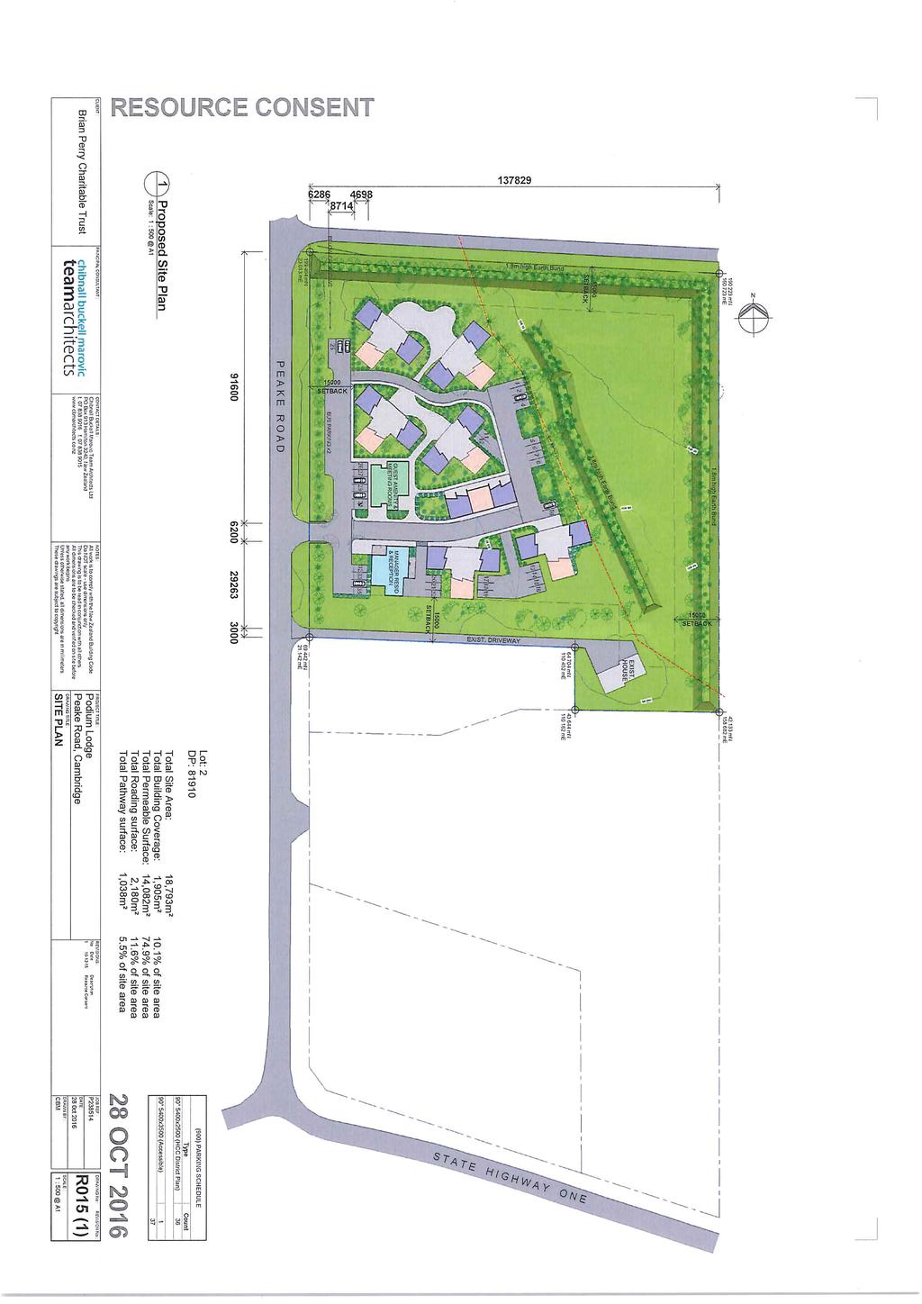
3 The drawings previously provided to Council in March and June 2016, have been updated in September 2016 to reflect visual, noise, amenity and reverse sensitivity effects design changes, in direct response to comments and submissions from the surrounding Neighbours, as the Applicant sought expert advice to address their concerns. 5. These masterplanning and architectural changes include the following; a. Creating a sculptured, sloping west to east and south to north, 1.2metre to 1.8metre high landscaped earth bunding, on both the north and east boundaries. b. Configuring a 1.2 metre high rural design aesthetic post and rail fence along the perimeter of the west, north and east earth bund. c. Relocation of the main carparking area from the north yard to be more centralised between the building groups. d. Relocation of the north building group, to a location slightly nearer the north boundary, yet still outside the 15metre Council setback. e. Providing additional landscaping along many of the car parking edges. f. Amending the parking areas and alignments and related manoeuvring of most arrival vehicles, to be located adjacent to the main Reception building. g. Amending parking areas between the Reception building and the adjacent accommodation group of buildings. h. Reconfiguring the traffic movement around the site, to be a simply managed clockwise, and one way system.
4 i. Preparing a landscape planting and fencing plan to reflect the rural residential character of the area. 6. Further Masterplanning and Architectural Design refinements have been undertaken as a series of recommendations by Rebecca Ryder of Boffa Miskell Landscape. These refinements include the following; a. Reducing and decentralising the scale and number of the east carpark area, to relocate these vehicle spaces in and around the adjacent chalets. This vehicle layout refinement moves the traffic movements behind the buildings and away from the northern and eastern boundaries. b. Adding larger landscaping screening to the pedestrian courtyard areas between and around the chalet groups, to further depict the character of the Cambridge Rural Residential area. c. Provide large trees to the main entry off Peake Road, sufficient to maintain the established character and feel of the surrounding Cambridge Rural Residential area. d. Provide a 1.2metre high post and rail fence along Peake Road, bringing rural fencing design elements into the project s overall architectural design and boundary treatments. e. Provide a sculptured, sloping west to east and south to north, 1.2metre to 1.8metre high landscaped earth bund to the north and east boundaries, with a sloping mowable surface, and on top of the bund provide a dense hedgerow, like Conifer or similar large scale screening tree planting. Further, a smaller earth bund has been located on the east of the carparking area to further screen the site from the north and east neighbours.

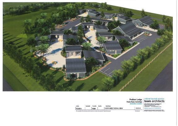
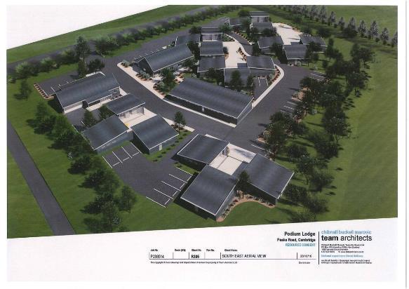
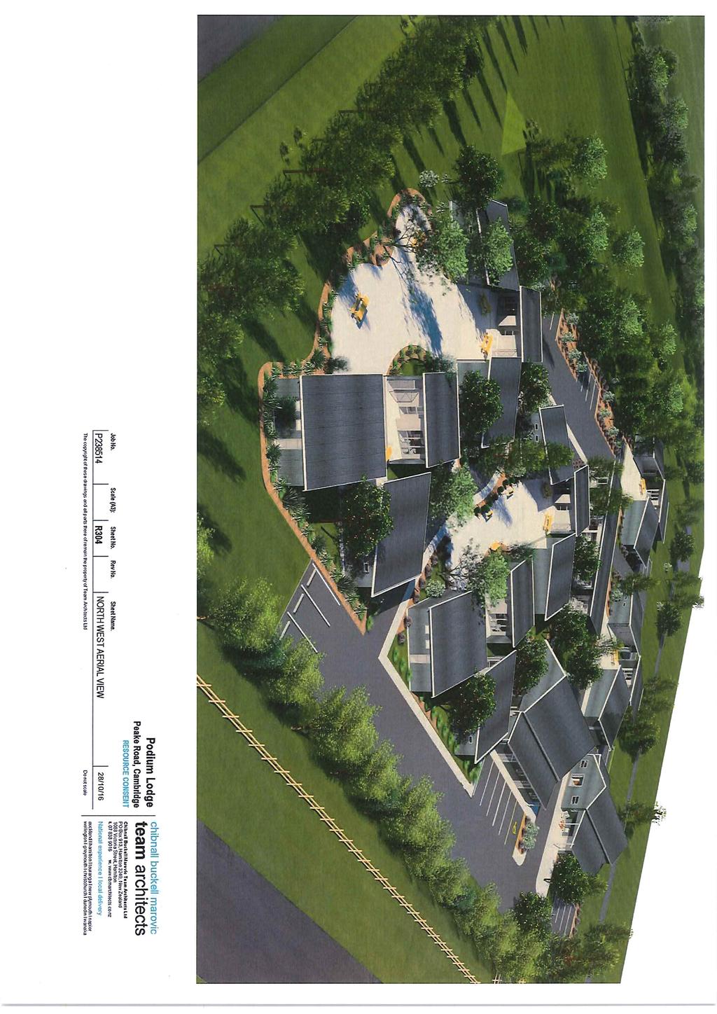
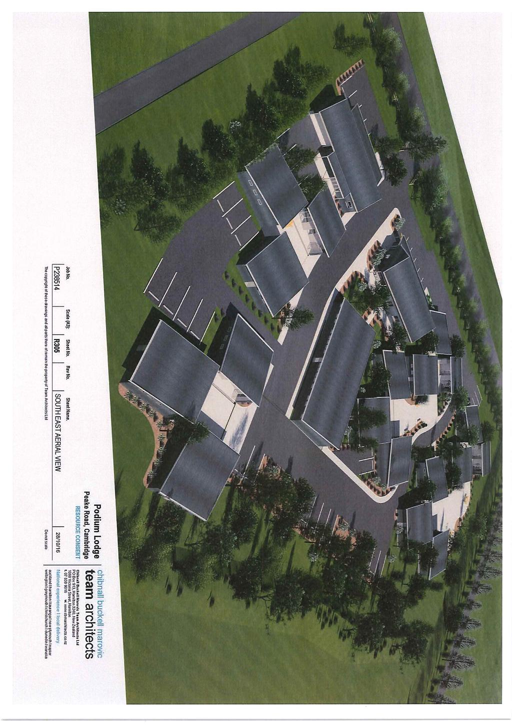
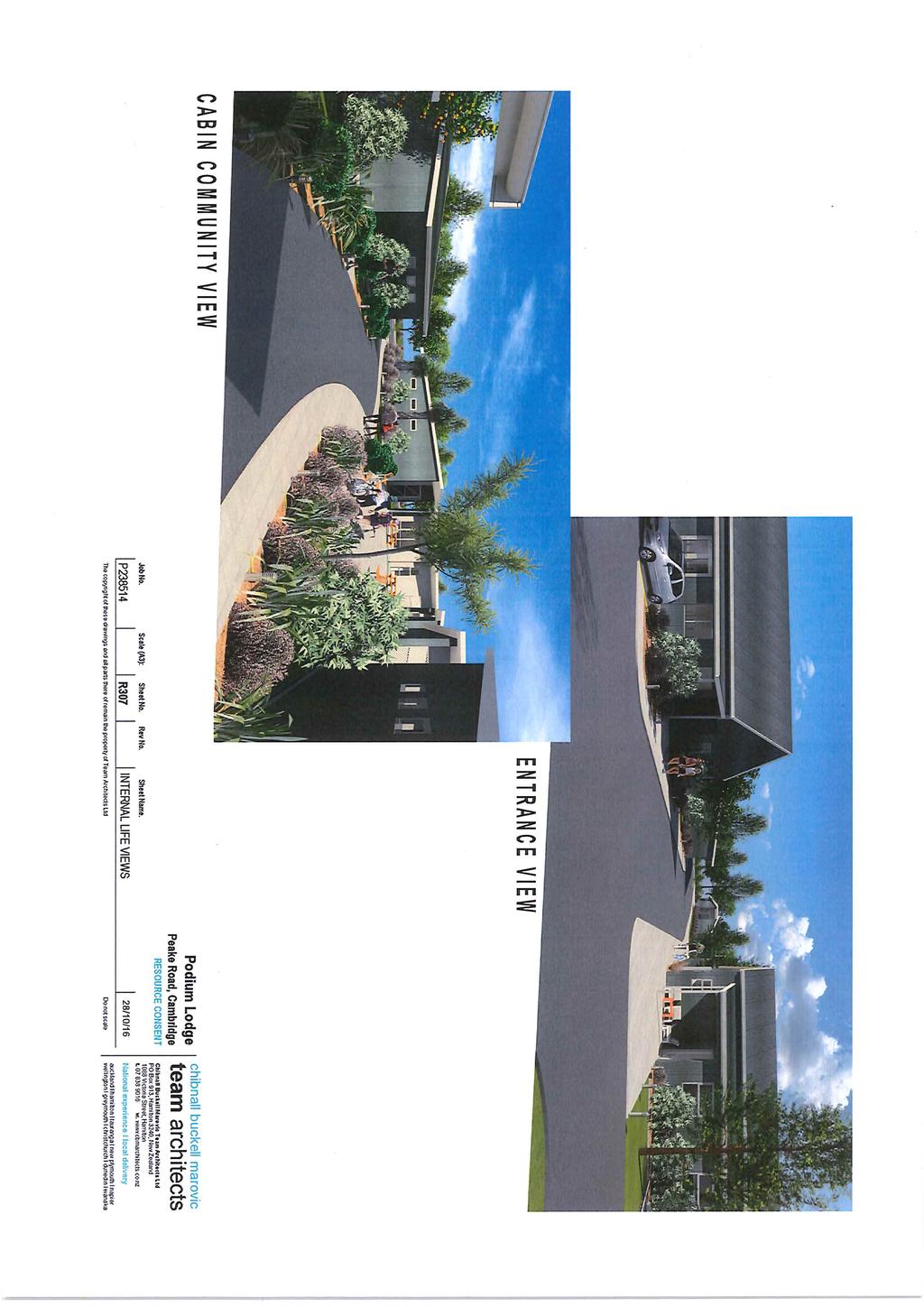
5 7. The main architectural drivers in this Sports Lodge design, are as follows; a. A distinctly traditional rural farmhouse architectural design aesthetic. This architectural delivery brings to this site, a configuration of timeless, one level farm cottage buildings, configured in and around several pedestrian and vehicle precincts, to create an overall Sports Lodge campus configuration. b. The cottages are further configured in and around a series of adjacent external courtyards. The buildings are configured on site, as far from the north and east neighbours as is practical. This is shown with the red line on the Site Plan, Page R015. Each Studio can open out onto this adjacent landscaped and screened courtyard, as is shown on these aerial images, Page R304 and R305.

6

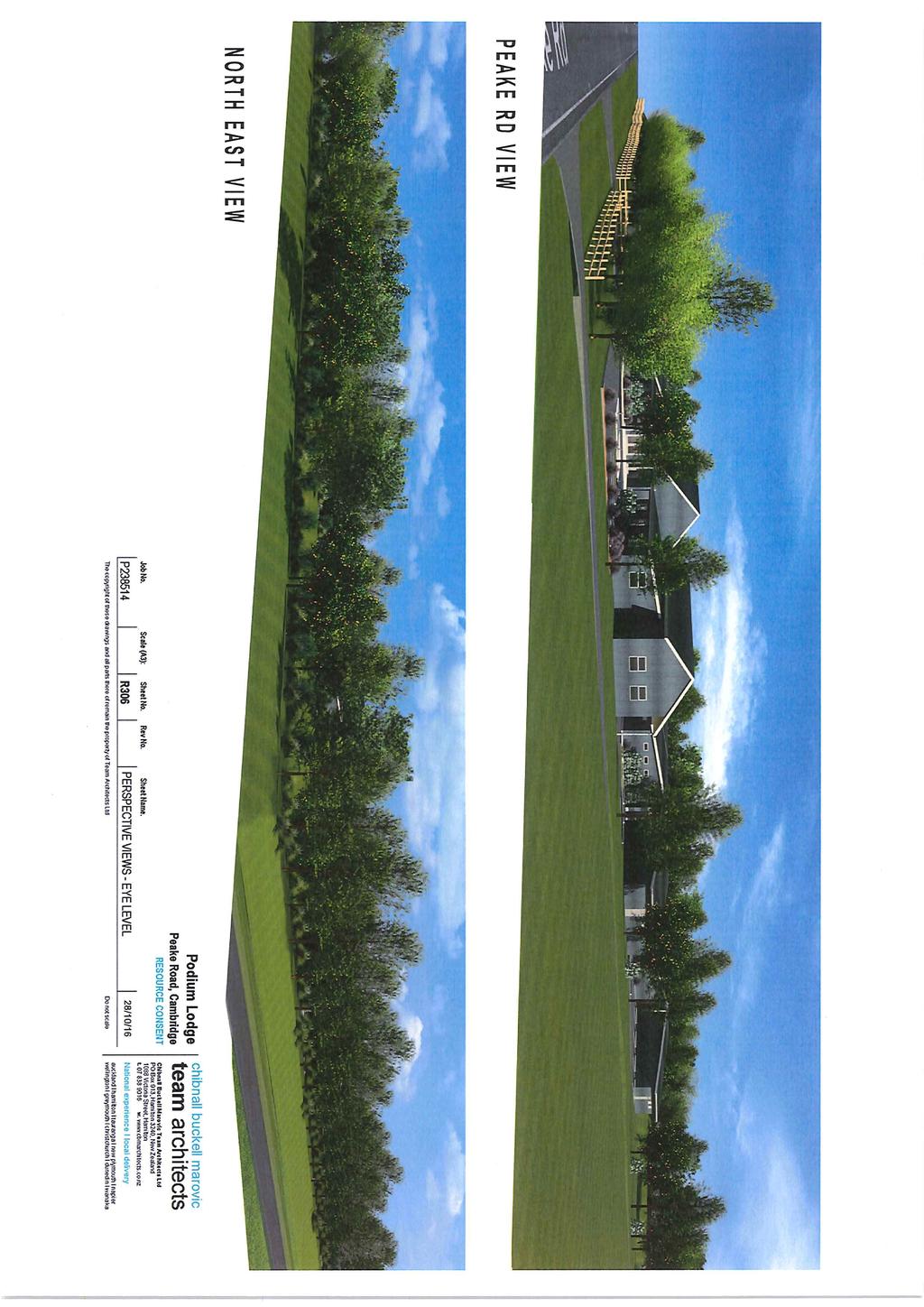
7 c. The exterior materials to these cottages are a mix of corrugated Colorsteel cladding, both to the walls and roof planes. This reinforces the New Zealand rural farm cottage design aesthetic. Combined with stained vertical tongue and grooved and/or board and batten cladding, the exterior materiality reinforces this architectural delivery, into a subtle and simple New Zealand architectural composition. d. The vehicle access into and out of the site, is taken through the existing Peake Road crossing. The vehicle traffic is configured in a clockwise movement through the building groups. Screening from the west, the north and the east neighbours, is by way of generous landscaping and earth berms, to prevent vehicle headlight

8 sweeping and related traffic/people noise affecting those neighbours as shown on the northeast perspective image on Page R306. e. The Arrival/Reception/Guest Amenity/Meeting Rooms/Manager s buildings are deliberately set next to this existing Peake Road crossing, ensuring noise and traffic movements are well away from the north and east neighbours. f. The Sports Lodge Campus is deliberately conceived as a landscaped rural park, with generous mature and young deciduous and evergreen trees screening the west, south, east and north neighbours. Peter Chibnall, Registered Architect,

9
10
11
12
13
14
15
16
17
18
19
20
21
22
23
24
RESIDENTIAL ACTIVITY PERFORMANCE STANDARDS
 Preferred Options Consultation Q&A Sheet RESIDENTIAL ACTIVITY PERFORMANCE STANDARDS What are the key goals for managing the design of residential buildings in the Second Generation Plan (2GP)? The key
AND STATEMENT OF EVIDENCE OF JOHN LONINK ON BEHALF OF CHRISTCHURCH CITY COUNCIL SPECIFIC PURPOSE (GOLF RESORT) ZONE
 ZONE") Page 1 of 13 BEFORE THE CHRISTCHURCH REPLACEMENT DISTRICT PLAN INDEPENDENT HEARINGS PANEL IN THE MATTER of the Resource Management Act 1991 and the Canterbury Earthquake (Christchurch Replacement District
Page 1 of 13 BEFORE THE CHRISTCHURCH REPLACEMENT DISTRICT PLAN INDEPENDENT HEARINGS PANEL IN THE MATTER of the Resource Management Act 1991 and the Canterbury Earthquake (Christchurch Replacement District
BEFORE THE CHRISTCHURCH REPLACEMENT DISTRICT PLAN HEARINGS PANEL
 BEFORE THE CHRISTCHURCH REPLACEMENT DISTRICT PLAN HEARINGS PANEL IN THE MATTER of the Resource Management Act 1991 and the Canterbury Earthquake (Christchurch Replacement District Plan) Order 2014 AND
Hearing Topic: 058 Public Open Space. Primary Evidence: from Andrea Broughton
 Submitter: Andrea & Alex Broughton Submission Number: 5650-1 Hearing Topic: 058 Public Open Space Primary Evidence: from Andrea Broughton Date: 10 June 2015 1. Introduction My name is Andrea Broughton
4 Residential and Urban Living Zones
 4 Residential and Urban Living Zones Refer to Chapters 11 to 20 for additional rules that may apply to these zones. 4.1 OBJECTIVES AND POLICIES Objective Res1 Policy 1 Policy 2 Policy 3 Policy 4 Policy
open space environment
 This section updated August 09 GUIDELINE TO THE RULES The Open Space Environment Rules apply to activities on sites within the Open Space Environment as shown on the Human Environments Maps. Most of the
32.1 General Industrial, Aviation Commercial and Rural Industrial B zones:
 APPENDIX 32 RULES FOR LANDSCAPING 32.1 General Industrial, Aviation Commercial and Rural Industrial B zones: Yard All yards adjoining a reserve, rural or residential zone or a road adjacent to a reserve,
Please take time to view our latest plans, speak to the development team and ask any questions you may have. EALING BROADWAY A4020
 WELCOME Durston House School is a successful school in the heart of Ealing. With 90 per cent of our pupils living in the borough, we have a strong connection to the local area. We are proposing to consolidate
I539. Smales 2 Precinct
 I539. Smales 2 Precinct I539.1. Precinct Description The Smales 2 Precinct applies to a 4.8 hectare block of land located on the southern side of Northcote Road and fronting Lake Pupuke, Takapuna. The
INTRODUCTION. Land West of Main Road, Stanton Harcourt THE SITE. Why is the Site Suitable for Development?
 0 INTRODUCTION THE SITE Application Boundary Gladman Developments Ltd has successfully invested in communities throughout the UK over the past 0 years, developing high quality and sustainable residential,
SECTION ONE North East Industrial Zone Design Guide Palmerston North City Council June 2004
 SECTION ONE North East Industrial Zone Design Guide Palmerston North City Council June 2004 young heart easy living 1 Preface Industrial areas are a very important component of the economic well-being
1. Local Plan Context
 1. Local Plan Context WHY ARE YOU HERE? ABOUT US PLANNING APPLICATION CONSULTATION Stewart Milne Homes are in the process of preparing a detailed planning application for a development of approximately
4 RESIDENTIAL ZONE. 4.1 Background
 4 RESIDENTIAL ZONE 4.1 Background The residential areas within the City are characterised by mainly lowrise dwellings sited on individual allotments. Past architectural styles, settlement patterns and
Neighbourhood Plan Representation
 Date: 10 th November 2017 Neighbourhood Plan Representation Land to the east of Callow Hill Road, Alvechurch Introduction This representation has been prepared by RPS Planning and Development on behalf
SOUTH CAMBRIDGESHIRE DISTRICT COUNCIL. Planning and New Communities Director
 SOUTH CAMBRIDGESHIRE DISTRICT COUNCIL REPORT TO: Planning Committee 5 June 2013 AUTHOR/S: Planning and New Communities Director S/0747/13/FL HISTON Construction of Car Park at Histon Baptist Church, Station
WELLINGTON CITY DISTRICT PLAN
 Section 32 Report WELLINGTON CITY DISTRICT PLAN PROPOSED DISTRICT PLAN CHANGE 54 REZONING 178 AND 180 OWHIRO BAY PARADE 1 Introduction Before a Proposed District Plan change is publicly notified the Council
OVERVIEW PROJECT SUMMARY
 OVERVIEW These five houses on Ridge View Crescent form an important part of the wider Anslemi Ridge development. They are the backdrop to the lake that is the community heart of the nieghbourhood, and
64 Mineral Extraction Area Rules
 64 Mineral Extraction Area Rules 64.1 Introduction For the purposes of this Chapter: Active Area, in relation to a Mineral Extraction Area (MEA), is that part of the Mineral Extraction Area which is owned
Land to West of Bessel s Way, Blewbury. Contextual Analysis. fluid
 Land to West of Bessel s Way, Blewbury Contextual Analysis fluid Contents fluid - Overview - Growth pattern - Footpath & Road connections - Landscape Character - Amenities - Agriculture - Characteristic
Clairtrell Area Context Plan
 Clairtrell Area Context Plan March 2005 Urban Development Services City Planning Contents 1. Introduction... 4 2. Development Structure... 6 2.1 Streets... 7 2.1.1 Sheppard Avenue and Bayview Avenue...
Bel-Air Lexus Automobile Service Station
 Bel-Air Lexus Automobile Service Station Design Brief 443-447 McArthur Avenue Ottawa April 30, 2015 14-1299-MCA Site Details Application: Site Plan Control Legal Description and Municipal Addresses: 443
Matamata Piako District Council. Rings Scenic Tours Limited. Statement of Evidence by Michael Richard Graham on behalf of Rings Scenic Tours Limited
 Before the Hearings Commissioners at Matamata in the matter of: A Private Plan Change to the Matamata Piako District Plan under Schedule 1 of the RMA by Rings Scenic Tours Limited to introduce new objectives,
8 & 10 Donalda Crescent Official Plan & Rezoning Application Final Report
 STAFF REPORT ACTION REQUIRED 8 & 10 Donalda Crescent Official Plan & Rezoning Application Final Report Date: July 26, 2010 To: From: Wards: Reference Number: Scarborough Community Council Director, Community
section five BEAUTIFICATION PLAN
 section five BEAUTIFICATION PLAN BEAUTIFICATION PLAN Section Five Beautification Plan The goal of the Beautification Plan is to improve the Route 8-Sunnyland Corridor in terms of aesthetics and to create
Guidance Notes Completing an AEE
 Guidance Notes Completing an AEE The purpose of this guidance note is to assist you with completing your Assessment of Environmental Effects (AEE) for your land-use consent application. If you do not provide
4.3 Dudley Area Plan. Introduction. History and Existing Character. Desired Future Character for Dudley
 4.3 Dudley Area Plan Introduction The suburb of Dudley has developed as a result of various circumstances including its topography, history and mineral resources. Dudley development has been identified
Land at Rampton Road. Cottenham
 Land at Rampton Road Cottenham Introduction TEP is preparing an outline planning application for 54 dwellings on 6.9 hectares of land adjacent to Rampton Road, Cottenham on behalf of the owners Cambridgeshire
Nelson Residential Street Frontage Guideline
 DRAFT 22-06-2012 Nelson Residential Street Frontage Guideline June 2012 1317273 Contents and purpose Residential s are important Residential s are much more than corridors which move traffic. Streets allow
DESIGN AND ACCESS STATEMENT NEW TALYBONT HALLS, CARDIFF UNIVERSITY JULY 2018
 DESIGN AND ACCESS STATEMENT NEW TALYBONT HALLS, CARDIFF UNIVERSITY JULY 2018 1 FILE NTHCU-STL-XX-XX-RP-A-9075-RP013 PROJECT New Talybont Halls, Cardiff University CLIENT Cardiff University STRIDE TREGLOWN
Urban Design Brief Woodland Cemetery Funeral Home 493 Springbank Drive
 Urban Design Brief Woodland Cemetery Funeral Home The Incorporated Synod of the Diocese of Huron April 15, 2016 Urban Design Brief April 15, 2016 TABLE OF CONTENTS Page No. INTRODUCTION... 1 SECTION 1
2 Nelson City Council Dear Cottages
 2 Nelson City Council Dear Cottages Design Guide introduction DI1 Why a Design Guide? The Council, in the development of the Nelson Resource Management Plan, has identified particular residential areas
Welcome to our public exhibition
 About our development Welcome to our public exhibition This public exhibition gives you the opportunity to view and comment on our proposals to create a new residential development on land adjacent to
11.3 SPECIAL CHARACTER ZONE HAWKE S BAY REGIONAL SPORTS PARK
 11.3 SPECIAL CHARACTER ZONE HAWKE S BAY REGIONAL SPORTS PARK 11.3.1 INTRODUCTION The availability of sports and recreation activities and facilities is important for the maintenance and enhancement of
INTRODUCTION CURRENT APPLICATION
 05/01805/FUL & 05/01807/LBC ERECTION OF A SINGLE DWELLING HOUSE WITH ANCILLARY ACCOMMODATION AT Flamingo Zoological Gardens, Olney Road, Weston Underwood FOR Mr A J Crowther (as amended by letter dated
APPENDIX MATAKANA COMMERCIAL URBAN DESIGN GUIDELINES
 APPENDIX MATAKANA COMMERCIAL URBAN DESIGN GUIDELINES 1.0 INTRODUCTION The following urban design guidelines are to be utilised by landowners, planners and other persons involved in development at early
PUBLIC NOTICE UNDER CLAUSE 5 OF SCHEDULE 1 OF THE RESOURCE MANAGEMENT ACT 1991 PLAN CHANGE 12 TO THE OPERATIVE CITY OF NAPIER DISTRICT PLAN
 PUBLIC NOTICE UNDER CLAUSE 5 OF SCHEDULE 1 OF THE RESOURCE MANAGEMENT ACT 1991 PLAN CHANGE 12 TO THE OPERATIVE CITY OF NAPIER DISTRICT PLAN Public notice is given in accordance with Clause 5 of Schedule
St Barnabas C of E Primary School, Spring Lane, Erdington, Birmingham, B24 9BY
 Committee Date: 12/06/2014 Application Number: 2014/02967/PA Accepted: 29/04/2014 Application Type: Full Planning Target Date: 24/06/2014 Ward: Erdington St Barnabas C of E Primary School, Spring Lane,
INVESTING IN WATERWAYS
 1 H2O Urban LLP is a joint venture vehicle between developers Bloc and British Waterways which specialises in regenerating canalside locations. aerial view of site The redevelopment of the site would generate
1.0 INTRODUCTION. Brantham Industrial Area Regeneration - Factory Lane - Brantham
 1.0 INTRODUCTION Welcome to this exhibition of our proposals for the regeneration of the Brantham Industrial Area located off Factory Lane in Brantham. This presentation will give you an opportunity to
ASSESSMENT OF LANDCAPE PROVISIONS FOR PROPOSED PLAN CHANGE 5. Local Business Zone PALMERSTON NORTH CITY COUNCIL FINAL
 Hawke s Bay Office: PO Box 8823 Havelock North john@hudsonassociates.co.nz Ph 06 877 9808 M 021 324 409 A division of Hudson Group Ltd ASSESSMENT OF LANDCAPE PROVISIONS FOR PROPOSED PLAN CHANGE 5 Local
PROPOSED RESIDENTIAL DEVELOPMENT MAWNAN SMITH CORNWALL Design & Access Statement
 PROPOSED RESIDENTIAL DEVELOPMENT MAWNAN SMITH CORNWALL Design & Access Statement St Piran House, Heron Way, Newham, Truro, Cornwall, TR1 2XN Tel: 08453 707 111 Fax: 08453 707 113 www.csa-architects.co.uk
I615. Westgate Precinct
 I615. Westgate Precinct I615.1. Precinct Description The Westgate Precinct is located approximately 18km west of the Auckland city centre. There are seven Sub-precincts in the Westgate Precinct: Sub-precinct
THAT Site Development Application DA (Villa Charities Inc./Villa Colombo DiPoce Campus) BE APPROVED, subject to the following conditions:
 BE APPROVED, subject to the following conditions:") COMMITTEE OF THE WHOLE JUNE 16, 2003 SITE DEVELOPMENT FILE DA.02.058 VILLA CHARITIES INC./VILLA COLOMBO DIPOCE CAMPUS Recommendation The Commissioner of Planning recommends: THAT Site Development Application
COMMITTEE OF THE WHOLE JUNE 16, 2003 SITE DEVELOPMENT FILE DA.02.058 VILLA CHARITIES INC./VILLA COLOMBO DIPOCE CAMPUS Recommendation The Commissioner of Planning recommends: THAT Site Development Application
URBAN DESIGN BRIEF. 2136&2148 Trafalgar Road. Town of Oakville
 URBAN DESIGN BRIEF 2136&2148 Trafalgar Road Town of Oakville Prepared By: METROPOLITAN CONSULTING INC For 2500674 Ontario Inc November 2016 TABLE OF CONTENTS Page No. 1.0 Introduction/Description of Subject
Development Control Plan
 Development Control Plan Rhodes Corporate Park (Also known as the Digital Site) Development Control Plan Date of Adoption: 4 September 2007 Effective Date: 7 March 2008 Index 1 INTRODUCTION... 3 1.1 LAND
I Te Koti Taiao o Aotearoa Ōtautahi Rohe ENV-2018-CHC- Appellant. Queenstown Lakes District Council. Respondent
 In the Environment Court of New Zealand Christchurch Registry I Te Koti Taiao o Aotearoa Ōtautahi Rohe ENV-2018-CHC- Under In the matter of Between the Resource Management Act 1991 (RMA) An appeal under
Subdivision Design Criteria. Penihana North GUIDELINES TO THE RULES
 Created September 2013 Penihana North Subdivision Design Criteria GUIDELINES TO THE RULES This part of the Plan sets out the design criteria for subdivision in Penihana North. The criteria will be considered
The eight-week period for this application expires on 5 October 2006.
 06/01213/FUL CHANGE OF USE FROM AGRICULTURAL LAND TO PRIVATE CAR PARK AND NEW FENCING. AT Land To The South of Perceval Almhouses, Lower Weald, Calverton FOR Calverton Parochial Church Council INTRODUCTION
ADOPTED AT NOVEMBER 15, 2012 PACC MEETING
 ADOPTED AT NOVEMBER 15, 2012 PACC MEETING STAFF MEMORANDUM TO PACC-TECH TO: PACC-Tech FROM: Elaine K. Echols, AICP, Missy Creasy, AICP, and Julia Monteith, AICP TOPIC: Review of Area B Recommendations
HOROWHENUA DEVELOPMENT PLAN June create a safe crossing for children moving to and from the school and other areas. 7.8 Ohau
 7.8 Ohau create a safe crossing for children moving to and from the school and other areas. Ohau has a traditional village form with a collective of school, church and reserve at the main road intersection.
PROPOSED RESIDENTIAL DEVELOPMENT LAND AT TRETHURFFE LADOCK, TRURO Design & Access Statement
 PROPOSED RESIDENTIAL DEVELOPMENT LAND AT TRETHURFFE LADOCK, TRURO Design & Access Statement Heron Way, Newham, Truro, Cornwall, TR1 2XN Tel: 08453 707 111 Fax: 08453 707 113 www.csa-architects.co.uk E:
I404 Beachlands 2 Precinct
 I404. Beachlands 2 I404.1. Precinct Description The Beachlands 2 precinct covers approximately 6 hectares of land at the corner of Beachlands and Whitford Maraetai Roads. Its purpose is to provide for
AMENDMENTS. Date Effective. Amendment No. Council. DCP 14 Davidson St, Greenacre Page 2
 AMENDMENTS Amendment No. Description Adopted by Council Date Effective DCP 14 Davidson St, Greenacre Page 2 TABLE OF CONTENTS 1.0 INTRODUCTION... 4 1.1 NAME OF THIS PLAN... 4 1.2 COMMENCEMENT OF DEVELOPMENT
7.2.9 Eudlo local plan code
 7.2.9 local plan code 7.2.9.1 Application (1) This code applies to assessable development:- (a) within the local plan area as shown on Map ZM29 contained within Schedule 2 (Mapping); and (b) identified
MASTER PLAN NO. 62 (SITE DEVELOPMENT PLAN BIRTINYA VILLAGE CENTRE) 2009
 2009") Development Agreement, Development Control Plan 1 - Kawana Waters and Section 6.1.45A (Development Control Plans under Repealed Act) of the Integrated Planning Act 1997 MASTER PLAN NO. 62 (SITE DEVELOPMENT
Development Agreement, Development Control Plan 1 - Kawana Waters and Section 6.1.45A (Development Control Plans under Repealed Act) of the Integrated Planning Act 1997 MASTER PLAN NO. 62 (SITE DEVELOPMENT
WELCOME TO THE NEW WILTON PARK
 WELCOME TO THE NEW WILTON PARK VISION HISTORY OF WILTON PARK TOWARDS A PLANNING APPLICATION Our objective is to create a truly outstanding environment at Wilton Park. At the heart of our proposals is a
Flint s Park Mixed Use Precinct
 Attachment A: Key plans from the Flints Park Residential Expression of Interest Site and Locality - Existing Transit and Cycling Connections (Overlaid the QLDC Ladies Mile Indicative Masterplan) Flint
APPLICATION BRIEFING Prepared For: Submitted by: Date: Subject:
 Planning & Development APPLICATION BRIEFING Prepared For: Submitted by: Date: Subject: Planning Advisory Committee Jason Fox, Director of Planning & Development Development Agreement application by Godfrey
City of Farmington. Downtown Plan. Amendment to the 1998 Master Plan Adopted October 11, 2004
 City of Farmington Amendment to the 1998 Master Plan Adopted October 11, 2004 Introduction Planning Background 1 Scope and Components of the Plan Amendment 2 Concept Introduction 3 Plan Concepts 3 Conceptual
Heritage Precincts Overlay
 Rule 2.4 Heritage Precincts Overlay Rule Statement Heritage Precincts are areas with consistent special heritage character. The District Plan has identified fourthree Heritage Precincts, the Frankton Railway
Urban Design Brief to 1557 Gordon Street & 34 Lowes Road West
 Urban Design Brief 1533 to 1557 Gordon Street & 34 Lowes Road West Reid s Heritage Homes Ltd. & 883928 Ontario Ltd. and RHH Property Management Ltd. City of Guelph Zoning By-law Amendment November 2017
MIDTOWN MIXED-USE VILLAGE. TECHNICAL DATA SHEET COMPONENT C-1 FOR PUBLIC HEARING - PETITION NUMBER Project No RZ1.1. Issued.
 N MIDTOWN MIXED-USE VILLAGE TECHNICAL DATA SHEET COMPONENT C- FOR PUBLIC HEARING - PETITION NUMBER 04-00 Project No. 496 Issued Revised SCALE: " = 0' N 0 0 0 40 RZ. c GENERAL PROVISIONS: a. SITE LOCATION.
Ensure that development within the Arrowtown Urban Growth Boundary provides:
 URBAN DEVELOPMENT 4 4.2.5.2 Ensure that development within the Arrowtown Urban Growth Boundary provides: an urban form that is sympathetic to the character of Arrowtown, including its scale, density, layout
I331. St John s Theological College Precinct
 I331. St John s Theological College Precinct I331.1. Precinct Description The precinct contains the existing St John s Theological College which is a residential college for the Anglican Church in New
2.0 AREA PLANS. Lakeside Business District. Lakeside Business District Land Use Categories:
 Lakeside Business District Lakeside Business District Land Use Categories: Campus Commercial Campus Commercial means a mixture of uses which includes corporate offices, office parks, hotels, commercial,
4121 Lawrence Avenue East Rezoning Application Preliminary Report
 STAFF REPORT ACTION REQUIRED 4121 Lawrence Avenue East Rezoning Application Preliminary Report Date: October 11, 2011 To: From: Wards: Reference Number: Scarborough Community Council Director, Community
Appendix 7 Precinct Analysis Carlton
 Appendix 7 Precinct Analysis Carlton (Andover Street) Rezone from R2 Low Density Residential to R3 Medium Density Residential Retain existing B1 Neighbourhood Centre zone Existing Zoning Map (R2 Low Density
MASTER PLAN N0. 76 (SITE DEVELOPMENT PLAN DETAILED PLANNING AREA 12 PRECINCT 13) 2013
 2013") MASTER PLAN N0. 76 (SITE DEVELOPMENT PLAN DETAILED PLANNING AREA 12 PRECINCT 13) 2013 TABLE OF CONTENTS 1.0 ADMINISTRATION... 5 1.1 Preliminary... 5 1.2 Location and Description... 6 1.3 Zoning Map Description...
MASTER PLAN N0. 76 (SITE DEVELOPMENT PLAN DETAILED PLANNING AREA 12 PRECINCT 13) 2013 TABLE OF CONTENTS 1.0 ADMINISTRATION... 5 1.1 Preliminary... 5 1.2 Location and Description... 6 1.3 Zoning Map Description...
REFERENCE: 16/8568/ENQ Received: 25 October 2016 Accepted: 26 October 2016
 LOCATION: Allianz Park, Greenlands Lane, London, NW4 1RL REFERENCE: 16/8568/ENQ Received: 25 October 2016 Accepted: 26 October 2016 WARD(S): Mill Hill APPLICANT: Saracens Copthall Ltd. PROPOSAL: Extension
Section Three, Appendix 17C Multiple Unit Housing Design Assessment Criteria
 APPENDIX 17C MULTIPLE UNIT HOUSING DESIGN ASSESSMENT CRITERIA Purpose of Appendix 17C In the Residential 9 Zone the construction and use of multiple household units located within the Multiple Household
East Harptree Landscape & Character Assessment
 East Harptree Landscape & Character Assessment Produced by East Harptree Parish Council in consultation with local residents September 2014 Contents The Parish of East Harptree: Objective Introduction
Statement of Community Involvement LAND OFF SOUTHDOWN ROAD HORNDEAN, HAMPSHIRE
 LAND OFF SOUTHDOWN ROAD HORNDEAN, HAMPSHIRE CONTENTS Page 1. Introduction 3 2. Pre-application Discussions 4 3. The Consultation Process 5 4. Consultation Feedback 7 5. Responses to Consultation Feedback
I326. Ōrākei 1 Precinct
 I326. Ōrākei 1 recinct I326.1. recinct Description The Ōrākei 1 recinct includes the land identified as hapu reservation (land held for the purposes of a marae, church, urupa and related hapu amenities)
I611. Swanson North Precinct
 I611. Swanson North Precinct I611.1. Precinct Description Swanson North is located in the north eastern foothills of the Waitakere Ranges. It is outside the Waitakere Ranges Heritage Area Act and the Waitakere
GREENFORD HALL & ADJOINING LAND
 GREENFORD HALL & ADJOINING LAND CONTENTS 1. Introduction 1. Introduction 2. Urban Context 2.1 The Site and Surroundings 2.2 Urban Context Map 2.3 Access and Movement 3. Planning Context 3.1 Planning History
East Panorama Ridge Concept Plan Amendment
 Page 1 of 7 L003 : East Panorama Ridge Concept Plan Amendment Corporate NO: L003 Report COUNCIL DATE: March 4, 2002 REGULAR COUNCIL LAND USE TO: Mayor & Council DATE: February 27, 2002 FROM: General Manager,
Division 7 Character Areas Housing Zone: Assessment Criteria and Assessment Tables
 Division 7 Character Areas Housing Zone: Assessment Criteria and Assessment Tables 4.7.1 Character Areas Housing Zone The provisions in this division relate to the Character Areas Housing Zone as follows
Ringsend & Irishtown Local Environmental Improvement Plan
 Ringsend & Irishtown Local Environmental Improvement Plan Study Area East Link Bridge St. Patrick s Boat Club Ringsend Technical Institute Stella Maris Boat Club St. Patrick s Church Ringsend Library Ringsend
MASTER PLAN NO. 60 (SITE DEVELOPMENT PLAN EASTBANK/REGATTA NORTH PRECINCTS 2 4) 2008
 2008") Page 2 TABLE OF CONTENTS PAGE 1 PRELIMINARY... 5 1.1 CITATION... 5 1.2 TYPE OF MASTER PLAN... 5 1.3 LEGAL REQUIREMENT FOR MASTER PLAN... 5 1.4 LEGAL EFFECT OF THE MASTER PLAN... 5 2 DESCRIPTION OF LAND...
Page 2 TABLE OF CONTENTS PAGE 1 PRELIMINARY... 5 1.1 CITATION... 5 1.2 TYPE OF MASTER PLAN... 5 1.3 LEGAL REQUIREMENT FOR MASTER PLAN... 5 1.4 LEGAL EFFECT OF THE MASTER PLAN... 5 2 DESCRIPTION OF LAND...
I309. Cornwall Park Precinct
 I309. Cornwall Park Precinct I309.1. Precinct Description Cornwall Park is a privately owned and managed landscaped park designed for public recreation and enjoyment and is a highly used and valued open
City of Heath. Town Center Concept
 In the give-and-take of getting projects designed, financed, and approved, the famous refrain from the film Field of Dreams is heard often: if you build it, they will come. From the perspective of the
St Michaels C of E Junior & Infant School, Nantmel Grove, Bartley Green, Birmingham, B32 3JS
 Committee Date: 06/03/2014 Application Number: 2013/08595/PA Accepted: 19/11/2013 Application Type: Full Planning Target Date: 14/01/2014 Ward: Bartley Green St Michaels C of E Junior & Infant School,
Proposed Plan Change 55: District Wide Rules. Hearing Report
 Proposed Plan Change 55: District Wide Rules Hearing Report Appendix 5 BEFORE THE HEARINGS PANEL In the Matter of: The Resource Management Act 1991 And Proposed Plan Change 55: Chapter 3 District Wide
Section Three, Appendix 16C Medium Density Housing, Design Assessment Criteria (Residential 8A zone)
") APPENDIX 16C MEDIUM DENSITY HOUSING, DESIGN ASSESSMENT CRITERIA (RESIDENTIAL 8A ZONE) PURPOSE OF APPENDIX 16C (RESIDENTIAL 8A ZONE) In the Residential 8A Zone the following are defined as restricted discretionary
APPENDIX 16C MEDIUM DENSITY HOUSING, DESIGN ASSESSMENT CRITERIA (RESIDENTIAL 8A ZONE) PURPOSE OF APPENDIX 16C (RESIDENTIAL 8A ZONE) In the Residential 8A Zone the following are defined as restricted discretionary
Schedule of Planning Applications Committee Date: 23 May Reference: 06/17/0726/F Parish: Hemsby Officer: Mr J Beck Expiry Date:
 Schedule of Planning Applications Committee Date: 23 May 2018 Reference: 06/17/0726/F Parish: Hemsby Officer: Mr J Beck Expiry Date: 22-05-2018 Applicant: Proposal: Site: Mr Gillett Change of use to the
KAHUKURA THE PURPOSE THE PROCESS THE GUIDELINES LIVING G (WIGRAM) DENSITY C SECTIONS YOUR HOME SITING BUILDING SIZE
 DENSITY C SECTIONS YOUR HOME SITING BUILDING SIZE") KAHUKURA Design Guidelines Thank you for choosing to build your new home at Wigram Skies. As part of the building process, each house design at Wigram Skies will need to have been approved by Ngai Tahu
KAHUKURA Design Guidelines Thank you for choosing to build your new home at Wigram Skies. As part of the building process, each house design at Wigram Skies will need to have been approved by Ngai Tahu
Public Consultation 23 January Peel Hall, Warrington Board 1. A message from Satnam... Site history...
 Board 1 A message from Satnam... Thank you for attending today s public consultation about proposals to develop a new residential neighbourhood at. The display boards show why the development is needed
THREE PARKS ZONE Three Parks Special Zone The process of applying for resource consents in the zone.
 .25 Three Parks Special Zone The purpose of this zone is to provide for growth and to give effect to the Wanaka 2020 Community (2002) and the more recent Wanaka Structure (2007) and Wanaka Transport Strategy
Replacement Golf Course Facilities and Residential Development, Churston. Environmental Statement Non-Technical Summary
 Replacement Golf Course Facilities and Residential Development, Churston Environmental Statement Non-Technical Summary July 2011 Reproduced from the Ordnance Survey s map with the permission of the Controller
Memorial Business Park Site. Proposed Future Development. Design guidelines. August
 Memorial Business Park Site Proposed Future Development Design guidelines August 2014 www.designenvironment.co.nz 0064 3 358 3040 Contents 1.0 Background 1.1 Introduction 3 1.2 Objectives 4 2.0 Context
7437, 7439 and 7441 Kingston Road - Zoning By-law Amendment and Site Plan Control Applications - Preliminary Report
 STAFF REPORT ACTION REQUIRED 7437, 7439 and 7441 Kingston Road - Zoning By-law Amendment and Site Plan Control Applications - Preliminary Report Date: August 13, 2015 To: From: Wards: Reference Number:
Lancaster Conservation Area Appraisal. Character Area 8. Cathedral
 Lancaster Conservation Area Appraisal Character Area 8. Cathedral March 2013 118 3.8 Character Area 8. Cathedral 3.8.1. Definition of Special Interest "This character area is distinctive for the fine group
Downtown Streetscape Manual & Built Form Standards
 City of Guelph Downtown Streetscape Manual & Built Form Standards July 2014 Prepared by Brook McIlroy Inc. in association with Unterman McPhail Associates and McCormick Rankin Inc. City of Guelph Downtown
Application for Resource Consent to the Christchurch City Council:
 Application for Resource Consent to the Christchurch City Council: Fortress Services Limited To retain the existing commercial boutique activity located at 121 Papanui Road, Christchurch 22 July 2013 Document
THE PURPOSE THE PROCESS THE GUIDELINES LIVING 1 SECTIONS YOUR HOME SITING BUILDING SIZE
 Design Guidelines Thank you for choosing to build your new home at Wigram Skies. As part of the building process, each house design at Wigram Skies will need to have been approved by Ngai Tahu Property
NEW HOMES IN ANCASTER S MATURE NEIGHBOURHOODS WHAT WE HAVE HEARD
 NEW HOMES IN ANCASTER S MATURE NEIGHBOURHOODS Council directed staff to review the Existing Residential ER Zone in Ancaster as a pilot project to determine how to manage the building of new residential
SOUTH CAMBRIDGESHIRE DISTRICT COUNCIL. Director of Development Services
 SOUTH CAMBRIDGESHIRE DISTRICT COUNCIL REPORT TO: Development and Conservation Control Committee 1 st June 2005 AUTHOR/S: Director of Development Services S/0743/05/F - Great Shelford Extension and Conversion
599 Kennedy Road - Official Plan Amendment and Zoning Amendment Application - Preliminary Report
 STAFF REPORT ACTION REQUIRED 599 Kennedy Road - Official Plan Amendment and Zoning Amendment Application - Preliminary Report Date: March 7, 2017 To: From: Wards: Reference Number: Scarborough Community
H7 Open Space zones. (a) provide for the needs of the wider community as well as the needs of the community in which they are located;
 provide for the needs of the wider community as well as the needs of the community in which they are located;") H7. Open Space zones H7.1. Background The majority of land zoned as open space is vested in the Council or is owned by the Crown. However some areas zoned open space are privately owned. While the open
H7. Open Space zones H7.1. Background The majority of land zoned as open space is vested in the Council or is owned by the Crown. However some areas zoned open space are privately owned. While the open
design & access statement Proposed Erection of 68 Bedroom Hotel and Restaurant with Associated Landscaping
 Proposed Erection of 68 Bedroom Hotel and Restaurant with Associated Landscaping Promenade, design & access statement lawrencemcphersonassociates 6 new road, ayr, ka8 8ex On Behalf of July 2015 CONTENTS