SEFUAP BOARD OF SUPERVISORS APPROVED ON JUNE 13, 2012 PLANNING COMMISSION FACILITATOR GROUP
|
|
|
- Alyson Richardson
- 5 years ago
- Views:
Transcription
1 SENSENY/EASTERN FREDERICK URBAN AREA PLAN SEFUAP BOARD OF SUPERVISORS APPROVED ON JUNE 13, 2012 PLANNING COMMISSION RECOMMENDED APPROVAL MAY 16, 2012 ENDORSED BY THE FACILITATOR GROUP FEBRUARY 1,
2 2
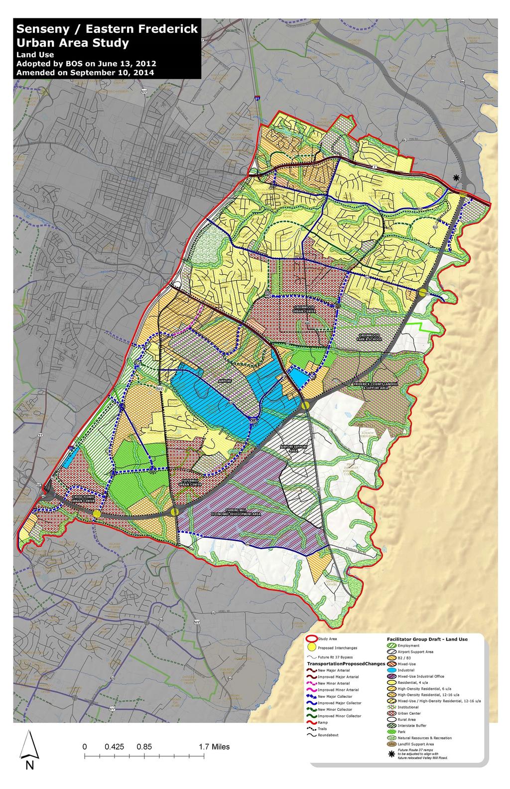
3 SENSENY/EASTERN FREDERICK URBAN AREA PLAN This area is home to many families and successful businesses, and contains some of the area s most accessible natural resources and environmental features, historic resources, and public facilities. The Senseny/Eastern Frederick Urban Area Plan effort builds upon these great assets and has identified opportunities to; create new communities, integrate land use and transportation choices, address community infrastructure needs, and expand the County s goals for economic development. A series of maps have been prepared which identify Future Land Use, Transportation, and Historical Resources, Natural Resources and Public Facilities within the study area. The Senseny/Eastern Frederick Urban Area Plan incorporates the following areas of new land use focus: the Urban Centers, the Parkins Mill Economic Development Area, Interstate and Highway Commercial at Routes 7, 50 and 522, Warrior Drive Employment and Commercial Center, and others. The above areas combine to form the County s urban areas between the City of Winchester and Clarke County. The study encompasses the area of the County that is generally east of the City of Winchester and Route 522, South to the Clarke County line and from Redbud Run in the north to the Opequon Creek in the south. This study area includes the Route 7 and Route 50 Business Corridor Plans which were both adopted in 1994, and the eastern portion of the Southern Frederick Land Use Plan which was adopted in 1999, generally north of the Opequon Creek. The study area includes both the Red Bud and Shawnee Magisterial Districts and a small portion of the Stonewall Magisterial District. 3
4 An overview to planning in Frederick County. Planning efforts, such as the Senseny Eastern Frederick Urban Area Plan, enables the community to anticipate and deal constructively with changes occurring in the community. Planning helps guide the future growth of the community and is intended to improve the public health, safety, convenience and welfare of its citizens. The Plan provides a guide for future land use and was a collaborative effort of the citizens of Frederick County, County Planning Staff, Planning Commissioners, and Board of Supervisors. However, it is the property owners who are the ones who make the decision as to whether or not to implement the Plan as it applies to their property. Future rezoning is a means of implementing the Plan. Rezonings in Frederick County have historically been initiated by the property owner, or with their consent. There is no reason to expect that this will change in the future. Therefore, it is important to remember that the Plan is a guide for the future of the community, but that the property owner is ultimately the one who controls the future use of their property. 4
5 Land Use Urban Centers The Urban Centers are envisioned to be intensive, walkable urban areas that are well integrated with the surrounding community. The urban center should be based on the principles of New Urbanism or Traditional Neighborhood Design promoted in the 2030 Comprehensive Plan. They shall contain a large commercial core, generally higher residential densities with a mix of housing types, an interconnected street system, and public open space around which the urban center is designed. Multiple uses are envisioned in single structures. Community facilities shall also provide a focal point for the urban center and surrounding community. Public spaces in the form of pocket parks, plazas, or greens shall be further integrated into the design of the Urban Centers. Presently, Greenwood Mill Elementary School, Admiral Byrd Middle School and Evendale Elementary School provide a focal point for community activity. In the future, these resources shall be complemented by a new High School, Middle School, and Elementary School which shall serve the existing and future population and be located within close proximity to the centers. The Urban Centers are centrally located in the study area. The commercial and residential mix of land uses shall have a strong street presence and shall relate to existing and planned road infrastructure. The mix of commercial, residential, employment, and community uses shall be linked to the surrounding area with inter-modal transportation choices and public open spaces. While the core characteristics of the urban centers are the same, each urban center is envisioned to be more individual, of a varying scale, and distinctive of their particular location. The following describes what an urban center in Frederick County may look like. The land use and/or building types could include, in addition to commercial and residential, community oriented types such as civic, religious, fraternal, or institutional uses. In the core area one may find 2 to 4 story buildings that, at the center, share party walls and front directly on the sidewalk; at the first or ground floor one will find retail and commercial uses, upper stories will have offices in some buildings and others will have apartments; and parking of cars 5
6 will be on the street or in lots behind the buildings and possibly in parking decks if there is such need for structured parking. These types of structures will be readily accessible from the boulevards that serve the urban center. The Crosspointe Urban Center The designated Crosspointe Urban Center provides an opportunity to enable either the currently approved project or an intensification of the proposal to allow for a greater mix of land uses, including residential, for a greater economic return to both the County and the property owner. The Crosspointe Urban Center is envisioned to be the most commercial and urban of the urban centers and, at the convergence of Interstate 81, Route 37 and future Warrior Drive, is ideally located to be the most intensive. The residential densities in this area have the potential to be the highest in the County s urban areas. Opportunities exist to further the entertainment characteristics of this area based on its location, visibility and accessibility. The Greenwood Urban Center The designated Greenwood Urban Center provides an opportunity for a focal point for an area where most of the recent suburban residential development has occurred. The Greenwood Urban Center is envisioned to introduce a mix of uses into already developed areas in a way that builds the identity and enhances it livability. This Urban Center should embrace a traditional main-street feel, be pedestrian-friendly, ecologically sensitive and architecturally distinctive, honor our region s local heritage and look to the future by promoting urban life in a dynamic new way. This lifestyle center should be defined by tree-lined boulevards and an inviting central park area oriented around the existing historic farm house and grounds. The residential densities in the core of this area are envisioned to be in the units per acre range, tapering off to 6 units per acre on its perimeter. Anchored in all directions by existing and proposed schools and park areas, this Urban Center is tailored to be the future focal point of the Senseny Road and Greenwood area. 6
7 The Parkins Mill Urban Center/Neighborhood Village This designated urban center provides an opportunity to introduce a mix of uses into a largely undeveloped area in a way that builds the identity and enhances the economic performance of these communities. This area is already anchored by an elementary school and middle school. Similar to the Senseny and Greenwood Urban Center, this Urban Center should also embrace a traditional main-street feel, be pedestrian-friendly, ecologically sensitive and architecturally distinctive, honor the area s local heritage and promote urban life in a dynamic new way. This urban center should be defined by tree-lined boulevards and an inviting central park area oriented around the existing public facilities. The residential densities in the center of this area are envisioned to be units per acre in the core area, tapering off to 6 units per acre on its perimeter adjacent to the existing residential land uses. Residential Land Uses Outside of the Urban Centers described above, the residential land uses in the Senseny/Eastern Frederick study area are defined in three main categories: R4 these are generally reflective of our existing residential densities at approximately 4 units per acre. R6 these are slightly higher residential densities at approximately 6 units per acre (this is generally attached house development). Higher density residential these are generally multifamily and a mix of other housing types with densities of approximately units per acre (this density is necessary to accommodate the anticipated growth of the County within the urban areas and is essential to support the urban center concept identified in the Comprehensive Plan and this study). The residential land uses outside and east of Route 37 are envisioned to be rural area residential in character. Route 37, to the north and east of Route 50, may generally be considered as the boundary between the urban areas and rural areas within 7
8 this study area. This provides a transition area to the Opequon Creek and to the well established rural character of adjacent Clarke County. A buffer area along and adjacent to Interstate 81 has been identified where future residential land uses are not appropriate. Commercial and Industrial uses are preferred. Within this buffer area, a linear trail system is promoted. The buffer area also provides for the reservation of additional right-of-way along 81 which may be necessary in the future. Noise abatement techniques should be a consideration in the Interstate 81 corridor to minimize the impact from vehicular traffic on the residents of the area. Shenandoah University s campus extends into this portion of the County. The plan recognizes and supports Shenandoah University and the University s presence in Frederick County, especially in and around its current location on the east side of Interstate 81 and north of Route 50, as well as the potential for future residential uses associated with the university in the area in the form of urban residential housing in redeveloped existing commercial properties. The Airport Support Area has been bolstered with the addition of land to the south east. The Airport Support Area was established to ensure the feasibility of continued airport- associated use and future airport expansion. The Comprehensive Plan reiterates that residential land uses are not desirable in the Airport Support Area. Business and industrial uses should be the primary land use. Other recommendations from the residential group: Utilize additional municipal land uses adjacent to the Frederick County Landfill as a buffer to non-compatible land uses, particularly residential. Provide for additional institutional opportunities in the southern part of the study area, west of Route 522. Consider another community college presence within this area plan. Establish a linear park area east of existing Greenwood Road, and a new park area west of the Justes Drive School cluster. 8
9 Supply additional locations for C & I land uses in the areas identified which are adjacent to transportation corridors and urban centers. These include: o An area of commercial and light industrial north of Route 7, buffered by higher density residential to the east, transitioning to existing school uses. o An area of medical office uses adjacent to and east of proposed Senseny Road Urban Center. o An area of commercial and employment land uses with significant office space availability north of Crosspointe Urban Center buffering into the high density residential areas. An area of commercial and employment land use with significant office space availability north of the Crosspointe Urban Center buffering the high density residential areas. 9
10 Business Development Land Uses Parkins Mill Economic Development Area The Parkins Mill Economic Development Area is intended to be a significant area of commercial and industrial use that is fully supportive of the Winchester Frederick County Economic Development Commission s targeted goals and strategies. The intent of the mixed use designation is to further enhance the County s commercial and industrial areas and to provide focus to the County s future regional employment centers. This area has been established to be a progressive location for economic development opportunities in eastern Frederick County. Targeted businesses include: Defense and Advanced Security Life Sciences Business Services Assembly Food Processing In prominent locations, office use with a mix of flexible space is encouraged. Such areas will be the entrance to clusters of industrial and commercial space, and contain distinctive architecture and site design that is aesthetically unique and attractive. It is the intent of such areas to promote a strong positive community image. In addition, this development will support businesses that encourage sustainable environmental practices and community oriented operating philosophies. Residential land use is not compatible with this development will not be permitted. Interstate and Highway Commercial at Routes 7 and 50 These areas of land use are located at highly visible locations on prominent interstate interchanges, and along the primary arterial roads that feed into the Interstate. They shall be designed specifically to accommodate and promote highway commercial land uses. Particular effort must be made to ensure that access management for the supporting transportation network is a key priority, as the function of the interstate and primary road network is of paramount importance. The site layout and building design should recognize the nature of the region and 10
11 land plans should not focus on the minor use, but the comprehensive macro use. In addition, an enhanced area of buffer and landscaping shall be provided adjacent to the Interstate 81 right-of-way and its ramps. Corridor design recommendations are discussed later in this plan. Warrior Drive Employment and Commercial Center A major employment and commercial area is proposed primarily along the west side of future Warrior Drive and adjacent to the east side of Interstate 81. This area extends east of Warrior Drive along Airport Road. This major employment area would be centered on the proposed future interchange at Interstate 81 at Papermill Road. Supported by future high density residential areas and central to proposed urban centers, this employment center will be ideally placed to capitalize on this core location. Emphasis should be placed on quality building and site design. Other recommendations from the business development group: New Retail/Service Land Use adjacent to the future Route 37 interchange areas with Route 522 South and Route 50 East to facilitate regional shopping opportunities. New Retail/Service Land Use adjacent to the future realignment of Valley Mill Road and Route 7 East. Infill Retail/Service Land Use within existing residential developments between Route 7 East and Senseny Road. Intensive Retail and Office use lie within the Urban Center planned between Senseny Road, Greenwood Road, Inverlee Way Extension and Channing Drive Extension. This area has been incorporated into the Senseny and Greenwood Urban Center. New Neighborhood Retail/Service and Office Land Use within the Mixed Use area planned around existing public school facilities and church facilities near Route 522 South and Justes Drive. This area has been incorporated into the Justes Drive and Evendale Urban Center. New Employment Centers are appropriate for the land between Route 522 South and Interstate 81 adjacent to the Paper Mill Road flyover bridge and the future Battaile Drive interchange with Interstate 81, and the future Warrior Drive extension and Tasker Road extension. New Employment Centers are envisioned to allow for intensive Retail, Office, Flex-Tech, and/or Light Industrial Land Use 11
12 in planned business park settings. This area has been incorporated into the Warrior Drive Employment and Commercial Center. A new Industrial Park is planned between Route 522 South, Route 50 East, Parkins Mill Road, and future Route 37. This area has been incorporated into the Parkins Mill Economic Development Area. The business development recommendations of this plan seek to implement the 2030 Comprehensive Plan by promoting the efficient utilization of existing and planned land areas and transportation networks. Further, the recommendations promote commercial, industrial, and employment land use areas to assure the County s desired taxable value ratio of 25 percent commercial/industrial to 75 percent residential and other land use is achieved. The Plan provides new industrial park and employment center areas to match the Economic Development Commission s vision for this portion of Frederick County. The plan identifies prime areas for Urban Center development to capitalize on future commercial and employment opportunities. In addition, areas are identified for neighborhood commercial retail use to accommodate existing residential communities. Existing commercial land uses are promoted that facilitate tourism and short-term visitor experiences and revenue growth. Specific Implementation Steps have been identified which would further promote business development opportunities in the Senseny/Eastern Frederick County Urban Area Plan and Frederick County in general. These include: The creation of a Future Land Use Revenue Incentive Program that provides property owners with the ability to sell residential density rights to keep their property available for future employment, commercial, or industrial land use as recommended by the Comprehensive Policy Plan. This program would incentivize the property owner by providing a revenue income source in the near term 12
13 and future revenue income when the property is zoned for employment, commercial or industrial land use. Incentivize the property owner with automatic placement of the property into the Sewer and Water Service Area (SWSA) if a rezoning application is processed for future employment, commercial, or industrial land use. Incentivize the property owner with County endorsement of Economic Development Access (EDA) funds and/or Revenue Sharing Funds to assist in the financing of major road infrastructure needed to serve the development project. Additionally, provide for County-managed support of the major road infrastructure projects to streamline the approval process for project design and construction management. Incentivize the property owner through the implementation of expedited rezoning processes for future employment, commercial, or industrial land use as recommended by the Comprehensive Policy Plan. The creation of new Zoning Ordinance requirements that facilitate more intensive FAR and height allowances for future employment, commercial or industrial land use, especially in the urban centers. The County should support and partner with various athletic organizations to sponsor regional or state tournaments and events using existing facilities to promote tourism in support of existing hotels, restaurants, and attractions. Corridor Design The Route 522, 50, and 7 corridor design guidelines should be reaffirmed. In addition, the following locations have been identified as priority corridor appearance and complete street locations: Route 50 between Interstate 81 and Prince Frederick Drive, to include Shenandoah University and prime commercial locations. Route 7 between Interstate 81 and Greenwood Road, to include Millbrook High School, Redbud Run Elementary School and prime commercial locations. Senseny and Greenwood Roads and Channing Drive, to include the area encompassed by the urban center and Senseny Road in its entirety. 13
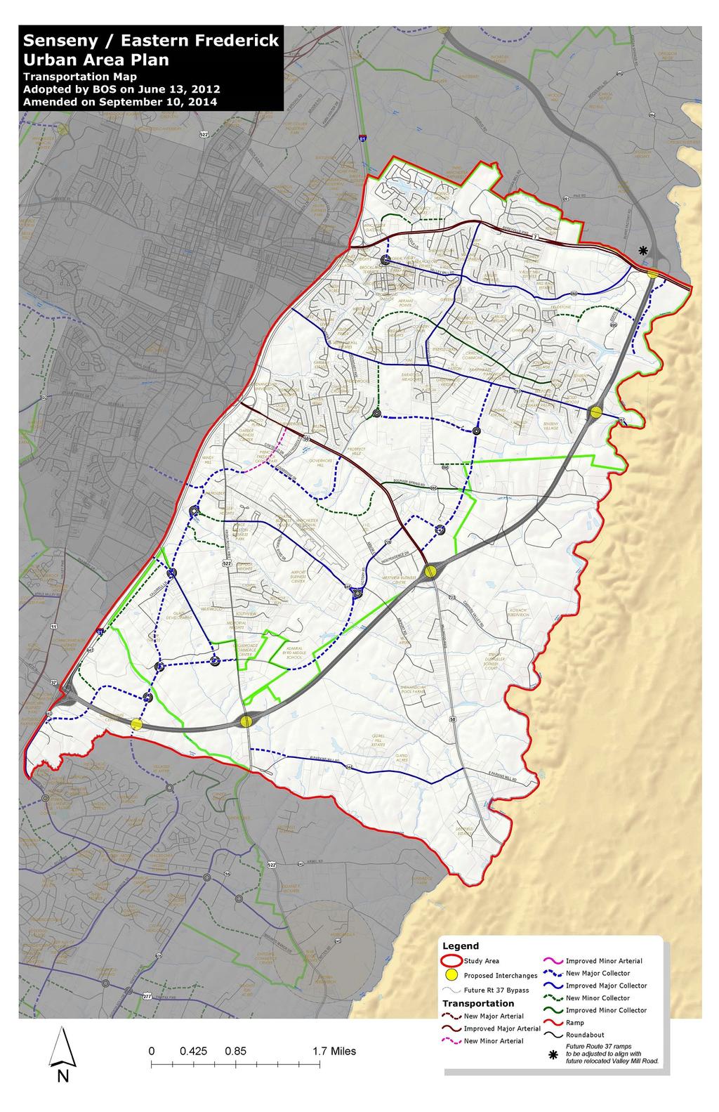
14 A significant corridor appearance buffer is proposed along Route 522 similar to that established for the Route 50 West corridor in the Round Hill Land Use Plan, which consisted of a 50 foot buffer area, landscaping, and bike path. The Route 50 and 7 corridors are more urban. Sufficient right-of-way is needed and street frontage is approached differently. Transportation In support of the new areas of land use, a transportation network has been proposed which relates to the location and context of the areas of land use, promotes multi-modal transportation choices and walkability, and furthers the efforts of the Win-Fred MPO. In this study, there is a direct nexus between transportation and land use. Interstate 81, future Route 37, Route 7, Route 50, and Route 522, provide orientation for the County s primary road system and provide new opportunities to create a transportation network which supports the future growth of the community in the right location, in this study area, generally inside future Route 37. Access Management is a significant consideration of this study and is a key element of all existing and future roads. The use of frontage roads, minor collector roads, and inter parcel connections to bring traffic to access points is promoted on the above roads. Access Management is also a key consideration on other roads within the study area; however, within a different context. The study also proposes a new and extended major collector network supplemented by interconnected minor collector street network in support of a significant urban center and new areas of economic growth - Warrior Drive, Justes Drive, Channing Drive, Inverlee Way. The context of the collector road network is proposed to be significantly different, however, than that of Route 37, with the focus being placed on a more walkable and complete street thoroughfare design. The Complete Street policies shall be integrated into the plan. The change in context is based upon the classification of a road and to ensure compatibility with 14
15 adjacent land uses and community goals. Particular attention should be paid to street network within the Urban Center. The surrounding land use, site design, and building design are features that will help create context and promote the creation of new communities, places, and focal points. Attention should also be provided to the context of the street in the immediate vicinity of existing and future schools, and the Neighborhood Village Commercial Areas to ensure that these prominent locations are safe and accessible to all modes of transportation. Bicycle and pedestrian accommodations should be fully integrated to achieve complete streets. Appropriately designed intersection accommodations should include pedestrian refuge islands and pedestrian actualized signals. More specific transportation considerations for Millbrook High School and the adjacent park areas include taking a proactive approach in creating safe interconnected routes to the park from the adjacent areas. Roundabouts should be considered as a priority preference for intersection design. Roundabouts are particularly effective when used in series. Consistent application of Comprehensive Plan goals to achieve an acceptable Level of Service on area roads and overall transportation network, Level of Service C or better, should be promoted. Further, efforts should be made to ensure that additional degradation of the transportation beyond an acceptable Level of Service shall be avoided. Consideration of future development applications within the study area should only occur when an acceptable Level of Service has been achieved and key elements and connections identified in this plan have been provided. Other recommendations from the transportation group: Emphasize the role of the State and the development community in the implementation of the planned road system. 15
16 Use modeling to determine lane needs based upon build out of planned land uses, but consider plans of neighboring localities when making recommendations (for example Senseny Road where it enters the City of Winchester or Clarke County) Consider the needs of bicycle users and pedestrians in the following ways: o Continue to plan all streets as complete streets which consider all users. o Within residential neighborhoods, this would mean that sidewalks be used and cyclists share the roads. Use of striping that defines parking bays or cycling areas would be preferred. o On collector roadways or higher, make use of separated multi-use paths at least 10 feet in width. o Incorporate wide shoulders or bike lanes into roadways that have budgetary or right-of-way limitations. This would be viewed as a step toward the ultimate goal of a separated facility. o Make use of paved shoulders with striping on rural roadways as a long term measure. Rural roadways would be defined by traffic count or as roadways outside of the UDA that are not part of the Primary System (ex. Route 50 or 522). o Bike paths should be constructed on the same grade as the adjacent roadway. o Bike path maintenance should be addressed by adjacent property owner groups whenever possible. Continue to enforce improved access management with redevelopment or new development. o This includes, but is not limited to, entrance location and spacing as well as traffic signal location and spacing. Roundabout use is preferred over signalization of intersections where traffic control is needed. Attractive median treatments (as alternative to standard grey concrete median) other than grass or other 16
17 landscaping should be considered when maintenance agreements with VDOT cannot be achieved. o Treatments should be reasonably consistent Street sections could be modified due to DCR changes specific to drainage requirements. 17
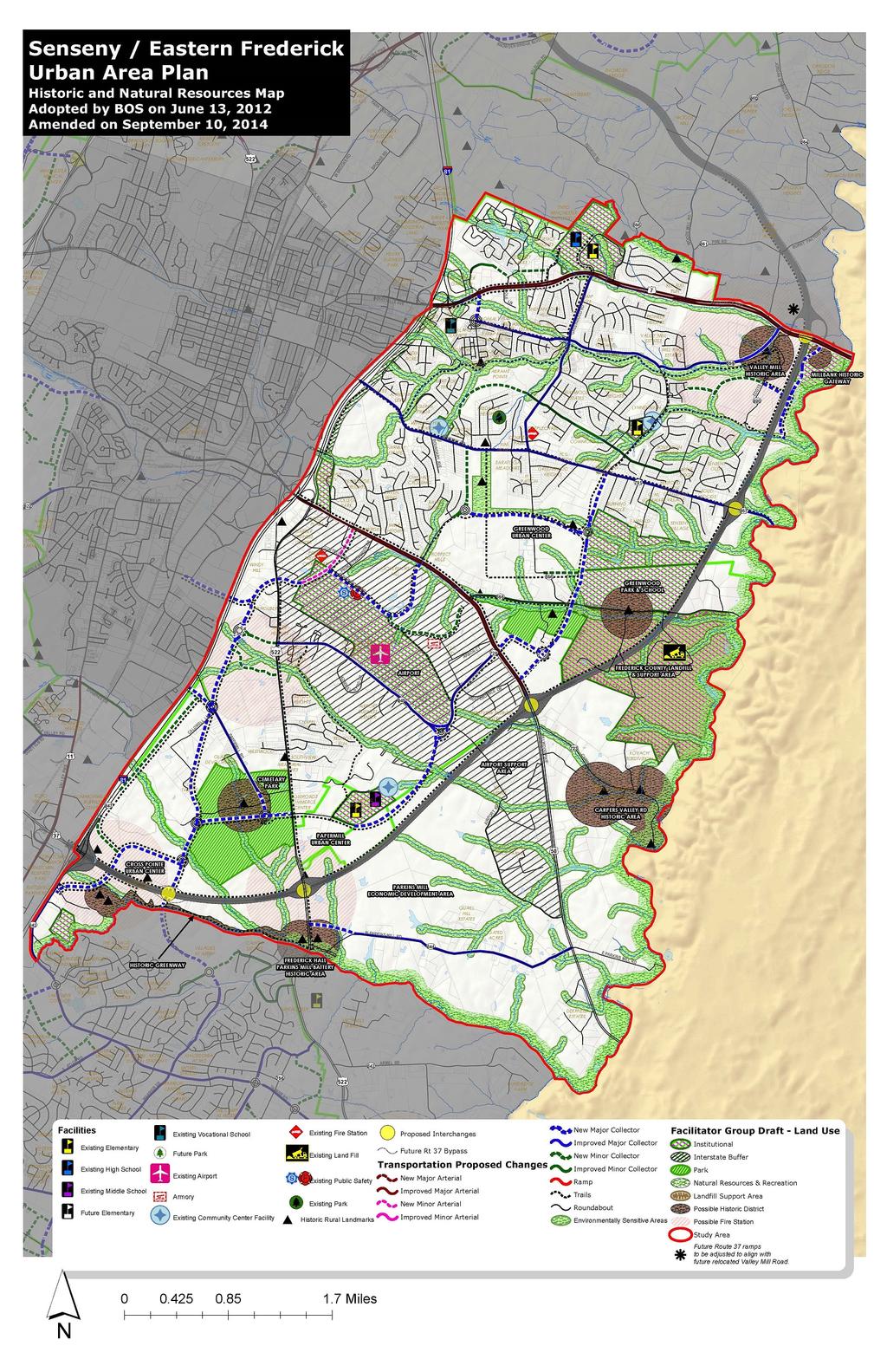
18 Natural Resources, Historic Resources, and Public Facilities. Natural Resources Frederick County is a community that values and protects its natural resources. Frederick County should create a green infrastructure inventory for the study area as well as the County as a whole. This inventory should guide land use and development to best preserve and protect natural resources. Developers should complete detailed environmental analysis for properties proposed for development. This information could be utilized to supplement the green infrastructure inventory. Within the Senseny/Eastern Frederick Urban Areas Plan, effort should focus on the creation of greenways, stream valley parks and stream buffers around waterways, while taking into account environmentally sensitive areas. Pedestrian facilities should be constructed that connect these features to other public facilities. Many such examples have been identified on the accompanying map. Environmental corridors should be incorporated with all development activities to ensure safe movement and protection of species and future development within the study area should take into account the natural resources located on and around their property. Businesses that utilize environmental management systems should be targeted by Frederick County. Further, developers should consider available renewable energy options with their projects. Historic Resources Frederick County is a community that recognizes and protects the historic structures and sites within the study area. Possible historic districts and significant structures have been identified and recognized. Priority sites for preservation within the study area should be identified and efforts initiated to 18
19 preserve those of highest need. These include Frederick Hall/Parkins Mill Battery and the historic area around Carpers Valley Road. Increase the rehabilitation, adaptive reuse, or restoration of historic structures. Heritage tourism should be promoted within the study area. The Comprehensive Plan calls for the adaptive reuse of historic structures, future development applications that have historic resources on the property should incorporate the site into development. Developmentally Sensitive and Historic Areas are shown on the land use map for the study area. By recognizing these historic sites and structures, we are implementing the policies of the Comprehensive Plan. Other recommendations from the group: Require archaeological surveys to be conducted prior to development, particularly any that involve battlefield areas, homesteads, Indian encampments, and waterways. Significant structures and properties should be shown with a developmentally sensitive/historic designation. These DSA s should be protected through historic districts and/or buffered from adjacent development activity. The historic areas around Frederick Hall/Parkins Mill Battery and the historic area around Carpers Valley Road should be considered for possible historic districts. Developments should incorporate and/or convert historic properties into recreational elements, including pedestrian trails, parks, and museums. Establish a linear historic greenway between Crosspointe (Hillandale, Carysbrooke, and the preservation park) and the fort (at Parkins Mill Battery), preserving the natural, recreational, and historical features and promoting accessibility. Create a Historic Gateway park to Frederick County by supporting the restoration and adaptive reuse of the Millbank House in conjunction with other preservation partners. The historic one-lane bridge located on Valley Mill Road should be maintained and preserved. 19
20 Ensure connectivity of bicycle or pedestrian transportation accommodations to existing or proposed public facilities and historic resource areas. A regional park site has been identified on Senseny Road; this site contains a potentially significant structure and one of the few remaining farming complexes within the developed area of the study area. This park should incorporate the historical farm house and contributing structure as a means to demonstrate urban agriculture. Public Facilities The need for public spaces within the study area (such as schools, neighborhood parks, and regional parks) is recognized and addressed. The accompanying maps identify general locations within the Senseny/Eastern Frederick Urban Area Plan where such facilities should be accommodated in order to ensure adequate public facilities corresponding with the growth of the community. Future school sites should be located within or near established or planned residential areas to encourage walk zones, as well as create a focus point for the community. Residential land uses that complement existing public facilities and schools are encouraged. Utilities and infrastructure will be needed within the study to accommodate future growth. Frederick County needs to look at preserving the intent of the landowner when planning for public facilities while still meeting the needs of the community. Other recommendations from the group: On any given request for development, the development community should work with all public facility providers to determine future public facility needs based upon this plan and the established standards of the public facility providers. The Parks & Recreation Department should continue to evaluate the ideal park site rings that are within the 2030 Comprehensive Plan. Sites that are outside of the 20
21 identified park rings should be considered if they meet the needs of the community. A regional park is envisioned within the study area. In addition, a smaller park is envisioned within the Greenwood Urban Center that should incorporate the historical farm house and contributing structure as a means to demonstrate urban agriculture. Urban parks and other public spaces should be constructed within or near communities. These parks should be open to the public and connected not only by road, but by various pedestrian facilities. The 42 acre parcel owned by the landfill (old landfill site) could be considered for future use as a park. Public access areas to the Opequon Creek should be constructed, taking into account environmentally sensitive areas. The bicycle and pedestrian facilities shown on the map and the 2007 Win-Fred MPO Bicycle & Pedestrian Mobility Plan should be implemented. The 2007 Win-Fred MPO Bicycle & Pedestrian Mobility Plan should be utilized as a reference for accommodation recommendations and guidelines. Pedestrian facilities should be constructed that connect existing and future neighborhoods to school, park and library facilities to promote access and walkability. A trail or sidewalk should be provided along Greenwood Road. Support completion of a linear recreation path encompassing the Senseny Road, Abrams Creek, Channing Drive areas. Ensure connectivity of bicycle or pedestrian transportation accommodations to existing or proposed public facilities and historic resource areas. Ensure connectivity with existing or proposed bicycle or pedestrian transportation accommodations wherever possible. A pedestrian crossing over Route 7 in the Millbrook School area should be provided. Handley Regional Library needs should be recognized and addressed within the study area. A satellite library location should be provided within the study area (similar to Bowman Library) to meet this need. Frederick County Public Schools should also work with the Handley Regional Library to provide public library locations within new school locations. 21
22 Future areas for Fire & Rescue stations have been identified on the map; development proposals in these areas should take this future need into account. The Airport has a 20 year Master Plan that outlines their ultimate expansion goals for this facility. Development proposals should not be considered on properties that fall within this planned expansion area. Also, development proposals considered within the Airport Support Area should not impact the current or future needs of the Airport. Incompatible development should be avoided near the landfill to ensure that their operations are not impacted (i.e., residential, urban, etc.). Industrial uses may be appropriate near the landfill. A landfill support area should be created around the landfill similar to the Airport Support Area. This support area should extend 1,000 feet from the boundaries of the landfill. 22
23
24
25
26
APPENDIX I - AREA PLANS
 SENSENY/EASTERN FREDERICK URBAN AREA PLAN SEFUAP Senseny/Eastern Frederick Urban Area Plan 9 SENSENY/EASTERN FREDERICK URBAN AREA PLAN This area is home to many families and successful businesses, and
The transportation system in a community is an
 7 TRANSPORTATION The transportation system in a community is an important factor contributing to the quality of life of the residents. Without a sound transportation system to bring both goods and patrons
Implementation Guide Comprehensive Plan City of Allen
 Implementation Guide 2030 Comprehensive Plan City of Allen DRAFT 2015 Implementation Guide Allen 2030 Comprehensive Plan INTRODUCTION The Comprehensive Plan serves as a guide for the growth and development
4.1.3 LAND USE CATEGORIES
 4.1.3 LAND USE CATEGORIES a. City Center District The City Center District incorporates the existing character and mix of uses in downtown Belmont to encourage redevelopment and new development in keeping
COMMUNITY DESIGN. GOAL: Create livable and attractive communities. Intent
 COMMUNITY DESIGN Intent An attractive, well-designed County will attract quality development, instill civic pride, improve the visual character of the community, and create a strong, positive image for
Secrest Short Cut and Monroe Expressway Small Area Plan AUGUST 29, 2018
 Secrest Short Cut and Monroe Expressway Small Area Plan AUGUST 29, 2018 Background and Process Monroe Expressway will be open by the end of 2018 Union County and Indian Trail identified a need to revisit
BROOKHILL NEIGHBORHOOD MODEL ZONING MAP AMENDMENT PREFACE TO APPLICATION
 BROOKHILL NEIGHBORHOOD MODEL ZONING MAP AMENDMENT PREFACE TO APPLICATION June 15, 2015 Revised: August 1, 2016 I. VISION Brookhill is a proposed community based upon the principles of Albemarle County
C. Westerly Creek Village & The Montview Corridor
 C. Westerly Creek Village & The VISION Community Vision When the goals of the city are achieved Westerly Creek Village, a distinctive community defined by Montview Boulevard and Westerly Creek, is a strong
Proposed Comprehensive Plan Strategies DRAFT for discussion June 28, 2017
 Proposed Comprehensive Plan Strategies DRAFT for discussion June 28, 2017 Land Use Rural Areas Refine the Farm and Forest area (FF) Update FF boundaries to account for existing lots less than five acres
Silverdale Regional Center
 Silverdale Regional Center Vision for Silverdale Regional Center The Silverdale Regional Center Plan (Plan) will guide the evolution of the Silverdale Regional Center from a collection of strip malls and
Comprehensive Plan ADOPTED APRIL 2014
 Comprehensive Plan ADOPTED APRIL 2014 8 8. Outstanding Recreational & Cultural Opportunities We are proud of our community s parks and recreation system. Our community will ensure that the legacy of our
2.0 AREA PLANS. Lakeside Business District. Lakeside Business District Land Use Categories:
 Lakeside Business District Lakeside Business District Land Use Categories: Campus Commercial Campus Commercial means a mixture of uses which includes corporate offices, office parks, hotels, commercial,
Section 4 BUILDING THE MASTER PLAN
 The Master Plan 33 Section 4 BUILDING THE MASTER PLAN Figure 4:1. A collaborative effort characterized the two design workshops sponsored by DISC to create hypothetical Master Plans for the Towers Property
CHAPTER 7: Transportation, Mobility and Circulation
 AGLE AREA COMMUNITY Plan CHAPTER 7 CHAPTER 7: Transportation, Mobility and Circulation Transportation, Mobility and Circulation The purpose of the Transportation, Mobility and Circulation Chapter is to
Gold Line Bus Rapid Transit Transit Oriented Development (BRTOD) Helmo Station Area Plan
 Helmo Station Area Plan") Appendix F Gold Line Bus Rapid Transit Transit Oriented Development (BRTOD) Helmo Station Area Plan Introduction and Purpose of the Plan The Gold Line Bus Rapid Transit facility is an eleven-mile dedicated
Appendix F Gold Line Bus Rapid Transit Transit Oriented Development (BRTOD) Helmo Station Area Plan Introduction and Purpose of the Plan The Gold Line Bus Rapid Transit facility is an eleven-mile dedicated
Town Center. Block 5 Existing multifamily residential units are expected to remain.
 Area Guidelines Germantown s districts should be developed as distinct communities with unique features that are supported through the guidelines. The guidelines not only help distinguish these districts
CHAPTER 3 VISION, GOALS, & PLANNING PRINCIPLES. City of Greensburg Comprehensive Plan. Introduction. Vision Statement. Growth Management Goals.
 CHAPTER 3 VISION, GOALS, & PLANNING PRINCIPLES Introduction The Greensburg Comprehensive Plan is intended as a working community document. A combination of long and short-term goals, this document is intended
Seneca Meadows. Block 4 Locate office, technology, and medical development adjacent to I Screen views of garage structures from I-270.
 Seneca Meadows Seneca Meadows has an industrial park in its southern end and a mixed-use employment area planned for the north end. The district benefits from extensive I-270 visibility, stream valley
CHAPTER 1. Ms. Guajardo s Class - Central Elementary CH 1 1
 INTRODUCTION CHAPTER 1 Ms. Guajardo s Class - Central Elementary CH 1 1 1.1 SETTING South Centre City is a linear corridor south of Downtown Escondido paralleling Centre City Parkway and South Escondido
DRAFT Land Use Chapter
 Stevens Creek Urban Village DRAFT 1 18 17 Land Use Chapter INTRODUCTION This Land Use Chapter describes how the Stevens Creek Urban Village will accommodate the growth that is planned for it in the Envision
Executive Summary. NY 7 / NY 2 Corridor
 Executive Summary NY 7 / NY 2 Corridor Transportation and Land Use Study December 2005 Prepared for: Town of Colonie Capital District Transportation Committee Prepared by: Introduction: Land use decisions
Appendix C: Interim Mixed-Use Evaluation Criteria
 Appendix C: Interim Mixed-Use Evaluation Criteria C-1 Appendix C: Interim Mixed-Use Evaluation Criteria PURPOSE: The implementation of numerous policies contained within the Master Plan hinges on the creation
Planning Districts INTRODUCTION
 INTRODUCTION To facilitate detailed examination of development prospects for all areas of the community, Delano has been divided into 14 planning districts. The location of these planning districts is
CHARLES PUTMAN CHARLES PUTMAN AND ASSOCIATES, INC
 MEMORANDUM CHARLES PUTMAN & ASSOCIATES, INC. LAND DEVELOPMENT CONSULTANTS PLANNING ZONING PERMITTING 4722 NW Boca Raton Boulevard, Suite C-106 Boca Raton, Florida 33431 Phone: 561/994-6411 FAX: 561/994-0447
Small Area Plan. South Gateway
 Small Area Plan Adopted May 12, 2008 South Gateway Purpose. The South Gateway Small Area Plan defines the City s expectations for the future of the southern entrance to the City at Interstate 85 and Highway
2018 Northampton Township Comprehensive Plan
 2018 BUCKS COUNTY, PENNSYLVANIA What is a? A comprehensive plan is a municipality s main policy document that details the collective vision for the future, the historic, environmental, and cultural facilities
LAND USE OVERVIEW WHAT YOU WILL FIND IN THIS CHAPTER
 LAND USE WHAT YOU WILL FIND IN THIS CHAPTER Information about the City s expected population and employment growth. Description and capacity of existing and future land use designations. Policies that
Policies and Code Intent Sections Related to Town Center
 Policies and Code Intent Sections Related to Town Center The Town Center Vision is scattered throughout the Comprehensive Plan, development code and the 1994 Town Center Plan. What follows are sections
Living in Albemarle County s Urban Places
 Living in Albemarle County s Urban Places ALBEMARLE COUNTY, VIRGINIA A Closer Look at Albemarle s Approach to Managing Growth and Creating Quality Urban Environments www.albemarle.org Page 2 Living in
Review of Opportunity Area C Draft Comprehensive Plan and Draft BOS Follow-On Motions. Special Working Group Meeting March 4, 2015
 Review of Opportunity Area C Draft Comprehensive Plan and Draft BOS Follow-On Motions Special Working Group Meeting March 4, 2015 The slides that follow identify where the draft Comprehensive Plan has
EXECUTIVE SUMMARY DRAFT CHAPTER 1 INTRODUCTION EXECUTIVE SUMMARY
 CHAPTER 1 EXECUTIVE SUMMARY INTRODUCTION Through the joint efforts of the City of Tulsa planning staff and the Land Services division of Indian Nations Council of Governments (INCOG), the Berryhill Land
Plano Tomorrow Vision and Policies
 Plano Tomorrow Vision and Policies PLANO TOMORROW PILLARS The Built Environment The Social Environment The Natural Environment The Economic Environment Land Use and Urban Design Transportation Housing
EXHIBIT A. Tax Increment Reinvestment Zone No. 1 (Town Center) First Amended Project Plan 1
 First Amended Project Plan 1") EXHIBIT A Tax Increment Reinvestment Zone No. 1 (Town Center) First Amended Project Plan 1 1 As amended by Resolution No. 2008-02-001(TR1R) of the Tax Increment Reinvestment Zone No.1, and approved to
EXHIBIT A Tax Increment Reinvestment Zone No. 1 (Town Center) First Amended Project Plan 1 1 As amended by Resolution No. 2008-02-001(TR1R) of the Tax Increment Reinvestment Zone No.1, and approved to
Former Rockcliffe Airbase Community Design Plan Guiding Design Vision and Principles December 4, 2013
 APPENDIX 5 - Guiding Design Vision and Principles Former Rockcliffe Airbase Community Design Plan Guiding Design Vision and Principles December 4, 2013 Vision Statement The redevelopment of the former
Beatties Ford Road & Mt. Holly-Huntersville Road Small Area Plan
 Beatties Ford Road & Mt. Holly-Huntersville Road Small Area Plan Town of Huntersville October 2005 Town of Huntersville Planning Department 101 Huntersville Concord Road Post Office Box 664 Huntersville,
G. RECREATION AND OPEN SPACE ELEMENT. The following summarizes the Recreation and Open Space Element:
 G. RECREATION AND OPEN SPACE ELEMENT The purpose of the Element is to provide the framework and direction for a comprehensive system of public and private sites for recreation, including, but not limited
IMPLEMENTATION STRATEGIES. In This Chapter. Goals & Strategies 182 Project List 183 Future Land Use 186 CHAPTER 11 IMPLEMENTATION STRATEGIES
 In This Chapter Goals & Strategies 182 Project List 183 Future Land Use 186 11 IMPLEMENTATION STRATEGIES NORTH AUGUSTA, SC 2017 COMPREHENSIVE PLAN 179 Individual commitment to a group effort that is what
This page intentionally blank.
 This page intentionally blank. Parks, Recreation, and Open Space Chapter Relationship to Vision Vision Parks, Recreation and Open Space Chapter Concepts County Government. County government that is accountable
ELMVALE ACRES SHOPPING CENTRE MASTER PLAN
 ELMVALE ACRES SHOPPING CENTRE MASTER PLAN Contents 1.0 INTRODUCTION... 2 2.0 LOCATION... 2 3.0 EXISTING CONTEXT... 2 4.0 VISION & GUIDING PRINCIPLES... 2 5.0 LAND USE AND BUILT FORM... 4 5.1 St. Laurent
Table of Contents. Elm Avenue Improvement Plan City of Waco, Texas. Introduction 1. Existing Context 1 Figure 1 2.
 Table of Contents Introduction 1 Existing Context 1 Figure 1 2 Plan Guidelines 3 Future Urban Form 4 The West-End 4 Main Street 6 The East-End 7 Figure 2 9 Public Improvement Recommendations 7 General
Ten Mile Creek Planning Area
 PLANNING AREA POLICIES TEN MILE CREEK Ten Mile Creek Planning Area Location and Context The Ten Mile Creek Planning Area ( Ten Mile Creek area ) is located south of the current Boise AOCI, generally south
1.0 Future Land Use. 1.1 Introduction. 1.2 Future Land Use Objectives
 1.0 Future Land Use 1.1 Introduction Can Holly Springs continue to accommodate significant growth while retaining and enhancing a Village-like atmosphere? Can enough commercial land be set aside for business
EXISTING COMPREHENSIVE PLAN
 EXISTING COMPREHENSIVE PLAN Town Center Land Use Element: V. LAND USE POLICIES Town Center Mercer Island's business district vision as described in "Your Mercer Island Citizen-Designed Downtown" was an
Table L-1 Summary Action Strategy. Action Item Timing Status Responsible Agency
 CHAPTER 4: CIRCULATION ELEMENT ISSUE #1: MAJOR THOROUFARES AND TRANSPORTATION ROUTES A balanced transportation system for Fontana is provided that meets the mobility needs of current and future residents
VILLAGE OF CLEMMONS PLANNING BOARD DRAFT STAFF REPORT
 VILLAGE OF CLEMMONS PLANNING BOARD DRAFT STAFF REPORT PETITION INFORMATION Docket # C-226 Staff Megan Ledbetter Petitioner(s) JBJH Properties, LLC Owner(s) JBJH Properties, LLC Subject Property 5892-49-1766
V. Vision and Guiding Principles
 V. Vision and Guiding Principles The Master Plan for the Powers Ferry Corridor seeks a foundation in the desires of the community. At times, various elements of the community offered opposing viewpoints,
OVERVIEW OF PLANS FOR THE JEFFERSON COUNTY COUNTRYSIDE FARM In the Context of Quality Place Characteristics
 OVERVIEW OF PLANS FOR THE JEFFERSON COUNTY COUNTRYSIDE FARM In the Context of Quality Place Characteristics By Steve Grabow, Professor and Community Development Educator University of Wisconsin-Extension,
3. VISION AND GOALS. Vision Statement. Goals, Objectives and Policies
 Vision Statement Queen Creek s interconnected network of parks, trails, open spaces and recreation opportunities provide safe and diverse activities and programs that sustain its unique, small town, equestrian
2040 LUP is a part of the Comprehensive Plan and carries the same legal authority. Economic Challenges
 1.1. Guiding Anchorage s Growth Where will new residents settle over the next two decades? Where will people work, shop, and play? Will there be enough room to grow? How will Anchorage look? Will growth
The Vision. Photo provided by The Minervini Group. 46 Vision, Objectives & Strategies
 Vision, Objectives & Strategies The is the public framework and guide for future development of the Grand Traverse Commons. The establishes public polices for infrastructure, the preservation of natural
THE 355/270 CORRIDOR:
 THE 355/270 CORRIDOR: Strategic Ideas for Sustaining a Livable Work Place Project Summary ACCESS LIFE DESIGN HEALTH WORK Montgomery County Planning Department The Maryland-National Capital Park and Planning
Future Land Use SAMPLE RECOMMENDATIONS
 SAMPLE RECOMMENDATIONS Future Land Use The Future Land Use Chapter of the Master Plan builds upon prior chapters examining the existing conditions in their respective topic areas to present a comprehensive
Further input invited as Colchester Growth Strategy nears final phase
 IUE 3 / NOVEMBER 2015 Further input invited as Colchester Growth trategy nears final phase trathcona County is seeking public feedback as it enters the final phase of work on a Growth Management trategy
SAN RAFAEL GENERAL PLAN 2040 INTRODUCTION AND OVERVIEW
 SAN RAFAEL GENERAL PLAN 2040 INTRODUCTION AND OVERVIEW Steering Committee Presentation February 14, 2018 Purpose of General Plan Guide land use and development decisions Coordinate transportation, infrastructure,
A. Background Summary of Existing Challenges and Potential Possibilities. 1. Summary of Existing Assets and Potential Opportunities
 A. Background 1 A Main Street Master Plan Study was performed and completed in October of 2007. The study was initiated to review current land uses and development patterns along Main Street, from Parrish
SECTION TWO: Urban Design Concepts
 SECTION TWO: Urban Design Concepts The Gardnerville Plan for Prosperity shapes economic opportunities presented by regional growth. The Urban Design Concepts provide policies and concepts for land use,
Future Land Use and Transportation
 Planning & Zoning Board Workshop Comprehensive Plan for Village of Estero Future Land Use and Transportation April 6, 2017 January Kick-off Meeting Public Input What do you like about Estero? Location
FUTURE LAND USE ELEMENT
 FUTURE LAND USE ELEMENT GOAL I: To create and sustain a great place to live, play, and prosper Objective 1: The City of Ocala shall incorporate the principles and strategies of the Ocala 2035 Vision into
A larger version of this map is located on the last page of this PDF.
 MAP Committee Input McLoughlin Area Draft Vision Map A larger version of this map is located on the last page of this PDF. 1. The map above is intended to portray a vision for the McLoughlin area. It highlights
The Five Components of the McLoughlin Area Plan
 The Five Components of the McLoughlin Area Plan This documents contains the complete language of the five components of the McLoughlin Area Plan: The Vision Statement The Values The Guiding Principles
Plan Policies. Introduction
 Plan Policies Introduction The purpose of the Plan Policies section is to identify the various Governing Body and Planning Commission land use related policy resolutions for use in evaluating development
ITEM #8. Regional Smart Growth Program. Regional Smart Growth Program. Presentation Overview. Coast Highway Vision and Stategic Plan.
 Regional Smart Growth Program Economic Development Commission What is Smart Growth? Adopted as part of the Regional Comprehensive Plan (RCP) RCP provides vision for region based on Smart Growth and sustainability
I-35 CORRIDOR VISION PLAN INTRODUCTION. Purpose. Background
 INTRODUCTION Purpose The Interstate 35-E Corridor Plan is intended to work conjunctively with the 2010 Red Oak Comprehensive Plan to promote positive and quality development and redevelopment along Interstate
APPENDIX I - AREA PLANS
 MIDDLETOWN/LORD FAIRFAX SEWER AND WATER SERVICE AREA BOARD OF SUPERVISORS APPROVED ON SEPTEMBER 26, 2012 Middletown/Lord Fairfax Sewer and Water Service Area 96 MIDDLETOWN/LORD FAIRFAX SEWER AND WATER
REQUEST Current Zoning: O-15(CD) (office) Proposed Zoning: TOD-M(CD) (transit oriented development mixed-use, conditional)
 (office) Proposed Zoning: TOD-M(CD) (transit oriented development mixed-use, conditional)") Rezoning Petition 2016-117 Zoning Committee Recommendation January 4, 2017 REQUEST Current Zoning: O-15(CD) (office) Proposed Zoning: TOD-M(CD) (transit oriented development mixed-use, conditional) LOCATION
Rezoning Petition 2016-117 Zoning Committee Recommendation January 4, 2017 REQUEST Current Zoning: O-15(CD) (office) Proposed Zoning: TOD-M(CD) (transit oriented development mixed-use, conditional) LOCATION
Concord Community Reuse Project Goals and Guiding Principles. Overarching Goals (OG)
") Concord Community Reuse Project Goals and Guiding Principles Overarching Goals (OG) No priority is implied by the order of presentation of the goals and guiding principles. Overarching goals for the Concord
Concord Community Reuse Project Goals and Guiding Principles Overarching Goals (OG) No priority is implied by the order of presentation of the goals and guiding principles. Overarching goals for the Concord
URBAN DESIGN BRIEF. 2136&2148 Trafalgar Road. Town of Oakville
 URBAN DESIGN BRIEF 2136&2148 Trafalgar Road Town of Oakville Prepared By: METROPOLITAN CONSULTING INC For 2500674 Ontario Inc November 2016 TABLE OF CONTENTS Page No. 1.0 Introduction/Description of Subject
Chapter 4. Linking Land Use with Transportation. Chapter 4
 Chapter 4 Linking Land Use with Transportation Chapter 4 59 Chapter 4 Linking Land Use with Transportation Community Design and Transportation Program Introduction Since the 1950s, the predominant development
Section 9 NEIGHBORHOOD DESIGN
 Section 9 NEIGHBORHOOD DESIGN City of Lancaster Comprehensive Plan D u n k i n, S e f k o & A s s o c i a t e s, I n c. NEIGHBORHOOD DESIGN INTRODUCTION There are many ways in which a neighborhood can
Lehigh Acres Land Development Regulations Community Planning Project
 Lehigh Acres Land Development Regulations Planning Effort Summary In July, 2010 Commissioner Frank Mann invited the Lehigh Acres community to start discussing how to achieve their recently adopted community
Metro. Activity Center Design Guidelines. Recommendations For Developing Focused, Mixed-Use Commercial/Residential Centers
 Metro Activity Center Design Guidelines Recommendations For Developing Focused, Mixed-Use Commercial/Residential Centers Metro Activity Centers What is a MAC? Legacy, the adopted guide for the future growth
5.1 Site Plan Guidelines
 5. Community Core Guidelines Development of the Community Core will take place by plan of subdivision and site plan approval. It will occur in a phased manner that will reflect the timing of residential
REGIONAL ACTIVITY CENTER
 DRAFT REGIONAL ACTIVITY CENTER 70 EAST BENCH MASTER PLAN DRAFT 06 Introduction The East Bench Regional Activity center is comprised of large educational, research, medical, and employment centers. These
TRANSPORTATION ELEMENT GOALS, OBJECTIVES, AND POLICIES
 TRANSPORTATION ELEMENT GOALS, OBJECTIVES, AND POLICIES GOAL 2 The City shall provide a safe, convenient, effective, and energy efficient multimodal transportation system which is coordinated with the Future
Long Branch Sector Plan
 June 2012 Long Branch is one of Montgomery County s most affordable, older communities and has served as a gateway community, especially for newly arriving immigrants, since the 1960s. Many within this
Additional information about land use types is given in Chapter 5. Design guidelines for Centers and Neighborhoods are given in Chapter 7.
 4. Place Types Introduction In Albemarle County s Development Areas, the Neighborhood is the fundamental unit of community planning. The County s Neighborhood Model, an adopted part of the Comprehensive
City of Hermosa Beach Administrative Policy #
 City of Hermosa Beach Administrative Policy # SUBJECT: Living Streets Policy Date: Approved by: City Council Authority: Public Works Department & Community Development Department Mayor, PURPOSE The City
DRAFT. October Wheaton. Design Guidelines
 October 2011 DRAFT Wheaton Design Guidelines 2 Draft - Design Guidelines - Wheaton Sector Plan Contents 04 Section 1: Introduction 06 Section 2: Context 08 Section 3: Design Guidelines 09 Goal 1: Create
Overview of the Plan. The Building Blocks of Centers, Neighborhoods and Network INTERNAL DRAFT
 Overview of the Plan 4 East Davidson Ramah Church Rd June Washam Rd Bradford District Park Bradford Shearer Rd Campus District NC 73 Davidson-Concord North Rocky River This Master Plan projects an approximate
Chapter 1 - General Design Guidelines CHAPTER 1 GENERAL DESIGN GUIDELINES
 CHAPTER 1 GENERAL DESIGN GUIDELINES 1.0 INTRODUCTION This Publication has been developed to provide current, uniform procedures and guidelines for the application and design of safe, convenient, efficient
Joint Meeting City Council and the Plan Commission. September 1st, 2015
 Joint Meeting City Council and the Plan Commission September 1st, 2015 1 The City Plan Commission shall recommend a City Plan for the physical development of the City Article IX Section 2 of the City of
Commercial Node Plan Devine Street/Jackson Blvd. COLUMBIA, SC
 Commercial Node Plan Devine Street/Jackson Blvd. COLUMBIA, SC 9.17.13 AGENDA 1 Introductions 2 Project Update 3 Concepts 4 Recommendations 5 Next Steps Introductions Project Update Process 5-Phase Process
PROPOSED REDEVELOPMENT OF THE GLEN ABBEY GOLF CLUB. STREETSCAPE DESIGN STUDY (excerpt from the Urban Design Brief) TOWN OF OAKVILLE.
 TOWN OF OAKVILLE.") PROPOSED REDEVELOPMENT OF THE GLEN ABBEY GOLF CLUB STREETSCAPE DESIGN STUDY (excerpt from the Urban Design Brief) TOWN OF OAKVILLE OCTOBER, 2016 for 2.4.2 STREETS Streets are the single largest component
PROPOSED REDEVELOPMENT OF THE GLEN ABBEY GOLF CLUB STREETSCAPE DESIGN STUDY (excerpt from the Urban Design Brief) TOWN OF OAKVILLE OCTOBER, 2016 for 2.4.2 STREETS Streets are the single largest component
CITY OF PUYALLUP. Background. Development Services
 CITY OF PUYALLUP Development Services 333 South Meridian Puyallup WA 98371 To: City Council From: Katie Baker, AICP, Planning Division Re: South Hill Neighborhood Plan Adoption Date: (Meeting date: February
Ivywild On The Creek PRELIMINARY CREEK DISTRICT MASTER PLAN
 Ivywild On The Creek PRELIMINARY CREEK DISTRICT MASTER PLAN Introduction: Rejuvenating an extraordinary Creekside neighborhood THE CREEKSIDE DISTRICT The Ivywild On The Creek Neighborhood District Master
TRANSIT ORIENTED DEVELOPMENT PINELLAS COUNTY MPO LIVABLE COMMUNITIES INITIATIVE PINELLAS COUNTY COMPREHENSIVE PLAN AMENDMENTS
 PINELLAS COUNTY MPO LIVABLE COMMUNITIES INITIATIVE MODEL LAND DEVELOPMENT CODE TRANSIT ORIENTED DEVELOPMENT PINELLAS COUNTY COMPREHENSIVE PLAN AMENDMENTS MPO Livable Communities Initiative Goal: Improve
CHAPTER 7: VISION AND ACTION STATEMENTS. Noble 2025 Vision Statement
 CHAPTER 7: VISION AND ACTION STATEMENTS This chapter presents the vision, policy and action statements that transform the comprehensive planning study, an analysis of Noble s past, future trends and community
DRAFT ROOSEVELT ROAD. District Recommendations. Figure 5.23 The Roosevelt Road Corridor
 CHAPTER 5 Figure 5.23 The Road Corridor Road will develop as a mixed-use corridor, emphasizing regional retail, west of the river and mixed-use development east of the river. KEY RECOMMENDATIONS 1. High
hermitage town center
 hermitage town center A Community Vision prepared by Strada for The City of Hermitage and The Mercer County Regional Planning Commission January 2007 table of contents introduction 3 design principles
4 Sustainability and Growth Management
 4 Sustainability and Growth Management Introduction Traditionally, has assumed growth and development with limited consideration for the long-term negative social, environmental or economic impacts on
HISTORIC RESOURCES VIII. HISTORIC RESOURCES THE 2035 COMPREHENSIVE PLAN 98
 VIII. HISTORIC RESOURCES THE 2035 COMPREHENSIVE PLAN 98 HISTORIC RESOURCES CURRENT CONDITIONS Frederick County has shifted in recent years from an agrarian community to one that has seen strong residential
Access Management: An Overview
 Figures 1-5 Below Evolution of development along a highway. In the early stages, land along the road is used for farming with little traffic generated. As time passes, the highway corridor becomes a de
AWH REPORT OF THE PLANNING AND DEVELOPMENT DEPARTMENT FOR APPLICATION FOR REZONING ORDINANCE TO PLANNED UNIT DEVELOPMENT
 AWH REPORT OF THE PLANNING AND DEVELOPMENT DEPARTMENT FOR APPLICATION FOR REZONING ORDINANCE TO PLANNED UNIT DEVELOPMENT MAY 8, 2014 The Planning and Development Department hereby forwards to the Planning
NEIGHBORHOOD DESIGN ELEMENT
 NEIGHBORHOOD DESIGN ELEMENT INTRODUCTION The following recommendations constitute an urban design oriented "neighborhood analysis" of Plantation. It is an optional Comprehensive Plan Element. The five
City of Bristol Route 6 Corridor Implementation Program
 City of Bristol Route 6 Corridor Implementation Program FITZGERALD & HALLIDAY, INC. Innovative Planning, Better Communities June 2017 Route 6 Corridor Plan IMPLEMENTATION PROGRAM The following Implementation
Public input has been an important part of the plan development process.
 Lakewood s Comprehensive Plan recognizes that transportation helps shape the community, and that the way the community provides for the safe and efficient movement of people affects the character of the
URBAN DESIGN BRIEF URBAN DESIGN BRIEF 721 FRANKLIN BLVD, CAMBRIDGE August 2018
 URBAN DESIGN BRIEF URBAN DESIGN BRIEF 721 FRANKLIN BLVD, CAMBRIDGE August 2018 DESIGN BRIEF CONTENTS PART A 1.0 INTRODUCTION 2.0 DESCRIPTION & ANALYSIS OF SITE CONTEXT 3.0 DESIGN CONSTRAINTS AND OPPORTUNITIES
Hockessin Community Redevelopment Plan
 Hockessin Community Redevelopment Plan 3.1 Introduction The Community Redevelopment Plan for the Village of Hockessin is the result of the people s vision for a distinct village center that serves as the
and services The protection and conservation of environmentally significant and sensitive natural heritage features and functions.
 6. Land Use 6.0 Preamble A healthy and livable city is one in which people can enjoy a vibrant economy and a sustainable healthy environment in safe, caring and diverse neighbourhoods. In order to ensure
ESTABLISH AN EFFICIENT TOWN CENTER
 ESTABLISH AN EFFICIENT TOWN CENTER 4 Overview Lisbon residents are proud of the history of Newent and at the same time recognize its current importance as a centralized location for a variety of municipal