Cultural Heritage Evaluation Report Victoria Bridge over the Thames River Ridout Street London, Ontario
|
|
|
- Hortense Martin
- 5 years ago
- Views:
Transcription
1 Cultural Heritage Evaluation Report Victoria Bridge over the Thames River Ridout Street London, Ontario Prepared by: AECOM York Street, Citi Plaza tel London, ON, Canada N6A 6K fax June, 2016 Project Number:
2 Distribution List # Hard Copies PDF Required Association / Company Name 2 Yes 1 Yes AECOM Canada Ltd. Revision History Revision # Date Revised By: Revision Description 0 May 6, 2016 MG Draft Report 1 June 13, 2016 MG Final Report Cityoflondon_Victoriabridge_CHER_June2016
3 Statement of Qualifications and Limitations The attached Report (the Report ) has been prepared by AECOM Canada Ltd. ( AECOM ) for the benefit of the Client ( Client ) in accordance with the agreement between AECOM and Client, including the scope of work detailed therein (the Agreement ). The information, data, recommendations and conclusions contained in the Report (collectively, the Information ): is subject to the scope, schedule, and other constraints and limitations in the Agreement and the qualifications contained in the Report (the Limitations ); represents AECOM s professional judgement in light of the Limitations and industry standards for the preparation of similar reports; may be based on information provided to AECOM which has not been independently verified; has not been updated since the date of issuance of the Report and its accuracy is limited to the time period and circumstances in which it was collected, processed, made or issued; must be read as a whole and sections thereof should not be read out of such context; was prepared for the specific purposes described in the Report and the Agreement; and in the case of subsurface, environmental or geotechnical conditions, may be based on limited testing and on the assumption that such conditions are uniform and not variable either geographically or over time. AECOM shall be entitled to rely upon the accuracy and completeness of information that was provided to it and has no obligation to update such information. AECOM accepts no responsibility for any events or circumstances that may have occurred since the date on which the Report was prepared and, in the case of subsurface, environmental or geotechnical conditions, is not responsible for any variability in such conditions, geographically or over time. AECOM agrees that the Report represents its professional judgement as described above and that the Information has been prepared for the specific purpose and use described in the Report and the Agreement, but AECOM makes no other representations, or any guarantees or warranties whatsoever, whether express or implied, with respect to the Report, the Information or any part thereof. Without in any way limiting the generality of the foregoing, any estimates or opinions regarding probable construction costs or construction schedule provided by AECOM represent AECOM s professional judgement in light of its experience and the knowledge and information available to it at the time of preparation. Since AECOM has no control over market or economic conditions, prices for construction labour, equipment or materials or bidding procedures, AECOM, its directors, officers and employees are not able to, nor do they, make any representations, warranties or guarantees whatsoever, whether express or implied, with respect to such estimates or opinions, or their variance from actual construction costs or schedules, and accept no responsibility for any loss or damage arising therefrom or in any way related thereto. Persons relying on such estimates or opinions do so at their own risk. Except (1) as agreed to in writing by AECOM and Client; (2) as required by-law; or (3) to the extent used by governmental reviewing agencies for the purpose of obtaining permits or approvals, the Report and the Information may be used and relied upon only by Client. AECOM accepts no responsibility, and denies any liability whatsoever, to parties other than Client who may obtain access to the Report or the Information for any injury, loss or damage suffered by such parties arising from their use of, reliance upon, or decisions or actions based on the Report or any of the Information ( improper use of the Report ), except to the extent those parties have obtained the prior written consent of AECOM to use and rely upon the Report and the Information. Any injury, loss or damages arising from improper use of the Report shall be borne by the party making such use. This Statement of Qualifications and Limitations is attached to and forms part of the Report and any use of the Report is subject to the terms hereof. AECOM: AECOM Canada Ltd. All Rights Reserved. Cityoflondon_Victoriabridge_CHER_June2016
4 Quality Information Report Prepared By: Michael Greguol, M.A., CAHP Intern Cultural Heritage Specialist Report Reviewed By: Christopher Andreae, Ph.D., CAHP Senior Architectural Historian Cityoflondon_Victoriabridge_CHER_June2016
5 Executive Summary AECOM Canada Ltd. (AECOM) was retained by the to conduct a Cultural Heritage Evaluation Report (CHER) as a part of the investigation regarding the feasibility of accommodating bicycle lanes and the general rehabilitation, as well as the overall condition, and the future uses of the Victoria Bridge, on Ridout Street over the South Branch of the Thames River. At the time of the preparation of this report, there is no specified proposed undertaking rehabilitation, replacement, adaptive re-use for the Victoria Bridge. It is understood that Ridout Street incorporates on-street bicycle lanes connecting Signed Bike Road Routes from the south end of the city with downtown and the Thames Valley Parkway. However, the existing width of the Victoria Bridge deck is not insufficient to accommodate bicycle lanes. In addition, there is also a bicycle path on the north bank of the Thames River, passing under the bridge, which is scheduled for construction upgrades in the near future. This CHER was prepared according to the guidelines set out in the Ontario Ministry of Tourism, Culture, and Sports Heritage Resources in the Land Use Planning Process document included as a part of the Ontario Heritage Toolkit. For the purposes of this report, AECOM undertook the following tasks: 1) Preparation of a land use history of the Study Area based on a review of: a) Primary and secondary resources; b) Historic mapping. 2) A review of the s Inventory of Heritage Resources, as well as the Ontario Heritage Trust Properties Database, and the Canadian Register of Historic Places. 3) Consultation with Kyle Gonyou, Heritage Planner for the to identify the presence of heritage properties or potential heritage properties. 4) A site investigation, undertaken on March 11, 2016 to document the existing conditions of the bridge structure and its associated landscape. 5) Evaluation of the bridge structure and its landscape using Ontario Regulation 9/06, Criteria for Determining Cultural Heritage Value or Interest. Based on the Ontario Regulation 9/06 evaluation the Victoria Bridge was determined to have design/physical, historic/associative, and contextual value. The following Statement of Cultural Heritage Value was prepared for the bridge: The Victoria Bridge is a seven panel modified Warren steel-pony truss bridge that carries Ridout Street over the South Branch of the Thames River. The two-span structure was built in 1926 as the fourth crossing of the Thames River at this location. It was designed by municipal engineer John R. Rostron as an elegant but affordable design that would utilize the remaining stone abutments and pier from the previous bridge at this crossing. As such, the concrete pier and abutments at the Victoria Bridge also include an undetermined amount of stone that has been encased in the concrete since The bridge is one of several historic truss crossings of the Thames River in London. Cityoflondon_Victoriabridge_CHER_June2016 i
6 Table of Contents 1. Introduction Study Purpose Study Method Metric Measurements Policy and Planning Framework Environmental Assessment Act Additional Guidelines Official Plan Historical Overview Natural Environment and Physical Setting Historic Context Local Historic Context London Street Railway Bridge Building Context Victoria Bridge Site Description Context Cultural Landscape Approaches Abutments and Pier Truss Deck/Railings Evaluation Ontario Regulation 9/ Design/Physical Value Historic/Association Value Contextual Value Statement of Cultural Heritage Value Heritage Attributes Review of Heritage Registers and Consultation Recommendations Bibliography Page Cityoflondon_Victoriabridge_CHER_June2016
7 List of Tables Table 1: Ontario Regulation 9/06 Evaluation of the Victoria Bridge Cityoflondon_Victoriabridge_CHER_June2016
8 1. Introduction 1.1 Study Purpose AECOM Canada Ltd. (AECOM) was retained by the to conduct a Cultural Heritage Evaluation Report (CHER) as a part of the investigation regarding the feasibility of accommodating bicycle lanes and the general rehabilitation, as well as the overall condition, and the future uses of the Victoria Bridge, on Ridout Street over the South Branch of the Thames River. At the time of the preparation of this report, there is no specified proposed undertaking rehabilitation, replacement, adaptive re-use for the Victoria Bridge. It is understood that Ridout Street incorporates on-street bicycle lanes connecting Signed Bike Road Routes from the south end of the city with downtown and the Thames Valley Parkway. However, the existing width of the Victoria Bridge deck is not insufficient to accommodate bicycle lanes. In addition, there is also a bicycle path on the north bank of the Thames River, passing under the bridge, which is scheduled for construction upgrades in the near future. 1.2 Study Method This CHER was prepared according to the guidelines set out in the Ontario Ministry of Tourism, Culture, and Sports Heritage Resources in the Land Use Planning Process document included as a part of the Ontario Heritage Toolkit. For the purposes of this report, AECOM undertook the following tasks: 1) Preparation of a land use history of the Study Area based on a review of: a) Primary and secondary resources; b) Historic mapping. 2) A review of the s Inventory of Heritage Resources, as well as the Ontario Heritage Trust Properties Database, and the Canadian Register of Historic Places. 3) Consultation with Kyle Gonyou, Heritage Planner for the to identify the presence of heritage properties or potential heritage properties. 4) A site investigation, undertaken on March 11, 2016 to document the existing conditions of the bridge structure and its associated landscape. 5) Evaluation of the bridge structure and its landscape using Ontario Regulation 9/06, Criteria for Determining Cultural Heritage Value or Interest. 1.3 Metric Measurements Between 1971 and 1984 Canada adopted the metric system. All structural dimensions in this text are given in Imperial units. In general, the use of Imperial rather than Metric is preferred for describing historic structures. Engineered structures were often built to standard Imperial dimensions and distinctive patterns within such structures can be obscured by converting the original Imperial to Metric units. Unless there are historical issues (i.e. contract specifications), distances and other common measurements are given in Metric units. Cityoflondon_Victoriabridge_CHER_June2016 1

9 Cityoflondon_Victoriabridge_CHER_June2016 2

10 Cityoflondon_Victoriabridge_CHER_June2016 3
11 2. Policy and Planning Framework 2.1 Environmental Assessment Act This report has been produced to satisfy cultural heritage reporting requirements typically undertaken as part of the Ontario Environmental Assessment (EA) process. Pursuant to the Environmental Assessment Act (R.S.O. 1990, Chapter E.18), applicable infrastructure improvements and development projects are subject to appropriate studies to evaluate and assess the potential related impacts of a project on the social, economic, or cultural environment, i.e. the cultural heritage of an area. Infrastructure improvement projects have the potential to impact cultural heritage resources in various ways including, but no limited to: Loss or displacement of resources through removal or demolition; Disruption of resources by introducing physical, visual, audible, or atmospheric elements that are not in keeping with the resources and their contextual surroundings. It is understood that at this stage, an Environmental Assessment for the bridge project has not been initiated, however, this report utilizes the methods and practice typically undertaken for cultural heritage reporting as required by the EA process. 2.2 Additional Guidelines The methods of analysis used in the cultural heritage resource assessment process addresses cultural heritage resources under various pieces of legislation and their supporting documentation: Environmental Assessment Act (R.S.O. 1990, Chapter E.18) o Guidelines for Preparing the Cultural Heritage Resource Component of Environmental Assessments (MCC-MOE 1992) o Guidelines on the Man-Made Heritage Component of Environmental Assessments (MCR-MOE 1981) Planning Act (R.S.O. 1990, Chapter P.13) o Heritage Resources in the Land Use Planning Process, 2005 Provincial Policy Statement Ontario Heritage Act (R.S.O. 1990,Chapter O.18) and Ministry of Tourism, Culture, and Sport o Ontario Heritage Toolkit (MCL 2006) 2.3 Official Plan The Official Plan (OP) outlines a policy context for land use planning, amongst other items, within the. Chapter 13 of the OP identifies planning policies, goals, and objectives associated with the identification, evaluation, and management of cultural heritage resources (built heritage, cultural heritage landscapes, and archaeological resources) within the city. Specifically, the objectives of the OP as they relate to heritage conservation include: Cityoflondon_Victoriabridge_CHER_June2016 4
12 Protect in accordance with Provincial policy those heritage resources which contribute to the identity and character of the City; Encourage the protection, enhancement, restoration, maintenance, and utilization of buildings, structures, areas, or sites within London which are considered to be of cultural heritage value or interest to the community; Encourage new development, redevelopment, and public works to be sensitive to, and in harmony with, the City's heritage resources; and Increase public awareness and appreciation of the City's heritage resources, and encourage participation by the public, corporations, and other levels of government in the protection, restoration, and utilization of these resources. In addition, the City maintains a descriptive inventory of properties of cultural heritage value or interest. The City of London s Inventory of Heritage Resources (2006) includes information related to the listing of properties in London. The inventory includes a priority level system for identifying properties of greater priority and/or significance for heritage recognition. In addition, properties designated under the Ontario Heritage Act are maintained in the City s inventory. The inventory is a living document subject to changes and approvals by City Council, advised by the London Advisory Committee on Heritage. As a result, when preparing this CHER, consultation with staff was undertaken to confirm as to the potential heritage interest or listing of the Victoria Bridge. Lastly, the s Strategic Plan set out a broad direction for the future of London. It identifies London City Council s vision, mission, values, strategic areas for focus and the specific strategies that define how Council and Administration will respond to the needs and aspirations of Londoners. As such, as part of the City s initiative for Building a Sustainable City, the Strategic Plan identifies the management of upgrading of transportation infrastructure such as heritage bridge, and more specifically, the Heritage Bridge Preservation Strategy as a part of its focus on robust infrastructure. Cityoflondon_Victoriabridge_CHER_June2016 5

13 3. Historical Overview 3.1 Natural Environment and Physical Setting The Victoria Bridge is located within the Caradoc Sand Plains and London Annex physiographic region, which are characterized by small sand plains typically located west and east of London. At the site of the bridge, the landscape consists of a wide valley with relatively steep valley walls, located just south of downtown London. The Thames Valley Parkway, a recreational trail extends along the north side of the river. An additional, separate trail on the south side of the river connects Ridout Street south of the bridge to Wortley Road on the west side of Thames Park (Photographs 1 3). The bridge structure carries Ridout Street South over the Thames River. The river runs through London, flows southwest towards Chatham and eventually drains into Lake St. Clair. The South Branch of the Thames River meanders from Woodstock through south London before joining the North Branch at the Forks of the Thames just northeast of the Victoria Bridge. At the site of the bridge, the river flows through a wide channel with moderately sloped banks lined to the north with gabion baskets. A concrete pier in the centre of the river supports the Victoria Bridge deck. Photograph 1: View looking east to the Victoria Bridge showing Thames River valley and surrounding landscape Cityoflondon_Victoriabridge_CHER_June2016 6


14 Photograph 2: View looking east showing Thames River channel and embankments on the south side of the river at left Photograph 3: View looking north showing Thames River meandering westwards. The Thames Valley Parkway is visible on the far embankment Cityoflondon_Victoriabridge_CHER_June2016 7
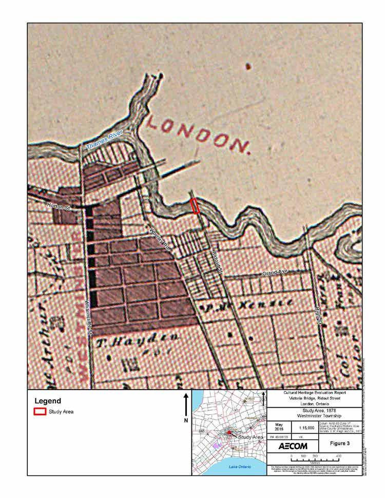
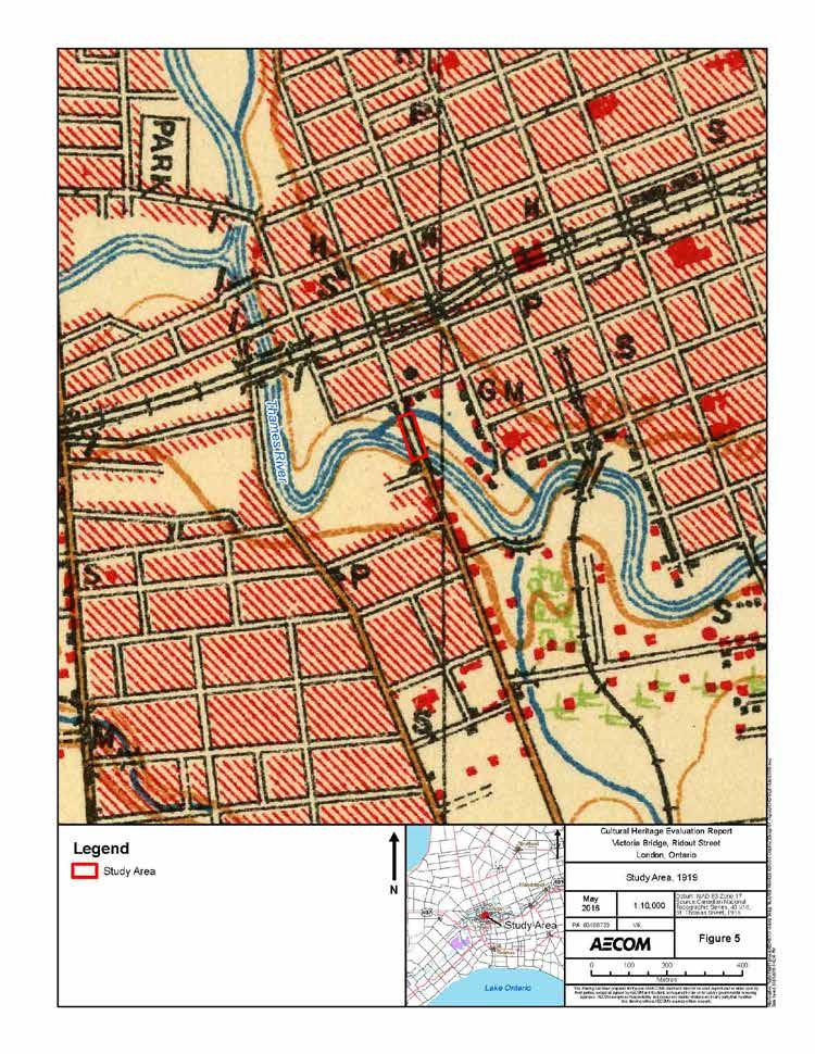
15 3.2 Historic Context Local Historic Context Historically the bridge was located over the boundary between London Township and Westminster Township in Middlesex County. The Township of London was first surveyed by Colonel Mahlon Burwell in The lots were laid out using the double front survey system which was commonly used by the Crown between 1815 and The survey was put on hold during the War of 1812 but resumed once peace had been reestablished and a total of 3,850 acres of land was reserved by Lieutenant Governor Simcoe for the future town of London. In 1826, the town plot was surveyed by Mahlon Burwell with settlement beginning shortly after around the Forks of the Thames along Ridout Street and the Talbot Block. Settlement in London began to expand rapidly after the construction of the courthouse in 1827 with the population reaching 1,000 by The Thames River had a profound impact on the growth of London. Historically, the city developed at the junction of the north and south branches of the river, and as a result bridge construction has been important in connecting London to the river. London underwent a number of population booms throughout its history beginning when the 32nd Regiment was stationed in London in Development of saw, cording, and grist industry powered by the Thames River and Medway Creek assisted the city s growth in the mid 1800 s, bolstered by the arrival of the railways in the 1850s with the Great Western Railway in 1853, the London Port Stanley Railway in 1856, and the Grand Trunk Railway in Steady growth in London continued as the city was established as a financial centre for the surrounding regions with large manufacturing industries taking root, including the Carling and Labatt s Brewery and the London Cigar Industry. London was incorporated as a Village in 1840 and by 1855 the population had leapt to 10,000 at which time it officially became a city. The former London Township survey system laid out by Burwell created a grid-like pattern of eight 100-acre lot allowances. 1 The resulting survey created much of the modern farm landscape that is still visible in the rural areas north of London. The survey pattern also created the modern road pattern that is still visible today. Ridout Street would have been laid out as one of the early town plot roads. However, the Thames River formed the boundary between Westminster Township and London Township and the road is shown continuing south though Westminster Township by the 1870s, where it eventually terminates at what is now Commissioners Road East. Since then, Upper Queen Street has been opened south of Commissioners Road. The former Township of Westminster was one of the early townships to be settled within Middlesex County. The Township was first surveyed by Mahlon Burwell and land patents were issued by the Crown for lands within Westminster Township as early as The lots were divided by the double front system which was commonly used by the Crown between 1815 and The earliest roads within Westminster Township were Commissioners and Longwoods Roads, to the south of the study area, established during the War of 1812; however, the majority of the township did not have an early road system and few passable roads. By the late-nineteenth century, the areas surrounding the bridge crossing on Ridout Street both north and south of the structure are depicted as relatively developed areas. Although the Illustrated Historic Atlas map for Westminster Township does not show structures in this area by 1877, the subdivision of the lots along Ridout Street suggest that the area was relatively developed. By 1919, historic mapping indicates that structures were located south of the bridge and the surrounding neighbourhoods on either side of the structure were developed. Fire Insurance Plans available from 1892, and revised in 1907 and 1912, revised in 1922 also confirm the development of the surrounding areas and indicate that the bridge was also used by the London Street Railway. 1 Typically the double front survey system was designed to lay out ten 100-acre lots, however, the system used in London Township laid out eight 100-acre lots. Cityoflondon_Victoriabridge_CHER_June2016 8

16 The Thames Park, located south and west of the Victoria Bridge appears to have been constructed in the early-20 th century. The lands on which the park was built belonged to Albert Major, son of William Simpson Smith, who served a term as a Mayor of London. Before Major s death he expressed his wish for his land holdings east of Wortley Road to be given to the City for use as a public park. In 1926, his executors arranged the lands to be given to the City, which in turn led to the creation of Thames Park. As early as 1926, when the City was the subject of a Geodetic Survey, the area that would become Thames Park was identified as containing four tennis courts and a swimming pool (Photograph 4). 2 Photograph 4: Geodetic Survey of Canada, 1926, showing Victoria Bridge, and the newly-estbalished Thames Park. Note, the fourth tennis court and the swimming pool constructed in the park are shown on a separate survey sheet London Street Railway The London Street Railway (LSR), incorporated in 1873 by provincial charter, provided what has been described as the great transportation breakthrough for London at the end of the 19 th century. In 1875, the company was started to provide an early transit system in London and negotiated rights to use the city streets for a horse-drawn railway network. That year, service commenced with three horse-drawn vehicles running on Dundas Street between Richmond Street and Adelaide Street. By the end of the year, it extended to the Western Fairgrounds. In 1888, it continued its expansion of services and constructed tracks across the Victoria Bridge (a predecessor of the existing bridge) to provide service to south London. The LSR eventually provided electric streetcar service and extended its network throughout London. Labour disruptions and backlash over fare prices plagued the company of numerous instances at the end of the19th and throughout the early-20 th century. In addition, by the 1940s most routes were phased out and replaced with bus service. By 1951, the London Transit Commission was formed and the LSR ceased to exist. 3 2 Geodetic Survey of Canada, 1926; Wortley Village/Old South Heritage Conservation District Final Study Report, Frederick H. Armstrong, The Forest City: An Illustrated History of London, Canada, p Cityoflondon_Victoriabridge_CHER_June2016 9
17 3.2.3 Bridge Building Context Most public highway bridges were built and owned by a municipality such as a county, town or a township. Much more rarely, they were owned by the province. Matters pertaining to bridge ownership have been dictated by the Ontario Municipal Act since The construction and operation of bridges over water courses that formed boundaries between townships were always assumed by an upper level of government, such as a County. Most 19 th -century bridges in southern Ontario were built of timber. Short spans were beam structures; longer spans employed simple trusses, such as King and Queen Post trusses. A few iron truss bridges were built in the 1870s- 1880s but were generally too costly to be widely used. Two iron bridges, an early Victoria Bridge, and the wellknown Blackfriar s Bridge were built within London. The economic value to communities of good roads, and by extension good bridges, was becoming evident. Nineteenth-century wooden bridges could not carry the weight of heavier wagon and street railway equipment coming into use. By the First World War, motor vehicles were becoming increasingly common and the provincial government began to provide grant programs and technical advice on bridge building. At the same time, counties began to create county-wide road networks by assuming the ownership of key township roads and bridges. Inexpensive steel trusses came into use in the 1890s and the designs were commonly used into the 1930s. The Pratt truss and the Warren truss dominated the early-20 th century, and were typically used for spans of up to 400 feet. 4 The existing Victoria Bridge is a modified Warren truss designed for a span of 258 feet. It is a late example of the use of steel bridge construction. At the beginning of the 20th century concrete became widely used to construct short span bridges. One of the earliest forms was the solid spandrel concrete arch design that was inexpensive to build. This design consisted of solid concrete spandrel walls that held back the stone rubble and earth fill on the interior of the arch. The arch itself was formed with rebar. By the 1930s, concrete challenged steel as the primary bridge-building material of choice and various concrete bridges types have since been used for road bridge construction Victoria Bridge The existing Victoria Bridge was not the first bridge crossing over the Thames River at Ridout Street. There has been three previous crossings at this location dating back to Spring flooding of the Thames was a continual threat to the survival of the Victoria Bridge and all other London bridges. The first crossing of the Thames at Ridout Street was opened in 1848 and was the fourth bridge constructed in London. The bridge was a short lived wood structure, the first to be named after Queen Victoria. Newspapers reported that during construction, the piles for the structure were not driven properly. The reports indicated that the pile drivers sawed off the tops of the piles to expedite their work process but within a few months the rising Thames River washed the bridge away. The crossing was not rebuilt until the 1860s, leaving a ferry to provide the only method of crossing at this location until a new structure was built. A new structure was planned in 1854 and designed by Samuel Peters, the Town Engineer for London between 1852 and 1854, then City Engineer for the newly incorporated City in 1855, however the structure never came to fruition (Photograph 5). The second Victoria Bridge was constructed in 1863, but no description exists of its design. In February 1874 a flood swept the bridge away. 5 4 T. Allan Comp and Donald Jackson, Bridge Truss Types: A Guide to Dating and Identifying, in American Association for State and Local History, 1977; National Park Services, Trusses: A Study by the Historic American Engineering Record, London Free Press, Feb 1949; Arthur McClelland, Bridges to the Past ; Arthur McClelland, All things Victorian, ; Samuel Peters, Plan of Part of Lot No. 7, East of Wortley Road in the Township of Westminster. Cityoflondon_Victoriabridge_CHER_June
 The third Victoria Bridge, a much longer lived structure, was then built of wrought iron in 1875 (Photograph 6).")

18 Photograph 5: Proposed Victoria Bridge designed by Samuel Peters, 1854 (Plan of Part of Lot No. 7, East Side of the Wortley Road in the Township of Westminster, 1854, London Room) The third Victoria Bridge, a much longer lived structure, was then built of wrought iron in 1875 (Photograph 6). The new bridge was constructed by the Wrought Iron Bridge Company of Canton, Ohio, that had been building the Blackfriars Bridge, when the Victoria Bridge was destroyed. The new bridge was a two-span iron structure of 258 feet, with an 18-foot roadway and one sidewalk. The abutments and the centre pier were of stone. The bridge design was a pin-connected through Pratt truss, a common truss bridge design. The bridge deck was suspended by stirrup hangers. Although designed for road traffic, it was sufficiently sturdy to accommodate the weight of the London Street Railway cars when streetcar service was extended into south London in the late 1890s. The bridge reached the end of its service life by 1919, and was ruled unsafe for motorists, however, Londoners voted against the use of public funds for construction of a new crossing. By 1925, the Ontario Railway and Municipal Board declared the bridge unsafe and closed the structure. 6 Photograph 6: Early-20th century postcard showing the third Victoria Bridge that was used between 1875 and Ibid. Cityoflondon_Victoriabridge_CHER_June
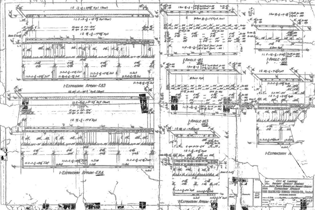
19 The existing Victoria Bridge was the fourth structure built over the Thames River at this location. The bridge was designed by John R. Rostron, a municipal engineer with the, and was built in 1926 as a steel pony truss design, constructed by the Hamilton Bridge Company. This 258-foot bridge, with two spans of 126 feet and a 31 foot wide deck, also carried a streetcar track with two six-foot sidewalks suspended on the outside of the bridge trusses. The bridge was opened in January of In 1927, the Canadian Engineer, a weekly paper published an article written by Rostron in which he outlines the context for the construction of the new bridge and a series of design challenges associated with the bridge. Given the public objection to the use of public funds for a new bridge, Rostron highlighted the particular challenge of building a bridge that would be elegant but not costly. In addition, the 41 degree skew, together with the cramped room for depth construction presented a particular design challenge. The decision to retain the existing stone pier and abutments and encase them in concrete with an extension to accommodate widening the structure provided an economical solution. The City also wished to do away with overhead obstructions on this structure. As a result, the use of a pony truss was decided on (Photographs 7 12). 8 The present bridge was built on a sharp skew of 41 degrees due to the angle at which Ridout Street crossed the Thames River at this location. The designer reused the abutments and centre pier of the previous bridge but it is unknown if the two earlier bridges were also on a skew. A skew design adds to the complexity of the bridge construction (See Appendix A for 1926 Plans). The chief aesthetic consideration for this bridge was centered on the approach to the crossing. At the time of design and construction it was determined that viewing the bridge from the east and west would not be very common so the approaches were to be the most elegant feature. As such, cut stone pilasters with concrete cores and solid cut stone newel posts were placed at the ends of the railings to provide a gateway-like design for the structure. Functionally, the abutments each had expansion bearings and the bearings on the pier were fixed. In addition to the sidewalks, a 10 inch gas main, an 8 inch sewer pipe, and a Bell conduit was carried across the river under the sidewalks, the remnants of which can still be seen (Photograph 13). 9 In the mid-20 th century the bridge underwent major repairs and reconstruction as a result of gradual deterioration. The bridge was closed in 1956 to repair damages to the abutments and piers caused by seasonal flooding. The bridge was closed first in March of that year, but by April the east side of the south abutments crumbled and collapsed resulting in additional reconstruction work. The bridge stayed closed until November of The bridge was also closed for a month in 1960 for replacement of the deck Hamilton Bridge Works Company Ltd. The Hamilton Bridge Works Company Limited was a well-known and prolific bridge building company, both provincially and nationally. It flourished in the latter part of the 1890s and well into the 20 th century, specializing in steel bridge construction, and making steel for the fabrication of buildings and bridges. Notable bridge projects include several bridges over the Welland Canal, the Blue Water Bridge, Montreal, the Burlington Canal lift bridge, the Burlington Skyway Bridge on the Beach Strip over the Canal as well as the Lion s Gate Bridge, Vancouver, as well as prominent railway bridges in Toronto including the Highland Creek Bridge and the Rouge River Bridge, built for the Grand Trunk Railway. The company ceased operation in Ibid.; Armstrong, p Rostron, Victoria Bridge, Ridout Street, London, Ont. Canadian Engineer, 1927.; London Free Press. 9 Ibid. 10 Ibid. Cityoflondon_Victoriabridge_CHER_June


20 3.2.6 John R. Rostron John Rostron was identified as one of the key team members for the design and construction of the Victoria Bridge. Little biographical information could be determined for Rostron, however, he was identified in an article as an Assistant Engineer on Structural Works for the, Ontario. The article in the 1927 edition of The Canadian Engineer, a weekly paper for civil engineer and contractor was a summary of the engineering design challenges and the construction process for the 1926 Victoria Bridge. Photograph 7: Victoria Bridge under construction in 1925 Photograph 8: Victoria Bridge under construction in 1925 Cityoflondon_Victoriabridge_CHER_June


21 Photograph 9: Victoria Bridge under construction in 1925 showing trusses nearing completion Photograph 10: Victoria Bridge under construction in 1925, showing temporary trestle structure under the bridge during construction Cityoflondon_Victoriabridge_CHER_June


22 Photograph 11: Victoria Bridge under construction in 1925 Photograph 12: Victoria Bridge following rising flood waters, The centre pier appears to be nearly submerged Cityoflondon_Victoriabridge_CHER_June
")
23 Photograph 13: Original approaches to the Victoria Bridge showing the concrete posts and integrated light fixtures. The only remnants of these approach features is a portion of a concrete post on the northwest side of the bridge (Canadian Engineer, 1927) Cityoflondon_Victoriabridge_CHER_June
24 Cityoflondon_Victoriabridge_CHER_June

25 Cityoflondon_Victoriabridge_CHER_June
26 Cityoflondon_Victoriabridge_CHER_June

27 Cityoflondon_Victoriabridge_CHER_June
28 4. Site Description 4.1 Context The Victoria Bridge is a two-span, riveted-steel pony truss bridge that carries Ridout Street over the South Branch of the Thames River, in London, Ontario (Photograph 14). 4.2 Cultural Landscape Ridout Street is a two lane, urban road that connects the downtown core with south London. Historically, the bridge crossing was an important link to traffic between London Township north of the Thames River and Westminster Township south of the river. The road was laid out as part of the early surveys for the. The Victoria Bridge is located approximately 100m south of Ridout Street s intersection with Horton Street East. At the site of the bridge, the river flows through a wide channel with moderately sloped embankments. The north side of the river, the embankment is lined with gabion baskets, and is the steeper of the two sides. On the south side, the river embankment is a shallower slope that extends back a greater distance. The river meanders through this portion of London before joining with the north branch just northwest of this bridge site. Recreational uses are also located on either side of the bridge crossing. Thames Park is a municipal park located on the southwest side of the bridge and includes tennis courts, an outdoor pool, and a paved path that extends along the river. On the north side of the river, the Thames Valley Parkway, the City s multi-use path system passes under the bridge. London Hydro properties and municipal services structures are located on either side of Ridout Street at the north end of the bridge (Photographs 15-18). 4.3 Approaches Both approaches to the bridge have a slight incline as one approaches the truss, however, the approaches are relatively flat and are consistent with the grading of the road. Both approaches are also on straight alignments from north to south of the bridge. Guard rails extend past the end posts of the truss at each approach. The skewed trusses are particularly evident at the north approach. In addition, the only remnants of the decorative stone and concrete end posts that were on the original structure is a short post on the east side of the north approach at the end of the pedestrian hand railings (Photographs 19-20). 4.4 Abutments and Pier The abutments and the pier are constructed of a mix of concrete and stone. Historic records indicate that when the bridge was constructed in 1926, the earlier stone abutments and pier were repurposed and encased in concrete to reduce the cost of the bridge project. As a result of widening the 1926 structure, the centre stone pier was encased in concrete and extended. In addition, the bridge underwent some extensive rehabilitation work in 1956 which included work on the abutments and pier. As a result of the 1926 rebuilding and subsequent repairs the amount of Cityoflondon_Victoriabridge_CHER_June
29 stone remaining in the abutments and pier is unknown. The only visible stone on the structure is on the east side of the north abutment, built into the sloping embankment (Photographs 20-25). 4.5 Truss The Victoria Bridge is a two-span, steel pony truss structure. It has two spans each 126 feet, 6 inches long with a deck width of approximately 31 feet. Sidewalks are located on both the east and west sides of the bridge with a combination of open railing barriers and modern guard rails. The bridge is a rendition of a Warren truss structure, a truss type typically used for spans ranging from feet. The trusses consist of five main panels and two half panels at each end post. The top chords and end posts are constructed of steel channels separated with riveted plates, and include riveted lattice on their underside. Unlike most verticals and diagonals on truss bridges, the vertical and diagonal members on the Victoria Bridge consist of heavy steel beams with riveted connections. The use of these members give the truss structure a much more stout and heavy appearance than most truss bridges. The centre panel on each of the trusses consists of two opposite diagonal steel channels connected by riveted plates that form an X with a large central gusset plate. A true Warren truss would typically consist of uninterrupted equilateral triangles, however, the central X panel in this structure results in a modified Warren truss. Throughout the top and bottom chords, and the heavy vertical and diagonal members CARNEGIE, a well-known American steel manufacturer, can be found stamped onto the steel (Photographs 26-31). A newspaper reference from the time of construction identifies that the bridge may have been painted red at one point, however, no further evidence about the colour of the bridge was located. Currently, the bridge includes a gray paint colour. The bridge is similar to the Kensington Bridge, a three-span modified Warren truss that carries Riverside Drive/Dundas Street over the North Branch of the Thames River approximately 800m northwest of the Victoria Bridge. Much like the Victoria Bridge, the Kensington Bridge, a sibling bridge was built in 1930 by the Hamilton Bridge Works Co. Ltd. 4.6 Deck/Railings The existing concrete deck is supported on floor beams riveted to the bottom chords of the trusses and stringers that run the length of the bridge. On the underside of the deck a series of pipes and conduits run the length of the crossing. The railing systems located on the outside of the cantilevered sidewalks consist of open steels posts and a railing that extends the length of the crossing. The only railing system that separates the traffic from the pedestrian sidewalk is a modern guard rail. In addition, decorative lampposts are located in between each truss and appear to have been a part of the original construction of the bridge. The bases of the lampposts appear to be original to the 1926 construction, however, the light fixtures have been replaced (Photographs 32-36). Cityoflondon_Victoriabridge_CHER_June


30 Photograph 14: Looking east showing west side of the Victoria Bridge Photograph 15: View looking north showing gabion baskets on the north side of the Thames River Cityoflondon_Victoriabridge_CHER_June


31 Photograph 16: View looking east showing rising embankment on south side of the Thames River Photograph 17: View looking west showing Thames Valley Parkway located on the north side of the river Cityoflondon_Victoriabridge_CHER_June


32 Photograph 18: View looking east showing recreational trail on the south side of the river Photograph 19: North approach showing sidewalks and slight grade change at truss Cityoflondon_Victoriabridge_CHER_June


33 Photograph 20: South approach showing sidewalks and relatively flat approach Photograph 21: North abutment, west side, showing location on embankment Cityoflondon_Victoriabridge_CHER_June


34 Photograph 22: North embankment, east side, showing remnants of original stone abutment and stone/concrete end post above Photograph 23: View looking south, showing centre pier Cityoflondon_Victoriabridge_CHER_June


35 Photograph 24: View looking northeast, showing centre pier Photograph 25: South abutment, west side, showing embankment and retaining wall Cityoflondon_Victoriabridge_CHER_June


36 Photograph 26: View looking south showing east side of trusses Photograph 27: View showing vertical and diagonal members and top chord with riveted lattice Cityoflondon_Victoriabridge_CHER_June


37 Photograph 28: Viewing showing centre panel with diagonals forming an X as part of the modified Warren truss Photograph 29: Viewing showing riveted lattice under the diagonal end posts and decorative lamp posts in between trusses Cityoflondon_Victoriabridge_CHER_June


38 Photograph 30: Connection on top chord showing gusset plates and connection of vertical and diagonal members Photograph 31: CARNEGIE stamp found throughout the steel used on the truss Cityoflondon_Victoriabridge_CHER_June


39 Photograph 32: Underside of deck at north abutments showing deck tray, stringers, and cross beams Photograph 33: Viewing looking south showing stringers and cross beams Cityoflondon_Victoriabridge_CHER_June


40 Photograph 34: View of riveted lattice connecting the steel on the bottom chord and the conduits and pipes extending along the west side of the bridge Photograph 35: View showing railing system on the west sidewalk Cityoflondon_Victoriabridge_CHER_June

41 Photograph 36: Base of decorative lamp post in between trusses Cityoflondon_Victoriabridge_CHER_June
42 5. Evaluation 5.1 Ontario Regulation 9/06 Ontario Regulation 9/06 provides criteria for determining cultural heritage value or interest. If a property meets one or more of the following criteria it may be designated under Section 29, Part IV of the Ontario Heritage Act. The criteria for determining cultural heritage value under Ontario Regulation 9/06 have been adopted by and are outlined below: 1) The property has design or physical value because it: Is a rare, unique, representative or early example of a style, type, expression, material or construction method; Displays a high degree of craftsmanship or artistic merit; or Demonstrates a high degree of technical or scientific achievement. 2) The property has historic or associative value because it: Has direction associations with a theme, event, belief, person, activity, organization, or institution that is significant to a community; Yields, or has the potential to yield information that contributes to an understanding of a community or culture; or Demonstrates or reflects the work or ideas of an architect, artist, builder, designer, or theorist who is significant to a community. 3) The property has contextual value because it: Is important in defining, maintaining, or supporting the character of an area; Is physically, functionally, visually, or historically linked to its surroundings; or Is a landmark. The application of the criteria for the evaluation of the Victoria Bridge is provided below in Table 1. Rationale for each criteria and its application is provided below in Section to Table 1: Ontario Regulation 9/06 Evaluation of the Victoria Bridge Criteria Site Specific Value 1) The property has design or physical value because it: i) Is a rare, unique, representative or early example of a The Victoria Bridge is a representative example of a style, type, expression, material or construction method. modified Warren truss structure. The use of steel trusses in highway bridge design is increasingly rare. A number of steel truss bridges remain in London, however, this is one of two modified Warren pony trusses in the City. ii) Displays a high degree of craftsmanship or artistic None identified merit. iii) Demonstrates a high degree of technical or scientific None identified achievement. Cityoflondon_Victoriabridge_CHER_June
43 2) The property has historic value or associate value because it: i) Has direct associations with a theme, event, belief, person, activity, organization, or institution that is significant to a community. ii) Yields, or has the potential to yield information that contributes to an understanding of a community or culture. iii) Demonstrates or reflects the work or ideas of an architect, artist, builder, designer, or theorist who is significant to a community. 3) The property has contextual value because it: i) Is important in defining, maintaining or supporting the character of an area. ii) Is physically, functionally, visually or historically linked to its surroundings. iii) Is a landmark. Historically, a crossing of the Thames River at Ridout Street has provided an important link in connecting London to its growing surroundings The bridge was designed by John R. Rostron, a municipal engineer for the. In addition, the bridge was built by the Hamilton Bridge Co., a wellknown bridge manufacturing company in the early-20 th century. None identified The Victoria Bridge, along with the King Street, Kensington and Blackfriars bridges form a grouping of historic bridges in downtown London. The Victoria Bridge is historically linked to its surroundings as one of the four crossings at this location. None identified Design/Physical Value The Victoria Bridge is a representative example of a modified Warren truss Bridge. Warren trusses were typically used for crossings between 50 and 400 feet. While a true Warren truss consists of equilateral triangle, the Victoria Bridge includes a centre panel with diagonals that form an X, indicating that it is a modified Warren truss. The nearby 1930 Kensington Bridge, is of a similar design. A number of steel truss bridges remain in London; however, this, along with the Kensington Bridge, is one of two modified Warren pony trusses in the City Historic/Association Value Historically, a crossing of the Thames River at Ridout Street has provided an important link in connecting London to its growing surroundings. Specifically, the existing bridge is the fourth crossing that has been vital in connecting downtown to South London. The Victoria Bridge was designed by John R. Rostron, Assistant Engineer on Structural Works for the City of London in Little information was determined about Rostron, however, he did write an article about the design challenges related to the Victoria Bridge. In addition, the bridge was constructed by the Hamilton Bridge Works Company, Ltd., a well-known bridge manufacturing company in Canada responsible for building a number of steel truss bridges in London, and elsewhere in Canada Contextual Value The Victoria Bridge is one of many historic bridges that can be found in London. The bridge, along with the King Street, Kensington and Blackfriars bridges form an important grouping of historic bridges in downtown London. The similarity in design and age to the Kensington Bridge add to a continuity of bridge design in the core. In addition, Cityoflondon_Victoriabridge_CHER_June
44 the bridge is the last of four crossings that have been constructed at Ridout Street since The abutments are partially constructed of stone and remnant materials from the third bridge that was in use at this location from 1875 to As such, the existing structure is historically linked to its surroundings. 5.2 Statement of Cultural Heritage Value The Victoria Bridge, is a seven panel modified Warren steel-pony truss bridge that carries Ridout Street over the South Branch of the Thames River. The two-span structure was built in 1926 as the fourth crossing of the Thames River at this location. It was designed by municipal engineer John R. Rostron as an elegant but affordable design that would utilize the remaining stone abutments and pier from the previous bridge at this crossing. As such, the concrete pier and abutments at the Victoria Bridge also include an undetermined amount of stone that has been encased in the concrete since The bridge is one of several historic truss crossings of the Thames River in London Heritage Attributes The following elements are the heritage attributes of the Victoria Bridge: Riveted, modified Warren truss structure with seven panels; Remnants of decorative stone and concrete end post at north abutment; Decorative lamp posts in centre of the bridge spans; Bridge skew evident in abutments, pier and truss alignments; and Hand railings original to the design of the bridge. 5.3 Review of Heritage Registers and Consultation As a part of the evaluation undertaken for this CHER, AECOM reviewed municipal, provincial, and federal heritage registers and inventories including:, Inventory of Heritage Resources (2006); Ontario Heritage Trust Plaque Guide; Canadian Register of Historic Places; and Federal Heritage Designations. The 1926 Victoria Bridge does not appear on any of the above registers or inventories. In addition, consultation with Kyle Gonyou, Heritage Planner for the indicated that the bridge is not listed or designated under the Ontario Heritage Act, however it was noted to be among one the older of London s bridges. It was also noted that the 1930 Kensington Bridge (described above) is designated under Part V of the Ontario Heritage Act as part of the Blackfriars-Petersville Heritage Conservation District. Lastly, the Thames River is a designated river as part of the Canadian Heritage Rivers System (CHRS). The CHRS is a conservation program that promotes, protects, and enhances Canada s river heritage and ensure that Canada s leading rivers are sustainably managed. As part of the designation application and the on-going monitoring and reporting for the Thames River, a series of publications have been developed to preserve and enhance the natural and cultural heritage of the river. Cityoflondon_Victoriabridge_CHER_June
45 6. Recommendations At the time of the preparation of this report, there is no specified proposed undertaking rehabilitation, replacement, adaptive re-use for the Victoria Bridge. It is understood that Ridout Street incorporates on-street bicycle lanes connecting Signed Bike Road Routes from the south end of the city with downtown and the Thames Valley Parkway. However, the existing bridge deck is not sufficiently wide enough to accommodate bicycle lanes. In addition, there is also a bicycle path on the north bank of the Thames River, passing under the bridge, which is scheduled for construction upgrades in the near future As such, this study has been undertaken as part of an investigation regarding the feasibility of accommodating full bicycle lanes, the general rehabilitation potential of the structure, as well as an assessment of the over condition of the bridge and the potential future use of the structure. The CHER has identified that the Victoria Bridge has significant cultural heritage value or interest under Ontario Regulation 9/06. As such, the bridge met the evaluation criteria to merit designation under the Ontario Heritage Act. This should be considered when determining a proposed undertaking for the bridge. Ideally, a solution should be developed that conserves the cultural heritage value of the bridge. This may include retaining the bridge in situ, rehabilitation with sympathetic modifications, or other forms of heritage conservation. If feasible, the should consider an option that retains the bridge in situ. Given the cultural heritage value or interest identified in this report and the requirements to rehabilitate the bridge and assess the potential widening of the bridge deck for bicycle lanes, it is more likely that an option to retain the bridge with sympathetic modifications is the most appropriate form of heritage conservation for this structure. A Heritage Impact Assessment should be undertaken when a preferred rehabilitation or replacement option is identified in order to more fully evaluate the potential impacts and identify mitigation options, if required, for the bridge. Cityoflondon_Victoriabridge_CHER_June
46 7. Bibliography Armstrong, Frederick H. The Forest City: An Illustrated History of London, Canada. Windsor. Windsor Publications, Ltd Bremner, Arnold., Ontario Canada: The Pioneer Period and the London of Today. London: London Printing and Lithographing Company Ltd Dean, W.G. Economic Atlas of Ontario. Toronto: University of Toronto Press, Goad, Charles E. Co. Insurance Plan for the, Ontario, Canada Revised Toronto. Goad, Charles E. Co. Insurance Plan for the, Ontario, Canada Revised Toronto. Illustrated Historical Atlas of the County of Middlesex. Toronto: H.R. Page and Co., London, City of. Inventory of Heritage Resources. The London Advisory Committee on Heritage. Department of Planning and Development London Free Press McClelland, Arthur. Bridges to the Past: A Historical Survey of Early Road Bridges in London, given by Arthur McClelland McClelland, Arthur. All things Victorian: A Brief History of Building and Places in London, Ontario named after Queen Victoria, A talk by Arthur McClelland to the London Branch of the United Empire Loyalists Association National Topographic Series. 40 I/14. St. Thomas National Topographic Series. 40 I/14. St. Thomas Parks Canada. Canadian Register of Historic Places. (accessed April 2016). Peters, Samuel. Plan of part of Lot No. 7 East of the Wortley Road in the Township of Westminster known as the Carfrae Farm laid out into Building Lots by Messrs Leather and Robinson for Thomas Craig Esqr Rostron, John R. Victoria Bridge, Ridout St., London, Ont. The Canadian Engineer. Vol. 53. No. 7. October 25, Cityoflondon_Victoriabridge_CHER_June
47 Appendix A Drawings Ridout Street Bridge The Hamilton Bridge Works Co., Limited Hamilton, Ontario 1926 Cityoflondon_Victoriabridge_CHER_June

48
49

50

51

52

53

54

55
56

57

58
Victoria Bridge Municipal Class EA Civic Works Committee
 Municipal Class EA John Pucchio, P. Eng., Project Manager June 19 2018 Introduction Existing Conditions Municipal Class EA Proposed Bridge Proposed Road Reconstruction Proposed Improvements Construction
CHAIR AND MEMBERS PLANNING & ENVIRONMENT COMMITTEE MEETING ON MONDAY AUGUST 28, 2017 JOHN M. FLEMING MANAGING DIRECTOR, PLANNING AND CITY PLANNER
 TO: FROM: SUBJECT: CHAIR AND MEMBERS PLANNING & ENVIRONMENT COMMITTEE MEETING ON MONDAY AUGUST 28, 2017 JOHN M. FLEMING MANAGING DIRECTOR, PLANNING AND CITY PLANNER REQUEST FOR DEMOLITION OF HERITAGE LISTED
5: Cross Avenue Bridge, Sixteen Mile Creek Rail Bridge
 1. Description of Property Municipal Address Name (if applicable) Legal Description Location of Property Ownership Access Current Use Existing Designation General Description Priority Level 5: Cross Avenue
You Don't Know What You've Got 'til it's Gone. Creative Cities Summit 2012 Victoria, British Columbia Kate Hagerman Cultural Heritage Specialist
 You Don't Know What You've Got 'til it's Gone Creative Cities Summit 2012 Victoria, British Columbia Kate Hagerman Cultural Heritage Specialist Presentation Outline Waterloo Region Research Based Conservation
6: 2417 Fourth Line, Sixteen Hollow, Lion Valley Park
 1. Description of Property 6: 2417 Fourth Line, Sixteen Hollow, Lion Valley Park Municipal Address 2417 Fourth Line ame (if applicable) Sixteen Hollow, Lion Valley Park Legal Description CO 1 SDS PT LOTS
Bridge Type Assessment and Evaluation
 16M-01410-01 (3216026) Glen Road Pedestrian Bridge EA Study Bridge Type Assessment and Evaluation Factor Group/Criteria Alternative 1: Steel girder with two inclined steel legs Alternative 2: Steel girder
Memo. B R A Y H e r i t a g e
 6 1 3. 5 4 2. 3 3 9 3 6 1 3. 5 4 9. 6 2 3 1 c a r l @ b r a y h e r i t a g e. c o m Memo To: Jennifer Murray, Windmill Development Corporation From: Carl Bray, Bray Heritage Date: Monday, June 5, 2017
TOWN OF AURORA HERITAGE IMPACT ASSESSMENTS AND CONSERVATION PLANS GUIDE
 PLANNING AND DEVELOPMENT SERVICES Development Planning Division Heritage Planning Section Phone: 905-727-3123 ext. 4226 Fax: 905-726-4736 Email: planning@aurora.ca Town of Aurora 100 John West Way, Box
Cookstown Heritage Conservation District Study Public Consultation March 26, 2013
 Public Consultation March 26, 2013 Funded by the Government of Ontario MMM Group Darryl Bird Project Manager, Senior Planner, CAHP Intern Shannon Baker Senior Landscape Architect, CAHP AREA Architects
2: Bond Street, I.O.F Orphanage
 1. Description of Property 2: 37-53 Bond Street, I.O.F Orphanage Municipal Address 37-53 Bond Street ame (if applicable) Independent Order of Foresters (I.O.F.) Orphanage Legal Description PT LTS 15 &
VILLAGE OF BOLTON HERITAGE CONSERVATION DISTRICT PLAN
 Page 1 1. INTRODUCTION AND BACKGROUND 1.1 THE PROJECT VILLAGE OF BOLTON HERITAGE CONSERVATION DISTRICT PLAN TERMS OF REFERENCE The Town of Caledon (Town) is a large, predominantly rural municipality with
National Register of Historic Places Continuation Sheet
 NPS Form 10-900-a (Rev. 8/2002) OMB No. 1024-0018 (Expires 5-31-2012) United States Department of the Interior National Park Service National Register of Historic Places Continuation Sheet Bridge No. 5721
Garden District Heritage Conservation District Study
 Garden District Heritage Conservation District Study Community Consultation Meeting September 24 th, 2013 What is a Heritage Conservation District? A defined area of heritage significance and character
43: 2165 Dundas St. West, Smith-Carrique Barn and Shed
 1. Description of Property Municipal Address Name (if applicable) Legal Description Location of Property Ownership Access Current Use Existing Designation General Description Priority Level 43: 2165 Dundas
Demolition of a Designated Heritage Property Roncesvalles Avenue
 REPORT FOR ACTION Demolition of a Designated Heritage Property - 421 Roncesvalles Avenue Date: March 8, 2018 To: Toronto Preservation Board Toronto and East York Community Council From: Acting Chief Planner
ONTARIO MUNICIPAL BOARD
 PL 120483 ONTARIO MUNICIPAL BOARD Applicant/Appellant: 2124123 Ontario Limited Subject: OPA, Rezoning and Draft Plan of Subdivision Municipal Address: 3940 Highway 7 East Municipality: City of Markham
APPENDIX 9 HERITAGE CHARACTER
 APPENDIX 9 HERITAGE CHARACTER Defining attributes and features Perth Official Plan Appendix 9 HERITAGE CHARACTER defining attributes and features This appendix includes a table describing heritage attributes
Appendix "A" Bill No. (number to be inserted by Clerk's Office) 2012
 2012") Appendix "A" Bill No. (number to be inserted by Clerk's Office) 2012 By-law No. L.S.P.- A by-law to adopt the Downtown Heritage Conservation District Plan and designate a heritage conservation district
Appendix "A" Bill No. (number to be inserted by Clerk's Office) 2012 By-law No. L.S.P.- A by-law to adopt the Downtown Heritage Conservation District Plan and designate a heritage conservation district
John M. Fleming Managing Director, Planning and City Planner. Old East Village Dundas Street Corridor Secondary Plan Draft Terms of Reference
 Report to Planning and Environment Committee To: From: Subject: Chair and Members Planning & Environment Committee John M. Fleming Managing Director, Planning and City Planner Old East Village Dundas Street
9 CITY OF VAUGHAN OFFICIAL PLAN AMENDMENT NO BOCA EAST INVESTMENTS LIMITED
 9 CITY OF VAUGHAN OFFICIAL PLAN AMENDMENT NO. 631 - BOCA EAST INVESTMENTS LIMITED The Planning and Economic Development Committee recommends the adoption of the recommendations contained in the following
Victoria Street Pedestrian Bridge
 Township of Centre Wellington Victoria Street Pedestrian Bridge Class Environmental Assessment County of Wellington & Township of Centre Wellington Badley Bridge Replacement/Rehabilitation (County of Wellington),
Better Cycling. The City will update the cycling master plan (London ON Bikes) based on the approved BRT network.
 based on the approved BRT network.") Better Cycling Dedicated bike facilities will be constructed along BRT corridors where space is available. Nearby bike routes will also be upgraded to ensure a complete network is available for cyclists.
Better Cycling Dedicated bike facilities will be constructed along BRT corridors where space is available. Nearby bike routes will also be upgraded to ensure a complete network is available for cyclists.
a) buildings, structures and artifacts of historical significance;
 buildings, structures and artifacts of historical significance;") 12.3.2. Definition Heritage Resources: There are two classes of heritage resources: monumental or landmark heritage that is considered to reflect exemplary architecture and style of a particular area or
12.3.2. Definition Heritage Resources: There are two classes of heritage resources: monumental or landmark heritage that is considered to reflect exemplary architecture and style of a particular area or
Planning Department. Director of Planning. Manager of Planning. Planning Technician/ Sustainability Coordinator. Planner II/ Heritage Coordinator
 Department Director of Manager of Policy Planner Planner II (2) Planner II/ Heritage Coordinator Technician/ Sustainability Coordinator Technician Administrative Clerk March 2017 Department 2018 Business
Freeport Bridge Score: 78
 Freeport Bridge Score: 78 This profile was researched and written by Elizabeth Waters Heinrichs "Heritage Property Report for Heritage Kitchener: Freeport Bridge," Kitchener, Ontario, July 1998. Documentation
WELCOME TO PUBLIC INFORMATION CENTRE #2. Please Sign In
 WELCOME TO PUBLIC INFORMATION CENTRE #2 Replacement of Oxtongue Lake Narrows Bridge & Oxtongue River Bridge, Highway 60 (G.W.P. 93-89-00 & G.W.P. 5550-04-00) Class Environmental Assessment (Group B) Please
GLEN ROAD PEDESTRIAN BRIDGE ENVIRONMENTAL ASSESSMENT STUDY PUBLIC INFORMATION CENTRE #2 OCTOBER 24, 2017
 GLEN ROAD PEDESTRIAN BRIDGE ENVIRONMENTAL ASSESSMENT STUDY PUBLIC INFORMATION CENTRE #2 OCTOBER 24, 2017 Glen Road Pedestrian Bridge Class Environmental Assessment 1 WELCOME! Welcome to the second Public
Municipal Heritage Bridges Cultural, Heritage and Archaeological Resources Assessment Checklist Revised April 11, 2014
 Municipal Heritage Bridges Cultural, Heritage and Archaeological Assessment Checklist Revised April 11, 2014 This checklist was prepared in March 2013 by the Municipal Engineers Association to assist with
21: Sovereign Street, Streetscape
 1. Description of Property Municipal Address ame (if applicable) Legal Description Location of Property Ownership Access Current Use Existing Designation General Description Priority Level 21: Sovereign
Variance from Chapter 297, Signs, of the Former City of Toronto Municipal Code Bloor Street West (High Park)
") Variance from Chapter 297, Signs, of the Former City of Toronto Municipal Code - 2595 Bloor Street West (High Park) (City Council on August 1, 2, 3 and 4, 2000, adopted this Clause, without amendment.)
Variance from Chapter 297, Signs, of the Former City of Toronto Municipal Code - 2595 Bloor Street West (High Park) (City Council on August 1, 2, 3 and 4, 2000, adopted this Clause, without amendment.)
13 THORNHILL YONGE STREET STUDY IMPLEMENTATION CITY OF VAUGHAN OPA 669 AND TOWN OF MARKHAM OPA 154
 13 THORNHILL YONGE STREET STUDY IMPLEMENTATION CITY OF VAUGHAN OPA 669 AND TOWN OF MARKHAM OPA 154 The Planning and Economic Development Committee recommends the adoption of the recommendations contained
historic name: STARR MILL ROAD BRIDGE other name/site number: Beverly Heights Bridge. Bridge No. 4541
 NFS Form 10-900 < (Rev. 8-86)! REGISTRATION FORM RECEIVED OCT 2 8 1993 NATIONAL REGISTER *! 0 2 4 0 0 1 8 =============================================$======================= === 1. Name of Property '
CHAIR AND MEMBERS PLANNING AND ENVIRONMENT COMMITTEE ON TUESDAY MARCH 29, 2016
 TO: FROM: SUBJECT: CHAIR AND MEMBERS PLANNING AND ENVIRONMENT COMMITTEE ON TUESDAY MARCH 29, 2016 JOHN M. FLEMING MANAGING DIRECTOR, PLANNING AND CITY PLANNER DESIGNATION OF 864-872 DUNDAS STREET UNDER
The purpose of tonight s PIC is to:
 The purpose of tonight s PIC is to: Provide an overview of the work completed to date and a summary of the Class EA process being followed; Provide a summary of public input received so far, including
GUIDELINES FOR CULTURAL HERITAGE IMPACT ASSESSMENTS
 GUIDELINES FOR CULTURAL HERITAGE IMPACT ASSESSMENTS Purpose A Cultural Heritage Impact Assessment (CHIA) is a study to identify and evaluate built heritage resources and cultural landscapes in a given
Report to: Development Services Committee Report Date: April 24, 2017
 SUBJECT: Cornell Rouge National Urban Park Gateway - Report on Design Charrette and Next Steps PREPARED BY: Lilli Duoba, MES, MCIP, RPP, Manager, Natural Heritage (ext. 7925) REVIEWED BY: Marg Wouters,
Municipal Inventory of Cultural Heritage Properties - St. Joseph Inventory of Designated and Potential Heritage Properties
 Municipal Inventory of Cultural Heritage Properties - St. Joseph Inventory of Designated and Potential Heritage Properties Municipality of Bluewater, Ontario (Comprised of the former Geographical Townships
Purpose of Report...1. Planning Framework Provincial Policy Statement Draft PPS...2. Ontario Heritage Act...3
 Cultural Heritage Policy Discussion Paper November 4 th, 2013 Table of Contents Purpose of Report...1 Planning Framework...1 2005 Provincial Policy Statement...1 2012 Draft PPS...2 Ontario Heritage Act...3
Shift Rapid Transit Public Participation Meeting May 3, 2017
 Shift Rapid Transit Public Participation Meeting May 3, 2017 Shift Rapid Transit Initiative Largest infrastructure project in the city s history. Rapid Transit initiative will transform London s public
HERITAGE IMPACT ASSESSMENT SALEM BRIDGE, COUNTY SITE No. B IRVINE CREEK (LOTS 15 & 16, CONCESSION 11 GEOGRAPHIC TOWNSHIP OF NICHOL)
") HERITAGE IMPACT ASSESSMENT SALEM BRIDGE, COUNTY SITE No. B018050 IRVINE CREEK (LOTS 15 & 16, CONCESSION 11 GEOGRAPHIC TOWNSHIP OF NICHOL) WOOLWICH STREET WEST (WR 18) SALEM, TOWNSHIP OF CENTRE WELLINGTON
HERITAGE IMPACT ASSESSMENT SALEM BRIDGE, COUNTY SITE No. B018050 IRVINE CREEK (LOTS 15 & 16, CONCESSION 11 GEOGRAPHIC TOWNSHIP OF NICHOL) WOOLWICH STREET WEST (WR 18) SALEM, TOWNSHIP OF CENTRE WELLINGTON
Long Branch Neighbourhood Character Guidelines Final Report
 STAFF REPORT ACTION REQUIRED Long Branch Neighbourhood Character Guidelines Final Report Date: October 26, 2017 To: From: Wards: Reference Number: Etobicoke York Community Council Director, Community Planning,
52: 2182 Lakeshore Road East, Horizons
 1. Description of Property Municipal Address Name (if applicable) Legal Description Location of Property Ownership Access Current Use Existing Designation General Description Priority Level 52: 2182 Lakeshore
The protection of the agricultural resources of the Province;
 PART II INTRODUCTION An Official Plan is a policy document, which is intended to serve as the basis for making land use decisions and managing change in any municipality in Ontario. According to the Planning
CITY CLERK. Parkland Acquisition Strategic Directions Report (All Wards)
") CITY CLERK Clause embodied in Report No. 10 of the, as adopted by the Council of the City of Toronto at its meeting held on November 6, 7 and 8, 2001. 10 Parkland Acquisition Strategic Directions Report
CITY CLERK Clause embodied in Report No. 10 of the, as adopted by the Council of the City of Toronto at its meeting held on November 6, 7 and 8, 2001. 10 Parkland Acquisition Strategic Directions Report
Commissioners Road West Realignment Environmental Assessment
 City of London Commissioners Road West Realignment Environmental Assessment Public Information Centre No. 1 March 30, 2017 Welcome to the Public Information Centre This first Public Information Centre
Second Line West Pedestrian/Cyclist Crossing of Highway 401 Class EA. Second Line West Pedestrian/Cyclist Crossing of Highway 401 Class EA
 1 1 Purpose of Public Information Centre #2 To provide interested and/or potentially affected stakeholders with an opportunity to participate in the planning and decision-making process for this Municipal
West London Dyke, April 1947 Flood. Forks of the Thames, July 2000 Flood. Source: UTRCA
 This Public Information Centre is the 1 st of 2. Its purpose is to inform the public and to receive input with regards to the West London Dyke Master Repair Plan. The following panels describe the history,
L 3-1. Heritage Report: Reasons for Heritage Designation. Wiley Bridge Gorewood Drive, Claireville Conservation Area
 L 3-1 Brampton Heritage Board Date: June 19, 2012 Heritage Report: Reasons for Heritage Designation Wiley Bridge Gorewood Drive, Claireville Conservation Area June 2012 1 L 3-2 Profile of Subject Property
St. Clair Avenue West Area Transportation Master Plan
 1 (Between Keele Street and Old Weston Road) Public Information Centre 1 December 2, 2015 2 Welcome Welcome to the first Public Information Centre for the St. Clair Avenue West Area. The panels will present
THE GARDEN CITY PLAN. City of St. Catharines Official Plan. City of St. Catharines
 THE GARDEN CITY PLAN City of St. Catharines Official Plan City of St. Catharines August 2010 APPROVAL INFORMATION This Official Plan of the City of St. Catharines Planning Area, known as the Garden City
TOWN OF WHITBY REPORT RECOMMENDATION REPORT
 TOWN OF WHITBY REPORT RECOMMENDATION REPORT REPORT TO: Council REPORT NO: PL 95-09 DATE OF MEETING: October 13, 2009 PREPARED BY: Planning/Public Works Joint Report FILE NO(S): N/A LOCATION: N/A REPORT
St. Lawrence Neighbourhood Focused Area - Official Plan Amendment Status Report
 STAFF REPORT ACTION REQUIRED St. Lawrence Neighbourhood Focused Area - Official Plan Amendment Status Report Date: May 21, 2015 To: From: Wards: Reference Number: Toronto and East York Community Council
Toronto and East York Community Council Item TE34.30, as adopted by City of Toronto Council on August 25, 26, 27 and 28, 2014 CITY OF TORONTO
 Authority: Toronto and East York Community Council Item TE34.30, as adopted by City of Toronto Council on August 25, 26, 27 and 28, 2014 CITY OF TORONTO BY-LAW 1393-2017 To designate the property at 481
Land Use Amendment in Southwood (Ward 11) at and Elbow Drive SW, LOC
 at and Elbow Drive SW, LOC") 2018 November 15 Page 1 of 10 EXECUTIVE SUMMARY This land use amendment application was submitted by Rick Balbi Architect on 2017 August 31 on behalf of Sable Developments Ltd, and with authorization from
2018 November 15 Page 1 of 10 EXECUTIVE SUMMARY This land use amendment application was submitted by Rick Balbi Architect on 2017 August 31 on behalf of Sable Developments Ltd, and with authorization from
Visitor's Guide to Historic Bridge Park
 Visitor's Guide to Historic Bridge Park Located in Calhoun County, Michigan, southeast of Battle Creek, the park is open year-round from 8:00 AM to 8:00 PM. Entry to the park is free of charge. Guide produced
Whitchurch Bridge Approach Road
 Approach Road Addendum to Report for Highway Widening On behalf of The Company Project Ref: 36466/ Rev: 0 Date: March 2017 Office Address: Caversham Bridge House, Waterman Place, Reading, Berkshire RG1
Newcourt Masterplan. November Exeter Local Development Framework
 Newcourt Masterplan November 2010 Exeter Local Development Framework Background The Exeter Core Strategy Proposed Submission sets out the vision, objectives and strategy for the development of Exeter up
City of Grande Prairie Development Services Department KENNEDY DEVELOPMENTS LTD. OUTLINE PLAN OP-09-01
 City of Grande Prairie Development Services Department KENNEDY DEVELOPMENTS LTD. OUTLINE PLAN OP-09-01 July 27, 2009 TABLE OF CONTENTS 1.0 Introduction... 1 1.1 Plan Area Location & Context... 1 1.2 Ownership
CITY OF VAUGHAN EXTRACT FROM COUNCIL MEETING MINUTES OF MAY 27, 2014
 CITY OF VAUGHAN EXTRACT FROM COUNCIL MEETING MINUTES OF MAY 27, 2014 Item 6, Report No. 21, of the Committee of the Whole, which was adopted without amendment by the Council of the City of Vaughan on May
CITY OF VAUGHAN EXTRACT FROM COUNCIL MEETING MINUTES OF NOVEMBER 15, 2016
 Item 11, Report No. 38, of the Committee of the Whole, which was adopted without amendment by the Council of the City of Vaughan on November 15, 2016. Regional Councillor Di Biase declared an interest
L 4-1. Heritage Report: Reasons for Heritage Designation. Kodors House. 35 Rosedale Avenue West
 L 4-1 Brampton Heritage Board Date: January 17, 2012 Heritage Report: Reasons for Heritage Designation Kodors House 35 Rosedale Avenue West December 2011 1 L 4-2 Profile of Subject Property Municipal Address
SUBJECT: Waterfront Hotel Planning Study Update TO: Planning and Development Committee FROM: Department of City Building. Recommendation: Purpose:
 Page 1 of Report PB-23-18 SUBJECT: Waterfront Hotel Planning Study Update TO: Planning and Development Committee FROM: Department of City Building Report Number: PB-23-18 Wards Affected: 2 File Numbers:
Transportation Committee
 Transportation Committee Business Item No. 2013-286SW Meeting date: October 14, 2013 For the Metropolitan Council meeting of October 16, 2013 Subject: Southwest Light Rail Transit (Green Line Extension):
Blackfriars/Petersville Heritage Conservation District Study
 Blackfriars/Petersville Heritage Conservation District Study Public Meeting #2 October 30, 2013 Overview Introduction of the Project Team Project Brief Summary of Work to Date Current Considerations Next
APPENDIX K WINDSOR OFFICIAL PLAN
 CEAA ENVIRONMENTAL ENVIRONMENTAL IMPACT ASSESSMENT AMBASSADOR BRIDGE ENHANCEMENT PROJECT Replacement Span and Plaza Expansion APPENDIX K WINDSOR OFFICIAL PLAN Avalon Consulting Professionals of Ontario,
Ebbsfleet Development Corporation
 Title of Paper Planning and Housing Delivery Report September 2018 Presented by Sub-Committee Mark Pullin, Chief Planning Officer Planning Committee Purpose of Paper and Executive Summary This paper provides
HISTORIC BRIDGE FOR SALE COLUMBIA BRIDGE IN JACKSON PARK, CHICAGO, ILLINOIS
 HISTORIC BRIDGE FOR SALE COLUMBIA BRIDGE IN JACKSON PARK, CHICAGO, ILLINOIS In Accordance With Illinois Law, The City of Chicago presents this information package as part of an effort to offer this historic
HURON COMMUNITY PLAN
 CITY OF KITCHENER DEPARTMENT OF DEVELOPMENT AND TECHNICAL SERVICES PD 94/7 HURON COMMUNITY PLAN Recommended by Planning and Economic Development Committee: October 31, 1994 Adopted by Kitchener City Council:
Memorials, Plaques & Interpretive Signs Policy
 Memorials, Plaques & Interpretive Signs Policy APPROVAL COUNCIL DATE / CEO VERSION NO: Version 0.4 TRIM REF: 16/31097 REVIEW 30 June 2020 RESPONSIBLE EXECUTIVE General Manager City Assets & Environment
Edward R. Sajecki Commissioner of Planning and Building
 Corporate Report Clerk s Files Originator s Files CD.03.POR DATE: TO: FROM: SUBJECT: Chair and Members of Planning and Development Committee Meeting Date: February 27, 2012 Edward R. Sajecki Commissioner
2.0 REGULATORY CONTEXT
 2.0 REGULATORY CONTEXT 2.1 CEAA and BC Parks Cooperation This Environmental Assessment Report (EAR) reflects the Terms of Reference for a Screening Report under the Canadian Environmental Assessment Act
Intention to Designate under Part IV, Section 29 of the Ontario Heritage Act 844 Don Mills Road and 1150 Eglinton Avenue East
 STAFF REPORT ACTION REQUIRED Intention to Designate under Part IV, Section 29 of the Ontario Heritage Act 844 Don Mills Road and 1150 Eglinton Avenue East Date: September 7, 2016 To: From: Toronto Preservation
MINNESOTA ARCHITECTURE - HISTORY INVENTORY FORM
 Identification Historic Name Dean Parkway Bridge Current Name Bridge 90661 Field # Address Midtown Greenway over Dean Parkway City/Twp Minneapolis County Hennepin Legal Desc. Twp 29N Range 24W Sec 32 QQ
Authorization to Study Potential Heritage Conservation Districts (HCD) under Part V of the Ontario Heritage Act
 under Part V of the Ontario Heritage Act") STAFF REPORT ACTION REQUIRED Authorization to Study Potential Heritage Conservation Districts (HCD) under Part V of the Ontario Heritage Act Date: August 16, 2012 To: From: Toronto and East York Community
STAFF REPORT ACTION REQUIRED Authorization to Study Potential Heritage Conservation Districts (HCD) under Part V of the Ontario Heritage Act Date: August 16, 2012 To: From: Toronto and East York Community
Access Management: An Overview
 Figures 1-5 Below Evolution of development along a highway. In the early stages, land along the road is used for farming with little traffic generated. As time passes, the highway corridor becomes a de
WELCOME TO THE PUBLIC INFORMATION CENTRE. Please Sign In
 WELCOME TO THE PUBLIC INFORMATION CENTRE Replacement of Oxtongue Lake Narrows Bridge & Oxtongue River Bridge, Highway 60 (G.W.P. 93-89-00 & G.W.P. 5550-04-00) Class Environmental Assessment (Group B) Please
6 Growth Management Challenges and Opportunities
 6 Growth Management Challenges and Opportunities The Town has established a goal of attaining a 50% participation rate with respect to employment opportunities versus residential population. The Town s
TABLE OF CONTENTS 1.0 INTRODUCTION... 3
 TABLE OF CONTENTS 1.0 INTRODUCTION... 3 1.1. BACKGROUND... 3 1.2. THE PROPOSAL... 5 2.0 EXISTING POLICY FRAMEWORK... 5 2.1. PROVINCIAL POLICY STATEMENT (PPS)... 5 2.2. CITY OF LONDON OFFICIAL PLAN (OP)...
RE: Report CDS (Municipal Heritage Committee Minutes May 8, 2018) Randwood Estate
 Randwood Estate") June 4, 2018 Members of the Committee of the Whole Town of Niagara-on-the-Lake 1593 Four Mile Creek Road P.O. Box 100, Virgil, ON L0S 1T0 Dear Lord Mayor Darte and Town Councillors: RE: Report CDS-18-028
June 4, 2018 Members of the Committee of the Whole Town of Niagara-on-the-Lake 1593 Four Mile Creek Road P.O. Box 100, Virgil, ON L0S 1T0 Dear Lord Mayor Darte and Town Councillors: RE: Report CDS-18-028
CURRICULUMVITAE. Pierre Chauvin, BSc(Agr.), MA, MCIP, RPP PROFESSIONAL ASSOCIATIONS
, MA, MCIP, RPP PROFESSIONAL ASSOCIATIONS") EDUCATION 1997 Masters of Arts, Regional Planning and Resource Development University of Waterloo 1993 Bachelor of Science in Agriculture University of Guelph Pierre Chauvin joined the firm as a Planner
EDUCATION 1997 Masters of Arts, Regional Planning and Resource Development University of Waterloo 1993 Bachelor of Science in Agriculture University of Guelph Pierre Chauvin joined the firm as a Planner
CONSULTING SERVICES FOR THE WHITEBELT VISIONING EXERCISE ADDENDUM TO THE GTA WEST LAND USE STUDY WORK PROGRAM
 CONSULTING SERVICES FOR THE WHITEBELT VISIONING EXERCISE ADDENDUM TO THE GTA WEST LAND USE STUDY 1. Introduction WORK PROGRAM The Town of Caledon is a large, local municipality located in the Greater Toronto
150 Eighth Street Zoning By-law Amendment Application Preliminary Report
 REPORT FOR ACTION 150 Eighth Street Zoning By-law Amendment Application Preliminary Report Date: March 27, 2019 To: Etobicoke York Community Council From: Director, Community Planning, Etobicoke York District
Mississippi Skyway Preliminary Engineering Report
 EXECUTIVE SUMMARY Mississippi Skyway Preliminary Engineering Report CITY OF RAMSEY, MINNESOTA DECEMBER 2014 City of RAMSEY EXECUTIVE SUMMARY Project Need and Intent The Mississippi Skyway pedestrian bridge
Declarations of Pecuniary Interest under the Municipal Conflict Of Interest Act
 Regional Municipality of Waterloo Heritage Planning Advisory Committee Minutes February 8, 2018 5:00 PM Regional Administrative Headquarters, Room 110 150 Frederick Street, Kitchener Present were: Councilor
Glenbrooke North. New Westminster s Neighbourhoods Identifying Historical Contexts. Historical Neighbourhood Context Statements 2008
 Historical Neighbourhood Context Statements 2008 Glenbrooke North Fifth Street: wide boulevard, with garden median at south end 1950s subdivision character along much of Eighth Avenue and east of Fourth
North Oakville East Parks Facilities Distribution Plan. November, 2009
 North Oakville East November, 2009 POLICY CONTEXT 1) Purpose a) The purpose of this document is to be a guide for the location, configuration, design and development of the parks system for the North Oakville
CHAIR AND MEMBERS PLANNING & ENVIRONMENT COMMITTEE ON MONDAY FEBRUARY 1, 2016
 TO: FROM: SUBJECT: CHAIR AND MEMBERS PLANNING & ENVIRONMENT COMMITTEE ON MONDAY FEBRUARY 1, 2016 JOHN M. FLEMING MANAGING DIRECTOR, PLANNING AND CITY PLANNER DESIGNATION OF THE KING STREET BRIDGE UNDER
The transportation system in a community is an
 7 TRANSPORTATION The transportation system in a community is an important factor contributing to the quality of life of the residents. Without a sound transportation system to bring both goods and patrons
Appendix D. Cultural Heritage Assessment Report
 Appendix D Cultural Heritage Assessment Report EXISTING CONDITION REPORT CULTURAL HERITAGE LANDSCAPES & BUILT HERITAGE RESOURCES & CLASS EA STUDY AND PRELIMINARY DESIGN MAVIS ROAD FROM COURTNEYPARK DRIVE
1.0 Purpose of a Secondary Plan for the Masonville Transit Village
 Report to Planning and Environment Committee To: Chair and Members Planning & Environment Committee From: John M. Fleming Managing Director, Planning and City Planner Subject: Masonville Transit Village
The Corporation of the TOWN OF MILTON
 Report to: From: Chair & Members of the Administration & Planning Standing Committee W.F. Mann, Director of Planning and Development Date: April 16, 2012 PD 022-12 (Z19/11) Subject: Technical Report Proposed
Preservation: Why Not In Pennsylvania? Presented By: Nathan Holth
 Preservation: Why Not In Pennsylvania? Presented By: Nathan Holth PA Preservation Barriers Why Not Pennsylvania? Pennsylvania has an unrivaled collection of historic bridges, particularly metal truss bridges,
DRAFT PLAN OF SUBDIVISION PLANNING RATIONALE 5100 KANATA AVENUE CITY OF OTTAWA. Hawthorn Retirement Group MALONE GIVEN PARSONS LTD.
 DRAFT PLAN OF SUBDIVISION PLANNING RATIONALE 5100 KANATA AVENUE CITY OF OTTAWA Prepared By: MALONE GIVEN PARSONS LTD. Prepared For: Hawthorn Retirement Group July 2015 Draft Plan of Subdivision 5100 Kanata
PROJECT SITE The Proposed Project includes the Allen and Pike Street malls between Delancey and South Streets (see Figure 2C-1).
.") Chapter 2, Section C: A. INTRODUCTION This chapter considers the potential of the proposed Reconstruction of the Allen and Pike Street Malls project to affect the urban design characteristics and visual
Chapter 2, Section C: A. INTRODUCTION This chapter considers the potential of the proposed Reconstruction of the Allen and Pike Street Malls project to affect the urban design characteristics and visual
Streets for People, Place-Making and Prosperity. #TOcompletestreets
 COMPLETE STREETS FOR TORONTO Streets for People, Place-Making and Prosperity COMPLETE STREETS: A NEW APPROACH A Complete Streets design approach considers the needs of all users people who walk, bicycle,
Courtice Main Street Study Community Vision Workshop PLANNING SERVICES DEPARTMENT
 Courtice Main Street Study Community Vision Workshop PLANNING SERVICES DEPARTMENT July 22, 2009 Tonight s Meeting 7:00 pm Introduction David Crome, Director of Planning 7:05 Presentation Stasia Bogdan,
SOUTH CAMBRIDGESHIRE DISTRICT COUNCIL. Planning and New Communities Director
 SOUTH CAMBRIDGESHIRE DISTRICT COUNCIL REPORT TO: Planning Committee 9 January 2013 AUTHOR/S: Planning and New Communities Director S/2270/12/FL FEN DRAYTON 850m long flood defence embankment ranging in
THE CITY OF VAUGHAN BY-LAW BY-LAW NUMBER
 THE CITY OF VAUGHAN BY-LAW BY-LAW NUMBER 123-2013 A By-law to designate the whole of the City of Vaughan as a Site Plan Control Area, and to adopt site development guidelines and rules of procedure for
CHAIR AND MEMBERS CIVIC WORKS COMMITTEE MEETING ON JUNE 19, 2018
 TO: FROM: SUBJECT: CHAIR AND MEMBERS CIVIC WORKS COMMITTEE MEETING ON JUNE 19, 2018 KELLY SCHERR, P. ENG., MBA, FEC MANAGING DIRECTOR, ENVIRONMENTAL & ENGINEERING SERVICES AND CITY ENGINEER VICTORIA BRIDGE
The Illinois Department of Transportation and Lake County Division of Transportation. Route 173, including the Millburn Bypass
 The Illinois Department of Transportation and Lake County Division of Transportation welcome you to this Public Hearing for U.S. Route 45 from Illinois Route 132 to Illinois Route 173, including the Millburn