MASTER OF SCIENCE LANDSCAPE DEVELOPMENT FOR HODGEMAN COUNTY STATE LAKE. Harold G. Gallaher. requirements for the degree. Department of Horticulture
|
|
|
- Lambert Wheeler
- 5 years ago
- Views:
Transcription
1 LANDSCAPE DEVELOPMENT FOR HODGEMAN COUNTY STATE LAKE Harold G. Gallaher B. S, in Forestry, University of Missouri, Columbia, Missouri, 1949 A THESIS submitted in partial fulfillment of the requirements for the degree MASTER OF SCIENCE Department of Horticulture KANSAS STATE UNIVERSITY OF AGRICULTURE AND APPLIED SCIENCE 1959


2 ID T4 mi -2- TABLE OF CONTENTS INTRODUCTION 1 PROCEDURE OF DESIGN.. 3 GENERAL PLAN 8. GRADING AND PLANTING PLAN CONCLUSION : PLANT LIST FOR GENERAL PLANTING. V 19 ACKNOWLEDGMENT 21

, Edwards")

3 1 INTRODUCTION The purpose of the 3tudy for this thesis vss to design a site and landscape plan for the outdoor recreational development of Hodgeman County- State Lake in southwest Kansas* This new 87-acre lake was completed in the spring of 1957 and is located four miles east and two and one-half miles south of Jetmore, Kansas, on Spring Creek, The lake was stocked with fish in the fall of 1957 and will be opened for fishing in I960 or 1961 The park area totals 254. acres* Hodgeman County has a population of 3,310* In addition to Hodgeman County residents, this is the nearest state lake for 4-7,023 people, the combined populations of Ford (19,510), Edwards (5,553), Pawnee (9,652), Rush (6,661), and Ness (5,647) counties* Population increases play a major role in recreation planning* According to the United States Department of Commerce, there are 7,200 new people added to our population every day, a rate of increase that adds 2*6 million people a year. Increases in population do not come from births alone. Vie are living longer, and, equally important, we are living healthier* There are now over two million people who have already passed their eightieth birthdays. A man today has nany active years left following his retirement* It isn't Just the man in retirement who is looking for outdoor activities* It is the workman who finds his work week growing shorter and his pay checks ample to finance trips over the long week-ends; it is the boating enthusiast


4 2 seeking new water courses* and it is the family with their new outdoor camping equipment* Every participating sport is increasing; and outdoor, woods, and water adventure leads all the rest, Americans are spending half as much again for recreation as they spend for clothing or shelter and twice as much as they spend for automobiles* A National Recreation Association representative has stated we may expect the present generally accepted park and recreation standard of ten acres per thousand population to increase to twenty acres per thousand* Landscape plans for the development of the Hodgeman County State Lake have been made with careful consideration and study of the use that will be made of the area. Existing topographic and climatic conditions were considered in the location of different use areas and in the selection of plant materials*


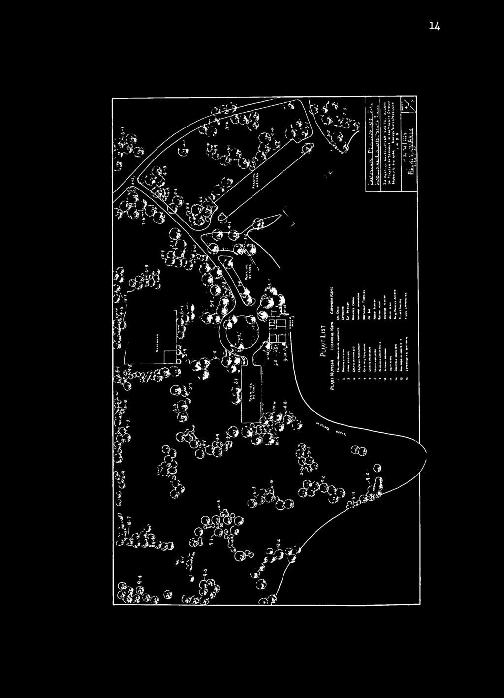
5 3 PROCEDURE OF DESIGN The objectives of this thesis are to anticipate and plan for the many possible uses of the lake area and relate them to the existing terrain. The purpose of the different studies made was to show hov the different use areas could be developed to receive maximum use of the acreage involved. In selection of the location for different areas and facilities, the topography and natural settings were considered. By so doing, overall development could be achieved more economically and with less disturbance to the natural beauty of the area. Preliminary studies were made from a contour and topographic map as shown in Plate I, Contours were laid out on five-foot intervals. By following contour lines as closely as possible, roads and other facilities could be located with a minimum of earth moving} this permits construction at least expense, will require less maintenance, and cause little change in the natural terrain. A composite plan is shown in Plate II, This shows the general layout and landscape treatment of the entire area. The composite plan is drawn to the scale of one inch equaling two hundred feet, A grading plan (Plate III) and planting plan (Plate IV) were made of the picnic, play, and main parking area. Both are drawn to a scale of one inch equaling fifty feet. Construction details are shown on Plate V. All plates were drawn on frosted acetate.

6 f ft 1


7 5
8 15


9 7


10 I GENERAL PLAN It can be assumed that this state lake will be used for fishing, boating, swimming, picnicking, camping, and other outdoor activities. The first facility needed is an access road leading to the different areas and a parking space at each facility. The lake will be used by two distinct groups of people? one group being campers who are going to remain overnight and the other, daily users such as picnickers. Campers and picnickers should not be mixed, but have separate areas entirely removed one from the other. The camping areas have been placed in the more remote aress, the picnickers and other day users closer to the lake entrance. Picnickers and campers are going to build cooking and warming firesj they are going to need water, and toilets must be provided. Water wells have been indicated in both picnic and camping areas. Final location will depend on test borings. Deep wells, with pressure flow, are most desirable. They are also most expensive. An alternstive is the shallow well with hand pump. Many campers will bring their own drinking water and use the supply at the site only for cooking and bathing. The type of sanitary facility to be provided depends on several factors. Flush toilets would depend on water supply. They are most preferable, but are costly to install and maintain. Well-constructed, pit latrines are an inexpensive and acceptable substitute. Boat launching r.mps have been located where they are easily reached and adequate parking facilities provided nearby for car plus trailer. A


11 9 national survey by the Sport Fishing Institute indicated a need for one acre of access area per 30 acres of water. The boat launching ramp should not exceed a 1$ per cent slope. It should have a width of H feet and a length of 50 to 100 feet, extending into the water to a minimum of 3 feet depth. Fireplaces and grills have been located so all fires will be safely confined* Small stacks of firewood will need to be furnished st each of the sites; otherwise, small trees will be used as fuel. Tables will have to be provided in the picnic and camping areas* Campers today provide their own shelter and beds* The camp site has provisions for cars to pull off the camp-site trail and make camp in the vicinity of their car* Three separate camping locations have been provided* One is for individual campersj the other two are for organized group camping such as scouts, A-fl, or church groups* A combination concession and bathhouse has been located near the beach, picnic, and hotting area. Swimming is confined to one area. Boundaries of the swimming area extend from the sand besch to floating barrels connected by ropes. Water skiers have a four-feet wide borrd dock from which to enter the water*


12 The lake will have to be supervised, policed, and maintained. The park superintendent residence has been locattd ne^r the entrance, so he is avare of any traffic coming in or leaving. A maintenance and storage shed has been located so it will be readily accessible to the superintendent's residence, but out of the way from other use areas*
13


14 1 12 a c v J*! bk < * ft i 5 s J. 4 t / 5 * 2? '* 3 * * 5 J 2 a - ^ ^ J a. c * 5 V s * i - I! 2si / ' I 4 /
15


16


17 15 GRADING AND PLANTING PLAN An attempt was made to fit proposed roads, buildings, and other facilities into the most desirable sites. All proposed roadways follow existing contours as much as possible. Contour lines on the grading plan are shown at one-foot intervals* In developing the planting plan, tree and shrub plantings have been used for providing summer shade, slowing the force of the wind, enframing views, preventing erosion, and providing screens for privacy in camping areas. The selection of plant materials has been limited to species that have proven to be hardy to southwest Kansas*
18 > s I


19 17


20 18 CONCLUSION This was a problem relating several forms of outdoor recreation to the topography of the site* The lake is suited for active use of the water area for boating, swimming, water skiing, and fishing. The shores have been planned for public use in picnicking, camping, sightseeing, nature study, hiking, and a limited playground area for small children. Plans include developments to facilitate full use of both the water and shore areas. These facilities include boat docks, launching ramps, swimming beach and float, concession building and bathhouse, picnicking and camping structures, parking areas, roads and trails, and related developments to meet public needs. The designer feels that the plans are functional, adapted to the site, provide for maximum use and beauty, and present a satisfactory solution to the problem.


21 PLANT LIST FOR GENERAL PLANTING* Deciduous Trees Poton^cal Myne Fraxinus pennsylvanica lanceolata Ash, Green Catalpa speciosa Catalpa, Northern Populus deltoides Cottonwood Ulmus americana Elm, American Celtis occidentalis Hackberry, Common Crataegus phaenupyrum Gleditsia triacanthos Hawthorn, Washington Honeylocust, Thornless Quereus macrocarpa Oak, Bur Madura pomifera Cercis canadensis Elaeagnus angustifolia Sapindus druineondi Osage Orange Redbud, Eastern Russian Olive Soapberry, Western Salix nigra Willow, Black Evergreen Trees Pinus nigra Pinus ponderosa Juniperus virginiana Juniperus scopulorum Austrian Pine Ponderosa Pine Redcedar, Eastern Rocky Mountain Juniper
 Colutes arborescens Bladder senna, Common Rhamnus cathartics Buckthorn, Common Shepherdla argentea")

22 20 Evergreen Shrubs Juniperus chinensis H. V. Pfitzer Juniper Deciduous Shrubs Prunus glandule sa Almond, Cherry (Flowering) Colutes arborescens Bladder senna, Common Rhamnus cathartics Buckthorn, Common Shepherdla argentea Buffaloberry, Silver Symphoricarpos orbiculatus Coralberry Cotoneaster acutifolia Cotoneaster, Peking Cotoneaster divaricate Cotoneaster, Spreading Cornus racemosa Dogwood, Gray CornuB ssperifolia Lonlcera tatarica Roughleef Honeysuckle, Tatarian Syrlnga vulgaris Lilac, Common Ligustrum amurense Privet, Amur Rhus arontatica Sumac, Fragrant Rhus trilobate Prunus americana Sumac, Lemonade Wild Plum "Nomenclature from Standardized Plant Names, American Joint Committee on Horticultural Nomenclature.

23 AC&OWLED&JLI.'T The author wishes to thank Professor Leon K. Quinlan for his invaluable instructions in solving problems, and for his constructive criticism and suggestions*


24 22 REFT R- NCIS Books Church, Thomas C. Gardens are for People* New Yorks Reinhold Publishing Corporation, 1955, 2U 9$ Clawson, Marion* Statistics on Outdoor Recreation, Resources for the Future, Inc# April, Eckbo, Garrett. Landscape for Living. New Yorki F«W. Dodge Corporation, P» Good, Albert H. Park and Recreation Structures United States National Park Service. Wirth, Conrad L. The National Park Service. United States Government Printing Office, Yard, Robert Sterling. The National Parks Portifolio. United States National Park Service, 1931» Hubbard, Henry Vincent and Kimball, Theodora. An Introduction to the Study of Landscape Design. New Yorks Macnillan, p. Handbook of Park Practices. The National Conference on State Parks Standardized Plant Names. American Joint Committee on Horticultural Nomenclature, Harrisburg, Pa,, Periodicals Kansas Agriculture 41st Report, , Kansas State Board of Agriculture. "30-Billion for Fun." Fortune, June, 1954* Bulletins Johnson,, W. Ornamental Shrubs for the Southern Great Plains. United States Department of Agriculture Farmers' Bulletin 2025, Washington: Government Printing Office, February, Bulletin No. 83. Sport Fishing Institute, Washington, D. C, October, 1958.

25 LANDSCAPE DEVELOPMENT FOR HODGEMAN COUNTY STATE LAKE Harold G. Gallaher B. S. in Forestry, University of Missouri, Columbia, Missouri, AH ABSTRACT OF A THESIS submitted in partial fulfillment of the requirements for the degree MASTER OF SCIENCE Department of Horticulture KANSAS STATE UNIVERSITY OF AGRICULTURE AND APPLIED SCIENCE 1959


26 The purpose of this thesis was to design a site plan and landscape development for outdoor recreation and camping facilities on Hodgeman County State Lake located in southwest Kansas* Objectives for the development were to locate and relate the different use areas and facilities to the topography and natural settings* The designer tried to comprehend the use and scope of the different functions and fit them to the topography of the site. Several preliminary studies were made. From the more desirable solutions, five final plans were made. They were: engineering plan, general plan, grading plan, planting plan, and construction details* The lake is suited for active use of the water area for boating, swimming, water skiing, and fishing. The shores were planned for public use in picnicking, camping, sightseeing, nature study, hiking, and a limited playground area for small children. Plans include developments to facilitate full use of both the water and shore areas. These facilities include boat docks, launching ramps, swimming beach and float, concession building and bathhouse, picnicking and camping structures, parking areos, roads and trails, and related developments to meet public needs. The designer feels that the plans are functional, adapted to the site, provide for maximum use and beauty, and present a satisfactory solution to the problem. /<V^TE ^fc\ P LIBRARY A
PLSC Plant Propagation Name Group Lab Exercise 1 January 21, SEED STRATIFICATION AND SCARIFICATION
 PLSC 368 - Plant Propagation Name Group Lab Exercise 1 January 21, 2009 1. SEED STRATIFICATION AND SCARIFICATION Note: You will learn procedures for removing seed dormancy in woody and herbaceous perennials
e. Wastes shall not have chlorine demand greater that fifteen (15) ppm. f. Wastes shall not contain phenols in excess of 0.05 ppm.
 ppm. f. Wastes shall not contain phenols in excess of 0.05 ppm.") b. Acidity or alkalinity shall be neutralized within an average ph range of between 5.5 to 7.5 as a daily average on the volumetric bases, with a temporary variation of ph 4.50 to 10.0. c. Wastes shall
b. Acidity or alkalinity shall be neutralized within an average ph range of between 5.5 to 7.5 as a daily average on the volumetric bases, with a temporary variation of ph 4.50 to 10.0. c. Wastes shall
COURSE OUTLINE FORM (Page 1 of 5)
") (Page 1 of 5) Course Title: Deciduous Trees: Culture and Identification Course Prefix & No.: HLSM 1130 LEC: 2.5 LAB: 1.5 Credit Hours: 3.0 COURSE DESCRIPTION: This course includes the study of characteristics,
(Page 1 of 5) Course Title: Deciduous Trees: Culture and Identification Course Prefix & No.: HLSM 1130 LEC: 2.5 LAB: 1.5 Credit Hours: 3.0 COURSE DESCRIPTION: This course includes the study of characteristics,
Riparian Planting Plan Requirements 21 October 2013
 Riparian Planting Plan Requirements 21 October 2013 a. Planting a riparian area with trees and shrubs evenly interspersed. The size of the riparian area must be at least 1:1 ratio with the amount of overwater
LAND DEVELOPMENT REGULATIONS
 Adopted by City Planning Commission on June 3, 1997 Approved by City Council on July 7, 1997 Revised by City Council on June 15, 1998 Revised by City Council on March 15, 2004 LAND DEVELOPMENT REGULATIONS
ZONING ORDINANCE TOWNSHIP OF BELLEVUE EATON COUNTY, MICHIGAN
 ZONING ORDINANCE TOWNSHIP OF BELLEVUE EATON COUNTY, MICHIGAN SECTION 23.08 LANDSCAPE PLANTING A. All plant materials required by this Ordinance or an approved Site Plan shall be planted to completion within
Hedges Pond Recreation Area & Preserve
 INTRODUCTION Weston & Sampson Master Plan Presentation Hedges Pond Recreation Area & Preserve Plymouth, Massachusetts June 11, 2009 Our Priority: Completion of a Master Plan that establishes realistic
ARTICLE 10 LANDSCAPE STANDARDS
 ARTICLE 10 LANDSCAPE STANDARDS SECTION 10.01 Intent The intent of this article is to promote the public health safety and welfare by establishing minimum standards for the design, installation and maintenance
CHAPTER 16 Landscaping Regulations
 CHAPTER 16 Landscaping Regulations Section 16.1 Purpose Landscaping is an important part of land development and use. The benefits of landscaping include, but are not limited to the following: A. Screening
EC1726 Revised 1957 Application Blank and Information on Clarke-McNary Seedling Trees
 University of Nebraska - Lincoln DigitalCommons@University of Nebraska - Lincoln Historical Materials from University of Nebraska- Lincoln Extension Extension 1-1957 EC1726 Revised 1957 Application Blank
CHAPTER XXVIII LANDSCAPING, SCREENING, GREENBELTS, BUFFERS AND FENCING
 CHAPTER XXVIII LANDSCAPING, SCREENING, GREENBELTS, BUFFERS AND FENCING Section 28.1 Intent and Purposes. The intent of this chapter is to promote public health, safety, and general welfare by minimizing
LANDSCAPING REQUIREMENTS PACKAGE
 LANDSCAPING REQUIREMENTS PACKAGE CREATED BY STANTEC CONSULTING LTD. REVISED MAY 2016 Landscaping Landscaping is a visible indicator of the quality of a development and should be integrated into every part
ARTICLE IV: DEVELOPMENT STANDARDS 404 MASTER PLANNING
 IV 13 404 MASTER PLANNING Master Planning through the Site Analysis (Master Planning Site Analysis) or Planned Development (Master Planning Planned Development) is provided to encourage development which
LANDSCAPING AND SCREENING
 ARTICLE 6.00 LANDSCAPING AND SCREENING Section 6.01 -- INTENT AND SCOPE OF REQUIREMENTS A. Intent Except where specifically noted, the provisions in this Article do not apply to single family and two-family
CHAPTER 20 FENCING I SCREENING I LANDSCAPING SECTION: : : : : : : :
 CHAPTER 20 FENCING I SCREENING I LANDSCAPING SECTION: 01-20-1: 01-20-2: 01-20-3: 01-20-4: 01-20-5: 01-20-6: 01-20-7: Purpose Fences General Mandatory Landscaping and Maintenance Required Landscaping Required
RV Park/Campground Operator s Manual
 RV Park/Campground Operator s Manual Chapter 9 Principles For Designing A New RV Park/Campground The Region The Site (Land) / maps, conditions, climate, topography, drainage, site evaluation Facilities
ARTICLE 13: Landscape Standards
 TOWNSHIP OF FOREST ZONING ORDINANCE ARTICLE 13: Landscape Standards Section 13.01 - Intent The intent of this article is to promote the public health safety and welfare by establishing minimum standards
EXPANDED LINER PROPAGATION OFFERINGS FROM L.E. COOKE CO PROPAGATION O: F:
 FRUIT LINERS Estimated Price VID Variety Name Quantity FORM Group 6051998 Mazzard Cherry (VC) Prunus avium 600 SDLG C Potted 6052000 Mahaleb Cherry (VC) Purnus mahaleb 27,000 SDLG C Potted 1052100 Jujube
Landscaping for Wildlife
 Landscaping for Wildlife Mid-Atlantic Ecological Landscape Partnership (MAEscapes) York County Conservation District 2008 YCCD 1 Presenter Gary R. Peacock, Watershed Specialist York County Conservation
LANDSCAPING, SCREENING AND BUFFER AREAS
 ARTICLE 9 LANDSCAPING, SCREENING AND BUFFER AREAS 9.1 PURPOSE AND SCOPE. The landscaping, screening and buffer regulations, adopted and prescribed in this Ordinance, are found by the Village Council to
ARTICLE XX. BUFFERING AND LANDSCAPING. Sec Purpose and jurisdiction.
 ARTICLE XX. BUFFERING AND LANDSCAING Sec. 80-20.1. urpose and jurisdiction. (a) These landscaping regulations are intended to establish minimum requirements and standards for landscaping for multifamily
LANDSCAPING DESIGN STANDARDS SECTION City of Maryland Heights ZONING CODE
 SECTION 25-16 City of Maryland Heights ZONING CODE The Zoning Code text contained in the Interpretive Version is current as of Ordinance #2018-4308 adopted on February 15, 2018. The City Planner comments
Section 53. Landscaping Regulations
 Section 53. Landscaping Regulations A. PURPOSE: It is the purpose of this section to establish certain regulations pertaining to landscaping within the City of Grapevine. These regulations provide standards
BOARDS, COMMISSIONS, AND COMMITTEES
 Sec. 33.24(8)(c)6.a.i BOARDS, COMMISSIONS, AND COMMITTEES 9) Urban Design District No. 2. (a) Statement of Purpose. The Urban Design District No. 2 is hereby established to make the Schroeder Road/Watts
PARTF Scoring System for Grants
 PARTF Scoring System for Grants The members of the N.C. Parks and Recreation Authority use the PARTF scoring system as one of several tools to select grant recipients. Please provide all of the information
Emerson Park Master Plan Update. Public Meeting III August 27, 2014
 Emerson Park Master Plan Update Public Meeting III August 27, 2014 Meeting Agenda: Project Update Presentation of Master Plan Components Discussion and Feedback The Path Forward: Building on the Concept
OPPORTUNITIES AND CONSTRAINTS - OXBOW PARK ENTRANCE AND PUT-IN
 OPPORTUNITIES AT OXBOW EXISTING WETLANDS Site is undeveloped and we can design a park that works well from the start. SAND BEACH Potential to eliminate invasive species. DEBRIS (CONCRETE, OLD CARS) VEGETATION
ARTICLE IX SPECIAL PERMIT USES
 ARTICLE IX SPECIAL PERMIT USES All special permit uses cited in Article IX and Attachment A of this Ordinance or any other Section of this Ordinance shall be subject to Site Plan Review. The procedures
Sec Intent and purpose.
 1 of 5 10/12/2012 10:33 AM Hastings, Michigan, Code of Ordinances >> PART II - CODE OF ORDINANCES >> Chapter 90 - ZONING >> ARTICLE XII. - LANDSCAPING >> ARTICLE XII. - LANDSCAPING Sec. 90-1006. - Intent
LANDSCAPE DESIGN AND INSTALLATION Lesson 20: DESIGN PROCESS
 LANDSCAPE DESIGN AND INSTALLATION Lesson 20: DESIGN PROCESS Script to Narrate the PowerPoint, 20_PowerPoint_Proc.ppt It is not permitted to export or reuse any images in the PowerPoint presentation. PowerPoint
Appendix D OUTDOOR RECREATION AND OPEN SPACE PLANNING OBJECTIVES, PRINCIPLES, AND STANDARDS FOR WASHINGTON COUNTY
 Appendix D OUTDOOR RECREATION AND OPEN SPACE PLANNING OBJECTIVES, S, AND FOR WASHINGTON COUNTY OBJECTIVE NO. 1 The provision of an integrated system of public -use outdoor recreation sites and related
Gary Morava Nature Preserve Ecological Management Schedule
 Gary Morava Nature Preserve Ecological Management Schedule Site Description Gary Morava Nature Preserve is 1.6 acre property that is owned by the Park District. Historically, the area was in agricultural
SEWRPC OUTDOOR RECREATION AND OPEN SPACE PLANNING OBJECTIVES, PRINCIPLES, AND STANDARDS
 SEWRPC OUTDOOR RECREATION AND OPEN SPACE PLANNING OBJECTIVES, S, AND STANDARDS Introduction The Southeastern Wisconsin Regional Planning Commission (SEWRPC), as part of the regional park and open space
City of Bonney Lake Allan Yorke Park. MASTER PLAN SUMMARY REPORT June 30, 2016
 City of Bonney Lake Allan Yorke Park MASTER PLAN SUMMARY REPORT June 30, 2016 TABLE OF CONTENTS INTRODUCTION PUBLIC INVOLVEMENT PROCESS MASTER PLAN North Park Central Park South Park East Park Field Development
Landscape & Lighting Design Guidelines
 Landscape Design Guidelines Landscape & Lighting Design Guidelines Hudson Heritage Town of Poughkeepsie Dutchess County, New York February 2017 Prepared for: EFG/DRA Heritage, LLC 47 Summit Road, Suite
Village of Willowbrook Landscaping Requirements
 Village of Willowbrook Landscaping Requirements PLANNING & DEVELOPMENT DEPARTMENT - VILLAGE OF WILLOWBROOK - Effective 4.14.17 01 02 03 04 05 General Landscaping Requirements... Section 9-14-2.23 Business
NORTH BETHANY ELEMENTARY SCHOOL SITE ASSESSMENT
 NORTH BETHANY ELEMENTARY SCHOOL SITE ASSESSMENT Prepared for: Prepared by: October 10, 2014 Page 2 Introduction and Purpose This report provides an assessment of two potential sites for a new elementary
Fence Permit Application City of Wayzata Permit Fee: $70.00
 Fence Permit Application City of Wayzata Permit Fee: $70.00 Property Owner: Mailing Address: Phone Number: The undersigned hereby makes application for a permit to erect a fence, as described below and
Lines, Limbs & The Landscape
 Lines, Limbs & The Landscape Section 1 - Lines & Limbs Introduction Upper Peninsula Power Company knows that you, your neighbors, hospitals, businesses your entire community depend on safe, reliable electric
Planting Guide. Some of these factors include, but in no way are limited to the following:
 Planting Guide Tuckahoe Nurseries recognizes the potential risks involved with the fall digging of some plant varieties. Each genus and species, have distinctly different timing and other factors involved
Healthy Living Strategy: Shorelines
 Healthy Living Strategy: Shorelines Shoreline Vegetation in Muskoka The basis of a natural ecosystem is a complex combination of vegetation that forms canopy, understory, and herbaceous layers. It is easier
Washtenaw County Conservation District 7203 Jackson Rd Ann Arbor MI Phone: (734) x 5 Fax: (734) Web:
 x 5 Fax: (734) Web:") Washtenaw County Conservation District 7203 Jackson Rd Ann Arbor MI 48103-9506 Phone: (734) 761-6721 x 5 Fax: (734) 662-1686 Web: www.washtenawcd.org STEPS IN BUILDING A POND The following list has been
Washtenaw County Conservation District 7203 Jackson Rd Ann Arbor MI 48103-9506 Phone: (734) 761-6721 x 5 Fax: (734) 662-1686 Web: www.washtenawcd.org STEPS IN BUILDING A POND The following list has been
PARKS & RECREATION SUBCOMMITTEE. Oct. 1, 2015
 PARKS & RECREATION SUBCOMMITTEE Oct. 1, 2015 1999 Bond - $22,000,000 Land Acquisition Allen Station Phase II Neighborhood Parks PREVIOUS BOND ELECTIONS 1999 & 2007 2002 Bond - $4,000,000 Allen Senior Recreation
Recommended Trees for the San Luis Valley Communities of Colorado. A Guide for Selecting, Planting, and Caring For Trees
 Recommended Trees for the San Luis Valley Communities of Colorado A Guide for Selecting, Planting, and Caring For Trees Do Not Top Your Trees! http://csfs.colostate.edu/ Trees that have been topped may
MASTER PLAN for the EARL NEWHOUSE WATERFRONT
 MASTER PLAN for the EARL NEWHOUSE WATERFRONT on RESERVOIR POND - CANTON, MA Community Meeting #2 - Thursday, January 11 th PROJECT INTRODUCTION Project Goals: To prepare a MASTER PLAN which develops the
Hedging. Price List Hattens Farm Nurseries Incorporating Tony Horn Forestry Co
 Hattens Farm Nurseries Incorporating Tony Horn Forestry Co Eddie and Julie Krutysza Hattens Farm Nurseries Fressingfield Road, Metfield Harleston. IP20 0LL Tel 01379 586325 Mob 07969578031 hattensfarmnurseries@gmail.com
Kensington Covenants Committee Guidelines
 1 Kensington Covenants Committee Guidelines The Covenants Committee will be appointed by the Board of Directors, with a membership of five association members, for a term of two years. The purpose of the
TABLE 5-3. EXISTING AND PROPOSED YAKIMA GREENWAY FACILITIES
 TABLE 5-3. Selah Recreation Area (Proposed) Greenway Pathway: Multi-use, recreational pathway Gravel Pit Ponds: Boating, canoeing, fishing, swimming Selah Boat Landing: To serve as northernmost river access
Backyard Conservation - Water Conservation TIP SHEET
 Backyard Conservation - Water Conservation TIP SHEET Wise use of water for garden and lawn waterings not only helps protect the environment, but saves money and provides for optimum growing conditions.
Town of Morrison. Downtown Revitalization Plan. Prepared for Morrison Planning Commission. February 8, 2013 Revised 9/6/2013. Parking.
 Wayfinding Street Tree Plan Alley Activation Parking Analysis Town of Morrison Downtown Revitalization Plan Prepared for Morrison Planning Commission February 8, 2013 Revised 9/6/2013 Design & Circulation
BEFORE THE UNITED STATES OF AMERICA FEDERAL ENERGY REGULATORY COMMISSION MOTION OF THE FRIENDS OF LIBERTY STATE PARK TO INTERVENE IN OPPOSITION
 BEFORE THE UNITED STATES OF AMERICA FEDERAL ENERGY REGULATORY COMMISSION Texas Eastern Transmission, LP ) NJ-NY Expansion Project Algonquin Gas Transmission, LLC ) Docket No. CP11-56 MOTION OF THE FRIENDS
TREE CONSERVATION REPORT 555 DEALERSHIP DRIVE, OTTAWA
 TREE CONSERVATION REPORT 555 DEALERSHIP DRIVE, OTTAWA PREPARED FOR: CURTIS MELANSON, C.E.T. MCINTOSH PERRY 115 WALGREEN ROAD, R.R. 3 CARP, ON K0A 1L0 613-836-2184 EXT. 2240 PREPARED BY: ANDREW BOYD, B.SC.F,
Maximo Park Master Plan. Public Forum 2 October 30, 2012
 Maximo Park Master Plan Public Forum 2 October 30, 2012 Welcome & Introductions Welcome and thank you for attending. Phil Whitehouse Parks & Recreation Superintendent Sharon Heal Eichler, RLA, LEED AP
I539. Smales 2 Precinct
 I539. Smales 2 Precinct I539.1. Precinct Description The Smales 2 Precinct applies to a 4.8 hectare block of land located on the southern side of Northcote Road and fronting Lake Pupuke, Takapuna. The
3.2 P - Park District
 3.2 P - Intent - The P: s are established to promote and maintain the development of recreational opportunities within the. The development of new parks or the major expansion of existing parks within
THAT a Community Enhancement Program be established with the following guidelines:
 68 ISSUED: JULY 6, 1982 REVISED: JULY, 2010; MAR 21/00; JUNE 12/89; DEC 3/91 & JAN 25/94 PREPARED BY: DIRECTOR OF MUNICIPAL SERVICES AUTHORIZED BY: COUNCIL TITLE: COMMUNITY ENHANCEMENT PROGRAM - MEMORIAL
Asbury Chapel Subdivision Sketch Plan
 Asbury Chapel Subdivision Sketch Plan PART 1: PROJECT SUMMARY Applicant: NVR Inc. Project Size: +/- 76.13 acres Parcel Numbers: 02101112,02116101,02116112, 02116113 Current Zoning: Transitional Residential
PURPOSE AND NEED FOR ACTION PUBLIC SCOPING LETTER SILVER GLEN SPRINGS RECREATION ENHANCEMENT PROJECT. Ocala National Forest
 File Code: 1950/2300/2720 PUBLIC SCOPING LETTER SILVER GLEN SPRINGS RECREATION ENHANCEMENT PROJECT Lake George Ranger District Marion County, Dear Visitor: The of the has developed a proposal (Proposed
Chapter RM MULTI FAMILY BUILDING ZONES
 Chapter 19.17 RM MULTI FAMILY BUILDING ZONES 19.17.010 Established 19.17.020 Primary Permitted Uses 19.17.030 Accessory Permitted Uses 19.17.040 Secondary Permitted Uses 19.17.050 Conditional Property
Hedging. Price List
 Hattens Farm Nurseries Incorporating Tony Horn Forestry Co Eddie and Julie Krutysza Hattens Farm Nurseries Fressingfield Road, Metfield Harleston, Norfolk. IP20 0LL Tel 01379 586325 Mob 07969578031 hattensfarmnurseries@gmail.com
ARTICLE 2550 LANDSCAPING AND SCREENING FOR COMMERCIAL/INDUSTRIAL AND MULTI- FAMILY HOUSING
 OF MONONGALIA COUNTY, WEST VIRGINIA Page 1 of 8 ARTICLE 2550 LANDSCAPING AND SCREENING FOR COMMERCIAL/INDUSTRIAL AND MULTI- FAMILY HOUSING 2550.01 Purpose The purpose of this Article is to establish provisions
Chapter 4 - Preparation of Stormwater Site Plans
 Chapter 4 - Preparation of Stormwater Site Plans The Stormwater Site Plan is the comprehensive report containing all of the technical information and analysis necessary for the City to evaluate a proposed
Procedures IV. V. Rural Road Design Option
 i IV. Procedures A. All applicants required to prepare a Conservation Design Subdivision shall provide the Planning Board with a conceptual conventional subdivision design as well as a proposed layout
PRELIMINARY CONDITIONAL USE SUBMITTAL CHECKLIST REQUIREMENTS
 This checklist must accompany your submittal as the cover page. CONDITIONAL USE Application Submittal Checklist for PRELIMINARY AND FINAL APPROVAL Per Winter Park Land Development Code Sec. 58-90 PRELIMINARY
Comprehensive Park System Master Plan
 PARKS AND RECREATION Comprehensive Park System Master Plan Citizen Advisory Committee, June 5, 2012 - Meeting Notes Transcription MIG met with the Parks Citizen Advisory Committee on Tuesday, June 5th,
Open Space and Recreational Facilities
 Chapter 5: Open Space and Recreational Facilities A. INTRODUCTION According to the guidelines of the 2001 New York City Environmental Quality Review (CEQR) Technical Manual, an open space analysis is necessary
REPUBLIC AIRPORT PERFORMANCE AND DEVELOPMENT STANDARDS
 ATTACHMENT A REPUBLIC AIRPORT PERFORMANCE AND DEVELOPMENT STANDARDS LAND S CAPE STANDARDS New York State Department of Transportation REPUBLIC AIRPORT ATTACHMENT A June 1, 1990 REPUBLIC AIRPORT Landscape
Source for insecticide options: Purdue Extension: 1- page=faq
 Source for insecticide options: Purdue Extension: 1-https://extension.entm.purdue.edu/EAB/index.php? page=faq Table 1. Insecticide options for professionals and homeowners for controlling EAB that have
Using Native Shrub and Small Tree Species to Enhance Forest Reclamation on Surface Mines. Alexis Monteleone
 Using Native Shrub and Small Tree Species to Enhance Forest Reclamation on Surface Mines Alexis Monteleone History of Surface Mining Reclamation A progression from rehabilitation restoration Surface Mining
Philbrook Avenue Wetlands and Stream Riparian Restoration Project Planting Plan 2009 REVISED AUGUST 24, 2009
 Philbrook Avenue Wetlands and Stream Riparian Restoration Project Planting Plan 2009 REVISED AUGUST 24, 2009 Submitted by Boyle Associates Per Request of Gorrill Palmer Consulting Engineers & the Cumberland
FOREVER GREEN TREE AND SHRUB SALE
 F FOREVER GREEN TREE AND SHRUB SALE 2018 Reference Guide WAYNE COUNTY SOIL & WATER CONSERVATION DISTRICT www.waynecountynysoilandwater.org 315-946-7200 INTRODUCTION Seedlings will have a smaller root system
ARTICLE AGRICULTURAL DISTRICTS
 ARTICLE 6 AGRICULTURAL DISTRICTS SECTION 600 Intent The intent of this article is to specifically identify and protect the present and future viability and character of agricultural and rural lands. SECTION
4 January 11, 2012 Public Hearing APPLICANT:
 . 4 January 11, 2012 Public Hearing APPLICANT: MID-ATLANTIC AUTO PROPERTY OWNER: DZR, LLC STAFF PLANNER: Leslie Bonilla REQUEST: Conditional Use Permit (truck rental, automobile service, and automotive/bulk
GENSTAR TREE PLANTING PROGRAM - CLEARMONT
 GENSTAR TREE PLANTING PROGRAM - CLEARMONT Every year Genstar plants thousands of trees in its communities. In addition to the environmental benefits, tree planting enhances the appearance and value of
a) That prior to the execution of the amending site plan agreement:
 That prior to the execution of the amending site plan agreement:") COMMITTEE OF THE WHOLE MAY 16, 2005 SITE DEVELOPMENT APPLICATION PETRO-CANADA FILE DA.04.043 Recommendation The Commissioner of Planning recommends: THAT the revised site layout, building elevations and
COMMITTEE OF THE WHOLE MAY 16, 2005 SITE DEVELOPMENT APPLICATION PETRO-CANADA FILE DA.04.043 Recommendation The Commissioner of Planning recommends: THAT the revised site layout, building elevations and
McCormick Pit Category 1 Class A License, Pit Below Water For Blueland Farms Limited. Visual Impact Assessment Report February 2013
 McCormick Pit Category 1 Class A License, Pit Below Water For Blueland Farms Limited Visual Impact Assessment Report February 2013 TABLE OF CONTENTS EXECUTIVE SUMMARY... v 1.0 BACKGROUND... 1 Figure 1.
STAFF REPORT FOR STANDARD COASTAL DEVELOPMENT PERMIT #CDP FEBRUARY 26, 2015 CPA - 1 PO BOX 238 APTOS, CA 94001
 STAFF REPORT FOR STANDARD COASTAL DEVELOPMENT PERMIT #CDP 2014-0030 FEBRUARY 26, 2015 CPA - 1 OWNER/APPLICANT: AGENT: REQUEST: HANS HEIM PO BOX 238 APTOS, CA 94001 JAMES HAY PO BOX 762 MENDOCINO, CA 95460
Southwest Fleetwood Enclave
 Southwest Fleetwood Enclave Development Concept Plan Southwest Fleetwood Enclave 1 st Land Owners Meeting April 30 th, 2012 Presentation Overview Why the Plan? ; Overview & Purpose of Study; Constraints
Project: Developer/Designer: Reviewer: I. Narrative: 1. Project Description: Describes the nature and purpose of the land disturbing activity.
 City of Charlottesville, Virginia Erosion and Sediment Control Plan Review Checklist 610 East Market Street, Charlottesville, VA 22902 Telephone 434-970-3182; Fax 434-970-3359 Project: Developer/Designer:
CHAPTER 26 LANDSCAPING (Chapter added in its entirety 05-08)
") CHAPTER 26 LANDSCAPING (Chapter added in its entirety 05-08) 26.01 DESCRIPTION AND PURPOSE. Landscaping is an important element of the use, development and preservation of land, and a significant factor
CHAPTER 26 LANDSCAPING (Chapter added in its entirety 05-08) 26.01 DESCRIPTION AND PURPOSE. Landscaping is an important element of the use, development and preservation of land, and a significant factor
St. Croix River Crossing Project - Visual Quality Manual
 St. Croix River Crossing Project - Visual Quality Manual Minnesota TH 36/TH 95 Interchange 3.1 Context Existing TH 36/TH 95 Environment The proposed TH 36/TH 95 interchange will occupy a large area of
I604. Hobsonville Marina Precinct
 I604. Hobsonville Marina Precinct I604.1. Precinct description Hobsonville Marina Precinct is located at Clearwater Cove, Hobsonville in Auckland s upper Waitemata Harbour. The precinct includes the coastal
Presented at USSD Conference April 20-24, 2009, Nashville, TN HIDING IN PLAIN SIGHT USING THE NATURAL LANDSCAPE AS A VISUAL BARRIER ABSTRACT
 HIDING IN PLAIN SIGHT USING THE NATURAL LANDSCAPE AS A VISUAL BARRIER 1 Andrew Aceves, P.G., Paul C. Rizzo Associates, Inc. 2 Melissa L. Dubinsky, Ph.D, Paul C. Rizzo Associates, Inc. 3 Craig Giesmann,
2. In 1959, the first full year the Arboretum was open 5,000 people visited. How many people visited in 2009?
 1. The Minnesota Landscape Arboretum covers acres. a. 987 acres b. 1012 acres c. 1074 acres d. 1137 acres** 2. In 1959, the first full year the Arboretum was open 5,000 people visited. How many people
Lab Notebook. Topic Investigation Activity Title Page Ref. Give It A Try Survivor! 96
 Lab Notebook Plants for Food and Fibre Index of Investigations, Challenges and Activities Topic Investigation Activity Title Page Ref. Give It A Try Survivor! 96 1 Understanding structures and life processes
SUBMITTAL REQUIREMENTS: FINAL PLAN REVIEW- PROJECT DEVELOPMENT PLAN (PDP)
") 1) Application form and filing fee. Application Form.pdf Development Review Guide STEP 6 of 8 SUBMITTAL REQUIREMENTS: FINAL PLAN REVIEW- PROJECT DEVELOPMENT PLAN (PDP) 2) Transportation Development Review
1) Application form and filing fee. Application Form.pdf Development Review Guide STEP 6 of 8 SUBMITTAL REQUIREMENTS: FINAL PLAN REVIEW- PROJECT DEVELOPMENT PLAN (PDP) 2) Transportation Development Review
2018 Boulevard Tree List
 2018 Boulevard Tree List Just as in year s past we are featuring a wide variety of trees that will work in an array of different city boulevard locations. We have larger trees for larger, more open boulevards
Oregon SCORP. Assessing Recreation Demand & Supply
 2013-2017 Oregon SCORP Assessing Recreation Demand & Supply SORP Conference: April 13, 2015 2013-2017 Oregon SCORP Supply/Demand Planning Components A County-Level and Regional Planning Approach Oregon
Mission Bay Park Master Plan Update: Fiesta Island Amendment (Information) Mission Bay Park Committee October 3, 2017
 Mission Bay Park Committee October 3, 2017") Mission Bay Park Master Plan Update: Fiesta Island Amendment (Information) Mission Bay Park Committee October 3, 2017 Tonight s Agenda Introduction & Project Overview Proposed Circulation Changes Overview
Mission Bay Park Master Plan Update: Fiesta Island Amendment (Information) Mission Bay Park Committee October 3, 2017 Tonight s Agenda Introduction & Project Overview Proposed Circulation Changes Overview
Botanical Name Common Name Availability Price
 Acer freemanii ' Armstrong' 2.5" Armstrong maple 4 289.00 Acer freemanii ' Armstrong' 3.0" Armstrong maple 4 324.00 Acer freemanii ' Armstrong' 3.5" Armstrong maple 1 358.00 Acer palmatum 'Bloodgood' 4'
ARTICLE XII LANDSCAPE REGULATIONS
 ARTICLE XII LANDSCAPE REGULATIONS 12.1 - GENERAL PROVISIONS 12.1.1 INTENT: It is the intent of these regulations to make Johnson City a more beautiful, environmentally sound, and more memorable place through
Prices range from $ $ Prices are based on both size and species of tree. Trees range in height from approximately 6ft to12ft.
 Shade Trees 2018 Retail Price List One year guarantee on all Prairie hardy shade trees Seasonal Business Hours April October Highway 16 E & Boychuk Drive Ph: 306-477-0713 Fax: 306-477-0795 www.lakeshoregardencentre.com
SITE SUMMARY REPORT Arlington Dump NONCD Yadkin County
 SITE SUMMARY REPORT Arlington Dump NONCD 0000644 Yadkin County Hurricane Recovery Act of 2005 State of North Carolina State Contract N06009S Schnabel Project No. 06210002.15 July 31, 2009 Prepared for:
29 Bella Fontaine Park
 29 Bella Fontaine Park 9565 Bellefontaine Road St. Louis County Parks Master Plan Planning Zone 2 Visit Date: July 2016 Page 1 129 Bella Fontaine Park 9565 Bellefontaine Road St. Louis County Parks Master
MEMORIAL PARK MANAGEMENT PLAN
 MEMORIAL PARK MANAGEMENT PLAN Village of Elk Rapids, Michigan 2015 Developed by the Parks and Recreation Commission Planning Commission Approved, Village Council Approved, 1 Introduction The purpose of
PART XVI - R-H(G) HALF-ACRE RESIDENTIAL - GROSS DENSITY ZONE A. INTENT
 HALF-ACRE RESIDENTIAL - GROSS DENSITY ZONE A. INTENT") PART XVI - R-H(G) HALF-ACRE RESIDENTIAL - GROSS DENSITY ZONE PART XVI - R-H(G) HALF-ACRE RESIDENTIAL - GROSS DENSITY ZONE A. INTENT This zone is intended for single family housing on suburban Amended lots,
PART XVI - R-H(G) HALF-ACRE RESIDENTIAL - GROSS DENSITY ZONE PART XVI - R-H(G) HALF-ACRE RESIDENTIAL - GROSS DENSITY ZONE A. INTENT This zone is intended for single family housing on suburban Amended lots,
Piney Mountain Trees Availability List
 Piney Mountain Trees Availability List 7501 Woodland Hills Road Hickory, North Carolina 28602 E-mail: trees@pineymtn.com Phone: 828-312-4867 Phone 2: 828-312-3780 Fax: 828-397-2800 Size Description Price
Draft TISCORNIA ESTATE SPECIFIC PLAN/EIR
 Draft TISCORNIA ESTATE SPECIFIC PLAN/EIR Submitted CONTENTS 1. PLAN SUMMARY II. INTRODUCTION IX. SPECIFIC PLAN RELATIONSHIPS X. XI. List of Figures 1. Regional Location 2. Point Richmond Area 3. Planning
SECTION 1000 HIGHWAY CORRIDOR OVERLAY DISTRICT REGULATIONS
 SECTION 1000 HIGHWAY CORRIDOR OVERLAY DISTRICT REGULATIONS 1001.00 INTENT AND PURPOSE... 1000-1 1002.00 CLASSIFICATIONS... 1000-1 1003.00 DEVELOPMENT STANDARDS TABLES Page 1003.01 Buffer Requirements...................................
River Bend Area Plan Map Amendment ARPP Analysis Camp Fire Day Camp November 20, 2014
 Regional Parks Department Jeffrey R. Leatherman, Director County of Sacramento Attachment 2 Divisions Administration Golf Leisure Services Maintenance Rangers Therapeutic Recreation Services River Bend