Guidance on Coastal Character Assessment Consultation Draft
|
|
|
- Theresa Wiggins
- 5 years ago
- Views:
Transcription


1 Consultation Draft Carol Anderson Landscape Associates for Scottish Natural Heritage February
2 CONTENTS 1 Introduction... 3 Background... 3 Scope of the guidance... 4 Who the guidance will be used by... 4 Development of this guidance An introduction to coastal character... 5 What is seascape?... 5 The extent of the coast... 5 Relationship to landscape character assessment Establishing an appropriate scale of characterisation... 7 The hierarchy of coastal character units... 7 A scale fit for purpose Undertaking the assessment Key principles of coastal character assessment Research and desk study Field survey Classification and description Outputs of the coastal character assessment Examples of coastal characterisation in Scotland Introduction Moray Offshore Renewables Firth of Clyde Appendix A: Glossary 24 Appendix B: References 25 Please send consultation comments to Coastal_Character_Assessment@snh.gov.uk by 5pm on 23 rd March

3 1 Introduction 1.1 This guidance presents a methodology on how to undertake coastal characterisation that will nest with terrestrial landscape character assessments to form baseline information. The arising coastal character assessment will help inform and guide coastal and marine planning, and also individual development proposals, for example through landscape/seascape and visual impact assessments. The method is used for aquaculture proposals and capacity studies, and in assessing offshore renewables (wind, wave, and tidal). Background 1.2 Scotland has a very diverse coastline ranging from the intricate west coast of long sea lochs, sounds and islands to the more even sandy beaches and settled broad firths on the east coast. The coast of Scotland is of national and international significance, featuring many areas of special landscape and ecological significance. It provides the setting to many of our major settlements and is also a prime resource for industry in some areas. Intricate sounds, long sea lochs and islands on the more remote and less settled north-west coast The well-settled, relatively industrialised coastal character of the broad Firth of Forth. 1.3 The increased interest in coastal and offshore development, including renewable energy generation, has resulted in a need to consider the coast more fully in terms of planning and assessment. A new marine planning system will provide a framework for the sustainable development of the Scottish marine area and guide decisions on development licensing and activity management at sea and in the coastal zone. The National Marine Plan sets economic, social and marine ecosystem objectives at a strategic level, but it is expected that new regional marine plans (in conjunction with adjacent onshore plans) will provide a more detailed framework specific to respective regions. Within this context, there is a need to understand particular coastal qualities to aid strategic planning of development and marine management. 1.4 It is the intention that coastal characterisation, which assesses the particular qualities of the coast, will supplement SNH s suite of Landscape Character Assessments (LCA) which cover Scotland. 3
4 Scope of the guidance 1.5 This document provides guidance on how to assess the character of the coast. The method is linked to landscape character assessment but considers additional specific characteristics associated with the coast. 1.6 Coastal character is made up of the often narrow margin of the coastal edge, its immediate hinterland and the sea. These three key components of coastal character include what is commonly known as seascape. The term coastal is used instead of seascape in this guidance as it is more appropriate to the nature of the Scottish coast, where often the sea is strongly inter-related to the land, particularly on the west coast and islands and within the firths. Appendix A is a glossary of common terms. Who the guidance will be used by 1.7 It is expected that this guidance will principally be used by those undertaking coastal character and/or capacity studies, perhaps to inform regional marine plans, coastal zone management plans, local/strategic development plans, and other planning policies or for Seascape, Landscape and Visual Impact Assessment (SLVIA) of specific coastal and marine development proposals. 1.8 The guidance is therefore likely to be used by local authorities, SNH and other bodies with a specific remit for the firths and coasts of Scotland as well as landscape professionals commissioned to undertake coastal capacity studies and SLVIA. Development of this guidance 1.9 This guidance is informed by earlier work undertaken by SNH which explored coastal character assessment and capacity. It particularly relies on the assessment methodologies outlined in Landscape/Seascape Carrying Capacity for Aquaculture (SNH Commissioned Report No 215, 2006) and Offshore Renewables -guidance (SNH, 2012). The methodology for coastal characterisation set out in both these documents is now well-established with it being used for a variety of baseline coastal character assessments undertaken for marine planning purposes, aquaculture capacity studies and SLVIA of offshore renewable energy developments. Examples of these applications are included in Section 5 of this document Natural England published guidance on seascape character assessment in While this guidance is linked to landscape character assessment in the same way as this SNH guidance, the definition and extent of what comprises the coastal component of seascape differs. 4

 and the marine component.")
5 2 An introduction to coastal character What is seascape 2.1 Seascape refers to an area, as perceived by people, from land, sea or air, where the sea is a key element of the physical environment. The term is commonly used and is included within the definition of landscape contained within the European Landscape Convention. 2.2 Innovative work in defining seascapes, undertaken by the Countryside Council for Wales was developed further in SNH research projects (Hill et al., 2001). These studies recognise that the coast is a significant part of seascape, together with the immediate hinterland (the landscape immediately adjacent to the coast) and the marine component. Defining the character of the coast and its relationship with both its hinterland and the sea is an important aspect of the assessment process. The extent of the coast 2.3 Some flexibility is necessary in defining the extent of the coast and the assessor will need to consider this on a case-by-case basis, this is principally influenced by the dominance of the sea in terms of physical characteristics, views and experience. The landward boundary of the coast can be narrow where edged by cliffs or settlement, but can also broaden to include raised beaches, dunes or more open coastal pasture or machair. The seaward extent can also vary considerably dependant on the span of water, degree of containment by land and the nature of views to open sea. The strong inter-relationship of land and sea in Scotland will also necessitate exploration of the wider coastal context, and of the interaction between sea, islands and land. 2.4 This coastal character methodology does not prescribe the mapping of precise landward and seaward boundaries, instead relying on the judgments of professionals carrying out the assessment to identify and describe the key components of the sea and immediate hinterland which contribute to coastal character. Significant cliffs will limit inter-visibility of land and sea and limit the extent of the immediate hinterland in forming coastal character Lower-lying estuaries, wetlands and dune systems will increase inter-visibility of land and sea and the inland extent of coastal character areas. 5
6 Relationship to landscape character assessment 2.5 Coastal characterisation is directly related to landscape character assessment. It uses the same principles and methodology of desk and field analysis. SNH s existing suite of landscape character assessment studies, covering all of Scotland, provide varying information on coastal character. While some of these studies will provide useful background when considering coastal character, the boundaries and scales of landscape character types and areas are unlikely to correlate with those defined for coastal character. This is because although the character of the coast is influenced by the immediate hinterland, it is often different in its articulation and scale. This can occur, for instance, where the coastal edge is fragmented and indented but is backed by a relatively simple landscape of moorland or pasture. It is not necessary therefore to attempt to reconcile the boundaries between landscape and coastal character areas when carrying out a coastal characterisation study. 2.6 Where the coastal characterisation is intended to form the baseline for SLVIA, it may be necessary to consider the effects of a development proposal on both landscape and coastal character. The nature and scale of a development will influence whether impacts on both coastal and landscape character need to be considered, for example, a large coastal power station or tall near-shore wind turbines, will have a wider landward influence than smaller offshore wave devices. Many offshore renewable energy developments will require onshore facilities and effects on landscape character may also need to be considered if these are situated well within the hinterland of the coast. 2.7 More detailed characterisation is often useful for landscape and visual impact assessment of many developments and this provides an opportunity to undertake a more integrated landscape and coastal assessment which could reconcile any potential anomalies between the existing SNH landscape character assessment and coastal characterisation. 6
7 Establishing an appropriate scale of characterisation The hierarchy of coastal character units 3.1 Coastal characterisation can be applied at a number of different scales, from the broad strategic level to finer grained assessments at the local level. 3.2 The SNH Seascapes Study (Scott et al, 2005) classifies 33 coastal units, comprising thirteen coastal character types around the Scottish coast (see Figure 1). This establishes coastal character at a national scale, providing a strategic level of characterisation only. As character types, they are generic and may occur at different places. Outline descriptions of these National Coastal Character Types are available on the SNH website. 3.3 Regional Coastal Character Areas form the next tier down, encompassing a geographically specific large coastal area at a regional level. They may comprise a broad bay, sea loch, sound or major part of a firth and are usually identifiable by a common geographic or place name, which forms the basis of the study area (e.g. the Sound of Bute; Inner Firth of Forth). At this coarse-level there will be obvious variation in the physical form of the coast, but it will stop short of the finer detail captured by Local Coastal Character. 3.4 Local Coastal Character Areas are smaller in size and characterised by a finer level of detail; they further subdivide the Coastal Character Area into areas of consistent coastal character with a strong integrity, like a specific bay, section of coast or loch with a similar character. Local Coastal Character Areas will be informed by existing Landscape Character Assessments and are usually mapped at 1:50,000 scale. 3.5 The hierarchy of coastal character types and areas is shown in Figure 2. It parallels the landscape character typology classification for Scotland which also defines these national, regional and local levels of characterisation (David Tyldesley & Associates 1998). A scale fit for purpose 3.6 The purpose of the coastal characterisation will influence the scale and scope of the assessment. Broader Coastal Character Areas are likely to be more useful for strategic marine planning but will also provide a wider context for more detailed assessment of Local Coastal Character Areas. 3.7 In terms of SLVIA, the size of the development proposal being assessed and its distance from shore will influence the appropriate scale of characterisation. Near-shore aquaculture or renewable energy devices are more likely to require a more detailed level of characterisation in the form of Local Coastal Character Areas, although the extent of characterisation necessary along the coast may be limited because of screening provided by coastal landform. 3.8 Regional Coastal Character Areas would be more appropriate for the assessment of offshore wind farm developments located beyond approximately 12 miles from shore where visibility from the coast may be more extensive. Examples of different scales of coastal characterisation used for a variety of applications are shown in Section 5 of this document. 7
8 Figure 1: National coastal character types (Scott et al, An assessment of the sensitivity and capacity of the Scottish seascape in relation to offshore windfarms.). 8
9 Figure 2: Hierarchy of coastal character assessment NATIONAL COASTAL CHARACTER TYPE 13 coastal character types based on coastal, hinterland and marine character. (Defined in An assessment of the sensitivity and capacity of the Scottish seascape in relation to offshore wind farms (Scott et al, 2005) Regional Coastal Character Area Suggested scale 1:100,000 Recognisable geographical areas with a consistent overall character at a strategic level e.g.: single loch within a larger system stretch of coastline with consistent overall character single island with a consistent coastal character Local Coastal Character Area Suggested scale 1:50,000 Areas of distinct character defined on the basis of: Physical landform, degree of enclosure or openness and an assessment of horizontal and vertical scale Degree of influence of the sea and maritime qualities on both landscape and coast of the area, including coastal dynamics Shape, scale and degree of fragmentation of the coastline Presence of human artefacts, distribution of settlement/pattern and amount of human activity Landscape features, including historic features and their setting Experience of the coast, landscape and seascape, including degree of remoteness and potential opportunity to appreciate wildness Visual catchment 9
10 4 Undertaking the assessment Key principles of coastal character assessment 4.1 The process of coastal character assessment is similar to that for landscape character assessment. It requires a specific focus on character of the coastline and also consideration of the contribution of the sea and immediate hinterland to coastal character. 4.2 In common with landscape character assessment, there are four key stages involved in the process of coastal character assessment. These are: Defining the scope of the coastal character assessment Desk study and review Field survey Classification and description of coastal character. 4.3 Definition of the scope of the coastal character assessment and guidance on selecting a suitable scale of characterisation has been outlined previously in Section 3 of this document. The remaining three stages are briefly described below with a focus on particular recommendations for coastal characterisation, although more detailed information on the process is set out within Landscape Character Assessment Guidance for England and Scotland (2002) which can be found on SNH s website. 4.4 It is important to note that the process of coastal character assessment is principally concerned with defining and describing character and not making judgments on coastal sensitivity, quality or value. This is another layer that may be added following the classification and description of coastal character, dependant on the end use of the character assessment. Research and desk study 4.5 Coastal characterisation has been undertaken for parts of the Scottish coast at regional and local scale for coastal capacity studies and SLVIA. SNH s website provides regularly updated details of coverage and availability. Marine Scotland and SNH are working to make this information available via the MS Interactive data portal. 4.6 The Landscape Character Assessments which exist for all parts of Scotland may also provide useful background information for coastal characterisation. Coverage across Scotland is given on SNH s website with individual volumes readily available. Review of the relevant LCA may help in understanding the physical coastal character, although not all areas are covered in the same detail. In order to determine local coastal character it is recommended that the relevant LCAs should be examined in conjunction with field survey and assessment. The terrestrial LCAs are currently being reviewed, and are due to be made available via interactive mapping late in The broad scale of coastal character types usually identified in the LCAs will necessitate more detailed assessment of coastal character particularly if Local Coastal Character Areas are to be defined. 4.7 Some landscape wind energy capacity studies also provide more detailed assessment of coastal character which may be useful. These include studies undertaken for East Lothian, Argyll and Bute and Scottish Borders. These are available from the relevant local authority websites. 10
11 4.8 Historic Landuse Assessment (HLA) is likely to be a particularly relevant data source given the concentration of historic features and elements that frequently occurs on the coast. In some places, a critical appraisal of the relevant sections of The Beaches of Scotland series may be useful. These regional reports describe many aspects of Scotland s coastline, including associated dunes, links and machair areas. However, as the studies are more than thirty years old and the habitats they surveyed are very dynamic, they may not be applicable: contact SNH before relying on their detailed information. Field survey 4.9 In accordance with best practice, field survey should ideally be undertaken by experienced landscape professionals with a degree of team working to ensure consistency in the classification of coastal character Where Local Coastal Character Areas are to be defined in the assessment it is advisable to walk the length of the coast as far as possible. Viewing the coast from the sea and from near-shore islands is also valuable for detailed characterisation and the use of a boat to undertake survey work is likely to also be necessary when undertaking survey of remote and difficult to access coastlines. Where narrower sounds, firths or sea lochs are involved, it will be essential to visit opposing shores in order to fully assess coastal character. Classification and description 4.11 The following key characteristics should be assessed when considering coastal character: Maritime influences and experience from the sea Character and experience of the coastal edge and its immediate hinterland Experience of isolated coast and wildness Views and visibility(visual assessment) 4.12 A detailed checklist of aspects of coastal character which should be considered is set out in Table 1. Assessment should involve analysis of both physical characteristics and of likely experiential qualities. Judgements will need to be made on key characteristics, including aesthetic qualities, and what essentially distinguishes one stretch of coast from another. Values in the form of designations or other recognised interests should also be recorded if considered relevant to the end use of the coastal character assessment. Table 2 lists the key visual characteristics that should be recorded during the characterisation process Further detail on these topics is provided in Appendix One of Guidance on Landscape/Seascape Carrying Capacity for Aquaculture (SNH 2008), available on SNH s website. 11
12 Table 1 : Checklist for establishing coastal character Maritime influences Topic Character of the coastal edge Character of immediate hinterland Analysis of physical characteristics aspect and orientation existing marine based activities maritime processes scale, distance and expansiveness of open sea shape and scale of coastline; degree of indentation and enclosure presence of offshore islands fragmentation of edge deposition features, tidal variations landmarks shoreline development key elements of landscape character topography and relief vegetation pattern existing settlement pattern landmarks Analysis of experiential characteristics sense of space and light sense of exposure sense of containment/openness sounds associated with the sea, smell of the sea sense of exposure sense of containment or open-ness sense of containment or open-ness presence of maritime influence Judgements unity of landscape character aesthetic qualities, including characteristics, experiences, and perceptions which create exceptional aesthetic quality assessing significance of physical characteristics assessing intensity and significance of experiential characteristics identification of dominant physical or experiential characteristics identification of aesthetic attributes determining the extent of the relevant setting for significant features and landmarks identifying relevant cultural associations with place Recognised values landscapes and seascapes designated because of their scenic, landscape or recreational value landmarks designated because of their cultural or historic significance longer distance routes roads designated as scenic or tourist routes Human activity: presence or absence presence of natural processes presence of development/ human activity actual accessibility ruggedness of terrain sense of naturalness perceived remoteness sense of isolation intensity of sense of wildness degree of ruggedness and perceived accessibility degree to which natural processes dominate the experience of place Wild land search areas/core Areas of Wildness 12
13 Table 2: Checklist for establishing visual character in coastal areas Topic Analysis of physical elements Analysis of type of views Judgements Recognised values Views and visibility presence of the coastal edge presence of the open sea focal points or features within the views aspect and orientation of viewpoint, character of seascape overlook from settled areas views experienced as part of a sequence elevated viewpoints panoramas sudden revelations glimpse views significance of views and viewpoints significance and dominance of compositional elements quality of visual composition from viewpoints significance of aspect and transient qualities such as quality of light and reflectivity views which contribute to the experience of a landscape or seascape designated for its scenic quality views to and from features designated because of their historic significance views from longer distance routes views from popular recreational areas or specific facilities 13

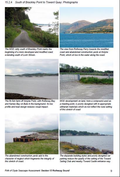
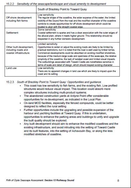
14 Outputs of the coastal character assessment 4.14 Irrespective of the scale of characterisation to be the focus of the study, the first step is to establish an overview of the Regional Coastal Character Area. This may encompass a whole Sound or Kyle, inner sea loch or firth and allows a wider contextual description of character and inter-visibility. An example from the Firth of Clyde seascape study is shown as an example in Section 5 of this document. Where relevant, the overview should additionally list the Local Coastal Character Areas which sit within the broader Coastal Character Area If carrying out a more detailed coastal character assessment, description of Local Coastal Character Areas should then follow. A description of key characteristics can be usefully and succinctly listed as bullet points or set in a table Regional Coastal Character Areas and Local Coastal Character Areas should be shown as a simple colour line along the coast on a 1:50,000 scale OS map. Photographs or sketches, annotated if required, are very helpful to illustrate the text. Steep-sided settled loch head Steep-sided outer loch 14
15 5 Examples of coastal characterisation in Scotland Introduction 5.1 Coastal characterisation is being used for a variety of projects within Scotland including SLVIA of marine renewables and coastal development projects, coastal/marine management and capacity studies. Two examples of coastal character studies are included in this section of the document. These comprise a regional scale baseline classification and description of coastal character undertaken by Optimised Environments for the Moray Offshore Renewables Ltd Environmental Statement (2012) and the Seascape/Landscape Assessment of the Firth of Clyde, which is a more detailed coastal character study, prepared by Alison Grant for the Firth of Clyde Forum. Moray Offshore Renewables 5.2 An extract of the baseline coastal character assessment, undertaken as part of the SLVIA of the Telford, Stevenson and MacColl offshore wind farms and transmission infrastructure, is included as an example of a regional scale characterisation study (Appendix A). The extract focuses on Coastal Character Areas 9 to 13 defined along the coasts of Caithness and Sutherland. This was prepared by, and included here with kind permission of Moray Offshore Renewables Ltd / Optimised Environments Ltd (OPEN) Firth of Clyde 5.3 This detailed coastal character study was carried out for the Firth of Clyde Forum in 2013 by Alison Grant, Landscape Architect. It provides a major means of defining and understanding the landscapes and seascapes of the Firth how they relate to one another, how they are experienced and the many influences that shape them. 5.4 The full assessment for Rothesay Sound is given in Appendix A. It demonstrates the range of issues examined at both regional and local assessment scale. Initially, the wider regional context the Coastal Character Area is mapped and described. It shows the firthwide approach, aiming to manage the coastal and marine environment in cross-border areas, looking beyond local authority boundaries. The study classifies and describes Local Coastal Character Areas (LCCA). Key characteristics of each LCCA are set out, together with their inherent sensitivity. Opportunities and guidance for development are then listed. 5.5 Elsewhere, a regional-scale approach is demonstrated in a series of regional studies for the Solway Firth, and for the North Channel as part of the Across the Waters Project. 15

16 Case Studies: Moray Offshore Renewables Baseline Coastal Character Areas 16
17 Case Studies Moray Offshore Renewables Ltd Environmental Statement Extract from Chapter 11 SLVIA baseline Coastal Character Areas (CCA) 9-13 CCA 9: Sinclair s Bay Maritime Influences Coastline curves giving east and south east aspects Dynamic coastal influences associated with migration of sand and constantly changing character of the sea and passing weather systems. Metamorphic stone on the beach implies glacial till deposition. Low level of shipping in coastal waters with some recreational sailing. Shipping is a common feature seen further out to sea on the horizon. Water based recreational beach activities e.g. surfing Strongly affected by the northern coastal light. Inter-tidal zone is fairly narrow widening form 150m to 300m. Shape of bay influenced by rock formations to the north and south and the interaction of water which is deep at the south and less deep at the north. The south limb thus acts as a giant groyne. Character of coastal edge Bay sweeps south in a long elliptical curve, past Castle Sinclair and terminating at Noss Head Cliffs are sheet further north, but to the south of Keiss, large white sandy beach and dunes form coastal edge, before a series of cliffs and crags further east around Noss Head. Wide open space and exposure to the sea. There is a strong horizontal emphasis Beach is an important recreational resource Keiss Castle creates prominent focal point feature in the horizontal landscape Subtle interlocking of dunes creating low pockets of semi-enclosure. Pipeline fabrication works interrupts the centre of the bay and extends inland across Keiss Links. Character of immediate hinterland The A99 passes parallel to coast while the small village of Keiss lies to the north of the area. Sand dunes with underlying shingle spit. Inland from the main dune zone extends an area of blown sand, triangular in shape and tapering towards the southern end where is becomes very narrow. The coastal edge is backed by agricultural land - species diversity increases inland. Wildness/Isolated coast Although exposed, built features including the main road, pipeline fabrication works and dwellings limit the sense of wildness likely to be experienced. Some illumination at night from small crofts and properties around Keiss and lighthouse at Noss Head. 17
18 CCA 10: Noss Head Maritime influences Strongly affected by the northern coastal light Coastal headland orientated to the north and to the east which defines Sinclair s Bay. Low level of shipping in coastal waters with some recreational sailing. Shipping is a common feature seen further out to sea on the horizon. Water based recreational beach activities such as surfing. Character of coastal edge Sandstone cliffs eroded into angular blocks with small bays at their base. Stacks, caves and collapsed cliffs. Strong contrast between verticality of cliffs and wide horizon of sea. Lighthouse at Noss Head and remains of Castle Sinclair Girnigoes are prominent features. Visitor parking and cliff top paths allow access for walkers to experience views from Noss Head. Character of immediate hinterland. Open intensive farmland with ordered, regularly shaped fields and scattered farm dwellings. A horizontal landscape with few vertical features and a high degree of exposure. Areas of semi-natural rough grassland at Noss Head. Wick airport located in the flat expanse of this area with associated visual and aural disturbance. Wildness/isolated coast Rugged, inaccessible coastal cliff terrain. Cultivated fields, farm dwellings, lighthouse and airport limit sense of wildness likely to be experienced. Some illumination at night from Wick and Wick airport, distant Beatrice Oil Platform flarestack wind turbines, visible alongside lighthouse at Noss Head and distant views of lights on the Moray coast. CCA 11: Wick Bay Maritime influences Rugged, coastal cliff terrain to north and south of the area and bay area where the Wick River discharges into the North Sea. Harbour in the bay area with fishing vessels and maritime activity. Inward looking views across the bay and towards headlands with main orientation to the east and south east away from Wick Bay. Character of coastal edge Built town environment creating hard edge with water in Wick harbour with vertical cliffs to north and south and distinctive bays in south. Local coastal roads cutting into and through hills adjoining the coast. Castle of Old Wick prominent ruin and coastal landmark. Character of immediate hinterland Cultivated fields with improved and semi-improved grassland. 18
19 Residential gardens and industrial areas in Wick. Rough grassland areas adjacent to the coastline in the north of the area. Sense of containment within the town with open views where there is less dense housing at Staxigoe and small farm holdings in Old Wick. Wildness/isolated coast Coastline is generally very accessible in this area with many manmade elements in Wick. The built environment is dominant and detracts from the sense of remoteness/wildness. Vertical cliffs have created inaccessible bays in places. Extensive illumination at night from immediate town and harbor. Distant Beatrice Oil Platform flarestack and wind turbines along with distant views of lights on Moray coast. CCA 12 Sarclet Head Maritime Influences Broad convex headland with south east orientation towards the sea. Dynamic coastal influences and processes under continual force from the sea. Small harbours once gave a safe haven for fishing boats Low level of shipping parallel to coast and some recreational sailing. Shipping is a common feature seen further out to sea on the horizon. Strong maritime connection with settlements and agricultural land use patterns. Beatrice platform and wind turbines visible out to sea. Character of coastal edge Rocky coastline with open sea views, vertical cliffs and small enclosed bays/harbours. Stacks, caves and cliffs with strong contrast between the verticality of cliffs and wide horizon of sea. Some recreational/visitor opportunity in places, such as Sarclet Haven and Whaligoe Steps. Exposed coastline with open views and strong historical associations of castles and cliffs top forts and cultural interest of fishing villages. Character of immediate hinterland Scattered small farms and crofts adjacent to the coast, occasionally concentrated to form crafting settlements such as Ulbster and Thrumster. Rough open grassland with gorse scrub in places and small lochs. A99 runs parallel to coastline. Settlements and built features appear at even intervals and provide a visual rhythm of foci along coast. Wildness/isolated coast Although it is exposed, built features including the main road and settlements limit the sense of wildness experienced. 19
20 CA 13: Lybster Bay The coastal edge is mainly inaccessible due to vertical cliff faces. Some illumination at night with Beatrice Oil Platform flarestack and existing turbines visible alongside lighthouses and distant views of lights on the Moray coast. Maritime influences Broad, shallowly concave bay with a mainly south east orientation. Dynamic coastal influences and processes under continual force from the sea. Small harbour in Lybster Bay with fishing vessels. Low level of shipping parallel to coast and some recreational sailing. Shipping is a common features seen further out to sea on the horizon. Sea more distant from elevation and less immediate due to undulating coastal edge. Character of coastal edge Rocky, undulating coastline with indentations, stacks and small enclosed bays. Lybster Bay formed from confluence of Reisgill Burn and the North Sea. Character of immediate hinterland Scattered small farms and crofts with open fields. Rough open grassland with gorse and scrub in places. A99 runs parallel to coastline. Wildness/isolated coast Although it is exposed, built features including the main road, transmission lines and dwellings limit the sense of wildness likely to be experienced. Some areas are inaccessible due to the presence of vertical cliff faces. 20

21 21


22 22

23 23
24 Appendix A: Glossary of common terms Coastal Character Area Coastal zone Intertidal Landscape capacity Landscape character Coastal character types LCA LVIA Seascape SLVIA A Coastal Character Area is a distinct, recognisable, geographical area which has a consistent overall character. Coastal character can be identified at different scales: Regional CCA at a strategic level (e.g. a loch within a larger system, a stretch of coastline or a whole island) or Local (shorter stretches of coast or shore). The space in which land-based activities and terrestrial environments influence the marine environment and vice versa (Hiscock, 1996) but there is no universally recognized definition for the coastal zone. Pragmatically, the seaward boundary to the coastal zone is usually set by the limits of enabling legislation. For the purposes of assessing offshore renewables the coastal zone is taken to be the area confined to Scottish Territorial Waters i.e. 12 nautical miles (22.22 km) offshore. The foreshore or area of seabed between high water mark and low water mark which is exposed each day as the tide rises and falls. The degree to which a particular landscape character type or area is able to accommodate change without significant effects on its character, or overall change of landscape character type. Capacity is likely to vary according to the type and nature of change being proposed. (Swanwick et al, 2002) A distinct, recognisable and consistent pattern of elements in the landscape that makes one landscape different from another (Swanwick et al, 2002, p 8). A distinct type of landscape, relatively homogenous in character. They are generic in nature and may occur and reoccur in different places. In Scotland, only the national level of coastal characterisation consists of character types. (based on GLVIA3) Landscape character assessment, a documented process which describes and categorises the landscape, highlighting key landscape characteristics. This process may include analysis of potential for change to occur to landscapes and their sensitivity to these changes. Landscape and Visual Impact Assessment a standard process for examining the likely landscape and visual effects of a development. An area, as perceived by people, from land, sea or air, where the sea is a key element of the physical environment (European Landscape Convention). It comprises the visual and physical conjunction of land and sea which combines maritime, coast and hinterland character (Grant, 2005) Seascape, Landscape and Visual Impact Assessment. The accepted methodology underpinning SLVIA is that of LVIA (see LVIA) 24
25 Appendix B: References David Tyldesley and Associates, (1998). Analysis of National Landscape Character Types in Scotland. SNH Unpublished report. Grant, A. (2001). Marine Aquaculture and the Landscape: The siting and design of marine aquaculture developments in the landscape. Scottish Natural Heritage, the Crown Estate and Scottish Quality Salmon. Grant, A. (2006). Landscape/seascape carrying capacity for aquaculture. Scottish Natural Heritage Commissioned Report No. 215 (ROAME No. F04NC12) Grant, A. for the Firth of Clyde Forum (2013) Landscape/Seascape Assessment of the Firth of Clyde. Hill, M., Briggs, J., Minto, P., Bagnall, D., Foley, K., and Williams, A. (2001). Guide to Best Practice in Seascape Assessment. Maritime Ireland / Wales INTERREG Guide to Best Practice in Seascape Assessment Countryside Council for Wales, Brady Shipman Martin and University College Dublin, (2001), for CCW. Hiscock, K. (1996). MarLIN Glossary. Lockwood, S.J. (2002). A Glossary of Marine Nature and Fisheries. Joint Nature Conservation Committee. Natural England (2012) An approach to Seascape Character Assessment. (NECR 105) Scott, K.E., Anderson, C., Dunsford, H., Benson, J.F. and MacFarlane, R. (2005). An assessment of the sensitivity and capacity of the Scottish seascape in relation to offshore windfarms. Scottish Natural Heritage Commissioned Report No.103 (ROAME No. F03AA06). Scottish Natural Heritage (2008). Guidance on Landscape/Seascape Capacity for Aquaculture. Natural Heritage Management. Scottish Natural Heritage (2012). Offshore Renewables guidance on assessing the impact on coastal landscape and seascape. Guidance for Scoping an Environmental assessment. Swanwick, C, Department of the University of Sheffield and Land Use Consultants on behalf of the Countryside Agency and Scottish Natural Heritage (2002). Landscape Character Assessment: Guidance for England and Scotland Wildlife and Countryside Link Task Force, Scottish Environment LINK Marine Task Force, Northern Ireland Marine Task Force and Wales Environment Link Marine Working Group. Across the waters. Implementation of the UK Marine and Coastal Access Act and devolved marine legislation: cross-border case studies. The North Channel. December Wildlife and Countryside Link Task Force, Scottish Environment LINK Marine Task Force, Northern Ireland Marine Task Force and Wales Environment Link Marine Working Group. Across the waters. Implementation of the UK Marine and Coastal Access Act and devolved marine legislation: cross-border case studies. The Solway Firth. December
Assessment of Landscape, Visual and Natural Character Effects
 Assessment of Landscape, Visual and Natural Character Effects Consent Footprint Amendments Mangamaunu Half Moon Bay Okiwi Bay South Report prepared for: New Zealand Transport Agency and KiwiRail Holdings
Guidance on Landscape/Seascape Capacity for Aquaculture
 Scottish Natural Heritage is a government body responsible to Scottish Government Ministers, and through them to the Scottish Parliament. Our mission Working with Scotland s people to care for our natural
Visualisations for aquaculture
 Scottish Natural Heritage Visualisations for aquaculture Draft Guidance Note draft 1 Contents Section 1 1 Summary of recommendations 1 Section 2 4 Introduction 4 Landscape and Visual Impact Assessment
LANDSCAPE UNIT 10 Te Kawau, Turipeka & Otautu Point
 Location Map LANDSCAPE VALUES Landscape Unit No. 10 Description: Te Kawau, Turipeka, & Otautu Point KEY LANDSCAPE FACTORS / VARIABLES LANDSCAPE UNIT 10 Te Kawau, Turipeka & Otautu Point LEGEND Outstanding
SHORELINE, FLOOD AND COASTAL DEFENCE MANAGEMENT PLANS
 These plans may provide opportunities as well as concern for recreational boating. They are currently being revised and consulted on. This document explains how we can engage in the process. Shoreline,
7. The Landscape. 7.1 Introduction. Environmental Impact Statement (EIS) Scoping Report
 Scoping Report") 7. The Landscape 7.1 Introduction The purpose of this section of the EIS Scoping Report is to describe the scope of work and methods to be applied in the identification and assessment of landscape and
7. The Landscape 7.1 Introduction The purpose of this section of the EIS Scoping Report is to describe the scope of work and methods to be applied in the identification and assessment of landscape and
Seascape, Landscape and Visual Impact Assessment
 Page 107 of 370 Seascape, Landscape and Visual Impact Assessment Chapter 17 Page 108 of 370 17 SEASCAPE, LANDSCAPE AND VISUAL IMPACT ASSESSMENT 17.1 INTRODUCTION This chapter of the Environmental Statement
LANDSCAPE CHARACTER ASSESSMENT
 THE COUNTY DURHAM LANDSCAPE CHARACTER ASSESSMENT FOREWORD The landscape of County Durham is one of great contrast and diversity. From the North Pennines in the west to the Durham Coast in the east it contains
Northland Regional Landscape Assessment Worksheet
 Northland Regional Landscape Assessment Worksheet Unit name TE POUAHI HEADLAND DESCRIPTION AND CHARACTERISATION Component Land Types (refer to list overleaf) Dune complex Coastal cliffs / escarpment Reefs
TOPIC PAPER 2: Links to other sustainability tools
 TOPIC PAPER 2: INTRODUCTION 1.1 Landscape Character Assessment can inform a range of other sustainability tools and methodologies. Equally these other tools may assist in reaching decisions concerning
LANDMAP Methodology Overview
 LANDMAP Methodology Overview June 2017 Jill Bullen, Senior Landscape Specialist jill.bullen@cyfoethnaturiolcymru.gov.uk 0300 065 4706 (Please note this is an information document and not a training presentation)
Definition of Cumulative Landscape and Visual Effects
 SECTION 5: GUIDANCE FOR ASSESSING CUMULATIVE LANDSCAPE AND VISUAL EFFECTS 5.1 Although this landscape sensitivity and capacity study has identified that parts of the National Park may be able to accommodate
Appendix 9.D: Additional Landscape Character Survey Sheets
 9D1 Appendix 9.D: Character Survey Sheets 9.1 Introduction 9.1.1 A further five additional Character Survey Sheets have been provided in addition to those provided in the ES. The Character Survey Sheets
3. Highway Landscaping Assessment
 Guidelines for Highway Landscaping 3-1 3. Highway Landscaping Assessment 3.1 Introduction This section outlines the steps necessary to assess the highway landscaping component of a state highway construction
Cotswolds AONB Landscape Strategy and Guidelines. June 2016
 Cotswolds AONB Landscape Strategy and Guidelines June 2016 Cotswolds AONB Landscape Strategy and Guidelines Introduction The evolution of the landscape of the Cotswolds AONB is a result of the interaction
xxxxxx xxxxxx Environmental Statement Chapter 13. Seascape Landscape and Visual Impact Assessment
 xxxxxx xxxxxx Environmental Statement Chapter 13. Seascape Landscape and Visual Impact Assessment www.tidallagoonswanseabay.com www.tidallagoonswanseabay.com Contents 13.0 Seascape & Landscape Visual Impact
The Initiative Landscape Character Assessment as a tool for the Conservation of Natural Values in the Eastern Mediterranean
 The Initiative Landscape Character Assessment as a tool for the Conservation of Natural Values in the Eastern Mediterranean Sixteenth Council of Europe Meeting of the Workshops for the Implementation of
Scottish Natural Heritage consultation on draft guidance: Assessing impacts on Wild Land Areas technical guidance
 Scottish Natural Heritage consultation on draft guidance: Assessing impacts on Wild Land Areas technical guidance Summary This consultation invites comment on the draft document Assessing impacts on Wild
Guidance for Wind Turbine Development in the Dorset AONB
 Photo 1: Rew Manor Farm, West Dorset, chalk downland landscape (Planning application ref: 1/D/09/001280 1 ) Scale & siting: 12m to hub / 16m to blade tip. A well sited small scale turbine, grouped with
Lower Sensitivity. VS Classification Level 2: Hills, Lower Plateau & Scarp Slopes (74%)/ Lowland Valleys (17%) / Exposed Upland/Plateau (7%)
/ Lowland Valleys (17%) / Exposed Upland/Plateau (7%)") S06 Coedwig Gwydyr Reproduced from the Ordnance Survey map with the permission of Ordnance Survey on behalf of the Controller of Her Majesty s Stationery Office, Crown copyright Licence No. 100023387 Location
S06 Coedwig Gwydyr Reproduced from the Ordnance Survey map with the permission of Ordnance Survey on behalf of the Controller of Her Majesty s Stationery Office, Crown copyright Licence No. 100023387 Location
Guidance for Wind Turbine Development in the Dorset Area of Outstanding Natural Beauty
 DRAFT January 2012 Guidance for Wind Turbine Development in the Dorset Area of Outstanding Natural Beauty Photo 1: Rew Manor Farm, West Dorset, chalk downland landscape (Planning application ref: 1/D/09/001280
Wind energy development in the South Pennines landscape
 Wind energy development in the South Pennines landscape Programme for today Background Policy context South Pennines landscape Impacts of wind energy development The South Pennines Wind Energy Landscape
Seascapes and Marine Planning in Wales
 Wales Landscape Partnership Seascapes and Marine Planning in Wales Synopsis of technical Seminar The Future Inn, Cardiff Bay Tuesday 25 th March 2014 Seascapes and Marine Planning in Wales Page 1 SEASCAPES
CA.1 Coastal Area. Index. CA.1.1 Description and Expectations
 Index.1.2.3.4 CA.2 CA.2.1 CA.2.2 CA.2.3 CA.3 CA.3.1 CA.3.2 CA.3.1 CA.4 CA.4.1 CA.4.2 CA.4.3 CA.4.4 CA.5 CA.5.1 CA.5.2 Description and Expectations Objectives Policies Guidance Note Landuse Eligibility
Apply scoring methodology
 1 Assessment of Alternatives The purpose of this assessment is to evaluate runway options against a range of environmental criteria. The first step is to formulate evaluation criteria necessary to understand
LANDSCAPE GUIDELINES. Countryside & Coastal Countryside Environments. Landscape, Natural Character & Amenity Values Guide
 Landscape, Natural Character & Amenity Values Guide Copyright WDC 2009 Version A2 18May09 Environmental Services Group Publication Countryside & Coastal Countryside Environments START HERE Quality Land
3. Neighbourhood Plans and Strategic Environmental Assessment
 1. Introduction This report sets out a draft Screening Determination for the Preston Parish Council s Neighbourhood Plan and has been prepared by rth Hertfordshire District Council. The purpose of the
- - - Key Characteristics
 S23 Dyffryn Dysynni Reproduced from the Ordnance Survey map with the permission of Ordnance Survey on behalf of the Controller of Her Majesty s Stationery Office, Crown copyright Licence No. 100023387
3.1 This evidence is based on the landscape and visual impact assessment included in Chapter 10 and Appendix I of the EIS.
 LANDSCAPE & VISUAL 1 QUALIFICATIONS AND EXPERIENCE 1.1 My name is Raymond Holbeach and I am a Regional Director for RPS Planning & Environment with full responsibility for management of the RPS Belfast
STATEMENT OF OBJECTION TO THE PROPOSED DEVELOPMENT OF LAND AT CHURCH CLIFF DRIVE FILEY
 STATEMENT OF OBJECTION TO THE PROPOSED DEVELOPMENT OF LAND AT CHURCH CLIFF DRIVE FILEY You will be aware that Scarborough borough council have adopted a new local plan that includes land at Church Cliff
PETERHEAD PORT AUTHORITY ENVIRONMENTAL STATEMENT. Non-Technical Document
 PETERHEAD PORT AUTHORITY ENVIRONMENTAL STATEMENT Document No 5357/04 Rev FINAL Issued January 2015 West Pier Peterhead Aberdeen AB42 1DW Niras Fraenkel Ltd Merlin House Mossland Road Hillington Park Glasgow
Appendix One. Landscape. Areas of Outstanding Landscape Value: Criteria for Selection. Landscape Character
 Areas of Outstanding Value: Criteria for Selection The dimensions of landscape are landscape character and landscape quality. The analysis of landscape character and quality draws heavily on the visual
Landscape considerations in Forests & Woodlands. Jill Bullen, Senior Landscape Specialist
 Landscape considerations in Forests & Woodlands Jill Bullen, Senior Landscape Specialist UK Forestry Standard (UKFS) Sustainable forest management Landscape sub-section (S6.4, page 96) Standards and requirements
Visual Impact Rating Form - Instructions
 Visual Impact Rating Form Instructions Project Name: Baron Winds Project EDR Project No: 13039 Date: 05.16.17 Reference: Visual Impact Rating Form - Instructions These instructions are intended to guide
Lower Sensitivity. VS Classification Level 2: Exposed Upland/Plateau
 S04 Moel Hebog Reproduced from the Ordnance Survey map with the permission of Ordnance Survey on behalf of the Controller of Her Majesty s Stationery Office, Crown copyright Licence No. 100023387 Location
MAKING SENSE OF PLACE
 MAKING SENSE OF PLACE Landscape Character Assessment Summary Guidance for England and Scotland MAKING SENSE OF PLACE People can welcome development if it is well designed and contributes to quality of
9 Archaeology & Cultural Heritage
 High Clachaig Wind Farm Scoping Report Page 56 9 Archaeology & Cultural Heritage 9.1 Introduction Cultural heritage in this context means the above- and below-ground archaeological resources, built heritage,
6. THE COAST POLICY INDEX
 6. THE COAST POLICY INDEX LP/C1 Development within the Coastal Zone Page 90 LP/C2 Piers & Harbours Page 92 LP/C3 Fish Farms Page 94 LP/C4 Coastal Erosion Page 96 THE ORKNEY LOCAL PLAN - Coastal Policies
Night-time Lighting Assessment. Brian Denney, Environmental Planning Director Pegasus Group
 Brian Denney, Environmental Planning Director Pegasus Group Contents: Introduction; Key Landscape and Visual Issues: Need For The Consideration Of Landscape And Visual Effects; Siting and Design Wind
Landscape Character Assessment. TOPIC PAPER 6: Techniques and Criteria for Judging Capacity and Sensitivity
 Character Assessment Guidance for England and Scotland TOPIC PAPER 6: Techniques and Criteria for Judging Capacity and Sensitivity An exploration of current thinking about landscape sensitivity and landscape
Balcombe Neighbourhood Plan. Habitats Regulations Assessment Screening Report
 Balcombe Neighbourhood Plan Habitats Regulations Assessment Screening Report Produced for Regulation 14 of the Neighbourhood Planning (General) Regulations 2012 17 th July 2015 1.0 Introduction 1.1 This
Assessing the impact of smallscale wind energy proposals on the natural heritage
 Scottish Natural Heritage Assessing the impact of smallscale wind energy proposals on the natural heritage Guidance March 2016 Version 3 1 Contents 1. Introduction. 3 2. Encouraging a spatial approach
Sunshine Coast Council Coastal Management Overview. January 2016 edition
 Sunshine Coast Council Coastal Management Overview January 2016 edition Mayor Mark Jamieson Mayor s foreword Our impressive beaches are fundamental to our Sunshine Coast lifestyle, economy and coastal
Severn Estuary Shoreline Management Plan What does it mean for planning in North Somerset?
 Severn Estuary Shoreline Management Plan What does it mean for planning in North Somerset? Coastal planning The National Planning Policy Framework sets out the Government s planning policies for England.
Introduction. Who we are. Purpose of this public consultation
 Introduction Who we are Purpose of this public consultation SHE Transmission are proposing to submit a planning application for our proposed Development of a High Voltage Direct Current Switching Station
Caithness HVDC Switching Station Pre Application Consultation Event. August 2016
 Caithness HVDC Switching Station Pre Application Consultation Event August 2016 Introduction Who we are Purpose of this public consultation Other SSE Businesses SHE Transmission are proposing to submit
Examination of South Cambridgeshire Local Plan
 Matter SC6A - Policy SS/5 Waterbeach New Town Historic England( formerly English Heritage) 874 Rep Nos 59748, 60250, 60253 Examination of South Cambridgeshire Local Plan Historic England, Hearing Statement
Lower Sensitivity. VS Classification Level 2: Exposed Upland/Plateau
 S05 Y Moelwynion Reproduced from the Ordnance Survey map with the permission of Ordnance Survey on behalf of the Controller of Her Majesty s Stationery Office, Crown copyright Licence No. 100023387 Location
Lower Sensitivity. VS Classification Level 2: Exposed Upland/Plateau (86%)/ Upland Valleys (10%)
/ Upland Valleys (10%)") S09 Y Mignient Reproduced from the Ordnance Survey map with the permission of Ordnance Survey on behalf of the Controller of Her Majesty s Stationery Office, Crown copyright Licence No. 100023387 Location
S09 Y Mignient Reproduced from the Ordnance Survey map with the permission of Ordnance Survey on behalf of the Controller of Her Majesty s Stationery Office, Crown copyright Licence No. 100023387 Location
Suffolk Coast & Heaths AONB Boundary Variation Project
 Suffolk Coast & Heaths AONB Boundary Variation Project 24 September 2014, David Vose, Jonathan Dix Background The project to formally consider a variation to the boundary of the SC&H AONB boundary www.naturalengland.org.uk
Appendix A. Planning Processes. Introduction
 1 Planning Processes Introduction This appendix outlines a number of planning processes which are used in the Auckland Region to support the effective management of development in the region s rural and
CAIRNGORMS NATIONAL PARK AUTHORITY
 Title: Prepared by: CONSULTATION FROM ANGUS COUNCIL KATHERINE DONNACHIE, PLANNING OFFICER (DEVELOPMENT MANAGEMENT) DEVELOPMENT PROPOSED: (1) ERECTION OF GAIA TURBINE OF 18 M. HUB HEIGHT AND 23.5 M. TO
Garden Bridge Planning Application
 Planning Application Additional Verified photomontages and assessment September 2014 Contents Page 1 Visual assessment 2 1.1 Introduction 2 1.2 Baseline 2 1.3 Potential effects and good environmental
S08 Dyffryn Y Ddwyryd
 S08 Dyffryn Y Ddwyryd Reproduced from the Ordnance Survey map with the permission of Ordnance Survey on behalf of the Controller of Her Majesty s Stationery Office, Crown copyright Licence No. 100023387
GREEN INFRASTRUCTURE PLANNING GUIDE
 GREEN INFRASTRUCTURE PLANNING GUIDE Authors: C Davies, R MacFarlane, C McGloin, MRoe. Abbreviation Green Infrastructure is frequently abbreviated to as GI and Green Infrastructure Planning as GIP. Contents
Chapter 3: Natural Environment. Proposed Waikato District Plan Stage 1. (Notified version)
") Chapter 3: Natural Environment Proposed Waikato District Plan Stage 1 Page 2 of 7 Contents Chapter 3: Natural Environment... 3 3.1 Indigenous Vegetation and Habitats... 3 3.1.1 Objective Biodiversity and
Chapter 3: Natural Environment Proposed Waikato District Plan Stage 1 Page 2 of 7 Contents Chapter 3: Natural Environment... 3 3.1 Indigenous Vegetation and Habitats... 3 3.1.1 Objective Biodiversity and
6B.1 INTRODUCTION B.1.1 Background B.1.2 Purpose of the Study... 2
 CONTENTS 6B.1 INTRODUCTION... 1 6B.1.1 Background... 1 6B.1.2 Purpose of the Study... 2 6B.2 STUDY METHODOLOGY... 3 6B.2.1 Approach... 3 6B.2.2 Collation of Baseline... 3 6B.2.3 Consultation... 4 6B.2.4
Environmental Assessment (Scotland) Act 2005: Clackmannanshire Council Sustainability Strategy Scoping Request
 Act 2005: Clackmannanshire Council Sustainability Strategy Scoping Request") TAYSIDE & CLACKMANNANSHIRE Tel: 01738 458582(direct line) Fax: 01738 458616 e-mail addresses: denise.reed@snh.gov.uk Niall Urquhart Team Leader Sustainability Clackmannanshire Council Kilncraigs Greenside
TAYSIDE & CLACKMANNANSHIRE Tel: 01738 458582(direct line) Fax: 01738 458616 e-mail addresses: denise.reed@snh.gov.uk Niall Urquhart Team Leader Sustainability Clackmannanshire Council Kilncraigs Greenside
Written Representation by the National Trust Interested Party No:
 Written Representation by the National Trust Interested Party No: 10028761 Introduction The National Trust, established over 115 years ago, is a leading conservation charity with over 4 million members.
Evidence-based Assessment of Natural Character
 Evidence-based Assessment of Natural Character RMLA Waikato Branch 07 Sept 2016 Michael Steven Landscape Architect/Landscape Planner Pohara, Golden Bay 1 The key issue. The adequacy of landscape & natural
Seascape, Landscape and Visual Impacts
 Chapter 21 Seascape, Landscape and Visual Impacts 21.1 Introduction 1 This chapter summarises the findings of the seascape, landscape and visual impact assessment (SLVIA). The SLVIA is included in full
Policy DM19: Development and Nature Conservation
 Avonmouth Wetland Habitat Project October 2010 and December 2011 (the Cresswell study). Policy Links Bristol Local Plan Core Strategy Lead Policy BCS4: Avonmouth and Bristol Port BCS9: Green Infrastructure
City of Rockingham. Local Management Practices, Costs and Strategic Coastal Planning
 City of Rockingham Local Management Practices, Costs and Strategic Coastal Planning Decision Making Process Considerations Climate Change Response Action Plan Ongoing observations/major Storm events Ongoing
National Character Area 70 Melbourne Parklands
 Summary The are a landscape of rolling farmland, parkland and woodland on the northern flanks of the ridge between Burton upon Trent and Swadlincote. The land slopes down to the River Trent, which borders
Tāhuhu whakaruruhau ā-taone The sheltering ridge pole
 B2. Tāhuhu whakaruruhau ā-taone - Urban growth and form B2.1. Issues Tāhuhu whakaruruhau ā-taone The sheltering ridge pole Auckland s growing population increases demand for housing, employment, business,
Section 32 report: Natural heritage for the Proposed Natural Resources Plan for the Wellington Region
 Section 32 report: Natural heritage for the Proposed Natural Resources Plan for the Wellington Region Issues and Evaluation Report Section 32 report: Natural heritage for the Proposed Natural Resources
Northland Regional Landscape Assessment Worksheet
 Northland Regional Landscape Assessment Worksheet DESCRIPTION AND CHARACTERISATION Component Land Types (refer to list overleaf) Coastal cliffs / escarpment Bays and headlands Dune complex Beach Reefs
Section 3b: Objectives and Policies Rural Environment Updated 19 November 2010
 Page 1 of Section 3b 3b RURAL ENVIRONMENT 3b.1 Introduction The Rural Environment comprises all the land outside of the Residential, Town Centre and Industrial Environments. Most land within the District
Guide to Best Practice in Seascape Assessment
 Maritime Ireland / Wales INTERREG 1994-1999 Guide to Best Practice in Seascape Assessment March 2001 Photo: J Briggs Point Lynas M. Hill, J. Briggs, P. Minto, D. Bagnall, K. Foley, A. Williams Countryside
Gather information from online resources covering the following topics:
 Assignment #1: Regional Analysis Project Site Location: Greater Boston Area What comprises a region? The many elements within a region comprise the region as a whole. Natural as well as manmade environmental
PART 05 VISUAL SETTING
 PART 05 VISUAL SETTING 5.1 How to use the Visual Settings 5.2 Views from the Headland 5.3 Creek Foreshore Park Looking North 5.4 Bridge looking North 5.5 Bridge looking West 5.6 Bridge looking South 5.7
Tables of Criteria and Matrices for Landscape Assessment (LSCA & LVIA)
") Carly Tinkler CMLI Environmental, Landscape and Colour Consultancy 46 Jamaica Road, Malvern, Worcestershire WR14 1TU Tel +44 (0)7711 538854 carlytinkler@hotmail.co.uk Tables of Criteria and Matrices for
Carly Tinkler CMLI Environmental, Landscape and Colour Consultancy 46 Jamaica Road, Malvern, Worcestershire WR14 1TU Tel +44 (0)7711 538854 carlytinkler@hotmail.co.uk Tables of Criteria and Matrices for
Caithness HVDC Switching Station Consultation
 Caithness HVDC Switching Station Consultation March 2016 Aberdeen Who are we? Building the North s future energy network The north of Scotland s electricity network is currently seeing the most sustained
Review of East Dunbartonshire Local Landscape Areas, A Light Touch Review
 Review of East Dunbartonshire Local Landscape Areas, A Light Touch Review Local Landscape Area (LLA) Review in Local Development Plan Process 2011 - SNH advise existing landscape designations are reviewed
Coastal hazard assessments in Victoria
 Coastal hazard assessments in Victoria Viktor Brenners viktor.brenners@delwp.vic.gov.au Future Coasts program 4 year program established in 2007. Outputs included: Coastal Digital Elevation Models Victorian
7. Landscape. Introduction
 Introduction Our landscapes provide us with a Marlborough identity and are an integral part of the Marlborough environment. Landscapes are distinct spatial areas influenced by location-specific processes
coastal plain coastal plain
 NORFOLK O R F O L K COAST C O A SAONB T A O NIntegrated B I n t elandscape g r a t e d L Guidance a n d s c a p e G u i d a n c e 1 Integrated landscape character MAP 23a - Coastal Plain Key Plan This
Proposal to designate the Queen of Sweden Historic Marine Protected Area - Partial Business Regulatory Impact Assessment (BRIA)
") Proposal to designate the Queen of Sweden Historic Marine Protected Area - Partial Business Regulatory Impact Assessment (BRIA) Title of Proposal Designating an area of the Scottish territorial seas as
Proposal to designate the Queen of Sweden Historic Marine Protected Area - Partial Business Regulatory Impact Assessment (BRIA) Title of Proposal Designating an area of the Scottish territorial seas as
Design Guidance. Introduction, Approach and Design Principles. Mauritius. November Ministry of Housing and Lands. .. a
 sig evelo r D Mauritius s. Utilities.. Individu a s. er itects.to ls chpers.po e Public. T. h rban D Sc U e me Promot e h ners. A Design Guidance o.h Planne rs n w iticians r l useholde National Development
Raewyn Peart. Policy Director Environmental Defence Society
 1 Raewyn Peart Policy Director Environmental Defence Society www.eds.org.nz Coastal Environment Where the sea impacts on the land and the land impacts on the sea 2 www.eds.org.nz Section 6 RMA matters
Managing Change in the Historic Environment. Setting
 Managing Change in the Historic Environment Setting Above: Kilmartin Glen, Argyll and Bute. An important prehistoric linear cemetery composed of a number of burial cairns and standing stones. Intervisibility
Section 6A 6A Purpose of the Natural Features and Landscapes Provisions
 Section 6A 6A Purpose of the Natural Features and Landscapes Provisions This Chapter addresses the protection and management of natural features and landscapes within the City. The City has a number of
Strategic Environmental Assessment Screening Report. Dublin Port Masterplan Review 2017
 Strategic Environmental Assessment Screening Report Dublin Port Masterplan Review 2017 Table of Contents 1 Introduction... 1 2 Purpose of the Masterplan... 2 3 Task 1.1 Pre-Screening Check... 5 4 Task
WALES ONLY INTERIM ADVICE NOTE 135/10 (W) LANDSCAPE AND VISUAL EFFECTS ASSESSMENT
 LANDSCAPE AND VISUAL EFFECTS ASSESSMENT") Interim Advice Note 135/10 (W) Landscape and Visual Effects Assessment INTERIM ADVICE NOTE 135/10 (W) LANDSCAPE AND VISUAL EFFECTS ASSESSMENT WALES ONLY Summary This Interim Advice Note provides instructions
Interim Advice Note 135/10 (W) Landscape and Visual Effects Assessment INTERIM ADVICE NOTE 135/10 (W) LANDSCAPE AND VISUAL EFFECTS ASSESSMENT WALES ONLY Summary This Interim Advice Note provides instructions
Methodology on Functional Linkage between Marine and Terrestrial Areas
 Methodology on Functional Linkage between Marine and Terrestrial Areas prepared within the frame of the project on Coastal and Maritime Spatial Planning in Pärnu Bay Area and Coastal Municipalities of
Landscape Guidelines. Landscape type: Valley Pasture Character areas: Frome Valley Pasture Stour Valley Pasture. Landscape change
 Landscape type: Valley Pasture Character areas: Frome Valley Pasture Stour Valley Pasture The valley pasture landscape type is found along the lower reaches of the Stour and Frome, formed from alluvial
volume 11 environmental assessment section 2 environmental impact assessment Part 7 ha 218/08
 DESIGN MANUAL FOR ROADS AND BRIDGES volume 11 environmental assessment section 2 environmental impact assessment Part 7 ha 218/08 glossary of terms Used in DMRB Volume 11, Sections 1 and 2 SUMMARY This
Understanding Wellington City s DISTRICT PLAN
 Understanding Wellington City s DISTRICT PLAN Wellington City Council 1 UNDERTANDING WELLINGTON CITY S DISTRICT PLAN CONTENTS 1. Introduction...3 1.1. Overview of this Guide...3 1.2. What is the District
Plan Modification to Chapter B2 of the Auckland Unitary Plan(AUP) Operative in part (15 November 2016)
 Operative in part (15 November 2016)") UNITARY PLAN UPDATE REQUEST MEMORANDUM TO FROM Phill Reid Linley Wilkinson DATE 25 September 2018 SUBJECT Plan Modification to Chapter B2 of the Auckland Unitary Plan(AUP) Operative in part (15 November
UNITARY PLAN UPDATE REQUEST MEMORANDUM TO FROM Phill Reid Linley Wilkinson DATE 25 September 2018 SUBJECT Plan Modification to Chapter B2 of the Auckland Unitary Plan(AUP) Operative in part (15 November
A Research Framework for the Archaeology of Wales Version 01, Final Paper Neolithic and Earlier Bronze Age
 NEOLITHIC AND EARLIER BRONZE AGE Introduction The introduction of farming around 4000 BC had a dramatic impact on the landscape of Wales and fundamentally changed they ways in which people lived and interacted.
Master Plan for Preservation and Scenic Conservation (1995)
") 3.2 Master Plan for Preservation and Scenic Conservation (1995) The Master Plan for Preservation and Scenic Conservation was developed under the direction of the Guilford Preservation Alliance in the 1980s
3.2 Master Plan for Preservation and Scenic Conservation (1995) The Master Plan for Preservation and Scenic Conservation was developed under the direction of the Guilford Preservation Alliance in the 1980s
Rolling Wooded Pasture Lulworth Wooded Pasture Rempstone Wooded Pasture
 Landscape type: Character areas: Rolling Wooded Pasture Lulworth Wooded Pasture Rempstone Wooded Pasture The rolling wooded pasture landscape type is found around the margins of the Dorset Heaths. Although
TERMS OF REFERENCE MALASPINA COMPLEX COASTAL PLAN
 TERMS OF REFERENCE MALASPINA COMPLEX COASTAL PLAN A. RATIONALE Land and Water BC, resource user groups and the Powell River Regional District have requested that the Ministry of Sustainable Resource Management
B4. Te tiaki taonga tuku iho - Natural heritage
 B4. Te tiaki taonga tuku iho - Natural heritage Tuia I runga, tuia i raro, tuia ki te waonui a Tiriwa Bind the life forces of heaven and earth to the great realm of Tiriwa B4.1. Issues Auckland s distinctive
Northland Regional Landscape Assessment Worksheet
 Northland Regional Landscape Assessment Worksheet DESCRIPTION AND CHARACTERISATION Component Land Types (refer to list overleaf) Volcanic cones Geology (including geopreservation sites) Soil Types Unit
TOWN AND COUNTRY PLANNING (SCOTLAND) ACT 1997
 ACT 1997") TOWN AND COUNTRY PLANNING (SCOTLAND) ACT 1997 APPEAL AGAINST REFUSAL OF PLANNING PERMISSION FOR CONSTRUCTION OF WIND FARM, CONSISTING OF ERECTION OF 12 NO. WIND TURBINES, HEIGHT OF 70 METRES TO HUB, ASSOCIATED
TOWN AND COUNTRY PLANNING (SCOTLAND) ACT 1997 APPEAL AGAINST REFUSAL OF PLANNING PERMISSION FOR CONSTRUCTION OF WIND FARM, CONSISTING OF ERECTION OF 12 NO. WIND TURBINES, HEIGHT OF 70 METRES TO HUB, ASSOCIATED
A study on the regional landscape planning framework on the relationships between urban and rural areas: case study of Tokachi region, Hokkaido, Japan
 A study on the regional landscape planning framework on the relationships between urban and rural areas: case study of Tokachi region, Hokkaido, Japan K. Yamagishi & H. Kobayashi Laboratory of Urban Planning
North York Moors National Park Authority Planning Committee
 Item 8 North York Moors National Park Authority Planning Committee 12 December 2013 Consultation from Redcar and Cleveland Borough Council on proposed Wind Farm at Bank Field Guisborough 1. Purpose of
Green Networks in Planning Policy and Management
 Promoting green networks in the Lothians & Fife delivering economic, social & ecological benefits in partnership, as part of the Central Scotland Green Network funded by: Green Networks in Planning Policy
Visualisations for aquaculture
 Scottish Natural Heritage Visualisations for aquaculture Guidance Note February 2018 Contents page Introduction 1 Landscape and Visual Impact Assessment 2 Cumulative landscape and visual effects 3 Visualisation