SUSTAINABLE URBANISM & GREEN NETWORKS
|
|
|
- Dayna Hood
- 5 years ago
- Views:
Transcription

1 SUSTAINABLE URBANISM & GREEN NETWORKS
2 SUSTAINABLE URBANISM & GREEN NETWORKS OUTLINE 1. Principles of sustainable urbanism 2. Sustainable urbanism in Vancouver Two Case Studies: 3. Wesbrook Place at UBC 4. Olympic Village in Vancouver

3 PROBLEM: URBAN LIFESTYLES Douglas Farr SUSTAINABLE URBANISM 2007 The American (and Canadian) Dream> single family detached house > sprawl Love affair with the automobile> huge GHG outputs An indoor, mechanically supported lifestyle > nature deficit + obesity Consumer society> acquisition of more and more stuff> larger houses, more waste CLIMATE CHANGE UNSUSTAINABLE ECOLOGICAL FOOTPRINT/ CAPITA OBESITY- A HUMAN HEALTH CRISIS WATER DEPLETION AND POLLUTION MOUNTAINS OF WASTE
4 HEALTH Sedentary lifestyles & lack of exercise Anxiety Cardiovascular disease [15] Migraines Breast & colon cancer Depression Diabetes Gout High blood pressure Skin problems Mortality in adults Obesity Osteoporosis Scoliosis & back problems

5 CLIMATE CHANGE Responding to climate change and our coming energy challenge without a more sustainable form of urbanism will be impossible. Peter Calthorpe 2013

6 Cities contribute 70% of global CO2 emissions. Megacities project megacities.jpl.nasa.gov Image: The Vulcan Project, Purdue University and NASA

7 CLIMATE CHANGE AND CITIES Center city dwellers produce only 25% of CO2 as compared to outer suburb dwellers Metropolitan Transportation Commission 2006 Average weekly CO2 emissions per household, San Francisco area
8 OUTER SUBURBS vs DOWNTOWN in Metro Vancouver Suburbs: 260% more GHGs than downtown dwellers from weekly car trips Annual GHG per household (kg) Edge Suburb 6500 kg Outer suburb Inner suburb First ring suburb Central area 2500 kg Downtown 2000 kg Estimated annual GHG emissions from weekday urban car trips CMHC Travel Tool 2001
9 2011 METRO VANCOUVER TRAVEL TO WORK/SCHOOL 2011 Metro Vancouver Mode Splits Metro Vancouver 11% 14% 16% 57% Pitt Meadows_Maple R 6% 6% 19% 69% Langleys 7% 3% 19% 70% South of Fraser 8% 10% 18% 63% WALK+ BIKE+ TRANSIT 27% 11% Bike Walk Transit Richmond_S Delta Northeast sector Burnaby_New West Vancouver_UEL North Shore 5% 9% 7% 9% 10% 11% 18% 12% 11% 21% 18% 17% 17% 22% 15% 13% 0% 20% 40% 60% 80% 100% 120% 61% 63% 61% 54% 43% 31% 45% 22% Auto Passenger Auto Driver 2011 Metro Vancouver Regional Trip Diary
10 HEALTH 40% 35% 30% 25% 20% 15% 10% 5% 0% ACTIVE TRANSPORTATION RATES V. OBESITY 38% 26% 28% 20% 15% 16% 11% 11% 7% Vancouver North Shore Surrey Walk/cycle- commute Walk/cycle- errands Obesity My Community My Health data haps://

11 SUSTAINABLE URBANISM + WALKABLE NEIGHBOURHOODS

12 COMPLETE COMMUNITIES The Urban Task Force, Australia
 (Tim Roberts Photography Shutterstock) X NOT THIS OLYMPIC VILLAGE, VANCOUVER BC (> 100 people/hectare)")
13 COMPACT COMMUNITIES mixed uses and densities- to support good transit and commercial services ARIZONA SPRAWL (below 35 people/hectare) (Tim Roberts Photography Shutterstock) X NOT THIS OLYMPIC VILLAGE, VANCOUVER BC (> 100 people/hectare) THIS


14 COMPLETE COMMUNITIES jobs, services, schools, parks close to people s homes Low density single family residential X NOT THIS WESBROOK PLACE AT UBC THIS


15 CONNECTED COMMUNITIES street networks that prioritize transit, biking and walking over vehicles X NOT THIS OLYMPIC VILLAGE, VANCOUVER BC THIS


16 ACCESS TO NATURE a 5-10 minute walk from home to urban greenspace SMITH PARK AT WESBROOK PLACE HABITAT ISLAND AT OLYMPIC VILLAGE THIS THIS

17 THEMES: compact, complete & diverse neighborhoods connectivity & accessibility for people reconnect the city s ecological structure working urban forests/ green infrastructure 2005 water health & balance


18 VOCABULARY GREEN GRAY NETWORK FABRIC serving primarily ecological functions serving primarily urban functions spatial corridors and systems residual spaces within networks Villebois, Wilsonville, OR 2003 GRAY FABRIC GRAY NETWORK GREEN NETWORK & FABRIC
19 GRAY FABRIC GRAY NETWORK GREEN NETWORK & FABRIC

20 SUSTAINABLE URBANISM: Vancouver Region GOALS 1. Protect the Green Zone Protect the agricultural land reserve Protect the watershed & ecosystem resources

21 2. Compact Metropolitan Region Growth centers Infill development Compact forms of housing 3. Complete communi\es Jobs, services, recreakon close to residences 4. Transporta\on choices Improving transit Improving bicycle networks Walkable neighborhoods

22 VANCOUVER CASE STUDIES: Wesbrook Place, UBC Southeast False Creek
23 EACH CASE STUDY: Compact community Complete community Connected community Green fabric Green networks

24 WESBROOK PLACE University of British Columbia UBC campus WESBROOK PLACE Pacific Spirit Regional Park UBC Farm

25 UBC CLIMATE ACTION PLAN (2010) Convert to district energy using renewable energy Require green buildings House 50% students on campus Increase family housing near campus 50% of Point Grey residents study or work on campus Both campus and communities- more complete Increase alternate modes of travel to campus

26 UBC - A COMMUTER CAMPUS 12 kilometres from downtown UBC STATS: ~63,000 people per day on campus 12,000 permanent residents on Point Grey* 16% of daytime population live on campus ~10,000 students, faculty, staff live on campus Weekdays: 138,200 trips to/from campus 2 directions= 69,100 More trips than people! * Statistics Canada census

27 WESBROOK PLACE An urban village in the woods Plan completed in 2005 First residents moved in 2008 NOTABLE FOR: A compact, pedestrian-oriented community Adds full time residents to a commuter campus 50% of residents study or work at UBC Green networkoff-street pedestrian paths habitat connections Requires green buildings

28 COMPACT COMMUNITY To UBC High School Community Centre Village Centre Future elementary school


29 COMPACT COMMUNITY SITE: 55.6 ha 6225 units at build-out 12,500 people at completion: 225 people /hectare EMPLOYMENT Primarily at UBC ~ 14,000 faculty and staff >50,000 students

 8 other")
30 COMPLETE COMMUNITY SERVICES Grocery store/pharmacy Liquor store Bank Dentist, eyecare Healthcare Restaurant/pub 7 food services (deli, coffee, fast food) 8 other services


31 COMPLETE COMMUNITY COMMUNITY CENTRE SCHOOLS 1 High school Future elementary school on site DAYCARE 75 daycare spaces on site ~ 750 daycare spaces on UBC campus Top: Community Centre Image by Robert Stefanowicz Bottom: Playground in Smith Park


32 CONNECTED COMMUNITY Fine-grained network Walkable streets Separated greenway network

33 GREEN FABRIC AND GREEN NETWORKS 15 hectares of parks, open spaces 27% of site is green space 4 parks 4 playgrounds Playing fields 100% within 5 minute walk of green space


34 HABITAT/TREE PROTECTION the site before development WESBROOK PLACE 4.6 ha or 10% of site are protected forest buffers


35 HABITAT CONNECTIVITY 1400 trees planted from planted in public spaces ~ 40% of trees are native trees


36 GREEN NETWORKS Pacific Spirit Regional Park Pacific Spirit Regional Park Regionally important habitat areas UBC South Campus Green spaces and networks


37 LOCAL FOOD: UBC FARM CENTRE FOR SUSTAINABLE FOOD SYSTEMS academically rigorous and globally significant research into sustainable and secure food future 24 hectare living laboratory grows over 200 varieties of fruits, vegetables, and herbs Public market every Tuesday & Saturday June to October

38 SOUTHEAST FALSE CREEK Stanley Park Downtown False Creek AKA the Olympic Village
39 HARLAND BARTHOLOMEW PLAN 1928 Proposed pleasure drives system

40 False Cr.

41 City of Vancouver 1995 GREENWAYS PLAN A system of paths for walking and cycling across the city.

42 OLYMPIC VILLAGE

43 OLYMPIC VILLAGE NOTABLE FOR Brownfield redevelopment 2010 Olympics Athletes Village LEED Platinum neighborhood Completing the Seaside Greenway Integrates habitat, water & agriculture

44 COMPACT COMMUNITY BUILD-OUT SITE: 32 hectares ~5500 dwellings 12,000 people GROSS DENSITY= 375 persons/hectare


45 COMPLETE COMMUNITY COMMERCIAL: Full Grocery Store Cafes & Pubs Drug Store Liquor Store Lots of shops CIVIC: Large community center 1 Elementary school 3 big, 8 small daycares 1 religious center Central Square

46 CONNECTED COMMUNITY MULTI-MODAL: Pedestrian Bicycle Bus Streetcar Rapid transit Water ferry Co-op cars TARGET: 60% of all trips to be NON- auto based

47 GREEN FABRIC AND GREEN NETWORKS 32% of the land is reserved for Public Open Space Retail/flex Aerial view of Hinge Park (turned 90º) N


48 PUBLIC WATERFRONT


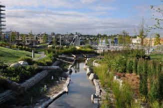
49 HINGE PARK: PARK + PLAYGROUND + HABITAT + GREEN INFRASTRUCTURE


50 HABITAT CREATION Wildlife returning to False Creek Eagles Waterfowl Songbirds Beaver Coyotes River otter Herring Beaver dam and birdhouse in Hinge Park


51 GREEN INFRASTRUCTURE Stormwater wetland Harvest rainwater for irrigation 40% effective impervious area 50% of roofs green 90% Native Plants

52 GREEN NETWORKS City-wide function: The last leg of a 25 km waterfront greenway Connections to adjacent neighborhoods

53 USER STUDY OF PUBLIC SPACES AT OLYMPIC VILLAGE > 7000 people observed over 7 months 437 to 1200 people per hour

54 METHODS- How did we do the research? Video & mapping Tracking + Questionnaires Jan Gehl and Birgitte Svarre, DATE

55
56 Salt Building Square, May 7, :20 pm
57 DOING WHAT? 90% moving 10% staying 66% moving 34% staying 58% moving 42% staying 65% came once/week or more 68% were walking, jogging, cycling, exercising 50% arrived on foot + 18% on bicycles
58 WHY DID THEY COME? 80% of people on the greenway reported coming for the views Most important green features of neighbourhood Most important nature benefits Urban parks 3.64 Breathing fresh air 3.50 View of the ocean/mountains 3.32 Relieving stress 3.50 Presence of tree lined streets 3.00 Enjoying the view 3.15 Community gardens 2.92 Feeling restored 2.90 Private gardens 2.24 Seeing wildlife 2.50 (Most important = 5, least important = 1, scores were scores were weighted averaged)

59
60 BC S SUSTAINABLE URBANISM Sustainable Urbanism: Compact communities Complete communities Connected communities Access to nature + High performance buildings Green infrastructure Green space functions: Social, political activity Day to day human interaction Recreation Connectivity/ Transportation Climate mitigation Wildlife habitat Stormwater management Food production

61 BC S SUSTAINABLE URBANISM
62 QUESTIONS?
Create a connected ecological network. Connect districts with transit. Let the centre define the community
 District A - D Southeast False Creek A 1 A 2 A 3 A 4 Create a connected ecological network Connect districts with transit Let the centre define the community Provide a variety of affordable housing types
Regional Context Statement
 Regional Context Statement REGIONAL CONTEXT STATEMENT 3. REGIONAL CONTEXT STATEMENT In 1995, the Provincial Government passed into law the Growth Strategies Act. The purpose of this provincial initiative
CITY OF LANGLEY OFFICIAL COMMUNITY PLAN BYLAW, 2005, NO APPENDIX II - REGIONAL CONTEXT MAP
 CITY OF LANGLEY OFFICIAL COMMUNITY PLAN BYLAW, 2005, NO. 2600 APPENDIX II - REGIONAL CONTEXT MAP ± Legend Agricultural Mixed Employment Industrial Conservation & Recreation Regional City Centre Urban Containment
Skinny Streets and Green Neighborhoods: Design for Environment and Community By Cynthia Girling and Ronald Kellett INDEX
 Skinny Streets and Green Neighborhoods: Design for Environment and Community By Cynthia Girling and Ronald Kellett INDEX Note: Page numbers in italics indicate illustrations or tables Alleys, 22, 79, 82
Vancouver. Title of the Initiative. Initiative Duration. Submitted by. Comments by the Jury
 134 Vancouver Title of the Initiative Initiative Duration Submitted by Comments by the Jury Visionary Vancouver: Creating a Welcoming and Sustainable Place for All 2009-2020 Wendy Au, Deputy City Manager,
2.0 Regional Context Statement
 2.0 Regional Context Statement REGIONAL CONTEXT STATEMENT Part 10 of the Municipalities Enabling and Validating Act (No.3) (MEVA), requires UBC to include a Regional Context Statement in a Land Use Plan.
Smart Growth Development Checklist
 2004 Smart Growth Development Checklist Smart Growth Development Checklist Corporation of the City of New Westminster Guide and manage growth in a manner which is consistent with the principles of sustainable
UBC URBAN STUDIO, FALL 2002 PEDESTRIAN ORIENTED
 SECTION B PEDESTRIAN ORIENTED PATTERN: CITY OF VANCOUVER B.1 Vision Overview Regional Framework Energy 50% of all energy used within the Region to be produced by the Region. Energy production methods to
CAMBIE CORRIDOR PLAN
 1 WELCOME TO THE OPEN HOUSE PUBLIC REALM PLAN - CAMBIE CORRIDOR Thank you for coming to the Cambie Corridor Public Realm Open House! Place a dot where you live Please provide us with your comments and
Nanaimo OCP Community Consultation
 Nanaimo OCP Community Consultation November 18, 2006 Cheeying Ho, Smart Growth BC Outline Problems with conventional development patterns Smart growth principles Plan Nanaimo 5 goals Progress and areas
1.3 TRANSIT VISION 2040 FROM VISION TO ACTION THEME 1: PUTTING TRANSIT AT THE CENTRE OF COMMUNITIES. Fully integrate transit with community planning
 TRANSIT VISION 2040 FROM VISION TO ACTION TRANSIT VISION 2040 defines a future in which public transit maximizes its contribution to quality of life with benefits that support a vibrant and equitable society,
THE NEIGHBORHOOD TODAY
 THE NEIGHBORHOOD TODAY CORE AREA VISION How are we Good Urbanism A Site s DNA thinking about Elements of great Unique elements urban communities embedded in a place the site and design? ELEMENTS LIKE:
WELCOME and introduction
 1 WELCOME and introduction Mobility Hub Locations within Burlington STUDY OVERVIEW STUDY OBJECTIVES The City of Burlington is developing four Area Specific Plans, one for each of Burlington s Mobility
The River Hub: NEW BUILDINGS
 Summary The River Hub includes 6 municipalities that all boarder the Fraser River. Combined, they are expected to double in population over the next 50 years. To accommodate this new population, 138,831
False Creek South Sustainability
 Green Infrastructure Tree well structure Non-porous asphalt vs porous asphalt Rain garden & infiltration bulge http://www.deeproot.com/blog/blog-entries/silva-cell-stormwater-testing-data-available-fall-2010
CHAPTER 7: Transportation, Mobility and Circulation
 AGLE AREA COMMUNITY Plan CHAPTER 7 CHAPTER 7: Transportation, Mobility and Circulation Transportation, Mobility and Circulation The purpose of the Transportation, Mobility and Circulation Chapter is to
Building out the Regional Growth Strategy in Surrey: a Strong Centre & a Connected Transit City
 Building out the Regional Growth Strategy in Surrey: a Strong Centre & a Connected Transit City Surrey in the Metro Vancouver Region Regional Growth Strategy identifies Surrey as a major provider of housing
CALL TO ACTION: DESIGN FOR WELL BEING. CaGBC National Conference Toronto, ON June 3, 2014
 CALL TO ACTION: DESIGN FOR WELL BEING CaGBC National Conference Toronto, ON June 3, 2014 Health is a state of complete physical, mental and social wellbeing and not merely the absence of disease or infirmity.
Becoming the greenest city in the world by Park Board Planning and Environment Committee September 9, 2010
 Becoming the greenest city in the world by 2020 Park Board Planning and Environment Committee September 9, 2010 IMAGINE 2020. JUST TEN YEARS FROM NOW. VANCOUVER IS THE GREENEST CITY IN THE WORLD. In early
include playgrounds, sports fields, community gardens and picnic areas.
 DEVELOPMENT PLAN OPEN SPACE SYSTEM OPEN SPACE SYSTEM The neighborhood provides for a range of open space types. The Village Square is an important open space in the neighborhood. It serves as a gathering
LEED for Neighborhood Development. A Brief Overview
 LEED for Neighborhood Development A Brief Overview What is LEED ND? LEED for Neighborhood Development First national standard for neighborhood design Developed as a partnership U.S. Green Building Council
June 12, 2012 Our File: O-20/02-II/I Doc#: I.VI. City Manager. General Manager Planning and Development
 CoQuitlam For Council Our File: 13-648O-20/02-II/I Doc#: 126318I.VI To: From: Subject: For: City Manager General Manager Planning and Development Partington Creek Neighbourhood Plan Update Council Recommendations:
Create Policy Options Draft Plan Plan Approval. Public Consultation Events. Phase 2
 Background Grandview-Woodland Community Plan In the spring of 2012, the City of Vancouver embarked on a comprehensive community planning program in the Grandview-Woodland neighbourhood. The process has
Westbound: A One-day Exploration of Growth
 Westbound: A One-day Exploration of Growth Frog Pond Area 2018 UGB Expansion Proposal June 13, 2018 Growing Out: UGB Asks Four cities submitted proposals to expand greater Portland s urban footprint by
SQUAMISH 2010 AND BEYOND COMMUNITY VISION
 Our plan has been imagined and created to be both pragmatic and visionary. At the core of the strategy is a consideration of the highway s role and its impact on the community. First and foremost in creating
Making the Land Use, Transportation, Air Quality Connection
 Special Thanks To Our Generous Sponsor What Happened To Harbor Drive and the Mt. Hood Freeway? Andy Cotugno Metro Policy Advisor 180 days of air quality violations Gas Crisis Making The Pacific the Land
Urban Form Case Studies
 Urban Form Case Studies Elana Horowitz Ontario Growth Secretariat Ministry of Energy and Infrastructure MINISTRY OF ENERGY AND INFRASTRUCTURE 1 Presentation Structure Role of the Ontario Growth Secretariat
WALKING TOUR 1: false creek south east
 WALKING TOUR 1: false creek south east walking tour summary november 25, 2017 WALKING TOUR EAST Participants met in front of Olympic Village station, and walked north along Spyglass Place, passing the
10.0 Open Space and Public Realm
 10.0 Open Space and Public Realm 10.0 Open Space and Public Realm The Public Open Space System is comprised of: outdoor spaces available for public use that are either publicly owned (e.g., parks and
Case studies. B1.1 Lloyds Crossing, Portland (USA)
") B. Case Studies 57 B1 Case studies B1.1 Lloyds Crossing, Portland (USA) Lloyds Crossing in Portland is a brownfields redevelopment site in the central city area, with the aim of: Developing a conceptual
B. Case Studies 57 B1 Case studies B1.1 Lloyds Crossing, Portland (USA) Lloyds Crossing in Portland is a brownfields redevelopment site in the central city area, with the aim of: Developing a conceptual
The Urban Environment
 9 The Urban Environment Overview of Chapter 9 Population and Urbanization Characteristics of Urban Population Urbanization Trends City as an Ecosystem Environmental Problems in Urban Areas Environmental
A revised Planning Justification
 PB-74-16-Appendix 10 October 3, 2016 Comments in response to the 4853 Thomas Alton BLVD Redevelopment Plan received from the GSP Group on behalf of ADI Development dated September 2, 2016. The SDC would
Spatial Areas of Practice AICP EXAM REVIEW. February 20, 2009 Georgia Tech Student Center Gary A. Cornell, FAICP
 Spatial Areas of Practice AICP EXAM REVIEW February 20, 2009 Georgia Tech Student Center Gary A. Cornell, FAICP Acknowledgement Thanks to Mary M. Shaw, AICP Planning at the National Level Federalism in
tinyan lee the hastings experience masterplan : hastings corridor individual design sustainable urbanism : the hastings corridor
 tinyan lee the hastings experience masterplan : hastings corridor individual design Research Context Managing urban growth in Burnaby has become an increasing challenge. Burnaby currently has an estimated
APPENDIX A - Block and Draft Plan
 Built Environment - Compact Development B&D 1 Persons & Jobs per hectare Note: Each municipality defines density ranges by land use types within the Official Plan and the Secondary Plans Places to Grow
Sustainably Repositioning Greyfield Sites. Greyfield Sites Anywhere
 Sustainably Repositioning Greyfield Sites Jim Constantine Looney Ricks Kiss Architects Todd Poole 4ward Planning Greyfield Sites Anywhere Pennsylvania Chapter American Planning Association Conference 2009
Concord Community Reuse Project Goals and Guiding Principles. Overarching Goals (OG)
") Concord Community Reuse Project Goals and Guiding Principles Overarching Goals (OG) No priority is implied by the order of presentation of the goals and guiding principles. Overarching goals for the Concord
Concord Community Reuse Project Goals and Guiding Principles Overarching Goals (OG) No priority is implied by the order of presentation of the goals and guiding principles. Overarching goals for the Concord
Hopkins. Development Guidelines May Overview. Sponsored by: Blake Road Corridor Collaborative City of Hopkins
 Hopkins Blake Road LRT Station Area Development Guidelines May 2015 Sponsored by: Blake Road Corridor Collaborative City of Hopkins Overview Hopkins is a dynamic community of over 17,000 residents located
Kelowna Sustainability Checklist
 Kelowna Sustainability Checklist The City of Kelowna endeavours to Sustain the Environment. Encourage development and land use changes that will not compromise the ability of future generations to meet
THE GREEN VISION WORKSHOP Friday, November 6, 2009
 THE GREEN VISION WORKSHOP Friday, November 6, 2009 SUSTAINABLE LONG RANGE PLANNING IN SANTA MONICA Eileen Fogarty Director, Planning and Community Development GREEN BUILDINGS Santa Monica has the most
Economy Vision Statements: Social Wellbeing Vision Statements: Natural Environment Vision Statements:
 Economy Vision Statements: 1. Our business environment makes us a region of choice for new employers as we encourage entrepreneurship and have a vibrant, diversified and resilient regional economy. 2.
Ch. 13 Urbanization. Global urbanizing trends 2/9/2016. Our urbanizing world. Central Case: Managing growth in Portland, Oregon
 Ch. 13 Urbanization Central Case: Managing growth in Portland, Oregon Oregon residents feared sprawling development would ruin their communities Urban Growth Boundaries (UGBs) allow development in urban
1.4 TRANSIT VISION 2040 FROM VISION TO ACTION THEME 1: PUTTING TRANSIT AT THE CENTRE OF COMMUNITIES. Fully integrate transit with community design
 TRANSIT VISION 2040 FROM VISION TO ACTION TRANSIT VISION 2040 defines a future in which public transit maximizes its contribution to quality of life with benefits that support a vibrant and equitable society,
10/19/2016. Chapter 22 Lecture Outline Urbanization. Urbanization and Sustainable Cities. Outline
 Chapter 22 Lecture Outline Urbanization 1 Urbanization and Sustainable Cities 2 Outline Urbanization Push and Pull Factors Urban Challenges in the Developing World Urban Challenges in the Developed World
Chapter 1. Community Context. Vision Statement Population and Housing Trends Legislative Context Regional Context Statement
 Chapter 1 Community Context Vision Statement Population and Housing Trends Legislative Context Regional Context Statement 1.1 VISION STATEMENT CORPORATE MISSION STATEMENT To promote a safe and livable
1 Welcome! UBC Okanagan Master Plan Update - Open House
 1 Welcome! UBC Okanagan Master Plan Update - Open House UBC is updating the Master Plan for the Okanagan Campus. The purpose of today s Open House is to: Present the draft 2015 Master Plan Answer any questions
1Planning. Approach. Part I Chapter 1: Planning Approach
 1Planning Approach Part I Chapter 1: Planning Approach 1 Planning Approach page 5 1Planning Approach The preparation of the Master Plan constitutes a unique opportunity to reflect collectively on the
City of Toronto Official Plan Indicators
 City of Toronto Official Plan Indicators Attachment 1 2017 Gladki Planning Associates in association with Hemson Consulting & Studio Jaywall City of Toronto Official Plan Indicators 1 Introduction What
Greater Langley: NEW BUILDINGS
 District Scale Overview The Liveable Region Strategic Plan (LRSP) identifies four main growth strategies: Protect the green zone; build complete communities; achieve a compact metropolitan area and increase
Gold Line Bus Rapid Transit Transit Oriented Development (BRTOD) Helmo Station Area Plan
 Helmo Station Area Plan") Appendix F Gold Line Bus Rapid Transit Transit Oriented Development (BRTOD) Helmo Station Area Plan Introduction and Purpose of the Plan The Gold Line Bus Rapid Transit facility is an eleven-mile dedicated
Appendix F Gold Line Bus Rapid Transit Transit Oriented Development (BRTOD) Helmo Station Area Plan Introduction and Purpose of the Plan The Gold Line Bus Rapid Transit facility is an eleven-mile dedicated
Chapter 10 The Urban World
 Chapter 10 The Urban World Overview of Chapter 10 Population and Urbanization Characteristics of Urban Population Urbanization Trends City as an Ecosystem Environmental Problems in Urban Areas Environmental
What s in a Name Sustainability, Smart Growth, New Urbanism
 What s in a Name Sustainability, Smart Growth, New Urbanism Published in the Summer 2011 Issue of APA s The Commissioner Pete Pointner FAICP Planning commissioners frequently hear abstract terms bantered
Public Open House #1
 Public Open House #1 TONIGHT S AGENDA Welcome Project Overview The Big Picture The Station Area The Analysis Thoughts about Future Change Breakout Group Discussions Summation / Next Steps Project Overview
Plan Framework Report. Attachment A
 Plan Framework Report Attachment A Uptown-Douglas Corridor Plan - Plan Framework Report Contents Introduction... 1 Planning Process... 3 Project Objectives... 4 Vision... 5 Community Values... 6 Structural
Wasatch CHOICE for 2040
 Wasatch CHOICE for 2040 Economic Opportunities We Can Choose a Better Future We enjoy an unparalleled quality of life along the Wasatch Front. People from all over the world are drawn to our stunning scenery,
New Partners for Smart Growth Conference February 5, 2010
 Dan Stroh, Planning Director City of Bellevue Planning and Community Development Bellevue, WA New Partners for Smart Growth Conference February 5, 2010 Summary of Project Long-range plan update for Bel-Red
4.1.3 LAND USE CATEGORIES
 4.1.3 LAND USE CATEGORIES a. City Center District The City Center District incorporates the existing character and mix of uses in downtown Belmont to encourage redevelopment and new development in keeping
Integrated Urban Development. April Reflections from the NZPI Study Tour of Portland, Seattle and Vancouver
 Integrated Urban Development April 2009 Reflections from the NZPI Study Tour of Portland, Seattle and Vancouver Integrated Urban Development Urban Growth Management Transportation Transit Orientated Mixed
BRISTOL PLACE MASTER PLAN. Prepared for the City of Champaign
 BRISTOL PLACE MASTER PLAN Prepared for the City of Champaign TABLE of CONTENTS 4 Bristol Place Master Plan Introduction 5 Current Aerial 6 Master Plan 9 Building Types 10 Dimensional Plan 11 LEED-ND Scorecard
Appendix E: Illustrative Green Infrastructure Examples
 Appendix E: Illustrative Green Infrastructure Examples Integrating LID into San Francisco s Urban Landscape Figure E. High-density Residential Figure E. Low-density Residential Figure E. Mixed Use 7 Figure
Clair-Maltby Community visioning
 Clair-Maltby Community visioning workshop #1 Summary April 27th, 2017 Table of Contents INTRODUCTIon 1 PURPOSE 1 CONSULTATION STRUCTURE 2 PARTICIPANT FEEDBACK 3 VISIONING EXERCISE 8 ONLINE SURVEY RESULTS
Planning for Staten. Habitat Restoration and Green Infrastructure. Island s North Shore
 Habitat Restoration and Green Infrastructure Planning for Staten Island s North Shore Community Board 1 March 1, 2018 NYC Parks Forestry, Horticulture, and Natural Resources Funded by the NYS Department
SECTION ONE: INTRODUCTION. introduction
 introduction 1 INTRODUCTION Since it was first established in 1843 as a trading post for the Hudson s Bay Company, Victoria has evolved into a Provincial capital city that is recognized across Canada and
Chapter 22 Cities and Sustainability
 Chapter 22 Cities and Sustainability The city is not an ecological monstrosity. It is rather the place where both the problems and the opportunities of modern technological civilization are most potent
Cambie Corridor Planning Program Phase Two Draft Plan. Standing Committee on City Services and Budgets May 5, 2011
 Cambie Corridor Planning Program Phase Two Draft Plan Standing Committee on City Services and Budgets May 5, 2011 Cambie Corridor Program Terms of Reference approved July 2009 Land Use Transportation Energy
Northeast False Creek : Past, Present and Future
 Northeast False Creek : Past, Present and Future Presentation to The Mortgage Investment Association of BC Kevin McNaney Director, Northeast False Creek Project Office Reclaiming and Reimagining Vancouver
CHONGMING ISLAND SHANGHAI CENTRAL CITY
 Chongming Island CHONGMING ISLAND SHANGHAI CENTRAL CITY Chongming Island Shanghai, China THE VISION: A GREEN ISLAND Chongming Island benefits from a magnificent setting, adjacency to the vibrant center
Urban Growth Management in Seven New World cities: Aligning visions and quality neighbourhood outcomes
 Urban Growth Management in Seven New World cities: Aligning visions and quality neighbourhood outcomes New Zealand Centre for Sustainable Cities 14 August 2013 Errol Haarhoff & Lee Beattie School of Architecture
Sustainable Waterfront Redevelopment Case Study: Seattle, Washington. By Nicole Faghin, LEED AP
 Sustainable Waterfront Redevelopment Case Study: Seattle, Washington By Nicole Faghin, LEED AP CONTENTS Introduction to AECOM Introduction to Puget Sound Sustainable Redevelopment of Seattle s Waterfront
Port Credit Local Advisory Panel October 20 th Meeting
 Port Credit Local Advisory Panel October 20 th Meeting Focus Of This Evening s Meeting: 1. Hurontario Main Street Higher Order Transit Study 2. Port Credit Mobility Hub & GO Station Parking Structure Study
Keyport. Vision for Keyport
 Keyport Vision for Keyport Keyport is a rural, historic waterfront village bounded and limited in size by its natural borders of water and the Naval Undersea Warfare Center. The community consists primarily
Preliminary Recommendations Tk Takoma/Langley Crossroads Sector Plan
 Preliminary Recommendations Tk Takoma/Langley Crossroads Sector Plan Vision is to achieve a Transit Oriented, pedestrian friendly Community that Celebrates and builds upon the cultural Diversity of the
Silverdale Regional Center
 Silverdale Regional Center Vision for Silverdale Regional Center The Silverdale Regional Center Plan (Plan) will guide the evolution of the Silverdale Regional Center from a collection of strip malls and
Welcome! MILLENNIUM LINE BROADWAY EXTENSION. Over the next 30 years, Metro Vancouver will welcome 1 million new residents and 600,000 new jobs.
 WELCOME Welcome! MILLENNIUM LINE BROADWAY EXTENSION Over the next 30 years, Metro Vancouver will welcome 1 million new residents and 600,000 new jobs. The Broadway Corridor is home to the second largest
The Trust for Public Land: Smart Growth for Dallas
 The Trust for Public Land: Smart Growth for Dallas Where could you walk in ten minutes? The Trust for Public Land land for people Trust for Public Land 4 Creating more parks for Texans Urban green assets
4 Sustainability and Growth Management
 4 Sustainability and Growth Management Introduction Traditionally, has assumed growth and development with limited consideration for the long-term negative social, environmental or economic impacts on
Community Design Guidelines. Port Wallace DRAFT
 Community Design Guidelines Port Wallace DRAFT Energy 1 2 3 Nature Movement Connections Built Form DRAFT Layout Energy 1 Nature Community Design Guidelines GREAT COMMUNITIES PROTECT, CELEBRATE, AND CONSERVE
The Urban Environment: Creating Livable and Sustainable Cities
 13 The Urban Environment: Creating Livable and Sustainable Cities Chapter Objectives This chapter will help students: Describe the scale of urbanization Assess urban and suburban sprawl Outline city and
Shifting Paradigms Urban Planning and Town Center Development in the United States
 Timothy H. Haahs PE, AIA April 20, 2010 Shifting Paradigms Urban Planning and Town Center Development in the United States Urban Life "The street is the river of life." Trends / 국민일보 2010 년 3 월 1 일자발췌
East Central Area Plan
 East Central Area Plan Steering Committee Meeting March 8 th, 2018 CHUN Tears McFarlane House Vision Statement Development Opportunities Analysis Vision Elements 1. Equitable, Affordable and Inclusive
III. Design Principles
 III. Design Principles The design of Bay Meadows Phase II has been guided by a series of Urban Design Principles. These principles, informed by consultant site analysis, City staff recommendations, and
Hamilton Area Plan Bylaw 9000 Schedule 2.14
 Official Community Plan (OCP) Hamilton Area Plan Bylaw 9000 Schedule 2.14 Original Adoption: June 19, 1995 Plan Adoption: February 25, 2014 Planning Area Boundaries Map Hamilton Area Plan Boundary Map
Municipal Development Plan Update Urban Service Area and Hamlets
 ENCLOSURE 1 Municipal Development Plan Update Urban Service Area and Hamlets Priorities Committee January 24, 2017 MUNICIPAL DEVELOPMENT PLAN UPDATE SHAPING OUR FUTURE MDP Update - Agenda MDP Update Public
Building Better Cities Pyrmont
 Building Better Cities Pyrmont 1 Building Better Cities A fieldwork program for the Stage 6 Geography Urban Places topic focussing on:! Pyrmont - a case study of an inner city suburb undergoing change
SPRINGHILL LAKE TRANSIT VILLAGE
 Greenbelt Metro Area Sector Plan - Subarea Design Policies and Guidelines - Springhill Lake Transit Village 113 SPRINGHILL LAKE TRANSIT VILLAGE Residential Neighborhood and Village Center CONCEPT Springhill
DRAFT Land Use Chapter
 Stevens Creek Urban Village DRAFT 1 18 17 Land Use Chapter INTRODUCTION This Land Use Chapter describes how the Stevens Creek Urban Village will accommodate the growth that is planned for it in the Envision
REPORT TO THE BOARD OF GOVERNORS
 Agenda Item #6.6 REPORT TO THE BOARD OF GOVERNORS SUBJECT AMENDMENT REGIONAL CONTEXT STATEMENT LAND USE PLAN (VANCOUVER) MEETING DATE November 26, 2013 Forwarded to the Board of Governors on the Recommendation
Improve Neighborhood Design and Reduce Non Point Source Water Pollution
 HOW TO Planning Guide Improve Neighborhood Design and Reduce Non Point Source Water Pollution This document was funded by a grant from the New Hampshire Coastal Program with funding from the National Oceanic
THE UNIVERSITY OF BRITISH COLUMBIA
 THE UNIVERSITY OF BRITISH COLUMBIA Report to the Board of Governors Agenda Item # 3.3 SUBJECT REGIONAL CONTEXT STATEMENT MEETING DATE June 4, 2013 APPROVED FOR SUBMISSION Forwarded to the Board of Governors
12600 S Existing Conditions
 STUDY AREA BOUNDARY Study Area Boundary Study Area Context The District Riverton Meadows Vista Station Mountain View Village Market Center 2 Mile Radius 12600 S Existing Conditions 12600 S is a river of
Economic Development & Housing Council Committee Comprehensive Plan Update September 20, 2005
 1 Economic Development & Housing Council Committee Comprehensive Plan Update September 20, 2005 Purpose To update the Committee on the ForwardDallas! Plan, including: Status Anticipated Products Public
Sewing the Seeds for a
 Sewing the Seeds for a Green Development Strategy Quote from -Thomas Mueller; President of the Canadian Green Building Council Buildings account for as much as 48% of energy consumption & greenhouse gas
Nader Obied Abd al raheem hathat. Dr. Farid S. Al-Qeeq
 Submit from Nader Obied Abd al raheem hathat Submit to Dr. Farid S. Al-Qeeq DEC. 2010 NEW URBANISM : is the most important planning movement this century, which emerged during the late 1980s and early
Additional information about land use types is given in Chapter 5. Design guidelines for Centers and Neighborhoods are given in Chapter 7.
 4. Place Types Introduction In Albemarle County s Development Areas, the Neighborhood is the fundamental unit of community planning. The County s Neighborhood Model, an adopted part of the Comprehensive
Description of Preferred Alternative
 Chapter 2 Description of Preferred Alternative 2.1 Introduction This chapter of the programmatic Sammamish Town Center Sub-area Plan Final EIS provides a more detailed description of the Preferred Alternative
Using AutoCAD Civil 3D and ESRI ArcGIS to meet LEED-ND (Neighborhood Development) Requirements NDIA O Brien & Gere. All Rights Reserved.
 Requirements NDIA O Brien & Gere. All Rights Reserved.") Using AutoCAD Civil 3D and ESRI ArcGIS to meet LEED-ND (Neighborhood Development) Requirements NDIA 12457 1 Using AutoCAD Civil 3D and ESRI ArcGIS to meet LEED-ND (Neighborhood Development) Requirements
Using AutoCAD Civil 3D and ESRI ArcGIS to meet LEED-ND (Neighborhood Development) Requirements NDIA 12457 1 Using AutoCAD Civil 3D and ESRI ArcGIS to meet LEED-ND (Neighborhood Development) Requirements
Guiding Principles, Objectives, Strategies and Policies
 Guiding Principles, Objectives, Strategies and Policies Section 1 Introduction These Guiding Principles were adopted as part of the 1999 Athens-Clarke County Comprehensive Plan and are carried over, in
WELCOME WHY A TEMPORARY PATHWAY? WE WANT TO HEAR FROM YOU
 WELCOME In March, the City of Vancouver purchased the lands known as the Arbutus Corridor from Canadian Pacific Railway for the purpose of creating a transportation corridor from False Creek to the Fraser
City of Vancouver Regional Context Statement Official Development Plan. (Adopted by By-law No , September 24, 2013)
") City of Vancouver Regional Context Statement Official Development Plan (Adopted by By-law No. 10789, September 24, 2013) Table of Contents Introduction GOAL 1 Create a Compact Urban Area STRATEGY 1.1
City of Vancouver Regional Context Statement Official Development Plan (Adopted by By-law No. 10789, September 24, 2013) Table of Contents Introduction GOAL 1 Create a Compact Urban Area STRATEGY 1.1
Horizon 2035 Land Use and Transportation Element
 CITY OF SUNNYVALE Horizon 2035 Land Use and Transportation Element City Council Study Session March 7, 2017 Overview General Plan Context Mixed Use Villages Transportation Mode & Parking General Plan Policy