Report to Planning and Environment Committee
|
|
|
- Agnes Berry
- 5 years ago
- Views:
Transcription
1 Report to Planning and Environment Committee To: Chair and Members Planning & Environment Committee From: John M. Fleming Managing Director, Planning and City Planner Subject: London Affordable Housing Foundation 1039, 1041, 1043, 1045, 1047 Dundas Street Public Participation Meeting on: April 3, 2018 Recommendation That, on the recommendation of the Managing Director, Planning and City Planner, the following actions be taken with respect to the application of London Affordable Housing Foundation relating to the property located at 1039, 1041, 1043, 1045, 1047 Dundas Street: (a) The proposed by-law attached hereto as Appendix "A" BE INTRODUCED at the Municipal Council meeting April 10, 2018 to amend Zoning By-law No. Z.-1, in conformity with the Official Plan, to change the zoning of the subject property FROM a Business District Commercial (BDC) Zone, TO a Business District Commercial Bonus (BDC*B(_)) Zone, subject to the completion of a development agreement, to facilitate the development of a high quality, multi-storey, mixed-use building with a maximum of 41 dwelling units (556 units per hectare) which substantively implements the Site Plan and Elevations attached as Schedule 1 to the amending by-law in return for the following facilities, services and matters: i) Exceptional Building Design The building design shown in the various illustrations contained in Schedule 1 of the amending by-law is being bonused for features which serve to support the City s objectives of promoting a high standard of design. ii) Provision of Affordable Housing The development provides 41 dwelling units (556 units per hectare), consisting of 32 one bedroom units and 9 barrier free one bedroom units for affordable housing. (b) The Site Plan Approval Authority BE REQUESTED to consider the following design issues through the site plan process: i) Appropriately mitigate potential CPTED issues through site design alternatives, specifically along the interior side yards and vehicular entrance. ii) Enhance the landscape strip along the rear property line to include buffer plantings (trees) adjacent to residential properties. Executive Summary Summary of Request The recommended bonus zone would permit the development of a mid-rise apartment building and ensure that only 1 bedroom units would be permitted within the development. Additional zoning provisions to provide for first floor residential units, and a minimum parking requirement of 22 spaces where 52 spaces are required has also been requested through the Bonus zone.
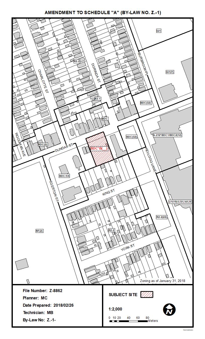
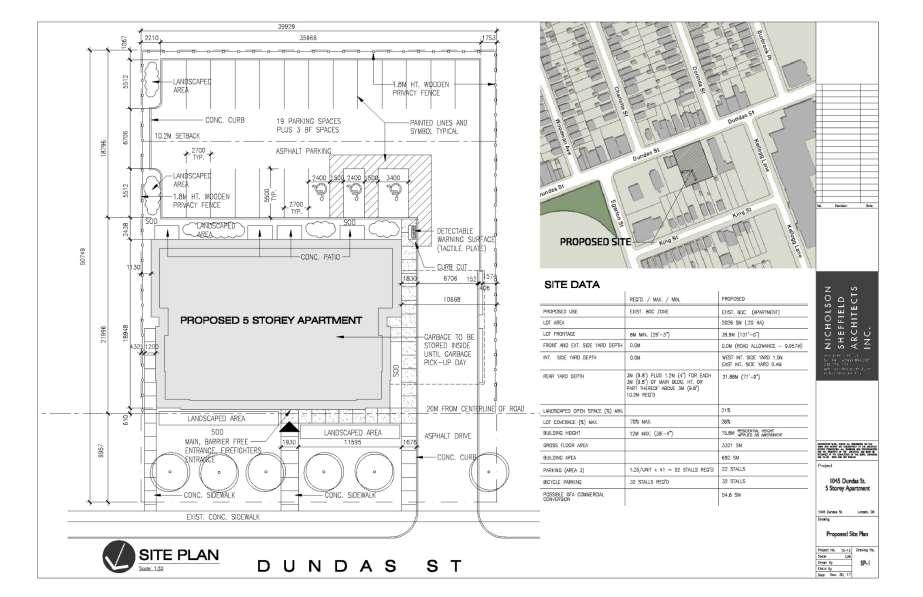
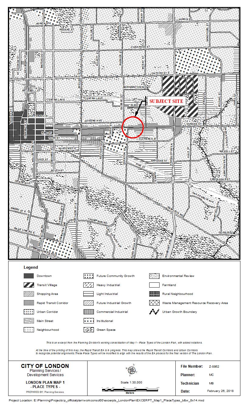
2 Purpose and the Effect of Recommended Action The purpose and effect of the requested amendment is to permit a new 5-storey apartment building containing 41 one bedroom residential units at a total density of 205uph and maximum height of 18 metres. Direction to the site plan approval authority will help address local concerns about the creation of unsafe areas on the site. The bonus zone shall be implemented through a development agreement to facilitate the development of the requested apartment building in return for the provision of affordable housing and the construction of the high quality form of development illustrated in Schedule 1 of the amending by-law. Rationale of Recommended Action 1. The recommended amendment is consistent with the PPS The recommended amendment is consistent with the City of London Official Plan policies and Rapid Transit Corridor Place Type policies of the London Plan. 3. The recommended amendment facilitates the redevelopment of an underutilized site and encourages an appropriate form of development. 4. The bonusing of the subject site ensures the building form and design will fit within the surrounding area and provide for an affordable housing and quality design standard. Analysis 1.0 Site at a Glance 1.1 Property Description The subject site is located along Dundas Street at the easterly end of the Old East Village Corridor. The site is situated on a block of land between the Western Fair grounds and former Kellogg s factory. The surrounding area is considered to be in transition as large areas of land were formerly used for light industrial uses (McCormicks and Kellogg s Sites) but the future land use direction envisions the development of commercial and residential uses. The subject site is currently vacant and previously consisted of 5 single detached dwellings which have been merged to create a single lot to accommodate the proposed apartment building. The sight also abuts a small cluster of low density residential uses to the south and commercial/low density residential uses to the north. 1.2 Current Planning Information (see more detail in Appendix D) Official Plan Designation Main Street Commercial Corridor The London Plan Place Type Rapid Transit Corridor Existing Zoning BDC Zone 1.3 Site Characteristics Current Land Use Vacant Frontage 40 metres (131.2 ft) Depth 52m (170.6 ft) Area 0.20ha (0.49 acre) Shape Rectangular 1.4 Surrounding Land Uses North Low Density Residential/Commercial Space East Assembly Hall/Light Industrial South Low Density Residential West Commercial/ Western Fair

3 1.5 Location Map
4 2.0 Description of Proposal 2.1 Development Proposal The proposed development is for a 5-Storey apartment with a total of 41 residential units, consisting of 32 one bedroom units and 9 barrier free one bedroom units for affordable housing. A total of 22 at-grade parking spaces are to be provided in the rear yard along with 32 indoor bicycle spaces. The building will be located at the front of the property along the ultimate road widening to address the street and maintain a form of development that is in keeping with current and future developments in the area. 3.0 Revelant Background 3.1 Planning History The subject site was previously home to 5 single detached dwellings which were demolished in 2008/2009 and have remained vacant since. The properties are located at the easterly edge of the Old East Village corridor in an area that historically was a transition area from the main commercial area of the Village to the former industrial uses of Kellogg s and McCormick s. Some light industrial uses still exist in this area however the extent of industrial uses has decreased and a shift to more commercial and residential uses has been planned in the area. The Old East Village has 3 specific area policies in the Main Street Commercial Corridor [MSCC] designation and this site is located just outside of the Area of Transition and Redevelopment. The Area of Transition identifies that these lands along the corridor are not considered to be a viable part of a continuous pedestrian commercial streetscape as such it promotes a mix of uses to help encourage development. 3.2 Requested Amendment The requested amendment would permit a new 5-storey apartment building containing 41 one bedroom residential units at a total density of 205uph and maximum height of 18.0 metres in return for eligible facilities, services and matters outlined in Section of the Official Plan. Other zoning provisions such as first floor residential units, and a minimum parking requirement of 22 spaces has also been requested. The amendment will require a change to the Zoning By-law Z.-1 from a Business District Commercial (BDC) Zone to a Business District Commercial Bonus (BDC*B(_)) Zone. 3.3 Community Engagement (see more detail in Appendix B) Through the circulation process some community concerns were raised about on site safety, details of the proposed design, requested reduction in parking and the lack of commercial uses on the main floor. The Old East Village Business Improvement Area also echoed these concerns and their comments are attached to Appendix C. The report below addresses these concerns in detail. A community meeting was also held by the applicant on January 31, 2018 comments from the meeting are attached as Appendix C and summarized in Appendix B. 3.4 Policy Context (see more detail in Appendix D) Provincial Policy Statement (2014) The Provincial Policy Statement 2014 (PPS) provides policy direction on matters of provincial interest related to land use and development. Section 1.1 Managing and Directing Land Use to Achieve Efficient and Resilient Development and Land Use Patterns of the PPS encourages healthy, livable and safe communities which are sustained by accommodating an appropriate range and mix of residential (including, affordable housing and housing for older persons), employment and institutional uses to meet long-term needs. It also promotes cost-effective development patterns and standards to minimize land consumption and servicing costs. The PPS encourages settlement areas (1.1.3 Settlement Areas) to be the main focus of growth and their vitality and regeneration shall be promoted. Appropriate land use patterns within settlement areas are established by providing appropriate densities and mix of land uses that efficiently use land and resources along with surrounding infrastructure, public
5 service facilities and are also transit-supportive ( ). The policies of the PPS require municipalities to identify appropriate locations and promote opportunities for intensification and redevelopment where this can be accommodated taking into account existing building stock [ ] while promoting appropriate development standards which facilitate intensification, redevelopment and compact form [ ] and promote active transportation limiting the need for a vehicle to carry out daily activities [ ]. The PPS also promotes an appropriate range and mix of housing types and densities to meet projected requirements of current and future residents (1.4 Housing). It directs planning authorities to establish and implement minimum targets for the provision of housing which is affordable to low and moderate income households. It also encourages planning authorities to permit and facilitate all forms of housing required to meet the social, health and wellbeing requirements of current and future residents, and direct the development of new housing towards locations where appropriate levels of infrastructure and public service facilities are or will be available to support current and projected needs. It encourages densities for new housing which efficiently use land, resources, and the surrounding infrastructure and public service facilities, and support the use of active transportation and transit in areas where it exists or is to be developed. Official Plan The Main Street Commercial Corridor (MSCC) designation is normally applied to long established, pedestrian-oriented shopping areas in the older parts of the City. Those Main Street Commercial Corridors adjacent to the Downtown will be regarded as gateway areas and subject to additional policies ( Function). The objectives of these corridors are to provide for the redevelopment of vacant, underutilized or dilapidated properties for one or more of a broad range of permitted uses at a scale which is compatible with adjacent development while maintaining a similar setback and character of the existing uses. ( Planning Objectives). In order to ensure these objectives of scale, compatibility and character are achieved the MSCC has specific Urban Design Objectives ( ) to help develop these corridors appropriately. These policies encourage the rehabilitation and renewal of Main Street Commercial Corridors and the enhancement of any distinctive functional or visual characteristics. They seek to provide for and enhance the pedestrian nature of the Main Street Commercial Corridor, provide high quality façade design, accessible and walkable sidewalks, street furniture and proper lighting while supporting public transit and encourage the transition and connection between the gateway Main Street Commercial Corridors and the Downtown through pedestrian, transit and design linkages. The main permitted uses in the Main Street Commercial Corridors ( ) include a wide range of commercial, office, institutional and residential uses created through the development of mixed-use buildings. In specified Main Street Commercial Corridors identified in Section the primary and secondary permitted uses and/or other policies relating to the nature and scale of development have been varied to meet specific policy objectives for these areas. The subject site is located just outside of the Old East Village Specific Main Street Commercial Corridor ( ) and although the policies do not directly apply to the subject site some of the principles are transferable to this section of Dundas Street. The specific policies refer to the Area of Transition and Redevelopment which is located west of the subject site spanning from the eastern edge of the Village Annex to Egerton Street on the south side of Dundas Street and to Charlotte Street on the north side of Dundas Street, almost across the street from the subject site. The Area of Transition acknowledges that large gaps in the streetscape exists and given the length of the entire corridor extending from Adelaide Street, this district is not currently considered a viable part of a continuous pedestrian commercial streetscape. This plan supports the transition of this area to provide for a mix of uses. The scale of development ( ) is also important in the Main Street Commercial Corridor when redeveloping or infilling commercial uses. The corridor aims to maintain
6 a setback and orientation that is consistent with adjacent uses. Residential densities within the corridor should be consistent with densities allowed in the Multi-Family, High Density and Medium Density Residential designations according to the provisions of Section of this Plan. Main Street Commercial Corridors shall be developed and maintained in accordance with the urban design guidelines in Chapter 11, the Commercial Urban Design Guidelines and specific policy areas. Main Street Commercial Areas should ensure that urban design provides continuity of the urban fabric; provides incentives and flexibility for redevelopment opportunities; provides appropriate building massing and height provisions to ensure main streets define the public spaces in front of and in between buildings ( Urban Design) London Plan The subject site is located in a Rapid Tranist Corridor which permits a range of residential, retail, service, office, cultural, recreational, and institutional uses. Mixed-use buildings are encouraged while large floor plate, single use buildings will be discouraged (Permitted Uses, 837_). Development within Corridors will be sensitive to adjacent land uses and employ such methods as transitioning building heights or providing sufficient buffers to ensure compatibility. The corridor requires minimum height of 2 storeys (or 8m) with the ability to bonus up to 12 storeys. Lot assembly is encouraged to help create comprehensive developments and reduce vehicular accesses to the street and to allow for coordinated parking facilities. Lots will be of sufficient size and configuration to accommodate the proposed development and to help mitigate planning impacts on adjacent uses. The Zoning By-law will include regulations to ensure that the intensity of development is appropriate for individual sites (Intensity, 840_). Like the current Official Plan, all planning and development applications will conform with the City Design policies of the London Plan. Buildings should be sited close to the front lot line, and be of sufficient height, to create a strong street wall along Corridors and to create separation distance between new development and properties that are adjacent to the rear lot line. The mass of large buildings fronting the street should be broken down and articulated at grade so that they support a pleasant and interesting pedestrian environment. Large expanses of blank wall will not be permitted to front the street, and windows, entrances, and other building features that add interest and animation to the street will be encouraged. Development should be designed to implement transit-oriented design principles while buildings and the public realm will be designed to be pedestrian, cycling and transit-supportive through building orientation, location of entrances, clearly marked pedestrian pathways, widened sidewalks, cycling infrastructure and general site layout that reinforces pedestrian safety and easy navigation. On-street parking within Corridors is encouraged wherever possible while surface parking areas should be located in the rear and interior side yard (Form, 841) 4.0 Key Issues and Considerations Through the circulation process no departmental concerns were expressed. Overall the proposal received positive reviews from the members of the public who attended the community meeting held by the applicant however some concerns were raised about the lack of commercial units on the main floor of the development, limited parking being provided, minor design changes and potential CPTED issues. The report below addresses these concerns in detail. 4.1 Issue and Consideration # 1 Commercial Uses on Main Floor Provincial Policy Statement, 2014 (PPS) The PPS encourages settlement areas (1.1.3 Settlement Areas) to be the main focus of growth and their vitality and regeneration shall be promoted. Appropriate land use patterns within settlement areas are established by providing appropriate densities and
7 mix of land uses that efficiently use land and resources along with surrounding infrastructure, public service facilities and are also transit-supportive. The proposed development will be integral within this community as it will increase the vitality and regeneration of the surrounding area while maintaining an appropriate land use pattern within a settlement area. The proposed apartment will help stimulate and support the existing uses in the area and help draw future uses to the primary commercial areas of Old East Village. The requested infill development will create an appropriate increase in density and provide a land use that is considered compatible with the surrounding lands and will efficiently use the consolidated properties which previously were home to single detached dwellings. The increase in density and proposed residential uses on the main floor is appropriate as it will take advantage of the surrounding resources, infrastructure, public service facilities and will be transit-supportive while providing a use to help stimulate growth in the area. The PPS also promotes appropriate range and mix of housing types and densities to meet projected requirements of current and future residents (1.4 Housing). It directs planning authorities to establish and implement minimum targets for the provision of housing which is affordable to low and moderate income households. It also encourages planning authorities to permit and facilitate all forms of housing required to meet the social, health and wellbeing requirements of current and future residents, and direct the development of new housing towards locations where appropriate levels of infrastructure and public service facilities are or will be available to support current and projected needs. The PPS promotes increased densities for new housing which efficiently use land, resources, and the surrounding infrastructure and public service facilities, and support the use of active transportation and transit in areas where it exists or is to be developed. As previously noted the residential development and proposed density are located in an area where the new development will efficiently use the existing infrastructure and surrounding resources/public service facilities. The proposed residential development helps promote an alternative form of housing and density in the area that mainly consists of low density forms of housing while helping meet the social, health and wellbeing for current and future residents. The increased density is also appropriate as it will support the existing transit systems in the area and is located along a future BRT route where higher densities are encouraged to locate. Official Plan The Main Street Commercial Corridors provide for a wide range of retail/commercial uses along with residential uses created through the conversion of existing buildings, or through the development of mixed-use buildings with residential uses permitted above the first floor. In specific Main Street Commercial Corridors identified in Section the primary and secondary permitted uses and/or other policies relating to the nature and scale of development have been varied to meet specific policy objectives for these areas. The subject site is located just east of the Old East Village Specific Main Street Commercial Corridor ( ) and although the policies do not directly apply to the subject site some of the principles are transferable to this section of Dundas Street. The specific policy of importance is called the Area of Transition and Redevelopment. This area is located just west of the subject site as it ends at Charlotte Street on the north side of Dundas Street almost across the street from the subject site. The subject site is located further away from the main commercial corridor of the OEV where policies encourage commercial uses to locate. The Area of Transition acknowledges that large gaps in the streetscape exists and given the length of the entire corridor extending from Adelaide Street, this district is not currently considered a viable part of a continuous pedestrian commercial streetscape. The specific area policies acknowledge the difficulties of the Old East Village corridor as it pertains to developing and maintaining a viable and continuous commercial presence along such a long corridor. With the Area of Transition promoting a mix of uses and not

8 requiring a continuous commercial streetscape, an alternative form like the proposed apartment would be deemed appropriate for this area. Policy states that this area will be pre-zoned to allow for medium and large-scale development such as multi-family housing. The subject site previously existed as 5 single detached dwellings with no commercial component existing on-site and the buildings across the street are primarily residential in nature with some commercial uses existing and other commercial units remaining vacant. Considering the previous absence of commercial uses on-site and the varying amount of at-grade commercial uses existing in the area it is considered appropriate to remove the requirement for commercial uses on the main floor. However, it should be noted that the recommended zoning does permit commercial uses at-grade, it simply removes the regulation to compel it. This block of land is also located in isolation to the other residential and commercial clusters of the corridor. It is situated between the existing Western Fair Grounds to the west and former industrial lands to the east where a continuous street level commercial corridor does not exist (See image below). Although the industrial lands to the east are looking to redevelop much of these uses will exist within the existing buildings with a minimum street-level presence and it will be difficult for this section of the corridor to function as an isolated pocket of street-level commercial in a mixed-use building away from the cluster of commercial to the west. With the current focus of directing commercial uses to the main portion of the Old East corridor there is no reason to require commercial space within this development. For these reasons it is appropriate to provide a special provision that does not require commercial uses on the main floor of the proposed development. The London Plan The Rapid Transit Place Type policies also encourage mixed-use buildings along the corridors, however given the surrounding context and above-mentioned analysis about commercial uses in this area, a residential building with no commercial uses on the main floor would be considered appropriate at this location at this time. While recognizing that should conditions change, the building has been designed to accommodate future commercial uses at-grade and the recommended Zoning would permit the transition. 4.2 Issue and Consideration # 2 Proposed Design/Form Provincial Policy Statement, 2014 (PPS) The proposed development is in keeping with the PPS as it provides an opportunity for intensification at an appropriate location taking into account the existing building stock in
9 the area. The new development provides a compact form that appropriately intensifies an underutilized site while providing an alternative form of development than what currently exists in the area. The development will be required to meet current development standards and site plan requirements. The subject site is located on a future bus rapid transit line in proximity to other bus routes and is an appropriate location to provide intensification at a higher density then previously existed. The development will promote active transportation limiting the need for a vehicle to perform daily activities in conformity with the goals of the PPS. Official Plan The objectives of the Main Street Commercial Corridors are to ensure that when implementing its broad range of permitted uses the scale is compatible with adjacent developments. The policies aim to maintain a setback that is consistent with adjacent uses while maintaining the character of the existing uses. ( Planning Objectives, Scale of Devleopment). In order to ensure these objectives of scale, compatibility and character are achieved, the MSCC has specific Urban Design Objectives ( ) to help develop these corridors appropriately. These policies encourage the rehabilitation and renewal of Main Street Commercial Corridors and the enhancement of any distinctive functional or visual characteristics. They seek to provide for and enhance the pedestrian nature of the Main Street Commercial Corridor, provide high quality façade design, accessible and walkable sidewalks, street furniture and proper lighting while supporting public transit and encourage the transition and connection between the gateway Main Street Commercial Corridors and the Downtown through pedestrian, transit and design linkages. Main Street Commercial Corridors shall be developed and maintained in accordance with the urban design guidelines in Chapter 11, the Commercial Urban Design Guidelines and specific policy areas ( Urban Design). As part of a complete application the applicant provided an Urban Design Brief, Character and Compatibility report and attended the Urban Design Peer Review Panel to identify how the above-mentioned policies have been achieved through the building design and form. Some minor concerns were raised by the UDPRP and Staff who suggested that the applicant revisit the design of the building s main entrance, refine the window pattern to add visual interest in the front façade, provide a variation in building height and increase the visual surveillance through building and site design. The applicant was also encouraged to consider opportunities to provide on-site common amenity area and include buffer plantings (trees) adjacent to residential properties along the rear property line. The recommendation includes a clause to the Site Plan Approval Authority to consider implementing this recommendation. The applicant has addressed many of the above-mentioned concerns by providing a revised building entrance that helps define the front façade and create a focal point for the building and establish a main street feel. The original window pattern has been altered from narrow rectangular windows to a large window pattern helping to provide visual interest to the front façade. The internal meeting space of the building was also shifted to the front of the building to help increase the visual interest and activity on the main floor as well as address safety concerns by increasing the visual surveillance of the site. Openings along the westerly wall of the vehicular access have also been provided to ensure light and sight lines are provided at the entrance. Though a physical change in height could not be accommodated, the applicant has altered the building design by providing a change in materials after the 4 th floor and use of a datum line to differentiate sections of the building. A concern that was also raised through the process was the setback of the proposed building in relation to the existing developments. The building was required to be sited further from Dundas Street than the existing developments along the corridor as the road widening requirements for the future BRT is greater than what previously existed. However, when the abutting lands redevelop they will also be required to provide the additional setback ensuring future development will be in line with the proposed development creating a continuous, pedestrian oriented block of land in keeping with
10 design objectives of the MSCC. The development is accessible providing walkable sidewalks from the City sidewalk to the main entrance and will support public transit while providing a quality form of development to help enhance the transition between the Dundas Street, Main Street Commercial Corridor as a gateway into Downtown. Urban Design Staff and UDPRP overall were pleased with the proposed development and, with the design considerations being addressed, the development is in keeping with the design guidelines outlined in Chapter 11 and in keeping with the Urban Design objectives of the MSCC. London Plan Development within Corridors will be sensitive to adjacent land uses and employ such methods as transitioning building heights or providing sufficient buffers to ensure compatibility. The corridor requires minimum height of 2 storeys or 8m with the ability to bonus up to 12 storeys. Lot assembly is encouraged to help create comprehensive developments and reduce vehicular accesses to the street and to allow for coordinated parking facilities. Lots will be of sufficient size and configuration to accommodate the proposed development and to help mitigate planning impacts on adjacent uses. The Zoning By-law will include regulations to ensure that the intensity of development is appropriate for individual sites (Intensity, 840_). Similar to the current Official Plan all planning and development applications will conform with the City Design policies of the London Plan. Buildings should be sited close to the front lot line, and be of sufficient height, to create a strong street wall along Corridors and to create a separation distance between new development and properties that are adjacent to the rear lot line. The mass of large buildings fronting the street should be broken down and articulated at grade so that they support a pleasant and interesting pedestrian environment. Large expanses of blank wall will not be permitted to front the street, and windows, entrances, and other building features that add interest and animation to the street will be encouraged. Development should be designed to implement transit-oriented design principles while buildings and the public realm will be designed to be pedestrian, cycling and transit-supportive through building orientation, location of entrances, clearly marked pedestrian pathways, widened sidewalks, cycling infrastructure and general site layout that reinforces pedestrian safety and easy navigation. On-street parking within Corridors is encouraged wherever possible while surface parking areas should be located in the rear and interior side yard (Form, 841) The proposed development is in keeping with the polices of a Rapid Transit Corridor. 4.3 Issue and Consideration # 3 Bonusing Provisions Official Plan Residential uses within the Main Street Commercial Corridor ( MSCC ) defer to the scale and densities allowed in the Multi-Family, High Density and Medium Density Residential designations which would permit a maximum density of 150uph at this location. As previously indicated, the applicant has applied to increase the density above the permitted 150 uph to 205 uph through the bonusing provisions outlined in Section of the Official Plan. The policies of the Official Plan permit Bonus Zoning as a means of achieving enhanced development features which result in a public benefit that cannot be obtained through the normal development process in return for permitting increased heights and densities. The Planning Act provides direction on bonusing which allows municipalities to use bonusing provisions in their Official Plan in return for facilities, services, or matters, as are set out in the By-law. The proposed building form and design (as discussed in Section 4.2- Design/Form) and provision of affordable housing, which may not otherwise be implemented through the normal development approvals process, allow the proposed development to qualify for Bonus Zoning in conformity to the policies of the Official Plan. These bonusable features are outlined below:
11 i) Exceptional Building Design The building design shown in the various illustrations contained in Schedule 1 of the amending by-law is being bonused for features which serve to support the City s objectives of promoting a high standard of design. ii) Provision of Affordable Housing The development provides 41 residential units, consisting of 32 one bedroom units and 9 barrier free one bedroom units for affordable housing. In order to implement the identified items for bonus zoning, section iv) of the Official Plan states that: As a condition to the application of bonus zoning provisions to a proposed development, the owner of the subject land will be required to enter into an agreement with the City, to be registered against the title to the land. The agreement will deal with the facilities, services, or matters that are to be provided, the timing of their provision, and the height or density bonus to be given. Bonus zoning is implemented through a development agreement with the City that is registered on title to the lands. The development agreement is intended to lock in the design features that will be incorporated into the form of development to merit the additional density. Through the site plan approval process, the proposed development will be reviewed to ensure that all facilities, services and matters that have warranted bonus zoning have been incorporated into the development agreement. These design features are highlighted in the recommendation and the amending by-law included in the illustrations attached as Schedule Issue and Consideration # 4 Parking Reduction Some concerns were raised about the request to reduce parking as it would result in overflow parking on abutting lands. The Zoning By-law requires apartments to provide 1.25 spots per residential unit, requiring 52 spaces for the 41 residential units proposed in this development. As part of a complete application the applicant submitted a Parking Justification Study which noted that the site is located on the No.2 Dundas Street transit route which operates at a 10 minute headway in peak hours and a 15 minute headway in off-peak hours and Saturdays. The site is within walking distance of the No.7 Wavell Route which operates on Florence Street and the No. 20 Cherryhill route which operates on Quebec Street. The latter provides a direct link to Fanshawe College. All three routes provide a direct link to the Downtown core. The Dundas Street Corridor will also be the future route of the BRT system. With several alternative forms of transportation in the immediate area the demand for automobile ownership will be reduced for future tenants given the proximity to three Bus routes and future BRT with direct access to the downtown core. It is also important to note that the proposed development will be restricted to 1 bedroom units through the recommended bonus zone where general apartments can range up to 5 bedrooms per unit. This reduction in the number of bedrooms per unit also warrants consideration in the required parking standards for the site. The parking study also referenced a similar affordable housing development owned by the applicant that provides 1 parking space per unit however only nine of the 25 spaces provided have registered users which results in a ratio of 0.36 spaces per unit. While this represents one example, this information in combination with the above mentioned public transit options and one bedroom restriction warrant a reduction in parking. For the above-mentioned reasons, the requested 22 parking spaces is being recommended where 52 are required.
12 4.5 Issue and Consideration # 5 CPTED During the consultation process the Old East Village BIA raised some site-specific safety concerns that relate to the physical development of the site. Both interior side yards create narrow, dark spaces between the proposed building and and future fencing on the site. It is recommended that these issues be considered through the Site Plan Approvals process to consider some form of fencing, lighting or alternative site design to ensure these spaces are protected from the public being able to access them for inappropriate uses. More information and detail is available in Appendix B and C of this report. 5.0 Conclusion The requested amendment to add a bonus zone on the subject site to permit a density of 205 uph would facilitate a purpose-built development which would include a 5-storey apartment building containing 41, one bedroom residential units for affordable housing. The recommended zoning is consistent with the PPS 2014 and with the City of London Official Plan and future London Plan. The recommendation will facilitate the redevelopment of an underutilized site and encourages an appropriate form of development while the use of a bonus zone ensures that the building form and design will fit within the surrounding area and provide for an enhanced design standard. Prepared by: Submitted by: Mike Corby, MCIP, RPP Current Planning Recommended by: Michael Tomazincic, MCIP, RPP Manager, Current Planning John M. Fleming, MCIP, RPP Managing Director, Planning and City Planner March 26, 2018 MC/mc \\FILE2\users-z\pdpl\Shared\implemen\DEVELOPMENT APPS\2017 Applications 8723 to\8862z Dundas St (MC)\PEC-Report-Template-AODA.docx
13 Appendix A Bill No.(number to be inserted by Clerk's Office) (2018) By-law No. Z A by-law to amend By-law No. Z.-1 to rezone an area of land located at 1039, 1041, 1043, 1045, 1047 Dundas Street. WHEREAS London Affordable Housing Foundation has applied to rezone an area of land located at 1039, 1041, 1043, 1045, 1047 Dundas Street, as shown on the map attached to this by-law, as set out below; AND WHEREAS this rezoning conforms to the Official Plan; THEREFORE the Municipal Council of The Corporation of the City of London enacts as follows: 1) Schedule A to By-law No. Z.-1 is amended by changing the zoning applicable to lands located at 1039, 1041, 1043, 1045, 1047 Dundas Street, as shown on the attached map comprising part of Key Map No. A.108, from a Business District Commercial (BDC)) Zone to a Business District Commercial Bonus (BDC*B(_)) Zone. 2) Section Number 4.3 of the General Provisions in By-law No. Z.-1 is amended by adding the following new Bonus Zone: 4.3) B(_) 1039, 1041, 1043, 1045, 1047 Dundas Street The Bonus Zone shall be implemented through a development agreement to facilitate the development of a high quality, multi-use building, a total of 41 dwelling units and density of 205 units per hectare, which substantively implements the Site Plan and Elevations attached as Schedule 1 to the amending by-law. The following special regulations apply within the bonus zone upon the execution and registration of the required development agreement(s): a) Regulations: i) Density 205 units per (maximum) hectare (83 units per acre) ii) Height 18 metres (maximum) (52.50 feet) iii) Parking 22 Parking Spaces (minimum) iv) Bedrooms 1 per unit (maximum) v) Dwelling units are permitted on the whole of the first floor. The inclusion in this By-law of imperial measure along with metric measure is for the purpose of convenience only and the metric measure governs in case of any discrepancy between the two measures. This By-law shall come into force and be deemed to come into force in accordance with Section 34 of the Planning Act, R.S.O. 1990, c. P13, either upon the date of the passage
14 of this by-law or as otherwise provided by the said section. PASSED in Open Council on April 10, Matt Brown Mayor Catharine Saunders City Clerk First Reading April 10, 2018 Second Reading April 10, 2018 Third Reading April 10, 2018
15

16 Schedule 1

17 Schedule 1

18 Schedule 1

19 Schedule 1
20
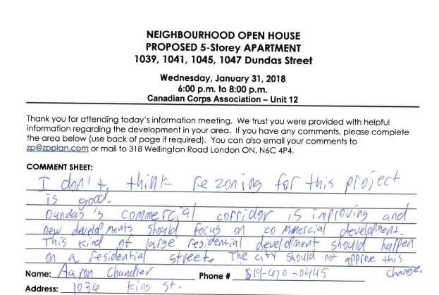
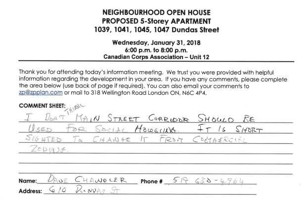
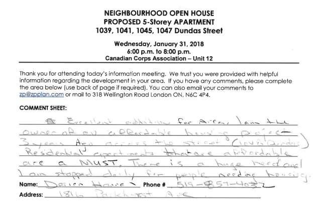
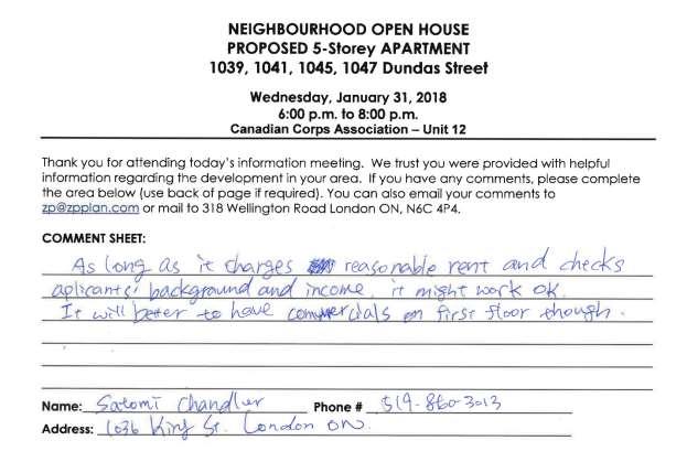
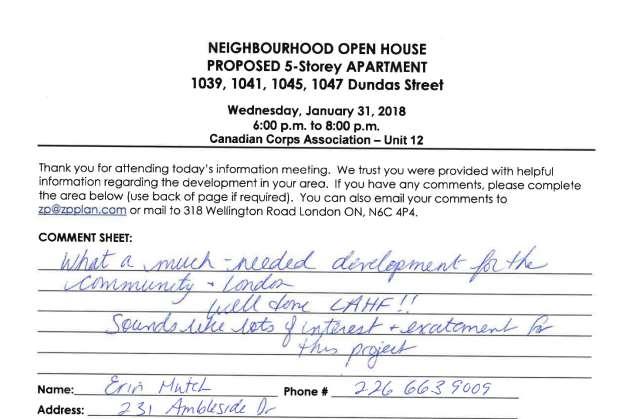
21 Appendix B Public Engagement Community Engagement Public liaison: On December 20, 2017, Notice of Application was sent to 92 property owners in the surrounding area. Notice of Application was also published in the Public Notices and Bidding Opportunities section of The Londoner on December 21, A Planning Application sign was also posted on the site. 4 replies were received Nature of Liaison: The purpose and effect of this zoning change is to permit a 5-storey apartment building containing 41 residential units. Change Zoning By-law Z.-1 from an Business District Commercial (BDC) Zone to a Business District Commercial Bonus (BDC*B( )) Zone to permit a height of 15.8 metres and a residential density of 205uph in return for eligible facilities, services and matters outlined in Section of the Official Plan. Other special zoning provisions such as first floor residential units, and a maximum parking requirement of 22 spaces where 52 spaces are required will also be considered as part of the bonus zone. Public liaison: On March 14, 2018, Revised Notice of Application and Public Meeting was sent to 92 property owners in the surrounding area. Revised Notice of Application and Public meeting was also published in the Public Notices and Bidding Opportunities section of The Londoner on March 15, No replies were received Nature of Liaison: The purpose and effect of this zoning change is to permit a 5-storey apartment building containing 41 residential units. Change Zoning By-law Z.-1 from an Business District Commercial (BDC) Zone to a Business District Commercial Bonus (BDC*B( )) Zone to permit a height of 17.8 metres and a residential density of 205uph in return for eligible facilities, services and matters outlined in Section of the Official Plan. Other special zoning provisions such as first floor residential units, and a maximum parking requirement of 22 spaces where 52 spaces are required will also be considered as part of the bonus zone. Community Meeting: A community meeting was also held by the applicant on January 31, 2018 comments from the meeting are attached below. Responses: A summary of the various comments received include the following: Concern for: - Requested reduction in parking. - No Commercial uses on Main Floor - Design - Saftey
22 - Responses to Public Liaison Letter and Publication in The Londoner Telephone Written Carol Cooke Dr. Malizia 432 Dorinda St, London ON, N5W4B Dundas St, London ON Bill Downie 1052 King St, London ON Alan R. Patton Patton Law Fullarton Street London ON N6A 5P2 Lewis Seale Dundas, London N5W 3A5 Agency/Departmental Comments Development Services January 19, 2018 Transportation No comments for the re-zoning application. The following items are to be considered during the development application approval stage: - Road widening dedication of 20.0m from centre line required on Dundas Street - Dundas Street has been identified as a rapid transit corridor in the Council approved Rapid Transit Master Plan (RTMP). Through the Transit Project Assessment Process (TPAP), the corridor and station locations will be refined and examined in greater detail, future access to Dundas Street will be restricted to right in/right out. For information regarding the RTMP or TPAP please use the following web links: or - Detailed comments regarding access design and location will be made through the site plan process. SWED No comments for the re-zoning application. The following items are to be considered during the development application approval stage: - The subject lands are located in the Central Thames Subwatershed. The Developer shall be required to provide a Storm/drainage Servicing Brief demonstrating that the proper SWM practices will be applied to ensure the maximum permissible storm run-off discharge from the subject site will not exceed the peak discharge of storm run-off under pre-development conditions. - This site can be service by the 1350mm storm sewer or the 825mm storm both on Dundas Street, confirming there is sufficient surplus capacity in the pipe and downstream system to accommodate the proposed development. Water No comments for the re-zoning application. The following items are to be considered during the development application approval stage: - A new 400mm PVC watermain along Dundas Street is available to service the site.
23 WADE No comments for the re-zoning application. The following items are to be considered during the development application approval stage: - The sanitary sewer available for the proposed development is the new 300mm sanitary sewer on Dundas Street. Additional comments may be provided upon future review of the site London Hydro January 8, 2018 London Hydro has no objection to this proposal or possible official plan and/or zoning amendment. Any new or relocation of the existing service will be at the expense of the owner. Upper Thames River Conservation Authority January 17, 2018 The UTRCA has no objections to this application. Urban Design Peer Review Panel February 21, 2018 The Panel provides the following feedback on the submission to be addressed through the zoning bylaw amendment application: 1. Entrance. The front building entrance should be further defined to be more prominent along the front façade. 2. Fenestration. The Panel supports the applicant s intent to further refine the window pattern to add visual interest in the front façade. 3. Variation in building height. The Panel recommends providing variation in building height which may also be achieved through the use of varying building materials and building volumes. 4. Visual Surveillance. The Panel is supportive of the openings added to the driveway wing wall, supporting the building above. Additional visual surveillance and transparency from the building is recommended by adding windows along the side walls at grade and at the corners (e.g. stairwells and the building s driveway wall). 5. On-site amenity. The Panel encourages the applicant to consider opportunities to provide on-site common amenity area either interior or exterior to the building. An example could include shifting the interior meeting room to the front façade (allowing for additional glazing and potential spill-out of amenity in the front e.g. benches). 6. Rear property line buffer. The landscape strip along the rear property line should include buffer plantings (trees) adjacent residential properties. Concluding comments: The Panel supports the proposed project with the recommendations noted above. Regarding the building s front setback, should the City re-evaluate the required BRT right-of-way width, the Panel would support moving the building closer to the street edge.
24 Urban Design Staff March 19, 2018 Urban design staff have worked closely with the applicant through the rezoning process to address many of the design concerns that have been raised by the community, the Urban Design Peer Review Panel, and City staff. The majority of the design concerns, in particular those related to the design of the main entry into the building, the amount of glazing on the ground floor, the size and shape of the window openings, and the design of the underpass driveway have been addressed with the final proposed elevations. The proposed building design is generally in keeping with the vision for the corridor and establishes an active built edge along the Dundas Street frontage with all parking functions located in the rear. The use of masonry brick and block materials on the façade provides for a high quality finish that is appropriate for this highly urban corridor and is consistent with other buildings along Dundas Street. London Transit Commission March 20, 2018 I am writing to voice London Transit's strong support for the by-law amendment at Dundas St. Intensification, particularly that involves subsidized housing, provides land uses that compliment the future rapid transit corridor and helps to maintain transit access for transit dependent income groups. London Transit also supports any reduction to minimum parking requirements particularly adjacent to major transit corridors and in the context of serving subsidized housing.
25 Appendix C Community Meeting Comments.
26
27
28
29
30 March 9, 2018 Proposed Affordable Housing Development 1047 Dundas Street March 9, 2018 Community Open House Feedback provided to and by the Old East Village BIA Jennifer Pastorius, Old East Village BIA Historically, the Old East Village BIA has supported retaining a variety of housing options and worked with numerous groups and property owners to assist in the development of both affordable and at market apartments on and around the commercial corridor. Even though the 1047 Dundas proposed development is just east of the Old East Village Community Improvement Plan area the possibility to further develop the area is an exciting one for the BIA. More residential units bring more customers to our existing businesses and create a greater need for additional shops and retail services. Projects that are developed with the thriving commercial environment and neighbourhood scale and design in mind will best integrate into the steadily revitalizing Old East Village commercial corridor. Six members of the Old East Village BIA board and the BIA Manager attended the January 31st meeting. Two additional board members submitted feedback based on the renderings circulated via prior to the Open House. One neighbourhood resident submitted their comments to both Zelinka Priamo Planners and the BIA. This feedback is offered in addition to feedback collected by the meeting organizers during the event. During both in person meetings and through submitted comments, three distinct themes emerged regarding the proposed development. These included comments regarding 1) need for mixed use, 2) the design and 3) importance of understanding the area context and activity. Below is a summary of the submitted feedback: 1. The comments demonstrated a significant concern regarding the lack of commercial units on the main floor of the development. Business owners shared that commercial activity is vitally important to any business district and residential buildings provide the feet on the street to shop in the retail sector. With the exception of Tony s Pizza and McHardy Vacuum, the most eastern end of the Old East Village commercial corridor was once void of the growing concentration of businesses that you see today. Investment data gathered by the BIA and the upcoming developments in previously empty factory sites like Kellogg s and McCormick s demonstrate that commercial interest is growing in this area of Dundas St. Property owners and residents stated that commercial spaces will be important assets as the corridor develops over the coming years and will create more walkable neighbourhoods and connectivity to the existing business community. 2. Regarding the building, attendees had strong opinions about the design and safety. It was recommended that the design should reflect the spirit of the Old East Village Urban Design Guidelines to ensure that in the future the development will complement the existing built form of the area; this would include a setback for all floors beyond three stories facing Dundas Street. Generally, the design was considered institutional and bland. References were made to quality designed London affordable housing developments which fit into the existing surrounding built form such as Woodfield Commons at 390 Princess Ave, Tecumseh Place, 77 Tecumseh Road and LAHF s Gethsemane Gardens. Concerns were raised regarding the expanse of blank walls on the front, east and west sides, the size and shape of the windows and lack of pronounced entrance pathway or overhang. There were safety concerns regarding the east and west walls in relation to the proximity of the proposed 7- foot fence. Strategically placed exterior lighting was also recommended. 3. It was articulated by those who provided comment what is critical is that developers understand the context of the existing neighbourhood area activity, and its potential impacts on their tenants. Currently, the area has a variety of businesses and activities. Much of the commerce in the area is positive and
31 supportive of local entrepreneurs. However, there still exist notable daily illegal activities just to the east and west of the proposed development. The BIA recognizes that the choice of tenancy resides outside the purview of City of London Planning; however, this theme was introduced in the comments and has therefore been included. Comments expressed significant support for a generous mix of at-market and affordable rents to ensure a varied tenant population. Specific building design components were suggested that could improve the safety of the tenants, if implemented; an on-site property manager was recommended to deter anti-social behaviour on the property. There is particular vulnerably when living in close proximity to anti-social and illegal activity, the potential risk of negative impacts to tenants cannot be understated. Therefore the Old East Village BIA, the London Affordable Housing Foundation and the London Housing Development Corporation have jointly acknowledged the nearby social challenges and have committed to work together proactively to mitigate the impacts of such activity on tenants, the development property and the surrounding area. The comments that informed this report have been provided to the London Affordable Housing Foundation, City of London Planning staff, and the London Housing Development Corporation for their review and consideration. The comments were not edited; they were provided to all parties as they were shared or submitted. Thank you for receiving the above thematic analysis based on conversations at the community consultation and comments collected via . Participation in new neighbourhood development is an active part of BIA work. We are pleased to provide this feedback and look forward to working with all parties to provide area context as the project develops.
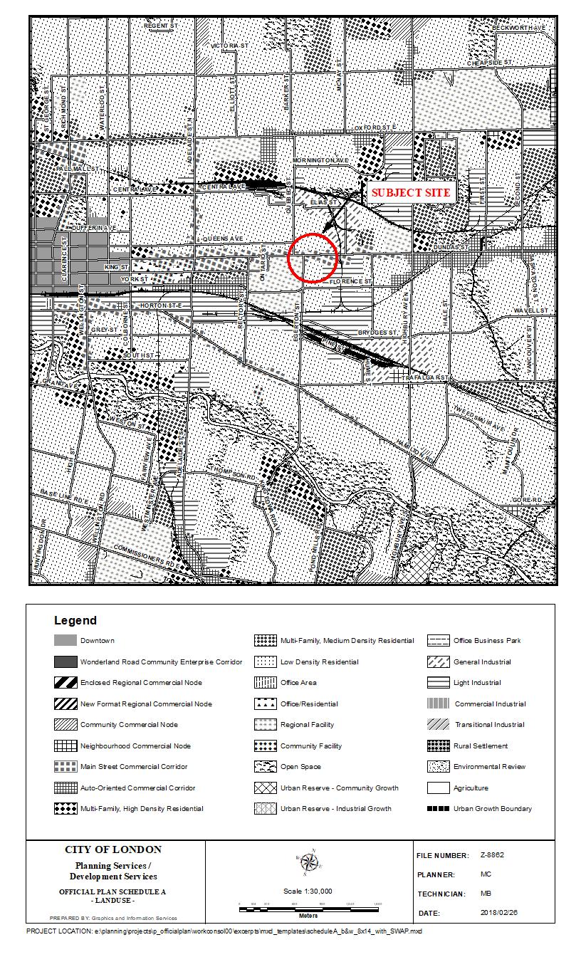
32 Appendix C Policy Context The following policy and regulatory documents were considered in their entirety as part of the evaluation of the requested land use change. The most relevant policies, by-laws, and legislation are identified as follows: PPS 1.1 Managing and Directing Land Use to Achieve Efficient and Resilient Development and Land Use Patterns a, b, c, e, f Settlement Areas , , , , Housing Transportation Systems Official Plan 3.4. Multi-Family, High Density Residential Scale of Development Main Street Commercial Corridor Function Planning Objectives Urban Design Objectives Permitted Uses Scale of Development Urban Design Specific Main Street Commercial Corridors Old East Village (iii) 19.4 Zoning Bonus Zoning London Plan Rapid Transit and Urban Corridors Permitted Uses 837 Intensity 840 From 841

33 Appendix D Relevant Background Additional Maps
34
35
Report to Planning and Environment Committee
 Report to Planning and Environment Committee To: Chair and Members Planning & Environment Committee From: John M. Fleming Managing Director, Planning and City Planner Subject: JAM Properties Inc. 147-149
John M. Fleming Managing Director, Planning and City Planner. Old East Village Dundas Street Corridor Secondary Plan Draft Terms of Reference
 Report to Planning and Environment Committee To: From: Subject: Chair and Members Planning & Environment Committee John M. Fleming Managing Director, Planning and City Planner Old East Village Dundas Street
CHAIR AND MEMBERS PLANNING & ENVIRONMENT COMMITTEE JOHN M. FLEMING MANAGING DIRECTOR, PLANNING AND CITY PLANNER
 TO: FROM: SUBJECT: CHAIR AND MEMBERS PLANNING & ENVIRONMENT COMMITTEE JOHN M. FLEMING MANAGING DIRECTOR, PLANNING AND CITY PLANNER APPLICATION BY: THE CORPORATION OF THE CITY OF LONDON OUTDOOR PATIOS IN
1.0 Purpose of a Secondary Plan for the Masonville Transit Village
 Report to Planning and Environment Committee To: Chair and Members Planning & Environment Committee From: John M. Fleming Managing Director, Planning and City Planner Subject: Masonville Transit Village
178 Carruthers Properties Inc.
 178 Carruthers Properties Inc. Planning Rationale for 178 Carruthers Avenue Site Plan Control Application June 2014 Table of Contents 1.0 Introduction 2.0 Overview of Subject Property 3.0 Current Zoning
URBAN DESIGN BRIEF URBAN DESIGN BRIEF 721 FRANKLIN BLVD, CAMBRIDGE August 2018
 URBAN DESIGN BRIEF URBAN DESIGN BRIEF 721 FRANKLIN BLVD, CAMBRIDGE August 2018 DESIGN BRIEF CONTENTS PART A 1.0 INTRODUCTION 2.0 DESCRIPTION & ANALYSIS OF SITE CONTEXT 3.0 DESIGN CONSTRAINTS AND OPPORTUNITIES
TABLE OF CONTENTS 1.0 INTRODUCTION... 3
 TABLE OF CONTENTS 1.0 INTRODUCTION... 3 1.1. BACKGROUND... 3 1.2. THE PROPOSAL... 5 2.0 EXISTING POLICY FRAMEWORK... 5 2.1. PROVINCIAL POLICY STATEMENT (PPS)... 5 2.2. CITY OF LONDON OFFICIAL PLAN (OP)...
ELMVALE ACRES SHOPPING CENTRE MASTER PLAN
 ELMVALE ACRES SHOPPING CENTRE MASTER PLAN Contents 1.0 INTRODUCTION... 2 2.0 LOCATION... 2 3.0 EXISTING CONTEXT... 2 4.0 VISION & GUIDING PRINCIPLES... 2 5.0 LAND USE AND BUILT FORM... 4 5.1 St. Laurent
Official Plan Review: Draft Built Form Policies
 PG.30.1 REPORT FOR ACTION Official Plan Review: Draft Built Form Policies Date: May 15, 2018 To: Planning and Growth Management Committee From: Chief Planner and Executive Director, City Planning Division
Mark-up of the effect of the proposed Bronte Village Growth Area OPA No.18 on the text of section 24, Bronte Village, of the Livable Oakville Plan
 Mark-up of the effect of the proposed Bronte Village Growth Area OPA No.18 on the text of section 24, Bronte Village, of the Livable Oakville Plan Notes: This document is provided for information purposes
2136 & 2148 Trafalgar Road Town of Oakville Region of Halton
 PLANNING JUSTIFICATION REPORT 2136 & 2148 Trafalgar Road Town of Oakville Region of Halton Zoning By-Law Amendment Application 2500674 Ontario Inc. November 2016 Table of Contents Page 1.0 Location/Summary
Report to Planning and Environment Committee
 Report to Planning and Environment Committee To: Chair and Members Planning & Environment Committee From: John M. Fleming Managing Director, Planning and City Planner Subject: Paramount Development (London)
Urban Design Brief December 23, 2015 Southside Construction Group Official Plan & Zoning By-Law Amendment
 Urban Design Brief Proposed Official Plan & Zoning By-Law Amendment 3244, 3263 and 3274 Wonderland Road South Southside Group December 23, 2015 TABLE OF CONTENTS Page No. INTRODUCTION... 1 SECTION 1 LAND
FORMER CANADIAN FORCES BASE (CFB) ROCKCLIFFE SECONDARY PLAN. Official Plan Amendment XX to the Official Plan for the City of Ottawa
 ROCKCLIFFE SECONDARY PLAN. Official Plan Amendment XX to the Official Plan for the City of Ottawa") FORMER CANADIAN FORCES BASE (CFB) ROCKCLIFFE SECONDARY PLAN Official Plan Amendment XX to the Official Plan for the City of Ottawa 1 INDEX THE STATEMENT OF COMPONENTS PART A THE PREAMBLE PAGE Purpose...
FORMER CANADIAN FORCES BASE (CFB) ROCKCLIFFE SECONDARY PLAN Official Plan Amendment XX to the Official Plan for the City of Ottawa 1 INDEX THE STATEMENT OF COMPONENTS PART A THE PREAMBLE PAGE Purpose...
PLANNING JUSTIFICATION REPORT
 PLANNING JUSTIFICATION REPORT 55 DELHI STREET CITY OF GUELPH PREPARED FOR: VESTERRA PROPERTY MANAGEMENT PREPARED BY: LABRECHE PATTERSON & ASSOCIATES INC. SCOTT PATTERSON, BA, CPT, MCIP, RPP PRINCIPAL,
KANATA CENTRUM 255 KANATA AVENUE OFFICIAL PLAN AMENDMENT ZONING BY-LAW AMENDMENT
 KANATA CENTRUM 255 KANATA AVENUE OFFICIAL PLAN AMENDMENT ZONING BY-LAW AMENDMENT JUNE 2015 PREPARED BY: FOTENN Consultants Inc. 223 Mcleod Street Ottawa, ON K2P OZ8 (613) 730-5709 PREPARED FOR: Kanata
The draft Secondary Plan will serve as the basis for further consultation with the community and stakeholders;
 File: O-8879 Planner: K. Killen Report to Planning and Environment Committee To: Chair and Members Planning & Environment Committee From: John M. Fleming Managing Director, Planning and City Planner Subject:
DRAFT Northeast Quadrant of Kipling Avenue and Highway 7 DRAFT AUGUST 29, Goals Land Use. The goals of this Plan are to:
 AUGUST 29, 2017 12.15 Northeast Quadrant of Kipling Avenue and Highway 7 12.15.1 Goals 12.15.2 Land Use The goals of this Plan are to: 12.15.2.1 General Provisions: a) Ensure the development of a compact
Complete Neighbourhood Guidelines Review Tool
 Complete Neighbourhood Guidelines Review Tool Prepared By: City of Regina Planning Department October 2014 Page 1 of 14 Community Development Review Checklist for Secondary Plans and Concept Plans The
Urban Design Manual PLANNING AROUND RAPID TRANSIT STATIONS (PARTS) Introduction. Station Study Areas
 Introduction. Station Study Areas") 111111 PLANNING AROUND RAPID TRANSIT STATIONS (PARTS) Introduction The ION rapid transit system will link Waterloo, Kitchener and Cambridge through a central transit corridor (CTC). There are a number
111111 PLANNING AROUND RAPID TRANSIT STATIONS (PARTS) Introduction The ION rapid transit system will link Waterloo, Kitchener and Cambridge through a central transit corridor (CTC). There are a number
150 Eighth Street Zoning By-law Amendment Application Preliminary Report
 REPORT FOR ACTION 150 Eighth Street Zoning By-law Amendment Application Preliminary Report Date: March 27, 2019 To: Etobicoke York Community Council From: Director, Community Planning, Etobicoke York District
ONTARIO MUNICIPAL BOARD
 PL 120483 ONTARIO MUNICIPAL BOARD Applicant/Appellant: 2124123 Ontario Limited Subject: OPA, Rezoning and Draft Plan of Subdivision Municipal Address: 3940 Highway 7 East Municipality: City of Markham
URBAN DESIGN BRIEF 181 Burloak Drive, Oakville
 URBAN DESIGN BRIEF 181 Burloak Drive, Oakville February 2017 Our File: 1730B 230-7050 WESTON ROAD / WOODBRIDGE / ONTARIO / L4L 8G7 / T: 905 761 5588/ F: 905 761 5589/WWW.MHBCPLAN.COM TABLE OF CONTENTS
Urban Design Brief. 583, 585 and 589 OXFORD STREET EAST. Salt Clinic Canada Inc.
 Urban Design Brief 583, 585 and 589 OXFORD STREET EAST Salt Clinic Canada Inc. February 3, 2013 TABLE OF CONTENTS Page No. INTRODUCTION... 1 SECTION 1 LAND USE PLANNING CONCEPT... 1 1.1 The Subject Property...
13 THORNHILL YONGE STREET STUDY IMPLEMENTATION CITY OF VAUGHAN OPA 669 AND TOWN OF MARKHAM OPA 154
 13 THORNHILL YONGE STREET STUDY IMPLEMENTATION CITY OF VAUGHAN OPA 669 AND TOWN OF MARKHAM OPA 154 The Planning and Economic Development Committee recommends the adoption of the recommendations contained
POLICY AMENDMENT AND LAND USE AMENDMENT TUXEDO PARK (WARD 9) CENTRE STREET N AND 26 AVENUE NE BYLAWS 36P2017 AND 234D2017
 CENTRE STREET N AND 26 AVENUE NE BYLAWS 36P2017 AND 234D2017") Page 1 of 11 EXECUTIVE SUMMARY This application proposes to redesignate a single parcel of land in the Community of Tuxedo Park from Commercial Corridor 2 (C-COR2 f1h10) District to Mixed Use Active Frontage
Page 1 of 11 EXECUTIVE SUMMARY This application proposes to redesignate a single parcel of land in the Community of Tuxedo Park from Commercial Corridor 2 (C-COR2 f1h10) District to Mixed Use Active Frontage
1120 Haist Street - Pelham Arena Community Co-Design Recommendation Report Haist Street - Pelham Arena Community Co-Design Recommendation Report
 1120 Haist Street - Pelham Arena Community Co-Design Executive Summary: In May, 2017 the Town retained the services of The Planning Partnership to undertake a community design charrette process to determine
5.1 Site Plan Guidelines
 5. Community Core Guidelines Development of the Community Core will take place by plan of subdivision and site plan approval. It will occur in a phased manner that will reflect the timing of residential
Figure 1- Site Plan Concept
 Figure 1- Site Plan Concept Parking will be provided underground on three levels at rate of 1.0 space/ unit; this rate includes all visitors parking. MMM Group has prepared a parking assessment (April,
URBAN DESIGN BRIEF Gordon Street City of Guelph. Prepared on behalf of Ontario Inc. March 25, Project No. 1507
 URBAN DESIGN BRIEF 1131 Gordon Street City of Guelph Prepared on behalf of 1876698 Ontario Inc. March 25, 2016 Project No. 1507 423 Woolwich Street, Suite 201, Guelph, Ontario, N1H 3X3 Phone (519) 836-7526
Edward R. Sajecki Commissioner of Planning and Building. Land Use Review- Former Parkway Belt West Lands- Fieldgate Drive and Audubon Boulevard
 Corporate Report Clerk s Files Originator s Files CD.04.FOR DATE: November 15, 2011 TO: FROM: SUBJECT: Chair and Members of Planning and Development Committee Meeting Date: December 5, 2011 Edward R. Sajecki
URBAN DESIGN BRIEF NORTHVIEW FUNERAL HOME HIGHBURY AVE N, LONDON, ON
 URBAN DESIGN BRIEF NORTHVIEW FUNERAL HOME - 1490 HIGHBURY AVE N, LONDON, ON 1.1Purpose The intent of the following report is to identify an opportunity for redevelopment of two residential properties within
URBAN DESIGN BRIEF. 2136&2148 Trafalgar Road. Town of Oakville
 URBAN DESIGN BRIEF 2136&2148 Trafalgar Road Town of Oakville Prepared By: METROPOLITAN CONSULTING INC For 2500674 Ontario Inc November 2016 TABLE OF CONTENTS Page No. 1.0 Introduction/Description of Subject
1296 Kennedy Road - Zoning Amendment Application - Preliminary Report
 STAFF REPORT ACTION REQUIRED 1296 Kennedy Road - Zoning Amendment Application - Preliminary Report Date: January 15, 2016 To: From: Wards: Reference Number: Scarborough Community Council Acting Director,
The Corporation of the TOWN OF MILTON
 Report to: From: Chair & Members of the Administration & Planning Standing Committee W.F. Mann, Director of Planning and Development Date: April 16, 2012 PD 022-12 (Z19/11) Subject: Technical Report Proposed
A Growing Community Rural Settlement Areas
 Town of Huntsville Official Plan Review - POLICY BACKGROUND PAPER A Growing Community Rural Settlement Areas BACKGROUND: In addition to the fully municipally-serviced Urban Settlement Area and the Hidden
4780 Eglinton Avenue West - Zoning By-law Amendment and Draft Plan of Subdivision Applications - Preliminary Report
 STAFF REPORT ACTION REQUIRED 4780 Eglinton Avenue West - Zoning By-law Amendment and Draft Plan of Subdivision Applications - Preliminary Report Date: May 29, 2014 To: From: Wards: Reference Number: Etobicoke
8 & 10 Donalda Crescent Official Plan & Rezoning Application Final Report
 STAFF REPORT ACTION REQUIRED 8 & 10 Donalda Crescent Official Plan & Rezoning Application Final Report Date: July 26, 2010 To: From: Wards: Reference Number: Scarborough Community Council Director, Community
141 GEORGE STREET PLANNING RATIONALE
 141 GEORGE STREET PLANNING RATIONALE MINOR ZONING BY-LAW AMENDMENT NOVEMBER 2, 2016 PLANNING RATIONALE 223 McLeod Street Ottawa, ON K2P 0Z8 613.730.5709 fotenn.com INTRODUCTION FOTENN Consultants is acting
K. SMART ASSOCIATES LIMITED
 Planning Justification Report Zoning By-Law Amendment 185 King Street North Waterloo, Ontario April 7th, 2017 Project Reference Number 16-245 K. SMART ASSOCIATES LIMITED CONSULTING ENGINEERS AND PLANNERS
240 and 242 Finch Avenue West Zoning By-law Amendment Application Preliminary Report
 REPORT FOR ACTION 240 and 242 Finch Avenue West Zoning By-law Amendment Application Preliminary Report Date: March 1, 2019 To: North York Community Council From: Director, Community Planning, North York
ROAD CLOSURE AND LAND USE AMENDMENT SILVER SPRINGS (WARD 1) NORTHEAST OF NOSEHILL DRIVE NW AND SILVER SPRINGS ROAD NW BYLAWS 2C2018 AND 29D2018
 NORTHEAST OF NOSEHILL DRIVE NW AND SILVER SPRINGS ROAD NW BYLAWS 2C2018 AND 29D2018") Page 1 of 19 EXECUTIVE SUMMARY This application proposes redesignating two parcels in the community of Silver Springs from Special Purpose Future Urban Development (S-FUD) District and undesignated road
Page 1 of 19 EXECUTIVE SUMMARY This application proposes redesignating two parcels in the community of Silver Springs from Special Purpose Future Urban Development (S-FUD) District and undesignated road
and services The protection and conservation of environmentally significant and sensitive natural heritage features and functions.
 6. Land Use 6.0 Preamble A healthy and livable city is one in which people can enjoy a vibrant economy and a sustainable healthy environment in safe, caring and diverse neighbourhoods. In order to ensure
Highland Village Green Design Guidelines
 Highland Village Green Design Guidelines Publishing Information Title Highland Village Green Design Guidelins Author The City of Calgary Status DRAFT - Proposed document subject to changes Additional Copies
Attachment 1 TOWN OF NEW TECUMSETH. Manual for the Preparation of an Urban Design Report
 Attachment 1 TOWN OF NEW TECUMSETH Manual for the Preparation of an Urban Design Report July 2010 TABLE OF CONTENTS Background, Policy Framework and the Preparation of Urban Design Reports 1. Introduction
and Richmond Street West - Official Plan Amendment Application - Preliminary Report
 STAFF REPORT ACTION REQUIRED 822-838 and 860-862 Richmond Street West - Official Plan Amendment Application - Preliminary Report Date: August 14, 2017 To: From: Wards: Reference Number: Toronto and East
393, 395, 397, 399, 401 and 403 Spring Garden Avenue Official Plan and Zoning By-law Amendment Application Preliminary Report
 STAFF REPORT ACTION REQUIRED 393, 395, 397, 399, 401 and 403 Spring Garden Avenue Official Plan and Zoning By-law Amendment Application Preliminary Report Date: March 29, 2010 To: From: Wards: Reference
Urban Design Brief. Watson Parkway North & Watson Road North Guelph, Ontario. Prepared by Coletara Development
 Urban Design Brief Watson Parkway North & Watson Road North Guelph, Ontario Prepared by Coletara Development December, 2013 Urban Design Brief, Coletara Development 1 Introduction This Urban Design Brief
*** DRAFT 2 FOR PUBLIC REVIEW ***
 6.7 The area is generally bounded by the Red Hill Valley Parkway to the west, Lake Avenue to the east, the Queen Elizabeth Way (QEW) to the north, and by the properties just south of Queenston Road to
ARLINGTON COUNTY, VIRGINIA
 ARLINGTON COUNTY, VIRGINIA County Board Agenda Item Meeting October 15, 2005 DATE: September 28, 2005 SUBJECT: Request to Advertise the adoption of the 2005 Clarendon Sector Plan C. M. RECOMMENDATION:
Bloor St. W. Rezoning - Preliminary Report
 STAFF REPORT ACTION REQUIRED 1638-1644 Bloor St. W. Rezoning - Preliminary Report Date: April 1, 2008 To: From: Wards: Reference Number: Toronto and East York Community Council Acting Director, Community
QUEEN-RIVER SECONDARY PLAN
 34 QUEEN-RIVER SECONDARY PLAN 34. QUEEN RIVER SECONDARY PLAN 1. INTRODUCTION The Queen-River area is approximately 6.4 hectares and is located at the eastern edge of the Downtown as shown on Map 34-1.
Urban Design Brief to 1557 Gordon Street & 34 Lowes Road West
 Urban Design Brief 1533 to 1557 Gordon Street & 34 Lowes Road West Reid s Heritage Homes Ltd. & 883928 Ontario Ltd. and RHH Property Management Ltd. City of Guelph Zoning By-law Amendment November 2017
Urban Design Brief 1576 Richmond Street City of London
 Urban Design Brief City of London Treadstone Developments October 31, 2014 Urban Design Brief October 31, 2014 TABLE OF CONTENTS Page No. INTRODUCTION... 1 SECTION 1 LAND USE PLANNING CONCEPT... 1 1.1
Commercial Development Proposal Tenth Line Road. Planning Rationale Report. Minto Developments Inc.
 Commercial Development Proposal 2168 Tenth Line Road Report September 2015 Prepared for Minto Developments Inc. Paquette Planning Associates Ltd. 56 Hutchison Avenue Ottawa, Ontario K1Y 4A3 PH: 613-722-7217
Long Branch Neighbourhood Character Guidelines Final Report
 STAFF REPORT ACTION REQUIRED Long Branch Neighbourhood Character Guidelines Final Report Date: October 26, 2017 To: From: Wards: Reference Number: Etobicoke York Community Council Director, Community Planning,
Urban Design Brief Fanshawe Park Road. Competition Toyota
 Urban Design Brief 1300 Fanshawe Park Road Competition Toyota May 2, 2014 TABLE OF CONTENTS Page No. INTRODUCTION... 1 SECTION 1 LAND USE PLANNING CONTEXT... 1 1.1 The Subject Lands... 1 1.2 The Proposal...
30 and 44 Zorra Street - Zoning By-law Amendment Application - Preliminary Report
 STAFF REPORT ACTION REQUIRED 30 and 44 Zorra Street - Zoning By-law Amendment Application - Preliminary Report Date: March 14, 2016 To: From: Wards: Reference Number: Etobicoke York Community Council Director,
Uptown Rideau Street Secondary Plan [Amendment #166, January 12, 2016]
![Uptown Rideau Street Secondary Plan [Amendment #166, January 12, 2016]](/thumbs/76/73760497.jpg "Uptown Rideau Street Secondary Plan [Amendment #166, January 12, 2016]") [Amendment #166, January 12, 2016] The policies of this Secondary Plan are in effect, save and except for the property at 560 Rideau Street, for which there remains a site specific appeal to this Secondary
[Amendment #166, January 12, 2016] The policies of this Secondary Plan are in effect, save and except for the property at 560 Rideau Street, for which there remains a site specific appeal to this Secondary
8 Oak Street - Official Plan and Zoning By-law Amendment Application - Preliminary Report
 STAFF REPORT ACTION REQUIRED 8 Oak Street - Official Plan and Zoning By-law Amendment Application - Preliminary Report Date: March 17, 2014 To: From: Wards: Reference Number: Planning and Growth Management
Welcome. Walk Around. Talk to Us. Write Down Your Comments
 Welcome This is an information meeting introducing the applications for proposed redevelopment of the Yorkdale Shopping Centre site at 3401 Dufferin Street and 1 Yorkdale Road over the next 20+ years,
Incentive Zoning Regulations Florida Municipal City of Orlando
 Topic: Resource Type: State: Jurisdiction Type: Municipality: Year (adopted, written, etc.): 2002 Community Type applicable to: Title: Incentive Zoning Regulations Florida Municipal City of Orlando Document
[PLANNING RATIONALE] For Site Plan Control and Lifting of Holding Zone By-Law 101 Champagne Avenue. May 23, 2014
![[PLANNING RATIONALE] For Site Plan Control and Lifting of Holding Zone By-Law 101 Champagne Avenue. May 23, 2014](/thumbs/75/71599615.jpg "[PLANNING RATIONALE] For Site Plan Control and Lifting of Holding Zone By-Law 101 Champagne Avenue. May 23, 2014") [PLANNING RATIONALE] For Site Plan Control and Lifting of Holding Zone By-Law 101 Champagne Avenue May 23, 2014 Contents 1.0 Introduction... 2 2.0 Site Context... 2 2.1 Adjacent Uses... 2 Figure 1: Site
[PLANNING RATIONALE] For Site Plan Control and Lifting of Holding Zone By-Law 101 Champagne Avenue May 23, 2014 Contents 1.0 Introduction... 2 2.0 Site Context... 2 2.1 Adjacent Uses... 2 Figure 1: Site
THE CITY OF VAUGHAN BY-LAW BY-LAW NUMBER A By-law to adopt Amendment Number 1 to the Official Plan of the Vaughan Planning Area.
 THE CITY OF VAUGHAN BY-LAW BY-LAW NUMBER 015-2014 A By-law to adopt Amendment Number 1 to the Official Plan of the Vaughan Planning Area. NOW THEREFORE the Council of the Corporation of the City of Vaughan
599 Kennedy Road - Official Plan Amendment and Zoning Amendment Application - Preliminary Report
 STAFF REPORT ACTION REQUIRED 599 Kennedy Road - Official Plan Amendment and Zoning Amendment Application - Preliminary Report Date: March 7, 2017 To: From: Wards: Reference Number: Scarborough Community
PORT WHITBY COMMUNITY
 PORT WHITBY COMMUNITY SECONDARY PLAN UPDATE COMMUNITY IMPROVEMENT PLAN URBAN DESIGN GUIDELINES September 2015 DRAFT PROPOSED AMENDMENT NUMBER # to the Whitby Official Plan PURPOSE: The intent of this Amendment
East Bayshore Road Neighbourhood
 East Bayshore Road Neighbourhood Northridge Property Management Urban Design Brief 3195 East Bayshore Road City of Owen Sound January 2016 East Bayshore Road Neighbourhood Northridge Property Management
Town of Cobourg Heritage Master Plan. Statutory Public Meeting
 Town of Cobourg Heritage Master Plan Statutory Public Meeting April 25 th 2016 Presentation Overview 1. Introduction 2. Project background and schedule overview 3. Review of strategic direction content
900 ALBERT PLANNING RATIONALE MARCH 21, 2016 TRINITY
 900 ALBERT PLANNING RATIONALE MARCH 21, 2016 TRINITY PREPARED FOR: TRINITY Trinity Development Group Inc. Sun Life Financial Centre, East Tower 3250 Bloor Street West, Suite 1000 Toronto, ON M8X 2X9 www.trinity-group.com
Tel: (705) Fax: (705)
 Fax: (705)") 521 and 525 Essa Road City of Barrie Tel: (705) 812-3281 Fax: (705) 812-3438 Email: INFO@IPSCONSULTINGINC.com 1 5 0 D U N L O P S T R E E T E A S T, S U I T E 2 0 1, B A R R I E O N T A R I O L 4 M 1 B
521 and 525 Essa Road City of Barrie Tel: (705) 812-3281 Fax: (705) 812-3438 Email: INFO@IPSCONSULTINGINC.com 1 5 0 D U N L O P S T R E E T E A S T, S U I T E 2 0 1, B A R R I E O N T A R I O L 4 M 1 B
Trafalgar Road Corridor Planning Study Open House
 Trafalgar Road Corridor Planning Study Open House June 24, 2013 6:30-8:30 p.m. Oakville & Trafalgar Rooms Overview The Livable Oakville Plan identifies the lands along Trafalgar Road, between the QEW and
THE CITY OF VAUGHAN BY-LAW BY-LAW NUMBER
 THE CITY OF VAUGHAN BY-LAW BY-LAW NUMBER 123-2013 A By-law to designate the whole of the City of Vaughan as a Site Plan Control Area, and to adopt site development guidelines and rules of procedure for
Old East Village Dundas Street Corridor Secondary Plan
 Old East Village Dundas Street Corridor Secondary Plan DRAF T February 2019 Contents 1.0 INTRODUCTION 1 1.1 Background 1 1.2 Location 2 1.3 Purpose and Use 3 1.4 Vision and Principles 4 2.0 CHARACTER
Queen Street West - Zoning Amendment Application - Preliminary Report
 STAFF REPORT ACTION REQUIRED 944-952 Queen Street West - Zoning Amendment Application - Preliminary Report Date: February 6, 2013 To: From: Wards: Reference Number: Toronto and East York Community Council
General Committee Presentation. Paddy Kennedy, MCIP, RPP Dillon Consulting Limited
 General Committee Presentation Paddy Kennedy, MCIP, RPP Dillon Consulting Limited November 2012 Location of Area 3 Fitch St. Prince Charles Dr. Area 3 First Ave Thorold Rd. Study Purpose At the time that
Regency Developments. Urban Design Brief. Holyrood DC2 Rezoning
 Regency Developments Urban Design Brief Holyrood DC2 Rezoning Stantec Consulting Ltd. 7-31-2017 1. Overview Regency Developments intends to rezone the lands located at 8510 and 8511 93 Avenue, within the
ADMINISTRATION RECOMMENDATION(S) 2018 January 25. That Calgary Planning Commission recommend APPROVAL of the proposed Land Use Amendment.
 2018 January 25. That Calgary Planning Commission recommend APPROVAL of the proposed Land Use Amendment.") Page 1 of 9 EXECUTIVE SUMMARY This land use amendment proposes to redesignate a parcel from DC Direct Control District to Multi-Residential Contextual Grade-Oriented (M-CG) District to allow for multi-residential
Page 1 of 9 EXECUTIVE SUMMARY This land use amendment proposes to redesignate a parcel from DC Direct Control District to Multi-Residential Contextual Grade-Oriented (M-CG) District to allow for multi-residential
420 FANSHAWE PARK ROAD EAST London, ON
 420 FANSHAWE PARK ROAD EAST London, ON URBAN DESIGN BRIEF, CHARACTER STATEMENT & COMPATIBILITY REPORT April 2016 Prepared by MHBC Planning 630 COLBORNE STREET SUITE 202 LONDON, ON N6B 2V2 TABLE OF CONTENTS
Town Center (part of the Comprehensive Plan)
") Town Center (part of the Comprehensive Plan) Mercer Island Town Center Looking North (2014) In 1994, a year-long process culminated in a set of design guidelines and code requirements for the Town Center
Town Center (part of the Comprehensive Plan) Mercer Island Town Center Looking North (2014) In 1994, a year-long process culminated in a set of design guidelines and code requirements for the Town Center
AMENDMENT NO. 42 TO THE OFFICIAL PLAN OF THE TOWN OF GRIMSBY
 AMENDMENT NO. 42 TO THE OFFICIAL PLAN OF THE TOWN OF GRIMSBY INITIATED BY TOWN OF GRIMSBY TABLE OF CONTENTS PART I: THE CERTIFICATION Certification Page Adopting By-law of the Town of Grimsby PART II:
SUBCHAPTER 4-B GUIDELINES FOR THE B-3 COMMERCIAL CHARACTER AREA
 1 SUBCHAPTER 4-B GUIDELINES FOR THE B-3 COMMERCIAL CHARACTER AREA Downtown Bozeman should be the location of buildings of greatest height and intensity in the community. The following guidelines apply
CHAPTER 3 VISION, GOALS, & PLANNING PRINCIPLES. City of Greensburg Comprehensive Plan. Introduction. Vision Statement. Growth Management Goals.
 CHAPTER 3 VISION, GOALS, & PLANNING PRINCIPLES Introduction The Greensburg Comprehensive Plan is intended as a working community document. A combination of long and short-term goals, this document is intended
An amendment to the Bridgeland-Riverside Area Redevelopment Plan is required to allow for the proposed redesignation.
 Page 1 of 12 EXECUTIVE SUMMARY This application proposes to redesignate the subject parcels from Multi-Residential Contextual Grade Oriented (M-CG) District to Commercial Corridor 1 (C-COR1 f4.5h29) District
New Street Proposed Redevelopment Architecture & Urban Design Brief
 2130 2136 New Street Proposed Redevelopment Architecture & Urban Design Brief Prepared By: Cynthia Zahoruk Architect Inc. 3077 New Street, Burlington, ON, L7N 1M6 TABLE OF CONTENTS Background and Objective
POLICY AMENDMENT AND LAND USE AMENDMENT KILLARNEY/GLENGARRY (WARD 8) NW CORNER OF RICHMOND ROAD AND 33 STREET SW BYLAWS 1P2015 AND 7D2015
 NW CORNER OF RICHMOND ROAD AND 33 STREET SW BYLAWS 1P2015 AND 7D2015") Page 1 of 13 EXECUTIVE SUMMARY This application seeks to redesignate an RC-2 (Residential Contextual One/Two Dwelling) parcel to MC-Gd72 (Multi-Residential Contextual Grade-Oriented) to allow for multi-residential
Page 1 of 13 EXECUTIVE SUMMARY This application seeks to redesignate an RC-2 (Residential Contextual One/Two Dwelling) parcel to MC-Gd72 (Multi-Residential Contextual Grade-Oriented) to allow for multi-residential
20 & 50 Ashtonbee Road, 1920 & 1940 Eglinton Avenue East, and 880, 890 & 900 Warden Avenue Zoning Amendment Application Final Report
 STAFF REPORT ACTION REQUIRED 20 & 50 Ashtonbee Road, 1920 & 1940 Eglinton Avenue East, and 880, 890 & 900 Warden Avenue Zoning Amendment Application Final Report Date: August 16, 2012 To: From: Wards:
Town of Newmarket 395 Mulock Drive P.O. Box 328, Newmarket, Ontario, L3Y 4X7. Website: newmarket.ca Phone:
 Town of Newmarket 395 Mulock Drive P.O. Box 328, Newmarket, Ontario, L3Y 4X7 Email: info@newmarket.ca Website: newmarket.ca Phone: 905-895-5193 Natural Heritage System Boundary Refinement: Vacant Lot West
The West Vaughan Employment Area Secondary Plan Policies
 Part 2: The West Vaughan Employment Area Secondary Plan Policies 2.1 General Policies It is the policy of Council: 2.1.1. That the West Vaughan Employment Area (the WVEA), identified on Schedule 1, will
Director, Community Planning, Etobicoke York District
 STAFF REPORT ACTION REQUIRED Baby Point Gates Planning Study 227-430 Jane Street, 665-685 Annette Street, 494 Armadale Avenue, 143 Evans Avenue and 502 504 Willard Avenue Status Report Date: August 11,
Clairtrell Area Context Plan
 Clairtrell Area Context Plan March 2005 Urban Development Services City Planning Contents 1. Introduction... 4 2. Development Structure... 6 2.1 Streets... 7 2.1.1 Sheppard Avenue and Bayview Avenue...
New-Cast Mixed-use Development Proposal King Street West, Newcastle, Ontario
 URBAN DESIGN BRIEF New-Cast Mixed-use Development Proposal King Street West, Newcastle, Ontario TABLE OF CONTENTS: 1.0 Executive Summary 2.0 Creating Vibrant and Sustainable Urban Places: Excerpts from
THE CORPORATION OF THE TOWN OF OAKVILLE BY-LAW NUMBER
 THE CORPORATION OF THE TOWN OF OAKVILLE BY-LAW NUMBER 2017-120 A by-law to adopt an amendment to the Livable Oakville Plan, Official Plan Amendment Number 20 (Downtown Oakville Growth Area) WHEREAS the
URBAN DESIGN BRIEF REPORT
 URBAN DESIGN BRIEF REPORT PREPARED FOR 2568401 ONTARIO INC NEW GASBAR, CONVENIENCE STORE & CARWASH DEVELOPMENT @ 1509 FANSHAWE PARK ROAD WEST LONDON, ONTARIO GAMA ENGINEERING INC. PROJECT NUMBER 1669 PREPARED
Official Plan Review
 Official Plan Review Summary Report - The Built Environment August 2014 Part 1: Introduction Planning for a healthy, prosperous and sustainable community is an important goal for our municipality. From
Corporation of the City of Cambridge Planning and Development Committee Meeting No
 Corporation of the City of Cambridge Planning and Development Committee Meeting No. 02-19 Historic City Hall - 46 Dickson Street Tuesday, January 29, 2019 7:00 p.m. AGENDA Meeting Called to Order Disclosure
808 Mount Pleasant Road Zoning Amendment Application Request for Interim Direction Report
 STAFF REPORT ACTION REQUIRED 808 Mount Pleasant Road Zoning Amendment Application Request for Interim Direction Report Date: June 15, 2018 To: From: Wards: Reference Number: Toronto and East York Community
SCHEDULE 'A' TO BY-LAW as Amended by AMENDMENT NO. 90 TO THE WHITBY OFFICIAL PLAN
 SCHEDULE 'A' TO BY-LAW 6413-10 as Amended by 6553-11 AMENDMENT NO. 90 TO THE WHITBY OFFICIAL PLAN SECTION A: GROWTH PLAN CONFORMITY PURPOSE: LOCATION: BASIS: The purpose of this Amendment is to: conform
From: Director, Community Planning, Etobicoke York District
 STAFF REPORT ACTION REQUIRED 4208, 4210 and 4214 Dundas Street West - Official Plan Amendment and Zoning By-law Amendment Application - Preliminary Report Date: July 22, 2014 To: Etobicoke York Community
Design Brief and Planning Rationale. for Site Plan Control Application. Harmony Subdivision, Stage 1, Block 104
 Design Brief and Planning Rationale for Site Plan Control Application Harmony Subdivision, Stage 1, Block 104 4025 Strandherd Drive, Minto Communities Inc. Prepared By: NOVATECH Suite 200, 240 Michael
EXISTING COMPREHENSIVE PLAN
 EXISTING COMPREHENSIVE PLAN Town Center Land Use Element: V. LAND USE POLICIES Town Center Mercer Island's business district vision as described in "Your Mercer Island Citizen-Designed Downtown" was an