NORTH FREMONT STREET AREA PLAN SEPTEMBER 2000
|
|
|
- Jasmine Strickland
- 5 years ago
- Views:
Transcription

1 NORTH FREMONT STREET AREA PLAN SEPTEMBER 2000 City of Monterey Community Development Department

2 NORTH FREMONT STREET AREA PLAN SEPTEMBER 2000 MONTEREY CITY COUNCIL Dan Albert, Mayor Clyde Roberson, Vice Mayor Theresa Canepa Don Edgren Ruth Vreeland MONTEREY PLANNING COMMISSION David Stocker, Chair Henry Ruhnke, Vice-Chair Toynette Bryant Chuck Della Sala Cheryl Jencks Mary Kracht Willard McCrone CITY STAFF City Manager Community Development Director Chief of Planning Project Planners Fred Meurer Bill Wojtkowski Bill Fell Bruce Kibby Todd Bennett Dicksie Allen
3 CITY OF MONTEREY RESOLUTION NO A RESOLUTION OF THE COUNCIL OF THE CITY OF MONTEREY ADOPTING THE NORTH FREMONT STREET AREA PLAN AS AN ELEMENT OF THE CITY OF MONTEREY GENERAL PLAN WHEREAS, the City Code and the Monterey General Plan encourage the development of area plans to translate the city-wide goals, policies, programs, and land use recommendations from its General Plan into more specific neighborhood recommendations; and WHEREAS, this Area Plan is an element of the City General Plan and should be used by City Staff, the Planning Commission, and City Council in determining zoning and subdivision consistency with the General Plan when considering all proposed public and private development projects; and WHEREAS, The was prepared by a committee and reviewed in general meetings of the business/property owners, in neighborhood meetings, and Planning Commission public hearings; and WHEREAS, the Area Plan includes the following ten policies to achieve the above goals Policy 1 Encourage Neighborhood and Resident-Serving Businesses to create a distinct business area identity, in contrast to the mix of incompatible businesses often found in strip commercial areas. Policy 2. Encourage coordination between the hotels and Fairgrounds in order to increase the number of room nights, support the primary goal of improving neighborhood serving uses, and support improved appearance and maintenance. Policy 3. Coordinate with other governmental agencies to improve east and west entrances to North Fremont Street. Policy 4. Street design should continue to support access to businesses, traffic flow without encouraging excess speeds or bypass travel through adjoining residential neighborhoods. Policy 5. Consider pedestrian and non-automobile circulation in transportation planning, street design, crosswalks, and traffic signal design. Policy 6. Continue to pursue parking options that support Fairgrounds events. Policy 7. Improve the overall appearance of the North Fremont Street area. Create the visual impact of a distinct commercial area as opposed to a typical strip commercial area. Policy 8. Improve hotel appearance. Policy 9. Encourage property maintenance to support the design standards creating a safe and high-quality commercial environment. Policy 10. Establish a Business Improvement District to implement the programs in the Area Plan.
4 and WHEREAS, the Planning Commission held a public hearing on this Area Plan before recommending its adoption to the City Council; and NOW, THEREFORE, BE IT RESOLVED BY THE COUNCIL OF THE CITY OF MONTEREY that The North Fremont Area Plan is hereby adopted as an element of the City General Plan. PASSED AND ADOPTED BY THE COUNCIL OF THE CITY OF MONTEREY this 19th day of September, 2000, by the following vote: AYES: 5 COUNCILMEMBERS: ALBERT, CANEPA, EDGREN, ROBERSON, VREELAND NOES: 0 COUNCILMEMBERS: NONE ABSENT: 0 COUNCILMEMBERS: NONE APPROVED: ATTEST: /s/daniel ALBERT Mayor of said City /s/bonnie GAWF City Clerk thereof
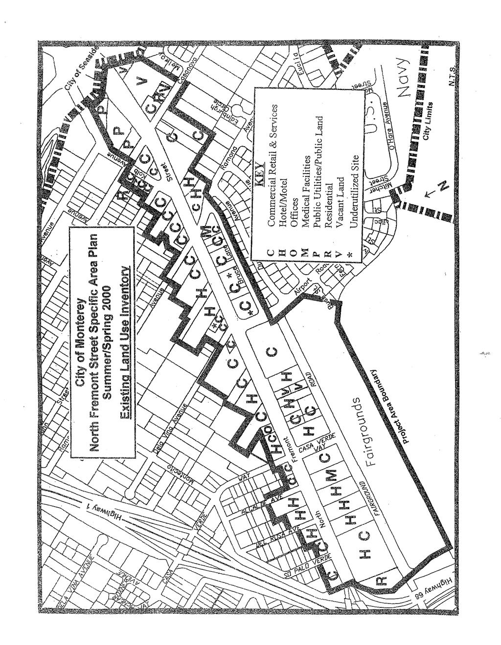
5 TABLE OF CONTENTS Land Use and Economics... 7 Traffic, Parking, Transportation and Pedestrian Flow Building, Site and Streetscape Design Issues and Objectives Organization and Implementation of the Plan LIST OF TABLES AND FIGURES Boundary Map... Facing 1 Existing Land Use Inventory... Facing 2 Types of Businesses and Source of Customers... Facing 3 Street Classifications... Facing 4 Hotel/Motel Inventory... Facing 7

6
7 LAND USE AND ECONOMICS North Fremont Street has a more cohesive sense of place than a typical strip commercial street because many of the businesses serve the adjoining residential areas. Business anchors for the street are Safeway, Longs, the Monterey Fairgrounds, hotels, and restaurants. Most retail and service uses have Citywide or Peninsula-wide market areas but also provide service to adjoining neighborhoods. Visitor-serving uses draw from outside the Monterey Peninsula but also provide support for restaurants and other neighborhood-serving uses. The Plan focus on resident-serving businesses allows creation of a distinct identity, in contrast to the mix of incompatible businesses often found in strip commercial areas. Hotels are the most dominant single use on North Fremont Street. There are seventeen hotels/motels with 673 hotel rooms. Most have design and room rates typical of budget-to medium price hotels. Most were developed when North Fremont Street was the main highway into Monterey, but they are generally well maintained and do not have deterioration or lack of maintenance often found in older hotels. Twelve hotels are at or near maximum allowed density. Added development potential is not an available incentive to modernize those hotels unless the VAF (hotel) zoning ordinance provisions are modified to allow expansion or expansion is allowed to adjoining properties. An additional 171 hotel rooms could be built on North Fremont Street, primarily on five sites. Added rooms could be an incentive to upgrade the existing hotels. North Fremont Street hotels face increased competition from new hotels in Seaside. Also, Peninsula-wide referral services have directed some potential customers to similar hotels in other communities. There is no unified promotion effort for the North Fremont Street business area. Promotion efforts could include design improvements to identify the street as a distinct commercial area, developing group event packages for events at the fairgrounds with lodging in North Fremont Street hotels, and establishing a Business Improvement District for group advertising, shared promotional activities, holiday lights, etc. Programs to address these issues are included under the design and organization chapters. Vacant and undeveloped sites will be difficult to develop or redevelop until improved market conditions support higher rents. The Area Plan proposes to improve the quality of the commercial area to improve the market conditions. Incentives to fill the gap between development costs and market rates of return would encourage improved appearance, mitigate impacts of older building designs on adjoining businesses, and minimize the collateral impact of businesses adjoining residential areas. Neighborhood-serving businesses are the preferred use for undeveloped, underdeveloped, and redeveloped sites. Uses with a neighborhood-serving component help establish the area as a unified business district. Businesses with a larger market area and visitor serving uses could be encouraged on these sites if they provide the economic base for neighborhood-serving uses on site. The predominant zoning on North Fremont Street is C-2 (Community Commercial) on non-hotel sites and VAF (Visitor Accommodation) on hotel sites. The C-2 zoning allows a broad range of retail, office, service, and other commercial uses.
8
9 Policy 1 Encourage Neighborhood and Resident-Serving Businesses to create a distinct business area identity, in contrast to the mix of incompatible businesses often found in strip commercial areas. Program 1.1 Support small businesses that directly serve the adjoining neighborhoods. Banks, clothing stores, and medium-price, family oriented restaurants would be desirable additions to the area. Program 1.2 Encourage business with a citywide or larger market area if they include a strong neighborhood-serving component. Longs and Safeway are examples of businesses with strong neighborhood service and a citywide market area. Program 1.3 Establish land use and other city incentives to support neighborhood-serving businesses. (a) Hotels may expand or develop beyond existing VAF sites if the project includes neighborhood-serving commercial component oriented to the street. The neighborhood-serving component and removal of marginal uses is a primary objective in allowing expansion of hotel uses. Voter approval is required for expansion of hotels on non-vaf sites. (b) The City should investigate other incentive programs to directly or indirectly support residentserving businesses, removal of marginal uses, and improvement of underdeveloped and undeveloped sites.. Program 1.4 Plan policies are intended to encourage an improved business area identity but do not modify the underlying zoning land use provisions. Policy 2. Encourage coordination between the hotels and Fairgrounds in order to increase the number of room nights, support the primary goal of improving neighborhood serving uses, and support improved appearance and maintenance. Program 2.1. Hotel promotion efforts should focus on coordinated event/hotel packages with the Fairgrounds, improved visibility at Peninsula wide referral services, and a strong presence at the Monterey Visitor Center. Program 2.2 Hotel and the Fairground coordination should encourage events with a family orientation, so that Fairground and hotel visitors support businesses compatible with the adjoining neighborhoods. Policy 3. Coordinate with other governmental agencies to improve east and west entrances to North Fremont Street. Program 3.1. Coordinate with the Cities of Seaside and Del Rey Oaks to improve streetscape frontage between Canyon Del Rey and the Monterey City limits. Program 3.2. Coordinate with CALTRANS to change freeway signs to read North Fremont Street or North Fremont Street, Monterey.
10 Types of Businesses and Source of Customers Type of Business # Neighbor- City/Regional Visitor/Tourist Street Traffic (in alpha order) hood (Strip Commercial) Adult Entertainment 2 X X X X Auto sales 2 X X X Auto services 4 X X X Bakery 1 X X X Beauty salon/barber 6 X X X X Bookstore 1 X Bowling alley 1 X X X Car Wash 1 X X X X Convenience Store 3 X X X Crafts- retail 2 X X Drug/pharmacy 1 X X X X Fairgrounds 1 X X Florist 1 X X X Furniture 2 X X Gas station 3 X X X Home Improvement 2 X X X Hotels/Motels 17 X X Jewelry repair 1 X X Laundry/Dry Clean 2 X X X Liquor 2 X X X X Medical care 3 X X X Music -- retail 1 X X Pet -- retail 1 X X Restaurant 10 X X X X Seasonal/Holiday 2 X X X Sporting goods 2 X X Supermarket 2 X X X X Video rental 2 X X Neighborhood: Businesses that typically serve the day-to-day needs of local residents from the adjacent neighborhoods. City/Regional: Businesses that typically require a larger than neighborhood customer base to support their operation. This customer base would typically be from Monterey/Seaside or the Monterey Peninsula. Visitor/Tourist: Businesses that typically serve the visitor or tourist market. Street Traffic/Strip Commercial: Commercial establishments that typically rely on high traffic from an arterial street as the source of customers.
11 TRAFFIC, PARKING, TRANSPORTATION AND PEDESTRIAN FLOW North Fremont Street does not have significant traffic and parking problems. North Fremont Street has occasional disruptions, but does not reach maximum capacity, where traffic is at Level of Service E or F, or where commercial parking spills into adjoining residential areas. The traffic signals on North Fremont Street are coordinated within the City. The long signal phases at Canyon Del Rey in Seaside do not coordinate with North Fremont Street timing, so that intersection often backs up into Monterey. There is generally sufficient parking on-site or on North Fremont Street to handle commercial parking demand. The commercial properties on Ramona have the potential to create neighborhood parking problems because they front on the side street, and parking tends to move into the neighborhood, rather than to vacant spaces on North Fremont Street. A U turn at the North Fremont Street/Canyon Del Rey intersection is necessary to allow a return to Monterey from the Cypress Bowl/Ito and Ralph s Market site. Also, the Canyon Del Rey U turn may reduce the number of cars which use neighborhood streets to return to Monterey, rather than remaining on arterial streets. A U-turn will require approval from the City of Seaside and CalTrans. Alternatives to a U turn at Canyon Del Rey include (a) median revisions in front of the Cypress Bowl/Ito Site, (b) design of the Casanova/North Fremont Street to facilitate return to Monterey from the Cypress Bowl/Ito Site if there is access to the site from Casanova Street. During heavy rains, there is flooding at North Fremont Street and Ramona Avenue, causing street closure. Improvements to the storm drain system are necessary to resolve this flooding. North Fremont Street sidewalks are narrow in several areas. In many instances, utility poles and bus stop benches are placed in the pedestrian way, reducing the width so that wheelchairs and strollers cannot pass. In general, North Fremont Street is not a strong pedestrian street, so wide sidewalks found in pedestrian commercial areas like downtowns would not be necessary. However, removal or relocation of the sidewalk obstacles is recommended. Dundee Avenue is sometimes used by North Fremont Street customers and delivery trucks as a return to Monterey, rather than returning to North Fremont Street and going through several traffic signals. Design of undeveloped, underdeveloped, and redeveloped properties can be tailored to reduce the amount of traffic, which would choose to use neighborhood streets. Neighborhood streets are also used to bypass traffic signals in commute periods. Traffic calming solutions within the neighborhood can minimize this through traffic. Parking for large Fairgrounds events can affect North Fremont Street parking. Fairground parking impacts can only be reduced by a combination of solutions aimed at providing substantial parking areas for large events, shuttles to bring patrons from offsite lots, and encouraging hotel guests to walk to the Fairgrounds. Revenues from parking on the Navy Golf Course are used for security, rather than to support the golf course. The Fairgrounds and City could explore financial arrangements that would make parking more financially attractive to the Navy.
12
13 Speeding is not a substantial issue along North Fremont Street, with the exception of the freeway on and off ramps. The on-ramp design from North Fremont Street to Highway 1 encourages acceleration on the City street in anticipation of merging onto the highway. Traffic exiting from Highway 1 to North Fremont Street is often travelling at freeway speeds when entering North Fremont Street. There are no significant commercial parking problems on North Fremont Street. Street parking demand is low enough that street parking spaces can be removed if needed for streetscape design elements. Policy 4. Street design should continue to support access to businesses, traffic flow without encouraging excess speeds or bypass travel through adjoining residential neighborhoods. Program 4.1. Work with the City of Seaside and CalTrans to develop a U turn at North Fremont Street and Canyon Del Rey. Alternates to the Canyon Del Rey U turn include (a) median break in front of the Cypress Bowl/Ito site or (b) design of the Casanova/North Fremont Street to facilitate U turns or return to Monterey from the Cypress Bowl/Ito Site. Program 4.2. Develop physical improvements to reduce speeding from North Fremont Street to the Highway 1 onramp. Solutions could include merging to a single lane in the block between Del Rosa Avenue and Palo Verde, eliminating onstreet parking between Palo Verde and the freeway onramp, and landscaping these areas Program 4.3. Develop physical improvements to reduce speeds from Highways 1 and 68 to North Fremont Street. These programs could include expanding landscape areas or use dense planting so that drivers perceive a narrow roadway rather than a wide street which encourages high speeds. Program 4.4. Access to Cypress Bowl/Ito site should be consistent with the type of uses desired. Development with a neighborhood-serving component may have access to Casanova Avenue. Development without a neighborhood serving component should have access only to North Fremont Street. Program 4.5. Bus stops should be evaluated for the entire length of North Fremont Street. Bus turnouts should be provided in areas where bus stops disrupt through traffic. Bus stops locations should be evaluated for impact on traffic flows. Program 4.6. Coordinate with adjoining residential neighborhoods to reduce the impacts of business customers and delivery vehicles on residential streets. Policy 5. Consider pedestrian and non-automobile circulation in transportation planning, street design, crosswalks, and traffic signal design. Program 5.1. Investigate pedestrian bump outs at corners to reduce the pedestrian crossing distance as long as they do not materially reduce traffic capacity.
14 Program 5.2. Use countdown signals for pedestrians crossing North Fremont Street. Program 5.3. Bus stops should be covered and bus enclosures should become a streetscape design element in design considerations on areas of the street where property lines have the space for structured bus stops or where property owners wish to incorporate bus structures on their sites. Program 5.4. The City should consider extending the WAVE to North Fremont Street. If extended, encourage the WAVE to work with Fairgrounds management so that fairgrounds or downtown visitors will use North Fremont Street businesses when practical. Program 5.5. Remove sidewalk obstacles. Consider placing bus stop seating and structures behind the pedestrian portion of the sidewalk. Policy 6. Continue to pursue parking options that support Fairgrounds events. Program 6.1. Pursue parking agreements between the Fairgrounds and the Navy Golf Course. Evaluate the potential for a long-term financial agreement to provide Fairgrounds parking on the Golf Course. Program 6.2. Investigate on-site parking or other parking options at the Fairgrounds.
15 Building, Site and Streetscape Design Issues and Objectives North Fremont Street is a primary gateway into the City of Monterey and should have the streetscape and commercial area design to emphasize its role as a gateway. North Fremont Street was originally part of a state highway with an extended strip of motels and highway commercial fronting uses. It is no longer a state highway, and design elements can support a distinct district identity. Entrances from the east and west should be enhanced. Streetscape features, street medians, building design, landscaping, and sign design should identify North Fremont Street as a distinct area with a unified visual presence. In many areas, North Fremont Street businesses adjoin single-family or apartment residential areas. Business-related noise, loading, trash, and truck traffic can have an adverse effect on adjoining single-family or apartment areas. In single family area with yards adjoining the commercial zones, there is a concern that uses with evening occupancy above the first floor would overlook private yards. Bruce Lane is a transition alley between commercial and residential uses, which provides both residential and commercial access. A design objective would be to address the impacts of commercial use on adjoining residential areas at a time when a planning permit is required. The Zoning Ordinance allows existing commercial uses to maintain their existing site configuration until a permit is requested. A strong goal of the Area Plan is to develop the commercial strength to support site upgrades, and those upgrades will address the impacts on adjoining residential areas. Policy 7. Improve the overall appearance of the North Fremont Street area. Create the visual impact of a distinct commercial area as opposed to a typical strip commercial area. Program 7.1. The area should be given high priority for undergrounding utilities because North Fremont Street is one of the main entrance streets to the City and is a first impression for visitors coming to Monterey, and the utility poles are sidewalk obstructions in several instances. Program 7.2. Using streetscape and Economic Development funding, develop design guidelines, which emphasize North Fremont Street as a distinct commercial area with dramatic entrance elements, underground utilities, and coordinated streetscape improvements, signage, and building design. The design guidelines should include the following. Use landscaping and building design to create a strong entry statement from the east. Coordinate with Seaside and Del Rey Oaks if agreement can be reached on properties between Canyon Del Rey and the Monterey City limits. If not, create a definite entrance point using dense landscaping at the City limit to screen the PG and E substation, behind the Welcome to Monterey Sign, and at the eastern edge of the Cypress Bowl/Ito Site. Use landscaping in areas proposed for traffic control in Programs 3.2 and 3.3 to create a strong entry statement from the west.

16
17 Public and private design standards should encourage the appearance of a distinct commercial area, rather than an area without a design identity or a typical strip commercial area. Area plan design standards will be given preference over standardized building and sign designs. Develop a North Fremont Street business district logo. Encourage use of the logo on signs and in advertisements. Design and sign standards should encourage remodeling to replace 1950 s design themes with more current design. Façade improvement funds should be offered to replace pole signs with monument signs or on-building signs. New construction should include building elements fronting on and oriented to the street, not buildings to the back of the lot with parking between the street and the building. Alternatives include buildings at the front setback line with parking to the rear or buildings with an element at the street setback line and parking to the side. Design adjoining residential areas should consider noise, truck loading, truck traffic, and trash impacts on the adjoining residential uses. Uses with night time occupancy should be designed so that windows above the first floor respect private yards if adjacent to single-family zones. Maintenance of approved design, landscaping, and signage should be encouraged, including code enforcement if needed. Design for existing and new construction should encourage public safety, including lighting on buildings or in landscaping areas to supplement the existing street lights. The design standards should consider opportunities for large trees, including street curb bump outs to create the appearance of a narrower street and room necessary for significant trees. Include street corner bump outs to minimize the pedestrian distance to cross the street Policy 8. Improve hotel appearance. Program 8.1. Hotels should be encouraged to upgrade appearance. A design objective is to reduce the visual impression that the hotels are obsolete designs from the 1950 s. Tools to encourage appearance upgrading could be: (a) increasing the number of rooms as allowed by VAF zoning and (b) improving the number of room nights by coordinated marketing with the Fairgrounds, and (c) allowing expansion to adjoining non-vaf parcels if the expansion includes neighborhood serving businesses and the expansion is approved by public vote, (d) City incentives based on rebating a portion of increased city revenues if the improvements support neighborhood-serving commercial. Such a program does not now exist and would have to be developed considering Citywide financial goals, (e) evaluating Neighborhood Improvement Program funding if improvements meet neighborhood objectives.
18 Policy 9. Encourage property maintenance to support the design standards creating a safe and high-quality commercial environment. Program 9.1. The Business Improvement District should monitor and encourage cleanliness, weed control, and replacement of burned out lights and sign lighting. The District should have a fixit program to assist in low-cost repairs if the property owner is not able to make repairs. Program 9.2. Investigate a Citywide property maintenance ordinance. This is not currently a City program and would have to be adopted Citywide. Support appearance improvements with the City Façade Improvement program.
19 ORGANIZATION AND IMPLEMENTATION OF THE PLAN Previous attempts to create a North Fremont Street Business Improvement District have not been successful. The Area Plan provides finite goals to improve the business climate and appearance of North Fremont Street. The Area Plan goals will not be fully realized without an organization to keep businesses informed, to create a discrete business area identity, and to represent the area to government agencies which affect the economic well-being of the area. Policy 10. Establish a Business Improvement District to implement the programs in the Area Plan. Program Establish a Business Improvement District using business license surcharge with sufficient funding to achieve the goals of the plan, including full-time staffing for the District. The District by laws should emphasize participation by businesses and property owners. Consideration should be given to a District Board with representatives from businesses, property owners, City Council appointees, Fairgrounds representation, and representation from adjoining neighborhood organizations.
The transportation system in a community is an
 7 TRANSPORTATION The transportation system in a community is an important factor contributing to the quality of life of the residents. Without a sound transportation system to bring both goods and patrons
EXISTING COMPREHENSIVE PLAN
 EXISTING COMPREHENSIVE PLAN Town Center Land Use Element: V. LAND USE POLICIES Town Center Mercer Island's business district vision as described in "Your Mercer Island Citizen-Designed Downtown" was an
Policies and Code Intent Sections Related to Town Center
 Policies and Code Intent Sections Related to Town Center The Town Center Vision is scattered throughout the Comprehensive Plan, development code and the 1994 Town Center Plan. What follows are sections
Table L-1 Summary Action Strategy. Action Item Timing Status Responsible Agency
 CHAPTER 4: CIRCULATION ELEMENT ISSUE #1: MAJOR THOROUFARES AND TRANSPORTATION ROUTES A balanced transportation system for Fontana is provided that meets the mobility needs of current and future residents
City of Farmington. Downtown Plan. Amendment to the 1998 Master Plan Adopted October 11, 2004
 City of Farmington Amendment to the 1998 Master Plan Adopted October 11, 2004 Introduction Planning Background 1 Scope and Components of the Plan Amendment 2 Concept Introduction 3 Plan Concepts 3 Conceptual
appendix and street interface guidelines
 appendix five: building and street interface guidelines appendix 5 building and street interface guidelines BOULEVARDS Boulevards are generally characterized by higher levels of traffic movement at higher
Planning Districts INTRODUCTION
 INTRODUCTION To facilitate detailed examination of development prospects for all areas of the community, Delano has been divided into 14 planning districts. The location of these planning districts is
Town Center (part of the Comprehensive Plan)
") Town Center (part of the Comprehensive Plan) Mercer Island Town Center Looking North (2014) In 1994, a year-long process culminated in a set of design guidelines and code requirements for the Town Center
Town Center (part of the Comprehensive Plan) Mercer Island Town Center Looking North (2014) In 1994, a year-long process culminated in a set of design guidelines and code requirements for the Town Center
STAFF REPORT TO COUNCIL PLANNING AND DEVELOPMENT
 DATE: April 29, 2013 STAFF REPORT TO COUNCIL PLANNING AND DEVELOPMENT 1100 Patricia Boulevard, Prince George, B.C., V2L 3V9 TO: FROM: SUBJECT: MAYOR AND COUNCIL JESSE DILL, PLANNER Development Variance
Introduction...UD-1. Plan...UD-3
 URBAN DESIGN ELEMENT TABLE OF CONTENTS Section Page Introduction...UD-1 Purpose of the Urban Design Element...UD-1 Scope and Content of the Urban Design Element...UD-1 Related Plans and Programs...UD-1
Port Lavaca Future Land Use
 Port Lavaca Future Land Use Introduction The City of Port Lavaca is beginning to see sustained growth, after many years of relative stable population. New single family homes, apartments, and businesses
north fremont specific plan
 north fremont specific plan Draft - November 25, 2013 contents Draft - October 21, 2013 Introduction The Specific Plan 8 Regional and Local Setting 10 Specific Plan Area 10 Regulatory Setting 12 Vision
Community Design Plan
 Gardena General Plan 2006 Authority While the is not a required element of a General Plan, it is included because improving the community appearance and image is paramount to the overall quality of life
Today Land & People. Northeast Nampa Gateway District. Employment. Land Use Characteristics. Demographics. Current Zoning
 Today Land & People Employment Major employers include Saint Alphonsus, the College of Western Idaho, the Auto Mall, Sorrento Lactalis and Walmart. 3,004 jobs in 2010 (COMPASS-CIM 2040 TAZ data) 4,345
This Review Is Divided Into Two Phases:
 Semiahmoo Town Centre Review The purpose of this review: To review the Semiahmoo Town Centre Concept Plan, originally approved in 1993, to ensure that this centre will continue to serve the needs of South
4.1.3 LAND USE CATEGORIES
 4.1.3 LAND USE CATEGORIES a. City Center District The City Center District incorporates the existing character and mix of uses in downtown Belmont to encourage redevelopment and new development in keeping
Urban Design 9Identity
 Urban Design 9Identity URBAN DESIGN IDENTITY Urban design is about connecting people to their places through the built environment, nature, and overall urban form. Done well, it creates a memorable space
LUNDY S LANE COMMUNITY IMPROVEMENT PLAN STUDY
 PUBLIC INFORMATION MEETING #2 October 12, 2016 LUNDY S LANE COMMUNITY IMPROVEMENT PLAN STUDY AGENDA 5:00 to 5:30pm: Open House 5:30 to 6:15pm: Presentation 6:15 to 7:00pm: Individual paced workshop with
Metro. Activity Center Design Guidelines. Recommendations For Developing Focused, Mixed-Use Commercial/Residential Centers
 Metro Activity Center Design Guidelines Recommendations For Developing Focused, Mixed-Use Commercial/Residential Centers Metro Activity Centers What is a MAC? Legacy, the adopted guide for the future growth
Clairtrell Area Context Plan
 Clairtrell Area Context Plan March 2005 Urban Development Services City Planning Contents 1. Introduction... 4 2. Development Structure... 6 2.1 Streets... 7 2.1.1 Sheppard Avenue and Bayview Avenue...
Hockessin Community Redevelopment Plan
 Hockessin Community Redevelopment Plan 3.1 Introduction The Community Redevelopment Plan for the Village of Hockessin is the result of the people s vision for a distinct village center that serves as the
WEST LOOP DESIGN GUIDELINES CHECKLIST
 WEST LOOP DESIGN GUIDELINES CHECKLIST Section 1.0 General Strategies 1.1 DESIGN EXCELLENCE: ENCOURAGE HIGH QUALITY AND INNOVATIVE DESIGN OF NEW BUILDINGS WITHIN THE WEST LOOP WITHOUT BEING PRESCRIPTIVE
DRAFT. October Wheaton. Design Guidelines
 October 2011 DRAFT Wheaton Design Guidelines 2 Draft - Design Guidelines - Wheaton Sector Plan Contents 04 Section 1: Introduction 06 Section 2: Context 08 Section 3: Design Guidelines 09 Goal 1: Create
CHAPTER 21 NC-PUD NEIGHBORHOOD COMMERCIAL PUD DISTRICT
 CHAPTER 21 NC-PUD NEIGHBORHOOD COMMERCIAL PUD DISTRICT Section 21.1. Title and Purpose. The Neighborhood Commercial Planned Unit Development District, designated the, is intended for commercial uses of
Small Area Plan. South Gateway
 Small Area Plan Adopted May 12, 2008 South Gateway Purpose. The South Gateway Small Area Plan defines the City s expectations for the future of the southern entrance to the City at Interstate 85 and Highway
CITY OF SEASIDE STAFF REPORT
 Item 12 CITY OF SEASIDE STAFF REPORT TO: FROM: BY: Honorable Mayor and City Council Ray Corpuz, City Manager Diana Ingersoll, Deputy City Manager, Resource Management Services Rick Medina, Senior Planner
MEMO 1. INTRODUCTION PURPOSE & PROCESS REQUEST
 MEMO Date: August 22, 2017 To: Board of Commissioners From: Jason Burdette, Planning Director Re: Davidson Commons East Hotel Stakeholder Feedback 1. INTRODUCTION PURPOSE & PROCESS This memorandum summarizes
7Page 91 CLEMMONS COMMUNITY COMPASS 7 COMMUNITY CHARACTER
 7 Community Character The beauty of Clemmons won t necessarily be a reflection of our past, but our future. This quote from Comprehensive Plan Steering Committee member Wayne Dodson captures the essence
3.0 LAND USE PLAN. 3.1 Regional Location. 3.2 Existing Conditions Existing Uses. Exhibit Regional Location Map
 3.0 LAND USE PLAN 3.1 Regional Location The Anaheim Resort Specific Plan (ARSP) area is located in the City of Anaheim, which is 35 miles southeast of downtown Los Angeles and 7 miles northwest of Santa
Honorable Mayor and Members of the City Council. Submitted by: Eric Angstadt, Director, Planning and Development
 Office of the City Manager ACTION CALENDAR January 29, 2013 To: From: Honorable Mayor and Members of the City Council Christine Daniel, City Manager Submitted by: Eric Angstadt, Director, Planning and
REPORT TO MAYOR AND COUNCIL
 AGENDA ITEM NO..e REPORT TO MAYOR AND COUNCIL TO THE HONORABLE MAYOR AND COUNCIL: DATE: March 1, 1 SUBJECT: ADOPTING RESOLUTION NOS. 1-, 1-, 1-, and 1- ORDERING THE PREPARATION OF THE ENGINEER S REPORT
Establish a network of streetscaped vehicle and pedestrian routes that connect within and outside the Plan area.
 This Plan s urban design goals are to create an urban scale, walkable community with connections to transit, parks, and services and with amenities and facilities for residents and employees. The 1992
Executive Summary. NY 7 / NY 2 Corridor
 Executive Summary NY 7 / NY 2 Corridor Transportation and Land Use Study December 2005 Prepared for: Town of Colonie Capital District Transportation Committee Prepared by: Introduction: Land use decisions
A. WHAT IS A GENERAL PLAN?
 I. Introduction A. WHAT IS A GENERAL PLAN? A general plan is the planning guideline for the future of a city. It contains goals and policies which regulate urban development, the protection of the natural
Corridors. Re-vitalize our Corridors and Gateways
 Corridors Re-vitalize our Corridors and Gateways Artist s rendering from the 287 Strategic Plan, 2015 Corridors are the major throughways of Loveland but they also provide important commercial, community
CHAPTER 3 VISION, GOALS, & PLANNING PRINCIPLES. City of Greensburg Comprehensive Plan. Introduction. Vision Statement. Growth Management Goals.
 CHAPTER 3 VISION, GOALS, & PLANNING PRINCIPLES Introduction The Greensburg Comprehensive Plan is intended as a working community document. A combination of long and short-term goals, this document is intended
6. DOWNTOWN. The Downtown Element focuses on supporting and expanding the vitality and enhancement of Downtown Chico as the City s central core.
 VISION In 2030, Downtown Chico is the heart of the community and the center of cultural activity. Engaging and active at the street level, it is a multi-story, mixed-use hub, with specialty retail, restaurants,
PINE CURVE REZONING. Property does not meet criteria for open space preservation and is not a candidate for a park
 PINE CURVE REZONING BACKGROUND Purchased as two parcels in 2001 and 2002 Annexed and Zoned Greater Downtown District Historic Center September 25, 2002 and October 7, 2002 WHAT THE PROJECT IS AND IS NOT
INSTITUTIONAL USE DESIGN COMPATIBILITY TECHNIQUES
 INSTITUTIONAL USE DESIGN COMPATIBILITY TECHNIQUES INTRODUCTION Community institutions are an important part of the character and vitality of neighborhoods in Forsyth County. Institutional uses include
NOTICE OF SPECIAL MEETING
 NOTICE OF SPECIAL MEETING Pursuant to Section 54956 of the Government Code of the State of California, a Special meeting of the Tracy City Council is hereby called for: Date/Time: Location: Tuesday, April
Table of Contents. Elm Avenue Improvement Plan City of Waco, Texas. Introduction 1. Existing Context 1 Figure 1 2.
 Table of Contents Introduction 1 Existing Context 1 Figure 1 2 Plan Guidelines 3 Future Urban Form 4 The West-End 4 Main Street 6 The East-End 7 Figure 2 9 Public Improvement Recommendations 7 General
CHAPTER 4 COMMUNITY DEVELOPMENT AND DESIGN
 CHAPTER 4 COMMUNITY DEVELOPMENT AND DESIGN The Community Development and Design Chapter is extremely important because it, together with the Transportation and Circulation Chapter, provides the foundation
4.9 Mendocino Avenue Corridor Plan Design Guidelines
 4.9 Mendocino Avenue Corridor Plan Design Guidelines The Mendocino Avenue Corridor Plan addresses the area between College Avenue and Steele Lane. Mendocino Avenue is a busy arterial that runs parallel
Chapter 1: Introduction
 Chapter 1: Introduction The Penn Avenue Community Works Corridor Vision and Implementation Framework presents an integrated communitybased vision and a coordinated, long-term implementation framework for
Pedestrian and Bike Bridge LOGO
 6.2.2 Pedestrian and Bike Bridge The proposed pedestrian and bike crossing re-envisions the existing bridge at Pismo Creek on Cypress Street. The bridge is currently underutilized by vehicular through
URBAN DESIGN BRIEF REPORT
 URBAN DESIGN BRIEF REPORT PREPARED FOR 2568401 ONTARIO INC NEW GASBAR, CONVENIENCE STORE & CARWASH DEVELOPMENT @ 1509 FANSHAWE PARK ROAD WEST LONDON, ONTARIO GAMA ENGINEERING INC. PROJECT NUMBER 1669 PREPARED
section five BEAUTIFICATION PLAN
 section five BEAUTIFICATION PLAN BEAUTIFICATION PLAN Section Five Beautification Plan The goal of the Beautification Plan is to improve the Route 8-Sunnyland Corridor in terms of aesthetics and to create
CHAPTER SPECIAL PURPOSE AND OVERLAY ZONING DISTRICTS
 Special Purpose and Overlay Zoning Districts 106.28.010 CHAPTER 106.28 - SPECIAL PURPOSE AND OVERLAY ZONING DISTRICTS SPECIAL PURPOSE AND OVERLAY ZONING DISTRICTS Sections: 106.28.010 - Purpose 106.28.020
BUILDING SCALE AND SETBACKS 5 ELEMENTS:... 5 FAÇADES (COMMERCIAL/RESIDENTIAL) 5
 5") VISION STATEMENT 3 UTILIZATION OF THE GUIDELINES 3 IMPLEMENTATION 3 PROCEDURES FOR DESIGN REVIEW 3 LAND USE AND ZONING 4 LAND USE 4 ELEMENTS:... 4 ZONING 4 ELEMENTS:... 4 BUILDING SCALE AND SETBACKS 5
VISION STATEMENT 3 UTILIZATION OF THE GUIDELINES 3 IMPLEMENTATION 3 PROCEDURES FOR DESIGN REVIEW 3 LAND USE AND ZONING 4 LAND USE 4 ELEMENTS:... 4 ZONING 4 ELEMENTS:... 4 BUILDING SCALE AND SETBACKS 5
Seneca Meadows. Block 4 Locate office, technology, and medical development adjacent to I Screen views of garage structures from I-270.
 Seneca Meadows Seneca Meadows has an industrial park in its southern end and a mixed-use employment area planned for the north end. The district benefits from extensive I-270 visibility, stream valley
Access Management: An Overview
 Figures 1-5 Below Evolution of development along a highway. In the early stages, land along the road is used for farming with little traffic generated. As time passes, the highway corridor becomes a de
Implementation Guide Comprehensive Plan City of Allen
 Implementation Guide 2030 Comprehensive Plan City of Allen DRAFT 2015 Implementation Guide Allen 2030 Comprehensive Plan INTRODUCTION The Comprehensive Plan serves as a guide for the growth and development
SDOT DPD. SDOT Director s Rule DPD Director s Rule DCLU DR SED DR of 7 CITY OF SEATTLE
 SDOT SDOT Director s Rule 2-07 DPD Applicant: CITY OF SEATTLE Page 1 of 7 Supersedes: DCLU DR 11-93 SED DR 93-4 Seattle Department of Transportation (SDOT) Department of Planning and Development (DPD)
Chapter PEDESTRIAN COMMERCIAL (PC) ZONING DISTRICT
 ZONING DISTRICT") Chapter 11-17 PEDESTRIAN COMMERCIAL (PC) ZONING DISTRICT Sections: 11-17-01 GENERAL PURPOSE 11-17-02 PERMITTED BUILDING TYPES 11-17-03 USES PERMITTED WITH DESIGN REVIEW 11-17-04 USES PERMITTED BY CONDITIONAL
Chapter 11-17 PEDESTRIAN COMMERCIAL (PC) ZONING DISTRICT Sections: 11-17-01 GENERAL PURPOSE 11-17-02 PERMITTED BUILDING TYPES 11-17-03 USES PERMITTED WITH DESIGN REVIEW 11-17-04 USES PERMITTED BY CONDITIONAL
Fifth and Detroit Street Design May 2017 Capital Improvements Committee. DOWNTOWN Street Design
 1 Fifth and Detroit Street Design May 2017 Capital Improvements Committee Agenda 2 Review Street Configuration Prior Meeting Review Outreach Synopsis Functional Street Design Refinements Curb Edge, Turning
Pattern 3: Parking. Parking in great amounts is not a characteristic of great streets. Allan Jacobs. Community Form and Mobility Principles
 Pattern 3: Parking Parking in great amounts is not a characteristic of great streets. Allan Jacobs Parking is an integral part of the municipal circulation system and is often as important as roads in
Urban Design Manual 2.0 DRIVE-THROUGH FACILITIES. Background. Urban Design Challenges
 222221 2.0 DRIVE-THROUGH FACILITIES Background In recent years, drive-through facilities have grown significantly in popularity with drive-through restaurants, in particular, being established on numerous
CHAPTER FIVE COMMUNITY DESIGN
 CHAPTER FIVE COMMUNITY DESIGN CHAPTER FIVE - COMMUNITY DESIGN Assumptions Frazier Park and Lebec have historically developed according to different patterns of spatial form. While both communities are
CHAIR AND MEMBERS PLANNING & ENVIRONMENT COMMITTEE GEORGE KOTSIFAS MANAGING DIRECTOR, DEVELOPMENT & COMPLIANCE SERVICES & CHIEF BUILDING OFFICIAL
 TO: CHAIR AND MEMBERS PLANNING & ENVIRONMENT COMMITTEE FROM: SUBJECT: GEORGE KOTSIFAS MANAGING DIRECTOR, DEVELOPMENT & COMPLIANCE SERVICES & CHIEF BUILDING OFFICIAL APPLICATION BY: 2261531 ONTARIO LIMITED
SECTION II SECTION II STATEMENT OF GOALS, OBJECTIVES, PRINCIPLES, ASSUMPTIONS, POLICIES AND STANDARDS
 STATEMENT OF GOALS, OBJECTIVES, PRINCIPLES, ASSUMPTIONS, POLICIES AND STANDARDS 1 2 STATEMENT OF GOALS, OBJECTIVES, PRINCIPLES, ASSUMPTIONS, POLICIES AND STANDARDS INTRODUCTION The New Jersey Municipal
DRAFT FOR COMMENT: EASTLAKE AVENUE PEDESTRIAN DISTRICT OVERLAY ORDINANCE
 DRAFT FOR COMMENT: EASTLAKE AVENUE PEDESTRIAN DISTRICT OVERLAY ORDINANCE Background: One of many actions in the 1998 Eastlake Neighborhood Plan was a proposal for an Eastlake Avenue Pedestrian District
I-35 CORRIDOR VISION PLAN INTRODUCTION. Purpose. Background
 INTRODUCTION Purpose The Interstate 35-E Corridor Plan is intended to work conjunctively with the 2010 Red Oak Comprehensive Plan to promote positive and quality development and redevelopment along Interstate
ARLINGTON COUNTY, VIRGINIA
 ARLINGTON COUNTY, VIRGINIA County Board Agenda Item Meeting of September 19, 2015 DATE: September 11, 2015 SUBJECTS: Outdoor Café at Citizen Burger Bar A. SP# 418 Site Plan Amendment to modify an approved
Staff Report and Recommendation
 Community Planning and Development Planning Services 201 W. Colfax Ave., Dept. 205 Denver, CO 80202 p: 720.865.2915 f: 720.865.3052 www.denvergov.org/cpd TO: City Council Neighborhoods and Planning Committee
July 12, Columbus City Council City Hall 90 West Broad Street Columbus, OH RE: I-70/71 Columbus Crossroads Project
 OHIO DEPARTMENT OF TRANSPORTATION DISTRICT 6 400 EAST WILLIAM STREET DELAWARE, OHIO 43015 800.372.7714 Columbus City Council City Hall 90 West Broad Street Columbus, OH 43215-9015 RE: I-70/71 Columbus
CHAPTER 3. Design Standards for Business, Commercial, Industrial, Recreational and Institutional Uses
 CHAPTER 3 Design Standards for Business, Commercial, Section Number Title Ordinance Number Date of Ordinance 16-3-1 Applicability 2006-11 2008-04 07-01-08 16-3-2 Uniform Standards for Architectural Design
Zoning Code Issues Prioritization
 City of Streetsboro The City of Streetsboro has begun the process of updating its Zoning Code. The new Zoning Code will be based on the recently adopted Comprehensive Plan, which establishes the overall
4. Shape Transitions. 4. Shape Transitions
 4. Shape Transitions 49 Zoning District Policies Overall Intent: Maintain neighborhood character by creating compatible transitions that minimize land use conflicts. Strategy: Define the character of zoning
REPORT TO: Council FOR: Regular Meeting. PRESENTED: April 1, 2008 FILE: , Byl 1932 & 1936
 DISTRICT OF SQUAMISH REPORT TO: Council FOR: Regular Meeting PRESENTED: April 1, 2008 FILE: 2006-08, Byl 1932 & 1936 DEPARTMENT: Planning Department SUBJECT: First and Second Readings for Bylaws 1932 (rezoning)
CITY OF SIMI VALLEY MEMORANDUM
 CITY OF SIMI VALLEY MEMORANDUM AGENDA ITEM NO. 9.1 May 18, 2016 TO: FROM: Planning Commission Department of Environmental Services SUBJECT: REVIEW OF POTENTIAL FISCAL YEAR (FY) 2016-17 CAPITAL IMPROVEMENT
MEMORANDUM. Planning and Zoning Division Department of Community Development TO: FROM: DATE: July 23, SUBJECT: PLNSUB : Salt City Plaza
 MEMORANDUM 451 South State Street, Room 406 Salt Lake City, Utah 84111 (801) 535-7757 Planning and Zoning Division Department of Community Development TO: FROM: Planning Commission Doug Dansie, Planning
C. Westerly Creek Village & The Montview Corridor
 C. Westerly Creek Village & The VISION Community Vision When the goals of the city are achieved Westerly Creek Village, a distinctive community defined by Montview Boulevard and Westerly Creek, is a strong
Lower Merion Commercial Districts Issues and Characteristics Handbook November 2013
 Lower Merion Commercial Districts Issues and Characteristics Handbook November 2013 DRAFT TOWNSHIP-WIDE VISION: To maintain and enhance commercial areas to complement the surrounding high-quality residential
The Ritz-Carlton, Paradise Valley
 The Ritz-Carlton, Paradise Valley 7000 E. Lincoln Drive Keys to Success Community Conversation II June 4, 2015 RITZ-CARLTON PARADISE VALLEY Town Council Study Session June 4, 2015 General Plan 2012 Land
V. Gateways GATEWAYS / V-1
 V. GATEWAYS / V-1 Many of Chesapeake s gateways are located on highways and call for bold and attractive designs that motorists can understand, appreciate, and enjoy. can also take the form of natural
Carlsbad Village Redevelopment Concept Summary of Features
 Carlsbad Village Redevelopment Concept Summary of Features Calthorpe Associates November 5, 2003 The Redevelopment Concept illustrates a vision for the future of Carlsbad Village. The overall vision of
REPORT TO MAYOR AND COUNCIL
 REPORT TO MAYOR AND COUNCIL AGENDA ITEM NO. 5.a TO THE HONORABLE MAYOR AND COUNCIL: DATE: May 26, 2015 SUBJECT: ADOPT RESOLUTION NOS. 15-33, 15-34, 15-35, AND 15-36, CONFIRMING THE ASSESSMENT DIAGRAMS
The Village. Chapter 3. Mixed Use Development Plan SPECIFIC PLAN
 The Village SPECIFIC PLAN Chapter 3 3.1 INTRODUCTION 3.1.1 Purpose This Chapter describes the development regulations applicable to the Mixed-Use and Transit Center Planning Areas. These form-based regulations
EXHIBIT A. Tax Increment Reinvestment Zone No. 1 (Town Center) First Amended Project Plan 1
 First Amended Project Plan 1") EXHIBIT A Tax Increment Reinvestment Zone No. 1 (Town Center) First Amended Project Plan 1 1 As amended by Resolution No. 2008-02-001(TR1R) of the Tax Increment Reinvestment Zone No.1, and approved to
EXHIBIT A Tax Increment Reinvestment Zone No. 1 (Town Center) First Amended Project Plan 1 1 As amended by Resolution No. 2008-02-001(TR1R) of the Tax Increment Reinvestment Zone No.1, and approved to
Citizen Advisory Committee Meeting #3.2
 Citizen Advisory Committee Meeting #3.2 August 10, 2016, 7:00 p.m. to 9:00 p.m. Police Department Conference Room, 7301 Hanna Street, Gilroy, CA 95020 Meeting Summary I. Call to Order Members present:
Planned Development Review Revisions (Project No. PLNPCM )
") Planned Development Review Revisions (Project No. PLNPCM2014-00139) Standard residential development Planned Development Example: Smaller lot sizes than what is allowed to create open space amenity. What
Planned Development Review Revisions (Project No. PLNPCM2014-00139) Standard residential development Planned Development Example: Smaller lot sizes than what is allowed to create open space amenity. What
July 6 th, Re: The Sugarmont Apartments Planned Development. Dear John,
 July 6 th, 2016 Planning Division Community And Economic Development Salt Lake City Corporation c/o John Anderson 451 South State Street, Room 215 Salt Lake City, Utah 84114 Re: The Sugarmont Apartments
REQUEST Current Zoning: O-15(CD) (office) Proposed Zoning: TOD-M(CD) (transit oriented development mixed-use, conditional)
 (office) Proposed Zoning: TOD-M(CD) (transit oriented development mixed-use, conditional)") Rezoning Petition 2016-117 Zoning Committee Recommendation January 4, 2017 REQUEST Current Zoning: O-15(CD) (office) Proposed Zoning: TOD-M(CD) (transit oriented development mixed-use, conditional) LOCATION
Rezoning Petition 2016-117 Zoning Committee Recommendation January 4, 2017 REQUEST Current Zoning: O-15(CD) (office) Proposed Zoning: TOD-M(CD) (transit oriented development mixed-use, conditional) LOCATION
Transportation. Strategies for Action
 Transportation A major priority for the Overlake Neighborhood is to develop a multimodal transportation system. To achieve this system, a balance has to be found among travel, circulation and access needs;
CHAPTER 7: Transportation, Mobility and Circulation
 AGLE AREA COMMUNITY Plan CHAPTER 7 CHAPTER 7: Transportation, Mobility and Circulation Transportation, Mobility and Circulation The purpose of the Transportation, Mobility and Circulation Chapter is to
V. Vision and Guiding Principles
 V. Vision and Guiding Principles The Master Plan for the Powers Ferry Corridor seeks a foundation in the desires of the community. At times, various elements of the community offered opposing viewpoints,
City Center Specific Plan Amendments And Background Report City of Richmond. PLANNING COMMISION FINAL DRAFT January, 2001
 City Center Specific Plan Amendments And Background Report City of Richmond PLANNING COMMISION FINAL DRAFT January, 2001 TABLE OF CONTENTS Page LIST OF TABLES... LIST OF FIGURES... INDEX... OVERVIEW...
4. INDUSTRIAL 53 CASTLE ROCK DESIGN
 4. INDUSTRIAL 53 CASTLE ROCK DESIGN CASTLE ROCK DESIGN 54 4. INDUSTRIAL Overview Well-designed and attractive industrial centers are the product of blending economic realities with both functional and
ARLINGTON COUNTY, VIRGINIA
 ARLINGTON COUNTY, VIRGINIA County Board Agenda Item Meeting of March 20, 2007 SUPPLEMENTAL REPORT #2 Additional and Revised Information DATE: March 20, 2007 SUBJECT: Request to Advertise Public Hearings
ARLINGTON COUNTY, VIRGINIA
 ARLINGTON COUNTY, VIRGINIA County Board Agenda Item Meeting October 15, 2005 DATE: September 28, 2005 SUBJECT: Request to Advertise the adoption of the 2005 Clarendon Sector Plan C. M. RECOMMENDATION:
Horizon 2035 Land Use and Transportation Element
 CITY OF SUNNYVALE Horizon 2035 Land Use and Transportation Element City Council Study Session March 7, 2017 Overview General Plan Context Mixed Use Villages Transportation Mode & Parking General Plan Policy
COMMUNITY DESIGN. GOAL: Create livable and attractive communities. Intent
 COMMUNITY DESIGN Intent An attractive, well-designed County will attract quality development, instill civic pride, improve the visual character of the community, and create a strong, positive image for
2.0 AREA PLANS. Lakeside Business District. Lakeside Business District Land Use Categories:
 Lakeside Business District Lakeside Business District Land Use Categories: Campus Commercial Campus Commercial means a mixture of uses which includes corporate offices, office parks, hotels, commercial,
The University District envisions, in its neighborhood
 Envisioning the University District Link Light Rail in Seattle s neighborhoods CIY OF SEALE CONCEP-LEVEL SAION AREA PLANNING RECOMMENDAION RESOLUION # 30165 EXHIBI L Vision 08.2000 he University District
Urban Design Brief. 875 Wellington Road. Proposed One-Storey Fast Food Restaurant and Two-Storey Restaurant. Wellington Harlech Centre Inc.
 Urban Design Brief 875 Wellington Road Proposed One-Storey Fast Food Restaurant and Two-Storey Restaurant Wellington Harlech Centre Inc. Prepared By: (519) 433-7587 info@yorkdev.ca May 3 rd 2013 1 Table
PLANNING APPROVAL & PLANNED UNIT DEVELOPMENT Date: November 2, 2017
 PLANNING APPROVAL & PLANNED UNIT DEVELOPMENT Date: November 2, 2017 DEVELOPMENT NAME LOCATION Mobile Christian School 5900 Cottage Hill Road (North side of Cottage Hill Road, 230 ± West of Freemont Drive
4 C OMMUNITY D ISTRICTS
 4 C OMMUNITY D ISTRICTS N ew development in the Area will include many different types of land uses, including a destination retail area that attracts people from all over the region; recreation opportunities
4 LAND USE DESIGNATIONS
 4 LAND USE DESIGNATIONS Chapter 4 describes the land use designations and densities that will implement the development vision for North Burlingame outlined in Chapter 3. Land use densities are described
SUBCHAPTER 4-B GUIDELINES FOR THE B-3 COMMERCIAL CHARACTER AREA
 1 SUBCHAPTER 4-B GUIDELINES FOR THE B-3 COMMERCIAL CHARACTER AREA Downtown Bozeman should be the location of buildings of greatest height and intensity in the community. The following guidelines apply
DRAFT. 10% Common Open Space
 % OF CHARLOTTE IS CATEGORIZED AS A. LAND USES : Placeholder map displaying location of Place Type GOALS: Accommodate XX% of future growth. Provide a concentration of primarily commercial and civic activity