Powys County Council Local refinement of TAN 8 Strategic Search Areas B and C Review Exercise
|
|
|
- Erica Stevenson
- 6 years ago
- Views:
Transcription
1 Local refinement of TAN 8 Strategic Search Areas B and C
2 Local refinement of TAN 8 Strategic Search Areas B and C April 2008 This report takes into account the particular instructions and requirements of our client. It is t intended for and should t be relied upon by any third party and Central Square, Forth Street, responsibility is undertaken to any third party Newcastle upon Tyne NE1 3PL Tel +44 (0) Fax +44 (0) Job number
3 Document Verification Page 1 of 1 Job title Document title Job number File reference Document ref Revision Date Filename Draft Report 01.doc Draft 1 08/01/08 Description First draft Prepared by Checked by Approved by Name Cathy Edy Simon White/Simon Power Signature Simon Power Draft 2 12/02/08 Filename Description Draft Report 02_CE.doc Updated following site review and internal review Prepared by Checked by Approved by Name Cathy Edy Simon White/Simon Power Signature Simon Power Draft 3 07/03/08 Filename Description Draft Final Report 03_CE_ corrected boundaries.doc Updated with correct draft 2006 IDCG boundaries Prepared by Checked by Approved by Name Cathy Edy Simon White/Simon Power Signature Simon Power Issue 11/04/08 Filename Description Final Report_ doc IDCG consultation responses moved to a separate document Prepared by Checked by Approved by Name Cathy Edy Simon White/Simon Power Signature Simon Power Issue Document Verification with Document
4 Contents Page 1 Introduction Overview Brief Report structure 2 2 Methodology and analysis Methodology The Review Process Study Area/Units of analysis Landscape sensitivity analysis Visual Data Deriving a least impact/refined SSA boundary Comparison with 2006 draft IDCG refined boundaries 33 3 Conclusions and recommendations Study findings/conclusions 36 Appendices Appendix A Landscape Sensitivity Summary Sheets
5 1 Introduction 1.1 Overview Technical Advice Note 8: Planning for Renewable Energy ( TAN 8 ) was published in June It contains details of seven Strategic Search Areas ( SSAs ) for onshore windfarms which are located throughout Wales. Two of these SSAs B ( Car North ) and C Newtown South ), are located in Mid Wales in Powys County Council ( PCC ). TAN 8 contains, as an annex, a methodology for local planning authorities to refine their SSAs, taking into account aspect of the local environment, principally landscape/ visual issues and cumulative impact issues. PCC appointed White Consultants with Arup and sub consultants in the summer of 2005, shortly after the finalisation of TAN 8, to begin work on a refinement exercise of SSAs B and C. The outcomes led to the preparation of a report on the local refinement process. This was published in January The planning response to the study was prepared in early Spring 2006 and was issued for consultation ( between 13 th Feb and 27 th March 06 ) in the form of Draft Interim Development Control Guidance 2 ( IDCG ), pending formal consideration of revised policies as part of the Local Development Plan process. The Draft IDCG contained refined boundaries 3 judged to be capable of meeting the TAN 8 indicative capacity for SSAs B and C, namely 290MW and 70MW of installed renewable energy capacity respectively. This review of the refinement boundaries for SSA B and C was commissioned by PCC following feedback on the nature and extent of the refinement boundaries following the publication of the Draft IDCG and the Inspector s decision letter for the Wern Ddu appeal Brief The brief for this study, agreed in dialogue with PCC, was to undertake a new local refinement of the boundary of the nationally published Strategic Search Areas (SSAs) for SSA B (Car North) and SSA C (Newtown South). The new local refinement exercise was to follow the principles as set out below: It was to comply as far as possible with the guidance contained within TAN 8 Annex D It was t to serve to cap development levels at the TAN 8 indicative capacities (in MW) for each SSA where the data indicated that greater levels of development might be possible i.e. the outcomes were to be driven by the landscape capacity of the area, within the context of an overall national policy objective to allow landscape change. This new study has been undertaken by an Arup team with ad-hoc support from White Consultants and the University of Northumbria. 1 TAN 8 Annex D study of TAN 8 Strategic Search Areas B ( Car North ) and C ( Newtown South ) Arup in conjunction with White Consultants and the Centre for Environmental and Spatial Analysis, Jan The Car and Llanbadarn Wind Farm zones 4 Denbighshire County Council - Appeal decision APP/R6830/A/05/ June Page 1
6 1.3 Report structure This review report uses the same basic structure as the original refinement study and as such is organised under the following main headings of: Introduction/Brief Methodology and analysis including: Technical and Environmental Constraints Review and Landscape and Visual Analysis Conclusions and Recommendations To understand the full context of this review, this report should be read in conjunction with the original refinement study report. Page 2
7 2 Methodology and analysis 2.1 Methodology The Review Process The review process undertaken can be summarised in the following flow diagram and is explained below in the sections which follows. 2.2 Undertake review of land unconstrained with respect to wind farms. Preparation of New Zones based on re-evaluation in response to third party representations. 2.3 Re-evaluation of landscape sensitivity for new zones in the field and completion of working landscape sensitivity and capacity sheets 2.4 Determine overall visual sensitivity of zones 2.5 Undertake review of sensitive landscape and settings Reassess refined boundary 2.2 Study Area/Units of analysis A technical and environmental constraints review of the SSA(s) and a 5km buffered margin (based on that used for the original refinement exercise) was undertaken to focus the scope of the area to be subject to the landscape and visual analysis. It comprised a standard constraint sieving exercise using a Geographic Information System (GIS), similar to that undertaken by all wind farm developers when selecting sites. This identified the unconstrained 5 land with respect to range of parameters which can then be tested for its suitability in landscape and visual terms. The technical and environmental constraints remain as described in the original refinement study report. The unconstrained land within the TAN 8 boundaries for SSA B and C is shown in Figures 1a and 1b. 5 Unconstrained in this context refers to the absence of a set of pre-defined technical and environmental constraints that prohibit development in absolute terms. It does t relate to the landscape and visual characteristics of an area or suggest that there are t other constraints that either singularly or in combination may affect the ability to develop wind turbines. Page 3


8 Figure 1a SSA B Technical and Environmental Constraints Figure 1b SSA C Technical and Environmental Constraints Page 4
9 In the original refinement exercise areas of highest absolute constraints were excluded from the zone creation process. The zones were derived from the LANDMAP visual and sensory aspect layer data for Powys CC and were verified in the field; see the Arup 2006 Refinement Report. The original refinement exercise used wind speed of <7m/s -1 as an absolute constraint in line with the constraints used for the derivation of the national TAN 8 boundaries. As wind turbine techlogy has progressed turbine heights have increased to provide greater energy yield at lower wind speeds. Figures 2a and 2b illustrate the increase in unconstrained land, in terms of absolute constraints, if lower wind speeds are used to define the constraints within the study area reflecting the increasing practice of wind developers expanding their search areas to include areas of lower wind speed. Page 5


10 Figure 2a SSA B Technical and Environmental Constraints with Varied Wind Speed Figure 2b SSA C Technical and Environmental Constraints with Varied Wind Speed Page 6
11 There is a generally limited increase in unconstrained land in SSA B when lower wind speeds are considered. While in SSA C the most significant increase are observed to the east of Zones 11 and 12 where, in terms of absolute constraints, approximately 11km 2 of previously constrained land would become available for consideration for wind development. The potential for wind development in the areas of land which become available when lower wind speeds are considered cant be igred. However, within the limited resources available for this study, it was t possible to undertake further detailed analysis of these newly available areas. Due to their suitability, in terms of wind speed, for modern turbine development these newly available areas should be considered for inclusion within the revised refined boundary. Where development proposals come forwards in areas of land made available by the use of lower wind speed as a constraint within the revised refined boundary, these proposals should be considered on their own merits. This study is predominately a desk based study which has built upon the original refinement exercise and the zones derived for it. Following comments received during the draft IDCG consultation process refined zones have been generated for this review of the refinement boundaries. Where representations were made during the consultation process regarding specific zones these (generally larger) zones have been further sub-divided based on observed landscape characteristics. These characteristics are described in the landscape sensitivity summaries in Appendix B. The following original zones have been sub-divided into new zones, illustrated in Figures 3a and 3b, as follows: For Area B: Zone 1 ( Pencoed upland ) has been sub-divided into Zones 1a and 1b; Zone 10 ( Dyfnant forest ) has been sub-divided into Zones 10a and 10b; Zone 11 ( Esgair Cwm Owen Uplands ) has been sub-divided into Zones 11a, 11b, 11c, 11d and 11e. For Area C: Zone 2 ( Banc Gorddwr ) has been sub-divided into Zones 2a and 2b. Page 7


12 Figure 3a SSA B Revised Zones Figure 3bSSA C Revised Zones Page 8


13 2.3 Landscape sensitivity analysis Following the identification of new zones, the visual and sensory value has been identified from LANDMAP data for each new area. This is the same as the larger zones in the previous report that have w been subdivided. The values are listed in Tables 2a and 2b and illustrated in Figures 4a and 4b. It should be ted that the underlying data from LANDMAP has t changed, just the spatial distribution of the zones in so far as they fit on top of the LANDMAP data. Figure 4a SSA B LANDMAP Visual and Sensory Value of Zones Page 9


14 Figure 4b SSA C LANDMAP Visual and Sensory Value of Zones The LANDMAP visual and sensory data was used as part of a desk and site based assessment of the landscape sensitivity for each zone. The summary landscape sensitivity justifications for each zone are provided for reference in Appendix B. The sensitivities are summarised in Table 2a and 2b below, and in Figures 5a and 5b. Page 10


15 Figure 5a SSA B Landscape Sensitivity Figure 5b SSA C Landscape Sensitivity Page 11
16 Table 2a Landscape Value of the Zones from LANDMAP Visual and Sensory Data and Summary Landscape Character Sensitivity of zones for SSA B (amending Table 4a and Table 5a in original 2006 refinement study report) Zone Zone name LANDMAP Visual & Sensory Value Landscape sensitivity value used 1a Pencoed Upland (a) Moderate Medium 1b Pencoed Upland (b) Moderate Medium-Low 2 Banwy Forest South Low Low 3 Banwy upland Moderate Medium-Low 4 Trann Moors (Car wind farm) Moderate Low 5 Mynydd Penypistyll (Car west) Moderate Medium-High 6 Banwy Forest (Llyn Coch-hwyad) Low Low 7 Mynydd Lluest Fach Moderate Medium-Low 8 Mynydd y Cemmaes Moderate Medium-Low 9 Plynlimon Moorlands (east of Glaslyn) High Medium-High 10a Dyfnant Forest (a) Moderate Medium-Low 10b Dyfnant Forest (b) Moderate Medium 11a Esgair Cwm Owen Uplands North (a) High Medium 11b Esgair Cwm Owen Uplands North (b) High Medium-Low 11c Esgair Cwm Owen Uplands North (c) High Medium-Low 11d Esgair Cwm Owen Uplands North (d) High Medium 11e Esgair Cwm Owen Uplands North (e) High Medium 12 Esgair Cwm Owen Uplands West High Medium-Low 13 Esgair Cwm Owen Uplands Central (Mynydd yr Hendre) 14 Esgair Cwm Owen Uplands South (Garreg Hir) 15 Esgair Cwm Owen Uplands East (Mynydd Clogau) High High High Medium-Low Medium-High Medium-Low 16 Clywedog Upland High Medium 17 Trann Woodlands High Medium 18 Trann and Car Uplands South-east High Medium-High Page 12
17 Table 2b Landscape Value of the Zones from LANDMAP Visual and Sensory Data and Summary Landscape Character Sensitivity of zones for SSA C (amending Table 4b and Table 5b in original 2006 refinement study report) Zone Zone name LANDMAP Visual & Sensory Value Landscape sensitivity value used 1 Kerry Hill and Clifaesty Hill High Medium-High 2a Banc Gorddwr (a) High Medium-High 2b Banc Gorddwr (b) High Medium-Low 3 Bryn Gydfa Moderate Medium-Low 4 Pen-y-Bank North Moderate Medium-Low 5 Rhiw Garn Moderate Medium-Low 6 Gors Lydan High Medium 7 Beacon Hill High Medium-High 8 Brondre Fawr Hill High Medium-Low 9 Lion Hill (Forest) Low Medium-Low 10 Banc Du High Medium-Low 11 Waun Dubarthog (Llandinam P&L east) High Low 12 Blue Lins Brook Low Medium-Low 13 Moel Lart High Medium-High 14 Kerry Ridgeway Forest Moderate Medium 15 Cwmderw Low Medium-Low The landscape sensitivity of a zone is related to, among other factors, the within the zone, the interrelationship between zones and the perceptual qualities of a zone. As indicated by the data in Tables 2a and 2b above the majority of the zones are considered to have a Medium or lower sensitivity to wind turbine development. No zones within study areas for SSA B or SSA C were classed as Outstanding in term of the LANDMAP visual and sensory data. Zones 5, 9, 14 and 18 within SSA B and Zones 1, 12a, 7 and 13 within SSA C are considered to have Medium High landscape sensitivity. This is due to their intrinsic landscape characteristics which are considered to increase landscape sensitivity to commercial scale wind turbine development. Zones which are considered to have a Medium-High or greater landscape sensitivity are t considered suitable for full inclusion within the revised refined boundary. This is due to the landscape characteristics of these zones, although the boundary may extend slightly into less sensitive parts of the zone. Page 13
18 2.4 Visual Data Following comments received regarding the initial refinement exercise and the complex ranking process that was used to define the suitability of zones for inclusion within the refined 2006 SSA boundaries an updated assessment of the relative visual performance of the zones within the study area was undertaken. The results of this assessment of the relative visual performance have been ranked but in a simple straight forward manner allowing the work to be transparent and more easily understood. The parameters used for the visual assessment are based upon evidence/experience gathered from previous similar studies in Northumberland and Wales by the study team. Visual impact is the dominant issue relating to most, if t all, wind farm proposals and in particular the potential for visual impact upon sensitive receptors. Sensitive visual receptors are diverse in nature, but can be grouped as follows: Landscape/Sensitive Outdoor Recreation Receptors these are locations within sensitive landscapes used by people who may be sensitive receptors such as walkers/cyclists and general visitors enjoying areas of scenic quality. Sensitive landscapes in this context are generally considered to be those which are valued nationally such as the Swdonia National Park, the Shropshire Hills AONB and any National Trails. People day to day these are people who may see turbines frequently while carrying out their day to day business or whilst residing in or around an area. Those most affected will be on the edges of settlements (others gaining glimpses between buildings and other structures). The category also includes those using highways in the area. The study has considered the relative visual effects of hypothetical turbines of fixed height placed within each of the landscape zones identified for the landscape sensitivity exercise. Each zone has been evaluated in terms of its visibility overall and to sensitive receptors via the creation of a zone of theoretical visibility [ZTV] for each. Key parameters used in the generation of the relative visual analysis are established within Table 3 below. Table 3 Key parameters used in the generation of the relative visual analysis Turbine height Turbine density in zones Grid size used in ZTV Extent of ZTV 125m to blade tip (a median value between a minal 135m in any forested areas and a minal 115m in open moorland). It should be stressed that using height to blade-tip in the ZTV presents a conservative approach to the analysis; many individual EIA ZTV studies for wind farms consider height to hub as well as to blade tip. These minal turbine heights may t exactly fit with a given manufacturers specification. 4 No. placed within each 1 km within the zone on a grid basis. Note this turbine distribution does t directly relate to the likely developable capacity (MW) available per zone as constraints are taken into account. 250m square Maximum extent of 20km from edge turbines in the zone. Whilst it is ackwledged that 30-35km represents the ZTV in many cases, the study is concerned with moderate adverse visual impacts and greater only. For m turbines these impacts are considered to occur within 20km of the study area. Page 14
19 The ZTV for each zone takes account of the presence of existing wind farms within the landscape (unlike the 2006 previous exercise). The ZTV generated is then broken down into component parts: The overall area that can see wind turbines in each zone The number/area of day-to-day receptors such as dwellings and A and B roads that can see wind turbines in each zone The number/area of sensitive landscape and receptors such as National Park/AONB or National Trails that can see wind turbines in each zone. This is further described within Table 4 below. Table 4 Visibility data description further details Measurement category Overall visual effect Overall total area that can view turbines Landscape/ sensitive outdoor recreation receptors Areas of National Park/AONB that can view turbines National Trail that can view turbines Comments This measurement defines the theoretical area that can view the theoretically placed wind turbines in any study area zone. It covers all potential receptors including those t covered by categories below such as users of open access land, public footpaths and mir roads. It is also a factor which brings in the effects of the turbines on perception of landscapes surrounding any zones. These are sensitive landscapes used by people who may be sensitive receptors such as visitors enjoying its scenic quality. The nature of the landscapes within National Parks/AONBs is such that they often allow broad, and wind turbines may be viewed whilst undertaking leisure activities. These are sensitive routes used by people who will be sensitive receptors-walkers enjoying scenic quality. The National Trails often allow broad, and wind turbines may be viewed whilst undertaking leisure activities. People day to day Settlements that can view turbines in close proximity Settlements that can view turbines in medium distance A and B roads that can view turbines The likelihood of severe effects upon visual amenity and setting, particularly cumulative effects upon communities. i.e. the visual effects that developing a zone might have upon adjacent villages and settlement in terms of dominance and sense of enclosure. Settlements are the most sensitive receptors. People may see turbines frequently while carrying out their day to day business or whilst residing in or around the study area. Those most affected will be on the edge of settlements, others gaining glimpses between buildings and other structures. Users of roads are less sensitive than residents generally but may include tourists and turbines will affect visitor s perceptions of an area. In arriving at an overall summary of the visual performance of a zone/sub-area, the data per receptor group is first ranked, and then the data combined. This is combined as follows:- Rank given to overall visual performance + Rank given to National Park/AONB + Rank given to settlement data (20km) + Rank given to settlement data (5km) + Rank given to roads + Rank given to the National Trails Page 15
20 The effects on these different receptors are considered at varying distances to cover the most significant effects dependent on the type of receptor. It is ackwledged that there will be effects beyond these distances and this is discussed further below Calibration of likely visual effects There have been many studies relating to the potential visual effect on wind farm development. This is brought together in the publication Visual assessment of Windfarms: Best practice produced for Scottish Natural Heritage by the University of Newcastle As pointed out by the study, the expected magnitude of effect varied between studies but this depended on whether the writer was pro or anti wind farm development. PAN 45: Renewable Energy Techlogies produced by the Scottish Executive in 2002 suggest the following perception for a wind farm in an open landscape [without relating this to tower height, but having earlier referred to turbines of tower height >70m and rotor diameters of >80m i.e. height to blade tip of up to 110 m] is as follows (Table 5): Table 5 Perceptual distances for Wind farms Distance 0-2km 2-5km 5-15km 15-30km Perception Likely to be a prominent feature Relatively prominent Only prominent in clear visibility -- seen as part of a wider landscape Only seen in very clear visibility -- a mir element in the landscape The University of Newcastle suggest, based on this and other research that the size classes, names and descriptions of visual effect should be modified. This study does t come to a view on significance which is related to the sensitivity of the receptor. In Table 6 below the University of Newcastle data is taken and a view is developed on distance and significance of effect for 125m to blade tip turbines depending on sensitivity of receptor as the basis of the calibration of effects for visual impact assessment Page 16

21 Table 6 Calibration of significance of visual effects with distance for wind farms University of Newcastle criteria This study calibration Distance range Sensitivity of Receptor High Moderate Sensitivity sensitivity Low sensitivity Size class [Magnitud e] Very large Large Medium Name Descriptors - appearance in central vision field Domina nt Promin ent Conspic uous Commanding, controlling the view Standing out, striking, sharp, unmistakable, easily seen Noticeable, distinct, catching the eye or attention, clearly visible, welldefined Modifying factors Few Few Many: Limit of potential visual significance Magnitude of Effects Substantial adverse Substantial / Moderate Up to 2 km 2 to 5 km Severe. Major in some situations Likely significance of effect Severe Major Moderate Major. Moderate in some situations Moderate Moderate 4-10 km Major Moderate Mir Very small Inconsp icuous Lacking sharpness of definition, t obvious, indistinct, t clear, obscure, blurred, indefinite Many Limit of ZVI Mir 9-20km Moderate Mir Mir Negligible Faint Weak, t legible, near limit of acuity of human eye Few Negligible 15km- 30km Negligible Negligible Negligible The sensitivity of receptors is based on commonly accepted standards derived from the Guidelines for Landscape and Visual Assessment [GLVIA 2002] where the most sensitive receptors may include: users of all recreational outdoor recreational facilities including public rights of way whose attention or interest may be focused on the landscape; communities where the development results in changes in the landscape setting or valued enjoyed by the community; and occupiers of residential properties with affected by the development. The majority of the study area for SSA B and C is comprised of large scale sparsely wooded open upland plateaus divided by steep sided settled valleys. Views are limited within the valleys but while there are localised areas of topographic interest and variation on the plateau tops which provide screening, the generally open nature of the landform allows long distance. The extreme nature of the potential intervisibility possible on the plateau tops has led to the use of maximum distances within the distance banding shown in Table 6 for severe to moderate significance effects on receptors. The most significant i.e. severe to moderate effects related to the sensitivity of a receptor are shown highlighted in Table 6 and can be considered to be namely: Settlements effects within 5km and 20km (ackwledged double counting distance band tends to highlight most significant effects where potential for inter-visibility screening would be less) National Park/AONB/National Trails effects within 20km Open Access land and other recreational users all effects within 20km Page 17
22 Roads effects within 10km (lower sensitivity users) The data 6 for severe to moderate significance effects on sensitive receptors within these distance bands for each of the zones within the strategic search areas are shown in Tables 7a and 7b below, and illustrated spatially as ranked data on Figures 6a and 6b. The data in Tables 7a and 7b generally shows the number of 250mx250m grid squares (in the computer generated ZTV distance band referenced) containing the appropriate sensitive receptors that would be theoretically able to see turbines located within each zone or subarea. The only exception to this relates to the settlement data. This shows the numbers of residential properties (in the computer generated ZTV distance band referenced) that would be theoretically able to see turbines located within each zone or sub-area. Each set of data is then ranked. 6 It should be ted that the visual analysis does t make allowances for the localised screening effect of tree cover and building. The computing and resource implications render modelling such within a County level 3-D model as generated for this study. It is therefore likely that the visual effects on settlement and other receptors may be less than indicated. Coniferous plantations, as a crop, cant be relied on to provide screening in perpetuity and with modern tall turbines will only provide limited screening as they would be less that 25% of the height of a turbine to blade tip. The visual analysis, as undertaken, does t differentiate between the number of turbines visible from each specified receptor r the amount of a turbine visible from each receptor. Visual analysis of this detail should be contained within the Environmental Statements produced for developer proposals. To produce a visual analysis that differentiated between the number of turbines and amount of a turbine visible from receptors would be highly resource intensive and was t considered necessary for this high level study as all zones were analysed following the same methodology and are compared only relative to one ather. Page 18
23 Table 7a Ranked Visual Data for SSA B Zone Turbine No Overall Visibility 20km Rank of Previous Data National Park Rank of Previous Data Settlement Rank of Previous Data Settlement Rank of Previous Data Roads Rank of Previous Data National Trails (20km) (20km) (5km) (10km) (20km) Rank of Previous Data AREA B Zone 1a Zone 1b Zone Zone Zone Zone Zone Zone Zone Zone Zone 10a Zone 10b Zone 11a Zone 11b Zone 11c Zone 11d Zone 11e Zone Zone Zone Zone Zone Zone Zone Sum of Ranks Overall ranking Page 19
24 Zone Table 7b Ranked Visual Data for SSA C Turbine No Overall Visibility 20km Rank of Previous Data AONB Rank of Previous Data Settlement Rank of Previous Data Settlement Rank of Previous Data Roads Rank of Previous Data National Trails (20km) (20km) (5km) (10km) (20km) Rank of Previous Data AREA C Zone Zone 2a Zone 2b Zone Zone Zone Zone Zone Zone Zone Zone Zone Zone Zone Zone Zone Sum of Ranks Overall ranking Page 20


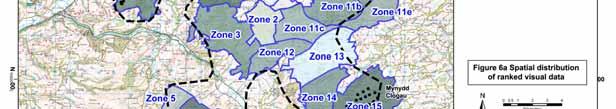


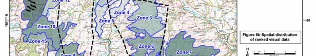

25 Figure 6a SSA B Spatial Distribution of Ranked Visual Data Figure 6b SSA C Spatial Distribution of Ranked Visual Data Page 21
26 2.4.2 Description of visual effects within SSA B Overall Visual Effects The most visible area is Zone B15 an upland area which is surrounded on three sides by relatively well settled lower ground. Zones B14 and B13 which form a continuation of this high ground therefore also have relatively high visibility. Zones B4 and B6, areas of higher ground in close proximity to settled land in the south and rth respectively perform poorly in terms of overall visibility. The least visible zones are Zones B11d, B1a and B1b which lie on the edge of the relatively sparsely settled Afon Gam valley. Zone B9 which lies in the far west of the study area away from settlement also performs relatively well. Some of these zones show different performance when considered against the various criteria, although Zones B6 and B15 perform poorly across the board and Zones B11d generally performs well. Effects on Settlement The area is relatively sparsely settled, with settlements generally confined to the valley floors and in some instances valley sides, in the valleys surrounding the study area. A few residential properties are located on the plateaus tops although they are very widely scattered. The worst performing zones in terms of visual effect on settlements at a distance of 20km are Zones B15, B14 and B13 in the south east of the study area. Zone B15 also performs the worst at a distance of 5km. Zone B4 which comprises an area of higher ground to the west of the settlement of Car and Zone B11a an area of higher ground above a well settled section of the Afon Banwy valley also perform poorly at 5km. Zone B9, located in the sparsely settled south west of the study area, performs best with respect to settlement at both 20km and 5km. Zone B11d above the Afon Gam Valley and B7 which lies between Zones B6 and B8 also perform well at both 20km and 5km. Zone 5 performs well at 20km but slightly less well at 5km due its proximity above the Afon Tymwyn valley. Effects on Roads Most of the road network in and around the study area is concentrated in the valleys. In general zones with large frontages to and those above settled valleys are more visible from roads including Zones B4, B8, B11a and B15. Zones B9, B11d, B2 and B11c perform well as they are in relatively remote, sparsely settled areas. Effects on National Park Swdonia National Park lies in close proximity to and in some cases shares a boundary with the study area. Zones B6, B7 and B8, which either touch or lie in close proximity to the National Park, all perform poorly. As do Zones B9 and B16 as there is intervening high ground between the National Park and these zones. Zones furthest away from the National Park, such as Zones B18, B15and B14 and on land sloping toward the south east such as Zone B11e perform relatively well. Page 22
27 2.4.3 Description of visual effects within SSA C Overall Visual Effects The most visible area is Zone C11 which comprises some of the highest ground within the study area and therefore visible from long distances. Zone C10 is a continuation of this high ground which also performs poorly. Zones B14 and B1 which lie along the Kerry Ridgeway in the rth east of the study also have high visibility. The least visible zones are Zones C4 and C5 which lie toward the middle of the study area. Zones C8 and C2a which lie at the outer edge of the study area also have relatively low overall visibility. While some of theses zones show markedly different performance when considered against the various criteria, Zones C7, C11 and C14 generally perform poorly across the board and Zones C4, C5 and C8 generally perform well. Effects on Settlement Like SSA B the area is relatively sparsely settled, with settlements generally confined to the valley floors in the valleys surrounding the study area. Zone C14 and C1 on the Kerry Ridgeway perform poorly at both 20km and 5km. Zones C11 and C13 which are adjacent to each other lie on some of the highest ground in the study area also perform poorly at 20km and 5km as they are highly visible from settlements within the surrounding lower land. Zone C7 performs poorly at 5km but much better at 20km. Zone C4 performs best at both 20km and 5km. Zone C5 adjacent to C4 also performs well. Zone C3 which lies to the east of these zones performs well at 20km but less well at 5km due to its proximity to the River Teme valley. Zone C8 which faces toward relatively unsettled land to the west of the study area performs well at both 20km and 5km. Zone C12 performs well at 5km but less well at 20km. Effects on Roads Again as for SSA B most of the road network in and around the study area is concentrated in the valleys. In general zones with large frontages to and those above settled valleys are more visible from roads including Zones C7 which is surrounded by lower land on three sides. Zones C11 and C10 lie on higher ground with main roads running along valleys on either side increasing their visibility from roads. Zones C6 and C9 are also highly visible from roads. The best performing zones are C1, C2a and C13 in the rth and C5 within the middle of the study area. Effects on AONB The Shropshire Hills AONB lies in close proximity to and in some cases shares a boundary with the study area. Zones B3, C6, C7 and C14, which either touch or lie in close proximity to the AONB, all perform poorly. Zones on lower ground, furthest away from the AONB, such as Zones C8, C12, C13 and C15 perform relatively well. Currently there are nationally accepted specific thresholds for the acceptability of visual effects of wind turbine development available. Therefore the relative visual performance of the zones and the presence of existing wind farms within zones have been considered qualitatively when reviewing the refined SSA boundaries Page 23
28 2.5 Deriving a least impact/refined SSA boundary The original refinement study 7 provides initial guidelines in the form of micro-siting guidance to minimise the adverse landscape and visual impacts of wind farms within SSAs/refined SSAs. The general principles behind the landscape guidelines have been used to inform the review of the refined SSA B and C boundaries. It is recognised that wind turbines are inevitably prominent in some and can become defining of some landscapes. The review of the refined SSA B and C boundaries has been informed by the guidelines and has sought to avoid dominant effects on sensitive receptors and serious distortion of sensitive landscape character. The revised refined boundaries have sought to avoid juxtapositions between wind farm development and: well defined landform and areas of complex land cover where sense of scale would be affected. valleys, scree slopes, crags and other whose sense of scale would be affected. the edge of plateaus, valley sides and hill fringes to avoid over-dominant effects. The revised refined boundaries have also sought to minimise impacts on the setting of both the Swdonia National Park and the Shropshire Hills AONB by drawing development back from their boundaries. This has been done by reviewing the proximity of each zone, the sensitive landscape and the relationship between the zone and the National Park/AONB rather than by applying an arbitrary buffer. Zones which are considered to have Medium-High landscape sensitivity were t considered suitable for full inclusion within the revised refined boundary. This is due to the landscape characteristics of these zones, although the boundary may extend slightly into less sensitive parts of the zone. Before the revised refined boundaries were drawn a review of sensitive landscape, foci and their setting was undertaken, carefully examining where the boundaries should come in/go out from the TAN 8 Boundaries for SSA B and C. Tables 8a and 8b provide a summary of the justifications for exclusion of land within each zone. Table 8a Justification for exclusion of land within zones for SSA B Zone Zone name Justification for exclusion of areas B1a Pencoed Upland (a) Part of the land in this zone is t considered suitable for inclusion within the revised refined boundary as wind development in these areas will impinge upon the setting of the Afon Banwy and Afon Gam valleys. Wind development in these areas will be visible from settlements such as Foel and Llangadfan and roads including the A 458(T). Pen Coed, in the south of this zone, forms the rounded termination of a broad ridge with several small outcrops which extends from the west and turbine development on the slopes of this hill will compromise its relative scale. Glyndŵr s Way passes through the south east of this zone. 7 TAN 8 Annex D study of TAN 8 Strategic Search Areas B ( Car North ) and C ( Newtown South ) Arup in conjunction with White Consultants and the Centre for Environmental and Spatial Analysis, Jan Page 24
29 Zone Zone name Justification for exclusion of areas B1b Pencoed Upland (b) Part of the land in the rth of this zone is t considered suitable for wind development of any scale as it will impinge upon the setting of the Afon Banwy valley. Wind development in this area will be visible from settlements and roads within the Afon Banwy valley. B2 Banwy Forest South No exclusions were made in this zone. B3 Banwy upland Some of the land in the west of this zone is t considered suitable for wind development as it will impinge upon the setting of the Afon Iaen valley due to topography and proximity. Wind development in these areas will be visible from settlements such as Llanbrynmair and Car and from the busy A470. B4 B5 B6 B7 Trann Moors (Car wind farm) Mynydd Penypistyll (Car west) Banwy Forest (Llyn Coch-hwyad) Mynydd Lluest Fach (Nant Carfan) The existing Car wind farm is located within this zone but some of the land in the east of this zone is considered unsuitable for wind development as it will impinge upon the setting of the Afon Iaen valley. Wind development in this location will be visible from settlements such as Talerddig and Car on the valley floor as well as from the busy A470. This area is considered to have Medium-High landscape sensitivity. Wind development will impinge upon the setting of the Afon Twymyn valley and will be visible from the roads and settlements within. Limited inclusion of development extending from Zone B4 into this zone may be acceptable but would have to be kept back from the narrow ridge which is visible from the Afon Twymyn valley. Part of the land in the east of this zone is t considered suitable for wind development as it will impinge upon the setting of the Afon Banwy valley. Wind development in this area will be visible from settlements such as Foel and roads within the valley. Part of the land in the rth of this zone is t considered suitable for wind development as it will impinge upon the setting of the Afon Dugoed valley and will be visible from settlements and roads within the valley. Wind development in the rth of the zone would dominate out from the south of the National Park, due in part to proximity and topography. The steep rth facing slopes in the rth of the zone would mean wind development within this part of the zone would be highly visible from the National Park. Land in the south west of this zone is t considered suitable for wind development due to the steeply sloping topography. Land, generally comprising the steep sloped edges of this zone, is t considered suitable for wind development as it will impinge upon the setting of the Afon Tafalog, Nant Carfan and Clegyrnant valleys. Wind development in these areas will be visible from settlements and roads within the valleys. Page 25
30 Zone Zone name Justification for exclusion of areas B8 Mynydd y Cemmaes The existing Mynydd y Cemais wind farm is located within this zone but land in the rth of this zone was considered unsuitable for wind development as it will compromise the setting of Esgair Ddu. The steep slopes around the edge of this zone are also considered unsuitable for wind development as it would impinge upon the setting of the Afon Dyfi, Afon Tafalog and Nant Carfan valleys and settlements and roads located within them. B9 Plynlimon Moorlands (east of Glaslyn) This area is considered to have Medium-High landscape sensitivity. Wind development is considered unsuitable in this zone as it will impinge upon the setting of Foel Fadian and its associated crags and outcrops. Wind development would dominate the ground above the Wynford Vaughan Thomas memorial viewpoint and the scenic route along which it is located. Glyndŵr s Way passes around the south of this zone. B10a Dyfnant Forest (a) The steep slopes in the south of this zone are t considered suitable for wind development as it will impinge upon the setting of the Afon Twrch valley. Wind development in this area will be visible from settlements and roads within the Afon Twrch valley. B10b Dyfnant Forest (b) The steep slopes in the south of this zone are t considered suitable for wind development as it will impinge upon the setting of the Afon Efyrnwy valley. Wind development in this area will be visible from settlements and roads within the Afon Efyrnwy valley. Glyndŵr s Way passes through the rth and west of this zone. B11a B11b B11c B11d B11e Esgair Cwm Owen Uplands North (a) Esgair Cwm Owen Uplands North (b) Esgair Cwm Owen Uplands North (c) Esgair Cwm Owen Uplands North (d) Esgair Cwm Owen Uplands North (e) The land in the rth of this zone rises steeply and has a relatively complex visual composition which will be dominated by wind development. Wind development is t considered suitable in this area as it will impinge upon the setting of the Afon Gam and Afon Banwy valleys and will be visible from settlements and roads within these valleys. Crags and outcrops are present in the rth of this area. The land in the rth of this zone forms a visual continuation of the land in Zone B11a. Wind development is t considered suitable in this area as it will impinge upon the setting of the Afon Gam valley and will be visible from settlements and roads within this valley. The land in the rth of this zone forms a visual continuation of the land in Zone B11a and B11b. Wind development is t considered suitable due to the steep topography in this area. Land in the rth of this zone which forms a prominent hill above the Afon Gam valley is t considered suitable for wind development of any scale as it will impinge upon the setting of the valley. Wind development in this area will be visible from settlements and roads within the Afon Gam valley. No exclusions were made in this zone. Page 26
31 Zone Zone name Justification for exclusion of areas B12 B13 B14 B15 Esgair Cwm Owen Uplands West Esgair Cwm Owen Uplands Central (Mynydd yr Hendre) Esgair Cwm Owen Uplands South (Garreg Hir) Esgair Cwm Owen Uplands East (Mynydd Clogau) The steep slopes in the south west of this zone are t considered suitable for wind development as it will impinge upon the setting of the Afon Iaen valley. Wind development in this area will be visible from settlements and roads within the Afon Iaen valley. Land in the south of this zone is t considered suitable for wind development as it will impinge upon the setting of steeply rising Esgair Cwm Owen in Zone B14. This area is considered to have Medium-High landscape sensitivity. Wind development is considered unsuitable in this zone as it would impinge upon the setting of Garreg-hir and its associated crags and outcrops to the rth. Wind development is also considered unsuitable on the narrow ridge of Esgair Cwm Owen. The existing Mynydd Clogau wind farm is located on the plateau top within this zone. The steep slopes around the edge of this zone are t considered suitable for wind development, as development in these locations would dominate the scale of the slopes and would be visible from settlements and roads located within the lower ground to the east. B16 Clywedog Upland Wind development is considered unsuitable in this zone as it will impinge upon the setting of Foel Fadian and its associated crags and outcrops. Wind development would dominate the ground above the Wynford Vaughan Thomas memorial viewpoint and the scenic route along which it is located. Wind development is t considered suitable in this east of this area as it will impinge upon the setting of the Afon Twymyn valley and will be visible from settlements and roads within this valley. B17 Trann Woodlands No exclusions were made in this zone. B18 Trann and Car Uplands South-east This area is considered to have Medium-High landscape sensitivity. Wind development would impinge upon the setting of the Afon Trann valley and will be visible from the roads and settlements within. Limited inclusion of development extending from Zones B4 and B17 into this zone may be acceptable in the rth of this zone. Page 27
32 Table 8b Justification for areas of exclusion within SSA C Zone Zone name Justification for exclusion of areas C1 Kerry Hill and Clifaesty Hill This zone is considered to have Medium-High landscape sensitivity. Wind development would impinge upon the setting of the Kerry Ridgeway, a prehistoric track which runs along a gently undulating ridge. Other of historic interest in this zone include tumuli. Wind development would reduce the scale of Bryn Coch and Cilafaesty Hill two locally prominent rounded hills in the middle and south of the zone. Limited inclusion of development extending from Zones C14, C2a and C2b into this zone may be acceptable in the east and west of this zone provided it would t compromise the setting of the above. C2a Banc Gorddwr (a) This zone is considered to have Medium-High landscape sensitivity. Wind development would reduce the apparent scale and impinge upon the setting of Glog in the rth of the zone. Features of historic interest including tumuli are located on this hill. Limited inclusion of development extending from Zone C2b into this zone may be acceptable in the south of this zone provided it would t compromise the setting of the above. C2b Banc Gorddwr (b) No exclusions were made in this zone. C3 Bryn Gydfa The steep slopes in the east of this zone are t considered suitable for wind development. Wind development in these locations would dominate the scale of the slopes and would be visible from settlements and roads located in the Shropshire Hills AONB to the east. C4 Pen-y-Bank North No exclusions were made in this zone. C5 Rhiw Garn The steep slopes in the west of this zone are t considered suitable for wind development. Wind development in this location would dominate both the scale of the slopes and Afon Ieithon valley and would be visible from settlements and roads located on the lower ground to the west. C6 Gors Lydan The steep slopes around the edge of this zone are t considered suitable for wind development. Wind development in these locations would dominate the scale of the slopes and would be visible from settlements and roads located within the surrounding lower ground. The zone also contains several hills including Warren Hill, Tylcau Hill and Tynybrynniau Hill. Wind development would dominate and reduce the apparent scale of these hills. Several of historic interest including tumuli are located on these hills. C7 Beacon Hill This zone is considered to have a Medium-High landscape sensitivity. Several prominent hills including Beacon Hill, Pool Hill, Stanky Hill and Black Mountain are located within this zone. Wind development would dominate and reduce the apparent scale of these hills. Several tumuli are located in the south of this zone. Page 28
33 Zone Zone name Justification for exclusion of areas C8 Brondre Fawr Hill Land in the south east of this zone is t considered suitable for wind development as it will dominate the relatively small Ffrwd Wen valley. Wind development in this area will be visible from the scattered settlements and roads to the south. C9 Lion Hill (Forest) Land in the south west of this zone is t considered suitable for wind development as it will dominate the relatively small Ffrwd Wen valley. Wind development in this area will be visible from the scattered settlements and roads to the south. C10 Banc Du The steep slopes in the west and south west of the zone are considered unsuitable for wind development. Several historic of interest inclosing Fowler s Armchair SAM and Domen-ddu tumulus are present within this zone and careful consideration should be given to any wind development in close proximity to these. C11 Waun Dubarthog (Llandinam P&L east) The existing P and L wind farm is located within this zone but land in the rth of this zone is considered unsuitable for wind development as it will dominate and compromise the setting of the landform. Steep slopes in the west of the zone are also considered unsuitable as wind development would be visible from settlement and roads to the west. C12 Blue Lins Brook No exclusions were made in this zone. C13 Moel Lart This area is considered to have a Medium-High landscape sensitivity. Wind development within this area would dominate and compromise the setting of Moel Iart. Wind development would be visible in the settled valleys to the rth, east and west of this zone. C14 Kerry Ridgeway Forest Wind development would impinge upon the setting of the Kerry Ridgeway, a prehistoric track which runs along a gently undulating ridge. Other of historic interest in this zone include tumuli. Wind development in this location would dominate the scale of the slopes to the rth and would be visible from settlements including Kerry and roads located on the lower ground to the rth. C15 Cwmderw The steep slopes in the south of this zone are t considered suitable for wind development. Wind development in this location would dominate the scale of the slopes. The extent of the land excluded from zones to protect of sensitive landscape, foci and their setting from wind turbine development is illustrated in Figures 7a and 7b below. Page 29


34 Figure 7a SSA B Land considered for exclusion Page 30


35 Figure 7b SSA C Land considered for exclusion Where edge and other landscape are visually enclosed and the number of visual receptors is small ( i.e. a few scattered farms, limited visitor numbers etc. ) then these have been considered for inclusion within the revised boundaries on the basis of their potential for limited landscape and visual impacts. The revised refined boundaries were drawn taking into account landscape sensitivity, the visual analysis and the exclusion of sensitive landscape ; due consideration was also given to the inclusion of areas of lower wind speed. The revised refined boundaries for SSA B and SSA C are shown in Figures 8a and 8b respectively. Page 31


36 Figure 8a SSA B Revised Refined Boundary Figure 8b SSA C Revised Refined Boundary Page 32
37 2.6 Comparison with 2006 draft IDCG refined boundaries The revised refined boundaries for SSA B and C and the 2006 draft IDCG boundaries are shown on Figures 9a and 9b. The main differences between the SSA B revised refined boundary and the SSA B 2006 draft IDCG boundary can be summarised as follows: The valley between Zone 8 and Zone 7 including steep slopes within these zones has t been included partially because of the low wind speeds within the valley and also to protect the setting of the Afon Tafalog valleys. Wind development in this area will be visible from settlements and roads within the valley. Some land within Zone 5 has t been included due to the landscape sensitivity of the zone and the potential effects on the Afon Twymyn valley, see Table 8a. Some land within Zone 14 has t been included due to the landscape sensitivity of the zone and the potential effects on the setting of Garreg Hir and Esgair Cwmowen, see Table 8a. Some land in Zone 18 has t been included due to the landscape sensitivity of the zone and the potential effects on the setting of Afon Trann valley, see Table 8a. Land in Zones 10a and 10b, which was excluded from the 2006 draft IDCG boundary as it was t required to achieve the targets set for that study, has been included. Land in Zones 11a, 11b and 11e, which was excluded from the 2006 draft IDCG boundary as it was t required to achieve the targets set for that study, has been included. Page 33


38 Figure 9a SSA B Comparison between Revised Refined Boundary and the 2006 Draft IDCG Boundary The main differences between the SSA C revised refined boundary and the SSA C 2006 draft IDCG boundary can be summarised as follows: Some land in Zone 13 and the extreme rth of Zone 11 has t been included due to the landscape sensitivity of Zone 13 and the potential effects development in this location may have on Moel Iart, the River Severn valley and the settlement within this valley, see Table 8b. Some land in Zone 10 and Zone 15 including steep slopes within these zones has t been included and wind energy development would dominate the scale of the slopes. Some land has also been excluded to protect the setting of historic within the area, see Table 8b. Some land within Zones 3, 5 and 9 has t been included to protect the setting of the incised valleys within these zones, see Table 8b. Land in Zones 2b, which was excluded from the 2006 draft IDCG boundary as it was t required to achieve the targets set for that study, has been included. Land between Zones 12 and 2b has been included within the revised refined boundary for SSA C following the consideration of lower wind speed as an absolute constraint for development, see Section 2.2. Page 34


39 Figure 9b SSA C Comparison between Revised Refined Boundary and the 2006 Draft IDCG Boundary Overall the review of the refinement exercise has led to an increase in the area of land contained within the new refined boundaries when compared to the original refinement boundaries for both SSA B and SSA C. Page 35
40 3 Conclusions and recommendations 3.1 Study findings/conclusions In accordance with the brief, the review exercise has allowed the original (2006) refinement study for SSAs B and C to be updated with inputs from other Welsh Annex D studies, other wind farm development landscape sensitivity and capacity studies undertaken by the study team and consultee responses to the draft IDCG. Two new boundaries result from the exercise. The revised refinement boundaries for SSA B and C are likely to be capable of accommodating a maximum of 806MW ±25MW and 345MW ± 25MW respectively, based on an estimated yield of 6.5MW/km2. It should be ted that these maximum capacities are based on developing the entire area within the revised SSA boundaries and would lead to significant cumulative effects in and around the SSA boundaries as well as the landscape change envisaged by TAN 8. In accordance with the aspirations of TAN 8, it is recommended that these refined SSA B and C boundaries, rather than the published TAN 8 boundaries, form the basis for policy and plan-making within Powys County Council. Page 36
41 Appendix A Landscape Sensitivity Summary Sheets
42 A1 Landscape Sensitivity sheets for SSA B POWYS WINDFARMS SSA B: Landscape sensitivity worksheet AREA: B1A PENCOED UPLAND (EAST) Generally criteria from better to worse for large scale windfarms, left to right. Visual and Sensory Criteria from LANDMAP assessment PHYSICAL AESTHETIC PERCEPTUAL Topographic plateau rolling/undulating hills/valleys levels mountains form Landcover forestry open land field development /mosaic Settlement settlements scattered/rural/farm clustered urban Scale of vast large medium small intimate landform Scale of vast large medium small intimate landcover Sense of confined enclosed open exposed enclosure Diversity uniform simple diverse complex Level of rare occasional infrequent Frequent constant human (in access LANDMAP) Presence of None Some Many attractive Presence of Many Some None detractive Tranquillity Noisy Tranquil Remoteness Remote Settled [in Wildness Human intervention LANDMAP] Wild Other criteria Skyline Skyline/ridge Sensitive Vertical smooth rounded complex multiple sensitive Many Masts and pylons (rthern part skyline to Afan Banwy) (Some cairns) some sensitive Some masts and pylons single on skyline No man made vertical Landscape Character Sensitivity Summary Overall Low Medium-low Medium Medium-high High sensitivity Comments The area Is open, large scale, gently rounded upland hillsides with a simple skyline. The skyline is visible and on the edge of part of the Afon Banwy valley (to the rth Letty Ma is most prominent) a small area of forestry is included. Page A1
43 LANDMAP Landscape Value Aspect Visual and Low Moderate High Outstanding sensory Historic Low Moderate High Outstanding N/A landscape Biodiversity Low Moderate High Outstanding N/A Cultural Low Moderate High Outstanding N/A Associations Geology Low Moderate High Outstanding N/A Overall Value Low Moderate High Outstanding Irrelevant Page A2
44 POWYS WINDFARMS SSA B: Landscape sensitivity worksheet AREA: B1B PENCOED UPLAND (WEST) Generally criteria from better to worse for large scale windfarms, left to right. Visual and Sensory Criteria from LANDMAP assessment PHYSICAL AESTHETIC PERCEPTUAL Topographic plateau rolling/undulating hills/valleys levels mountains form Landcover forestry open land field development /mosaic Settlement settlements scattered/rural/farm clustered urban Scale of vast large medium small intimate landform Scale of vast large medium small intimate landcover Sense of confined enclosed open exposed enclosure Diversity uniform simple diverse complex Level of rare occasional infrequent Frequent constant human access Presence of None Some Many attractive Presence of Many Some None detractive Tranquillity Noisy Tranquil Remoteness Remote Settled Wildness Human Wild intervention Other criteria Skyline Skyline/ridge Sensitive Vertical smooth rounded complex multiple sensitive Many Masts and pylons some sensitive Some masts and pylons single on skyline No man made vertical Landscape Character Sensitivity Summary Overall Low Medium-low Medium Medium-high High sensitivity Comments This area is open, large scale, gently undulating upland hillsides with a simple skyline. The area forms the south/east facing slopes facing the Nant Yr Eira Valley a side of valley off the Afan Banwy. Page A3
45 LANDMAP Landscape Value Aspect Visual and Low Moderate High Outstanding sensory Historic Low Moderate High Outstanding N/A landscape Biodiversity Low Moderate High Outstanding N/A Cultural Low Moderate High Outstanding N/A Associations Geology Low Moderate High Outstanding N/A Overall Value Low Moderate High Outstanding Irrelevant Page A4
46 POWYS WINDFARMS SSA B: Landscape sensitivity worksheet AREA: B2/B6 BANWY FOREST Generally criteria from better to worse for large scale windfarms, left to right. Visual and Sensory Criteria from LANDMAP assessment PHYSICAL AESTHETIC PERCEPTUAL Topographic plateau rolling/undulating hills/valleys levels mountains form Landcover forestry open land field development /mosaic Settlement settlements scattered/rural/farm clustered urban Scale of vast large medium small intimate landform Scale of vast large medium small intimate landcover Sense of confined enclosed open exposed enclosure Diversity uniform simple diverse complex Level of rare occasional infrequent Frequent constant human access Presence of None Some Many attractive Presence of Many Some (Single None detractive species) Tranquillity Noisy Remoteness Remote Settled Wildness Human Wild intervention Other criteria Skyline Skyline/ridge Sensitive Vertical smooth rounded complex multiple sensitive Many Masts and pylons some sensitive Some masts and pylons single on skyline No man made vertical (except forestry) Landscape Character Sensitivity Summary Overall Low Medium-low Medium Medium-high High sensitivity Comments Landform single, relatively flat and featureless plateau top with rectangular forestry blocks on a large scale. These act as detractors in themselves. Some steep slopes on western and rthern edge of 6 more sensitive. Page A5
47 LANDMAP Landscape Value Aspect Visual and Low Moderate High Outstanding sensory Historic Low Moderate High Outstanding N/A landscape Biodiversity Low Moderate High Outstanding N/A Cultural Low Moderate High Outstanding N/A Associations Geology Low Moderate High Outstanding N/A Overall Value Low Moderate High Outstanding Irrelevant Page A6
48 POWYS WINDFARMS SSA B: Landscape sensitivity worksheet AREA: B3 BANWY UPLAND Generally criteria from better to worse for large scale windfarms, left to right. Visual and Sensory Criteria from LANDMAP assessment PHYSICAL AESTHETIC PERCEPTUAL Topographic plateau rolling/undulating hills/valleys levels mountains form Landcover forestry open land field /mosaic Development (mixture) Settlement settlements scattered/rural/farm clustered urban Scale of vast large medium small intimate landform Scale of vast large medium small intimate landcover Sense of confined enclosed open exposed enclosure Diversity uniform simple diverse complex Level of rare occasional infrequent Frequent constant human access Presence of None Some Many attractive Presence of Many Some None detractive (Plantations are harsh) Tranquillity Noisy Remoteness Remote Settled Wildness Human Wild intervention Other criteria Skyline Skyline/ridge Sensitive Vertical smooth rounded complex multiple sensitive Many Masts and pylons tumulus some sensitive Some masts and pylons single on skyline No man made vertical Landscape Character Sensitivity Summary Overall Low Medium-low Medium Medium-high High sensitivity Comments This large scale upland plateau fringe has a gently undulating form and a landcover of open moorland and grasses interspersed with blocks of coniferous plantations. It is relatively remote but the southern slopes border the Afon Iaen valley forming a transition from the more isolated plateau to the rth. Views are possible across to the Trann Moors and Cambrian Mountains to the south and west. Page A7
49 LANDMAP Landscape Value Aspect Visual and Low Moderate High Outstanding sensory Historic Low Moderate High Outstanding N/A landscape Biodiversity Low Moderate High Outstanding N/A Cultural Low Moderate High Outstanding N/A Associations Geology Low Moderate High Outstanding N/A Overall Value Low Moderate High Outstanding Irrelevant Page A8
50 POWYS WINDFARMS SSA B: Landscape sensitivity worksheet AREA: B4 TRANNON MOORS Generally criteria from better to worse for large scale windfarms, left to right. Visual and Sensory Criteria from LANDMAP assessment PHYSICAL AESTHETIC PERCEPTUAL Topographic plateau rolling/undulating hills/valleys levels mountains form Landcover forestry open land field development /mosaic Settlement settlements scattered/rural/farm clustered urban Scale of vast large medium small intimate landform Scale of vast large medium small intimate landcover Sense of confined enclosed open exposed enclosure Diversity uniform simple diverse complex Level of rare occasional infrequent Frequent constant human access Presence of None Some Many attractive Presence of Many Some None detractive (dependent on view of wind turbines) Tranquillity Noisy (Turbines) Remoteness Remote Settled Wildness Human Wild intervention Other criteria Skyline Skyline/ridge Sensitive Vertical smooth rounded complex multiple sensitive Many Masts and pylons Wind farm car Broad topped ridge some sensitive Some masts and pylons single on skyline No man made vertical Landscape Character Sensitivity Summary Overall Low Medium-low Medium Medium-high High sensitivity Comments This large scale upland plateau has a gently undulating form, a smooth skyline and a relatively simple landcover of open moorland and grasses. It is relatively remote with settlement but the rthern steeper sloping edges border the Afon Iaen valley. The area already has a large windfarm within it- Car and forestry lies to the south [Area B17]. Northern edges with valley in which A470 is located are the most sensitive. Views are possible across to the plateau to the rth and across to the P and L windfarm at Llandinam to the south east. Page A9
51 LANDMAP Landscape Value Aspect Visual and Low Moderate High Outstanding sensory Historic Low Moderate High Outstanding N/A landscape Biodiversity Low Moderate High Outstanding N/A Cultural Low Moderate High Outstanding N/A Associations Geology Low Moderate High Outstanding N/A Overall Value Low Moderate High Outstanding Irrelevant Page A10
52 POWYS WINDFARMS SSA B: Landscape sensitivity worksheet AREA: B5 MYNYDD PENYPISTYLL Generally criteria from better to worse for large scale windfarms, left to right. Visual and Sensory Criteria from LANDMAP assessment PHYSICAL AESTHETIC PERCEPTUAL Topographic plateau rolling/undulating hills/valleys levels mountains form Landcover forestry open land field development /mosaic Settlement settlements scattered/rural/farm clustered urban Scale of vast large medium small intimate landform Scale of vast large medium small intimate landcover Sense of confined enclosed open exposed enclosure Diversity uniform simple diverse complex Level of rare occasional infrequent Frequent constant human access Presence of None Some Many attractive Presence of Many Some None detractive Tranquillity Noisy Windfarm at Tranquil Car nearby Remoteness Remote Settled Wildness Human Wild intervention Other criteria Skyline Skyline/ridge Sensitive Vertical smooth rounded complex multiple sensitive Many Masts and pylons some sensitive Some masts and pylons Single (narrow ridge) on skyline No man made vertical Landscape Character Sensitivity Summary Overall Low Medium-low Medium Medium-high High sensitivity Comments This narrow ridge with a varied skyline is a continuation of the Trann Moors plateau to the east with a relatively simple landcover of open moorland and grasses. Coniferous forest covers part of the valley sides around Cwmcalch. The area is remote and has settlement but the ridge is prominent in the Afon Twymyn valley to the west. Page A11
53 LANDMAP Landscape Value Aspect Visual and Low Moderate High Outstanding sensory Historic Low Moderate High Outstanding N/A landscape Biodiversity Low Moderate High Outstanding N/A Cultural Low Moderate High Outstanding N/A Associations Geology Low Moderate High Outstanding N/A Overall Value Low Moderate High Outstanding Irrelevant Page A12
54 POWYS WINDFARMS SSA B: Landscape sensitivity worksheet AREA: B7 MYNYDD LLUEST FACH Generally criteria from better to worse for large scale windfarms, left to right. Visual and Sensory Criteria from LANDMAP assessment PHYSICAL AESTHETIC PERCEPTUAL Topographic plateau rolling/undulating hills/valleys levels mountains form Landcover forestry open land field development /mosaic Settlement settlements scattered/rural/farm clustered urban Scale of vast large medium small intimate landform Scale of vast large medium small intimate landcover Sense of confined enclosed open exposed enclosure Diversity uniform simple diverse complex Level of rare occasional infrequent Frequent constant human access Presence of None Some Many attractive Presence of Many Some None detractive Tranquillity Noisy Remoteness Remote Settled Wildness Human Wild intervention Other criteria Skyline Skyline/ridge Sensitive Vertical smooth rounded complex multiple sensitive Many Masts and pylons some sensitive Some masts and pylons single on skyline No man made vertical Landscape Character Sensitivity Summary Overall Low Medium-low Medium Medium-high High sensitivity Comments This upland plateau fringe has a gently undulating top and steep sides to the adjacent valleys [which are more sensitive] and a relatively simple landcover of open moorland and grasses. It is remote with settlement or public rights of way. Views are possible to the National Park. Page A13
55 LANDMAP Landscape Value Aspect Visual and Low Moderate High Outstanding sensory Historic Low Moderate High Outstanding N/A landscape Biodiversity Low Moderate High Outstanding N/A Cultural Low Moderate High Outstanding N/A Associations Geology Low Moderate High Outstanding N/A Overall Value Low Moderate High Outstanding Irrelevant Page A14
56 POWYS WINDFARMS SSA B: Landscape sensitivity worksheet AREA: B8 MYNNYD Y CEMMAES Generally criteria from better to worse for large scale windfarms, left to right. Visual and Sensory Criteria from LANDMAP assessment PHYSICAL AESTHETIC PERCEPTUAL Topographic plateau rolling/undulating hills/valleys levels mountains form Landcover forestry open land field development /mosaic Settlement settlements scattered/rural/farm clustered urban Scale of vast large medium small intimate landform Scale of vast large medium small intimate landcover Sense of confined enclosed open exposed enclosure Diversity uniform simple diverse complex Level of rare occasional infrequent Frequent constant human access Presence of None Some Many attractive Presence of Many Some None detractive Tranquillity Noisy (already some Tranquil turbines) Remoteness Remote Settled Wildness Human intervention Wild Other criteria Skyline Skyline/ridge Sensitive Vertical smooth rounded complex multiple sensitive Many Masts and pylons [Existing Cemmaes Windfarm] some sensitive Some masts and pylons single on skyline No man made vertical Page A15
57 Landscape Character Sensitivity Summary Overall Low Medium-low Medium Medium-high High sensitivity Comments The area is a narrow ridge with a relatively even skyline and a simple landcover generally of open moorland and grasses with some conifer blocks on the slopes. There is an existing linear windfarm but settlement. Esgair Ddu lies to the rth as an outlying hill close to the Swdonia National Park and is of high sensitivity. The area is relatively remote but the ridge is prominent in the Afon Dyfi valley to the west. LANDMAP Landscape Value Aspect Visual and Low Moderate High Outstanding sensory Historic Low Moderate High Outstanding N/A landscape Biodiversity Low Moderate High Outstanding N/A Cultural Low Moderate High Outstanding N/A Associations Geology Low Moderate High Outstanding N/A Overall Value Low Moderate High Outstanding Irrelevant Page A16
58 POWYS WINDFARMS SSA B: Landscape sensitivity worksheet AREA: B9 PLYNLIMON MOORLANDS Generally criteria from better to worse for large scale windfarms, left to right. Visual and Sensory Criteria from LANDMAP assessment PHYSICAL AESTHETIC PERCEPTUAL Topographic Plateau rolling/undulating hills/valleys levels mountains form (should be) (landmap) Landcover forestry open land field development mixture /mosaic Settlement settlements scattered/rural/farm clustered urban Scale of vast large medium small intimate landform Scale of vast large medium small intimate landcover Sense of confined enclosed open exposed enclosure Diversity uniform simple diverse complex Level of rare occasional infrequent Frequent constant human access Presence of None Some Many[ to attractive distant peaks] Presence of Many Some None detractive Tranquillity Noisy Tranquil Remoteness Remote Settled Wildness Human Wild intervention Other criteria Skyline Skyline/ridge Sensitive Vertical smooth rounded Slightly complex undulations multiple sensitive Many Masts and pylons some sensitive Some masts and pylons complex single on skyline No man made vertical Landscape Character Sensitivity Summary Overall Low Medium-low Medium Medium-high High sensitivity Comments This upland plateau landscape is an open moorland with a multiple slightly complex skyline and landcover of rough grasses with heather and bilberry patches. The area cuts across a conifer plantation. The scale is large and there are to Plynlimon to the south. The area is exposed and relatively remote in feel although it is bounded by the Machynlleth to Staylittle road to the rth which is a scenic route on which the Wynford Vaughan Thomas memorial viewpoint is located, just to the rth west, and there is settlement to the east at Dylife. The nature reserve and lake at Glaslyn is adjacent to the west. Views are possible to the windfarms of Car and P and L Llandinam to the east. Page A17
59 LANDMAP Landscape Value Aspect Visual and Low Moderate High Outstanding sensory Historic Low Moderate High Outstanding N/A landscape Biodiversity Low Moderate High Outstanding N/A Cultural Low Moderate High Outstanding N/A Associations Geology Low Moderate High Outstanding N/A Overall Value Low Moderate High Outstanding Irrelevant Page A18
60 POWYS WINDFARMS SSA B: Landscape sensitivity worksheet AREA: B10A DYFNANT FOREST (WEST) Generally criteria from better to worse for large scale windfarms, left to right. Visual and Sensory Criteria from LANDMAP assessment PHYSICAL AESTHETIC PERCEPTUAL Topographic plateau rolling/undulating hills/valleys levels mountains form Landcover forestry open land field development /mosaic Settlement settlements scattered/rural/farm clustered urban Scale of Vast large medium small intimate landform (LANDMAP) Scale of vast large medium small intimate landcover Sense of confined enclosed open exposed enclosure Diversity uniform simple diverse complex Level of rare occasional infrequent Frequent constant human access Presence of None Some Many attractive (to SNP) Presence of detractive Many Some (clear felling areas) None Tranquillity Noisy Remoteness Remote Settled Wildness Human intervention Wild Other criteria Skyline Skyline/ridge Sensitive Vertical smooth rounded complex multiple sensitive Many Masts and pylons some sensitive Some masts and pylons single on skyline No man made vertical (forestry only) Landscape Character Sensitivity Summary Overall Low Medium-low Medium Medium-high High sensitivity Comments Rounded/undulating profile broad ridge with moderately sloping convex sides. The tops are covered with forest plantation some of which is felled. The scale of the land form is around 200m above the adjacent valley bottoms. The area lies close to the SNP but t close to sensitive receptors. Page A19
61 LANDMAP Landscape Value Aspect Visual and Low Moderate High Outstanding sensory Historic Low Moderate High Outstanding N/A landscape Biodiversity Low Moderate High Outstanding N/A Cultural Low Moderate High Outstanding N/A Associations Geology Low Moderate High Outstanding N/A Overall Value Low Moderate High Outstanding Irrelevant Page A20
62 POWYS WINDFARMS SSA B: Landscape sensitivity worksheet AREA: B10B DYFNANT FOREST (EAST) Generally criteria from better to worse for large scale windfarms, left to right. Visual and Sensory Criteria from LANDMAP assessment PHYSICAL AESTHETIC PERCEPTUAL Topographic plateau rolling/undulating hills/valleys levels mountains form Landcover forestry open land field development /mosaic Settlement settlements scattered/rural/farm clustered urban Scale of Vast large medium small intimate landform (LANDMAP) Scale of vast large medium small intimate landcover Sense of confined enclosed open exposed enclosure Diversity uniform simple diverse complex Level of rare occasional infrequent Frequent constant human access Presence of None Some Many attractive (to lower land to east Presence of detractive Tranquillity Many Some (clear felling areas) especially) None Noisy Remoteness Remote Settled Wildness Human intervention Wild Other criteria Skyline Skyline/ridge Sensitive Vertical smooth rounded complex multiple sensitive Many Masts and pylons some sensitive Some masts and pylons single on skyline No man made vertical (forestry only) Landscape Character Sensitivity Summary Overall Low Medium-low Medium Medium-high High sensitivity Comments Rounded series of hills as part of a broad ridge, more prounced than to the west with sloping sides, steep in places. The tops are covered with forest plantation some of which is felled. The tops rise around 170m above the adjacent valleys. The land falls gradually away to the east making this area somewhat exposed to from lower areas. Page A21
63 LANDMAP Landscape Value Aspect Visual and Low Moderate High Outstanding sensory Historic Low Moderate High Outstanding N/A landscape Biodiversity Low Moderate High Outstanding N/A Cultural Low Moderate High Outstanding N/A Associations Geology Low Moderate High Outstanding N/A Overall Value Low Moderate High Outstanding Irrelevant Page A22
64 POWYS WINDFARMS SSA B: Landscape sensitivity worksheet AREA: B11A DISGWYLFA Generally criteria from better to worse for large scale windfarms, left to right. Visual and Sensory Criteria from LANDMAP assessment PHYSICAL AESTHETIC PERCEPTUAL Topographic plateau rolling/undulating hills/valleys levels mountains form Landcover forestry open land field development /mosaic Settlement settlements scattered/rural/farm clustered urban Scale of vast large medium small intimate landform Scale of vast large medium small intimate landcover Sense of confined enclosed open exposed enclosure Diversity uniform simple diverse complex Level of rare occasional infrequent Frequent constant human access Presence of None Some Many attractive Presence of Many Some None detractive Tranquillity Noisy Tranquil Remoteness Remote Settled Wildness Human Wild intervention Other criteria Skyline Skyline/ridge Sensitive Vertical smooth rounded complex multiple sensitive Many Masts and pylons some sensitive Some masts and pylons single on skyline No man made vertical Landscape Character Sensitivity Summary Overall Low Medium-low Medium Medium-high High sensitivity Comments Northern end of extensive upland plateau forming a ridge with multiple hilltops in part. Open rough grazing landcover with occasional isolated woodland cover or tree belts. Steep slopes to NW and SE. Area overlooks Afan Banwy Valley. Page A23
65 LANDMAP Landscape Value Aspect Visual and Low Moderate High Outstanding sensory Historic Low Moderate High Outstanding N/A landscape Biodiversity Low Moderate High Outstanding N/A Cultural Low Moderate High Outstanding N/A Associations Geology Low Moderate High Outstanding N/A Overall Value Low Moderate High Outstanding Irrelevant Page A24
66 POWYS WINDFARMS SSA B: Landscape sensitivity worksheet AREA: B11B MYNYDD WAUN FAWR Generally criteria from better to worse for large scale windfarms, left to right. Visual and Sensory Criteria from LANDMAP assessment PHYSICAL AESTHETIC PERCEPTUAL Topographic Plateau rolling/undulating hills/valleys levels mountains form (should be) (LANDMAP) Landcover forestry open land field development /mosaic Settlement settlements scattered/rural/farm clustered urban Scale of vast large medium small intimate landform Scale of vast large medium small intimate landcover Sense of confined enclosed open exposed enclosure Diversity uniform simple diverse complex Level of rare occasional infrequent Frequent constant human access Presence of None Some Many attractive Presence of Many Some None detractive Tranquillity Noisy Tranquil Remoteness Remote Settled Wildness Human Wild intervention Other criteria Skyline Skyline/ridge Sensitive Vertical smooth rounded complex multiple sensitive Many Masts and pylons some sensitive Some masts and pylons [two dwellings] single on skyline No man made vertical Landscape Character Sensitivity Summary Overall Low Medium-low Medium Medium-high High sensitivity Comments Part of an extensive upland plateau with relatively smooth skyline and moderately steep to the rth east which are more sensitive. Open rough grazing landcover with isolated conifer blocks and upland water bodies. Area overlooks mir valley of Nant yr Eira. Page A25
67 LANDMAP Landscape Value Aspect Visual and Low Moderate High Outstanding sensory Historic Low Moderate High Outstanding N/A landscape Biodiversity Low Moderate High Outstanding N/A Cultural Low Moderate High Outstanding N/A Associations Geology Low Moderate High Outstanding N/A Overall Value Low Moderate High Outstanding Irrelevant Page A26
68 POWYS WINDFARMS SSA B: Landscape sensitivity worksheet AREA: B11C MYNYDD LLUEST-Y-GRAIG Generally criteria from better to worse for large scale windfarms, left to right. Visual and Sensory Criteria from LANDMAP assessment PHYSICAL AESTHETIC PERCEPTUAL Topographic Plateau rolling/undulating hills/valleys levels mountains form (should be) (LANDMAP) Landcover forestry open land field development /mosaic Settlement settlements scattered/rural/farm clustered urban Scale of vast large medium small intimate landform Scale of vast large medium small intimate landcover Sense of confined enclosed open exposed enclosure Diversity uniform simple diverse complex Level of rare occasional infrequent Frequent constant human access Presence of None Some Many attractive Presence of Many Some None detractive Tranquillity Noisy Tranquil Remoteness Remote Settled Wildness Human Wild intervention Other criteria Skyline Skyline/ridge Sensitive Vertical smooth rounded complex multiple sensitive Many Masts and pylons some sensitive Some masts and pylons single on skyline No man made vertical Landscape Character Sensitivity Summary Overall Low Medium-low Medium Medium-high High sensitivity Comments Part of an extensive simple upland plateau with smooth skyline with steep slopes at one point facing rth west which is more sensitive. Open rough grazing land cover with isolated conifer blocks. Page A27
69 LANDMAP Landscape Value Aspect Visual and Low Moderate High Outstanding sensory Historic Low Moderate High Outstanding N/A landscape Biodiversity Low Moderate High Outstanding N/A Cultural Low Moderate High Outstanding N/A Associations Geology Low Moderate High Outstanding N/A Overall Value Low Moderate High Outstanding Irrelevant Page A28
70 POWYS WINDFARMS SSA B: Landscape sensitivity worksheet AREA: B11D TRWYN-Y-BRYN Generally criteria from better to worse for large scale windfarms, left to right. Visual and Sensory Criteria from LANDMAP assessment PHYSICAL AESTHETIC PERCEPTUAL Topographic Plateau rolling/undulating hills/valleys levels mountains form (should be) (landmap) Landcover forestry open land field development /mosaic (In parts to the rth) Settlement settlements scattered/rural/farm clustered urban Scale of vast large medium small intimate landform Scale of vast large medium small intimate landcover Sense of confined enclosed open exposed enclosure Diversity uniform simple diverse complex Level of rare occasional infrequent Frequent constant human access Presence of None Some Many attractive Presence of Many Some None detractive Tranquillity Noisy Tranquil Remoteness Remote Settled Wildness Human Wild intervention Other criteria Skyline Skyline/ridge Sensitive Vertical smooth rounded complex multiple sensitive Many Masts and pylons some sensitive Some masts and pylons Forest single on skyline No man made vertical Landscape Character Sensitivity Summary Overall Low Medium-low Medium Medium-high High sensitivity Comments LANDMAP Landscape Value Aspect Visual and Low Moderate High Outstanding Page A29
71 sensory Historic Low Moderate High Outstanding N/A landscape Biodiversity Low Moderate High Outstanding N/A Cultural Low Moderate High Outstanding N/A Associations Geology Low Moderate High Outstanding N/A Overall Value Low Moderate High Outstanding Irrelevant Page A30
72 POWYS WINDFARMS SSA B: Landscape sensitivity worksheet AREA: B11E FOELFAWR Generally criteria from better to worse for large scale windfarms, left to right. Visual and Sensory Criteria from LANDMAP assessment PHYSICAL AESTHETIC PERCEPTUAL Topographic form Landcover Settlement Plateau (should be) forestry settlements [LANDMAP] rolling/undulating (landmap) open land [LANDMAP] hills/valleys levels mountains field /mosaic [some] scattered/rural/farm clustered urban development Scale of vast large medium small intimate landform Scale of vast large medium small intimate landcover Sense of confined enclosed open exposed enclosure Diversity uniform simple diverse complex Level of rare occasional infrequent Frequent constant human access Presence of attractive Presence of detractive None Some Many Many Some None Tranquillity Noisy Tranquil Remoteness Remote Settled Wildness Human intervention Wild Other criteria Skyline Skyline/ridge Sensitive Vertical smooth rounded complex multiple sensitive Many Masts and pylons some sensitive Some masts and pylons single on skyline No man made vertical Landscape Character Sensitivity Summary Overall Low Medium-low Medium Medium-high High sensitivity Comments Upland plateau with smooth simple skyline of open rough grazing and some enclosure with some settlement and a mir road. Slopes to enclosed Afon Rhiw Valley to south east less sensitive to rth away from settlement. Page A31
73 LANDMAP Landscape Value Aspect Visual and Low Moderate High Outstanding sensory Historic Low Moderate High Outstanding N/A landscape Biodiversity Low Moderate High Outstanding N/A Cultural Low Moderate High Outstanding N/A Associations Geology Low Moderate High Outstanding N/A Overall Value Low Moderate High Outstanding Irrelevant Page A32
74 POWYS WINDFARMS SSA B: Landscape sensitivity worksheet AREA: B12-B15 ESGAIR CYMOWEN UPLANDS Generally criteria from better to worse for large scale windfarms, left to right. Visual and Sensory Criteria from LANDMAP assessment PHYSICAL AESTHETIC PERCEPTUAL Topographic Plateau rolling/undulating hills/valleys levels mountains form (should be) Landcover forestry open land field development /mosaic Settlement settlements scattered/rural/farm clustered urban Scale of vast large medium small intimate landform Scale of vast large medium small intimate landcover Sense of confined enclosed open exposed enclosure Diversity uniform simple diverse complex Level of rare occasional infrequent Frequent constant human access Presence of None Some Many attractive Presence of Many Some None detractive Tranquillity Noisy Tranquil Remoteness Remote Settled Wildness Human Wild intervention Other criteria Skyline Skyline/ridge Sensitive Vertical Smooth (In places) multiple sensitive Many Masts and pylons rounded [Garreg Hir] complex some sensitive Some masts and pylons single on skyline (Garreg Hir- cairns, stone circles, rock outcrops) No man made vertical Landscape Character Sensitivity Summary Overall Low Medium-low Medium [upland Medium-high High sensitivity fringes] [Garreg Hir] Comments Extensive area of upland plateau with steep valley sides. Used for upland grazing with simple landcover and a few isolated areas of conifer plantation. Mainly grass with some moorland vegetation. Sensitivity varies across the area- Garreg Hir is intrinsically sensitive as are edges and steep slopes. Page A33
75 LANDMAP Landscape Value Aspect Visual and Low Moderate High Outstanding sensory Historic Low Moderate High Outstanding N/A landscape Biodiversity Low Moderate High Outstanding N/A Cultural Low Moderate High Outstanding N/A Associations Geology Low Moderate High Outstanding N/A Overall Value Low Moderate High Outstanding Irrelevant Page A34
76 POWYS WINDFARMS SSA B: Landscape sensitivity worksheet AREA: B16 CLYWEDOG UPLANDS GRAZING Generally criteria from better to worse for large scale windfarms, left to right. Visual and Sensory Criteria from LANDMAP assessment PHYSICAL AESTHETIC PERCEPTUAL Topographic Plateau rolling/undulating hills/valleys levels mountains form (should be) (landmap) Landcover forestry open land field development mixture /mosaic Settlement settlements scattered/rural/farm clustered urban Scale of vast large medium small intimate landform Scale of vast large medium small intimate landcover Sense of confined enclosed open exposed enclosure Diversity uniform simple diverse complex Level of rare occasional infrequent Frequent constant human access Presence of None Some Many attractive Presence of Many Some None detractive Tranquillity Noisy Tranquil Remoteness Remote Settled Wildness Human Wild? intervention Other criteria Skyline Skyline/ridge Sensitive Vertical smooth rounded complex multiple sensitive Many Masts and pylons some sensitive Some masts and pylons single on skyline No man made vertical Landscape Character Sensitivity Summary Overall Low Medium-low Medium Medium-high High sensitivity Comments This elevated rolling upland landscape has a rounded form interspersed with drainage gullies and a relatively simple landcover of improved grassland. The scale is large although the ridge to valley height is around 100m. Enclosure is minimal. It is exposed and relatively remote in feel although it is crossed by the Machynlleth to Staylittle road which is a scenic route on which the Wynford Vaughan Thomas memorial viewpoint is located, just to the west, and there is settlement to the east at Dylife. Views are possible to Swdonia to the west, and to the windfarms of Car and P and L Llandinam to the east. Areaon rth western fringe is high sensitivity due to its proximity to the Wynford Vaughan Thomas Memorial Page A35
77 LANDMAP Landscape Value Aspect Visual and Low Moderate High Outstanding sensory Historic Low Moderate High Outstanding N/A landscape Biodiversity Low Moderate High Outstanding N/A Cultural Low Moderate High Outstanding N/A Associations Geology Low Moderate High Outstanding N/A Overall Value Low Moderate High Outstanding Irrelevant Page A36
78 POWYS WINDFARMS SSA B: Landscape sensitivity worksheet AREA: B17 TRANNON WOODLANDS [FOREST PLANTATION] Generally criteria from better to worse for large scale windfarms, left to right. Visual and Sensory Criteria from LANDMAP assessment PHYSICAL AESTHETIC PERCEPTUAL Topographic Plateau rolling/undulating hills/valleys levels mountains form (landmap) Landcover forestry open land field development mixture /mosaic Settlement settlements scattered/rural/farm clustered urban Scale of vast large medium small intimate landform Scale of vast large medium small intimate landcover Sense of confined enclosed open exposed enclosure Diversity uniform simple diverse complex Level of rare occasional infrequent Frequent constant human access Presence of None Some [out] Many attractive Presence of Many Some [in] None detractive Tranquillity Noisy Tranquil Remoteness Remote Settled Wildness Human Wild? intervention Other criteria Skyline Skyline/ridge Sensitive Vertical smooth rounded complex multiple sensitive Many Masts and pylons some sensitive Some masts and pylons single on skyline No man made vertical Landscape Character Sensitivity Summary Overall sensitivity Comments Low Medium-low Medium Medium-high High Page A37
79 LANDMAP Landscape Value Aspect Visual and Low Moderate High Outstanding sensory Historic Low Moderate High Outstanding N/A landscape Biodiversity Low Moderate High Outstanding N/A Cultural Low Moderate High Outstanding N/A Associations Geology Low Moderate High Outstanding N/A Overall Value Low Moderate High Outstanding Irrelevant Page A38
80 POWYS WINDFARMS SSA B: Landscape sensitivity worksheet AREA: B18 TRANNON AND CARNO UPLANDS Generally criteria from better to worse for large scale windfarms, left to right. Visual and Sensory Criteria from LANDMAP assessment PHYSICAL AESTHETIC PERCEPTUAL Topographic Plateau rolling/undulating hills/valleys levels mountains form (should be) (landmap) Landcover forestry open land field development mixture /mosaic Settlement settlements scattered/rural/farm clustered urban Scale of vast large medium small intimate landform Scale of vast large medium small intimate landcover Sense of confined enclosed open exposed enclosure Diversity uniform simple diverse complex Level of rare occasional infrequent Frequent constant human access Presence of None Some Many attractive Presence of Many Some None detractive Tranquillity Noisy Tranquil Remoteness Remote Settled Wildness Human Wild intervention Other criteria Skyline Skyline/ridge Sensitive Vertical smooth rounded complex multiple sensitive Many Masts and pylons some sensitive Some masts and pylons single on skyline No man made vertical Landscape Character Sensitivity Summary Overall sensitivity Comments LANDMAP Landscape Value Low Medium-low Medium Medium-high High Aspect Visual and Low Moderate High Outstanding sensory Historic Low Moderate High Outstanding N/A Page A39
81 landscape Biodiversity Low Moderate High Outstanding N/A Cultural Low Moderate High Outstanding N/A Associations Geology Low Moderate High Outstanding N/A Overall Value Low Moderate High Outstanding Irrelevant Page A40

82 A2 Landscape Sensitivity sheets for SSA C POWYS WINDFARMS SSA C: Landscape sensitivity worksheet AREA: C1 KERRY RIDGEWAY Generally criteria from better to worse for large scale windfarms, left to right. Visual and Sensory Criteria from LANDMAP assessment PHYSICAL AESTHETIC PERCEPTUAL Topographic plateau rolling/undulating hills/valleys levels mountains form Landcover forestry open land field development /mosaic Settlement settlements scattered/rural/farm clustered urban Scale of vast Large medium small intimate landform Scale of vast Large medium small intimate landcover Sense of confined Enclosed open exposed enclosure Diversity uniform Simple diverse complex Level of rare Occasional infrequent frequent constant human access Presence of None Some [To farming Many attractive to rth To upland to Presence of detractive south] Many Some None Tranquillity Noisy Tranquil Remoteness Remote Settled Wildness Human intervention Wild Other criteria Skyline Skyline/ridge Sensitive Vertical smooth rounded complex multiple sensitive Many Masts and pylons Kerry Ridgeway + 2 other hills] some sensitive [Two tumps, cross dyke and ridgeway] Some masts and pylons single on skyline No man made vertical Page A41
Mid Wales (Powys) Conjoined Wind Farms Public Inquiry:
 Conjoined Wind Farms Public Inquiry:") Mid Wales (Powys) Conjoined Wind Farms Public Inquiry: Application by RES UK & Ireland Limited, dated 27 March 2009 for consent under Section 36 of the Electricity Act 1989 to construct and operate a 100MW
Mid Wales (Powys) Conjoined Wind Farms Public Inquiry: Application by RES UK & Ireland Limited, dated 27 March 2009 for consent under Section 36 of the Electricity Act 1989 to construct and operate a 100MW
Definition of Cumulative Landscape and Visual Effects
 SECTION 5: GUIDANCE FOR ASSESSING CUMULATIVE LANDSCAPE AND VISUAL EFFECTS 5.1 Although this landscape sensitivity and capacity study has identified that parts of the National Park may be able to accommodate
Wind energy development in the South Pennines landscape
 Wind energy development in the South Pennines landscape Programme for today Background Policy context South Pennines landscape Impacts of wind energy development The South Pennines Wind Energy Landscape
Lower Sensitivity. VS Classification Level 2: Exposed Upland/Plateau
 S04 Moel Hebog Reproduced from the Ordnance Survey map with the permission of Ordnance Survey on behalf of the Controller of Her Majesty s Stationery Office, Crown copyright Licence No. 100023387 Location
Route Alignment Options Summary Report
 Brechfa Forest Connection Project February 2014 Summary report 1. RSK Environment Ltd (RSK) was commissioned by Western Power Distribution (WPD) to provide environmental consultancy support services for
- - - Key Characteristics
 S23 Dyffryn Dysynni Reproduced from the Ordnance Survey map with the permission of Ordnance Survey on behalf of the Controller of Her Majesty s Stationery Office, Crown copyright Licence No. 100023387
LANDMAP Methodology Overview
 LANDMAP Methodology Overview June 2017 Jill Bullen, Senior Landscape Specialist jill.bullen@cyfoethnaturiolcymru.gov.uk 0300 065 4706 (Please note this is an information document and not a training presentation)
S18 Mynyddoedd Yr Aran
 S18 Mynyddoedd Yr Aran Reproduced from the Ordnance Survey map with the permission of Ordnance Survey on behalf of the Controller of Her Majesty s Stationery Office, Crown copyright Licence No. 100023387
9 Archaeology & Cultural Heritage
 High Clachaig Wind Farm Scoping Report Page 56 9 Archaeology & Cultural Heritage 9.1 Introduction Cultural heritage in this context means the above- and below-ground archaeological resources, built heritage,
Lower Sensitivity. VS Classification Level 2: Exposed Upland/Plateau
 S05 Y Moelwynion Reproduced from the Ordnance Survey map with the permission of Ordnance Survey on behalf of the Controller of Her Majesty s Stationery Office, Crown copyright Licence No. 100023387 Location
S08 Dyffryn Y Ddwyryd
 S08 Dyffryn Y Ddwyryd Reproduced from the Ordnance Survey map with the permission of Ordnance Survey on behalf of the Controller of Her Majesty s Stationery Office, Crown copyright Licence No. 100023387
PLACE WORKSHOP REPORT. A+DS SNH sustainable placemaking programme
 PLACE briefing WORKSHOP REPORT A+DS SNH sustainable placemaking programme INTRODUCTION This report summarises the outcome of a Scottish Natural Heritage workshop on placemaking which was held on Wednesday
Genex Kidston Connection Project: Draf t Environmental Assessment Report Powerlink Queensland
 : Draf t Environmental Assessment Report Powerlink Queensland Chapter 14 \\autsv1fp001\projects\605x\60577456\6. Draft Docs\6.1 Reports\4. Compiled draft 17 September\Covers\Chapters\Ch 14.docx Rev ision
North York Moors National Park Authority Planning Committee
 Item 8 North York Moors National Park Authority Planning Committee 12 December 2013 Consultation from Redcar and Cleveland Borough Council on proposed Wind Farm at Bank Field Guisborough 1. Purpose of
Mid Wales (Powys) Conjoined Wind Farms Public Inquiry:
 Conjoined Wind Farms Public Inquiry:") Mid Wales (Powys) Conjoined Wind Farms Public Inquiry: Application by RES UK & Ireland Limited, dated 27 March 2009 for consent under Section 36 of the Electricity Act 1989 to construct and operate a 100MW
Mid Wales (Powys) Conjoined Wind Farms Public Inquiry: Application by RES UK & Ireland Limited, dated 27 March 2009 for consent under Section 36 of the Electricity Act 1989 to construct and operate a 100MW
Lower Sensitivity. VS Classification Level 2: Exposed Upland/Plateau
 S02 Y Carneddau Reproduced from the Ordnance Survey map with the permission of Ordnance Survey on behalf of the Controller of Her Majesty s Stationery Office, Crown copyright Licence No. 100023387 Location
Assessing the impact of smallscale wind energy proposals on the natural heritage
 Scottish Natural Heritage Assessing the impact of smallscale wind energy proposals on the natural heritage Guidance March 2016 Version 3 1 Contents 1. Introduction. 3 2. Encouraging a spatial approach
Lower Sensitivity. VS Classification Level 2: Exposed Upland/Plateau (86%)/ Upland Valleys (10%)
/ Upland Valleys (10%)") S09 Y Mignient Reproduced from the Ordnance Survey map with the permission of Ordnance Survey on behalf of the Controller of Her Majesty s Stationery Office, Crown copyright Licence No. 100023387 Location
S09 Y Mignient Reproduced from the Ordnance Survey map with the permission of Ordnance Survey on behalf of the Controller of Her Majesty s Stationery Office, Crown copyright Licence No. 100023387 Location
TOWN AND COUNTRY PLANNING (SCOTLAND) ACT 1997
 ACT 1997") TOWN AND COUNTRY PLANNING (SCOTLAND) ACT 1997 APPEAL AGAINST REFUSAL OF PLANNING PERMISSION FOR CONSTRUCTION OF WIND FARM, CONSISTING OF ERECTION OF 12 NO. WIND TURBINES, HEIGHT OF 70 METRES TO HUB, ASSOCIATED
TOWN AND COUNTRY PLANNING (SCOTLAND) ACT 1997 APPEAL AGAINST REFUSAL OF PLANNING PERMISSION FOR CONSTRUCTION OF WIND FARM, CONSISTING OF ERECTION OF 12 NO. WIND TURBINES, HEIGHT OF 70 METRES TO HUB, ASSOCIATED
7. The Landscape. 7.1 Introduction. Environmental Impact Statement (EIS) Scoping Report
 Scoping Report") 7. The Landscape 7.1 Introduction The purpose of this section of the EIS Scoping Report is to describe the scope of work and methods to be applied in the identification and assessment of landscape and
7. The Landscape 7.1 Introduction The purpose of this section of the EIS Scoping Report is to describe the scope of work and methods to be applied in the identification and assessment of landscape and
Oxford Green Belt Study. Summary of Final Report Prepared by LUC October 2015
 Oxford Green Belt Study Summary of Final Report Prepared by LUC October 2015 Project Title: Oxford Green Belt Study Client: Oxfordshire County Council Version Date Version Details Prepared by Checked by
Lower Sensitivity. VS Classification Level 2: Hills, Lower Plateau & Scarp Slopes (74%)/ Lowland Valleys (17%) / Exposed Upland/Plateau (7%)
/ Lowland Valleys (17%) / Exposed Upland/Plateau (7%)") S06 Coedwig Gwydyr Reproduced from the Ordnance Survey map with the permission of Ordnance Survey on behalf of the Controller of Her Majesty s Stationery Office, Crown copyright Licence No. 100023387 Location
S06 Coedwig Gwydyr Reproduced from the Ordnance Survey map with the permission of Ordnance Survey on behalf of the Controller of Her Majesty s Stationery Office, Crown copyright Licence No. 100023387 Location
GUILDFORD BOROUGH GREEN BELT AND COUNTRYSIDE STUDY
 GUILDFORD BOROUGH GREEN BELT AND COUNTRYSIDE STUDY Volume II - Addendum On behalf of Guildford Borough Council PPG Ref : BNL.0287 April 2014 COPYRIGHT The conents of this document must not be copied or
Keirs Hill Windfarm. Section 36 Application. Review of Environmental Statement - Landscape and Visual Impact Assessment
 Keirs Hill Windfarm Section 36 Application Review of Environmental Statement - Landscape and Visual Impact Assessment Objection on behalf of Save Straiton for Scotland Mark Steele Consultants Limited Phone:
Scottish Natural Heritage consultation on draft guidance: Assessing impacts on Wild Land Areas technical guidance
 Scottish Natural Heritage consultation on draft guidance: Assessing impacts on Wild Land Areas technical guidance Summary This consultation invites comment on the draft document Assessing impacts on Wild
Development in the setting of the Cotswolds AONB
 COTSWOLDS CONSERVATION BOARD POSITION STATEMENT Development in the setting of the Cotswolds AONB.1. Introduction Areas of Outstanding Natural Beauty (AONBs) are designated by the Government for the purpose
Settlement Boundaries Methodology North Northumberland Coast Neighbourhood Plan (August 2016)
") Introduction This background paper sets out a methodology for the definition of settlement boundaries in the North Northumberland Coast Neighbourhood Plan. The neighbourhood plan is planning positively
Introduction This background paper sets out a methodology for the definition of settlement boundaries in the North Northumberland Coast Neighbourhood Plan. The neighbourhood plan is planning positively
CAIRNGORMS NATIONAL PARK AUTHORITY
 Title: Prepared by: CONSULTATION FROM ANGUS COUNCIL KATHERINE DONNACHIE, PLANNING OFFICER (DEVELOPMENT MANAGEMENT) DEVELOPMENT PROPOSED: (1) ERECTION OF GAIA TURBINE OF 18 M. HUB HEIGHT AND 23.5 M. TO
Linfairn Wind Farm Addendum Chapter A6: LVIA
 A6. Landscape and Visual 6.1 Introduction The purpose of this chapter is to review amendments to the Project design and to advise of any consequent alterations to the landscape and visual effects as previously
Visual Impact Rating Form - Instructions
 Visual Impact Rating Form Instructions Project Name: Baron Winds Project EDR Project No: 13039 Date: 05.16.17 Reference: Visual Impact Rating Form - Instructions These instructions are intended to guide
Summary Note on Landscape and Visual Impact and Mitigation
 East Anglia TWO Offshore Windfarm Appendix 4.4 Summary Note on Landscape and Visual Impact and Mitigation Preliminary Environmental Information Volume 3 Document Reference EA2-DEVWF-ENV-REP-IBR- 000799_004
3. Neighbourhood Plans and Strategic Environmental Assessment
 1. Introduction This report sets out a draft Screening Determination for the Preston Parish Council s Neighbourhood Plan and has been prepared by rth Hertfordshire District Council. The purpose of the
Visualisations for aquaculture
 Scottish Natural Heritage Visualisations for aquaculture Draft Guidance Note draft 1 Contents Section 1 1 Summary of recommendations 1 Section 2 4 Introduction 4 Landscape and Visual Impact Assessment
VOLUME 2 APPENDIX 3.2. Scoping Opinion from Brecon Beacons National Park Authority
 C A N T R E F A D V E N T U R E F A R M L U G E E N V I R O N M E N T A L S T A T E M E N T VOLUME 2 APPENDIX 3.2 Scoping Opinion from Brecon Beacons National Park Authority Mr Wynne Davies Cantref Adventure
BARRATT HOMES September 2017 LAND OFF ENGINE ROAD NAILSEA LANDSCAPE AND VISUAL IMPACT ASSESSMENT
 0 CONTENTS PAGE 1.0 INTRODUCTION 2 2.0 DESCRIPTION OF DEVELOPMENT & LANDSCAPE STRATEGY 4 3.0 BASELINE SURVEY AND ASSESSMENT 5 4.0 ASSESSMENT OF LANDSCAPE EFFECTS 11 5.0 ASSESSMENT OF VISUAL EFFECTS 17
17A. Wind Microclimate
 17A. Wind Microclimate 17A.1 Introduction 17A.1.1 17A.1.2 17A.1.3 17A.1.4 This Chapter, which has been prepared by Waterman and BMT, provides further information with regard to the potential wind microclimate
Radnorshire LANDMAP Historic Landscape Aspect Evaluation
 THE CLWYD POWYS ARCHAEOLOGICAL TRUST Radnorshire LANDMAP Historic Landscape Aspect Evaluation Technical Report CPAT Report No 1002 CPAT Report No 1002 Radnorshire LANDMAP Historic Landscape Aspect Evaluation
Chapter 11 Landscape and Visual Effects
 Chapter 11 Landscape and Visual Effects CONTENTS 11. Landscape and Visual... 3 11.1 Introduction... 3 11.2 Changes since the 2014 PEIR... 3 11.3 Legislation, policy and guidance... 4 11.4 Methodology...
SgurrEnergy Ltd Linfairn Wind Farm: Environmental Statement: Chapter 6
 6 LANDSCAPE AND VISUAL 6.1 INTRODUCTION This chapter of the ES evaluates the impacts of the Project on the landscape character and visual amenity. It achieves this by describing and evaluating the potential
Toddington Central Bedfordshire Stage 3 Green Belt Study December 2017
 Toddington Central Bedfordshire Stage 3 Green Belt Study December 2017 Site: ALP086 - Middle Lakes, Toddington Site size (ha): 2.83 Site: ALP086 - Middle Lakes, Toddington Site size (ha): 2.83 Site description
LANDSCAPE CHARACTER ASSESSMENT
 THE COUNTY DURHAM LANDSCAPE CHARACTER ASSESSMENT FOREWORD The landscape of County Durham is one of great contrast and diversity. From the North Pennines in the west to the Durham Coast in the east it contains
List of Policies. SESPlan. None applicable. Consolidated Scottish Borders Local Plan 2011: POLICY G1 - QUALITY STANDARDS FOR NEW DEVELOPMENT
 List of Policies Local Review Reference: 15/00021/RREF Planning Application Reference: 15/00616/FUL Development Proposal: Installation of 16no solar photovoltaic (PV) panels to roof Location: Raebank,
Chapter 7: Landscape and Visual Impact Assessment
 Chapter 7: Landscape and Visual Impact Assessment Landscape Character and Visual Impact Assessment 7. Landscape Character and Visual Impact Assessment... 2 7.1 Methodology... 2 7.2 Assessment Findings...
12 TH ANNUAL CHILTERNS AONB PLANNING CONFERENCE ENGLISH HERITAGE: HISTORIC ENVIRONMENT GOOD PRACTICE ADVICE
 12 TH ANNUAL CHILTERNS AONB PLANNING CONFERENCE ENGLISH HERITAGE: HISTORIC ENVIRONMENT GOOD PRACTICE ADVICE MARTIN SMALL HISTORIC ENVIRONMENT PLANNING ADVISER ENGLISH HERITAGE Policy ENGLISH HERITAGE GOOD
Babergh and Mid Suffolk Joint Draft Local Plan Consultation, August 2017, Public Consultation
 Babergh and Mid Suffolk Joint Draft Local Plan Consultation, August 2017, Public Consultation Having reviewed the documents, the Society has made the following response: Housing Delivery Q 7. Do you agree
Guidance for Wind Turbine Development in the Dorset AONB
 Photo 1: Rew Manor Farm, West Dorset, chalk downland landscape (Planning application ref: 1/D/09/001280 1 ) Scale & siting: 12m to hub / 16m to blade tip. A well sited small scale turbine, grouped with
Guidance for Wind Turbine Development in the Dorset Area of Outstanding Natural Beauty
 DRAFT January 2012 Guidance for Wind Turbine Development in the Dorset Area of Outstanding Natural Beauty Photo 1: Rew Manor Farm, West Dorset, chalk downland landscape (Planning application ref: 1/D/09/001280
Proof of Evidence Landscape and Visual Issues. Prepared by Michelle Bolger CMLI, Dip.LA, BA, PGCE, BA
 Proof of Evidence Landscape and Visual Issues Prepared by Michelle Bolger CMLI, Dip.LA, BA, PGCE, BA In respect of Appeal concerning 7 Wind Turbines on land off A44 South West of Llandegley, Llandrindod
Sustainability Statement. Whitby Business Park Area Action Plan
 Sustainability Statement Whitby Business Park Area Action Plan November 2014 Contents Page 1. Introduction 1 2. Scoping 3 3. Sustainability Appraisal of Options 6 4. Assessment of Draft Area Action Plan
TIDAPA Structure Plan
 TIDAPA Structure Plan Prepared by Tract Consultants 28 MARCH 2017 0217-0074 Table of Contents 01 STRATEGIC CONTEXT Executive Summary Regional Context Page 3 Page 4 02 LOCAL CONTEXT Aerial Photograph Local
APPENDIX 7.1: LANDSCAPE AND VISUAL IMPACT ASSESSMENT METHODOLOGY
 APPENDIX 7.1: LANDSCAPE AND VISUAL IMPACT ASSESSMENT METHODOLOGY 1.0 Introduction 1.1 Landscape and Visual Impact Assessment (LVIA) is a tool used to systematically identify and assess the nature and significance
6 Landsc apes and rur al char ac
 LANDSCAPES AND RURAL CHARACTER QLDC PROPOSED DISTRICT PLAN [PART TWO] DECISION VERSION ter 6 Landsc apes and rur al char ac 6.1 Purpose Appendix C QLDC DISTRICT PLAN [PART TWO] DECISION VERSION 6 Landsc
Neighbourhood Plan Representation
 Date: 10 th November 2017 Neighbourhood Plan Representation Land to the east of Callow Hill Road, Alvechurch Introduction This representation has been prepared by RPS Planning and Development on behalf
SUSTAINABLE MANAGEMENT
 . Sustainable Management.1 The Concept of Sustainable Management The concept of sustainable management recognises there are limits to the use of natural and physical resources and there is a need to balance
INCREMENTAL CHANGE AREA REVIEW March 2015 Page 1
 INCREMENTAL CHANGE AREA REVIEW March 2015 Page 1 Table of Contents Introduction... 3 Background to Review... 3 Comparison of the Schedules to the General Residential Zone... 7 Methodology... 7 Policy Context...
LONGDEN VILLAGE DEVELOPMENT STATEMENT
 LONGDEN VILLAGE DEVELOPMENT STATEMENT 2017-2027 1 Longden Development Statement 2017-2027 15/01/18 1. Background 1.1 Longden Village Longden village is a very rural and traditional community first mentioned
CAIRNGORMS NATIONAL PARK AUTHORITY
 CAIRNGORMS NATIONAL PARK AUTHORITY Title: Prepared by: CONSULTATION FROM SCOTTISH GOVERNMENT KATHERINE DONNACHIE PLANNING OFFICER (DEVELOPMENT MANAGEMENT) DEVELOPMENT PROPOSED: REFERENCE: APPLICANT: RECOMMENDATION:
Assessing the Significance of the key characteristics of Historic Landscape Character Areas: a Discussion Paper
 Assessing the Significance of the key characteristics of Historic Landscape Character Areas: a Discussion Paper Background The 11 distinct Historic Landscape Types in the East Devon AONB have been used
HeritageCollectiveLLP
 Appendix C, Review of Archaeology and Cultural Heritage Assessment Introduction 1. This information (SEI) addresses the likely significant impacts of a six-turbine development in which T6 is removed from
Mid Wales (Powys) Conjoined Public Inquiry (CPI) into. 5 wind farm Applications and a 132 kv Overhead. Culture and Heritage.
 Conjoined Public Inquiry (CPI) into. 5 wind farm Applications and a 132 kv Overhead. Culture and Heritage.") OBJ/003/LAND/POE/S4 Mid Wales (Powys) Conjoined Public Inquiry (CPI) into 5 wind farm Applications and a 132 kv Overhead Power Line Connection. Session 4 Cumulative Effects Proofs of Evidence re: Landscape.
OBJ/003/LAND/POE/S4 Mid Wales (Powys) Conjoined Public Inquiry (CPI) into 5 wind farm Applications and a 132 kv Overhead Power Line Connection. Session 4 Cumulative Effects Proofs of Evidence re: Landscape.
Interim Advice Note 76 / 06 ASSESSMENT PART 1 AIMS AND OBJECTIVES OF ENVIRONMENTAL ASSESSMENT. Contents
 Interim Advice Note 76 / 06 VOLUME 11 SECTION 1: ENVIRONMENTAL ASSESSMENT INTRODUCTION PART 1 AIMS AND OBJECTIVES OF ENVIRONMENTAL ASSESSMENT Contents 1. Introduction and Application 2. Aims and Objectives
Chapter 2: OUTLINE PLANNING APPLICATION PROPOSALS. A New Garden Neighbourhood Matford Barton 17
 Chapter 2: OUTLINE PLANNING APPLICATION PROPOSALS A New Garden Neighbourhood Matford Barton 17 2.1. SUMMARY AND STATUS OF THE PROPOSALS 2.1.1. The parameter plans and associated wording in this chapter
Garden Bridge Planning Application
 Planning Application Additional Verified photomontages and assessment September 2014 Contents Page 1 Visual assessment 2 1.1 Introduction 2 1.2 Baseline 2 1.3 Potential effects and good environmental
The analysis of key visual characteristics and attributes that contribute to variations in the
 15.0 CHIGWELL/CHIGWELL ROW 15.1 Overview 15.1.1 Chigwell and Chigwell Row settlements are situated in the south of Epping Forest District, to the south of Abridge and southwest of Stapleford Abbotts. Both
Project Title: Deephams Sewage Works Upgrade. Figure Title: Viewpoint 8. For Information Only. Figure 13.4
 Project Title: Deephams Sewage Works Upgrade Figure Title: Viewpoint 8 For Information Only Figure 13.4 June 2014 13.9 Visual Impact Assessment 13.9.1 Likely visual effects are assessed for significance
Cotswolds AONB Landscape Strategy and Guidelines. June 2016
 Cotswolds AONB Landscape Strategy and Guidelines June 2016 Cotswolds AONB Landscape Strategy and Guidelines Introduction The evolution of the landscape of the Cotswolds AONB is a result of the interaction
Suffolk Coast & Heaths AONB Boundary Variation Project
 Suffolk Coast & Heaths AONB Boundary Variation Project 24 September 2014, David Vose, Jonathan Dix Background The project to formally consider a variation to the boundary of the SC&H AONB boundary www.naturalengland.org.uk
Salhouse Parish Council, 11 th November Response to Planning Application
 Salhouse Parish Council, 11 th November 2013 Response to Planning Application 20131408 Summary Salhouse Parish Council (SPC) has received via Broadland District Council a Planning Application for a 5MWp
WALES ONLY INTERIM ADVICE NOTE 135/10 (W) LANDSCAPE AND VISUAL EFFECTS ASSESSMENT
 LANDSCAPE AND VISUAL EFFECTS ASSESSMENT") Interim Advice Note 135/10 (W) Landscape and Visual Effects Assessment INTERIM ADVICE NOTE 135/10 (W) LANDSCAPE AND VISUAL EFFECTS ASSESSMENT WALES ONLY Summary This Interim Advice Note provides instructions
Interim Advice Note 135/10 (W) Landscape and Visual Effects Assessment INTERIM ADVICE NOTE 135/10 (W) LANDSCAPE AND VISUAL EFFECTS ASSESSMENT WALES ONLY Summary This Interim Advice Note provides instructions
WOKING DESIGN SUPPLEMENTARY PLANNING DOCUMENT (SPD)
") Agenda Item No. 5 EECUTIVE - 15 JANUARY 2015 Executive Summary WOKING DESIGN SUPPLEMENTARY PLANNING DOCUMENT (SPD) The report outlines the various responses to the consultation on the Design Supplementary
Agenda Item No. 5 EECUTIVE - 15 JANUARY 2015 Executive Summary WOKING DESIGN SUPPLEMENTARY PLANNING DOCUMENT (SPD) The report outlines the various responses to the consultation on the Design Supplementary
North Wales Wind Farm Connections. Route Corridor Report
 North Wales Wind Farm Connections Route Corridor Report May 2013 Contents Section 1.0 Section 2.0 Section 3.0 Section 4.0 Section 5.0 Section 6.0 Figures: Figure 1.1 Figure 1.2 Figure 4.1 Figure 4.2 Figure
MATURE SUBURBS RESIDENTIAL DEVELOPMENT GUIDELINES
 MATURE SUBURBS RESIDENTIAL DEVELOPMENT GUIDELINES DRAFT FEBRUARY 2005 BIRMINGHAM CITY COUNCIL 1 Introduction Mature Suburbs Residential Development Guidelines - Interim Supplementary Planning Advice -
Neighbourhood Planning Local Green Spaces
 Neighbourhood Planning Local Green Spaces Introduction... 2 1. Why green space is important... 4 2. Neighbourhood plans and green space... 6 3. Evidence... 8 Statutory designations... 9 Green space audit...
Tables of Criteria and Matrices for Landscape Assessment (LSCA & LVIA)
") Carly Tinkler CMLI Environmental, Landscape and Colour Consultancy 46 Jamaica Road, Malvern, Worcestershire WR14 1TU Tel +44 (0)7711 538854 carlytinkler@hotmail.co.uk Tables of Criteria and Matrices for
Carly Tinkler CMLI Environmental, Landscape and Colour Consultancy 46 Jamaica Road, Malvern, Worcestershire WR14 1TU Tel +44 (0)7711 538854 carlytinkler@hotmail.co.uk Tables of Criteria and Matrices for
DUNSFOLD NEIGHBOURHOOD PLAN Site Selection Policies
 DUNSFOLD NEIGHBOURHOOD PLAN Site Selection Policies The criteria for assessing sites for future housing and business development in Dunsfold are set out below. (Development criteria, covering what it is
Visual Impact Assessment - December Figure 5.2: Viewshed analysis of the haul route.
 Visual Assessment - December 2014 Figure 5.2: Viewshed analysis of the haul route. 21 Baobab Resources (Pty) Ltd 5.1.3 Visual Exposure The following can be deduced from the Figure 5.1: the area to the
Section Three, Appendix 16C Medium Density Housing, Design Assessment Criteria (Residential 8A zone)
") APPENDIX 16C MEDIUM DENSITY HOUSING, DESIGN ASSESSMENT CRITERIA (RESIDENTIAL 8A ZONE) PURPOSE OF APPENDIX 16C (RESIDENTIAL 8A ZONE) In the Residential 8A Zone the following are defined as restricted discretionary
APPENDIX 16C MEDIUM DENSITY HOUSING, DESIGN ASSESSMENT CRITERIA (RESIDENTIAL 8A ZONE) PURPOSE OF APPENDIX 16C (RESIDENTIAL 8A ZONE) In the Residential 8A Zone the following are defined as restricted discretionary
Replacement Golf Course Facilities and Residential Development, Churston. Environmental Statement Non-Technical Summary
 Replacement Golf Course Facilities and Residential Development, Churston Environmental Statement Non-Technical Summary July 2011 Reproduced from the Ordnance Survey s map with the permission of the Controller
Cumulative Landscape and Visual Matters. Proof of Evidence for the Applicant
 Mid Wales (Powys) Conjoined Wind Farms Public Inquiry SESSION 4: SSA C Proposed Repowering and Extension to Llandinam Wind Farm, Powys, Wales CeltPower Limited Cumulative Landscape and Visual Matters Proof
Perth and Kinross Council Development Management Committee 20 February 2013 Report of Handling by Development Quality Manager
 Perth and Kinross Council Development Management Committee 20 February 2013 Report of Handling by Development Quality Manager 4(4)(iii) 13/81 Erection of sports hall, associated changing facilities, offices
Landscape considerations in Forests & Woodlands. Jill Bullen, Senior Landscape Specialist
 Landscape considerations in Forests & Woodlands Jill Bullen, Senior Landscape Specialist UK Forestry Standard (UKFS) Sustainable forest management Landscape sub-section (S6.4, page 96) Standards and requirements
Draft Hailey Neighbourhood Plan
 Persimmon Homes (Wessex) Draft Hailey Neighbourhood Plan Representations to West Oxfordshire District Council s Regulation 16 Consultation December 2018 2 Copyright 2018 Persimmon Homes Ltd. All rights
Warwickshire County Council. Upper and Lower Brailes. Landscape Study
 Warwickshire County Council Upper and Lower Brailes Landscape Study Produced by WCC Landscape Architects March 2016 Landscape Assessment of Potential Development Sites within the parish of Brailes 1.0
EAST OF ENGLAND OFFICE
 Mr Philip Isbell Direct Dial: 01223 582751 Mid Suffolk District Council 131 high Street Our ref: P00524468 Needham Market Ipswich Suffolk IP6 8DL 18 January 2017 Dear Mr Isbell T&CP (Development Management
SPG 1. * the northern and western sections which are open fields used for pasture and grazing;
 SPG 1 1.0 INTRODUCTION This development brief is based on the allocation of the Priors Hall site for employment and countryside recreational purposes in the Corby Borough Local Plan. The brief is intended
Tāhuhu whakaruruhau ā-taone The sheltering ridge pole
 B2. Tāhuhu whakaruruhau ā-taone - Urban growth and form B2.1. Issues Tāhuhu whakaruruhau ā-taone The sheltering ridge pole Auckland s growing population increases demand for housing, employment, business,
COLD BLOW, WERNOG POWYS REVIEW OF A SINGLE WIND TURBINE PLANNING APPLICATION
 National Resources Wales COLD BLOW, WERNOG POWYS REVIEW OF A SINGLE WIND TURBINE PLANNING APPLICATION January 2014 National Resources Wales COLD BLOW, WERNOG, POWYS SINGLE WIND TURBINE PLANNING APPLICATION
Place Brief. National Collections Facility (NCF site)
") Place Brief. National Collections Facility (NCF site) Contents 1.0 Purpose 2.0 Location and Proposal 3.0 Vision and Aim 4.0 Placemaking Principles 5.0 Conclusion Plan 1 Location Plan Plan 2 Placemaking
Place Brief. National Collections Facility (NCF site) Contents 1.0 Purpose 2.0 Location and Proposal 3.0 Vision and Aim 4.0 Placemaking Principles 5.0 Conclusion Plan 1 Location Plan Plan 2 Placemaking
Plumpton Neighbourhood Development Plan Revised Pre Submission Document - Regulation 14 Consultation
 REPRESENTATIONS... Plumpton Parish Council Plumpton Neighbourhood Development Plan Revised Pre Submission Document - Regulation 14 Consultation Representations submitted on behalf of: Cala Homes (South
Everton s Neighbourhood Plan. Site Allocation - Assessment Criteria
 Everton s Neighbourhood Plan Site llocation - ssessment Criteria Introduction 1.1 This report assesses all the sites identified through the emerging Neighbourhood Plan for Everton and their potential for
GARREG LWYD HILL WIND FARM ACCESS ROUTE
 GARREG LWYD HILL WIND FARM ACCESS ROUTE Environmental Statement July 2013 Volume I Non Technical Summary PREFACE This Environmental Statement (ES) has been prepared in support of a planning application
Rural (Urban Expansion) Environment
 Environment") RUEE.1 Rural (Urban Expansion) Environment Subsequent to the receipt of appeals, a 'marked up' version of the Proposed District Plan was prepared. The provisions of the Proposed Version of the Plan subject
RUEE.1 Rural (Urban Expansion) Environment Subsequent to the receipt of appeals, a 'marked up' version of the Proposed District Plan was prepared. The provisions of the Proposed Version of the Plan subject
RURAL ZONE - POLICY. Rural Zone Policy. Issue: Rural Environment. Ruapehu District Plan Page 1 of 8
 Rural Zone Policy RU2 RURAL ZONE - POLICY RU2.1 Introduction The natural resources of the rural environment in the Ruapehu District provide the basis for the existing and potential character, intensity
Longmore House Salisbury Place Edinburgh EH9 1SH. 18 January 2008
 We safeguard the nation s historic environment and promote its understanding and enjoyment Martin Dean Access and Countryside Projects Officer Development and Environmental Services Clackmannanshire Council
LandscapeCollective. Dorothy House, Winsley. Landscape and Visual Appraisal. On behalf of Dorothy House Hospice Care.
 Project Ref: LC/00043 Project Number: 00043A Authored by: Stuart Hocking Reviewed by: Stephen Wadsworth Date: August 2016 Document version P:\Landscape Collective\Admin\Templates\LC Report Template Jan
Site ref: AS06 Site Name or Address: Murreys Court, Agates Lane
 Site ref: AS06 Site Name or Address: Murreys Court, Agates Lane Proposed Land Use: Total Site Area (Ha): Housing 1.85 Ha Description: It is understood that the owner has no plans to dispose of the site
volume 11 environmental assessment section 2 environmental impact assessment Part 7 ha 218/08
 DESIGN MANUAL FOR ROADS AND BRIDGES volume 11 environmental assessment section 2 environmental impact assessment Part 7 ha 218/08 glossary of terms Used in DMRB Volume 11, Sections 1 and 2 SUMMARY This
Town and Country Planning (Environmental Impact Assessment Regulations) 2011 SCOPING OPINION
 2011 SCOPING OPINION") Town and Country Planning (Environmental Impact Assessment Regulations) 2011 SCOPING OPINION Application Site and Description of Development Proposed new quarry at Culham, Oxfordshire Land and Mineral
Town and Country Planning (Environmental Impact Assessment Regulations) 2011 SCOPING OPINION Application Site and Description of Development Proposed new quarry at Culham, Oxfordshire Land and Mineral
Response to Review Panel Stage 2 Consultation on Designated Landscapes in Wales. UK Environmental Law Association s Wales Working Party
 Response to Review Panel Stage 2 Consultation on Designated Landscapes in Wales UK Environmental Law Association s Wales Working Party The UK Environmental Law Association (UKELA) aims to make the law
Change Paper / Date CAIRNGORMS NATIONAL PARK AUTHORITY
 Change Paper / Date CAIRNGORMS NATIONAL PARK AUTHORITY Title: Prepared by: REPORT ON CALLED-IN PLANNING APPLICATION FIONA MURPHY (PLANNING OFFICER DEVELOPMENT MANAGEMENT) DEVELOPMENT PROPOSED: REFERENCE: