LAND USE PLAN. Introduction
|
|
|
- Phebe Fletcher
- 6 years ago
- Views:
Transcription
1 LAND USE PLAN Introduction The City of Lake Elmo is a unique gem within the metropolitan region given its overall rural character, significant natural resources and abundance of agricultural lands. The land use plan herein represents a series of significant steps the City is taking to preserve and protect these treasured characteristics while simultaneously responding to its fiscal and regional responsibilities. The plan is a culmination of a new vision for Lake Elmo that was forged over seven years of debate, discussion, deliberation and the hard work of many dedicated citizens. Purpose The land use plan is prepared and presented for the following purposes: 1. The Land Use Plan is intended to be a management tool for City officials, City staff and other parties involved in land development and growth management in Lake Elmo. Land use planning is the most directly tangible evidence of a community's comprehensive planning objectives. Lake Elmo s land use plan indicates the basic location, density and types of land uses in the City that are considered to be compatible with the competing goals of maintaining rural character and allowing for necessary growth. Goals and policy statements are outlined herein to assist officials in making decisions on various development proposals anticipated as a result of this plan. 2. The Land Use Plan is intended to be a guide for future development which reinforces the City s commitment to preserving a rural character. By focusing required and necessary growth into targeted and logical areas based on historical and transportation system factors, the City can ensure a vast majority of the community can and will retain its agricultural feel. The plan is responsive to development patterns in neighboring communities by focusing a majority of the proposed urbanized development South of 10 th Street near or adjacent to similar developments in Oakdale and Woodbury. Rural boundaries with neighboring communities are also maintained. 3. The Land Use Plan is intended to advise the Metropolitan Council and our municipal neighbors of Lake Elmo s planning and growth management programs. The Land Use Plan is a convenient medium to illustrate and coordinate the various goals and policies of all the elements of the City s Comprehensive Plan. Facility plans, transportation plans and other plan components are directly linked to the land use policies contained herein. The most significant description of Lake Elmo s planning intentions is the designations of urban and rural development areas as depicted on Map 3-1. III 1

2
3 4. The Land Use Plan is intended to be used as a basis for public facilities planning. A major function of municipal government is planning for and establishment of public facilities such as sewer, water, roads, stormwater facilities, and parks. These physical improvements require extensive initial investment and a long term maintenance commitment that can become a financial burden when such systems are overbuilt or prematurely installed. The Land Use Plan therefore plays an important role in determining each neighborhood's ultimate population, the required capacity of public facilities, and an appropriate capital improvements program. The level of services and facilities required by this Plan are consistent with the existing or planned capacity of the applicable regional systems. 5. The Land Use Plan is intended to be used as the basis for developing responsible ordinances for land use management. Development according to the land use plan, especially in a community like Lake Elmo, is almost totally accomplished by private development forces, many times on the scale of individual homeowners. To ensure all parties are working towards the common goals of the community, it is incumbent upon the city to provide reasonable regulations to properly guide development. Zoning, licensing and subdivision controls have been and will continue to be established to implement the intent of this Land Use Plan. 6. The Land Use Plan is intended to clearly delineate how Lake Elmo complies with the memorandum of understanding between the City and the Metropolitan Council. Ensuring the City s legal obligations are ultimately met for residential equivalency units, households, employment, etc, is another important purpose behind the land use plan. Maps, tables and text within this chapter fully outline how all objectives are to be met. Plan Timeframe The time framework of the Land Use Plan is intended to be consistent with the regional planning period of 2008 through Land Use Plan Lake Elmo s land use plan is guided by its core vision of creating and maintaining a rural community within the Metropolitan region. The plan itself provides guidance for a desired land use pattern, mix of uses, range of densities, and site/building designs. To ultimately ensure future development adds to the overall quality and uniqueness of the community and builds upon the existing foundation that defines Lake Elmo, the plan is centered on the following core set of principles: 1. The preservation of rural lands; 2. Promotion of open space and green corridors; 3. A rebirth of the historic village center; 4. Enhancement of the community s rural sense of place (through design standards); and 5. Establishment of a sustainable planned growth pattern which strikes a balance between providing municipal services and local/regional fiscal responsibility. III 3
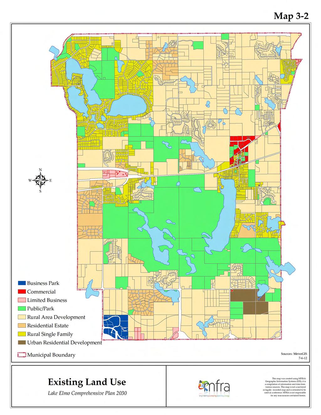
4 Whenever possible, the guiding principles should be kept in mind to guide individual development at all scales: community, neighborhood, street, block front and individual parcel. Existing Land Use An examination of Lake Elmo in 2012 clearly shows a community with a rich history of agricultural use, open space development, and preservation of significant park lands. Lake Elmo Regional Park and Sunfish Lake Park, covering 2,165 and 284 acres respectfully, are at the heart of the community and provide significant natural and recreational opportunities not generally available in the metropolitan area. Single-family homes on lots measured in acreages rather than square feet dominate the residential housing stock throughout the community, and the City s 30+ open space cluster/rural neighborhoods established Lake Elmo as a local, regional and national leader in this type of development. Non-residential uses are largely restricted to a few scattered focal points along Highway 5, Highway 36, and Interstate 94. A total of approximately 3400 parcels covering 15,584 acres (24.35 square miles) are currently found within the municipal boundary. The distribution of existing land uses in this area is shown on Map 3-2 and is summarized in Table 3-A: Land Use Table 3-A Existing Land Use Existing Permitted Residential Density (units/acre) Min Max Existing Land Use (acres) Rural Area Development n/a Residential Residential Estates Rural Single Family Urban Medium Density Business Park na na Commercial Commercial na na Limited Business na na Public/Semi Public/Park na na Public Road ROWs na na Undeveloped Open Water na na TOTAL: 15, III 4
5
6 Existing Land Use Category Definitions The existing land use types within the City are defined as follows: Rural Area Development This category represents the large areas of rural residential development and agricultural uses within the City. Common uses found in these areas include working farms, alternative agricultural uses as defined by City Code, and rural single family detached residences. Development in these areas requires 10+ acres, or a conditional use permit to authorize a cluster development meeting the City s Preserved Open Space regulations. Residential Estates This category defines areas developed specifically for large lot single family detached housing typically on 2+ acres of land. Rural Single Family This category defines a large portion of the City that was platted for conventional subdivision prior to 2005, but is largely serviced by private on-site well and septic systems. Urban Medium Density This category current defines areas within Lake Elmo dedicated to manufactured home parks. The Cimarron development is currently the only such area within Lake Elmo. Business Park This category provides for a wide variety of professional businesses including medical and research facilities, offices and corporate headquarters. Uses specifically excluded from existing business park areas include warehousing, manufacturing, distribution, assembly and truck terminals. Retail sales of goods and services are allowable uses by conditional use permit provided such uses are goods and services to the employees of the permitted business use. Commercial This category is includes areas that have been used for retail business land uses, and primarily covers lands within or near the Village Area. Small pockets of commercial land can also be found where retail goods and services are integrated within and are demonstrably designed to provide retail goods and services to employees of Business Park lands or sewered residential properties. Limited Business This category defines areas within the City that are allowed to host commercial land uses at a more restricted level than would typically be allowed within a commercially guided area. Public/Park This category defines lands that include publicly owned facilities, places of worship, public parks, and privately owned recreational facilities. The scale and types of uses allowable on public/park lands are controlled by the city s conditional use permit process. Road ROWs This category encompasses all areas dedicated specifically for use as road right-ofway. It should be noted that not all roads in Lake Elmo are on platted right-of-way, but are rather accommodated by easements over other land use categories. Accordingly, there is more land dedicated to use by roads than is depicted on the existing land use table. III 6
7 Open Water This category includes all land area in Lake Elmo covered by open water lakes and ponds as identified in the DNR Public Waters Inventory. Existing Land Use Dichotomy Unlike most communities within the Minneapolis-St. Paul metropolitan area, Lake Elmo is and will continue to be a city which supports two very different land use types. The City s predominant land use has always focused on agricultural uses and settings. Large working farms, significant public parks, open space developments and large-lot single family neighborhoods have historically combined to form the agricultural setting Lake Elmo is known for throughout the region. In contrast, the higher density oldtown area referred to as the Old Village provides the community an urban focal point that supports its rural uses. The split between urban and rural has always been significantly slanted towards rural uses throughout Lake Elmo s history. The Old Village first took form in the late 1800 s following the construction of Highway 5, a post office, and ultimately the establishment of the St. Paul, Stillwater & Taylor s Falls Railroad (later the Omaha RR). To support the resort area around Bass Lake (renamed Lake Elmo in 1879), the Old Village was home to a store, a saloon, a flat grain house where farmers could unload wagons directly onto trains, a blacksmith, and a wagon repair shop. By the 1920s, the Old Village was viewed regionally as a substantial shipping point and dairy center which included a creamery, grain elevator, two grocery stores, hardware and implement stores, a private hospital, a bank, a garage, and even a roller skating rink. Changes to the regional streetcar transportation system in the early 1900 s, however, resulted in traffic being diverted away from the Old Village and its growth (but not its importance to the Community) has been curtailed since that time ensuring that rural uses continued to be the predominant focus of the community. Today the Old Village stands as a unique example of a classic urban setting within rural America. While the future land use plan anticipates resurgence within this area following nearly a century of limited growth, the City has no intent of losing the characteristics which make the existing Old Village special. Future growth plans will require adherence to specific design standards reminiscent of the Old Village s last period of growth, and a defined development boundary will ensure expansion of the Old Village is contained to avoid the typical sprawl development pattern seen in many suburbs throughout the region. Planned Land Use Per the memorandum of understanding with the Metropolitan Council initially adopted by the City in 2005 and subsequently amended, urbanized growth must be part of Lake Elmo s future. To that end, the next chapter in the evolution of Lake Elmo will include resurgence within and around the Old Village, and the establishment of a new urbanized zone between Interstate Highway 94 and 10 th Street. The remainder of the community north of 10 th Street and surrounding the Old Village will continue Lake Elmo s long tradition of providing rural living opportunities within the Metropolitan area. III 7
8 This section of the Land Use chapter establishes the City s official land use categories and the official Future Land Use Map. The map assigns planned land use types to all parcels within the community to guide current and future planning and development through the year 2030, and is the official land use designation map for the City. The assigned land use designations are intended to shape the character, type and density of future development according to sound planning principles. Any new development, redevelopment, change in land use or change in zoning is required to be consistent with the official land use guidance for each parcel. The official land use plan categories are as follows: RURAL AREA DEVELOPMENT This category represents the large areas of rural residential development within the City. Common uses found in these areas include working farms, alternative agricultural uses as defined by City Code, and rural single family detached residences. Development in these areas requires 10+ acres, or a conditional use permit to authorize a cluster development meeting the City s Open Space Preservation regulations. Densities are allowed up to 0.45 dwelling units per buildable acre when planned as part of an Open Space Preservation development. No new areas of rural area development are being established by the official land use plan. [Corresponding Zoning District(s): A, RR, OP] RESIDENTIAL ESTATE This category defines areas developed specifically for large lot single family detached housing typically on 2+ acres of land. No new areas of residential estate are being established by the official land use plan. [Corresponding Zoning District(s): RE] RURAL SINGLE FAMILY This category defines a large portion of the City that was historically platted for conventional subdivision prior to 2005, but has been and will continue to be serviced by private on-site well and septic systems. Limited locations within this classification are allowed to have two-family dwellings based on zoning. [Corresponding Zoning District(s): R-1, R-2] URBAN LOW DENSITY The Urban Low Density land use category is intended primarily for single-family detached housing serviced by public sewer and water. This category allows net residential densities from two and one-half (2.5) to four (4) units per acre. Significant new areas of urban low density are guided both within the Old Village and along I-94. [Corresponding Zoning District: LDR] URBAN MEDIUM DENSITY The Urban Medium Density land use category allows net residential densities from four and one-half (4.5) to seven (7) units per acre; with greater densities only allowed if deemed appropriate and approved through the PUD process and that meet incentives for density bonus as allowed under the PUD ordinance. This category allows for a variety of housing types including single-family detached, duplexes, townhomes, and small two- and three-story apartment buildings and/or senior living centers. Significant new areas of urban medium density are guided both within the Old Village and along I-94. [Corresponding Zoning District(s): R-3, MDR] URBAN HIGH DENSITY The Urban High Density land use category is intended for higher density, compact urban residential development. This category allows for a net residential density range of seven and one-half (7.5) to fifteen (15) units per acre; however zoning may allow a greater net density if III 8
9 approved through the PUD process. The appropriate building height will vary by development and depend upon the characteristics of the development and its surroundings. In addition to residential development, a small proportion of supportive retail and service is also appropriate in this land use category. Retail, service and office beyond those supporting the residential development would only be permitted as part of a mixed-use planned unit development. Significant new areas of urban high density are guided both within the Old Village and along I-94. [Corresponding Zoning District(s): HDR] LIMITED BUSINESS This category defines areas within the City that are allowed to host commercial land uses at a more restricted level than would typically be allowed within a commercially guided area and in areas that are not planned for public sanitary sewer services. No new areas of limited business are being established by the official land use plan. [Corresponding Zoning District(s): LB, LC] COMMERCIAL This category is intended to accommodate a wide range and scale of commercial uses (such as retail, service, entertainment, and office) throughout the City s planned urban centers. Commercial uses can range from small neighborhood convenience nodes, to community retail areas along major roadways, to large shopping centers, to auto-related commercial uses along freeways. Residential uses are also appropriate as part of a mixed-use commercial development where allowed, with unit densities being determined by either the identified range within the comprehensive plan or to a level deemed appropriate by a planned unit development process. Significant new areas of commercial land use are guided both within the Old Village and along I-94. [Corresponding Zoning District(s): C, CC, GB] BUSINESS PARK The Business Park land use category is intended to encourage the creation of significant employment centers that accommodate a diverse mix of office and light industrial uses and jobs. Specific desired attributes of this land use include a diversity of jobs, high development densities and jobs per acre, high quality site and building architectural design, and increased tax revenues for the community. Office, office showroom/warehousing, research and development services, light and hightech electronic manufacturing and assembly, and medical laboratories are typical uses appropriate for this land use category. Some retail and service uses may be allowed as supporting uses for the primary office and light industrial uses of the employment center. In addition to the Eagle Point Business Park, much of the land between Manning Ave and Keats Ave adjacent to I-94 is guided for this land use classification. [Corresponding Zoning District(s): BP] PUBLIC/PARK This category defines lands that include publicly owned facilities, places of worship, public parks, and privately owned recreational facilities. The scale and types of uses allowable on public/park lands are controlled by the city s conditional use permit process. No new areas of public/park space are currently designated by the new land use plan, but it is recognized that such areas will be created during the development process, and the land use map will need to be updated accordingly. [Corresponding Zoning District(s): P, OSP] ROAD R.O.W.s This category encompasses all areas dedicated specifically for use as road right-of-way. It should be noted that not all roads in Lake Elmo are on platted right-of-way, but are rather accommodated by easements over other land use categories. Accordingly, there is more land dedicated III 9
10 to use by roads than is depicted on the existing/planned land use table. New development will be required to dedicate right-of-way to accommodate the proposed road network. OPEN WATER This category includes all land area in Lake Elmo covered by open water lakes and ponds as identified in the DNR Public Waters Inventory. No new areas of open water are by the official land use plan. The distribution of planned land uses on the official Future Land Use Map is shown on Map 3-3 and is summarized in Table 3-B: Mixed Uses Within the Old Village and in areas south of 10 th Street, specific areas are targeted for potential mixeduse development; however, this designation means different things in both districts. Mixed Uses within the Old Village The mixed use designation on property within the Old Village indicates development must adhere to the specific zoning requirements established for mixed use development within the City Code. This type of development will typically see residential, commercial, office, and/or similar uses combined in complimentary ways within the same building. Mixed Uses south of 10 th Street The mixed use designation on property south of 10 th Street is intended to spur development by providing maximum flexibility on future land uses, thereby allowing a development proposal to cater to existing market conditions. In the areas designated as possible mixed-use on the Future Land Use Map (Map 3-3), the City s planning process has identified that either the base land use or the adjacent land use designation would be appropriate for the site. These mixed-use areas may be zoned in accordance with the base land use category, or the adjacent land use category provided that: Any such zoning will only be allowed if it is contiguous to property in an adjacent land use category; and The Urban Low Density Residential land use category will not allowed as an alternative land use within mixed-use areas. Alternatively, a combination of the uses allowed within the base land use category and future land uses adjacent to a mixed use area may be allowed through a planned unit development process. III 10
11 Table 3-B Existing and Planned Land Use Table Residential Planned Land Use Changes Density Existing Land Planned (anticipated acreages in (units/acre) Use (acres) Land 5 year increments) 3 City wide Use 2012 to 2015 to 2020 to 2025 to Change Land Use Min Max (Village) 1 (acres) (acres) RESIDENTIAL Rural Area Development n/a Residential Estates Rural Single Family Urban Low Density Urban Medium Density Urban High Density Village Urban Low Density Village Urban Medium Density COMMERCIAL 2 Business Park Commercial Limited Business Village Mixed Use PUBLIC/SEMI PUBLIC/OPEN SPACE 3 Public/Park Greenbelt Corridor Road ROWs UNDEVELOPED Open Water TOTALS: 15, , , , , , Residential uses within the Business Park and Commercial land use designations can only occur in areas specifically designated for mixed use on the planned land use map 2 It is recognized that both park and road ROW areas will expand as new development occurs, but such acreage is accounted for in the respective development land use types as such land areas must contribute towards required development densities. 3 The staging plan for future development is fluid and will allow development to occur as market conditions dictate. Because of this, specific timing for development of any specific land use category is not possible. For the purposes of this table, the anticipated acreage changes are incrementally broken down into four periods of time showing a consistent rate of change between now and The acreage of the greenbelt corridor areas, which are portions of the Village Open Space Overlay, that are adjacent to urban zoning districts were calculated to account for the remaining acreage in the Village. The other portions of the Village Open Space Overlay are accounted for through the base land use guidance (i.e. Rural Area Development or Rural Single Family). III 11

12 Map Municipal Boundary Village Open Space Overlay White hatching denotes possible mixed use areas Planned Land Uses Business Park Commercial Limited Business Village Mixed Use Village Urban Low Density Village Urban Medium Density Urban Low Density Urban Medium Density Urban High Density Rural Single Family Residential Estate Rural Area Development Public/Park Sources: Washington County & Metro GIS Planned Land Use Lake Elmo Comprehensive Plan 2030
13 Design Standards Following completion of the Comprehensive Plan, the City will adopt design standards to ensure the look and feel of future development is compatible with the community vision of a small town within a rural setting. Standards for building materials, building articulation, design variety and other requirements should be upheld to ensure the quality of the built environment is distinctly Lake Elmo. Preservation of Rural Character One of the main benefits of the official land use plan is that the long range planning objective to retain a permanent rural identity is achieved. Under the memorandum of understanding with the Metropolitan Council, a vast majority of the City will be allowed to maintain its rural character and existing land uses. Furthermore, concentrating urbanization adjacent to I-94 and within the Old Village will result in clear boundaries between the urban and rural portions of the community. Beyond that, the City s desire to protect its sensitive park lands is also achieved. Both Lake Elmo Regional Park and Sunfish Lake Park will continue to be surrounded by agricultural lands and will not be impacted by encroaching urbanization. Future Land Use Boundaries The curved lines separating future land uses on Map 3-3 midway between I-94 and 10 th Street indicate one possible alignment of a future east/west collector roadway envisioned to serve the new development in this area of the City. Future development proposals and their associated engineering studies will ultimately determine the exact alignment of this collector roadway. The final boundary between the proposed different land uses shall ultimately be set by the final location of the east/west collector roadway, whether or not this roadway deviates from the approximate location shown. Buffering/Land Use Transitions The City s Land Use Plan calls for a diverse range of development types, from very low density agricultural and rural residential uses to high density urban residential and commercial development. In order to provide for a transition between the existing and planned rural development and future urban development, the Land Use Plan creates a lower density urban residential district. This low density urban district is planned for areas near existing rural development areas, and will provide for an area of transition between higher density residential development and either existing or planned rural development areas. Certain areas designated as Public/Park on the Future Land Use Map (Map 3-3) have been established to provide a green belt/buffer between areas developed under a previous Comprehensive Plan at rural development densities and areas planned for residential development at higher densities. This green belt will be incorporated as part of any development plans for new development with a minimum width of 100 feet. The green belt may be incorporated as part of the greenway envisioned in the Lake Elmo Comprehensive Park and Recreation Plan (Chapter IX). Open Space Preservation The City will encourage the preservation of open space within new developments through the dedication of public parkland and the clustering of lots within urban residential districts. The specific zoning development standards for the City s urban residential districts will allow the platting of smaller III 13
14 lots that will allow open space to be set aside in each development while still achieving the overall minimum density guidance for each land use area. Staging Plan/Memorandum of Understanding The City of Lake Elmo entered into a Memorandum of Understanding (MOU) with the Metropolitan Council prior to the preparation of its 2005 Land Use Plan and this MOU remains in effect to ensure the City s conformance to metropolitan system statements as required by state law. This MOU has since been revised; however, to take into account a severe downturn in the housing market and to grant the City of Lake Elmo additional flexibility in meeting the population, household, and employment targets from the original MOU. Table 3-C summarizes the updated development staging plan that will be used to measure conformance to the MOU. This table is broken down into five year increments starting in 2010 and continuing forward to the end of the planning period in The targets from the original MOU have been moved back five years to reflect the economic downturn and the extension of time to meet the mandated REC unit counts consistent with the requirements of the revised MOU. The population and household targets at the end of the 2030 planning period have not been adjusted and reflect the numbers approved in the MOU. Table 3-C Housing, Population and Employment Projections Year Total Households Sewered Households New Existing Total Sewered Households Non-Residential REC Units New Existing Total Non-Residential REC Units Total REC Units Total Population The density ranges specified in the Land Use Plan have been established so that development at the minimum levels will achieve the residential and non-residential REC unit counts listed in Table 3-C. A variation in development densities is expected at the level of specific development projects, but overall densities within a land use planning area must achieve the minimum levels specified in the III 14
15 Comprehensive Plan. The City will also be adopting zoning district standards within the urban residential development areas that will allow the clustering of housing on smaller lots in exchange for the preservation of open space within new developments. Staging Plan While Table 3-C provides a projected schedule for the construction of new residential and nonresidential developments, the City has also adopted a general staging plan within the City s urban growth areas to help ensure that the City is able to deliver the required municipal services and public infrastructure that will be needed to support new development. The infrastructure needed to serve these developing areas is substantial and the staging plan will provide a mechanism for the City to manage this growth and to be able to adequately prepare for the City s future infrastructure needs. The objectives of the staging plan are to: Identify a logical pattern for future growth based on the amount of land planned for new development and the availability of infrastructure to serve this development Give the City additional control over the timing and location of new development to coincide with the City s ability to provide the required services. Provide additional opportunities and an official mechanism for the City to be able to plan, budget, and set goals for future development. The Staging Plan is document as part of Map 3-4, and identifies three separate stages for future development without a specific time period attached to these phases. Instead, growth is expected to occur at the rate documented in Table 3-C, with each of the stages being developed in the order depicted on the map and further described as follows: Stage I: New sewered development located west of Keats Avenue that will connect to the MCES WONE interceptor. Stage II: New sewered development located west of Manning Avenue and south of the Forest residential subdivision that will connect to the MCES Cottage Grove Ravine regional interceptor. Stage III: All remaining new sewered development south of 10 th Street that will connect to the MCES Cottage Grove Ravine regional interceptor. The City will monitor growth by assessing market conditions, land capacity, and the availability of public infrastructure in order to determine when development may occur in stages subsequent to the first stage. The acceleration of a development in any of the latter stages may be permitted by the City provided it is demonstrated that adequate public infrastructure exists to support this development. The availability of infrastructure and any necessary utility extensions and transportation improvements needed to support new development will be considered in deciding whether or not to open up the next staging area to development. In order to accelerate the development of latter stages, there must be a commitment that the development will pay its proportionate share of the infrastructure costs to extend services to any new development. III 15

16 Map I-94 Corridor Development Staging Plan - Lake Elmo, MN 94 City of Lake Elmo Data Scource: Washington County, MN Stage 1 Stage 2 Stage 3 K Miles
17 To help ensure that public facilities needed to support new development meet or exceed an acceptable level of service, the City will consider adoption of an adequate facilities ordinance. The primary goals of this ordinance are to: 1) avoid sprawling or leapfrog development that would result in an inefficient use of the City s infrastructure and services, and 2) give priority to development opportunities that do not require the construction of significant extensions of public infrastructure. When developers build on parcels that are not contiguous to areas served by existing infrastructure, there is an expectation that the developer will pay for the added costs to serve non-contiguous development. Non-contiguous development will not be allowed if it would negatively impact the City s financial stability and capacity. Implementation The following tasks will be completed by the City to facilitate the implementation of the land use plan. Zoning Code Update Planned development within the Old Village and south of 10 th Street will introduce development styles and patterns new to the community that cannot be achieved by existing zoning classifications. The zoning code will need to be updated to include new residential, commercial and Business Park districts as needed to ensure the City s vision can be successfully carried out. Creation of Design Standards As a supplement to the new zoning districts, the City will pursue the creation and adoption of specific design standards for areas of new development. Design standards go beyond standard zoning requirements such as area and width to specify required building materials, building articulation, architectural standards, etc. Adoption of design standards sets an overall policy for what development should look like to guide the quality of the built environment towards the community s established vision. Form Based Code Within the Old Village area, the City will consider implementation of a form based code in lieu of standard Euclidian zoning districts. Under a form based code, requirements focus primarily on the built environment and its relation to the public realm rather than on the separation of uses. Form based codes are regulatory, not advisory like typical design standards. Specific standards for public spaces and building forms are adopted directly into code and mandate that future construction achieve the established community vision. Internal Process Evaluation A review of procedures for all application types will be undertaken by the City to ensure internal processes are optimized for quick turn-around and minimal delays whenever possible. Cooperation with Other Government Agencies The City will reach out to neighboring communities and reviewing agencies to proactively address issues that may impact future development. III 17
18 Village Land Use Plan Introduction The approximately 1,300 acres that comprise the Village Planning Area as defined on the Village Land Use Map, Map 3-5, have been the subject of numerous studies and planning efforts extending back for several decades. The Village Area serves as the heart of the community and provides a direct connection to the City s past with its historic buildings and small-town character. As part of Lake Elmo s most recent Comprehensive Plan update in 2005, the City decided to accommodate a portion of future sewered development within the Village Planning Area with the direct intent of building upon the existing character of the Village while preserving those aspects that make it unique. This section of the Lake Elmo Land Use Plan includes an updated land use plan for the Village Planning Area and has been prepared with the specific intent of building off of previous planning efforts for this area, including the City s 2005 Comprehensive Plan update and the Village Master Plan completed in This revised plan generally recognizes the adopted goals and objectives from these previous planning efforts while updating some of the specific land use elements to conform to the broader Land Use plans for the City. The decision to extend public sanitary sewer services into the Village Planning Area and to plan for new development within this planning area has been based on a number of factors, including the following: The desire to maintain the Village Planning Area as the core of the city by accommodating a portion of new development set to occur outside of the rural development areas. The ability to locate new and expanded public services and facilities in a central location. The need to extend public services, and specifically public sanitary sewer, to existing users within the Village Area that are presently using older and non-compliant septic treatment systems. The potential to take advantage of redevelopment and renovation activities within the existing core of the Village and to encourage new development that builds off of the existing character of the Village. The need to address existing traffic congestion and safety problems along the main roadway corridors that transect the Village Planning Area. The opportunity to preserve open space around the Village Planning Area to clearly delineate the edge of the Village and preserve the sense of place that presently exists. The desire to accommodate some of the expected future urban growth outside of the I-94 Corridor closer to the historic center of the community. History of the Village Lake Elmo has a long history as one of the oldest settled areas in Minnesota, beginning with its platting by the railroad company in 1878 in the approximate location of the present Village. The namesake lake, formerly Bass Lake, served as a focal point for much of the early development, which included a large hotel that was erected on the north side of the lake in the 1880 s and a 330-acre residential development called Elmo Residential Park that was platted to the north and east of the lake (which was never fully developed as planned). III - 18
19 After incorporation as a Village in 1925, the city continued to develop as a rural center providing goods and services to the surrounding agricultural lands in Washington County. Lake Elmo later flourished as a center for farmers throughout the middle part of the 20 th Century. It also became a popular destination for summer villas and cottages, attracting residents from the larger Minneapolis and St. Paul region as a picnic and excursion area. As a result of this varied history, one can find examples of wide variety of architectural eras within the Village Planning Area, including buildings that were built from the early 20th Century through the post World War II time period. New subdivisions began appearing in the post war era, and these housing developments began to shift the focus of community life from farming to housing for commuters. This general transformation continued as the cabins and summer homes north of Lake Elmo were converted into permanent homes. While the City has undergone significant changes over the course of its history, many of the buildings located in the Village Planning Area still retain their early 20th Century settlement character. An excellent example of this character is the historic farmstead built by William S. Moscrip, who in 1921 was selected as Minnesota s best farmer. The farmstead is currently located on land owned by the Peter Schiltgen family. Moscrip s North Star Farm, known for its Holstein cows, still stands essentially as it did nearly 100 years ago and continues to serve as an exemplary gateway into the Village Planning Area. Physical Context Located 15 miles east of downtown Saint Paul, Lake Elmo has been successful at retaining its rural character even with its close proximity to the Twin Cities metropolitan area. Like traditional midwestern towns, the edges of the Old Village are clearly defined; one can literally walk into a cornfield from the outfield of the local ball diamond, which represents a unique environment within the suburban metropolitan area. The Village Planning Area includes a small historic Main Street that contains several lovely buildings arranged at an intimate scale that is bisected by an active rail line. State Highway 5, also known as Stillwater Boulevard, runs east-west through the community and leads to Stillwater to the east and Minneapolis/St. Paul to the west. The highway was designed as a rural section, with ditches, culverts and large setbacks to buildings. Approximately 12,000 cars traverse the road a day, with most of this traffic occurring during the morning and evening rush hours. The City has expressed interest in having the roadway turned over from the State to the County in the past. There are no signalized or controlled intersections on Highway 5 in the Old Village, which makes this route attractive to commuters interested in bypassing busier roadways. With its significant traffic levels, Highway 5 divides the Village Planning Area and crossing this road is dangerous for both vehicles and pedestrians. County Road 17, Lake Elmo Avenue, runs north and south through the heart of the Village (it is the historic Main Street), and provides a direct connection between Highway 36 to the north and the 1-94 frontage road to the south. The road jogs about a block to the east via a quarter-mile section of Highway 5, which is both confusing and dangerous for motorists. The location of Lake Elmo Elementary School at this intersection further exacerbates concerns regarding safety in this area. County Road 15, Manning Trail, runs north to south on the east side of the Old Village, connecting Stillwater Boulevard to I-94. This is a preferred route for many commuters and will eventually be upgraded to a four-lane section by Washington County. Two significant lakes and associated parks contribute to the quality of life in the Village. These lakes and parks include Lake Elmo and the Lake Elmo Regional Park Reserve located on the southwest side of the III - 19
20 community, the 30-acre Reid Park on the south side of the Village, the smaller Lions and VFW parks in the middle of the City, and Sunfish Lake and Sunfish Lake Park are to the west, all of which represent beautiful amenities for community residents and visitors. The Lake Elmo Regional Airport is located immediately across Manning Trail in Baytown Township. Primarily a recreational facility, the airport safety zones associated with the airport extend into the Village Planning Area and will need to be considered as development occurs along the eastern boundary of the Village area. The City will work the Metropolitan Airports Commission to develop appropriate multi-jurisdictional zoning to help plan for future residential development in this area. A number of new developments lie on the outskirts of the Old Village. In most of these developments the City s OP Open Space Preservation zoning designation has guided site design so that major portions of the these subdivisions are retained as open space. Existing and proposed trails are planned to connect to several of these neighborhoods. Finally, it should be noted that some other challenges exist related to the physical context of the Village. These challenges include the following: - There is a significant natural gas-line easement running from north to south on the eastern portion of the Village. - The area east of downtown Lake Elmo in the Village has experienced some groundwater contamination. Development within this site should be aware of the contamination. - The location of the Christ Cemetery along State Highway 5 may present some challenges related to buffering for residential development adjacent to this facility. - The area to the east of downtown experiences significant drainage and storm water runoff. The drainage and runoff creates sizeable water-courses that could create challenges in managing storm water in this area. Previous Planning Efforts The City last updated its Land Use Plan in 2005 to reflect the extension of public sanitary sewer services into the Village and the City s plan to accommodate a portion of the required REC units within the Village Planning Area. Prior to the preparation of the 2005 plan, the City undertook numerous planning initiatives to analyze land use within the Village, which in the recent past has included the following studies: The 1996 Minnesota Design Team Report The 1999 Thornbeck Architects Old Village Urban Design Study The 2000 Calthorpe Design Study The 2002 Thornbeck and Associates design work The 2003 TKDA Water Supply, Traffic, and Surface Water Reports These efforts demonstrate the comprehensive approach that has been taken with planning in the Village. In addition, many of the planning efforts were spearheaded by countless volunteer hours of many Lake Elmo residents, representing a grass-roots approach. Throughout all of these studies, as well as the studies that preceded them, several common themes have emerged. These themes have helped shape the goals and objectives for the Village Planning Area that are reflected in this plan. After adoption of the 2005 Comprehensive Plan, the City decided to prepare an overall master plan for the Village Planning Area as part of a larger and more focused land use study in this area. III - 20
21 Village Master Plan and Village AUAR In the summer of 2005, the City of Lake Elmo retained a team led by Robert Engstrom Companies to prepare a Master Plan to guide anticipated development within the Village Planning Area. This study focused on techniques that could be used by the City to help preserve the character of the Village while accommodating the growth and development anticipated under the updated Comprehensive Plan. This plan further acknowledges the pressures that the City will face once sanitary sewer services are extended into the Village, and further establishes policies intended to minimize any negative impacts to the unique charm and scale of the area. The design team, which included Jerry Mazzara of Design Forum and Bob Close and Bruce Jacobson of Close Landscape Architecture, was charged with two areas of focus: 1) to prepare a physical plan with associated guidelines, and 2) to provide a strategy for allocating development units throughout the planning area. The intent of this approach was to present a guide for development that would allow the City to work with developers to achieve common goals while ultimately strengthening community character through good design. The Village Master Plan creates an overall vision that places new development within a framework of parks, trails, and open space. It also notes that balancing growth with the preservation of small town living will rely on creative design and careful implementation of the plan. While the plan as a whole is not being adopted as part of this chapter, the overall guiding principles and various recommendations from this plan are referenced in the latter portions of this plan. The Village Master Plan will continue to serve as a guide for new development within the Village Planning Area and will be used to help define the development qualities and preferences being sought by the City. Upon completion of the Village Master Plan, the City prepared an Alternate Urban Area-Wide Review (AUAR) for the Village Planning Area in order to address the expected cumulative environmental impacts associated with the anticipated growth and development within the Village. This study used the Master Plan as the basis for the three alternatives that were studied, each of which assumed increasing intensities of residential, commercial, and mixed-use development. The AUAR document includes a mitigation plan that will need to be addressed as development occurs in the Village. The Village Planned Land Use Map that accompanies this Chapter, Map 3-5, has been designed to fall within the scope of the alternatives that were studied and it is expected that the AUAR will remain a valid environmental review as the City works to implement this plan. Village Planning Area Objectives and Goals The land use plan for the Village Planning Area focuses on downtown Lake Elmo, the residential neighborhoods south of the downtown, and the farm land immediately surrounding it. The plan addresses future land uses, location of new roads, location of open space corridors, and the measurers that could be used to implement the overall vision for the Village Planning Area. The primary objective of this plan is to create a blueprint for new development that builds on existing community strengths such as the compact, walkable core, easy access to recreation, and proximity to major transportation corridors. The plan recommends locating new neighborhoods contiguous to the existing core and emphasizing walking connections between neighborhoods and the core and within the neighborhoods themselves. The land use plan will provide space for civic buildings, new retail and service businesses, lifestyle housing, and recreational/open spaces that will combine to make a highly desirable, sustainable and welcoming center for the City. The ultimate goal of the plan is to build on the existing strengths of Lake III - 21
22 Elmo, including a compact assemblage of streets and blocks, a distinct edge, a historic main street and good access to parks and open space. The plan intends to extend these qualities to the newly developing areas surrounding the existing downtown. In addition, it proposes connecting the existing residential neighborhoods to the south with the village core and new neighborhoods. The Village Land Use Plan includes a series of specific goals and objectives for each of the land use elements, and establishes the following as the overall goals and objectives for the plan: 1) Adhere to the Guiding Principles from the Village Master Plan, which are incorporated into this land use plan in Table 3D. 2) Preserve the existing character of the Village while accommodating new housing and businesses to comply with the growth projections of the Comprehensive Plan. 3) Create a walkable, viable community with a distinct center. 4) Explore options to provide space for public and commercial activities around a village green that can serve as a focal point for new development. 5) Create an open space buffer around the new development areas to foster a true village feel. 6) Plan for development on a village scale rather than a suburban scale, recognizing the existing character of the Old Village. 7) Promote traffic calming measures along State Highway 5 to improve auto and pedestrian safety, particularly in the vicinity of Lake Elmo Avenue and Lake Elmo Elementary School. 8) Plan for at least one grade-separated crossing of Highway 5 for bicycles and pedestrians 9) Provide for the recreation needs of the new neighborhoods while building on existing facilities and accommodating the need for community-wide recreation facilities. 10) Create a natural system for storm water management that takes advantage of existing drainage patterns. 11) Plan for a new Village Parkway as a major north/south collector with a new railroad crossing approximately midpoint between Lake Elmo Avenue and Manning Ave. 12) Promote mixed-use development in the areas close to the Village Center. Village Land Use Plan The Village Land Use Plan, Map 3-5, identifies three primary land use categories within this planning area that will accommodate growth, and incorporates an open space overlay category to specify which portions of the area will be designated for open space. The land use categories as applied in the Village Planning Area include: V-LDR Village Urban Low Density Residential at 1.5 to 2.5 units per acre V-MDR Village Urban Medium Density Residential at 3.0 to 4.0 units per acre VMX Village Mixed Use with residential densities of 6.0 to 10.0 units per acre III - 22
23 Map Sunfish Lake Lake Elmo Planned Land Uses Public/Park (P) Rural Area Development (RAD) Rural Single Family (RS) Village Urban Low Density (V-LDR) Village Urban Medium Density (V-MDR) Village Mixed Use (VMX) Commercial (C) Village Boundary Village Open Space Overlay Open Space Acreage: 592 Acres Sources: Washington County & Metro GIS Village Planned Land Use Lake Elmo Comprehensive Plan 2030
24 All of these categories are defined in the previous section of this Chapter. The Village Open Space Overlay category is further described below. The Village Land Use Plan was designed to accommodate a range of 900 to 1,100 new housing units with the understanding that the target growth for the Village is 934 additional units of housing. Using the midpoint of the density range and gross acreages associated with each land use category, the City expects that up to 800 of these units will be located within areas guided for V-LDR and V-MDR land uses, while an additional housing units are expected to be built within the VMX land use category. As these numbers represent a calculation based on gross acreages, the actual unit numbers are expected to be somewhat lower on a net acreage basis. A summary of the purpose and intent of each of the elements of the land use plan is included in the following section along with the goals and objectives that are specific to each of these elements. Village Center Mixed Use Area In order to achieve the goals and objective of the Village Land Use Plan, a heavy emphasis is placed on the planning of the existing Village Center, or downtown area. The Village Center is comprised of the area guided for mixed-use development. Building off the existing historic development pattern surrounding Lake Elmo Avenue to the south of State Highway 5 is critical to creating a distinctive and walkable core. This core is envisioned to provide an experience that is consistent with a historic downtown. To make this vision a reality, the Village Land Use Plan utilizes mixed-use zoning (VMX) for the Village Center to encourage a variety of uses that will provide opportunities for commerce, retail, entertainment, community spaces and housing, all working in synergy to drive activity, energy and people to downtown Lake Elmo. To successfully achieve the desired vision, the following details surrounding implementation will be provided for: - The Village Center may include a development with a village green or outdoor community gathering space. This development is intended to support downtown Lake Elmo by providing an increased sense of place and opportunities for community events. - The Village Center will utilize mixed-use zoning, allowing a broad mix of uses that are consistent with historical development patterns and reflect traditional downtown areas. - Additional protections will be afforded to existing homes in terms of providing additional screening or landscaping to buffer existing homes from new development in the Village Center. - Existing homes will be considered conforming uses within the mixed-use district. - Infill development that is sensitive to the existing context, development pattern and architecture is encouraged, particularly along Lake Elmo Avenue. - The City may consider the adoption of a historic district to promote the preservation of historic properties and the existing character and architecture of downtown Lake Elmo. - In order to preserve the historic development pattern of downtown Lake Elmo, the City will pursue the adoption of a form-based or hybrid code in the mixed-use area of the Village. - To ensure that parking is adequately addressed downtown, the City will work with business and property owners in the Village Center to devise solutions for parking that are agreeable to all parties. Providing additional parking is necessary for business and district vitality. In addition, III - 24
25 the provision of parking in the Village Center should be mindful of maintaining a safe and pleasing pedestrian experience, which is critical in supporting a successful downtown. - Village Green Community Space In order to draft a plan moving forward to stimulate growth in the Village Center and build off the existing downtown along Lake Elmo Avenue, the City may work to pursue a mixed-use development known as the Village Green that will serve as a community gathering space and destination. The intent of this development is to drive more energy and activity to downtown, specifically along Lake Elmo Avenue. As part of this project, the City anticipates the following aspects of implementation and design will be considered: - The project could be developed as part of a master plan prepared by private developers with the potential for City involvement. - The signature feature of the project shall be a village green or other community gathering space. This gathering space is intended to be a destination, hosting community events such as concerts and farmers markets. - The project is intended to include mixed-use development surrounding the community space, with residential development incorporated into retail, office and service uses. - The opportunity to incorporate public facilities into the development may arise. - Development in the Village Green will most likely include: 1) direct access and visibility from Lake Elmo Avenue, 2) access from the new village collector road, 3) connections to the Old Village, and 4) opportunities to create pedestrian connections to areas of new residential development. - The configuration of HWY-5 and the future Village collector road system, or parkway, will provide an excellent opportunity for additional anchor-type development along State Highway 5 (e.g. community center, health care facility, retail, etc.) that will drive additional users to support downtown Lake Elmo. - Public Spaces The City anticipates that additional growth in the Village may provide opportunities to add new or improve existing public facilities and amenities. Planning for additional public facilities or improvements will be done in a manner that is consistent with the goals of the Village Land Use Plan. More specifically, public facilities and amenities shall be provided in a user-friendly way that promotes accessibility and safety for all Lake Elmo residents. - City Hall will continue to serve as a key public building within the mixed-use development area. Opportunities for the expansion and/or relocation of City Hall may be considered either as part of the Village Green or in another prominent location within the Village Center. - Other public uses within the mixed use development area are encouraged, including recreational facilities, the downtown post office, and others, as long as they are consistent with the character and function of a traditional downtown. - The Lake Elmo Parks Commission will play an integral role in planning for recreational facilities in the Village and ensuring that they are accessible to the surrounding residential areas. III - 25
26 - Commercial Areas Lake Elmo Avenue has traditionally functioned as the commercial center for the City, and the Land Use Plan strives to maintain the Village as a viable and attractive place to do business, while providing opportunities for new development to occur in appropriate locations. The key strategy to accomplish this objective is the reclassification of the existing commercial core and certain portions of the surrounding land to the VMX Village Mixed Use district. This district will allow a wide range of commercial activities and is intended to provide an area for compact, mixed use development made compatible through a combination of careful planning and urban design. When planning for such a variety of commercial uses, different performance standards may be incorporated to accommodate both auto-oriented and pedestrian-oriented uses so that these different uses are able to function well in proximity to one another. As long as these uses are implemented in a thoughtful manner, the mixture of land uses within the district will establish the level of vitality and intensity needed to support retail and service uses in downtown Lake Elmo. Preserving and enhancing the character of the existing main street along Lake Elmo Avenue is another key strategy that will help further reinforce this area as the heart of the community. Lake Elmo Avenue, at present, does not have a unified streetscape and is missing key elements that would improve workability throughout the corridor. The City intends to work with Washington County and the Minnesota Department of Transportation to incorporate streetscape improvements with future road reconstruction projects. Specific recommendations are included in the transportation section below. Opportunities for expansion of commercial activity will be limited to the mixed-use areas within the Village Center, particularly areas adjacent to the existing core and along major collector roads (Lake Elmo Avenue and State Highway 5). New commercial development will adhere to strict standards related to form and design in order to ensure compatibility with surrounding land uses and to maintain a sense of place within the Village Planning Area. A small area of commercial development outside of the mixed use development area is planned at the intersection of State Highway 5 and Manning Avenue. The appropriate zoning for this area will be convenience commercial in order to provide for smaller scale commercial development or an attractive neighborhood shopping center that is compatible with surrounding residential development. Other objectives for the commercial components of the Village Planning area include the following: - Mixed use buildings are encouraged as the primary building type throughout the mixed use areas. Retail uses should be located on ground floor levels and facing the street where practical. - New commercial development along State Highway 5 should be oriented in a manner that keeps the majority of parking to the side or rear of buildings in order to promote a main street feel for this road segment. - Uses within the Village Center that primarily cater to automobiles will be permissible through careful site design and the incorporation of pedestrian-oriented design elements. - Business activity should be focused on the key roadway segments within the mixed use development area, and in particular, along the traditional downtown core along Lake Elmo Avenue. Residential Development Residential development as the primary land use will occur within those areas designated for V-LDR and V-MDR within the Village Planning Area. Residential uses will also be allowed within the mixed-use development (VMX) areas either as the primary land use or as part of a mixed-use development project. III - 26
27 The existing residential neighborhoods within the Village Planning Area will guided either as RS Rural Single Family or as VMX Village Mixed-Use with the intent of classifying all existing single family residential homes as permitted uses. The Village Master Plan includes a series of recommendations for housing types, with key provisions that encourage the construction of life-cycle housing (a mix of housing types, styles, locations and prices that will offer both opportunity and choice for a range of potential buyers and renters) and that also promotes a balanced transportation system that does not favor one mode of transportation (i.e. cars, bicycles, and pedestrians) over another. The descriptions for these housing types are adopted by reference as part of this chapter, and are consistent with the Land Use Plan that calls for denser residential development as one moves closer to the center of the Village Planning Area. The City will adopt zoning districts that correlate with the planned V-LDR, V-MDR and VMX land uses, which generally relate to the Master Plan categories as follows: V-LDR: Large Lot Single Family, Medium Lot Single Family, Small Lot Single Family V-MDR: Small Lot Single Family, Twin Home, Townhouse, Apartment/Condominium VMX: Twin Home, Townhouse, Apartment/Condominium, Housing Above Retail These categories should be used as a general guide for the types of housing that may be built within the Village Planning Area. The densities depicted in the Land Use Plan will take precedence over any such figures used in the Master Plan. The zoning that correlates to the various residential land uses will be designed to allow for smaller lots and higher densities than allowed under each land use category with the expectation that residential subdivisions will incorporate open space into developments. The use of these open space areas may include: storm water infiltration, trails, natural or engineered watercourses, natural areas, private or public parkland, and other similar purposes. No development will be allowed that exceeds the density levels specified in the Comprehensive Plan, and the median of the density range will be used as a target for planning purposes. The areas depicted on the Land Use Plan as open space may not be used to calculate residential densities; however, any internal open space, other than City park land, will not be deducted from these calculations. Other objectives for residential development in the Village include the following: - It is important to foster connections between the residential areas in the Village, maintaining some continuity of character between residential areas as opposed to many distinct and disconnected neighborhoods. - In terms of housing, the City supports a variety of housing types and price points that are inclusive to all generations. - While not required, residential design that incorporates environmental considerations, such as energy efficiency and solar orientation, is encouraged. Greenbelt /Open Space When evaluating the context of the existing land uses and development types surrounding the Village, one cannot overlook the significant number of open space preservation (OP) developments in Lake Elmo. These open space developments have had a significant role in shaping Lake Elmo s character and identity; an identity that is unique in the Twin Cities Metropolitan Area. In order to preserve the elements that have made Lake Elmo and specifically the Village unique, it is important to plan for III - 27
28 sewered development in a manner that is reflective of the community s existing character. For that reason, all of the previous planning efforts within the Village have included significant amounts of open space. Building off of the vision created in the Village Master Plan, the current Land Use Plan also utilizes open space in a strategic way to balance future growth and existing conditions within the Village. Ultimately, the open space included in the Village will serve as a critical amenity that ensures that the existing character of the heart of the community is preserved to the best extent possible. The future open space areas in the Village, as determined by the Village Open Space Plan, Map 3-6, will be consistent with one of the three following open space types, all offering different opportunities and purposes: 1. Natural Resource Preservation Areas. Natural Resource Preservation Areas are natural areas considered to be of high environmental and aesthetic value. Such areas in the Village include but are not limited to the areas adjacent to Sunfish Lake and Reid Park. These areas are considered to be of high environmental value due to the large stands of mature trees, steep slopes, wetlands, natural amenities, and the other ecologically sensitive features that are located in these areas. The Natural Resource Preservation Area may include uses such as passive recreation, trails, natural areas, and other activities or uses that are consistent with passive recreation. 2. Rural Preservation Areas. Rural Preservation Areas are areas within the Village historically utilized for agricultural purposes. Agriculture remains an integral part of the community s history and identity. Providing for open spaces dedicated to agricultural uses in the Village is critical for maintaining the existing character of the Village. Uses within the Rural Preservation Areas include active farming, passive recreation, trails, public gathering spaces, natural areas, natural water courses and other amenities that are consistent with agricultural use or character. 3. Greenbelt Corridors. Greenbelt Corridors run along the perimeter of proposed development and serve as transitional areas between future sewered growth within the Village and existing rural development. The corridor may be reduced if the design of the development includes the following: (1) a design that is mindful of the landscape features of the site, providing enhanced environmental benefit, (2) a design that is consistent with overall goals for the Village Land Use Plan, and (3) a design that meets the requirements of the underlying land use category of the parcel. At a minimum, the corridor shall be established and provided for by performance standards within the Zoning Code based upon the locations of the existing Village Boundary and area guided for commercial use in the northeastern portion of the Village. Not only will this provide a significant physical and visual amenity, but it will also encourage more residential development closer to the Village Center. Uses within the Greenbelt Corridor may include trails, passive recreation, public gathering spaces, natural areas, storm water management systems, natural water courses, small-scale or community oriented agricultural activities and other amenities intended for aesthetic enjoyment. These open space types will comprise the Village Open Space Overlay, as detailed in the Village Open Space Plan (Map 3-6) and Village Land Use Plan (Map 3-5). The details surrounding the implementation of the Village Open Space Plan and the associated land use implications are further discussed in the section on implementation. Parks and Trails The City has adopted a Parks and Trails Plan, Chapters IX and X of this Comprehensive Plan, which will be used as a guide for locating new parks and trails associated with development within the Village III - 28


29 Map 3-6 Village Open Space Overlay Sunfish Lake Sunfish Lake Lake Elmo Lake Elmo Open Space - Defined Open Space - General Village Open Space Plan Lake Elmo Comprehensive Plan 2030 Open Space Category Natural Resource Preservation Area Rural Preservation Area Greenbelt Corridor Source: Washington County and Metro GIS
30 Planning Area. Other specific objectives that are specific to the Village concerning parks and trails include the following: - Construction of a new trail connection between the northeastern portion of the Lake Elmo Regional Park Reserve and the Village. This proposed trail connection would primarily follow existing road right-of-way and serve as a new off-road entrance into the Park Reserve. - Utilizing 36 th Street as a key pedestrian connection between the existing commercial areas along Lake Elmo Avenue and future development in the Village Center, or mixed-use area. - Development of a grade separated trail either over or under State Highway 5 (Stillwater Boulevard) in order to promote a safe pedestrian crossing between the northern and southern portions of the Village Planning Area. - Construction of a multi-use trail along Lake Elmo Avenue that is separated from vehicular traffic and that will serve as the primary trail connection to the I-94 corridor. Due to constraints associated with the available right-of-way and other limitation associated with its location next to Lake Elmo, this trail should be given special consideration as part of any future improvements to Lake Elmo Avenue. - Expansion of Reid Park into adjacent prime natural areas and other property to the east of Reid Park that is not well-suited for residential development. Future trails will be encouraged to connect Reid Park with the surrounding residential neighborhoods. - Development of a larger community recreational facility to the east of the Village Center adjacent to the railroad right-of-way. - The establishment of trail connections between the new and existing neighborhoods located within the Village Planning Area. Sidewalks will be required for all new developments; however, the City will consider trails as a substitute for sidewalks in instances where they provide connections to other neighborhoods or other public features within the planning area. - The City may consider the relocation of the existing ball fields located downtown to a new community recreation facility in the Village. Transportation The existing and planned transportation corridors that circumvent the Village Planning Area will play a critical role in shaping the character of the Village. State Highway 5 and County Highway 17 serve as the primary routes into and out of the Village and will continue to see increasing levels of traffic in the future. These routes also represent important connections for the local businesses, many of which rely on these major transportation routes for visibility and access. The Village Land Use Plan balances the need for access to local businesses with the overall objective of managing and calming the expected increases in traffic levels throughout the planning area. The general transportation goals for the planning area include the following: State HWY-5 (Stillwater Boulevard) State Highway 5 is the primary east-west travel route through the Village. Because of existing high speed limits and traffic volumes, it is often a barrier (or at least a significant inconvenience) to pedestrian and vehicular movement. Its current design includes ditches, culverts and wide setbacks for buildings along the right of way. III - 30
31 The City is seeking design flexibility with regards to future improvements to this roadway in order to reduce speed limits, narrow travel lanes, and to consider other features that will encourage a future Main Street that emphasizes pedestrian character, traffic calming and mix of uses described in the Comprehensive Plan. A potential turn-back of the road to Washington County may help accomplish this design flexibility. Specific considerations: - Roundabouts may be used at the east and west ends of Stillwater Boulevard to slow traffic and mark the edges of downtown. The redesigned road segment in between will transition from the existing rural section to a traditional Main Street design that includes: Curb and gutter with associated storm sewer Wider sidewalks with pedestrian scale amenities (benches, lights, street trees) Narrower lanes perhaps with planted medians and center turn lanes Curb-side parking if feasible, with additional parking located between or behind Main Street buildings Controlled intersections, one at Lake Elmo Avenue and one at 39th Street, will provide safe crossings, slow traffic and pull the Village together as one piece, not two halves. Stillwater Boulevard and Lake Elmo Avenue will continue to be the primary commercial streets in the Village, promoting existing businesses, while encouraging new and expanded opportunities for local goods and services. Buildings will be located at (or near) the right of way, with generous walkways for pedestrian movement and spill-out activities, such as sidewalk café, coffee shop or other uses. County HWY-17 (Lake Elmo Avenue) Lake Elmo Avenue, specifically south of State Highway 5, is recognized as the existing Main Street of the Village. The existing conditions include a T intersection terminus and jog along State Highway 5 to connect with Lake Elmo Avenue to the north. The Comprehensive Plan does not plan for the realignment of this roadway segment, and instead recommends improvements along Highway 5 to calm traffic and reduce speeds in order to better manage the traffic through these intersections. The City will consider modifications to Lake Elmo Avenue in conjunction with the public improvements necessary to bring public sanitary sewer service into existing buildings within the Village Planning Area. Future road improvements to Lake Elmo Avenue will include an emphasis on the pedestrian environment and incorporate appropriate features including benches, lighting, sidewalks, and other elements in order to create an inviting pedestrian environment. Specific recommendations: Consideration of angled parking along Lake Elmo Avenue in order to provide additional parking for businesses and to provide additional separation between pedestrians and vehicles. Development of a streetscape plan for Lake Elmo Avenue that will identify the design features appropriate for Village-scale development. III - 31
32 A controlled intersection, with the potential for a round-a-bout at the intersection of State Highway 5, will help calm traffic and provide opportunities to create a gateway into the Village core. Traffic Calming Future roadway improvements should incorporate traffic calming measures to help manage the projected traffic levels. The City will pursue both non-physical and physical measures as described in the U.S. Traffic Calming Manual (American Planning Association and the American Society of Civil Engineers) in order to help reduce the need for a major roadway expansion (in terms of additional traffic lanes) and to promote road improvements that are designed to be consistent with a Village scale. In this context, traffic calming may involve changes in street alignment, installation of barriers and other physical measures to reduce traffic speeds in the interest of street safety, livability and other public purposes. Traffic calming measures will be considered for all existing streets that are renovated and all new streets constructed with the Village Planning Area. New Village Parkway A new collector road system will provide for a new north/south connection between State Highway 5 and 30 th Street within the Village Planning Area. This road will serve as the backbone for much of the new development with this area and will provide for a connection back to the existing downtown via an extension of 36 th Street. The City will work the Union Pacific Railway company to create a new crossing of the railroad at approximately the mid-point between Lake Elmo Avenue and Manning Avenue. The design of this street will employ a parkway style of design and serve as a collector road for new development on the east side of the Village Planning Area. Finally, the alignment of the collector road may serve as the boundary between the mixed-use (VMX) and medium density (MDR) land uses. Street Design The City will work to establish a unified street design for all streets (existing and new) within the Village Planning Area. As a part of this process, the City has initiated an effort to develop a common theme for public spaces within the City and will use the results of this theming work as part of future streetscape designs. The theming effort will be critical in creating a unified sense of place in the new and old areas of the Village. Trail System along HWY-5 and CSAH-17 New trails along State Highway 5 and Lake Elmo Avenue will serve as the backbone for a trail system that connects the existing and new development within the Village Planning Area and that also connects to major destinations such as the Lake Elmo Elementary School, Stillwater Area High School, Village Center, Village Green, Lake Elmo Regional Park Reserve, and residential and commercial areas along the I-94 Corridor. HWY-5 Pedestrian Crossings As improvements are made to State Highway 5, the ability of pedestrians to safely cross this roadway will be given strong consideration as part of the final design. In addition to crossings at controlled intersections, the plan recommends that at least one grade separated crossing be incorporated into the sidewalk and trail network. III - 32
. The Land Use Plan proposes a green belt/buffer zone within a portion of these airport zones.")
33 Lake Elmo Regional Airport The Lake Elmo Regional Airport is located adjacent to the Village Planning Area and portions of its safety zones and noise contours/impact areas are located within this planning area (see Map 3-7). The Land Use Plan proposes a green belt/buffer zone within a portion of these airport zones. No development will be allowed within the Runway Protection Zone (RPZ), and all portions of the RPZ zone are included in the green belt corridor along Manning Avenue. Urban low density residential land uses are proposed in Safety Zones A and B; however, no zoning map amendments to rezone property within these safety zones will be approved until an updated airport zoning ordinance is adopted by the City (or a Joint Planning Board) to regulate land uses within these areas. The City will work with the Metropolitan Airports Commission and MnDOT Aeronautics Division to develop airport zoning regulations that address noise and safety concerns within these zones. Map 3-7 Phasing Plan The Village Planning Area will initially be served by a new sanitary sewer force main that extends from the southern boundary of the City to a lift station immediately north of 30 th Street and east of Reid Park. This force main is scheduled to be constructed by 2014 and will be the starting point for further service III - 33
Chapter 2: Vision, Goals and Strategies
 Chapter 2: Vision, Goals and Lake Elmo Today & Tomorrow Comprehensive Plan 2040 2 VISION, GOALS & STRATEGIES - DRAFT 4-6-2018 INTRODUCTION Comprehensive Plan Purpose Perhapse the most important objective
Gold Line Bus Rapid Transit Transit Oriented Development (BRTOD) Helmo Station Area Plan
 Helmo Station Area Plan") Appendix F Gold Line Bus Rapid Transit Transit Oriented Development (BRTOD) Helmo Station Area Plan Introduction and Purpose of the Plan The Gold Line Bus Rapid Transit facility is an eleven-mile dedicated
Appendix F Gold Line Bus Rapid Transit Transit Oriented Development (BRTOD) Helmo Station Area Plan Introduction and Purpose of the Plan The Gold Line Bus Rapid Transit facility is an eleven-mile dedicated
The transportation system in a community is an
 7 TRANSPORTATION The transportation system in a community is an important factor contributing to the quality of life of the residents. Without a sound transportation system to bring both goods and patrons
The following rules shall be used to determine the precise location of any zone boundary shown on the Official Zoning Map of Auburn:
 ARTICLE III. ESTABLISHMENT OF ZONING DISTRICTS Section 300. Establishment of Zoning Districts. The City of Auburn, Alabama is hereby divided into zoning districts of such number and character as are necessary
Planning Districts INTRODUCTION
 INTRODUCTION To facilitate detailed examination of development prospects for all areas of the community, Delano has been divided into 14 planning districts. The location of these planning districts is
9 th Street Sub Area Plan
 9 th Street Sub Area Plan In the 1990 s, when the Township prepared the last Master Plan, the 9 th Street corridor was studied as part of a larger 9 th Street Focus Area that included the West Main Street
2040 LUP is a part of the Comprehensive Plan and carries the same legal authority. Economic Challenges
 1.1. Guiding Anchorage s Growth Where will new residents settle over the next two decades? Where will people work, shop, and play? Will there be enough room to grow? How will Anchorage look? Will growth
LAND USE OVERVIEW WHAT YOU WILL FIND IN THIS CHAPTER
 LAND USE WHAT YOU WILL FIND IN THIS CHAPTER Information about the City s expected population and employment growth. Description and capacity of existing and future land use designations. Policies that
This chapter describes the purpose of the Plan, introduces how the Plan is organized and provides contextual background for the Plan.
 Chapter 1: INTRODUCTION Purpose of a Comprehensive Plan The 2040 Comprehensive Plan establishes Medina s vision as a community and sets goals and objectives which guide future decisions and policies. The
DEVELOPMENT FRAMEWORK POST 2030 LAND USE PLAN INTRODUCTION
 INTRODUCTION Oak Grove s Comprehensive Plan identifies a future Metropolitan Urban Service Area (MUSA). The Metropolitan Council does not anticipate extending utilities to this area prior to 2030. The
Town Center (part of the Comprehensive Plan)
") Town Center (part of the Comprehensive Plan) Mercer Island Town Center Looking North (2014) In 1994, a year-long process culminated in a set of design guidelines and code requirements for the Town Center
Town Center (part of the Comprehensive Plan) Mercer Island Town Center Looking North (2014) In 1994, a year-long process culminated in a set of design guidelines and code requirements for the Town Center
A citizen s guide to the. Comprehensive Plan. City of Lakeville, Minnesota 1
 A citizen s guide to the Comprehensive Plan 2008 City of Lakeville, Minnesota 1 Introduction The City of Lakeville completed an update of its Comprehensive Plan in 2008. A comprehensive plan is a tool
City of Heath. Town Center Concept
 In the give-and-take of getting projects designed, financed, and approved, the famous refrain from the film Field of Dreams is heard often: if you build it, they will come. From the perspective of the
To ensure that resources will be available to provide a consistent level of public services to the community.
 Future Land Use Plan The land use plan is one of the most prominent chapters in the Stillwater Comprehensive Plan. It provides a visual representation of what the community is expected to look like in
ARTICLE 6: Special and Planned Development Districts
 ARTICLE 6: Special and Planned Development Districts 6-10 Traditional Neighborhood Development (TND) District 6-10.10 Purpose and Intent The Traditional Neighborhood Development (TND) District provides
Port Lavaca Future Land Use
 Port Lavaca Future Land Use Introduction The City of Port Lavaca is beginning to see sustained growth, after many years of relative stable population. New single family homes, apartments, and businesses
EXISTING COMPREHENSIVE PLAN
 EXISTING COMPREHENSIVE PLAN Town Center Land Use Element: V. LAND USE POLICIES Town Center Mercer Island's business district vision as described in "Your Mercer Island Citizen-Designed Downtown" was an
6 Growth Management Challenges and Opportunities
 6 Growth Management Challenges and Opportunities The Town has established a goal of attaining a 50% participation rate with respect to employment opportunities versus residential population. The Town s
Staff Report and Recommendation
 Community Planning and Development Planning Services 201 W. Colfax Ave., Dept. 205 Denver, CO 80202 p: 720.865.2915 f: 720.865.3052 www.denvergov.org/cpd TO: City Council Neighborhoods and Planning Committee
CITY OF PUYALLUP. Background. Development Services
 CITY OF PUYALLUP Development Services 333 South Meridian Puyallup WA 98371 To: City Council From: Katie Baker, AICP, Planning Division Re: South Hill Neighborhood Plan Adoption Date: (Meeting date: February
34TH ST N. Pond MUSA VILLAGE. post-2040 existing. Armstrong Goose 10TH ST N RAD. post-2040 RSF LDR MDR RSFS V-HDR HDR V-MU MU-BP
 34TH ST N N STILLWATER BLVD Beutel's 60TH ST N Klawitter MUSA Clear VILLAGE Unnamed 50TH ST N 47TH ST N Goetschel 2020 2020 N JANE TRL Berschen's MANNING AVE N Sunfish N STILLWATER BLVD Beutel's Friedrich
17.11 Establishment of Land Use Districts
 17.11 Establishment of Land Use Districts 17.11.010 Purpose. To promote the health, safety, and general welfare of City residents and those who come to South Salt Lake to work, exchange commerce and recreate.
SECTION UNIFIED DEVELOPMENT ORDINANCE SECTION Part 1 Ordinance. ARTICLE 1 Zoning Districts
 SECTION 1-100 UNIFIED DEVELOPMENT ORDINANCE SECTION 1-300 Part 1 Ordinance SECTION 1-100. Introduction. ARTICLE 1 Zoning Districts Crystal Lake strives to maintain a balance of various land uses for a
Chapter 4: Land Use Plan
 Chapter 4: Plan 4.1. GENERAL DEVELOPMENT POLICIES Chapter Purpose The Plan is the foundation of the City s Comprehensive Plan. The plan identifies where people will live, work, shop and play. Development
Section 4 BUILDING THE MASTER PLAN
 The Master Plan 33 Section 4 BUILDING THE MASTER PLAN Figure 4:1. A collaborative effort characterized the two design workshops sponsored by DISC to create hypothetical Master Plans for the Towers Property
Draft CHAPTER TWO THREE LAND USE PLAN
 CHAPTER TWO THREE LAND USE PLAN LAND USE PLAN The basic intent of the comprehensive planning process is to provide a well-founded and coordinated decision-making framework to guide both public and private
Section 9 NEIGHBORHOOD DESIGN
 Section 9 NEIGHBORHOOD DESIGN City of Lancaster Comprehensive Plan D u n k i n, S e f k o & A s s o c i a t e s, I n c. NEIGHBORHOOD DESIGN INTRODUCTION There are many ways in which a neighborhood can
4.1.3 LAND USE CATEGORIES
 4.1.3 LAND USE CATEGORIES a. City Center District The City Center District incorporates the existing character and mix of uses in downtown Belmont to encourage redevelopment and new development in keeping
CHAPTER 4 FUTURE LAND USE AND URBAN SERVICES DISTRICTS
 CHAPTER 4 FUTURE LAND USE AND URBAN SERVICES DISTRICTS Introduction This chapter discusses how Benzie County should grow and change in the future. A community can grow and change in many different ways.
ARLINGTON COUNTY, VIRGINIA
 ARLINGTON COUNTY, VIRGINIA County Board Agenda Item Meeting October 15, 2005 DATE: September 28, 2005 SUBJECT: Request to Advertise the adoption of the 2005 Clarendon Sector Plan C. M. RECOMMENDATION:
CITY OF LANGLEY OFFICIAL COMMUNITY PLAN BYLAW, 2005, NO APPENDIX II - REGIONAL CONTEXT MAP
 CITY OF LANGLEY OFFICIAL COMMUNITY PLAN BYLAW, 2005, NO. 2600 APPENDIX II - REGIONAL CONTEXT MAP ± Legend Agricultural Mixed Employment Industrial Conservation & Recreation Regional City Centre Urban Containment
CONTENTS 8.0 LAND USE 8.1 GENERAL LAND USE 8.2 RESIDENTIAL 8.3 MIXED USE 8.4 COMMERCIAL 8.5 EMPLOYMENT LANDS
 8-2 Land Use 8.0 LAND USE CONTENTS 8.1 GENERAL LAND USE 8.1.1 Uses provided for in all Land Use Designations 8.1.2 Uses prohibited in Hazardous Lands, Hazardous Sites and Special Policy Areas 8.1.3 Uses
INTRODUCTION PLANNING HISTORY
 INTRODUCTION The Upper Rock Creek Master Plan Area lies in the east central part of Montgomery County. The Master Plan Area is adjacent to the City of Rockville to the south, the Olney Planning Area to
COMMUNITY DESIGN. GOAL: Create livable and attractive communities. Intent
 COMMUNITY DESIGN Intent An attractive, well-designed County will attract quality development, instill civic pride, improve the visual character of the community, and create a strong, positive image for
hermitage town center
 hermitage town center A Community Vision prepared by Strada for The City of Hermitage and The Mercer County Regional Planning Commission January 2007 table of contents introduction 3 design principles
YONGE STEELES CORRIDOR SECONDARY PLAN. Young + Wright / IBI Group Architects Dillon Consulting Ltd. GHK International (Canada) Ltd.
 Ltd.") PART A: PREAMBLE 1.0 PURPOSE The purpose of this Secondary Plan is to provide a development framework for intensification of the Yonge/ Steeles corridor including the north side of Steeles Avenue West
PART A: PREAMBLE 1.0 PURPOSE The purpose of this Secondary Plan is to provide a development framework for intensification of the Yonge/ Steeles corridor including the north side of Steeles Avenue West
Implementation Guide Comprehensive Plan City of Allen
 Implementation Guide 2030 Comprehensive Plan City of Allen DRAFT 2015 Implementation Guide Allen 2030 Comprehensive Plan INTRODUCTION The Comprehensive Plan serves as a guide for the growth and development
Comprehensive Plan. Faribault, Minnesota. Hoisington Koegler Group Inc. Claybaugh Preservation Architecture Inc. Howard R. Green Company Bonz/REA
 Comprehensive Plan Faribault, Minnesota Adopted by the Faribault City Council July 8, 2003 prepared for: prepared by: Hoisington Koegler Group Inc. Claybaugh Preservation Architecture Inc. Howard R. Green
Regional Context Statement
 Regional Context Statement REGIONAL CONTEXT STATEMENT 3. REGIONAL CONTEXT STATEMENT In 1995, the Provincial Government passed into law the Growth Strategies Act. The purpose of this provincial initiative
Policies and Code Intent Sections Related to Town Center
 Policies and Code Intent Sections Related to Town Center The Town Center Vision is scattered throughout the Comprehensive Plan, development code and the 1994 Town Center Plan. What follows are sections
WATERFORD Plan of Preservation, Conservation and Development Supplement Part 1 - Policy Element
 WATERFORD 2012 Plan of Preservation, Conservation and Development 2015 Supplement Part 1 - Policy Element Effective June 11, 2015 2015 Plan Update GOAL To respond to the evolving land use needs and continually
Urban Planning and Land Use
 Urban Planning and Land Use 701 North 7 th Street, Room 423 Phone: (913) 573-5750 Kansas City, Kansas 66101 Fax: (913) 573-5796 Email: planninginfo@wycokck.org www.wycokck.org/planning To: From: City Planning
CHAPTER 1. Ms. Guajardo s Class - Central Elementary CH 1 1
 INTRODUCTION CHAPTER 1 Ms. Guajardo s Class - Central Elementary CH 1 1 1.1 SETTING South Centre City is a linear corridor south of Downtown Escondido paralleling Centre City Parkway and South Escondido
Chapter 10 IMPLEMENTATION RECOMMENDATIONS
 Chapter 10 IMPLEMENTATION RECOMMENDATIONS The recommended land use plan presented in the previous chapter provides a design for the attainment of the urban and rural development and open space preservation
Midtown Greenway Land Use and Development Plan Executive Summary
 Midtown Greenway Land Use and Development Plan Executive Summary Introduction The Midtown Greenway Land Use and Development Plan sets policy direction for land use and development in the Midtown Greenway
CHAPTER 3 VISION, GOALS, & PLANNING PRINCIPLES. City of Greensburg Comprehensive Plan. Introduction. Vision Statement. Growth Management Goals.
 CHAPTER 3 VISION, GOALS, & PLANNING PRINCIPLES Introduction The Greensburg Comprehensive Plan is intended as a working community document. A combination of long and short-term goals, this document is intended
FORMER CANADIAN FORCES BASE (CFB) ROCKCLIFFE SECONDARY PLAN. Official Plan Amendment XX to the Official Plan for the City of Ottawa
 ROCKCLIFFE SECONDARY PLAN. Official Plan Amendment XX to the Official Plan for the City of Ottawa") FORMER CANADIAN FORCES BASE (CFB) ROCKCLIFFE SECONDARY PLAN Official Plan Amendment XX to the Official Plan for the City of Ottawa 1 INDEX THE STATEMENT OF COMPONENTS PART A THE PREAMBLE PAGE Purpose...
FORMER CANADIAN FORCES BASE (CFB) ROCKCLIFFE SECONDARY PLAN Official Plan Amendment XX to the Official Plan for the City of Ottawa 1 INDEX THE STATEMENT OF COMPONENTS PART A THE PREAMBLE PAGE Purpose...
2.0 AREA PLANS. Lakeside Business District. Lakeside Business District Land Use Categories:
 Lakeside Business District Lakeside Business District Land Use Categories: Campus Commercial Campus Commercial means a mixture of uses which includes corporate offices, office parks, hotels, commercial,
4 C OMMUNITY D ISTRICTS
 4 C OMMUNITY D ISTRICTS N ew development in the Area will include many different types of land uses, including a destination retail area that attracts people from all over the region; recreation opportunities
Corridor Vision. 1Pursue Minnehaha-Hiawatha Community Works Project. Mission of Hennepin County Community Works Program
 1Pursue Minnehaha-Hiawatha Community Works Project Minnehaha-Hiawatha Community Works is a project within the Hennepin Community Works (HCW) program. The mission of the HCW program is to enhance how the
Section 1. Executive Summary
 Executive Summary (This page left blank intentionally) Executive Summary Background Economic growth in southern Leavenworth County over the past decade has been strong. As both the number of business and
CHAPTER 7: Transportation, Mobility and Circulation
 AGLE AREA COMMUNITY Plan CHAPTER 7 CHAPTER 7: Transportation, Mobility and Circulation Transportation, Mobility and Circulation The purpose of the Transportation, Mobility and Circulation Chapter is to
CHARLES PUTMAN CHARLES PUTMAN AND ASSOCIATES, INC
 MEMORANDUM CHARLES PUTMAN & ASSOCIATES, INC. LAND DEVELOPMENT CONSULTANTS PLANNING ZONING PERMITTING 4722 NW Boca Raton Boulevard, Suite C-106 Boca Raton, Florida 33431 Phone: 561/994-6411 FAX: 561/994-0447
Olde Towne Vision Plan
 Olde Towne Vision Plan Introduction In 2016, the City of Bellevue will complete its move of City offices from Olde Towne Bellevue to its new municipal complex on Wall Street. The City intends to sell its
CHAPTER 12 IMPLEMENTATION
 CHAPTER 12 IMPLEMENTATION The 2010 Town of Denton Comprehensive Plan is intended to capture a vision of the future of Denton. As such, it provides a basis for a wide variety of public and private actions
VILLAGE OF CLEMMONS PLANNING BOARD DRAFT STAFF REPORT
 VILLAGE OF CLEMMONS PLANNING BOARD DRAFT STAFF REPORT PETITION INFORMATION Docket # C-226 Staff Megan Ledbetter Petitioner(s) JBJH Properties, LLC Owner(s) JBJH Properties, LLC Subject Property 5892-49-1766
PLANNED UNIT DEVELOPMENT Date: April 5, 2018
 PLANNED UNIT DEVELOPMENT Date: April 5, 2018 DEVELOPMENT NAME SUBDIVISION NAME LOCATION Robert Myers Robert Myers 2955 and 2989 Dauphin Street (Southeast corner of Dauphin Street and Sage Avenue) CITY
Woodburn Comprehensive Plan Growth Management Goals and Policies
 Goal Woodburn Comprehensive Plan Growth Management Goals and Policies G-1. The City's goal is to manage growth in a balanced, orderly and efficient manner, consistent with the City s coordinated population
Hockessin Community Redevelopment Plan
 Hockessin Community Redevelopment Plan 3.1 Introduction The Community Redevelopment Plan for the Village of Hockessin is the result of the people s vision for a distinct village center that serves as the
Chapter 6: Community Character
 Chapter 6: Community Character The term "community character" covers a broad spectrum of concerns. First and foremost, community character is a visual concept. In Long Grove, however, community character
Tri-County Transportation & Land Use Study. Steering Committee Meeting May 14, 2009
 Tri-County Transportation & Land Use Study Steering Committee Meeting May 14, 2009 Agenda Recap of Study Goals and Objectives Update on CV Land Use Model: Business as Usual (BAU) Growth Scenario Pros vs
IMPLEMENTATION STRATEGIES. In This Chapter. Goals & Strategies 182 Project List 183 Future Land Use 186 CHAPTER 11 IMPLEMENTATION STRATEGIES
 In This Chapter Goals & Strategies 182 Project List 183 Future Land Use 186 11 IMPLEMENTATION STRATEGIES NORTH AUGUSTA, SC 2017 COMPREHENSIVE PLAN 179 Individual commitment to a group effort that is what
3.10 LAND USE SETTING PROJECT SITE EXISTING LAND USE DESIGNATIONS AND ZONING. General Plan Land Use Designations.
 This section of the Draft EIR addresses the existing land uses on and adjacent to the project site and discusses the potential impacts of the proposed project on existing land uses. Key issues addressed
DRAFT Amsterdam/Churchill Community Plan (4/17/08) Adopted By the Gallatin County Commission
 Adopted By the Gallatin County Commission") DRAFT Amsterdam/Churchill Community Plan (4/17/08) Adopted By the Gallatin County Commission Table of Contents Acknowledgements Chapter 1: Introduction A Brief History What s Next Authority Organization
DRAFT Amsterdam/Churchill Community Plan (4/17/08) Adopted By the Gallatin County Commission Table of Contents Acknowledgements Chapter 1: Introduction A Brief History What s Next Authority Organization
Land Use. Hardware Street Vendor Mixed-Use
 Land Use Definition Land Use is the way a piece of real estate is utilized. Existing, proposed, and adopted land uses all play a role in the planning process. Once a land use plan is adopted, the next
ALBEMARLE COUNTY CODE CHAPTER 18 ZONING SECTION 20A NEIGHBORHOOD MODEL - NMD
 CHAPTER 18 ZONING SECTION 20A NEIGHBORHOOD MODEL - NMD Sections: 20A.1 PURPOSE AND INTENT 20A.2 STATUS AS A PLANNED DEVELOPMENT DISTRICT 20A.5 CODES OF DEVELOPMENT 20A.6 PERMITTED USES 20A.7 RESIDENTIAL
SECTION ONE: INTRODUCTION. introduction
 introduction 1 INTRODUCTION Since it was first established in 1843 as a trading post for the Hudson s Bay Company, Victoria has evolved into a Provincial capital city that is recognized across Canada and
PSRC REVIEW REPORT & CERTIFICATION RECOMMENDATION
 PSRC REVIEW REPORT & CERTIFICATION RECOMMENDATION KITSAP COUNTY COUNTYWIDE PLANNING POLICIES July 2, 2012 BACKGROUND A major emphasis of the Washington State Growth Management Act (GMA) is the need to
WORK SESSION STAFF REPORT Work Session Item No. 2. Michael Grochala, Community Development Director
 WORK SESSION STAFF REPORT Work Session Item No. 2 WS Item 2 Date: March, 2018 To: From: Re: City Council Michael Grochala, Community Development Director 200 Comprehensive Plan Mixed Use Districts Background
AWH REPORT OF THE PLANNING AND DEVELOPMENT DEPARTMENT FOR APPLICATION FOR REZONING ORDINANCE TO PLANNED UNIT DEVELOPMENT
 AWH REPORT OF THE PLANNING AND DEVELOPMENT DEPARTMENT FOR APPLICATION FOR REZONING ORDINANCE TO PLANNED UNIT DEVELOPMENT MAY 8, 2014 The Planning and Development Department hereby forwards to the Planning
E. RURAL COMMERCIAL/INDUSTRIAL PARK MODEL
 E. RURAL COMMERCIAL/INDUSTRIAL PARK MODEL 1. PURPOSE The purpose of the Rural Commerce/Industrial Park Model is to provide parameters within which a grouping of business buildings with parking, loading
Secrest Short Cut and Monroe Expressway Small Area Plan AUGUST 29, 2018
 Secrest Short Cut and Monroe Expressway Small Area Plan AUGUST 29, 2018 Background and Process Monroe Expressway will be open by the end of 2018 Union County and Indian Trail identified a need to revisit
TREASURE COAST REGIONAL PLANNING COUNCIL M E M O R A N D U M. To: Council Members AGENDA ITEM 5I
 TREASURE COAST REGIONAL PLANNING COUNCIL M E M O R A N D U M To: Council Members AGENDA ITEM 5I From: Date: Subject: Staff December 12, 2008 Council Meeting Local Government Comprehensive Plan Review Town
CHAPTER 7: VISION AND ACTION STATEMENTS. Noble 2025 Vision Statement
 CHAPTER 7: VISION AND ACTION STATEMENTS This chapter presents the vision, policy and action statements that transform the comprehensive planning study, an analysis of Noble s past, future trends and community
1.0 Circulation Element
 5/9/18 1.0 Circulation Element 1.1 Introduction As growth and development occur in Apache County, enhancements to its circulation system will be necessary. With time, more roads will be paved and air and
LAND USE AMENDMENT CORNERSTONE (WARD 3) 60 STREET NE AND COUNTRY HILLS BOULEVARD NE MAP 26NE BYLAW 22D2017
 60 STREET NE AND COUNTRY HILLS BOULEVARD NE MAP 26NE BYLAW 22D2017") Page 1 of 14 EXECUTIVE SUMMARY This Land Use Amendment application covers an area of 43.76 hectares ± (108.14 acres ±) located in northeast Calgary, bound by Country Hills Boulevard NE to the south and
Page 1 of 14 EXECUTIVE SUMMARY This Land Use Amendment application covers an area of 43.76 hectares ± (108.14 acres ±) located in northeast Calgary, bound by Country Hills Boulevard NE to the south and
DRAFT ROOSEVELT ROAD. District Recommendations. Figure 5.23 The Roosevelt Road Corridor
 CHAPTER 5 Figure 5.23 The Road Corridor Road will develop as a mixed-use corridor, emphasizing regional retail, west of the river and mixed-use development east of the river. KEY RECOMMENDATIONS 1. High
ATTACHMENT. To the west, north, and east of the block, primarily singlefamily detached residential patterns, with some townhouses, predominate.
 COMMENT / REVISION MATRIX (as of ) for Washington and Kirkwood Special GLUP Study "Plus" and Concept Plan 1 2 Resolve inconsistency between American Legion site area noted in Map 1 1.36 AC 1.29 AC and
Additional information about land use types is given in Chapter 5. Design guidelines for Centers and Neighborhoods are given in Chapter 7.
 4. Place Types Introduction In Albemarle County s Development Areas, the Neighborhood is the fundamental unit of community planning. The County s Neighborhood Model, an adopted part of the Comprehensive
This page has been intentionally left blank.
 This page has been intentionally left blank. Chapter 3 3-2 3. Employment 3.A Niagara Economic Gateway 3.A.1 General The Niagara Economic Gateway comprises: a) The Gateway Economic Zone which includes all
Rural Land Use Designations Kittitas County December 6, 2007 Draft
 KITTITAS COUNTY COMMUNITY DEVELOPMENT SERVICES 411 N. Ruby St., Suite 2, Ellensburg, WA 98926 CDS@CO.KITTITAS.WA.US Office (509) 962-7506 Fax (509) 962-7682 Rural Land Use Designations Kittitas County
Concord Community Reuse Project Goals and Guiding Principles. Overarching Goals (OG)
") Concord Community Reuse Project Goals and Guiding Principles Overarching Goals (OG) No priority is implied by the order of presentation of the goals and guiding principles. Overarching goals for the Concord
Concord Community Reuse Project Goals and Guiding Principles Overarching Goals (OG) No priority is implied by the order of presentation of the goals and guiding principles. Overarching goals for the Concord
City of Tacoma Planning and Development Services
 Agenda Item D-3 City of Tacoma Planning and Development Services To: Planning Commission From: Stephen Atkinson, Associate Planner, Planning Services Division Subject: Land Use Designations - Phase 2 Meeting
LAND USE AMENDMENT DOWNTOWN COMMERCIAL CORE (WARD 7) MACLEOD TRAIL SE AND 5 AVENUE SE BYLAW 254D2017
 MACLEOD TRAIL SE AND 5 AVENUE SE BYLAW 254D2017") Page 1 of 10 EXECUTIVE SUMMARY This Land Use Amendment application seeks to redesignate a full downtown block (currently the YWCA site) from a Direct Control based on the CM-2 District (Land Use Bylaw
Page 1 of 10 EXECUTIVE SUMMARY This Land Use Amendment application seeks to redesignate a full downtown block (currently the YWCA site) from a Direct Control based on the CM-2 District (Land Use Bylaw
CHUGIAK-EAGLE RIVER SITE-SPECIFIC LAND USE PLAN
 CHUGIAK-EAGLE RIVER SITE-SPECIFIC LAND USE PLAN JUNE 2010 Final Prepared for The Heritage Land Bank, Municipality of Anchorage by Agnew: :Beck Consulting www.agnewbeck.com 907.222.5424 Chugiak-Eagle River
City of Royalton Comprehensive Land Use Plan 2005 to Revision February 8, 2011
 City of Royalton Comprehensive Land Use Plan 2005 to 2015 2011 Revision February 8, 2011 PART ONE: INTRODUCTION TO THE COMPREHENSIVE PLAN 1.0 Purpose and Introduction The Comprehensive Land Use Plan provides
NEW CASTLE COUNTY S ZONING DISTRICTS
 NEW CASTLE COUNTY S ZONING DISTRICTS This is general information about New Castle County s zoning districts. The information included is by no means exhaustive or complete. Before designing plans to develop
Visioning Statement and Guiding Principles
 Visioning Statement and Guiding Principles Planning for the Future The General Plan The General Plan represents Woodland's shared vision of the future and defines a path to lead the community toward its
TABLE 5-1 EXISTING LAND USES (2016)
") Chapter 5: LAND USE & GROWTH Introduction Medina has significant natural resources, high-quality neighborhoods and areas for commercial and retail development. The City s extensive wetlands and limited
Chapter 5: LAND USE & GROWTH Introduction Medina has significant natural resources, high-quality neighborhoods and areas for commercial and retail development. The City s extensive wetlands and limited
Official Plan Review
 Official Plan Review Summary Report - The Built Environment August 2014 Part 1: Introduction Planning for a healthy, prosperous and sustainable community is an important goal for our municipality. From
[THIS PAGE INTENTIONALLY LEFT BLANK]
![[THIS PAGE INTENTIONALLY LEFT BLANK]](/thumbs/77/76526040.jpg "[THIS PAGE INTENTIONALLY LEFT BLANK]") 1-1 LAND USE [THIS PAGE INTENTIONALLY LEFT BLANK] TABLE OF CONTENTS INTRODUCTION... 7 1-1. GOAL: TO DEVELOP AND MAINTAIN A WELL-BALANCED COMMUNITY WITH A VARIETY OF LAND USES THAT ARE COMPATIBLE WITH EACH
1-1 LAND USE [THIS PAGE INTENTIONALLY LEFT BLANK] TABLE OF CONTENTS INTRODUCTION... 7 1-1. GOAL: TO DEVELOP AND MAINTAIN A WELL-BALANCED COMMUNITY WITH A VARIETY OF LAND USES THAT ARE COMPATIBLE WITH EACH
CITY OF CLAREMONT MASTER PLAN 2017 CHAPTER 1: LAND USE
 CITY OF CLAREMONT MASTER PLAN CHAPTER 1: LAND USE Prepared by the Claremont Planning Board and the Claremont Planning and Development Department Vision Claremont Master Plan Chapter 1: Land Use Claremont
Chapter 1 Vision Statement & Goals
 Chapter 1 Section 1.1 Section 1.2 Section 1.3 Section 1.4 Section 1.5 Introduction Vision Statement Visioning Exercise Prioritization of Land Use Issues Goals of the Comprehensive Plan CHAPTER 1 SECTION
HE VISION. Building a Better Connected Place
 HE VISION Building a Better Connected Place WALK INTO THE FUTURE. Life in Cranberry, 2030 Here s what our residents told us they wanted to see in their community by 2030: The Cranberry of 2030 is a place
EXHIBIT A. Tax Increment Reinvestment Zone No. 1 (Town Center) First Amended Project Plan 1
 First Amended Project Plan 1") EXHIBIT A Tax Increment Reinvestment Zone No. 1 (Town Center) First Amended Project Plan 1 1 As amended by Resolution No. 2008-02-001(TR1R) of the Tax Increment Reinvestment Zone No.1, and approved to
EXHIBIT A Tax Increment Reinvestment Zone No. 1 (Town Center) First Amended Project Plan 1 1 As amended by Resolution No. 2008-02-001(TR1R) of the Tax Increment Reinvestment Zone No.1, and approved to
City of Mahtomedi Park System Plan Public Hearing Draft: September 13, 2006
 Chapter 6: IMPLEMENTATION INTRODUCTION Earlier chapters of this Plan analyzed existing conditions, identified park and recreation needs, and proposed park, trail, and open space recommendations. This chapter
CITY OF GRIDLEY 2030 General Plan
 I TABLE OF CONTENTS Page INTRODUCTION... 1 Relationship to Other Elements... 1 Areas Covered by the... 2 Planned Growth Area... 5 BUILDOUT ESTIMATES... 9 Buildout in the Planned Growth Area... 10 Buildout
RESIDENTIAL PLANNED UNIT DEVELOPMENT / SUBDIVISION AND REZONING CONCEPT AND DEVELOPMENT STAGE PLAN SUBMITTAL NARRATIVE
 RESIDENTIAL PLANNED UNIT DEVELOPMENT / SUBDIVISION AND REZONING CONCEPT AND DEVELOPMENT STAGE PLAN SUBMITTAL NARRATIVE DEVELOPMENT TEAM DONEGAL SOUTH Maple Grove, Minnesota March 27, 2017 Applicant/Developer/Builder:
COLVER ROAD INDUSTRIAL CONCEPT PLAN
 COLVER ROAD INDUSTRIAL CONCEPT PLAN A CONCEPTUAL LAND USE AND TRANSPORTATION PLAN FOR TA-4 AN URBAN RESERVE AREA OF THE CITY TALENT City of Talent Adopted by City Council Resolution No., June, 2015 PART
Chapter 1.0 Introduction
 Chapter 1.0 Introduction 1.1 Background The North Metro commuter rail line is part of the RTD FasTracks regional transit system expansion program to build more than 100 miles of rail transit throughout