NORTH CENTRAL DISTRICT (Highlands & Centennial Park Neighborhoods)
|
|
|
- Oscar Hancock
- 6 years ago
- Views:
Transcription
1 City of Highland Park NORTH CENTRAL DISTRICT (Highlands & Centennial Park Neighborhoods) Neighborhood Strategic Plan Approved February 2001
2 TABLE OF CONTENTS INTRODUCTION...3 Relationship to Master Plan...3 Neighborhood Planning Process...3 NEIGHBORHOOD PROFILE...4 History...4 District Boundaries...5 North Central Neighborhood District North Central Neighborhood District Zoning NORTH CENTRAL DISTRICT VISION STATEMENT...8 ISSUES AND RECOMMENDATIONS...9 Traffic and Public Safety...10 Infrastructure...12 Zoning and Neighborhood Character...13 Neighborhood Commercial Development...16 NORTH CENTRAL DISTRICT ACTION PLAN STEPS...20 VI 2
3 INTRODUCTION Relationship to Master Plan In 1997, the City s 1976 Comprehensive Master Plan was updated to reflect the needs of a growing community. The purpose for the Master Plan is to provide direction and focus for issues related to development, neighborhood character, city maintenance and function and community activity. The second phase of 1997 revision was the division of the City into neighborhood districts that would allow residents the opportunity to be a part of the planning process. Each neighborhood would have the opportunity to create their own neighborhood plan, which would become a part of the City s Master Plan. The North Central District, more commonly referred to as the Highland Park Highlands and Centennial Park Neighborhoods, is one of eleven planning districts created for that purpose. Neighborhood Planning Process In April of 1999, 1,000 letters went out to Neighborhood residents inviting them to a May kick off meeting and asking them to fill out an attached neighborhood survey. They were asked to identify what they felt should be the key issues addressed in the neighborhood plan. At the kick off meeting the results of the survey were presented and residents were encouraged to attend regular neighborhood planning meetings that would help to create the neighborhood plan. Over the next year and a half, neighbors from the North Central District came together to address issues identified in the survey and the kick off meeting. Each meeting focused on a particular subject, (zoning, infrastructure, public safety, traffic, etc.). Community Development Staff drafted the neighborhood plan based on the meeting discussions and written comments from residents. Areas where neighborhood residents felt future city and community efforts should be focused were identified. From the list of objectives, an action plan was developed that specifically identified key agencies responsible for each issue and set a reasonable timeframe to meet the objectives. VI 3

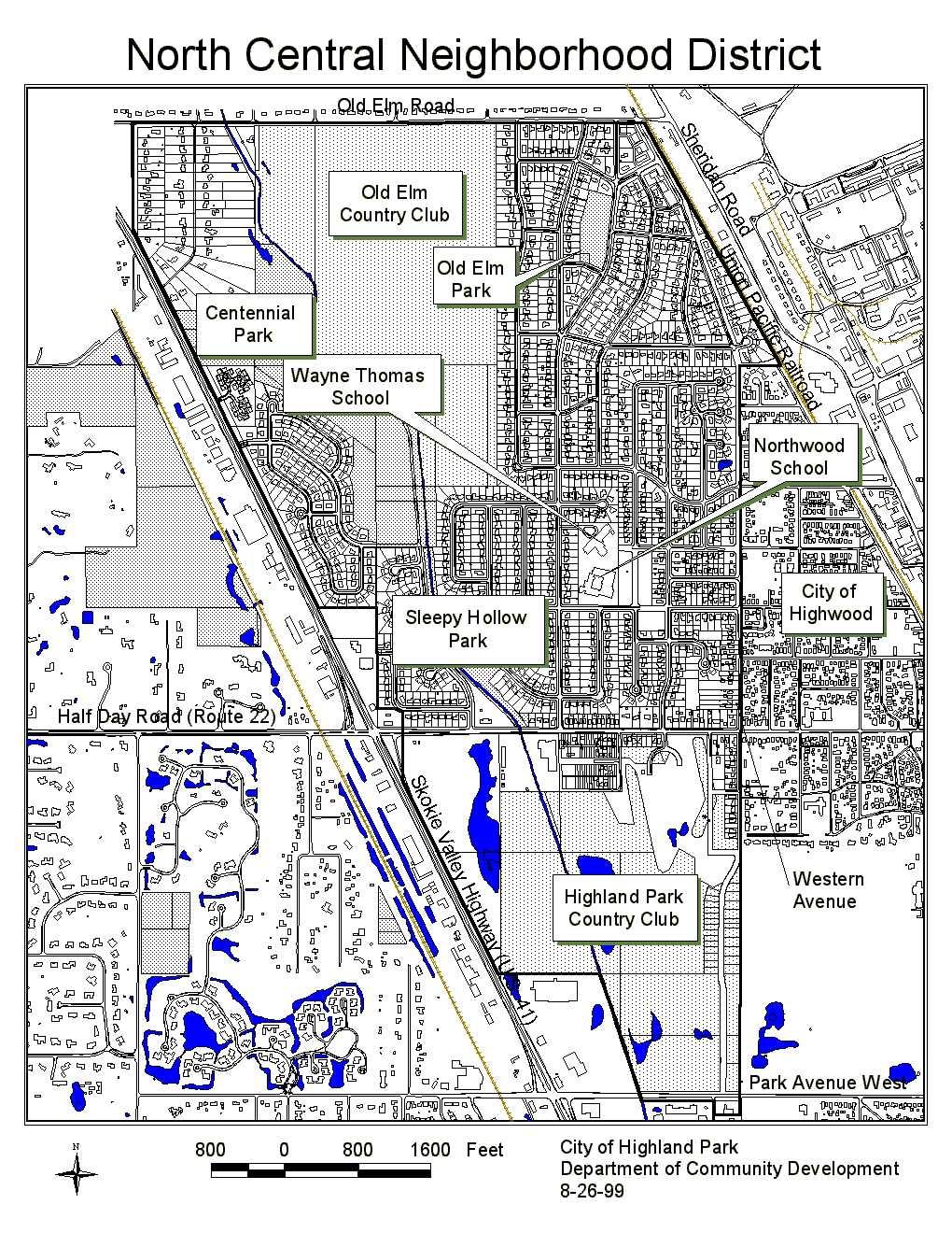
4 NEIGHBORHOOD PROFILE History At the turn of the century, Highland Park was officially 31 years old and the city limits were only as far west as Green Bay Road. As for the North Central Neighborhood, commonly referred to today as The Highlands, the land west of the City of Highwood and south of Old Elm Road was mainly oak trees and farmland. Eventually part of this area became the home of the Old Elm Country Club in 1912, as a small group of local residents wanted a private golf club of their own. The Slogan Better Homes in America courted a restless nation in the aftermath of war. Sky rocketing prosperity led scores to invest in swamps, woods and farmland within commuting distance of Chicago. - Pioneer to Commuter The 1920 s found America awash in prosperity and Highland Park was no exception. The national slogan Better Homes in America captured the sentiment of local residents as the demand for housing rose in the post World War I years. To meet that demand, developers were looking west of Green Bay Road for open land to build new subdivisions. Krenn and Dato, a local development firm saw opportunity with land known as the Sweeney Farm south of Old Elm Road, (then called Green Bay Road) and directly east of the Old Elm Country Club. In 1927 they recorded the Krenn and Dato s Highland Park Subdivision. This land not only met their needs for development, but its proximity to the Old Elm Country Club tapped into America s recent fascination with golf. Started with great fanfare, tudor homes emerged from the oaks and farmland. The depression brought the end of the Krenn and Dato firm and a partially built subdivision. Other subdivisions in the area including the never built Greenwood Gardens south of Half Day Road became just a dream as America s need for shelter became more basic. With the end of World War II, the late 1940 s and 1950 s saw a new demand for housing and the area south of Old Trail Road became desirable for homebuilders and homebuyers. As America grew so did Highland Park and homes south and west of the original Krenn and Dato subdivision began to shape today s neighborhood of over one thousand homes. VI 4
5 District Boundaries The North Central District starts on the city s northern boundary with Lake Forest and Old Elm Road. Going west from the corner of Old Elm and Western Avenue it meets with Buena Road. Here the neighborhood turns south to Highway 41 and follows it to the Southeast to Park Avenue West excluding all commercial properties along the way. From Park Avenue West, the boundary goes east to Birchwood Lane, jogs to the south to include the medical office building at the southeast corner of Birchwood Lane and Park Avenue West, then proceeds east to the boundary between the Highland Park Country Club and Exmoor Country Club. The neighborhood follows this boundary north where it meets with Western Avenue. Following Western Avenue, the boundary is closed when it joins with the intersection of Old Elm Road and Western Avenue. VI 5
6 VI 6
7 VI 7
8 VISION STATEMENT A vision statement is a tool to provide focus for the goals, wishes and plans of a community. In this case, the residents of the North Central Neighborhood District have identified in a few statements what they would like present and future community leaders to consider for their neighborhood s future. The residents of the North Central Neighborhood see their area as a largely residential community. Parks, golf courses and quiet streets are an integral part of the North Central Neighborhood fabric. North Central residents have identified the following issues as important to maintaining a prosperous and livable community. They would like current and future City leaders to consider these issues when planning for their neighborhood: Encourage neighborhood integration with the rest of the City by strengthening physical linkages to other neighborhoods. Maintain the quiet and peaceful nature of the neighborhood. Preserve existing neighborhood character by promoting large lot sizes, maintain housing diversity and strictly enforce zoning regulations. Open space and parks should be created and preserved at every opportunity. New development should be consistent with existing conditions. VI 8
9 ISSUES AND RECOMMENDATIONS Major issues identified by North Central neighborhood residents are divided into four categories; Public and Traffic Safety, Infrastructure, Zoning and Neighborhood Character and Neighborhood Commercial Development. PUBLIC AND TRAFFIC SAFETY INFRASTRUCTURE ZONING AND NEIGHBORHOOD CHARACTER NEIGHBORHOOD COMMERICAL DEVELOPMENT VI 9
10 TRAFFIC AND PUBLIC SAFETY Objective: Improving vehicular safety and efficiency through signage and light controls Every community desires safe and efficient movement of vehicles throughout their neighborhood. This section explores ways that the community can identify opportunities for placement of traffic signage and traffic calming measures. Every community desires safe and efficient movement of people and vehicles throughout their neighborhood Recommended Action Steps: Work with the Illinois Department of Transportation to improve traffic circulation at the Half Day Road and Highway 41 intersection. Develop a corridor plan for Half Day Road between Western Avenue and Skokie Highway (US 41). The plan should include a comprehensive long range traffic improvement plan as well as aesthetic improvements. Have the Traffic Commission study Old Trail Road to identify possible safety concerns and traffic congestion due to multiple stop signs. Have the Traffic Commission study Summit Avenue for traffic calming opportunities. As a major collector street and direct access between Old Trail Road and Half Day Road, safety and speeding are concerns of local residents. Possible impacts on other through streets such as University Avenue should also be considered. Have the Traffic Commission study existing restrictions for truck traffic and load limits. Consider further restrictions along Summit and Old Trail. Have the Traffic Commission study access and visibility on Old Elm Road at intersections with side streets providing access to the neighborhood. Coordination with Lake Forest will be necessary as Old Elm Road is under their jurisdiction. VI 10
11 Objective: Study Traffic Circulation and Public Safety Issues for Wayne Thomas Elementary and Northwood Junior High School Every parent knows that having schools nearby home is a convenience to an otherwise busy life. But school accessibility also promotes better child/school interaction benefiting both child and community. In the center of the North Central district among the neighborhood homes is an educational campus that is the home of Wayne Thomas Elementary and Northwood Junior High School. For long time residents with children, the campus becomes a familiar destination as their children start kindergarten here and work toward high school ending with the 8 th grade. School buses provide transportation for High School students. Bus stops are sometimes located where there are no sidewalks or waiting areas. Having an educational campus in the middle of a residential community also has its disadvantages, namely traffic and circulation conflicts between vehicles and pedestrians. At peak times during the day, as students are arriving and leaving school by car, bicycle or on foot, conflicts between the different modes of transportation hamper traffic flow and present certain safety risks. Recommended Action Steps: Have the City work with Wayne Thomas and Northwood School to develop a traffic and pedestrian circulation plan. Focus on ways to safely move traffic more efficiently through loading and drop off areas. Also look at the walking habits of students, where they go and how frequently. With this information identify pedestrian routes based on usage. Identify locations where High School Students wait for the school bus and determine what improvements are needed at bus stops. Develop a public improvement action plan that will implement the sidewalks, crossing walks, bus stops and safety measures identified in the circulation plan. VI 11
12 INFRASTRUCTURE Objective: Public Improvements. One of the biggest challenges facing any community today is the continual maintenance of the City s infrastructure. Aging infrastructure, heavy usage and the elements hamper efforts by the City s Public Works Department to manage the situation. However, the maintenance of these systems is vital to running the community. Poor road conditions and aging sewer lines will threaten the quality of life for neighborhood residents. Municipalities that can best address these issues are those that continually monitor conditions and prepare capital improvement plans that provide funding for repairs and preventive maintenance measures. Recommended Action Steps: Evaluate and prioritize existing street conditions in the North Central Neighborhood to target short to long term public improvement projects. Study the feasibility of placing a sound barrier along the east side of the Skokie Highway between Old Mill Road and Half Day Road. Objective: Accessibility Residents in the North Central Neighborhood feel isolated from the rest of Highland Park Residents in the North Central Neighborhood feel they are isolated from the rest of Highland Park. In part this is due to existing physical barriers and municipal boundaries. The City of Lake Forest borders the neighborhood to the north. To the east is another municipality, Highwood. To the west, Skokie Highway, (41) acts as a physical barrier to other parts of Highland Park. And to the south, Highland Park Country Club provides an open space buffer, but also separates most of the North Central Neighborhood from other neighborhoods and the downtown area. To tie residents of this neighborhood to the rest of the community requires consideration of better transportation systems, (i.e. streets, bikeways, sidewalks) that will bridge the distance between neighborhoods and the perception of isolation among neighborhood residents. VI 12
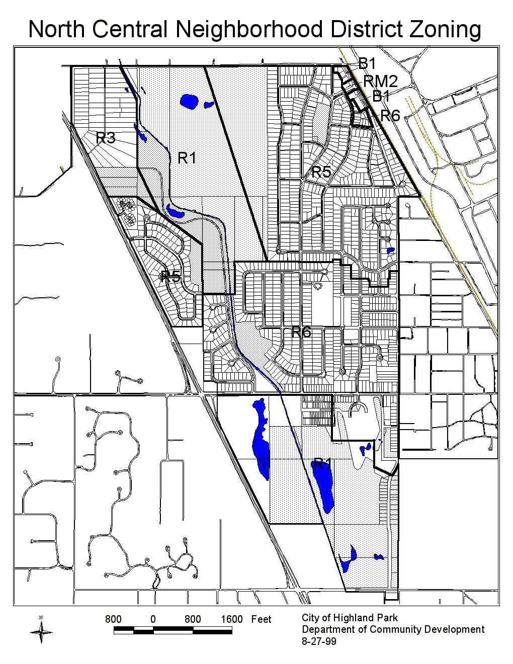
13 The City of Highland Park s Greenways Plan adopted by the City Council in 1995 identifies existing and proposed trials, sidewalks, pedestrian bridges and bike routes. Recommended Action Steps: Link exiting off street and on street bike paths that would tie the northern area of the North Central District to the Downtown area. Use of the existing bike path along the eastern boundary of the Highland Park Country Club would be one example. Study a North South street, that has minimal impact on the area, between Half Day Road and Park Avenue West to provide a third alternative to destinations south like commercial districts along the Skokie Highway and the downtown area. Promote existing roads and trails to area residents. Encourage use and implementation of the 1995 Greenways Plan. ZONING AND NEIGHBORHOOD CHARACTER Objective: Create an Open Space Zoning District for Parks, Schools and Golf Courses The North Central Neighborhood is home to five parks and two golf courses. The golf courses alone make up a large portion of the neighborhood district. Because open space is so predominant in the neighborhood, not to mention the benefits gained by the uses, preserving it is a priority to North Central residents. Under the current zoning ordinance, golf courses for example, which are zoned residential can be redeveloped as a single family residential subdivision. In the North Central Neighborhood, all golf courses and parks are zoned R1 Country Estate Single Family, (1 home for every 4 acres), R5 Moderate Density Single Family, (4 homes/ acre), or R6 Medium Density Single Family, (6 homes/ acre). Should any of these areas be considered for development some day, the potential impact on neighborhood character is high. VI 13
14 Recommended Action Steps: Have the City study the creation of an Open Space zoning district that would limit usage to parks, golf courses and schools. In absence of an open space zoning district, rezone all parks, schools and golf courses in the neighborhood to R1 Country Estate Single Family. Have the City develop an open space acquisition program and fund. This effort should include coordinating acquisition with other agencies such as the Forest Preserve District and Park District. Explore other sources of funding for open space acquisition such as grants. Objective: Preserve the 38 Acres as Open Space At the southeast corner of Half Day Road and the Skokie Highway, there is currently 38 acres of undeveloped privately owned land that contains mainly trees and wetland areas. Neighborhood residents are concerned about the potential impact of this land s development. Specifically, they feel any development on the 38 acre parcel will increase traffic on Half Day Road and exasperate the current congestion at the intersection of Half Day Road and the Skokie Highway. Recommended Action Steps: Consider establishing the "38 acres as publicly owned open space. If the property is developed, prevent access to Half Day Road. Objective: Preserve the Character of the Half Day Road (Highway 22) Corridor. Predominantly residential on the north side of Half Day Road, between the Skokie Highway and Western Avenue, residents are concerned that development along the south half of Half Day Road will change the character of the area. Development will increase density and traffic in an area that is mostly zoned R1 Single- Family Residential. Recommended Action Steps: VI 14
15 Limit future development on the south side of Half Day Road between the Skokie Highway and Western Avenue. Maintain the Highland Park Country Club as a Golf Course. Objective: Insure that Residents are Satisfied with their Communities Character and Development Trends. Two of the five issues identified in the Vision Statement for the Community are: 1. Preserve existing neighborhood character by promoting large lot sizes, maintaining housing diversity and strictly enforce zoning regulations. 2. New development should be consistent with existing conditions. Insure that Residents Are Satisfied with Their Communities Character and Development Trends This clearly indicates concern that future development be compatible with existing neighborhood character. A Community meeting was held to discuss new residential development and its compatibility with existing neighborhoods. While some residents were concerned about compatibility of new development, others felt that redevelopment was positive and would improve the character and diversity in the Community. There was not a clear consensus regarding these issues or what action, if any, should be taken. Residents who did have concerns seemed to be primarily concerned with the impact new construction or additions might have on existing homes especially regarding building height and proximity to side lot lines. Action on these issues, specific to the neighborhoods in the North Central District is not recommended. Bulk and character issues may still be considered by the City on a Citywide basis. Also of concern was the location of cellular antennas. The Community consensus is that cellular facilities should not be located in or adjacent to residential areas. The Skokie Highway Corridor was sited as one possible alternative. Recommended action steps: Continue to monitor resident concerns regarding new development in the Community. Locate cellular facilities away from residential areas and schools. VI 15
16 NEIGHBORHOOD COMMERCIAL DEVELOPMENT Objective: Upgrade the existing commercial district while maintaining low intensity development consistent with the surrounding single family neighborhood. Within the North Central District, there is only one area that is considered commercial in use. This is in the northeast corner of the neighborhood at the intersection of Western Avenue and Old Elm Road. As commercial districts go this one is very small, only two half blocks. Zoned mostly B1 Neighborhood Commercial, this area is under utilized with vacant storefronts and office uses. Sidewalks, curbs and parking are either unimproved or in need of maintenance. Landscaping is minimal. The area has very little of the community feel that you would expect from a neighborhood commercial area. This area was discussed in detail at a neighborhood meeting. The two primary topics discussed were land use/zoning and physical improvements. Each of these is explained below. Upgrade the Existing Commercial District While Maintaining Low Intensity Development Consistent with the Surrounding Single Family Neighborhood Land Use/Zoning: It was generally agreed that the existing retail area at the southwest corner of Old Elm Road and Western Avenue should be retained as a local shopping area to serve the immediate community. Retail uses should be limited to those which serve the immediate Community such as convenience stores, drug stores and dry cleaners. Uses which draw from a larger geographic area, such as restaurants, should be disallowed. Upper story residential units should not be allowed. The vacant convenience store at 3556 Western Avenue and the adjacent vacant lot should be allowed to become town homes or a low density multi-family use under the RM1 zone or a new town-home district if the owner decides that retail uses are no longer viable farther south on Western Avenue. The existing apartment building at the northwest corner of Hyacinth Place and Old Elm Road should remain multi-family residential. As the site is too small to redevelop under the current RM2 zoning and the bulk and density allowed under RM2 zoning would be out of character with the neighborhood, the zoning classification should be changed to RM1 or a new town-home district which will allow redevelopment as town homes or a low density multi-family use. The office uses south of Hyacinth Place should be maintained. Retail uses allowed under the current B1 zoning are undesirable to VI 16
17 the property owners and the Community. The B1 zone does not allow the current office uses nor does the City currently have a low density office zone. Zoning should allow a full range of office uses except for those which would have high traffic generation such as banks, realtors, or medical offices. In any new construction, building design, scale, massing, setbacks and landscaping should be similar and compatible to the adjacent single family area. Buffering and screening should be used to minimize the impact on adjacent homes. There was discussion of allowing multi-family uses where offices are currently located but Community opposition was strong. It was also felt that RM2 zoning, requested by one property owner, was incompatible with the adjacent single family neighborhood. Recommended Action Steps: Take the necessary steps to conduct a staff led communitywide charette for the commercial area. Revise the B1 zoning in this area to disallow upper floor residences and limit uses to those which serve the immediate area such as convenience, drug stores or dry cleaners. Allow RM1 or town-home zoning at the vacant convenience store at 3556 Western Avenue and the adjacent lot should the property owner apply for a change in zoning. Rezone the site of the existing apartment building at the northwest corner of Hyacinth and Western to RM1 or town-home zoning. Zone the office building sites to allow a full range of low traffic generating office uses. Development requirements set out in the zoning should require that development be compatible with the adjacent single family homes as discussed in the above paragraph. The City should pursue a comprehensive improvement program for the commercial area which provides a positive unified image. Physical Improvements: The City should pursue a comprehensive improvement program for the commercial area which provides a positive unified image. Streetscape type features should be included. These improvements could be made in conjunction with improvements on private property; however, there was some community opposition to using public funds for improvements to private property. A list of items identified to be addressed in this program includes: 1. A pedestrian circulation system which provides continuous sidewalks and crosswalks within the area and connecting to adjacent areas. VI 17
18 2. The lack of curb along the east side of Krenn Avenue adjacent to the retail area could be improved to control vehicular access and encourage pedestrian use. 3. Landscaping improvements could be made to provide a more positive image for the area. 4. Barriers to pedestrian use caused by grade changes along Old Elm Road and Western Avenue could be addressed to provide better pedestrian access and circulation. 5. The undeveloped loading area behind the retail buildings could be improved to provide controlled auto circulation, improved paving, additional landscaping and additional buffering of nearby residences. 6. Unused on-street parking along Hyacinth and Western Avenue could be used to provide commuter parking for residents in the area or could be removed to provide additional landscaping and green-space. 7. An at-grade pedestrian track crossing could be provided immediately adjacent to the Metra station building to provide more convenient access between the station, the neighborhood, and the Pace bus stop. 8. Additional buffering could be provided between the retail and residential areas to reduce impacts on residents. 9. Improving limited visibility at the Old Elm Road - Western Avenue intersection caused by existing grade changes and landscaping would provide safer access to Old Elm Road for drivers. 10. The pavement width on Hyacinth Place at Western Avenue provides an opportunity for additional landscaping. Extending the median on Hyacinth Place was discussed but there was not a clear consensus whether the median should be extended. 11. A pedestrian track crossing along the south side of Old Elm Road, separated from the street pavement, will provide pedestrians a safer crossing. 12. Providing crosswalks on Old Elm Road will improve pedestrian access to the business area and provide Highland Park residents with improved access to the sidewalks on the north side of Old Elm Road and to the Green Bay Trail. 13. A comprehensive Improvement Program could be used to create a positive unified image for the immediate area and the City of Highland Park as the area is a gateway into the City. VI 18
19 14. Providing a paved waiting area and shelter at the Pace bus stop on Western Avenue will improve safety and convenience for transit users. 15. The grass area between Western Avenue and the train tracks provides an opportunity for additional planting. This planting could create a visual screen of the tracks south of Hyacinth. North of Hyacinth low ground covers and shade trees could be planted to provide additional landscaping while maintaining visibility of the station and platforms. Recommended Action Steps: Develop a comprehensive program of improvements with the help of commercial property owners, business owners, and local residents. Establish a timeline for implementation of these improvements. VI 19
20 North Central District Action Plan Steps OBJECTIVES AND ACTION STEPS RESPONSIBLE AGENCY TIME TABLE Work with the Illinois Department of Transportation to improve circulation at the Half Day Road and Highway 41 intersection. Develop a corridor plan for Half Day Road between Western Avenue and Skokie Highway (US 41). The Plan should include a comprehensive long range traffic improvement plan as well as aesthetic improvements. Have the Traffic Commission study Old Trail Road to identify possible safety concerns and traffic congestion due to multiple stop signs. Have the Traffic Commission study Summit Avenue for traffic calming opportunities. As a major collector street and direct access between Old Trail Road and Half Day Road, safety and speeding are concerns of local residents. Possible impacts on other through streets such as University Avenue should also be considered. Have the Traffic Commission study existing restrictions for truck traffic and load limits. Consider further restrictions along Summit and Old Trail. Have the Traffic Commission study access and visibility on Old Elm Road at intersections with side streets providing access to the neighborhood. Coordination with Lake Forest will be necessary as Old Elm is under their jurisdiction. Have the city work with Wayne Thomas and Northwood School to develop a traffic and pedestrian circulation plan. Focus on ways to safely move traffic more efficiently through loading and dropping off areas. Also look at the walking habits of students, where they go and how frequently. With this information identify pedestrian routes based on usage. Identify locations where High School Students wait for the school bus and determine what improvements are needed at bus stops. Develop a public improvement action plan that will implement the sidewalks, crossing walks, bus stops and safety measures identified in the circulation plan. Evaluate and prioritize existing street conditions in the North Central Neighborhood to target short to long term public improvement projects. Study the feasibility of placing a sound barrier along the east side of the Skokie Highway between Old Mill Road and Half Day Road. Link existing off street and on street bike paths that would tie the northern area of the North Central District to the Downtown area. Use of the existing bike path along the eastern boundary of the Highland Park Country Club would be one example. Promote existing roads and trails to area residents. Encourage use and implementation of the 1995 Greenways Plan. Study a North - South street, that has minimal impact on the area, between Half Day Road and Park Avenue West to provide a third alternative to destinations south like commercial Public Works and IDOT Public Works & Traffic Commission Public Works & Traffic Commission Public Works & Traffic Commission Public Works & Traffic Commission Public Works & Traffic Commission Public Works, Department of Community Development, & School District Public Works, Department of Community Development, & School District Public Works, Department of Community Development, & School District Public Works, Department of Community Development, & School District Public Works Public Works & IDOT Public Works Park District of Highland Park & City of Highland Park Public Works & City Council VI year 0-2 years 0-1 year 0-2 years 0-1 year 0-2 years 0-1 year 0-1 year 0-1 year 0-1 year 0-10 years 2-5 years 5+ years 2-5 years 5+ year
21 districts along the Skokie Highway and the downtown area. Have the City study the creation of an Open Space zoning district that would limit usage to parks, golf courses and schools. In absence of an open space zoning district, rezone all parks, schools, and golf courses in the neighborhood to R1 Country Estate Single Family. Have the City develop an open space acquisition program and fund. This effort should include coordinating acquisition with other agencies as the Forest Preserve District and Park District. Explore other sources of funding for open space acquisition such as grants. Consider establishing the "38 Acres" as publicly owned open space. If the property is developed, prevent access to Half Day Road. Development & City Council Development & City Council Development & City Council 0-1 year 2-5 years 0-2 years Ongoing Development & City Council 0-2 years Development & City Council Public Works, Department of Ongoing Community Development, & City Council Limit future development on the south side of Half Day Road Ongoing between the Skokie Highway and Western Avenue. Development & City Council Maintain the Highland Park Country Club as a Golf Course. City Council Ongoing Continue to monitor resident concerns regarding new Ongoing development in the Community. Development Locate cellular facilities away from residential areas and Plan Commission & City Council Ongoing schools Take the necessary steps to conduct a staff led communitywide 0-1 year charette for the commercial area. Development Revise the B1 zoning in this area to disallow upper floor 0-2 years residences and limit uses to those which serve the immediate Development & City Council area such as convenience, drug stores or dry cleaners. Allow RM1 or town-home zoning at the vacant convenience store at 3556 Western Avenue and the adjacent lot should the property owner apply for a change in zoning. Rezone the site of the existing apartment building at the northwest corner of Hyacinth and Western to RM1 or townhome zoning. Zone the office building sites to allow a full range of low traffic generating office uses. Development requirements set out in the zoning should require that development be compatible with the adjacent single family homes. Develop a comprehensive program of improvements with the help of commercial property owners, business owners, and local residents. Establish a timeline for implementation of these improvements. Development & City Council Development & City Council Development & City Council Development, Public Works, Businesses, & the Neighborhood Development & Public Works Ongoing 0-2 years 0-2 years 0-2 years 0-2 years VI 21
The transportation system in a community is an
 7 TRANSPORTATION The transportation system in a community is an important factor contributing to the quality of life of the residents. Without a sound transportation system to bring both goods and patrons
Proposed Comprehensive Plan Strategies DRAFT for discussion June 28, 2017
 Proposed Comprehensive Plan Strategies DRAFT for discussion June 28, 2017 Land Use Rural Areas Refine the Farm and Forest area (FF) Update FF boundaries to account for existing lots less than five acres
Planning Districts INTRODUCTION
 INTRODUCTION To facilitate detailed examination of development prospects for all areas of the community, Delano has been divided into 14 planning districts. The location of these planning districts is
3. VISION AND GOALS. Vision Statement. Goals, Objectives and Policies
 Vision Statement Queen Creek s interconnected network of parks, trails, open spaces and recreation opportunities provide safe and diverse activities and programs that sustain its unique, small town, equestrian
Executive Summary. NY 7 / NY 2 Corridor
 Executive Summary NY 7 / NY 2 Corridor Transportation and Land Use Study December 2005 Prepared for: Town of Colonie Capital District Transportation Committee Prepared by: Introduction: Land use decisions
BUILDING SCALE AND SETBACKS 5 ELEMENTS:... 5 FAÇADES (COMMERCIAL/RESIDENTIAL) 5
 5") VISION STATEMENT 3 UTILIZATION OF THE GUIDELINES 3 IMPLEMENTATION 3 PROCEDURES FOR DESIGN REVIEW 3 LAND USE AND ZONING 4 LAND USE 4 ELEMENTS:... 4 ZONING 4 ELEMENTS:... 4 BUILDING SCALE AND SETBACKS 5
VISION STATEMENT 3 UTILIZATION OF THE GUIDELINES 3 IMPLEMENTATION 3 PROCEDURES FOR DESIGN REVIEW 3 LAND USE AND ZONING 4 LAND USE 4 ELEMENTS:... 4 ZONING 4 ELEMENTS:... 4 BUILDING SCALE AND SETBACKS 5
Tonight s Agenda. Summary Presentation Open House. Group Discussion Next Steps: online community wide survey
 Community Open House February 22, 2018 Tonight s Agenda Summary Presentation Open House Station 1: Project Overview and Community Input Station 2: Draft Vision and Guiding Principles Station 3: Western,
Gold Line Bus Rapid Transit Transit Oriented Development (BRTOD) Helmo Station Area Plan
 Helmo Station Area Plan") Appendix F Gold Line Bus Rapid Transit Transit Oriented Development (BRTOD) Helmo Station Area Plan Introduction and Purpose of the Plan The Gold Line Bus Rapid Transit facility is an eleven-mile dedicated
Appendix F Gold Line Bus Rapid Transit Transit Oriented Development (BRTOD) Helmo Station Area Plan Introduction and Purpose of the Plan The Gold Line Bus Rapid Transit facility is an eleven-mile dedicated
CHAPTER 7: VISION AND ACTION STATEMENTS. Noble 2025 Vision Statement
 CHAPTER 7: VISION AND ACTION STATEMENTS This chapter presents the vision, policy and action statements that transform the comprehensive planning study, an analysis of Noble s past, future trends and community
Town Center (part of the Comprehensive Plan)
") Town Center (part of the Comprehensive Plan) Mercer Island Town Center Looking North (2014) In 1994, a year-long process culminated in a set of design guidelines and code requirements for the Town Center
Town Center (part of the Comprehensive Plan) Mercer Island Town Center Looking North (2014) In 1994, a year-long process culminated in a set of design guidelines and code requirements for the Town Center
City of Farmington. Downtown Plan. Amendment to the 1998 Master Plan Adopted October 11, 2004
 City of Farmington Amendment to the 1998 Master Plan Adopted October 11, 2004 Introduction Planning Background 1 Scope and Components of the Plan Amendment 2 Concept Introduction 3 Plan Concepts 3 Conceptual
Table of Contents. Elm Avenue Improvement Plan City of Waco, Texas. Introduction 1. Existing Context 1 Figure 1 2.
 Table of Contents Introduction 1 Existing Context 1 Figure 1 2 Plan Guidelines 3 Future Urban Form 4 The West-End 4 Main Street 6 The East-End 7 Figure 2 9 Public Improvement Recommendations 7 General
Hockessin Community Redevelopment Plan
 Hockessin Community Redevelopment Plan 3.1 Introduction The Community Redevelopment Plan for the Village of Hockessin is the result of the people s vision for a distinct village center that serves as the
CHAPTER 7: Transportation, Mobility and Circulation
 AGLE AREA COMMUNITY Plan CHAPTER 7 CHAPTER 7: Transportation, Mobility and Circulation Transportation, Mobility and Circulation The purpose of the Transportation, Mobility and Circulation Chapter is to
CITY OF COLWICH COMPREHENSIVE PLAN LAND USE LAND USE 1
 LAND USE LAND USE 1 WHAT YOU WILL FIND IN THIS CHAPTER: Discussion of today s conditions and tomorrow s projections Discussion of challenges and opportunities Discussion of the environmental quality goals,
SUMMERSIDE / MT. CARMEL REINVESTMENT CORRIDOR COMMUNITY DEVELOPMENT STRATEGY
 SUMMERSIDE / MT. CARMEL REINVESTMENT CORRIDOR COMMUNITY DEVELOPMENT STRATEGY FEBRUARY 2013 I. Location of the Summerside/Mt. Carmel Reinvestment Corridor The Summerside/Mt. Carmel Reinvestment Corridor
Port Lavaca Future Land Use
 Port Lavaca Future Land Use Introduction The City of Port Lavaca is beginning to see sustained growth, after many years of relative stable population. New single family homes, apartments, and businesses
Urban Design 9Identity
 Urban Design 9Identity URBAN DESIGN IDENTITY Urban design is about connecting people to their places through the built environment, nature, and overall urban form. Done well, it creates a memorable space
THEMES, VISION, + PRINCIPLES
 CHAPTER 2: THEMES, VISION, + PRINCIPLES This page intentionally left blank. 20 VISION DRAFT AUGUST 2018 2 2 THEMES, VISION, + GUIDING PRINCIPLES The Key Themes, Vision, and Guiding Principles presented
Urban Planning and Land Use
 Urban Planning and Land Use 701 North 7 th Street, Room 423 Phone: (913) 573-5750 Kansas City, Kansas 66101 Fax: (913) 573-5796 Email: planninginfo@wycokck.org www.wycokck.org/planning To: From: City Planning
REGIONAL ACTIVITY CENTER
 DRAFT REGIONAL ACTIVITY CENTER 70 EAST BENCH MASTER PLAN DRAFT 06 Introduction The East Bench Regional Activity center is comprised of large educational, research, medical, and employment centers. These
4.1.3 LAND USE CATEGORIES
 4.1.3 LAND USE CATEGORIES a. City Center District The City Center District incorporates the existing character and mix of uses in downtown Belmont to encourage redevelopment and new development in keeping
MEMO 1. INTRODUCTION PURPOSE & PROCESS REQUEST
 MEMO Date: August 22, 2017 To: Board of Commissioners From: Jason Burdette, Planning Director Re: Davidson Commons East Hotel Stakeholder Feedback 1. INTRODUCTION PURPOSE & PROCESS This memorandum summarizes
The Vision. Photo provided by The Minervini Group. 46 Vision, Objectives & Strategies
 Vision, Objectives & Strategies The is the public framework and guide for future development of the Grand Traverse Commons. The establishes public polices for infrastructure, the preservation of natural
The Illinois Department of Transportation and Lake County Division of Transportation. Route 173, including the Millburn Bypass
 The Illinois Department of Transportation and Lake County Division of Transportation welcome you to this Public Hearing for U.S. Route 45 from Illinois Route 132 to Illinois Route 173, including the Millburn
ARTICLE 6: Special and Planned Development Districts
 ARTICLE 6: Special and Planned Development Districts 6-10 Traditional Neighborhood Development (TND) District 6-10.10 Purpose and Intent The Traditional Neighborhood Development (TND) District provides
Corridor Vision. 1Pursue Minnehaha-Hiawatha Community Works Project. Mission of Hennepin County Community Works Program
 1Pursue Minnehaha-Hiawatha Community Works Project Minnehaha-Hiawatha Community Works is a project within the Hennepin Community Works (HCW) program. The mission of the HCW program is to enhance how the
CHARLES PUTMAN CHARLES PUTMAN AND ASSOCIATES, INC
 MEMORANDUM CHARLES PUTMAN & ASSOCIATES, INC. LAND DEVELOPMENT CONSULTANTS PLANNING ZONING PERMITTING 4722 NW Boca Raton Boulevard, Suite C-106 Boca Raton, Florida 33431 Phone: 561/994-6411 FAX: 561/994-0447
[PLANNING RATIONALE] For Site Plan Control and Lifting of Holding Zone By-Law 101 Champagne Avenue. May 23, 2014
![[PLANNING RATIONALE] For Site Plan Control and Lifting of Holding Zone By-Law 101 Champagne Avenue. May 23, 2014](/thumbs/75/71599615.jpg "[PLANNING RATIONALE] For Site Plan Control and Lifting of Holding Zone By-Law 101 Champagne Avenue. May 23, 2014") [PLANNING RATIONALE] For Site Plan Control and Lifting of Holding Zone By-Law 101 Champagne Avenue May 23, 2014 Contents 1.0 Introduction... 2 2.0 Site Context... 2 2.1 Adjacent Uses... 2 Figure 1: Site
[PLANNING RATIONALE] For Site Plan Control and Lifting of Holding Zone By-Law 101 Champagne Avenue May 23, 2014 Contents 1.0 Introduction... 2 2.0 Site Context... 2 2.1 Adjacent Uses... 2 Figure 1: Site
Lower Merion Commercial Districts Issues and Characteristics Handbook November 2013
 Lower Merion Commercial Districts Issues and Characteristics Handbook November 2013 DRAFT TOWNSHIP-WIDE VISION: To maintain and enhance commercial areas to complement the surrounding high-quality residential
EXISTING COMPREHENSIVE PLAN
 EXISTING COMPREHENSIVE PLAN Town Center Land Use Element: V. LAND USE POLICIES Town Center Mercer Island's business district vision as described in "Your Mercer Island Citizen-Designed Downtown" was an
Route 1 Corridor Study
 Route 1 Corridor Study Westbrook, Connecticut A Vision for the Connecticut Shoreline Public Informational Meeting July 28, 2015 Lower Connecticut River Valley Council of Governments Fitzgerald & Halliday,
Issues, Challenges & Opportunities
 Below is a summary of issues, challenges, and opportunities relating to the revitalization of Downtown Romeoville and potential development of the Village s East Side TOD Area. Current Issues & Challenges
7Page 91 CLEMMONS COMMUNITY COMPASS 7 COMMUNITY CHARACTER
 7 Community Character The beauty of Clemmons won t necessarily be a reflection of our past, but our future. This quote from Comprehensive Plan Steering Committee member Wayne Dodson captures the essence
Implementation Guide Comprehensive Plan City of Allen
 Implementation Guide 2030 Comprehensive Plan City of Allen DRAFT 2015 Implementation Guide Allen 2030 Comprehensive Plan INTRODUCTION The Comprehensive Plan serves as a guide for the growth and development
Access Management: An Overview
 Figures 1-5 Below Evolution of development along a highway. In the early stages, land along the road is used for farming with little traffic generated. As time passes, the highway corridor becomes a de
Volume 2: Implementation Plan
 Volume 2: Implementation Plan February 25 th 2002 Implementation Introduction This document outlines the steps that should be taken to implement the Washington Heights Neighborhood Plan. The City Council
FOSTER COMPREHENSIVE PLAN UPDATE CIRCULATION
 5.8.1 INTRODUCTION CIRCULATION The Circulation Element of the Comprehensive Plan studies the routes and modes of travel. The circulation network of the town affects the ease of movement through Foster
Beatties Ford Road & Mt. Holly-Huntersville Road Small Area Plan
 Beatties Ford Road & Mt. Holly-Huntersville Road Small Area Plan Town of Huntersville October 2005 Town of Huntersville Planning Department 101 Huntersville Concord Road Post Office Box 664 Huntersville,
City of Royalton Comprehensive Land Use Plan 2005 to Revision February 8, 2011
 City of Royalton Comprehensive Land Use Plan 2005 to 2015 2011 Revision February 8, 2011 PART ONE: INTRODUCTION TO THE COMPREHENSIVE PLAN 1.0 Purpose and Introduction The Comprehensive Land Use Plan provides
Planning Board Briefing
 Planning Board Briefing Why Now? The Sector Plan Implementation Chapter States: Before Stage 1 begins, the following must occur: Approval of the Sectional Map Amendment. Approval of the Greater Lyttonsville
DRAFT Amsterdam/Churchill Community Plan (4/17/08) Adopted By the Gallatin County Commission
 Adopted By the Gallatin County Commission") DRAFT Amsterdam/Churchill Community Plan (4/17/08) Adopted By the Gallatin County Commission Table of Contents Acknowledgements Chapter 1: Introduction A Brief History What s Next Authority Organization
DRAFT Amsterdam/Churchill Community Plan (4/17/08) Adopted By the Gallatin County Commission Table of Contents Acknowledgements Chapter 1: Introduction A Brief History What s Next Authority Organization
Future Land Use SAMPLE RECOMMENDATIONS
 SAMPLE RECOMMENDATIONS Future Land Use The Future Land Use Chapter of the Master Plan builds upon prior chapters examining the existing conditions in their respective topic areas to present a comprehensive
YONGE STEELES CORRIDOR SECONDARY PLAN. Young + Wright / IBI Group Architects Dillon Consulting Ltd. GHK International (Canada) Ltd.
 Ltd.") PART A: PREAMBLE 1.0 PURPOSE The purpose of this Secondary Plan is to provide a development framework for intensification of the Yonge/ Steeles corridor including the north side of Steeles Avenue West
PART A: PREAMBLE 1.0 PURPOSE The purpose of this Secondary Plan is to provide a development framework for intensification of the Yonge/ Steeles corridor including the north side of Steeles Avenue West
CITY OF PUYALLUP. Background. Development Services
 CITY OF PUYALLUP Development Services 333 South Meridian Puyallup WA 98371 To: City Council From: Katie Baker, AICP, Planning Division Re: South Hill Neighborhood Plan Adoption Date: (Meeting date: February
Comprehensive Plan. Faribault, Minnesota. Hoisington Koegler Group Inc. Claybaugh Preservation Architecture Inc. Howard R. Green Company Bonz/REA
 Comprehensive Plan Faribault, Minnesota Adopted by the Faribault City Council July 8, 2003 prepared for: prepared by: Hoisington Koegler Group Inc. Claybaugh Preservation Architecture Inc. Howard R. Green
VILLAGE OF CLEMMONS PLANNING BOARD DRAFT STAFF REPORT
 VILLAGE OF CLEMMONS PLANNING BOARD DRAFT STAFF REPORT PETITION INFORMATION Docket # C-226 Staff Megan Ledbetter Petitioner(s) JBJH Properties, LLC Owner(s) JBJH Properties, LLC Subject Property 5892-49-1766
PLAN ELEMENTS WORKSHOP. April 5, 2016
 PLAN ELEMENTS WORKSHOP April 5, 2016 needs more housing. But there is no one-size fits-all solution. Every neighborhood has its own character. In some places, density is not only appropriate it is badly
BROOKHILL NEIGHBORHOOD MODEL ZONING MAP AMENDMENT PREFACE TO APPLICATION
 BROOKHILL NEIGHBORHOOD MODEL ZONING MAP AMENDMENT PREFACE TO APPLICATION June 15, 2015 Revised: August 1, 2016 I. VISION Brookhill is a proposed community based upon the principles of Albemarle County
McCowan Precinct Plan Study Background & Deliverables
 1 DRAFT & WITHOUT PREJUDICE McCowan Precinct Plan Study Background & Deliverables In September, 2011, City Planning (Scarborough District) began a study of an area within the Scarborough Centre, identified
SECTION II SECTION II STATEMENT OF GOALS, OBJECTIVES, PRINCIPLES, ASSUMPTIONS, POLICIES AND STANDARDS
 STATEMENT OF GOALS, OBJECTIVES, PRINCIPLES, ASSUMPTIONS, POLICIES AND STANDARDS 1 2 STATEMENT OF GOALS, OBJECTIVES, PRINCIPLES, ASSUMPTIONS, POLICIES AND STANDARDS INTRODUCTION The New Jersey Municipal
Today Land & People. Northeast Nampa Gateway District. Employment. Land Use Characteristics. Demographics. Current Zoning
 Today Land & People Employment Major employers include Saint Alphonsus, the College of Western Idaho, the Auto Mall, Sorrento Lactalis and Walmart. 3,004 jobs in 2010 (COMPASS-CIM 2040 TAZ data) 4,345
Chapter 6: Community Character
 Chapter 6: Community Character The term "community character" covers a broad spectrum of concerns. First and foremost, community character is a visual concept. In Long Grove, however, community character
Status Update (2006 vs. Now) Citizen s Advisory Committee February Plan for Prosperity
 Citizen s Advisory Committee February Plan for Prosperity") Status Update (2006 vs. Now) Citizen s Advisory Committee February 2018 Plan for Prosperity 2000 2017 2000 2017 Gardnerville Population 6,000 5,760 5746 5,500 5,000 5,067 5,550 5,165 5,394 5,412 5,250
Status Update (2006 vs. Now) Citizen s Advisory Committee February 2018 Plan for Prosperity 2000 2017 2000 2017 Gardnerville Population 6,000 5,760 5746 5,500 5,000 5,067 5,550 5,165 5,394 5,412 5,250
38 Queen s University Campus Master Plan Part 1
 38 Queen s University Campus Master Plan Part 1 46 The Campus at the City Scale Chapter 4 The Campus at the City Scale 39 Queen s is an urban University centrally located in Kingston. Decisions made by
SUSSEX COUNTY COMPREHENSIVE PLAN COUNTY PLANNING AND ZONING COMMISSION WORKSHOP
 SUSSEX COUNTY COMPREHENSIVE PLAN COUNTY PLANNING AND ZONING COMMISSION WORKSHOP August 21, 2017 TODAY S WORKSHOP Public Comment Utilities Update Economic Development Update Future Land Use Discussion Public
Plan-It Greenville (2009) Comprehensive Plan 5-Year Update
 Comprehensive Plan 5-Year Update") Plan-It Greenville (2009) Comprehensive Plan 5-Year Update What is the comprehensive plan: Collecting communitywide data Projecting future population growth Setting communitywide goals Framing policies
Plan-It Greenville (2009) Comprehensive Plan 5-Year Update What is the comprehensive plan: Collecting communitywide data Projecting future population growth Setting communitywide goals Framing policies
Harlem Avenue Corridor Plan: Corridor Planning Across Municipal Boundaries
 Harlem Avenue Corridor Plan: Corridor Planning Across Municipal Boundaries Heather Tabbert, Manager, Local Planning and Programs Division Regional Transportation Authority (RTA) Jen McNeil Dhadwal, Principal
Policies and Code Intent Sections Related to Town Center
 Policies and Code Intent Sections Related to Town Center The Town Center Vision is scattered throughout the Comprehensive Plan, development code and the 1994 Town Center Plan. What follows are sections
Community Design Plan
 Gardena General Plan 2006 Authority While the is not a required element of a General Plan, it is included because improving the community appearance and image is paramount to the overall quality of life
VISION AND GUIDING DESIGN PRINCIPLES
 pleasure point commercial corridor VISION AND GUIDING DESIGN PRINCIPLES Public Draft November 26, 2018 County of Santa Cruz with assistance from MIG CONTENTS PART I: INTRODUCTION AND VISION... 3 Community
Draft Memorandum #1: Goals and Vision for Revitalization
 Keizer Revitalization Plan Draft Memorandum #1: Goals and Vision for Revitalization Submitted to: City of Keizer April 12, 2018 (revised) Prepared By: Angelo Planning Group and Otak, Inc. Project No. 17482.A
Land Use. Hardware Street Vendor Mixed-Use
 Land Use Definition Land Use is the way a piece of real estate is utilized. Existing, proposed, and adopted land uses all play a role in the planning process. Once a land use plan is adopted, the next
Issues Requiring Future Study
 Issues Requiring Future Study Transportation planning is an ongoing process that tends to identify new issues as it finds solutions for others. Some issues are so complex that a solution to one problem
The West Vaughan Employment Area Secondary Plan Policies
 Part 2: The West Vaughan Employment Area Secondary Plan Policies 2.1 General Policies It is the policy of Council: 2.1.1. That the West Vaughan Employment Area (the WVEA), identified on Schedule 1, will
Small Area Plan. South Gateway
 Small Area Plan Adopted May 12, 2008 South Gateway Purpose. The South Gateway Small Area Plan defines the City s expectations for the future of the southern entrance to the City at Interstate 85 and Highway
The Five Components of the McLoughlin Area Plan
 The Five Components of the McLoughlin Area Plan This documents contains the complete language of the five components of the McLoughlin Area Plan: The Vision Statement The Values The Guiding Principles
POCKET COMMUNITY PLAN
 POCKET COMMUNITY PLAN Part Three : COMMUNITY PLAN AREAS AND SPECIAL STUDY AREAS CONTENTS Community Location... 3-P-3 Community Vision... 3-P-4 Community Profile... 3-P-4 Community Issues... 3-P-6 Land
East Bench Master Plan Update
 Community & Economic Development Office of the Director East Bench Master Plan Update To: From: Planning Commission Wayne Mills, Senior Planner Date: November 18, 2015 CC: Re: Nora Shepard, City Planning
City of Long Beach. creating vibrant and exciting places
 City of Long Beach creating vibrant and exciting places Land Use Element Urban Design Element Overview of the two draft General Plan elements Discuss areas of change Economic goals of the plans Case study
LAND USE ELEMENT. Purpose. General Goals & Policies
 LAND USE ELEMENT Purpose This Land Use Element contains the goals and policies necessary to support the City s responsibility for managing land resources and guiding development through implementing regulations,
Community Open House March 26 th, 2018
 Community Open House March 26 th, 2018 Open House Agenda 1. Overview of Planning Process What we heard 2. Future Land Use Policy 3. Priority Growth Areas 4. Plan Elements Making it happen What is a Comprehensive
Section 9 NEIGHBORHOOD DESIGN
 Section 9 NEIGHBORHOOD DESIGN City of Lancaster Comprehensive Plan D u n k i n, S e f k o & A s s o c i a t e s, I n c. NEIGHBORHOOD DESIGN INTRODUCTION There are many ways in which a neighborhood can
Chapter 1: Introduction
 Chapter 1: Introduction The Penn Avenue Community Works Corridor Vision and Implementation Framework presents an integrated communitybased vision and a coordinated, long-term implementation framework for
FUTURE LAND USE ELEMENT
 FUTURE LAND USE ELEMENT GOAL I: To create and sustain a great place to live, play, and prosper Objective 1: The City of Ocala shall incorporate the principles and strategies of the Ocala 2035 Vision into
RECREATION AND OPEN SPACE ELEMENT GOALS, OBJECTIVES, AND POLICIES
 RECREATION AND OPEN SPACE ELEMENT GOALS, OBJECTIVES, AND POLICIES Goal 7 To provide park facilities, recreation programs, and open space resources that are safe, adequate, and accessible to all City residents,
V. Vision and Guiding Principles
 V. Vision and Guiding Principles The Master Plan for the Powers Ferry Corridor seeks a foundation in the desires of the community. At times, various elements of the community offered opposing viewpoints,
CHAPTER 2: FUTURE LAND USE CONCEPTS
 CHAPTER 2: FUTURE LAND USE CONCEPTS INTRODUCTION The future land use concepts presented in this chapter are an expression of community support for a viable and vital US 50 Corridor. Land use recommendations
A citizen s guide to the. Comprehensive Plan. City of Lakeville, Minnesota 1
 A citizen s guide to the Comprehensive Plan 2008 City of Lakeville, Minnesota 1 Introduction The City of Lakeville completed an update of its Comprehensive Plan in 2008. A comprehensive plan is a tool
Chapter 1.0 Introduction
 Chapter 1.0 Introduction 1.1 Background The North Metro commuter rail line is part of the RTD FasTracks regional transit system expansion program to build more than 100 miles of rail transit throughout
EXECUTIVE SUMMARY DRAFT CHAPTER 1 INTRODUCTION EXECUTIVE SUMMARY
 CHAPTER 1 EXECUTIVE SUMMARY INTRODUCTION Through the joint efforts of the City of Tulsa planning staff and the Land Services division of Indian Nations Council of Governments (INCOG), the Berryhill Land
AWH REPORT OF THE PLANNING AND DEVELOPMENT DEPARTMENT FOR APPLICATION FOR REZONING ORDINANCE TO PLANNED UNIT DEVELOPMENT
 AWH REPORT OF THE PLANNING AND DEVELOPMENT DEPARTMENT FOR APPLICATION FOR REZONING ORDINANCE TO PLANNED UNIT DEVELOPMENT MAY 8, 2014 The Planning and Development Department hereby forwards to the Planning
URBAN DESIGN BRIEF. 2136&2148 Trafalgar Road. Town of Oakville
 URBAN DESIGN BRIEF 2136&2148 Trafalgar Road Town of Oakville Prepared By: METROPOLITAN CONSULTING INC For 2500674 Ontario Inc November 2016 TABLE OF CONTENTS Page No. 1.0 Introduction/Description of Subject
Executive Summary. The goals of the Plan are to:
 Executive Summary The Wiscasset Bath Road Master Plan (Plan) seeks to maximize development opportunities along Bath Road through the strategic coordination of traffic infrastructure improvements, land
A BLUEPRINT FOR BROCKTON A CITY-WIDE COMPREHENSIVE PLAN
 A BLUEPRINT FOR BROCKTON A CITY-WIDE COMPREHENSIVE PLAN Public Meeting October 2016 1 Plan Summary and Discussion Public Meeting May 4 2017 City of Brockton Bill Carpenter, Mayor Department of Planning
3 Vision and Goals. Vision and Goals. Blueprint for Bloomsburg. Vision. Town of Bloomsburg Comprehensive Plan,
 Vision and Goals 3 Vision and Goals Citizens of the Town of Bloomsburg clearly value their natural and cultural heritage, the walkable, mixed use pattern of downtown, the access to education, and the community
STAFF SUMMARY FOR S17-02 SPECIAL USE PERMIT APPLICATION
 APPLICATION SUMMARY Case Number: S17-02 Request: STAFF SUMMARY FOR S17-02 SPECIAL USE PERMIT APPLICATION SUP application in order to develop a convenience food store. Applicant: Property Owner(s): Cindee
Silverdale Regional Center
 Silverdale Regional Center Vision for Silverdale Regional Center The Silverdale Regional Center Plan (Plan) will guide the evolution of the Silverdale Regional Center from a collection of strip malls and
Making Transit Oriented Development Work For Boonton, NJ
 Making Transit Oriented Development Work For Boonton, NJ Bloustein School of Planning and Public Policy Studio Dan Burton Loannie Dao Webster Slater Brandon Williams Ian Watson Maria Laham Nicola Mammes
Goals and Objectives Survey December 4, 2013
 Goals and Objectives Survey December 4, 2013 Process The 2006 Master Plan was based upon a set of 12 goals with various objectives tied to each goal. Goals = High level aspirations that provide general
C. Westerly Creek Village & The Montview Corridor
 C. Westerly Creek Village & The VISION Community Vision When the goals of the city are achieved Westerly Creek Village, a distinctive community defined by Montview Boulevard and Westerly Creek, is a strong
2030 Comprehensive Plan VISION STATEMENT
 RESOURCE DOCUMENT for Steering Committee Meeting #2 July 12, 2017 2030 Comprehensive Plan VISION STATEMENT Steering Committee from 2008 Established the Lauderdale s Vision as: Creating a livable, lovable
IMPLEMENTATION STRATEGIES. In This Chapter. Goals & Strategies 182 Project List 183 Future Land Use 186 CHAPTER 11 IMPLEMENTATION STRATEGIES
 In This Chapter Goals & Strategies 182 Project List 183 Future Land Use 186 11 IMPLEMENTATION STRATEGIES NORTH AUGUSTA, SC 2017 COMPREHENSIVE PLAN 179 Individual commitment to a group effort that is what
12 January 12, 2011 Public Hearing APPLICANT: TAILWIND DEVELOPMENT GROUP,LLC PROPERTY OWNER: CITY OF VIRGINIA BEACH
 12 January 12, 2011 Public Hearing APPLICANT: TAILWIND DEVELOPMENT GROUP,LLC PROPERTY OWNER: CITY OF VIRGINIA BEACH STAFF PLANNER: Faith Christie REQUEST: Conditional Change of Zoning (from PD-H1 Planned
Outer Congress Street Land Use
 Outer Congress Street Land Use Outer Congress Street, with its historic residential district, natural resource and open space amenities, trail network, and proximity to major transportation infrastructure
The University District envisions, in its neighborhood
 Envisioning the University District Link Light Rail in Seattle s neighborhoods CIY OF SEALE CONCEP-LEVEL SAION AREA PLANNING RECOMMENDAION RESOLUION # 30165 EXHIBI L Vision 08.2000 he University District
A larger version of this map is located on the last page of this PDF.
 MAP Committee Input McLoughlin Area Draft Vision Map A larger version of this map is located on the last page of this PDF. 1. The map above is intended to portray a vision for the McLoughlin area. It highlights
URBAN DESIGN BRIEF 181 Burloak Drive, Oakville
 URBAN DESIGN BRIEF 181 Burloak Drive, Oakville February 2017 Our File: 1730B 230-7050 WESTON ROAD / WOODBRIDGE / ONTARIO / L4L 8G7 / T: 905 761 5588/ F: 905 761 5589/WWW.MHBCPLAN.COM TABLE OF CONTENTS
Public input has been an important part of the plan development process.
 Lakewood s Comprehensive Plan recognizes that transportation helps shape the community, and that the way the community provides for the safe and efficient movement of people affects the character of the
Mark-up of the effect of the proposed Bronte Village Growth Area OPA No.18 on the text of section 24, Bronte Village, of the Livable Oakville Plan
 Mark-up of the effect of the proposed Bronte Village Growth Area OPA No.18 on the text of section 24, Bronte Village, of the Livable Oakville Plan Notes: This document is provided for information purposes