CULTURAL HERITAGE RESOURCES
|
|
|
- Hugh Lewis
- 6 years ago
- Views:
Transcription
1 The Hearn
2 4.3 CULTURAL HERITAGE RESOURCES The Port Lands will be a special urban environment where heritage resources will be given new life as key components of the contemporary city that provide a visible narrative of the area s history and legacy with placemaking power. The geological, pre-contact and industrial heritage is the DNA of the area. This Plan seeks to not only conserve and showcase heritage resources, but also to integrate them as actively programmed landmarks that enhance the overall character of the area Laying The Foundations The Port Lands rich history dates back many centuries to when the Don River emptied into the Ashbridges Bay Marsh before entering the Inner Harbour and was hunting and gathering territory for First Nations. Starting in the 1870s, man-made interventions to the original geological formation began with the construction of breakwaters, the original Keating Channel and finally with the filling in of the Marsh in the early 20th Century creating the Port Lands we know today. The creation of the Port Lands was, at the time, the largest project of its kind in Canada with ambitions of creating nearly 265 hectares (650 acres) of industrial land to support dense factory development for a rapidly industrializing metropolis (Reeves, 1992). Equally important elements of the original plan included creating lands to support commercial and dock development and a major park space 300 metres (1,000 feet) wide (Toronto Harbour Commissioners, 1912 and Stinson, 1986). Many aspects of the original 1912 plan never fully materialized. The uptake of factory development in the Port Lands was lukewarm with only a few industries having moved into the area. According to Stinson, by 1925, the largest land use was for material storage of coal and oil. Nonetheless, many elements of the 1912 plan were successfully implemented and are key Port Lands Planning Framework 156


3 SECTION 4 DIRECTIONS AND RECOMMENDATIONS CULTURAL HERITAGE RESOURCES 1912 Map of the Port Lands 1912 Toronto Harbour Commissioners Plan 157 Port Lands Planning Framework


4 features of the Port Lands landscape today, including: A vestige of earlier efforts, but maintained in the 1912 Plan, the Keating Channel edged by concrete walls, large metal ship moorings and office and workshop buildings utilized for harbour and maritime purposes; The 120-metre-wide Ship Channel and Turning Basin which continues to be capable of handling the largest ships in the Great Lakes and St. Lawrence Seaway; A number of smaller commercial and civic buildings along Cherry Street and Commissioners Street intended to provide services for expanding industrial users; that offers tremendous opportunities to emphasize the legacy of Toronto s working harbour. The point of departure for this Framework is a recognition of the special history of the Port Lands with its interwoven urban fabric of early 19th and mid-century buildings, silos, monolithic buildings and chimney stacks that are monuments of the Port Lands cultural heritage. Commemoration and interpretation of the geologic and pre-contact history of the Port Lands is an equally important consideration for shaping how regeneration and renewal in the Port Lands will unfold. The original street network established to service the industrial users, including older street plantings as are found on Commissioners Street; The network of rail in the Port Lands which is evidence of the Toronto Harbour Commission s efforts to link rail and water transportation in the district; and The Strauss Trunion Bascule Bridge, 1920 The parkland created south of Unwin Avenue (where the Cherry Beach Life Saving Station and Change Room are heritage features). However, the lagoons and summer cottages that were contemplated were never realized. The shoreline has also continued to evolve over the last century. The continued evolution of the Port Lands has equally contributed to the formation of an industrial landscape Construction of the Ship Channel Port Lands Planning Framework 158

5 Built and Cultural Heritage SECTION DIRECTIONS AND RECOMMENDATIONS CULTURAL HERITAGE RESOURCES The Port Lands boasts an impressive collection of early and mid-20th century industrial buildings, structures and landscapes spanning three different waves of development - early 20th century port development, 1950s power and civic developments, and St. Lawrence Seaway port expansion in the late 50s and early 60s. The regeneration and renewal of the Port Lands will include, at its heart, an enthusiasm for conserving, showcasing and adaptively reusing the many heritage and cultural heritage resources that give the Port Lands its unique identity and profile. Many of these resources are already listed on the City s Heritage Register and/or designated under the Ontario Heritage Act. A Cultural Heritage Resource Assessment was undertaken as part of the Port Lands and South of Eastern Transportation and Servicing Master Plan which identified potential additional built and cultural heritage resources that require further evaluation. Additional research to support the development of the Villiers Island Precinct Plan area also provided additional insight into many of the resources within this precinct area. ASHBRIDGES STACK COMMISSIONERS TRANSFER STATION 1954 MARINE TERMINAL 35 + ATLAS CRANE 1958 ESSROC SILOS 1959 THE HEARN 1952 CANADA CEMENT TERMINAL 1920s DOMINION BOXBOARDS 1931 Port Lands Skyline and the Port/Industrial Collage 159 Port Lands Planning Framework
6 Figure 45: Built and Cultural Heritage Port Lands Cultural Heritage Landscape Listed Heritage Structures/Buildings King St. E. Designated Heritage Structures/Buildings DV P oa Br Cultural Heritage Landscapes dv iew Cherry St. Potential Heritage Structures/Buildings h. e Av S Lake Rail Corridors. St. way Road Quay E. Leslie w Ave Carla Don Queens d E. evar oul ore B t. ers S sion mmis Co rry S Che ve in A Unw t. Port Lands Planning Framework 160
7


8 Early Built Heritage to Support the Port and Industrial District The oldest buildings in the Port Lands date from the early twentieth century. These include the Queen s Foundry building and original Toronto Harbour Commissioners buildings constructed along the Keating Channel as bases of operations for the major land reclamation project. The Queen s City Foundry building is one of the oldest buildings in the Port Lands, dating to It has a two-storey centre section, gable roof and one storey, shed roof wings on each side. This building has been adaptively reused and repurposed and is now home to Cherry Beach Sound which hosts an eclectic mix of tenants, including sound studios and axe throwing. The Toronto Harbour Commissioners buildings consist of a series of buildings constructed along the Keating Channel. Notable from a heritage perspective are two one-storey brick buildings, dating to The buildings served as workshop and office space for the land reclamation undertaking. Although simple buildings with reversible alterations (metal siding covering the original brick and stone base), the elegant Edwardian Classical style is believed to have been intended to set an example for other tenants. A third building within this property with historic significance is the Toronto Dry Dock Company building, built circa 1920s, which is located on the eastern part of the property and was used as 1914 View s.e. showing Keating Channel, the Harbour Commission Workshop and Office, and Queen s City Foundry Harbour Commissioners Building Bank of Montreal Building Toronto Hydro Substation and the Dominion Bank Building Sun Oil Company Building Port Lands Planning Framework 162


9 SECTION 4 a DIRECTIONS AND RECOMMENDATIONS CULTURAL HERITAGE RESOURCES dry dock facility from 1917 to The dry dock building is located in the future mouth of the naturalized river and additional assessment on the potential to relocate this resource is required during detailed design of the river valley. Other early buildings constructed in the Port Lands consist of financial and municipal service buildings. Cherry Street is an important cultural corridor with its series of low-rise buildings that extend along the eastern edge between Villiers Street and Commissioners Street. The corridor is anchored at the northern end by the one-storey, classically designed Bank of Montreal building at the corner of Villiers Street and Cherry Street and the Dominion Bank building at the southern end. Located between these two anchors is the William McGill and Company Building at two-storeys with Art Moderne styling, and the Toronto Hydro Electrical building at 281 Cherry Street which was designated under the Ontario Heritage Act in Fire Hall No. 30 at 39 Commissioners, which terminates the view of Munitions Street, and the Sun Oil Company Building located on Basin Street in the Film Studio District are other significant heritage assets. Fire Hall No. 30 will need to be relocated southward to accommodate the future rightof-way of Commissioners Street and dedicated transit. While Munitions Street is proposed to be relocated to the east, a mid-block pedestrian connection extending from Villiers Street and Commissioners Street will be maintained, enabling the Fire Hall No. 30 building to continue to be a key view terminus for the historic corridor. The Sun Oil Company has occupied its Basin Street location since as early as T. H. Mothershill and Company designed the two-storey office building in While on the surface this building appears unassuming, its attention to detailing, shown in the stonework and classically-embellished entrance with nameband reading Sun Oil Company Ltd, stands out among the industrial structures in the Port Lands and is one of the few original buildings and structures remaining in the Film Studio District area. Many of the resources noted above are located within the Lower Don Lands area, which will need to Toronto Hydro Substation William McGill and Company Building Fire Hall No Port Lands Planning Framework


10 undergo comprehensive regrading to accommodate the new Mouth of the Don and to ensure the lands are appropriately flood protected. The historical context of resources is a key consideration for the grading plan of the area. Minimal regrading in the vicinity of these resources will be a key objective. Further, any regrading or raising of heritage buildings is to be minimized to the extent possible to ensure the integrity of the heritage resources. Structural and Heritage Impact Assessments will be required where this is proposed. Channels and Bridges The Port Lands channels and location adjacent to Toronto s Inner and Outer Harbours provide a unique sense of place deeply rooted in water and are important aspects of the Port Lands heritage. These resources will have outstanding public amenity and value, for active recreation, continued port activity, and creating scenic views and walks. They enable exciting and diverse public realm opportunities in the Port Lands. The Keating Channel is an exceptional artifact and collection of authentic marine construction that includes dock walls, cribs, mooring ties and crane pads which line a unique water body which has served as both a working waterfront and the mouth of the Don River for over a century. The Keating Channel will be retained and repurposed as an iconic public space. It will be the centerpiece of two new precincts north and south of the Channel and a key east-west linear system. A key feature of the plan as originally conceptualized by the Toronto Harbour Commissioners in the 1912 plan, was for the creation of a ship channel constructed for a distance of 6,800 feet, terminating in a turning basin 1,000 feet square (Toronto Harbour Commissioners, 1912), and capable of handling the largest vessels of the time. The Ship Channel was later expanded in the 1960s as part of renewed hopes that the opening of the St. Lawrence Seaway would bring increased traffic. The Ship Channel was extended to Leslie Street, bringing its impressive length to 2,830 metres (7,600 feet) and an area totaling 40 hectares. The Ship Channel and Turning Basin is one of the most important features Strauss Trunion Bascule Bridge The Keating Channel The Ship Channel Port Lands Planning Framework 164


11 SECTION 4 that DIRECTIONS AND RECOMMENDATIONS CULTURAL HERITAGE RESOURCES has, and continues, to shape the landscape in the Port Lands. Still actively used for port purposes, the Ship Channel and Turning Basin offer a number of opportunities. There is the ability to create continuous water s edge promenades on the north side of the Channel and to provide enhanced public access coupled with continued docking and mooring of ships on its southern edge. The Turning Basin and its edges can be capitalized to create both a functional marine and open space amenity. In association with the Ship Channel, is the Strauss Trunion Bascule Bridge that spans and crosses the Ship Channel at Cherry Street. Constructed in 1931 and designed by the Joseph Strauss and the Dominion Bridge Company, it is an icon of the Port Lands and marks the entrance to the Ship Channel with its massive concrete counterweights and steel girder design, providing exceptional views north and south along Cherry Street and great placemaking potential. It marks the gateway on Cherry Street to the lands south of Ship Channel and will be a focal point for the Maritime Hub. Streets and Rail The Toronto Harbour Commissioners 1912 plan laid out a street network and railroad reservations for the planned industrial district. The plan called for a 20 metre (66 feet) right-of-way south of the Ship Channel that extended for over three miles to divide the Industrial District from the park area to the south. North of the Ship Channel, a regular pattern of northsouth and east-west streets were illustrated that were to be a minimum of 22.8 metres (75 feet) and maximum of 53.3 metres (175 feet). The plan also boasted the creation of 30 miles of railway tracks with the tracks alternating on every other street. While this street network never fully materialized as the district developed, some influences from the original plan are evident in the street network that exists today. Unwin Avenue, for instance, is the main east-west street south of the Ship Channel and separates industrial and port lands from the parks and open space to the south, and Commissioners Street is the major east-west spine extending from the Cherry Street to Leslie Street. Rail Sidings in the Port Lands Commissioners Street Row of mature trees in front of the Commissioners Incinerator building 165 Port Lands Planning Framework


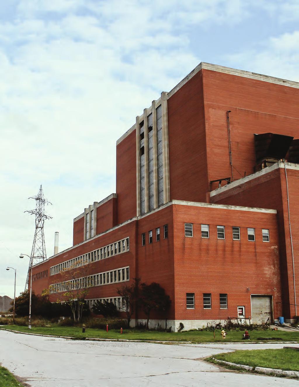
12 A notable element of the street network is the prevalence of mature street trees along key corridors, unusual for an industrial district. The historic rows of street trees are important aspects to be considered through the reconfiguration of existing streets and introduction of dedicated transit. Where it is not possible to retain these, streets will be designed to both capture and enhance the character these mature trees instill in the area. Another key feature in the Port Lands is the network of railway tracks that provided rail access and service for industries in the Port Lands. The rail access along the centre median of Villiers Street to the Lake Ontario Portland Cement Company Silos, and within the Film Studio District along Basin Street highlight how both ship and rail were integral aspects to the industrial district. Other railway tracks have been abandoned or are no longer in use. The Harbour Lead Line continues to provide rail access into the Port Lands along Lake Shore Boulevard, Leslie Street and Unwin Avenue. Used infrequently by Toronto Water and Ports Toronto, the line is anticipated to be maintained. Should rail access no longer be required, inventive approaches to revive this rail line for public use should be further explored, while also recognizing that it is an important wildlife corridor. Monolithic Buildings and Power By the early 1950s, the majority of the lands created for the industrial district were being utilized for storage purposes. However, a renewed interest in the Port Lands began with solitary monolithic buildings being constructed to serve the broader city allowing for a renewed function for the Port Lands. Power generation and distribution became an important function associated with the Port Lands during this time. The Hearn Generating Station, one of the largest structures in Canada, with its impressive Art Moderne facade on its western front and 213 metre high chimney stack, stands proud south of the Ship Channel as a symbol of the Port Lands and is immediately recognizable. One of the first major generating stations constructed by the Ontario government, it initially provided much of Toronto s power The Commissioners Incinerator The Hearn Port Lands Planning Framework 166
 and ultimately shuttered in the 1980s, the building s mass is unparalleled, capable of housing two Tate Modern Museums.")

13 SECTION 4 DIRECTIONS AND RECOMMENDATIONS CULTURAL HERITAGE RESOURCES from coal and then was later converted to natural gas. Built in two phases (1953 and an eastward expansion in the early 1960s) and ultimately shuttered in the 1980s, the building s mass is unparalleled, capable of housing two Tate Modern Museums. It is a prominent landmark viewed from multiple vantage points and backdrop for many movies filmed in Toronto. The Hearn and its four outbuildings flanking the Ship Channel have many adaptive reuse opportunities. The Province of Ontario recently completed a heritage evaluation of the property. The evaluation concluded that the Hearn is a rare example of a mid-century, pre-nuclear generating station and plays a significant role in defining the industrial character of the Port Lands. It serves as a landmark due to its prominent presence on the waterfront, recognizable brick mass and highly visible chimney. Predating the Hearn, was the construction of a small generating station at 450 Commissioners Street. This is the smallest remaining heritage building in the Port Lands and a stark contrast to the massive Hearn building. The transmission towers and the original switching station associated with the Hearn (now largely decommissioned) distributed power throughout the city and region. The remnants of this original infrastructure coupled with the Hearn reinforce the importance of power to the Port Lands history and evolution. One of the Hearn s Four Outbuildings Toronto Hydro Electric building at 450 Commissioners The Commissioners Incinerator, while a fraction of the size of the Hearn at 6,500 square metres (70,000 square feet), is in its own right a symbol of the Port Lands. Constructed in the early 1950s to service the broader city, with its stone detailing, varied fenestration and stepped ramps that mark the entrances to the tipping floor, it is an impressive piece of civic architecture. It fills the block between Logan Avenue and Bouchette Street and has its own dominating chimney of 137 metres which itself is a prominent visual landmark of the Port Lands. Currently used by Solid Waste Management Services as a transfer station, the transfer station function is proposed to be relocated. The impressive civic building is envisioned to be reprogrammed and McCleary Park expanded to create a new, centrally-located community hub with a wide variety of programming in the Port Lands. 167 Port Lands Planning Framework

.")
.")

14 These impressive buildings must remain prominent elements of the Port Lands landscape, adaptively reused for the benefit of all Torontonians. Regeneration and renewal will need to recognize and reinforce the special character these monolithic buildings have in the Port Lands geography. Silos and Chimney Stacks The historic silos and chimney stacks continue to stand as symbolic landmarks of the Port Lands expansion as a port and industrial district of the city. Prominent waterfront landmarks, the silos are among the few structures of this type that survive on Toronto s waterfront and mark the eastern edge of the harbor (Stinson, 1986). The Lake Ontario Portland Cement Company silos, constructed in the 1960s, provide a powerful view terminus at the end of the long western vista down Villiers Street. The Port Lands chimney stacks are other prominent emblems of the Port Lands industrial heritage. Chimneys stood for progress and prosperity (Stinson, 1986). While the chimney stacks that remain at the Incinerator and the Hearn are not the buildings original stacks, they are nonetheless impressive at 137 metres and 213 metres in height. The Hearn stack, constructed in the early 1970s using compact slipform construction similar to the CN The Port Lands Chimney Stacks The Hearn s 213 m High Chimney Stack Canada Cement Company Silos (now owned and operated by Lafarge) Lake Ontario Portland Cement Company silos constructed in the 1960s Port Lands Planning Framework 168


15 SECTION 4 Tower DIRECTIONS AND RECOMMENDATIONS CULTURAL HERITAGE RESOURCES continues to be one of the tallest structures in Canada. It is capable of being seen from New York State. It also provides a remarkable existing view terminus along Carlaw Avenue north of Lake Shore Boulevard East. Renewed Hope and Investment The opening of the St. Lawrence Seaway in 1959 brought with it renewed hope for Toronto s burgeoning port and shipping industry. Completed in 1962, Marine Terminal 35 is a surviving example of purpose built accommodation that handled the container cargo brought by oceangoing vessels following the opening of the St. Lawrence Seaway. The Toronto Harbour Commissioners, known for their attempts to keep pace with developments in cargo handling (Stinson, 1986), introduced a new type of marine terminal emerging at the time that utilized fork lifts for the unloading and transferring of cargo from the transit shed to truck/rail. The location, scale, continuous roof canopy and material prominence of the administrative portion of the transit shed are apparent features of the building. Within the transit shed building itself, the structural system of steel columns and plate girders has a distinctive and unique pattern and reinforces the modern expression of the building. The small fork lift building and Atlas Crane located on the site are also important aspects of the original functionality planned for the site and terminal. The building recently caught fire and only a portion of it remains. It is also located within the footprint of the Marine Terminal 35 Atlas Crane 169 Port Lands Planning Framework
16 Figure 46: Heritage Buildings/Structures Listed Heritage Structures/Buildings King St. E. Designated Heritage Structures/Buildings DVP Lake. 8 s St. Co r sione mmis Che 12 e n Av nwi rry S U t Port Lands Planning Framework 170 St. 5 4 way 3 Road Leslie w Ave Quay E. 2 e Shor eva Boul Carla Don Queens rd E. e. Av Cherry St. iew dv oa Br Potential Heritage Structures/Buildings 1 Marine Terminal 35 2 Century Coal Company Building 3 Bank of Montreal 4 William McGill and Company Building 5 Toronto Hydro Substation 6 Dominion Bank Branch 7 Toronto Harbour Commissioners Buildings 8 Queen s City Foundry 9 Fire Hall No Canada Cement 11 Dominion Boxboards Building 12 Strauss Trunion Bascule Bridge 13 Sun Oil Company Building 14 Commissioners Incinerator Commissioners Street 16 Hearn Generating Station Unwin Avenue 18 Cherry Beach Life Saving Station
17
18 future Promontory Park. Any proposed interventions or alternations to the portions of the Terminal building that remain, and to the site itself, will need to ensure that the remaining integrity and cultural heritage value of the property is appropriately retained, conserved and, where appropriate, interpreted in a meaningful way. South of the Ship Channel, a midcentury industrial complex is located on the south side of Unwin Avenue at Cherry Street. Constructed in the 1950s, the complex consists of two buildings generously set back from Unwin Avenue. With the Hearn, they were the only buildings constructed south of Ship Channel. The buildings have strong massing and rectangular footprints and feature common bond brickwork. Further research into the historical significance of this complex, and its values and attributes, will need to be undertaken to understand its historical significance in the evolving Port Lands landscape. Adaptive Re-use Concepts for Marine Terminal 35 Activated terminal edge retains berm Roof opens to sky to let landscape in Covered landscape engages all-seasons Open structure invites new habitat Preservation of Terminal Building Combined with Park Landscape Selective-Editing of Terminal Structure Combined with Park Landscape Port Lands Planning Framework 172


19 SECTION 4 DIRECTIONS AND RECOMMENDATIONS CULTURAL HERITAGE RESOURCES Ashbridge s Marsh looking northeast, circa 1909 Ashbridge s Bay looking south-east Port Lands Planning Framework
20 4.3.3 Geologic and Archaeological Heritage Geologic Heritage Toronto was a city founded next to a marsh. In its natural state, the Port Lands was an area of shifting channels, small islands, sandbars and marshland (ACMS, 2008). During the late 1800s and early 1900s, unchecked industrial and municipal discharges into the Don River and Ashbridges Bay Marsh contributed to the Marsh s general decay and perception as a wasteland - a source of pestilence and disease, with its ultimate demise in the pursuit of continued industrialization of the city and under the guise of land reclamation. The Don River was channelized in the 1890s, followed by the creation of the Keating Channel created in the late 1890s. The development of the Ashbridges Bay Treatment Plant occurred in the early 1900s and the eventual filling in of the Marsh was completed through the implementation of the 1912 Toronto Harbour Commissioner s Plan beginning in The renaturalization of the mouth of the Don holds such tremendous power for returning a portion of the Port Lands geography to how it originated and to reinvigorate the area s geologic and pre-contact heritage in a new chapter of evolution. The renaturalization will revive an environment long since lost and foster a renewed relationship with water and nature. Archaeological Heritage In 2008, Waterfront Toronto, in partnership with the City of Toronto, completed an Archaeological Conservation and Management Strategy (ACMS) for the Central Waterfront. The ACMS provided additional analysis for areas with archaeological potential and determined the archaeological significance of potential resources. The ACMS identifies resources as Grade 1, 2 3 or 4. Grade 1 resources are those that would require additional field work. Grade 2 resources are historically important features for which limited archaeological fieldwork, typically monitoring, is recommended. Grade 3 resources have little historical significance and no mitigation or monitoring is required. Grade 4 resources consist of lake-filled areas in the waterfront where there is little archaeological interest, but would assist in gaining a better understanding of development occurring in Toronto in the nineteenth century. Within the Port Lands a number of Grade 2 and 3 resources have been identified, requiring, where appropriate monitoring during construction, and interpretation and commemoration. Since the area includes remnants of landfroms around the former Ashbridges Bay Marsh, it is possible that deeply buried remains or artifacts left by one or more First Nations groups are present,dating from before European settlement. Port Lands Planning Framework 174

21 SECTION 4 An DIRECTIONS AND RECOMMENDATIONS CULTURAL HERITAGE RESOURCES important aspect of developing this Plan, was consulting with First Nations groups. Many ideas and interpretive opportunities were provided and suggested to ensure that history and activities of First Nations groups are considered in the planning for the area. These ideas and suggestions included: Increase public awareness of the history and current activity of First Nations groups such as through integrating the Mississauga s of New Credit First Nations Moccasin Identifier project in landscape or trail projects or naming new streets/public spaces using traditional names; Consider the traditional use of the lands for hunting and gathering and include consideration for native plantings or practices such as rice gardens; Think more naturally and enhance ecology and environmental stewardship through habitat creation and restoration of the natural environment; and Recognize the significance and importance of water. Water was the highway. Bring people to water through cantilevered walkways or trails and paths. Artistic rendering of Ontario Place ravine with Moccasin Identifier 175 Port Lands Planning Framework
22 Figure 47: Archaeology LDP Don Breakwater King St. E. LDP Government Breakwater DVP Br oa LDP Toronto Dry Dock iew dv e. Av Cherry St. LDP-4 Sand Bar and Fisherman s Island Peninsula Sh way LDP-10 LDP-5 LDP-6 Fisherman s Island Cottages/ Boat Houses St. LDP-9 LDP-5 Simcoe Beach Park, Cottages/ Boat Houses Leslie. LDP-12 Road LDP-7 Don E. w Ave LDP-3 LDP-1 Quay Queens Lake Carla LDP-11 d E. evar oul ore B LDP-7 National Iron Works oners issi Comm St. LDP-8 British Forgings LDP-9 Toronto Ship Building Company LDP-8 LDP-10 Foundry Specialities Ltd. LDP-11 Toronto Iron Works LDP-12 British American Oil LDP-2 LDP-4 Source: Waterfront Toronto Archaeological Conservation And Management Plan t. rry S Che e n Av i Unw LDP-6 Port Lands Planning Framework 176
23
24 4.3.4 Recommendations A key objective of the vision for the Port Lands is to celebrate and conserve the unique history of the Port Lands to create new experiences that build on the past and bolster character. The recommendations identified below build on directions in the Central Waterfront Secondary Plan, but provide enhanced policies unique to the Port Lands context consistent with recently adopted heritage policies to the City s Official Plan and recognized City practices and procedures. Additionally, the recommendations provide guidance for additional exploration and more detailed studies required as detailed design and redevelopment occurs in the Port Lands and where continued consultation as regeneration and renewal activities unfold. Heritage resources will be appropriately conserved as vital to the cultural heritage landscape of the Port Lands, Toronto waterfront and symbols of the waterfront s industrial heritage: Properties on the Heritage Register will be conserved and maintained consistent with the Standards and Guidelines for the Conservation of Historic Places in Canada, as revised from time to time and as adopted by Council; Proposed alterations, development, and/or public works on or adjacent to, a property on the Heritage Register will ensure that the integrity of the heritage property s cultural heritage value and attributes will be retained, prior to work commencing on the property and to the satisfaction of the City; and When a City-owned property on the Heritage Register is sold, leased or transferred to another owner, it will be designated under the Ontario Heritage Act. A Heritage Easement Agreement will be secured and monitored, and public access maintained to its heritage attributes, where feasible. Buildings, structures and/or landscapes with cultural heritage value or interest are identified on Figures 45 and 46 and will be appropriately conserved and celebrated as important features of the Port Lands. This will include, but not be limited to: Evaluating the cultural heritage values, attributes and character of a site, resource or landscape not currently listed on the City s Heritage Register or designated under the Ontario Heritage Act in accordance with relevant legislation and City policies and practices to establish the values and attributes of the resources and, if appropriate, conserving the site and/or resource; Official Plan Policy Direction Future Follow-on Work Continued Consultation Port Lands Planning Framework 178
25 SECTION 4 DIRECTIONS AND RECOMMENDATIONS CULTURAL HERITAGE RESOURCES Ensuring transitions of new development adjacent to or in proximity to a resource through setbacks of buildings to heritage resources, generous stepbacks of tall building elements where tall buildings are permitted, and stepping down and tapering the heights of new buildings in order to protect and mitigate negative impacts to heritage properties and/or corridors and to reinforce and distinguish the historic character, setting and scale of the resources; Where it is supported by the cultural heritage values and attributes of a property on the Heritage Register and/or identified on Figure 45, conserving whole or substantial portions of buildings, structures and landscapes on those properties is desirable and encouraged. The retention of facades alone is discouraged; Reinforcing views and viewsheds of heritage resources and their attributes, that includes, among others, the silos and chimney stacks as prominent landmarks and termini of long views, through the thoughtful placement, orientation and control of buildings and building heights. Completing view studies during precinct planning and the development application review process to demonstrate how the proposed siting and scale of proposed buildings: a) Maintain views to important heritage resources; b) Enable heritage resources to be prominent elements within the overall skyline of the Port Lands as viewed from the promenade of the Central Waterfront between Yonge Street and Sherbourne Common; and c) Ensure the existing scale, character and attributes of the heritage resources and landmarks are not negatively impacted by development within the view corridors. Giving silos, chimney stacks and other heritage resources address or frontage on/in major public open spaces and streets; and Ensuring that the character of the Cherry Street Cultural Corridor and the Keating Channel Public Promenade in Villiers Island is respected and complemented by maintaining the low-rise character in any proposed development on the east side of existing Cherry Street and lining the Keating Channel Public Promenade. Heritage Evaluation Reports to the City s satisfaction will be prepared prior to redevelopment or alteration of places and/or landscapes of cultural heritage value identified on Figures 45 and 46 not currently listed on the City s Heritage Registrar or designated under the Ontario Heritage Act. The boundaries of the cultural heritage landscapes on Figure 45 are general and solely based on the street network and/or existing property limits. They are not to be interpreted as the boundaries associated with the values and attributes of the landscapes. Prior to detailed design of the River and Promontory Park for the Marine Terminal 35 site, an assessment of the heritage values and attributes of the site consistent with provincial regulations and City practices will be undertaken by the City, or to the City s satisfaction, to inform an appropriate conservation and mitigation strategy. Official Plan Policy Direction Future Follow-on Work Continued Consultation 179 Port Lands Planning Framework
26 Heritage Impact Assessments will be required prior to alteration of heritage buildings, structures and/or landscapes identified on Figures 45 and 46. The Heritage Impact Assessment will evaluate the impact of a proposed alteration (e.g. grade change, addition, alteration, displacement or relocation) to a property on the Heritage Register, potential cultural heritage resource and/or development adjacent to properties on the Registrar or potential cultural heritage resource, to the satisfaction of the City. Heritage buildings and/or structures should be conserved in their original location, including minimization of any grade changes needed to flood protect lands. A heritage building and/or structure may be relocated, where technically possible, to accommodate a major public work project, such as the naturalization of the mouth of the Don River or widening major public streets to accommodate transit in dedicated rights-of-way, subject to a completed Environmental Assessment process and securing appropriate conditions in a Heritage Easement Agreement prior to relocation. The 2008 Waterfront Toronto Archaeological Conservation and Management Strategy (ACMS) will serve as the basis for future planning decisions with respect to the archaeological assessment process, including: Documentation during construction monitoring for identified Grade 2 resources in the ACMS; and Interpretation and commemoration of all archaeological resources identified, and in consultation with any First Nations/Aboriginal community that may be interested in identifying opportunities to commemorate the historical relationship that First Nations/Aboriginal communities have with the waterfront and the Port Lands. In the event that First Nations/Aboriginal archaeological sites are encountered, consultation with First Nations communities will take place during the archaeological assessment process when site parameters and significance are determined. Explore whether there would be potential to make use of the Harbour Lead Line and Unwin rail corridor as a public transit corridor in connection with legal obligations for maintaining continued rail access and ensuring the corridor can be maintained as a key wildlife corridor in and out of the Port Lands. Undertake an adaptive re-use study for the Commissioners Incinerator Building to create a community hub with community infrastructure and creative sector incubator uses subject to confirmation that the waste transfer station function will be relocated elsewhere in the Port Lands. Consult with First Nations and Aboriginal groups during detailed design for interpretative and commemorative integration in landscape, open space and streetscape design. Official Plan Policy Direction Future Follow-on Work Continued Consultation Port Lands Planning Framework 180
Port Lands Planning Initiatives - Final Report
 RE: PG23.6 Port Lands Planning Initiatives - Final Report Planning and Growth Management Committee October 2017 1-2017-10-12 Existing Conditions - Defining Elements Heritage Buildings + Structures Active
PORT LANDS ACCELERATION INITATIVE- PHASE 2 PORT LANDS PLANNING FRAMEWORK
 Re: ED14.9 PORT LANDS ACCELERATION INITATIVE- PHASE 2 PORT LANDS PLANNING FRAMEWORK Toronto Film, Television and Digital Media Board June 10, 2016 2016-06-10-1 THE PORT LANDS TODAY CARLAW AVENUE CHERRY
Chairman and Members of the Planning and Development Committee. Thomas S. Mokrzycki, Commissioner of Planning and Building
 LA.09.TOR (Toronto) DATE: TO: FROM: SUBJECT: Chairman and Members of the Planning and Development Committee Thomas S. Mokrzycki, Commissioner of Planning and Building Central Waterfront Secondary Plan
Table 8-4: Road Classification Local Roads, second table, of Chapter 8 Create a Multi-Modal City, be amended by adding the following:
 1 Port Street East Official Plan Amendment APPENDIX 3 Amendments to Mississauga Official Plan Table 8-4: Road Classification Local Roads, second table, of Chapter 8 Create a Multi-Modal City, be amended
The Master Plan Framework
 The Master Plan Framework The East Harbour Master Plan advances the development of 60 acres of former industrial lands east of the Don River. The Master Plan outlines a vision for a vibrant, transit-oriented
M i s s i o n B a y W a t e r f r o n t
 114 M i s s i o n B a y W a t e r f r o n t Character of the Area: The Mission Bay Waterfront extends from Pier 48 at China Basin Channel to 18th Street in the Central Basin. This area of the waterfront
QUEEN-RIVER SECONDARY PLAN
 34 QUEEN-RIVER SECONDARY PLAN 34. QUEEN RIVER SECONDARY PLAN 1. INTRODUCTION The Queen-River area is approximately 6.4 hectares and is located at the eastern edge of the Downtown as shown on Map 34-1.
Report to: Development Services Committee Report Date: April 24, 2017
 SUBJECT: Cornell Rouge National Urban Park Gateway - Report on Design Charrette and Next Steps PREPARED BY: Lilli Duoba, MES, MCIP, RPP, Manager, Natural Heritage (ext. 7925) REVIEWED BY: Marg Wouters,
Welcome. Community Consultation Meeting November 28, Review and discuss the Bathurst Quay Neighbourhood Plan Framework
 Welcome Community Consultation Meeting November 28, 2016 Why Are We Here Today? Review and discuss the Bathurst Quay Neighbourhood Plan Framework Review and discuss an Action Plan for Implementation Next
Chapter 6 cultural heritage
 6 Cultural Heritage 6.1 Protecting Vaughan s Cultural Heritage 165 6.1.1 Protecting Vaughan s Cultural Heritage 165 6.1.2 Maintaining a Heritage Inventory 166 6.1.3 Promoting Vaughan s Cultural Heritage
APPENDIX K WINDSOR OFFICIAL PLAN
 CEAA ENVIRONMENTAL ENVIRONMENTAL IMPACT ASSESSMENT AMBASSADOR BRIDGE ENHANCEMENT PROJECT Replacement Span and Plaza Expansion APPENDIX K WINDSOR OFFICIAL PLAN Avalon Consulting Professionals of Ontario,
SECTION ONE: INTRODUCTION. introduction
 introduction 1 INTRODUCTION Since it was first established in 1843 as a trading post for the Hudson s Bay Company, Victoria has evolved into a Provincial capital city that is recognized across Canada and
GUIDELINES EXHIBITION PLACE LOCATION: OBJECTIVES. Structure Plan URBAN DESIGN GUIDELINES
 Development in the Exhibition Place lands will be consistent with the following urban design guidelines. They provide a framework for new development of the lands and are to be read in conjunction with
PORT UNION VILLAGE COMMUNITY SECONDARY PLAN
 4 PORT UNION VILLAGE COMMUNITY SECONDARY PLAN 4. PORT UNION VILLAGE COMMUNITY SECONDARY PLAN The following policies and principles apply to the area herein referred to as Port Union Village, as outlined
GARDINER EXPRESSWAY AND LAKE SHORE BOULEVARD EAST RECONFIGURATION ENVIRONMENTAL ASSESSMENT Planning, Urban Design, Public Realm and Socio- Economic
 GARDINER EXPRESSWAY AND LAKE SHORE BOULEVARD EAST RECONFIGURATION ENVIRONMENTAL ASSESSMENT Socio- Economic Background Conditions Report - 2014 Socio-Economic Background Conditions Report 2014 TABLE OF
DOWNTOWN PARKS & PUBLIC REALM PLAN
 DOWNTOWN PARKS & PUBLIC REALM PLAN CHALLENGES The Parks and Public Realm Strategy addresses challenges associated with a growing Downtown, including: GOALS 3.3 New buildings will fit within their existing
URBAN DESIGN BRIEF URBAN DESIGN BRIEF 721 FRANKLIN BLVD, CAMBRIDGE August 2018
 URBAN DESIGN BRIEF URBAN DESIGN BRIEF 721 FRANKLIN BLVD, CAMBRIDGE August 2018 DESIGN BRIEF CONTENTS PART A 1.0 INTRODUCTION 2.0 DESCRIPTION & ANALYSIS OF SITE CONTEXT 3.0 DESIGN CONSTRAINTS AND OPPORTUNITIES
The West Vaughan Employment Area Secondary Plan Policies
 Part 2: The West Vaughan Employment Area Secondary Plan Policies 2.1 General Policies It is the policy of Council: 2.1.1. That the West Vaughan Employment Area (the WVEA), identified on Schedule 1, will
1 Introduction. Chapter. In this chapter:
 Chapter 1 Introduction In this chapter: 1.1 A Snapshot of the Region 1.2 Towards a Sustainable Region 1.3 The Provincial Context 1.4 Purpose and Organization The Regional Municipality of York Official
Urban Design Manual PLANNING AROUND RAPID TRANSIT STATIONS (PARTS) Introduction. Station Study Areas
 Introduction. Station Study Areas") 111111 PLANNING AROUND RAPID TRANSIT STATIONS (PARTS) Introduction The ION rapid transit system will link Waterloo, Kitchener and Cambridge through a central transit corridor (CTC). There are a number
111111 PLANNING AROUND RAPID TRANSIT STATIONS (PARTS) Introduction The ION rapid transit system will link Waterloo, Kitchener and Cambridge through a central transit corridor (CTC). There are a number
Mark-up of the effect of the proposed Bronte Village Growth Area OPA No.18 on the text of section 24, Bronte Village, of the Livable Oakville Plan
 Mark-up of the effect of the proposed Bronte Village Growth Area OPA No.18 on the text of section 24, Bronte Village, of the Livable Oakville Plan Notes: This document is provided for information purposes
Official Plan Review: Draft Built Form Policies
 PG.30.1 REPORT FOR ACTION Official Plan Review: Draft Built Form Policies Date: May 15, 2018 To: Planning and Growth Management Committee From: Chief Planner and Executive Director, City Planning Division
Bloor Street East Potential Ravine Portal Overlook and Access Passage to the Rosedale Valley and Don River Valley Ravine, Toronto, Canada
 TRANSFORMATIVE IDEA 2. GREAT STREETS Bloor Street Christie Pits Park Bloor St Spadina Ave Bathurst St Shaw St 1 Recognize the significant public realm improvements along Bloor Street and extend and enhance
CREATE A VIBRANT MIXED-USE COMMUNITY
 CREATE A VIBRANT MIXED-USE COMMUNITY Land Use Public Realm Plan Built Form Heritage Tell us what you think! Place a sticky note here or leave us a comment form LAND USE The land use framework of this Secondary
Derry Green Corporate Business Park
 Town of Milton Derry Green Corporate Business Park Urban Design Guidelines BMI/Pace - June 2010 Draft 3 Prepared by: Brook McIlroy Planning + Urban Design / Pace Architects Suite 300-51 Camden Street Toronto,
Midtown Greenway Land Use and Development Plan Executive Summary
 Midtown Greenway Land Use and Development Plan Executive Summary Introduction The Midtown Greenway Land Use and Development Plan sets policy direction for land use and development in the Midtown Greenway
1.0 PLANNING MARKHAM S FUTURE CONTENTS
 1-1 Planning Markham s Future 1.0 PLANNING MARKHAM S FUTURE CONTENTS 1.1 THE PURPOSE OF THE OFFICIAL PLAN 1.2 THE MARKHAM CONTEXT 1.3 THE REGULATORY CONTEXT 1.3.1 Province of Ontario 1.3.2 York Region
13 THORNHILL YONGE STREET STUDY IMPLEMENTATION CITY OF VAUGHAN OPA 669 AND TOWN OF MARKHAM OPA 154
 13 THORNHILL YONGE STREET STUDY IMPLEMENTATION CITY OF VAUGHAN OPA 669 AND TOWN OF MARKHAM OPA 154 The Planning and Economic Development Committee recommends the adoption of the recommendations contained
Downtown Streetscape Manual & Built Form Standards
 City of Guelph Downtown Streetscape Manual & Built Form Standards July 2014 Prepared by Brook McIlroy Inc. in association with Unterman McPhail Associates and McCormick Rankin Inc. City of Guelph Downtown
Page 1 of 19 URBAN DESIGN FRAMEWORK FOR BOLTON STREET WATERFORD
 Page 1 of 19 URBAN DESIGN FRAMEWORK FOR BOLTON STREET WATERFORD 1.0 Introduction: The relocation of the City Council stores and depot from Bolton Street creates an exciting opportunity for development
6 PORT SYDNEY SETTLEMENT AREA
 Section 6 Port Sydney Page 61 6 PORT SYDNEY SETTLEMENT AREA 6.1 Basis and Principles Village of Port Sydney Waterfront Community Existing Services 6.1.1 Port Sydney is an historic settlement that has developed
DAVENPORT VILLAGE SECONDARY PLAN
 27 DAVENPORT VILLAGE SECONDARY PLAN 27. DAVENPORT VILLAGE SECONDARY PLAN 1. VISION FOR THE DAVENPORT VILLAGE SECONDARY PLAN Davenport Village, municipally known as 830, 940, 980 and 1100 Lansdowne Avenue,
Part D. College Avenue Campus PAGE 121 UNIVERSITY OF REGINA / CAMPUS MASTER PLAN 2011
 Part D College Avenue Campus UNIVERSITY OF REGINA / CAMPUS MASTER PLAN 2011 PAGE 121 PAGE 122 PREPARED BY / DIALOG Figure D-1. A view of the College Building at the College Avenue Campus in winter 11.0
New-Cast Mixed-use Development Proposal King Street West, Newcastle, Ontario
 URBAN DESIGN BRIEF New-Cast Mixed-use Development Proposal King Street West, Newcastle, Ontario TABLE OF CONTENTS: 1.0 Executive Summary 2.0 Creating Vibrant and Sustainable Urban Places: Excerpts from
Chapter IV: Development Pattern
 Chapter IV: Development Pattern Introduction The 2002 Prince George s County Approved General Plan designates three growth policy tiers Developed, Developing, and Rural as well as three center designations
Authorization to Study the Distillery District as a potential Heritage Conservation District
 STAFF REPORT ACTION REQUIRED Authorization to Study the Distillery District as a potential Heritage Conservation District Date: March 24, 2014 To: From: Wards: Reference Number: Toronto Preservation Board
St. Lawrence Neighbourhood Focused Area - Official Plan Amendment Status Report
 STAFF REPORT ACTION REQUIRED St. Lawrence Neighbourhood Focused Area - Official Plan Amendment Status Report Date: May 21, 2015 To: From: Wards: Reference Number: Toronto and East York Community Council
L 4-1. Heritage Report: Reasons for Heritage Designation. Kodors House. 35 Rosedale Avenue West
 L 4-1 Brampton Heritage Board Date: January 17, 2012 Heritage Report: Reasons for Heritage Designation Kodors House 35 Rosedale Avenue West December 2011 1 L 4-2 Profile of Subject Property Municipal Address
Director, Community Planning, Toronto and East York District
 Lower Yonge Precinct Plan Update STAFF REPORT ACTION REQUIRED Date: October 16, 2012 To: From: Wards: Reference Number: Toronto and East York Community Council Director, Community Planning, Toronto and
Highest & Best Use Study Marina Park Lands
 Executive Summary of Report MARCH 2006 TABLE OF CONTENTS 1. Introduction...1 2. Study Process...2 3. Highest And Best Use Program...3 4. Concept Plan...8 5. Public Area Animation...9 6. Marina Park Implementation
Bird s eye of the Port Lands looking west from Leslie Street. Attachment 1: Section 4-12
 Bird s eye of the Port Lands looking west from Leslie Street Attachment 1: Section 4-12 4.12 EARLY ACTIVATION PROJECTS Regeneration and renewal in the Port Lands is a multi-decadelong proposition. The
Hockessin Community Redevelopment Plan
 Hockessin Community Redevelopment Plan 3.1 Introduction The Community Redevelopment Plan for the Village of Hockessin is the result of the people s vision for a distinct village center that serves as the
DRAFT Northeast Quadrant of Kipling Avenue and Highway 7 DRAFT AUGUST 29, Goals Land Use. The goals of this Plan are to:
 AUGUST 29, 2017 12.15 Northeast Quadrant of Kipling Avenue and Highway 7 12.15.1 Goals 12.15.2 Land Use The goals of this Plan are to: 12.15.2.1 General Provisions: a) Ensure the development of a compact
ELMVALE ACRES SHOPPING CENTRE MASTER PLAN
 ELMVALE ACRES SHOPPING CENTRE MASTER PLAN Contents 1.0 INTRODUCTION... 2 2.0 LOCATION... 2 3.0 EXISTING CONTEXT... 2 4.0 VISION & GUIDING PRINCIPLES... 2 5.0 LAND USE AND BUILT FORM... 4 5.1 St. Laurent
KING-SPADINA SECONDARY PLAN
 16 KING-SPADINA SECONDARY PLAN 16. KING-SPADINA SECONDARY PLAN 1. INERPREAION 1.1 he lands affected by this Secondary Plan for the King-Spadina Area are shown on Map 16-1. 1.2 Where a building within a
01 Welcome! About Ontario Shores
 01 Welcome! Thank you for participating in the Master Planning Open House. Ontario Shores Centre for Mental Health Sciences is in the process of preparing a Master Program and Master Plan for submission
Welcome. Walk Around. Talk to Us. Write Down Your Comments
 Welcome This is an information meeting introducing the applications for proposed redevelopment of the Yorkdale Shopping Centre site at 3401 Dufferin Street and 1 Yorkdale Road over the next 20+ years,
Policies and Code Intent Sections Related to Town Center
 Policies and Code Intent Sections Related to Town Center The Town Center Vision is scattered throughout the Comprehensive Plan, development code and the 1994 Town Center Plan. What follows are sections
CONTENTS 6.1 URBAN DESIGN
 6-2 Urban Design and Sustainable Development 6.0 URBAN DESIGN AND SUSTAINABLE DEVELOPMENT CONTENTS 6.1 URBAN DESIGN 6.1.1 General Policies 6.1.2 The Public Realm 6.1.3 Streets and Blocks 6.1.4 Streetscapes
CHAPTER 5: GUIDING PRINCIPLES
 CHAPTER 5: GUIDING PRINCIPLES The following 10 principles were developed based on public consultation, planning policy and the background analysis conducted during Phase 1. The Guiding Principles significantly
3.1 Existing Land Use
 3.0 Land Use This strategy has been developed taking into account the position of the Town of Sidney as the economic center of the Saanich Peninsula. It acknowledges existing land use patterns in the downtown
Workshop 3. City of Burlington Waterfront Hotel Planning Study. September 14, The Planning Partnership
 Workshop 3 City of Burlington Waterfront Hotel Planning Study September 14, 2017 The Planning Partnership The Waterfront Hotel Planning Study 01 The Brant & Lakeshore Planning Study will establish a Strategic
CITY CLERK. Parkland Acquisition Strategic Directions Report (All Wards)
") CITY CLERK Clause embodied in Report No. 10 of the, as adopted by the Council of the City of Toronto at its meeting held on November 6, 7 and 8, 2001. 10 Parkland Acquisition Strategic Directions Report
CITY CLERK Clause embodied in Report No. 10 of the, as adopted by the Council of the City of Toronto at its meeting held on November 6, 7 and 8, 2001. 10 Parkland Acquisition Strategic Directions Report
3.3. Urban Structure Defining a New Hierarchy of Routes and Spaces >Images
 Section 3.0 I The Masterplan Framework 18 >Images Examples of high quality routes and spaces 3.3. Urban Structure The success of any masterplan lies in a clear definition of the future urban structure
UTSC SECONDARY PLAN COMMUNITY OPEN HOUSE
 WELCOME TO THE UTSC SECONDARY PLAN COMMUNITY OPEN HOUSE 1 Welcome to the first Community Open House for the UTSC Secondary Plan. Hosted by the University of Toronto Scarborough (UTSC), the following panels
PORT OF VANCOUVER WATERFRONT DEVELOPMENT. Concept Development Plan City Center Redevelopment Authority April 20, 2017
 PORT OF VANCOUVER WATERFRONT DEVELOPMENT Concept Development Plan City Center Redevelopment Authority April 20, 2017 Port History PORT ESTABLISHED 1912 TERMINAL 1 ACQUIRED 1925 GWM SIGNS LEASE 1935 HARBOR
RAILWAY LANDS EAST SECONDARY PLAN
 17 RAILWAY LANDS EAST SECONDARY PLAN 17. RAILWAY LANDS EAST SECONDARY PLAN 1. INTERPRETATION 1.1 The lands affected by the Railway Lands East Secondary Plan are shown on Map 17-1. 1.2 The boundaries of
[PLANNING RATIONALE] For Site Plan Control and Lifting of Holding Zone By-Law 101 Champagne Avenue. May 23, 2014
![[PLANNING RATIONALE] For Site Plan Control and Lifting of Holding Zone By-Law 101 Champagne Avenue. May 23, 2014](/thumbs/75/71599615.jpg "[PLANNING RATIONALE] For Site Plan Control and Lifting of Holding Zone By-Law 101 Champagne Avenue. May 23, 2014") [PLANNING RATIONALE] For Site Plan Control and Lifting of Holding Zone By-Law 101 Champagne Avenue May 23, 2014 Contents 1.0 Introduction... 2 2.0 Site Context... 2 2.1 Adjacent Uses... 2 Figure 1: Site
[PLANNING RATIONALE] For Site Plan Control and Lifting of Holding Zone By-Law 101 Champagne Avenue May 23, 2014 Contents 1.0 Introduction... 2 2.0 Site Context... 2 2.1 Adjacent Uses... 2 Figure 1: Site
Public Meeting #3 May 9, 2009 MVVA Team
 Public Meeting #3 May 9, 2009 MVVA Team Welcome to the third Public Meeting for the Lower Don Lands Municipal Class Environmental Assessment (EA) Infrastructure Master Plan and Keating Channel Precinct
City Center Neighborhood Plan
 [1] City Center Neighborhood Plan As adopted by Ordinance No. 2014-09-049 and amended by Ordinance Nos. Formerly CBD Neighborhood as adopted by Ordinance No. 8868 and amended by Ordinance Nos. 8946, 9693,
Edward R. Sajecki Commissioner of Planning and Building
 Corporate Report Clerk s Files Originator s Files CD.03.POR DATE: TO: FROM: SUBJECT: Chair and Members of Planning and Development Committee Meeting Date: February 27, 2012 Edward R. Sajecki Commissioner
Ashbridges Bay Erosion and Sediment Control Project
 Ashbridges Bay Erosion and Sediment Control Project Project Brief Overview Toronto and Region Conservation Authority, in partnership with the City of Toronto, intends to carry out remedial erosion control
Purpose of Open House #3
 Public Meeting #3 May 9, 2009 MVVA Team Purpose of Open House #3 The main purpose of this Open House is to present and seek input on the: Evaluation of transportation and infrastructure design alternatives
2.0 Urban Design Concepts
 0 Urban Design Concepts Urban Design Concept diagrams The Waterfront Axis The Park Axis The Wharf Axis Waterfront Precincts 0.1 The Four Key Concepts: This Concept for the Wynyard Quarter establishes four
Port Dalhousie Secondary Plan & Heritage Conservation District Study Public Meeting October 25, 2017
 Port Dalhousie Secondary Plan & Heritage Conservation District Study Public Meeting October 25, 2017 Macaulay Shiomi Howson Ltd. Brook McIlroy Inc. Catherine Nasmith Architect BA Consulting Group Ltd Meeting
Town Center (part of the Comprehensive Plan)
") Town Center (part of the Comprehensive Plan) Mercer Island Town Center Looking North (2014) In 1994, a year-long process culminated in a set of design guidelines and code requirements for the Town Center
Town Center (part of the Comprehensive Plan) Mercer Island Town Center Looking North (2014) In 1994, a year-long process culminated in a set of design guidelines and code requirements for the Town Center
1. PLANNING CONCEPTS. Central Petaluma Specific Plan Chapter 1. Planning Concepts Page 7
 Page 7 1. PLANNING CONCEPTS Overview of Planning Concepts The plan for Central Petaluma envisions a reinvigorated central district that accommodates a greater diversity and intensity of activities, including
Clairtrell Area Context Plan
 Clairtrell Area Context Plan March 2005 Urban Development Services City Planning Contents 1. Introduction... 4 2. Development Structure... 6 2.1 Streets... 7 2.1.1 Sheppard Avenue and Bayview Avenue...
10.0 Open Space and Public Realm
 10.0 Open Space and Public Realm 10.0 Open Space and Public Realm The Public Open Space System is comprised of: outdoor spaces available for public use that are either publicly owned (e.g., parks and
Demolition of a Designated Heritage Property Roncesvalles Avenue
 REPORT FOR ACTION Demolition of a Designated Heritage Property - 421 Roncesvalles Avenue Date: March 8, 2018 To: Toronto Preservation Board Toronto and East York Community Council From: Acting Chief Planner
SUBJECT: Waterfront Hotel Planning Study Update TO: Planning and Development Committee FROM: Department of City Building. Recommendation: Purpose:
 Page 1 of Report PB-23-18 SUBJECT: Waterfront Hotel Planning Study Update TO: Planning and Development Committee FROM: Department of City Building Report Number: PB-23-18 Wards Affected: 2 File Numbers:
Figure 1- Site Plan Concept
 Figure 1- Site Plan Concept Parking will be provided underground on three levels at rate of 1.0 space/ unit; this rate includes all visitors parking. MMM Group has prepared a parking assessment (April,
Buildings may be set back to create small plazas provided that these setbacks do not substantially disrupt the street wall s continuity.
 6-22 Community Design Street Walls and Street-front Setbacks The siting of buildings will play a critical role in establishing the character and sense of place for the District. Siting buildings at the
City of Long Beach. creating vibrant and exciting places
 City of Long Beach creating vibrant and exciting places Land Use Element Urban Design Element Overview of the two draft General Plan elements Discuss areas of change Economic goals of the plans Case study
EXECUTIVE SUMMARY EXECUTIVE SUMMARY
 1 EXECUTIVE SUMMARY EXECUTIVE SUMMARY Penn s Landing is envisioned as a welcoming riverfront green space adjacent to a refurbished civic marina becoming the centerpiece for adjacent development. With a
2040 LUP is a part of the Comprehensive Plan and carries the same legal authority. Economic Challenges
 1.1. Guiding Anchorage s Growth Where will new residents settle over the next two decades? Where will people work, shop, and play? Will there be enough room to grow? How will Anchorage look? Will growth
11.5 Kipling Avenue Corridor Secondary Plan
 11.5 Kipling Avenue Corridor Secondary Plan ADOPTED BY VAUGHAN CITY COUNCIL NOT YET APPROVED BY THE ONTARIO MUNICIPAL BOARD 11.5.1 Development Principles and Objectives The following principles support
38 Queen s University Campus Master Plan Part 1
 38 Queen s University Campus Master Plan Part 1 46 The Campus at the City Scale Chapter 4 The Campus at the City Scale 39 Queen s is an urban University centrally located in Kingston. Decisions made by
4- PA - LD - LIVELY DOWNTOWN. LD - Background
 4- PA - LD - LIVELY DOWNTOWN LD - Background The downtown has been the service centre for the community since the city s inception and the area continues to supply people with their personal services,
Urban Design Brief December 23, 2015 Southside Construction Group Official Plan & Zoning By-Law Amendment
 Urban Design Brief Proposed Official Plan & Zoning By-Law Amendment 3244, 3263 and 3274 Wonderland Road South Southside Group December 23, 2015 TABLE OF CONTENTS Page No. INTRODUCTION... 1 SECTION 1 LAND
The transportation system in a community is an
 7 TRANSPORTATION The transportation system in a community is an important factor contributing to the quality of life of the residents. Without a sound transportation system to bring both goods and patrons
11.4 Highway 400 North Employment Lands Secondary Plan APPROVED BY THE ONTARIO MUNICIPAL BOARD ON NOVEMBER 21, 2011
 11.4 Highway 400 North Employment Lands Secondary Plan APPROVED BY THE ONTARIO MUNICIPAL BOARD ON NOVEMBER 21, 2011 11.4.1 General 11.4.1.1. as approved by the Ontario Municipal Board on November 21, 2011,
AGINCOURT SECONDARY PLAN
 1 AGINCOURT SECONDARY PLAN 1. AGINCOURT SECONDARY PLAN The following policies and principles apply to the area herein referred to as Agincourt, as outlined on Map 1-1. 1. GENERAL POLICIES 1.1 This Secondary
WELLINGTON STREET WEST COMMUNITY DESIGN PLAN
 36 3.CDP POLICIES 37 Wellington Street West CDP Vision Statement 38 3.1 Introduction 3.1.1 Purpose The development of buildings and public spaces is influenced by a variety of factors over time. City of
YONGE STEELES CORRIDOR SECONDARY PLAN. Young + Wright / IBI Group Architects Dillon Consulting Ltd. GHK International (Canada) Ltd.
 Ltd.") PART A: PREAMBLE 1.0 PURPOSE The purpose of this Secondary Plan is to provide a development framework for intensification of the Yonge/ Steeles corridor including the north side of Steeles Avenue West
PART A: PREAMBLE 1.0 PURPOSE The purpose of this Secondary Plan is to provide a development framework for intensification of the Yonge/ Steeles corridor including the north side of Steeles Avenue West
burlington mobility hubs study Downtown Burlington Mobility Hub
 burlington mobility hubs study Downtown Burlington Mobility Hub Draft Precinct Plan Workbook PIC #3, September 7, 2017 downtown mobility hub objectives City staff and their consultants are proposing an
PORT WHITBY COMMUNITY
 PORT WHITBY COMMUNITY SECONDARY PLAN UPDATE COMMUNITY IMPROVEMENT PLAN URBAN DESIGN GUIDELINES September 2015 DRAFT PROPOSED AMENDMENT NUMBER # to the Whitby Official Plan PURPOSE: The intent of this Amendment
FORMER CANADIAN FORCES BASE (CFB) ROCKCLIFFE SECONDARY PLAN. Official Plan Amendment XX to the Official Plan for the City of Ottawa
 ROCKCLIFFE SECONDARY PLAN. Official Plan Amendment XX to the Official Plan for the City of Ottawa") FORMER CANADIAN FORCES BASE (CFB) ROCKCLIFFE SECONDARY PLAN Official Plan Amendment XX to the Official Plan for the City of Ottawa 1 INDEX THE STATEMENT OF COMPONENTS PART A THE PREAMBLE PAGE Purpose...
FORMER CANADIAN FORCES BASE (CFB) ROCKCLIFFE SECONDARY PLAN Official Plan Amendment XX to the Official Plan for the City of Ottawa 1 INDEX THE STATEMENT OF COMPONENTS PART A THE PREAMBLE PAGE Purpose...
Uptown Rideau Street Secondary Plan [Amendment #166, January 12, 2016]
![Uptown Rideau Street Secondary Plan [Amendment #166, January 12, 2016]](/thumbs/76/73760497.jpg "Uptown Rideau Street Secondary Plan [Amendment #166, January 12, 2016]") [Amendment #166, January 12, 2016] The policies of this Secondary Plan are in effect, save and except for the property at 560 Rideau Street, for which there remains a site specific appeal to this Secondary
[Amendment #166, January 12, 2016] The policies of this Secondary Plan are in effect, save and except for the property at 560 Rideau Street, for which there remains a site specific appeal to this Secondary
Transportation Master Plan Environmental Assessment
 Transportation Master Plan Environmental Assessment AUGUST, 2014 Waterfront Toronto / Perkins + Will Lower Yonge Transportation Master Plan Environmental Assessment Contents Executive Summary 1 1 Introduction
GUIDELINES WESTON LOCATION: URBAN DESIGN GUIDELINES
 Development in the Weston area will be consistent with the following urban design guidelines. The guidelines correspond to Site and Area Specific Policies 45, 46, 47, 48, 49, 51, 52 and 232 in Chapter
EXISTING COMPREHENSIVE PLAN
 EXISTING COMPREHENSIVE PLAN Town Center Land Use Element: V. LAND USE POLICIES Town Center Mercer Island's business district vision as described in "Your Mercer Island Citizen-Designed Downtown" was an
Summary of Heritage Input
 Summary of Heritage Input Commonwealth is providing services to the City of Ottawa, as heritage expert in the Lansdowne Revitalization project recognizing not only that Lansdowne accommodates designated
1. MAKING CHOICES. What kind of city will Toronto be in the 21st century?
 1. MAKING CHOICES Toronto is a great city! It has evolved into a special place that people care about deeply. It is a wonderful city in which to live, offering a diversity and richness of urban life that
PLAN ELEMENTS WORKSHOP. April 5, 2016
 PLAN ELEMENTS WORKSHOP April 5, 2016 needs more housing. But there is no one-size fits-all solution. Every neighborhood has its own character. In some places, density is not only appropriate it is badly
13. New Construction. Context & Character
 13. New Construction Context & Character While historic districts convey a sense of time and place which is retained through the preservation of historic buildings and relationships, these areas continue
Complete Neighbourhood Guidelines Review Tool
 Complete Neighbourhood Guidelines Review Tool Prepared By: City of Regina Planning Department October 2014 Page 1 of 14 Community Development Review Checklist for Secondary Plans and Concept Plans The
Fort Wellington National Historic Site
 Fort Wellington National Historic Site DECEMBER 2015 PUBLIC CONSULTATION DOCUMENT Invitation to participate Fort Wellington National Historic Site has begun the process of reviewing its management plan.
Baselands Trails Master Plan Public Meeting. April 28, 2015 Fire Academy, 895 Eastern Avenue, Toronto 6:30 p.m. to 9:00 p.m.
 Baselands Trails Master Plan Public Meeting April 28, 2015 Fire Academy, 895 Eastern Avenue, Toronto 6:30 p.m. to 9:00 p.m. Baselands Trails Master Plan Meeting Purpose To present and get feedback on:
B4. Te tiaki taonga tuku iho - Natural heritage
 B4. Te tiaki taonga tuku iho - Natural heritage Tuia I runga, tuia i raro, tuia ki te waonui a Tiriwa Bind the life forces of heaven and earth to the great realm of Tiriwa B4.1. Issues Auckland s distinctive