Port Lands Planning Initiatives - Final Report
|
|
|
- Damon Garrett
- 5 years ago
- Views:
Transcription


1 RE: PG23.6 Port Lands Planning Initiatives - Final Report Planning and Growth Management Committee October

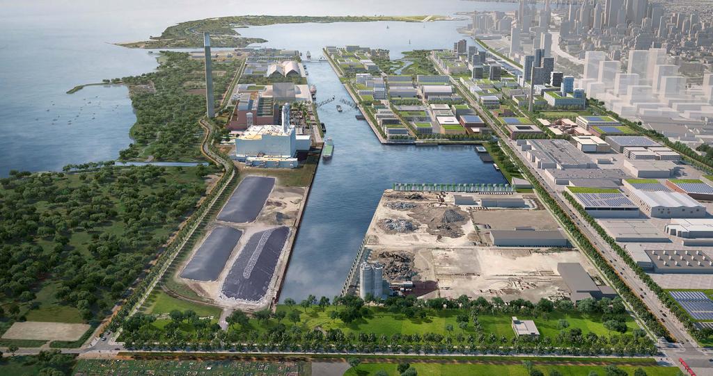
2 Existing Conditions - Defining Elements Heritage Buildings + Structures Active Port Uses Ports Toronto Active Port Edge Unilever Precinct Hydro Infrastructure Pinewood Secure Permineter Film + Film Related Existing Parks + Open Spaces Unilever Precinct Area of Influence

3 Land Ownership way Road s Str ioner s s i m Com eet enue w Av Don eet r rs St Villie eet e Str Lesli Carla. ard E v e l u Bo hore S e k La eet rystr Cher ue ven A in Unw Federally Owned Land Provincially Owned Land Municipally Owned Land Long-term Leases Long-term Options to Lease Waterfront Toronto Owned Land Privately Owned Land
4 Port Lands Planning Initiatives Port Lands Planning Framework Port Lands and South of Eastern Transportation and Servicing Master Plan (TSMP) Villiers Island Precinct Plan Completed
5 FRAMEWORK IN BRIEF 1 VISION DIRECTIONS AND RECOMMENDATIONS
6
7 50+ YEAR PLAN Guidance for the near, medium + longer terms so that we know what to expect tomorrow, but also to provide flexibility for what is yet to come

8 THE VISION The Port Lands will transform into a number of new, vibrant districts with unique and memorable local identities and character that promote social interaction, cultural enrichment, ecological health, a low-carbon future, and a prosperous local economy. Each district will take its cue from the naturalized river valley and wild natural areas, spectacular waterfront parks and open spaces, and rich cultural heritage. The Port Lands will have an eclectic mix of uses, offering diverse opportunities for Torontonians to live, work and play. Intrinsic to this mix of uses is the energy, vibrancy and theatre of the working port and nurturing the growth of creative and innovative industries. A resilient urban structure will be set in place, connecting the Port Lands to the city and providing sustainable options for moving in and through the area. The urban structure will provide a robust legacy of fine-grained streets and blocks to allow the Port Lands to continue to evolve and transform over time.
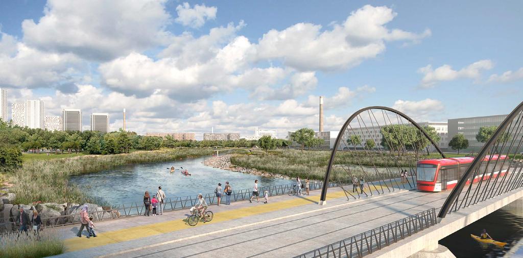
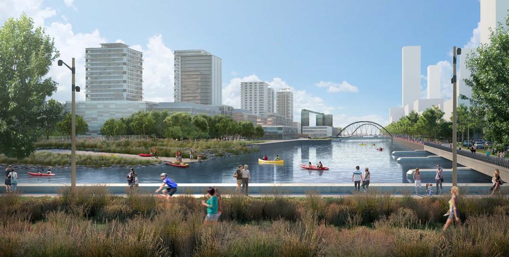
9 King St. E. DVP Corktown Common Eastern Ave. Cherry St. Broadview Ave. Lake Shore Boulevard E. Carlaw Ave. McCleary Park Leslie Green Portal Keating Channel Don Roadway Queens Quay E. Silo Square Villiers Park Commissioners St. Turning Basin Promontory Park River Park North River Park South Don Greenway North New Lift Bridge Hearn Hub Tommy Thompson Park Cherry St. Ship Channel Unwin Ave Don Greenway South Cherry Beach Sport Fields The Unwin Wilds Leslie Street Spit Illustrative Plan

10 King St. E. DVP Corktown Common Eastern Ave. Cherry St. Broadview Ave. Lake Shore Boulevard E. Carlaw Ave. McCleary Park Leslie Green Portal Keating Channel Queens Quay E. Don Roadway Commissioners St. Turning Basin River Park North River Park South Don Greenway North New Lift Bridge Tommy Thompson Park Ship Channel Unwin Ave Don Greenway South Cherry Beach Sport Fields The Unwin Wilds Leslie Street Spit Unique and Memorable Districts Lower Don Lands Villiers Island Polson Quay South River Film Studio District McCleary District Media City Turning Basin District East Port 7 8 Warehouse District East Port South Ship Channel South Port East South Port Ports Toronto

11
12
13
14
15
16 King St. E. DVP e. Av iew dv oa Br Cherry St. Quay E. * St. Leslie. w Ave Carla way Road Don Queens Lake rd E. uleva e Bo Shor Turning Basin rs St. sione is Comm * * * l nne ha ip C Sh l ne han pc Shi Tommy Thompson Park Don Greenway South t. rry S Che ve in A Unw Cherry Beach Sport Fields Leslie Street Spit Cherry Beach Civic, Public and Natural Realms * Final size and configuration of local parks in to be determined during precinct/concept planning Aquatic Habitat/Waterways Top of Bank Community Infrastructure Lake Connected Wetlands Wetland Levee System Future Naturalization Heritage Buildings/Structures Linear Open Spaces Natural Areas Valley Slope Transition Parks and Open Spaces Net Environmental Gain Zone River-related Habitat Water s Edge Promenades Environmentally Significant Areas

17 King St. E. Eastern Ave. DVP Broadview Ave. Cherry St. Lake Shore Boulevard E. Carlaw Ave. Leslie St. Don Roadway Queens Quay E. Commissioners St. New Lift Bridge Cherry St. Unwin Ave Street Network Major Streets Protected for Future Crossing/Connection Local Streets* Lane Ways/Shared Streets* Mid-Block Pedestrian Connection* *Local Streets, lane ways/shared streets and mid-block pedestrian connections are conceptually shown and will be determined through precinct planning or concept planning
18 Transit Cycling Network King St. E. King St. E. Eastern Ave.. iew dv Lake. ard E oulev eb Shor. St. Lift Newge Brid t. ers S ission Comm Leslie w Ave Carla way Road St. Quay E. Don Leslie. w Ave Carla Queens oa. iew dv way iss Comm Br oa Road s St. ioner E. Cherry St. Br Don Quay E. DVP DVP Cherry St. Queens h S Lake vard oule ore B Eastern Ave. Lift Newge Brid Che t. rry S ve in A Unw t. rry S Che ve in A Unw Streetcar in Dedicated ROW Streetcar Stop Relief Line Streetcar in Mixed-Traffic Protected for Future Streetcar in Dedicated ROW SmartTrack/RER Transit Hub Future Streetcar Stop Bus in Mixed Traffic Proposed/Planned Priority Raised Cycle Track Existing Cycle Track Optional Raised Cycle Track Lanes / Sharrows Multi-use Trail Multi-use Trail Water s Edge Promenade Trail Improved/Realigned Existing Multi-use Trail Trail Protected for Future Cycling/ Pedestrian Connection


19 Cherry Street Carlaw Avenue Don Roadway Caroline Extension P P Broadview Avenue Leslie Street Commissioners Street Unwin Avenue P
20 Planning Framework and TSMP Process NOVEMBER 2013 JUNE 2014 JULY 2014 NOVEMBER 2015 Q2-Q PORT LANDS PROFILE 02 LAND USE DIRECTION 03 VISION WORKSHOP 04 EMERGING DIRECTIONS 05 PORT LANDS PLANNING FRAMEWORK Nov. 28, 2013 Introductory Community Meeting Feb. 13, 2014 Land Use Options and Infrastructure Alternatives March 5, 2014 Workshop July 23 & 24, 2014 Port Lands Charrette Nov , 2015 Shaping the Future: Placemaking in the Port Lands + Connecting South of Eastern Consultation TRANSPORTATION + SERVICING MASTER PLAN VILLIERS ISLAND PRECINCT PLAN 5 Major Public Consultation Events 16,700 Notices Mailed 54 Meetings with Stakeholders 6 Stakeholder Advisory Committee Meetings 705 People Engaged at Public Consultation Events 27,250 Website Visits 5 Land Owner and User Advisory Committee Meetings 3,250 Views of Shaping the Future Presentations
21 Inputs into the Plans Provincial Policies + Legislation Economic + Market Advice Public Consultation First Nations Consultation Background Studies Biodiversity Working Group Noise + Air Quality Study PREFERRED PLANS Port Lands Charrette Global Best Practices and Models City Policies + Guidelines Transportation + Hydrological Modeling Expert Review Panel Divisions + Agencies Land Owners + Stakeholders Design Review Panel City Building Objectives Financial Considerations Microclimatic Analysis, 3D Modelling and View Studies Hydro Feasibility Study Film + Media Sector Consultation

22 Villiers Island Precinct Plan Precinct Plan Vision Guiding Principles, Structuring Moves, Character Areas Strategies and Guidelines Climate Positive Precinct Mobility, Transportation and Access Parks, Open Space and Public Realm Heritage Activity and Uses Built Form Municipal Infrastructure
 A high-level plan focused on: The creation of new urban districts set amid Toronto s ongoing port activities Renaturalizing the mouth")
23 Central Waterfront Secondary Plan Central Waterfront Secondary Plan approved in 2003 and appealed to the Ontario Municipal Board. CWSP Map E - Land Use Plan (2003 Central Waterfront Part II Plan) A high-level plan focused on: The creation of new urban districts set amid Toronto s ongoing port activities Renaturalizing the mouth of the Don River Mixed-use (live-work) with new media, knowledge based industries and industrial Mid-rise character with some taller buildings at appropriate locations The Ship Channel as a focal point, unique amenity and required for port activities Lack of specificity for co-existence of different land uses and compatibility with heavier industrial, cityserving uses Planned street network impeded by significant constraints or precluded by development, and key connections required detailed study
24 Recommended Official Plan Modification Updates and streamlines policy directions related to the Port Lands in the CWSP based on the outcomes and findings of the Framework and previous undertakings. Policy directions for the Port Lands are consolidated in a Port Lands Area Specific Policy; Amends Maps A through E of the CWSP to: Incorporate the major streets identified in the Lower Don Lands Class EA and the preferred solutions from the TSMP in Map A; Incorporate the final transit networks associated with the EAs and more detailed transit studies undertaken in the area in Map B; Update the major parks and open spaces on Map C; Update the pedestrian, cycling and water routes shown on Map D; and Implement minor adjustments to the land use designations on Map E to reflect the major parks and open spaces; Amends Schedule A (Proposed Rights-of-Way for Major Roads); and Introduces a Port Lands Area Specific Policy as a new Schedule to the CSWP
 7 Recognition of final river per DMNP EA if Cement")

25 CWSP Land Use Plan CWSP Map E - Land Use Plan (2003 Central Waterfront Part II Plan) Proposed Amendments Recognition of the naturalized river mouth and greenway as approved 6 Recognition of existing Cement Operation 2 Expanded McCleary Park boundary (Lake Shore to Commissioners) 7 Recognition of final river per DMNP EA if Cement Operation relocates 3 4 Parks and Open Space Areas on west side of Leslie and reflect open space areas realized through Leslie Barns Revise some Public Promenade to Future Public Promenade 8 9 Introduction of additional Inner Harbour Special Places Reflect objective to designate all lands south of Unwin Avenue as Parks and Open Space 5 Refined Don Greenway South
26 South of Eastern Transportation Official Plan Amendment Implements the preferred street network from the Port Lands and South of Eastern Transportation and Servicing Master Plan through an amendment to the City s Official Plan: Amends Map 3 Right-of-Way Widths Associated with Existing Major Streets to reflect the 3m widening for Eastern Avenue; Identifies the surface transit priority route in the Broadview extension from Queen to Lake Shore Boulevard East; Introduces the additional new streets in Schedule 2 of the Official Plan
27 Work Program Initiate a zoning review for the Port and Industrial Districts; Prepare a Precinct Plan for the McCleary District and develop urban design guidelines/zoning for Productions, Interactive and Creative districts; Develop a Port Lands-wide truck management strategy; Undertake a feasibility study to determine the optimal approach for low-carbon energy solutions in the Port Lands; and Prepare a Class B cost estimate (±20 per cent) for relocating and undergrounding hydro infrastructure in the Port Lands
28 Recommendations Adoption of the Port Lands Planning Framework (Attachment 1) to guide the revitalization of the Port Lands over the coming decades; Endorsement of the Villiers Island Precinct Plan (Attachment 2) to provide additional guidance for Zoning By-law amendments and Plans of Subdivision; Instruction for the City Solicitor to request the Ontario Municipal Board to modify the Central Waterfront Secondary Plan (CWSP) for the Port Lands at the on-going hearing in accordance with the recommended Official Plan modification (Attachment 3); and Classification of Villiers Island, the McCleary District, Polson Quay and South River districts as Class 4 areas under the Ministry of Environment and Climate Change s Environmental Noise Guideline; Adoption of the South of Eastern Transportation Official Plan Amendment (Attachment 4); and Endorsement of a work program to initiate more detailed planning in key areas
PORT LANDS ACCELERATION INITATIVE- PHASE 2 PORT LANDS PLANNING FRAMEWORK
 Re: ED14.9 PORT LANDS ACCELERATION INITATIVE- PHASE 2 PORT LANDS PLANNING FRAMEWORK Toronto Film, Television and Digital Media Board June 10, 2016 2016-06-10-1 THE PORT LANDS TODAY CARLAW AVENUE CHERRY
Chairman and Members of the Planning and Development Committee. Thomas S. Mokrzycki, Commissioner of Planning and Building
 LA.09.TOR (Toronto) DATE: TO: FROM: SUBJECT: Chairman and Members of the Planning and Development Committee Thomas S. Mokrzycki, Commissioner of Planning and Building Central Waterfront Secondary Plan
Attachment 1: Section 4-1
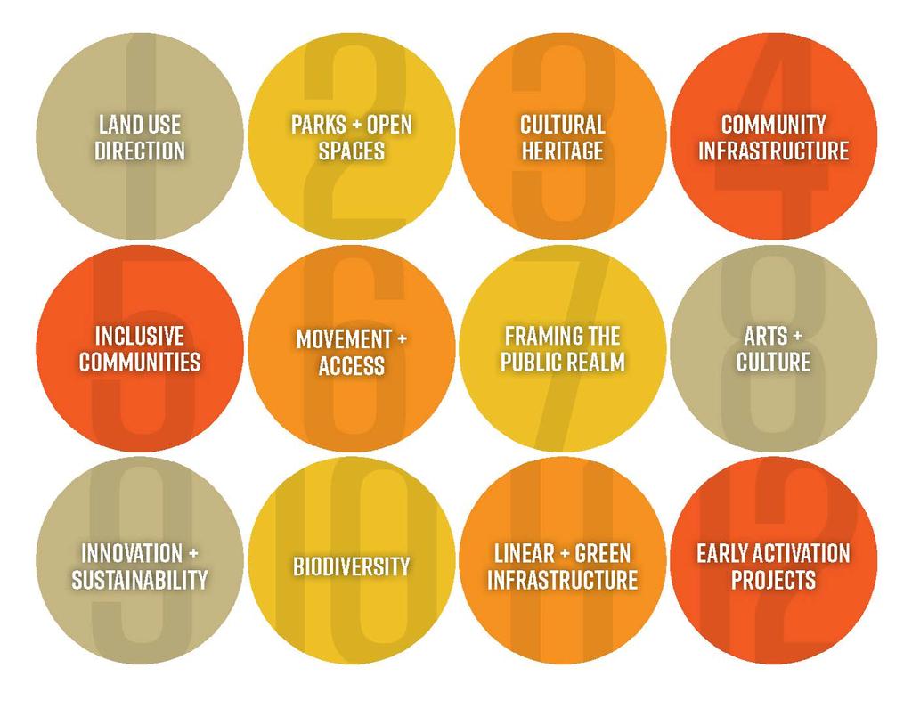
 Attachment 1: Section 4-1 SECTION 4 DIRECTIONS + RECOMMENDATIONS Directions in twelve key areas collectively form the blue print for achieving the vision. Enhanced policy direction and guidance is provided
WELCOME TO THE SOUTH OF EASTERN OPEN HOUSE
 WELCOME TO THE SOUTH OF EASTERN OPEN HOUSE Providing for Good Jobs and Supporting Services in the South of Eastern Area City Planning has initiated the Unilever Precinct Planning Study to comprehensively
Welcome. Community Consultation Meeting November 28, Review and discuss the Bathurst Quay Neighbourhood Plan Framework
 Welcome Community Consultation Meeting November 28, 2016 Why Are We Here Today? Review and discuss the Bathurst Quay Neighbourhood Plan Framework Review and discuss an Action Plan for Implementation Next
Director, Community Planning, Toronto and East York District
 Lower Yonge Precinct Plan Update STAFF REPORT ACTION REQUIRED Date: October 16, 2012 To: From: Wards: Reference Number: Toronto and East York Community Council Director, Community Planning, Toronto and
Baselands Trails Master Plan Public Meeting. April 28, 2015 Fire Academy, 895 Eastern Avenue, Toronto 6:30 p.m. to 9:00 p.m.
 Baselands Trails Master Plan Public Meeting April 28, 2015 Fire Academy, 895 Eastern Avenue, Toronto 6:30 p.m. to 9:00 p.m. Baselands Trails Master Plan Meeting Purpose To present and get feedback on:
A 25-YEAR PLAN FOR DOWNTOWN
 A 25-YEAR PLAN FOR DOWNTOWN The Downtown Secondary Plan will provide policy direction to shape future growth and link that growth to the provision of infrastructure for liveability 1. BALANCING GROWTH
South of Eastern Strategic Direction Status Update
 STAFF REPORT ACTION REQUIRED South of Eastern Strategic Direction Status Update Date: July 10, 2014 To: From: Planning and Growth Management Committee Chief Planner and Executive Director, City Planning
CULTURAL HERITAGE RESOURCES
 The Hearn 4.3 CULTURAL HERITAGE RESOURCES The Port Lands will be a special urban environment where heritage resources will be given new life as key components of the contemporary city that provide a visible
The Master Plan Framework
 The Master Plan Framework The East Harbour Master Plan advances the development of 60 acres of former industrial lands east of the Don River. The Master Plan outlines a vision for a vibrant, transit-oriented
Public Meeting #3 May 9, 2009 MVVA Team
 Public Meeting #3 May 9, 2009 MVVA Team Welcome to the third Public Meeting for the Lower Don Lands Municipal Class Environmental Assessment (EA) Infrastructure Master Plan and Keating Channel Precinct
1. Introduction
 Table of Contents 1. Introduction... 1-1 1.1 Project Background... 1-1 1.2 Project Goals and Objectives... 1-3 1.3 Proponent... 1-5 1.4 The Ontario EA Act... 1-6 1.4.1 Co-ordinated EA Process... 1-9 1.4.2
Purpose of Open House #3
 Public Meeting #3 May 9, 2009 MVVA Team Purpose of Open House #3 The main purpose of this Open House is to present and seek input on the: Evaluation of transportation and infrastructure design alternatives
1 Introduction. Chapter. In this chapter:
 Chapter 1 Introduction In this chapter: 1.1 A Snapshot of the Region 1.2 Towards a Sustainable Region 1.3 The Provincial Context 1.4 Purpose and Organization The Regional Municipality of York Official
Ashbridges Bay Erosion and Sediment Control Project
 Ashbridges Bay Erosion and Sediment Control Project Project Brief Overview Toronto and Region Conservation Authority, in partnership with the City of Toronto, intends to carry out remedial erosion control
DOWNTOWN PARKS & PUBLIC REALM PLAN
 DOWNTOWN PARKS & PUBLIC REALM PLAN CHALLENGES The Parks and Public Realm Strategy addresses challenges associated with a growing Downtown, including: GOALS 3.3 New buildings will fit within their existing
Public Open House. Overview of the Downtown Plan Official Plan Amendment April 23, 2018
 Public Open House Overview of the Downtown Plan Official Plan Amendment April 23, 2018 1 A 25-Year Plan for Downtown To ensure growth contributes positively to Toronto s Downtown as a great place to live,
GARDINER EXPRESSWAY AND LAKE SHORE BOULEVARD EAST RECONFIGURATION ENVIRONMENTAL ASSESSMENT Planning, Urban Design, Public Realm and Socio- Economic
 GARDINER EXPRESSWAY AND LAKE SHORE BOULEVARD EAST RECONFIGURATION ENVIRONMENTAL ASSESSMENT Socio- Economic Background Conditions Report - 2014 Socio-Economic Background Conditions Report 2014 TABLE OF
Report to: Development Services Committee Report Date: April 24, 2017
 SUBJECT: Cornell Rouge National Urban Park Gateway - Report on Design Charrette and Next Steps PREPARED BY: Lilli Duoba, MES, MCIP, RPP, Manager, Natural Heritage (ext. 7925) REVIEWED BY: Marg Wouters,
Unilever Precinct Planning Study and East Harbour Application Review Update Report. Planning and Growth Management Committee
 PG24.1 STAFF REPORT ACTION REQUIRED Unilever Precinct Planning Study and East Harbour Application Review Update Report Date: October 24, 2017 To: From: Planning and Growth Management Committee Acting Chief
Planning and Growth Management Committee. Chief Planner and Executive Director, City Planning
 PG18.6 STAFF REPORT ACTION REQUIRED Unilever Precinct Planning Study Status Update 21 Don Valley Parkway and 30 Booth Avenue Zoning Amendment and Subdivision Applications Preliminary Report Date: February
CDAC. Update: Downtown Dartmouth Update: CDAC July 25 th Motion
 CDAC Update: Downtown Dartmouth Update: CDAC July 25 th Motion 2018-10-24 Downtown Dartmouth Plan Open House October 22, 2018 6:00 pm Open House 6:30 pm Presentation + Q&A 7:20 pm Open House 8:30 pm Close
APPENDIX K WINDSOR OFFICIAL PLAN
 CEAA ENVIRONMENTAL ENVIRONMENTAL IMPACT ASSESSMENT AMBASSADOR BRIDGE ENHANCEMENT PROJECT Replacement Span and Plaza Expansion APPENDIX K WINDSOR OFFICIAL PLAN Avalon Consulting Professionals of Ontario,
13 THORNHILL YONGE STREET STUDY IMPLEMENTATION CITY OF VAUGHAN OPA 669 AND TOWN OF MARKHAM OPA 154
 13 THORNHILL YONGE STREET STUDY IMPLEMENTATION CITY OF VAUGHAN OPA 669 AND TOWN OF MARKHAM OPA 154 The Planning and Economic Development Committee recommends the adoption of the recommendations contained
John M. Fleming Managing Director, Planning and City Planner. Old East Village Dundas Street Corridor Secondary Plan Draft Terms of Reference
 Report to Planning and Environment Committee To: From: Subject: Chair and Members Planning & Environment Committee John M. Fleming Managing Director, Planning and City Planner Old East Village Dundas Street
TORONTO COMPLETE STREETS GUIDELINES
 TORONTO COMPLETE STREETS GUIDELINES Presentation by Fiona Chapman, Manager, Pedestrian Projects Public Realm Section, Transportation Services, City of Toronto June 2017 PURPOSE OF THE PROJECT To develop
2. Purpose of the Undertaking
 Table of Contents 2. Purpose of the Undertaking... 2-1 2.1 Problem Assessment... 2-1 2.1.1 Ecologically Dysfunctional River Mouth... 2-1 2.1.2 Flood Risk Vulnerability... 2-2 2.1.3 Derelict Waterfront...
38 Queen s University Campus Master Plan Part 1
 38 Queen s University Campus Master Plan Part 1 46 The Campus at the City Scale Chapter 4 The Campus at the City Scale 39 Queen s is an urban University centrally located in Kingston. Decisions made by
SCARBOROUGH SUBWAY EXTENSION. Scarborough Subway Extension. Final Terms of Reference
 Scarborough Subway Extension Final Terms of Reference 1 1.0 Introduction and Background 1.1 Introduction Toronto City Council recently confirmed support for an extension of the Bloor-Danforth Subway from
PORT LANDS ACCELERATION INITIATIVE
 PORT LANDS ACCELERATION INITIATIVE Appendix Planning and Infrastructure Rendering of River Park North by Michael Van Valkenburgh Associates courtesy of Waterfront Toronto Precedent Review and Analysis
Proposed Downtown Plan
 Proposed Downtown Plan Harbord Village Residents Association AGM October 18, 2017 Timeline Implementation The Role of Downtown Employment Growth Downtown 432,900 jobs 502,100 jobs 850,000-915,000 jobs
3. Endorse the LRT vision in transforming Surrey into Connected-Complete-Livable communities, and more specifically, the official vision statement:
 CORPORATE REPORT NO: R038 COUNCIL DATE: February 20, 2017 REGULAR COUNCIL TO: Mayor & Council DATE: February 16, 2017 FROM: General Manager, Engineering FILE: 8740-01 SUBJECT: Surrey Light Rail Transit
Public Open House. YWCA, 87 Elm Street December 2nd, 2017, 10 a.m. 2 p.m.
 Public Open House YWCA, 87 Elm Street December 2nd, 2017, 10 a.m. 2 p.m. 1 A 25-Year Downtown Plan A blueprint for future growth and infrastructure in the heart of Toronto Ensuring growth contributes positively
Parks Master Plan Implementation: Phase I Waterfront Use and Design REPORT #: September 7, 2016 File #
 0 'O DI Lan-171-14 1 - THE CORPORATION OF THE TOWN OF COBOURG..,. STAFF REPORT TO: FROM: Mayor and Members of Council Dean A. Hustwick, Director of Recreation and Culture DATE OF MEETING: Committee of
10.0 Open Space and Public Realm
 10.0 Open Space and Public Realm 10.0 Open Space and Public Realm The Public Open Space System is comprised of: outdoor spaces available for public use that are either publicly owned (e.g., parks and
Bathurst Quay Neighbourhood Plan Interim Report
 STAFF REPORT ACTION REQUIRED Bathurst Quay Neighbourhood Plan Interim Report Date: June 8, 2017 To: From: Wards: Reference Number: Toronto and East York Community Council Director Community Planning, Toronto
Cambie Corridor Planning Program Phase Two Draft Plan. Standing Committee on City Services and Budgets May 5, 2011
 Cambie Corridor Planning Program Phase Two Draft Plan Standing Committee on City Services and Budgets May 5, 2011 Cambie Corridor Program Terms of Reference approved July 2009 Land Use Transportation Energy
University of Saskatchewan CAMPUS MASTER PLAN. Senate Meeting Preliminary Presentation. April 21, 2018 DIALOG ECS DA WATT
 University of Saskatchewan CAMPUS MASTER PLAN Senate Meeting Preliminary Presentation April 21, 2018 DIALOG ECS DA WATT project process presentation agenda Stakeholder Engagement Project Control phase1
Richard Butts, Deputy City Manager
 STAFF REPORT ACTION REQUIRED Lower Don Lands Project Date: May 31, 2010 To: From: Executive Committee Richard Butts, Deputy City Manager Wards: Wards 28 and 30 Reference Number: P:\ 2010\ClusterB\wf\ec10003
APPENDIX L3. Table of Contents. SWP EA Information Sheets
 E N V I R O N M E N T A L A S S E S S M E N T APPENDIX L3 SWP EA Information Sheets Table of Contents EA Info Sheet 1... L3-1 EA Info Sheet 2... L3-3 EA Info Sheet 3... L3-5 EA Info Sheet 4... L3-7 SCARBOROUGH
Rapid Transit Implementation Working Group
 Rapid Transit Implementation Working Group October 12, 2017 1 Agenda 1. Consultation Update 2. Technical Work Update 3. LTC Rapid Transit Integration 4. Next Steps 2 Consultation Update 3 Consultation
Case Study Presentation of the Downtown Brampton Flood Protection Class EA
 Case Study Presentation of the Downtown Brampton Flood Protection Class EA Presented by: Kenneth M. Dion, Project Director Port Lands Integration, Waterfront Toronto (formerly Senior Manager, TRCA) At:
5 TOWN OF MARKHAM OFFICIAL PLAN AMENDMENT NO. 144 MILLIKEN MAIN STREET SECONDARY PLAN
 5 TOWN OF MARKHAM OFFICIAL PLAN AMENDMENT NO. 144 MILLIKEN MAIN STREET SECONDARY PLAN The Planning and Economic Development Committee recommends the following: 1. The communication from Brendan O Callaghan,
1.0 Purpose of a Secondary Plan for the Masonville Transit Village
 Report to Planning and Environment Committee To: Chair and Members Planning & Environment Committee From: John M. Fleming Managing Director, Planning and City Planner Subject: Masonville Transit Village
implementation r expression in landscape
 6 ubc okanagan implementation campus plan r expression in landscape 68 6 implementation campus plan sections The Campus Plan supports the academic mission, values and commitments of the University by providing
Gary & Regional Investment Project. October 27, Creating Tomorrow Today Comprehensive Regional Plan - NIRPC
 Creating Tomorrow Today 2040 Comprehensive Regional Plan Gary & Regional Investment Project October 27, 2010 Creating Tomorrow Today - 2040 Comprehensive Regional Plan - NIRPC What is NIRPC? - Northwestern
CITY COUNCIL AGENDA REPORT
 CITY COUNCIL AGENDA REPORT Subject: DESIGNATED FLOOD LINE CARROT CREEK Recommendation(s) That Administration bring forward a Land Use Bylaw amendment in October 2014 establishing the Designated Flood Line
Official Plan Review
 Official Plan Review Summary Report - The Built Environment August 2014 Part 1: Introduction Planning for a healthy, prosperous and sustainable community is an important goal for our municipality. From
City of Farmington. Downtown Plan. Amendment to the 1998 Master Plan Adopted October 11, 2004
 City of Farmington Amendment to the 1998 Master Plan Adopted October 11, 2004 Introduction Planning Background 1 Scope and Components of the Plan Amendment 2 Concept Introduction 3 Plan Concepts 3 Conceptual
Queensborough Eastern Neighbourhood Node. Community Open House
 Queensborough Eastern Community Open House The Vision The Queensborough Eastern will become the heart of eastern Queensborough. Through a sensitive mix of viable commercial and residential areas, the neighbourhood
Queens Quay East & Lake Shore Boulevard East & 26 Richardson Street Public Art Plan
 STAFF REPORT ACTION REQUIRED 130-132 Queens Quay East & 143-177 Lake Shore Boulevard East & 26 Richardson Street Public Art Plan Date: April 20, 2016 To: From: Toronto East York Community Council Director,
Official Plan Review: Draft Built Form Policies
 PG.30.1 REPORT FOR ACTION Official Plan Review: Draft Built Form Policies Date: May 15, 2018 To: Planning and Growth Management Committee From: Chief Planner and Executive Director, City Planning Division
Moving from Vision to Action
 Moving from Vision to Action Photo: John Carvalho What does it mean for a city to move? To see its people belong and connect? To prosper? To become green? Those are the pillars that are helping Mississauga
CITY OF VAUGHAN EXTRACT FROM COUNCIL MEETING MINUTES OF NOVEMBER 15, 2016
 Item 11, Report No. 38, of the Committee of the Whole, which was adopted without amendment by the Council of the City of Vaughan on November 15, 2016. Regional Councillor Di Biase declared an interest
PART 1. Background to the Study. Avenue Study. The Danforth
 The Danforth 1.1/ Study Purpose & Key Municipal Goals 1.2/ The Local Advisory Committee 1.3/ The Project Team 1.4/ Study Process/Summary of Method 1.5/ Summary of Consultation 1.1 Study Purpose and Key
Table 8-4: Road Classification Local Roads, second table, of Chapter 8 Create a Multi-Modal City, be amended by adding the following:
 1 Port Street East Official Plan Amendment APPENDIX 3 Amendments to Mississauga Official Plan Table 8-4: Road Classification Local Roads, second table, of Chapter 8 Create a Multi-Modal City, be amended
Town of Cobourg Heritage Master Plan. Statutory Public Meeting
 Town of Cobourg Heritage Master Plan Statutory Public Meeting April 25 th 2016 Presentation Overview 1. Introduction 2. Project background and schedule overview 3. Review of strategic direction content
PORT OF VANCOUVER WATERFRONT DEVELOPMENT. Concept Development Plan City Center Redevelopment Authority April 20, 2017
 PORT OF VANCOUVER WATERFRONT DEVELOPMENT Concept Development Plan City Center Redevelopment Authority April 20, 2017 Port History PORT ESTABLISHED 1912 TERMINAL 1 ACQUIRED 1925 GWM SIGNS LEASE 1935 HARBOR
SUBJECT: Waterfront Hotel Planning Study Update TO: Planning and Development Committee FROM: Department of City Building. Recommendation: Purpose:
 Page 1 of Report PB-23-18 SUBJECT: Waterfront Hotel Planning Study Update TO: Planning and Development Committee FROM: Department of City Building Report Number: PB-23-18 Wards Affected: 2 File Numbers:
Edward R. Sajecki Commissioner of Planning and Building
 Corporate Report Clerk s Files Originator s Files CD.03.POR DATE: TO: FROM: SUBJECT: Chair and Members of Planning and Development Committee Meeting Date: February 27, 2012 Edward R. Sajecki Commissioner
Transportation Master Plan Environmental Assessment
 Transportation Master Plan Environmental Assessment AUGUST, 2014 Waterfront Toronto / Perkins + Will Lower Yonge Transportation Master Plan Environmental Assessment Contents Executive Summary 1 1 Introduction
1.0 PLANNING MARKHAM S FUTURE CONTENTS
 1-1 Planning Markham s Future 1.0 PLANNING MARKHAM S FUTURE CONTENTS 1.1 THE PURPOSE OF THE OFFICIAL PLAN 1.2 THE MARKHAM CONTEXT 1.3 THE REGULATORY CONTEXT 1.3.1 Province of Ontario 1.3.2 York Region
QUEEN-RIVER SECONDARY PLAN
 34 QUEEN-RIVER SECONDARY PLAN 34. QUEEN RIVER SECONDARY PLAN 1. INTRODUCTION The Queen-River area is approximately 6.4 hectares and is located at the eastern edge of the Downtown as shown on Map 34-1.
Canadian Consulting Engineering Awards 2016 Queens Quay West Revitalization. Category B: Transportation
 Canadian Consulting Engineering Awards 2016 Queens Quay West Revitalization Category B: Transportation April 2016 Arup Contents Online Submission Confirmation Receipt Entry Consent Form Project Information...1
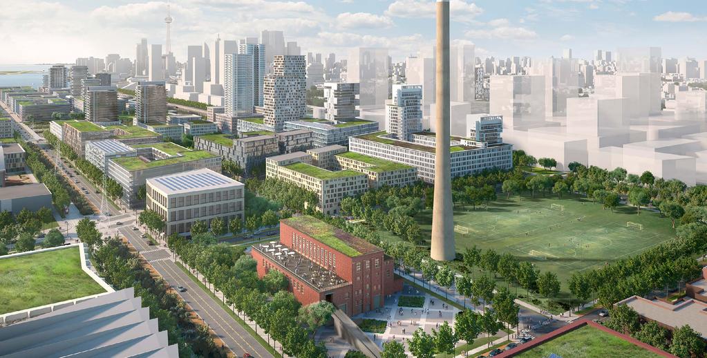
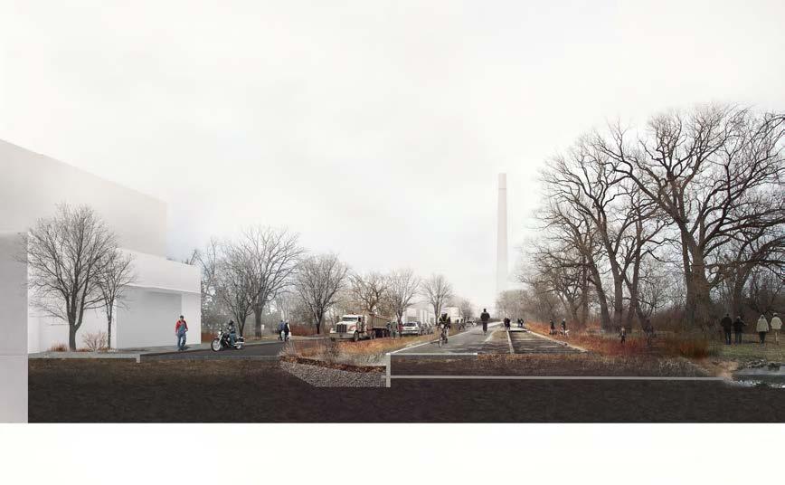
Bird s eye of the Port Lands looking west from Leslie Street. Attachment 1: Section 4-12
 Bird s eye of the Port Lands looking west from Leslie Street Attachment 1: Section 4-12 4.12 EARLY ACTIVATION PROJECTS Regeneration and renewal in the Port Lands is a multi-decadelong proposition. The
Welcome. Walk Around. Talk to Us. Write Down Your Comments
 Welcome This is an information meeting introducing the applications for proposed redevelopment of the Yorkdale Shopping Centre site at 3401 Dufferin Street and 1 Yorkdale Road over the next 20+ years,
~!VAUGHAN NOV Z November 21, Mr. Denis Kelly, Regional Clerk The Regional Municipality of York Yonge Street Newmarket, ON L3Y 6Z1
 ~!VAUGHAN NOV Z 5 2016 November 21, 2016 Mr. Denis Kelly, Regional Clerk The Regional Municipality of York 17250 Yonge Street Newmarket, ON L3Y 6Z1 Dear Mr. Kelly: RE: NEW KIRBY GO STATION IN BLOCK 27
Planning for the Future Urban Area. in north Markham. Update. Development Services Committee. December 9, De Development Services Committee
 Planning for the in north Markham 1 Update De December 9, 2014 Overview - Growth Management Strategy and new Official Plan 2014 Status - Official Plan 2014 and ROPA3 Update - Planning for the Future Urban
Bloor Street East Potential Ravine Portal Overlook and Access Passage to the Rosedale Valley and Don River Valley Ravine, Toronto, Canada
 TRANSFORMATIVE IDEA 2. GREAT STREETS Bloor Street Christie Pits Park Bloor St Spadina Ave Bathurst St Shaw St 1 Recognize the significant public realm improvements along Bloor Street and extend and enhance
CONTENTS 6.1 URBAN DESIGN
 6-2 Urban Design and Sustainable Development 6.0 URBAN DESIGN AND SUSTAINABLE DEVELOPMENT CONTENTS 6.1 URBAN DESIGN 6.1.1 General Policies 6.1.2 The Public Realm 6.1.3 Streets and Blocks 6.1.4 Streetscapes
GOLDEN MILE SECONDARY PLAN. Community Consultation Meeting #3 June 26, 2018
 GOLDEN MILE SECONDARY PLAN Community Consultation Meeting #3 June 26, 2018 Meeting Overview 1. Introduction 2. Principles + Vision 3. Street + Block Alternatives 4. Parks + Open Space Alternatives 5. Land
Draft Official Plan Amendment - The Port Lands
 mciminan ll, PG21.4.2 Reply to the Attention of Mary Flynn-Guglietti Direct Line 416.865.7256 Email Address mary.flynn@mcmillan.ca Our File No. 79074 Date May 25, 2017 DELIVERED VIA EMAIL (critz@toronto.ca)
Public Works and Infrastructure Committee
 STAFF REPORT ACTION REQUIRED Progress Report on Design Concepts for the Hybrid EA Preferred Alternative Gardiner Expressway and Lake Shore Boulevard East Reconfiguration Environmental Assessment (EA) and
Route 1 Corridor Study
 Route 1 Corridor Study Westbrook, Connecticut A Vision for the Connecticut Shoreline Public Informational Meeting July 28, 2015 Lower Connecticut River Valley Council of Governments Fitzgerald & Halliday,
Don Mills Crossing Study and Celestica Lands Development Application Community Meeting, Open House, and Breakout Discussions
 Consultation Summary Don Mills Crossing Study and Celestica Lands Development Application Community Meeting, Open House, and Breakout Discussions This report is not intended to provide a verbatim transcript
McCowan Precinct Plan Study Background & Deliverables
 1 DRAFT & WITHOUT PREJUDICE McCowan Precinct Plan Study Background & Deliverables In September, 2011, City Planning (Scarborough District) began a study of an area within the Scarborough Centre, identified
PORT WHITBY COMMUNITY
 PORT WHITBY COMMUNITY SECONDARY PLAN UPDATE COMMUNITY IMPROVEMENT PLAN URBAN DESIGN GUIDELINES September 2015 DRAFT PROPOSED AMENDMENT NUMBER # to the Whitby Official Plan PURPOSE: The intent of this Amendment
Waterfront Development Master Plan
 PORT of VANCOUVER USA Vancouver, WA Waterfront Development Master Plan DRAFT - FINAL CONCEPTUAL MASTER PLAN PROJECT TEAM NBBJ Heritage Research Associates JLA Kittelson Associates Leland Consulting Group
STRATEGIES AND GUIDELINES
 Attachment 2 - Part 2 SECTION 3 STRATEGIES AND GUIDELINES 56 VILLIERS ISLAND PRECINCT PLAN This section of the Precinct Plan describes the strategies and guidelines for directing the change and evolution
6 CATHEDRAL COMMUNITY SECONDARY PLAN OFFICIAL PLAN AMENDMENT 123 TOWN OF MARKHAM
 6 CATHEDRAL COMMUNITY SECONDARY PLAN OFFICIAL PLAN AMENDMENT 123 TOWN OF MARKHAM The Planning and Economic Development Committee recommends the adoption of the recommendation contained in the following
Corridor Vision. 1Pursue Minnehaha-Hiawatha Community Works Project. Mission of Hennepin County Community Works Program
 1Pursue Minnehaha-Hiawatha Community Works Project Minnehaha-Hiawatha Community Works is a project within the Hennepin Community Works (HCW) program. The mission of the HCW program is to enhance how the
Relief Line Project Assessment
 Relief Line Project Assessment Public Information Centre April 5, 2017 Tonight s Meeting PURPOSE To review the preferred alignment for the Local Segment. AGENDA 6:30 Open House 7:00 Presentation / Discussion
Downtown Streetscape Manual & Built Form Standards
 City of Guelph Downtown Streetscape Manual & Built Form Standards July 2014 Prepared by Brook McIlroy Inc. in association with Unterman McPhail Associates and McCormick Rankin Inc. City of Guelph Downtown
Lower Don River West Remedial Flood Protection Project TABLE OF CONTENTS. Page. Executive Summary
 TABLE OF CONTENTS Page Executive Summary 1.0 INTRODUCTION...1-1 1.1 Purpose of the Undertaking...1-1 1.2 Study Area Description...1-1 1.3 Description of the Undertaking...1-1 1.4 Rationale for the Undertaking...1-2
FINAL. HEMSON C o n s u l t i n g L t d. STUDY OF FILM AND SCREEN INDUSTRY STUDIOS IN THE PORT LANDS AND SOUTH OF EASTERN EMPLOYMENT DISTRICT
 STUDY OF FILM AND SCREEN INDUSTRY STUDIOS IN THE PORT LANDS AND SOUTH OF EASTERN EMPLOYMENT DISTRICT Economic Development and Culture Division FINAL C o n s u l t i n g L t d. July 21 st, 2017 TABLE OF
SAN RAFAEL GENERAL PLAN 2040 INTRODUCTION AND OVERVIEW
 SAN RAFAEL GENERAL PLAN 2040 INTRODUCTION AND OVERVIEW Steering Committee Presentation February 14, 2018 Purpose of General Plan Guide land use and development decisions Coordinate transportation, infrastructure,
Workshop 3. City of Burlington Waterfront Hotel Planning Study. September 14, The Planning Partnership
 Workshop 3 City of Burlington Waterfront Hotel Planning Study September 14, 2017 The Planning Partnership The Waterfront Hotel Planning Study 01 The Brant & Lakeshore Planning Study will establish a Strategic
Director, Community Planning, Toronto and East York District
 STAFF REPORT ACTION REQUIRED 55 to 95 Lake Shore Boulevard East, 33 53 Freeland Street and 2 and 15 Cooper Street - Official Plan Amendment and Zoning Amendment Application - Request for Direction Report
CHAPTER 5: GUIDING PRINCIPLES
 CHAPTER 5: GUIDING PRINCIPLES The following 10 principles were developed based on public consultation, planning policy and the background analysis conducted during Phase 1. The Guiding Principles significantly
1. MAKING CHOICES. What kind of city will Toronto be in the 21st century?
 1. MAKING CHOICES Toronto is a great city! It has evolved into a special place that people care about deeply. It is a wonderful city in which to live, offering a diversity and richness of urban life that
9 CITY OF VAUGHAN OFFICIAL PLAN AMENDMENT NO BOCA EAST INVESTMENTS LIMITED
 9 CITY OF VAUGHAN OFFICIAL PLAN AMENDMENT NO. 631 - BOCA EAST INVESTMENTS LIMITED The Planning and Economic Development Committee recommends the adoption of the recommendations contained in the following
Streets for People, Place-Making and Prosperity. #TOcompletestreets
 COMPLETE STREETS FOR TORONTO Streets for People, Place-Making and Prosperity COMPLETE STREETS: A NEW APPROACH A Complete Streets design approach considers the needs of all users people who walk, bicycle,
Lakeview and Port Credit District Policies Review Public Engagement Process
 Lakeview and Port Credit District Policies Review Public Engagement Process Brook McIlroy Planning + Urban Design/PACE Architects MSAi Architects Poulos and Chung Transportation Engineers December 11,
St. Lawrence Neighbourhood Focused Area - Official Plan Amendment Status Report
 STAFF REPORT ACTION REQUIRED St. Lawrence Neighbourhood Focused Area - Official Plan Amendment Status Report Date: May 21, 2015 To: From: Wards: Reference Number: Toronto and East York Community Council
North District What we heard
 What we heard Vision to 2056 and Priorities Governance and implementation Infrastructure and funding The vision for a metropolis of three cities, and the 30 minute city. Feedback emphasised: That for the
STRATEGIC DIRECTION. QLDC PROPOSED DISTRICT PLAN [PART TWO] DECISIONS VERSION 3 strategic direction
![STRATEGIC DIRECTION. QLDC PROPOSED DISTRICT PLAN [PART TWO] DECISIONS VERSION 3 strategic direction](/thumbs/79/79711764.jpg "STRATEGIC DIRECTION. QLDC PROPOSED DISTRICT PLAN [PART TWO] DECISIONS VERSION 3 strategic direction") 3 STRATEGIC DIRECTION QLDC PROPOSED DISTRICT PLAN [PART TWO] DECISIONS VERSION 3 strategic direction QLDC DISTRICT PLAN [PART TWO] AUGUST 2015 3 strategic direction 3.1 Purpose This chapter sets out the
3 STRATEGIC DIRECTION QLDC PROPOSED DISTRICT PLAN [PART TWO] DECISIONS VERSION 3 strategic direction QLDC DISTRICT PLAN [PART TWO] AUGUST 2015 3 strategic direction 3.1 Purpose This chapter sets out the
Planning and Growth Management Committee. Chief Planner and Executive Director, City Planning Division
 PG10.7 STAFF REPORT ACTION REQUIRED 1, 5, 9 & 21 Don Valley Parkway; 6, 30 & 50 Booth Avenue; 0, 385, 405, 415, 433 & 447 Eastern Avenue - Official Plan Amendment Application - Preliminary Report Date:
Welcome. Green Line LRT. Beltline Alignment Options. Stay engaged! Follow the Green Line story at calgary.ca/greenline
 Welcome Green Line LRT Beltline Alignment Options Stay engaged! Follow the Green Line story at calgary.ca/greenline Green Line LRT Why are we here? Our Challenge Determine the best alignment in the Beltline.
Complete Neighbourhood Guidelines Review Tool
 Complete Neighbourhood Guidelines Review Tool Prepared By: City of Regina Planning Department October 2014 Page 1 of 14 Community Development Review Checklist for Secondary Plans and Concept Plans The