The Lemay Branding and Streetscape Plan: Streetscape Plan March 24, 2011
|
|
|
- Kristina Brittany Whitehead
- 6 years ago
- Views:
Transcription

1 The Lemay Branding and Streetscape Plan: Streetscape Plan March 24, 2011
2 This page intentionally left blank
3 Table of Contents Page 1.0 Executive Summary Project Process Streetscape Goals Coordination with Branding Tasks Community Engagement in the Streetscape Plan Future Development Conceptual Plans Existing Conditions Assets Challenges Site Analysis Focus Area Conceptual Plans Telegraph Road and Kingston Drive Corridor Telegraph Road/Kingston Drive/Reavis Barracks Road Intersection Kingston Drive and South Broadway Intersection Ripa Avenue and Broadway Intersection I-55 and River City Boulevard Interchange Lemay Ferry Road and River City Casino Boulevard Intersection Broadway and River City Casino Boulevard Intersection Lemay Ferry Road Corridor Lemay Ferry Road and Telegraph Road Intersection Broadway Corridor Streetscape Hierarchy of Civic Identity Signage Gateways Streetscape Furnishings Street Lights Street Trees Implementation Focus Area Plan Cost Estimates Implementation Recommendations Implementation Summary... 65
4 This page intentionally left blank ii


5 1.0 Executive Summary The Lemay Streetscape Plan seeks to develop an overarching vision that will enhance and improve the civic identity of Lemay. The Lemay area benefits greatly from the historic legacy of the community. However, Lemay is also a community looking forward. The many enduring assets of the area, paired with recent significant investments, present an opportunity to elevate the image of the community. The casino and infrastructure improvements have instilled a new energy into the greater Lemay area. The overall goal of the Lemay Branding and Streetscape Plan is to complement that energy in order to enhance the image of Lemay. River City Casino Boulevard has a well defined edge, east of Broadway, leading visitors to the River City Casino. The Streetscape Plan represents a valuable opportunity for residents to see and experience further investments within their community. The Streetscape Plan includes recommendations for improvements to the public realm of streets and open spaces in Lemay. The goals of the Lemay Streetscape Plan include the following: Identify the Gateways: The gateways will define the major access points into Lemay. Gateways will be designed to have streetscape elements of towers, wayfinding signage, landscaping and lighting to establish entrances into Lemay. Community Gateways have been identified at I-55 and River City Boulevard; Lemay Ferry Road and River City Casino Boulevard; Broadway and River City Casino Boulevard and on Telegraph Road, north of I-270. Entrance to Jefferson Barracks Park showcasing limestone masonry architecture. Illustration of proposed wayfinding sign at the corner of Bayless Avenue and Lemay Ferry Road. 1


6 Define the Edges: The edges of Lemay will be delineated through streetscape elements to help define the community s borders. Opportunities to strengthen the edges of Lemay occur along the River Des Peres, the Telegraph Road/Kingston Drive corridor, and at numerous important intersections such as Lemay Ferry Road and Telegraph Road. Capitalize on the Strengths of Lemay: The Lemay community can take pride in its many wonderful assets of parks, institutions, and neighborhoods. These community strengths will be reflected in the streetscape elements of gateways, signage, logos, sculpture, walls, lighting and landscaping. Improve the Street Infrastructure: Improvements to the public infrastructure of the streets in Lemay will greatly enhance the image of the community. Investments in new sidewalks, curb and gutters and storm sewers are effective functional investments that also showcase civic pride. Promote Jefferson Barracks heritage in Lemay: The Jefferson Barracks complex is a regional destination that attracts many visitors to Lemay. The streetscape plan identifies opportunities to make the complex more visible and introduce Jefferson Barracks heritage into the community. A community gateway tower, piers, fencing and landscaping strengthens the edge along the River Des Peres. Improved and well maintained street infrastructure on Ripa Avenue contributes to a positive image for Lemay. The goals of the streetscape plan have the common objective to improve the built environment of Lemay and create a sense of place for the community. The streetscape plan will enhance Lemay by establishing gateways, defining edges, reflecting the community in streetscape elements and improving the infrastructure of the streets. Stone piers and ornamental fencing on the Jefferson Barracks complex. 2


7 The Lemay Streetscape Plan has developed ten focus areas which have been identified as important corridors and intersections in the community. The focus areas are recommended to be the priority areas for investment in streetscape improvements. Listed below are the focus areas described in Section 4 of this report. Focus Area Conceptual Plans 4.1 Telegraph Road and Kingston Drive Corridor Conceptual Plan 4.2 Telegraph Road/Kingston Drive/Reavis Barracks Road Intersections Conceptual Plan 4.3 Kingston Drive and Broadway Intersection Conceptual Plan 4.4 Ripa Avenue and Broadway Intersection Conceptual Plan 4.5 I-55 and River City Boulevard Interchange Conceptual Plan 4.6 Lemay Ferry Road and River City Casino Boulevard Intersection Conceptual Plan 4.7 Broadway and River City Casino Boulevard Intersection Conceptual Plan 4.8 Lemay Ferry Road Corridor Conceptual Plan 4.9 Lemay Ferry Road and Telegraph Road Intersection Conceptual Plan 4.10 Broadway Corridor Conceptual Plan The exact areas of streetscape improvements will be constructed as funding and development opportunities are determined. The plan proposes the use of streetscape elements within the street right of way to help unify the focus areas. The Streetscape Plan contains recommendations on streetscape elements such as street furniture, street lights, street trees, gateways and wayfinding signs. These streetscape elements will complement new investments in basic public infrastructure and help to identify gateways, strengthen edges and reflect the heritage of Lemay. Detail of the cross section for Kingston Drive. Lemay Ferry Road River City Boulevard Detail of the Focus Area Plan for the Lemay Ferry Road and River City Boulevard intersection. The streetscape will provide a common aesthetic to the public realm of Lemay. The aesthetic will then help to establish a well-defined image and civic identity for Lemay. Proposed wayfinding, regulation and street signs. 3
8 This page intentionally left blank 4


9 2.0 Project Process The streetscape plan for Lemay was developed through a process that included research, analysis, community engagement and creativity in order to outline a long term vision for the Lemay community. The process required that the streetscape design team learn about the community and the current perception of Lemay. This section of the report describes some of the tasks of the project process itself, including creating streetscape goals, coordinating with the branding tasks and engaging the community. An analysis of existing conditions is described in section 3 of the report. 2.1 Streetscape Goals The main goal of the Lemay streetscape plan is to provide recommendations to enhance the image of the Lemay community. The streetscape plan provides a creative and enduring vision for the built environment of Lemay, establishing a strong civic identity for the community. The Lemay branding and streetscape project is also intended to create an identity for Lemay that will encourage future business investment, redevelopment, and improve the visitor experience within the community. In order to achieve these broader objectives, goals for the streetscape plan were developed based on research, site analysis, and meetings with stakeholders. Existing welcome sign on Broadway. Section of Lemay Ferry Road lacking a well defined edge between street pavement and sidewalk. Research and stakeholder discussions confirmed Lemay s reputation of a needing improvement. Many streets have broken sidewalks or lack sidewalks. There are numerous streets with overhead utility lines which create visual clutter and a negative image. Most streets have little landscaping in the right of way. Numerous streets lack a storm water sewer system of curbs, gutters, inlets and pipes. Many areas of Lemay have obsolete or nonexistent infrastructure and utility networks. Lemay also lacks defined entrance points and boundaries which fosters an absence of identity for the community. Existing house in Lemay which reflects the brick and stone masonry architecture that is common in Lemay. 5


10 The goals for the streetscape plan are listed as follows: Identify the Gateways: Enhancing the key intersections is critical to developing an identity for Lemay. The gateways will help to define the entrance points into Lemay. The gateways should reflect the local architectural fabric, be unique and be visible at the intersections. Define the Edges: Streetscape elements will delineate the edges of Lemay to help define Lemay s location and create a sense of place for the community. Hancock Place High School, on Ripa Avenue. Capitalize on the Strengths of Lemay: Lemay has challenges like many older communities; however, the community has many assets as well. The area is fortunate to have numerous parks and recreation facilities, natural systems of rivers and open spaces, a strong legacy of masonry architecture in brick and stone, the history of Jefferson Barracks and a sense of community in its many institutions and neighborhoods. These community strengths are reflected in the streetscape elements, which enhance the Lemay image and direct visitors to the numerous destinations in the community. Improve the Street Infrastructure: The streetscape plan identifies areas of the major roadways, where the existing infrastructure should be improved. The essential infrastructure of a street: pavement, sidewalks, curb and gutters and other elements, should be improved and maintained. Infrastructure that is maintained in good condition, enhances civic identity and helps showcase community pride. Well-maintained infrastructure reflects community pride. Promote Jefferson Barracks heritage in Lemay: The Jefferson Barracks complex is a wonderful asset in Lemay. However, the complex has limited access and visibility from adjacent roadways. The streetscape plan identifies opportunities to bring the Jefferson Barracks heritage into the public spaces of Lemay. Existing gatehouse at entrance to Jefferson Barracks park. 6


11 2.2 Coordination with Branding Tasks The Lemay Branding and Streetscape Plan has the goal of enhancing the image of Lemay. The objective of the plan is to develop creative ideas and recommendations for a new vision of Lemay. Fleishman Hillard, the prime consultant for the project, managed the branding tasks, while PGAV Planners was in charge of developing streetscape plans. Collectively, the branding and streetscape plans offer a new vision of Lemay for the leaders and residents of the community. The streetscape plan provides a guide for the long-term investment of the new Lemay brand. The elements of the streetscape: concrete sidewalks, stone piers, lighting and landscaping, are durable components for the streets and public spaces of Lemay. The streetscape, when implemented, will be visible for many years, reflecting the Lemay brand that will evolve into the civic identity of Lemay. The streetscape plan will utilize brand elements such as logos, taglines and graphics in wayfinding signage, street signs, icon panels and gateway towers. The streetscape components were utilized in the branding plan to illustrate how the proposed brand could be used throughout the community. Logos and taglines were developed by Fleishman Hillard, lead consultant for the branding task of the Lemay Branding and Streetscape Plan. 7


12 2.3 Community Engagement in the Streetscape Plan The community engagement process of the Lemay Streetscape plan was comprised of discussions with key stakeholders of the Lemay community, local transportation officials, and residents. The engagement process also included meetings with stakeholders and the general public, with a design charette in October and a public meeting in November. Discussions with key stakeholders included local business owners and managers, local school officials and Lemay residents. Interviews were conducted with officials of the Missouri Department of Transportation and St. Louis County Department of Highways and Traffic regarding streetscape design concepts and elements within the roadway right of way. A design charette with local stakeholders was conducted on the evening of October 12, 2010, at the Hancock Place School District Administration Building on Broadway in Lemay. The design charette attracted approximately twenty Lemay stakeholders, including business owners, civic and political leaders and residents. The meeting participants reviewed a site analysis of the project area, photographs of existing conditions and images of other streetscapes in the St. Louis area to act as inspiration for improvements in Lemay. Participants emphasized the many assets of Lemay including rivers, natural systems, sports and recreation, neighborhoods, schools, Jefferson Barracks and Lemay history. A public meeting open house was conducted on November 4, 2010, again at the Hancock Place School District Administration office. The public meeting drew approximately seventy individuals from throughout the Lemay community. Initial concepts illustrating urban design and streetscape elements were presented, including intersection plans, wayfinding signs, landscapes and gateways. The meeting discussion among the attendees included design themes, logos and opportunities for future public input by Lemay residents. Streetscape Design Charette Meeting on October 12, Streetscape Public Meeting on November 4, Streetscape Public Meeting on November 4,


.")
13 2.4 Future Development Conceptual Plans The Lemay streetscape plan focuses on enhancing the public right of way of major streets in the community. The planning project team was also cognizant that the condition of private property has a major influence on the image of the community. (Understanding the opportunities for redevelopment is important for the implementation of the streetscape plan.) Redevelopment projects can help to fund streetscape improvements on adjacent streets. Another method frequently used in community planning is to have the public investment of streetscape and infrastructure improvements serve as an incentive for private investment in local properties. A community improvement district (CID) is another method to develop funding for streetscape improvements. The Lemay Streetscape Plan identified the Lemay Ferry Road and River City Casino Boulevard intersection as a potential redevelopment area. (Refer to Focus Area Plan 4.6 on page 29). The intersection and roadways have high traffic volumes, great visibility and very good access. The properties adjacent to Lemay Ferry Road are a mix of public park land and private commercial/retail properties, from the intersection to Fannie Avenue. These properties have the potential for future redevelopment through public/private partnerships. Lemay Commons: The intersection of River City Boulevard and Lemay Ferry Road has an open space area in the southwest corner, which has the potential to greatly enhance the image of Lemay. This area, approximately 1/2 acre in size, can be improved with streetscape elements to serve as the front door or gateway to Lemay. The enhancements on public property would be referred to as the Lemay Commons. The open space design could incorporate gateway towers, sculpture and landscaping. Unique elements reflective of Lemay could be incorporated into the design of the Commons such as a St. Louis Amateur Baseball Walk of Fame or interpretive art on the history of Lemay. Section 4 of the report illustrates the Lemay Commons plan in detail on pages Existing buildings on Lemay Ferry Road, immediately south of River City Casino Boulevard. Heine Meine Baseball Fields, a private baseball facility near Lemay Ferry Road. Lemay Ferry Road and River City Casino Boulevard intersection is a highly visible entrance point into Lemay. 9
14 This page intentionally left blank 10


15 3.0 Existing Conditions The study area for the Lemay streetscape plan encompasses the entire area of the Lemay community. The project area is bordered on the north by the River Des Peres and the Mississippi River to the east; extending south to the Jefferson Barracks area; north along Telegraph Road to Reavis Barracks Road; then west to the I-55 corridor. The study area varies in character, density and land use from more urban residential neighborhoods to commercial corridors with more of a suburban character. Lemay contains numerous parks, churches, schools, commercial areas and entertainment destinations that bring visitors into the community. These visitors develop their impression of Lemay based on what they experience as they travel through the area. The major corridors that lead to the destinations in Lemay are the focus of the Lemay streetscape plan. Entrance sign to Heine Meine Field, a baseball complex in Lemay. 3.1 Assets The Lemay community is fortunate to have numerous assets, stable neighborhoods to abundant open space. These assets present the positive character of Lemay. The Lemay area has numerous parks and recreation facilities that provide opportunities for active and passive recreation for local residents and visitors. These facilities offer venues for athletic competition, exercise for active healthy living, historical interpretation and entertainment. These facilities include: Jefferson Barracks Park Jefferson Barracks complex Lemay Park Black Forest Park Sylvan Springs Park Heine Meine Baseball Fields These parks and facilities attract visitors from outside of Lemay, bringing athletic teams, clubs and tourists into the Lemay community. Grant s Trail trailhead on Reavis Barracks Road. Entrance to Jefferson Barracks Park, a recreation destination in Lemay. 11


16 Lemay has commercial areas and corridors which are home to locally owned small businesses and a few brand name stores. River City Casino, a new regional destination for gaming, entertainment and dining is also located in Lemay. The Lemay community has two high schools Hancock Place High School, a public school, and Notre Dame High School, a private school. Each school brings groups, families, athletic teams and visitors to the Lemay area. Numerous religious institutions also bring many visitors into Lemay over the course of the week and throughout the weekend. The Jefferson Barracks complex is a major destination in Lemay. The complex is an attraction for recreation users and for entertainment in the park amphitheater. The complex has many facilities and events which brings in cultural tourists. The Jefferson Barracks Veterans Administration Health Center is also an employment center. River City Casino, a regional destination in Lemay. The leading architectural character of Lemay is masonry architecture of brick, limestone and ornamental metal. Many houses and older mercantile buildings were constructed with these materials. The use of limestone walls and ornamental fencing can be seen throughout the Jefferson Barracks complex. The Lemay community contains many assets in the natural and built environment. The area is fortunate to have numerous natural systems and open space areas, including the Mississippi River. However, these natural areas vary in character and accessibility. While some of these environments are underdeveloped and have suffered from a lack of attention, they still provide the opportunity for open space, wildlife and natural landscapes for the residents of Lemay. The project area of the Lemay Streetscape Plan has an extensive network of streets which provide easy access within the community and to local interstate highways. The street grid system allows for good vehicular and pedestrian connectivity with arterial roads, local collector roads, local streets and sidewalks. The connectivity gives Lemay the positive attribute of being easy to get to and easy to get around within the community. Entrance walls to Hancock Place Elementary School on Broadway. Main entrance to Gethsemane Lutheran Church on Lemay Ferry Road, illustrating use of brick, limestone and cast stone elements in the façade. 12


 in the northern area of Lemay near the River Des Peres, limits development opportunities.")
17 3.2 Challenges While the Lemay area has many positive attributes, there are challenges as well, especially along some of the major streets. The public right of way often presents evidence of aged or non-existing infrastructure: Sidewalk pavement that is cracked and failing. Lack of sidewalks on numerous streets. Sidewalks that are narrow and fail to meet ADA compliance. Lack of a curb and gutter to convey storm water. Numerous curb cuts or poorly defined edges of the streets. Some streets have parallel parking or undefined parking on the streets which gives an undefined edge to the street. Lack of convenient off-street parking for commercial buildings. Lack of street trees and landscaping on the streets. Lack of an on-street bicycle network. Streets with overhead utility lines. Limited wayfinding signage. Lack of consistent street lighting. Flood plain (100 year) in the northern area of Lemay near the River Des Peres, limits development opportunities. The existing conditions noted above are evident throughout the study area; however, they are predominant in the northern part of Lemay, especially along Broadway, Lemay Ferry Road and Telegraph Road. The right of way on many of the streets is narrow, with building facades often abutting the back of sidewalks. The limited space in the right of way is also crowded with utility poles, traffic signal posts, signs, on-street parking and many other objects which add to visual clutter along the streets and physical barriers for pedestrian movement. Again, this condition is more predominant in the older, more northern areas of Lemay. Other challenges exist, including vacant lots and older buildings which are not maintained. Existing conditions of sidewalk on Lemay Ferry Road, south of Bayless Avenue. Existing conditions on Lemay Ferry Road showing one of many curb cuts, failed drive apron pavement, lack of curb and poor drainage. Poorly defined parking conditions and visual clutter in the right of way of Broadway. 13
18 3.3 Site Analysis 14


19 4.0 Focus Area Conceptual Plans Lemay has a variety of roads, streets and highways leading people to neighborhoods, institutions and destinations in the community. These thoroughfares bring visitors into the Lemay community where impressions are developed based on the surrounding environment. The Lemay streetscape project seeks to enhance the built environment of the public right of way. Enhancing the identity, accessibility and beauty of the streetscapes in Lemay will provide a better user experience for local residents, visitors to the area s many destinations and promote future investment. Lemay Park, one of many recreation destinations in Lemay. Ten focus areas have been identified as important corridors and intersections and should be the priority areas of investment for streetscape improvements. The Focus Areas are listed below and are described and illustrated on the following pages of this section. Focus Area Conceptual Plans 4.1 Telegraph Road and Kingston Drive Corridor Conceptual Plan 4.2 Telegraph Road/Kingston Drive/Reavis Barracks Road Intersection Conceptual Plan 4.3 Kingston Drive and South Broadway Intersection Conceptual Plan 4.4 Ripa Avenue and Broadway Intersection Conceptual Plan 4.5 I-55 and River City Boulevard Interchange Conceptual Plan 4.6 Lemay Ferry Road and River City Casino Boulevard Intersection Conceptual Plan 4.7 Broadway and River City Casino Boulevard Intersection Conceptual Plan 4.8 Lemay Ferry Road Corridor Conceptual Plan 4.9 Lemay Ferry Road and Telegraph Road Intersection Conceptual Plan 4.10 Broadway Corridor Conceptual Plan The implementation of future streetscape improvements will be determined as funding and development opportunities are identified. The focus area plans provide recommendations for sidewalks, street trees, lighting, signage and gateway monuments for streetscape improvements of specific areas in Lemay. Cusanelli s Restaurant, a local restaurant near the intersection of Lemay Ferry Road and Bayless Avenue. Highway sign directing travelers to Jefferson Barracks, a regional destination in Lemay. 15

20 16


21 4.1 Telegraph Road and Kingston Drive Corridor Conceptual Plan The Telegraph Road and Kingston Drive Corridor is a major north south roadway which brings travelers into Lemay from South County and I-255. The corridor serves visitors going to the Jefferson Barracks complex, schools, neighborhoods and commercial areas. The corridor also provides access to the River City Casino in the northeast corner of Lemay. The existing conditions of the Telegraph Road/Kingston Drive Corridor are listed below: Two lanes in each direction, with center turn lane, from I-255 to Sigsbee Road intersection. North of Sigsbee Road, two lanes each direction and parking lane on each side of road. Sidewalks vary in width, materials, quality and ADA compliance. Multiple curb cuts; drive aprons, utility poles and signs. Limited lawn parkway areas, landscaping and trees. Existing conditions: Telegraph Road, just north of I-255 interchange. Proposed Streetscape Enhancements Area: Telegraph Road: Alpen Rose Court to Kingston Drive Kingston Drive: Telegraph Road to South Broadway Install new ornamental pedestrian lights to provide visual continuity and to define the vertical edge of the street. Pedestrian lights should incorporate metal panels with the Jefferson Barracks logo, Lemay brand logo and flag brackets. Seasonal flag displays and the logos will help to bring the Jefferson Barracks heritage to Telegraph Road and Kingston Drive. Community gateway tower, landscaping and a wayfinding sign should be located on Telegraph Road, visible to northbound drivers, near Alpen Rose Court. Install new sidewalks, ADA ramps and curbs and gutters per MoDOT standards. Street trees should be installed to soften the roadway view shed, strengthen the vertical edge and provide shade and color to the street. Landscaping of shrubs and perennials should be installed where right-of-way allows. The intersections of Telegraph Road with Sheridan Drive and Jefferson Barracks Drive will be enhanced, in the future, as identified in the Jefferson Barracks Master Plan (2010). Existing conditions: Telegraph Road near Sappington Barracks Road. Existing conditions: Telegraph Road at Jefferson Barracks Drive. 17


22 Proposed Streetscape Enhancements Area: Telegraph Road: Alpen Rose Court to Kingston Drive Proposed Streetscape Enhancements Area: Kingston Drive: Telegraph Road to Broadway 18

23 19


24 4.2 Telegraph Road/Kingston Drive and Telegraph Road/Reavis Barracks Road Intersections Conceptual Plan The Telegraph Road, Kingston Drive and Reavis Barracks Intersection is a focus area due to the fact that the two intersections connect three important roads in Lemay. Telegraph Road connects to neighborhoods and Lemay Ferry Road to the north and I-255 to the south; Kingston proceeds to the north to connect with Jefferson Barracks Park, high schools and the casino. Approximately 700 west of the Telegraph Road and Kingston Road intersection, is the Telegraph Road and Reavis Barracks intersection. Reavis Barracks Road connects the area to the west with neighborhoods, Grant s Trail and eventually to Interstate 55. Existing conditions: Intersection of Telegraph Road and Kingston Drive, view to the north. The existing conditions of the Telegraph Road/Kingston Drive and Telegraph Road/ Reavis Barracks Road Intersections are listed below: Each roadway has large expanses of pavement, with Kingston and Telegraph Road having two lanes in each direction. Sidewalks are in fair condition, however the south side of Telegraph Road has no defined sidewalk at the Kingston Drive intersection. There are no street trees, and lawn parkway areas have been paved. Crosswalks are not defined. Proposed Streetscape Enhancements Area: Telegraph Road between Kingston Drive and Reavis Barracks Road Existing conditions: Telegraph Road, between Kingston Drive and Reavis Barracks Road, view to the east. Install new ornamental pedestrian lights for visual continuity and to define the vertical edge of the street. Install new sidewalks, ADA ramps and crosswalks per MoDOT/County standards. Street trees should be installed to soften the roadway view shed, strengthen the vertical edge and provide shade and color. Spacing will vary due to curb cuts. Install a neighborhood gateway tower at the northwest corner of the intersection of Telegraph Road and Kingston Drive. Locate a new wayfinding sign on the north side of Telegraph Road before Reavis Barracks Drive intersection. The wayfinding sign would be visible from west and east bound traffic on Telegraph Road. Existing conditions: View from Telegraph Road and Reavis Barracks Road intersection. 20


25 Proposed Streetscape Enhancements Area: Telegraph Road between Kingston Drive and Reavis Barracks Road 21


26 4.3 Kingston Drive and South Broadway Intersection Conceptual Plan The Kingston Drive and South Broadway Intersection is the north entrance into Jefferson Barracks Park and serves the primary entrance to Notre Dame High School. Both the park and school are destinations which bring visitors to Lemay. The recommended location of the Lemay Community Center is on the south side of the intersection, on St. Louis County park property. Implementation of the streetscape improvement project should coordinate with the schedule of the Lemay Community Center construction. The existing conditions of the Kingston Drive and South Broadway Intersection are listed below: The street is well defined with curbs and sidewalks in good condition. Open view into Jefferson Barracks Park. Kingston Drive includes four lanes with a parking lane on each side. Some visual clutter with multiple signs and utility poles, especially in the southeast quadrant of the intersection. Existing conditions: Broadway, southbound at South Broadway and Kingston Drive Intersection. Proposed Streetscape Enhancements Area: Broadway from Kingston Drive intersection to Ripa Avenue Install new ornamental pedestrian lights to provide visual continuity and define the vertical edge to the street. Pedestrian lights should incorporate the metal panel Lemay brand logo and flag brackets. Seasonal flag displays and the brand logo panel will help to bring the Jefferson Barracks heritage to Kingston Drive. A neighborhood gateway tower with landscaping is proposed for the northeast corner of the intersection. Street trees should be installed to soften the roadway view shed, strengthen the vertical edge and provide shade and color to the street. Street trees should be installed at the back of the sidewalk when possible, to allow for the best growing conditions for the trees. Regulation, directional and monument signage for park should be consolidated to reduce visual clutter at the intersection. At this intersection is the proposed site of the future community center, on the south side of the intersection. Future improvements may include a traffic signal with pedestrian crosswalks, sidewalks and trail connections into the park. Wayfinding signs should be located to direct traffic into the park from both north bound and sound bound traffic on Kingston Drive. Existing conditions: Pedestrian jogging along South Broadway near the intersection with Kingston Drive. Existing conditions: Entrance to Jefferson Barracks Park. 22


27 Proposed Streetscape Enhancements Area: Broadway from Kingston Drive Intersection to Ripa Avenue Recommended location of Lemay Community Center. 23


28 4.4 Ripa Avenue and Broadway Intersection Conceptual Plan The Ripa Avenue and Broadway Intersection was selected as a focus area plan because it is a neighborhood gateway into the heart of the Lemay community. Beyond the intersection are many neighborhoods, businesses and institutions. The Lemay Child and Family Center, an important community institution, is located near the intersection. The Broadway and Ripa Avenue intersection also leads to the two high schools in Lemay, Hancock Place High School and Notre Dame High School. Each institution brings local residents, students, families and other groups into the area. The existing conditions of the Ripa Avenue and Broadway Intersection are listed below: Existing conditions: Substandard sidewalk along Broadway at Ripa Avenue. Each street is one lane in each direction, with parking on the sides. The right of way is very narrow and buildings are very close to the sidewalks. The sidewalks vary in material and condition, with the sidewalks along Broadway in poor condition. Sidewalks and curbs on Ripa Avenue, east of Broadway are in very poor condition. Many utility poles, signs and traffic signal poles create visual clutter at the intersection and along the street. There are no street trees and the lawn parkway areas have been paved. Proposed Streetscape Enhancements Area: Broadway: Ripa Avenue to Arlee Avenue Ripa Avenue: Linn Avenue to Clyde Avenue Existing conditions: View of vacant lot at northeast quadrant of the Broadway and Ripa Avenue intersection. Install new sidewalks and crosswalks, per MoDOT standards, to enhance the pedestrian connectivity along both Ripa Avenue and Broadway. Provide curb and gutter, per MoDOT standards, to address storm water drainage. Install new ornamental pedestrian lights to provide visual continuity and define the vertical edge of the street. Street trees should be installed in the parkway area to give a vertical edge and provide shade and color to the street. Future improvements to the intersection should consider improving the turning movements, sight triangles and safety of vehicles and pedestrians. Existing conditions: Intersection of Broadway and Ripa Avenue, view to the west. 24


29 Proposed Streetscape Enhancements Area: Broadway: Ripa Avenue to Arlee Avenue Ripa Avenue: Linn Avenue to Clyde Avenue 25


30 4.5 I-55 and River City Boulevard Interchange Conceptual Plan The I-55 and River City Boulevard Interchange gives a first impression of the Lemay area after exiting I-55. Although technically this interchange is within the city limits of St. Louis, visitors do not know which municipality or jurisdiction they have entered. Visitors develop their image of the local Lemay community based on what they see and experience. The interchange is used heavily by visitors headed to the River City Casino. The existing conditions of the I-55 and River City Boulevard interchange are listed below: The north edge of River City Boulevard is the levee for the River Des Peres, with an open view of the river. The interchange lacks wayfinding and civic signage. Industrial uses north of the river are visible from the interchange. A sidewalk is located along the south side of River City Boulevard. The street has few street trees and limited landscaping. Existing conditions: River City Boulevard at interchange, view to the east. Proposed Streetscape Enhancements Area: River City Boulevard from I-55 interchange to Poepping Street Intersection Strengthen the north edge of River City Boulevard by installing stone piers and ornamental fencing to screen the river and give a more defined aesthetic to the interchange. Develop civic identity at the interchange with a Community Gateway tower at the west end of the piers and fencing. Install landscaping of ornamental trees, shrubs and perennials to complement the fencing and piers. Install ornamental pedestrian lights along the south side of River City Boulevard. Coordination with the City of St. Louis will also be required for streetscape improvements in the intersection. A wayfinding sign should be located near the I-55 exit ramp to direct traffic to destinations in Lemay. Existing conditions: Levee for River Des Peres, north side of River City Boulevard view to the west. Existing conditions: Levee for River Des Peres, north side of River City Boulevard, view to the east. 26


31 Proposed Streetscape Enhancements Area: River City Boulevard from I-55 interchange to Poepping Street Intersection 27

32 28


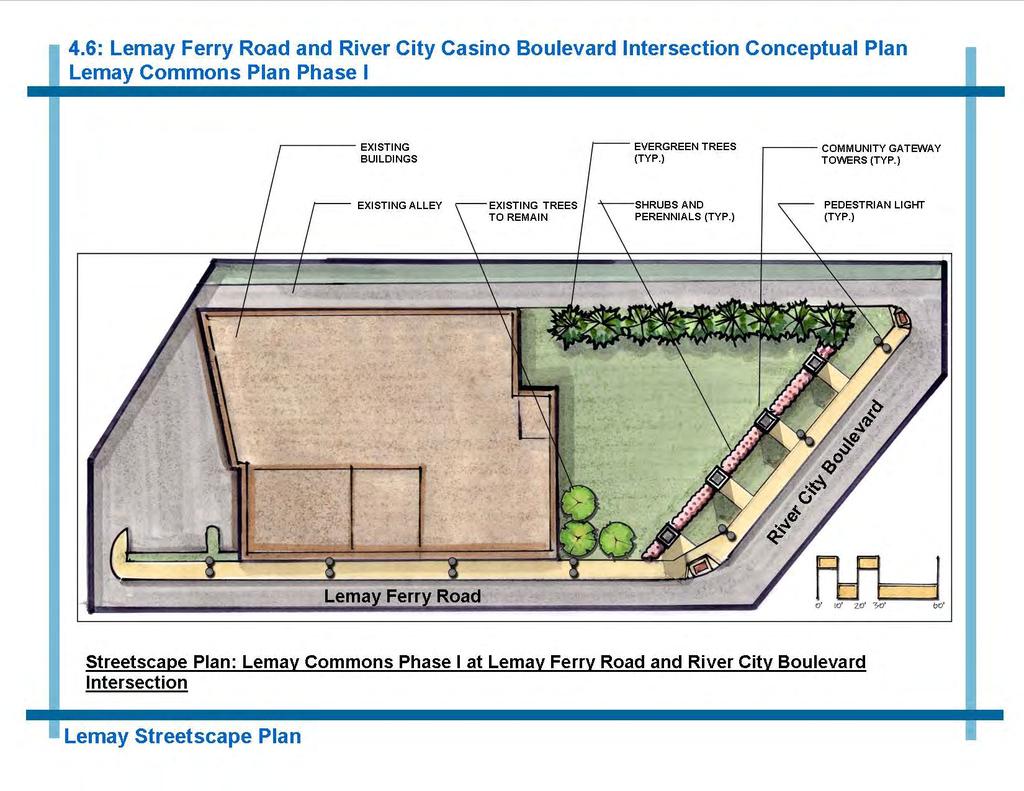
33 4.6 Lemay Ferry Road and River City Casino Boulevard Intersection Conceptual Plan The Lemay Ferry Road and River City Casino Boulevard Intersection is a key community gateway for Lemay. Lemay Ferry Road is a major north-south arterial in the community connecting neighborhoods, commercial areas and destinations. River City Boulevard and River City Casino Boulevard are the primary route from Interstate 55 to the River City Casino, bringing numerous visitors into Lemay. Adjacent to the intersection is Lemay Park and Heine Meine Baseball Park, each a recreation destination for local residents and visitors to Lemay. The existing conditions of the Lemay Ferry Road and River City Casino Boulevard Intersection are listed below: Existing conditions: View of crosswalk and Lemay Park. Each road is two lanes in each direction, with a center turn lane. Sidewalk and curbs are in very good condition at the intersection. Older sections of sidewalk and curbing south of the intersection are in fair condition. Multiple curb cuts, drive aprons, utility poles and signs create visual clutter. Trees are primarily in the park on east side of Lemay Ferry Road and in the open space in the southwest corner of the intersection. The open space area in southwest corner of the intersection is a potential gateway opportunity for civic identity. The intersection and existing structures are within the 100 year floodplain of the River Des Peres. Existing conditions: Sidewalk along Lemay Ferry Road at intersection. Proposed Streetscape Enhancements Area: Lemay Ferry Road from River City Boulevard to Fannie Avenue Install new ornamental pedestrian lights to provide visual continuity and define the vertical edge of the street. Community Gateway towers, landscaping, wayfinding sign and lighting in the southwest corner to define an entry into Lemay. The gateway is proposed to be the first phase of a new Lemay Commons open space area. Install new sidewalks, ADA ramps and curbs/gutters per MoDOT standards. Street trees to strengthen the vertical edge, and provide shade and color to the street. Curb cuts should be consolidated, where possible, to enhance pedestrian experience and create a better defined roadway edge. Existing conditions: View of intersection from crosswalk on the north side of River City Casino Boulevard. 29


34 Proposed Streetscape Enhancements Area: Lemay Ferry Road from River City Boulevard to Fannie Avenue 30
35 31

36 32


37 4.7 Broadway and River City Casino Boulevard Intersection Conceptual Plan The Broadway and River City Casino Boulevard Intersection is another community gateway opportunity at the north edge of Lemay. The intersection is bordered on the north by the River Des Peres. The intersection is an entrance into Lemay with Broadway being a major north-south road that runs through the east side of the Lemay community. The intersection is within the municipal boundary of the City of St. Louis. The existing conditions of the Broadway and River City Casino Boulevard Intersection are listed below: Each roadway has two lanes and center turn lanes, thus a wide expanse of pavement. River City Casino monument signs, trees and landscaping are on the east side of the intersection, which provide a high quality edge to the east side of the intersection. The north edge of the intersection is open space and levee of the River Des Peres Sidewalks and curbs/gutters are in good condition due to recent improvements for casino development. Existing conditions: Edge of River Des Peres along north side of River City Casino Boulevard. Proposed Streetscape Enhancements: River City Casino Boulevard from Broadway to Fannie Avenue Install new ornamental pedestrian lights to provide visual continuity and define the vertical edge of the street. Install community gateway tower in the southwest quadrant of the intersection to give civic identity and announce a gateway into Lemay. Coordinate improvements with Great Rivers Greenway District for their future proposed trail, landscaping, piers/fencing and lighting along the north edge of River City Boulevard. Coordination with the City of St. Louis will also be required for streetscape improvements in the intersection. Existing conditions: River City Casino monument sign and landscaping. Existing conditions: View to the south across River City Casino Boulevard. 33


38 Proposed Streetscape Enhancements: River City Casino Boulevard from Broadway to Fannie Avenue 34


39 4.8 Lemay Ferry Road Corridor Conceptual Plan Lemay Ferry Road is a busy arterial roadway which runs north-south through the center of the Lemay community. The Lemay Ferry Road and Bayless Avenue Intersection is in the heart of a commercial area with brand name stores and local establishments. The four way intersection has older mercantile buildings along the east side of Lemay Ferry Road and franchise buildings set back from the street on either side of Bayless Avenue. A large open space of lawn is at the northwest quadrant of the intersection. The existing conditions of the Lemay Ferry Road Corridor are listed below: Lemay Ferry Road one lane in each direction from Fannie Avenue to Bayless Avenue; south of Bayless Avenue, Lemay Ferry Road is two lanes in each direction. Sidewalks and crosswalks are in fair condition. Sidewalks, accessible ramps and curbs south of Bayless Avenue are in poor condition. Sidewalks vary in width, materials, quality and ADA compliance. There are multiple curb cuts, drive aprons, utility poles and signs. Parallel on-street parking in front of businesses on Lemay Ferry Road contribute to visual clutter and undefined street edge. Proposed Streetscape Enhancements: Lemay Ferry Road: Fannie Avenue to Cleves Avenue Bayless Avenue: Lemay Ferry Road to Pardella Avenue Install new ornamental pedestrian lights to provide visual continuity and define the vertical edge of the street. Install new sidewalks, ADA ramps and curbs/gutters per MoDOT standards. Street trees should be installed to soften the roadway, strengthen the vertical edge and provide shade and color. Spacing will vary due to curb cuts. Curb cuts should be consolidated where possible to enhance the pedestrian experience and create a more well-defined roadway edge. A wayfinding sign directing motorists to Lemay destinations should be installed in the northwest corner of the Bayless Avenue intersection, visible from east bound Bayless Avenue and in the southeast corner for northbound motorists on Lemay Ferry Road. Sign locations should be coordinated with property owners. Locations for off street parking lots should be identified with future improvements. Existing conditions: View across intersection, looking south on Lemay Ferry Road. Existing conditions: Sidewalk along west side of Lemay Ferry Road, south of intersection. Existing conditions: View of crosswalk at Bayless Avenue and open space in northwest quadrant of intersection. 35


40 Proposed Streetscape Enhancements: Lemay Ferry Road: Fannie Avenue to Cleves Avenue Bayless Avenue: Lemay Ferry Road to Pardella Avenue 36


41 4.9 Lemay Ferry Road and Telegraph Road Intersection Conceptual Plan The Lemay Ferry Road and Telegraph Road Intersection connects two major roadways in Lemay in a commercial area with a popular restaurant, food stores and a post office. These restaurants and facilities bring local residents and visitors to the area. The existing conditions of the Lemay Ferry Road and Telegraph Road intersection are listed below: Each road has two lanes in each direction, with left hand turn lanes, resulting in a large expanse of pavement. The sidewalks and curbs are in fair condition. The parkway is lawn on the east side of the road and paved on the west side of Lemay Ferry Road. The parkway area varies from paved to lawn along Telegraph Road. Sidewalks vary in width, materials, quality and ADA compliance. Multiple curb cuts and drive aprons discourage pedestrian circulation. Minimal street trees or landscaping. Existing conditions: Lawn area in southeast quadrant of the intersection. Proposed Streetscape Enhancements Area: Lemay Ferry Road: Cleves Avenue to Point Drive Telegraph Road: Lemay Ferry Road to Reavis Barracks Road Install new ornamental pedestrian lights to provide visual continuity and define the vertical edge of the street. Install new sidewalks, ADA ramps and curbs/gutters per MoDOT standards. Street trees should be installed to soften the roadway, strengthen the vertical edge, and provide shade and color to the street. Neighborhood gateway tower and landscaping should be installed at the southeast corner of the intersection. Curb cuts should be consolidated where possible to enhance the pedestrian experience and create a more well-defined roadway edge. Existing conditions: Lemay Ferry Road, showing wide expanse of pavement and no street trees. Existing conditions: View of intersection with post office in background. 37


42 Proposed Streetscape Enhancements Area: Lemay Ferry Road: Cleves Avenue to Point Drive Telegraph Road: Lemay Ferry Road to Reavis Barracks Road 38


43 4.10 Broadway Corridor Conceptual Plan The Broadway Corridor is the major north/south roadway on the east edge of Lemay. The arterial street connects with River City Casino Boulevard on the north to Kingston on the south, at the entrance to Jefferson Barracks Park. Neighborhoods, small commercial uses and the St. Louis Metropolitan Sewer District (MSD) Plant are served by the Broadway corridor. The Broadway and Hoffmeister Avenue intersection is an important focus area which serves the Hancock Place School District offices, a local church, a fraternal society and a convenience store. Hoffmeister Avenue is a local collector street which connects Broadway with Military Road and Lemay Ferry Road. The existing conditions of the Broadway Corridor are listed below: Existing conditions: Bus stop and fence along MSD property on Broadway, view to the north. Broadway varies from two lanes in each direction, with left hand turn lane on the north to one lane each direction with parallel parking on sides on the south end of the corridor towards Arlee Avenue. No sidewalk exists along the MSD property, on the east side of Broadway, although two bus stops are located along the edge. Sidewalks vary in width, materials, quality and ADA compliance. Parallel parking lanes in front of homes and businesses on Broadway contribute to visual clutter and to an undefined street edge. Proposed Streetscape Enhancements Area: Broadway: Arlee Avenue to River City Casino Boulevard Hoffmeister Avenue: Broadway to Military Road Existing conditions: Southeast corner of intersection illustrating visual clutter of signs and posts as well as lack of sidewalk. Install new ornamental pedestrian lights to provide visual continuity and define the vertical edge of the street. Install new sidewalks, ADA ramps and curbs/gutters per MoDOT standards, including along the MSD property and on Hoffmeister Avenue to Military Road. Street trees should be installed to soften the roadway, strengthen the vertical edge, and provide shade and color to the street. Landscaping at the Hoffmeister Avenue intersection will help to highlight the importance of the intersection and soften the expanse of pavement. New landscaping is proposed along the MSD property, on the Hancock Place School District parking lot, and at the intersection of Hoffmeister Avenue and Military Road. Existing conditions: View to the west on Hoffmeister Avenue showing undefined edge of street and lack of sidewalk. 39


44 Proposed Streetscape Enhancements Area: Broadway: Arlee Avenue to River City Casino Boulevard Hoffmeister Avenue: Broadway to Military Road 40


45 5.0 Streetscape The built environment, including streets and adjacent streetscapes, are a major factor of what makes up the image of a community. The elements of the street, from lighting to landscaping, help to define a street. What a pedestrian experiences along a sidewalk or what motorists view from their vehicles contributes to the identity of a community. Streetscape design utilizes various elements to provide visual continuity and beautification to the street right of way. The Lemay Streetscape Plan proposes streetscape elements for use in the focus areas and on the primary streets of Lemay to contribute to the civic identity of Lemay. The streetscape elements of this section are listed below and are illustrated on the following pages: Existing benches near the intersection of Reavis Barracks Road and Lemay Ferry Road. Streetscape Elements: 5.1 Hierarchy of Civic Identity 5.2 Signage 5.3 Gateways 5.4 Streetscape Furnishings 5.5 Street Lights 5.6 Street Trees Existing streetscape with civic identity sign near intersection of Reavis Barracks Road and Telegraph Road. The streetscape elements proposed for Lemay reflect the assets of the community: recreation and athletic facilities, natural systems, Jefferson Barracks complex and the community s commitment to education. These assets are incorporated as themes in the streetscape elements, along with stone piers and ornamental metal components. Design composition, materials, furnishings and street trees were selected for enhancing the streetscape and to minimize maintenance and nuisance issues. Infrastructure improvements, including sidewalks, curbs and gutters and parkway areas will also contribute to the streetscape composition. Parkway areas, in between curbs and sidewalks should be sodded with hardy grass species such as creeping red fescue grass, low maintenance fescue/rye mixes or buffalo grass. Limestone walls at the entrance to Jefferson Barracks Park. 41
46 5.1 Hierarchy of Civic Identity Elements 42

47 5.2 Signage 43

48 5.3 Community Gateway Towers 44
49 5.3 Community Gateway Towers 45
50 5.3 Neighborhood Gateway Towers 46

51 5.4 Streetscape Furnishings 47

52 5.5 Street Lights 48

53 5.6 Street Trees 49
54 This page intentionally left blank 50
55 6.0 Implementation The Lemay Streetscape Plan was developed to help enhance civic identity of the Lemay community. The study area encompasses major arterial roadways, local collector streets and local roads across an area which is generally accepted as Lemay. The proposed streetscape improvements will require the coordination of multiple jurisdictions, property owners and public agencies. The streetscape improvements will be constructed in phases, based on numerous factors including public support, collaboration of public agencies, developer s interest and the availability of funding and maintenance for the improvements. 6.1 Focus Area Plan Cost Estimates The conceptual cost estimates listed in this section, assign an initial value to the proposed streetscape improvements of the focus areas described in Section 4: Focus Area Plans. The conceptual cost estimates list the proposed site demolition and site improvements. The estimates also list the proposed project area limits of the streetscape enhancements, along with a brief description of the issues for each respective focus area. Further data regarding right of way boundaries, property ownership, jurisdictions, zoning regulations, permits, utilities, soils, vehicular access, safety, design standards and many other issues will need to be addressed in future design phases. These issues will impact the actual design, location and cost of construction of the proposed improvements. The cost estimates were developed per standard means and methods of construction and unit costs for the year The estimates include a contingency line item of twenty percent (20%) of construction costs as well as a mobilization line item of three percent (3%). Professional design fees for architecture and engineering were projected at eight percent (8%) of construction, for preliminary and final design services. 51
56 The Focus Area approximate cost estimates are summarized below and discussed in detail on the following pages. Focus Area Plans Cost Estimate Summary: 4.1 Telegraph Road and Kingston Drive Corridor Conceptual Plan....$2,018, Telegraph Road/Kingston Drive/Reavis Barracks Road Intersection Conceptual Plan..$438, Kingston Drive and South Broadway Intersection Conceptual Plan....$803, Ripa Avenue and Broadway Intersection Conceptual Plan....$956, I-55 and River City Boulevard Interchange Conceptual Plan....$737, Lemay Ferry Road and River City Casino Boulevard Intersection Conceptual Plan $1,590, Broadway and River City Casino Boulevard Intersection Conceptual Plan....$314, Lemay Ferry Road Corridor Conceptual Plan....$2,461, Lemay Ferry Road and Telegraph Road Intersection Conceptual Plan..$1,713, Broadway Corridor Conceptual Plan....$1,677,000 APPROXIMATE TOTAL COST $12,707,000 52

57 4.1 Telegraph Road and Kingston Drive Corridor Conceptual Plan Proposed Streetscape Enhancements Area: Telegraph Road: Alpen Rose Court to Kingston Drive Kingston Drive: Telegraph Road to South Broadway Sidewalks and curbs are in good to fair condition, except for section on Telegraph Road from Jefferson Barracks Road to Kingston Drive. New sidewalks and curb/gutter are proposed for this section of Telegraph Rd., on both sides, approximately 1,600 linear feet. Pedestrian lights are proposed on Telegraph and Kingston, with flag brackets and Lemay brand logo panel to reflect the Jefferson Barracks heritage on Telegraph. Due to curb cuts and length of project area, spacing for lights is calculated at 100 on center. Community Gateway tower, wayfindng sign and landscaping is proposed for open space area within Telegraph Road right of way near Alpen Rose Court intersection. Implementation of streetscape improvements could be conducted in two phases: - Telegraph Road: Alpen Rose Court to Kingston Drive. - Kingston Drive: Telegraph Road to South Broadway. 53
 are proposed on Telegraph Road.")
58 4.2 Telegraph Road and Kingston Drive and Telegraph Road and Reavis Barracks Road Intersections Conceptual Plan Proposed Streetscape Enhancements Area: Telegraph Road between Kingston Drive and Reavis Barracks Road New sidewalks, curb and gutter and accessible ADA ramps are proposed along Telegraph Road. Pedestrian lights (single luminaire) are proposed on Telegraph Road. Due to many curb cuts spacing of the lights vary from 60 to 80 on center. A neighborhood gateway tower and landscaping are proposed for the open space area in the northwest corner of the intersection of Telegraph Road and Kingston Drive. A wayfinding sign is proposed for the north side of Telegraph Road, visible to east and west bound traffic. 54

59 4.3 Kingston Drive and South Broadway Intersection Conceptual Plan Proposed Streetscape Enhancements Area: Broadway from Kingston Drive Intersection to Ripa Avenue New sidewalks and curb/gutter on both sides of South Broadway to Ripa Avenue. Pedestrian lights are proposed on Kingston Drive, with flag brackets and Lemay brand logo panel to reflect the Jefferson Barracks heritage on Kingston Drive. A neighborhood gateway tower and landscaping are proposed for the open space area in the northeast corner of the intersection. Street trees should be planted at the back edge of sidewalk to utilize optimum growing area for trees. Wayfinding signs should be located on either side of Kingston Drive to direct travelers into Jefferson Barracks Park. 55

60 4.4 Ripa Avenue and Broadway Intersection Conceptual Plan Proposed Streetscape Enhancements Area: Broadway: Ripa Avenue to Arlee Avenue Ripa Avenue: Linn Avenue to Clyde Avenue New sidewalks and curb/gutter on both Broadway and Ripa Avenue. Multiple curb cuts and drive access aprons need to be accommodated on Broadway. Pedestrian lights on Broadway only. Street trees on Broadway only. Benches at the intersection of Broadway and Ripa Ave. Storm sewers and storm water drainage on Ripa Avenue will need to be addressed. Future plaza area at the northwest corner of the intersection would be implemented by others. 56

61 4.5 I-55 and River City Boulevard Interchange Conceptual Plan Proposed Streetscape Enhancements Area: River City Boulevard from I-55 Interchange to Poepping Street Intersection Proposed improvements would be within the City of Saint Louis municipal boundaries. Coordination with the city would be necessary to implement the improvements as illustrated in this report. Coordination would also be required with the St. Louis Metropolitan Sewer District and the Missouri Department of Transportation for improvements within the right of way of the river levee and Interstate 55. Proposed improvements are from the interchange, east along River City Boulevard, approximately 900 linear feet. A wayfinding sign will be located near the I-55 exit ramp, to direct travelers to the east towards Lemay. 57
, in the existing open space area.")
62 4.6 Lemay Ferry Road and River City Casino Boulevard Intersection Conceptual Plan Proposed Streetscape Enhancements Area: Lemay Ferry Road from River City Boulevard to Fannie Avenue Opportunity for a community gateway at the southwest corner of the intersection of Lemay Ferry Road and River City Boulevard (Weber Road), in the existing open space area. The proposed improvements, on the north side of the intersection, would be within the City of Saint Louis municipal boundaries. Coordination with the city would be necessary to implement the improvements as illustrated in this report. Coordination would also be required with the St. Louis Metropolitan Sewer District and the Missouri Department of Transportation for improvements within the right of way of the river levee and Lemay Ferry Road. Coordination with the St. Louis County Parks department would be required for any proposed improvements within Lemay Park. Multiple curb cuts and drive access aprons along Lemay Ferry Road exist. Consolidation of curb cuts should be considered to improve pedestrian environment on Lemay Ferry Road. 58

63 4.7 Broadway and River City Casino Boulevard Intersection Conceptual Plan Proposed Streetscape Enhancements: River City Casino Boulevard from Broadway to Fannie Avenue Intersection has relatively new pavement, sidewalks and curbs due to recent improvements associated with casino development. The proposed improvements, on the north side of the intersection, would be within the City of Saint Louis municipal boundaries. Coordination with the city would be necessary to implement the improvements as illustrated in this report. Coordination would also be required with the St. Louis Metropolitan Sewer District and the Missouri Department of Transportation for improvements within the right of way of the river levee and Broadway. Coordination with the Great Rivers Greenway District will be required for their future trail on north side of River City Boulevard. Improvements may impact existing casino sign, lighting and landscaping. Coordination with casino officials will be required during implementation of the proposed streetscape improvements. Improvements would be along River City Boulevard from the Broadway intersection, primarily on the south side of the road, to Fannie Avenue, approximately 600 linear feet. 59

64 4.8 Lemay Ferry Road Corridor Conceptual Plan Proposed Streetscape Enhancements: Lemay Ferry Road: Fannie Avenue to Cleves Avenue Bayless Avenue: Lemay Ferry Road to Pardella Avenue Multiple curb cuts and drive access aprons along Lemay Ferry Road currently exist. Consolidation of curb cuts should be considered to improve pedestrian environment on Lemay Ferry Road. New sidewalks and curb/gutter on Lemay Ferry Road, especially south of Bayless Avenue to Susan Avenue is needed. South of Susan Avenue to Cleves Avenue the sidewalks are in good condition. Proposed sidewalk/curb replacement is from Waller Avenue to Bayless Avenue, east side of street only and from Bayless Avenue to Susan Avenue, both sides of Lemay Ferry Road. Wayfinding sign in the northwest quadrant of the intersection, visible from east bound traffic on Bayless Avenue and south bound traffic on Lemay Ferry Road. Issues of curb elevation, cross slopes and connection of sidewalks to adjacent buildings doors, steps and walls will need to be addressed. Storm water drainage, curbs and gutters on Lemay Ferry Road, especially south of Bayless Avenue will need to be addressed. 60

65 4.9 Lemay Ferry Road and Telegraph Road Intersection Conceptual Plan Proposed Streetscape Enhancements Area: Lemay Ferry Road: Cleves Avenue to Point Drive Telegraph Road: Lemay Ferry Road to Reavis Barracks Road New sidewalks, curbs/gutters and accessible ramps along approximately one half of Telegraph Road from Lemay Ferry Road to Reavis Barracks Road. New pedestrian street lights would only be at the intersection of Lemay Ferry Road and Telegraph Road. New street trees are proposed on both Lemay Ferry Road and Telegraph Road. A neighborhood gateway tower and landscaping is proposed at the southeast corner of the intersection. Multiple curb cuts should be consolidated where possible to improve the pedestrian environment on both Lemay Ferry Road and Telegraph Road. 61

66 4.10 Broadway Corridor Conceptual Plan Proposed Streetscape Enhancements Area: Broadway: Arlee Avenue to River City Casino Boulevard Hoffmeister Avenue: Broadway to Military Road New sidewalks, curbs/gutters and accessible ramps on Broadway is needed especially south of Hoffmeister Avenue where the right of way is very narrow and with multiple cross streets. Lack of street trees and landscaping is very evident in the existing conditions of the intersection. Landscaping of trees and shrubs along the MSD property to screen the sewage treatment facility. New sidewalk along the MSD property and on Hoffmeister Avenue to provide better pedestrian connectivity in the corridor. Install new landscaping and trees on the north edge of the Hancock Place School District Administration Building parking lot. New pedestrian street lights would only be from River City Casino Boulevard to Hoffmeister Avenue and at the intersection. 62
Table of Contents. Elm Avenue Improvement Plan City of Waco, Texas. Introduction 1. Existing Context 1 Figure 1 2.
 Table of Contents Introduction 1 Existing Context 1 Figure 1 2 Plan Guidelines 3 Future Urban Form 4 The West-End 4 Main Street 6 The East-End 7 Figure 2 9 Public Improvement Recommendations 7 General
7Page 91 CLEMMONS COMMUNITY COMPASS 7 COMMUNITY CHARACTER
 7 Community Character The beauty of Clemmons won t necessarily be a reflection of our past, but our future. This quote from Comprehensive Plan Steering Committee member Wayne Dodson captures the essence
V. Vision and Guiding Principles
 V. Vision and Guiding Principles The Master Plan for the Powers Ferry Corridor seeks a foundation in the desires of the community. At times, various elements of the community offered opposing viewpoints,
SECTION II SECTION II STATEMENT OF GOALS, OBJECTIVES, PRINCIPLES, ASSUMPTIONS, POLICIES AND STANDARDS
 STATEMENT OF GOALS, OBJECTIVES, PRINCIPLES, ASSUMPTIONS, POLICIES AND STANDARDS 1 2 STATEMENT OF GOALS, OBJECTIVES, PRINCIPLES, ASSUMPTIONS, POLICIES AND STANDARDS INTRODUCTION The New Jersey Municipal
The Lower SaLuda Greenway
 The Lower SaLuda Greenway InITIaTIve a FLourIShInG Greenway. a hub For economic GrowTh. a ConneCTIon BeTween CoMMunITIeS. In April 2017 the Michael J. Mungo Foundation and Lexington County commissioned
Hockessin Community Redevelopment Plan
 Hockessin Community Redevelopment Plan 3.1 Introduction The Community Redevelopment Plan for the Village of Hockessin is the result of the people s vision for a distinct village center that serves as the
Potential Green Infrastructure Strategies May 6, 2015 Workshop
 Potential Green Infrastructure Strategies May 6, 2015 Workshop Background The City of Cortland is developing the Tioughnioga Urban Headwaters Green Infrastructure Action Plan with funding from the National
A. Background Summary of Existing Challenges and Potential Possibilities. 1. Summary of Existing Assets and Potential Opportunities
 A. Background 1 A Main Street Master Plan Study was performed and completed in October of 2007. The study was initiated to review current land uses and development patterns along Main Street, from Parrish
COMMUNITY DESIGN. GOAL: Create livable and attractive communities. Intent
 COMMUNITY DESIGN Intent An attractive, well-designed County will attract quality development, instill civic pride, improve the visual character of the community, and create a strong, positive image for
Planning Districts INTRODUCTION
 INTRODUCTION To facilitate detailed examination of development prospects for all areas of the community, Delano has been divided into 14 planning districts. The location of these planning districts is
Open House RIVER DES PERES GREENWAY: LANSDOWNE SHREWSBURY METROLINK TO FRANCIS R. SLAY PARK
 Open House 10.12.16 RIVER DES PERES GREENWAY: LANSDOWNE SHREWSBURY METROLINK TO FRANCIS R. SLAY PARK MEETING AGENDA Great Rivers Greenway and Project Partners River des Peres Greenway Overview Project
Public input has been an important part of the plan development process.
 Lakewood s Comprehensive Plan recognizes that transportation helps shape the community, and that the way the community provides for the safe and efficient movement of people affects the character of the
V. Gateways GATEWAYS / V-1
 V. GATEWAYS / V-1 Many of Chesapeake s gateways are located on highways and call for bold and attractive designs that motorists can understand, appreciate, and enjoy. can also take the form of natural
Urban Design Brief December 23, 2015 Southside Construction Group Official Plan & Zoning By-Law Amendment
 Urban Design Brief Proposed Official Plan & Zoning By-Law Amendment 3244, 3263 and 3274 Wonderland Road South Southside Group December 23, 2015 TABLE OF CONTENTS Page No. INTRODUCTION... 1 SECTION 1 LAND
CHAPTER 3 VISION, GOALS, & PLANNING PRINCIPLES. City of Greensburg Comprehensive Plan. Introduction. Vision Statement. Growth Management Goals.
 CHAPTER 3 VISION, GOALS, & PLANNING PRINCIPLES Introduction The Greensburg Comprehensive Plan is intended as a working community document. A combination of long and short-term goals, this document is intended
City of Farmington. Downtown Plan. Amendment to the 1998 Master Plan Adopted October 11, 2004
 City of Farmington Amendment to the 1998 Master Plan Adopted October 11, 2004 Introduction Planning Background 1 Scope and Components of the Plan Amendment 2 Concept Introduction 3 Plan Concepts 3 Conceptual
URBAN DESIGN BRIEF URBAN DESIGN BRIEF 721 FRANKLIN BLVD, CAMBRIDGE August 2018
 URBAN DESIGN BRIEF URBAN DESIGN BRIEF 721 FRANKLIN BLVD, CAMBRIDGE August 2018 DESIGN BRIEF CONTENTS PART A 1.0 INTRODUCTION 2.0 DESCRIPTION & ANALYSIS OF SITE CONTEXT 3.0 DESIGN CONSTRAINTS AND OPPORTUNITIES
BROOKLYN PARK / 85TH AVE LRT STATION CDI DEVELOPMENT GUIDELINES DRAFT
 August 2018 Page intentionally left blank The Brooklyn Park Library adjacent to the 85th Ave LRT Station Area. OVERVIEW The Blue Line LRT Extension / Bottineau corridor offers a unique opportunity to leverage
Urban Design 9Identity
 Urban Design 9Identity URBAN DESIGN IDENTITY Urban design is about connecting people to their places through the built environment, nature, and overall urban form. Done well, it creates a memorable space
Draft Memorandum #1: Goals and Vision for Revitalization
 Keizer Revitalization Plan Draft Memorandum #1: Goals and Vision for Revitalization Submitted to: City of Keizer April 12, 2018 (revised) Prepared By: Angelo Planning Group and Otak, Inc. Project No. 17482.A
C. Westerly Creek Village & The Montview Corridor
 C. Westerly Creek Village & The VISION Community Vision When the goals of the city are achieved Westerly Creek Village, a distinctive community defined by Montview Boulevard and Westerly Creek, is a strong
REGIONAL ACTIVITY CENTER
 DRAFT REGIONAL ACTIVITY CENTER 70 EAST BENCH MASTER PLAN DRAFT 06 Introduction The East Bench Regional Activity center is comprised of large educational, research, medical, and employment centers. These
4. INDUSTRIAL 53 CASTLE ROCK DESIGN
 4. INDUSTRIAL 53 CASTLE ROCK DESIGN CASTLE ROCK DESIGN 54 4. INDUSTRIAL Overview Well-designed and attractive industrial centers are the product of blending economic realities with both functional and
Implementation Guide Comprehensive Plan City of Allen
 Implementation Guide 2030 Comprehensive Plan City of Allen DRAFT 2015 Implementation Guide Allen 2030 Comprehensive Plan INTRODUCTION The Comprehensive Plan serves as a guide for the growth and development
Appendix A COMMUNITY IMPROVEMENT PLAN DESIGN GUIDELINES
 Appendix A COMMUNITY IMPROVEMENT PLAN DESIGN GUIDELINES INTRODUCTION The continuous and desirable improvement of Arnprior requires a clear understanding of what is envisioned for the Town. These Design
Lambeth Main Street Streetscape Improvements
 Lambeth Main Street Streetscape Improvements Open House October 5th, 2017 Agenda 1. Introduction 2. Project Background 3. Context 4. Project Objectives 5. Design Principles & Approach 6. Streetscape Design
LUNDY S LANE COMMUNITY IMPROVEMENT PLAN STUDY
 PUBLIC INFORMATION MEETING #2 October 12, 2016 LUNDY S LANE COMMUNITY IMPROVEMENT PLAN STUDY AGENDA 5:00 to 5:30pm: Open House 5:30 to 6:15pm: Presentation 6:15 to 7:00pm: Individual paced workshop with
Chapter 1: Introduction
 Chapter 1: Introduction The Penn Avenue Community Works Corridor Vision and Implementation Framework presents an integrated communitybased vision and a coordinated, long-term implementation framework for
Pedestrian and Bike Bridge LOGO
 6.2.2 Pedestrian and Bike Bridge The proposed pedestrian and bike crossing re-envisions the existing bridge at Pismo Creek on Cypress Street. The bridge is currently underutilized by vehicular through
Community Design Plan
 Gardena General Plan 2006 Authority While the is not a required element of a General Plan, it is included because improving the community appearance and image is paramount to the overall quality of life
section five BEAUTIFICATION PLAN
 section five BEAUTIFICATION PLAN BEAUTIFICATION PLAN Section Five Beautification Plan The goal of the Beautification Plan is to improve the Route 8-Sunnyland Corridor in terms of aesthetics and to create
U n i v e r s i t y o f S o u t h C a r o l i n a A i k e n. Land Plan Study
 U n i v e r s i t y o f S o u t h a r o l i n a A i k e n Land Plan Study 06.27.2008 Goals ampus Growth Develop a Land Plan that allows for the orderly expansion of the campus over the next ten years and
Urban Design Brief Fanshawe Park Road. Competition Toyota
 Urban Design Brief 1300 Fanshawe Park Road Competition Toyota May 2, 2014 TABLE OF CONTENTS Page No. INTRODUCTION... 1 SECTION 1 LAND USE PLANNING CONTEXT... 1 1.1 The Subject Lands... 1 1.2 The Proposal...
URBAN DESIGN BRIEF. 2136&2148 Trafalgar Road. Town of Oakville
 URBAN DESIGN BRIEF 2136&2148 Trafalgar Road Town of Oakville Prepared By: METROPOLITAN CONSULTING INC For 2500674 Ontario Inc November 2016 TABLE OF CONTENTS Page No. 1.0 Introduction/Description of Subject
The Lincoln Neighborhood Corridor Plan. The LiNC
 October 1, 2014 Planning Commission Study Session The Lincoln Neighborhood Corridor Plan The LiNC Purpose of Tonight s Meeting Introduction to The LiNC Review of Existing Conditions and Community Identified
DRAFT MAJOR CORRIDORS 48 EAST BENCH MASTER PLAN
 DRAFT MAJOR CORRIDORS 48 EAST BENCH MASTER PLAN DRAFT 05 Introduction Foothill Drive, Parley s Way, Sunnyside Avenue and 1300 East serve as thoroughfares into the City and are important pieces in the regional
Olde Towne Vision Plan
 Olde Towne Vision Plan Introduction In 2016, the City of Bellevue will complete its move of City offices from Olde Towne Bellevue to its new municipal complex on Wall Street. The City intends to sell its
Volume 2: Implementation Plan
 Volume 2: Implementation Plan February 25 th 2002 Implementation Introduction This document outlines the steps that should be taken to implement the Washington Heights Neighborhood Plan. The City Council
CHAPTER 8 ISSUES, CONCERNS, CONSTRAINTS AND OPPORTUNITIES
 CHAPTER 8 ISSUES, CONCERNS, CONSTRAINTS AND OPPORTUNITIES Introduction This River Conservation Plan was developed during a time of tremendous activity and effort in planning the transformation of the Delaware
The transportation system in a community is an
 7 TRANSPORTATION The transportation system in a community is an important factor contributing to the quality of life of the residents. Without a sound transportation system to bring both goods and patrons
I-70 Corridor Enhancement Plan
 i - Table of Contents Table of Contents Chapter I Overview Chapter II Bridge and Roadway Improvements Chapter III Landscape Enhancements Chapter IV Riparian Corridors Chapter V Showcase Missouri Plan Chapter
THEMES, VISION, + PRINCIPLES
 CHAPTER 2: THEMES, VISION, + PRINCIPLES This page intentionally left blank. 20 VISION DRAFT AUGUST 2018 2 2 THEMES, VISION, + GUIDING PRINCIPLES The Key Themes, Vision, and Guiding Principles presented
A Vibrant Downtown. Chapter 5 Cary Public Art Opportunities 31
 A Vibrant Downtown Cary s vision for Downtown is a unique, vibrant, dynamic, pedestrian friendly location; a regional destination and a place to live, work, and recreate, according to the 2001 Town Center
Small Area Plan. South Gateway
 Small Area Plan Adopted May 12, 2008 South Gateway Purpose. The South Gateway Small Area Plan defines the City s expectations for the future of the southern entrance to the City at Interstate 85 and Highway
Hamilton Road Corridor Streetscape Master Plan. Open House October 4 th, 2017
 Hamilton Road Corridor Streetscape Master Plan Open House October 4 th, 2017 Agenda 1. Introductions Agenda Overview 2. Project Background 3. Existing Conditions 4. Strengths, Weaknesses, Opportunities
Tel: (705) Fax: (705)
 Fax: (705)") 521 and 525 Essa Road City of Barrie Tel: (705) 812-3281 Fax: (705) 812-3438 Email: INFO@IPSCONSULTINGINC.com 1 5 0 D U N L O P S T R E E T E A S T, S U I T E 2 0 1, B A R R I E O N T A R I O L 4 M 1 B
521 and 525 Essa Road City of Barrie Tel: (705) 812-3281 Fax: (705) 812-3438 Email: INFO@IPSCONSULTINGINC.com 1 5 0 D U N L O P S T R E E T E A S T, S U I T E 2 0 1, B A R R I E O N T A R I O L 4 M 1 B
In surveys, Dallas residents say what they want to change most
 NEIGHBORHOODS ELEMENT In surveys, Dallas residents say what they want to change most in the city is its appearance they want it to look beautiful, with trees and pedestrian-friendly neighborhoods. The
Today Land & People. Northeast Nampa Gateway District. Employment. Land Use Characteristics. Demographics. Current Zoning
 Today Land & People Employment Major employers include Saint Alphonsus, the College of Western Idaho, the Auto Mall, Sorrento Lactalis and Walmart. 3,004 jobs in 2010 (COMPASS-CIM 2040 TAZ data) 4,345
ARLINGTON COUNTY, VIRGINIA
 ARLINGTON COUNTY, VIRGINIA County Board Agenda Item Meeting October 15, 2005 DATE: September 28, 2005 SUBJECT: Request to Advertise the adoption of the 2005 Clarendon Sector Plan C. M. RECOMMENDATION:
CHAPTER 6: Community Design and Appearance
 AGLE AREA COMMUNITY Plan CHAPTER 6 CHAPTER 6: Community Design and Appearance Community Design and Appearance How a community is designed and what a community looks like are attributes fundamental to the
Fifth and Detroit Street Design May 2017 Capital Improvements Committee. DOWNTOWN Street Design
 1 Fifth and Detroit Street Design May 2017 Capital Improvements Committee Agenda 2 Review Street Configuration Prior Meeting Review Outreach Synopsis Functional Street Design Refinements Curb Edge, Turning
I-35 CORRIDOR VISION PLAN INTRODUCTION. Purpose. Background
 INTRODUCTION Purpose The Interstate 35-E Corridor Plan is intended to work conjunctively with the 2010 Red Oak Comprehensive Plan to promote positive and quality development and redevelopment along Interstate
Lower Merion Commercial Districts Issues and Characteristics Handbook November 2013
 Lower Merion Commercial Districts Issues and Characteristics Handbook November 2013 DRAFT TOWNSHIP-WIDE VISION: To maintain and enhance commercial areas to complement the surrounding high-quality residential
BUILDING SCALE AND SETBACKS 5 ELEMENTS:... 5 FAÇADES (COMMERCIAL/RESIDENTIAL) 5
 5") VISION STATEMENT 3 UTILIZATION OF THE GUIDELINES 3 IMPLEMENTATION 3 PROCEDURES FOR DESIGN REVIEW 3 LAND USE AND ZONING 4 LAND USE 4 ELEMENTS:... 4 ZONING 4 ELEMENTS:... 4 BUILDING SCALE AND SETBACKS 5
VISION STATEMENT 3 UTILIZATION OF THE GUIDELINES 3 IMPLEMENTATION 3 PROCEDURES FOR DESIGN REVIEW 3 LAND USE AND ZONING 4 LAND USE 4 ELEMENTS:... 4 ZONING 4 ELEMENTS:... 4 BUILDING SCALE AND SETBACKS 5
LAND USE AMENDMENT DOWNTOWN COMMERCIAL CORE (WARD 7) MACLEOD TRAIL SE AND 5 AVENUE SE BYLAW 254D2017
 MACLEOD TRAIL SE AND 5 AVENUE SE BYLAW 254D2017") Page 1 of 10 EXECUTIVE SUMMARY This Land Use Amendment application seeks to redesignate a full downtown block (currently the YWCA site) from a Direct Control based on the CM-2 District (Land Use Bylaw
Page 1 of 10 EXECUTIVE SUMMARY This Land Use Amendment application seeks to redesignate a full downtown block (currently the YWCA site) from a Direct Control based on the CM-2 District (Land Use Bylaw
BUSINESS DISTRICT DESIGN GUIDELINES
 Des Plaines, Illinois Prepared for the City of Des Plaines by: The Lakota Group Laurie Marston, AICP March 2005 Section 5: Streetscape Elements Business District Design Guidelines STREETSCAPE ELEMENTS
PUBLIC RIGHT-OF-WAY IN THIS CHAPTER PUBLIC REALM
 PUBLIC RIGHT-OF-WAY This section provides design guidelines for improvements in the public right-of-way. The public right-of-way refers to streets, sidewalks, non-vehicular thoroughfares, parks and greenways
Arlington, Virginia is a worldclass
 EXECUTIVE S U M M A RY Arlington maintains a rich variety of stable neighborhoods, quality schools and enlightened land use policies, and received the Environmental Protection Agency s highest award for
STAFF REPORT Agenda Item: J.4 To: Mayor and City Council Date:
 STAFF REPORT Agenda Item: J.4 To: Mayor and City Council Date: 2-14-2007 Thru: Charles McNeely, City Manager Subject: Staff Report: Approval of a project to be submitted for the NDOT 2007-2009 Landscape
New-Cast Mixed-use Development Proposal King Street West, Newcastle, Ontario
 URBAN DESIGN BRIEF New-Cast Mixed-use Development Proposal King Street West, Newcastle, Ontario TABLE OF CONTENTS: 1.0 Executive Summary 2.0 Creating Vibrant and Sustainable Urban Places: Excerpts from
124 Subarea Visions. Vision Plan. A. Nelessen Associates, INC I Visioning I Planning I Urban Design
 Subareas 124 Subarea Visions The next seven sections describe specific recommendations tailored to each subarea. Each subarea is discussed separately except for certain aspects of 95th Street and Antioch
The open space system should provide connective elements, relate to natural resources, and enhance the suburban character of the landscape..
 The open space system should provide connective elements, relate to natural resources, and enhance the suburban character of the landscape.. Mixed-use and infill development should maintain or enhance
the village at market creek
 the village at market creek executive summary october 2012 i ii introduction The Village at Market Creek is primed to grow into one of San Diego s most lively, multi-cultural arts destinations. Our community
VEHICULAR AND PEDESTRIAN CIRCULATION
 This perspective sketch communicates the intended character and quality of a proposed streetscape design. Locate benches near a major intersection where people tend to gather. Seating and lighting provide
ATTACHMENT A. SILVERDALE DESIGN STANDARDS Amendments to the Waaga Way Town Center Chapter
 ATTACHMENT A SILVERDALE DESIGN STANDARDS Amendments to the Waaga Way Town Center Chapter Chapter 10. Waaga Way Town Center 10.1 Physical Identity Elements & Opportunities The Waaga Way Town Center includes
PROPOSED REDEVELOPMENT OF THE GLEN ABBEY GOLF CLUB. STREETSCAPE DESIGN STUDY (excerpt from the Urban Design Brief) TOWN OF OAKVILLE.
 TOWN OF OAKVILLE.") PROPOSED REDEVELOPMENT OF THE GLEN ABBEY GOLF CLUB STREETSCAPE DESIGN STUDY (excerpt from the Urban Design Brief) TOWN OF OAKVILLE OCTOBER, 2016 for 2.4.2 STREETS Streets are the single largest component
PROPOSED REDEVELOPMENT OF THE GLEN ABBEY GOLF CLUB STREETSCAPE DESIGN STUDY (excerpt from the Urban Design Brief) TOWN OF OAKVILLE OCTOBER, 2016 for 2.4.2 STREETS Streets are the single largest component
Corridor Identity. Section 9. Introduction. Corridor Guiding Principles
 Corridor Identity An attractive and healthy community is a critical element of a quality place, and the design of quality places is a balance between environmental, economic, and social considerations.
Clairtrell Area Context Plan
 Clairtrell Area Context Plan March 2005 Urban Development Services City Planning Contents 1. Introduction... 4 2. Development Structure... 6 2.1 Streets... 7 2.1.1 Sheppard Avenue and Bayview Avenue...
CHAPTER FIVE COMMUNITY DESIGN
 CHAPTER FIVE COMMUNITY DESIGN CHAPTER FIVE - COMMUNITY DESIGN Assumptions Frazier Park and Lebec have historically developed according to different patterns of spatial form. While both communities are
Public Art Plan. We have elected to submit Public Art Plans before or concurrently with the CSP Submittal per the FDP Manual
 Public Art Plan The intent of the Horizon Uptown Public Arts Program is to create great places that engage the community and leverage the neighborhood development and economic vitality. The Horizon Uptown
Chapter 7: Streetscape & Design Elements
 OVERVIEW Chapter 7: Streetscape & Design Elements During the public input phase of The Dixie Fix, the area of streetscape generated much interest. While safety and traffic flow are primary objectives of
DEVELOPMENT CONTROLS MEDICAL DISTRICT
 6.01. GENERAL DESIGN GUIDELINES A. Site Planning B. Architectural Design C. Medical Facility Signage & Lighting D. Exhibit 48. ARCHITECTURAL DESIGN CONCEPTS 6.02. MEDICAL FACILITY STANDARDS & GUIDELINES
FUTURE LAND USE ELEMENT
 FUTURE LAND USE ELEMENT GOAL I: To create and sustain a great place to live, play, and prosper Objective 1: The City of Ocala shall incorporate the principles and strategies of the Ocala 2035 Vision into
URBAN DESIGN BRIEF 305, 309, & 315 SOUTHDALE ROAD WEST LONDON ONTARIO
 URBAN DESIGN BRIEF 305, 309, & 315 SOUTHDALE ROAD WEST LONDON ONTARIO CARVEST PROPERTIES LTD. December 2013 Section 1 - Land Use Planning Context 1.1 Subject Lands The subject lands are located immediately
Corridor Vision. 1Pursue Minnehaha-Hiawatha Community Works Project. Mission of Hennepin County Community Works Program
 1Pursue Minnehaha-Hiawatha Community Works Project Minnehaha-Hiawatha Community Works is a project within the Hennepin Community Works (HCW) program. The mission of the HCW program is to enhance how the
Corridor Enhancements
 Corridor Enhancements Safety is MoDOT s first priority in widening and rebuilding I-70 across the state of Missouri. MoDOT also understands that the interstate - and its interchanges and overpasses - are
DRAFT Civic Center Station Area Plan. Executive Summary
 DRAFT Civic Center Station Area Plan Executive Summary This project is funded in part through the Metropolitan Transportation Commission s Station Area Planning Program. The preparation of this report
Robbinsdale LRT Station. CDI Development Guidelines. August Overview
 Robbinsdale LRT Station August 2018 Overview The City of Robbinsdale may have the coolest opportunity site along the 13 mile stretch of the Bottineau LRT corridor / Blue Line extension. Located a block
Downtown Streetscape Manual & Built Form Standards
 City of Guelph Downtown Streetscape Manual & Built Form Standards July 2014 Prepared by Brook McIlroy Inc. in association with Unterman McPhail Associates and McCormick Rankin Inc. City of Guelph Downtown
6. DOWNTOWN. The Downtown Element focuses on supporting and expanding the vitality and enhancement of Downtown Chico as the City s central core.
 VISION In 2030, Downtown Chico is the heart of the community and the center of cultural activity. Engaging and active at the street level, it is a multi-story, mixed-use hub, with specialty retail, restaurants,
appendix and street interface guidelines
 appendix five: building and street interface guidelines appendix 5 building and street interface guidelines BOULEVARDS Boulevards are generally characterized by higher levels of traffic movement at higher
Corridor Transformation Strategy
 Corridor Transformation Strategy County Road 22 Special Planning Area Design Guidelines January 2012 D14-06017 Corridor Transformation Strategy County Road 22 Special Planning Area Corridor Design Guidelines
RESOLUTION NO R
 e e RESOLUTION NO R04 0054 BE IT RESOLVED by the Mayor and City Council ofthe City ofpapillion that The Papillion Comprehensive Plan is hereby amended to incorporate the Option A Future Land Use Map Transportation
Appendix D North Road/N. Leroy Street Subarea Plan
 North Road/N. Leroy Street Subarea Plan INTRODUCTION The City of Fenton Master Plan was updated in 1996 and included a subarea plan for the North Leroy Street area of the City. It was recognized at that
Neighborhood Districts
 NEIGHBORHOOD DISTRICTS SEVEN MAIN DISTRICTS Neighborhood Districts While the Development Plan provides a broad-scale overview of the neighborhood, this section focuses on uses and relationships at the
People who are members of historically disenfranchised racial, ethnic, cultural, and other identity groups are encouraged to apply.
 CALL TO ARTISTS REQUEST FOR QUALIFICATIONS CITY OF TACOMA MUNICIPAL ART PROGRAM East 64 th Streetscape, Tacoma, WA APPLICATION DEADLINE October 10, 2018, 11:59pm BUDGET $72,000, all-inclusive SUMMARY The
New York Avenue Streetscape and Trail Project Public Meeting #1 Summary
 New York Avenue Streetscape and Trail Project Public Meeting #1 Summary I. King Jordan Student Academic Center (SAC) Gallaudet University, Washington, DC February 23, 2017 Table of Contents 1.0 Introduction...
4.1.3 LAND USE CATEGORIES
 4.1.3 LAND USE CATEGORIES a. City Center District The City Center District incorporates the existing character and mix of uses in downtown Belmont to encourage redevelopment and new development in keeping
Mark-up of the effect of the proposed Bronte Village Growth Area OPA No.18 on the text of section 24, Bronte Village, of the Livable Oakville Plan
 Mark-up of the effect of the proposed Bronte Village Growth Area OPA No.18 on the text of section 24, Bronte Village, of the Livable Oakville Plan Notes: This document is provided for information purposes
NEIGHBORHOOD DESIGN ELEMENT
 NEIGHBORHOOD DESIGN ELEMENT INTRODUCTION The following recommendations constitute an urban design oriented "neighborhood analysis" of Plantation. It is an optional Comprehensive Plan Element. The five
Campus Sign Plan. Adopted by the Campus Planning Committee Adopted: June 26, 2006 Revised: April 14, 2016
 Campus Sign Plan Adopted by the Campus Planning Committee Adopted: June 26, 2006 Revised: April 14, 2016 INTRODUCTION Oregon State University requires an effective system of visual communication that projects
WEST LOOP DESIGN GUIDELINES CHECKLIST
 WEST LOOP DESIGN GUIDELINES CHECKLIST Section 1.0 General Strategies 1.1 DESIGN EXCELLENCE: ENCOURAGE HIGH QUALITY AND INNOVATIVE DESIGN OF NEW BUILDINGS WITHIN THE WEST LOOP WITHOUT BEING PRESCRIPTIVE
GUIDING PRINCIPLES IN THIS CHAPTER
 GUIDING PRINCIPLES The guiding principles and design concepts in this chapter work together with the Chapel Hill 2020 Comprehensive Plan to support new public places that can be enjoyed by all while also
CITY OF COLWICH COMPREHENSIVE PLAN LAND USE LAND USE 1
 LAND USE LAND USE 1 WHAT YOU WILL FIND IN THIS CHAPTER: Discussion of today s conditions and tomorrow s projections Discussion of challenges and opportunities Discussion of the environmental quality goals,
RESEDA - WEST VAN NUYS COMMUNITY PLAN
 RESEDA - WEST VAN NUYS COMMUNITY PLAN Executive Summary As part of the initial outreach effort, the Department of City Planning hosted two workshops for the Reseda-West Van Nuys Community Plan Area during
NEIGHBORHOOD 3: UNIVERSITY EDGE
 NEIGHBORHOOD 3: UNIVERSITY EDGE Aerial View of North Indiana Avenue EXISTING CHARACTER The University Edge neighborhood represents the primary town/gown interface between the campus and the city of Bloomington,
DRAFT. October Wheaton. Design Guidelines
 October 2011 DRAFT Wheaton Design Guidelines 2 Draft - Design Guidelines - Wheaton Sector Plan Contents 04 Section 1: Introduction 06 Section 2: Context 08 Section 3: Design Guidelines 09 Goal 1: Create
CHAPTER 7: VISION AND ACTION STATEMENTS. Noble 2025 Vision Statement
 CHAPTER 7: VISION AND ACTION STATEMENTS This chapter presents the vision, policy and action statements that transform the comprehensive planning study, an analysis of Noble s past, future trends and community
CHAPTER 5 Public Realm Improvements
 5.1 OVERVIEW This chapter focuses on the public realm, that is, spaces within and directly adjacent to public rights-of-way (ROWs), including streets, Oso Creek, the rail corridor, and the freeway edge.
COMPLETE GREEN STREET CHECKLIST
 COMPLETE GREEN STREET CHECKLIST This document was developed to dissect the structure of an urban street and explore opportunities to make our streets more complete while also integrating green street strategies.