Access Management and Site Plan Review. Robert W. Hofrichter Asst Administrator, Transportation and Mobility Planning Division April 2014
|
|
|
- Cathleen Marsh
- 6 years ago
- Views:
Transcription
1 Access Management and Site Plan Review Robert W. Hofrichter Asst Administrator, Transportation and Mobility Planning Division April 2014
2 Access Management 2
3 Access Management What is Access Management? Managing Location, Number, Spacing, and Design of Entrances to highways Intersections and median openings Traffic signals Goal is to Preserve safety Preserve capacity Provide appropriate access to property AM Regulations and Standards replaced Minimum Standards of Entrances to State Highways For VDOT Principal Arterial Highways in 2008 For all other VDOT highways in


4 Access Management: Research Findings 74% of crashes at driveway connections involve left turns Making a U-Turn at an intersection is 25% safer than a left turn across highway lanes 4

5 Access Management Techniques: Geography Location Determines sight distance Can be used to reduce conflict points Number and Spacing Separates decision points Improves signal operation Simplifies driving task 5
")

6 Access Management Techniques: Design Turn Lane Removes slowing vehicles from main line (limits speed differential) Entrance width Simplifies driving task Throat length Keeps queues from impacting main line Median Reduces conflict points 6
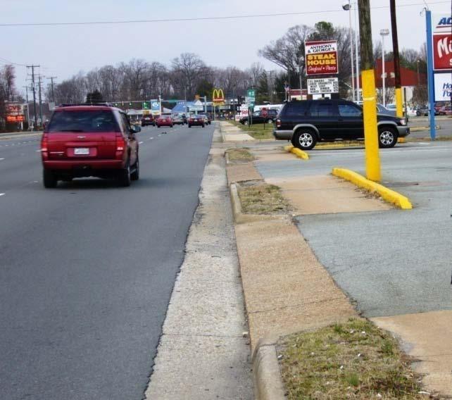
7 Access Management Regulations: Entrance Types Different Entrance Types Have Different Requirements Private Entrance Up to 2 residences, access to fields, or utility site generating up to 10 trips per day No set sight distance required ( best possible ) Normally gravel entrance (paved in C&G sections) Low Volume Commercial Entrance Not a private entrance but serves up to 50 trips per day (or five single family homes) Stopping sight distance required * Normally gravel entrance (paved in C&G sections) Commercial Entrance Expected to handle more than 50 trips per day Intersection sight distance required Normally 30 paved entrance 7
 Exception Traffic engineering study shows no safety or")
 Exception Physical constraints such as topography, environmental issues, hazardous land uses")

8 Access Management Regulations Commercial Entrances Entrances Not Permitted within Functional Area of Intersection (24VAC C 1) Exception Traffic engineering study shows no safety or operational impacts Cross-parcel Connections to Adjoining Undeveloped Properties (24VAC C 1) Exception Physical constraints such as topography, environmental issues, hazardous land uses Shared Entrances 24VAC C 2 Exceptions If adjoining property owner will not agree provide written evidence Physical constraints such as topography, environmental issues, hazardous land uses 8
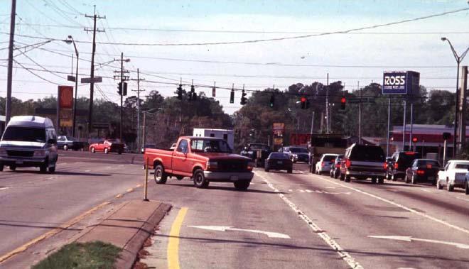
9 Appendix F, Road Design Manual Corner Clearance on Minor Side Street Keep Entrances Away from Intersection to Reduce Congestion & Enhance Safety Downstream (Top to Bottom): Separate (C) from entrance turning movements (A) by 225 ft (20 mph intersection sight distance) Upstream (Bottom to Top): 225 ft plus width (W) of major street right turn lane or length of queue (D) to protect E, B, F turning movements 9
 Needed to meet SSAR connectivity requirements Insufficient frontage")
10 Access Management Standards Entrance Spacing (Appendix F Table 2-2) Exceptions: Plan or proffer setting location of entrance approved prior to AM regulations Under approved access management corridor plan Within established business corridor Within urban development area (or VDOT/locally adopted Multimodal Activity Center) Needed to meet SSAR connectivity requirements Insufficient frontage available 10
11 Access Management Standards Moderate Volume Commercial Entrance (Appendix F) 11
12 Access Management Standards Entrance Design Details (Appendix F) Shoulder Section Curb & Gutter Section 12

13 Site Plans 13
14 VDOT Involvement in Land Development Authorized by Titles 15.2 and 33.1 of the Code of Virginia Comprehensive plans and amendments Provide assistance with transportation plan (at request of locality ) Review proposal (at request of locality or if TIA regulations triggered or if Transportation Plan involved ) Review official map (required for counties that have official map ) Zoning Review proposals (at request of locality or if Ch. 527 triggered ) Site plans Review proposals (at request of locality and ) Subdivisions Review of preliminary plats (at request of locality ) Review and approval (required for streets intended for state maintenance or others at request of locality ) Entrances Review and approval (required through ) 14
15 VDOT Involvement in Land Development VDOT s Land Development Regulations Traffic Impact Analysis (Chapter 527) Provide traffic information on land use proposals Secondary Street Acceptance Requirements Requirements for streets to be accepted by VDOT Access Management Regulate entrances/connections to state highways Land Use Permits Regulate activities allowed to occur on highway R/W 15
16 VDOT Involvement in Land Development Local Authority and VDOT Authority Overlap Design standards for streets Minimum standards in Appendix A & B(1) of Road Design Manual Locality may adopt more strict standards for subdivisions Locality may adopt alternate standards based upon Appendix B(2) Erosion control Work within R/W VDOT control (land use permits) Work outside R/W local control (streets prior to acceptance) Community signing Within R/W local approval and VDOT land use permit Outside R/W VDOT OA control and local approval 16
17 Who at VDOT Reviews Site Plans Land Use Section Leaders (Lynchburg District Office) Gerry Harter Acting Transportation and Land Use Director Jeff Kessler Area Land Use Engineer Ken Carlton Area Land Use Engineer Joe Craddock Area Land Use Engineer Harley Joseph Area Land Use Engineer Rick Youngblood District Planner Other Sections As Needed District Location & Design Regional Traffic Engineering District Structure & Bridge 17
18 Site Plans: What is VDOT Looking For? Specifics Depend Upon Purpose Site plan with entrances to VDOT highway Site plan/plat creating streets to be part of state system Other In General Safety Sight distance Speed Conflict points Clear zone Operations Traffic volume Queuing Intersection spacing Signs and markings Construction and Maintenance Coordination with other projects Maintainability Drainage Slopes/grades Work zone traffic control Regulations Cross-parcel connections Pedestrian accommodation Parking 18

19 Lynchburg District Checklists 19
20 Site Plans: Frontage Frontage Conditions Highway traffic speed and volume Impacts: Entrance location (to achieve site distance) Entrance design (turn lanes, tapers, curb radii, entrance profile) Entrance traffic control (stop vs. signalization) Clear zone requirements Adjacent development Impacts: Entrance location (spacing requirements, functional area of intersection, & corner clearance) Shared access/cross parcel connectivity Design of turn lanes and tapers Highway design Impacts: Entrance configuration (right in/right out vs. all-way access) Entrance stabilization type and design 20
21 Site Plans: Land Use Land Use Building area Impacts: Trip generation Site configuration Stormwater runoff Trip generation (volume, time, type) Impacts: Required sight distance (intersection vs. stopping) Entrance design (turn lanes, tapers, curb radii, width, throat length, entrance profile) Entrance traffic control (stop vs. signalization) Site configuration (queue control features, parking requirements) Site configuration Impacts: Stormwater runoff Slopes/grades Cross parcel connectivity 21

22 Site Plan Example 1 22


23 Site Plan Example 1 (cont d) 23
24 Site Plan Example 2 24

25 Site Plan Example 2 (cont d) 25
26 Site Plan Review Questions
ROANOKE STREET IMPROVEMENTS CHRISTIANSBURG, VIRGINIA VDOT PROJECT # U R24 UPC #:
 ROANOKE STREET IMPROVEMENTS CHRISTIANSBURG, VIRGINIA VDOT PROJECT # U000-154-R24 UPC #: 108868 VICINITY MAP This project is to be constructed in accordance with the Virginia Department of Transportation
Community Development Rezoning Report REZ14-006
 Community Development Rezoning Report REZ14-006 Planning Commission Board of Supervisors March 4, 2014 March 26, 2014 Applicant M & N Real Estate, LLC Tax Map Id 125-(A)- L20E,125-(A)- L20E1, portion of
14 October 10, 2012 Public Hearing APPLICANT: MPB, INC
 14 October 10, 2012 Public Hearing APPLICANT: MPB, INC PROPERTY OWNER: MUNDEN & ASSOCIATES, LP STAFF PLANNER: Karen Prochilo REQUEST: Conditional Change of Zoning (AG-1 & AG-2 to Conditional O-2) ADDRESS
New Stanton Project Update July 3, 2012
 New Stanton Project Update July 3, 2012 The Needs BACKGROUND INFO I-70 Geometric Concerns Substandard Horizontal & Vertical Clearance at Center Ave. Bridge (The Center Avenue Bridge is Replaced in all
Local Access Management. Brent Sweger, P.E. Division of Planning Kentucky Transportation Cabinet June 2, 2006
 Local Access Management Brent Sweger, P.E. Division of Planning Kentucky Transportation Cabinet June 2, 2006 Topics Need for State Policy Model Ordinance Permit Review Agreement Corridor Plan MOU Land
Camden County Development Regulations. Updated February 2017
 Camden County Development Regulations Updated February 2017 GENERAL MEETING SCHEDULE OF THE CAMDEN COUNTY PLANNING BOARD All meetings will convene at 6:00 PM on the 4th Tuesday of each month and will be
TENNESSEE STATE ROUTE 109 CORRIDOR MANAGEMENT AGREEMENT MEMORANDUM OF UNDERSTANDING CORRIDOR MANAGEMENT ALONG STATE ROUTE 109
 TENNESSEE STATE ROUTE 109 CORRIDOR MANAGEMENT AGREEMENT MEMORANDUM OF UNDERSTANDING CORRIDOR MANAGEMENT ALONG STATE ROUTE 109 I. Purpose The purpose of this Agreement is to provide a framework for the
2040 Long Range Transportation Plan
 2040 Long Range Transportation Plan Adopted: April 15, 2013 APPENDIX D HIGHWAY NEEDS PLAN PROJECTS FREDERICKSBURG Existing and Committed Projects Fall Hill Avenue/Mary Washington Blvd. (Fredericksburg)
City of Yelm. Tahoma Terra Final Master Plan Development Guidelines. Table of Contents
 City of Yelm Tahoma Terra Final Master Plan Development Guidelines Table of Contents Table of Contents... 1 Purpose... 2 Low Density Residential (R4-6)... 3 Moderate Density Residential (R6-10)... 5 Neighborhood
Title 11 Streets and Sidewalks
 Chapter 11.01 - Definitions Title 11 Streets and Sidewalks Low Impact Development (LID) - A stormwater and land use management strategy that strives to mimic predisturbance hydrologic processes of infiltration,
Access Management: An Overview
 Figures 1-5 Below Evolution of development along a highway. In the early stages, land along the road is used for farming with little traffic generated. As time passes, the highway corridor becomes a de
ARTICLE 6: Special and Planned Development Districts
 ARTICLE 6: Special and Planned Development Districts 6-10 Traditional Neighborhood Development (TND) District 6-10.10 Purpose and Intent The Traditional Neighborhood Development (TND) District provides
Appendix I. Access Management & Land Use Zoning Strategies Memo
 Appendix I ` Access Management & Land Use Zoning Strategies Memo Route 96 Access Management and Land Use/Zoning Strategies The Town of Victor has access management guidelines in Section 5.0 of the 2014
McDonald s Restaurant - Purcellville Town of Purcellville Special Use Permit Statement of Justification July 24, 2014
 Introduction / Written Statement McDonald s Restaurant - Purcellville McDonald s Corporation is proposing to redevelop the existing McDonald s eating establishment with a drive-through located at 121 N
Your town s subdivision or land use ordinance standards should reference the following street standards, for example:
 Your town s subdivision or land use ordinance standards should reference the following street standards, for example: Streets shall be designed to move traffic safely and in a way that minimizes environmental
3. Additional driveways may be permitted where determined by the Planning Commission to adequately accommodate traffic or ensure public safety.
 ARTICLE 10 ACCESS MANAGEMENT Section 10.01 Purpose. The purpose of this Article is to protect the substantial public investment in the City s street system by preserving the traffic capacity of existing
VALLEY COUNTY MINIMUM STANDARDS FOR PRIVATE ROAD DESIGN AND CONSTRUCTION
 MINIMUM STANDARDS FOR PRIVATE ROAD DESIGN AND CONSTRUCTION Adopted November 28, 2005 TABLE OF CONTENTS DEFINITION OF TERMS...II I. DESIGN CRITERIA... 1 A. GENERAL DESIGN CRITERIA... 1 B. ROADWAY CLASSIFICATION...
Subdivision Staff Report
 Subdivision Staff Report Name: Bridgewalk Subdivision Date: December 8, 2004 File: SUB04-00089 Meeting: December 14, 2004 Approval: Preliminary To: City Council Lead Agency: Boise City From: Richard Beck
Application Number: SD Project Name: Walton Farms Preliminary Subdivision (acting as Master Plan)
") STAFF REPORT Town of Clayton Planning Department 111 E. Second Street, Clayton, NC 27520 P.O. Box 879, Clayton, NC 27528 Phone: 919-553-5002 Fax: 919-553-1720 Planning Board May 22, 2017 Application Number:
STAFF REPORT Town of Clayton Planning Department 111 E. Second Street, Clayton, NC 27520 P.O. Box 879, Clayton, NC 27528 Phone: 919-553-5002 Fax: 919-553-1720 Planning Board May 22, 2017 Application Number:
COLVER ROAD INDUSTRIAL CONCEPT PLAN
 COLVER ROAD INDUSTRIAL CONCEPT PLAN A CONCEPTUAL LAND USE AND TRANSPORTATION PLAN FOR TA-4 AN URBAN RESERVE AREA OF THE CITY TALENT City of Talent Adopted by City Council Resolution No., June, 2015 PART
COMPLETE GREEN STREET CHECKLIST
 COMPLETE GREEN STREET CHECKLIST This document was developed to dissect the structure of an urban street and explore opportunities to make our streets more complete while also integrating green street strategies.
This page left intentionally blank.
 July 2012 This page left intentionally blank. Table of Contents Appendix A : Project Development Checklist Appendix B: At-Grade Rail Crossings Appendix C: Maintenance and Operations Examples Appendix D:
PREPARED FOR: PLATTEVIEW ROAD CORRIDOR STUDY EXECUTIVE SUMMARY
 PREPARED FOR: PLATTEVIEW ROAD CORRIDOR STUDY EXECUTIVE SUMMARY SEPTEMBER 2016 Introduction The Platteview Road Corridor Study was led by the Metropolitan Area Planning Agency (MAPA) with assistance from
June 17, ACHD Board of Commissioners. Mindy Wallace Planning Review Supervisor. PUD /Cantabria Apartments
 Development Services Department June 17, 2013 TO: FROM: SUBJECT: ACHD Board of Commissioners Mindy Wallace Planning Review Supervisor PUD13-00003/Cantabria Apartments Executive Summary: The applicant is
SUBDIVISION, PLANNED UNIT DEVELOPMENT, PLANNING APPROVAL, REZONING & SIDEWALK WAIVER STAFF REPORT Date: February 7, 2013
 SUBDIVISION, PLANNED UNIT DEVELOPMENT, PLANNING APPROVAL, REZONING & SIDEWALK WAIVER STAFF REPORT Date: February 7, 2013 APPLICANT NAME SUBDIVISION NAME DEVELOPMENT NAME LOCATION S. E. Cemeteries of AL
Town of West Point Plan of Development
 Town of West Point Plan of Development Plan Submission In accordance with Section 70-51(b) of the Town Code, the Zoning Administrator shall establish a written policy for the form, format, content and
F. Driveways. Driveways which provide access to off-street parking or loading from public streets shall comply with the following:
 Section 20.945.040 General Design Standards for Surface Parking Areas. A. Review Authority. Parking lot design and drainage shall be subject to review and approval of the City Transportation Manager. B.
STANDARD DETAILS QUICK REFERENCE
 STANDARD DETAILS QUICK REFERENCE Note: DWGs need to be saved locally before opening file. Requires AutoCad, DWG TrueView, or Autodesk Design Review (the later two are available for free from http://usa.autodesk.com/)
Response: The public school use, including the SWM facility, is within the R-1 District.
 Loudoun County School Board Dulles North Elementary School (ES-31) CMPT 2017-0006 and SPMI 2017-0015 First Response to Referral Comments Zoning Administration Comments dated October 2, 2017 Comment 1:
Collaborative Planning:
 Spokane County City of Spokane City of Spokane Valley City of Liberty Lake City of Airway Heights City of Millwood Collaborative Planning: Implementation in Spokane County s Metro Urban Growth Area Appendix
Essential Skills: Reading and Interpreting Maps and Plans
 Essential Skills: Reading and Interpreting Maps and Plans Prepared for: NYS Tug Hill Commission Local Government Conference March 31, 2016 Prepared by: Peter G. Vars, P.E. BME ASSOCIATES Stages of Plan
The West Vaughan Employment Area Secondary Plan Policies
 Part 2: The West Vaughan Employment Area Secondary Plan Policies 2.1 General Policies It is the policy of Council: 2.1.1. That the West Vaughan Employment Area (the WVEA), identified on Schedule 1, will
NAPA COUNTY PUBLIC WORKS Standards & Specifications
 Roadway Design & Construction Manual (Table of Contents) 1. Chapter 1: General Provisions 1.1 Short Title 1.2 Jurisdiction 1.3 Purpose and Effect 1.4 Enactment Authority 1.5 Amendment and Revisions 1.6
5.1.1 The streetscape along US Highway 64 (Brevard Road); and, The built environment within new residential developments; and,
; and, The built environment within new residential developments; and,") Article 5. Landscaping 5.1 Purpose The Town of Laurel Park s landscape standards are designed to create a beautiful, aesthetically pleasing built environment that will complement and enhance community
Article 5. Landscaping 5.1 Purpose The Town of Laurel Park s landscape standards are designed to create a beautiful, aesthetically pleasing built environment that will complement and enhance community
Pine Island Road Corridor Master Plan
 RECOMMENDED DEVELOPMENT PLAN Figure 9: Del Prado Village District Conceptual Framework The Conceptual Framework (Figure 8) for development of the Pine Island Corridor is to encourage mixed-use development
PRELIMINARY PLAT DESIGN REQUIREMENTS Updated 4/8/2016
 PRELIMINARY PLAT DESIGN REQUIREMENTS Updated 4/8/2016 The following items are required for the preliminary plat. Numbers correspond with those on the example preliminary plat. RENO COUNTY SUBDIVISION REQUIREMENTS
CASE NUMBER: 15SN0594 APPLICANT: Racetrack Petroleum, Inc.
 CASE NUMBER: 15SN0594 APPLICANT: Racetrack Petroleum, Inc. STAFF S ANALYSIS AND RECOMMENDATION Board of Supervisors (BOS) Public Hearing Date: DECEMBER 10, 2014 BOS Time Remaining: 365 DAYS Applicant s
Alternatives Development Three conceptual alternatives were developed for the Race Road/Jessup Village Planning Study and are described below:
 Race Road/Jessup Village Planning Study (H550601) Project Newsletter Spring 2015 Project Description The Study Team, consisting of staff from Anne Arundel County (Department of Public Works and Department
Michael D, Harvey, Current Planning Supervisor. This project was originally approved in 2012 by the BOCC and is summarized as follows:
 PLANNING & INSPECTIONS DEPARTMENT Craig N. Benedict, AICP, Director Current Planning (919) 245-2575 (919) 644-3002 (FAX) www.orangecountync.gov 131 W. Margaret Lane Suite 201 P. O. Box 8181 Hillsborough,
VDOT Vegetation Management Policy
 VDOT Vegetation Management Policy Appropriation Act Item 436 H (2010) Report to the Chairmen of House Appropriations and Transportation Committees and Senate Finance and Transportation Committees Virginia
DEPARTMENT OF PUBLIC WORKS & UTILITIES
 CITY OF PORT ANGELES DEPARTMENT OF PUBLIC WORKS & UTILITIES URBAN SERVICES STANDARDS AND GUIDELINES January 2017 Craig Fulton, P.E., Director TABLE OF CONTENTS "URBAN SERVICES STANDARDS AND GUIDELINES"
Rapid City Planning Commission Rezoning Project Report
 Rapid City Planning Commission Rezoning Project Report July 21, 2016 Applicant Request(s) Case # 16RZ022 Rezoning from Office Commercial District to Light Industrial District Companion Case(s): 16RZ023-Rezoning
PLANNED UNIT DEVELOPMENT Date: April 5, 2018
 PLANNED UNIT DEVELOPMENT Date: April 5, 2018 DEVELOPMENT NAME SUBDIVISION NAME LOCATION Robert Myers Robert Myers 2955 and 2989 Dauphin Street (Southeast corner of Dauphin Street and Sage Avenue) CITY
SH 199 Corridor Master Plan. Community Meeting No. 2 May 31, 2017
 Community Meeting No. 2 May 31, 2017 Transportation Projects On or Near SH 199 SH 199 from 0.3 miles south of FM 1886 to south end of Lake Worth bridge Construct freeway mainlanes and frontage roads 10-Year
County of Fairfax, Virginia
 County of Fairfax, Virginia To protect and enrich the quality of life for the people, neighborhoods and diverse communities of Fairfax County TO: SUBJECT: All Architects, Builders, Developers, Engineers,
Green Book 7 th Edition Summary of Changes. Jim Rosenow NCITE Geometric Design Committee August 30, 2018
 Green Book 7 th Edition Summary of Changes Jim Rosenow NCITE Geometric Design Committee August 30, 2018 Outline 1. The drama 2. Chapter 1 rewrite 3. The rest of the book 2 Outline 1. The drama 2. Chapter
Access Management Strategies for Major Corridors. Town of Amherst, New York Erie County
 Access Management Strategies for Major Corridors Town of Amherst, New York Erie County September 2004 Table of Contents Section I Introduction to the Project A. Project Background 2 Section II Overview
Rapid City Planning Commission Rezoning Project Report
 Rapid City Planning Commission Rezoning Project Report April 5, 2018 Item # 4 Applicant Request(s) Case # 18RZ008 Rezoning request from General Agricultural District to Low Density Residential District
Toronto Complete Streets Guidelines
 Toronto Complete Streets Guidelines 108 110 7.1 Green Infrastructure Design Principles 112 7.2 Context-Sensitive Green Streets 114 7.3 Key Green Street Elements Green infrastructure refers to natural and
Community Development Rezoning Report REZ16-018
 Community Development Rezoning Report Planning Commission Board of Supervisors March 1, 2016 March 23, 2016 Applicant Tax Map Id Present Zoning Proposed Zoning Location Medical Center 125-(17)- L1, 125-(17)-
BOULEVARD AND PARKWAY STANDARDS
 88-323 BOULEVARD AND PARKWAY STANDARDS 88-323-01 PURPOSE Considerable public and private investment exists and is expected to occur adjacent to boulevards and parkways within the city. The following standards
APPENDIX J PERFORMANCE STANDARDS FOR GRAVEL MINE, PIT MINE, OR QUARRY
 APPENDIX J PERFORMANCE STANDARDS FOR GRAVEL MINE, PIT MINE, OR QUARRY A. Purpose: 1. Regulatory Requirement and Use Mitigation: The purpose of this appendix is to provide a regulatory context (standards)
Sec Intent and purpose.
 1 of 5 10/12/2012 10:33 AM Hastings, Michigan, Code of Ordinances >> PART II - CODE OF ORDINANCES >> Chapter 90 - ZONING >> ARTICLE XII. - LANDSCAPING >> ARTICLE XII. - LANDSCAPING Sec. 90-1006. - Intent
2 January 13, 2010 Public Hearing APPLICANT: AUTOBELL CAR WASH, INC
 REQUEST: Conditional Use Permit (car wash) 2 January 13, 2010 Public Hearing APPLICANT: AUTOBELL CAR WASH, INC PROPERTY OWNER: MESSER 1060 INDEPENDENCE BOULEVARD STAFF PLANNER: Carolyn A.K. Smith ADDRESS
ORDINANCE AN ORDINANCE TO ADD A NEW SECTION 4.N. IN THE ZONING CODE FOR THE TOWN OF MIDDLETOWN, RELATING TO MIXED-USE DEVELOPMENT
 Introduced: November 5, 2018 Approved: ORDINANCE 18-11-01 AN ORDINANCE TO ADD A NEW SECTION 4.N. IN THE ZONING CODE FOR THE TOWN OF MIDDLETOWN, RELATING TO MIXED-USE DEVELOPMENT BE IT ENACTED BY THE MAYOR
Scope of Services. River Oaks Boulevard (SH 183) Corridor Master Plan
 Corridor Master Plan") Scope of Services River Oaks Boulevard (SH 183) Corridor Master Plan PROJECT AREA The project area consists of the River Oaks Boulevard (SH 183) corridor bounded by SH 199 at the northern end and the Trinity
Scope of Services River Oaks Boulevard (SH 183) Corridor Master Plan PROJECT AREA The project area consists of the River Oaks Boulevard (SH 183) corridor bounded by SH 199 at the northern end and the Trinity
INDEX EXECUTIVE SUMMARY...1 BASIC INFORMATION AND PROCEDURES...3 EXISTING CONDITIONS EXISTING UTILITIES
 INDEX EXECUTIVE SUMMARY...1 INTRODUCTION...2 BASIC INFORMATION AND PROCEDURES...3 EXISTING CONDITIONS... 4-5 EXISTING UTILITIES... 6-7 MEDIAN BREAKS AND TURN LANE STORAGE REQUIREMENTS...8 PRELIMINARY DESIGN
Subdivision Staff Report
 Subdivision Staff Report Subdivision Name Villa Veneto Subdivision File Number SUB08-00021 Approval Preliminary Plat Lead Agency Boise City Annexation Date Pending (CAR08-00015/DA) Comp. Plan Does Not
Executive Summary. The goals of the Plan are to:
 Executive Summary The Wiscasset Bath Road Master Plan (Plan) seeks to maximize development opportunities along Bath Road through the strategic coordination of traffic infrastructure improvements, land
Committed to Service
 Committed to Service Kent Goldthorpe, President Paul Woods, Vice President Rebecca W. Arnold, Commissioner Sara M. Baker, Commissioner Jim D. Hansen, Commissioner December 5, 2016 Development Services
12 January 12, 2011 Public Hearing APPLICANT: TAILWIND DEVELOPMENT GROUP,LLC PROPERTY OWNER: CITY OF VIRGINIA BEACH
 12 January 12, 2011 Public Hearing APPLICANT: TAILWIND DEVELOPMENT GROUP,LLC PROPERTY OWNER: CITY OF VIRGINIA BEACH STAFF PLANNER: Faith Christie REQUEST: Conditional Change of Zoning (from PD-H1 Planned
5. LOW IMPACT DEVELOPMENT DESIGN STANDARDS
 5. LOW IMPACT DEVELOPMENT DESIGN STANDARDS Low Impact Development (LID) requires a shift in stormwater management away from conveying runoff to a small number of downstream points through hydraulically
Article X Landscape Regulations
 Article X Landscape Regulations Zone Landscaping Uses other than Single Family or Duplex May 21, 2015 1 Current Code vs. Proposed Current Code-Landscaping Street Trees Street Buffer (Design Standard -
Request Alternative Compliance (Commercial Parking Lot in Restricted Area) Staff Recommendation Approval. Staff Planner Ashby Moss
 Staff Recommendation Approval. Staff Planner Ashby Moss") Applicant Property Owners Pacific Avenue West, LLC Public Hearing April 11, 2018 City Council Election District Beach Agenda Item 2 Request Alternative Compliance (Commercial Parking Lot in Restricted
Applicant Property Owners Pacific Avenue West, LLC Public Hearing April 11, 2018 City Council Election District Beach Agenda Item 2 Request Alternative Compliance (Commercial Parking Lot in Restricted
Appendix E Preliminary Location Hydraulic Study
 Appendix E Prepared for: State of Alaska Department of Transportation and Public Facilities Prepared by: HDR Alaska, Inc. 2525 C Street, Suite 305 Anchorage, Alaska 99503 February 2014 This page intentionally
Preliminary Development Plan 07/ /2
 OWENSBORO METROPOLITAN PLANNING COMMISSION Preliminary Development Plan 07/06 120 1/2 Development Information The table at right refers to the application materials required for submission, unless otherwise
TETON COUNTY FIRE PROTECTION RESOLUTION FOR NEW SUBDIVISIONS 2008 Edition. Chapter I General Provisions
 TETON COUNTY FIRE PROTECTION RESOLUTION FOR NEW SUBDIVISIONS 2008 Edition Chapter I General Provisions SECTION 1.1: TITLE. This Resolution shall be known as the Teton County Fire Protection Resolution
MALLETTS BAY INITIATIVE
 MALLETTS BAY INITIATIVE Stormwater Management & Transportation Scoping Study January 19, 2017 Project Team Bryan Osborne Director of Public Works Sarah Hadd Director of Planning & Zoning Marshall Distel
PLANNED UNIT DEVELOPMENT & SUBDIVISION STAFF REPORT Date: May 18, 2017
 & PUD-0000102-2017 PLANNED UNIT DEVELOPMENT & SUBDIVISION STAFF REPORT Date: May 18, 2017 NAME SUBDIVISION NAME Dauphin Creek Estates Subdivision Dauphin Creek Estates Subdivision LOCATION CITY COUNCIL
MODEL ACCESS MANAGEMENT PLAN MINNESOTA TRUNK HIGHWAY 7 COMPREHENSIVE PLAN AMENDMENT (HUTCHINSON SEGMENT)
") MODEL ACCESS MANAGEMENT PLAN MINNESOTA TRUNK HIGHWAY 7 (HUTCHINSON SEGMENT) COMPREHENSIVE PLAN AMENDMENT INTRODUCTION. The purpose of this plan is to provide consistent access management in the Trunk
MODEL ACCESS MANAGEMENT PLAN MINNESOTA TRUNK HIGHWAY 7 (HUTCHINSON SEGMENT) COMPREHENSIVE PLAN AMENDMENT INTRODUCTION. The purpose of this plan is to provide consistent access management in the Trunk
SAN MARTIN BOULEVARD OVER RIVIERA BAY PROJECT DEVELOPMENT & ENVIRONMENT (PD&E) STUDY
 STUDY") KICK-OFF PRESENTATION SAN MARTIN BOULEVARD OVER RIVIERA BAY PROJECT DEVELOPMENT & ENVIRONMENT (PD&E) STUDY PROJECT IDENTIFICATION NUMBER (PID): #001036A May 13, 2015 1 2 PROJECT LOCATION PROJECT HISTORY
KICK-OFF PRESENTATION SAN MARTIN BOULEVARD OVER RIVIERA BAY PROJECT DEVELOPMENT & ENVIRONMENT (PD&E) STUDY PROJECT IDENTIFICATION NUMBER (PID): #001036A May 13, 2015 1 2 PROJECT LOCATION PROJECT HISTORY
M-11 (Wilson Avenue) Access Management Plan
 Access Management Plan") M-11 (Wilson Avenue) Access Management Plan Acknowledgements M-11 (Wilson Avenue) Corridor Advisory Committee: City of Walker Michigan Department of Transportation (MDOT) Grand Valley Metropolitan Council
M-11 (Wilson Avenue) Access Management Plan Acknowledgements M-11 (Wilson Avenue) Corridor Advisory Committee: City of Walker Michigan Department of Transportation (MDOT) Grand Valley Metropolitan Council
Town of Windham. Planning Department 8 School Road Windham, ME voice fax
 Town of Windham Planning Department 8 School Road Windham, ME 04062 voice 207.864-5960 fax 207.892.1916 MEMO DATE: TO: Staff Review Committee FROM: Amanda Lessard, Planner Cc: Ellen Rathbone, St. Germain
APPENDIX E: SAMPLE ACCESS MANAGEMENT ORDINANCE
 APPENDIX E: SAMPLE ACCESS MANAGEMENT ORDINANCE Model Access Management Ordinance DRAFT June, 1998 Acknowledgments This Model Access Management Ordinance was made possible, in part, by a grant award from
WELCOME! 8 8:30 6: TH STREET IMPROVEMENTS. Open House. Presentation & Q&A
 WELCOME! 168 TH STREET IMPROVEMENTS 6:30 Open House 7 8 Presentation & Q&A 8 8:30 Open House WELCOME Todd Pfitzer City of Omaha Engineer Bob Stubbe City of Omaha Public Works Director Jon Meyer Project
When Main Street Is a Highway: Addressing Conflicts Between Land Use and Transportation
 When Main Street Is a Highway: Addressing Conflicts Between Land Use and Transportation http://www.virginiadot.org/vtrc/main/online_reports/pdf/17-r13.pdf PETER B. OHLMS, AICP Research Scientist KAYLEIGH
VILLAGE OF CLEMMONS PLANNING BOARD DRAFT STAFF REPORT. Single Family Residential, Townhomes
 VILLAGE OF CLEMMONS PLANNING BOARD DRAFT STAFF REPORT PETITION INFORMATION Docket # C-212 Staff Megan Ledbetter Petitioner(s) Peacehaven Development LLC Owner(s) Larry Jarvis, William Alexander and Peacehaven
This chapter provides minimum development standards supplementing the applicable standards as set forth in Chapter
 TRANSPORTATION CHAPTER 4 4.000 TRANSPORTATION 4A GENERAL CONSIDERATIONS 4A.010 General The overall goal of this chapter is to encourage the uniform development of an integrated, fully accessible public
ORDINANCE NO WHEREAS, the City provided the proposed code amendments to the Washington State Department of Commerce on September 20, 2017; and
 ORDINANCE NO. 1541 AN ORDINANCE OF THE CITY OF LYNDEN AMENDING THE CITY'S MUNICIPAL CODE TITLE 12 STORMWATER MANAGEMENT SYSTEM, TO INCORPORATE AND REQUIRE LOW IMPACT DEVELOPMENT (LID) PRINCIPLES AND BEST
CITY OF ZEELAND PLANNING COMMISSION
 APPLICATION FOR SITE PLAN REVIEW AND SPECIAL LAND USE Date City Official App. Filing Fee Rec'd ($350) NOTE TO APPLICANT: Please submit this application for Site Plan Review along with twenty (20) copies
REPORT TO: Council FOR: Regular Meeting. PRESENTED: April 1, 2008 FILE: , Byl 1932 & 1936
 DISTRICT OF SQUAMISH REPORT TO: Council FOR: Regular Meeting PRESENTED: April 1, 2008 FILE: 2006-08, Byl 1932 & 1936 DEPARTMENT: Planning Department SUBJECT: First and Second Readings for Bylaws 1932 (rezoning)
M E M O R A N D U M. Brenda Garton, County Administrator Ted Wilmot, County Attorney Garrey Curry, Asst. Co. Administrator for Community Development
 Department of Planning & Zoning County Building Three 6582 Main Street P. O. Box 329 Gloucester, Virginia 23061 Phone (804) 693-1224 Fax (804) 693-7037 M E M O R A N D U M TO: CC: FROM: DATE: SUBJECT:
APPENDIX G: TOWN ORDINANCE REVIEW
 APPENDIX G: TOWN ORDINANCE REVIEW TYLin (225740) Woodard & Curran SWMP January 2013 Stormwater LID strategies, ranked for Zoning Bylaw and Site Plan Review Standards Dimensional Requirements Permit the
Iowa s Statewide Urban Design Standards Promote Improved Access Management
 Iowa s Statewide Urban Design Standards Promote Improved Access Management David J. Plazak and Dale S. Harrington Center for Transportation Research and Education Iowa State University 2901 South Loop
AWH REPORT OF THE PLANNING AND DEVELOPMENT DEPARTMENT FOR APPLICATION FOR REZONING ORDINANCE TO PLANNED UNIT DEVELOPMENT
 AWH REPORT OF THE PLANNING AND DEVELOPMENT DEPARTMENT FOR APPLICATION FOR REZONING ORDINANCE TO PLANNED UNIT DEVELOPMENT MAY 8, 2014 The Planning and Development Department hereby forwards to the Planning
NEWPORT NEWS/WILLIAMSBURG INTERNATIONAL AIRPORT DESIGN AND SUSTAINABILTY GUIDELINES
 NEWPORT NEWS/WILLIAMSBURG INTERNATIONAL AIRPORT DESIGN AND SUSTAINABILTY GUIDELINES VERSION 1.6 August 2011 PREPARED BY: 900 Bland Boulevard Suite G Newport News, Virginia 23602 DESIGN AND SUSTAINABILITY
Executive Summary. NY 7 / NY 2 Corridor
 Executive Summary NY 7 / NY 2 Corridor Transportation and Land Use Study December 2005 Prepared for: Town of Colonie Capital District Transportation Committee Prepared by: Introduction: Land use decisions
I. INTRODUCTION. Project Background and Study Area
 I. INTRODUCTION Project Background and Study Area Freedom Parkway is a key east-west corridor connecting I-25 on the west to the Town of Kersey on the east, running approximately one to two miles south
City of Mt. Juliet Planning & Zoning Department. Site Plan Checklist. Site plan cklist v1.18
 City of Mt. Juliet Planning & Zoning Department Site Plan Checklist Site Plan approval is required for all specified community facilities, all commercial, industrial, and multi-family residential activities
The Illinois Department of Transportation and Lake County Division of Transportation. Route 173, including the Millburn Bypass
 The Illinois Department of Transportation and Lake County Division of Transportation welcome you to this Public Hearing for U.S. Route 45 from Illinois Route 132 to Illinois Route 173, including the Millburn
APPLICATION FORM SITE PLAN REVIEW REGULATIONS TOWN OF CONWAY, NH
 February 25, 2010 INSTRUCTIONS APPLICATION FORM SITE PLAN REVIEW REGULATIONS TOWN OF CONWAY, NH Please complete each section of this application from and submit it with all required application material
Construction and Landscaping on Public Property
 Construction and Landscaping on Public Property City of Manhattan Beach Community Development Department 1400 Highland Avenue 310-802-5504 www.citymb.info January, 2004 Construction and Landscaping on
Appendix G Response to Comments
 Appendix G Response to Comments This appendix contains the comments received during the public circulation and comment period (May 27, 2008 to July 11, 2008). The comments have been numbered (Comment Set
CHAPTER 7: VISION AND ACTION STATEMENTS. Noble 2025 Vision Statement
 CHAPTER 7: VISION AND ACTION STATEMENTS This chapter presents the vision, policy and action statements that transform the comprehensive planning study, an analysis of Noble s past, future trends and community
CARVER COUNTY DIVISION OF PUBLIC WORKS LANDSCAPE POLICY. Adopted by the Carver County Board of Commissioners March 3, 2015
 CARVER COUNTY DIVISION OF PUBLIC WORKS LANDSCAPE POLICY Adopted by the Carver County Board of Commissioners March 3, 2015 Policy Statement Goals It is the goal of Carver County Public Works to provide
Project Overview. Get Involved. Public Information Meeting. Contact Information
 Get Involved VDOT representatives will review and evaluate information received as a result of this meeting. Please fill out the comment sheet provided in this brochure if you have any comments or questions.
Town of Portola Valley General Plan. Nathhorst Triangle Area Plan
 Town of Portola Valley General Plan Amended December 10, 1997 Table of Contents Introduction... 1 Planning Area... 1 Objectives... 2 Principles... 2 Standards... 4 Description... 4 Community Commercial...
ZONING ORDINANCE FOR THE ZONED UNINCORPORATED AREAS ARTICLE 1150 OF PUTNAM COUNTY, WEST VIRGINIA Page 95 ARTICLE 1150 SITE PLAN REVIEW
 OF PUTNAM COUNTY, WEST VIRGINIA Page 95 1150.01 PURPOSE 1150.02 APPLICABILITY 1150.03 APPLICATION PROCESS 1150.04 REVIEW PROCESS 1150.05 REVIEW CRITERIA 1150.06 SITE PLAN GUIDELINES 1150.01 PURPOSE ARTICLE
4 January 11, 2012 Public Hearing APPLICANT:
 . 4 January 11, 2012 Public Hearing APPLICANT: MID-ATLANTIC AUTO PROPERTY OWNER: DZR, LLC STAFF PLANNER: Leslie Bonilla REQUEST: Conditional Use Permit (truck rental, automobile service, and automotive/bulk
ARTICLE 13 STREETS General
 ARTICLE 13 STREETS 13.1 General Streets shall be designed to suit their functions. Many streets have purposes other than vehicular traffic. As an alternative to current N.C. Department of Transportation