FRESH KILLS PARK: LIFESCAPE STATEN ISLAND, NEW YORK DRAFT MASTER PLAN MARCH 2006
|
|
|
- Lily Simmons
- 6 years ago
- Views:
Transcription

1 FRESH KILLS PARK: LIFESCAPE STATEN ISLAND, NEW YORK DRAFT MASTER PLAN MARCH 2006
2

3 FRESH KILLS PARK: DRAFT MASTER PLAN MARCH 2006 prepared for: THE CITY OF NEW YORK Michael R. Bloomberg, Mayor NEW YORK CITY DEPARTMENT OF CITY PLANNING Amanda M. Burden, Director New York City Department of Parks & Recreation New York City Department of Sanitation New York City Department of Cultural Affairs New York City Department of Transportation Office of the Staten Island Borough President New York State Department of State New York State Department of Environmental Conservation New York State Department of Transportation Municipal Art Society prepared by: FIELD OPERATIONS 475 Tenth Avenue, 10th Floor New York, New York in collaboration with: Hamilton, Rabinovitz & Alschuler AKRF, Inc. Applied Ecological Services Arup GeoSyntec Skidmore, Owings & Merrill Stan Allen Architect L Observatoire International Tomato Richard Lynch Curry & Kerlinger Mierle Laderman Ukeles The New York Department of State, through the Division of Coastal Resources, has provided funding for the Fresh Kills Park Master Plan under Title 11 of the Environmental Protection Fund for further information: Fresh Kills Park Hotline: , ex.275 New York City Representative: 311 or 212.NEW.YORK
4 Community Advisory Group James P. Molinaro, President, Borough of Staten Island Michael McMahon, Councilman, City of New York James Oddo, Councilman, City of New York Andrew Lanza, Councilman, City of New York Linda Allocco, Executive Director, Staten Island YMCA John Antoniello, Chairman, Community Board 3 Linda Baran, President, Staten Island Chamber of Commerce Kent Barwick, President, Municipal Art Society Richard Buegler, Protectors of Pine Oaks Woods Sean Sweeney, Chairman, Community Board 1 Marcia Bystryn, Executive Director, New York League of Conservation Voters Cesar Claro, President, Staten Island EDC Dennis Dell Angelo, President, Prince s Bay Pleasant Plains Civic Association Timothy Desiderio, Staten Island EDC Christian DiPalermo, Executive Director, New Yorkers for Parks Nick Dmytryszyn, Staten Island Borough President s Office Elizabeth Egbert, Executive Director, Staten Island Institute of Arts and Sciences Denise Fastasia, Membership Manager, Girl Scouts Council of Greater New York John Guild, Executive Director, Staten Island Historical Society Lance Hermus, Sports Coordinator, Public School Athletic League Robert Hoerburger, Director, Public School Athletic League Sanford Krueger, Chief Executive Officer, Staten Island Board of Realtors Brian Laline, Editor-in-Chief, Staten Island Advance Mathew J. Lebow, Vice President, New York Adventure Racing Association Vin Lenza, Staten Island EDC Adena Long, Executive Director, Greenbelt Conservancy, Inc. Richard Lynch, Ecologist and Staten Island Resident Dana Magee, Chairman, Community Board 2 Kevin Brosnick, Borough Scout Executive, Staten Island Council of the Boy Scouts of America Frank Marino, Staten Island Recreational Congress, Inc. Gregory Markow, Community Board 3 E. J. McAdams, Executive Director, New York City Audubon Society Dennis J. McKeon, Church of St. Clare: WTC Outreach Program Kimberly Miller, Director of Planning, Municipal Art Society Anthony Navarino, Catholic Youth Organization Joe Panepinto, Executive Director, Catholic Youth Organization Henry Salmon, Chairman, Staten Island Chamber of Commerce James Scarcella, President, Natural Resources Protective Association Dee Vandenburg, Staten Island Tax Payers Assocation Laura Jean Watters, Executive Director, Council on the Arts & Humanities for Staten Island Sally Williams, Greenbelt Conservancy, Inc.

5 CONTENTS 1.0 INTRODUCTION 1.1 FRESH KILLS NEW YORK S NEW PARK: EXECUTIVE STATEMENTS 1.2 THE FRESH KILLS PARK DRAFT MASTER PLAN 1.3 THE MASTER PLAN PROCESS & PUBLIC ENGAGEMENT THE FRESH KILLS PARK DRAFT MASTER PLAN WHAT IS LIFESCAPE? SUMMARY OF THE DRAFT MASTER PLAN FRESH KILLS PAST AND PRESENT ENVIRONMENTAL HEALTH & SAFETY THE ILLUSTRATIVE SITE PLAN VEHICULAR CIRCULATION PLAN PARKING PLAN NON-VEHICULAR CIRCULATION PLAN PROGRAM PLAN STRUCTURES PLAN ART AND CULTURE AT FRESH KILLS LANDSCAPE AND HABITAT PLAN HABITAT TYPES LANDFILL MOUND RESTORATION PLAN FIVE AREAS OF THE PARK 3.1 THE CONFLUENCE THE POINT CREEK LANDING, THE TERRACE & THE MARSH 3.2 NORTH PARK 3.3 SOUTH PARK 3.4 EAST PARK 3.5 WEST PARK IMPLEMENTATION 4.1 PHASING SITE PHASING MAJOR PROJECTS IN PHASE GROWTH OF THE PARK OVER TIME 4.2 FINANCE 4.3 STEWARDSHIP 4.4 NEXT STEPS CREDITS 61
6 1.1 FRESH KILLS NEW YORK S NEW PARK: EXECUTIVE STATEMENTS The City s Commitment to Fresh Kills Park: Fresh Kills, which operated from 1948 until it closed initially in 2001, is the world s largest landfill. Consisting of more than 2,000 acres on the western edge of Staten Island, it contains within its boundaries intact tidal wetlands and significant wildlife habitats. Because of its size and diverse topography, the site lends itself to both recreational and scenic uses. We hope that Fresh Kills Park, with its unprecedented size, metropolitan context, and challenging but rich opportunities for end-use development, will serve as a model for land reclamation projects around the world. Today, it is a great pleasure to present the Draft Master Plan for Fresh Kills Park, Staten Island, a significant step toward transforming the former landfill into a green oasis for all New Yorkers. As we embark on the development of this site, we would like to offer Staten Islanders and all New Yorkers a glimpse of the many ways we can re-imagine this extraordinary open space. Fresh Kills Park will be a significant addition to New York City s portfolio of parks, providing waterfront access and innovative recreational uses. New York City is known for its leadership in innovative design. The RFP and related competition, and the master plan it yielded, are the first steps toward transforming the site into a world-class amenity for the Borough of Staten Island, the City and the tri-state region. As we begin one of the most innovative and important planning projects in the City s history, we invite you to join us to explore the possibilities. We hope this Draft Master Plan will offer you a vivid preview of that future. Michael R. Bloomberg, Mayor, The City of New York The Significance of Fresh Kills Park for Staten Island: Who could have imagined that in my lifetime I would one day hold such a document in my hands? For within these pages, I and my fellow Staten Islanders will be able to read and celebrate in the certainty that, with Fresh Kills, a simultaneous ending and beginning are finally here. First and foremost, this master plan embodies a most important ending for us: that Fresh Kills will never reopen as New York City s garbage disposal facility. Staten Islanders can finally exhale and vacate from within all those remaining pent-up fears large and small, real and imagined, from the personal to the community-based that for two generations both defined and stigmatized Staten Island to the nation and the world as someplace you did not want to be in or even near. While long in coming, changes are already evident. During the intervening five years since the last ton of garbage was dumped in the landfill, Staten Island s population has grown to such an extent that our landscape is now a place to be, a location where people want to remain, to raise a family, and even remain when they retire. To paraphrase a famous playwright, an exit door is also the entrance into a new space, and this Master Plan is the sound of the exit door closing, leaving behind the Fresh Kills of yesterday. This document is thus the first step into our new space, the beginning in how we can and must redefine, through Fresh Kills, this island for ourselves and the next generations. It is an organic blueprint in how we can have a direct hand in planning, and perhaps even witnessing, the evolution of a 20th-century blight on the landscape into a 21st-century lifescape. That s the key point here: life within a landscape. For the emphasis will never again be on degradation and decomposition but on renewal and rebirth. And it is also the once-in-alifetime opportunity to recapture what was lost, to rediscover and reincorporate into Staten Island s geography almost 3,000 acres of land and a roadway system that I, for one, thought was lost to us. As Borough President, it is my duty to ensure that the transformation of Fresh Kills reflects the character of this unique community. Therefore, I encourage every island resident to read this plan and participate in this exciting public process. Together we will usher in a new and promising era for Staten Island. James P. Molinaro, Staten Island Borough President 2
7 Design in the Context of New York City Parks: This document offers a thrilling glimpse into a visionary plan. The reclamation of Fresh Kills with restored tidal marshes, scenic trails for hiking and biking, playing fields and playgrounds will be one of the most significant and exciting open space projects in our city s history. Indeed, the effort in which we are now engaged is reminiscent of the popular movements that gave rise to Central Park, Prospect Park and many of our other greatest parks. Like these achievements of the past, this Master Plan owes its existence to the vision of civic and community leaders who understand that parks and open spaces are a critical facet of the health of our children, the quality and value of our neighborhoods, and the well-being of our city. The creation of Fresh Kills Park also shows us how government can respond to the needs of local communities and reminds us that public works can still be undertaken at the grandest scale. The park will become a tangible symbol of renewal and an expression of how our society can tap into natural processes and help to restore the proper functioning of our landscape. Fresh Kills will be unique in our city s park system. Its vastness and rolling topography of mounds and creeks will add a layer of richness and complexity that might seem improbable within the dense urban fabric of New York. From within its valleys, visitors will feel immersed in a vibrant landscape, with little sign of the metropolis beyond. From its hilltops, views across the harbor and the Arthur Kill will provide a fresh perspective of our great city and the plains and mountains to the west. Adrian Benepe, Commissioner, New York City Department of Parks and Recreation A New Future: As a longtime Staten Islander, it gives me great pleasure to participate in the transformation of the massive Fresh Kills landfill property into what will become a wonderful expanse of parklands and needed recreational facilities. For 50 years, Fresh Kills served the City of New York as a vital component in our solid waste management system. Now, it will serve as an even more vital recreational asset to be enjoyed by all for many years to come. A World-Class Park of Unlimited Opportunity: The Department of City Planning is proud to present the Draft Master Plan for Fresh Kills Park, Staten Island. After the closing of the Fresh Kills Landfill in 2001, the City of New York made a commitment to work with Staten Islanders toward redeveloping Fresh Kills into a world-class park. The Draft Master Plan is a significant milestone toward realizing a new future for this extraordinary site. Working closely with our partner city and state agencies, elected officials, local stakeholders and the general public, the design team, led by Field Operations, has developed a plan that establishes Fresh Kills Park as an important asset and destination for the residents of Staten Island, the city and the region. At 2,315 acres, Fresh Kills is nearly three times the size of Central Park. The transformation of Fresh Kills from landfill to park will be one of the most ambitious public works projects of this magnitude, driven by an ecological restoration program that will in turn provide extraordinary settings for enjoying the natural landscape, public art and recreational activities not typically accommodated in big-city environments. The Draft Master Plan provides a blueprint for reclaiming one of the world s largest landfills for public use, and is a critical step in the longterm development of Fresh Kills Park. The city, and the project team, is committed to making Fresh Kills Park a model of excellence for innovative open space design. The Draft Master Plan was undertaken with an extraordinary participatory planning process involving affected stakeholders and the general public. Over the past two years, after numerous large public meetings, smaller planning and design workshops, and many additional meetings with elected representatives, stakeholders and public agencies, a vision for Fresh Kills Park developed. There is broad-based consensus for a park filled with expansive open spaces, recreational uses, innovative programming opportunities and access to the waterfront. We are gratified to have received strong support from the stakeholders who have embraced this plan as a means to reclaim this former liability as an extraordinary public amenity. We look forward to a continued dialogue with all stakeholders throughout the park s planning and development. Amanda M. Burden, AICP, Director, New York City Department of City Planning John J. Doherty, Commissioner, New York City Department of Sanitation A Major Cultural Destination: Fresh Kills is one of the most distinctive landscapes in New York City, and the extraordinary nature and scope of the Fresh Kills site offer us an unprecedented opportunity to create a range of cultural attractions that will complement and enhance the other facets of the master plan. With art installations, performance venues, workshop space and cultural events, the expansive parkland will serve as a cultural destination like no other, engaging New Yorkers and visitors in the city s unique and vibrant creative community. Kate D. Levin, Commissioner, New York City Department of Cultural Affairs INTRODUCTION FRESH KILLS NEW YORK S NEW PARK: EXECUTIVE STATEMENTS 3


8 1.2 THE FRESH KILLS PARK DRAFT MASTER PLAN The Draft Master Plan is the first major milestone in the process of imagining and projecting a new future for Fresh Kills, once the world s largest landfill, now to become one of the world s largest and most ecologically innovative urban public parks. The Draft Master Plan describes a vision and framework for review, discussion and decisionmaking. Its recommendations are not fixed or final. The input of many experts, policy makers and the public will be critical to the refinement of the plan over the remainder of the planning process. The objectives of the Draft Master Plan are to: Outline goals, a design vision and framework plan for Fresh Kills Park; Demonstrate that the vision and goals are responsive to community and city agency desires, and are grounded and realistic; Advance discussion at the leadership level regarding design direction, finance and stewardship options; Build broader understanding and leadership for the project. FIGURE 1: THE TIME LINE FOR MAJOR PHASES OF THE MASTER PLANNING PROCESS The process, to date, has involved site study and extensive discussion, review and feedback among the consultant team, city and state agencies, local and regional stakeholders, and the Staten Island community. Ongoing landfill capping, maintenance and management operations have been a key determinant of the Draft Master Plan recommendations. This report is the third iteration in the development of the Master Plan. It was preceded by the Conceptual Design Approach (spring 2004) and the Preliminary Draft Master Plan (December 2004). Upon review and feedback from agencies, stakeholders and the community, this report will serve as the basis for an environmental impact study (EIS) and an associated Uniform Land Use Review Procedure (ULURP). This process includes a series of required public hearings with community boards, the City Planning Commission and City Council. The EIS, expected in summer 2007, will lead to further revisions to create the Final Master Plan, a basis for design that may then be used to guide further development of the site. Upon completion of the Master Plan, the first projects could begin design development and construction at Fresh Kills, allowing for public access and use of certain areas of the site by The first major project, planned to be open and operational as early as 2007, is the Owl Hollow soccer field complex in South Park. The administration is also committed to the construction of a park drive connection between Richmond Avenue and the West Shore Expressway, targeted for completion by At the outset, the city has embraced an open dialogue with the community and demanded a design that would be responsive to public needs and desires. The project has been presented to the public numerous times in public and community forums during the past two years. Public outreach will continue through the environmental assessment and land use review period and during the final design and implementation. The goal of this outreach is twofold: to garner input from the community about the park that they will be using, and to build a constituency that has a vested interest in making the park a reality. FIGURE 2: COMMUNITY MEMBERS IN DISCUSSION WITH THE DESIGN AND PLANNING TEAM AT A PUBLIC MEETING ON STATEN ISLAND, MARCH
9 1.3 THE MASTER PLAN PROCESS & PUBLIC ENGAGEMENT The transformation of Fresh Kills should be a model of continued public engagement. The scale and unusual nature of this project have generated a great deal of interest and enthusiasm at public meetings over the past two years. It is crucial to continue to engage the public so that the Master Plan reflect its needs, desires and dreams. In general, the public has expressed a strong desire for a broad mix of programs at Fresh Kills, with an emphasis on dedicating large tracts of the park to scenic passive uses, ecological restoration and habitat creation. A synopsis of main themes advocated by stakeholders during the outreach is outlined below. Activate the park: Most people want to see a mix of active programming, including recreation and sports facilities, restaurants, educational and cultural institutions, and waterfront amenities, but many caution against allowing too much development. The majority hope to retain large sections of quiet, scenic landscape, while offering concentrated areas for active programming. Create opportunities for large-scale recreational activities: People see the opportunity to create extensive pathways and trails for walking, running, organized marathons, bicycling and horseback riding. They also would like an area dedicated to mountain biking trails. There is also an interest for sports fields (particularly soccer and tennis) and more flexible-use, large-scale meadows for picnicking, kite-flying and community events. Some expressed a desire to see a golf course, an amphitheater and a night-sky observatory. Create neighborhood park amenities: There has been strong support for improving existing recreational and park amenities and building new ones, responsive to the needs of local residential communities. Capitalize on Fresh Kills vast scale to improve regional natural resources: Many people recognize Fresh Kills as a rare opportunity to restore natural systems, create wide-open spaces, and improve ecology and habitat in the region. A significant number envision extensive areas of passive park with diverse wildlife and plant habitats. Build new roadways to mitigate the impact of the park on local congestion: There is widespread concern among Staten Islanders about the effect a destination park may have on traffic in already congested areas. Many people see transportation improvements as the key to managing anticipated impacts, and as an opportunity to help improve local connectivity, with a new east-west connection to the West Shore Expressway. People recognize the need for park drives in a four-square mile site, but many want to limit these to only a few main circulation routes. Create opportunities for waterfront recreation: People are excited about the existing water resources of Fresh Kills, seeing opportunities for canoeing, kayaking, fishing, bird-watching, picnicking and strolling. Marinas and launch ramps for motorized boats have also been supported. Create opportunities for art and culture: The unique nature and scale of the site suggests opportunities for environmental art, performance art and cultural event programming. People are generally interested in seeing an arts program at Fresh Kills, including artwork installations, community and art workshops, a museum or gallery, an amphitheater, events and displays. Demonstrate renewable energy systems: The public is supportive of a park design that includes sustainable energy demonstrations harnessing solar, wind, water and methane power. Many feel these experiments would give the park a cutting-edge identity and augment its educational value. A few worry that windmills might have an adverse effect on ambient noise levels or on bird life. Concentrate commercial facilities: Opinion is fairly consistent among local residents that large-scale, commercial programs should be located primarily in the center of the park, rather than along its edges, but that any such development be limited. Most people understand that commercial concessions are needed to activate the park and generate operating revenue. Support for these elements, however, is not unanimous. People are especially skeptical about chain restaurants and generic development, but are amenable to distinctive, thoughtfully designed facilities. Promote youth recreation: Many people feel that Staten Island has too few sports facilities, particularly year-round facilities. Noting that the borough is growing and there is an increasing number of school-age children, participants suggested that the Master Plan incorporate facilities such as an NCAA-class indoor track and field training center, indoor aquatic center and indoor tennis center. Landfill operations: There is a clear need to accommodate and avoid conflict with landfill operations and maintenance. Coordination with landfill operations is a major priority of the master planning process. Environmental Health and Safety: Some people have voiced concern for health and safety at Fresh Kills, and have asked for the city s commitment to ensuring environmental regulatory standards are met and maintained. The city has in fact made this commitment, and extensive on-site infrastructures, monitoring and maintenance will ensure the site is safe for public use. The city will not allow any part of the site to be opened for public use until regulatory standards have been clearly met. Process at Fresh Kills: The Fresh Kills Park Draft Master Plan is the result of extensive site analysis, community needs assessment and outreach, landfill operations consideration, and studies and reviews of other landfill models. For a project as big and complicated as Fresh Kills, decision-making based upon informed consensus among the primary representatives is critical. The Draft Master Plan represents a milestone in terms of describing a vision and framework, and will serve as the basis for further review, discussion and decision-making. Create educational opportunities: Many people value the importance of educational opportunities and recognize the international significance of the conversion of Fresh Kills to parkland. The history and workings of the landfill can be explained through educational exhibits. An ecology center could involve local youth in ecological science experiments. INTRODUCTION THE MASTER PLAN PROCESS & PUBLIC ENGAGEMENT 5


10 2.1 WHAT IS LIFESCAPE? Lifescape is both a place and a process. The place is Fresh Kills Park, once the world s largest landfill, now to be transformed into 2,315 acres of public parkland, featuring a beautiful expanse of tidal marshes and creeks, over 40 miles of trails and pathways, and significant recreational, cultural and educational amenities, including a proposed hilltop earthwork monument to honor the September 11 recovery effort undertaken at Fresh Kills. Fresh Kills Park will be a diverse reserve for wildlife, cultural and social life, and active recreation. Lifescape is an ecological process of environmental reclamation and renewal on a vast scale, recovering not only the health and biodiversity of ecosystems across the site, but also the spirit and imagination of people who will use the new park. Lifescape is about the dynamic cultivation of new ecologies at Fresh Kills over time ecologies of soil, air and water; of vegetation and wildlife; of program and human activity; of financing, stewardship and adaptive management; of environmental technology, renewable energy and education; and of new forms of interaction among people, nature, technology and the passage of time. The Fresh Kills site today already shows signs of remarkable ecological, cultural and scenic potential. Its vast scale, beautiful winding creeks and extensive wetlands, along with the surreal presence of large engineered mounds (mostly now covered in grasses and clumps of woody material) create an unusually beautiful landscape. While significant areas of landfill are still undergoing closure construction and the operations of the Sanitation Department will continue for many years to come, lifescape is a design strategy for actualizing the public parkland potential of the site in realistic and intelligent ways. The design strategy proposes a series of flexible and incremental stages to ensure an effective working balance between ongoing landfill closure and processes of site management with the transformation of the site into new public parkland. The City and State of New York, led by the Department of City Planning, are coordinating this master planning study for the conversion of the site into Fresh Kills Park. The Draft Master Plan describes the place and process of lifescape, and demonstrates how New Yorkers will soon be able to boast to the world that they transformed an industrial landscape into a state-of-the-art environmental preserve and innovative, contemporary urban park. This vision is responsive to the increasingly urgent global green demands of the 21st century, while significantly enhancing the recreational opportunities for Staten Islanders and the New York Metropolitan region. FIGURE 3: PHOTOGRAPH FROM NORTH MOUND LOOKING SOUTH ACROSS MAIN CREEK TOWARD EAST MOUND, SUMMER 2003 FIGURE 4: PHOTOGRAPH FROM EAST MOUND LOOKING WEST ACROSS RICHMOND CREEK TOWARD SOUTH MOUND, FALL 2003 FIGURES 3, 4 and 5: Photographs of the site as it looks today show the intrinsic beauty of creeks, tidal flats, wetlands, grasslands and hill forms. The huge, open scale of the site suggests great potential for significant ecological habitat improvement and new public recreational uses. FIGURE 6: This aerial view shows how the site might look 20 years or so from now, with restored landscapes, extensive paths and trails, scenic overlooks, sports and recreational amenities, and alternative energy resources. FIGURE 5: AERIAL PHOTOGRAPH TAKEN ABOVE WILLIAM T. DAVIS WILDLIFE REFUGE LOOKING SOUTH ALONG MAIN CREEK TOWARD ARDEN HEIGHTS, SUMMER

11 FIGURE 6: ILLUSTRATIVE AERIAL VIEW OF FRESH KILLS PARK THE FRESH KILLS PARK DRAFT MASTER PLAN WHAT IS LIFESCAPE 7


12 2.2 SUMMARY OF THE DRAFT MASTER PLAN The transformation of Fresh Kills landfill into a park heralds a significant enhancement to the quality of life and land use on Staten Island, and at the same time marks a new commitment to the transformation of once-industrial sites to new cultural, programmatic and environmental uses. NEW JERSEY BAYONNE Only 45% of Fresh Kills four square miles is actually landfill; the other 55% is made up of wetland, creeks and tidal flats, open meadows and woodland. Paradoxically, the landfill operations during the past 50 years have afforded a unique opportunity for the preservation of this huge land reserve from development sprawl and fragmentation. Now that the landfill is approaching final capping of the mounds, the beauty and potential of the area are striking. The Draft Master Plan is the first step in beginning the process of transformation that will open the site for new public uses. Reengineered over time as a self-sustaining ecosystem, Fresh Kills Park will create significant wildlife habitat for the region and estuary, provide hundreds of acres of land for active and passive recreation (including over 40 miles of new walking, running, bicycle and equestrian paths), and improve local connectivity with the provision of new park drives and access points. This ambitious project will showcase state-of-the-art environmental reclamation techniques alongside innovative design of park spaces coordinated with landfill infrastructure and ongoing monitoring operations both important elements given the unique characteristics of the site. Another proposed major feature in the park is the September 11 earthwork monument honoring the recovery effort that occurred at Fresh Kills in The Design Team has proposed a huge earthwork that would allow for contemplative strolling along a vast open horizon, culminating in a 360-degree view of the surrounding region and estuary, including an axis vista to lower Manhattan. FIGURE 7: AERIAL VIEW OF EXISTING SITE STATEN ISLAND MALL ARDEN HEIGHTS Important to the success of Fresh Kills Park is community engagement and participation. During the past two years, numerous public meetings as well as many smaller meetings with representatives, stakeholders and public agencies have allowed for broad-based discussion, input and feedback. As the Master Plan moves forward, continued public participation will be essential to the successful stewardship of the project. STATEN ISLAND MALL Also important to the success of the project is the ongoing relationship with the Department of Sanitation (DSNY), which is charged with the final closure of the landfill and the long-term monitoring and maintenance of its infrastructure and facilities. The phased opening and transformation of the site into parkland has been and will continue to be carefully coordinated with long-term DSNY operations and ongoing landfill infrastructure and maintenance obligations. The implementation of the project comprises three 10-year phases, the first beginning as early as 2008 following the EIS and design development. This first phase should see the implementation of entrances and drives; two neighborhood parks; public pathways and trails; public art installations; sports and recreational fields; wetland, meadow and woodland restoration; and the completion of the September 11 earthwork monument to the recovery effort, a major feature of the site. One-hundred million dollars has already been budgeted for Phase 1 with additional funding to be sought from a combination of sources. At the conclusion of this project, Staten Island, New York and the world will have created a truly unique place, as significant to the region as Central Park is today, although in a very different context, scale and form. ISLE OF MEADOWS FIGURE 8: ILLUSTRATIVE SITE PLAN ARDEN HEIGHTS 8


13 The park as a whole can be seen as comprising five areas, each undergoing continuing review and further consideration. The 233-acre North Park [figure 9] is characterized by simple, vast natural settings meadows, wetlands and creeks. Adjacent to the Travis neighborhood, and overlooking the William T. Davis Wildlife Refuge, this area is to remain open, with paths and trails to the creek. Extensive pathways, specifically designated for walking, bicycling and multiple uses, encircle the northern mound. Scenic overlooks and spaces for picnicking, fishing and sitting are provided. A neighborhood park is proposed alongside the Travis edge, with picnic areas, a playground, a lawn and restored stream and paths. The 100-acre Confluence is the cultural and waterfront recreation core of the park, sited at the confluence of the two main creeks and encircled by the park drive and entry points on and off the Expressway. Two developed areas along this loop are the main activity sites in the park. The 20-acre Creek Landing [figure 10] is designed for waterfront activities, including an esplanade, canoe and boat launch, special restaurants, a visitor center and a large event lawn for gatherings, picnics and sunbathing. The area will also allow for ample car parking and a central point of arrival and departure of park users. The 50-acre Point [figure 11] is the western area of the confluence loop, and is designed to accommodate sports fields, event spaces, lawns, artwork and educational programming. A long promenade along the water s edge supports restaurants, a banquet facility and an open-air market roof. Old machinery and artifacts from Fresh Kills landfill operations provide a unique feature here, as do the old barges remade as floating gardens. The promenade will be a vibrant social place, with seating, fishing piers, a boat launch and great views across the water toward the Isle of Meadows. Three smaller areas around the Confluence the Terrace, the Marsh and the Sunken Forest provide additional spaces for picnicking, strolling and habitat restoration. The 425-acre South Park [figure 12] is characterized by large natural settings and active recreational spaces, including soccer fields, an equestrian facility and mountain biking pathways. Adjacent to Arden Heights, South Park will also support picnic areas, fields and trails. This area is also large enough to house a major sports and recreation center for track and field and/or swimming. The hilltops afford spectacular views across the site to distant horizons. The 482-acre East Park [figure 13] is characterized by large, vegetated spaces and spectacular views. This 482-acre site is defined by the drive that extends from Richmond Avenue into the heart of the site and connects to the West Shore Expressway. The park drive is sensitively designed as a scenic route integrated into the landscape. Multiple alignments for the Park Drive along East Mound are under review. The Richmond Avenue side of East Park is designed as a nature education area, with specially designed wetlands, boardwalks and exhibits, public art installations and early access berm overlooks. The large mound in this area lends itself to a variety of recreational uses, from golf and field sports to skeet shooting, archery, informal pickup games, frisbee and picnicking. The 545-acre West Park [figure 14] is characterized by the site s largest mound, with the expressway to the east and Arthur Kill to the west. An enormous earthwork monument is envisioned atop the mound, the same size and scale of the original twin towers, in remembrance of the September 11 recovery effort that occurred in this location. Set upon a vast hilltop wildflower meadow, the earthwork would be open to the sky and offer spectacular 360-degree views of the region, including an axis to lower Manhattan. FIGURE 9: ILLUSTRATIVE VIEW OF NORTH PARK BIKING TRAIL FIGURE 10: ILLUSTRATIVE VIEW OF CREEK LANDING CANOE LAUNCH FIGURE 11: ILLUSTRATIVE VIEW OF THE POINT PROMENADE AND FERRY LANDING FIGURE 12: ILLUSTRATIVE VIEW FROM SOUTH PARK S SCENIC OVERLOOK FIGURE 13: ILLUSTRATIVE VIEW OF EAST PARK S PARK DRIVE FIGURE 14: ILLUSTRATIVE VIEW OF WEST PARK S SEPTEMBER 11 EARTHWORK MONUMENT THE FRESH KILLS PARK DRAFT MASTER PLAN SUMMARY OF THE DRAFT MASTER PLAN 9

14 2.3 FRESH KILLS PAST AND PRESENT Many thousands of years ago, Staten Island was formed as glacial meltwaters deposited gravels, sands and silts. ONLY 45% OF THE FRESH KILLS SITE IS LANDFILL. THE OTHER 55% IS MADE UP OF CREEKS, WETLANDS AND OPEN FIELDS Marshland soon developed, and the higher moraine of eastern Staten Island shed most of its rainwater west into the lower marshes of what is now Fresh Kills a name given by Dutch settlers meaning fresh creek or fresh waters. The modifying effect of the Hudson estuary also created a special microclimate that, in combination with the glacial soils and drainage patterns, allowed for rich ecosystems and plant communities to emerge. Indeed, naturalists on Staten Island have historically found species growing here that are outside of their normal geographical limits, meaning that many northern and southern Atlantic seaboard species commingle and create unusually rich ecological diversity. The island, and Fresh Kills in particular, is also a major destination of birds migrating along the eastern flyway. Urban development on Staten Island has since destroyed much of the ecological richness originally found there, and certainly the use of the Fresh Kills marshes as landfill during the latter half of the 20th-century further eroded the quality of the environment. And yet today, with the closure of the landfill, the site has a hauntingly potent presence, where the pulse of life, new growth and greenery is surprisingly palpable. This is aided by the fact that less than half of the site is actual landfill; the rest of the site consists of meandering creeks and tidal flats; extensive marsh and wetland (including the William T. Davis Wildlife Refuge and the Isle of Meadows); areas of grassland, meadow and woodland; and close proximity to the Staten Island Greenbelt, La Tourette Park and Arden Heights Woods. This site was opened as a landfill in It received its last barge of waste in March 2001 and was scheduled to close in December The final date of closure was delayed until the spring of 2002 due to the World Trade Center tragedy that took place on September 11, As part of closure, the Department of Sanitation has been laying down infrastructure and building final covers, and is required to fulfill ongoing maintenance and monitoring obligations mandated by the state. Today, four landfill mounds lend an unusual large-scale topographic character to the site. The largest of the mounds is the westernmost mound (labeled by the Department of Sanitation as section 1/9), which is undergoing closure. The next largest is the easternmost mound, along Richmond Avenue (section 6/7), which is also undergoing closure. The remaining two mounds making up the central spine of the site, the South Mound (section 2/8), and the North Mound (section 3/4) have been closed since the mid-1990 s, although ongoing maintenance and monitoring operations continue. The site will continue to be subject to a variety of environmental regulations throughout closure and post-closure, which require that the site be continually monitored and maintained. In particular, the leachate control, landfill gas management, storm water management and final cover systems will need to be protected and maintained. Moreover, the numerous monitoring systems the groundwater and methane gas monitoring wells will need to be protected and kept accessible. The Master Plan has been informed and guided by ongoing landfill closure and maintenance operations through the staged phasing of implementation, the coordinated placement of program areas, structures, roads and paths, and the provision of easy access to landfill infrastructure. FIGURE 15: ILLUSTRATIVE DIAGRAM OF EXISTING SITE DEPICTING THE DISTRIBUTION OF LAND TYPE 10

15 FIGURE 16: AERIAL PHOTOGRAPH OF THE SITE TODAY 0 mile 0.25 mile 0.5 mile 1 mile THE FRESH KILLS PARK DRAFT MASTER PLAN FRESH KILLS PAST AND PRESENT 11
 and State Environmental Quality Review (SEQRA), and will be examined in an environmental impact statement.")
16 2.4 ENVIRONMENTAL HEALTH AND SAFETY Landfill operations and closure are subject to numerous local, state and federal regulations that ensure public health and safety. The Fresh Kills Master Plan will be subject to City Environmental Quality Review (CEQR) and State Environmental Quality Review (SEQRA), and will be examined in an environmental impact statement. This analysis will include an assessment of proposed modifications to the closure plan and their possible affect on the public health or on wildlife and natural resources as well as the water, air and soil monitoring data for areas of public access, to determine if there is any potential adverse environmental impact. No area of Fresh Kills Park will be opened to the public until regulatory standards for health and safety are demonstrably met. In addition to the landfill closure regulations that must be adhered to, there are environmental standards for groundwater, surface water and air. These standards were established in part for the purposes of protecting public health and the environment. By applying these or similar standards, as well as environmental controls and monitoring programs, many closed landfill sites both regionally and nationally have been reopened to public use. Among the landfill closure requirements, all of which are met at Fresh Kills, are landfill methane gas control, leachate collection and treatment, and a post-closure operation and maintenance plan for a minimum 30-year period. These regulations are enforced by the New York State Department of Environmental Conservation (DEC) as part of the New York State Codified Rules and Regulations, Part 360, Solid Waste Management Facilities, specifically, subsection , Landfill Closure and Post Closure Criteria. Closure at Fresh Kills, in accordance with these regulations, is implemented by the Department of Sanitation, (DSNY). This closure includes installing final cover at the landfill mounds (two are completed and two are undergoing final cover), groundwater and surface water protection measures (including leachate collection and treatment), and landfill gas collection. The original method for releasing the methane buildup on the landfill was through flaring, performed at three flare stations on the site. This method of flaring of the gas was replaced with the sophisticated gas collection system that now harnesses the methane gas and utilizes it as an energy resource. The stations are maintained to be operational in the case of a temporary closure of the gas collection plant and for the future, when methane production decreases to such a level that it is no longer financially viable to extract the methane from the mounds. At that time, the gas may again be flared at up to two of the three stations. Once the site is open for park use, continual monitoring of the water and air will continue for the duration of the required post-closure maintenance period to ensure that allowing public access does not impact public health. Environmental control systems and monitoring programs will be in place at Fresh Kills to monitor conditions to protect the environment, public health, and indigenous and migratory wildlife from adverse environmental impacts associated with the landfill. As a result, the potential pathways of pollutant exposure areas used by hikers or kayakers for example are monitored and regularly tested to ensure that the public health and the environment are protected. FIGURE 17: HISTORICAL AND INFRASTRUCTURAL LAYERS FOR THE FRESH KILLS SITE 12
17 FIGURE 18: LANDFILL INFRASTRUCTURE 0 mile 0.25 mile 0.5 mile 1 mile THE FRESH KILLS PARK DRAFT MASTER PLAN ENVIRONMENTAL HEALTH & SAFETY 13

18 2.5 THE ILLUSTRATIVE SITE PLAN The lifescape site plan: The Fresh Kills Park: lifescape illustrative site plan (figure 20), shows the overall organization of the park. The plan illustrates a coherent landscape framework for Fresh Kills Park that supports the six primary design goals for the project, each defined through public outreach during the master planning phase: Create a world-class, large-scale park that capitalizes upon the unique characteristics of its metropolitan location, vast scale, openness and ecology; Restore ecological systems across the site and cultivate a diverse, sustainable landscape, potentially incorporating the use of state-of-the-art land reclamation techniques, alternative energy resources and ecological demonstration projects; Create extraordinary large-scale settings for a range of activities and programs that are unique in the city, allowing for extensive active and passive recreation, educational amenities and cultural enrichment; Honor the events of September 11 and the enormous recovery effort that took place at Fresh Kills in a dignified, unique and powerful way; Build a limited system of ecologically sensitive park drives to optimize local and regional access to and around the park and reduce local traffic congestion through improved connectivity; Stage the implementation of the park build-out in a way that affords maximum public gain early on (within the next 10 years) while also ensuring safe and effective operations of ongoing landfill closure, maintenance and monitoring. Proposed land use A diverse mix of uses is proposed, but the majority of the park 1,740 acres is devoted to natural areas, including open water, salt marsh and freshwater wetlands, meadow and woodland. Over 40 miles of bikeways, trails and paths open up many of the meadow and woodland areas for recreation in wild settings and enjoyment of the large-scale open space. The waterways can be used for boating and fishing as well as habitat, while the wetlands are reserved for wildlife. The master plan recommends a wide array of sports and recreation facilities, cultural and educational activities, restaurants, market spaces, waterfront programs, energy farming and greenhouses, art, architecture, gardens and earthwork features for the 330 acres of the park designated for active programming. The proposed land use approach is consistent with the aspirations for Fresh Kills Park suggested by participants in public meetings over the past three years. FIGURE 19: CHART SHOWING DISTRIBUTION OF PROGRAM AREAS AND LANDSCAPE TYPES 14

19 NORTH PARK 1 tennis, handball or basketball 2 playground 3 hockey rink 4 restored stream and trail 5 softball field 6 Travis parade ground 7 nature center 8 picnic strip 9 birding dock 10 canoe dock 11 wildlife observation deck 12 fishing dock 13 floating dock for birders and kayaks 14 William T. Davis Wildlife Refuge 15 overlook picnic deck 16 hilltop open field for kites + games 17 flare station: art installation / performance area 18 wind energy farm 19 native plant center greenhouses SOUTH PARK 20 horseback riding, cross-country skiing + hiking trails 21 restored wetland inlet 22 cross-country running and hiking trails 23 mountain biking course 24 hilltop meadow + overlook deck 25 berm overlook / art installation 26 Arden Heights neighborhood park, barbecue + play area 27 berm trail 28 pedestrian + bicycle bridge 29 equestrian center + stables 30 equestrian training ring 31 open lawn for steeplechase, carnivals, concerts 32 tennis center 33 multi-sport sports barn 34 restored wetlands 35 Owl Hollow soccer fields 36 Arden Heights Woods 37 early intervention entrance + information center CONFLUENCE The Point 38 restored wetland 39 pier overlook 40 ferry landing 41 market roof 42 fishing + family picnic piers 43 signature bridge 44 restaurant row 45 barge gardens 46 marina for small boats 47 light towers / media field posts + screen 48 banquet hall facilities 49 multi-use sports fields 50 arts exhibition space + cultural programming 51 discovery center 52 amphitheater Creek Landing 53 visitor center 54 fishing pier 55 event lawn 56 esplanade + market shade roof 57 restaurants 58 canoe rentals, boat tie-up + boathouse The Terrace 59 fishing piers and boat tie-up 60 wetland garden 61 flare station + screen The Marsh 62 sunken forest exhibit + performance space WEST PARK 63 hilltop field 64 habitat area for grassland + nesting birds 65 Department of Sanitation garage 66 methane gas recovery plant and screen 67 Isle of Meadows bird sanctuary 68 water entry to the park 69 Isle of Meadows bird-watching overlook 70 boat + fishing deck 71 September 11 earthwork monument to the recovery effort 72 September 11 materials area (TBD) 73 landfill leachate treatment plant 74 future rail lines to transfer station (outside park boundary) 75 organic compost manufacturing area (outside park boundary) 76 Staten Island waste transfer facility (outside park boundary) EAST PARK 77 East Park drive (alt. A) 78 East Park drive (alt. B) 79 East Park drive south 80 waterfront bike path and running loop 81 event lawn and overlook 82 light installation, morphing timelines: energy 83 outdoor classroom 84 freshwater marsh interpretive center 85 wetland garden boardwalk 86 picnic area + paddling club 87 kayak and canoe tie-up 88 La Tourette Park 89 tidal marsh 90 flare station + screen 91 Department of Sanitation garage 92 berm overlook 93 potential golf course or recreation fields 94 pedestrian + bicycle bridge FIGURE 20: ILLUSTRATIVE SITE PLAN 0 mile 0.25 mile 0.5 mile 1 mile THE FRESH KILLS PARK DRAFT MASTER PLAN THE ILLUSTRATIVE SITE PLAN 15


20 2.6 VEHICULAR CIRCULATION PLAN The site plan optimizes connectivity, access and movement. The circulation plan responds to five primary goals: Optimize connectivity within and beyond the site, facilitating both local and regional access to major destinations in the park and alleviating local traffic congestion. Allow all areas of the park to be accessible to all people and compliant with ADA regulations; Integrate vehicular park drives into the landscape, using curvilinear geometry to follow the contours and create slow (35 mph), scenic driving experiences; Enhance the park experience with an extensive intermodal circulation network, including multi-use paths and trails; specially designated paths for bicycles, mountain bikes, horseback riding and hiking; boating access; local bus connections; and a docking facility for passenger ferries; Use the drives and pathways to help orient visitors in the park through varied materials, signage and signature design, and provide pedestrian-friendly crossings; FIGURE 21: ILLUSTRATIVE VIEW OF NEW PARK DRIVE Coordinate the implementation and operation of new drives, paths and trails with ongoing maintenance and service needs associated with landfill closure. Vehicular circulation is accommodated through the construction of seven miles of new park drives, most of which will be in place by The city is committed to providing connectivity from Richmond Avenue to the West Shore Expressway. With new entrances at Richmond Avenue (one at Richmond Hill Road and one at Forest Hill Road), the drives can be routed around the East Mound to the center of the site, and then on to the West Shore Expressway. The roads will be designed to provide the needed connectivity and to preserve large open spaces and habitat areas. While the preliminary traffic analysis indicates that the proposed single-lane, two-way drives will adequately serve demand, a roadway system incorporating two lanes in each direction to provide future capacity for long-term growth will be studied in detail. This study will include a preliminary engineering analysis. In addition, a four-lane road system will be evaluated in the project s EIS. A new signature-design bridge west of the expressway will complete the loop, improving circulation and access to the western part of the parkland. From the loop, service roads will extend north and south (parallel to the expressway), facilitating connectivity to and from Arthur Kill Road, and north to and from Victory Boulevard. As the specific siting of the drives must balance environmental, landfill management, regulatory and local transportation demands, alternative driveway designs and access locations on and off the expressway will be explored as part of the EIS. FIGURE 22: ILLUSTRATIVE VIEW OF PARK DRIVE ALIGNMENT A LOOKING SOUTH ALONG MAIN CREEK The design team is also studying two alternative drive alignments in East Park, both of which are equally effective in terms of meeting traffic and site design goals and providing scenic and direct routes. The west side of the mound, alignment A, presents technical challenges to construction of roadways on mound slopes and presents a visual intrusion in the northeastern part of the park near the William T. Davis Wildlife Refuge. The east side of the mound, alignment B, also presents technical challenges to bring the road to grade and over the mound, and impacts upon the freshwater pond system between the East Mound and the Richmond Avenue berm. These alignments will undergo further study in the EIS to determine the preferred route. FIGURE 23: ILLUSTRATIVE VIEW OF PARK DRIVE ALIGNMENT B LOOKING SOUTH ALONG RICHMOND AVENUE 16
21 FIGURE 24: PROPOSED VEHICULAR CIRCULATION PLAN 0 mile 0.25 mile 0.5 mile 1 mile THE FRESH KILLS PARK DRAFT MASTER PLAN VEHICULAR CIRCULATION PLAN 17


22 2.7 PARKING PLAN Parking will be distributed throughout the park in tree-shaded lots with permeable surfaces. At major gathering points, the tree-lined parking areas, or bosques, will become major design features. Even though the goal of island officials is to greatly enhance public transportation, it is unlikely that a paradigm shift away from a highly car-dependent community will take place within the next 50 years on Staten Island. Therefore, this site must be prepared to accommodate a large population of attendees arriving to the site by car. However, because the site is intended to be a major urban habitat, the parking program needs to be carefully integrated into the overall landscape of the park. The strategy is to disperse the parking at appropriate locations throughout the site, allowing for localized or neighborhood access associated with the many secondary park entrances. These entrances, intended to provide local residents with access to the park by bicycle or on foot, will also provide sufficient space for parking. The lots will be designed with permeable surfaces to reduce heat island effect and control runoff, and will be lined with trees to blend into the surrounding natural habitat. These parking areas will be sized appropriately for the uses that can be accessed in the park area that adjoins each entrance. Larger parking bosques, lined with mature trees, will become major elements in the areas of high concentration, the Point and Creek Landing. This concentration allows for users to access the hub, which is centered at the two bulkheaded non-landfilled dock areas of the site, at points where all of the mounds can be accessed. This strategy will allow for maximum opportunity to experience the many diverse areas of the park. FIGURE 25: ILLUSTRATIVE SECTION AND VIEW OF THE PARK DRIVE, BIKE LANE, PARKING BOSQUES AND MULTI-USE PATH AT CREEK LANDING The parking areas, as well as the two main access roads into the confluence, will also contain much of the necessary infrastructure that will need to be brought to the site to accommodate envisioned new programs. This infrastructure will likely be supported by on-site energy generation techniques under consideration. FIGURE 26: ILLUSTRATIVE AERIAL VIEW OF THE PARKING BOSQUE ADJACENT TO CREEK LANDING LOOKING WEST 18

23 FIGURE 27: PROPOSED PARKING PLAN AT FULL BUILD OUT 0 mile 0.25 mile 0.5 mile 1 mile THE FRESH KILLS PARK DRAFT MASTER PLAN PARKING PLAN 19
, while others are specifically designated for single use.")
.")
24 2.8 NON-VEHICULAR CIRCULATION PLAN A variety of paths and trails allow for extensive movement and access to all areas of the park. Many of these paths allow for multiple users (walkers, cyclists, runners, etc.), while others are specifically designated for single use. All paths are separated from roads, with special pedestrian crossings as needed to facilitate safe passage. Most paths are also designed to be compliant with ADA standards. There are three types of paths suggested for the park: Multi-use paths accommodate a mix of non-motorized usage (walking, running, cycling, horseback riding). These 20-foot-wide pathways create loops (13 miles in sum) around the base of each of the mounds, allowing visitors to complete a measured circuit (ideal for walkers and runners). With signage, seating, picnic areas and lighting, these loops could be the primary activity paths in the park. These paths also accommodate service, maintenance and emergency vehicles. Specially designated paths and trails allow for separation of cyclists, mountain bikers, horseback riders, pedestrians and hikers. The plan provides more than 20 miles of such paths, each specifically designed for their user group. FIGURE 28: ILLUSTRATIVE VIEW OF THE MULTI-USE PATH ALONG THE BASE OF NORTH PARK Waterfront access is accommodated by numerous docks and launches around the creeks. A larger boat facility is proposed west of the expressway (at the Point) for boating west to the Arthur Kill. A ferry port is also proposed to facilitate connection to and from Manhattan. Key connections are needed to ensure non-vehicular access into the park and between park areas. Two pedestrian overpasses are envisioned, both critical to connectivity. The first, across Route 440 at Muldoon Avenue, allows for direct non-vehicular connections between West Mound and South Mound with regional connectivity for pedestrians, bicycles and horses moving north to south. The second critical connection allows for direct non-vehicular movement across Richmond Avenue. While at-grade crossings will be available at the intersection of Richmond Hill Road and Forest Hill Road, a direct above-grade link between the greenbelt and Fresh Kills Park will be essential to the connectivity of these two large park expanses. Both bridges are envisioned to be constructed in the later phases of park implementation. FIGURE 29: ILLUSTRATIVE VIEW OF THE BICYCLE PATH ALONG THE BASE OF SOUTH PARK FIGURE 30: ILLUSTRATIVE VIEW OF THE CANOE AND KAYAK LAUNCH AT NORTH PARK 20

25 FIGURE 31: PROPOSED NON-VEHICULAR CIRCULATION PLAN 0 mile 0.25 mile 0.5 mile 1 mile THE FRESH KILLS PARK DRAFT MASTER PLAN NON-VEHICULAR CIRCULATION PLAN 21

 to coexist.")
26 2.9 PROGRAM PLAN The cultivation of Fresh Kills Park will help enhance the identity of Staten Island as a place to live, raise children, visit and enjoy. There is extraordinary potential at Fresh Kills for a wide range of active uses to be set within generous and diverse landscapes: a rich reserve for nature and wildlife, cultural and social life, environmental education and outdoor arts, active recreation and sports, and alternative energy resources and experimentation. The sheer size of the site allows seemingly incompatible programs (wildlife habitat and major public gatherings) to coexist. The Master Plan aims to promote the development of a lively mix of programs by creating extraordinary settings for a wide range of activities. Over time, the park program will become increasingly diverse and focused as the community and stewardship group adaptively manage the site to suit particular interests and needs. The program strategy for the site plan has five main goals: Create a distinctive programmatic identity for the park that is contemporary, productive, active and green, incorporating nature, art, leisure, recreation, education and park commerce; Create neighborhood-scaled recreational facilities for local communities; FIGURE 32: ILLUSTRATIVE VIEW OF A FIREWORKS DISPLAY ON THE GREAT LAWN AT CREEK LANDING Design a durable landscape framework that is flexible enough to accommodate change; Organize and stage park programming around existing natural resources and site features, including ongoing landfill closure, maintenance and monitoring operations; Concentrate active programs and structures in the center of the site, responding to both central connectivity and the preservation of large open landscape areas; Identify opportunities for commercial programs that will help generate revenue and sustain the park. A contemporary park at Fresh Kills can accommodate a range of active programs that the city s historic parks cannot a competition-sized mountain biking venue, orienteering, boating, cross-country running and skiing, team sports, festivals and even camping. At the same time, areas of the site can be preserved as quiet natural areas that are beautiful and scenic and improve regional environmental health. FIGURE 33: ILLUSTRATIVE VIEW OF THE TRAVIS NEIGHBORHOOD PICNIC AREA AND PLAYGROUND Active program and commercial uses are concentrated in two high-intensity areas: the Point and Creek Landing. Additional sports and recreation facilities are found in three sites within South, East and North Parks. Passive program areas are more dispersed. All of these settings are nested in open landscapes laced with paths and trails. The Master Plan concentrates active programs in the dry, lowland, non-landfill areas that do not have significant existing vegetation. The lowlands form a connective tissue between the mounds, the wetlands and waterfront. Relatively flat, the lowlands are suited to architecture, playing fields and other large surface programs. Lowland areas in the Point and Creek Landing have been paved and bulkheaded to support current DSNY operations facilities. These waterfront areas are the most flexible in terms of future active and commercial development. The plan limits programming and construction on the mounds to paths and trails, earthworks, open fields, public art and scenic overlooks. Construction in the wetlands is limited to boardwalks, viewing platforms, signage, and fishing and boat docks in select areas. Proposed elements will recognize the site s recent past as an industrial facility, while also pointing to the future integration of nature, culture and technology as the park evolves. The site may also accommodate community facilities, such as NYPD and FDNY stations. FIGURE 34: ILLUSTRATIVE VIEW OF THE OWL HOLLOW SOCCER FIELDS 22

27 FIGURE 35: SITE PROGRAM PLAN 0 mile 0.25 mile 0.5 mile 1 mile THE FRESH KILLS PARK DRAFT MASTER PLAN PROGRAM PLAN 23


28 2.10 STRUCTURES PLAN There is a unique opportunity for distinctive and innovative architecture at Fresh Kills for all envisioned building types. We envision an architecture that is consistent with the landscape and ecological strategies outlined in the Master Plan. This implies an architecture open to change and adaptability, yet fully integrated with the local ecologies and site conditions. Many of the structures and programs proposed will need to anticipate changing programmatic needs; others may be only temporary, or will need to be relocated over time. Still others will be required to service the site, including comfort stations, maintenance buildings, security posts and storage. The idea is to integrate these facilities into the landscape so as not to detract from otherwise scenic settings. The plan proposes an innovative architectural palette of open roof structures, multiuse sheds, platforms or programmable surfaces a flexible architectural infrastructure that will adapt as the site itself develops and changes. Some site structures could provide the opportunity for artist participation. Three architectural typologies govern the plan. First are vertical structures, modest in height, which include information posts, observation platforms, large fence screens designed to protect non-public infrastructure, signage and wayfinding, and park entrance structures at both the neighborhood and regional scale. Second are horizontal structures: low buildings such as boathouses, cafes, market roofs, shade structures, bleacher-type seating, canopy structures, comfort stations and park administration, maintenance and security facilities. And third are boxes: large enclosed buildings that echo the industrial sheds on the site today, but reinterpreted or retrofitted existing structures for new uses in a contemporary park setting. These include larger restaurants, banquet halls, visitor centers, a sports barn and art and community workshop facilities for public art. Structures are generally confined to the Confluence area in an effort to limit building on mounds and in wetlands and preserve large open landscape areas. Signage elements may be more broadly distributed, especially around entrances and overlooks, providing information about the unusual transformation and restoration process at Fresh Kills. FIGURE 37: ILLUSTRATIVE VIEW OF THE VISITOR CENTER, GATHERING EVENT ROOF AND OBSERVATION PLATFORM All structures in the park are envisioned to conform to the highest degree of environmental conservation and principles of sustainability. All structures are designed to: have a minimal impact on the site by reducing built footprints and heavy foundations; FIGURE 38: ILLUSTRATIVE VIEW OF FLARE STATION ARCHITECTURAL SCREEN take advantage of opportunities for passive heating, cooling and ventilation systems; where appropriate, incorporate sustainable technologies such as photovoltaics or greenroofs; utilize local, industrial or recycled materials wherever possible; FIGURE 36: POSSIBLE ARCHITECTURE TYPOLOGIES: DESTINATION RESTAURANT, INFO/VISITOR CENTER, VIEW SCREEN AND FLARE SCREEN FIGURE 39: ILLUSTRATIVE VIEW OF THE INTERIOR OF THE BLUE BARN GALLERY 24

29 FIGURE 40: STRUCTURES PLAN 0 mile 0.25 mile 0.5 mile 1 mile THE FRESH KILLS PARK DRAFT MASTER PLAN STRUCTURES PLAN 25


30 2.11 ART AND CULTURE AT FRESH KILLS A site as culturally significant as Fresh Kills with its history of consumption, waste, endless work, engineering and, now, transformation calls out for the integration of art and culture throughout the new parkland. The master planning team continues to collaborate with the Department of Cultural Affairs to explore opportunities for artists contributions and involvement throughout the site s development. The plan envisions and recommends locations for art and community workshops, galleries and exhibitions, public art and an amphitheater for performances, although artists explorations need not be so limited. Indeed, artists should be involved with many aspects of site design, furniture and signage and in the ongoing development and planning of cultural events. The master planning team is also collaborating with artist Mierle Laderman Ukeles, commissioned by the Department of Cultural Affairs Percent for Art Program and the Department of Sanitation, on specific proposals for artwork. They come out of her vision for Fresh Kills, where our power to create transformation becomes visible and renews people s connection to the site. These conceptual proposals include: FIGURE 41A: MORPHING TIME LINES: ENERGY, DAY TIME VIEW; 41B: MORPHING TIME LINES: ENERGY, NIGHTTIME VIEW Morphing Timelines: Energy This would be an early project for the park s East Mound. Tiny, delicate points of light signal the grid layout of the methane gas monitoring heads, tied to the gas infrastructure organized below the surface. This energy infrastructure system is revealed in two ways: During the day, small mirrors move in tandem, slowly tracking the sun s passage overhead; and at night, cobalt blue solar-powered lights pulse softly. Expressing alternative energy from methane produced from waste decomposition, the artwork becomes a timeline of this productive landscape. Discovery Center With Four Discovery Outposts This represents an attempt to capture the spirit of this unique environmental urban park, allowing the stories of Fresh Kills to be interpreted. An entry for visitors at the Point, the Discovery Center comprises a distributed field of earthwork structures and mounds with high-tech interior hollows eggs for hands-on learning, experimentation and exploration of advanced developments in ecology, technology and the flow of urban materials. Discovery Outposts would be located at infrastructure work facilities for leachate processing and methane recovery and at various soil manufacturing sites. A series of Media Field Posts around the park reveal provocative insight, at multiple scales, into their location and prospect. FIGURE 42A: DISCOVERY CENTER, AERIAL DIAGRAM; 42B: 4 DISCOVERY OUTPOSTS, AERIAL DIAGRAM Public Offerings: Made By All, Redeemed By All All of us made the social sculpture that is Fresh Kills. In order to renew the site s social meaning, 1 million donor citizens are invited to create or select something of personal value as public offerings. These material objects would be offered to be shared in community and embedded in glass blocks as markers of intention materialized. The offerings would be embedded at local workshops held in a citywide network of Cultural Transfer Stations. Each glass block containing an offering is marked with a bar code and is inventoried in a web archive that records, classifies and locates the coordinates of each one on paths and vertical surfaces all around the site. Berm Overlooks In the early stages of park development, a series of berm overlooks located around the perimeter of the site would allow people to look into the site and view its transformation. As the site is developed and begins to open, the overlooks themselves morph into staircases, ramps and points of access all around. FIGURE 43A: PUBLIC OFFERINGS: OFFERINGS EXCHANGED VIA NETWORK OF CITYWIDE CULTURAL TRANSFER; 43B: PUBLIC OFFERINGS: ENCASED OFFERING WITH BARCODE 26

31 FIGURE 44: ART AND CULTURE PLAN 0 mile 0.25 mile 0.5 mile 1 mile THE FRESH KILLS PARK DRAFT MASTER PLAN ART AND CULTURE AT FRESH KILLS 27


32 2.12 LANDSCAPE AND HABITAT PLAN Before the opening of the landfill in 1948, Fresh Kills was one of the largest and most productive marshes in the Hudson River Estuary. The site is currently a highly engineered landscape. Vast and varied, it is a complex amalgam of artificial landscape and natural systems. The disturbance to ecosystems and blight of 50 years of land filling has been significant, and much of the landfill now supports only simple, homogenous ecologies dominated by two plant species. Yet Fresh Kills has surprising ecological assets: hundreds of acres of salt marsh, a network of tidal creeks, diverse microclimates created by the artificial terrain, and proximity to the biomass of the Greenbelt from which a rich mix of species could migrate. The Master Plan proposes to build on these natural assets to cultivate a diverse and resilient landscape, one that might improve the performance of the landfill cap covers and reduce maintenance over time. This ambitious transformation of over 2,300 acres of landfill into a dynamic contemporary park is an opportunity for New York to demonstrate innovative ecological techniques for land reclamation. The landscape and habitat plan has five main goals: Cultivate a diverse, resilient landscape that is a natural asset to the region in terms of ecological connectivity, water and air quality improvement, biodiversity and sustainability; Eleven natural areas on Staten Island were surveyed to develop a palette of plant communities that support native wildlife. Working from this palette, diverse habitats appropriate to Fresh Kills topography and hydrology are proposed FIGURE 45: DIVERSIFICATION CHART OF LIFESCAPE S DEVELOPMENT OVER TIME Create meaningful habitat for the region and the estuary by building wildlife corridors linked to existing natural resources, taking into account not only plant life but also bird, mammal, fish, crustacean, insect and microbial communities; Organize the park internally around existing natural resources and local opportunities for enhanced habitat creation; Design and stage ecological improvements so that the parkland can be understood and enjoyed in each phase of its development as a legible landscape in process, designed to promote successional diversification over time; Integrate ecological improvement plans with ongoing landfill management operations to increase benefits, reduce public expenditure and enhance site sustainability. Although there are many signs of life at Fresh Kills Park, decades of land filling and industrial cover operations have impaired the health and productivity of ecological systems. Through adaptive engineering of existing ecology, this site can be converted into a diverse and valuable natural and open-space asset. Appropriate site strategies must be tuned to the scale of Fresh Kills and the public mandate for cost-effective solutions. Many techniques that operate well on a smaller scale or in a less challenging site may be difficult to implement on a site this vast, therefore larger-scale agricultural techniques may be more appropriate. FIGURE 46: EDUCATIONAL OPPORTUNITIES FOR URBAN RECLAMATION, WETLAND RESTORATION AND ENVIRONMENTAL STUDY In keeping with the ecological goals of the Master Plan, three primary factors drive the organization of the habitat layer: 1) location of existing natural resources and opportunities for habitat creation, 2) connectivity with adjacent natural resources, and 3) desired spatial envelope and landscape setting for the park. FIGURE 47: EXPANSIVE AREAS OF RECLAIMED AND RE-CREATED WETLAND, GRASSLAND AND WOODLAND 28
33 FIGURE 48: LANDSCAPE AND HABITAT PLAN 0 mile 0.25 mile 0.5 mile 1 mile THE FRESH KILLS PARK DRAFT MASTER PLAN LANDSCAPE AND HABITAT PLAN 29

34 2.13 HABITAT TYPES Three primary landscape types are proposed to be created and managed at Fresh Kills wetlands, grasslands and woodlands. The 10-foot contour marks the edge of the regulated wetland boundary. From a current regulatory standpoint, land below the 10-foot contour is considered wetland. Over time these wetlands will be renovated to remove invasive species and create more diverse, self-sustaining wetland communities. Off-mound grasslands will be shaped to accommodate new uses in the park. On-mound grasslands will need to be cultivated over time, using special installation and management techniques. The conversion of the current grasses on the mounds to native meadows would help to improve ecological resources and habitat and may reduce costs of mowing and long-term maintenance. Woodlands would be expanded from where they are presently, as well as in significant areas of new planting, both on- and off-mound, to help create a large buffer rim around the site and enhance corridor connectivity with adjacent natural systems. Over time, the plan proposes cultivating a diverse range of wetland, grassland and woodland communities to ensure biodiversity, to test and experiment with different habitat groupings and to construct a truly unique nature reserve. The proposed palette of planted communities at Fresh Kills is based on site analysis and field study in healthy natural areas on Staten Island. It includes hardy species that are adapted to existing conditions, as well as a more diverse set of species suited to improved growing conditions. The plan recommends that habitat creation efforts rely primarily on tough, workhorse species. The majority of the vast acreage of the parkland should be planted with reliable plants that do not require a high degree of maintenance. These workhorse species will re-establish the prerequisite conditions for natural, successional processes to build diversity over time. Small-scale plantings of a wider range of species will test their adaptability to park conditions and restock the seed bank with plants indigenous to Staten Island. This mixed palette would satisfy the goals of creating significant wildlife habitat while cultivating a diverse, resilient and sustainable landscape. FIGURE 49: HABITAT MATRIX 30

35 0-15 YEARS HABITAT DIVERSIFICATION OVER TIME early stages: preliminary plantings related to existing biomass and habitat YEARS HABITAT DIVERSIFICATION OVER TIME developed stages: overlapping inter-plantings and spread of seed bank and species, establishing stratified habitat communities and diverse ecological matrices FIGURE 50: HABITAT DIVERSIFICATION OVER TIME THE FRESH KILLS PARK DRAFT MASTER PLAN HABITAT TYPES 31


36 2.14 LANDFILL MOUND RESTORATION PLAN Based on preliminary analysis, current conditions on the landfill mounds will not be sufficient to meet habitat goals and may be subject to extensive maintenance and repair over the long term. Soils are thin and of poor quality, moisture levels are generally low but also highly variable, invasive species dominate, and there is very little species diversity. Importantly, the renovation of soils and vegetative cover on the mounds would not only improve the health and diversity of ecosystems across the site but would also improve the performance of the landfill caps by reducing localized cover burnout, minimizing erosion, improving soil hydrology and drainage, thickening soil depth and reducing long-term maintenance costs. Critical objectives for the mound ecological restoration are: increase soil quality and quantity while ensuring structural stability; retain more water for plants while avoiding water accumulation; reduce the spread of invasive species; FIGURE 51: STRIP-CROPPING LANDSCAPE: A COST-EFFECTIVE AND VISUALLY INTERESTING TECHNIQUE TO BUILD AND RENOVATE NEW SOIL OVER TIME reintroduce native plant communities capable of building a diverse seed bank and establishing a robust cover; minimize maintenance requirements and costs, while complying with regulatory requirements. The habitat plan proposes a range of techniques for achieving these goals, ranging from in situ management over time to importing and/or manufacturing new soils for overlay on the cap and farming the slopes to renovate soils in situ, and then establishing new meadow cover. Given the range of different situations and cover types at Fresh Kills, it is likely that a combination of techniques will be necessary. One technique currently under consideration that may be of particular significance is an adaptation of agricultural strip cropping. By gently plowing and cultivating the slopes following the contours of the mounds, fast-growing plants can be repeatedly grown and then plowed into the soil to create a green manure, adding organic matter and depth to the soil over time. When the quality of the soil has improved to a suitable level, a final meadow mix may be sown and established. Strip cropping is a potentially less expensive industrial-scale technique for increasing the organic content of poor soils, reducing plant uptake of metals in the soil, increasing soil depth and controlling weeds over a large area. In addition to its productive effects, the distinctive visual and spatial qualities of large-scale strip cropping (particularly in the city) could be beautiful and experientially distinctive emblematic of largescale environmental renovation and renewal of the site for new uses. Combined with other techniques of soil production at Fresh Kills, there is an unusual opportunity to foreground soil making, recycling and in situ reclamation. All of these options are still undergoing further research and study. FIGURE 52: STRIP CROPPING ON THE SLOPES OF THE MOUNDS FIGURE 53: IMPORTED SOIL + TREE PLUG PLANTING 32

37 CULTIVATING NEW HABITATS OVER TIME FIGURE 54: PHASING AND CULTIVATION OF NEW HABITATS OVER TIME AT FRESH KILLS PARK THE FRESH KILLS PARK DRAFT MASTER PLAN LANDFILL MOUND RESTORATION PLAN 33


38 3.0 FIVE AREAS OF THE PARK The park has five main areas: the Confluence, North Park, South Park, East Park and West Park, each with its own unique attributes, habitats and amenities. The specific features and context of each area are outlined in detail in this section. Each area of Fresh Kills Park is defined by the unique geography of the site and has a distinct character and programming approach. The definition and programming of these five areas has been developed in response to site opportunities and constraints, public meeting and stakeholder input, agency input, operating and maintenance concerns, and feasibility of implementation. All park areas are linked to the central confluence circulation network that organizes the site as a whole and establishes connectivity between the different areas of the park. Phasing of the park will affect the time of development for the five park areas. For example, it is easier to create early interventions and public access at North Park and South Park than at East Park and West Park, which are still undergoing capping procedures. Similarly, the Confluence projects are dependent upon the completion of a new park drive loop, although partial roadway segments could conceivably permit earlier development. The goal is not to focus on a single location, but to program activities and habitat improvements in all five areas, increasing opportunities for widespread access for a diversity of activities. Within the first 5-10 years, visitors should be able to picnic in North Park and stroll to Main Creek for bird-watching, or park across Arthur Kill Road from Arden Heights and bike or walk through a wooded valley and up onto South Mound. They will be able to walk along the Richmond Avenue berm and continue into East Park, or park at the foot of East Mound and stroll around the East Park freshwater wetlands. They may even be able to drive into Creek Landing, launch a kayak into Main Creek and explore the site s numerous waterways. 1. THE CONFLUENCE 100 acres Programmatic core of the site + waterfront recreation hub The Point 50 acres Creek Landing 20 acres The Terrace 10 acres The Marsh and the Sunken Forest 20 acres 2. NORTH PARK 233 acres Lightly programmed natural and open areas + Travis neighborhood park Wetland and lowland natural areas that extend William T. Davis Wildlife Refuge North Mound natural areas with light trail network Travis neighborhood recreation area, with trails, fishing and bird-watching docks 3. SOUTH PARK 425 acres Concentrated active recreation + programmed natural areas + Arden Heights neighborhood park Sports and active recreation center Mountain biking trails South Mound natural areas with mixed-use trail network Lowland natural areas Arden Heights neighborhood picnic and play area 4. EAST PARK 482 acres Specialized programming + programmed natural areas Freshwater marsh and nature education center East Mound golf course Berm overlooks and trail Boat docks Public art installations 5. WEST PARK 545 acres September 11 programs + lightly-programmed natural areas September 11 earthwork monument to the recovery effort West Mound natural areas with light trail network Arthur Kill promenade and picnic areas with fishing piers DSNY and park infrastructure + management facilities 34

39 FIGURE 55: FIVE AREAS OF THE PARK 0 mile 0.25 mile 0.5 mile 1 mile FIVE AREAS OF THE PARK 35


40 3.1 THE CONFLUENCE The Confluence is the area at the center of the site defined by the meeting of the creeks and their flow toward the Isle of Meadows and Arthur Kill. The Confluence is at the physical center of the vast expanse of park. With a loop road traversing all three creeks, providing access to all four park areas, the Confluence acts as the main zone of orientation for the entire site. Major markers, such as the existing flare stations that bound this area, a signature bridge and the large earthwork sunken forest, define this space and its vast scale and provide clues to orient users of the park as they plan their visits. Although there are smaller local access points in each of the park areas, this central point should act as the dominant ingress and egress point to the park and should concentrate most of the major crowd-oriented activities and events anticipated for the park. The Confluence also represents the most intensively used and designed area of the site the core where most visitors will park before walking into the larger, quieter natural landscape. These are the sites where larger parking areas, visitor and information centers, restaurants and event spaces would occur, as well as a variety of park landscapes for a range of flexible uses. FIGURE 56: ILLUSTRATIVE AERIAL VIEW OF THE POINT Access to the water will be a highlight, with esplanades, boat launches, a small marina and a ferry or boat-taxi launch. At night, the intent is to envelop the flare stations in brightly lit architectural screens, light the signature bridge, and create a soft glow emanating from the Sunken Forest to signal the boundaries of the Confluence. The Confluence links all four parks, providing access to all four mounds, but concentrates its major development into two specific locations, the Creek Landing and the Point. These are the large, flat, paved, bulkheaded landing points for original barge deliveries to the site and the main processing point from which trash was off-loaded and placed in trucks for dumping at the various mound sites. The clearly delineated and regulated boundaries of the mounds and the water make these areas perfect for the programming of large-scale active public park activities. They are also appropriate for park service and ongoing post-closure maintenance and monitoring facilities. In addition to these two main areas, the Terrace and the Marsh and Sunken Forest are envisioned as special, bucolic areas, more representative of the preserve nature of much of the park. These areas, also accessible along the central loop, provide exciting opportunities for the insertion of new habitat that is accessible to the public. FIGURE 57: ILLUSTRATIVE AERIAL VIEW OF THE CREEK LANDING Although mostly decommissioned now, during the earliest years of park construction the Confluence areas will provide operations for continued mound closure. Therefore, the planning, design and construction of these areas will need to be very carefully coordinated with ongoing capping operations, as many of the roadways and hard surfaces are presently being used as DSNY staging and circulation areas. Nonetheless, the Master Plan anticipates being able to resolve these issues to the degree that the Confluence can be phased and built in a manner that will minimally affect landfill capping operations. Four primary areas define the Confluence: The Point (50 acres) Creek Landing (20 acres) The Terrace (10 acres) The Marsh and the Sunken Forest (20 acres) FIGURE 58: EXAMPLE OF A SIGNATURE BRIDGE THAT COULD CROSS THE FRESH KILLS CREEK (GATESHEAD, UK) 36

41 CONFLUENCE 1 The Point; 50 acres 2 Creek Landing; 20 acres 3 The Terrace; 10 acres 4 The Marsh; 20 acres 5 Sunken Forest exhibit + boardwalk; 4 acres 6 flare stations + screens; n/a 7 signature bridge; 0.35 miles FIGURE 59: ILLUSTRATIVE SITE PLAN OF THE CONFLUENCE 0 mile 0.25 mile 0.5 mile FIVE AREAS OF THE PARK THE CONFLUENCE 37


42 3.1.1 THE POINT The 50-acre Point is a large, level waterfront area, affording sports fields, event spaces, lawns, art works and commercial facilities. The Point is planned as the largest concentration of destination programs in Fresh Kills Park. The site is accessible to and visible from the West Shore Expressway, and will serve as a gateway destination marked by a signature bridge crossing Fresh Kills Creek. The location is optimal for iconic, waterfront programs and cultural and commercial uses that depend on a high degree of finish, visibility and proximity to other amenities, structures with large footprints and ample parking areas. The Point is the preferred location for development of the main park administrative center, a visible structure intended to house the main park offices but also intended to encourage active community participation in the stewardship and development of the park. The Point offers opportunities to accommodate active recreation programs and multi-use sports facilities and fields with the ability to include stands and even a stadium. It could be an active area in daytime and evening, highlighted by media light posts and projection screens. In short, it is a primary location for the gathering of groups for largescale events and major active recreational, commercial and cultural uses. Much of this area is important for ongoing landfill closure operations and serves as the main operational complex for DSNY. Still, the Point is flat, bulkheaded and mostly paved, so it is well suited for the envisioned park activities. As landfill closure operations on the West and East Mounds come to a close, a significant part of the Point will become available for park development. The Master Plan anticipates phased development of this area, in later years of Phase 1, beginning with the waterfront edge. Even with interim improvements the waterfront edge could provide delightful and functional public use. The goal over time is to adaptively reuse some of the DSNY maintenance buildings for commercial, cultural and administrative park uses. A long promenade along the water s edge can support restaurants, a banquet facility, an open-air market roof, a boat marina and a ferry or boat-taxi launch. Figure 60 illustrates the potential of the waterfront esplanade, with the placement of a line of old landfill machinery and artifacts from Fresh Kills, including a line of floating gardens, the former trash barges that will be planted as floating viewing gardens. The promenade will be a vibrant social place, with seating, fishing piers and great views across the water toward the Isle of Meadows. A critical component will be the construction of a new signature bridge across Fresh Kills Creek, connecting the North and South Confluence Drives, completing the connection to the West Shore Expressway and the gateway through which most visitors enter the park on their way to the Point and additional destinations like the September 11 earthwork monument on the West Mound. By reinforcing the primacy of this entrance, the impact on traffic along the neighborhood edges of the park would be reduced. FIGURE 60: ILLUSTRATIVE VIEW OF FLOATING GARDENS AND OLD LANDFILL MACHINERY EXHIBIT ALONG THE FRESH KILLS CREEK PROMENADE FIGURE 61: ILLUSTRATIVE VIEW OF THE OPEN-AIR RESTAURANT TERRACE AND FERRY / BOAT-TAXI LAUNCH ALONG THE FRESH KILLS CREEK PROMENADE FIGURE 62: ILLUSTRATIVE VIEW OF THE WATERFRONT MARKET ROOF AT THE POINT 38

43 THE POINT 1 ferry landing; 6,000 sf 2 fishing pier; 4,900 sf 3 barge gardens; 43,500 sf 4 restaurant row (3 restaurants); 20,000 sf 5 marina for small boats; 2 acres 6 boat launch; 6,750 sf 7 parking bosque; 5 acres 8 waterfront promenade; 37,300 sf 9 pier overlook; 3,500 sf 10 exhibition hall; 8,590 sf 11 fishing + family picnic pier; 4,100 sf 12 restored wetland; 3 acres 13 banquet hall + maintenance facilities; 13,750 sf 14 art and community center; 2 acres 15 swamp forest exhibit basin; 2 acres 16 multi-use sports fields; 14 acres 17 bleacher seating; 25,500 sf 18 amphitheater (2,000 seats); 50,000 sf 19 event lawn; 10 acres 20 discovery center; n/a 21 landfill machine row; 9,000 sf 22 signature bridge; 0.35 miles 23 market roof; 32,700 sf 24 light towers / media field posts 25 park administration center and maintenance building; n/a FIGURE 63: ILLUSTRATIVE SITE PLAN OF THE POINT FIVE AREAS OF THE PARK THE POINT 39


44 3.1.2 CREEK LANDING, THE TERRACE AND THE MARSH Creek Landing is in the heart of the site, at the confluence of the two creeks. Creek Landing is planned as a concentration of waterfront and cultural activity on the northern side of the loop drive. It will be a key location for access to and interaction with the waterfront, a programming goal of particular importance to Fresh Kills Park stakeholders. Smaller than the Point, the Creek Landing is scaled and oriented primarily toward family and community use, with an emphasis on ecological, educational and participatory water-related programs. The Creek Landing would be the likely base of operations for a family s day trip, which might include a bike ride in the North Park, lunch at one of the waterfront restaurants, a trip to the visitor center and exploration of the creeks in a rented kayak. Like the Point, the Creek Landing is a flat off-mound area that is partially bulkheaded and paved and currently supports DSNY operations and maintenance. Existing facilities are likely to be decommissioned early in the development of the park, so the site offers the greatest potential for early public access to recreational, commercial and cultural programming and to the creeks that provide a unique way to experience the park. The combination of hard and soft edges makes the site an advantageous location for decks and docks adjacent to restored and wellmaintained tidal wetland. FIGURE 64: ILLUSTRATIVE VIEW OF THE THE CREEK LANDING ESPLANADE WITH MARKET ROOF This 20-acre area is designed to emphasize waterfront facilities, including a waterfront esplanade, canoe and boat launch, a restaurant, a visitor center, a restored wetland exhibit with boardwalk, fishing piers and overlooks, and a huge event lawn for gatherings, picnics and sunbathing. It can also be used as a viewing area for fireworks and festivals. A primary feature of the Creek Landing is the concave bosque of trees that separates the ring road from the lawn areas and provides shade to car parking underneath. It is important to provide sufficient parking to accommodate envisioned usage and to design the parking as integral to the landscape. The road alignment may necessitate that a small portion cross over the landfill mound boundary, requiring some mitigation and slope retention as per the regulatory framework that governs the mounds. Opposite the Creek Landing are two special areas called the Terrace and the Marsh. Within the Marsh is the Sunken Forest, a feature built out of two existing water overflow basins that could be reshaped and reprogrammed as unique wetland features. The Sunken Forest is envisioned as a four-acre magnolia and swamp grove, with paths, a bikeway, signage and an outdoor classroom, all lying within a circular man-made earthwork. Although much of the landfill will be darkened at night in deference to the goal of creating opportunities for new habitat creation, the inside of the earthwork could be lit to demark the entrance to the confluence and create a locus of light that might double as an art installation. FIGURE 65: ILLUSTRATIVE VIEW OF THE THE GREAT LAWN The Terrace, located directly across Main Creek from Creek Landing, is slated to provide additional opportunies for picnicking, pickup games, frisbee, projection screens, a fishing dock, water access and a canoe and kayak launch. The Terrace may also provide the opportunity for additional wetland remediation, ecological enhancements and habitat restoration. The Terrace offers accessibility from the Park Drive with direct parking access and connections to the South Mound, multi-use, pedestrian and bicycling pathways, and waterfront access by canoe or kayak. FIGURE 66: ILLUSTRATIVE VIEW OF THE THE BOAT LAUNCH AND TERRACE 40

45 CREEK LANDING, THE TERRACE & THE MARSH 1 flare station exhibit + projection screen; n/a 2 multi-use recreational path loop; n/a 3 swamp forest/ stone basin exhibit; 1 acre 4 pedestrian crossings; n/a 5 bicycle path; n/a 6 greenhouses; 25,500 sf 7 parking bosque; 4 acres 8 event lawn; 4 acres 9 boating lawn + beach terrace; 2 acres 10 boat launch; 4,750 sf 11 boathouse + canoe rental; 900 sf 12 cafe; 900 sf 13 market roof; 13,750 sf 14 restaurant; 900 sf 15 visitor center (retrofitted blue barn); 5,200 sf 16 restored marsh exhibit; 1 acre 17 marsh boardwalk; 7,900 sf 18 esplanade; 22,850 sf 19 fishing pier / overlook; 1,350 sf 20 overlook; 1,000 sf 21 fishing pier + boat tie-up; 1,600 sf 22 flare station exhibit + screen; n/a 23 sunken forest exhibit +boardwalk; 4 acres 24 earthwork ring ; n/a FIGURE 67: ILLUSTRATIVE SITE PLAN OF THE CREEK LANDING, THE TERRACE AND THE MARSH FIVE AREAS OF THE PARK CREEK LANDING, THE TERRACE AND THE MARSH 41


46 3.2 NORTH PARK North Park is characterized by simple, vast natural settings, meadows, wetlands and creeks. North Park is envisioned as a lightly programmed natural area with a neighborhood park along the Travis neighborhood edge. This 233-acre section is bordered by the West Shore Expressway and the Travis neighborhood to the west, the William T. Davis Wildlife Refuge and Main Creek to the north and east, and the loop drive to the south. North Park vehicular access and parking is provided from both the Travis neighborhood entrance to the north for localized access and through a much larger central parking area at Creek Landing at the southern end. This sector of the park is primarily planned as a natural area in order to extend the rich habitat provided by the adjacent Wildlife Refuge, to improve a degraded edge of the Refuge and capitalize on one of the quietest and most sheltered areas at Fresh Kills. The proposed character is also responsive to community input suggesting that this area be programmed primarily for wildlife and passive recreation. The North Park encompasses a variety of terrains: roughly 60% is upland on the North Mound, 25% is lowland, and 15% wetland. Site improvements may build on this variety to create diverse habitat and wild settings for bicycling, walking and hiking trails. A few light architectural elements a waterfront birding and observation deck, shade structure for the hilltop picnic area, an eco-education center located within a redesigned and replanted North Mound basin and a floating dock for kayak and canoe access enhance explorers experience of these habitats. FIGURE 68: ILLUSTRATIVE VIEW OF AN OVERLOOK ALONG MAIN CREEK OVERLOOKING THE WILLIAM T. DAVIS WILDLIFE REFUGE The seven-acre neighborhood park planned at the Travis entrance expands the existing Schmul Park in keeping with community desires expressed at public meetings. The proposal includes the restoration of a small-scale creek and woodland along the Travis edge of the site, building up a denser vegetated buffer between the park and adjacent properties and the creation of a lawn and picnic area. The restoration of the North Mound basins, including the development of an eco-education center and exhibit, will also mark a new destination. Adjacent to the Travis neighborhood park within North Park, and overlooking the William T. Davis Wildlife Refuge, the North Mound area is intended to be kept open, with paths and trails to the creek edges. Extensive pathways, specifically designated for walking, bicycling and multiple uses, will encircle the northern mound. Scenic overlooks and spaces for picnicking, fishing and sitting are provided. As in all other areas of the park, comfort stations carefully designed to fit into the landscape will be provided. The result is both a series of circuitous trails around and up onto the mound and destination trails to waterfront spots, ecoenvironmental exhibits and scenic overlooks that provide unparalleled views of Staten Island s rich wildlife. FIGURE 69: ILLUSTRATIVE VIEW OF THE PICNIC GROUNDS NEAR THE TRAVIS NEIGHBORHOOD PARK ENTRANCE FIGURE 70: ILLUSTRATIVE VIEW OF CROSS-COUNTRY SKIING ALONG NORTH PARK TRAILS 42

47 NORTH PARK 1 restored stream + trail; 6 acres 2 expanded park lawn + picnic area; 7 acres 3 renovated softball field, picnic + playground; 5 acres 4 pond + educational wetland exhibit; 4 acres 5 eco-educational center; 600 sf 6 successional grassland + trails; 70 acres 7 bird observation deck; 900 sf 8 overlook deck; 900 sf 9 canoe dock; 900 sf 10 fishing dock; 900 sf 11 rock basin picnic area; 1 acre 12 scenic overlook deck; 1,000 sf 13 north mound recreational path loop; 2 miles 14 hilltop field and deck overlook; 10 acres 15 meadow; 35 acres 16 mixed woodland; 80 acres 17 flare station exhibit + projection screen; n/a 18 swamp forest exhibit + rock basin; 2 acres 19 creek landing; 20 acres 20 Staten Island waste transfer facility; n/a 21 parking bosque; 4 acres FIGURE 71: ILLUSTRATIVE SITE PLAN OF NORTH PARK 0 mile 0.25 mile 0.5 mile FIVE AREAS OF THE PARK NORTH PARK 43


48 3.3 SOUTH PARK South Park is characterized by large natural settings and active recreational spaces, including soccer fields, an equestrian facility, a mountain biking venue and a neighborhood park. South Park is unique in that it is a zone that contains both ample flat, non-wetland space for active recreational programming and a large area of natural woodland, encompassing, in addition to the 140-acre South Mound, 155 acres of dry lowland and 50 acres of wetland. To take advantage of the size of the flat, dry lowland and its proximity to major access points, the sector is planned as a major concentration of active recreational opportunities. Major recreational programming is concentrated in a 38-acre strip in the lowland that lies between Arthur Kill Road and the West Shore Expressway. Special programs intended for this area may include 20 tennis courts, sized to allow for programming of major USTA events not available elsewhere in Staten Island; a special mountain bike venue in response to public interest and to the fact that none exist at this scale anywhere in the New York metropolitan area; an indoor aquatic and/or track and field facility, which the public has expressed a strong need for; and an equestrian center with stables, show ring and bridle trails. One of the first projects in the redevelopment of Fresh Kills will be the design and construction of the Owl Hollow soccer fields, currently undergoing environmental assessment. FIGURE 72: VIEW OF SPECIAL MOUNTAIN BIKING TRAILS ON THE MOUND Beyond this area, a series of pedestrian, mountain bike and horseback riding trails would traverse the natural woodlands stepping up to the South Mound itself. Access to South Park could take place along Arthur Kill Road or along the West Shore Expressway service road connection. A new local entrance with a four-acre barbecue area and playground, parking and entrance signage is envisioned along Arthur Kill Road across from Arden Heights. Maintenance and comfort station facilities, among others, will be concentrated in lowland areas conducive to recreational development. These areas would also be close to existing woodlands, meadows, palustrine plant communities and spatial features that could quickly be enhanced to create an attractive, diverse site in the first phase of park development. FIGURE 73: VIEW OF HORSEBACK TRAILS ON SOUTH MOUND FIGURE 74: VIEW OF SOCCER FIELDS ADJACENT TO ARTHUR KILL ROAD 44

49 SOUTH PARK 1 multi-use recreational path loop; 8 miles 2 restored wetland inlet; 4 acres 3 wetland crossing; 0.25 miles 4 hilltop meadow; 2 acres 5 hilltop meadow + overlook deck; 7 acres 6 swamp forest basin; 2 acres 7 picnic area and playground; 4 acres 8 open meadow; 15 acres 9 equestrian center + stable; 5 acres 10 sports barn (indoor gym); 29,500 sf 11 tennis center; 10 acres 12 parking bosque; 3 acres 13 Owl Hollow soccer fields; 18 acres 14 mountain bike trails; 7 miles 15 mixed woodland + trails; 74 acres 16 woodland + berm trail; 50 acres 17 berm overlook; 900 sf 18 information center; 600 sf 19 wet woods; 12 acres 20 woodland highway buffer; 12 acres 21 pedestrian and bicycle bridge; 0.25 miles FIGURE 75: ILLUSTRATIVE SITE PLAN OF SOUTH PARK 0 mile 0.25 mile 0.5 mile FIVE AREAS OF THE PARK SOUTH PARK 45


50 3.4 EAST PARK East Park is characterized by large, vegetated spaces with spectacular views and is the main area for vehicular access into and around the park. East Park is the area closest to Richmond Avenue. Nestled between the East Mound and the Richmond Avenue berm is a quiet and serene necklace of ponds that has become a favorite stopping point for some of the area s bird life. This spot is now one of the best examples of the amazing transformation that is occurring as nature retakes its place at Fresh Kills. Some of the early programming ideas include berm-top trails with scenic overlooks, a vision and design proposed by site Percent for Art artist Mierle Laderman Ukeles that would allow people to look down into the pools and witness the ongoing regrowth of habitat in conjunction with the closure of the mounds. In the longer term, an entrance off Richmond Avenue could provide pedestrian and bicycle access to an extensive circular trail system that would run through this area and up onto the East Mound. Because of its size and topography, the top of the East Mound is a promising site for either extensive parkland meadows, lawns and trails, recreation fields for pickup games, frisbee, and picnicking, a large-scale art installation or energy-production field, or, in the longer term of 10 to 20 years, a revenue-generating golf course facility. Such a facility would need to respect the ecological character of the site and be maintained as a more natural environment with sustainable maintenance practices that could help to generate both capital and operating revenue for the park as a privately operated facility. FIGURE 76: ILLUSTRATIVE AERIAL VIEW OF THE NATURE EDUCATION AREA IN EAST PARK ALONGSIDE RICHMOND AVENUE A major component of the East Mound are the two critical roadway connections that would traverse the mound. These roads will have a significant impact upon the ultimate placement of entry connections, bicycle and pedestrian routes, maintenance roads and mound-top programming. The alignments will be determined as part of the environmental impact review process, and their location will help to determine the siting of additional recreational, ecological, cultural and operational programming under consideration for East Park. FIGURE 77: ILLUSTRATIVE VIEW OF GOLF IN EAST PARK FIGURE 78: ILLUSTRATIVE VIEW ALONG BOARDWALK IN THE WETLANDS AND NATURE EDUCATION AREA 46

; 1.5 miles 21 East Park Drive (alternate B); 1.5 miles 22 East Park Drive, south; 1 mile 23 bridge over wetland; 0.")
51 EAST PARK 1 hilltop field; 23 acres 2 overlook deck; 550 sf 3 picnic fields; 9 acres 4 flare station + screen; n/a 5 picnic area and lawn; 2 acres 6 recreational path loop; 12 miles 7 tidal marsh area; 28 acres 8 wetlands with boardwalk; 13 acres 9 nature education area; 21 acres 10 parking bosque; 6 acres 11 mixed woodland; 130 acres 12 successional meadow; 187 acres 13 outdoor classroom; 600 sf 14 nature education center; 4000 sf 15 woodland + berm trail; 30 acres 16 berm overlooks; 900 sf each 17 Forest Hill entrance; n/a 18 Richmond Hill entrance; n/a 19 Yukon entrance; n/a 20 East Park Drive (alternate A); 1.5 miles 21 East Park Drive (alternate B); 1.5 miles 22 East Park Drive, south; 1 mile 23 bridge over wetland; 0.25 miles 24 potential golf course or recreational fields; n/a 25 morphing timelines; energy (MLU) 26 pedestrian and bicycle bridge; 0.25 miles FIGURE 79: ILLUSTRATIVE SITE PLAN OF EAST PARK 0 mile 0.25 mile 0.5 mile FIVE AREAS OF THE PARK EAST PARK 47


52 3.5 WEST PARK Atop the West Mound, the site plan proposes an enormous earthwork monument, the same size and scale of the original twin towers, in remembrance of the exhaustive recovery effort that occurred in this location. The West Mound was the site of the September 11 recovery effort. For 10 months after the tragedy, a team of 16,000 investigators and recovery workers carefully screened and sifted 1.2 million tons of debris from the World Trade Center to search for traces of the missing. Over 20,000 remains were recovered and brought to the medical examiner s office for identification. When all discernible remains and effects were recovered, the remaining material was placed in a 50-acre area on the West Mound and covered with clean soil. Recognition of the importance and sensitivity of the recovery area and the 50-acre material site is a key element of the planned transformation of the landfill into parkland. The plan proposes a major earthwork monument on the site of the recovery area. In the design team s concept, two earth-forms, the exact width and height of the twin towers, would lay parallel with the adjacent landscape, each at slight incline upwards extending into the horizon. The second incline is on axis with the place where the towers once stood. From the top of the monument, visitors will have a 360-degree view of the city, the harbor, and the coastline. The durational experience of ascending the incline will allow people to reflect on the magnitude of the loss. This immense monument, situated in an expansive wildflower meadow, would mark the site of the recovery effort and provide a large expansive space, open to the sky and the distant horizon, where the visitor can find a place for quiet reflection. In addition, the September 11 recovery effort may be memorialized with a museum, but the likelihood is that it would be situated in the lowland area of the Confluence, where parking space is more prevalent. Plans for the 50-acre World Trade Center materials site adjacent to the recovery area are still to be determined. For the time being, this area is shown on the illustrative plan as woodland. Active recreation would be kept away from the September 11 monument area and materials site. A local road circumnavigates the base of the West Mound providing access to other areas of the park, particularly viewpoints along the Arthur Kill. Trails would provide continuous routes for bicycles and pedestrians. In addition to the pathways, an extensive planting and reforestation plan is envisioned, completely transforming the mound into a ecologically rich mix of forested areas and prairies. FIGURE 80: ILLUSTRATIVE VIEW OF THE SEPTEMBER 11 EARTHWORK IN HONOR OF THE RECOVERY EFFORT THAT TOOK PLACE AT FRESH KILLS IN THIS LOCATION FIGURE 81: THE VIEW FROM THE TOP OF THE EARTHWORK IS ON AXIS WITH LOWER MANHATTAN The area south and east of the West Mound along Muldoon Avenue houses major active DSNY operations, both related to Fresh Kills closure and to local sanitation needs. It is envisioned that the Muldoon Avenue entrance will, in part, function as a maintenance entrance for DSNY operations for the entire 30-year maintenance period and beyond. As it represents a maintenance location, it makes sense that it also become the major back-of-house maintenance entrance for park operations as well. However, it is the intent that this location will also act as a secondary entrance for park usage, providing parking and entrance signage and a direct pedestrian connection across the West Shore Expressway and directly into South Park, providing regional bicycle and horse path connections. FIGURE 82: ILLUSTRATIVE VIEW OF THE OVERLOOK AND BIRD-WATCHING DECK ALONG THE ARTHUR KILL 48
; 50 acres 10 woodland + trails; 200 acres 11 overlook and dock;")
53 WEST PARK 1 DSNY Muldoon service entrance; 3 acres 2 DSNY garage; n/a 3 DSNY methane recovery plant; n/a 4 meadow; 5 acres 5 overlook deck + earthwork; 450 sf, 2 acres 6 hilltop field; 3 acres 7 recreational path loop; 3 miles 8 September 11 earthwork monument to the recovery effort; 12 acres 9 September 11 materials area (TBD); 50 acres 10 woodland + trails; 200 acres 11 overlook and dock; 450 sf 12 Isle of Meadows birding overlook; 450sf 13 woodland highway buffer; 20 acres 14 meadow + successional grassland;173 acres 15 pedestrian and bicycle bridge 16 DSNY leachate treatment plant 17 parking bosque; 1 acre FIGURE 83: ILLUSTRATIVE SITE PLAN OF WEST PARK 0 mile 0.25 mile 0.5 mile FIVE AREAS OF THE PARK WEST PARK 49


54 4.1 PHASING The huge scale and complexity of the site s transformation means that the process will inevitably take time. It will be some 20 to 30 years before the park is complete, and likely some time after that before the waste has decomposed to the point that environmental control systems are no longer required. At that time, a new phase in the park s evolution may occur, as new uses and desires demand adaptation and modification of the park s landscape. The very fact that the park will continue to grow and adapt, that it will never really be finished or managed in a static state, is an inherent and fascinating part of the lifescape vision. It is also integral to the plan s implementation. Investment and park construction during the early years is proposed to occur incrementally and adaptively literally growing the park over time. This growing process will take the form of new landscapes and habitats, grown as vegetative colonies that succeed or are cultivated into more complex communities in time; as drives, paths and trails that open up the site and extend new circuits of circulation; and as new surfaces, structures and facilities that can accommodate a range of future uses. FIGURE 84: EARLY-STAGE ACCESS OPPORTUNITIES INCLUDE GUIDED BUS TOURS, LANDFILL TOURS AND SCENIC OVERLOOKS Importantly, though, this growth strategy does NOT mean that design and implementation should happen in an ad hoc or piecemeal manner. On the contrary, it is crucial that the first phase of development be compelling and exciting to residents of Staten Island and the larger region, and so clear design qualities and principles need to be upheld. The momentum and success of later phases will depend on public appraisal of what is built and opened in Phase 1. The first 10 years of development must capitalize on the assets of Fresh Kills to create a range of unusual opportunities for access, enjoyment, active recreation and cultural activity that will make Fresh Kills a regional destination. Early investments will need to transform the identity of the site, lay infrastructure including roads and utilities, create settings for public programming and begin the process of ecological renewal. It is anticipated that civic, cultural and recreation groups along with private investors will respond, investing in additional facilities and programs that further help to activate and sustain the park. The Master Plan envisions steady, intelligent and flexible growth, with public participation throughout the anticipated 30-year period of park development. The phasing plan needs to meet expressed public enthusiasm for early access and use of site areas that will be safe and secure; coordinate with ongoing landfill closure, management and monitoring operations; develop a capital budget plan that recognizes availability of funds and maximizes exposure of the park; and respect stewardship priorities guiding the management of natural resources and the provision of parkland program spaces. FIGURE 85: STRIP CROPPING AND RESTORING THE GRASSLAND COVER ON THE MOUNDS WILL CULTIVATE A MORE SUSTAINABLE LANDSCAPE OVER TIME Numerous opportunities exist for private sector involvement and revenue-generating activity at Fresh Kills from waterside restaurants, park concessions and golf, to wind and solar energy farms. However, while demand in many market segments within Staten Island is strong, the site currently has negative market value for any private-sector operator seeking to establish a presence at Fresh Kills. Consequently, significant up-front public capital investment is needed to fund implementation to the point that it changes perceptions of Fresh Kills, excites interest and builds momentum for continued investment. FIGURE 86: HIGH-QUALITY WATERSIDE RESTAURANTS AND ACTIVITIES WILL HELP TO CONTRIBUTE TO THE POPULARITY AND REVENUE PRODUCTION OF THE PARKLAND 50


55 Growing a new parkland over time the existing site is a closed landfill, without public access or amenity within a few years, soon therafter, new larger areas of the park restaurants, cultural areas phase of the 1 site can park phase drives can 2 connect will phase be reclaimed 3 as phase facilities, 4 sports be reclaimed as useful public parkland over public landscapes time Richmond Avenue to the West Shore Expressway and allow access around the park amenities and other recreational uses will activate the site a mature biomatrix within the next 30 years, Fresh Kills Park may be transformed into a fully sustainable, living park FIGURE 87: SUCCESSIVE SEQUENCE OF STAGES IN OPENING UP AND GROWING THE NEW PARKLAND OVER TIME IMPLEMENTATION PHASING 51
56 4.1.1 SITE PHASING The site phasing strategy has four main objectives: Create a compelling and achievable first phase of development in the first 10 years that will provide access and circulation through the site, initiate broad-based active use of the park, generate enthusiasm and commitment on the part of stakeholders and attract investment. Despite the stigma and constraints of Fresh Kills status as a former landfill, the site has unusual assets that early-stage visitors will appreciate. These assets include 360-degree views of New York and the harbor from the tops of the mounds, the possibility of immersion in the landscape with no sight lines to the surrounding city from lowland areas, tidal creek and wetland systems that are beautiful and surprisingly intact, and vast open spaces. The first phase of development must build on these assets to create an accessible, safe and compelling place, the success of which will help to build momentum and secure investment for subsequent phases. Establish a physical landscape framework that is both robust and flexible. The underlying landscape framework must be flexible enough to accommodate change over time and respond to unforeseen events, yet sufficiently coherent and durable to shape future park development and define its physical form. The goal is to create an initial framework of interrelated habitat, program and circulation elements that will clearly define the park s primary spatial structure, form and character, even though these spaces may be further defined and filled out at a later time. It is particularly important that the 30-year implementation period not cause visitors to view the park as an endless construction site. In order to recast the park s long time horizon for construction not as a waiting period, but as a gradual opening of a compelling public space in-process, implementation should be choreographed as a series of coherent projects. A strong landscape framework, phased as a series of related implementation techniques, will accommodate flexible use while giving the site definition, form and identity. Coordinate phasing and implementation with ongoing landfill closure operations The design and implementation of Phase 1 projects require close coordination with ongoing DSNY closure, maintenance and monitoring operations. DSNY staging and operating sites, as well as mounds still undergoing closure, will need to be fenced and secure to allow for safe and efficient operations. Access and service roads crucial for DSNY operations will also need to remain open during any construction, opening or active use of park facilities. In some cases, ongoing DSNY operations can actually help to lay the groundwork for later park uses through revegetating the landfill cap cover, for example, as part of their maintenance and management program, or allocating some segments of existing service roads for sharing with public uses, or even reshaping part of the mound topography for future parkland uses in a way that also improves drainage, cap performance or the maintenance regime. Plan for steady, intelligent growth with broad public participation throughout the 30-year period of the park s development. The scale, complexity and duration of the Fresh Kills Park project, and its intended interrelationships with the surrounding context, ensure that many important decisions about the park s future will be made after the Final Master Plan is complete. In fact, these future choices are an essential ingredient of a dynamic lifescape. Given the scale and complexity of the site, it will be impossible to predict all scenarios and incorporate all contingencies into a physical design. The Master Plan will be most effective if it lays out an initial set of targets for implementation that will catalyze public interest and private initiative, and establishes a practical process for responding effectively to changing demands. Organization of Phases: The phasing plan suggests a set of initial targets for the growth and development of the park. Three 10-year implementation phases are proposed, with the first beginning as early as In each phase, program, habitat and circulation improvements are integrated into purposeful project sets. This proposed framework is subject to ongoing study and evaluation, especially with regard to DSNY operational needs. Phase 1 (the first 10 years) The definition of Phase 1 is important it must be successful as well as provide real amenity if further investment and development is to follow. Major outcomes of Phase 1 would include: South Park, North Park, Creek Landing and the waterfront area of the Point Park drives through the site Local perimeter improvements, including park entrances and recreational facilities at the Travis neighborhood park, Arden Heights neigborhood park and the eastern edge of East Park along Richmond Avenue Public paths and trails associated with the above Early generator programs and settings for nonprofit and commercial initiative (Creek Landing) September 11 earthwork monument as a destination feature Signature bridge completing the loop and establishing the site gateway Buffers around waste transfer station Morphing timelines: energy art installation and Richmond Avenue early-access berm trail and overlooks Process of ecological transformation under way and visible Phase 2 (the next 10 years) With much of the park infrastructure already in place, Phase 2 enhances program settings and ecology. These public investments will also encourage civic and cultural groups to build new facilities in the park. They will promote quality architecture, investment in green technology, and more costly ventures an ecological golf course, outdoor amphitheater, marina, cultural and educational center or meeting hall, for example that could significantly expand the program offerings of the park. Major outcomes of Phase 2 would include: East Park Public space and habitat significantly improved in the Confluence, South Park and North Park Range of nonprofit and commercial ventures built and animating program areas Paths, trails and boatways extended and diversified Larger natural setting for the parkland taking shape Public investment in natural areas beginning to promote larger private ventures Phase 3 (the third decade) Phase 3 expands the acreage open to the public to support new uses. In this phase, the Master Plan anticipates some enhancement of earlier-stage program areas, and adaptive management of wildlife habitat in what will have become a vast complex of natural areas. Development of the Arthur Kill edge of the park and the end of landfill settlement and gas production in some areas of the park may create new opportunities for the evolution of lifescape. Major outcomes of Phase 3 would include: West Park, Arthur Kill edge and the Point public landscapes significantly expanded All park areas and programs built out and active Some early program areas and circulation routes adapted for new uses Continued wildlife and habitat enhancement Lifescape resilient and evolving, with full public involvement 52

57 FIGURE 88: PHASING SEQUENCE OVER 30 YEARS IMPLEMENTATION SITE PHASING 53


58 4.1.2 MAJOR PROJECTS IN PHASE 1 In order to recast the park s long time horizon for construction not as a waiting period, but as a gradual opening of a dynamic public space in-process with early access and amenities, phasing may be choreographed in coherent project sets. This approach, which provides diverse opportunities for early use of the site, is adapted to the constraints of ongoing landfill closure and maintenance operations while opening up as much of the site as possible for public appreciation. Phase 1 may be seen as comprising three project sets, each independent of the others and capable of being developed concurrently or in any sequence. The third project set (the Point waterfront, signature bridge and the September 11 earthwork) will be dependent upon the timing and progress of closing the West Mound and other DSNY operational factors. These proposals are undergoing further study and revision. It should also be noted that current capping operations of East and West Mounds may present opportunities for shaping spaces for future park uses. North and South Parks Project Set Soil improvements and native meadow planting on 240 acres in North and South Parks Neighborhood parks adjoiningtravis (North Park) and Arden Heights (South Park) 60 acres of new woodland in North and South Parks Enhancement of 20 acres of existing woodland in South Park 8 acres of restored wetland, wildlife observation tower and floating dock in North Park Owl Hollow Soccer Fields (35 acres) Settings for nonprofit and commercial initiative in a 20-acre area of South Park 8 miles of bikeways and pedestrian paths Process of ecological transformation visible Park entrances, signage, lighting and parking Park Drive East and Creek Landing Project Set Loop Drive east of West Shore Expressway and first ramps to expressway Significant improvements to adjacent landscapes to screen the road and offset its visual and ecological impacts, including wetland improvements and the creation of new plantings Waterfront public space in the Creek Landing, including visitor center Art installations by the Percent for Art artist Sunken Forest feature 3.4 miles of bikeways and pedestrian paths Park entrances, signage, lighting and parking Morphing timelines: energy and Richmond Avenue berm trail and overlooks The Point and September 11 destinations Project Set (pending closure of the West Mound) Signature bridge and Loop Drive west of West Shore Expressway Expressway service road improvements First 10 acres of the waterfront Point site September 11 earthwork monument and remembrance Park entrances, signage, lighting and parking Buffers around waste transfer station Percent for Art and other public art projects FIGURE 89: PROJECT 1; ILLUSTRATIVE VIEW OF TRAVIS NEIGHBORHOOD PLAYGROUND IN NORTH PARK FIGURE 90: PROJECT 2; ILLUSTRATIVE VIEW OF RESTORED WETLAND, WATER ACCESS AND EVENT LAWN FIGURE 91: PROJECT 3; ILLUSTRATIVE VIEW OF WATERFRONT EVENT ROOF AT THE POINT 54

59 PHASE 1 MAY BE SEEN AS COMPRISING THREE PROJECT SETS, EACH INDEPENDENT OF THE OTHERS AND CAPABLE OF BEING DEVELOPED CONCURRENTLY OR IN ANY SEQUENCE. FIGURE 92: THE THREE MAIN PROJECT AREAS IN PHASE 1 IMPLEMENTATION MAJOR PROJECTS IN PHASE 1 55

60 4.1.3 GROWTH OF THE PARK OVER TIME The diagrams to the right illustrate the cumulative effect of the proposed projects in each phase and how one phase builds on the next. These projects are illustrative in nature and do not indicate any final or fixed elements. illustrative Phase 1 site plan Proposed projects for the three phases are based on access and use goals, priorities expressed at public meetings, policy considerations, preliminary financial planning and estimated completion dates for the final cover of the East and West Mounds. Coordination of each stage of transition with DSNY operations still needs to be studied, evaluated and refined. In particular, DSNY circulation and accessibility to the mounds will need to be assured at all stages of development. 10 years The illustration shows the elements and areas of the park that may be developed by the end of the first 10-year phase. Owl Hollow soccer fields are proposed to be built and open as soon as Infrastructure, early habitat improvements, circulation routes and program settings that initiate development are created in the Loop, North and South Parks. The very important road connection between Richmond Avenue and the West Shore Expressway will be established, along with construction of two segments of the Confluence loop road. Depending on funding, the signature bridge could begin in Phase 1. Some of the proposed recreational amenities and public use improvements include recreational facilities, hiking and biking trails, canoe and kayak docks and boat launches, event and picnic lawns, neighborhood parks, public art installations and selected Percent for Art projects. The September 11 earthwork monument and remembrance area may be open to the public pending completion of DSNY operations in this area. 20 years The illustration shows suggested elements and areas of the park that may be built by the end of the first 20 years of park development. The completion of the signature bridge will connect the Confluence loop road and overall park circulation network. Pedestrian connection bridges over the West Shore Expressway and Richmond Avenue will enhance regional connectivity for bicycles and walkers. Early habitat improvements, circulation routes and program settings could be created in the East Park. A second wave of improvements expands habitat areas, and creates additional public spaces, amenities and trails in the Loop, North and South Parks. Significant private or nonprofit sector investments in new park facilities could enhance and build out early program settings. 30 years The illustration shows the elements and areas of the park that could be built at the end of 30 years. Habitat improvements, circulation routes and program settings are created in the West Park. A second wave of improvements expands habitat areas and creates additional public spaces in the East Park. The Point area of the Loop is fully occupied, and additional private or nonprofit-sector investments create major new park facilities. FIGURE 93, 94 & 95: color areas show public or limited public access; black-and-white areas show existing conditions and ongoing DSNY operations, not yet open to the public 56
61 illustrative Phase 2 site plan illustrative Phase 3 site plan IMPLEMENTATION GROWTH OF THE PARK OVER TIME 57
62 4. 2 FINANCE The Finance Plan outlines the significant capital and operating funds needed to realize the Master Plan s vision, and identifies potential revenue sources to create and sustain a vibrant, accessible park. The scale and complexity of the Fresh Kills transformation requires a financial strategy based on the following premises: Realization of the Fresh Kills vision will require early strategic capital investments (the city has already commited $100 million for Phase 1 projects) that generate excitement about the project and change public perceptions of the site. Ongoing maintenance of lifescape will need to consider balancing public funds with potential revenue-generating uses that are compatible with the park. Park construction and maintenance investments must be undertaken with a clear understanding of DSNY s government-mandated landfill operations at Fresh Kills. Opportunities to limit additional capital and operating costs should be pursued through coordination of investments with the Department of Sanitation (DSNY). Capital Investments To transform Fresh Kills into a world-class park that attracts local, regional, national, and international visitors, sizable investments in park construction, facilities and infrastructure will be necessary. The city already has allocated $100 million toward the bold Phase 1 vision for Fresh Kills. These investments will reshape Fresh Kills in the short term, connecting Staten Islanders to dramatic new venues for active and passive recreation, exploration of natural habitats and special events. Specifically, these early-year investments will include: Expansive natural areas of grasslands, forests and wetlands Neighborhood parks Pedestrian, cycling and horseback riding trails Sports fields and facilities such as soccer and baseball fields and canoeing and kayaking launches Esplanades, boardwalks and waterfront access A park drive circulation system, providing access to all five park areas and connectivity between Richmond Avenue and the West Shore Expressway Significantly, during this same time period, DSNY has allotted approximately $260 million for ongoing landfill closure construction, plus an additional $150 million for post-closure care. 1 These sizable, government-mandated DSNY costs are interlinked with the park construction investments that have been envisioned for Fresh Kills, and therefore, close coordination of park construction and DSNY operations will be undertaken on a project-by-project basis to ensure that park construction activities do not adversely affect essential landfill closure, maintenance and monitoring operations. Operating Expenses It is reasonable to assume that the annual operating cost to maintain Fresh Kills Park at full build-out would range between $15,000 and $30,000 per acre, 2 over and above any costs associated with landfill closure and ongoing landfill maintenance and monitoring costs. These park costs include management and administration, equipment, operations and maintenance. This projection takes into account the fact that up to 80% of the site is devoted to wetland, meadow, woodland and open water, all of which would require minimal levels of maintenance. The team considered the utilization, desired standard and nature of the site in defining the preliminary operating cost-per-acre figure. Utilization was assumed to be similar to other flagship parks (i.e., Prospect Park). The desired maintenance standard was assumed to be consistent with the level of other successful New York regional parks. The higher cost and degree of difficulty of maintaining a former landfill site was also factored into the estimate. Per-acre operating costs for habitat, program and circulation areas at comparable New York City parks and former landfill parks throughout the nation, including operating budgets for these different park spaces, were also examined. These operating costs will be refined further as the capital program and phasing is determined as described above. These estimates will also incorporate additional input from DPR s operational experience and the identification of costs that could be included as part of DSNY s ongoing landfill closure and corrective measures. Operating Income At a time when public operating funds for parks are scarce, many newer park facilities are seeking to generate income from on-site or adjacent activities to cover a portion of park operating costs. In New York City, new and older parks such as Brooklyn Bridge Park, Hudson River Park and Randall s Island have incorporated commercial elements to partially offset their operating costs. These elements frequently have the added benefit of generating excitement about the park and attracting additional users. Given the size of Fresh Kills Park and the fact that residential and major commercial development is precluded, it is unrealistic to expect the park to generate sufficient income to cover its annual operating expenses. Recreational and potential commercial activity such as restaurants, banquet halls and a golf course will produce a revenue stream that would cover only a small portion of the park operating expenses. However, these and other valuable revenue-generating assets can provide additional income to reduce an anticipated operating gap. In addition to these uses, methane gas production could be another vital component of the revenue-generating equation. The team has determined that the harvesting of methane could provide a significant source of revenue to offset operating costs. In fact, this revenue could potentially be greater than the revenues generated from all other combined commercial activities at the site. Given this potential, further discussions concerning the city s policy on disbursement of revenues will determine whether the potential income generated by collecting and selling methane gas from the site can be dedicated to the park to offset operating costs. 1. All financial estimates are in 2005 dollars for the purposes of illustration. Actual costs will vary. 2. This estimate averages operating cost per acre over time and will vary at different stages of development, and in different areas of the park. The NYC per-acre average is approximately $6,

63 4.3 STEWARDSHIP The Stewardship Plan defines the vehicle(s) that will undertake the tasks needed to realize the Master Plan s vision. Successful completion of these tasks will require collaboration among experts over a decadeslong period. The following diagram illustrates the broad functions required to be completed over the span of a generation. Responsible management and care is critical for implementation of the plan, the protection and enhancement of this unique site, and the creation of a meaningful legacy for future generations. A strong stewardship entity will guide the interim approvals and implementation processes and spearhead the planning process, site preservation and redevelopment functions. Ultimately, this entity will take accountability for, and have the long-term organizational and management capacity to: Spearhead the bold Phase 1 vision for the site: exciting capital projects that spark public interest supported by a new transportation network; Oversee the development and build-out of the site throughout Phases 1 through 3; Oversee and coordinate with vital landfill operations throughout the duration of the project; Operate and maintain the park and its facilities; Engage in community outreach; Provide long-range planning to ensure the park s continued viability. Cataloguing Roles and Responsibilities The transformation of Fresh Kills will involve a scope of activities surpassing that of virtually any other reclamation project in the world. The team has compiled a list of over 100 necessary tasks within the following general categories: Landfill closure operations Planning and design Capital construction Landscape and horticulture Facility maintenance Security Recreation and programming Oversight and accountability Legal affairs Communications Development/community relations Information technology Finance and budget Given the breadth of expertise required to undertake these tasks, the team formulated a vision for the stewardship entity defined around a set of key assumptions. Refining the Stewardship Concept: Key Assumptions Working with a collaboration of city agencies, the team has crafted a set of six key assumptions that inform the scope and character of the stewardship entity that will oversee Fresh Kills. These include: 1. Fresh Kills will be mapped city parkland, and will become a flagship New York City park. 2. As a flagship park, Fresh Kills will be overseen by a dedicated park administrator, a senior manager within DPR and a staff of park workers. 3. Mandated landfill monitoring operations will continue as the park is built; therefore, ongoing coordination of DSNY and DPR activities will be essential. 4. Coordination among multiple agencies in addition to DPR and DSNY, including DCP, CDOT, DCA and NYS DEC, must also be ensured. A City Hall-led interagency task force has been formed to coordinate the activities of all relevant stakeholders. 5. The city will continue to dedicate substantial resources to realize the world-class vision for Fresh Kills that has been proposed by the design team, and to maintain the park to the standard desired. 6. The city will cultivate a not-for-profit group composed of Staten Island, regional and national advocates for the transformation of Fresh Kills. Modeled after other successful nonprofits supporting flagship parks around the city, this group would provide resources and rally public support for the maintenance and improvement of the park, in addition to strengthening a Staten Island green network that includes the Greenbelt and William T. Davis Wildlife Refuge. IMPLEMENTATION FINANCE & STEWARDSHIP 59
64 4.4 NEXT STEPS The Draft Master Plan is a significant threshold leading to Environmental/Regulatory Review, the Final Master Plan and a detailed development plan for phased implementation. As this Draft Master Plan attempts to make clear, the creation of Fresh Kills Park is not merely challenging in the manner of conventional large municipal projects. Beyond placing unique technical and creative demands on its designers, engineers and planners, the transformation to parkland will be a deeply layered, complex organizational undertaking for city agencies and park enthusiasts. Fresh Kills Park must be safe and beautiful, rejuvenating to the spirit and the environment, and it must be fun. The commitment to succeed in these ambitions, to complete and implement the Final Master Plan for Fresh Kills Park, requires that there be a clear, pragmatic sequence for phased development. In addition to preparing the environmental and regulatory reviews and initiating preliminary design for such early action items as the roads and neighborhood parks, one of the most significant next steps is the preparation of a Development Plan for Fresh Kills Park. This Development Plan will lay out a detailed implementation plan, taking into account landfill closure operations, regulatory requirements, technical constraints, phasing of design and construction, and park management and budgeting. Preparation of the Development Plan requires the same care as envisioning the park. It starts with Phasing Recommendations for early projects found in this Draft Master Plan. These include: Neighborhood parks (including Owl Hollow soccer fields) on the site s perimeter, adjoining the Arden Heights and Travis communities; Park drives to provide access to the site and connectivity with the surrounding road network; Habitat enhancements and restoration, focused on the North and South Parks; Listed below are the next steps toward responsible implementation of the Fresh Kills Park Master Plan and creation of New York s next great park: Regulatory Approvals and Project Administration o Environmental review (CEQR and the GEIS) o City, state and federal permit applications and review o Land use review (ULURP) o Appointment of a park administrator o Final Master Plan Implementation Planning and Park Stewardship o Interagency team coordination and supervision o Coordination of landfill closure operations and park phasing o Engineering and operational studies and demonstration projects o Community outreach Park Design and Construction Phasing o Budget analysis and allocations o Design for anticipated early projects o Schematic design for anticipated later-phase projects A draft of the Development Plan is under way and a park administrator will be appointed. Regulatory review and schematic design for the Owl Hollow soccer fields in South Park has already begun. A public scoping session for the Generic Environmental Impact Statement will be held in mid-2006 which, along with the Final Master Plan, should be complete in Additional park improvements will begin immediately thereafter with the first segment of the park drive system, providing access into the Park and connections between Richmond Avenue and the West Shore Expressway, expected to be open in During this time the city will continue public outreach, including the site tours begun in summer 2005 and special events programming coordinated by the Department of Parks and Recreation. Facilities in the Confluence for larger public gatherings, restaurants and waterside access; Planting and soil-making strategies; Sustainable energy strategies. To start this transformation, many steps beyond the Draft Master Plan must now be taken, even before construction begins, to set the physical and operational foundations for both short and long-term improvements. Some are under way, others will proceed sequentially, providing information and analysis needed to set longer-term priorities at the highest level. Taken together, these actions will result in a Fresh Kills Park Development Plan. 60
65 5.0 CREDITS Fresh Kills End Use Master Plan Staten Island, New York Project Team: Field Operations James Corner, Project Executive Director Tom Jost, Project Manager Michael Flynn, Project Manager for Design (2005 -) Ellen Neises, Project Manager for Design ( ) Sarah Weidner Hong Zhou Brian Goldberg Sierra Bainbridge Deborah Marton Lisa Switkin Te-Hsuan Liao Nahyun Hwang Maura Rockcastle Danilo Martic Skidmore, Owings & Merrill Marilyn Taylor, Senior Project Advisor Anthony Vacchione, Senior Project Advisor Kristopher Takacs Hamilton, Rabinovitz & Alschuler Candace Damon, Director of Community Outreach and Fiscal Strategy Josh Lockwood Cary Hirschstein Mehul Patel Tony Felzen Jean Shia Stan Allen Architects Stan Allen, Principal Kate E. Goggin Arup Andrew Wisdom, Principal Tom Maguire, Senior Transportation Planner Sherazad Mehta, Transportation Engineer AKRF, Inc. Debra Allee, Principal Stephen Rosen, Chairman Robert White, Vice President Jennifer Morris, Technical Director Applied Ecological Services, Inc. Steve Apfelbaum, Senior Ecologist Bill Stoll, Ecologist Bill Young, Landscape Architect James Ludwig, Director of Ecological Restoration GeoSyntec Mike Houlihan, Director of Site Engineering Percent for Art Artist Mierle Laderman Ukeles Curry & Kerlinger Paul Kerlinger Department of City Planning: Amanda M. Burden, AICP, Director Richard Barth, Executive Director Wilbur Woods, Project Executive Jeffery Sugarman, Project Manager Jane Meconi, Project Planner Michael Marrella, AICP, Project Planner Len Garcia-Duran, Staten Island Borough Director Rachaele Raynoff, Director of Public Affairs Ellen Ryan, Director of Intergovernmental Affairs Jennifer Posner, Special Assistant to the Chair Tom Hess, Planner Paul Brunn, Planner Jennifer Horn Office of the Deputy Mayor for Economic Development and Rebuilding: Andrew Winters, Director, Office of Capital Project Development Tricia Zenobio, Program Manager, Office of Capital Project Development Joe Chan, Senior Policy Advisor Angela Sung, Deputy Chief of Staff Department of Sanitation: John J. Doherty, Commissioner Michael Bimonte, First Deputy Commissioner, Operations Robert Orlin, Deputy Commissioner Lorenzo Cipollina, Deputy Commissioner Vito A. Turso, Deputy Commissioner, Public Information and Community Affairs Keith Mellis, Executive Officer to Deputy Commissioner, Public Information and Community Affairs Martin Bellew, Director, Waste Disposal Michael Mucci, Deputy Director, Waste Disposal Rocco DiRico, Assistant Commissioner, Support Services Harry Szarpanski, Assistant Commissioner Maria Termini-Miller, Assistant Commissioner Phil Gleason, Assistant Commissioner Ted R. Nabavi, Director of Waste Management Engineering Dennis Diggins, Director of Fresh Kills Sheila Metcalf, Program Manager for Fresh Kills End Use John Hinge, Weston Solutions, Deputy Program Manager Michal Paryente, Weston Solutions, Project Planner, Landscape Architect Department of Cultural Affairs: Kate Levin, Commissioner Susan Chin, Assistant Commissioner Charlotte Cohen, Director, Percent for Art Lauren Arana, Project Manager Jason Schupbach Office of the Staten Island Borough President: James P. Molinaro, Borough President Nick Dmytryszyn Mike Nagy New York State Department of State: Frank P. Milano, First Deputy Secretary of State George Stafford, Director Steve Ridler Nancy Welsh Department of Parks and Recreation: Adrian Benepe, Commissioner Liam Kavanagh, First Deputy Commissioner Thomas Paulo, Staten Island Borough Commissioner Joshua Laird, Chief of Planning Charles McKinney, Chief of Design (2005 -) Bonnie Koeppel, Chief of Design (- 2005) Michael Browne, Team Leader for SI Capital Projects David Carlson, Deputy Chief of Design Paul Ersboll, Senior Project Manager for Planning Mike Feller, Chief Naturalist Johanna Freeman, Park Planner Adena Long, Greenbelt Administrator Ellen Macnow, Coordinator of Interagency Planning Nicholas Molinari, Park Planner Eric Rothstein, Hydrologist Jane Rudolph, Chief of Staff Bill Tai, Director of Natural Resources Ed Toth, Director, Native Plant Nursery Department of Transportation: Iris Weinshall, Commissioner Judith Bergtraum, First Deputy Commissioner Michael Primeggia, Deputy Commissioner David Woloch, Deputy Commissioner John Giaccio, Staten Island Borough Commissioner Tom Cocola, Assistant Commissioner Kate Alcorn, Special Assistant Alan Borock, Executive Director, Signals Division Marjorie Bryant, Project Manager Jay Jaber, Executive Director, Roadway Capital Program Management Michael Johnson, Director, Roadway Capital Project Planning and Development John Martin, Executive Director, Roadway Capital Program Management Pat Matera, Borough Engineering Division Ronald Moehle, Director, Office of Land Use Review Joseph Noto, Executive Director, Office of Construction Mitigation and Coordination Naim Rasheed, Chief, CEQR/Project Analysis Michele Samuelsen, Project Manager Stuart Schorr, Staten Island Borough Engineer Gerard Soffian, Executive Director, Signs and Markings New York State Department of Environmental Conservation: Denise M. Sheehan, Acting Commissioner Thomas Kunkel, Regional Director Gubbi Murthy Municipal Art Society: Kent Barwick, President Frank Sanchis, Senior Vice President Kimberly Miller, Director of Planning Issues Tomato Michael Horsham L Observatoire International Herve Descottes Nathalie Rozot Steve Horner IMPLEMENTATION NEXT STEPS / CREDITS 61
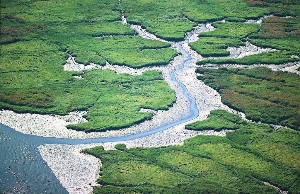
66
Open Space and Recreational Facilities
 Chapter 5: Open Space and Recreational Facilities A. INTRODUCTION According to the guidelines of the 2001 New York City Environmental Quality Review (CEQR) Technical Manual, an open space analysis is necessary
SOUTH PARK. Construction of a Portion of South Park at Fresh Kills Park, Staten Island
 SOUTH PARK Construction of a Portion of South Park at Fresh Kills Park, Staten Island FRESHKILLS PARK FIRST PHASE OF SOUTH PARK FRESHKILLS PARK CONTEXT SOUTH PARK EXISTING CONDITIONS PROJECT OPPORTUNITIES
Fresh Kills Park in Regional Context
 Fresh Kills Park in Regional Context Fresh Kills Location On Staten Island Community District 1 THE SITE TODAY TRAVIS William T. Davis Wildlife Refuge New Jersey NEW SPRINGVILLE MOUND 3/4 Little Fresh
James Corner. Lifescape Fresh Kills Parkland
 James Corner Lifescape Fresh Kills Parkland 14 For over 50 years Fresh Kills on Staten Island served as a landfill for New York City. A long-term strategy based on natural processes, agricultural practice
April 11, 2016 Park Board Chair and Commissioners General Manager Vancouver Board of Parks and Recreation New Brighton Salt Marsh - Preferred Concept
 TO: FROM: SUBJECT: April 11, 2016 Park Board Chair and Commissioners General Manager Vancouver Board of Parks and Recreation New Brighton Salt Marsh - Preferred Concept RECOMMENDATION A. THAT the Vancouver
10.0 Open Space and Public Realm
 10.0 Open Space and Public Realm 10.0 Open Space and Public Realm The Public Open Space System is comprised of: outdoor spaces available for public use that are either publicly owned (e.g., parks and
Volunteer Guide to Freshkills Park
 Volunteer Guide to Freshkills Park www.freshkillspark.org/volunteer March 2016 Welcome to Freshkills Park and thank you for volunteering your time and energy. Volunteers provide important support to the
Monday, October 5, THE LIGHTHOUSE, PIER 61 at CHELSEA PIERS, HUDSON RIVER PARK, NEW YORK CITY SPONSORSHIP DECK
 Monday, October 5, 2015 THE LIGHTHOUSE, PIER 61 at CHELSEA PIERS, HUDSON RIVER PARK, NEW YORK CITY SPONSORSHIP DECK ABOUT US Our Mission The Waterfront Alliance works to protect, transform, and revitalize
Planning for Staten. Habitat Restoration and Green Infrastructure. Island s North Shore
 Habitat Restoration and Green Infrastructure Planning for Staten Island s North Shore Community Board 1 March 1, 2018 NYC Parks Forestry, Horticulture, and Natural Resources Funded by the NYS Department
Mendota Heights 2040 Comprehensive Plan Draft Vers
 4 Parks and Trails The City of Mendota Heights boasts a variety of recreational and open space opportunities. Few cities can claim access to regional trails, riverside and lakeside parks, scenic bluffs
The Vision. Photo provided by The Minervini Group. 46 Vision, Objectives & Strategies
 Vision, Objectives & Strategies The is the public framework and guide for future development of the Grand Traverse Commons. The establishes public polices for infrastructure, the preservation of natural
Kevin M. Rampe, President -- Lower Manhattan Development Corporation
 For Internal Use Only: Date Received: WRP no. DOS no. NEW YORK CITY WATERFRONT REVITALIZATION PROGRAM Consistency Assessment Form Proposed actions that are subject to CEQR, ULURP or other local, state
Port Lavaca Future Land Use
 Port Lavaca Future Land Use Introduction The City of Port Lavaca is beginning to see sustained growth, after many years of relative stable population. New single family homes, apartments, and businesses
11TH STREET BRIDGE PARK COMPETITION
 11TH STREET BRIDGE PARK COMPETITION DESIGN PRINCIPLES, VALUES AND FACILITIES DESCRIPTION The design principles and list of facilities for a future 11th Street Bridge Park have been gathered through over
SALISBURY TOMORROW Our Vision
 SALISBURY TOMORROW Our Vision Salisbury is committed to supporting a high quality of life and sense of community for all residents. These commitments need to be reflected in our community programs, services
MARINA MARKET & WATERFRONT DEVELOPMENT STUDY PORT ARANSAS, TEXAS
 MARINA MARKET & WATERFRONT DEVELOPMENT STUDY PORT ARANSAS, TEXAS FEBRUARY 2015 PRESENTATION OUTLINE 1 2 3 4 5 6 7 REGIONAL POSITIONING SITE IMPRESSIONS PLANNING & DESIGN PRINCIPLES EXISTING IMPROVEMENTS
6. RECREATION AND OPEN SPACE ELEMENT
 6. RECREATION AND OPEN SPACE Introduction This Recreation and Open Space Element includes Goals, Objectives and Policies (GOP) that apply to the main campus in Gainesville and the Lake Wauburg Recreation
ATTACHMENT A AERIAL PHOTO OF McINTIRE PARK EAST
 ATTACHMENT A AERIAL PHOTO OF McINTIRE PARK EAST McIntire Botanical Garden Request for Proposals Attachments Page 1 of 33 ATTACHMENT B - MEMORANDUM OF AGREEMENT WITH THE CITY OF CHARLOTTESVILLE McIntire
FACT SHEET: COMMUNITY INPUT S IMPACT ON THE DESIGN FOR THE OBAMA PRESIDENTIAL CENTER
 FOR IMMEDIATE RELEASE January 10, 2018 Contact: Kate Berner, kberner@skdknick.com FACT SHEET: COMMUNITY INPUT S IMPACT ON THE DESIGN FOR THE OBAMA PRESIDENTIAL CENTER Since announcing initial plans in
Chapter 2: Vision, Goals and Strategies
 Chapter 2: Vision, Goals and Lake Elmo Today & Tomorrow Comprehensive Plan 2040 2 VISION, GOALS & STRATEGIES - DRAFT 4-6-2018 INTRODUCTION Comprehensive Plan Purpose Perhapse the most important objective
1. Parks & Recreation Neighborhood Parks Community Parks Special Use Sites 2. Open Space 3. Trails
 Appendix A: Park Classifications The intent of parks and recreation classifications is to aid in making acquisition and design decisions for park sites, facilities and the organization of recreation space
Public Workshop 2 December 11, 2014 OLIN
 Public Workshop 2 December 11, 2014 OLIN TRIPLE IMAGE PANORAMA A NEW VISION FOR THE RIVERFRONT PROMENADE Burlington s Riverfront has historically been a defining character of the City s identity. This
MCCOYS CREEK RESTORATION 30% DESIGN
 MCCOYS CREEK RESTORATION 30% DESIGN THE MCCOYS CREEK RESTORATION PLAN The restoration plan aims to reduce flooding, restore ecosystem health, expand recreational opportunities along the creek, and connect
DRAFT FOR PUBLIC REVIEW. Game Plan for a Healthy City
 DRAFT FOR PUBLIC REVIEW 2018 Game Plan for a Healthy City 2 Denveright. Parks & Recreation Game Plan Draft for Public Review Draft for Public Review Executive Summary Game Plan Overview Executive Summary
This page intentionally blank.
 This page intentionally blank. Parks, Recreation, and Open Space Chapter Relationship to Vision Vision Parks, Recreation and Open Space Chapter Concepts County Government. County government that is accountable
CHAPTER 8 ISSUES, CONCERNS, CONSTRAINTS AND OPPORTUNITIES
 CHAPTER 8 ISSUES, CONCERNS, CONSTRAINTS AND OPPORTUNITIES Introduction This River Conservation Plan was developed during a time of tremendous activity and effort in planning the transformation of the Delaware
Western Sydney Parklands Australia s Largest Urban Park
 Western Sydney Parklands Australia s Largest Urban Park 37 WLA 1 MAGAZINE 21 38 WESTERN SYDNEY PARKLANDS AUSTRALIA S LARGEST URBAN PARK Large urban parks have dual roles to play in meeting the demands
Fresh Kills Park East Park Roads Draft Scope of Work to Prepare a Supplemental Environmental Impact Statement A. INTRODUCTION
 Fresh Kills Park East Park Roads Draft Scope of Work to Prepare a Supplemental Environmental Impact Statement A. INTRODUCTION This is a Draft Scope of Work to prepare the Fresh Kills Park East Park Roads
Phase 1 : Understanding the Campus Context. Phase 2 : APPROACHES - Alternates & Preferred Plan
 Introduction MASTER PLAN PURPOSE WHY A CAMPUS MASTER PLAN? The purpose of the Master Plan at the University of Illinois at Chicago is to translate UIC s strategic goals and objectives into a compelling
Support the implementation of Cape Coral's Comprehensive Plan. Protect and utilize the unique natural resources in the City.
 7.0 OVERVIEW - RECOMMENDATIONS Chapter 7 The preparation of the Cape Coral Parks and Recreation Master Plan spanned a period of approximately 12 months. Plan preparation included the input of a wide range
East Midtown Greenway East 53 rd 61 st Street. Community Board 8 Project Introduction November 16, 2017
 East Midtown Greenway East 53 rd 61 st Street Community Board 8 Project Introduction November 16, 2017 Agenda Overview - Development of the East Midtown Waterfront Esplanade Current East Midtown Greenway
Appendix A. Park Land Definitions
 Appendix A Park Land Definitions Mini Park May serve specific function for any and all ages, depending on need of the user area. Size range 1-5 acres with optimum size being 3 acres. Service area is sub-neighborhood
PEQUITSIDE FARM ONE PROPERTY, MANY USES
 PEQUITSIDE FARM ONE PROPERTY, MANY USES Laura Campbell March 8, 2016 A plan for the public use of a historic estate Introduction At 33 acres, Peuitside Farm is the largest public owned open space in the
Emerson Park Master Plan Update. Public Meeting III August 27, 2014
 Emerson Park Master Plan Update Public Meeting III August 27, 2014 Meeting Agenda: Project Update Presentation of Master Plan Components Discussion and Feedback The Path Forward: Building on the Concept
PARTF Scoring System for Grants
 PARTF Scoring System for Grants The members of the N.C. Parks and Recreation Authority use the PARTF scoring system as one of several tools to select grant recipients. Please provide all of the information
Whitemarsh Comprehensive Plan Update: Housing & Land Use. Public Workshop #3: September 20, 2018
 Whitemarsh Comprehensive Plan Update: Housing & Land Use Public Workshop #3: September 20, 2018 Agenda Welcome Process Recap What We ve Heard The Plan Framework Review of Recommended Actions Land Use Housing
2011 ASLA Design Awards. Centennial Park Merit Award Design Concepts CLA, Inc. Design over $500,000 Construction Budget
 2011 ASLA Design Awards Centennial Park Merit Award Design Concepts CLA, Inc. Design over $500,000 Construction Budget 2011 ASLA Colorado Professional Design Awards Project Name: Category: Location: Const.
Shoreline Master Program Town of La Conner, Washington
 Shoreline Master Program Town of La Conner, Washington Department of Ecology approval effective Adopted September 24, 2013 by Town of La Conner Ordinance No.1106 Amended May 13, 2014 by Town of La Conner
Concept Master Plan. for. Draft of. Wildlife Management Area. Prepared for. June, 2008
 Draft of Concept Master Plan for Vermillion Highlands: A Research, Recreation and Wildlife Management Area Prepared for Vermillion Highlands Steering Committee - Minnesota Department of Natural Resources
Table of Contents. Executive Summary...S-1
 Table of Contents Executive Summary...S-1 1: Project Description... 1-1 A. Project Identification... 1-1 B. Background to the Proposed Project... 1-5 C. Description of the Project Site... 1-8 D. Description
greenprint midtown SUSTAINABILITY ACTION PLAN 2012
 greenprint midtown SUSTAINABILITY ACTION PLAN 2012 MIDTOWN ALLIANCE SOUTHFACE ENERGY INSTITUTE RENAISSANCE PLANNING GROUP SUSTAINABLE ATLANTA PERKINS+WILL 2 GREENPRINT MIDTOWN 1. Introduction Sustainability
3.1 community vision. 3.3 required plan elements
 Chapter 3 Community Form 3.1 community vision 3.2 Parks & landscaping concepts 3.3 required plan elements D R A F T 20 Community Form Chapter 3 3.0 Community form 3.1 community vision The Specific Plan
APPENDIX D: PARKS AND RECREATION ACTION PLAN
 APPENDIX D: PARKS AND RECREATION ACTION PLAN Goals The following goals are specific to the development, maintenance, and operation of the existing parks in the Township, as well as the acquisition and
City Council March 27, Parks, Recreation, and Trails Master Plan
 City Council March 27, 2018 Parks, Recreation, and Trails Master Plan Planning Process Develop Goals and Objectives Inventory of Areas and Facilities Needs Assessment And Identification Public Participation
RESPONSES TO PUBLIC CONCERNS AND QUESTIONS
 RESPONSES TO PUBLIC CONCERNS AND QUESTIONS Stations and Summary Questions for Public Meeting #2 June 23, 2015 General Questions / Concerns: 1. Is there any way this development can raise revenue for the
Route 1 Corridor Study
 Route 1 Corridor Study Westbrook, Connecticut A Vision for the Connecticut Shoreline Public Informational Meeting July 28, 2015 Lower Connecticut River Valley Council of Governments Fitzgerald & Halliday,
APPENDIX A FINAL SCOPE OF WORK
 APPENDIX A FINAL SCOPE OF WORK FRESH KILLS PARK EAST PARK ROADS FINAL SCOPE OF WORK CEQR No. : 06DPR002R Lead Agency: Adrian Benepe, Commissioner New York City Department of Parks and Recreation Lead Agency
Mississippi Skyway Preliminary Engineering Report
 EXECUTIVE SUMMARY Mississippi Skyway Preliminary Engineering Report CITY OF RAMSEY, MINNESOTA DECEMBER 2014 City of RAMSEY EXECUTIVE SUMMARY Project Need and Intent The Mississippi Skyway pedestrian bridge
Ivywild On The Creek PRELIMINARY CREEK DISTRICT MASTER PLAN
 Ivywild On The Creek PRELIMINARY CREEK DISTRICT MASTER PLAN Introduction: Rejuvenating an extraordinary Creekside neighborhood THE CREEKSIDE DISTRICT The Ivywild On The Creek Neighborhood District Master
EXECUTIVE SUMMARY EXECUTIVE SUMMARY
 1 EXECUTIVE SUMMARY EXECUTIVE SUMMARY Penn s Landing is envisioned as a welcoming riverfront green space adjacent to a refurbished civic marina becoming the centerpiece for adjacent development. With a
2040 LUP is a part of the Comprehensive Plan and carries the same legal authority. Economic Challenges
 1.1. Guiding Anchorage s Growth Where will new residents settle over the next two decades? Where will people work, shop, and play? Will there be enough room to grow? How will Anchorage look? Will growth
I WILL BEGIN BY EXPLAINING THE PROCESS BY WHICH WE MET THE CHALLENGE OF GATHERING PUBLIC INPUT.
 DRAFT TESTIMONY OF ALEX GARVIN, VICE PRESIDENT, PLANNING, DESIGN AND DEVELOPMENT LOWER MANHATTAN DEVELOPMENT CORPORATION BEFORE NEW YORK STATE ASSEMBLY NOVEMBER 13, 2002, 10:30 AM GOOD MORNING SPEAKER
Lawrencetown Beach & Rainbow Haven Beach
 Lawrencetown Beach & Rainbow Haven Beach Public Engagement Session Wednesday, September 27 th, 2017 6:00pm 8:00pm Cole Harbour Place 51 Forest Hills Pkwy, Dartmouth Agenda Welcome & Introductions Overview
OVERVIEW OF PLANS FOR THE JEFFERSON COUNTY COUNTRYSIDE FARM In the Context of Quality Place Characteristics
 OVERVIEW OF PLANS FOR THE JEFFERSON COUNTY COUNTRYSIDE FARM In the Context of Quality Place Characteristics By Steve Grabow, Professor and Community Development Educator University of Wisconsin-Extension,
CHONGMING ISLAND SHANGHAI CENTRAL CITY
 Chongming Island CHONGMING ISLAND SHANGHAI CENTRAL CITY Chongming Island Shanghai, China THE VISION: A GREEN ISLAND Chongming Island benefits from a magnificent setting, adjacency to the vibrant center
CIVITAS CIVITAS CIVITAS CIVITAS CIVITAS CIVITAS CIVITAS CIVITAS CIVITAS CIVITAS CIVITAS CIVITAS CIVITAS CIVITAS CIVITAS CIVITAS
 7. The Vision 80 East River Esplanade Vision Plan Site Specific Visions Through research, analysis, outreach, and discussions with city and state agency representatives, it became apparent that a phased,
Call for Artists for: Design and Construction of Environmental Art Activation Story Mill Community Park, Bozeman, MT
 Call for Artists for: Design and Construction of Environmental Art Activation Story Mill Community Park, Bozeman, MT Seeking artists to design, fabricate and install art elements in the nature sanctuary
1 Introduction. Chapter. In this chapter:
 Chapter 1 Introduction In this chapter: 1.1 A Snapshot of the Region 1.2 Towards a Sustainable Region 1.3 The Provincial Context 1.4 Purpose and Organization The Regional Municipality of York Official
City Center Neighborhood Plan
 [1] City Center Neighborhood Plan As adopted by Ordinance No. 2014-09-049 and amended by Ordinance Nos. Formerly CBD Neighborhood as adopted by Ordinance No. 8868 and amended by Ordinance Nos. 8946, 9693,
quarters Building Our Cultural Quarters Together
 cultural quarters Building Our Cultural Quarters Together Implementation Plan june 2013 To enrich the ability of Montréalers to appreciate art, culture and heritage in its downtown core and throughout
The John Bartram Association Action Plan to advance the 10 year Strategic Plan
 The John Bartram Association 2013-2015 Action Plan to advance the 10 year Strategic Plan We are poised to take significant leaps with the opportunities that surround us. In the next three years we are
NORTH BAY RECREATION AND NATURAL AREA
 HUDSON NORTH BAY RECREATION AND NATURAL AREA City of Hudson, New York Prepared by the Columbia Land Conservancy North Bay: from forgotten waterfront to dynamic public park The proposal for the North Bay
BISCUIT RUN PARK MASTER PLAN
 BOARD OF SUPERVISORS November 14, 2018 BISCUIT RUN PARK MASTER PLAN COUNTY OF ALBEMARLE ANHOLD ASSOCIATES Contents Project Introduction Property Background County Park Planning Process Existing Site &
Executive Summary. Parks and Recreation Plan. Executive Summary
 Parks and Recreation Plan Executive Summary The Whitemarsh Township Parks and Recreation Plan sets forth a vision for how Whitemarsh Township can provide a premiere parks and recreation system reflective
Chairman and Members of the Planning and Development Committee. Thomas S. Mokrzycki, Commissioner of Planning and Building
 LA.09.TOR (Toronto) DATE: TO: FROM: SUBJECT: Chairman and Members of the Planning and Development Committee Thomas S. Mokrzycki, Commissioner of Planning and Building Central Waterfront Secondary Plan
Parks Master Plan Implementation: Phase I Waterfront Use and Design REPORT #: September 7, 2016 File #
 0 'O DI Lan-171-14 1 - THE CORPORATION OF THE TOWN OF COBOURG..,. STAFF REPORT TO: FROM: Mayor and Members of Council Dean A. Hustwick, Director of Recreation and Culture DATE OF MEETING: Committee of
The following principles guide the development of goals and strategies to protect and promote these amenities:
 OPEN SPACE/PARKS/TRAILS/RECREATION GOALS/STRATEGIES Cherry Hills Village is a living environment that offers low density development, open areas, public scenic vistas, public trails and public parks. This
CITY CLERK. Parkland Acquisition Strategic Directions Report (All Wards)
") CITY CLERK Clause embodied in Report No. 10 of the, as adopted by the Council of the City of Toronto at its meeting held on November 6, 7 and 8, 2001. 10 Parkland Acquisition Strategic Directions Report
CITY CLERK Clause embodied in Report No. 10 of the, as adopted by the Council of the City of Toronto at its meeting held on November 6, 7 and 8, 2001. 10 Parkland Acquisition Strategic Directions Report
ELK GROVE GENERAL PLAN VISION
 2-1 CHAPTER 2: 2-2 CREATING OUR The Community Vision for Elk Grove, expressed through a Vision Statement and a series of Supporting Principles, is a declaration of the kind of community that Elk Grove
Atlanta BeltLine Corridor Environmental Study. Scoping Meeting August 2008
 Atlanta BeltLine Corridor Environmental Study Scoping Meeting August 2008 What Will We Be Discussing Today? Study Overview - How Did We Get Here? - What Is the Study About? - Who Is Involved? - Where Is
Chapter 1.0 Introduction
 Chapter 1.0 Introduction 1.1 Background The North Metro commuter rail line is part of the RTD FasTracks regional transit system expansion program to build more than 100 miles of rail transit throughout
In surveys, Dallas residents say what they want to change most
 NEIGHBORHOODS ELEMENT In surveys, Dallas residents say what they want to change most in the city is its appearance they want it to look beautiful, with trees and pedestrian-friendly neighborhoods. The
HE VISION. Building a Better Connected Place
 HE VISION Building a Better Connected Place WALK INTO THE FUTURE. Life in Cranberry, 2030 Here s what our residents told us they wanted to see in their community by 2030: The Cranberry of 2030 is a place
Gold Line Bus Rapid Transit Transit Oriented Development (BRTOD) Helmo Station Area Plan
 Helmo Station Area Plan") Appendix F Gold Line Bus Rapid Transit Transit Oriented Development (BRTOD) Helmo Station Area Plan Introduction and Purpose of the Plan The Gold Line Bus Rapid Transit facility is an eleven-mile dedicated
Appendix F Gold Line Bus Rapid Transit Transit Oriented Development (BRTOD) Helmo Station Area Plan Introduction and Purpose of the Plan The Gold Line Bus Rapid Transit facility is an eleven-mile dedicated
INTRODUCING THE BALTIMORE CITY GREEN NETWORK VISION PLAN
 INTRODUCING THE BALTIMORE CITY GREEN NETWORK VISION PLAN GOALS OF THE GREEN NETWORK PLAN Protect and enhance the unique ecological resources of our city Support economic growth and sustainable redevelopment
CITY OF CHARLOTTESVILLE, VIRGINIA CITY COUNCIL AGENDA
 CITY OF CHARLOTTESVILLE, VIRGINIA CITY COUNCIL AGENDA Agenda Date: December 16, 2013 Action Required: Adoption of Resolution Presenter: Staff Contacts: Title: James E. Tolbert, AICP, Director of NDS James
A Vision for Walnut Creek
 A Vision for Walnut Creek Photo: City of Clive Walnut Creek Booklet 8 of 8 Greater Des Moines Water Trails and Greenways 1 Table of Contents Booklet 1: Water Trails Strategies and Policies Booklet 2: Beaver
- Document 2 - Algonquin Interpretation and The Continuing Conversation toward a Vision for a Revitalized Lansdowne
 140 - Document 2 - Algonquin Interpretation and The Continuing Conversation toward a Vision for a Revitalized Lansdowne On May 4, 2012, the City of Ottawa participated in a Forum with a number of Elders,
Lynn Waterfront Master Plan
 Lynn Waterfront Master Plan Public Meeting #2 December 10th, 2018 1 Project Schedule Update September 26, 2018 December 10, 2018 Development of the Master Harbor Plan Amendment and Revised Waterfront Master
FORT MISSOULA REGIONAL PARK
 FORT MISSOULA REGIONAL PARK Master Plan Refinement/ Design Development www.missoulaparks.org DHM Design/WGM Group December 3, 2008 Master Plan Report Fort Missoula Regional Park Guiding Principals i 6/14/01
APPENDIX D TRANSPORTATION PLANNING FACTORS
 APPENDIX D TRANSPORTATION PLANNING FACTORS 440 Park Avenue South New York, NY 10016 tel: 212 696-0670 fax: 212 213-3191 www.akrf.com To: From: Subject: Eloise Hirsh Project Coordinator, DPR Angelyn Chandler,
SECTION ONE: INTRODUCTION. introduction
 introduction 1 INTRODUCTION Since it was first established in 1843 as a trading post for the Hudson s Bay Company, Victoria has evolved into a Provincial capital city that is recognized across Canada and
Neighborhood Districts
 NEIGHBORHOOD DISTRICTS SEVEN MAIN DISTRICTS Neighborhood Districts While the Development Plan provides a broad-scale overview of the neighborhood, this section focuses on uses and relationships at the
Sacramento County Regional Parks American River Parkway Group Activity & Special Event Procedures
 1 Sacramento County Regional Parks American River Parkway Group Activity & Special Event Procedures Department of Regional Parks Document Introduction and Public Review Process In May 2013 the Board of
PLANNING ADVISORY BOARD AGENDA OCTOBER
 ! City of Langley PLANNING ADVISORY BOARD AGENDA OCTOBER 1, 2014 3-5pm LANGLEY CITY HALL - 112 2 nd Street, Langley WA 1) Call to Order and Roll Call 2) Approval of the Minutes September 10, 2014 3) Public
North Oakville East Parks Facilities Distribution Plan. November, 2009
 North Oakville East November, 2009 POLICY CONTEXT 1) Purpose a) The purpose of this document is to be a guide for the location, configuration, design and development of the parks system for the North Oakville
HUMBER BAY PARK PROJECT - BUILDING CONCEPT
 WELCOME 1 Humber Bay Park, with its system of trails, rugged shoreline, and dramatic views, is a unique and rare waterfront experience within the larger metropolitan Toronto area offering a place for quiet,
OAKLAND COUNTY PARKS AND RECREATION DEPARTMENT 2800 Watkins Lake Road, Waterford, Michigan
 OAKLAND COUNTY PARKS AND RECREATION DEPARTMENT 2800 Watkins Lake Road, Waterford, Michigan 48328 248-858-0906 http://www.oakgov.com/parksrec OAKLAND COUNTY PARKS AND RECREATION COMMISSION Pecky D. Lewis,
38 Queen s University Campus Master Plan Part 1
 38 Queen s University Campus Master Plan Part 1 46 The Campus at the City Scale Chapter 4 The Campus at the City Scale 39 Queen s is an urban University centrally located in Kingston. Decisions made by
Town Center (part of the Comprehensive Plan)
") Town Center (part of the Comprehensive Plan) Mercer Island Town Center Looking North (2014) In 1994, a year-long process culminated in a set of design guidelines and code requirements for the Town Center
Town Center (part of the Comprehensive Plan) Mercer Island Town Center Looking North (2014) In 1994, a year-long process culminated in a set of design guidelines and code requirements for the Town Center
Pittsfield Action Plan (West Branch of the Housatonic River)
") An initiative of the Massachusetts Executive Office of Energy and Environmental Affairs in partnership with the City of Pittsfield Pittsfield Action Plan (West Branch of the Housatonic River) The spring
An initiative of the Massachusetts Executive Office of Energy and Environmental Affairs in partnership with the City of Pittsfield Pittsfield Action Plan (West Branch of the Housatonic River) The spring
The principal elements of the NTC Strategic Vision plan are as follows.
 The proposed project would improve the NTC site plan, circulation, visitor amenities, and landscaping, and would include construction of two new stadiums to replace the existing Louis Armstrong Stadium
PLAN ELEMENTS WORKSHOP. April 5, 2016
 PLAN ELEMENTS WORKSHOP April 5, 2016 needs more housing. But there is no one-size fits-all solution. Every neighborhood has its own character. In some places, density is not only appropriate it is badly
ADOPTED CAPITAL IMPROVEMENT PROGRAM BUDGET ARROYO PROJECTS
 ADOPTED CAPITAL IMPROVEMENT PROGRAM BUDGET ARROYO PROJECTS HAHAMONGNA FY 212-216 Capital Improvement Program Priority Description Total Estimated Costs Appropriated Through FY 211 Adopted FY 212 FY 213
Wasatch CHOICE for 2040
 Wasatch CHOICE for 2040 Economic Opportunities We Can Choose a Better Future We enjoy an unparalleled quality of life along the Wasatch Front. People from all over the world are drawn to our stunning scenery,
Public Art Plan. We have elected to submit Public Art Plans before or concurrently with the CSP Submittal per the FDP Manual
 Public Art Plan The intent of the Horizon Uptown Public Arts Program is to create great places that engage the community and leverage the neighborhood development and economic vitality. The Horizon Uptown
Authority of the General Plan
 Authority of the General Plan This La Habra Heights General Plan will serve as the blueprint for future planning and development in the City. This General Plan describes the City s vision for the future
3. VISION AND GOALS. Vision Statement. Goals, Objectives and Policies
 Vision Statement Queen Creek s interconnected network of parks, trails, open spaces and recreation opportunities provide safe and diverse activities and programs that sustain its unique, small town, equestrian
Arlington, Virginia is a worldclass
 EXECUTIVE S U M M A RY Arlington maintains a rich variety of stable neighborhoods, quality schools and enlightened land use policies, and received the Environmental Protection Agency s highest award for
An Ambitious Plan: Transforming the blighted South Platte River and surrounding environment into Denver s greatest natural resource.
 CONNECTING THE PEOPLE TO THEIR RIVER SOUTH PLATTE RIVER VISION IMPLEMENTATION PROGRAM: GRANT-FRONTIER PARK TO OVERLAND POND PARK REACH The South Platte River Vision Implementation Program (River Vision)