FORT MISSOULA REGIONAL PARK
|
|
|
- Sharlene Andrews
- 5 years ago
- Views:
Transcription


1 FORT MISSOULA REGIONAL PARK Master Plan Refinement/ Design Development DHM Design/WGM Group December 3, 2008 Master Plan Report Fort Missoula Regional Park Guiding Principals i 6/14/01 1
2 CONCEPT OF A REGIONAL PARK - PROVIDE MULTIPLE USES THAT ATTRACTS USERS NOT ONLY FROM MISSOULA, BUT ALSO FROM ENTIRE COUNTY AND REGION. - STRIVE TO BALANCE MANY INTERESTS AND NEEDS - PROVIDE MIX OF DEVELOPED AND UNDEVELOPED PARK AREAS STEERING COMMITTEE ORIGINAL ASSUMPTIONS - DEVELOP THE PARK IN PHASES - CONTEXT OF SITE SHOULD PLAY ROLE IN DECISION MAKING (HISTORIC SITE, ALONG BITTERROOT RIVER, HOME TO MANY PUBLIC AGENCIES AND COMMUNITY ORGANIZATIONS). -RECOGNIZE LIMITED SPACE WITH MULTIPLE DEMANDS - PROVIDE FACILITY FOR PUBLIC ENJOYMENT AND BENEFIT -- PROVIDE FOR INDOOR AND OUTDOOR FACILITIES - CONSIDER ONGOING MAINTENANCE COSTS - FACILITIES SHOULD SERVE BOTH ADULT & YOUTH COMPETITIVE PLAY - PROVIDE FOR RESTROOMS, PARKING, CONCESSIONS, STORAGE & MAINTENANCE FACILITIES - COMPLY WITH ADA - INCLUDE PASSIVE RECREATION - ACKNOWLEDGE, PRESERVE AND ENHANCE UNIQUE HISTORIC VALUES - ENCOMPASS DIVERSE ACTIVITIES - SERVE PEOPLE OF ALL ABILITIES, AGES AND INCOME GROUPS - PARK DESIGN & CONSTRUCTED WITH ENVIRONMENTAL SENSITIVITY -INCLUDE WILDLIFE, RIPARIAN & OPEN AREAS - MAINTAIN NATURAL VISTAS AND VIEWS Adopted Master Plan Fort Missoula Regional Park August


3 Rocking M Design Stakeholders Meeting Design Considerations/ Program April 8-9,
4 DESIGN CONSIDERATIONS/ PROGRAM FIELD SIZES AND PROGRAM NEEDS OF PARK: STAKEHOLDERS INCLUDED: FRIENDS OF FORT MISSOULA REGIONAL PARK FORT MISSOULA HISTORICAL MUSEUM ROCKY MOUNTAIN MILITARY MUSEUM NORTHERN ROCKIES HERITAGE CENTER MISSOULA COUNTY MISSOULA COUNTY PUBLIC SCHOOLS UNIVERSITY OF MONTANA MISSOULA PARKS BOARD ULTIMATE STRIKERS MAGGOTS YMCA - PROVIDE SAFE ENTRY ROAD CONNECTION TO SOUTH AVENUE - MAINTAIN ALIGNMENT OF GUARDSMAN LANE APPROACHING MUSEUMS - PROVIDE NARROW, MEANDERING ROADS TO SLOW TRAFFIC. - STAY CLEAR OF TRASH SCATTER, NON DISCLOSURE OF SITE (MAINTAIN 30 CM HORIZON) - PROVIDE FACILITIES TO HOST TOURNAMENTS AT HOME - 8 to 10 MULTIUSE FIELDS (SOCCER, RUGBY, FOOTBALL AND ULTIMATE) 70M X 120M WITH 10 TO 15 YDS BETWEEN FIELDS, 10 YDS AT ENDS OF FIELDS - POSSIBLE PREMIER SOCCER PITCH (ARTIFICIAL TURF FOR EARLY AND LATE SEASON GAMES) LOCATE IN FAR CORNER - PREMIER RUGBY PITCH (144M X 70M) - POSSIBLE BLEACHERS AT PREMIER FIELDS - ULTIMATE NEEDS 40 YD X 120 YD FIELDS FOR TOURNAMENTS - STORAGE FOR SOCCER, STORAGE WITH SCOREBOARD FOR RUGBY - RESTROOMS, STORAGE AND POSSIBLE CONCESSION BUILDING (GROUP TOGETHER RATHER THAN SPREADING ACROSS SITE) - PROVIDE PARKING LOTS, NOT ALONG ROADS. - PICNIC SHELTERS FOR GROUPS OF 40, 200 AND POSSIBLE COVERED SHELTER FOR ICE SKATING Cultural Resources working with western cultural, inc, April September
 AVOID INTRODUCING TRAFFIC IMPACTS AT OFFICERS ROW PROVIDE PEDESTRIAN CONNECTIONS TO")

 POST CEMETERY")
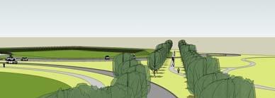
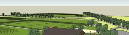
5 PRESERVE AND MAINTAIN THE HISTORIC DOUBLE ROW OF TREES (USE TREES WITH SIMILAR SIZE AND SHAPE) AVOID INTRODUCING TRAFFIC IMPACTS AT OFFICERS ROW PROVIDE PEDESTRIAN CONNECTIONS TO ADJACENT AREAS OF FORT MISSOULA PROVIDE INTERPRETIVE SIGNAGE TO ENHANCE THE PARK EXPERIENCE OFFICERS ROW MAINTAIN BUFFER ZONE AROUND POST CEMETERY ALONG WITH VEHICULAR ACCESS AND PARKING AVOID NON-COMPATIBLE ARCHITECTURE AVOID IMPACTS OF NONCOMPATIBLE USES STAY CLEAR OF TRASH SCATTER, NON DISCLOSURE OF SITE (MAINTAIN 30 CM HORIZON) POST CEMETERY CCC WAREHOUSE 5


6 SIGNIFICANT HISTORIC PERIODS ORIGINAL FORT MISSOULA FORT RECONSTRUCTION CIVILIAN CONSERVATION CORPS WWII INTERNMENT CAMP HISTORIC LANDSCAPES CITY BEAUTIFUL CIVILIAN CONSERVATION CORPS. (CCC) THE CIVILIAN CONSERVATION CORPS WAS PART OF PRESIDENT FRANKLIN D. ROOSEVELT S NEW DEAL PROGRAM, FROM

 TRAINING, SUPPLY AND ADMINISTRATION CENTER FOR THE ROCKY MOUNTAIN REGION.")
7 THE CIVILIAN CONSERVATION CORPS (CCC) HAD TWO PURPOSES. ONE TO CONSERVE OUR NATURAL RESOURCES AND THE OTHER TO PUT AMERICANS BACK TO WORK DURING THE GREAT DEPRESSION. ROADWAYS, LODGES, CABINS, RECREATION STRUCTURES, TRAILS, PARKS, BRIDGES AND THOUSANDS OF TREES WERE PLANTED AS PART OF THE CCC PROGRAM. 75 YEAR ANNIVERSARY FORT MISSOULA SERVED AS THE CIVILIAN CONSERVATION CORP. (CCC) TRAINING, SUPPLY AND ADMINISTRATION CENTER FOR THE ROCKY MOUNTAIN REGION. WORKERS WERE MOBILIZED FROM FORT MISSOULA TO WORK AT YELLOWSTONE AND GLACIER NATIONAL PARKS. THE PROPOSED PARK THEMING IS BASED UPON THIS SIGNIFICANT PART OF THE PARKS AND RECREATION MOVEMENT. 7
8 Open House Meeting Heritage Hall, Historic Fort Missoula June 25, 2008 OBJECTIVES - UPDATE PUBLIC ON FORT MISSOULA REGIONAL PARK PLANNING PROCESS - SHARE WESTERN CULTURAL, INC. FINDINGS ON CULTURAL RESOURCES AND RECOMMENDATIONS FOR PARK DESIGN - SHARE DESIGN DEVELOPMENT OF PARK SITE & ANSWER QUESTIONS - PROVIDE PUBLIC FORUM FOR CITIZENS TO BRAINSTORM IDEAS FOR HISTORICAL INTERPRETATION OF GUARDSMAN LANE (ALSO KNOWN AS THE CCC ROAD). ROUNDTABLE DISCUSSION - PUBLIC GENERALLY SUPPORTED PLANS AND THEMING IDEAS - THE CCC THEMING IS CONSISTANT WITH HISTORY OF SITE - PROVIDE TRAFFIC CALMING, MARK CROSS WALKS, DIVIDE LANES WITH MEDIANS, DISCOURAGE CUT THRU TRAFFIC, IMPROVE PEDESTRIAN ACCESS BETWEEN NEIGHBORHOODS AND PARK - RECOMMEND NAMING THE CCC ROAD FOR VEHICULAR ROAD & GUARDMAN LANE FOR TRAIL WITH DOUBLE ROW OF TREES. - KEEP TRAILS CLOSER TO ROADS TO MAXIMIZE OPEN SPACE OF PARK 8
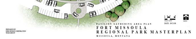
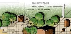
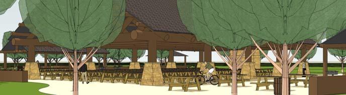
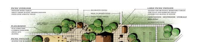
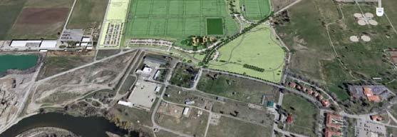
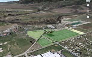
9 Proposed Park Design SUSTAINABLE APPROACH TO DESIGN PROVIDE PEDESTRIAN CONNECTIVITY TO REGIONAL TRAILS, NEIGHBORHOODS AND NEARBY ACTIVITY AREAS. MAKE PARK WALKABLE. PROVIDE CONNECTIONS TO PUBLIC TRANSPORTATION (MOUNTAIN LINE STOP) LIMIT BLUEGRASS TO SPORTS FIELDS, USE NATIVE GRASSES IN PASSIVE AREAS, SYNTHETIC TURF WHERE APPROPRIATE USE NATIVE OR XERIC TREES AND SHRUBS PROVIDE SOPHISTICATED IRRIGATION SYSTEM, CONTROLLER AND WEATHER STATION RECHARGING GROUND WATER WITH VEGETATED SWALES UTILIZE RECYCLED MATERIALS (ROAD BASE, SITE FURNITURE, ETC.) PRESERVE HISTORIC VIEWS RESPECT HISTORIC COMPATIBILTY PRESERVE CULTURAL ASSETS OF SITE 9


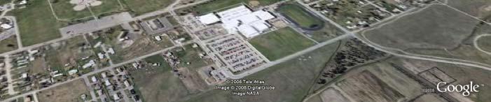

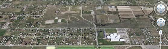
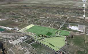
10 APPROX. 246 ACRES 10

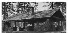
 CLUSTER")


11 83 Acres 740 Parking Spaces MAINTAIN HISTORIC LANDSCAPE (OPEN VIEWS) CLUSTER STRUCTURES STAY CLEAR OF TRASH SCATTER, NON DISCLOSURE OF SITE (MAINTAIN 30 CM HORIZON 11


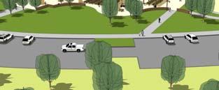
12 PROPOSED ENTRY OFF 33 TH AVENUE 12


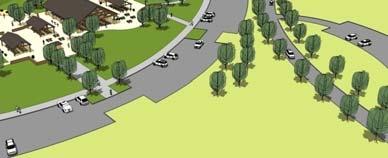
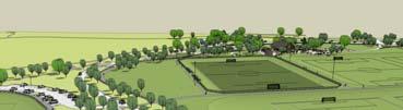
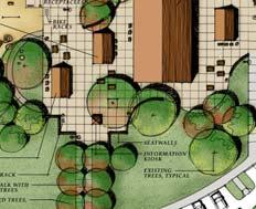
13 Central Community and Regional Events Area VEHICULAR ACCESS/ INTERSECTION IMPROVEMENTS/CIRCULATION 13

14 14


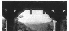
15 Park Character 15


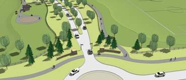
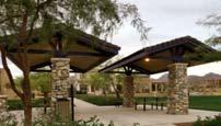
16 POSSIBLE ENTRY SCULPTURE Entry Arrival 16


17 IRON MIKE THE FIRST STATUE EVER PRODUCED IN HONOR OF THE CCC WAS TITLED SPIRIT OF THE CCC OR IRON MIKE ORIGINALLY DEDICATED IN 1935 BY FDR Entry Sculpture Central Community and Regional Events Area Large all school reunions, festivals, concerts, museum, arts and cultural events, schools, family and corporate picnics 17
18 18

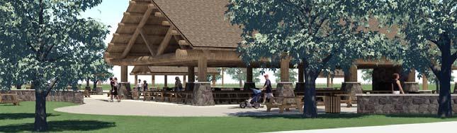
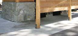
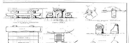
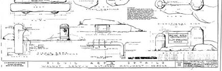
19 Pavilions 19


20 20
21 Restrooms/ Concession 21

. 2.")


22 WE RE STUDYING FIELD CONSTRUCTION TYPES : TOPSOIL BASED FIELDS VS. SAND BASED FIELDS. PRO S 1.FIELD CAN BE BUILT COMPLETELY FLAT, BEST PLAYING FOR SOCCER WITH REDUCED INJURIES (PRO FIELDS ARE FLAT). 2.SAND IS LESS EXPENSIVE AND MORE READILY AVAILABLE THAN TOPSOIL. 3.SAND BASED FIELDS ARE PLAYABLE IN LESS TIME FOLLOWING RAINFALL. THERE IS LESS DETERIORATION. THIS IS VERY IMPORTANT WITH LARGE TOURNAMENTS. 4.FLAT FIELDS ARE EASIER TO BUILD AT ONE ELEVATION. LOW POINTS ARE EASIER TO AVOID. 5.GOALS CAN BE ROTATED IN ANY POSITION REDUCING WEAR PATTERNS. CON S 1. FIELDS WILL REQUIRE APPROX. 10% MORE WATER AND FERTILIZER THAN TOPSOIL BASED FIELDS, BUT THIS CAN BE MITIGATED BY USING FERTIGATION (DIRECT APPLICATION TO LAWN WITH MINIMAL LEACHING INTO SOIL) 22


23 Extended Playing Season Use vegetated swales to transport and filter storm water. Use dry well sumps to dispose of excess water that cannot infiltrate the grass 23


24 Regional Trail Connection Possible Historic Cemetery Interpretation Possible CCC Warehouse Interpretation Possible CCC Bakery Interpretation Possible City Beautiful Interpretation Future River Connection Connection to Museum Trail System Connectivity Loop Trails.5 mile and 1.5 miles Interpretive Opportunities Signage 24


25 Signage Site Furniture 25

 THE")


26 THE STATE HISTORICAL PRESERVATION BOARD HAS APPROVED THE MITIGATION PLANS FOR FORT MISSOULA REGIONAL PARK. THESE PLANS INCLUDE: 1) THE INTERPRETATION OF GUARDSMAN LANE THROUGH A COMBINATION OF ROAD AND TRAIL DESIGN AND LAYOUT, SIGNAGE, AND TREE LINED ROAD SIMILAR TO OLD FORT ROAD. 26
 THE INTERPRETATION OF GUARDSMAN LANE THROUGH A COMBINATION OF ROAD AND TRAIL DESIGN AND LAYOUT, SIGNAGE, AND TREE LINED ROAD SIMILAR")
 NAMING THE NEW ENTRY OFF SOUTH AVENUE INTO THE PARK CCC ROAD AND THE NEW TRAIL GUARDSMAN LANE TRAIL CCC ROAD GUARDSMAN LANE TRAIL 2) NAMING THE NEW")

27 THE STATE HISTORICAL PRESERVATION BOARD HAS APPROVED THE MITIGATION PLANS FOR FORT MISSOULA REGIONAL PARK. THESE PLANS INCLUDE: 1) THE INTERPRETATION OF GUARDSMAN LANE THROUGH A COMBINATION OF ROAD AND TRAIL DESIGN AND LAYOUT, SIGNAGE, AND TREE LINED ROAD SIMILAR TO OLD FORT ROAD. 2) NAMING THE NEW ENTRY OFF SOUTH AVENUE INTO THE PARK CCC ROAD AND THE NEW TRAIL GUARDSMAN LANE TRAIL CCC ROAD GUARDSMAN LANE TRAIL THE STATE HISTORICAL PRESERVATION BOARD HAS APPROVED THE MITIGATION PLANS FOR FORT MISSOULA REGIONAL PARK. THESE PLANS INCLUDE: 1) THE INTERPRETATION OF GUARDSMAN LANE THROUGH A COMBINATION OF ROAD AND TRAIL DESIGN AND LAYOUT, SIGNAGE, AND TREE LINED ROAD SIMILAR TO OLD FORT ROAD. 2) NAMING THE NEW ENTRY OFF SOUTH AVENUE INTO THE PARK CCC ROAD AND THE NEW TRAIL GUARDSMAN LANE TRAIL 3) STRONG PRESENCE AND USE OF LANDSCAPE AND ARCHITECTURE TO INTERPRET THE CCC ERA AND CITY BEAUTIFUL WITH EMPHASIS ON THE CCC THEMING. 27
 THE INTERPRETATION OF GUARDSMAN LANE THROUGH A COMBINATION OF ROAD AND TRAIL DESIGN AND LAYOUT, SIGNAGE, AND TREE LINED ROAD SIMILAR TO OLD")
 NAMING THE NEW ENTRY OFF SOUTH AVENUE INTO THE PARK CCC ROAD AND THE NEW TRAIL GUARDSMAN LANE TRAIL 3) STRONG PRESENCE AND USE OF LANDSCAPE AND ARCHITECTURE TO")
 INTERPRETATION OF THE BAKERY, WAREHOUSE AND HISTORIC LANDSCAPE, AS WELL AS PARK ENTRY SIGNAGE THE MITIGATION PLANS FOR FORT MISSOULA REGIONAL PARK WERE APPROVED")
28 THE STATE HISTORICAL PRESERVATION BOARD HAS APPROVED THE MITIGATION PLANS FOR FORT MISSOULA REGIONAL PARK. THESE PLANS INCLUDE: 1) THE INTERPRETATION OF GUARDSMAN LANE THROUGH A COMBINATION OF ROAD AND TRAIL DESIGN AND LAYOUT, SIGNAGE, AND TREE LINED ROAD SIMILAR TO OLD FORT ROAD. 2) NAMING THE NEW ENTRY OFF SOUTH AVENUE INTO THE PARK CCC ROAD AND THE NEW TRAIL GUARDSMAN LANE TRAIL 3) STRONG PRESENCE AND USE OF LANDSCAPE AND ARCHITECTURE TO INTERPRET THE CCC ERA AND CITY BEAUTIFUL WITH EMPHASIS ON THE CCC THEMING. 4) INTERPRETATION OF THE BAKERY, WAREHOUSE AND HISTORIC LANDSCAPE, AS WELL AS PARK ENTRY SIGNAGE THE MITIGATION PLANS FOR FORT MISSOULA REGIONAL PARK WERE APPROVED BASED UPON THE COMMITMENT AND ATTENTION TO DETAIL OF THE CCC ERA. THE CITY HAS NOW COMPLIED WITH ALL THE REQUIREMENTS OF THE FEDERAL 106 ANTIQUITIES ACT AND THE MONTANA HISTORIC AND CULTURAL PRESERVATION ACTS. THE SHPO (STATE HISTORIC PRESERVATION OFFICER) HAS PROVIDED A LETTER OF CONCURRENCE. 28
29 29


30 S DESIGN DEVELOPMENT PLANS INCLUDED: DESIGN DEVELOPMENT PLANS INCLUDED: Existing Conditions & Removals Layout Plans Grading Plans Landscape and Irrigation Plans Roadway Plan & Profile Schematic Utility & Lighting Plans Site Details Phasing Plans 30

31 PHASING/ COSTS PHASING PLAN BASED UPON INFRASTRUCTURE, UTILITIES, OVERLOT GRADING, AND PRIORITY OF FACILITIES SITE DIVIDED INTO 7 AREAS 31


32 PHASE ONE IMPROVEMENTS $5,259,030 Escalation to mid $6,047, PARKING SPACES PHASE 1- OVERLOT GRADING, UTILITIES, PARKING AND AREA ONE MULTI-USE SPORTS FIELDS. THIS PHASE INCLUDES THE INFRASTRUCTURE FOR THE PARK & NEEDS TO BE COMPLETED IN ITS ENTIRETY Area 2 Improvements - $3,495,297 Escalation to mid $4,019, PARKING SPACES 33 PARKING SPACES AREA 2- Entry Road, Parking, Premier Rugby Pitch 32
33 Area 3 Improvements - $3,123,001 Escalation to mid $3,591,452 AREA 3 Community and Regional Events Area Area 4 Improvements - $439,925 Escalation to mid $505, PARKING SPACES AREA 4 Parking Lot Expansion 33
34 Area 5 Improvements - $554,851 Escalation to mid $638, SHARED PARKING SPACES AREA 5 Proposed Future Shared Parking & 36 th Avenue Extension Area 6 Improvements - $2,443,937 Escalation to mid $2,810,528 AREA 6 Championship Soccer Field 34

35 Area 7 Improvements - $1,225,110 Escalation to mid $1,443,376 AREA 7 Open Area PHASE ONE IMPROVEMENTS $5,259,030 Escalation to mid 2010 $6,047,884 FUTURE PHASES Area 1 Improvements $977,361 Escalation to mid 2010 $1,123,965, Area 2 Improvements $3,495,297 Escalation to mid 2010 $4,019,592 Area 3 Improvements $3,123,001 Escalation to mid 2010 $3,591,452 Area 5 Improvements $554,851 Escalation to mid 2010 $638,079 Area 6 Improvements $2,443,937 Escalation to mid 2010 $2,810,528 Area 7 Improvements $1,225,110 Escalation to mid 2010 $1,443,376 Overall Project Total $17,548,515 Escalation to mid 2010 $20,180,792 Area 4 Improvements $439,925 Escalation to mid 2010 $505,914 ESTIMATE OF PROBABLE COST 35
36 Thank You 36
Fort Missoula Regional Park PUBLIC COMMENT SUMMARY AND FAQ APRIL, 2015
 Fort Missoula Regional Park PUBLIC COMMENT SUMMARY AND FAQ APRIL, 2015 In April, 2015, Parks and Recreation and Missoula County Parks and Trails hosted an open house to accept public comment on and answer
1. Parks & Recreation Neighborhood Parks Community Parks Special Use Sites 2. Open Space 3. Trails
 Appendix A: Park Classifications The intent of parks and recreation classifications is to aid in making acquisition and design decisions for park sites, facilities and the organization of recreation space
(Exhibit A) Site Plan Adoption Detail and Support Information
 Site Plan Adoption Detail and Support Information") McCormick Park Master Site Plan (Exhibit A) Site Plan Adoption Detail and Support Information July, 2003 McCormick Park Site Plans.... 2-3 McCormick Park Site Plan Comparison... 4 Basic Assumptions about
McCormick Park Master Site Plan (Exhibit A) Site Plan Adoption Detail and Support Information July, 2003 McCormick Park Site Plans.... 2-3 McCormick Park Site Plan Comparison... 4 Basic Assumptions about
Dowdy Park. Concept Plans TOWN OF NAGS HEAD NORTH CAROLINA. Developed by: Albemarle & Associates, Ltd VHB/ Vanasse Hangen Brustlin, Inc.
 TOWN OF NAGS HEAD NORTH CAROLINA Concept Plans Developed by: Albemarle & Associates, Ltd VHB/ Vanasse Hangen Brustlin, Inc. Site Looking Southeast Dowdy Park Existing Conditions Nags Head Woods Sound Future
Montana Rail Link Park
 Montana Rail Link Park Neighborhood Open House A Missoula Community Partnership WITH LEADERSHIP FROM THE FRANKLIN TO THE FORT & SOUTHGATE TRIANGLE NEIGHBORHOODS Sovereign Hope Church, (1919 North Ave.)
SOUTHEAST SPORTS COMPLEX MASTER PLAN
 REPORT TO SOUTHGATE NEIGHBORHOOD COUNCIL APRIL 13, 2016 Visioning Process April 30: Stakeholder Meeting with Sports Groups May 5: Stakeholder Meeting with Southgate Land Use Committee May 13: SNC Meeting
Las Colonias Park Master Plan
 2013 Las Colonias Park Master Plan City of Grand Junction June 2013 Introduction Las Colonias Park, a 101 acre parcel on the edge of the Colorado River south of downtown, was deeded to the City of Grand
BISCUIT RUN PARK MASTER PLAN
 BOARD OF SUPERVISORS November 14, 2018 BISCUIT RUN PARK MASTER PLAN COUNTY OF ALBEMARLE ANHOLD ASSOCIATES Contents Project Introduction Property Background County Park Planning Process Existing Site &
Scope of Services. River Oaks Boulevard (SH 183) Corridor Master Plan
 Corridor Master Plan") Scope of Services River Oaks Boulevard (SH 183) Corridor Master Plan PROJECT AREA The project area consists of the River Oaks Boulevard (SH 183) corridor bounded by SH 199 at the northern end and the Trinity
Scope of Services River Oaks Boulevard (SH 183) Corridor Master Plan PROJECT AREA The project area consists of the River Oaks Boulevard (SH 183) corridor bounded by SH 199 at the northern end and the Trinity
Appendix A. Park Land Definitions
 Appendix A Park Land Definitions Mini Park May serve specific function for any and all ages, depending on need of the user area. Size range 1-5 acres with optimum size being 3 acres. Service area is sub-neighborhood
South th E ast Communit ity Centre (SECC)
") South East Community Centre (SECC) 1 New Park Design & Community Centre Update Thursday, February 8, 2018 Public Open House Thank you for attending this Open House! The town and the Consulting Team will
South East Community Centre (SECC) 1 New Park Design & Community Centre Update Thursday, February 8, 2018 Public Open House Thank you for attending this Open House! The town and the Consulting Team will
ELK GROVE GENERAL PLAN VISION
 2-1 CHAPTER 2: 2-2 CREATING OUR The Community Vision for Elk Grove, expressed through a Vision Statement and a series of Supporting Principles, is a declaration of the kind of community that Elk Grove
CARMODY PARK MASTER PLAN
 the site Smith Reservoir Cottonwood Lake Kendrick Lake Carmody Rec Center Carmody Middle School Pool Court Play Carmody Pond Sanderson Ditch Sports Fields Foothills Ice Arena Open Field why a master plan?
Storm Water Quality and Shoreline Restoration Improvements - Grant Funding Request City of Mound Carlson Park Bolton & Menk Project No.
 September 15, 2016 Brett Eidem Cost Share Grant Administrator Minnehaha Creek Watershed District 15320 Minnetonka Boulevard Minnetonka, MN 55345 RE: Storm Water Quality and Shoreline Restoration Improvements
SH 199 Corridor Master Plan. Community Meeting No. 2 May 31, 2017
 Community Meeting No. 2 May 31, 2017 Transportation Projects On or Near SH 199 SH 199 from 0.3 miles south of FM 1886 to south end of Lake Worth bridge Construct freeway mainlanes and frontage roads 10-Year
City of Bonney Lake Allan Yorke Park. MASTER PLAN SUMMARY REPORT June 30, 2016
 City of Bonney Lake Allan Yorke Park MASTER PLAN SUMMARY REPORT June 30, 2016 TABLE OF CONTENTS INTRODUCTION PUBLIC INVOLVEMENT PROCESS MASTER PLAN North Park Central Park South Park East Park Field Development
Master Site Development Plan (MSDP) Rocky View County Campus at Balzac East
 Rocky View County Campus at Balzac East") Master Site Development Plan (MSDP) Rocky View County Campus at Balzac East Balzac East, Alberta July 2009 CONTENTS 1.0 purpose 1 2.0 guiding principles 2 3.0 site description 3 4.0 site analysis and county
Master Site Development Plan (MSDP) Rocky View County Campus at Balzac East Balzac East, Alberta July 2009 CONTENTS 1.0 purpose 1 2.0 guiding principles 2 3.0 site description 3 4.0 site analysis and county
South East Sports Complex Phase I
 South East Sports Complex Phase I City of Spokane Design Review Board August 29, 2018 (Revised) Objectives 1. Early discussion and collaboration. 2. Provide framework / catalyst for future improvements
City Council March 27, Parks, Recreation, and Trails Master Plan
 City Council March 27, 2018 Parks, Recreation, and Trails Master Plan Planning Process Develop Goals and Objectives Inventory of Areas and Facilities Needs Assessment And Identification Public Participation
Route 347. New York State Department of Transportation Region 10, Long Island. THE GREENING of ROUTE 347
 The GREENING of Route 347 The Greening of Route 347 The Greening of Route 347: History 3 The Greening of Route 347 4 The Greening of Route 347 5 The Greening of Route 347 Smith Haven Mall 6 The Greening
ITA and Vicinity Master Plan Update
 1 ITA and Vicinity Master Plan Update PHASE 3 SEPTEMBER 27, 2017 Three Phase Process 2 Phase 1 - Understanding October 13th Public Meeting Phase 2A - Exploring Ideas November 17th Public Meeting Phase
APPENDIX D: PARKS AND RECREATION ACTION PLAN
 APPENDIX D: PARKS AND RECREATION ACTION PLAN Goals The following goals are specific to the development, maintenance, and operation of the existing parks in the Township, as well as the acquisition and
Potential Green Infrastructure Strategies May 6, 2015 Workshop
 Potential Green Infrastructure Strategies May 6, 2015 Workshop Background The City of Cortland is developing the Tioughnioga Urban Headwaters Green Infrastructure Action Plan with funding from the National
Review of Opportunity Area C Draft Comprehensive Plan and Draft BOS Follow-On Motions. Special Working Group Meeting March 4, 2015
 Review of Opportunity Area C Draft Comprehensive Plan and Draft BOS Follow-On Motions Special Working Group Meeting March 4, 2015 The slides that follow identify where the draft Comprehensive Plan has
PARTF Scoring System for Grants
 PARTF Scoring System for Grants The members of the N.C. Parks and Recreation Authority use the PARTF scoring system as one of several tools to select grant recipients. Please provide all of the information
The Turtle Creek Master Plan- A Summary. July 7, 2011
 The Turtle Creek Master Plan- A Summary July 7, 2011 Background During 2004, TCA commissioned highly regarded Antonio Di Mambro & Associates to create a Master Plan for the Turtle Creek Corridor. The resulting
Parks, and Recreation & Cultural Arts Master Plan Update
 Parks, and Recreation & Cultural Arts Master Plan Update Community Profile Public Input Summary: Staff Interviews conducted April 14 and 15, 2014 Citizens Workshop - conducted April 15 th and 24 th, May
Y Sports Complex PROGRAMMING Capitol Improvement Plan. Anticipated/Suggested Improvements. Sedgwick County Park: Sports Complex:
 PROJECT OVERVIEW Location: East of Ridge Road, between 21 st Street and 13 th Street, not including SCZ In conjunction with The Sedgwick County Park Facilities Observation Report Compilation of improvements
2011 ASLA Design Awards
 2011 ASLA Design Awards Interstate 70 Mountain Corridor Aesthetic Guidance Honor Award Design Workshop, Aspen / THK Associates, Inc. / CH2MHill Planning and Urban Design Project Title: Interstate70 Mountain
Description of Preferred Alternative
 Chapter 2 Description of Preferred Alternative 2.1 Introduction This chapter of the programmatic Sammamish Town Center Sub-area Plan Final EIS provides a more detailed description of the Preferred Alternative
Appendix I ARLINGTON COUNTY SECTOR PLANS SUMMARY RECOMMENDATIONS RELATED TO PUBLIC SPACES
 Appendix I ARLINGTON COUNTY SECTOR PLANS SUMMARY RECOMMENDATIONS RELATED TO PUBLIC SPACES The County has developed Sector Plans for various planning areas within Arlington County s Metro corridors. Following
KASPER. City of Georgetown, Texas PUD Planned Unit Development. December 30, 2015 Revised January 27, 2016
 KASPER City of Georgetown, Texas PUD Planned Unit Development December 30, 2015 Revised January 27, 2016 Applicant: Sentinel Land Company, LLC 4910 Campus Drive Newport Beach, CA Prepared by: SEC Planning
Subarea 4 Indian Creek. Vision The combination of park networks and transportation amenities make Subarea 4 the greenest hub in the Corridor.
 indian creek 180 extends south from 101st Street to I-435. The I-435 and Metcalf intersection is one of the primary intersections in the Kansas City Metro Area. The area includes several residential neighborhoods
CHAPPLES PARK MASTER PLAN
 CHAPPLES PARK MASTER PLAN Presentation of Preliminary Development Options Public Open House #2 Wednesday November 2 nd, 2016 TONIGHT S AGENDA 1. Welcome & Introductions 2. Presentation by Sierra Planning
COMPLETE GREEN STREET CHECKLIST
 COMPLETE GREEN STREET CHECKLIST This document was developed to dissect the structure of an urban street and explore opportunities to make our streets more complete while also integrating green street strategies.
CHAPTER 7: VISION AND ACTION STATEMENTS. Noble 2025 Vision Statement
 CHAPTER 7: VISION AND ACTION STATEMENTS This chapter presents the vision, policy and action statements that transform the comprehensive planning study, an analysis of Noble s past, future trends and community
Johnson Street Bridge Public Realm Update
 Johnson Street Bridge Public Realm Update August 20, 2015 Background Johnson Street Bridge Replacement Project impacts a diverse range of stakeholders In addition to a new bridge, the project also includes
LAND USE ELEMENT. Purpose. General Goals & Policies
 LAND USE ELEMENT Purpose This Land Use Element contains the goals and policies necessary to support the City s responsibility for managing land resources and guiding development through implementing regulations,
ATTACHMENT A. SILVERDALE DESIGN STANDARDS Amendments to the Waaga Way Town Center Chapter
 ATTACHMENT A SILVERDALE DESIGN STANDARDS Amendments to the Waaga Way Town Center Chapter Chapter 10. Waaga Way Town Center 10.1 Physical Identity Elements & Opportunities The Waaga Way Town Center includes
SALEM FOREST RIVER PARK PRELIMINARY POOL AREA ASSESSMENT & MASTER PLAN STUDY. For the City of Salem
 SALEM PRELIMINARY POOL AREA ASSESSMENT & MASTER PLAN STUDY For the City of Salem 6-13-17 This process undertaken by Weston & Sampson is to outline preliminary ideas only of what possibilities exist for
Park Types and Attributes
 02 APPENDIX B APPENDIX B s and s 194 APPENDIX B 04 Size Level of Service Any privately owned park, of any size, is a neighborhood park Primary Service Area - 1/2 mile or within 15 minutes walking distance
VIRGINIA KEY CONSENSUS MASTER PLAN
 VIRGINIA KEY CONSENSUS MASTER PLAN JULY 2010 Existing Conditions JULY 2010 STAKEHOLDER INTERVIEW PROCESS, January 18-22, 2007 PUBLIC MEETING #1: SITE INVENTORY AND ANALYSIS, March 29, 2007 PUBLIC MEETING
Ohlone College Measure G Project Scope Revisions
 Scope Revisions Current Title Revised Title Current Scope Revised Scope 6101 Relocated Baseball Field Athletic Fields Create new sustainable baseball field with synthetic turf, bleacher seating and batting
WELCOME! 8 8:30 6: TH STREET IMPROVEMENTS. Open House. Presentation & Q&A
 WELCOME! 168 TH STREET IMPROVEMENTS 6:30 Open House 7 8 Presentation & Q&A 8 8:30 Open House WELCOME Todd Pfitzer City of Omaha Engineer Bob Stubbe City of Omaha Public Works Director Jon Meyer Project
Balancing Conservation and Development on the Jordan River
 Balancing Conservation and Development on the Jordan River Jordan River Parkway Trail Regional Athletic Complex Conservation & Restoration Balancing Conservation and Development on the Jordan River Jordan
Elm Fork Land Use. Trinity River Corridor Project Committee May 13, 2013
 Elm Fork Land Use Trinity River Corridor Project Committee May 13, 2013 Purpose Discuss Trinity River planned Land Use and Appropriate Compatible Uses, particularly with respect to the Elm Fork Area 2
Site Design for Protecting Water Quality 2013 Award Winning Projects
 C.3. Workshop, May 29, 2013 Site Design for Protecting Water Quality 2013 Award Winning Projects Vishakha Atre Santa Clara Valley Urban Runoff Program Current New Development and Redevelopment Requirements
Courthouse Planning Area
 Courthouse Planning Area Current Reality The Courthouse Planning Area is the characterized by expansive suburbanscale residential areas as well as the community resource planned area of athletic, educational,
CITY OF GAINESVILLE PARKS, RECREATION AND CULTURAL AFFAIRS DEPARTMENT VISION 2020
 CITY OF GAINESVILLE PARKS, RECREATION AND CULTURAL AFFAIRS DEPARTMENT VISION 2020 A BLUE PRINT FOR THE NEXT 20 YEARS The PRCA Vision 2020 Master Plan, adopted in November 2012, addresses the current state
BRADENTON RIVERWALK EXPANSION MASTER PLAN
 BRADENTON RIVERWALK EXPANSION MASTER PLAN INTRODUCTION & AGENDA Process Update Community Engagement Summary Center for Active Design (CfAD) Recommendations Context and Existing Conditions Master Plan Alternatives
TOWN OF JUPITER. Honorable Mayor and Members of Town Council Andrew D. Lukasik, Town Manager
 DATE: June 07, 2016 TO: THRU: TOWN OF JUPITER Honorable Mayor and Members of Town Council Andrew D. Lukasik, Town Manager FROM: Thomas V. Driscoll, P.E., Director of Engineering, Parks & Public Works SUBJECT:
Living in Albemarle County s Urban Places
 Living in Albemarle County s Urban Places ALBEMARLE COUNTY, VIRGINIA A Closer Look at Albemarle s Approach to Managing Growth and Creating Quality Urban Environments www.albemarle.org Page 2 Living in
W&OD PARK MASTER PLAN. The City s Greenest Street. DRAFT W&OD Trail Master Plan v4.docx Page 1
 W&OD PARK MASTER PLAN Adopted XXX-XX-XXXX The City s Greenest Street DRAFT W&OD Trail Master Plan v4.docx Page 1 Introduction and Purpose The Washington & Old Dominion Railroad Regional Park (W&OD) (which
Whitemarsh Comprehensive Plan Update: Housing & Land Use. Public Workshop #3: September 20, 2018
 Whitemarsh Comprehensive Plan Update: Housing & Land Use Public Workshop #3: September 20, 2018 Agenda Welcome Process Recap What We ve Heard The Plan Framework Review of Recommended Actions Land Use Housing
WARM SPRINGS PARK MASTER PLAN
 TABLE OF CONTENTS page 1.0 Introduction and Overview 1 2.0 Information Gathering 2 3.0 Conceptual Alternative Development 8 4.0 Master Plan Development 14 5.0 Construction Cost Estimates 19 LIST OF FIGURES
OPEN SPACE AND RECREATION
 OPEN SPACE AND RECREATION The Town celebrates and maintains the spectacular visual character of our Sonoran Desert setting and we value our open space, mountain views, washes, vegetation, and wildlife.
Town of Lyons Parks Flood Recovery Planning Process. Photograph courtesy of Ed Bruder
 Town of Lyons Parks Flood Recovery Planning Process Photograph courtesy of Ed Bruder Lyons Parks and Recreation Flood Recovery Update 1. Meadow Park Phase II - Project PW20B1 Estimated Completion: Summer
Public may provide comments on the GDP within the next two weeks (December 24)
") 25/70 General Development Plan (GDP) Public Meeting Wednesday, December 10, 2014 6:00 8:00 P.M. District 1 Police Station Community Room 1311 W 46th Ave, Denver, CO 80211 Council Woman Montero: This particular
25/70 General Development Plan (GDP) Public Meeting Wednesday, December 10, 2014 6:00 8:00 P.M. District 1 Police Station Community Room 1311 W 46th Ave, Denver, CO 80211 Council Woman Montero: This particular
Chapter 5: Recreation
 Chapter 5: Recreation Introduction and Setting Recreational opportunities within Nevada County are varied, ranging from public parks with intensively used active recreational facilities, to vast tracts
Emerson Park Master Plan Update. Public Meeting III August 27, 2014
 Emerson Park Master Plan Update Public Meeting III August 27, 2014 Meeting Agenda: Project Update Presentation of Master Plan Components Discussion and Feedback The Path Forward: Building on the Concept
Preci nct P l ans Figure 56 Campus Aerial Photo, 2008 CAL STATE EAST BAY, HAYWARD CAMPUS MASTER PLAN
 9 Precinct Plans This section contains a detailed discussion of the planning and design concepts for specific areas or precincts of the Cal State East Bay Hayward campus. The Precinct Plans pertain to
BENJAMIN BANNEKER PARK FRAMEWORK PLAN (PLAN ADOPTION)
") BENJAMIN BANNEKER PARK FRAMEWORK PLAN (PLAN ADOPTION) COUNTY BOARD MEETING DECEMBER 16, 2017 County Board Consideration: Adopt the Benjamin Banneker Park Framework Plan and Design Guidelines Framework
BENJAMIN BANNEKER PARK FRAMEWORK PLAN (PLAN ADOPTION) COUNTY BOARD MEETING DECEMBER 16, 2017 County Board Consideration: Adopt the Benjamin Banneker Park Framework Plan and Design Guidelines Framework
include playgrounds, sports fields, community gardens and picnic areas.
 DEVELOPMENT PLAN OPEN SPACE SYSTEM OPEN SPACE SYSTEM The neighborhood provides for a range of open space types. The Village Square is an important open space in the neighborhood. It serves as a gathering
Building Innovation Celebrating Park Architecture and Beyond: Building for Resilience and Stewardship
 Building Innovation 2017 Celebrating Park Architecture and Beyond: Building for Resilience and Stewardship Shawn Norton National Park Service January, 2017 1 Todays Goals Understand the history and trends
The Illinois Department of Transportation and Lake County Division of Transportation. Route 173, including the Millburn Bypass
 The Illinois Department of Transportation and Lake County Division of Transportation welcome you to this Public Hearing for U.S. Route 45 from Illinois Route 132 to Illinois Route 173, including the Millburn
Don Mills Crossing Study and Celestica Lands Development Application Community Meeting, Open House, and Breakout Discussions
 Consultation Summary Don Mills Crossing Study and Celestica Lands Development Application Community Meeting, Open House, and Breakout Discussions This report is not intended to provide a verbatim transcript
Inter River Park Sportsfields
 Inter River Park Sportsfields Council Workshop February 26, 2018 Presented by: Carolyn Girard, Park Planner, DNV Parks Susan Rogers, Parks Manager, DNV Parks Agenda 1. Potential for 2 nd ATF Field in Inter
Olde Towne Vision Plan
 Olde Towne Vision Plan Introduction In 2016, the City of Bellevue will complete its move of City offices from Olde Towne Bellevue to its new municipal complex on Wall Street. The City intends to sell its
Section 4 - Public Realm & Landscape proposals Landscape Masterplan. Section 4 52
 - Public Realm & Landscape proposals Landscape Masterplan 52 Proposed Masterplan - Green Infrastructure Strategy District Park 4.33 Ha to provide Passive and active recreation with a large play area which
Charles P. Johnson and Associates. Annapolis Landscape Architects
 Charles P. Johnson and Associates Annapolis Landscape Architects AGENDA Introduction Project Limits and Scope Site Analysis Opportunities & Constraints Program Goals Image Boards Design Alternatives Pros
AWH REPORT OF THE PLANNING AND DEVELOPMENT DEPARTMENT FOR APPLICATION FOR REZONING ORDINANCE TO PLANNED UNIT DEVELOPMENT
 AWH REPORT OF THE PLANNING AND DEVELOPMENT DEPARTMENT FOR APPLICATION FOR REZONING ORDINANCE TO PLANNED UNIT DEVELOPMENT MAY 8, 2014 The Planning and Development Department hereby forwards to the Planning
Gratigny Parkway East Extension Project Development & Environment (PD&E) Study
 Study") Gratigny Parkway East Extension Project Development & Environment (PD&E) Study Session 4: Presentation of Charrette Results December 8, 2010 MDX Work Program #: 92407 ETDM#: 11500 Project Location & Description
Gratigny Parkway East Extension Project Development & Environment (PD&E) Study Session 4: Presentation of Charrette Results December 8, 2010 MDX Work Program #: 92407 ETDM#: 11500 Project Location & Description
Errol Heights Park and Community Garden Frequently Asked Questions March 22, 2018
 Errol Heights Park and Community Garden Frequently Asked Questions March 22, 2018 Question 1: What improvements are planned for Errol Heights Park? How will the community be engaged in the process to shape
TOWN BRANCH COMMONS & VINE STREET MOBILITY IMPROVEMENTS
 TOWN BRANCH COMMONS & VINE STREET MOBILITY IMPROVEMENTS CONTACT: Jeff Fugate, President O: 859-367-4972 F: 859-425-2292 JFugate@LexingtonDDA.com www.lexingtondda.com TOWN BRANCH COMMONS & VINE STREET MOBILITY
Toronto Complete Streets Guidelines
 Toronto Complete Streets Guidelines 108 110 7.1 Green Infrastructure Design Principles 112 7.2 Context-Sensitive Green Streets 114 7.3 Key Green Street Elements Green infrastructure refers to natural and
Concord Hills Regional Park Land Use Plan
 Photo by Stephen Joseph Public Meeting #2: Design Concepts Review November 19, 2015 Agenda Photo by Stephen Joseph 1) Welcome 2) Presentation Project Background and Status Existing Conditions, Opportunities,
FY Capital Improvement Program Arroyo Projects
 FY 219-223 Capital Improvement Program FY 218 FY 219 FY 22 FY 221 FY 222 FY 223 1 2 3 4 5 6 7 8 9 1 Hahamongna - Implement Master Plan - Oak Grove Area Improvements (7756) Hahamongna - Implement Master
Applicant Name Phone / Fax / Address City State Zip Code . Property Owner Phone / Fax / Address City State Zip Code
 Master Development Plan Application Community Development Department City of Redmond 411 SW 9 th Street Redmond, Oregon 97756 541-923-7721 541-548-0706 FAX Master Development Plan Fee $38,862.52 File Number
CITY OF CHARLOTTESVILLE, VIRGINIA CITY COUNCIL AGENDA
 CITY OF CHARLOTTESVILLE, VIRGINIA CITY COUNCIL AGENDA Agenda Date: December 16, 2013 Action Required: Adoption of Resolution Presenter: Staff Contacts: Title: James E. Tolbert, AICP, Director of NDS James
YEAR RECIPIENT PARK/REGION TYPE PURPOSE
 2016 2015 2015 2014 2014 2013 LOLO DISTRICT #7 LOLO MTB MISSOULA MARSHALL MOUNTAIN COMMUNITY FOUNDATION FRIENDS OF SYRINGA EVARO COMMUNITY CENTER MOUNT JUMBO LITTLE UPPER HISTORICAL SOCIETY NO AWARD RECIPIENTS
Washington Park Diagonal
 Public Input Meeting August 3, 2011 Nicole Stahly RLA DPR Project Manager Jesse Clark RLA, LEED Stream Design Paul Thomas RLA Stream Design Kerry White RLA Urban Play Studio Tonight s Agenda 1st Meeting:
BUILDING SCALE AND SETBACKS 5 ELEMENTS:... 5 FAÇADES (COMMERCIAL/RESIDENTIAL) 5
 5") VISION STATEMENT 3 UTILIZATION OF THE GUIDELINES 3 IMPLEMENTATION 3 PROCEDURES FOR DESIGN REVIEW 3 LAND USE AND ZONING 4 LAND USE 4 ELEMENTS:... 4 ZONING 4 ELEMENTS:... 4 BUILDING SCALE AND SETBACKS 5
VISION STATEMENT 3 UTILIZATION OF THE GUIDELINES 3 IMPLEMENTATION 3 PROCEDURES FOR DESIGN REVIEW 3 LAND USE AND ZONING 4 LAND USE 4 ELEMENTS:... 4 ZONING 4 ELEMENTS:... 4 BUILDING SCALE AND SETBACKS 5
Preferred Riverwalk Alternative Components August 17, 2017:
 Preferred Riverwalk Alternative Components August 17, 2017: 1. Entrance and Future Pump Station Location: Entrance location to line up with main parking entrance to Captain Parkers and allows future Pump
CHAPTER 7: Transportation, Mobility and Circulation
 AGLE AREA COMMUNITY Plan CHAPTER 7 CHAPTER 7: Transportation, Mobility and Circulation Transportation, Mobility and Circulation The purpose of the Transportation, Mobility and Circulation Chapter is to
3.0 master plan concept
 3.0 master plan concept 3.1 introduction The purpose of the Huron Church Road Master Plan Concept is to provide an overview of the Master Plan design process, identify preliminary streetscape installations
REGIONAL ACTIVITY CENTER
 DRAFT REGIONAL ACTIVITY CENTER 70 EAST BENCH MASTER PLAN DRAFT 06 Introduction The East Bench Regional Activity center is comprised of large educational, research, medical, and employment centers. These
Community Engagement Committee Meeting #1 December 10, :30pm-8:30pm
 Community Engagement Committee Meeting #1 December 10, 2014 6:30pm-8:30pm Welcome and Introductions Dana Murdoch Minneapolis Park and Recreation Board Project Manager Ryan French Walker Art Center Director
Rotary Park / Railroad Lake
 Rotary Park / Railroad Lake Park Location: 600 NW Vesper St. Park Land Established: 1975 Park Size: 12 acres Developed Acres: 12 acres Undeveloped Acres: 0 acres Park Type: Community Park Amenities: 2
Background Information
 Background Information view at site entrance THE LONDON BOROUGH OF SUTTON As the strategic local authority the Council is working with a range of partners to take forward various development sites in Hackbridge.
Improve Neighborhood Design and Reduce Non Point Source Water Pollution
 HOW TO Planning Guide Improve Neighborhood Design and Reduce Non Point Source Water Pollution This document was funded by a grant from the New Hampshire Coastal Program with funding from the National Oceanic
GREENBANK DEVELOPMENT MASTERPLAN
 DEVELOPMENT MASTERPLAN POTENTIAL TRAIN STATION COMMUNITY CENTRE Greenbank will be a connected masterplanned community providing easy access to local and surrounding amenity. Affordable quality homes, green
The Vision. Photo provided by The Minervini Group. 46 Vision, Objectives & Strategies
 Vision, Objectives & Strategies The is the public framework and guide for future development of the Grand Traverse Commons. The establishes public polices for infrastructure, the preservation of natural
Glenn Highway MP DSR. Landscape Narrative
 Glenn Highway MP 34-42 DSR Landscape Narrative Project Landscape Goals The Glenn Highway MP 34-42 Project extends through a variety of landscape types typical to the Matanuska-Susitna Valley. In general,
Daniels Park Master Plan
 Daniels Park Master Plan Prepared for: Douglas County & The City and County of Denver October, 2007 EXHIBIT A Contents Daniels Park Overview 2 Project History & Goals 2-3 Regional Context Map 4 Park Zone
Lowe Park Master Plan Update Marion, IA August 25 th, 2011
 Lowe Park Master Plan Update Marion, IA August 25 th, 2011 Lowe Park Master Plan Update Concept Plan - June 1 st, 2011 Agenda 1 - INTRODUCTION Vision Statement Aerial of Existing Condition 2 MASTER PLAN
Welcome! Far Northeast Area Plan Meeting #3 Council District 11 Town Hall Meeting Resource Fair. Jan. 30, 2018
 Welcome! Far Northeast Area Plan Meeting #3 Council District 11 Town Hall Meeting Resource Fair Jan. 30, 2018 Tonight s Agenda 6:15- Welcome and Councilmember Remarks 6:25- Presentation 6:45- Activities
Former Rockcliffe Airbase Community Design Plan Guiding Design Vision and Principles December 4, 2013
 APPENDIX 5 - Guiding Design Vision and Principles Former Rockcliffe Airbase Community Design Plan Guiding Design Vision and Principles December 4, 2013 Vision Statement The redevelopment of the former
OPPORTUNITIES AND CONSTRAINTS - OXBOW PARK ENTRANCE AND PUT-IN
 OPPORTUNITIES AT OXBOW EXISTING WETLANDS Site is undeveloped and we can design a park that works well from the start. SAND BEACH Potential to eliminate invasive species. DEBRIS (CONCRETE, OLD CARS) VEGETATION
Appendix A Goals and Policies
 Appendix A Goals and Policies i This page left blank intentionally Introduction This Appendix lists the Goals and Policies from the adopted 1996 Parks and Recreation Master Plan. The Parks and Recreation
Murphy Crossing Site Redevelopment Community Engagement Meeting September 19, 2016
 Murphy Crossing Site Redevelopment Community Engagement Meeting September 19, 2016 SUMMARY 1 EXECUTIVE SUMMARY STATEMENT OF PURPOSE ABI has conducted a detailed study of 1. Market potential 2. Building