John Veverka & Associates
|
|
|
- Nelson Simmons
- 6 years ago
- Views:
Transcription


1 John Veverka & Associates John Veverka & Associates May 2009
2 2 Acknowledgements National Park Service Awards Help Chesapeake Bay Gateways Funding for this project was received from the National Park Service Gateways Program. This project was financed, in part, by a grant from the Community Conservation Partnership Program, Keystone Recreation, Park and Conservation Fund, under the administration of the Pennsylvania Department of Conservation and Natural Resources, Bureau of Recreation and Conservation. Also, thanks to Executive Director Gary Bloss and the Susquehanna Greenway Partnership (SGP) for all of their support and contributions to making this project a success.
3 3 Susquehanna Greenway and Water Trail Interpretive Master Plan Table of Contents page Executive Summary 4 Introduction and Scope of the Project 8 Interpretive Objectives and Policy Recommendations 11 Greenway Interpretive Staffing Needs and Recommendations 22 Economic Impact Potential 27 Development of a Marketing Plan 32 Susquehanna Greenway River Town Concept 36 Mass Customization Matrix (Sites x Themes) summary 39 5 year Implementation and Operations Matrix Summary 51 Susquehanna Greenway Interpretive Media and Development Suggestions 65 Outdoor Recreation and Linkage System for Self-guiding Auto Routes 71 Appendix A Interpretive Graphic Standards Recommendations 75 Appendix B. Way finding Graphic Signage System Recommendations 101 Appendix C Site Analysis of Installed Existing Orientation & Safety Panels 112 Appendix D Questionnaire Response Results 121
4 4 Executive Summary The Scope of the Project In March 2008, JVA was awarded the contract to develop the Interpretive Master Plan for the Susquehanna River Water Trail and Susquehanna Greenway. The plan includes site visits and analysis of existing, or potential, interpretive services and media within the approximate 500 mile corridor of the Susquehanna Greenway and the Susquehanna River Water Trail. The project included: 1. Updating the inventory of existing educational and interpretive programs/services in the region. 2. Reviewing existing related plans. 3. Conducting individual site analysis using a standard interpretive planning assessment form. 4. Reviewing and critiquing existing interpretive media or services as appropriate at each site. 5. Conducting stakeholder interviews. 6. Profiling the corridors current and potential market mix. 7. Providing a photo log of the corridor site visits. 8. Developing recommended interpretive and operational policies for the Greenway. 9. Developing specific interpretive objectives for the Greenway. 10. Developing an interpretive theme for the greenway. 11. Recommending future operational and staffing needs. Findings were summarized and presented on three (3) matrices including: 1. Interpretive Sites by Topic or Focus Matrix This matrix provides a visual summary of all the main interpretive topics presented at each of the sites visited. It provides us an overview of the interpretive topics that the total greenway is strongest in presenting, and the weakest in presenting. It can be used to create a web based mass customization matrix for visitors to search for interpretive topics and
5 5 experiences that they are most interested in within the total greenway system. A mass customization matrix allows visitors to customize their tourism experience by selecting the topics, media, experiences or regions that they have the most interest in. In the planning stage this gives us a big picture overview of the variety of interpretive topics we can offer, the kinds of interpretive media that are in place, and ways to link stories or experiences together for driving tours, coach tours or related heritage tourism marketing strategies. 2. Interpretive Sites by Media Matrix This matrix looks at the type and quality of interpretive media located at each site inventoried as part of the Greenway Interpretive Plan. Media reviewed included interpretive panels, orientation panels, museum exhibits, self-guiding trails and print materials. The analysis showed that the main media for the Greenway sites, if any was present, were interpretive panels. Many of the interpretive panels were old, damaged, and in need of replacement. The Lower Section of the Susquehanna had the best quality interpretive panels, with copies of each being provided in the Interpretive Plan for the Lower section. 3. Implementation and Operations Matrix When developing the individual site assessments for approximately 120 sites within the Greenway for this initial planning process, recommended maintenance or interpretive needs, such as replacement of outdated interpretive panels, were noted. The Implementation and Operations Matrix provides a summary of the recommendations from all of the sites, with details on what is recommended for each site (add new interpretive panel, remove old signs, relocate orientation panel, etc.) and the estimated cost for that activity. The matrix allows for phasing in the recommended additions, changes, maintenance over 5 years, thus allowing for developing grants for new signage or interpretive media, or work plans, several years in advance. The interpretive plan also includes appendices for the following: 1. Recommendations for Interpretive Graphic Standards The interpretive graphic standards provide illustrations and directions in the planning, design, and text writing for outdoor interpretive panels. A variety of graphic illustrations showing how Tilden s Interpretive Principles were used (provoke, relate, reveal) in design and copy writing for interpretive panels are provided to serve as guidelines for developing interpretive media for the Susquehanna River Water Trail and the Susquehanna Greenway. 2. Way Finding Graphic Signage System Recommendations The way finding signage system recommendations include several graphic examples of signage, and signage needs, for visitors to locate sites and attractions within the Greenway system. This included recommended
6 6 designs for River Town directional and arrival signage and for recommended Self-Guiding Auto Tour Signage. A way marking sign system for denoting that travelers were within the Susquehanna Greenway was also recommended. Included in the appendix are guidelines recently developed by the PA Tourism Signage Trust for a proposed Statewide Way-finding Program that is currently under development. Outdoor Recreation & Linkage System The outdoor recreation and linkage system developed within the Interpretive Plan recommends four (4) self-guiding driving tour routes that would link communities and river towns together within a themed travel experience. The use of the mass customization matrix would help visitors link like sites together, such as canal historic sites or historic home site locations, within the total greenway for a themed link system. The linkage system would be supported by the recommended way finding signage system, and computer based mapping and way finding directions. Site Analysis of Previously Installed Orientation & Safety Panels As part of the Interpretive Plan Scope of Work, approximately forty-seven (47) newly installed Susquehanna River Water Trail Orientation & Safety Panels were reviewed, with consideration of their placement on site for maximum exposure and content. As part of this activity, a signage evaluations project was added to the Interpretive Master Planning project to do observational evaluation (were visitors stopping and looking at/using the panels), and visitor interviews about panel content and design. The details of this survey research are available as a separate document. What the general survey results showed was that the panels were not being used by visitors using the boat access points for a variety of reasons. These results would lead to a potential retrofit of existing panels. Analysis of Potential Retrofit of Existing Panels The orientation and safety panel s research results prompted the team developing the panels to review and recommend several design changes to the panels, as well as re-locating several panels to more prominent or appropriate locations within the boat ramp/river access areas. The re-designed panels may be re-evaluated to determine the effect their improved design has on visitor attraction to the panels, and visitor use of the information provided on the panels. Interpretive Site Inventory and Assessment Form Sets were completed for each site, which provides details on recommendations, if any, for panel retrofitting or location changes. A photo log for all of the sites included in the survey was also developed. Written summary report The written summary report is the completed page Interpretive Master Plan for the Susquehanna River Water Trail and Susquehanna Greenway. The summary report developed the main interpretive theme and objectives for
7 7 interpretation, a set of recommended policies, detailed analysis of over one hundred and twenty (120) sites selected for inclusion in the plan, and the various summary matrices noted earlier. It also includes a 5-year phasing strategy for implementation of the plan. Summary Conclusions The interpretive analysis and plan for the Susquehanna River Water Trail and Susquehanna Greenway reveal a corridor with tremendous heritage tourism and interpretation potential. This tourism potential to bring in millions of dollars to the local economy along the Greenway Corridor is provided in a general overview, presented in this plan, of the kinds of financial impacts that corridor tourism, such as scenic byways and heritage areas, will have on this area. Note that this is a general overview, as the scope of this plan was not to look at the financial impact of the Susquehanna Greenway interpretation in any detail. Thus, the potential for dramatic financial impacts for the many communities, organizations, facilities, and related tourism support operations within the Susquehanna Greenway Corridor is significant. None the less, the formal development of a Susquehanna Greenway Partnership (SGP) to work with stake holders throughout the Greenway is an important step in being able to look at the Susquehanna River Water Trail and Susquehanna Greenway Corridor in an overarching view to help all the stakeholders, organizations, and agencies within the Greenway to maximize their potential, accomplish their missions, and serve the public in new ways. SGP has already put in place a number of strategic initiatives for the short and long term development of the Susquehanna Greenway heritage tourism potential. It is the goal of the interpretive plan to provide the SGP with a interpretive/marketing strategy to assist them in realizing this substantial potential, to provide a sustainable way forward to begin to make the Susquehanna Greenway more tourism ready in providing visitors with new opportunities to explore, discover, and experience the Susquehanna Greenway and its numerous partners, sites, and facilities in new and dynamic ways.
8 8 Introduction and Scope of the Project The Susquehanna Greenway is a place that connects people and communities to the Susquehanna River. It is an effort to renew awareness of the river s distinct scenery and its natural and cultural heritage. The Susquehanna is a river that has been shaped by diverse groups of people providing a rich history that bridges the gap between the river as a place and a story. Through implementing and promoting the Greenway, a new realm of open space, recreation areas, facilities, and connecting trails will aid in improving the character of communities, the economic prospects of people, and the quality of life all along the Susquehanna River. The Susquehanna Greenway and Water Trail is the next chapter in this story. Managed by the Susquehanna Greenway Partnership, this project is an initiative which brings together: Recreation-Planning Watershed Stewardship Heritage Preservation Downtown Revitalization Economic Prosperity Opportunities for Healthy Living Within a single historic landscape once traversed by Native Americans connecting them to the Chesapeake Bay and later by extensive canal and railway systems, the Susquehanna River corridor is an American treasure reflecting the unique places and people that comprise the Pennsylvania heartland. Today, perhaps as never before, the Susquehanna has the potential to shape our future prospects in ways that we can only begin to imagine. The Susquehanna River is unique and memorable - No other place has the look and feel of the Susquehanna Valley. Within mere hours, visitors to the Susquehanna Greenway may connect with an extraordinary range of experiences. The intertwining of physical geography, cities and towns, forests and countryside with the meandering path of the Susquehanna, creates a special sense of place; something uniquely memorable and increasingly rare. Susquehanna resources remain largely undiscovered - The scenic environment of the Susquehanna region and the River that defines it beg to be discovered. The economic value of the region s lumber, agriculture, mining, transportation, and industrial heritage cannot be underestimated. And recreation opportunities such as: biking, hiking and backpacking, bird watching and wildlife viewing, camping, hunting and fishing, horseback riding, paddling and boating, sight-seeing, skiing and snow sports are a growing source of economic activity within the region. Water quality is key to public use and enjoyment of the Susquehanna - The water resources of the Susquehanna are under new pressure for use and development, creating
9 9 new conflicts among uses and users. While water quality is much improved, pollution remains an ongoing challenge. The after-effects of historic mining practices continue. And while much has been done to mitigate the impact of modern farming practices on the River and the Chesapeake Bay, sedimentation, chemical and nutrient pollution are continuing concerns. The Susquehanna River Corridor is a region at risk - Increasing urbanization and development threaten the character and economies of Susquehanna River communities. New roads and sprawling development change the historic patterns of daily life and work. These changes disturb the balance between man and nature in urban and rural areas alike. The loss of open space reduces the extent of viable fish and wildlife habitats and diminishes the region s man-nature connection and its deep-rooted sporting traditions. The Susquehanna Greenway preserves regional distinctions - The Susquehanna Greenway will set a new course for communities along the Susquehanna River. Development practices can be honed to conserve the region s valued land and water assets and its cultural heritage. Tied to local development and county conservation plans, the Greenway will help preserve regional distinctions and authenticity while creating new opportunities for conserving open space and restoring habitat; for diverse health and recreational pursuits; and for guiding community development to the best economic advantage and environmental benefit. The Susquehanna Greenway is a compelling attraction - The Susquehanna Greenway is among the nation s largest river-related greenways making it a compelling attraction. The River s unique combination of world-class fisheries, diverse boating opportunities, and seasonal-interest scenery is a compelling attraction to residents and visitors, a fact revealed in public opinion surveys conducted for the Susquehanna Greenway Partnership. Existing water trails, and those currently under development, will further elevate the Susquehanna among America s treasured rivers. The Susquehanna Greenway will connect the man-made environment of River communities with the Water Trail and protected open spaces and ecosystems. It will link recreation facilities and trails of differing types. But equally important, the Greenway will stimulate efforts to renew River communities and their economies. It will create impetus for urban, suburban, and rural projects reflecting the River corridor s varied character. And it will help bolster the lure of the Susquehanna River through the portrayal and strengthening of its regional character. The Susquehanna Greenway and Water Trail will elevate the Susquehanna River to new importance. The Greenway will link communities with nature and help people to experience all that the River offers. It promises residents and visitors a mix of economic, environmental, community, recreation, health and fitness, transportation, and education benefits. These will vary over time and according to location, but the ability to achieve these benefits is real and lasting.
10 10 PROJECT DESCRIPTION AND PURPOSE The objective of this project was to provide a detailed action strategy that will identify and prioritize the most significant historic, cultural, outdoor recreational, and nature tourism sites and venues of the Susquehanna Greenway and Water Trail. Interpretive sites and buildings must be chosen through a set of agreed upon criteria based on significance and their current and future potential for effective public programming. The usefulness and utility of the Basic Interpretive Framework (themes, stories, and eras) must be tested by matching current and potential sites against the Framework. In addition, the plan recommends a comprehensive and detailed outdoor recreational (auto tour route and trail) linkage system to move residents and visitors through the Susquehanna Greenway and Water Trail and tie stories, attractions, and resources together in a cohesive manner. A detailed comprehensive way finding Graphic Signage System to include directional, attraction, and interpretive signs, exhibits, and waysides for the interpretive program and linkage system will be planned and designed. The goal of this sign system is to provide the Susquehanna Greenway and Water Trail with a visually strong, but clear, and simple method for tying together the significant resources and attractions into one perceptible package. The product elements of the plan includes: A. Interpretive Plan and Report B. Way Finding Signage System C. Site Analysis of installed existing Water Trail Orientation & Safety panels D. Analysis of potential retrofit of existing Water Trail Orientation & Safety panels E. Outdoor Recreation and Linkage System F. Model Signage Plan for Susquehanna River Water Trail Phase II
11 11 Susquehanna Greenway Interpretive Objectives and Policy Recommendations. Draft Interpretive Objectives: During and/or after their Susquehanna Greenway (SG) Experience, the majority of visitors will: (not in order of priority) - Gain an overview of the importance of the SG in offering quality heritage and recreational experiences. - Learn about the wealth of heritage experiences located within the approximate 500 mile SG resource area. - Learn how to find out more about SGP programs, services and special events. - Learn how to mass customize their own heritage experiences within the SG. - Learn the many sites and agencies located within the SG. - Learn of current and existing heritage sites located within their own region. - Learn about existing tours, tour routes and related heritage interpretation services within the Greenway. - Understand the mission of the SGP and its managing organization. - Be able to pick up travel guides, historic downtown walking tour guides and related materials from SG orientation sites and community visitor centers. - Be surprised at the number of and variety of heritage experiences within the Greenway. - Gain an overview of the geology and natural history of the Susquehanna River corridor. - Learn the locations of watchable wildlife sites, trails or interpretive programs within the Susquehanna River Corridor. - Learn the locations of historic districts that the SG communities may have. - Learn of some of the historic architecture that can be seen in Greenway communities. - Learn of some of the historic personalities that lived within the Greenway corridor. - Be able to easily find sites of interest to them (good maps, driving guides, etc.). - Learn of the variety of recreational sites and opportunities of the Greenway corridor (bike, hiking and water trails). - Be able to obtain specific site information and brochures to help them find sites and plan their trips. - Learn about and be motivated to attend Greenway site/community special events and festivals. - Learn about Greenway partner organizations and how to contact them. - Be motivated to travel the Greenway in a safe and stewardship-like manner. - Be motivated to learn more about the history and heritage of the Greenway based on their area of interest (book lists, web sites, etc.).
12 12 - Learn about books and references available from gift shops, book stores, libraries, etc. on Greenway sites and history. - Be motivated to Discover, Explore and Experience the Greenway. - Feel that the Greenway will lead to enjoyable and unique experiences. - Learn and understand how the history of the Greenway relates to their lives today. - Understand and feel that they are a part of the history continuum and can/do contribute to it. - Understand why preservation of historic sites is really a preservation of people and their contributions that affect our lives today. - Feel that the links that make up the Greenway is really a living museum experience that they can be a part of. - Think of the Greenway as a living natural and historic legacy corridor where history is evolving and developing every day. - Be able to access a variety of innovative interpretive media to help them discover and explore the many Greenway heritage experiences available to them. Interpretive Theme Based on the Greenway inventory and site visits, and the above objectives, the theme for the Greenway could be: The Susquehanna Greenway Partnership helps celebrate, enhance, and make more accessible the wealth of natural and cultural history/heritage sites and experiences within the Susquehanna Greenway. As well as promote its sustainable and safe use by all residents and visitors. Policies Policies are the general rules of an organization and can cover a wide range of subject areas. There is no right or wrong policies, as they dictate how you want the organization, site or facility to operate. The following are draft policy statements. The Susquehanna Greenway Partnership should review these draft statements, and consider additions or modifications to these. Additional policies may be added as the planning process develops. These are not presented in any order of importance. SGP Site/Agency Membership Policies 1. Initial consideration for SGP development sites or agency inclusion assessment only non-profit sites will be surveyed and become part of the SGP initial marketing program. Non profit sites, to be included, should meet the following requirements:
13 13 Have posted and reliable hours of operation. Have stories or interpretive topics and, or services, that directly relate to the SGP mission. Support the SGP mission and objectives. Have visitor support services in place such as: restrooms, visitor directional or way finding signage, and designated parking areas. For profit sites could be considered if they have interpretive/educational programs or services that strongly support the educational aspect of the SGP mission. Would be willing to help cross market regional or local interpretive sites or experiences, and help market the SGP program and mission. 2. Sites, agencies or organizations that meet the above membership requirements would be able to be included in the mass customization marketing via the SGP web site for marketing their sites as well as near-by related sites. 3. Would be eligible for marketing/advertising on SGP related site or community interpretive orientation signage/kiosks, and/or interpretive media located along the Susquehanna River Corridor landing and put-in sites. 4. Member sites/sgp members may be asked to meet other quality customer care and tourism excellence standards to be able to market themselves as a partner site of the SGP program (use the SG logo on their marketing materials, web site links, etc.). 5. Sites, organizations and agencies that fail to continuously meet the customer and tourism standards of SGP can be asked to remove the use of the SG logo from their marketing efforts, and would be removed from SGP web site marketing, until such time as any deficiencies are corrected. 6. Sites/communities can become a member for years. Annual membership fees will be based on a sliding scale depending on the annual revenue of the organizations. These membership fee would be: Agencies making more than: Up to $20, annually: $21,000 - $50,000 annually: $50K - $100K annually: Over $100 K annually: Fee for Communities (such as river towns, etc.): 3- year membership $
14 14 7. To maintain their SGP membership, sites will be re-evaluated at the end of their 3-year membership period. Sites not renewing their SGP membership would be dropped from any SGP marketing programs. 8. Sites failing to meet the quality standards for customer care could be dropped from membership at any time, with their membership fee being returned at a prorated level. Future SGP Visitor Center Operations (or presence in other visitor information centers). 1. All visitor centers will clearly state the SGP interpretive theme and mission. 2. SGP visitor centers will reflect the interpretive sub-themes represented by the interpretive stories, sites and resources within their area of influence. 3. SGP visitor centers can display marketing brochures for select sites within their area of influence that relate to the SGP mission, themes and partners. 4. SGP visitor centers will develop and maintain interpretive exhibits on their sites main stories that reflect or use: a. Best practice in interpretive exhibit design. b. Best practice in interpretive exhibit planning. c. Be objective based (Learn, Feel, Do). d. Utilize Tilden s Interpretive Principles in their development. e. Have limited label copy (100 words of text or less). f. Be pre-tested or undergo evaluation to ensure their effectiveness. 5. SGP Staff will be well versed in the main services of related or nearby interpretive sites, partners or attractions. 6. Will have and maintain posted hours of operations. 7. Will maintain a variety of self-guiding interpretive materials/media for sale, use, or loan to park visitors. 8. Will develop and/or have available for public viewing a DVD that relays the SGP mission and Interpretive Theme and provides and overview history. 9. Will develop exhibits that promote good resource conservation practices for visitors to use while traveling or at home.
15 Will develop exhibits that promote water/boating safety. 11. Will develop/maintain an exhibit on SGP partner organizations. 12. Will develop exhibits that reflect the seasonal changes visitors will see during their visit in the natural history of the region. 13. Will keep all exhibits updated/current. 14. Will learn of any SGP conservation or preservation projects, activities or management practices being used in this region, or within the total Greenway. 15. Will maintain an adequate supply of SGP brochures, maps, booklets or other SGP promotional materials. 16. Will have internet access for SGP staff to be able to download current or future self-guiding materials available on the SGP interpretive services web site, for sale to park visitors (printing fee). 17. Can maintain a variety of items for sale (souvenirs, books, videos/dvd s, branded clothing, and SG theme related materials). Sale items will be SG theme related materials or SG marketing items. Partnership Policies 1. Partnerships between other agencies or organizations must reflect, and not be in conflict with, the SGP Mission. 2. Any partnership relationships must be clearly outlined in a memo of understanding signed by each organization. 3. Terms of operation, any financial cost sharing, marketing relationships, and conditions for terminating partnership agreement, etc. must be clearly detailed in the memo of understanding. 4. Only authorized partners may list this partnership relationship on their advertising materials. 5. Only authorized partners can use the SG logo on their marketing materials. 6. Partnership agreements can be terminated at any time should the mission, operations, or management goals of the partner be in conflict with the SGP mission or operational policies.
16 16 7. Open communication between SGP and its partners must be maintained so partners are aware of any changes in SGP operational policies, programs, services or related activities that might affect the partnership relationship. Partners may sell SGP related items, as defined and/or produced, and approved by the SGP. Terms of sales, money transfers, accounting practices, etc. will be clearly outlined in the memo of understanding; however SGP s set of policies should not dictate the sale of non-sgp-generated products at a site. Marketing Materials 1. SGP marketing products (web site, brochures, all interpretive materials) will reflect the best practice in interpretive design to include: a. Be designed to accomplish specific objectives. b. Use photographs that reflect the kinds of experiences visitor can undertake in the SG sites. c. As a general rule, use photographs with people in them demonstrating the variety of market groups the total Greenway services will be directed to. d. Only show photographs of visitors undertaking activities using appropriate safety wear (helmets for cycling, lift vests for boating, etc.). 2. All marketing materials will direct visitors to the SG Interpretive Web Site for more details on interpretive programs, services, activities, visitor center locations, etc. 3. SGP will develop and maintain an interpretive component of the SGP web site.. 4. SGP will conduct an annual evaluation strategy to see if the marketing materials are actually working in accomplishing their objectives. 5. Will conduct visitor survey research to determine what SG s visitors perceptions are about SGP missions, services, programs, and related customer care. 6. Will pre-test key marketing materials before they go into production to ensure that the market groups find the marketing materials useful, motivational, and clearly present the SG interpretive theme.
17 17 Interpretive Materials and Services Policies 1. All interpretive programs, services and materials will be developed following the Interpretive Planning Model to include: a. Develop and present a clear interpretive theme and message. b. Understanding of the target audience and their specific needs and interests. c. Have clearly developed Learning, Behavioral and Emotional Objectives. d. Select the best interpretive media, services or teaching aides to present the program or services. e. Have clearly identified implementation strategies (costs, time issues and scheduling, maintenance needs, etc.). f. Under go pre-test evaluation to make sure it works in accomplishing its objectives. g. Help accomplish management, conservation, or safety objectives. 2. All interpretive programs, services and media will be developed to utilize best practice in interpretive communications, and be based on Tilden s Interpretive Principles. 3. Interpretive staff should have formal training in interpretation. Staff that does not have formal training in interpretation will be sent to Interpretive Training Courses, Interpretive Workshops, or other training activities to build their professional skill levels. 4. SGP should maintain a professional membership in Interpretive Organizations, and receive their journals or publications to be circulated to SGP staff and partners. 5. SGP should create a Chief of Interpretation position for the SGP to provide professional consultation and project management for any interpretive staff or projects. 6. A Chief of Interpretation position would be responsible for management of interpretive projects provided by consulting firms (panels, exhibits, etc.) to ensure that interpretive policies for best practice are being used. 7. All SGP interpretive materials and services will reflect the SGP main interpretive theme and interpretive objectives/policies. 8. The SGP official/approved definition of interpretation shall be: Interpretation is a communication process designed to reveal meanings and relationships of our cultural and natural heritage, to all visitors, using first hand experiences with objects, artifacts, landscapes, built features or sites and utilizing/employing Tilden s Interpretive Principles.
18 18 9. Interpretation will be used as a major SGP communication tool in communicating to the public SGP s mission, objectives, and the benefits it provides the region, communities, and the environment. 10. Interpretation will be utilized to help accomplish SGP management objectives. 11. Interpretive communications principles will be utilized in developing all SGP marketing materials. 12. Consultants or contractors providing the planning, design or development of interpretive products or services must have at least one team member fully trained in interpretation, have a university degree majoring in interpretation, or have 5+ years of dedicated interpretive planning or design experience that clearly demonstrates objective based interpretive planning, and use of Tilden s Interpretive Principles (an alternative for consideration might be supporting a staff member who wishes to be trained and receive certification to be an interpretive planner). Preference will be given to contractors that have one team member that is a Certified Interpretive Planner or Certified Professional Heritage Interpreter. Instead of hiring an already certified interpretive planner, some reference might be made to the idea of supporting a staff member who wishes to be trained and receive certification to be an interpretive planner. Policies for Interpretive Panels 1. The use of interpretive panels at any interpretive site will be used if it is determined that interpretive panels are the best interpretive and most cost effective media for that location. 2. Interpretive panels will meet the SGP interpretive graphics standards of best practice. 3. Interpretive panel s material will be clearly specified for the site and based on any need for seasonal changes, vandalism resistance, replacement, and maintenance. 4. Interpretive Panels will be planned to have a life span for use not to exceed five years. 5. Contracting of interpretive panels will include a step in the design process for pretesting the panel design to ensure the panel is market based and will accomplish its stated objectives.
19 19 Policies for Visitor Orientation 1. SGP will provide visitor orientation interpretive media at all key visitor contact areas such as: a. Visitor Center Locations (for after hour information services). b. At community tourist center facilities. c. At key boat mooring sites/walkways. d. On the SGP web site. e. At select partner sites. f. At select parking lots to SG access points. 2. Orientation signs, panels, kiosks will reflect, depending on type and location of the orientation sign or kiosk: a. That this is a SG Site. b. Introduction to the SGP mission. c. Introduction to the SGP strategic initiatives. d. Contact information, including web site. e. Local issues or regional safety, conservation or other management issues. f. Locations of SGP offices, visitor center, or partner sites. g. Basic hours of operation, seasonal openings, etc. 3. Orientation signs by visitor centers or interpretive program sites can have a changeable bulletin board for posting program or event schedules and related information. Any dated materials will be removed after the schedule or event has passed. 4. SGP Logos will be clearly displayed with the notation that this is part of the SG Region. Interpretive Services Web Site Policies 1. The SGP will plan, design, and maintain an innovative and creative web site section dedicated to the Interpretive Services aspect of SGP operations. 2. The SGP interpretive services web site will: a. Clearly identify the total SG region and system. b. Present the main interpretive theme of the SGP, with a short explanation of the theme statement. c. Illustrations of how the SGP is using this theme (preserving the past, promoting best use, and protection for the future). d. List with links to SGP visitor centers or other interpretive sites. e. Links to SGP interpretive partners, agencies and organizations. f. Lists of program or event schedules SG wide.
20 20 g. Lists of interpretive services offerings at sites or regionally (self-guiding trails, walks, boardwalks, exhibits, etc.). h. Downloadable interpretive guides, self-guiding printed materials, downloadable MP3 audio interpretation, downloadable interpretive video, and related materials. i. SGP interpretive contacts ( addresses, phone numbers, etc.). Interpretive Planning Policy 1. Interpretive planning projects undertaken by SGP interpretive staff or contractors will follow the SGP interpretive planning standards. 2. Interpretive planning best practice will be incorporated into all interpretive project development (panels, exhibits, site interpretive master plans, publications, and related interpretive media). 3. It is recommended that contracted services in interpretive planning will require one of the principal team members to be a Certified Interpretive Planner or have 5+ years of dedicated interpretive planning experience. Contractors will be required to follow the SGP Interpretive Planning Standards Manual. Interpretive Services Outreach 1. SGP interpretive and educational staff will be encouraged to undertake outreach activities. These can include providing interpretive programs or activities off-site for school groups, community organizations, regional workshops, county fairs, and related opportunities to communicate with people about the SGP mission, services, and opportunities. 2. Outreach programs or services will focus on illustrating the main SGP interpretive theme. Focus may also be on a specific site s main theme or specific features of the SG. 3. Outreach programs will present to audiences how to use SG sites and resources in a safe and stewardship like manner. 4. Outreach programs and services will be offered only if staff time is available, and not take away from on-site SGP interpretive programs or services. 5. Based on a to be developed fee structure, SGP staff may or may not charge for outreach programs or services provided to non-profit sites, agencies or organizations.
21 21 6. SGP staff can charge a fee for outreach programs provided for commercial sites, organizations, or agencies. Fee schedules will be determined by SGP management staff and set in the form of a fee schedule policy. Long Range Tourism Development Policies 1. The SGP Director and management team will develop, maintain, and execute the long range tourism development plan to phase in annual improvements to increase visitation/attendance of SGP programs and services. 2. The SGP will concentrate its marketing efforts on attracting a high end heritage/experience visitor for developed Greenway Experience packages of several days in length to a week in length. 3. Marketing efforts will focus changing the market mix of visitors to attract visitors specifically for the Greenway Experience so tourism dollars will flow through the SGP and to local communities. 4. The short and long term goal is to increase the number visitors to the entire length of the Greenway and increase the economic impact of new tourism dollars throughout the Greenway and its many organizations and communities. 5. Maintain and annually update an international marketing plan. 6. Develop annual pilot tourism products for pre-testing for future fiscal year implementation. 7. Develop new heritage tourism offerings for specialty markets including: o Bird watching and watchable wildlife. o Driving experiences o Art experiences o Visiting local parks, nature centers and historical museums. o Fishing o Kayak, canoe, and other boat tours. o Interpretive hiking and nature programs. o Archaeology o Regional history and experiences (food, culture, music, etc.) o Bike trail experiences o Classes and workshops on specialty topics. 8. Conduct annual visitor surveys and visitor trend studies to help plan for next seasons marketing efforts and program and services development.
22 22 Greenway Interpretive Staffing Needs and Recommendations Susquehanna Greenway Partnership Staffing Recommendations Position Description Recommendations To implement and manage the 500 mile Susquehanna Greenway Corridor as presented in this plan, the Susquehanna Greenway will have to greatly expand and re-develop its operations. To function as a meaningful organization, the Susquehanna Greenway Partnership, as an organization, not just a place, will need to develop heritage tourism and interpretive products and services for the total Greenway and its many organizations, agencies, and sites that are already part of the corridor. What will the Susquehanna Greenway need to become? Some of the kinds of services that will need to be managed and offered by the SGP could include, but not be limited to: - Regional Greenway Segment Marketing (developing marketing clusters within communities, river towns, heritage sites, and other agencies and organizations to market a large region those sites are apart of.) - Develop, as part of a Greenway marketing effort, a dynamic Web site for all Greenway Members so that current and potential visitors (tourists) can develop a mass customized itinerary for interpretive, heritage, and recreational experiences that best fits their needs and interests. - Provide training courses and seminars for member sites in marketing, program development, site management, interpretive services development, publications development and distribution and other related topics. - Conduct and provide visitor survey results to Greenway Partnership Members. - Provide cost share advertising in mass media outlets. - Develop and manage a Travel Writer Center for hosting travel writers to the Susquehanna Greenway and assisting them in developing articles for various magazines and news media. - Represent the Greenway and its Members at Trade Shows, State and County Fairs, and tourism related trade shows and conferences. - Assist in Grant Writing for the implementation of new and innovative interpretive programs and services. - Assist in the development of Educational Outreach materials for school groups working with regional Greenway Members. - Partner with organizations, such as PPL Riverlands, and communities in developing new interpretive and heritage experiences within the Greenway. - Work to develop new employment opportunities for heritage tourism offerings such as: Watch-able Wildlife tour companies, interpretive theater groups, living history interpretation, professional river guiding services, and more.
23 23 To develop, manage and operate these new services, the Susquehanna Greenway Partnership will need to add to its staffing. The positions that will be needed would include: Executive Director Current job description K-12 Education and Outreach Manager This position would work with school districts to develop SGP and school partnerships and develop curriculum related programs for school districts on Greenway natural, cultural, and historical subject matter. This could include working on obtaining joint grants for school outreach funding, in-school heritage educations, classroom materials, web-based instructions, field trip organizations and leading, developing internships with universities and colleges, and other education and outreach duties as assigned. Community and Partner (member) Interpretive/Tourism Services Manager. This position would be responsible for working with individual sites (such as historical societies, museums, state parks, etc.) or agencies in developing SPG related interpretive panels, kiosks, river community interpretive plans, traveling exhibits, interpretive workshops and seminars, and interpretive media and services development within the total greenway. This can include driving tours, seasonal interpretive programs presented at campgrounds, interpretive seminars and programs presented at member sites, step on interpretive guide services for tour bus companies, and related duties as assigned. Marketing and Public Relations Manager This position will be responsible for coordinating with the Interpretive, Education, and Grants staff persons and in developing and implementing the SGP marketing plan. This would include, but not be limited to: - Membership services development and management. - Developing a SGP newsletter for member sites and agencies. - Working in developing promotional materials with commercial sites and organizations. - Placing advertisements and/or news releases in publications, TV, radio, web-based marketing. - Developing a sponsorship program for SGP activities, workshops, special events, etc.
24 24 - Management of the SGP web site. - Managing volunteer programs and recruitment staff. - Coordinating advertising efforts with state, regional and local marketing organizations like convention bureaus and chambers of commerce. - Conducting on-going marketing research to monitor the success of marketing materials and advertisements. - Other duties as assigned. Grants and Fundraising Specialist This could be a part time or self-funding position. This person would be responsible for working with other staff members in developing and coordinating grant and fundraising activities, assisting in developing K-12 school grants, as well as State or National grants to further SGP short and long term development. They would also be responsible for assisting member organizations or agencies in grant writing for SGP related programs, services, media and related activities. Volunteer Coordinator This position would be used to develop a Friends of the Susquehanna Greenway to assist with programs, tours, fund raising, and other services. Staffing and Operation Costs According to documents in the Susquehanna Greenway Strategic Action Plan, it was estimated that the operation costs for the Susquehanna Greenway office/staffing would be approximately $1,000,000.00/year. This is only an estimate, and the development of a marketing plan and business plan would further detail the final operating costs, phased in over 3-5 years. A less robust staffing chart in these lean economic times might include the following positions: (1) Executive Director, (2) Interpretive/ Educational Specialist, (3) Marketing & PR Specialist (may have to take on some fundraising responsibilities see #4) (4) Fundraiser (self-funded position) 5. Partner & Volunteer Coordinator.
25 25 Regional Representatives Susquehanna Greenway Executive Director Office Manager K-12 Education outreach/program development manager. Community and partner (member) interpretive services manager. Marketing and public relations manager. Grants and fundraising specialist. Internship program for education, interpretation, and related projects. Membership development and services specialist. Regional Education and Outreach specialists K-12 (part time or grant funded). Web site webmaster. (part time or contracted position/service). Volunteer services and recruitment specialist.
26 26
27 27 Potential Economic Impact of the Susquehanna Greenway In the December 23 rd, 2008 on-line The Daily Item, published in Sunbury, PA, the following article appeared: Northumberland County will announce its recipients next week, according to Andrew Miller, executive director of the Susquehanna River Valley Visitors Bureau, which administers the funds. "The important part is to attract people from outside the area, specifically farther than a 50-mile radius, to visit and spend the night," said Miller, adding that the state grant program has been in place since "When people stay overnight, they're not just staying in a hotel, they're buying gas, eating out and shopping. This certainly has a trickle-down effect into our local communities." Miller said a recent tourism report done by Global Insights revealed that more than $331 million was spent in 2006 by visitors in Northumberland, Snyder and Union counties. "Being able to effectively promote activities that draw people to the Valley has an immediate impact on our local economy," Miller said. "Each organization has to file a report after using the grant to show the effectiveness of the dollars. In the three years I've been here, I've seen attendance numbers rising, so that means more money is being spent here locally." This represents just one part of an area that is included in the 500 mile Susquehanna Greenway. Heritage and Cultural Tourism Economic Impact. Audiences spend for cultural events. In a 2007 issue of Cultural Tourism News, the following research on audience spending was reported: Arts and culture, unlike most industries, leverages a significant amount of event-related spending by its audiences. For example, when patrons attend an arts event, they may pay to park their car in a garage, purchase dinner at a restaurant, eat dessert after the show, and return home to pay the babysitter. This generates related commerce for local businesses such as restaurants, parking garages, hotels, and retail stores. Total eventrelated spending by nonprofit arts and culture audiences was $103.1 billion in This spending supports 3.1 million full-time jobs in the U.S., provides $46.9 billion in household income, and generates $16.4 billion in government revenue.

28 28 Nationally, the typical attendee spends an average of $27.79 per person, per event, in addition to the cost of admission. Businesses that cater to cultural audiences reap the rewards of this economic activity. Visitors Spend More In addition to spending data, researchers asked each of the 94,478 survey respondents to provide their home zip codes. This enabled an analysis of event-related spending by local and nonlocal attendees. Previous economic and tourism research has shown that nonlocal attendees spend more than their local counterparts do. This study reflects those findings. Nationally, 39 percent of the respondents were nonlocal evidence that arts and culture is a magnet that will draw people to your community. Local audiences, who live in the county in which the event occurred, spent an average of $19.53 per person per event in addition to the cost of admission. Nonlocal attendees, those who live outside the county, spent twice that amount, or $40.19 per person.

29 29 As would be expected, non local attendees spent significantly more in the categories of lodging, meals, and transportation. These findings demonstrate that when a community attracts cultural tourists, it harnesses significant economic rewards. Clearly some cultural tourists, traveling from far away even abroad specifically to partake of cultural offerings, spend far more than this average. What would an average heritage tourist group (2 adults) spend/day, spending one night at a hotel within the Greenway? Here are some average costs: Hotel - $85.00 Gas - $60.00 (depending on local gallon costs) Food - $65.00 Entry Fees $30.00 Souvenirs $25.00 Maps, Guides $20.00 Total revenue generated by a family of two spending one day/overnight would be approximately: $295.00
30 30 The Susquehanna Greenway is really more of a Heritage Corridor, 500 miles long. So in looking at the potential financial impact of a fully operating Susquehanna Greenway Corridor, the following information may better reflect the future potential the Susquehanna Greenway has for tourism development and the economic impact of that development to communities within the total Greenway. In a 2005 Study by the Alliance of National Heritage Areas found the following regarding the economic impact of heritage areas. Community leaders, residents, businesses, and local governments are joining together in 27 Congressionally-designated National Heritage Areas (NHAs) across the United States to preserve, promote and celebrate their region s heritage, culture, and natural resources for the benefit of current and future generations. An important element of the NHA s work is to draw in visitors to heritage sites, facilities and other attractions. In 2005, five heritage areas -- Augusta Canal NHA in Georgia, the Delaware and Lehigh NHC and the Lackawanna Heritage Valley in Pennsylvania, the Essex NHA in Massachusetts and the National Coal Heritage Area in West Virginia participated in a study to assess the characteristics of the visitors to their sites and estimate the impact of these visitors on their local economies. These five NHAs alone attracted more than 5.5 million tourists in An estimated 68.3 million visitors visited the entire 27 National Heritage Areas in the same year. The impact of this tourism activity is significant to the local economies of each region. Based on surveys of the five National Heritage Areas, it can be estimated that: Visitors to the entire NHA network generated $8.5 billion in direct and indirect sales last year. These sales were enough to support more than 152,324 jobs, which paid nearly $3.2 billion in wages and salaries. The total direct and indirect value-added to the community from the heritage tourism related activity, in the form of personal income to workers, profits and rents to businesses, and indirect business taxes paid to government, is estimated to have reached $5 billion in 2005.
31 31 The Money Generation Model To estimate the impact of heritage tourism spending on local economies, ANHA used the Money Generation Model (MGM2). MGM2 was developed for the National Park Service by a team at the Department of Community, Agriculture, and Recreation and Resource Studies at Michigan State University. The model was designed specifically to assess the economic impact of national parks and heritage areas. Detailed information on MGM2, including the results of an earlier analysis of NHA sites in 2004, can be found at This model could be used when developing a business plan for the Susquehanna Greenway as well as developing a marketing strategy. The bottom line is that within 5 years of beginning implementation of the interpretive and marketing plan, the Susquehanna Greenway could help generate millions of dollars in new tourism income, which could also lead to the creation of hundreds of full and part time (seasonal) jobs to support the increase and operations of a new heritage tourism effort.
32 32 The Susquehanna Greenway Marketing Plan Developing a marketing plan followed by marketing materials such as brochures or print advertisements requires that we know the answers to some (all?) of the following questions about our visitors: Existing Markets to our sites or attractions - Where are our visitors coming from? - What are their age groups and other socio-economic backgrounds? - How long does the average visit last? - Is there a visitor perception that the admission fee was good value for the experience paid for, or do they think they paid too much or to little? - What did they spend money on and how much? - What were the attraction visit components (shopping, food service, interpretive experiences, social interactions, recreation opportunities, etc.) of most importance to the visitors? - What were/are their seasonal visitation patterns and influences? - Why did they decide to visit the site or attraction in the first place? - What experiences or recreational learning opportunities were they looking for? - Did the site/attraction meet or exceed their expectations of what they would seedo-and experience here or did it fall short of the visitors expectations (from marketing brochures and related advertising)? - What were their best or most powerful memories of their visit? - What reasons did we give them to return again to this attraction? - What is the attractions physical and psychological carrying capacity and did we exceed it? Were we too successful in attracting visitors and couldn t give visitors a quality experience because of too many visitors? - Could our support services handle our visitor load? - Was our on-site experience (the visit) as good in reality as our marketing pieces made it look? - Did our customer care plan/training pay off did the visitor feel welcome? These are some of the questions that need to be asked and answered in developing a marketing plan, and marketing materials for current visitors or market groups. Market creation generating new market groups. The next aspect of developing heritage tourism/attraction marketing plans and materials is the issue of market creation. This is the answer to the question I often ask clients - we know who your visitors are but who do you want your visitors to be? Market creation is generating new visitors or market groups to come to your site. For example: more school groups; more local visitors or community residents; special interest groups such as photographers, bird watchers, historical architecture buffs, railroad buffs; more
33 33 retired visitors, etc. Here are some of the questions to be answered in developing marketing strategies and materials for these potential visitors (market groups): - What specific new target markets would be interested in the stories, materials, experiences, artifacts, etc. that our site offers? - What would we promote as the BENEFITS for these new market groups to coming to our attraction? What s in it for them by coming to our attraction? - Would these be seasonal market groups? If so, which seasons? - How do we contact these new market groups (advertisements in specialty magazines or publications, mail outs to clubs and organizations, s to specialty organizations membership lists, etc.)? - Do we have the support services in place to handle a surge in visitation (parking, staff, food service, volunteers, etc.) if they show up? - How do we design and structure our advertising materials to get the attention of, and RELATE to these new market groups? Do our marketing materials have photos with people in them? Are there photos of our intended market groups in our marketing pieces? What are the people in our marketing piece photos doing? - How will we track and evaluate the success of our market creation plan? - Will we need to do some site re-design or additions for these new market groups (such as adding baby changing stations in restrooms if we are trying to attract families with very young children)? - Are these new market groups renewable (want to come to the attraction more than once) or are they one-time visitors only (as the market groups might be for attractions located along interstate highways)? - How have other attractions done that cater to or try to attract these same market groups? What has been the key to their marketing success? Were they successful? You can see that there is overlap in considering these questions, as you may be marketing to both groups (current visitors as well as trying to attract new or different market groups) at the same time. The question arises as to how you can do any real marketing efforts at all without knowing the answers to most of these questions? This is why some existing marketing pieces can look great but not work. They may be giving answers to questions that your main market groups aren t asking, and not answering the questions that they are asking. And no one knows this is going on. Mass customization With a 500 mile Greenway Corridor with over 100 cities, villages, towns and communities, and a wealth of natural and cultural sites and attractions, the marketing plan must take a broader view in developing the plan for the total Greenway Corridor. This is where the web site Mass Customization Matrix (site x topic and site x media) comes into play. With a mass customization search engine, any current or potential visitor can come to the Greenway Web Site, bring up the search engine, enter in the kinds of topics (canal history or Native American sites for example), and locate the specific sites or attractions with links to their individual web sites, as well as driving directions and regional maps,
34 34 while at home. In addition to the cultural sites, the search engine can help new Greenway visitors find: - Community Events - Ecotourism opportunities - River recreation opportunities and outfitters - Museums and historic sites. - Community Heritage Districts - Links to Chamber of Commerce s and Visitors Bureaus for local accommodations, food service, and other activities. The marketing plan will be one of the next major undertakings of the Greenway development to identify the various topic or experience-based market groups, and determine the best tools in advertising to reach them. In addition, a marketing tracking program will also be included so that the success of any marketing efforts can be tracked for cost effectiveness and to ensure that the marketing material objectives are being accomplished. Marketing Plan Basic Outline for The Susquehanna Greenway A. Objectives (what do you want this plan to accomplish?). 1. Learning Objectives 2. Emotional Objectives 3. Behavioral Objectives B. Product(s) Analysis (what are you selling?). 1. Experiences (experience and memory mapping and analysis). a. Passive Experiences b. Active Experiences c. Psychological immersion d. Physical immersion e. The experience mix. 2. Physical products (books, trail guides, guided tours, videos, etc.). C. Current Market Groups (Macro and Micro) analysis. (Who are your current visitors, where are they coming from, etc.). 1. Current visitor demographics (any existing research available?). 2. Seasonal visitation patterns. 3. Visitor expectations and motivations for visiting your site. 4. Customer care needs (handicap accessibility, food service, etc.). 5. Market mix sustainability (school groups, out of country tourists, etc.). 6. Visitation patterns (increase or loss) over the past 5 years.
35 35 D. Critique of current marketing/advertising strategies (do the work how do you know?). 1. Current advertising plans and ad placements (what magazines, etc. and why). 2. Current brochure and brochure distribution. 3. Other advertising materials. E. Market Income Stream. 1. Cost per contact. 2. Cost Effectiveness 3. % of total budget from admissions and gift shop sales, etc. F. Competition Analysis 1. Other near-by like attractions or sites with similar services and experiences. 2. Other attractions in your area (their visitation numbers, seasonal visitation patterns, target market groups, etc.). 3. Potential for developing partnerships (joint admission tickets, etc.?) with near-by attractions? G. Market Creation 1. Which new market groups do you want to try to attract? 2. What benefits can you offer them by visiting your site or attraction? 3. What promotion or advertising strategies will you need to communicate with them and tell them about your site and services? 4. Where and how to make the most powerful first contacts. H. Marketing Campaign 1. Budget allocations based on need. 2. Advertising material design and pre-testing. 3. Ad placements and tracking strategy. 4. Web Site Development I. Advertising Strategy (consolidated from other sections above). 1. What, when where, media selections, costs, etc. 2. Ad mix designs and pre-testing. J. Implementation of the Marketing Plan. 1. Time Lines for implementation. 2. Budget determinations per ad line item. 3. Staffing needs. 4. Contracting needs. K. Tracking and evaluation of the ad campaign. On-going evaluation to see how the advertising is going month by month. l. Tracking reviews (schedule, etc.). 2. Evaluation tools and on-going evaluation (monthly?).
36 36 Susquehanna Greenway River Town Concept The Susquehanna River and Greenway has numerous towns located along its shore and each has a unique story to reveal to visitors about its past, and often, its future. From Native American legacies to early Canal Boat history and a wealth of architectural and industrial history, the Susquehanna Greenway is a living museum of some of Pennsylvania s natural and culture treasures. Seventy (70) River Towns and more than 100 communities can benefit from embracing the river in a way that promotes healthy living and utilizes the great asset that the river offers by reframing their association with it. Major River Towns include (alphabetically): Athens, Pennsylvania Berwick, Pennsylvania Bloomsburg, Pennsylvania Briar Creek, Pennsylvania Clearfield, Pennsylvania Columbia, Pennsylvania Danville, Pennsylvania Dauphin, Pennsylvania Duncannon, Pennsylvania Jersey Shore, Pennsylvania Halifax, Pennsylvania Harrisburg, Pennsylvania Highspire, Pennsylvania Enola, Pennsylvania Lacyville, Pennsylvania Lemoyne, Pennsylvania Lewisburg, Pennsylvania Liverpool, Pennsylvania Lock Haven, Pennsylvania Marysville, Pennsylvania Marietta, Pennsylvania Millersburg, Pennsylvania Middletown, Pennsylvania Mifflinville, Pennsylvania Milton, Pennsylvania Montgomery, Pennsylvania Montoursville, Pennsylvania Muncy, Pennsylvania Nanticoke, Pennsylvania Nescopeck, Pennsylvania New Buffalo, Pennsylvania New Cumberland, Pennsylvania Northumberland, Pennsylvania Pequea, Pennsylvania

37 37 Port Trevorton, Pennsylvania Renovo, Pennsylvania Riverside, Pennsylvania Sayre, Pennsylvania Selinsgrove, Pennsylvania Shamokin Dam, Pennsylvania Steelton, Pennsylvania Sunbury, Pennsylvania Towanda, Pennsylvania Watsontown, Pennsylvania West Pittston, Pennsylvania Wilkes-Barre, Pennsylvania Williamsport, Pennsylvania Wormleysburg, Pennsylvania Wrightsville, Pennsylvania Wyalusing, Pennsylvania Regional Tourism Ambassadors As part of the future marketing and heritage tourism development, the Susquehanna Greenway Partnership envisions developing partnerships with these river towns to serve as regional tourism ambassadors. The Susquehanna Greenway Partnership would, based on a variety of possible criteria set out in the Greenway Policy Section, and other considerations develop a program to officially designate Susquehanna Greenway River Towns. This would include the community being able to market itself with the Greenway River Town logo on its entrance signs and related marketing materials. In addition to the use of the Greenway River Town Logo, Susquehanna Greenway Orientation Panels could be installed on a cost/share basis. Several River Towns may also be selected to cost/share in the installation of a Susquehanna Greenway River Town Kiosk. River Town Kiosks would be located in key tourism areas and a community could have more than one if multiple locations were desired. The basic River Town Kiosk could include:
. - Other information as desired by the River Town.")
38 38 - Overview summary and map of the total Greenway System. - Local regional Greenway sites for visitors to Live, Learn and Explore. - Greenway web site and related contact information. - Current events bulletin board (or optional touch-screen computer). - Other information as desired by the River Town. Early River Town Recommendations Based on initial community visits and meetings with many community leaders, it is recommended that the following be initially considered for Susquehanna Greenway River Town status: - Laceyville - Lewisburg - Berwick - Columbia - Clearfield - Danville - Millersburg - Milton - Duncannon - Selinsgrove - Towanda - Wyalusing
39 39 Mass Customization Matrix Results Sites x Interpretive Topics A key element of the interpretive plan was to summarize the main interpretive theme or topics currently interpreted by sites in the Susquehanna Greenway network corridor, and in addition, their general tourism readiness. Practical limitations relative to time and budget did not allow for a comprehensive evaluation of all potential sites. It is expected that additional sites will be evaluated using the Site Accession Form as provided herein and added to the matrix as appropriate. A copy of the site x topic matrices from all of the Susquehanna River sections is provided on the following pages. In general, this analysis shows that the Greenway is currently best positioned to develop themed experiences around the following topics: - Native American History along the Susquehanna. - Susquehanna River Geology and Natural History. - The Susquehanna River Canal Heritage and River Towns. - River Town Communities (historic districts and architecture). - Watchable wildlife - Historic industries of the Susquehanna River Corridor Interpretive Plan Site Index Key As part of the interpretive site inventory, each site inventoried for inclusion in the interpretive plan was assigned a Site Index name/number that reflects the kind of site it represented and its location within the Susquehanna Greenway network corridor. In general, the majority of the sites inventoried reflect the site number for river access sites as represented on published maps for the Susquehanna River Water Trail and are reflected on all of the Susquehanna River Water Trail Section maps. Additional site index codes are provided below: WB West Branch Section Inventoried Sites: WB H Historic Sites WB - HC Historic City or Community WB HT Historic Trail System WB F Facility, such as a power plant. WB AT Indicates existing Auto Tour Route WB V Vista or viewpoint. WB with a number (such as WB 15.6) indicates a boating access site represented in river miles as shown on Susquehanna River Water Trail mapping. NB North Branch Section Inventoried Sites: NB H Historic Sites NB HR Historic Railroad Sites or Features NB B Biological Site NB F Facility, such as a power plant or dam. NB V Vista or View Point
40 40 NB HF Historical Facility (like a dam site). NB with a town or community name river access site that is community managed. NB with a number (such as NB 158) indicates a boating access site represented in river miles as shown on Susquehanna River Water Trail mapping. MS - Middle Section Inventoried Sites: All of the inventoried interpretive sites for the Middle Section are reflected by the prefix MS and then with a number (such as MS 101) indicates a boating access site represented in river miles as shown on Susquehanna River Water Trail mapping. For example: MS 101 Liverpool PFBC is the Site Index name/number of the Susquehanna River Water Trail - Middle Section map that contains the Liverpool PFBC access site located at river mile 101. The river mile numbers decrease as the Water Trail moves from North to South and approach the confluence with the Chesapeake Bay. LS - Lower Section Harrisburg to York Haven All of the inventoried interpretive sites for the Lower Section are reflected by the prefix LS and then the official Pennsylvania Fish and Boat Commission Put-In sites that appear on the Susquehanna River Trail Section Maps. For example: LS 35 New Market Public Access is the map site number of the Susquehanna River Trail Section Map that contains the New Market Public Access site map reference 35. The map reference numbers decrease as the River Trail moves from North to South. LS HF represents a Historic Facility.
41 NB pg 1 41 Site Index Historic Historical Architecture Canal Revol War Civil Native Natural Industry Rail Other Home(s) Person & community History war American History Heritage Road NB Oakland PFBC (Great Bend Access). 2 NB 351 Susquehanna Depot (Great Bend 2 NB - H-1 Starrucca Viaduct NB - HR-1 D & H Rail Trail NB H-2 Mormon Monument / Joseph Smith 1 1 NB 348 Great Bend Access 2 NB 342 Hallstead PFBC 2 Access NB 290 Sayre PFBC Access 2 NB 288 Sayre Riverfront Park Access NB H-3 Tioga Point Museum NB 279 Ulster Bridge Municipal Access 2 NB Towanda Riverfront Park Access 2 Key: 1 = Tour Bus Ready; 2= Can handle up to 30 visitors; 3 = Less than 10 at one time; 4 Not tourism ready via policy.
42 NB Pg 2 42 Site Index Historic Historical Architecture Canal Revol War Civil Native Natural Industry Other Home(s) Person & community History war American History Heritage Topics NB 269 Wysox PFBC Access 2 NB Wysox Township Park Access 2 NB H-4 French Azilum Historic Site NB Azilum Township Old Mill Park Access 3 3 NB 254 Terrytown PFBC Access 2 NB V-1 Wyalusing Rocks Overlook vista NB H-5 The Wyalusing Valley Museum NB 241 Laceyville Borough Access 3 NB 233 Meshoppen Access NB 219 Tunkhannock 2 2 Municipal Park Access Key: 1 = Tour Bus Ready; 2= Can handle up to 30 visitors; 3 = Less than 10 at one time; 4 Not tourism ready via policy.
43 NB pg 3 43 Site Index Historic Historical Architecture Canal Revol War Civil Native Natural Industry Other Home(s) Person & community History war American History Heritage Topics NB H- 6 Wyoming Valley Levee Trail System NB H-7 Luzerne County Historical Museum NB 188 Nesbitt Park Access 2 NB H-8 Avondale Mine Disaster Site 3 3 NB HR-2 Susquehanna Warrior Trail (mile 175R) NB HR-3 Mocanaqua Trail (mile 172L) NB F-1 Susquehanna Riverlands Environmental Preserve and Visitor Center 1 1 many NB B-1 Wetlands Nature Area (Mile 166R) 2 NB V-2 Council Cup Overlook (Mile 166L) NB 158 Test Track Park Access 3 Key: 1 = Tour Bus Ready; 2= Can handle up to 30 visitors; 3 = Less than 10 at one time; 4 Not tourism ready via li
44 NB pg 4 44 Site Index Historic Historical Architecture Canal Revol War Civil Native Natural Industry Other Home(s) Person & community History war American History Heritage Topics NB 149 Bloomsburg Access 2 NB 148 Bloomsburg Town Park 3 3 NB 138 Danville Access 2 NB WB Northumberland Point NB V-3 Shikellamy State Park Vista NB HR Adam T. Bower Memorial Dam NB H-9 Joseph Priestley House NB H-10 The Hunter House Museum NB H-11 Sunbury Historic District Walking Tour Key: 1 = Tour Bus Ready; 2= Can handle up to 30 visitors; 3 = Less than 10 at one time; 4 Not tourism ready via policy.
45 WB pg 1 45 Site Index Historic Historical Architecture Canal Revol War Civil Native Natural Industry Other Home(s Person & community History war American History Heritage Topics WB H-9 Packwood House WB H-10Dale Engler/Walker House Slavery WB H-11 Slifer House Museum WB H-12Little League Baseball Museum (Williamsport) Baseball 1 WB H-13 Millionaire Row Historic District (Williamsport) WB H-14 Thomas T. Taber Museum (Williamsport) See form set. WB H-15 Avondale Mine Disaster (sign) 4 4 WB H-16 Eckley Miners Village WB 5.8 Chillisquaque Access 2 2 PFBC WB 11.4 Milton State Park 2 Blue Birds Access Key: 1 = Tour Bus Ready; 2= Can handle up to 30 visitors; 3 = Less than 10 at one time; 4 Not tourism ready via policy.
46 WB pg 2 46 Site Index Historic Historical Architecture Canal Revol War Civil Native Natural Industry Other Home(s Person & community History war American History Heritage Topics WB HC 1 City of Milton Heritage Area See plan WB 15.6 Watsontown Access PFBC 2 WB 15.9 Watsontown Boro. Access WB 22.8 Montgomery PFBC 2 WB H-17 Muncy Historic District WB 27.8 Muncy Access PFBC WB 35.3 Mountoursville Municipal Access 2 WB HT-1 Canfield Island Native American Trail 1 WB 37.3 Greevy Access PFBC 2 WB 42.1 Susquehanna State Park Access WB 70.8 Lock Haven 2 2 Municipal Access WB 90.8 Hyner Access PFBC See plan. Key: 1 = Tour Bus Ready; 2= Can handle up to 30 visitors; 3 = Less than 10 at one time; 4 Not tourism ready via policy.
47 WB pg 3 47 Site Index Historic Historical Architecture Canal Revol War Civil Native Natural Industry Other Home(s Person & community History war American History Heritage Topics WB H-18 Western Clinton Sportsman s Assoc Environmental Center 2 2 WB 94.5 North Bend Access PFBC 3 WB 97.3 Flaming Foliage Access (Canoe) 2 WB AT-1 Bucktail State Park/ Scenic Auto Tour (Rt. 120). See plan. WB Karthaus Access (Bureau of Forestry) 2 WB F-1 Reliant Energy Electric Generation Plant (and Dam) WB 174 Lower Witmer Park Borough Access (Clearfield) 2 WB 185 Irvin Park Borough Access 3 Key: 1 = Tour Bus Ready; 2= Can handle up to 30 visitors; 3 = Less than 10 at one time; 4 Not tourism ready via policy.
48 WB pg 4 48 Site Index Historic Historical Architecture Canal Revol War Civil Native Natural Industry Other Home(s) Person & community History war American History Heritage Topics WB V-3 Curwensville COE See plan Vista WB 187 Curwensville Lake Access (COE) 1 WB 209 McGees Mills Access and Covered Bridge 3 See Plan WB 217 Burnside Municipal Access (future) WB 227 Cherry Tree Borough Access 3 See Plan Key: 1 = Tour Bus Ready; 2= Can handle up to 30 visitors; 3 = Less than 10 at one time; 4 Not tourism ready via li
49 MS pg 1 49 Site Index Historic Historical Architecture Canal Revol War Civil Native Natural Industry Other Home(s) Person & community History war American History Heritage Topics MS 106 Mahantango 1 MS 103 Sweigarts Island 3 MS 101 Liverpool PFBC 1 MS 98 Millersburg River Front Park 3 MS 94 Halifax PFBC 1 MS 94w Montgomerys Ferry 1 MS 92e Halifax Borough 4 MS 92w Clemson Island MS 88 Haldeman Island 2 2 MS 76 Marysville 3 MS 77e Fort Hunter PFBC See plan MS 75 Schrauder Park Access MS 72 West Fairview/ Conodoquinet Creek Water Trail MS 70 City Island 1 1 Key: 1 = Tour Bus Ready; 2= Can handle up to 30 visitors; 3 = Less than 10 at one time; 4 Not tourism ready via policy.
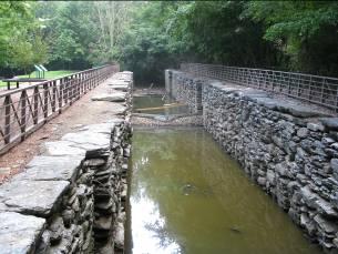
50 LS pg 1 50 Site Index Historic Historical Architecture Canal Revol War Civil Native Natural Industry Other Home(s Person & community History war American History Heritage Topics LS 35 New Market Public Access 3 3 LS 34 Middletown Access 1 LS 29 Falmouth Boat Access 3 3 LS HF 2 York Haven Hydro Station 1 Hydro LS 28 Conewago Access 3 LS 19 Wrightsville Access 3 LS 18 Columbia River Park Access 2 LS 10 York Furnace Boat Ramp 3 LS 9 Indian Steps Access LS 7 Lock 12 Historic Area 1 LS 6 Lock 15 Historic Area 1 LS 5 Muddy Creek Access 2 Key: 1 = Tour Bus Ready; 2= Can handle up to 30 visitors; 3 = Less than 10 at one time; 4 Not tourism ready via policy.
51 5 year Implementation and Operations Matrix Summary. 51
52 NB pg 1 52 Year Index # Media/Services Cost Estimate NB Oakland PFBC (Great Bend Access). - Add proposed new Greenway panel. $ NB 351 Susquehanna Depot (Great Bend) - Potential for new Greenway panel. $ NB - H-1 Starrucca Viaduct - Good location for new interpretive panel in partnership with community. $ Potential stop on Viaduct Scenic Byway proposed interpretive booklet. NA NB - HR-1 D & H Rail Trail - Develop new trail head sign w/panel. $ Develop interpretive trail guide (photo ready). $ Proposed Greenway overview panel location. $ SRG R-=1 PA Route 92 Viaduct - Develop an Interpretive Plan for the Byway. $12, Scenic Byway. - Develop a Byway Driving Guide (master). $10, NB H-2 Mormon Monument / Joseph Smith - No additional media are needed here. NB 348 Great Bend Access - Proposed Greenway overview panel. $ NB 342 Hallstead PFBC Access - Proposed Greenway overview panel. $ NB 290 Sayre PFBC Access - Proposed Greenway overview panel. $ NB 288 Sayre Riverfront Park Access (sign has been removed from access) - Replace River Trail Panel if not installed yet. - Proposed Greenway overview panel. $ NB H-3 Tioga Point Museum - Proposed Greenway River Town Kiosk here. $15,000.00
53 NB pg 2 53 Year Index # Media/Services Cost Estimate NB 279 Ulster Bridge Municipal Access - Add new Greenway overview panel. $ NB Towanda Riverfront Park Access - Move River Trail Panel nearer to ramp. TBD - Add new Greenway overview panel. $ NB Wysox PFBC Access - Move River Trail Panel to better location. TBD - Add new Greenway overview panel. $ NB Wysox Township Park Access - Add new Greenway overview panel. $ NB H-4 French Azilum Historic Site - Work with site to add a Greenway overview panel. $ NB Azilum Township Old Mill Park Access - No additional media required. NB 254 Terrytown PFBC Access - Add Greenway overview panel. $ NB V-1 Wyalusing Rocks Overlook - Good location to add a Greenway overview panel. $ NB H-5 The Wyalusing Valley Museum - No additional media. NB 241 Laceyville Borough Access - Add a Greenway River town kiosk in park. $15, NB 233 Meshoppen Access - No additional media. NB 219 Tunkhannock Municipal Park - Good location for a Greenway River Town Kiosk. $15, Access
54 NB pg 3 54 Year Index # Media/Services Cost Estimate NB H- 6 Wyoming Valley Levee Trail System - Interpretative panels/kiosks here are very good. Suggest adding a Greenway River Town Kiosk. $15, NB H-7 Luzerne County Historical Museum - No media or services are recommended. NB 188 Nesbitt Park Access - Add one River Trail panel. $ Add one Greenway overview panel. $ NB H-8 Avondale Mine Disaster Site (under development) Potential site for an interpretive kiosk, developed in partnership with site managers. Interpretive plan required first. $ NB HR-2 Susquehanna Warrior Trail - Add a Greenway overview panel. $ NB HR-3 Mocanaqua Trail (mile 172L). - Add a Greenway overview panel. $ NB F-1 Susquehanna Riverlands Environmental Preserve and Visitor Center. NB B-1 Wetlands Nature Area (Mile 166R) - Work with site to add a Greenway Panel near the main parking lot. $ No media required. NB V-2 Council Cup Overlook - All of their interpretive panels need to be replaced many are damaged. New interp. plan for PPL site recommended. $ Replace vista panel with new one. $ NB 158 Test Track Park Access - Add River Trail panel and Gen. Greenway panel. $ Recommend interpretive panel on test track and industrial history here. $
55 NB pg 4 55 Year Index # Media/Services Cost Estimate NB 149 Bloomsburg Access - Relocate current River Trail Panel to face river. TBD - Add Greenway Overview Panel. $ NB 148 Bloomsburg Town Park - Recommend River Town Kiosk for Park. $15, NB 138 Danville Access - Add Greenway Overview Panel. $ NB WB Northumberland Point - Add River Trail and Greenway Panels $ Good location for interpretive panels on the Native American story of this area. $ each NB V-3 Shikellamy State Park Vista - Recommend 3 interpretive panels (see plan). $ each NB HR Adam T. Bower Memorial Dam - Add Greenway overview panel w/partner site. $ With partner site, add one or more interp. panels on history and function of the dam. $ each NB H-9 Joseph Priestley House - No new media recommended. NB H-10 The Hunter House Museum - No new media recommended. NB H-11 Sunbury Historic District Walking Tour - No new media recommended.
56 WB pg 1 56 Year Index # Media/Services Cost Estimate WB H-9 Packwood House Develop as a potential stop on the proposed new Greenway Driving Tour. List on web site. TBD WB H-10Dale Engler/Walker House Develop as a potential stop on the proposed new Greenway Driving Tour. List on web site. TBD WB H-11 Slifer House Museum Same as above. WB H-12Little League Baseball Museum (Williamsport) Same as above. WB H-13 Millionaire Row Historic District (Williamsport) Develop a partnership to develop a walking guide $ est. Or driving guide for the District. Have the district Listed on the Greenway web site. WB H-14 Thomas T. Taber Museum (Williamsport) Develop as a driving tour stop. List on web site. WB H-15 Avondale Mine Disaster (sign) Work with site planners to develop: - Interpretive panels at the site. $ ea - Develop as a stop on the proposed driving tour. - Interpret via Greenway web site. WB H-16 Eckley Miners Village Develop as a stop on the proposed Greenway driving tour. Partner to develop place a Greenway Orientation Panel on site parking area. WB 5.8 Chillisquaque Access PFBC - Remove old blue interpretive panel. - Add River Trail and Greenway panels. $
57 WB pg 2 57 Year Index # Media/Services Cost Estimate WB 11.4 Milton State Park Access Possible location for a new Greenway orientation panel. $ WB HC 1 City of Milton Heritage Area Possible partner for Greenway orientation panel. $ Possible partner for Greenway River Town Kiosk $15, WB 15.6 Watsontown Access PFBC -Remove old Blue river trail panel. - Add New River Trail Orientation panel. $ Possible location for interp. panel on Fish Restoration. $ WB 15.9 Watsontown Boro. Access - Consider adding a new River Trail Panel. $ WB HT-1 Canfield Island Native American Trail - Consider adding a proposed Greenway Panel to park. $ WB 37.3 Greevy Access PFBC - Remove old Blue river trail panel. WB 42.1 Susquehanna State Park Access - Consider adding new River Trail Orientation panel. $ Consider adding proposed Greenway panel. $ WB 70.8 Lock Haven Municipal Access - Consider adding new River Trail Orientation panel. $ Consider adding new Greenway Orientation panel. $ Recommend new interp. panel on Canal history here. $ Remove old Blue river trail panel. WB 90.8 Hyner Access PFBC -Remove old Blue river trail panel. WB H-18 Western Clinton Sportsman s Assoc Environmental Center - No recommendations at this time see plan.
58 WB pg 3 58 Year Index # Media/Services Cost Estimate WB 94.5 North Bend Access PFBC - Remove old Blue panel. WB 97.3 Flaming Foliage Access (Canoe) - Potential new Greenway Panel by visitor center. - Potential for exhibit in visitor center/ web site access. WB AT-1 Bucktail State Park/Scenic Auto Tour (Rt. 120). - Develop a self-guiding driving booklet for the tour route Photo-ready master copy on CD. $ WB Karthaus Access - Remove old Blue river trail panel. - Potential location for new Greenway panel. $ WB F-1 Reliant Energy Electric Generation Plant (and Dam) - In partnership with power company, develop two interpretive panels one on power production, one on river ecology. $ ea WB 174 Lower Witmer Park Borough Access (Clearfield) - Remove old Blue river trail panel. - Add new River Trail Panels. $ Add proposed new Greenway panel. $ Potential for 3+ interpretive panels (see plan) $ ea. - Potential location for a River Town kiosk. $ WB 185 Irvin Park Borough Access - Remove old Blue panel. - Add new River Trail Panel $ Add proposed new Greenway orientation panel by parking lot. $
59 59 WB pg 4 Year Index # Media/Services Cost Estimate WB V-3 Curwensville COE Vista No additional media required. WB 187 Curwensville Lake Access (COE) - Add proposed new Greenway Orientation Panel by office. $ Remove old Blue river trail panel. WB 209 McGees Mills Access and Covered Bridge - Remove old Blue river trail panel. - Work with partners to develop covered bridge panel. $ WB 217 Burnside Municipal Access (future) - Potential location for new River Trail Orientation panel. $ WB 227 Cherry Tree Borough Access - Remove old Blue river trail panel frame. - Add Greenway orientation panel. $ Add new interpretive panel on WB of river head waters $ and Chesapeake Bay watershed.
60 MS LS pg 1 60 Year Index # Media/Services Cost Estimate MS 106 Mahantango - Add a Greenway Orientation Panel $ Add interp. panel on river geology. $ Develop a watchable wildlife area. TBD MS 103 Sweigarts Island - Add River Trail Orientation Panel $ Potential site for Greenway Panel $ Panel on State Wildlife Mgt. Program $ MS 101 Liverpool PFBC - Add a Greenway Orientation Panel $ Add Panel on watchable wildlife. $ MS 98 Millersburg River Front Park - Relocate River Trail Panel TBD - Add a Greenway Orientation Panel $ MS 94 Halifax PFBC - Add a Greenway Orientation Panel $ MS 94w Montgomery Ferry - Add a Greenway Orientation Panel $ MS 92e Halifax Borough - Add a Greenway Orientation Panel $ MS 92w Clemson Island -No media recommended at this time. MS 88 Haldeman Island - Repair and re-install Canal Marker TBD - Add Greenway Orientation Panel - Add panel on Propagation Area ;program. $
61 MS LS pg 2 61 Year Index # Media/Services Cost Estimate MS 76 Marysville - Add Greenway Panel (low priority). $ MS 77e Fort Hunter PFBC - Add Greenway Orientation Panel. $ Work with Museum for potential partnership. MS 75 Schrauder Park Access - Potential site for a River Trails Panel. $ Potential site for a Greenway Orientation Panel. $ Potential site for River Ecology Panel. $ MS 72 West Fairview/Conodoquinet Creek Water Trail - Add a River Trail Orientation Panel. $ Add a Greenway Orientation Panel. $ Interpretive panel on Conodoquinet Creek. $ Interpretive panel on watchable wildlife/birding. $ MS 70 City Island - Relocate River Trail Panel (see photo in plan). TBD - Add a Greenway Orientation Panel. $ MS AT 3 Proposed driving tour - Develop an interpretive plan for the proposed on Rt. 11/15. Rt. 15/11 Auto Driving Tour. $ Develop a photo ready master driving guide. $ Develop an audio CD driving guide production ready master. $10,000.00
62 MS LS pg 3 62 Year Index # Media/Services Cost Estimate LS 35 New Market Public Access No new media at this time. LS 34 Middletown Access - No additional media at this time. Can be a stop On a Rt. 441/230 Driving Tour route. LS 29 Falmouth Boat Access - Replace and reinstall existing interpretive panel. $ No new media recommended at this time. - Potential stop on a Rt. 441/230 Driving Tour. LS HF 2 York Haven Hydro Station - Potential partner for a Greenway Orientation Panel. $ Interpretive panel on River Safety/Portage. (2) one at each portage site. $ LS 28 Conewago Access - Add a new Greenway Orientation Panel. $ LS 19 Wrightsville Access - Additional panel on S&T Canal at trail entrance. $ Add Greenway Orientation Panel. $ LS 18 Columbia River Park Access - Add Greenway Orientation Panel. $ Recommended location for a SG river town Kiosk. $15, Potential stop/trail head for the proposed Rt. 441 Driving tour (terminus and N. bound). - Develop an Auto Tour Trail Head Panel. $ LS 10 York Furnace Boat Ramp - Relocate current River Trail Panel (see plan) TBD - Add Greenway Orientation Panel. $
63 MS LS pg 4 63 Year Index # Media/Services Cost Estimate LS 9 Indian Steps Access - Add a Greenway Orientation Panel. $ LS 7 Lock 12 Historic Area - All of the interpretive panels at this site Are in need of replacement. Greenway can partner with site managers to develop new panels (joint grant?). $21, Explore adding Greenway Orientation Panel $ LS 6 Lock 15 Historic Area - All of the interpretive panels at this site Are in need of replacement. Greenway can partner with site managers to develop new panels (joint grant?). $10, Explore adding Greenway Orientation Panel. LS 5 Muddy Creek Access - Add a Greenway Orientation Panel. $ LS A-2 Driving tour Columbia - Interpretive plan for the proposed tour. $8, north on 441 to Royalton, changing - Developing photo-ready driving guide. $ to 230 North to Rt. 22 which - Develop production ready CD for the would like up with Rt. 15/11 at driving tour. $10, Amity Hall.
64 64
65 65 Susquehanna Greenway Interpretive Media Development Suggestions Susquehanna River/Greenway Driving/Exploration Guide. The driving guide would be similar to the I-75 driving guide. The guide would include information on resources, sites, geology, natural and cultural history, view sheds, and stories as visitors drive the Greenway. Probably divide into sections (west branch, and NY to Maryland Sections). For NPS gateway grants, the driving guide can focus on the Susquehanna River watershed feeding the Chesapeake Bay from historical and modern day aspects. This can include the watershed transportation corridors (i.e.: river to Bay to the world). It is suggested that this be a major marketing tool to attract new visitors to the SG river towns, river access areas, historic and cultural sites, etc. and to stay in the area longer providing economic benefits to the communities within the Greenway. Cell Phone Interpretation This is a key new technology aspect for the Susquehanna Greenway. Our research has noted that river users need real time information at river access sites that the current panels do not provide. The interpretive cell phone bank would provide visitors with updated river information at key access sites on the river. The cell phone interpretation could also be incorporated into the driving guide as well for visitors to hear more about the cultural and natural history of the Greenway Corridor. Greenway Web Site Upgrade This is another important needed improvement for the Greenway, and essential for marketing the Greenway as an entity other than a place. The Greenway has poor user identification and the development of an improved web site is essential to agency identification, image, services, and role. Some of the functions of the web site could include: - Downloadable river access maps. - Links to Greenway partner sites. - A Greenways resource center (books, CD s, maps, driving guides, etc.). - Real time information on river levels and access (similar to the River Trail web site or link to the river trail web site). - Web cam on the river. - Wildlife guides and related natural and cultural history self-guiding materials. - Podcast section - Resources available in multiple languages.

66 66 River Town Interpretive Kiosks These interpretive kiosks would be available for river communities, outfitters, or other organizations to purchase or cost/share from the Greenway. The kiosks could contain: - local river access information - local attractions, businesses, tourism support services. - Interpretive panel on the Greenway (with contact web site and cell phone interpretation). - Changeable bulletin board for local use.

67 67 Develop a traveling exhibit for use at partner sites, museums, County Fairs, Trade Shows, etc. Develop a set of waterproof river interpretive guides on: - Watchable wildlife - River plants and invasive species. - River history (canal, industry) - Interpretation of the Susquehanna River Watershed and the Chesapeake Bay. - Interpretation of SR aquatic ecology Develop a set of interpretive panels that can be purchased by Greenway Partners, outfitters, etc. on: - Water (kayak, canoe, and boating safety). - Native plants and animals (watchable wildlife). - River stewardship (leave no trace). - River history (canal era).
68 68 Develop an interpretive video (DVD) on the Greenway for use at museums, partner sites, trade shows and conferences, and other venues. This DVD on the Greenway and Susquehanna River could be developed as a 20 minute DVD, but also used in sections including: - 30 second and 60 second PSA s for marketing the Greenway - 7 minute presentation for visitor orientation areas, use for outfitters, etc. This could also be available on the proposed updated Greenway web site for play or downloading. - Longer version for conferences and outreach. Also available for sale as tourist souvenirs. Greenway Partner Interpretive Resource Guide The interpretive resource guide would be available to any Greenway site partner, member, etc. interested in developing or updating their interpretive site exhibits, outdoor panels, live programs or tours, or self-guiding materials. The resource guide could include: - Interpretive graphic standards - Interpretive signage resources and providers - Developing interpretive marketing brochures - RFP templates for interpretive media, exhibits, planning. - Interpretive planning form sets (panels, exhibits, live programs). - Power Point presentations and example on the above topics. - Other resources to be determined. Greenway Site Assessment Instructions When the initial interpretive planning process and inventory of interpretive sites was conducted in 2008 it was realized that given the time frame for the project it was impossible to visit and review every site within the 500 mile long corridor. So only the main sites, recommended by regional river trail and Greenway staff were included in the first inventory. This site accession form is designed to have any regional river trail/greenway representation or other stakeholders to recommend other sites to be added to the interpretive master plan.
69 69 Criteria for sites to be considered for inclusion into the interpretive plan: - Sites are owned or managed by a non-profit organization. - Sites are owned or managed by a government agency. - Sites that are facilities have regularly posted hours of operations. - Sites that visitors can access at any time such as scenic overlooks, self-guiding auto tours or historic district walking tours. Susquehanna River Water Trail And Susquehanna Greenway Interpretive Plan Site Accession Form Name of the Site or Facility to be added: Location: Main interpretive theme or message this site presents or illustrates (i.e. historic architecture, canal era history, river ecology or geology, industrial heritage, etc.). Existing interpretive media or services (interpretive panels, self-guiding brochures, exhibits, etc.). Recommendations for new interpretive media or services that could be developed for this site in the future:
70 70 Any management issues associated with this site (parking, safety, orientation signage, etc.) or site improvement needs? How will/does this site contribute to the interpretation of the Susquehanna River Water Trail and Greenway? Any other comments: Please include site photos or existing printed material on this site that supports your request for its addition to the Interpretive Master Plan. Your contact details: Name: Organization and address/phone number:
 This driving/linking route would")

71 71 Recommended Outdoor Recreation and Linkage System for Self-guiding Auto Routes: Community linking System Susquehanna Greenway Connections North Branch For the North Branch of the Susquehanna River Trail/Greenway there are two main driving/linking routes recommendations: North Branch Susquehanna Greenway Driving Tour Route #1 Sayre to Tunkhannock (or reverse) This driving/linking route would follow Route 220 from Sayre to Towanda where it would then change to Rt. 6 from Towanda to Laceyville. Interpretation for this route including stops listed in the interpretive plan for this section could include, but not be limited to: - River Towns - Museums - Community historic districts - Revolutionary War sites and history - Canal History - Railroad History - Native American sites and stories - River Ecology and Geology - Historic Homes and Personalities. - Natural history and watchable wildlife sites and opportunities Recommendations: - Develop an Interpretive Master Plan for this Driving/Linking Route. $12, Develop an Interpretive Tour Booklet for this section of the Greenway (photo or production ready). $
72 72 North Branch Susquehanna Greenway Driving Tour Route #2 Wilkes Barre to Sunbury (or reverse). This driving route would follow Rt. 11 and connect with sites noted in the interpretive plan that can be easily accessed off of Rt. 11. Potential stops for the driving tour include but are not limited to: - Historic Communities and Historic Districts - River Towns - Historic Homes and Personalities - Interpretive Vistas and viewpoints - Native American Heritage - Natural history and watchable wildlife sites and opportunities. - River ecology and geology - Industrial interpretation - Railroad heritage sites Recommendations: - Develop an Interpretive Master Plan for this Driving/Linking Route. $12, Develop an Interpretive Tour Booklet for this section of the Greenway (photo or production ready). $
73 73 Community linking System Susquehanna Greenway Connections West Branch West Branch Susquehanna Greenway Driving Tour Route #1 Route 15 to Route 405 to Rt. 220 Lewisburg to Lock Haven Route Interpretation for this route including stops listed in the interpretive plan for this section could include, but not be limited to: - River Towns - Museums - Community historic districts - Revolutionary War sites and history. - Canal History - Railroad History - Lumber Heritage - Native American sites and stories - River Ecology and Geology - Historic Homes and Personalities. - Natural history and watchable wildlife sites and opportunities Recommendations: - Develop an Interpretive Master Plan for this Driving/Linking Route. $12, Develop an Interpretive Tour Booklet for this section of the Greenway (photo or production ready). $ Driving Route #2 Bucktail Auto Tour This is an existing marked scenic driving tour (see interpretive plan copy), but has no formal interpretation media associated with it. The auto tour route goes from just west of Lock Haven to Keating, at the junction of the Sinnemahorning Creek and West Branch of the Susquehanna River. At this point, Rt. 120 goes north (see the interpretive plan) away from the West Branch to complete the tour route (75 miles total). A postcard book on the Bucktail was recently published noting the Native American and other natural and cultural features that can be seen along this route. In addition, there are many watchable wildlife opportunities along this route as well.
74 74 Community linking System Susquehanna Greenway Connections Middle and Lower Sections Potential Interpretive Self-guiding Auto Tour Routes. There are two very good potential driving tour routes in the Middle and Lower Sections of the Susquehanna River Corridor connecting interpretive assets and communities. The following routes were recommended based on the simplicity of the route (fewer chances for drivers to get lost driving the route). Routes 11/15 running from Selinsgrove south to West Fairview (Harrisburg viewpoint). Interpretive resources for potential stops and view points include: - River geology and natural history - Watchable wildlife locations (several) - Canal heritage sites - View points (Harrisburg) - Millersburg Ferry - Amish Country - Historic River Towns - Historic Architecture - Roadside geology - Wildlife management areas The auto tour route could cross the George N. Wade Bridge to the East side of the river to loop back on Rt. 22/322 hitting the east side attractions and meeting back at the Rts. 11/15 intersections at Amity Hall. Route 441 running from Columbia north to Royalton, changing to 230 North to Route 22 which, again, would meet up with Routes 11/15 at Amity Hall. Interpretive Resources and attractions could include: - Canal historic sites - River Towns - Historic Architecture - Energy/hydro interpretation - Three Mile Island Nuclear Plant - River ecology. - River geology - Museums (Fort Hunter). - Watchable wildlife/birding - Wildlife management.
75 75 Appendix A Interpretive Graphic Standards Recommendations
76 76 Interpretive Graphics Recommended Interpretive Panel Standards John A. Veverka John Veverka & Associates The function of an interpretive sign or panel is to communicate specific educational and/or management learning, behavioral and emotional messages to visitors. Interpretive signs are most commonly used for self-guiding trails, or wayside exhibits at points of interest such as viewing areas, resource management areas, or visitor information kiosks. As interpretive signs will vary greatly in content and design, this Interpretive Graphics Manual will focus on interpretive planning and writing guidelines and format suggestions. It is not the intent of this manual to control the visual look of the finished interpretive panel; rather, the intent is to provide guidance in developing interpretive signs. Interpretive signs need to reflect creativity and flexibility as they relate to specific sites, goals, and objectives. Interpretive signs are to be used for interpretive purposes and not to circumvent requirements for approval of, or as a replacement for, caution, danger, warning, or other management signs. Interpretive signs may be used to help create public awareness about management issues and their responsibility or safety when using these resources. What does it mean to be "Interpretive"? Today almost everything we toss out in front of visitors is called "interpretive" yet most of the communications we give them are informational, not interpretive! The definition of interpretation I prefer to use, and have taught for many years, is: Interpretation is a communication process designed to reveal meanings and relationships of our cultural and natural heritage to the public through first hand involvement with objects, artifacts, landscapes, or sites. The communication process in the definition is the use of Tilden's Interpretive Principals which state that to be "interpretive" the communication process must: Provoke the attention, curiosity, or interest of the audience Relate to the everyday life of the viewer or reader Reveal the theme or key point of the message through a unique or creative viewpoint, design, or perspective The interpretation should illustrate a higher theme or message
77 77 Strive for message unity by using correct graphics, colors, textures, and design elements to support the theme of the interpretive message. This process is also the basics a good advertisement. When you look at or read a provocative ad in a magazine, or on TV, you are seeing interpretive principals at work. Interpretation has come from, and utilizes, communication strategies and techniques from: advertising, marketing, consumer behavior, psychology of the audience, recreational learning theory, journalism, as well as other support areas. Planning Interpretive Panels Plan for your total site interpretation and your media mix Before you begin planning for one or more interpretive panels you should first consider the main story or theme of your total site and other interpretive media and services that will make up your message media mix. What is a media mix? To illustrate and interpret the total site story to your visitors you may use a variety of media including printed leaflets, visitor center exhibits, outdoor demonstrations, living history, guided tours, self-guiding audio devices, and interpretive panels. The variety of media you use for interpreting your total site is your media mix. In the interpretive plan for your total site you should have determined that for a given site, resource or location, interpretive panels were the best or most cost effective media for interpretation at that location. But the panel(s) is only one of many different media types you may be using to illustrate/interpret your total site theme. You should consider as good planning practice where and how the panel will fit into your total media mix presentation of your site story. Is a panel the best media? Do you need an interpretive panel? Remember, you are interpreting the "whole site" and a panel(s) for an individual location should be planned and designed to fit into the total site story presentation and design look (media graphic standards). The bottom line is the interpretive panel should fit in and help illustrate your total site interpretive message. Interpretive panel planning considerations Once you have decided that an interpretive panel(s) is the BEST media for interpretation at a particular site or resource, here are the key steps I recommend in planning and designing interpretive panels. 1. Story and theme analysis. Identify the key concept that this particular panel(s) will be designed to interpret. The best way to determine the theme is to ask yourself, "if a visitor only remembers one thing or message from this panel, I want that one thing to be ". The answer is the theme. Note that there is a big difference
78 78 between a theme and a topic. A theme is a complete sentence and a topic is not. For example: Topic: Birds of the park. Theme: We manage this habitat to attract three species of migratory birds. The THEME is what the panel graphics and text will "illustrate". 2. Audience analysis. Once you have the theme you want the panel to interpret, you also need to consider just who will be reading the panel. Will the audience be experts or people with little knowledge; local residents or tourists; children or retired folks, etc. The market group that the panel is designed for will translate into the kind of text, graphics, and "relate" approaches you use in the final design. 3. What are the objectives of the panel? This is the area where most planning falls short. I would guess that most panels in the countryside today are "objective-less" panels. That means that no one can explain why they are there other than that "we got funding for 5 boards and had to do something!" The ONLY way you can be sure that your panels are working are to have objectives for them. I like to use three different objective levels in panel planning: * Learning objectives: Upon completion of reading/looking at the panel, the majority of the visitors will be able to list the three ways that wildlife preserves benefit wildlife and people. * Behavioral objectives: These are the most important of the objectives as they determine the real results or purpose of the panel. Upon completion of reading the panel, the majority of the visitors will use this resource in a safe and stewardship-like manner. Upon completion of reading the panel, the majority of visitors will stay on designated trails only. * Emotional objectives: These are the objectives where you describe how you want the audience to FEEL upon completion of their interaction with the panel. It is the emotional objectives that drive the Behavioral objectives quite often. Upon completion of reading the panel, the majority of the visitors will feel that protecting natural areas is important for them and their children. Upon completion of reading the panel, the majority of the visitors will feel the desire to help support the (agency, etc.) that manages this preserve.
79 79 The true success of the interpretive panel is dependent upon you having clear and accomplishable objectives. How can you plan a panel if you don't know what it is you want the panel to accomplish? 4. The two questions! After you have developed your objectives, or as you consider what you want the objectives of the panel to be, ask yourself these two questions: * Why would the visitor want to know this? This is my who cares? or so what? question. If you cannot answer this question, you will have a problem with the panel being successful. Be careful not to have your panel giving answers to questions that no one is asking! If you can think of a good reason that the visitors will want to know this information, use that statement as part of the panel header (Provoke). For example: This plant can save your life! Would you want to know more? * How do you want the visitor to USE the information you are giving them? If you don't want the visitors to use the information on the panel in some way, then why are you giving it to them? The answer to this question can become your behavioral objective(s) such as, "have a safer experience", or "consider becoming a volunteer at the Center". Again, there is not a right answer. But you need to consider the question carefully. You have spent a lot of time and money on developing this panel. WHY? What do you want as a result of your panel investment? 5. Determine How, Where, and When to use Interpretive Boards or Panels. This planning consideration concerns itself with such issues as selecting the panel materials that would be best for your site/use. Kinds of materials can range from Fiberglass and porcelain signs to photo metal, lexan, and other materials. Each sign material has its benefits and limitations. It's good to ask for material specifications and samples from different sign manufactures to see what your options and costs are. Remember, the visitors don't care what kind of panel material you use; they only care about the quality of the message presentation! How/When/Where questions you also need to consider are: Panel locations. What kind of mounting system will you need? What will the impact of the panel mount have on the environment or the view? Panel maintenance. Can the panel and mounting system be easily maintained should any vandalism occur or if the panel needs to be changed in the future? What is the life span of the panel? How long do you intend to have it in place as is? (the answer to this question might be a reflection on your choice of materials used to manufacture the panel(s).) Will the panel topic be for a seasonal presentation or a year round presentation? Will any of the information presented on the panel be likely to change in the near future? 6. Evaluation. This is an important step in the interpretive planning process that is almost always left out. Before you spend $ on a panel or board, wouldn't you like to be sure that it works; that its objectives are being accomplished? I recommend that you make a simple photo copy of the proposed draft panel and pre-test it with a sample of
80 80 your visitors to see if they understand the message, etc. When you have the panel text and graphics working at a 70% or greater level of objective accomplishment, and then send it out for final production. 7. Implementations and Operations. This part of the planning process focuses on the real costs, time, and logistics involved in getting from the "lets have a panel" stage to the final installed product. Some of the questions you need to consider include: What is the budget and what are the media fabrication options for that budget? What should the panels be made out of? (material options) Will there be a warranty on the panels? When is the panel(s) needed by and how long does it take from planning to fabrication? Who will do the contract and then continue to manage it? Who will do the research, write the label copy, select graphics, do final design, and do the actual fabrication? Who is responsibly for approvals (drafts, text, design, etc.)? Who will do any pre-testing evaluation studies? Who will install the panels and maintain them? Remember the visitor! In planning and designing interpretive panels it is important to remember some basics about how visitors learn and remember information. - People learn better when they're actively involved in the learning process. - People learn better when they're using as many senses as possible. - People retain about: 10% of what they hear 30% of what they read 50% of what they see 90% of what they do Make sure that the visitors use the panel to help them look at and understand the resource the panel is interpreting. Use behavioral considerations in the panel design and text such as: "look for the...", or can you find the... in the site in front of you?", "go ahead and touch the...", "listen for the... These action steps will help design some minds on and hands on activities for the 90% of what they do communication information retention process.
81 81 General Interpretive Panel Graphic Guidelines 1. Point Size. This means the size of the text you will use on the panel. Here are some sample point sizes for illustration: This is 12 point type. This is 14 point type This is 20 point type This is 28 point type A lot of research has been conducted by the US National Park Service and other agencies that use thousands of interpretive panels. The research recommends that the smallest type size to be used on interpretive panels is point. It has been learned that this is the minimum size that is easiest for visitors to read while standing between 3-5 feet away from the interpretive panel. A visitor should never have to bend down to read an interpretive panel! 2. Font design. This is the shape of the letters you can use. As you know, most computers have lots of different fonts. For example this font is Times New Roman. Here are some other fonts that are recommended to be used on interpretive panels. Again these have been researched for the fonts that are easiest for visitors to read, but you are free to try others. If you not sure test them with your visitors, at about 30 point size, to see which they find easiest to read. This is Verdana This is Palatino Linotype This is Rockwell This is Arial Black 3. You can also use colors and different fonts to illustrate a point or theme in your interpretive panel. For example. You can bold in the first part of a sentence to attract visitors to some key part of the message (provoke). You can use color to illustrate a point such as interpretation of fire management. You can bold in key words that you want visitors to focus on or when introducing new vocabulary words such as habitats. You can use different fonts to illustrate points such as FAST vs. fast (note the letters are tipping) or HEAVY vs. HEAVY.


82 82 4. Amount of text for interpretive panels. As a general rule of thumb, again coming from research on readability for interpretive panels, we know that interpretive panels should not have more than 100 words, (about two 50 word paragraphs). Within these guidelines, it is recommended that the first sentence of each paragraph be bold to attract the visitor s attention to what the paragraph/text is about (like newspaper headlines). 5. Mounting angles. In general, interpretive panels would be mounted at about a 45 degree angle. This is the easiest angle for visitors to read at. Frames and mountings. Remember that your panel will need to be held up by a framing system. Frames can vary widely in design, shape, and materials; from metal to wood and from angular to vertical. You need to think about which framing system and materials would work best for you. These are just a few of the possible mounting systems (from Hopewell Manufacturing website). Check with different interpretive sign companies for their brochures illustrating the sign framing systems they may have available.

83 83 Developing draft designs for your interpretive panels. It is generally recommended that you first develop a draft design and text of what you want your panel to look like based on your learning, behavioral, and emotional objectives and using Tilden s Tips of Provoke, Relate, and Reveal. This gives you a chance to think about your audience, final sign placement, vandalism issues, and content. You can also pre-test your draft designs with your visitors before going to a designer for the final design/layout and artwork. Here are some samples of DRAFT or Mock-up Interpretive Panels collected from interpretive panel design workshops to give you an idea of how a mock-up interpretive panel might look. This is a really good draft example. Note the use of PROVOKE in the header, and look for how the objectives were blended into the text. Can you spot the other interpretive tips (relate and reveal)?
.")
84 Here is a DRAFT interpretive panel for a watchable wildlife area. While it may not look like a draft, it was done on a computer using Microsoft Word. Text boxes were used to insert the header, photos of eyes, lower text box, and finally a text box for the photo (inserted as a jpeg). This draft can be printed off from the computer printer for pretesting and making any corrections. Once corrections have been made, it can be ed to a designer for any final touch-ups and to make sure the layout is correct for enlarging this mock-up to a large interpretive panel. 84

85 85 Trail Head Signs Self-guiding interpretive trails use two different types of signs: one large trail orientation sign, called a trail head sign, and several smaller trail stop/station signs located at various stops along the trail. The role of the trail orientation sign at the beginning of the interpretive trail is to give the visitor a general overview of what the trail is about and what kinds of experiences to expect. Based on this information, the visitors can decide whether or not to walk the trail. Every trail orientation sign should include: 1. The name of the trail. 2. A brief introduction to the theme of the trail. 3. Walking distance and time. Note: for most visitors the walking time is the most important element to present. 4. A trail map so visitors can see where the trail ends. 5. Any necessary safety information (i.e. sturdy hiking shoes recommended, steep hills, etc.). The general size for a trail head sign is about 24 x 36, but sizes and shapes can vary widely as illustrated below. Trail Logo Photos of trail stops.

86 This trail head sign from Barton Broad Boardwalk uses a variety of innovative designs including raised illustrations on the sand-blasted wood frame. It is well written using interpretive techniques and has a design standard that matches the rest of the interpretive panels located along the trail (to be illustrated on following pages). 86
87 87 Designing Interpretive Panels As presented earlier, there are a variety of recommendations in developing interpretive panels. Here are some rules of thumb and examples of some best practice in interpretive panel design and writing. 1. Design the interpretive panel (size, colors, and shapes) to fit the landscape and/or location where it will be positioned. 2. Design the interpretive panel to accomplish specific objectives (learn, feel, do). 3. Develop the design, content and text using Tilden s Interpretive Principles (Provoke, Relate, reveal, address the whole and message unity). 4. Keep it SIMPLE. One graphic that CLEARLY illustrates the concept and about 100 words of text. 5. If you can t get your concept across in 15 seconds, you probably won t. 6. Pre-test your design and copy. While a picture might be worth 1000 words, they could be the wrong 1000 words! 7. Remember to have the visitor DO something with the panel interpretation (look for the smell the can you find the touch the). 8. Keep your sentences short. 9. Avoid using technical or unfamiliar terms or vocabulary unless you illustrate the new vocabulary word for the visitor. 10. Use active verbs. 11. Add touches of humanity. Use first person quotations, make references to people s common experiences, and write with warmth and emotion. 12. Encourage visitor involvement (emotional or behavioral objectives). 13. Use colorful language (metaphors, puns, quotations, etc.). 14. Make the interpretive panel contact with the visitor enjoyable so they will be drawn to look for other panels. 15. If the panel is boring it is NOT interpretive! If you remember 50% of what you see, here are a variety of interpretive panels that we feel illustrate the main points presented in this graphic standards document. Feel free to add your own examples you may see when you visit other interpretive sites to add to this collection.

88 88 Provocative header and graphics. Relate natural mounting for panel to match the landscape. Relate and Reveal - hands-on rock samples for visitor to feel. Photo courtesy of Scottish Natural Heritage. In this example notice how the panel header and graphic pulls you in. The hands-on attachment of rock samples adds that experience bonus to the panel. The provocation elements of header and design encourage the visitor to read the copy, which also is written in an interpretive manner.
 with provocative header and illustration.")
89 89 Provoke header and content copy and provocative graphics. Relate graphic illustrations and text. Notice that the text body is kept short and about 30 point size. Relate and Reveal sub topic with 3-D illustration. Photo courtesy of Scottish Natural Heritage Second layer of text (headlining) with provocative header and illustration. Notice that the point size is a bit smaller than main copy.

90 This is a good illustration of fitting the mounting of the panel into the landscape. Notice how the shape of the rock mounting is similar to the mountain being interpreted by the panel. 90

91 The following three examples illustrate the main concepts of Tilden s Principles of Provoke, Relate and Reveal. They are part of the self-guiding interpretive boardwalk at Barton Broad. Notice how the snail drawing accomplishes both the requirement for Relate and Reveal at the same time. 91 Provoke Relate Reveal Reveal and restate main interpretive theme.
92 92 Provoke Relate and Reveal Provocative use of graphics. Relate with good analogies.

93 93 Provoke. Notice how the provocative header and graphic work together to illustrate the concept. Relate and Reveal. This is a good example of interpretive writing using less than 100 words.
.")
94 94 This interpretive panel from the Chester Zoo Jaguar exhibit, is a good example of how having some hands-on elements can make the panel more interesting. It also does an excellent job of relating the Jaguar teeth to familiar utensils we can find in our home. Notice the copy is kept short (under 100 words). Relate and Reveal Provoke
95 95 Interpretive Panel Planning Worksheet Project: Panel #: Theme or Topics: Panel Header (Provoke): Main Concept to be interpreted: Panel Location: Panel Objectives: Learning Objectives: Behavioral Objectives: Emotional Objectives: Audience (vandalism issues?) Panel Materials and specifications (size, shape, etc.) Maintenance issues: Framing System: Panel add on interpretive elements (3-D attachments, audio devices, activities): Warranty (yes, no): Evaluation Pre-test:
96 96-2- Panel Design Check List: Provocative header Provocative graphic Text in 30 point size or larger Use headline effect larger for main copy, smaller for secondary copy. Text around 100 words or less. Use of Provoke in text. Use of Relate in text. Use of Reveal in Text. Used simple language, analogies, metaphors, etc. Warranty Framing System Appropriate for its landscape location.
97 97 Request for Proposal (Template) Outdoor Interpretive Panel Planning/Design and Fabrication Services Agency or Organization Name XYZ Visitor Center I. Agency and project introduction. This introductory section gives the bidder an overview of who you are, what you do, and what the project is. It might give a brief history of the project, who is funding it, and what you want the project to accomplish when completed. II. III. Project Requirements. This section provides more detail on what you are looking for, such as a team of experienced panel designers, or panel planners that are familiar with Chesapeake Bay Natural History. It may also describe other project requirements such as the need for panels that are bi-lingual. Will the project require any handicap visitor design needs or expertise? Scope of Work. This is one of the most important sections of the RFP. Here you will detail exactly what the scope of work will cover. The following is a template example of typical scope of work for an exhibit project. The selected contractor will: 1. Conduct a focus workshop session with staff to determine/re-affirm the main interpretive theme and sub-themes of the total interpretive message presentation. -Develop with staff, the specific objectives, in writing, of each interpretive panel: Learning objectives Behavioral objectives Emotional objectives 2. Review the facility visitor numbers, market make-up and mix, and seasonal visitation patterns that might influence exhibit design and any needs for easily changeable panels (seasonal or topical). 3. For each proposed panel, the designer will develop an Interpretive Panel Planning Form that details those individual panels: Main interpretive sub-theme or message concept. The specific recommended/approved objectives that individual exhibit is to accomplish (learn, feel, do).
98 98 The best interpretive approach for that panel to accomplish its stated objectives. The interpretive panel plan for the individual panels will be reviewed by facility staff and approved before moving on to the DESIGN phase of the exhibit project. The individual panels will be designed to accomplish the objectives stated and draft designs will be reviewed for approval on how well the design addressed the specific objectives. 4. Work with facility staff and review the facility collections for appropriate photographs or related materials to help illustrate the theme of each panel. 5. Develop draft label copy for the panels. Label text should be interpretive and based on Tilden s Interpretive Principals of Interpretation. 6. Provide a final design (based on comments from the review of the draft design) for approval. 7. Provide panel fabrication as per your proposal. 8. Have the client review panels for any technical or editorial errors. 9. Have the client sign off on the panel s production after the review. 10. Ship panels by the deadline set forth in the contract. Additional considerations: Contractor will provide a WARRANTY on all panels. Panel Specifications (list your panel material, size and thickness specifications here. Required panel mounting system (kind of panel frames you want) specifications) if you want the contractor to provide the frames too. IV. Agency provided services and materials. This is the section of the RFP where you list what products or services you will provide for the project. This might include: As part of the project our agency (name) will provide the following materials or services for the project: Assistance in photographic research and photo selection. Assistance in historic or biological research for text development. Assistance in organizing meetings and providing meeting rooms and associated audio-visual needs as needed. Other kinds of help you can provide for the project.
99 99 V. Qualifications. This section is where you list the qualifications that the successful bidder or firm should possess. This might include: Technical Qualifications Bidders should meet or exceed these minimum qualifications: Five or more years of experience planning, designing, construction of outdoor interpretive panels. It is recommended that the contractor have a professional interpreter on the team to provide the interpretive planning expertise and interpretive text writing. Have experience in planning/design of projects of a similar size or nature. Be able to meet the design and fabrications specifications of the panels (panel materials, thickness, etc.) Be able to provide a warranty of the finished panels. VI. Bid submittal requirements: Provide list/samples of interpretive panel design projects developed within the past year. Provide a sample of your best interpretive panel design with a narrative of why the panel is interpretive; how did you use Tilden s Interpretive Principles in the design and message presentation? Provide a list of three references from recent projects. Provide a list of personnel (resumes) who will be involved with the project management, interpretive planning/writing, design, research and fabrication, including any/all sub-contractors. Provide a breakdown of budget: Panel research, planning and design Panel construction/fabrication Panel delivery and installation. Provide a draft project time line. Payment terms and conditions. VII. Selection Criteria. This is the section where you explain how you will judge the proposals and the criteria you have established to make your final selection. This could include:
100 100 Our selection criteria follow the rules and standards of (your agency or facility, such as a county government), and the National Park Service Chesapeake Bay Gateways Program. The selection of the successful candidate/bidder is not based solely on low bid, but on the best product to accomplish the objectives of the project. The successful bidder will: Meet or exceed the standards of the National Park Service Chesapeake Bay Gateways Program. Meet our city (agency or organization) standards for bidder qualifications through our formal bid process. Not exceed the amount budgeted for the project. Meets or exceeds the qualifications as listed in the RFP. Clearly details how they will accomplish the stated scope of work within the allotted time frame. VIII. Award of Contract. Award of the contract is not based on low bid, but by the receipt of the proposal that best meets the needs of the (city, county, agencies, etc.), the Chesapeake Bay Gateways Network, and this project. It is our intent to select the consultant/firm no later than (date) and to have the project formally begin by (date). Send one (or as many copies as you need) copy of your proposal to: Name and address you want the proposal sent to: All proposals are due in our office by 5:00 pm (date). Any specific questions about this project or proposal contents should be directed to the project manager (name) at: Address, phone, fax, .
101 101 Appendix B. Way finding Graphic Signage System Recommendations
102 102 Development of the Greenway Brand Susquehanna Greenway Orientation and Wayfinding Signage Concepts This appendix provides a variety of design concepts for various wayfinding and orientation signage for the Susquehanna Greenway. It is based, in part, on standards and designs developed for, and illustrated in, the Susquehanna Greenway Strategic Action Plan Marketing Section. The graphic concepts presented here are directed to the Susquehanna Greenway Wayfinding System Only.
103 103 Highway wayfinding signage (to comply with highway signage size and placement regulations). Greenway Highway Identification and Directional Orientation Sign. The purpose of this identification and orientation sign is to help reassure visitors that they are on the right road that is part of the Greenway Corridor. Bottom box would be for directional arrows at key decision points in the road system, such as highway junctions. General sign size 2 x 3 (approximate depending on DOT signage size regulations).

104 104 Self Guiding Auto Tour/Heritage Trail Signage Self-guiding Auto Tour Route Marker Concepts. Route Marker Logo (based on Strategic Plan concepts), top right. This design has the auto tour logo inserted into the center. International Self-guiding Auto Tour Symbol Wayfinding directional/self-assurance signage option concepts. Center Sign below would be posted at the stop location. Canal Trail Canal Trail

105 105 River Town Arrival Sign/Logo and wayfinding signage. River Town Logo and signage concepts for wayfinding for a particular community, and entry signage for highway marking. Signs would be designed to meet DOT signage sizes. Welcome to Columbia Columbia 3.5 miles.
.")

106 106 Historic District Orientation/Identification Signage Orientation and directional signage concepts for Historic Downtowns (or Historic Districts). Directional signage from Greenway access highways, and entry or community directional signage concepts. Logo bottom text would have the name of the community and/or historic district. Columbia


107 107 Greenway Orientation Panel draft design concept. Action photos of things to explore in this region. The Susquehanna Greenway is a 500 mile long living museum of our natural and cultural history for you to explore, discover and experience. But unlike some museums, our museum exhibits change almost daily, sometimes right before your eyes. Here are some of the sites and places you can explore and enjoy in this section Map would have an insert map of the total Greenway for you are here reference. Look at what you can do here! LIVE Learn Explore Call out photos relating to sites keyed to regional map. Web site and contact info. This area is just one of the many regional sites waiting for you to discover to escape to, to relax, to learn, to be with family and friends and to reconnect with nature. You can find out more about the Susquehanna Greenway at our web site : www-gogreen.org or by contacting us at (phone number). (local information if available) Photo(s) showing tourists living, learning, exploring locally. Let the River be your guide. Standard NPS size panel similar in size (4 x 5 ) to the current River Trail panels. Fiberglas embedment format, with NPS framing system. Can be mounted on the rear of current River Trail panels. Main design idea keep it simple and visually exciting.

108 Susquehanna River Water Trail Campsite Designation Signage 108
109 109 River Access Signage System River to Access View Conducting the Access Signage evaluation and critique in 2008, which included interviews with approximately 100 boaters and paddlers, the one thing that most of them mentioned was the need for Access Identification Signage that can be seen from the river looking to the land/access. New river users noted that they could easily miss an access pick-up point for some of the smaller access sites an none of them are signed. We are recommending a River Access Sign for posting above the river flood level at key access sites noted in the Interpretive Plan. A general simple design concept is provided below. 2 x 3 ft. Hopewell frame Fiberglas Embedment. Bottom space for other logos or information.
110 110 Susquehanna Greenway Member Site Door or Window Sticker The interpretive plan policies section recommends that the Susquehanna Greenway undertake a membership marketing and administration program. With this program, sites would join (fee based) the Susquehanna Greenway, and in doing so, gain access to many diverse benefits such as web site links and marketing, access to training, consultations, marketing, and other services. Membership as a Greenway Partner would require a membership application and ask the proposed member to meet high standards of professional tourism welcoming and customer care (again outlined in the policy for membership). The following is a concept design for a window or door sticker given to successful applicants. Approximate size would be 8 long x 5 high. LIVE LEARN - EXPLORE
111 111 Pennsylvania DOT Statewide Wayfinding Program Guidelines June 2008 Note that this document is currently in PDF form, so could not be inserted into this section. A printed copy is available in the hard copy notebook for the Susquehanna Greenway Interpretive Plan Administrative Section Notebook.
112 112 Appendix C Site Analysis of Installed Existing Orientation & Safety Panels

113 John Veverka & Associates October
114 114 Introduction During the course of boat access site visits and analysis as part of the Interpretive Master Planning project for the Susquehanna Greenway and River Corridor, review and discussions about the newly installed orientation panels occurred. We had observed problems at boat access sites with panel placements and had some concerns that the panels were not being used by visitors to the extent envisioned. At that point JVA suggested doing an evaluation of some of the panels to see if and how they were being used by visitors. A proposal was developed for an evaluation project that would: - Determine how and if they are viewed or used by the target market user groups. - See if they are providing useful and meaningful information for these users. - To see what visitors may consider lacking or need to be added to proposed new panels. - To get a better idea of just who the user groups actually are and their perception for the need for this type of information. - Critique panel design and content (can the maps be read and understood, are the symbols meaningful and useful to user groups, etc.). - Critique sign placement strategies. To do a successful scientifically valid post installation evaluation of the signage, we suggested the following sampling strategy: - Develop a two-page survey tool to use for an interview type analysis with user groups. This will be designed to be filled out by visitors chosen by a random analysis and will keep their responses anonymous. They will be returned to the researcher for a %100 return rate. - Select 6 different sites for the surveys to take place. - Surveys would occur in July, August and September, selected days to include one weekend day and one week day. - A total of 100 questionnaires will be developed for analysis. Survey Locations. The sites selected for conducting the surveys were suggested by Susquehanna Greenway Partnership s staff based on the assumptions that they would be the busiest boat access sites. This was based on our extensive field trips for site visits for most of the boat access sites on the Susquehanna Greenway and noting during those visits that the majority of sites we visited had no or little visitor use at the times of our visits. This helped develop our concern that the panels were not being used by visitors, in part, due to the fact that most of the boat access sites had very weak visitor use.


, who were the paddler market group. Second Survey Group - August 10th and 11 th, 2008.")
115 115 Sites selected for the surveys included: Tunkhannock Access Signage surveys and observations were done on June 27 th 28 th. Part of the survey results for this site were biased toward the paddler market group (Kayak and Canoe users) as a kayak and canoe race scheduled for the 27 th of June had its completion of the race at this site. This created an influx of about 200 visitors, (participants in the race and supports/rides for the participants), who were the paddler market group. Second Survey Group - August 10th and 11 th, Liverpool Access Montgomery s Ferry Access Mahantango Access Liverpool Access. Montgomery s Ferry Access Mahantango A

 had very large parking areas, we found that for most days there were only a handful of boaters using these sites.")
116 116 Columbia and Wrightsville Access September 20 th and 21 st, Columbia Access Wrightsville Access Survey Challenges Based on our original perceptions of visitor use of these access sites, we anticipated a large number of visitors to survey. What we found was this perception of high visitor use was over estimated. Most of the sites where the surveys were conducted, with the exception of the Columbia Access, had very low use. While these sites (above photos) had very large parking areas, we found that for most days there were only a handful of boaters using these sites. The sites at Tunkhannock and Columbia also had higher use by local residents, as these sites were local parks as well. We had a good number of dog walkers, and walkers/picnickers at these two locations. What the surveys revealed: Summary of questionnaire results from each of the survey weeks is provided as Appendix A. The following is a combined summary from all three survey sites: Questions: How often do you use this site? : First time visitors: 29% 2-4 time a year: 35% 5 or more times a year: 36%
Summary of Action Strategies
 Strategic Action Plan 6 Summary of Action Strategies Action Strategy Categories: 1. Organization and Management 2. Implementation 3. Marketing and Promotion This chapter summarizes all of the action strategies
Byway Beginnings: What s Your Story and How It Can Create Tourism. Sharon Liggett University of Georgia Archway Partnership
 Byway Beginnings: What s Your Story and How It Can Create Tourism Sharon Liggett University of Georgia Archway Partnership Summer Trips VA - Blue Ridge Parkway AL - Natchez Trace FL - Florida State Parks,
The John Bartram Association Action Plan to advance the 10 year Strategic Plan
 The John Bartram Association 2013-2015 Action Plan to advance the 10 year Strategic Plan We are poised to take significant leaps with the opportunities that surround us. In the next three years we are
National Association of Recreation Resource Planners Conference
 DEVELOP INTERPRET RESTORE National Association of Recreation Resource Planners Conference Pittsburgh-to-Harrisburg Main Line Canal Greenway new connections between old neighbors Learning Objectives By
Member Service Plan Sierra Nevada AmeriCorps Partnership
 Member Service Plan Sierra Nevada AmeriCorps Partnership Service plans lay the framework for what each Member will be doing during their service. Service plans detail the major projects and expected results
TABLE OF CONTENTS. Transportation Chapter 1 - Introduction and Purpose of Planning to 1-3. Utilities
 Chapter 1 - Introduction and Purpose of Planning... 1-1 to 1-3 Pennsylvania Municipalities Planning Code (Act 247)...1-1 Previous County Planning Activities...1-1 Objectives of the Plan...1-2 Elements
SECTION FOUR: MISSION STATEMENT, GOALS & OBJECTIVES
 SECTION FOUR: MISSION STATEMENT, GOALS & OBJECTIVES Chapter Summary Chapter Ten: Mission Statement, Goals & Objectives To fulfill its mission, the Parks and Recreation Commission has identified four basic
Connecting people to parks
 Connecting people to parks Introduction from the Governor It is up to all of us to ensure the conservation of our State s wonderful national parks, marine parks and other conservation reserves continues
Arlington, Virginia is a worldclass
 EXECUTIVE S U M M A RY Arlington maintains a rich variety of stable neighborhoods, quality schools and enlightened land use policies, and received the Environmental Protection Agency s highest award for
Comprehensive Plan ADOPTED APRIL 2014
 Comprehensive Plan ADOPTED APRIL 2014 8 8. Outstanding Recreational & Cultural Opportunities We are proud of our community s parks and recreation system. Our community will ensure that the legacy of our
10.0 Open Space and Public Realm
 10.0 Open Space and Public Realm 10.0 Open Space and Public Realm The Public Open Space System is comprised of: outdoor spaces available for public use that are either publicly owned (e.g., parks and
THE FUTURE OF THE MCABEE FOSSIL BEDS HERITAGE SITE - Aligning the management of the site with fossil management approaches
 November 2014 A world class site with an interpretive and research centre that explores the role of fossils in our lives in a natural and cultural setting. PURPOSE The purpose of this document is to articulate
Outdoor Recreation and Conservation Careers Toolkit WEBINAR: OUTDOOR RECREATION AND CONSERVATION CAREERS TOOLKIT 1
 Outdoor Recreation and Conservation Careers Toolkit WEBINAR: OUTDOOR RECREATION AND CONSERVATION CAREERS TOOLKIT 1 The Outdoor Recreation Economy accounts for $646 billion in consumer spending annually
Local Authority Borough: Pembrokeshire Coast National Park
 Case Study Theme: Our Council Rhagoriaeth Cymru Local Authority Borough: Pembrokeshire Coast National Park Good Practice: Oriel y Parc Creating the St. Davids Landscape Gallery in partnership with the
Preface. Erie. Scranton. Allentown. Pittsburgh. Harrisburg. Philadelphia
 The Southern Alleghenies Region The Southern Alleghenies Region spans the Laurel Highlands and Allegheny Front in the west across the Appalachians to the east. It is comprised of Blair, Bedford, Cambria,
Denton. A. Downtown Task Force
 2 Public Involvement Early and ongoing public involvement was solicited so that the public had ample opportunity to help direct the DTIP s concepts and implementation strategies. The residents of Denton
Statewide Greenways Vision
 Greenways Vision The formation of a greenways vision is based on a thorough analysis of the current state of recreation and open space in a region and the existing pressures that threaten it. Lehigh and
Town of Peru Comprehensive Plan Executive Summary
 Town of Peru Comprehensive Plan Executive Communities that plan grow by choice, not by chance. A plan makes growth thoughtful, understandable, and predictable. A plan shows that a community is managing
RIDGES TO RIVERS OPEN SPACE NETWORI< OF THE MID-COLUMBIA DRAFT ACTION PLAN
 RIDGES TO RIVERS OPEN SPACE NETWORI< OF THE MID-COLUMBIA DRAFT ACTION PLAN Ridges to Rivers Open Space Network of the Mid-Columbia Region Draft Action Plan (8/6/08) The goals of the propose
Study of the Economic Value of Northern
 Study of the Economic Value of Northern Ireland s Historic Environment Summary Report on behalf of: Department of the Environment June 2012 eftec and RSM McClure Watters i May 2012 1 Introduction to the
Chapter 1: Introduction 8. Chapter 2: About Outdoor Living Industry Sales & Growth 13
 Chapter 1: Introduction 8 Research Objectives 8 Consumer Insights on Outdoor Living Lifestyles and Purchases 8 Also Included Is Garden Retailers' Perspective on this Marketplace 9 Consumer Insights Focus
State Parks and Wildlife Conservation Trust Fund Act
 State Parks and Wildlife Conservation Trust Fund Act The People of the State of California find and declare all of the following: (1) California s natural resources and wildlife must be preserved and protected
SALISBURY TOMORROW Our Vision
 SALISBURY TOMORROW Our Vision Salisbury is committed to supporting a high quality of life and sense of community for all residents. These commitments need to be reflected in our community programs, services
CHAPTER 1 Introduction
 CHAPTER 1 Introduction From sea to summit, Lane County covers almost 4,800 square miles of diverse Oregon landscape. Stretching from the Pacific Ocean through the Coastal Range, the Willamette Valley to
Rocky Areas Project Guidance HABITAT
 Rocky Areas Project Guidance HABITAT Introduction Rocky habitats are surface areas dominated by exposed rock, such as mountain peaks, inland cliffs, buttes and rocky outcrops. In many cases, rocky areas
Community Conservation Workshop. Lake Placid
 Community Conservation Workshop Lake Placid 2 Community Conservation Program Welcome! We have designed a Community Conservation Program that listens to the needs of community members. We are conducting
BEST PRACTICES IN CREATIVE PLACEMAKING VA Hometown Summit: The Future of Small Cities April 13-15, 2017, Charlottesville, VA
 The Strand American Conservatory Theater in San Francisco BEST PRACTICES IN CREATIVE PLACEMAKING VA Hometown Summit: The Future of Small Cities April 13-15, 2017, Charlottesville, VA AGENDA Background
Sacramento Area Council of Governments (SACOG)
") Sacramento Area Council of Governments (SACOG) The Blueprint Vision The SACOG Board of Directors adopted the Preferred Blueprint Scenario in December 2004, a bold vision for growth that promotes compact,
Sacramento Area Council of Governments (SACOG) The Blueprint Vision The SACOG Board of Directors adopted the Preferred Blueprint Scenario in December 2004, a bold vision for growth that promotes compact,
SAN RAFAEL GENERAL PLAN 2040 INTRODUCTION AND OVERVIEW
 SAN RAFAEL GENERAL PLAN 2040 INTRODUCTION AND OVERVIEW Steering Committee Presentation February 14, 2018 Purpose of General Plan Guide land use and development decisions Coordinate transportation, infrastructure,
Community Conservation Workshop. Saranac River Basin Communities
 Community Conservation Workshop Saranac River Basin Communities 2 Community Conservation Program Welcome! We have designed a Community Conservation Program that listens to the needs of community members.
Handshake Partnership Program Report - FY 2013 Recipients
 Handshake Partnership Program Report - FY 2013 Recipients 1. Name of Corps Project/Lake: Raystown Lake Project 2. Handshake Project Name: The Raystown Lake Naturalized Wildlife & Bird Watering Rehabilitation
Cultural Heritage Tourism What How Why. Nancy B. Kramer Program Coordinator Northwest Colorado Heritage
 Cultural Heritage Tourism What How Why Nancy B. Kramer Program Coordinator Northwest Colorado Heritage What? What Is It - I Travel With a Purpose! Cultural heritage tourism is traveling to experience the
Town of Cobourg Heritage Master Plan. Statutory Public Meeting
 Town of Cobourg Heritage Master Plan Statutory Public Meeting April 25 th 2016 Presentation Overview 1. Introduction 2. Project background and schedule overview 3. Review of strategic direction content
Interpretive Planning Toolkit for Trails National Trails Conference May 2011
 Star-Spangled Banner National Historic Historic Trail Trail Star-Spangled Maryland Star-Spangled Banner Scenic Banner Byway Scenic Byway National Park Service Chesapeake Bay Office Chesapeake Bay Gateways
SCORP THE 2019 STATEWIDE COMPREHENSIVE OUTDOOR RECREATION PLAN EXECUTIVE SUMMARY
 THE 2019 STATEWIDE COMPREHENSIVE OUTDOOR RECREATION PLAN EXECUTIVE SUMMARY SCORP Statewide Comprehensive Outdoor Recreation Plan 1 December 11, 2018 Dear Fellow Coloradans, It gives me great pleasure to
Al Hansen, Director of Parks and Recreation City of Petoskey, Michigan
 Al Hansen, Director of Parks and Recreation City of Petoskey, Michigan 231-347-2500 ahansen@petoskey.us What is Placemaking? Definitions Found Online: Creating a sense of place Creating a sense of belonging
SUSTAINABILITY PLAN OTTAWA COUNTY PARKS AND RECREATION COMMISSION FALL 2017
 SUSTAINABILITY PLAN OTTAWA COUNTY PARKS AND RECREATION COMMISSION FALL 2017 Table of Contents Introduction Natural Resources Quality of Life Community Continuing the Mission Sustainability Measuring Sustainability
CHAPTER 8 JOPLIN S STORIES: INTERPRETATION AND ENGAGEMENT
 CHAPTER 8 JOPLIN S STORIES: INTERPRETATION AND ENGAGEMENT Joplin has a rich and interesting history associated with the Tri- State Mining District and national stories related to the mining industry and
FARMLAND PRESERVATION AND PUBLIC POLICY ISSUES
 FARMLAND PRESERVATION AND PUBLIC POLICY ISSUES Lancaster County, home to the richest, most productive agricultural soils in the country, faces a tough battle in efforts to preserve our home, our harvest,
8implementation. strategies
 PROGRAM STRATEGIES 8implementation strategies T he implementation actions of this chapter are designed to support and carry out the land use, economic development, transportation, urban design, and program
Interpretive Master Plan. for Arnold Arboretum Visitors Summer, 2008
 Interpretive Master Plan for Arnold Arboretum Visitors Summer, 2008 Interpretive Master Plan for Arnold Arboretum Visitors Summary In 2008 the Arnold Arboretum of Harvard University created an Interpretive
Historic Preservation Element
 Casa Gardens by Carolyn Pelkey Historic Preservation Element Incorporated in 1928, the City of San Clemente was among the first master planned communities in the U.S. built from open grazing land. Before
1 Introduction. Chapter. In this chapter:
 Chapter 1 Introduction In this chapter: 1.1 A Snapshot of the Region 1.2 Towards a Sustainable Region 1.3 The Provincial Context 1.4 Purpose and Organization The Regional Municipality of York Official
Envision Front Royal Workshop 1 of 2
 Envision Front Royal Workshop 1 of 2 September 12, 2013 Summary The Envision Front Royal project held the first of two public workshops on September 12, 2013. The purpose of the workshop was to evaluate
3. VISION AND GOALS. Vision Statement. Goals, Objectives and Policies
 Vision Statement Queen Creek s interconnected network of parks, trails, open spaces and recreation opportunities provide safe and diverse activities and programs that sustain its unique, small town, equestrian
Dyersville Downtown Plan. Open House October 24, 2017
 Dyersville Downtown Plan Open House October 24, 2017 What is a Comprehensive Plan? - Vision - Guidance for decisions - Basis for regulations What is a Downtown Plan? - Understand priorities - Identify
Chapter 3. Community Vision and Goals
 Chapter 3. Community Vision and Goals 3.1 Public Involvement Charlevoix s master plan was prepared in a way that maximized public participation. Dating back to 2004, the Planning Commission and staff held
This page intentionally blank.
 This page intentionally blank. Parks, Recreation, and Open Space Chapter Relationship to Vision Vision Parks, Recreation and Open Space Chapter Concepts County Government. County government that is accountable
Director of Development and External Relations
 Director of Development and External Relations Emerald Necklace Conservancy Boston, MA Summer/Fall 2017 Tracy Marshall SENIOR VICE PRESIDENT OF EXECUTIVE SEARCH SERVICES Development Guild DDI 617.277.2112
TORTI GALLAS and partners, inc. How to Retrofit Your Suburb to Make a Downtown
 How to Retrofit Your Suburb to Make a Downtown April, 2010 Where to Start What should the Town look like? How do I attract new residents, businesses and visitors?? Should we preserve our heritage? How
HERITAGE ACTION PLAN. Towards a renewed Heritage Conservation Program. What is the Heritage Action Plan? Key areas of work. A Collaborative Approach
 HERITAGE ACTION PLAN Towards a renewed Heritage Conservation Program What is the Heritage Action Plan? The Heritage Action Plan (HAP) is a set of actions to update the City s Heritage Conservation Program
Introducing the Main Street Strategic Toolbox
 Ulster County Main Streets: A Regional Approach Ulster County Planning Department, 244 Fair Street, Kingston NY 12401 Why do we take a regional approach to Main Streets? There are many different approaches
TEXAS CHAPTER AMERICAN SOCIETY OF LANDSCAPE ARCHITECTS 2019 PROFESSIONAL AWARDS GUIDELINES
 TEXAS CHAPTER AMERICAN SOCIETY OF LANDSCAPE ARCHITECTS 2019 PROFESSIONAL AWARDS GUIDELINES The Texas Chapter of the American Society of Landscape Architects invites, from the Chapter membership, submission
Greenway. Two Rivers. Design Guidelines and Signage Plan. Broome County. Tioga County. Prepared For: The Binghamton Metropolitan Transportation Study
 Broome County Two Rivers Greenway Design Guidelines and Signage Plan Tioga County Prepared For: The Binghamton Metropolitan Transportation Study Prepared By: 2012 This project is included in the 2011-2012
REGIONAL ACTIVITY CENTER
 DRAFT REGIONAL ACTIVITY CENTER 70 EAST BENCH MASTER PLAN DRAFT 06 Introduction The East Bench Regional Activity center is comprised of large educational, research, medical, and employment centers. These
MAXIMIZING PROJECT SUCCESS THROUGH BEST PRACTICES IN CREATIVE PLACEMAKING Juanita Hardy, ULI Senior Visiting Fellow
 The Strand American Conservatory Theater in San Francisco MAXIMIZING PROJECT SUCCESS THROUGH BEST PRACTICES IN CREATIVE PLACEMAKING Juanita Hardy, ULI Senior Visiting Fellow Spring Meeting, May 2-4, 2017
EAU CLAIRE AREA CONVENTION AND VISITORS BUREAU TOURISM GRANT APPLICATION FORM
 EAU CLAIRE AREA CONVENTION AND VISITORS BUREAU TOURISM GRANT APPLICATION FORM ***Application must be received no less than 90 days prior to the first day of the event.*** The many festivals, conventions,
Executive Summary. Parks and Recreation Plan. Executive Summary
 Parks and Recreation Plan Executive Summary The Whitemarsh Township Parks and Recreation Plan sets forth a vision for how Whitemarsh Township can provide a premiere parks and recreation system reflective
COMMUNITY GARDEN BYLAWS
 COMMUNITY GARDEN BYLAWS Article I Name and Purpose of the Garden Name of garden: Midland Health Community Garden 4214 Andrews Highway, Midland, Texas 79703 Goals: To provide an accessible and affordable
WAC #7 3/14/14. Coachella General Plan Update
 WAC #7 3/14/14 Coachella General Plan Update Agenda 2 Introductions Public Draft General Plan Overview and Discussion of Next Steps Implementation and Evaluation Health Element Process Evaluation (discussion)
This matter is a Key Decision within the Council s definition and has been included in the relevant Forward Plan
 This matter is a Key Decision within the Council s definition and has been included in the relevant Forward Plan Barnsley Museums National Portfolio Organisation Status 1. Purpose of Report Report of Executive
Ontario Heritage Trust. Strategic Plan
 Ontario Heritage Trust Strategic Plan 2017-2020 Our Vision An Ontario where the places, landscapes, traditions and stories that embody our heritage are reflected, valued and conserved for future generations.
Parks for Produce Community Gardens Program 2018
 Parks for Produce Community Gardens Program 2018 Request for Applications As part of the Salt Lake County Urban Farming program, underutilized County park land will be considered for community gardens.
A BLUEPRINT FOR BROCKTON A CITY-WIDE COMPREHENSIVE PLAN
 A BLUEPRINT FOR BROCKTON A CITY-WIDE COMPREHENSIVE PLAN Public Meeting October 2016 1 Plan Summary and Discussion Public Meeting May 4 2017 City of Brockton Bill Carpenter, Mayor Department of Planning
Grantsburg Community Design Team (CDT)
") Grantsburg Community Design Team (CDT) Summary Report Overview On April 10-13, 2014, a team of (19) volunteer planners, design professionals, and community development educators volunteered their time
Grantsburg Community Design Team (CDT) Summary Report Overview On April 10-13, 2014, a team of (19) volunteer planners, design professionals, and community development educators volunteered their time
RECREATION, OPEN SPACE AND GREENWAYS ELEMENT GOALS, OBJECTIVES, AND POLICIES
 RECREATION, OPEN SPACE AND GREENWAYS ELEMENT GOALS, OBJECTIVES, AND POLICIES GOAL R-1: DEVELOP A RECREATION, OPEN SPACE AND GREENWAYS SYSTEM AS AN INTEGRAL COMPONENT OF AN OVERALL, COUNTY-WIDE ECONOMIC
1 October Dear Citizens of Charlotte and Mecklenburg County,
 1 October 2011 Dear Citizens of Charlotte and Mecklenburg County, As co-chairs of the Center City 2020 Vision Plan Steering Committee, we are proud to present the Center City 2020 Vision Plan, which sets
Brockholes Wetland and Woodland Nature Reserve, Preston Lancashire
 Newlands Brockholes Wetland and Woodland Nature Reserve, Preston Lancashire Nature s Gateway to Lancashire NEWLANDS Brockholes: site profile Brockholes Wetland and Woodland Nature Reserve project area
THE TOWN OF WASAGA BEACH
 THE TOWN OF WASAGA BEACH Downtown Development Master Plan Committee of the Whole Presentation January 26 th 2017 Uses within this designation should reflect a dependence on tourism as opposed to the permanent
IMPLEMENTING SOMERSET COUNTY S INVESTMENT FRAMEWORK
 IMPLEMENTING SOMERSET COUNTY S INVESTMENT FRAMEWORK SMART CONSERVATION THROUGH SMART GROWTH NJ LAND CONSERVATION RALLY March 22, 2014 Laurette Kratina, PP, AICP, Supervising Planner Somerset County Planning
PREVIOUS PUBLIC PARTICIPATION BRIEF October 2014
 Comprehensive Planning During the development of the county comprehensive plan, Cultivating Community: A Plan for Union County s Future from 2007 through 2009, and three concurrent multi municipal plans
Title: Project Lead: Abstract: Promoting Landscape Stewardship Through Interactive Interpretation.
 Title: Promoting Landscape Stewardship Through Interactive Interpretation. Project Lead: Tanya M. Quist, Asst. Professor, School of Plant Sciences and UA Campus Arboretum Director. Contact information:
1.0 Purpose of a Secondary Plan for the Masonville Transit Village
 Report to Planning and Environment Committee To: Chair and Members Planning & Environment Committee From: John M. Fleming Managing Director, Planning and City Planner Subject: Masonville Transit Village
UPPER BRODHEAD CREEK PARADISE CREEK GREENWAY PLAN
 UPPER BRODHEAD CREEK PARADISE CREEK GREENWAY PLAN The Upper Brodhead & Paradise Creeks Greenway Cooperating Municipalities Mount Pocono Borough Paradise Township Barrett Township Price Township Funding
Biodiversity: My Hotel in Action
 Biodiversity: My Hotel in Action Hotel Manager s Checklist This checklist is designed to guide you in evaluating how many of the practices recommended in this guide have been implemented in your hotel.
Parks Master Plan Implementation: Phase I Waterfront Use and Design REPORT #: September 7, 2016 File #
 0 'O DI Lan-171-14 1 - THE CORPORATION OF THE TOWN OF COBOURG..,. STAFF REPORT TO: FROM: Mayor and Members of Council Dean A. Hustwick, Director of Recreation and Culture DATE OF MEETING: Committee of
The Lower SaLuda Greenway
 The Lower SaLuda Greenway InITIaTIve a FLourIShInG Greenway. a hub For economic GrowTh. a ConneCTIon BeTween CoMMunITIeS. In April 2017 the Michael J. Mungo Foundation and Lexington County commissioned
HOW TO START A COMMUNITY GARDEN IN YOUR NEIGHBOURHOOD
 HOW TO START A COMMUNITY GARDEN IN YOUR NEIGHBOURHOOD What is a community garden? Community gardens are places where groups of people come to create a garden and build community. Can be on private or public
AND WHY YOU SHOULD, TOO
 WHY WE DO IT Friends of Trees was founded in 1989 with the idea of fostering community-based urban forestry. Portland's vibrant urban canopy is the only one in a major U.S. city that has increased in size
PRINCIPLE 6: Preserve open space, farmland, natural beauty, and critical environmental areas
 HOW TO APPLY SMART GROWTH PRINCIPLES TO RURAL COMMUNITIES PRINCIPLE 6: Preserve open space, farmland, natural beauty, and critical environmental areas A product of AND A cooperative publication from the
Section 4: Goals, Objectives, and Strategies
 99 Section 4: Goals, Objectives, and Strategies Goal 1 Resource Protection, Maintenance, Preservation, and Enhancement Protect, preserve, maintain, and enhance the natural, recreational, archaeological,
East Central Area Plan
 East Central Area Plan Steering Committee Meeting January 10 th, 2019 Tears-McFarlane House Community Room East Central Area Plan Steering Committee Meeting January 10 th, 2019 CHUN Tears-McFarlane House
Toronto Parks Renaissance Strategy
 Toronto Parks Renaissance Strategy Overview, Emerging Themes and Directions Presentation to EDPC, May 4, 2006 Parks Renaissance Strategy Presentation Agenda Project Overview Emerging Themes and Directions
ELK GROVE GENERAL PLAN VISION
 2-1 CHAPTER 2: 2-2 CREATING OUR The Community Vision for Elk Grove, expressed through a Vision Statement and a series of Supporting Principles, is a declaration of the kind of community that Elk Grove
To qualify for federal Transportation Enhancement (TE) funds a project must meet two basic federal requirements:
 funds a project must meet two basic federal requirements:") Eligibility Requirements To qualify for federal Transportation Enhancement (TE) funds a project must meet two basic federal requirements: 1) Relate to surface transportation and 2) Be one of the 12 designated
Eligibility Requirements To qualify for federal Transportation Enhancement (TE) funds a project must meet two basic federal requirements: 1) Relate to surface transportation and 2) Be one of the 12 designated
Strategies/Actions Priority List
 Strengthening the Creative Sector: Build stronger relationships with, and between, cultural organizations and businesses and increase opportunities for working together to build capacity within organizations.
CHAPTER 7: Transportation, Mobility and Circulation
 AGLE AREA COMMUNITY Plan CHAPTER 7 CHAPTER 7: Transportation, Mobility and Circulation Transportation, Mobility and Circulation The purpose of the Transportation, Mobility and Circulation Chapter is to
WATERLOO RECREATION AREA PHASE 2 LONG-RANGE ACTION GOALS. September 2012
 September 2012 PHASE 2 LONG RANGE ACTION GOALS PLAN Long-range management guidance focused on the specific natural resources, historic-cultural resources, recreation opportunities and the education-interpretation
Neighbourhood Planning Local Green Spaces
 Neighbourhood Planning Local Green Spaces Introduction... 2 1. Why green space is important... 4 2. Neighbourhood plans and green space... 6 3. Evidence... 8 Statutory designations... 9 Green space audit...
Overview of Southwestern Pennsylvania Commission s (SPC) 2040 Long Range Transportation Plan (LRTP)
 2040 Long Range Transportation Plan (LRTP)") Overview of Southwestern Pennsylvania Commission s (SPC) 2040 Long Range Transportation Plan (LRTP) Presented to Pennsylvania Agency Coordination Meeting May 27, 2015 Doug Smith & Ryan Gordon 1 Southwestern
Overview of Southwestern Pennsylvania Commission s (SPC) 2040 Long Range Transportation Plan (LRTP) Presented to Pennsylvania Agency Coordination Meeting May 27, 2015 Doug Smith & Ryan Gordon 1 Southwestern
DALY CITY VISIONING PROCESS COMMUNITY WORKSHOP 3 MAY 8, 2008
 DALY CITY VISIONING PROCESS COMMUNITY WORKSHOP 3 MAY 8, 2008 PROCESS General Plan - a statement of the community s values, vision and aspirations for now and into the future... Timeframe LONG TERM - 2030
CITY OF BEACON NOTICE TO LANDSCAPE ARCHITECTS GENERAL INFORMATION AND REQUEST FOR PROPOSALS
 CITY OF BEACON NOTICE TO LANDSCAPE ARCHITECTS GENERAL INFORMATION AND REQUEST FOR PROPOSALS The City of Beacon (the CITY) is issuing this Request for Proposals (RFP) for the selection of a landscape architect
ADOPTION OF THE REVISED OPEN SPACE AND CONSERVATION ELEMENT OF THE GENERAL PLAN
 TO: FROM: SUBJECT: Honorable Mayor and City Council Planning Department ADOPTION OF THE REVISED OPEN SPACE AND CONSERVATION ELEMENT OF THE GENERAL PLAN RECOMMENDATION: It is recommended that the City Council:
Please read the entire document
 projects impacting the waterfront revitalization area. The waterfront revitalization area of the town will have to subareas to the west and east of the village. Page 6 of 6 Wayfinding master plan create
CORPORATE SPONSORSHIP
 CORPORATE SPONSORSHIP CORPORATE SPONSORSHIPS HELP THE WILDFLOWER CENTER ACHIEVE ITS VISION OF A MORE beautiful, ecologically supportive world while providing recognition and exclusive benefits for you
CHAPTER 4.1 COMMUNITY HERITAGE AND HISTORIC PRESERVATION ELEMENT
 CHAPTER 4.1 COMMUNITY HERITAGE AND HISTORIC PRESERVATION ELEMENT Vision: Retention of the community s heritage and atmosphere through identification, preservation and ongoing support of important traditions,
7Page 1 CLEMMONS COMMUNITY COMPASS 1 PLAN OVERVIEW
 1 Plan Overview WHAT IS I THE CLEMMONS COMMUNITY COMPASS? The Clemmons Community Compass is our community s comprehensive plan. It serves as our blueprint and provides direction for the future of the Village
Planning for Waterfront Communities
 Planning for Waterfront Communities Redevelopment Ready Communities Supplemental Training Program OFFICE OF THE GREAT LAKES Waterfront Community Best Practices and Guidelines New supplemental criteria
Mendota Heights 2040 Comprehensive Plan Draft Vers
 4 Parks and Trails The City of Mendota Heights boasts a variety of recreational and open space opportunities. Few cities can claim access to regional trails, riverside and lakeside parks, scenic bluffs
PARK AND RECREATION MASTER PLAN UPDATE
 PARK AND RECREATION MASTER PLAN UPDATE 2014-2018 Prepared for: Avon Parks, Recreation and Beautification Council (PRBC) and Town of Avon Prepared by: Lehman & Lehman, Inc. 24-Apr-14 Mission Statement The