Millbrae, CA Report No.: 8
|
|
|
- Erik Woods
- 6 years ago
- Views:
Transcription
1 PLANNING COMMISSION AGENDA REPORT SUBJECT: Actions relative to the Gateway at Millbrae Station development located north of Millbrae Avenue, south of the Highline Canal and the Bayside Manor neighborhood, east of the rail lines on the Millbrae BART site with access from Rollins Road in the Transit Oriented Development Planning Zone of the Millbrae Station Area Specific Plan, as follows: 1. TENTATIVE SUBDIVISION MAP to subdivide 16.9 acres into six parcels: four development parcels, a site for the existing BART station and garage, and a site for a surface parking lot in the northeast corner of the site. 2. SITE DEVELOPMENT PLAN for four buildings on 6.6 acres as follows: a. Site 5A - a six-story building with 151,583 square feet of offices on the top three floors over three levels of parking, with 22,534 square feet of ground floor retail; b. Site 5B market rate housing units in a seven-story building with parking on the first two floors and 13,749 square feet of ground floor retail; c. Site 6A - 80 affordable units in a five-story building; and d. Site 6B - a 164-room hotel and 7,840 square feet of ground floor retail in a five-story building. 3.CONDITIONAL USE PERMIT to allow commercial lodging (the hotel). 4.DEVELOPMENT AGREEMENT that provides benefits to the Developer including increased development intensity and development at less than the minimum allowed density for the hotel site in exchange for community benefits which includes affordable housing and the provision of more than 10 percent publicly accessible open space on the project site. The Planning Commission will make a recommendation to the City Council, which takes final action on Development Agreements, Special Plan Districts and subdivisions. (Public Hearing) Report No.: 8 CITY OF MILLBRAE 621 Magnolia Avenue Millbrae, CA For Agenda of: October 16, 2017 Address: North of Millbrae Avenue, east of the rail lines on the Millbrae BART site, and south of the Highline Canal and the Bayside Manor neighborhood Property Owners Bay Area Rapid Transit District (BART) and City of Millbrae Applicant: Republic Millbrae LLC Originator: Tonya Ward, Director Tom Madalena, Deputy Director Colette Meunier, Project Planner Application submittal dates: March 12, 2016, August 26, 2016, and February 6, 2017 Application deemed complete date: The Project includes a Development Agreement, which is a legislative action, and therefore, the Project is not subject to the California Permit Streamlining requirements. Prior Planning Commission meeting date(s): None ATTACHMENTS: Attachments A through J are summarized in staff report. 1
2 REPORT TYPE: ACTION _X INFORMATIONAL ITEM TYPE: CONSENT PUBLIC HEARING _X _ EXISTING BUSINESS NEW BUSINESS RECOMMENDATION It is recommended that the Planning Commission open the public hearing regarding adopting the attached Resolution (see Attachment A) recommending that the City Council adopt the following Resolutions and Ordinance: 1. A Resolution making the necessary findings under CEQA to approve the Gateway at Millbrae Station project; 2. An Ordinance approving a Development Agreement that provides benefits to the Developer including increased development intensity and development at less than the minimum allowed density for the hotel site in exchange for community benefits which includes affordable housing and the provision of more than 10 percent publicly accessible open space on the project site; 3. A Resolution approving a Tentative Subdivision Map to allow the merger and subdivision of existing parcels, totaling approximately 11 acres, into six parcels including four development parcels, a parcel for the existing BART station and parking garage, and one for a surface parking lot in the northeast corner of the site; 4. A Resolution approving a Site Development Plan to allow the construction of four new structures; and 5. A Resolution approving a Use Permit to allow commercial lodging in Building 6B; Receive public testimony, provide staff and the applicant with the Commissioners questions and concerns and then continue the public hearing to allow time for the completion of the Development Agreement negotiations and for staff to respond to the Commission s questions, complete evaluation of some aspects of the Project, and provide of draft Council actions for the Commission s review. ATTACHMENTS: A. Resolution recommending that the City Council adopt Resolutions making the necessary CEQA findings, approving the Site Development Plan, approving a Conditional Use Permit, and approving a Vesting Tentative Parcel Map; and adopt an Ordinance approving a Development Agreement for the Gateway at Millbrae Station. Exhibits: 1. Resolution making required CEQA Findings and Adopting the Mitigation Measures Monitoring and Reporting Program (MMRP) [to be provided at a subsequent meeting] 2
3 2. Ordinance Approving the Development Agreement [to be provided at a subsequent meeting] 3. Resolution approving Vesting Tentative Parcel Map [to be provided at a subsequent meeting] 4. Resolution approving the Site Development Plan 5. Resolution to approve a Conditional Use Permit to allow commercial Lodging in Building 6B [to be provided at a subsequent meeting] B. Gateway at Millbrae Station Compliance Table with MSASP Policies C. Gateway at Millbrae Station Compliance Table with MSASP Design Standards and Guidelines D. Building 5A Compliance Table with MSASP Development Standards E. Building 5B Compliance Table with MSASP Development Standards F. Building 6A Compliance Table with MSASP Development Standards G. Building 6B Compliance Table with MSASP Development Standards H. Pending FEMA Flood Map for the Millbrae Station. I. Memorandum from Fehr & Peers, dated April 6, 2017, titled Millbrae TOD #2 Project Alternative, evaluating the traffic impacts from the Project now proposed which has a different mix and amount of land use. J. Letters of comment: 1. Greenbelt Alliance letter dated October 3, 2017 K. Applicant s Project Description The following plan set is being provided to the Planning Commissioners under separate cover: L. Site Development Plan Set and Tentative Subdivision Map These plan sets and other application materials are available on the City s website at: or: Project Plans Vesting Tentative Map Site Development Permit Plans Part 1 (page 1-20) Site Development Permit Plans Part 2 (page 21-40) Site Development Permit Plans Part 3 (page 41-66) Supporting Documents 3
4 Project Description Project Analysis Parking Management Plan Stormwater Management Plan Street Sections - Comparison to MSASP Transportation Demand Management Plan Fiscal Impact Report updated Millbrae Station Access and Circulation Plan Traffic Study updated Correspondence Republic Letter - Millbrae Development Agreement- Open Issues for Mayor and Council City of Millbrae Response to Republic Letter Republic Position Paper - Millbrae Development Agreement City of Millbrae Response to Republic Position Paper The Draft EIR and Final EIR are available on the City s website at: or: OUTLINE OF THIS STAFF REPORT This staff report is organized as follows: I. Background II. Proposed Project A. Project Site and Vicinity B. Project Description 1. Site Development Plan 2. Conditional Use Permit 3. Tentative Subdivision Map 4. Development Agreement III. Issues and Analysis A. Project Consistency with the MSASP Policies and Design Standards and Guidelines B. Building Consistency with MSASP Development Regulations 1. Office Building 5A 2. Market Rate Residential Building 5B 3. Affordable Residential Building 6A 4. Hotel Building 6B and the Conditional Use Permit 4
5 C. Consistency of Changes to the Millbrae Station with MSASP 1. BART Parking 2. Rollins Road Extension to the highline Canal 3. Shuttle Stops 4. Parking on Aviador Ave. 5. Pedestrian Crossing of Rollins Road 6. South Station Road D. Pending Updates in FEMA Flood Levels E. Preliminary Evaluation of the Tentative Subdivision Map 1. Abandonment of Rollins Road and the former Garden Lane 2. Adjustment of the Rollins Road ROW for the 5A Site 3. Compliance of Street Cross-sections with the MSASP 4. Incorporation of City Owned Property into Project Site G. Evaluation of the Development Agreement 1. Developer Benefits 2. Community Benefits IV. Environmental Review V. Next Steps VI. Recommendation I. BACKGROUND The Millbrae Station opened in June 2003 as part of the San Francisco International Airport (SFO) extension and is a vital and crucial connection between Caltrain s commuter rail system and BART s transit system located near SFO. It is also a planned station for California s High Speed Rail system. In 1998, prior to the opening of the Millbrae Station, the City of Millbrae adopted the Millbrae Station Area Specific Plan (MSASP). The Plan outlined a vision for the area around the Bay Area Rapid Transit (BART) Station, set development standards for new buildings, and identified implementation strategies. While some development successfully occurred under the 1998 MSASP, new development pressures, economic shifts, and changes in the Millbrae community led to the City undertaking an update to the 1998 MSASP. The intent of the Specific Plan Update was to provide policy and regulatory foundation to encourage a vibrant, mixed-use Transit Oriented Development (TOD) district that takes advantage of the regionally significant multi-modal transit facility. The MSASP Update, adopted by the City Council on February 10, 2016, refined the vision for the Millbrae Station area and provided updated policies for circulation, infrastructure, development regulations, and design standards and guidelines to enhance new development in an effort to continue to improve the community experience. 5
6 An Environmental Impact Report (EIR) was prepared for the MSASP Update, and for two proposed Transit-Oriented developments within the Specific Plan area: 1. Gateway at Millbrae Station, located east of the railway tracks on existing BART parking lots, proposed by Republic Urban (the project evaluated in this staff report); and 2. Millbrae Serra Station located west of the railway tracks on the site of a closed convalescent hospital and vacant land, proposed by Millbrae Serra Station LLC. The Planning Commission took action on November 16, 2015, to recommend to the City Council certification of the EIR with necessary CEQA findings, and approval of the Specific Plan Update and related General Plan and Zoning Ordinance amendments. On January 12, 2016, the City Council adopted Resolution certifying the Final Environment Impact Report for the MSASP Update and two proposed Transit-Oriented Developments. On January 26, 2016, the City Council adopted Resolution to amend the Millbrae General Plan to ensure consistency between the General Plan and the MSASP and adopted Resolution adopting the MSASP Update. On February 9, 2016, the City Council gave second reading to and adopted Ordinance No. 758 to amend two sections in Chapter of the Millbrae Zoning Ordinance to update definitions which referenced the MSASP. A. PROJECT SITE AND VICINITY II. PROPOSED PROJECT The project site is located on the east side of the Millbrae Intermodal Station ( Millbrae Station ) and is currently developed with a parking structure, existing Station, access roads, shuttle stops, passenger pick-up and drop-off ( kiss-and-ride ) and parking lots. A PG&E electrical transmission line crosses the eastern portion of the site. The site is generally level and covered by pavement. Rollins Road, an existing public roadway, extends into the site. The total site being subdivided is approximately 16.9 acres, and the four development sites total 6.6 acres. The project site was originally made up of 13 lots with access from Garden Lane (a public street), and six other lots (see Attachment L Tentative Map Plan Sheet TM.2). When the Millbrae Station was developed, the existing lot layout and streets were left in place. A 0.18-acre portion of the Millbrae Avenue right-of-way west of Rollins Road and adjacent to the BART property, which is owned by the City of Millbrae, is proposed to be incorporated into the project site. The Project site is bounded by: North: The City s Public Works storage yard, the Highline Canal, the BART parking structure, and the Bayside Manor neighborhood South: The existing gas station, Millbrae Avenue and the Millbrae Avenue overpass East: West: Aviador Avenue which is a public street, vacant land owned by the San Francisco Airport, Highway 101, and the Millbrae Avenue / Highway 101 interchange The existing Millbrae Station and railway tracks The San Francisco International Airport is located to the east of the project site, across Highway 6
7 101. The maximum building heights within the project site are controlled by the San Mateo County Airport Land Use Compatibility Plan and the Federal Aviation Administration (FAA). The maximum building heights are shown on Figure 5-2 of the MSASP, and show that the project site is limited to a maximum building height of 65 feet to the east of Rollins Road, and 90 to 100 feet to the west. Table 1: General Plan Designation and Zoning for the Project Site and Vicinity Project Address: 200 North Rollins Road Site North South East West General Plan Zoning Millbrae Station Area Specific Plan MSAPD District Utilities and Public Facilities; and Low- Density Residential Public Facilities (PF) and Single Family R-1 Millbrae Station Area Specific Plan MSAPD District Millbrae Station Area Specific Plan MSAPD District MSAPD District: Millbrae Station Area Planned Development District, MMC Article XVII, Section et seq. B. PROJECT DESCRIPTION Republic Urban LLC (the Applicant) has made application for the following entitlements: 1. Site Development Plan Millbrae Station Area Specific Plan MSAPD District The Gateway at Millbrae Station Site Development Plan (SDP) shows the site plan and building design for four buildings, and changes to the Millbrae Station site, within the Transit Oriented Development Planning Area of the Millbrae Station Area Specific Plan. A Site Development Plan (SDP) must be submitted to the City for review and approval for development in the MSAPD District pursuant to Millbrae Municipal Code (MMC) It must show proposed development in sufficient detail to demonstrate that it will be consistent with the MSASP. The SDP is included in Attachment L to this report and shows the following development: a. Site 5A - a six-story building with 151,583 square feet of offices on the top three floors over three levels of parking, with 22,534 square feet of ground floor retail; b. Site 5B market rate housing units in a seven-story building with parking on the first two floors and 13,749 square feet of ground floor retail; c. Site 6A - 80 affordable units in a five-story building; and d. Site 6B - a 164-room hotel and 7,840 square feet of ground floor retail in a five-story building. 2. Conditional Use Permit In accordance with MSASP Table 5-1, a Conditional Use Permit (CUP) is required to allow commercial lodging (the hotel). 7
8 3. Tentative Subdivision Map The proposed Tentative Subdivision Map (TM) would establish four development parcels: Parcels 5A, 5B, 6A, and 6B, and creates two lots which contain the existing Millbrae Station and parking structure, and the surface parking lot in the northwest corner of the site. The TM also shows future access and utility services for the site. 4. Development Agreement. The MSASP allows for variations in development intensity, such as Floor Area Ratio (FAR) and dwelling units per acre, for projects that provide community benefits, in compliance with Chapter 10 of the MSASP. The implementation tool is a Development Agreement, which requires City Council approval. The applicant is seeking both increases and decreases in the maximum Floor Area Ratio (FAR) in exchange for proposed community benefits: This section includes the following analyses: III. ISSUES & ANALYSIS 1. Evaluation of Project Consistency with the MSASP Policies, and Design Standards and Guidelines 2. Evaluation of consistency with the MSASP development regulations for each of the four buildings. 3. Evaluation of the overall Millbrae Station site once redeveloped. 4. Compliance with pending FEMA maps 5. Evaluation of the Tentative Subdivision Map 6. Evaluation of the Development Agreement, particularly regarding the provision of affordable housing 7. Fiscal Impact of Project A. PROJECT CONSISTENCY WITH THE MSASP POLICIES AND DESIGN STANDARDS AND GUIDELINES The project s compliance with Millbrae s Station Area Specific Plan will ensure consistency with Millbrae s General Plan because these two land use planning documents were written to be consistent with each other, as required by law. Therefore, this evaluation concentrates on the Project s consistency with the MSASP. The project site is located in the Transit Oriented District (TOD) within the MSASP. The intent of the TOD Zone is to support a variety of uses at higher intensities in order to create a vibrant day and evening activity center in close proximity to the existing Millbrae Station, incorporating a mix of transit-supportive uses in order to make the area a more convenient and enjoyable experience for the residents and visitors of the area. Attachment B to this staff report is a table which summarizes all of the MSASP policies and how the Project complies with them or will be conditioned to comply with them. Attachment C to this 8
9 staff report is a table which summarizes all of the MSASP design standards and guidelines and how the Project complies with them or will be conditioned to comply with them. Based on these two tables, staff finds that the Gateway at Millbrae Station project generally complies with the MSASP policies and design standards and guidelines. The following policies and Project compliance are discussed in more detail in this staff report: 1. The sidewalk on the south side of East Station Road. 2. Adequacy of Provided Parking. 3. The improvements to South Station Road. B. BUILDING CONSISTENCY WITH THE DEVELOPMENT STANDARDS In this section, each of the Project components will be evaluated for consistency with the development standards in the MSASP. This includes each proposed building and the changes to the Millbrae Station site as well. 1. Site 5A the Office Building Site 5A would be located immediately south of the BART parking garage on the interior of the site and contain a six-story building with offices on the top three floors over three levels of parking, with ground floor retail along the pedestrian plaza on the south side of the building. A new private roadway with public access (East Station Road) would be located between the office building and the BART parking structure, and provide the shuttle pick-up and drop-off area. Building 5A would provide ground floor retail along the pedestrian plaza (or paseo) that extends from Rollins Road to the plaza in front of the entry to the BART station. Building 5B would provide the other edge. The portion of the plaza within Site 5A is 20,810 square feet, which is 25 percent of the site, exceeding the 10 percent publicly accessible open space requirement. There would be a ground floor passageway from the pedestrian plaza through Building 5A connecting the pedestrian plaza to East Station Road, and the BART parking structure. The Floor Area Ratio (FAR) would be 2.2, which is in the allowed range of development intensity. There would be 288 parking spaces provided, which exceeds the minimum required parking of 269 spaces (see Plan Sheet A2.00). Access to the building s parking would be from two access driveways along East Station Road. 9
10 Site Size Office Retail Restaurant Table 3: Building 5A Components 82,355 sq. ft. or 1.9 acres 151,583 sf 20,334 sf 2,200 sf Floor to Lot Area Ratio 2.2 (see Note 1) Required Parking Provided Parking Open Space Area 1.5 spaces per 1,000 sf of retail 1.5 spaces per 1,000 sf of office 5.0 spaces per 1,000 sf of restaurant = 269 parking space 288 spaces 20,810 sf or 25% of total site sf = square feet Note 1: The enclosed parking is not included in the FAR calculation This site s compliance with the MSASP development standards is summarized in Attachment D. It complies with all of the development standards except that there is not a six-foot wide sidewalk on the south side of East Station Road; however, an eight-foot wide sidewalk is provided on the north side. The Tentative Map shows the realignment of Rollins Road to incorporate part of the existing ROW into the 5A site. This area would be developed at the ground level with a sidewalk and a shuttle stop, and the upper floors of the building would project out over this area. Later, in the discussion of the Tentative Map, staff discusses a recommendation to not approve the realignment of Rollins Road and to instead use an encroachment permit to allow the building overhang. Building 5A Non-Compliance Issues. MSASP, Figure 4-3, Pedestrian Circulation Concept, shows sidewalks on both sides of East Station Road. However, Building 5A does not have any entries onto East Station Road and the shuttle pick-up and drop-off is on the opposite side of the road. There is a clearly marked crosswalk that connects the sidewalk on the north side of East Station Road to the passageway through building 5A to the pedestrian plaza between Buildings 5A and 5B. Not having a sidewalk on the south side of East Station Road allows the pedestrian plaza between Buildings 5A and 5B to be wider. The crosswalk across Rollins Road is aligned with the sidewalk on the north side of East Station Road and continues the enhanced pedestrian corridor between Buildings 6A and 6B which connects with the pedestrian corridor through the surface parking lot. Because of the overall connectivity, and to allow the Pedestrian Plaza to remain as wide as proposed, staff recommends that a sidewalk not be required on the south side of East Station Road. 2. Site 5B the Market-Rate Residential building Site 5B would be immediately adjacent to Millbrae Avenue and contain a seven-story building with a basement level. The basement level and the first two floors would contain parking, with ground floor retail along the pedestrian plaza. The top five floors would contain 320 market rate apartments and wrap around three elevated courtyard spaces that would vary the building façade 10
11 along Millbrae Avenue that provide light and air to the residential units. Building 5B would provide ground floor retail along the south side of the pedestrian plaza. On the south side of this building adjacent to the Millbrae Avenue overpass, Site 5B would include an art walk pedestrian area. The portion of the plaza within Site 5B and the art walk total 11,888 square feet, which is 21 percent of the site, exceeding the 10 percent publicly accessible open space requirement. The building would exceed both the maximum allowed FAR of 2.5 and the maximum of 80 units per acre. This increase in intensity of development may be allowed with the provision of community benefits. There would be 347 parking spaces provided, which is slightly less than the minimum required parking of 352 spaces (see Plan Sheet A3.00). Access to the building s parking would include one access driveway from the eastern end of the pedestrian plaza, and an exit driveway onto South Station Road. Table 4: Building 5B Components Site Size 116,875 sq. ft. or 2.68 acres Apartments 320 units or 309,713 sf Retail 10,749 sf Restaurant 3,000 sf Dwelling Units/Acre Floor to Lot Area Ratio 2.76 (See Note 1) Required Parking 1.5 spaces per 1,000 sf of retail 1 space per dwelling unit 5.0 spaces per 1,000 sf of restaurant = 352 parking space Provided Parking 347 spaces Open Space Area 24,629 sf or 21% of total site sf = square feet Note 1: The enclosed parking is not included in the FAR calculation This site s compliance with the MSASP development standards is summarized in Attachment E. It complies with all of the standards except for: a. Maximum FAR b. Maximum number of dwelling units per acre c. Required minimum amount of parking Building 5B Noncompliance Issues. The applicant is proposing providing community benefits to address the increases in development intensity (i.e. exceeding the maximum FAR and the maximum number of dwelling units per acre). Regarding the shortfall on required parking, Building 5A has a surplus of 19 parking spaces, which exceeds the shortfall of parking spaces. A Parking Management Plan would allow the parking of the two buildings to be managed together to meet the needs of residents, workers, and 11
12 retail/restaurant patrons. A condition of approval requires a satisfactory Parking Management Plan. 3. Site 6A Affordable Housing Site 6A would contain a five-story building with a lobby, management office, and resident community space on the ground floor, with four floors of apartments above. The building would exceed both the maximum allowed FAR of 2.5 and the maximum of 80 units per acre. This increase in intensity of development may be allowed with the provision of community benefits. Seventy-two surface parking spaces would be provided to the rear of the building, which is less than the minimum required parking of 80 spaces (see Plan Sheet A4.00). Additionally, no accessible parking is provided adjacent to the building. The project would include outdoor seating areas and an enhanced pedestrian walkway totaling 2,871 square feet, satisfying the 10 percent publicly accessible open space requirement. Table 5: Building 6A Components Site Size 23,605 sq. ft. or 0.54 acres Apartments * 80 units, or 60,379 sf Dwelling Units/Acre Floor to Lot Area Ratio 2.56 Required Parking 1 space per dwelling unit = 80 spaces Provided Parking 71 spaces Open Space Area 2,871 sf or 12% of total site * with a Veteran s Preference. sf = square feet This site s compliance with the MSASP development standards is summarized in Attachment F. The site does not comply with: a. Maximum FAR. b. Maximum number of units per acre. c. Maximum street wall height along Rollins Road. The building is just beyond 600 feet from the Millbrae Station, so a shorter street wall height (55 ft. instead of 65 feet applies). d. Residential Uses are only allowed in mixed-use buildings (see MSASP Table 5-1, the first end note) and building 6A contains only residential uses. The building does not comply with the Permitted and Conditionally Permitted Land Uses. e. Minimum amount of required parking not provided and there are no accessible parking spaces adjacent to the building. Building 6A Noncompliance Issues: The applicant is proposing providing community benefits to address the increases in development intensity (i.e. exceeding the maximum FAR and the maximum number of dwelling units per acre). The maximum street wall height of 65 feet where the maximum allowed is 55 feet. The MSASP contains an Adjustment procedure (see page 1.10) but it only allows an adjustment of up to 10 12
13 percent which is insufficient to allow the 65 ft. street wall height. Similarly, there is no procedure to allow an all-residential building in the TOD Zone. A Development Agreement is required to secure the community benefits and a Development Agreement can allow exceptions in land use controls if the project continues to fulfill General Plan, Specific Plan, and zoning policies and purposes. The provision of affordable housing is a key policy of the Housing Element of the General Plan, and a goal of the MSASP. On page 3.3 of the MSASP, under the goal of providing A vibrant daytime and Evening Activity Center where people live, work and visit, part of what is included in this goal is Housing should be provided at a wide range of affordability levels. Staff recommends that the Development Agreement include exceptions to the MSASP land use and development standards to allow the 80-unit affordable housing building. No accessible parking is provided adjacent to Building 6A. A condition of approval requires that some of the parking spaces be revised to provide accessible parking near the building. Only 71 parking spaces are included for the 80 affordable units which does not meet the minimum parking standards for the TOD zone. Staff recommends that a variety of strategies be used to ensure adequate parking is provided. The parking within the development should be provided on an unbundled basis which means that parking is purchased or rented separate from the rent or sale price for a dwelling unit, or retail or office space. The amount of parking designated for BART parking could be reduced slightly to provide additional parking for the affordable housing building. A Transportation Demand Management Program would help reduce private automobile use. A Parking Management Plan would allow the surface parking to be managed together to meet the needs of residents, hotel visitors and workers and BART patrons, and retail/restaurant patrons. A condition of approval requires a satisfactory Parking Management Plan which includes consideration of the other options. 4. Site 6B the Hotel Building Site 6B would contain a five-story hotel with up to 164 guest rooms. The first floor of the hotel would include the lobby / registration area, break room, outdoor terrace, restaurant and kitchen, indoor pool, fitness room, and ground floor retail. The top four floors would contain the hotel guest rooms. The new Garden Lane would extend from Rollins Road through a passageway in the hotel that would be spanned by the hotel above the second floor. The building would not meet the minimum FAR of 2.0. This decrease in intensity of development may be allowed with the provision of community benefits. The hotel would include outdoor seating areas and an enhanced pedestrian walkway totaling 6,733 square feet, satisfying the 10 percent publicly accessible open space requirement. There would be 68 surface parking spaces to the rear of the hotel, which is less than the minimum required parking of 86 spaces (see Plan Sheet A3.00). 13
14 Table 6: Building 6B Components Site Size 66,090 sq. ft. or 1.52 acres Hotel Rooms 164 rooms, or 114,557 sf Restaurant 2,320 sf Retail 5,530 sf Floor to Lot Area Ratio 1.85 Required Parking 1.5 spaces per 1,000 sf of retail 5.0 spaces per 1,000 sf of restaurant 0.4 spaces per room = 86 parking space Provided Parking 68 spaces Open Space Area 6,733 sf or 10% of total site sf=square feet This site s compliance with the MSASP development standards is summarized in Attachment E. It complies with all of the development standards except for: a. Does not provide the minimum required FAR b. Does not provide the minimum amount of parking Building 6B Noncompliance Issues: The applicant is proposing providing community benefits to address the decrease in development intensity (i.e. not meeting the minimum FAR of 2.0). The amount of parking designated for BART parking could be reduced slightly to provide additional parking for the hotel. An airport shuttle as proposed in the Transportation Demand Management Program would help reduce private automobile use and parking demand. A Parking Management Plan would allow the surface parking to be managed together to meet the needs of residents, hotel visitors and workers and BART patrons, and retail/restaurant patrons. A condition of approval requires a satisfactory Parking Management Plan which includes consideration of these and other options. Commercial Lodging (Hotel) Conditional Use Permit: MSASP Table 5-1, Permitted and Conditionally Permitted Land Uses, shows that Commercial Lodging requires approval of a Conditional Use Permit (CUP). The hotel is located immediately adjacent to Millbrae Avenue and would be visible from Highway 101. The building is attractive and includes amenities such as a restaurant, fitness center and indoor pool. The hotel would be subject to the Transportation Demand Management TDM) Plan, which includes the operation of a hotel to airport shuttle, and to the Parking Management Plan. Staff recommends the approval of the CUP. D. CONSISTENCY OF CHANGES TO THE MILLBRAE STATION SITE WITH MSASP The proposed development sites would change the Millbrae Station as follows: a. Remove existing surface parking lots, the shuttle pick-up and drop-off areas, and the passenger pick-up and drop-off areas ( kiss and ride ). b. Reconfigure and restripe the existing parking lot in the northeast corner of the overall 14
15 Millbrae Station site. c. Improve the BART Plaza, an area of approximately 8,803 square feet located immediately adjacent to the 5A site, with street furnishings, lighting, seating and landscaping so that it is integrated with the publicly accessible open space within Site 5A. d. Extend Rollins Road north to the property boundary and widen it to provide turn lanes and median improvements. e. Remove the connection between South Station Road and Rollins Road. Existing conditions provide two-way vehicle access to the existing Garden Lane, and southbound one-way traffic from the BART parking garage. The development of the project would include changing Garden Lane to a pedestrian plaza which would only allow access to emergency vehicles and trash trucks. One-way vehicle traffic southbound from the BART parking garage would be maintained. Bicycle lanes would be provided in both directions. The proposed garage within Site 5B would have an exit only to South Station Road. f. Relocate the Kiss-and-Ride area into the existing parking garage and remove 62 parking spaces. g. Restripe the west side of Aviador Avenue to provide 37 BART parking spaces. As required by the MSASP, a Comprehensive Access Plan (BART CAP) for the Project site was prepared. The Plan, Millbrae Station FINAL Access & Circulation Plan dated July 2016, prepared by Fehr & Peers for BART, was adopted by the BART Board of Directors in Once the proposed development is constructed, access would be provided as follows: a. Rollins Road would the sole access road into the site. b. The existing road access to Aviador Avenue would be maintained, shown as Garden Lane, and secured by a public access easement to ensure ongoing public access. c. South Station Road, the existing parking structure one-way exit roadway adjacent to the BART station, is also maintained and proposed for a public access easement for the portion immediately west of Building 5B. d. A new private road with public access, East Station Road, will provide access to the Building 5A parking and serve as the location for shuttle pick-up and drop off. The turnaround at the west end of this road will accommodate shuttles up to 40 feet in length. e. Some shuttles are up to 45 feet in length and will not be able use East Station Road. A shuttle stop for vehicles over 40 feet long would be provided along Rollins Road to the east of the office building. An enhanced pedestrian walkway will be provided through the middle of the north east corner parking lot. Improved bicycle access would be provided along South Station Road, improving bike access from the south of the BART station. Improved access would be provided along Rollins Road, and along Garden Lane, from the regional bicycle trail along the west side of Highway 101. The following section addresses several issues related to the overall changes at the Millbrae Station. 15
16 1. BART Parking The following table summarizes the reduction in BART parking as the result of the Gateway at Millbrae Station development. Table 7: Reduction in BART Parking Existing Proposed Comment BART parking garage 2,107 2, parking spaces removed to relocate the Kiss-and-Ride area into the garage. Surface parking See Note 1 Total parking provided 2,970 2,435 See Note2 Total loss of parking 535 Note 1: The proposed amount of parking does not include the 139 parking spaces designated for the affordable housing building and the hotel, or the proposed 37 spaces on Aviador Ave. Note 2: The Comprehensive Access Plan (CA) adopted by BART shows that there are 2,979 existing parking spaces, a discrepancy of 9 spaces to figures elsewhere. The Draft EIR, page 3.78, evaluated the reduction of 556 parking spaces for BART. The projected reduction summarized in the following table is 535 parking spaces, which is less than the reduction evaluated in the EIR. The following is a summary of required and provided parking for the proposed Project showing a deficit of 13 parking spaces for the overall development. Table 8: Summary Total of Development and Parking Required Provided Difference Building 5A office and retail Building 5B residential and retail Building 6A affordable housing Building 6B hotel and retail Total Staff has included a condition which provides that some additional parking may be designated for the development in the surface parking to ensure sufficient parking for the proposed development. Alternatively, the provision of an acceptable Parking Management Plan which shows how the parking would be managed to meet parking needs could be submitted. 2. Rollins Road Extension to the Highline Canal Rollins Road is extended north to the property boundary with the Highline Canal but only the curve of the turnaround touches the property line. It provides insufficient access to accommodate a future crossing of the Canal to provide improved access to the Corporation Yard. Staff recommends that the public ROW dedication be widened to match the widest point of the turnaround extended north to the property boundary. 16
17 3. Shuttle Stops There are eleven existing shuttle stops located south of the parking garage. The MSASP includes a recommendation that a total of seven shuttle bays be provided when the Millbrae Station is redeveloped (see MSASP, page 7.8). This is consistent with the analysis in the EIR (page ). The initial Project plans showed shuttle stops on Garden Lane, east of Rollins Road, and also on Rollins Road, southbound next to Building 5B. The shuttle stops on Garden Lane were removed because they were located too far from the Station. The ones adjacent to Building 5B were removed because they had potential to conflict with traffic operations at the intersection of Millbrae Avenue and Rollins Road because a shuttle would need to cross two lanes of traffic in a very short distance in order to make a left turn from Rollins Road onto Millbrae Avenue. These changes leave a total of five shuttle stops: four along East Station Road that can accommodate shuttles up to 40 feet in length, and one along southbound Rollins Road next to Building 5A which could accommodate 45-foot long shuttles. City staff is concerned that there may be insufficient shuttle stops once the Millbrae Station is redeveloped. The following recommendations which are included as conditions of approval would help ensure adequate shuttle access. a. No shuttle layover will be allowed in the five shuttle stops. b. Layover space for shuttles would be provided on Aviador Avenue, as recommended in the BART Comprehensive Access Plan ( Executive Summary, pages xviii, xix, and xx). c. Reserve the potential to add another shuttle stop long enough to accommodate 45 foot long shuttles in front of Building 6A. d. As outlined in the BART Comprehensive Access Plan, BART will prepare a shuttle management plan to ensure that continued adequate access will be maintained at the Millbrae Station, on both the east and west sides of the Station )see Executive Summary, page xx). 5. Parking on Aviador Ave. The Project plans show establishing 37 perpendicular parking spaces on the west side of Aviador Ave. to be used as BART parking. Staff recommends that this not be approved at this time so that this area can be used for shuttle layover. Once the construction of the Project is complete and operations of the Millbrae Station under its new configuration have been observed for a while, the needs for the shuttle layover area and parking can be reviewed and parking could be provided at that time. 6. Pedestrian Crossing of Rollins Road Pedestrians crossing Rollins Road, particularly at Garden Lane, which is close to the Rollins Road / Millbrae Ave. signal controlled intersection, could affect traffic flow, causing traffic to back up into the intersection. The Garden Lane / Rollins Road intersection will have a pedestrian crossing light that is connected with the lights at Rollins Road / Millbrae Ave. so that pedestrian crossings will be coordinated with the light cycle at the major intersection. 17
18 7. South Station Road South Station Road is a local one-way southbound street that extends from Millbrae Station parking garage, under the Millbrae Avenue Overpass, and south to Adrian Road. South Station Road has two lanes north of Millbrae Avenue and one lane to the south. The improvement of South Station Road was extensively discussed in the BART CAP and the MSASP shows this roadway being improved to provide two-way traffic. The Project plans show the road being widened to 26 feet with two lanes southbound one-way traffic from the parking garage through to the escalators into the Millbrae Station. From the escalators south, South Station Road would be reduced to one vehicle travel lane with two 6-foot wide bicycle lanes on either side to the boundary of the Millbrae Station site. The BART CAP shows the bicycle lanes being extended to Adrian Avenue in conjunction with redevelopment of the parcels adjacent to South Station Road south of Millbrae Ave. The proposed Project makes it unlikely that South Station Road will ever be widened for two lane traffic. The site and size of Building 5B does not leave sufficient area between the building and the rail line to widen the road sufficiently for two-way vehicle travel and keep the bicycle lanes. The creation of the Garden Lane pedestrian plaza means that this area cannot be used as a roadway connection between South Station Road and Rollins Road Connection between South Station Road and East Station Road was evaluated in the BART CAP (see page 100) for shuttle traffic only. The following excerpt from pages of the BART CAP describes the two alternatives: Two designs for this connecting roadway were evaluated. The first would extend East Station Road directly to the south at the west end of the turnaround adjacent to the eastside station entrance. The roadway would pass immediately in front of the main station entrance, through the TOD s public plaza area, shift to the west, and connect with South Station Road. This design was rejected by BART for a number of reasons. Most importantly, it would put pedestrians and shuttle vehicles in direct conflict, resulting in a negative impact on pedestrian safety and comfort. The great majority of people entering the station s eastside escalator are coming from the TOD and surface parking lots, and a vehicular route at this location would be in direct conflict with this pedestrian path of travel. The BART Access Hierarchy prioritizes pedestrians over every other mode of access, and at this location, the conflicts would be ongoing and potentially put pedestrians at risk. Secondly, the area near the station entrance is the heart of the planned TOD and is planned as a community gathering area. This plaza area is planned for public open space and is intended to serve Millbrae as a locale for farmers markets, performances, and community events. Occupying this valuable area with a widened road does not support the City s Project Objectives for TOD in the Specific Plan, including [d]esign and construct a project that accommodates the needs of transit service providers to ensure safe and reliable transit access continues, and [d]esign and construct a project that provides publicly accessible open spaces (MSASP, page 3-65), which are not consistent with a road through the central plaza. 18
19 A second shuttle route design was evaluated to see if concerns about public safety and preservation of public space in the TOD could be met. This alignment would extend East Station Road farther west, past the west wall of the garage, through the columns and then southward on the existing one-lane portion of South Station Road, behind the existing eastside station escalator. This design would avoid conflict with passengers using the escalator and avoid demolishing the plaza area. However, people using the stairs on the west side of the garage may have to cross the shuttle route. Moreover, this alignment would require removal and relocation of the piers supporting the bridge between the fourth floor of the garage and the station concourse. It could require additional structural redesign and reconstruction of the station entrance. A full engineering analysis and cost study would be required to determine if this alignment is physically feasible and meets a benefit/cost standard. While the MSASP included extending East Station Road as an option, the alignment was not defined. With more review, it has become clear that the alignment in front of the escalator has two fatal flaws: pedestrian safety and loss of public space. The alignment behind the escalator also has significant flaws: potential pedestrian safety and costly structural work on the station that may or may not be feasible. However, these issues do not preclude further consideration of the second alignment, and if currently planned shuttle capacity and access proved inadequate, further analysis of the feasibility of this alignment could be undertaken. Safety of pedestrians using the westside garage stairs, relocation of the bridge columns and any other structural elements, and project cost would be primary concerns in such a review. In order to preserve the option of having two-way shuttle traffic in the future, in addition to bicycle lanes, the area reserved for widening of South Station Road between building 5B and the rail line would have to be widened. This would require reducing the length of at least two stories of parking in this building and cantilevering the building over and above the ROW. This change in the project would reduce the amount of parking that can be provided in Building 5B which already does not meet the minimum parking standards and increase construction costs of the building. Staff recommends that the project be approved as proposed which would maintain one-way southbound vehicle traffic exiting the parking garage but preclude accommodating two-way shuttle traffic in the future. D. PENDING UPDATES IN FEMA FLOOD LEVELS FEMA has prepared updated Flood Maps in the Millbrae area which show a more significant portion of the Project site within the 100-year flood plain. Plan Sheets TM5.a andtm.5.b show the existing flood areas from the current FEMA Maps. Attachment H shows the updated flood maps for the Station area. These maps are not yet adopted. They are going through the formal adoption process which is projected to be completed by The pending flood elevations are shown in the submitted Project Plans on sheets TM.5.a and TM.5.b. 19
20 Staff is recommending a condition of approval that would require the Project to comply with the new flood maps, not the ones currently in effect, which would require changes in the buildings to protect them from potential flooding. MMC provides the standards of construction which require: C. 1: Residential construction, new or substantial improvement, shall have the lowest floor including basement:... b. In an A zone, elevated to or above the base flood elevation by at least two feet; said base flood elevation shall be determined by one of the methods in MMC ;... For non residential construction, can either be elevated to the minimum elevations specified in MMC C. 1, or flood proofed below the elevation specified. E. PRELIMINARY EVALUATION OF THE TENTATIVE SUBDIVISION MAP The proposed Tentative Subdivision Map (TM) would subdivide the 16.9 acre Millbrae Station to establish four development parcels and separate parcels for the existing Station and parking garage, and for the surface parking lot in the northeast corner of the site, as summarized in the following table: Table 9: Proposed Tentative Map Parcels and Future Development Lot Development Lot Size in No. Site Square Feet Proposed Use 1 5B 116,875 Residential/Retail 2 5A 82,355 Office/Retail 3 254,910 Existing Station and Parking Structure 4 6A 23, Units affordable housing 5 6B 66,090 Hotel/Restaurant/Retail 6 125,055 Repaved and reconfigured BART Parking Lot A 49,810 Existing Rollins Road and its extension to the north property boundary B 17,455 Proposed Garden Lane (roadway) Total Site = 736,154 sq. ft. or 16.9 acres. Sites 5A, 5B, 6A and 6B = 288,924 sq. Ft. or 6.6 acres. Additionally, the TM would: a. Extend Rollins Road to the north property boundary with the Highline Canal. b. Lay out three new private roadways with public access: Garden Lane, East Station Road, and South Station Road. The proposed new Garden Lane would pass underneath the hotel building on Parcel 6B which would extend across the roadway at the second and third levels, and then extend east to connect with Aviador Avenue. c. Show the abandonment of an existing public road, which is partially located under the parking structure. 20
21 d. Show the widening of Rollins Road and a small realignment on the west side to incorporate part of the existing ROW into Site 5A. e. Expand the Millbrae Avenue ROW east of Rollins Road to allow for a wider public sidewalk, and f. Abandon obsolete existing public easements and establishes new ones (see Attachment K, TM, plan sheet TM.2). g. Incorporate a 0.18 acre area of Millbrae Avenue underneath the Millbrae overpass into the Project site. The Applicant will enter into a long term ground lease with BART to construct the proposed development. Staff has identified the following issues with the proposed TM. 1. Abandonment of Rollins Road and Garden Lane Plan Sheet TM.1 (see Attachment L) shows that Rollins Road is to be abandoned as a public ROW and be maintained as a private roadway with public access and utility easements. This portion of the roadway serves only the Millbrae Station area and should be maintained by the developer of the Project. In subsequent discussions, City staff has determined that Rollins Road should be kept as a public ROW but be subject to a maintenance agreement providing that the developer is responsible for maintenance. The reason for this change is that the City will have an ongoing concern about the operation of this portion of roadway in terms of impacts on Millbrae Avenue and ensuring that good access and circulation is maintained for the Millbrae Station. This recommendation is included as a condition of approval. Garden Lane remains as an existing public ROW although the BART parking garage is built over part of it, and the rest of it is located in the northeast parking lot (see pages TM.1 & 2 of the plan submittal). This public ROW can be abandoned, provided that a public access easement is provided over the proposed new Garden Lane to ensure that public access is maintained to Aviador Ave. 2. Adjustment of the Rollins Road ROW for the 5A Site The TM shows a portion of the Rollins Road ROW being incorporated into the 5A site. However, the development of the area would be sidewalks and the shuttle stop that would accommodate 45 foot long shuttles which should be in the public ROW. It creates an irregularity in the alignment of the ROW which is not necessary. Staff has included a recommended condition of approval which requires that the Final Map not include this realignment. 3. Compliance of Street Cross-sections with the MSASP The MSASP includes standards and cross-sections for various roadways. This section reviews the roadway cross-sections which do not fully comply. South Station Road: Will continue to provide only one-way vehicle access. See the discussion earlier in this staff report. 21
22 East Station Road: On page 7.9 of the MSASP, the recommended dimensions for bus or shuttle loading zones are 12 foot-wide travel lanes, and a 10-foot wide loading zone. The proposed cross section (see Plan Sheet TM.4.a) is an 8-foot loading lane and 11-foot wide travel lanes. As discussed earlier in this staff report, staff recommends that the loading lane be widened to 10 feet, but would allow the 11-foot wide travel lanes to remain. Rollins Road: Rollins Road generally complies with the cross-section and standards set out on p.7.21 of the MSASP, except as follows: Separate bike lanes are not provided, but a shared bicycle vehicle lane is provided. Improved bike access would be provided on South Station Road. There is not a median / left center turn lane. Instead, there is a median, and shared through traffic-left-turn lanes in several locations. Two travel lanes in each direction are provided as set out in the standards, except for immediately adjacent to the parking garage, where there is only one-through lane in order to accommodate a ride turn lane out of the garage. Aviador Avenue: Aviador Ave. does not comply with the roadways standards of the MSASP in order to provide right-angle parking. This results in a narrower multi-user path and placing the sidewalk on the west side of the road outside of the Aviador Ave. ROW on the BART property. Staff has recommended that the parking not be permitted at this time, so this ROW will have to be reconfigured for the Final Map. 4. Incorporation of City Owned Property into the Project Site Staff has identified two concerns with this proposal. First, adequate access needs to be maintained alongside the Millbrae Avenue overpass for future maintenance needs. So, an access easement would be required over some or all of the proposed parcel proposed for incorporation into the Project site and the improvements within the access easement would have to be compatible with the staging and vehicle access necessary for the overpass maintenance. Staff has included this as a condition of approval. The second issue relates to the issue of consideration for the parcel. BART controls land and easements on the west side of the Station that affect the California Drive Extension and Realignment which are part of the Serra Station TOD development. Staff will discuss with BART and the applicant that the transfer of the Millbrae Avenue parcel to BART to be included in the Project site be conditioned on BART providing the necessary easements and approvals on land needed for the California Drive and Realignment in which BART has an interest. The conditions of approval also include the increase in the width of the Rollins Road ROW at the northern property boundary and that the public BART parking along Aviador Ave. is not approved at this time. These issues were discussed earlier in the staff report. F. DEVELOPMENT AGREEMENT The MSASP allows for variations in development intensity, such as Floor Area Ratio (FAR) and dwelling units per acre, for projects that provide community benefits, in compliance with Chapter 10 of the MSASP. The implementation tool is a Development Agreement (DA), which requires City Council approval. The applicant is seeking increases in the maximum Floor Area 22
23 Ratio (FAR) and in the maximum number of units for sites 5B and 6A, and to not meet the minimum FAR on site 6B, as follows: Table 10: Variations in Development Intensity Requiring Community Benefits 5A 5B 6A 6B Allowed Range of FAR 2.0 to Max. Dwellings Per Acre 80 units N/A N/A Requires Community Benefit No Yes Yes Yes 1. Developer Benefits The applicant is seeking the following benefits under the Development Agreement: 1. Variations in Development Intensity. The applicant is seeking approval in the variations in development intensities as summarized in Table 8, above. 2. Waiving impact fees for the affordable units. The Developer requested that the impact fees related to the affordable units be waived to assist in their affordability. If the Parks impact fee is waived for the 80 affordable units, the total amount would be (80 x $21,516) $1,721,280. If all the impact fees are waived for the 80 units, then the total amount would be (80 x $25,869) $2,069,520. Staff considers the increased development intensity and reduction of parking requirements within the TOD Zone as providing assistance in the project affordability and does not recommend approval of the fee waiver request. Additionally, some of the impact fees are necessary to mitigate environmental impacts related to sewer capacity and traffic. Waiving the fees would require the City to replace those impact fees out of the City s budget, or leave the impacts unmitigated. 3. Extension of time for which project approvals are valid. Approval of a Site Development Plan can be approved for an initial period of up to three years (MMC Section D), after which an extension from the Planning Commission is required to extend the period of validity for the approval. Approval of a Parcel Map is valid for one year and may receive up to a six-month extension (MMC Section ). 1 Under the DA, the Project approval would be valid for at least 10 years. 4. Protection from changes in development policies and regulations. The DA provides that the project shall not be subject to any changes in the General Plan, rezoning, or development regulations, under most circumstances, for the duration of the Agreement. The DA also provides that the City will not apply regulations that may apply to the project that are adopted by regional, State or Federal authorities, except in limited circumstances. 5. Protection from new impact fees. The DA provides that the project shall not be subject to any new or increased project specific development fees while the DA is in effect. Without a DA, a project would be subject to new or increased fees if they were in effect at the time of issuance of a building permit or filing of a Final Map. 1 The Subdivision Map Act, Government Code Section , provides that a tentative map is valid for 24 months and that up to a one year extension may be granted. 23
24 2. Community Benefits The applicant proposes the following community benefits: 80 units of affordable housing in a separate building. Development schedule that ensures that the hotel development will be constructed early in the development schedule to ensure that there will be sufficient tax revenue to cover the increased costs of services for the residential use. Publicly accessible open space greater than the 10 percent minimum required. Improvements to the BART Plaza such as landscaping, seating and landscaping, to make this a more attractive and useable area. Affordable Housing: The two outstanding issues regarding affordable housing are (1) the need for an enforceable provision ensuring that the affordable housing will be constructed and (2) the applicant s request that the impact fees for the affordable housing be waived. The issue of the waiver of impact fees was discussed earlier in the staff report and staff does not recommend that this request be approved. The issue regarding the development of an enforceable guarantee that the affordable housing be provided relates to the fact that the developer is seeking exceptions to development intensity standards as outlined in Table 10 in this staff report. In exchange for these exceptions, and in compliance with the MSASP, the developer is proposing to offer community benefits, primarily the development of affordable housing. However, due to its business arrangement with BART and the design of the project, the developer is proposing to provide the affordable housing units in a different location and on a potentially different development schedule from the market-rate housing. This raises the potential for the developer to construct the other portions of its project, taking advantage of the increased densities, and then fail to provide the promised community benefit by never completing the affordable housing. The developer's recent request for a waiver of development fees highlights the uncertain financing of the affordable component. Through a long negotiation process, staff and the developer have discussed ways in which the developer's obligation to provide the affordable housing could be enforced. Options that were discussed and not acceptable to the developer included: If the market-rate housing is completed but not the affordable housing, provide 15 percent affordable units in the market rate building until the affordable units are constructed. Withhold issuance of a final certificate of occupancy of the market-rate housing until the affordable housing is completed. In the event this provision was legally challenged and overturned, there would be a substantial financial penalty instead. To date, the developer has been willing to guarantee that a building pad would be provided for the affordable building, which obligation would be enforced by the City withholding the final certificate of occupancy until that building pad is delivered. However, this arrangement would not guarantee that the affordable component would ever be completed. 24
25 Construction Schedule for the Hotel: The parties are close to having an acceptable schedule and guarantee for the delivery of this community benefit, and staff believes that agreement can be reached for this benefit. Staff recommends that the community benefits are not sufficient to warrant entering into a Development Agreement without guarantees for the affordable housing and construction of the hotel. This leaves the following options: a. The applicant identifies enforceable guarantees acceptable to the City for the construction of the affordable housing and the timing of the construction of the hotel. b. The applicant offer alternative community benefits of sufficient value to the community to justify the city entering into a Development Agreement. c. The applicant revises the proposed Project so that it no longer requires exceptions to development intensities so that a Development Agreement is no longer necessary. Staff recommends that approval of the Development Agreement not be recommended to the City Council at this time. III. ENVIRONMENTAL REVIEW An Environmental Impact Report (EIR) was prepared for the MSASP Update and for the two projects now being processed: Serra Station and the Gateway at Millbrae Station. On January 26, 2016, the City Council adopted Resolution certifying the EIR as part of its actions in approving the updated MSASP, but did not approve either of the projects nor did it make the CEQA findings required to support approvals of these projects. Staff has prepared the required CEQA findings, based on the certified EIR and its adequacy as the environmental review document for the Gateway at Millbrae Station Project, as part of its recommendations for taking action on these proposed developments. See Exhibit 1 to Attachment A. The California Environmental Quality Act (CEQA) guidelines provide that further environmental review is not required once an EIR has been certified, unless there have been changes in the project, changes in the project circumstances, or new information that was not known at the time of certification that results in new or significantly increase adverse environmental impacts (CEQA guidelines Section 15162). Staff has not identified any changes in project circumstances or new information since the Council s action in January There have been the following changes in the Gateway at Millbrae Station Project from the project analyzed in the EIR: The general location and height of the buildings are the same as what was evaluated in the certified EIR. The architecture and the site plan have evolved from the concept plans shown in the Draft EIR, as follows: The corporation yard to the north of the Canal (shown as Site 8 on Figure 3-27, page 3-67 of the Draft EIR) is no longer part of the project. 25
26 Rollins Road is extended all the way to the northern property boundary to allow the potential for a future canal crossing at this location. There is no free standing retail space next to the BART station entrance. South Station Road currently existing as an exit from the parking garage running along the western side of the BART tracks will be improved within the southern portion adjacent to the residential building to accommodate one lane southbound traffic and two way bicycle traffic. The biggest change is on the east side of Rollins Road. o The northern end (Site 6B) includes an 80 unit affordable housing building intended for veterans. o The hotel has been moved south to immediately abut Millbrae Avenue. o The amount of retail in this area has been reduced. The amount of development has changed as follows: Table 11: Proposed Project Changes from Project Evaluated in the EIR Use Current Proposal Evaluated in EIR 1 Residential 320 units 321 units 400 units Affordable housing 80 units 0 units 321 units Hotel 164 rooms 164 rooms 116 rooms 116 rooms Office -5A 151,583 sf 123,675 sf Office -5B 0 151,583 sf 3,000 sf 164,535 sf Office -6B 0 25,000 sf Retail 5A 13,749 sf 18,200 sf Retail 5B 22,534 sf 11,000 sf 44,123 sf Retail 6A 0 5,000 sf 46,935 sf Retail 6B 7,840 sf 10,400 sf BART parking 392 spaces 392 spaces 317 spaces 317 spaces 1. Based on Table 3-1 on Page 3-6 of the Draft EIR. The applicant submitted a report from Fehr & Peers dated showing that the increase in amount of development would not significantly change the traffic impacts (see Attachment I). Staff recommends that the Planning Commission recommend to the City Council that no further environmental review is necessary for approval of the Gateway at Millbrae Station Project, and will provide a draft resolution for approval of the CEQA findings for the continued public hearing on November 6,
27 IV. PUBLIC COMMENT The City has received the following letters of comment regarding the Project: 1. Letter dated October 3, 2017 from the Greenbelt Alliance in support of the Project. See Attachment J-1. V. NEXT STEPS Staff is recommending that the Planning Commission continue the public hearing to a future date to allow the DA negotiations to conclude, for staff to complete its evaluation of the Fiscal Impact Report, and to provide a more detailed evaluation of the Tentative Map. These would be presented in a future staff report. Staff would also provide the Commission with draft Resolutions regarding CEQA findings, the Site Development Plan, the Conditional Use Permit, and the Vesting Tentative Map. Once the Planning Commission makes its recommendations regarding the Project, the Project will then be scheduled for public hearing before the City Council. Once the Project is approved by the City Council, the DA must be signed and recorded. The applicant will then be able to proceed to satisfy the conditions of approval and proceed to construction. Design Review approval is required for each building, which provides the review process to ensure all the conditions of approval have been satisfied before building permits are approved and construction can commence. VI. RECOMMENDATION It is recommended that the Planning Commission open the public hearing regarding adopting the attached Resolution (see Attachment A) recommending that the City Council adopt the following Resolutions and Ordinance: 1. A Resolution making the necessary findings under CEQA to approve the Gateway at Millbrae Station project; 2. An Ordinance approving a Development Agreement that provides benefits to the Developer including increased development intensity and development at less than the minimum allowed density for the hotel site in exchange for community benefits which includes affordable housing and the provision of more than 10 percent publicly accessible open space on the project site; 3. A Resolution approving a Site Development Plan to allow the construction of four new structures; 4. A Resolution approving a Use Permit to allow commercial lodging in Building 6B; and 5. A Resolution approving a Tentative Subdivision Map to allow the merger and subdivision of existing parcels, totaling approximately 11 acres, into six parcels including four development parcels, a parcel for the existing BART station and parking garage, and one for a surface parking lot in the northeast corner of the site; 27
28 Receive public testimony, provide staff and the applicant with the Commissioners questions and concerns and then continue the public hearing to allow time for the completion of the Development Agreement negotiations and for staff to respond to the Commission s questions, complete evaluation of some aspects of the Project, and provide of draft Council actions for the Commission s review. 28
29 ATTACHMENT A RESOLUTION NO. 17- RESOLUTION OF THE PLANNING COMMISSION OF THE CITY OF MILLBRAE RECOMMENDING THAT THE CITY COUNCIL ADOPT A RESOLUTION MAKING THE NECESSARY CEQA FINDINGS, AND APPROVE A DEVELOPMENT AGREEMENT, SITE DEVELOPMENT PLAN, AND VESTING TENTATIVE PARCEL MAP FOR THE MILLBRAE SERRA STATION PROJECT LOCATED IN THE TRANSIT ORIENTED DEVELOPMENT ZONE OF THE MILLBRAE STATION AREA SPECIFIC PLAN (ASSESSOR S PARCEL NUMBERS , , , , and ) WHEREAS, Millbrae Serra Station LLC made application for a Site Development Plan ( SDP ), a Vesting Tentative Parcel Map, (VTM) and a Development Agreement for a 3.6-acre site ( Project site ) located in the Transit Oriented Development Zone of the Millbrae Station Area Specific Plan on the west side of the Millbrae Intermodal Station, east of El Camino Real and bounded by El Camino Real and Serra Avenue to the west; Linden Avenue to the south; the Millbrae Station to the east; and single family homes fronting on Hemlock Avenue and a commercial property located at 210 El Camino Real to the north; and WHEREAS, the SDP shows the proposed development of three buildings described as follows: a. Building R1 is 10 stories with a penthouse and contains 119 apartments and approximately 4,255 sq. ft. of retail on the ground floor; b. Building R2 is 10 stories and contains 325 apartments; and c. Building C1 is 9 stories and contains approximately 8,960 sq. ft. of retail and approximately 290,140 sq. ft. of office; which buildings are proposed to overhang the public right-of-way a minimum of 25 feet above finished grade, over a three-story underground garage which is proposed to project underneath street right-of-ways, on a site which encroaches seven feet into the Serra Avenue right-of-way; and WHEREAS, the VTM shows the consolidation of the existing parcels into three parcels, the layout of roadways and infrastructure to service the proposed Project, and the proposed easements and dedications; and WHEREAS, the Planning Commission held a properly noticed public hearing on, 2017 at which time the Commission heard all persons wishing to speak and considered all pertinent information; and WHEREAS, the Planning Commission found that the proposed project to be consistent with the Millbrae Station Area Specific Plan and the City s Zoning Ordinance; and NOW THEREFORE BE IT RESOLVED THAT the Planning Commission
30 ATTACHMENT A recommends that the City Council adopt a Resolution finding that the Environmental Impact Report prepared for the Millbrae Station Area Specific Plan Update and Transit- Oriented Development (TOD) #1 and #2 ( EIR, State Clearinghouse (SCH) No ), certified and approved on January 12, 2016 by the City of Millbrae ( City ), acting as lead agency under the California Environmental Quality Act ( CEQA ), provides adequate environmental review for the Project; and NOW THEREFORE BE IT FURTHER RESOLVED THAT the Planning Commission recommends that the City Council approve the Millbrae Serra Station Project by taking the following actions based on the findings and with the conditions set out in the attached exhibits: 1. Pass an Ordinance approving a Development Agreement that provides benefits to the Developer including increased development intensity in exchange for community benefits which includes that 15 percent of the residential units are to be affordable, and the proposed extension of California Drive to the north of Linden Avenue and the realignment to the south. 2. Adopt a Resolution approving a Site Development Plan to allow the construction of three new structures over a three-story underground parking garage. 3. Adopt a approving a Vesting Tentative Parcel Map to allow the merger and subdivision of 22 parcels, totaling approximately 3.6 acres, into three lots, abandonment of various existing public and utility easements, and granting easements for public access and public utilities, including extending California Drive along the east and north side of the project site. PASSED AND ADOPTED as a Resolution of the City of Millbrae Planning Commission at a public meeting held on the day of, 2017, by the following vote: AYES: NOES: ABSENT: ABSTAIN:
31 EXHIBIT 3 TO ATTACHMENT A PLEASE NOTE: The following Resolution approving the Site Development Plan is a preliminary draft and the conditions will be refined by discussions with the applicant team and continuing review by city staff. ********* CITY OF MILLBRAE, COUNTY OF SAN MATEO STATE OF CALIFORNIA *** RESOLUTION OF THE CITY COUNCIL OF THE CITY OF MILLBRAE APPROVING A SITE DEVELOPMENT PLAN FOR THE GATEWAY AT MILLBRAE STATION PROJECT LOCATED IN THE TRANSIT ORIENTED DEVELOPMENT ZONE OF THE MILLBRAE STATION AREA SPECIFIC PLAN (ASSESSOR S PARCEL NUMBERS , 110, 120, 130, 140, 150, 160, 170, 180, 190, 200, 210, 220, 230, and 240; and 020; , and portions of and 300) WHEREAS, Republic Millbrae LLC made application for a Site Development Plan ( SDP ), a Tentative Subdivision Map, a Conditional Use Permit ( CUP ) for Commercial Lodging, and a Development Agreement on a 6.6-acre portion ( Project Site ) of the 16.9-acre Millbrae Intermodal Station ( Millbrae Station ) located in the Transit Oriented Development Zone of the Millbrae Station Area Specific Plan on the east side of the Millbrae Intermodal Station, located north of Millbrae Avenue, south of the Highline Canal and the Bayside Manor neighborhood, east of the rail lines on the Millbrae BART site, and west of Highway 101, with access from Rollins Road; and WHEREAS, The SDP shows the proposed development of four buildings described as follows: a. Site 5A - a six-story building with 151,583 square feet of offices on the top three floors over three levels of parking, with 22,534 square feet of ground floor retail; b. Site 5B market rate housing units in a seven-story building with parking on the first two floors and 13,749 square feet of ground floor retail; c. Site 6A - 80 affordable units in a five-story building; and d. Site 6B - a 164-room hotel and 7,840 square feet of ground floor retail in a five-story 1
32 EXHIBIT 3 TO ATTACHMENT A building. WHEREAS, the Planning Commission held a properly noticed public hearing on 2017 at which time the Commission heard all persons wishing to speak and considered all pertinent information; and WHEREAS, the Planning Commission found the proposed project to be consistent with the Millbrae Station Area Specific Plan and the City s Zoning Ordinance; and WHEREAS, the Planning Commission recommended that the City Council adopt a Resolution finding that the Environmental Impact Report prepared for the Millbrae Station Area Specific Plan Update and Transit-Oriented Development (TOD) #1 and #2 ( EIR, State Clearinghouse (SCH) No ), certified and approved on January 12, 2016 by the City of Millbrae ( City ), acting as lead agency under the California Environmental Quality Act ( CEQA ), provides adequate environmental review for the Project; and WHEREAS, the Planning Commission, having considered the evidence received at the public hearing and all pertinent written materials, took action to recommend that the City Council approve the project based on findings and conditions of approval; and WHEREAS, the City Council held a properly noticed public hearing on, 2017 at which time the Council heard all persons wishing to speak and considered all pertinent information; and WHEREAS, the staff report for this action and all its attachments are hereby incorporated by reference; NOW, THEREFORE, BE IT RESOLVED that the City Council of the City of Millbrae hereby approves the Site Development Plan required pursuant to Millbrae Municipal Code (MMC) for development within the Millbrae Station Area Planned Development District (MSAPDD), subject to the findings and the conditions of approval set out in this Resolution. SECTION 1: FINDINGS 1. That the proposed development conforms to the overall intent of the Millbrae Station Area Specific Plan, and will produce an environment of stable, desirable character and produce highquality development with uses that contribute to the visual identity and environmental quality of the station area because: As documented in the staff report, Attachments B and C, the Project complies with all of the MSASP policies and design guidelines and standards, or there are conditions of approval that will ensure the Project will comply. The Project includes a mix of uses including residential, retail, and office uses which will allow people to live and work in proximity to public transit in an attractive environment that includes ground floor open space and retail businesses. The enclosed parking in two of the buildings ensures an attractive, high quality development that minimizes the presence of vehicles and provides ground floor open spaces for the use of residents and workers of the development and the general public. The Project includes the establishment of East Station Road to provide shuttle stops near the Millbrae Station, a new Garden Lane which will maintain 2
33 EXHIBIT 3 TO ATTACHMENT A access to Aviador Avenue, and improvements to South Station Road to add bicycle lanes in both directions in addition to the existing single southbound traffic lane to the south of the Station escalator. 2. That the proposed development complies with goals, policies, objectives, development standards and design guidelines of the MSASP, and provides overall standards of population densities, of open space, of circulation and off-street parking and other general conditions of use at least equivalent to those required by the MSASP or by the terms of this chapter in districts where similar uses are permitted because: As documented in the staff report, Attachments B and C, the Project complies with all of the MSASP policies and design guidelines and standards, or there are conditions of approval that will ensure the Project will comply. The applicant has requested approval of increases in development intensity to make the most effective use of the site adjacent to the Millbrae Station. In exchange for the density increases, the applicant has offered community benefits including affordable housing. 3. That the proposed site development plan represents a development of sufficient harmony within itself and with adjacent areas because: The four proposed buildings have complementary architectural styles, materials, and colors, are still unique in design while creating a cohesive project. Landscaping, signage, and other on-site amenities will be consistent throughout the project. 4. That fire protection is adequate because: The conditions of approval ensure that there will be adequate access to the Project site and the individual buildings, and that sufficient fire protection measures will be included in the construction plans submitted for building permit approval. 5. That drainage is adequate because: The conditions of approval ensure that there will be new infrastructure constructed as part of the project to provide adequate storm drainage capacity and overland release, as well as onsite best management practices for ensuring stormwater quality. 6. That capacity of utilities and infrastructure, including size and location of streets and sidewalks, are adequate or will be installed/improved to an adequate level prior to the granting of a certificate of occupancy because: The conditions of approval ensure that the Project will include the construction of necessary utilities and infrastructure, or the payment of fees so that the City can construct necessary offsite utility and infrastructure improvements that serve the MSASP area. 7. That recreation is adequately provided for in the area (or adequate in-lieu fees are paid) because: The Project site includes more than 10 percent public open space and the conditions of approval require the payment of the impact fees established for the MSASP area that includes park fees. 3
34 EXHIBIT 3 TO ATTACHMENT A SECTION 2: CONDITIONS OF APPROVAL 1. Approval of the Millbrae Serra Station Site Development Plan: The Gateway at Millbrae Station Site Development Plan as shown in the following exhibits is hereby approved pursuant to MMC Section , subject to the changes and conditions set out in this Resolution. The Tentative Subdivision Map is included as an exhibit for the Site Development Plan, but is not approved as part of this Resolution: a. Plan set entitled Gateway at Millbrae Station dated 08/26/2016, revised through , prepared by Studio T Square, HMH, Square Peg Design, LPMD Architects, Form 4, Awbrey, Cook, Roger, McGill Architects and Interiors, consisting of 64 pages, marked Exhibit A and on file in the Millbrae Community Development Department. b. Plan set entitled Gateway at Millbrae Tentative Map dated 08/26/2016, revised through , prepared by HMH, consisting of 15 pages, marked Exhibit B and on file in the Millbrae Community Development Department. c. Plan sheet entitled Gateway at Millbrae Open Space Exhibit, Plan Sheet L-4, dated 08/26/16, revised through d. Project narrative submitted by the Developer, date-stamped Feb. 6, 2017 consisting of 18 pages, marked Exhibit D and on file in the Millbrae Community Development Department. e. Exterior Color and Materials Exhibits marked Exhibit E and on file in the Millbrae Community Development Department. Exhibits A, B, C, D and E are referred to collectively as the Project Plans. 2. Definition of Terms: The following terms used in these conditions of approval shall have the following meanings: a. MMC shall mean the Millbrae Municipal Code. b. Project Site shall refer to the 6.6-acre site located north of Millbrae Avenue, south of the Highline Canal and the Bayside Manor neighborhood, east of the rail lines on the Millbrae BART site with access from Rollins Road, on the West side of the Millbrae Intermodal Station, consisting of Assessor s Parcel Numbers (APNs) , 110, 120, 130, 140, 150, 160, 170, 180, 190, 200, 210, 220, 230, and 240; and 020; , and portions of and 300. c. The City shall mean the City of Millbrae; and in the event of a legal challenge from a third party regarding the City s approval of the Project, the City shall include its City Council; its appointed Boards, Commissions, and Committees; its agents and employees; and its consultants. 4
35 EXHIBIT 3 TO ATTACHMENT A d. The Developer shall mean Republic Millbrae LLC and its successors and assigns. e. The Director shall refer to the Millbrae Community Development Director or designee. f. MSASP shall refer to the Millbrae Station Area Specific Plan as approved by the City Council on February 9, g. The Project shall refer to the Gateway at Millbrae Station project as shown on the Project Plans and as modified by the conditions of approval herein. h. Project Plans shall refer collectively to Exhibits A, B, C, D, and E as identified in Condition #1 herein. i. Project Site shall refer to Assessor Parcel Numbers (APN) , 110, 120, 130, 140, 150, 160, 170, 180, 190, 200, 210, 220, 230, and 240; and 020; , and portions of and 300. j. ROW shall refer to right-of-way. k. TDM shall refer to a Transportation Demand Management Program. 3. Other Actions Required for this Approval to be in Effect: This approval shall be of no force and effect unless and until all of the following actions have occurred. Failure to complete any of these actions shall require an amendment of this approval for the Project to proceed without the completion of the action. a. The City and the Developer shall approve and execute a Development Agreement for the Project Site and Project, and Effective Date of the Development Agreement shall have passed. The Development Agreement must include the following provisions: i. Building 6A is approved to have a 6 foot tall street wall although the building is over 600 feet from the Millbrae Station. ii. Building 6A is approved for residential use even though the building is not a mixeduse building. b. The Developer shall submit a Form to the Federal Aviation Administration (FAA) and have received a Determination of No Hazard for the proposed Project, and Developer shall have provided a copy of this Determination to the City. If the FAA determination requires a minor reduction in building height, the Planning Commission is authorized to ensure that the reduced height is met through the Design Review process for each individual building. c. The Tentative Subdivision Map shall have been approved, and the Final Map recorded. d. The City has agreed to transfer the 0.18 acre parcel along Millbrae Avenue adjacent to building 5B to BART so that it can be leased to the Developer as part of the Project site. 5
36 EXHIBIT 3 TO ATTACHMENT A e. The Developer shall have entered into a Ground Lease with BART, the terms of which shall comply with the Project Plans and the conditions of approval herein, to the satisfaction of the City f. The Developer shall pay all outstanding City invoices for consultant services related to the Project. 4. Indemnification: The indemnification shall be as specified in the Development Agreement. 5. Vesting: The time period within which the Developer must exercise this entitlement shall be as specified in the Development Agreement for the Project and Project Site. 6. Design Review Required for All New Buildings: As required by MMC Section , each new building and its related site shall be subject to Design Review in accordance with MMC Article XXV. The development plans submitted for Design Review shall be in substantial compliance with the Project Plans as modified by the conditions of approval herein. 7. Authorization to Make Minor Changes: All plans submitted for Design Review shall be in substantial conformance with the Project Plans except where modified by a condition of approval. The Planning Commission in reviewing the plans submitted for Design Review approval may approve minor changes to the Project, and to the conditions as approved by the City Council, including changes in deadlines for condition compliance, with a determination that the changes are in substantial compliance with the representation of the project depicted in the Project Plans and the TM, that the proposed change will be in compliance with the required development standards, and the change will not materially affect adjacent private or public property. 8. No Sidewalk on One Side of East Station Road. East Station Road is approved with an eight-foot wide sidewalk on the north side and no sidewalk on the south side. 9. Specific Requirements for Building 5A. a. If the proposed Rollins Road realignment, which would to add a portion of the existing right of way, is not approved, the Developer shall obtain an irrevocable encroachment permit for the proposed building overhang. If no encroachment permit is approved, the building shall be redesigned to remove the building overhang b. The building shall contain lockers and shower facilities for employees to support bicycle use. 10. Specific Requirements for Building 5B. a. The basement level of the parking garage shall be redesigned to provide a turnaround area for vehicles entering this level but not able to find a parking space. b. The building shall include the bike-kitchen for bicycle maintenance and repair. 11. Specific Requirements for Building 6A. a. The surface parking adjacent to the building shall be revised to provide the required number of accessible parking spaces immediately adjacent to the building. 6
37 EXHIBIT 3 TO ATTACHMENT A b. Across the building s frontage on Rollins Road, an area shall be reserved to provide a second shuttle stop that can accommodate shuttles greater than 40 feet in length. 12. Garden Lane Paseo. The Garden Lane Paseo (located between buildings 5A and 5B shall not be used by motor vehicles, except as follows: a. Access from Rollins Road to the parking garage driveway for vehicles using the garage. b. Emergency Vehicles. c. Trash pick-ups and vehicles making deliveries and/or pick-ups during limited hours which shall be subject to review and approval by the City. 13. Transfer of the Millbrae Ave. City Property. The transfer of the 0.18 acre parcel of Millbrae Avenue from the City to BART to be included as part of the Project Site is subject to the following requirements: a. The City will retain easements over the area to ensure adequate access to the Millbrae Avenue Overpass for maintenance and repair purposes. b. The improvements within the easement area shall not interfere with access for maintenance and repair purposes, including access for construction equipment and staging areas. 14. Rollins Road Extension. The width of Rollins Road when it meets the north property line shall be at least the diameter of the turnaround. 15. No Parking Provided on Aviador Ave. No public BART parking is to be provided on Aviador Avenue as part of this Project. 16. Rollins Road to Remain a Public ROW. Rollins Road is to remain a public ROW and the Developer shall enter into an agreement with the City to be responsible for all maintenance costs for Rollins Road. 17. No Realignment of Rollins Road adjacent to Building 5A. The realignment of Rollins Road to add a portion of the existing ROW to the 5A Parcel is not approved. The proposed overhang of the building above Rollins Road may be approved by an encroachment permit. 18. Pedestrian Signal for Rollins Road at Garden Lane. The pedestrian crossing shall be signalized for pedestrian crossing, and the signal shall be coordinated with the signalization of Rollins Road and Millbrae Ave. 19. Compliance with Pending Updated FEMA FIRM. Development within the Project Site shall comply with the Federal Emergency Management Agency (FEMA) Flood Insurance Rate Maps (FIRM) dated August 8, 2015, or as they may be revised through the formal adoption process. 20. Public Access Easements. Public access easements shall be provided over the Garden Lane Paseo, the new Garden Lane, all other publicly accessible open space, and the walkway through the surface parking lot in the north-east corner of the Millbrae Station site. 7
38 EXHIBIT 3 TO ATTACHMENT A 21. Bicycle Visibility. In compliance with Policy P-CP 7, Rollins Road and South Station Road shall incorporate enhanced treatments at intersections to increase bicycle visibility. These treatments shall be shown on the site improvement plans submitted for construction of the Project. 22. Improvements to the BART Plaza. The improvements to the BART Plaza shall be shown on plans submitted for Design Review for buildings 5A and 5B, whichever is submitted first, and shall show all landscaping, seating, paved surfaces, lighting, public art, shade structures, etc. for the review and approval by the Planning Commission. 23. Specific Requirements for Design Review: The plans submitted for Design Review shall comply with the following requirements to the satisfaction of the Planning Commission: a. Short-term bicycle parking shall be provided at the ground level adjacent to each building entry and made available to the public. The amount of short-term bicycle parking provided for each building shall comply with the requirements of Table 5-5 of the MSASP. Bicycle parking should be designed to accommodate a range of bicycle types, including standard bicycles and bicycles with trailers. b. Long-term parking shall be provided as secure and sheltered spaces in accordance with the description of such spaces on pages 5.18 and 5.19 of the MSASP for each building in the amount required by Table 5-5 for each building. c. All light sources shall be directed downward and shielded to prevent light and glare spillover. d. Loading, trash, and maintenance areas shall be clearly indicated on the plans submitted for Design Review and should be carefully located to avoid their exposure to adjacent residential uses. The trash area shall be large enough to accommodate the building s solid waste and recycling needs. The City will require written confirmation from the solid waste handler that the location and size will be acceptable. e. Each building shall fulfill the criteria to meet the Leadership in Energy and Environmental Design (LEED) Silver category. f. Public art shall be included for each building either outside or, if an indoor location, in a location open to the public during normal business hours. The proposed public art and the locations shall be included in the Design Review application and shall be to the satisfaction of the Planning Commission. g. Reflective glass is not permitted to be used on the exterior of any of the buildings. h. The garage exits shall include warning devices for pedestrians and drivers such as audible buzzers and flashing lights to ensure that drivers and pedestrians are aware of potential pedestrian / vehicle conflicts. i. A report prepared by a qualified professional shall be submitted with each design review application and document that each building and site complies with the MSASP Crime Prevention Through Environmental Design (CPTED) Design Standards and Guidelines. 24. Use of Doors or Sliding Windows for Ground Floor Retail or Restaurants: Doors or sliding windows may be used for ground floor commercial spaces to allow them to provide outdoor seating or other amenity areas along sidewalks and publicly accessible open spaces. 8
39 EXHIBIT 3 TO ATTACHMENT A 25. Timing Requirements for Community Benefits: As provided for in Chapter 10 of the MSASP, the Project has received increases in development intensity in exchange for community benefits, as set out in the Development Agreement approved in conjunction with this Project. The following community benefits shall be secured and provided by the deadlines as set out in the Development Agreement. 26. Transportation Demand Management Program (TDM): The TDM Program prepared by Prizadeh Associates, Inc. dated April 12, 2017, is in compliance with the Land Use Guidelines of the San Mateo County Congestion Management Program (CMP). Prior to the issuance of a building permit for any building the Developer shall enter into a TDM Program Agreement with the City that includes TDM measures with trip credits sufficient to equal or surpass the highest peak hour trip generation of the Project. The Agreement shall include provisions for annual monitoring, enforcement, assessment of financial penalties for non-compliance, requirements for annual monitoring, and changes in the TDM measures if the monitoring shows that the TDM Program is not achieving at least a 20 percent reduction in trips. 27. Parking Management Program (PMP): Because the proposed provided parking does not comply with minimum parking requirements for Buildings 5B, 6A, and 6B, prior to the issuance of the first building permit for the first building on the Project Site, the Developer shall submit a Parking Management Plan (PMP) which shall be to the satisfaction of the Community Development Director in consultation with other City staff. The PMP shall clearly demonstrate how the Project will comply with the minimum parking standards for all four buildings, or alternatively, what parking management techniques will be used to ensure that the parking provided can be managed so that the parking demands of the four buildings are met. The PMP may include: a. Unbundling parking from lease or sale of units or space. b. Reducing the amount of parking dedicated to BART parking in the northeast surface lot and assigning additional parking assigned to the Project. c. Transportation Demand Management programs that would reduce parking demand at the Project Site. d. Managing the overall parking provided within the Project Site as a whole instead of by individual buildings to ensure the parking is efficiently used throughout the day e. Operation of valet parking. The PMP shall also include specific details about how the parking spaces in the northeast surface parking lot designated for Building 6A and 6B, will be managed to ensure that they will be available for these two buildings and not used by BART patrons. The Developer and the City shall enter into a Parking Management Plan Agreement to require that the onsite parking be managed in accordance with the PMP prior to occupancy of the first building. 28. Prohibited Uses: The prohibited uses shall be as specified in the Development Agreement. 9
40 EXHIBIT 3 TO ATTACHMENT A 29. Sign Program: A Sign Program for all exterior signs shall be submitted with Design Review application for each building. The Program shall comply with the applicable standards and guidelines set out in Chapter 6 of the MSASP. 30. Wayfinding Signage: A wayfinding signage program for roadways, intersections, pedestrian paths and cycle trails is required for the overall development and it is to be submitted for review and approval with the first Design Review application for any of the buildings on the Project Site, except for the parking garage. Wayfinding signage shall be oriented to travel mode (pedestrian, bicyclists, or vehicles), shall direct people to the Millbrae Station, and shall be highly visible and easy to read. 31. Landscaping: The plans submitted for Design Review shall include landscaping plans for each development site and comply with the following requirements to the satisfaction of the Planning Commission: a. The landscape plans shall show the location, species, and trunk diameter at 4 feet above grade for all existing trees on the site proposed for removal, and for all trees proposed to be retained. b. Native, drought-tolerant, or tree and plant species well adapted to Millbrae s climate shall be used since they generally require less water and maintenance. c. Incorporate sustainability measures such as permeable paving, and solar-powered lighting. d. All site irrigation shall use recycled water. Purple pipes shall be installed to serve all landscape areas. e. Seasonal and year-round flowering shrubs and trees should be located where they can be most appreciated by site users and passersby, such as adjacent to walks and open space areas, or as frames for building entrances and stairs. f. The landscape design shall emphasize gateway or entry points with distinctive trees and plants. g. The landscape plan shall show the location of seating areas adjacent to the building entrances and throughout the publicly accessible open space, shade structures, public art, and shortterm bicycle parking. h. The landscape plan shall include the location and design of lighting fixtures and systems to ensure that the publicly accessible open space is safe and useable at night, particularly for pedestrian and bicycle routes. i. The landscape irrigation shall employ water-efficient irrigation techniques, including micro irrigation, drip systems, and weather-based irrigation controllers, instead of conventional sprinklers. Provide gray water recycling as an additional source of irrigation water to the extent feasible and allowed by the California Plumbing Code (CPC). j. The Landscaping Plans shall be submitted with certification prepared by the Landscape Architect confirming the compliance of the proposed landscaping with the City s Low-Water Use landscaping requirements. 10
41 EXHIBIT 3 TO ATTACHMENT A k. The Landscaping Plans shall include plans for the streetscape for all adjacent streets and shall include street tree planting and pedestrian scale street lighting and street furnishing such as trash receptacles and seating. 32. Impact fees: In accordance with MMC Article XVIII, Section et seq., impact fees are payable with the first building permit issued for a building, except that the impact fees for Buildings 5B and 6A shall be collected prior to occupancy in accordance with Government Code Section a. 33. Sewer and Water Connection Fees: The sewer and water connection fees shall be paid prior to the commencement of construction on the Project Site. This shall include demolition and grading activities. 34. East Station Road: East Station Road shall be configured to provide an 8 ft. minimum width sidewalk on the north side, a 10 foot minimum width shuttle stop lane (the plans show an 8 foot wide lane), and two 11 foot wide travel lane, which increases the width of the roadway by two feet. 35. Required Utility Improvements: The following public improvements are required for the Project and shall be shown on the site improvement plans submitted with Design Review: a. Installation of telecommunications conduits in all streets that are affected by the development. b. A recycled water connection shall be provided to each lot. If the connection must cross through another property, then an easement shall be provided. c. Adequate electrical, gas, and telecommunications services to support new development. d. Sewer and water systems as shown on the TM, Exhibit B to this Resolution. Development of a system to reuse grey water on site is encouraged. e. Recycled water lines shall be extended from the City s sewer treatment facility to serve the Project Site, 36. Water conservation: As part of the Design Review application, the Developer shall submit documentation demonstrating how the Project complies with the water conservation and water efficiency ordinances adopted by the City and any other applicable regulations. 37. Acoustical studies: Development of residential uses in the Project shall conform to the outdoor noise level goal of 70 dba Ldn (or CNEL) for areas where a railroad is the noise source as established in General Plan Policy NS2.1. Additionally, indoor noise levels for residential uses in the Project shall demonstrate an indoor noise level of 45 dba CNEL, per Millbrae Municipal Code standards. Acoustical studies shall be submitted and shall accompany the building permit application. These studies must demonstrate that the structure has been designed to limit interior noise in habitable rooms to a maximum of 45 dba CNEL and the outdoor open space, including balconies, to 70 dba Ldn (or CNEL). 11
42 EXHIBIT 3 TO ATTACHMENT A 38. Stormwater Management: As part of Design Review, a detailed stormwater management plan shall be submitted demonstrating implementation of best management practices, including the following: a. Stormwater retention features that minimize runoff from streets, parking lots, landscaped areas, and open spaces should be incorporated, whenever feasible. Stormwater retention features include drainage swales, and rain gardens. b. To the extent feasible, paved areas shall include green stormwater collection and treatment and employ Low Impact Development (LID) features that minimize surface water runoff. LID features may include bioretention systems, swales, green roofs, and permeable pavers. c. All drainage design shall comply with Provision C3 of the San Francisco Bay Region Municipal Regional Stormwater Permit issued on October 14, 2009 and all subsequent permit amendments from the State. 39. Recycling Demolition and Construction Debris: The Developer shall prepare and submit for approval a Solid Waste Management Plan that details the anticipated reuse, recycling, and disposal of materials from the project. The Plan shall be submitted to and approved by the City s Environmental Programs Manager prior to the approval of a building permit. The Developer shall achieve and document a recycling rate of at least 50% of all waste generated for the project by weight, with at least 25% achieved through reuse and recycling of materials other than dirt, concrete and asphalt. The Developer shall submit monthly reports and one final report on disposal and reuse and recycling activities in a format acceptable to the Community Development Director. The reports shall detail recycling rates and activities and summarize all tonnages disposed, reused, and recycled, and shall include receipt documentation from disposal, reuse and recycling facilities. These reports shall be submitted to and reviewed and approved by the City s Environmental Programs Manager prior to final project approval. The City has an exclusive franchise agreement for garbage and recycling services including hauling and dumpster or roll-off bin services with South San Francisco Scavenger Company. All solid waste removal including debris boxes must be contracted through South San Francisco Scavenger Company. 40. Recycled Content Building Materials: In conjunction with the Design Review application, the Developer shall submit what proposed use of recycled content building materials will be incorporated into the Project. 41. Construction Management Plan: Prior to the issuance of a building permit, Developer shall submit a construction management plan in compliance with MSASP Policy P-IMP 11 which plan shall be to the satisfaction of the Community Development Director. 42. Repair of Off-site Improvements Damaged During Construction: Any off-site improvements found to be damaged as the result of the construction of the project approved herein shall be repaired and/or replaced as required by the City of Millbrae Director of Public Works. The Developer shall document the existing pavement conditions and submit pre-construction street conditions report to the City Engineer for review. The review shall include the streets in the 12
43 EXHIBIT 3 TO ATTACHMENT A vicinity of the project and along the route that trucks and construction equipment would use to reach the Project Site from Highway 101 or Highway 280. Upon completion of construction the Developer shall reinspect street conditions and submit a post-construction street condition to the City Engineer. Any damage determined to be the result of the construction activity for the project shall be repaired by the Developer. A repair plan shall be submitted to the City Engineer for review and approval prior to the Developer making the repairs. 43. Compliance with the Public Works General Conditions of Approval: The project shall comply with all applicable City of Millbrae Public Works General Conditions of Approval (copy available online at: This condition includes project compliance with the Public Works Construction and Demolition Reuse and Recycling Requirements, including submittal of planning forms to the City s Recycling Coordinator prior to issuance of a Building Permit. 44. Hours of Construction: Hours of construction are limited from Monday to Friday 7:30 A.M. To 7:00 P.M., Saturday 8:00 A.M. to 6:00 P.M., with Sunday and State and Federal Holidays from 9:00 A.M. to 6:00 P.M. Upon written request from the Developer for unusual circumstances or conditions, the Community Development Director may approve construction activities outside of these hours. 45. Compliance with Building and Fire Requirements: The plans submitted for Design Review and for construction permits shall comply with the Building and Fire Codes in effect at the time of submittal of the plans. 46. Preferential Parking Permit Program: The Developer shall provide a $10,000 deposit for the City s use in establishing a Preferential Permit Parking Program for the Hemlock Ave. or Bayside Manor neighborhoods upon The City Council directing the establishment of such a program either in response to a petition received from residents in accordance with MMC Chapter 4.80, Preferential Parking Permit Program, or as initiated by the City Council. The deposit funds may be used for the installation of necessary signage, City staff time in implementing the program, community notification and information, and to pay the residents costs for a permit for the first year of the program. 47. Central County Fire Department Conditions of Approval: The following requirements shall be complied with for plans submitted for building permit or on-site improvements: 1. Emergency Fire Apparatus Access to the buildings includes overlap with the pedestrian walkway. Approval of fire lane marking and apparatus road materials shall be approved by the Central County Fire Department prior to submission of construction plans. More than likely, specialty surfaces shall require a maintenance clause attached as a deed restriction filed with the San Mateo County Assessor s Office. 2. The buildings shall be equipped with an approved NFPA 13 Sprinkler System throughout and a NFPA 14 Type I Standpipe System. Sprinkler and Standpipe drawings shall be submitted and approved by the Central County Fire Department prior to installation. The system shall be electronically monitored by an approved central receiving station. Standpipe outlets shall be located at the intermediate landings of stairs and at either end of the roof. 13
44 EXHIBIT 3 TO ATTACHMENT A 3. The applicant shall ensure proper drainage in accordance with the City of Millbrae Engineering Standards is available for the fire sprinkler main drain and inspector test on the building plumbing drawings. 4. The fire protection underground shall be submitted and approved by the Central County Fire Department prior to installation. 5. The fire sprinkler system will not be approved by the Central County Fire Department until the fire protection underground has been submitted and approved. 6. Provide a fire alarm system throughout the buildings. The fire alarm system shall be reviewed and approved by the Central County Fire Department prior to installation. The system shall monitor flow and valves of the fire sprinkler/standpipe system. 7. Fire Command Rooms for highrise shall be located at the exterior of the building with exterior opening and shall be approved by the Central County Fire Department. 48. Mitigation Measures: The following mitigation measures from the certified Environmental Impact Report shall be implemented in accordance with the Mitigation Monitoring and Reporting Program adopted by the City Council in Resolution No.. AQ-TOD#2-3.1: Implement Mitigation Measures AQ-TOD#1-4.1a and AQ-TOD#1-4.1b. AQ-TOD#1-4.1a: The Applicant shall require the construction contractor to use equipment that meets the United States Environmental Protection Agency (US EPA)-Certified Tier 3 emissions standards for off-road diesel-powered construction equipment greater than 50 horsepower. Additionally, any emissions control device used by the contractor shall achieve emissions reductions that are no less than what could be achieved by a Level 3 diesel emissions control strategy for a similarly sized engine, as defined by CARB regulations. Prior to construction, the project engineer shall ensure that all demolition and grading plans clearly show the requirement for US EPA Tier 3 or higher emissions standards and Level 3 diesel emissions control for construction equipment over 50 horsepower. During construction, the construction contractor shall maintain a list of all operating equipment in use on the Project site for verification by the City of Millbrae Community Development Department or their designee. The construction equipment list shall state the makes, models, and number of construction equipment onsite. Equipment shall properly service and maintain construction equipment in accordance with the manufacturer s recommendations. Construction contractors shall also ensure that all nonessential idling of construction equipment is restricted to five minutes or less in compliance with CARB Rule AQ-TOD#1-4.1b: Prior to issuance of any building permits, the Applicant shall prepare and submit to the City of Millbrae Community Development Department an additional health risk assessment (HRA) to provide a refined evaluation of health risks impacts to the surrounding sensitive receptors from project-related construction activities. If available, the HRA shall include within the report a detailed list of the construction equipment mix anticipated to be utilized in addition to construction phasing and other details of the overall construction processes. The HRA shall be prepared in accordance with the policies and procedures of the State Office of Environmental Health Hazard Assessment (OEHHA) and the Bay Area Air Quality Management District. The latest OEHHA guidelines shall be used for the analysis, including age sensitivity factors, breathing rates, and body weights appropriate for children age 0 to 16 years. If the HRA shows that the incremental cancer risk exceeds ten in one million (10E-06), PM2.5 concentrations 14
45 EXHIBIT 3 TO ATTACHMENT A exceed 0.3 µg/m 3, or the appropriate noncancer hazard index exceeds 1.0, the applicant will be required to identify and demonstrate that mitigation measures are capable of reducing potential cancer and non-cancer risks to an acceptable level (i.e. below ten in one million or a hazard index of 1.0), including appropriate enforcement mechanisms. Mitigation measures identified in the HRA shall be identified as mitigation measures in the environmental document and/or incorporated into the all construction plans (e.g. demolition and grading plans) and verified by the City of Millbrae Community Development Department. AQ-TOD#2-3.3: Implement Mitigation Measure AQ-TOD# AQ-TOD#1-4.2: Prior to issuance of any building permits, the proposed TOD #1 project applicant shall prepare and submit to the City of Millbrae Community Development Department a health risk assessment (HRA) to evaluate the health risk impacts of all major sources of TACs within 1,000 feet of the Project site. The HRA shall be prepared in accordance with policies and procedures of the State Office of Environmental Health Hazard Assessment (OEHHA) and the Bay Area Air Quality Management District. The latest OEHHA guidelines shall be used for the analysis, including age sensitivity factors, breathing rates, and body weights appropriate for children age 0 to 16 years. If the HRA shows that the incremental cancer risk exceeds ten in one million (10E-06), PM2.5 concentrations exceed 0.3 µg/m 3, or the appropriate noncancer hazard index exceeds 1.0, the applicant will be required to identify and demonstrate that mitigation measures are capable of reducing potential cancer and non-cancer risks to an acceptable level (i.e. below ten in one million or a hazard index of 1.0), including appropriate enforcement mechanisms. Measures to reduce risk may include but are not limited to: Air intakes located away from high volume roadways and/or truck loading zones. Heating, ventilation, and air conditioning systems of the buildings provided with appropriately sized Maximum Efficiency Rating Value (MERV) filters. Mitigation measures identified in the HRA shall be identified as mitigation measures in the environmental document and/or incorporated into the site development plan as a component of the proposed TOD #1 project. The air intake design and MERV filter requirements shall be noted and/or reflected on all building plans submitted to the City and shall be verified by the City of Millbrae Community Development Department. CULT-TOD#2-2a: Implement Mitigation Measure CULT-SP-2a. CULT-SP-2a: If a potentially significant subsurface cultural resource is encountered during ground disturbing activities, all construction activities within a 100-foot radius of the find shall cease until a qualified archeologist determines whether the resource requires further study. All developers in the Specific Plan Area shall include a standard inadvertent discovery clause in every construction contract to inform contractors of this requirement. Any previously undiscovered resources found during construction activities shall be recorded on appropriate Department of Parks and Recreation (DPR) forms and evaluated for significance in terms of CEQA criteria by a qualified archeologist. If the resource is determined significant under CEQA, the qualified archaeologist shall prepare and implement a research design and archaeological data recovery plan that will capture those categories of data for which the site is significant. The archaeologist shall also perform appropriate technical analyses; prepare a comprehensive report complete with methods, results, and recommendations; and provide for the permanent curation of the recovered 15
46 EXHIBIT 3 TO ATTACHMENT A resources. The report shall be submitted to the City of Millbrae, Northwest Information Center (NWIC), and State Historic Preservation Office (SHPO), if required. CULT-TOD#2-2b: Implement Mitigation Measure CULT-SP-2b. CULT-SP-2b: The Community Development Director, or his/her designee, shall notify the Indian Canyon Mutsun Band of Costanoan tribe at the time final applications for future projects under the Specific Plan Update where future development requires substantial excavation that could reach significant depths below the ground surface where no such excavation has previously occurred. CULT-TOD#2-3: Implement Mitigation Measure CULT-SP-3. CULT-SP-3: In the event that fossils or fossil bearing deposits are discovered during ground disturbing activities, excavations within a 50-foot radius of the find shall be temporarily halted or diverted. Ground disturbance work shall cease until a City-approved qualified paleontologist determines whether the resource requires further study. The paleontologist shall document the discovery as needed (in accordance with Society of Vertebrate Paleontology standards [Society of Vertebrate Paleontology 1995]), evaluate the potential resource, and assess the significance of the find under the criteria set forth in CEQA Guidelines Section The paleontologist shall notify the appropriate agencies to determine procedures that would be followed before construction activities are allowed to resume at the location of the find. If avoidance is not feasible, the paleontologist shall prepare an excavation plan for mitigating the effect of construction activities on the discovery. The excavation plan shall be submitted to the City of Millbrae for review and approval prior to implementation, and all construction activity shall adhere to the recommendations in the excavation plan. GEO-TOD#2-1: The recent geotechnical investigation of the proposed TOD #2 project site identified settlement, including liquefaction-related settlement, as a significant geotechnical concern. The report presented formal recommendations for project design and construction, including site grading/soil preparation and foundation design, some goals of which were to mitigate the potential for liquefaction-related settlement, expansive soils, and highly compressible soils prone to settlement/subsidence. The final geotechnical report shall be provided to the City of Millbrae for review and approval. The geotechnical engineer of record should also review the final grading, drainage, and foundation plans to confirm incorporation of the report recommendations. Lastly, field monitoring during project construction is warranted to verify that the work is performed as recommended and in accordance with the approved plans and specifications. HAZ-TOD#2-4a: Prior to the issuance of a building permit, the agency with primary regulatory oversight of environmental conditions at the project site ("Oversight Agency") shall have determined that the proposed land use for that property, including proposed development features and design, does not present an unacceptable risk to human health, if applicable, through the use of an Environmental Site Management Plan (ESMP) that could include institutional controls, sitespecific mitigation measures, a risk management plan, and deed restrictions based upon applicable risk-based cleanup standards. Remedial action plans, risk management plans, and health and safety plans shall be required as determined by the Oversight Agency for a given property under applicable environmental laws, if not already completed, to prevent an unacceptable risk to human health, including workers during and after construction, from exposure to residual contamination in soil and groundwater in connection with remediation and site development activities and the proposed land use. 16
47 EXHIBIT 3 TO ATTACHMENT A HAZ-TOD#2-4b: Prior to the construction of the proposed TOD #2 project, the Project Applicant shall prepare a vapor intrusion assessment by a licensed environmental professional. If the results of the vapor intrusion assessment indicate the potential for significant vapor intrusion into the proposed building, the project design shall include vapor controls or source removal, as appropriate, in accordance with Regional Water Quality Control Board (RWQCB), the Department of Toxic Substances Control (DTSC) or the San Mateo County Environmental Health Divisions (SMCEHD) requirements. Appropriate soil vapor mitigations or controls could include vapor barriers, passive venting, and/or active venting. The vapor intrusion assessment as associated vapor controls or source removal can be incorporated into the ESMP (Mitigation Measure HAZ-TOD#2-1a). HAZ-TOD#2-4c: Prior to the import of a soil, the Project Applicant shall prepare a soil inspection where such soils shall be sampled for toxic or hazardous materials exceeding applicable Environmental Screening Levels by a licensed environmental professional during the construction phase. If contaminated soils are encountered, such soils shall be handled and disposed of in accordance with Regional Water Quality Control Board (RWQCB), the Department of Toxic Substances Control (DTSC) or the San Mateo County Environmental Health Divisions (SMCEHD) requirements. NOISE-TOD#2-1: Implement Mitigation Measures NOISE-TOD#1-1. NOISE-TOD#1-1: Development of residential uses in the TOD #1 project site shall conform to the outdoor noise level goal of 70 dba Ldn (or CNEL) for areas where a railroad is the noise source as established in General Plan Policy NS2.1. Additionally, indoor noise levels for residential uses in the TOD #1 project site shall demonstrate an indoor noise level of 45 dba CNEL, per Millbrae Municipal Code standards. To achieve this goal, acoustical studies shall be prepared during the project design phase and shall accompany the building plans submitted to the City for approval. These studies must demonstrate that the structure has been designed to limit interior noise in habitable rooms to acceptable noise levels. With such detailed acoustical studies and the associated appropriate sound insulation design features, indoor and outdoor noise effects for residents living in the TOD #1 project site would be less than significant. NOISE-TOD#2-2: Implement Mitigation Measure-TOD# NOISE-TOD#1-2.2: The project applicant shall submit a vibration evaluation study to the satisfaction of the City of Millbrae Community Development Department. Site-specific reports should contain a brief description of the project(s) and the sensitivity of the land use type to vibration effects/impacts, an accurate map describing the setting with surrounding uses and vibration sources identified, and a quantitative description of the vibration environment. For multistory structures, the report should discuss vibration effects for the upper floors. Field vibration level measurements should be taken over several days and at several locations to adequately establish the in situ conditions from rail operations. If the project is located within the vicinity of previously collected measurements, a measurement should also be duplicated at that point for purposes of updating the database to the then-current conditions. Vibration reports shall be prepared by an acoustical or vibrations engineer holding a degree in engineering, architecture, physics, or allied discipline able to demonstrate a minimum of two years of experience in the following areas: field measurement of vibration levels, transportation vibration forecasting, building acoustics and vibration isolation, and vibration mitigation. The evaluation report shall include design recommendations for external project features or internal project features or both 17
48 EXHIBIT 3 TO ATTACHMENT A to adequately mitigate rail vibration at the receiver property. External project features could include investigations of buffer zones near rail lines or the use of vibration-reducing trenches between the rail line(s) and the receiving property. Internal design features could include investigations of building designs for whole-building isolation features and/or floor stiffening elements. NOISE-TOD#2-4: Implement Mitigation Measure NOISE-TOD#1-4. NOISE-TOD#1-4: The project Applicant shall implement the following measures, which shall be identified in construction contracts and acknowledged by the contractor: Construction equipment shall be well maintained and used judiciously to be as quiet as practical. Equipment and trucks used for project construction shall utilize the best available noise control techniques (e.g. improved mufflers, equipment redesign, use of intake silencers, ducts, engine enclosures, and acoustically attenuating shields or shrouds), wherever feasible; Utilize quiet models of air compressors and other stationary noise sources where such technology exists. Select hydraulically or electrically powered equipment and avoid pneumatically powered equipment where feasible. Impact tools (e.g. jack hammers, pavement breakers, and rock drills) used for project demolition or construction shall be hydraulically or electrically powered wherever possible to avoid noise associated with compressed air exhaust from pneumatically powered tools. However, where use of pneumatic tools is unavoidable, an exhaust muffler on the compressed air exhaust shall be used. Quieter procedures shall be used, such as drills rather than impact equipment, whenever such procedures are available and consistent with construction procedures; Locate stationary noise-generating equipment as far as possible from sensitive receptors that adjoin construction sites. Construct temporary noise barriers or partial enclosures to acoustically shield such equipment where feasible; Prohibit unnecessary idling of internal combustion engines; Prior to initiation of on-site construction-related demolition or earthwork activities, a minimum 8-foot-high temporary sound barrier shall be erected along the project property line abutting adjacent operational businesses, residences or other noise-sensitive land uses. These temporary sound barriers shall be constructed with a minimum surface weight of 4 pounds per square foot and shall be constructed so that vertical or horizontal gaps are eliminated. These temporary barriers shall remain in place through the construction phase in which heavy construction equipment, such as excavators, dozers, scrapers, loaders, rollers, pavers, and dump trucks, are operating within 50 feet of the edge of the construction site by adjacent sensitive land uses. This measure could lower construction noise levels at adjacent, ground-floor residential units by up to 8 dba, depending on topography and site conditions; To the maximum extent feasible, route construction-related traffic along major roadways and away from sensitive receptors; Notify all businesses, residences or other noise-sensitive land uses within 500 feet of the perimeter of the construction site of the construction schedule in writing prior to the beginning 18
49 EXHIBIT 3 TO ATTACHMENT A of construction and prior to each construction phase change that could potentially result in a temporary increase in ambient noise levels in the project vicinity; Signs shall be posted at the construction site that include permitted construction days and hours, a day and evening contact number for the job site, and a day and evening contact number for the on-site complaint and enforcement manager, and the City s Building Division, in the event of problems; An on-site complaint and enforcement manager shall be available to respond to and track complaints. The manager will be responsible for responding to any complaints regarding construction noise and for coordinating with the adjacent land uses. The manager will determine the cause of any complaints (e.g. starting too early, bad muffler, etc.) and coordinate with the construction team to implement effective measures (considered technically and economically feasible) to correct the problem. The telephone number of the coordinator shall be posted at the construction site and provided to neighbors in a notification letter. The manager shall notify the City s Building Division of all complaints within 24 hours. The manager will be trained to use a sound level meter and should be available during all construction hours to respond to complaints; and A pre-construction meeting shall be held with Building Division Staff and the general contractor/on-site project manager to confirm that noise measures and practices (including construction hours, neighborhood notification, posted signs, etc.) are fully operational. TRANS- TOD#2-15.4: Implement Mitigation Measure TRANS-SP-1.6. TRANS-SP-1.6: The City could work with Caltrans to expand the Rollins Road/Millbrae Avenue intersection footprint. The expanded intersection footprint would add one (1) eastbound and one (1) westbound through lane (for a total of four [4] in each direction), one (1) eastbound left turn pocket lane (for a total of two [2]), one (1) eastbound right turn pocket lane (for a total of two [2]), one (1) westbound right turn pocket lane (for a total of two [2]), and one (1) southbound right turn pocket lane (for a total of two [2]). This mitigation measure would require significant intersection expansion, which is not recommended due to the adverse secondary impacts to pedestrians and/or encroachment into private property. Implementation of this mitigation measure requires participation or and decisions by agencies over which Millbrae has no authority, and it is not within the City s power to impose such mitigation. Furthermore, future projects under the Specific Plan Update would also be required to comply with the Specific Plan Update policies that could potentially reduce vehicle miles traveled (VMT) and vehicle congestion in the Specific Plan Area by providing improved pedestrian, bicycle, and transit opportunities for alternative modes of transportation for employees; however, it cannot be assured at this time that the reductions would sufficiently reduce the impact. For these reasons, the impact remains significant and unavoidable. TRANS-TOD#2-20: The project shall provide shuttle access on the eastside of the station as close to the Millbrae Station entrance as possible taking into consideration the design constraints of the proposed TOD #2 project. Cutaway shuttles (35 feet and smaller) should be allowed to use the East Station Access Road with accommodations for four (4) bays while the three (3) bays and two (2) layover spots included in the TOD #2 project site would provide access to larger (up to 45 feet) over-the-road (OTR) coaches and transit buses. Garden Lane east of Rollins Road shall be widened to 12-foot travel lanes to safely accommodate bi-directional bus activity. The intersection crossing 19
50 EXHIBIT 3 TO ATTACHMENT A at Garden Lane and Rollins Road shall be designed with improvements to enhance the safety and convenience of pedestrian access to shuttle access on Garden Lane. UTIL-TOD#2-6. Prior to the issuance of building permits, the proposed TOD #2 project applicant, in coordination with the City, shall engineer, design and pay their fair share of the capital improvements required to increase capacity and/or reduce Rainfall Dependent Infiltration Inflow (RDII) for the sewer collection and treatment system, based on hydraulic studies and agreements forthcoming by the applicant, prior to City approval of the project building permits. REGULARLY PASSED and adopted this day of, MAYOR ATTEST: CITY CLERK 20
51 MSASP Policies ATTACHMENT B Compliance of Gateway at Millbrae Station Project with The Millbrae Station Area Specific Plan Policies Project Compliance The MSASP policies are set out in Chapter 4 of the Plan, pages 4.19 to 4.26, and are prefaced by the following: The following policies are set forth to help achieve the vision and goals of the Specific Plan. The following policies shall be observed in all development. LAND USE P-LU 1. Encourage a rich mix of transit-supportive land uses in the Plan Area in close proximity to one another to encourage transit use, walking, and bicycling. P-LU 2. Promote a mix of uses that support a day and evening environment in the immediate vicinity of the Millbrae Station. Uses that bring evening and weekend activity include retail shopping and services, food stores, restaurants and cafes, hotels, health clubs, and other similar uses. P-LU 3. Encourage residential mixed-use development with ground-floor retail spaces facing El Camino Real that support transit and downtown businesses. P-LU 4. Encourage the development of hotels in the Plan Area, especially near highway frontage. P-LU 5. Strive to concentrate active ground-level uses along major pedestrian routes and at key nodes to contribute to a safe and lively pedestrian environment. P-LU 6. Provide public gathering places directly adjacent to the Millbrae Station that are pedestrian friendly and minimize conflict with automobiles. P-LU 7. Preserve the historic Millbrae Depot for public-oriented uses. P-LU 8. Ensure that proposed land uses are compatible with the noise environment, including rail, freeway, road traffic, and aircraft. P-LU 9. Encourage the development of uses that contribute to the quality of life of residents and employees, such as childcare facilities, community The project provides a mix of land uses including residential, office, retail, and hotel that support transit ridership as well walking and bicycling. The proposed residential, office, retail (including restaurants, cafes, coffee shops, etc.), and hotel uses create an environment that will be active throughout the day, seven days a week. N/A A 164-room hotel is proposed along Millbrae Avenue and will be visible from Highway 101. Retails spaces are proposed along the major vehicular and pedestrian corridors. Where retail spaces are not proposed, other active uses like a fitness room, indoor pool, and lobbies will be developed. The BART plaza and proposed Garden Lane paseo are pedestrianoriented and provide direct access to the Station. Automobiles have access only on a portion of the Garden Lane paseo to reach the residential building 5B entrance to the enclosed garage. N/A Appropriate measures will be taken to minimize noise to the residential units and open spaces, and hotel patrons from sources including the rail lines and Millbrae Avenue. This is addressed by a mitigation measure. A variety of plazas and pocket parks are proposed throughout the project which can be used by residents, employees, transit patrons,
52 ATTACHMENT B The Gateway at Millbrae Station Project Compliance with MSASP Policies MSASP Policies centers, plazas, playgrounds, and parks. P-LU 10. Promote Class A office development near the station and along Adrian Road to take advantage of its proximity to Highway 101, transit, and new residential development. P-LU 11. Encourage land assemblage to create parcels that are attractive to mixed use and office development. P-LU 12. Ensure new development includes appropriate buffers for land use compatibility between new uses and existing uses. P-LU 13. Ensure new uses contribute to a balanced mix of uses in the Plan Area consistent with the land use regulations set forth in Chapter 5. P-LU 14. Ensure the build out of the Plan Area advances the social, economic, environmental, and physical goals of the community and results in a series of community benefits that address the needs of existing and future Millbrae residents. URBAN DESIGN P-UD 1. Allow for more intensive and taller development in the immediate vicinity of the Millbrae Station as a means to bring vitality to the area and increase transit ridership. P-UD 2. Require building heights of new development to comply with FAA standards and the San Francisco International Airport Land Use Compatibility Plan. P-UD 3. Ensure new development includes varying and visually engaging facades to promote a pedestrian- friendly environment. P-UD 4. Require new development to employ sustainable building and site design principles, such as Leadership in Energy and Environmental Design (LEED), as promulgated by the U.S. Green Building Council, or other acceptable standards. Sustainable building and site design principles include minimizing impervious surfaces, orienting toward solar access, and incorporating energy- Project Compliance and visitors. Approximately 151,583 SF of Class A office space is proposed on Site 5A. N/A The site is bounded by the rail line, Millbrae Avenue, the Highline Canal, and Highway 101. The only abutting uses are the existing gas station and the site used for construction staging owned by the San Francisco Airport. The project proposes a mix of uses to create a balanced community. The project includes community benefits that support current and future Millbrae residents, including public gathering spaces, affordable housing, and increased revenue for the City of Millbrae. The project proposes a high-density development which maximizes the allowable height of its building to allow for more residents and employees to utilize the site and be near transit. The proposed building heights will comply with any FAA or SFO requirements. The development proposes varying and visually engaging facades to promote a pedestrian friendly environment. The project will implement numerous strategies and design measures to be sustainable and environmentally-friendly. The buildings will be designed to LEED Silver standards. 2
53 ATTACHMENT B The Gateway at Millbrae Station Project Compliance with MSASP Policies efficient elements. MSASP Policies P-UD 5. Ensure that new buildings use high quality materials, visually interesting physical elements, and building modulation. P-UD 6. Ensure new development adjacent to residential neighborhoods provide appropriate transitions that respect the scale and character of the adjacent residential neighborhoods. P-UD 7. Require that new buildings orient toward public spaces with entries and frontages. P-UD 8. Ensure that new development provides visual interest at the ground floor to provide pedestrian interest. Blank walls and non-transparent street frontages should be minimized. P-UD 9. Create gateway features at the intersections of Victoria/El Camino Real, Murchison/El Camino Real, and Millbrae Avenue/Rollins Road to enhance the identity of Millbrae and the Plan Area. Gateway features include special architectural elements like corner towers, unique landscaping treatments, special intersection paving, signage, enhanced lighting, and corner development setbacks for open space. Ensure that new development buildings located at the three gateway intersections provide such features. P-UD 10. Require all development projects provide appropriate landscaping between the street and buildings to soften the hardscape and along the edges of open spaces to define the space. P-UD 11. Ensure all landscaping plans conform with the City s Water Efficient Landscape Ordinance. P-UD 12. Enhance streetscapes along El Camino Real and Millbrae Avenue to enhance the gateway role and appearance of the street. P-UD 13. Ensure new buildings that can be seen from Highway 101 include a visually pleasing building envelope and signage. Project Compliance The proposed buildings would use high quality materials, elements that are visually interesting, and provide modulations throughout the building facades. The existing residential uses to the north are separated from the project by the Highline Canal and an access road, a distance of approximately 140 feet. The closest proposed building is 65-ft. in height. Building entries and retail frontages are oriented toward public spaces like the Garden Lane Paseo. Active ground floor uses and entrances are oriented toward public spaces providing visual interest at the ground floor level for pedestrians. Building signage and transparent windows will also add to the pedestrian experience. The project proposes gateway features at the Millbrae Avenue / Rollins Road intersection which include; towers elements on the corner of the apartment building, enhanced paving, lighting, project signage/graphics, a new City of Millbrae sign, and public art. Landscaping is proposed along the sidewalks and within the pedestrian paseos in the form of tree wells, potted plants and raised planters to soften the hardscape/paving. The proposed plant palette will meet the requirements of the City s Water Efficient Landscape Ordinance. This has been included as a condition of approval. The Millbrae Avenue frontage will consist of a well-designed 7-story residential building and 5-story hotel in addition to trees, landscaping, signage, and art. The hotel building will be visible from Highway 101 and will incorporate a signage element and rooftop deck. 3
54 ATTACHMENT B The Gateway at Millbrae Station Project Compliance with MSASP Policies MSASP Policies P-UD 14. Encourage office development with state- of-the-art design techniques to maximize space, flexibility, and functionality. Ensure office buildings are oriented towards public streets or open space. P-UD 15. Ensure parking structures are screened from pedestrian views and/ or wrapped with active uses. Pay attention to design of the upper portions of parking structures to ensure attractive architecture. P-H 1. Require the provision of housing for people of all incomes in new development projects in the Plan Area. P-H 2. Develop housing consistent with the goals, policies, and programs specified in the City s adopted Housing Element. P-H 3. Designate the Plan Area as a Housing Opportunity Site consistent with the Housing Element and require at least 15 percent affordability for residential projects to the extent consistent with prevailing law. The 15 percent affordable housing shall include at least five percent of the units affordable to very-low income households or ten percent affordable to low income households. The maximum of affordability shall be County median income or less. P-H 4. The 15 percent housing affordability requirement shall not be satisfied by the payment of in-lieu affordable housing fees but shall be satisfied by the construction of affordable housing units in or nearby the Plan Area. Nearby is defined as being within a 10 minute walk or one-half mile, and/or a 15 minute ride on transit with 15 minute headways. P-OS 1. Provide a variety of public and private open spaces, pedestrianoriented streetscapes, and gathering spaces to meet the needs of new and Project Compliance The proposed office building includes state-of-the-art designs and allows for flexibility and functionality for a future tenant or multiple tenants. The building is also oriented toward the Garden Lane paseo for easy pedestrian access and an inviting entry space. Parking for the residences, offices, and retail are located within the building structures behind the ground floor retail spaces on the Garden Lane Paseo and Rollins Road. Surface parking to serve the hotel, the affordable housing development, and transit users is located in the northeast corner of the site. This parking is screened by landscaping, and the two buildings on the east side of Rollins Road. HOUSING OPEN SPACE The project is proposing 80 units of affordable housing for very lowand low-income residents. This exceeds the 15% requirement by 5%. The affordable units are proposed to be in a separate building from the market-rate units. The City is seeking an enforceable guarantee that the housing will be constructed. Public open spaces are provided throughout the project in the form of plazas, pocket parks, and paseos. These areas will include site 4
55 ATTACHMENT B The Gateway at Millbrae Station Project Compliance with MSASP Policies MSASP Policies existing residents, visitors, workers and businesses. P-OS 2. Require the development of new publicly accessible open space and necessary pedestrian connections as part of new development projects or the payment of in-lieu fees. Project Compliance furniture and public art for residents, employees, and visitors to enjoy. Private open space (courtyards) will be provided within the market-rate apartment project for its residents. The project will exceed its publicly accessible open space requirement. Open spaces will be connected by pedestrian walkways across the site. P-OS 3. Frame potential open spaces with buildings or structures to provide a sense of enclosure to the open spaces and their users. P-OS 4. Streetscape improvements should incorporate open spaces, such as pocket parks in bulbouts, to the extent feasible. P-OS 5. Require open spaces and parks to incorporate sustainability measures, such as including native plant species, drought tolerant plants that require minimal irrigation, permeable paving, solar-powered lighting, and other similar features. P-OS 6. Integrate public art into public space design consistent with the City s Public Art Policy. P-OS 7. In light of the identified absence of parklands in the Plan Area and no specific requirement for private open space in new residential development, all new residential development shall provide a parkland dedication of 5 acres per 1,000 persons or payment of a development impact fee. The preference is for these fees to be used on parks and recreation facilities. P-CP 1. Provide superior pedestrian access and circulation in the Plan Area, especially to Millbrae Station, by providing sidewalks on all roadways and adding new routes where feasible. CIRCULATION AND PARKING P-CP 2. Accommodate projected pedestrian volumes by increasing sidewalk Buildings will frame the proposed open spaces to create a sense of enclosure and placemaking. The project proposes seating alcoves at key street intersections and enhanced streetscapes with landscaping and street furniture. Landscaping areas in will incorporate native and drought tolerant plants. Public art is proposed at key locations in the project site like the BART and Garden Plaza, Garden Lane / Rollins Road intersection, and throughout the art walk between the apartment building and Millbrae Avenue. The city has adopted impact fees for the MSASP area. A condition of approval requires that these be paid. The applicant is seeking a waiver of fees for the affordable units. The project proposes sidewalks and pedestrian paseos throughout the site leading to the BART Plaza. This includes a new walkway through the surface parking lot and a walkway leading from the BART parking structure through the office building into the Garden Lane Paseo. Crosswalks are also provided at all intersections. Wide sidewalk widths are provided along major pedestrian corridors 5
56 ATTACHMENT B The Gateway at Millbrae Station Project Compliance with MSASP Policies widths to a minimum of 6 to 10 feet. MSASP Policies P-CP 3. Create a direct pedestrian connection between El Camino Real (including the northbound bus stop on El Camino Real) and the west side Millbrae Station entrance through a pedestrian paseo or similar. P-CP 4. Enhance pedestrian safety at signalized intersections with pedestrian countdown signals, signal timing that minimizes pedestrian wait times and provides adequate crossing times (3.5 feet per second), crosswalks at all approaches, continental and/or high- visibility crosswalk striping, corner bulbouts, and perpendicular ADA- standard curb cuts on all corners. P-CP 5. Design all streets to provide an attractive pedestrian and visual environment, including by adding pedestrian-scale lighting, benches, and street furniture. P-CP 6. Improve bicycle access to Millbrae Station and bicycle connections among the surrounding Plan Area land uses through a system of on-street and off- street bicycle facilities including Class I bicycle paths and Class II bicycle lanes. P-CP 7. Increase bicycle visibility to other road users through enhanced treatments at intersections, including bicycle signal detection (using bicycleoriented loop detectors or push buttons) and colored pavement markings. P-CP 8. Provide secure, short- and long-term bicycle parking facilities at the Millbrae Station and at all developments. P-CP 9. Provide wayfinding signage in the Plan Area for all modes, with emphasis at the nearest entrances and exits, and web- available maps for Project Compliance like Rollins Road to allow for large pedestrian volumes as well as outdoor seating, lighting, and landscaping. The Garden Lane Paseo is approximately 50-feet wide to accommodate the most pedestrian traffic while providing room for gathering spaces and event areas. All sidewalks within the project site will meet the Specific Plan requirement of 6-ft. minimum, except that no sidewalk is provided on the south side of East Station Road. N/A The project will ensure that pedestrian safety is incorporated into the design of signals, crosswalks, and intersections. This includes a pedestrian activated signal on Rollins Road. Pedestrian scale lighting, benches, seating, wayfinding, and other street furniture are provided within pedestrian corridors and open spaces. New Class III bike facilities will be provided along Rollins Road and Garden Lane. Class II bike facilities are proposed on S. Station Road and a Class I multi-use path will be provided on Aviador Avenue and a portion of Garden Lane to connect to the future Bay Trail. A condition of approval requires the incorporation of bicycle visibility measures into Rollins Road and South Station Road. Short term bike parking is provided throughout the site in the form of bike racks. Long term bike storage rooms are provided in the office building, apartment building, and affordable apartment building for employees and residents. Other long-term bike facilities will be provided near the BART station for its riders. Wayfinding will be planned for vehicles, pedestrians, and bicyclists, for accessing the BART Station, various parking lots, retail shops, Bay 6
57 ATTACHMENT B The Gateway at Millbrae Station Project Compliance with MSASP Policies MSASP Policies users, as required in Chapters 6 and 7 of this Specific Plan. P-CP 10. Require development projects in the vicinity of the station to provide wayfinding signage along wayfinding paths, which include all streets and paseos within the Plan Area, major intersections, and designated bicycle routes. P-CP 11. Accommodate kiss-n-ride (passenger pick-up and drop-off) and taxis near station entrances on both the east side and west side of the Millbrae Station. P-CP 12. Provide bus and shuttle transfer facilities near station entrances on both the east side and west side of the Millbrae Station to accommodate the peak projected vehicles to support bus and shuttle as a priority access mode to BART, Caltrain, and future rail service, such as High-Speed Rail (HSR). P-CP 13. Accommodate SamTrans Route ECR bus service by enhancing stops at Linden Avenue (El Camino Real) northbound at pedestrian paseo) and Murchison Drive (El Camino Real) northbound and southbound) and by providing a deviated route southbound (off El Camino Real) on California Drive Extension with a stop at the pedestrian paseo near the station entrance. P-CP 14. Coordinate with SamTrans, the Peninsula Corridor Joint Powers Board and BART to ensure implementation of all Millbrae station area improvements. P-CP 15. Extend California Drive from Linden Avenue north to intersect El Camino Real at Victoria Ave. P-CP 16. Expand the South Station Road as a two-way public street connecting from the station entrance to Adrian Road. Project Compliance Trail, etc. A condition of approval requires that the proposed signage be submitted as part of Design Review for city review and approval. The passenger drop off (kiss n ride) will be relocated onto the 2 nd floor of the existing parking garage. This location provides access to the station, ADA accessibility, and vehicular exits to either Rollins Road or S. Station Road. Shuttle stops will be provided on E. Station Road and along southbound Rollins Road for larger shuttles. Shuttle capacity has been analyzed in the Millbrae Station Comprehensive Access Plan adopted by BART, the EIR, and the MSASP. Five shuttle stops are provides, which is less than proposed in these three documents. This is discussed in more detail in the staff report. N/A The project is being coordinated with the property owner BART. N/A The project will complete the interim design for S. Station Road, oneway southbound with bike lanes, as shown in the MSASP. As the project is currently designed, cars traveling northbound on S. Station Road would only be able to enter the apartment garage since vehicles will not be allowed through the BART plaza, so only one-way traffic only is proposed. 7
58 ATTACHMENT B The Gateway at Millbrae Station Project Compliance with MSASP Policies MSASP Policies P-CP 17. Operate Victoria Avenue between El Camino Real and Broadway as a two-way roadway. Add special paving treatments and pedestrian and bicycle facilities to emphasize this critical connection between Downtown and Millbrae Station. P-CP 18. Encourage the shared use of station area parking facilities for offpeak users. For example, drivers visiting restaurants in the evening could use station area parking during evening hours. P-CP 19. Establish parking standards that are adequate to serve new development but encourage the use of transit and alternate modes. P-CP 20. Explore and implement a residential permit parking program to manage potential spillover parking from the Millbrae Station in the residential areas immediately adjacent to the Plan Area, as defined in Municipal Code Section 4.80, Preferential Parking Permit Program. P-CP 21. Design and locate parking facilities to be compatible with adjacent areas and to reinforce the pedestrian environment. P-CP 22. Require new developments within the Plan Area to accommodate alternative modes of transportation and to provide support facilities for bicyclists, such as showers and changing areas. P-CP 23. Require Plan Area employers, property managers, and housing providers to prepare Transportation Demand Management (TDM) Plans that include measures to increase the number of residents and employees walking, biking, using transit, or ridesharing (using carpools and vanpools) as commute modes and to reduce vehicle congestion. Where future projects have the potential to impact facilities under the Congestion Management Plan, the TDM Plan shall meet the current City/ County Association of Governments of San Mateo County (C/CAG) requirements to reduce the number of trips on the Congestion Management Plan roadway network and be approved by both the City and C/CAG. TDM Plans shall achieve at least a 20 percent reduction in trip N/A Project Compliance Shared use of parking for off-peak users will be used for the office parking and on station parking areas when BART parking is free. The project does not meet the minimum parking requirements of the MSASP. Conditions of approval outline ways that this shortfall should be addressed. A condition of approval has been included that the applicant shall provide $10,000 as a deposit to cover the costs of establishing a Preferential Parking Permit Program if initiated by the City Council. Structured parking is hidden within the office and market rate apartment buildings to promote a friendly pedestrian environment. The surface lot is screened by the affordable housing building and hotel, and includes a pedestrian walkway down the middle. Showers and changing facilities will be provided within the office building to promote bicycling to work instead of driving. A TDM plan was prepared for the project and will achieve at least a 20% reduction in trip generation. 8
59 ATTACHMENT B The Gateway at Millbrae Station Project Compliance with MSASP Policies MSASP Policies generation, and the Plan shall include provisions for monitoring, enforcement, and assessment of financial penalties for non-compliance. P-CP 24. Require site-specific transportation studies to address on-site circulation, driveway designs, loading, access, and safety for all modes as part of the development review process. P-CP 25. Plan for and implement public parking on the west side of the BART/Caltrain Station should transit parking be lost due to the development of the BART parking lot on the east side of the station. P-CP 26. The City shall work with Caltrans to modify the existing El Camino Real/ Millbrae Avenue intersection footprint through restriping, with a preference for two right-turn lanes from westbound Millbrae Avenue onto northbound El Camino Real. P-CP 27. The City shall work with Cal- trans to determine if it is feasible to construct an additional mixed flow and/or HOV lane on north- bound and southbound US 101. P-CP 28. The City of Millbrae shall work with the City of Burlingame to modify the El Camino Real/Murchison Drive intersection footprint. The modified intersection footprint can be accommodated within the existing right of way. P-CP 29. The City of Millbrae shall work with the City of Burlingame to conduct a full signal warrant analysis at the California Drive/Murchison Drive intersection and determine feasibility. P-CP 30. The City shall work with the City of Burlingame to improve the El Camino Real/Millbrae Avenue intersection lane configurations, as appropriate. P-CP 31. Development projects shall participate in funding and implementing a comprehensive, multi-agency, multi-modal access plan to the Millbrae Transit Station. The Plan shall provide sufficient multimodal access to and from the station to support expected growth in transit ridership. In the event the access plan is not complete at the time of application for projects within the TOD zone, applicants shall submit a plan of how multi-modal access and circulation Project Compliance W-Trans has provided transportation comments for the project, which have been addressed and incorporated into the project design. The proposed development will reduce the available BART parking on the east side of the Station by more than 500 spaces. There may be opportunities to provide additional public parking on the west side as part of the realignment of California Drive, or as part of project development on the east side. This is a responsibility of the City, not an individual project. This is a responsibility of the City, not an individual project. This is a responsibility of the City, not an individual project. This is a responsibility of the City, not an individual project. This is a responsibility of the City, not an individual project. The Developer submitted a Comprehensive Access Plan (CAP) for the Millbrae Station prepared for and adopted by BART. The CAP was reviewed by all transit operators. The needed improvements are identified as Tier 1, which are incorporated into the Project, or which BART intends to complete in the near term, and Tier 2 improvements, which are longer term. 9
60 ATTACHMENT B The Gateway at Millbrae Station Project Compliance with MSASP Policies MSASP Policies to the transit station will be accomplished. All transit operators serving the Millbrae Station, including BART, California High-Speed Rail Authority, Caltrain, and SamTrans, shall have an opportunity to review and provide comments on the developer proposed multi-modal access and circulation plan prior to City entitlement approval. In addition, private shuttle operators and pedestrian and cyclist communities shall also have an opportunity to review and provide comments. P-CP 32. Because the station is located within a reasonable walking distance from the General Plan designated Downtown (Broadway) core area, the City should work to extend the downtown toward the BART station, including pedestrian- friendly links enhanced by bus or shuttle service. Structured parking in the downtown area served by bus or shuttle connections to the station would strengthen the downtown area by providing parking for retail and entertainment activities and meet additional parking needs in support of the station. P-CP 33. Work with Caltrans to explore the potential of adding a separate entry for shuttles or other transit into BART parking/ TOD 2 site, either from the southbound US 101 off ramp directly, or from Mill- brae Avenue where Aviador could be ex- tended to intersect Millbrae Avenue. It is likely that either of these measures will require a design exception from Caltrans. Project Compliance BART is contributing to the funding of the comprehensive, multiagency, multi-modal access plan to the Millbrae Station, will participate in its development and review, and will be responsible for implementation of its recommendations. This is a responsibility of the City, not an individual project. It is being addressed as part of the General Plan update now underway. This is a responsibility of the City, not an individual project. UTILITIES AND PUBLIC SERVICES P-UTIL 1. Establish a water supply distribution system that is adequate to serve This is a City responsibility, not an individual project. the potable and fire protection needs of new development. P-UTIL 2. Conduct a hydraulic study to determine necessary system upgrades. This is a City responsibility, not an individual project. P-UTIL 3. Reduce water consumption through a program of water conservation measures. P-UTIL 4. Encourage use of gray water where available. P-UTIL 5. Provide improvements to the Millbrae treatment plant in order to accommodate planned new growth within the Plan Area and the city as a whole. A condition of approval requires that the landscaping be irrigated with recycled water. Compliance with the California Green Building Code will ensure that all plumbing fixtures are low flow. The project will be designed to use gray water where possible. The City has adopted impacts fees within the MSASP area to fund these improvements and payment of these fees are required by conditions of approval. 10
61 ATTACHMENT B The Gateway at Millbrae Station Project Compliance with MSASP Policies MSASP Policies P-UTIL 6. Improve the wastewater collection system to accommodate demands from new development. P-UTIL 7. Provide necessary storm drainage facilities as new development is constructed. P-UTIL 8. Incorporate sustainable stormwater management features in new development and public improvements, including low impact development (LID) features and swales, permeable pavers, and other similar features to manage stormwater runoff from public streets. P-UTIL 9. Provide adequate electrical, gas, and telecommunications services to support new development. P-UTIL 10. Incorporate energy conserving design and equipment into new development in order to promote energy conservation. P-UTIL 11. Allow co-generation systems utilizing all methods of alternative energy production where feasible. P-UTIL 12. Promote recycling of construction and demolition debris. P-UTIL 13. Encourage the use of recycled content building materials. P-UTIL 14. Cooperate with the Millbrae Elementary School District and the San Mateo Union High School District in planning for adequate public school facilities. Coordinate with affected school districts to consider the impacts of residential development on school facilities and services. Help facilitate the school districts and developers in determining school related needs that result from development, and in addressing impacts through the imposition of development fees and other mitigation measures to the extent permitted by law. P-UTIL 15. Ensure the San Mateo County Sherriff s Office and BART Police Department work together to determine the boundary of each department s primary jurisdiction, and explore the potential need for a police substation at Project Compliance The City has adopted impacts fees within the MSASP area to fund these improvements and payment of these fees are required by conditions of approval. Additionally, the Project includes some improvements to the system as part of infrastructure to serve the new development. The Project includes improvements to the system as part of infrastructure to serve the new development. Compliance with this requirement is a condition of approval. The extension of these public utilities will be required for the Project. The Project will be required to comply with the California Green Code, which promotes energy conserving design and equipment. No opportunities have been identified as part of this project. This has been made a condition of project approval. This has been made a condition of project approval. The developer has met with school representatives and will continue to be available to discuss the project. The developer will pay the legally required school impact fees. This is a responsibility of the City, not an individual project. 11
62 ATTACHMENT B The Gateway at Millbrae Station Project Compliance with MSASP Policies MSASP Policies the station, through a Memorandum of Understanding or other means when development projects come forward in the areas near the Millbrae Station. P-UTIL 16. Require installation of infrastructure for purple pipes for future use of recycled water when available. P-UTIL 17. The City shall require future project applicants to clearly demonstrate how the project complies with the water conservation and water efficiency ordinances adopted by the City and any other applicable regulations. P-UTIL 18. The City shall work with the San Francisco Public Utilities Commission (SFPUC) to ensure that supplemental water supply sources for the 2035 buildout year of the Plan are identified and developed by SFPUC. P-UTIL 19. Ensure that measures are taken by all new developments to address requirements for recycling and disposal of solid waste. These requirements include AB 341 covering separation of reuse, recycling, and composting, AB 1826 for commercial organics recycling, and AB 1594 to eliminate the ability for cities to use organics as landfill daily cover as part of their recycling goals. TELECOMMUNICATIONS P-TEL 20. Develop a plan to expand current fiber optic networks throughout the Plan Area to attract new high- tech businesses and provide new hotel development with a significant amenity to business travelers. P-TEL 21. Require all new development projects to incorporate broadband infrastructure in their planning and construction. All development projects shall install telecommunications conduits in all streets that are affected by the development. P-TEL 22. Ensure street improvement projects incorporate the laying of fiber and conduit. Project Compliance This has been made a condition of project approval. This has been made a condition of project approval. This is a responsibility of the City, not an individual project. A condition of approval requires that adequate space be provided within each building to accommodate for recycling and solid waste disposal. This is a responsibility of the City, not an individual project. This requirement has been made a condition of approval. This requirement has been made a condition of approval. IMPLEMENTATION P-IMP 1. Implement the Specific Plan through coordination and/or outreach to This is a responsibility of the City, not an individual project. all City departments, landowners, Plan Area developers, advocates, and other 12
63 ATTACHMENT B The Gateway at Millbrae Station Project Compliance with MSASP Policies stakeholders. MSASP Policies P-IMP 2. Continue to carry out design review procedures to ensure that new development is of a high quality and consistent with Specific Plan vision and goals. P-IMP 3. Ensure all future development projects are compatible and consistent with the vision, goals, policies, and requirements set forth in this Specific Plan. P-IMP 4. Require all new development projects pay their fair share for any needed infrastructure improvements, including all pedestrian/bicycle path facilities identified in this Plan and park acquisition or improvements, as well as their fair share of any increased operational costs, such as costs for police and fire services. P-IMP 5. Monitor future development and public improvements to reconsider and reevaluate phasing, financing, and funding strategies. P-IMP 6. Ensure the timely construction of circulation improvements necessary to support the Millbrae BART/Caltrain Station. P-IMP 7. Pursue State and federal grants for station area improvements. P-IMP 8. Initiate studies as necessary to further the vision, concepts, and principles outlined in this Specific Plan. P-IMP 9. Complete a nexus study to apportion fair share costs of all necessary infrastructure in the Plan Area. P-IMP 10. Require applicants for new development to prepare a technical assessment evaluating potential project construction-related air quality impacts in conformance with current Bay Area Air Quality Management District s methodology. Project Compliance Each building will be subject to Design Review to ensure compliance with the conditions of approval. The requirement for approval of a Site Development Plan for each project provides the mechanism for review to ensure compliance. This project will be responsible for the payment of the adopted impact fees for the MSASP area. Public improvements funded by the impact fees will be incorporated into the Five Year Capital Improvement Program, which is regularly approved as part of the City s budgeting process. The project includes improvements to Rollins road, the development of East Station Road, and improvements to South Station Road. This is a responsibility of the City, not an individual project. This is a responsibility of the City, not an individual project. The City has adopted impact fees for the MSASP area for sewer, transportation, parks and public safety. This assessment was done as part of the EIR and the identified mitigation measures have been included as conditions of approval. 13
64 ATTACHMENT B The Gateway at Millbrae Station Project Compliance with MSASP Policies MSASP Policies P-IMP 11. Require applicants for new development to prepare and implement construction management plans to control construction-related impacts from fugitive dust, emissions, noise, and traffic. Project construction management plans shall include, but are not limited to, the following: Current Bay Area Air Quality Control Management District (BAAQMD) basic control measures for fugitive dust control in addition to other feasible measures that may be identified in project-level technical air quality assessments, when required; A list of all construction equipment to be used during construction that identifies the make, model, and number of each piece of equipment; Location of construction staging areas for materials, equipment, and vehicles; Notification procedures for adjacent property owners and public safety personnel regarding when major deliveries, detours, and lane closures will occur; Identification of haul routes for movement of construction vehicles that would minimize impacts on vehicular and pedestrian traffic, circulation, and safety; and provision for monitoring surface streets used for haul routes so that any damage and debris attributable to the haul trucks can be identified and corrected by the project sponsors; Provisions for pedestrian and bicycle circulation through the congestion zone; Provisions for removal of trash generated by project construction activity; and A process for responding to, and tracking, complaints pertaining to construction activity, including identification of an on-site complaint manager. Project Compliance This has been made a condition of project approval. P-IMP 12. All new development projects that take advantage of the Community Benefits Program shall enter into a Development Agreement that This has been made a condition of project approval. 14
65 ATTACHMENT B The Gateway at Millbrae Station Project Compliance with MSASP Policies MSASP Policies specifies the types of community benefits. P-IMP 13. Major mixed-use development proposals having a lot area of one acre or more; or which include more than 75,000 square feet of development shall submit as part of the project application a fiscal impact analysis study for City Council approval. Project Compliance A Fiscal Impact Report has been submitted and is included as part of the staff report attachments. 15
66 ATTACHMENT C Compliance of Gateway at Millbrae Station Project with the MSASP Design Standards and Guidelines The following guidelines are contained in Chapter 6 of the MSASP. MSASP DESIGN STANDARDS AND GUIDELINES PROJECT COMPLIANCE 6.1. MILLBRAE STATION AREA CHARACTERISTICS TRANSIT HUB DESIGN - Standards» Development adjacent to the station shall provide publicly accessible plazas and public gathering spaces that cater to transit users. Such spaces should be visible and directly accessible from the station. At least one central publicly accessible space with a minimum dimension of 30 feet shall be provided on each development site, except for individual infill projects on parcels with frontage of less than 100 feet.» Development shall prioritize pedestrian, bicycle, and transit access over vehicle access.» Development shall provide clear and safe connections to and within the station area. Wayfinding signage shall be oriented to travel mode (pedestrian, bicyclists, or vehicles) and shall direct people to the station and shall be highly visible and easy to read.» Transit-supportive amenities, such as convenient cafés and seating areas, shall be located on the most highly traveled routes to the station.» Buildings adjacent to the station shall provide a direct pedestrian connection to the station, including front entrances, walkways, and paved connections to public streets that lead to the station. TRANSIT HUB DESIGN - Guidelines» Plazas and public gathering spaces should incorporate pedestrian amenities, outdoor seating, landscaping, shade trees, lighting, and public art.» Open spaces and buildings should help foster a community identity for Millbrae and create a sense of place by incorporating unique architectural styles, materials, and innovative design approaches. Buildings may be designed with striking design elements, strong color palettes, and other A large public plaza is proposed at the entry of the BART station. This area can be used for seating, entertainment, community events, etc. Wide sidewalks and paseos are proposed to prioritize pedestrians and bicyclists. Facilities for shuttles, and passenger drop off will be provided to support ride sharing. Paseos and crosswalks will provide safe access throughout the station area. Wayfinding will be incorporated to direct people to the station. Restaurants and retail shops will be located along major routes to the station. Outdoor dining and seating will be provided along these routes as well. The office and residential building have lobbies that face the paseo that will be used to access the Station. Outdoor plazas, paseo, pocket parks will include seating, landscaping and trees, lighting, and public art. The proposed buildings utilize clean, modern design elements. The colors and materials are unique in style and offer articulations and height variations. The hotel includes a street that runs through the middle of the building, which is an unusual feature. 1
67 ATTACHMENT C Compliance of Gateway at Millbrae Station Project with the MSASP Design Standards and Guidelines MSASP DESIGN STANDARDS AND GUIDELINES highly recognizable features to further highlight the importance of the station area and showcase state-of-the-art architecture. GATEWAY DESIGN - Standards» Buildings at major entries, corners, or intersections on Millbrae Avenue and El Camino Real shall include special architectural features, such as corner towers, to help create a prominent gateway. PROJECT COMPLIANCE The project proposes gateway features at the Millbrae Avenue / Rollins Road intersection which include; transparent towers elements on the corners of the apartment building, enhanced paving, lighting, project signage/graphics, a new City of Millbrae sign, and public art. GATEWAY DESIGN - Guidelines» At major intersections, special gateway features are encouraged, including special paving, signage, public art, and landscaping. To the extent feasible, gateway features should be designed to coordinate with streetscape designs as required in the Streetscape Standards in Chapter 7 of this Specific Plan. The project proposes gateway features at the Millbrae Avenue / Rollins Road intersection which include; transparent towers elements on the corners of the apartment building, enhanced paving, lighting, project signage/graphics, a new City of Millbrae monument sign, and public art.» Install attractive landscaping along all gateway corridors. Street trees are proposed along the Gateway corridors with taller trees at the Millbrae Avenue / Rollins Road intersection. PREVAILING WIND - Standards» Building massing shall be broken into smaller pieces to reduce the creation of wind tunnels. This may include setting back upper floors from ground floors in new buildings to redirect winds.» For buildings over 65 feet, developers shall provide documentation to explain wind control features in projects. Notches and modulations are included in the residential and office buildings to reduce the wind tunnel effect through the paseo. A Wind Analysis was submitted. PREVAILING WIND - Guidelines» Ensure open spaces are enclosed and protected from prevailing winds. Notches and modulations within the buildings protect open space areas from wind.» Plant tall trees with dense foliage along streets susceptible to wind to reduce wind funneling effects by mitigating winds. If appropriate in the location, shrubs can be planted at tree bases to help block winds closer to the ground level. Tall trees with dense foliage are located adjacent to street frontages, sidewalk corridors, and open space plazas to reduce wind tunneling affects. 2
68 ATTACHMENT C Compliance of Gateway at Millbrae Station Project with the MSASP Design Standards and Guidelines MSASP DESIGN STANDARDS AND GUIDELINES» Other wind-mitigating features include placement of awnings on building facades, street and frontage plantings, articulation of building facades, or the use of a variety of architectural materials. NEIGHBORHOOD TRANSITIONS - Standards» Adequate buffer or setback shall be provided between new buildings and properties zoned as single family residential as required in Chapter 5 of this Specific Plan. If a new building is to be built adjacent to single family homes, the building shall set back 20 feet from the property line of the adjacent single family home. The setback area can consist of open space, a street, or a paseo. Landscaping along property shall be provided as a screen or buffer.» New development massing shall be divided into smaller scale elements to respond to the scale of adjacent residential neighborhoods and provide a gradual transition in height and frontage character. NEIGHBORHOOD TRANSITIONS - Guidelines» Loading, trash, and maintenance areas should be carefully located to avoid their exposure to adjacent residential uses.» All light sources should be directed downward and shielded to prevent light and glare spillover onto adjacent residential properties. OUTDOOR ROOMS - Guidelines PROJECT COMPLIANCE The pedestrian paseo is generally blocked by the prevailing winds by the office and residential buildings and the existing Millbrae Station building. The existing residential uses to the north are separated from the project by the Highline Canal and an access road., a distance of approximately 140 feet. The closest proposed building is 65-ft. in height. The existing residential uses to the north are separated from the project by the Highline Canal and an access road. The closest proposed building is 65-ft. in height, with taller buildings closer to the existing BART station. Adjacent residential uses will not be impacted by loading, trash or maintenance. A condition of approval requires that these be specifically identified on plans submitted for Design Review so that the screening and separation of such activities can be verified. All light sources will be directed downward.» Outdoor rooms should be visible from the public streets. Outdoor courtyards on the apartment building face the Millbrae Avenue overpass.» Outdoor rooms should be large enough to allow for integration of landscaping, signage, and seating.» Outdoor rooms should be landscaped in a manner that encourages active use and should be directly connected to building interiors. When possible, retail should front theses spaces to activate them. There are a proposed paseos that will incorporate landscaping, signage, seating, and art between buildings5a and 5B, and also one through the northeast surface parking lot. The Garden Lane paseo is enclosed by the residential and office buildings which include ground floor retail spaces and lobbies to activate this space. 3
69 ATTACHMENT C Compliance of Gateway at Millbrae Station Project with the MSASP Design Standards and Guidelines MSASP DESIGN STANDARDS AND GUIDELINES» Outdoor rooms should be consistent with design guidelines in the Outdoor Rooms section of this chapter. ENHANCING CHARACTER OF MAJOR ARTERIALS - Standards» Primary building facades shall face onto Millbrae Avenue or El Camino Real. Where Millbrae Avenue becomes an overpass, new development shall still face the street with well designed building frontages.» Large scale street trees shall be provided to create canopy consistency and rhythm as required in the Streetscape Standards section in Chapter 7 of this Specific Plan.» Front pedestrian entries to buildings shall be accessed directly from Millbrae Avenue or El Camino Real. Where necessary, provide passages from parking areas that exit onto Millbrae Avenue or El Camino Real and lead to front building entries along these streets. ENHANCING CHARACTER OF MAJOR ARTERIALS - Guidelines» Where Millbrae Avenue becomes an overpass, building entries are strongly encouraged to directly access the pedestrian and bicycle path on the overpass GENERAL DESIGN STANDARDS AND GUIDELINES SITE PLANNING» Building Orientation: Buildings shall frame and invigorate the public realm of streets and active open spaces, with well-proportioned, humanscaled building features and amenity areas to create comfortable and interesting environments that invite pedestrian activity. Orient active ground floor spaces of buildings towards open spaces, streets, and pathways.» Open Space Placement: Open spaces shall be located close to pedestrian areas, such as streets, on-site pathways, or primary building entries. Circulation: Each project shall provide safe and clear connections for all modes of transportation, both internally and to existing streets, open spaces, and adjoining neighborhoods. Breaks or interruptions on sidewalks PROJECT COMPLIANCE The outdoor rooms will be designed to meet MSASP guidelines. See comments in the Outdoor Section of this table. The Millbrae Avenue building facades are well designed and include varying heights, colors, and materials. Street trees are proposed along Millbrae Avenue and Rollins Road. Given grading constraints and the fact the Millbrae Avenue is a busy street, entrances into the corner retail spaces are on Rollins Road. However, there are 15-ft. tall ground floor spaces with large windows and outdoor seating to create activity along Millbrae Avenue. There are no building entries proposed to connect to Millbrae Avenue. The office and market rate apartments create a large pedestrian paseo in the space between them. Ground floor retail space face this paseo or Rollins Road creating comfortable pedestrian spaces for walking and dining. Open spaces are located around buildings where they will be most used by pedestrians. Wide sidewalks, paseos, walkways, and crosswalks are incorporated around the site to allow for safe and easy connections. Bike lanes, sharrows, and bike paths would be 4
70 ATTACHMENT C Compliance of Gateway at Millbrae Station Project with the MSASP Design Standards and Guidelines MSASP DESIGN STANDARDS AND GUIDELINES for driveways should be limited in number and width to reduce conflicts with pedestrians. Include safe, direct pedestrian connections within and around the site.» Parking Placement: Surface parking areas shall be placed away from public streets and open spaces. Buildings shall be placed between along public areas to screen parking areas behind. Where parking is incorporated in the building envelope, it shall be lined with screening and active uses to the greatest extent possible.» Environmental Consideration: Consider natural factors, such as solar orientation, passage of light and airflow, and prevailing wind patterns, when placing buildings and open spaces. Open spaces should include areas that provide shade and sunlight during different times of the day, as well as areas protected from the wind if necessary. Similarly, building orientation should consider topographic conditions and cardinal direction to contribute to environmental quality by minimizing energy use and grading.» Integral Design: Projects should adopt a clear and strong architectural idea or design concept that makes the building or building ensemble read as part of a whole. This integral design concept should be extended to all portions of a building, as well as its signage and circulation system, allowing tenants or visitors to easily navigate their way within the project.» Street Corners: Buildings or public plazas shall be placed on street corners to acknowledge the prominence of the corner. Include special architectural and building design features at street corners, such as taller building elements or architectural detail. Locate the main entrance of corner buildings at the corner, where feasible. BUILDING DESIGN Building Articulation and Massing» Large building mass and bulk shall be broken up by modulating building exteriors. To establish a human scale along project frontages, building façades shall provide features that break up building massing at intervals of 25 to 50 feet. The overall length of individual building volumes shall not PROJECT COMPLIANCE provided to accommodate connections through the site for bicyclists. There would be minimal driveways proposed that would breakup the sidewalks. The surface parking lot is screened from Millbrae Avenue by open space and trees, and by buildings along Rollins Road. The building orientations are largely determined by the need to provide east-west access through the site to the Millbrae Station. The pedestrian paseo between Buildings 5A and 5B connects to the plaza in front of the Millbrae Station. The paseo will receive sun for a portion of the day but will also be shaded because of the heights of the buildings. The Millbrae Station will shelter these areas from the prevailing westerly winds. The site is already level so little grading will be required. The four proposed buildings have complementary architectural styles, materials, and colors, but are still unique in design while creating a cohesive project. Landscaping, signage, and other onsite amenities will be consistent throughout the project. Taller building elements are proposed at the corner of Rollins Road and Millbrae Avenue to make the corner more prominent. Buildings 5A, 5B, and ^b, the office building, market-rate building, and hotel building are all nearly 500 feet long. The residential building has a number of substantial articulations that break up its massing. The office building is less articulated in shape but has 5
71 ATTACHMENT C Compliance of Gateway at Millbrae Station Project with the MSASP Design Standards and Guidelines MSASP DESIGN STANDARDS AND GUIDELINES exceed 500 feet in length unless the site is designed with a series of smaller buildings separated by pedestrian pathways. Under any circumstance, after 500 feet, a new development building shall provide either a new connection or a pedestrian route to break apart the buildings into smaller segments.» In residential buildings, changes in massing and architectural details should be used to differentiate individual units, such as window bays, balconies, porches, and recessed features.» Upper levels should be shaped to increase solar access, light, and air to adjacent lower structures, on- and off-site open spaces, and adjoining land uses.» Tall buildings should feature a clear distinction between their base (ground floor), middle, and top. Building Entrances» Buildings should be designed so that all entries are easy to find and are visible from public rights-of-way.» In mixed-use buildings, residential entries should be differentiated from commercial entries using different scales and architectural design.» Primary building entrances should include architectural features that give them prominence, such as recessed entry bays, tower elements, moldings, lighting, overhangs, or awnings.» When locating pedestrian seating and bicycle parking, areas near building entrances should be prioritized. PROJECT COMPLIANCE significant vertical elements and changes of materials to break up the façade, particularly along East Station Road where the façade is flat. Since the proposed buildings are large, the architecture incorporates varying building massing and projections, heights, uses of colors, façade materials, and above grade terraces / courtyards with landscaping to break up the massing. The residential buildings incorporate varying building massing, heights, colors, and materials at various portions of the building to distinguish various sections. The use of balconies and windows also help to differentiate individual units. The market rate apartment building is designed with cutouts to allow for sun exposure within the Garden Lane paseo and podium level courtyards. The ground floors of all four buildings are distinctive with 15 feet ground floor stories, large retail and lobby windows and doorways, and signage. The middle portion has smaller windows that provide detail to the facades and the tops of the buildings have a parapet that does not have any windows. These elements provide the clear distinction between the top, middle and ground floor levels of the buildings. Signage for each retail space and building tenant will be included on the building. The lobby of the market rate apartments is set back from the rest of the building to allow for more visual interest with a large visible sign. Primary building entrances will include architectural features like signage, lighting, landscaping, and awnings to give them prominence. Seating and bike parking will be located throughout the project in front of retail shops and within plaza and park areas. 6
72 ATTACHMENT C Compliance of Gateway at Millbrae Station Project with the MSASP Design Standards and Guidelines MSASP DESIGN STANDARDS AND GUIDELINES» Provide multiple entrances into large buildings, such as those that occupy most of a city block. These entrances should be located and arranged to create a rhythm. Ground Floor Design» Transparent windows, storefronts, show windows, building entries, dwelling entries, and other active uses shall be placed along street and public open space frontages, as required in the Active Frontage section in Chapter 5 of this Specific Plan.» Doors or sliding windows should enable ground floor restaurants and retail to expand into outdoor amenity areas along sidewalks.» High-quality materials, detailing, and intensity of color should be utilized adjacent to sidewalks. Particular attention should be given to enhancing building entries and other ground floor openings. Windows» Upper story windows should be enhanced with architectural details, such as sills, molded surrounds, and lintels, or the use of recessed or projected windows.» Windows should be arranged and aligned to establish rhythms across the façade. Recessed or projected windows could create patterns.» Street-level glazing should be clear. Transparent glazing at upper levels may be lightly tinted. Reflective glazing is strongly discouraged.» Non-reflective coatings, low-emissivity glass, and external shade devices should be used for heat and glare control. Architectural Character» Contemporary and innovative design styles are encouraged provided that the design includes human-scaled proportions and engaging, pedestrian-oriented ground-floor features. PROJECT COMPLIANCE The office and market rate apartments each have one main entry that faces the Garden Lane plaza. Additional entries exist from the parking structures of these two buildings. The hotel and affordable housing offer various entry locations. Transparent windows are provided on storefronts and building entries to activate the streets and pedestrian paseos. Outdoor dining is envisioned along sidewalks and the Garden Lane pedestrian paseo. The flexibility for doors or sliding windows is included as a condition of approval. Building entries will be enhanced with signage, lighting, and potted plants. Upper story windows are enhanced with balconies, varying colors and materials, and other architectural elements. Varying window sizes, locations, and depths are proposed to create visual interest. Street level glazing will be clear. Glass types shall meet City standards. The proposed buildings would use high quality materials, elements that are visually interesting, and provide modulations throughout the building facades. All ground floor foot plates are 15-ft. with active spaces to create a pedestrian-oriented project.» Franchise retail should adapt to the design character of the Plan Area. The retails spaces will be designed as part of the overall building 7
73 ATTACHMENT C Compliance of Gateway at Millbrae Station Project with the MSASP Design Standards and Guidelines MSASP DESIGN STANDARDS AND GUIDELINES SUSTAINABLE BUILDING DESIGN» Public open spaces should be designed and located such that they maximize sunlight exposure during the day. Buildings located to the south of a public open space should use step-backs to achieve maximum sunlight exposure.» Sunlight exposure shall be considered when determining building locations and orientation, to maximize comfort and minimize energy use for building inhabitants by taking advantage of solar heat and light.» Green building features and elements should be integrated into building designs. Consider incorporation of vegetated roofs and building walls, and horizontal and vertical photovoltaic panels. These features can also contribute to the realization of a unique building character.» Potable water consumption shall be reduced and recycled water use should be increased with efficient plumbing fixtures, rainwater harvesting, dual plumbing, on-site greywater systems (systems designed to reuse wastewater from showers, baths, and handwash basins for other uses because of its relative cleanliness), and other stormwater features.» Energy-efficient insulation, heating, ventilation, and cooling systems that regulate the interior temperature of buildings throughout the day shall be used. Fully operable windows should be provided that can be adjusted throughout the day for maximum ventilation. VEHICLE DRIVEWAY DESIGN» Access points and driveways for parking areas in new development shall be prohibited on Millbrae Avenue and El Camino Real. Driveways to parking areas on adjacent development sites shall be accessed by connecting side streets.» Driveways should be designed to minimize conflicts with pedestrians and bicyclists. The number and width of driveways from parking areas onto the main frontage roadway should be minimized. Wherever possible, common access driveways are encouraged for adjacent lots to reduce the concepts. PROJECT COMPLIANCE The market rate apartment building includes cutouts to allow for more sun exposure on the Garden Lane paseo and on the courtyards on the south elevation. The large windows of the office building allow for lots of natural light within the buildings. The buildings will be designed to meet LEED Silver standards, including eco-friendly building materials. The roofs will be built to support photovoltaics. The project will install purple pipe for landscape areas. The buildings will include efficient HVAC systems and meet Building code requirements. Fully operable windows will be considered where there are no sound attenuation requirements. There is no direct access to parking from Millbrae Avenue. The number of driveways from parking areas to main roadways is minimal. 8
74 ATTACHMENT C Compliance of Gateway at Millbrae Station Project with the MSASP Design Standards and Guidelines MSASP DESIGN STANDARDS AND GUIDELINES number of access points along roadways.» Where a driveway crosses a sidewalk, clearly demarcate the sidewalk across the entire width of the driveway by using colored paving or materials.» Indicate major vehicle entrances with special design treatments, such as entry signage or distinctive landscaping.» If there is a driveway or parking entrance an audible buzzer should be installed. OFF-STREET PARKING AND LOADING» Parking shall be located behind, within, or under buildings, or within separate structures. Surface parking areas are prohibited between buildings and streets, with the exception of Aviador Avenue north of Millbrae Avenue. This will contribute to an attractive and active street frontage that is pleasant to walk along.» Loading docks and service areas shall be located at the rear of the development or inside parking structures for parcels deeper than 80 feet, separate from parking areas. For smaller parcels, loading docks and service area must be located on the side street, wherever possible. Loading zones should not disrupt the flow of traffic within a given project area.» For mixed-use projects, landowners should be encouraged to enter into shared parking agreements that allow uses with different peak hours of operation to utilize off-street parking facilities provided by another building or use.» Parking garages shall be lined with active uses or residential entries, or designed with attractive building façades to screen structural elements of the garage. Above-ground parking garages should be designed to complement the overall building design on project sites. They should be wrapped with attractive facades that either include active spaces or screen the garage in an attractive way.» The design of entries to parking garages should not be more prominent on the building façade than the primary pedestrian entry. PROJECT COMPLIANCE The crosswalk at the Garden Lane paseo has a special pavement detail. Project signage, tall trees, and enhanced architectural corner elements are proposed at the Rollins Road entrance to the site. Safety features will be reviewed as part of the Design Review submittal. Parking for the residences, offices, and retail are located within the building structures behind the ground floor retail spaces on the Garden Lane Paseo and Rollins Road. The surface parking lot will be screened with trees. Loading, delivery, and move-ins will be managed to ensure that any impacts to vehicular, pedestrian, and bicycle circulation is minimized. Shared parking will be considered among the proposed buildings and station parking areas. Structured parking is screened within the office and market rate apartment buildings to promote a friendly pedestrian environment. The surface lot is screened by the affordable housing building and hotel, and includes a pedestrian walkway down the middle. Parking garage entries are incorporated into the building design so that they do not take up a significant amount of the building 9
75 BICYCLE FACILITIES ATTACHMENT C Compliance of Gateway at Millbrae Station Project with the MSASP Design Standards and Guidelines MSASP DESIGN STANDARDS AND GUIDELINES» Bicycle parking spaces shall be separated from automobile parking spaces by walls, fences, hedges, curbs, protective bollards, clearly demarcated and painted buffers, or other areas.» Development projects in the vicinity of the station shall design a consistent and recognizable wayfinding signage package for bicycles along major wayfinding paths to the station.» Bicycle parking should be located close to building entrances and bicycle routes to help make bicycling more convenient. Bicycle parking should be designed to accommodate a range of bicycle types, including standard bicycles and bicycles with trailers.» Design bicycle commuter amenities into the buildings, including showers, lockers, repair stands, and wayfinding information. frontage. OPEN SPACE AND LANDSCAPING IN PRIVATE DEVELOPMENT» Publicly accessible open spaces shall be made visible and accessible to public streets either by their location or clear and direct signage that leads pedestrians from the street to the open space.» Buildings located to the south of a public open space should use stepbacks to achieve maximum sunlight exposure.» Projects should contribute street-level open spaces where private property meets public rights-of-way, such as plazas, seating areas, courtyards, and landscaped setbacks.» Climatic factors, such as sun orientation and prevailing winds, shall be accounted for when locating open spaces.» For larger projects, developers shall design a comprehensive open space network that includes plazas and other open space elements to connect different project components.» For smaller projects, small plazas, courtyards, and other small outdoor N/A PROJECT COMPLIANCE Short term bike parking would be provided near storefronts on the sidewalks or paseos. Signage and wayfinding programs will be required to be submitted as part of Design Review. Short term bike parking would be provided near storefronts on the sidewalks or paseos. Bike storage rooms would be provided within the residential and office buildings. The office will contain showers facilities for its employees. The market-rate apartment building would also contain a bike kitchen for repairs. Publicly accessible open space is provided at various locations throughout the project site all with visibility from public streets and the BART plaza.. The apartment building includes recessed building facades to allow for maximum sunlight exposure into the Garden Lane paseo. The project proposes plazas, paseos, and pocket parks with seating and dining opportunities, landscaping, lighting, and art. Most of the open spaces will be protected from the prevailing wind by the buildings and landscaping. Open spaces are connected by paseos, wide sidewalks, and crosswalks to create safe connections around the site. 10
76 ATTACHMENT C Compliance of Gateway at Millbrae Station Project with the MSASP Design Standards and Guidelines MSASP DESIGN STANDARDS AND GUIDELINES spaces should create a visual connection to public areas, as well as a physical transition zone between the building and the street.» Open spaces should provide both shaded and sunlit areas. Shade can be provided by trees, shading structures, awnings, canopies, or umbrellas.» Open spaces should be designed for day and evening use. Lighting fixtures and systems should act as an integral part of open space design.» Some building windows shall be oriented toward the publicly accessible open space areas for natural surveillance of these areas. Common Open Space» Buildings should provide enclosure for common open spaces, and secondary building facades should be oriented toward the common open spaces.» Common open space should be accessible from all surrounding buildings. In multi-family residential developments, dwelling units or amenity areas should be sited adjacent to the common open space areas.» Some building windows should be oriented toward the common open space areas for natural surveillance of these areas. On-Site Landscaping» Landscaping shall be used at the edges of paths, plazas, and seating areas as appropriate to help define the spatial organization of the site.» For multi-family residential development, setback areas shall be landscaped to establish transition zones between the sidewalk and streetlevel residential units and entries.» Landscaped areas shall be regularly maintained to keep them aesthetically pleasing, and to remove dead and dying plants. PROJECT COMPLIANCE Open spaces contain trees for shade and may also include building awnings or tables with umbrellas. The tall buildings will also provide lots of shade opportunities in the open spaces. Lighting will be included in all open spaces to ensure safety in the evening. Storefronts are located along the major streets and walkways to promote safety. The art walk paseo between the apartment building and Millbrae Ave. overpass will contain sufficient lighting and is proposed to generally be closed to the public after sunset. Windows and patios face the common open space courtyards provided on the podium of the apartment building. There are three courtyards proposed that will provide seating, BBQs, game spaces, and a small pool. The common open space courtyards provided in the apartment building are for residents of the building only and are surrounded by residential units on 3-sides and are open to Millbrae Avenue on the other side. Windows and patios face the common open space courtyards provided on the podium of the apartment building. Landscaping is designed to create visually interesting spaces at a pedestrian scale. Residential units will be accessed from the interior of the building from public paseos. Landscaping will be maintained.» Gateway or entry points should be emphasized with distinctive trees and Tall palm trees are proposed at the Millbrae Ave / Rollins Road 11
77 ATTACHMENT C Compliance of Gateway at Millbrae Station Project with the MSASP Design Standards and Guidelines MSASP DESIGN STANDARDS AND GUIDELINES plants.» Existing trees should be preserved and integrated into site designs to the extent feasible.» To reduce water usage, all development shall employ water-efficient irrigation techniques, including micro irrigation, drip systems, and weather-based irrigation controllers, instead of conventional sprinklers. Provide gray water recycling as an additional source of irrigation water to the extent allowed by the California Plumbing Code (CPC) and other applicable local ordinance standards. Native, drought-tolerant, or well-adapted tree and plant species shall be used to Millbrae s climate since they generally require less water and maintenance.» Seasonal and year-round flowering shrubs and trees should be located where they can be most appreciated by site users and passersby, such as adjacent to walks and open space areas, or as frames for building entrances and stairs Stormwater Management» Projects should minimize the amount of paved areas. Where feasible, paved areas should include green stormwater collection and treatment and employ Low Impact Development (LID) features that minimize surface water runoff. LID features may include bioretention systems, swales, green roofs, and permeable pavers.» Stormwater retention features that minimize runoff into streets, parking lots, landscaped areas, and open spaces should be incorporated, whenever feasible. Stormwater retention features include drainage swales, and rain gardens.» Where feasible, use permeable paving and materials for streets, sidewalks, parking lots, and driveways. CRIME PREVENTION THROUGH ENVIRONMENTAL DESIGN» Natural Surveillance: The design of space shall promote eyes on the street by strategically locating windows, entrances, lighting, and other PROJECT COMPLIANCE intersection to emphasize the project s entry. Some of the existing palm trees may be incorporated into the final project design. The project will comply with the Green Building Code requirements for irrigation, which are water conserving. The proposed plant palette will meet the requirements of the City s Water Efficient Landscape Ordinance. Landscaping is proposed throughout the site including shrubs, trees, and planted pots. The project would incorporate biotreatment cells within parking areas to treat stormwater runoff. The project incorporates biotreatment cells within parking areas to treat stormwater runoff. Permeable pavers are not proposed with this project. Storefronts are located along the major streets and walkways to promote safety. The art walk paseo between the apartment 12
78 ATTACHMENT C Compliance of Gateway at Millbrae Station Project with the MSASP Design Standards and Guidelines MSASP DESIGN STANDARDS AND GUIDELINES activity generators near a potential crime area.» Natural Access Control: The design of walkways, fences, lighting, signage, and landscape should provide people with a sense of direction, while keeping unauthorized people out of a particular place.» Territorial Reinforcement: Development shall use physical designs, such as pavement treatments, landscaping, and signage, to help users create a sense of proprietorship. Clear boundaries between public and private areas shall be provided.» Maintenance: All development projects shall develop a maintenance plan to avoid neglected and poorly maintained properties, which can attract criminal activity PUBLIC ART» Art should be incorporated into new development, whenever feasible, and should be placed in visible areas where many tenants, visitors, and other passerby can enjoy it, such as sidewalks, plazas, and common open space areas.» Interactive art and functional art, such as creative seating, wayfinding, and lighting, is encouraged. PROJECT COMPLIANCE building and Millbrae Ave. overpass will contain sufficient lighting and will likely be closed to the public after sunset. All ground-floor outdoor areas on the site will be open to the public and will contain lighting, site furnishing, signage, and landscaping. Wayfinding signage will provide a sense of direction. All ground-floor outdoor areas on the site will be open to the public unless enclosed by walls, gates, etc. The project developer and/or BART will be responsible for maintaining the site. Public art will be proposed at key locations in the project site like the BART and Garden Plaza, Garden Lane / Rollins Road intersection, and throughout the art walk between the apartment building and Millbrae Avenue. Public art pieces will be finalized through the Design Review process.» Public art can be incorporated into walls, buildings, and paving. Public art pieces will be finalized through the Design Review process.» The design and placement of public art should not disrupt vehicle, bicycle, or pedestrian flow and safety. SIGNAGE AND WAYFINDING» Development projects in the vicinity of the station shall design a consistent and recognizable wayfinding signage package along major wayfinding paths to the station.» Wayfinding signage for pedestrians, bicyclists and drivers shall be appropriately scaled for each user.» The physical design of signage should conform to the architectural detailing of the associated building. A coordinated signage and graphic Public art will be installed in locations that will not disrupt circulation around the site. A Master Sign and Wayfinding Program will be submitted as part of Design Review. A Master Sign and Wayfinding Program will be submitted as part of Design Review. Proposed signage will be submitted as part of Design Review, and conform to the Design Guidelines and will be subject to the City for 13
79 ATTACHMENT C Compliance of Gateway at Millbrae Station Project with the MSASP Design Standards and Guidelines MSASP DESIGN STANDARDS AND GUIDELINES design program shall be submitted to the City for review prior to project approval.» Incorporate building scale, design, and materials selection into the design of all signs.» A master sign program for multi-tenant buildings shall be developed to minimize potential visual conflict, clutter, and competition.» Signage shall not obscure architectural details, such as recesses, structural bays, or fenestration, with signs.» Externally illuminated or halo lit signs are encouraged. The use of internally lighted or box type signs should be discouraged.» For ground floor retail uses, window signs should be placed in a manner which does not obscure primary views into and out of storefronts.» For ground floor retail uses, hanging or projecting signs should be located near the front entry of a store. Coordinate with the overall design of the street wall. Hanging or projecting signs shall meet Americans with Disabilities Act (ADA) clearance requirements. Freeway-oriented signage is limited to the area between Rollins Road and Highway 101 and shall comply with each of the following: Freeway-oriented signs are defined as free-standing structures containing signage intended for motorists traveling on Highway 101. Maximum allowable sign height, as measured above the finished grade at the base of the sign, shall be 50 feet. Only one free-standing freeway-oriented sign may be permitted per site development plan as defined in the MSASP provisions of the zoning ordinance. All signs must comply with the aircraft glide slope restrictions imposed by the Federal Aviation Administration (FAA) at the San Francisco International Airport and written approval must be obtained from the FAA prior to City approval of a freeway sign. Design Review approval by the Planning Commission is required in all cases. approval. PROJECT COMPLIANCE Proposed signage will conform to the Design Guidelines and will be submitted as part of Design Review. A Master Sign and Wayfinding Program will be submitted as part of Design Review. Proposed signage will conform to the Design Guidelines and will be submitted to the City for approval. Proposed signage will conform to the Design Guidelines and will be submitted to the City for approval. Proposed signage will conform to the Design Guidelines and will be submitted to the City for approval. Proposed signage will conform to the Design Guidelines and will be submitted to the City for approval. Proposed signage will conform to the Design Guidelines and will be submitted to the City for approval. 14
80 Attachment D Compliance Table with MSASP Development Standards Lot: 5A. Area: 82,355 square feet or 1.9 acres. Office Building with ground floor retail. Development Standards from MSASP Tables 5-2 and 5-3 Required TOD Provided Maximum height limited by ALUCP/FAA ft. For 5 A and 5B; 85.5 ft. Max Street Wall Height within 600 feet of Millbrae Station 100 ft. 64 ft. (Rollins Road) Max. Street wall height next to Millbrae Ave. beyond 600 feet from Millbrae Station 65 ft. N/A Max. Street wall height next to Rollins Rd. beyond 600 feet from Millbrae Station 55 ft. N/A Height -min 2 stories Complies Height-ground floor (see Note 1) 15 ft. 15 ft. Height adjacent to areas zoned single family 45-degree plane N/A - Closest proposed building is approx. 140 ft. from areas zoned Single Family and would be 65 ft. tall. FAR -minimum Page 5.8 of the MSASP defines Floor Area as habitable area FAR maximum 2.5 and excludes all basement areas. Therefore, the above grade parking is not included in the calculation of FAR. Max. density units/acre 80 N/A No residential use within this parcel. SIDEWALK WIDTHS Along Rollins Rd. 10 ft. 10ft. 17 ft. Along South Station Road 10 ft. N/A Parcel 5A abuts the BART plaza, but not South Station Rd. Along Aviador Ave. 10 ft. N/A - Parcel does not abut Aviador Ave. Along Millbrae Ave. 10 ft. N/A - Parcel does not abut Millbrae Ave. BUILDING SETBACKS Setback from Millbrae Overpass 20 ft. N/A - Parcel does not abut Millbrae Ave. Setback Millbrae Ave. 0 ft. with 10 ft. sidewalk N/A - Parcel does not abut Millbrae Ave. Setback Rollins Road 0 ft. with 10 ft. sidewalk 10.7 ft. at the narrowest point (see Note 2) Setback South Station Road 0 ft. with 10 ft. sidewalk N/A - Parcel does not abut S. Station Rd. The BART Plaza is between them. Setback East Station Road 0 ft. with 6 ft. sidewalk No sidewalk is provided on the south side of East Station Rd. Sidewalk is approx. Does not comply. This is discussed in the staff report. Front property line adjacent to areas zoned single family 20 ft. N/A
81 Development Standards from MSASP Tables 5-2 and 5-3 Min. interior side yard Min. Required Public Access. Open Space per parcel Active Frontage Type 1 Rollins Rd Pedestrian Paseo between Buildings 5A and 5B Active Frontage Type 2 Millbrae Ave South Station Road Attachment D Compliance Table with MSASP Development Standards Required TOD 5 ft. 10% 25% (see Note 3) 75% ground floor transparent 75% ground floor transparent 40% ground floor transparent for office 40% ground floor transparent for office Provided Approx. 10 ft. along Garden Lane Paseo. Approx. 40 to 50 ft along west property boundary. N/A. The portion of Rollins Road adjacent to the Building s east façade is not designated Active Frontage Type 1. 95% N/A Building not adjacent to this roadway. N/A - The portion of S. Station Rd. adjacent to the Building s west façade is not designated Active Frontage Type 2. Notes: 1. Height of ground floor to be measured from floor plate to floor plate. 2. Building 5A is adjacent to a portion of Rollins Road for which a realignment of the existing public ROW is proposed. A sidewalk and a shuttle bus bay are proposed to be located within the boundaries of Parcel 5A. 3. The exact location of the parcel boundary of Lot 5A with the BART Plaza has not been finally determined. This may affect the area of publicly accessible open space within this Parcel and the building setback.
82 Attachment E Compliance Table with MSASP Development Standards Lot: 5B. Area: 116,875 square feet acres. 320 unit residential building with ground floor retail Development Standards from MSASP Tables 5-2 and 5-3 Required TOD Provided Maximum height limited by ALUCP/FAA ft. For 5 A and 5B 85 ft. Max Street Wall Height within 600 feet of 83 ft. (Rollins Road) 100 ft. Millbrae Station 83 (Millbrae Ave.) Max. street wall height next to Millbrae Ave. beyond 600 feet from Millbrae Station 65 ft. N/A Max. street wall height next to Rollins Rd. beyond 600 feet from Millbrae Station 55 ft. N/A Height -min 2 stories Complies Height-ground floor (1) 15 ft. 15 ft. Height adjacent to areas zoned single family 45-degree plane N/A FAR -minimum FAR maximum Requires community benefits. Page 5.8 of the MSASP defines Floor Area as habitable area and excludes all basement areas. Therefore, the above grade parking is not included in the calculation of FAR. Max. density units/acre Requires community benefits. SIDEWALK WIDTHS Along Rollins Rd. 10 ft. 15 ft. 27 ft. Along South Station Road 10 ft. 17 ft. - 9 ft. within ROW & 8 ft. within the property. Along Aviador Ave. 10 ft. N/A - Parcel does not abut Aviador Ave. Along Millbrae Ave. 10 ft. N/A BUILDING SETBACKS Setback from Millbrae Overpass 20 ft. 20 ft. Setback Millbrae Ave. 0 ft. with 10 ft. sidewalk Has 10+ft. sidewalk. Does not have 0 ft. setback because of proximity to Millbrae overpass and 20 ft. setback requirement. Setback Rollins Road 0 ft. with 10 ft. sidewalk Setback approx. 10 feet from property boundary. Has wide sidewalk - 15ft. 27 ft. Setback South Station Road 0 ft. with 10 ft. sidewalk 8 ft. with 9 ft. setback provides a minimum 17 ft. sidewalk. Front property line adjacent to areas zoned single family 20 ft. N/A Min. interior side yard 5 ft. Approx. 15 ft. along Garden Lane Paseo.
83 Attachment E Compliance Table with MSASP Development Standards Development Standards from MSASP Tables 5-2 and 5-3 Required TOD Min. Required Public Access. Open Space 10% 21% Active Frontage Type 1 Rollins Rd 75% ground floor transparent 75% Pedestrian Paseo between Buildings 5A 75% ground floor and 5B transparent 75% Active Frontage Type 2 Millbrae Ave 40% ground floor transparent for office N/A South Station Road 40% ground floor transparent for office N/A Notes: 1. Height of ground floor to be measured from floor plate to floor plate. Provided
84 ATTACHMENT F Compliance Table with MSASP Development Standards Lot: 6A. Area: 23,605 square feet acres 80-unit affordable residential building Development Standards from MSASP Tables 5-2 and 5-3 Required TOD Provided Maximum height limited by ALUCP/FAA 65 feet for 6A & 6B 65 ft. Max Street Wall Height within 600 feet of Millbrae Station 100 ft. N/A Max. street wall height next to Millbrae Ave. beyond 600 feet from Millbrae Station 65 ft. N/A Max. street wall height next to Rollins Rd. beyond 600 feet from Millbrae Station 55 ft. 65 ft. Does not comply. Height -min 2 stories Complies Height-ground floor (1) 15 ft. 15 ft. Height adjacent to areas zoned single family 45-degree plane N/A FAR -minimum 2.0 FAR maximum Requires community benefits. Max. density units/acre Requires community benefits. SIDEWALK WIDTHS Along Rollins Rd. 10 ft. 10 ft. with planting strips between sidewalk and road and between building and road. Along South Station Road 10 ft. N/A Along Aviador Ave. 10 ft. Existing condition no change. Along Millbrae Ave. 10 ft. N/A BUILDING SETBACKS Setback from Millbrae Overpass 20 ft. N/A Setback Millbrae Ave. 0 ft. with 10 ft. sidewalk N/A Setback Rollins Road 0 ft. with 10 ft. sidewalk Set back 10 ft. from property line and a 10 ft. sidewalk beyond Setback South Station Road 0 ft. with 10 ft. sidewalk N/A Front property line adjacent to areas zoned single family 20 ft. N/A Min. interior side yard 5 10 ft. to the north property boundary. 18 ft. to the east property boundary. Approx. 12 to 15 ft to boundary with Parcel 6B. Min. required public access. open space per 10% 10%
85 ATTACHMENT F Compliance Table with MSASP Development Standards Development Standards from MSASP Tables 5-2 and 5-3 parcel Active Frontage Type 1 Rollins Rd Pedestrian Paseo between Buildings 5A and 5B Active Frontage Type 2 Millbrae Ave South Station Road Required TOD 75% ground floor transparent 75% ground floor transparent 40% ground floor transparent for office 40% ground floor transparent for office Notes: 1. Height of ground floor to be measured from floor plate to floor plate. N/A N/A N/A N/A Provided
86 ATTACHMENT G Compliance Table with MSASP Development Standards Lot: 6B. Area: 66,090 square feet. 1.5 acres. 164-room hotel. Development Standards from MSASP Tables 5-2 and 5-3 Required TOD Provided Overall maximum height limited by ALUP 65 feet for 6A & 6B 63 ft. Max Street Wall Height within 600 feet of Millbrae Station 100 ft. N/A Max. street wall height next to Millbrae Ave. beyond 600 feet from Millbrae Station 65 ft. N/A Max. street wall height next to Rollins Rd. beyond 600 feet from Millbrae Station 55 ft. 55 ft. Height -min 2 stories Complies Height-ground floor (1) 15 ft. 15 ft. Height adjacent to areas zoned single family 45-degree plane N/A FAR -minimum Requires community benefits because it is less than the FAR maximum 2.5 minimum FAR. Max. density units/acre 80 N/A SIDEWALK WIDTHS Along Rollins Rd. 10 ft. 10 ft ft. Along South Station Road 10 ft. N/A Along Aviador Ave. 10 ft. N/A Along Millbrae Ave. 10 ft. 15 ft. BUILDING SETBACKS Setback from Millbrae Overpass 20 ft. N/A Setback Millbrae Ave. 0 ft. with 10 ft. sidewalk Provides a 15 ft. sidewalk. The building is set back 3 feet from the property line and that area is incorporated into the sidewalk. Setback Rollins Road 0 ft. with 10 ft. sidewalk The building is setback 15 feet from the property line and provides a sidewalk width of 10 to 26 feet.0 ft. 26 ft. Setback South Station Road 0 ft. with 10 ft. sidewalk N/A Front property line adjacent to areas zoned single family 20 ft. N/A Min. interior side yard 5 More than 5 feet to property line with Parcel 6A and to east property line. Min. Required Public Access. Open Space per 10% 10%
87 ATTACHMENT G Compliance Table with MSASP Development Standards Development Standards from MSASP Tables 5-2 and 5-3 parcel Active Frontage Type 1 Rollins Rd Active Frontage Type 2 Millbrae Ave Required TOD 75% ground floor transparent 40% ground floor transparent for office Notes: 1. Height of ground floor to be measured from floor plate to floor plate. 83% Provided Although there is not an applicable transparency standard for this frontage because it is not office, 85% is provided.

88 ATTACHMENT H PRELIMINARY FEMA Flood Insurance Rate Map August 8, 2015 FEMA Flood Insurance Rate Map October 16, 2012
89
90
91
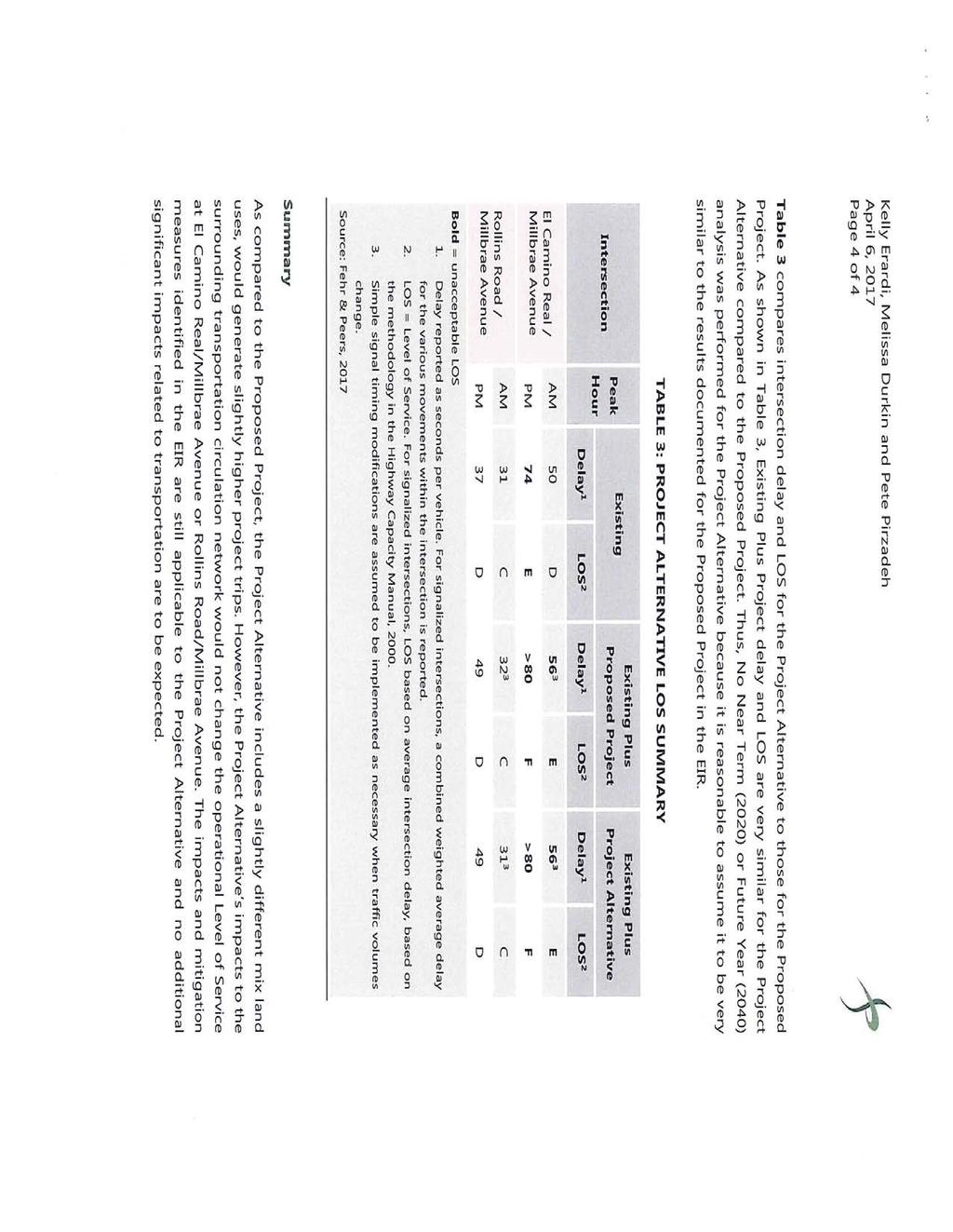
92
93 Attachment J
94
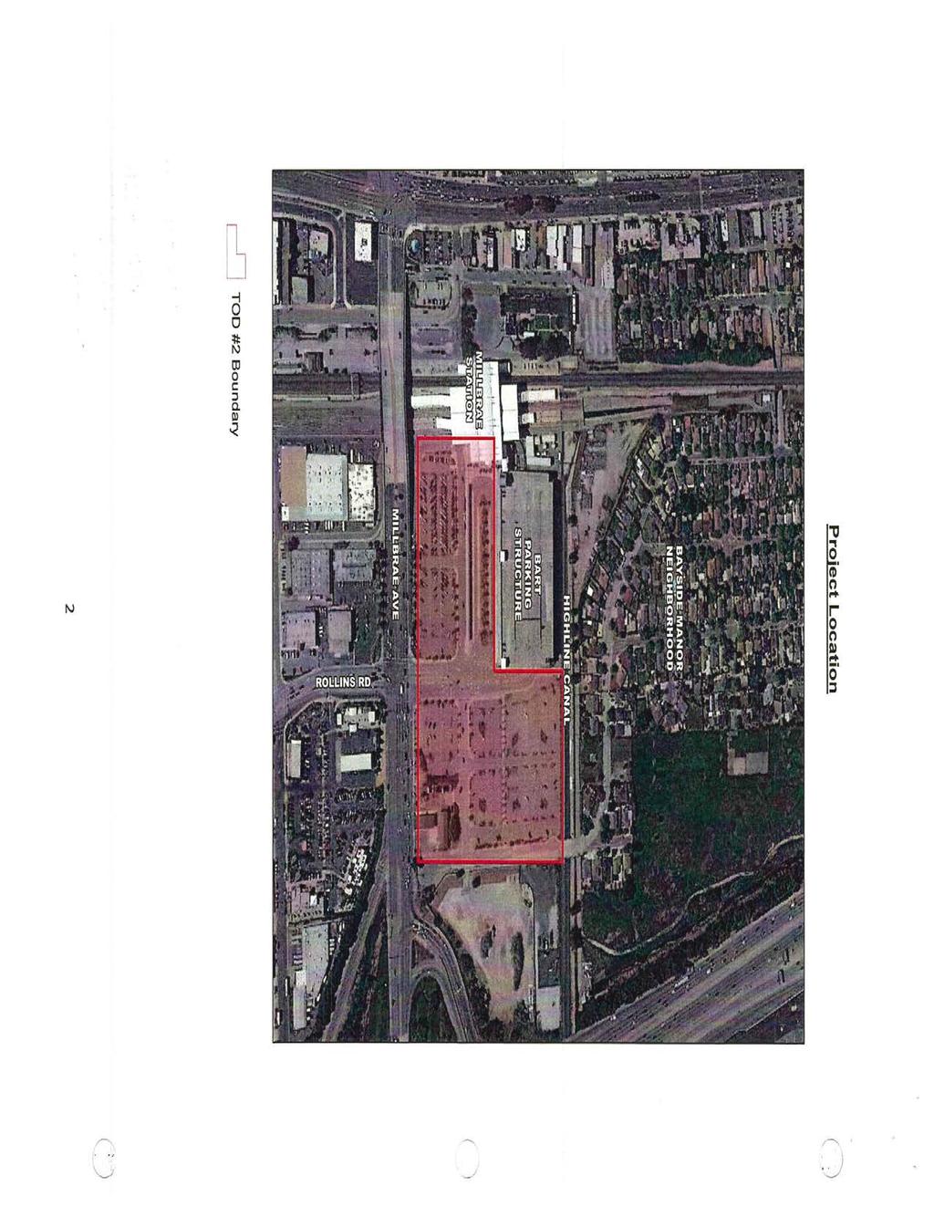
95
96
97
98
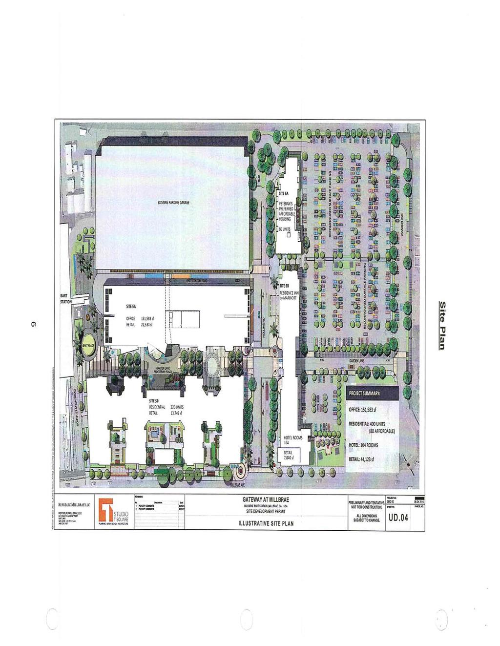
99
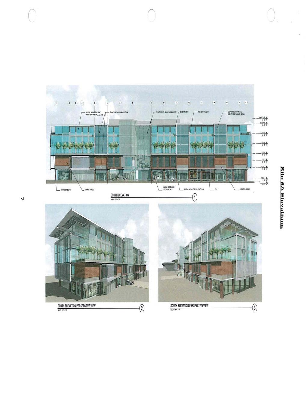
100
101
102
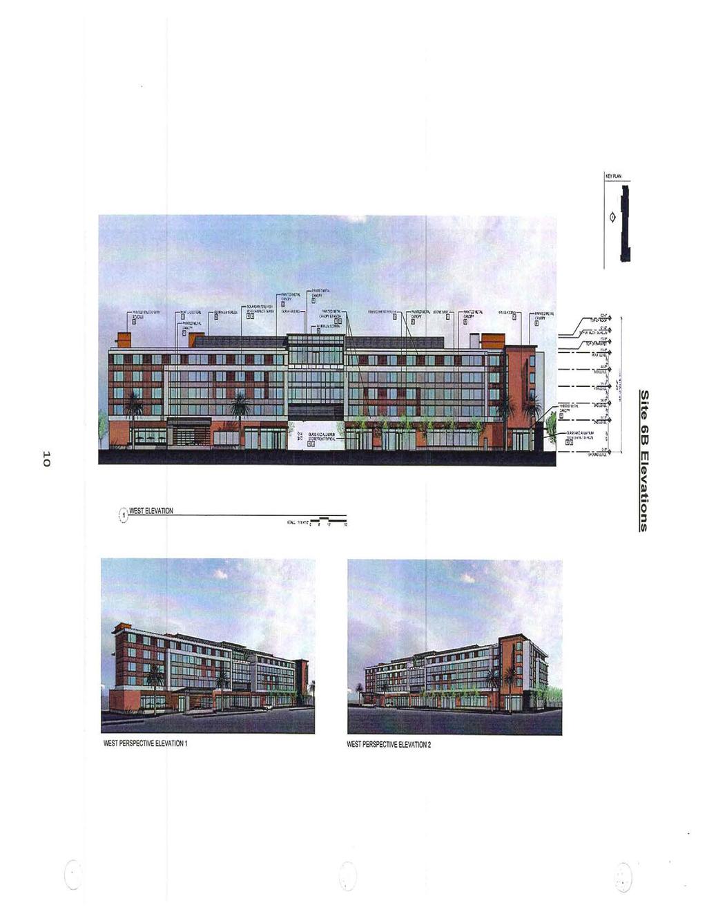
103
104
105
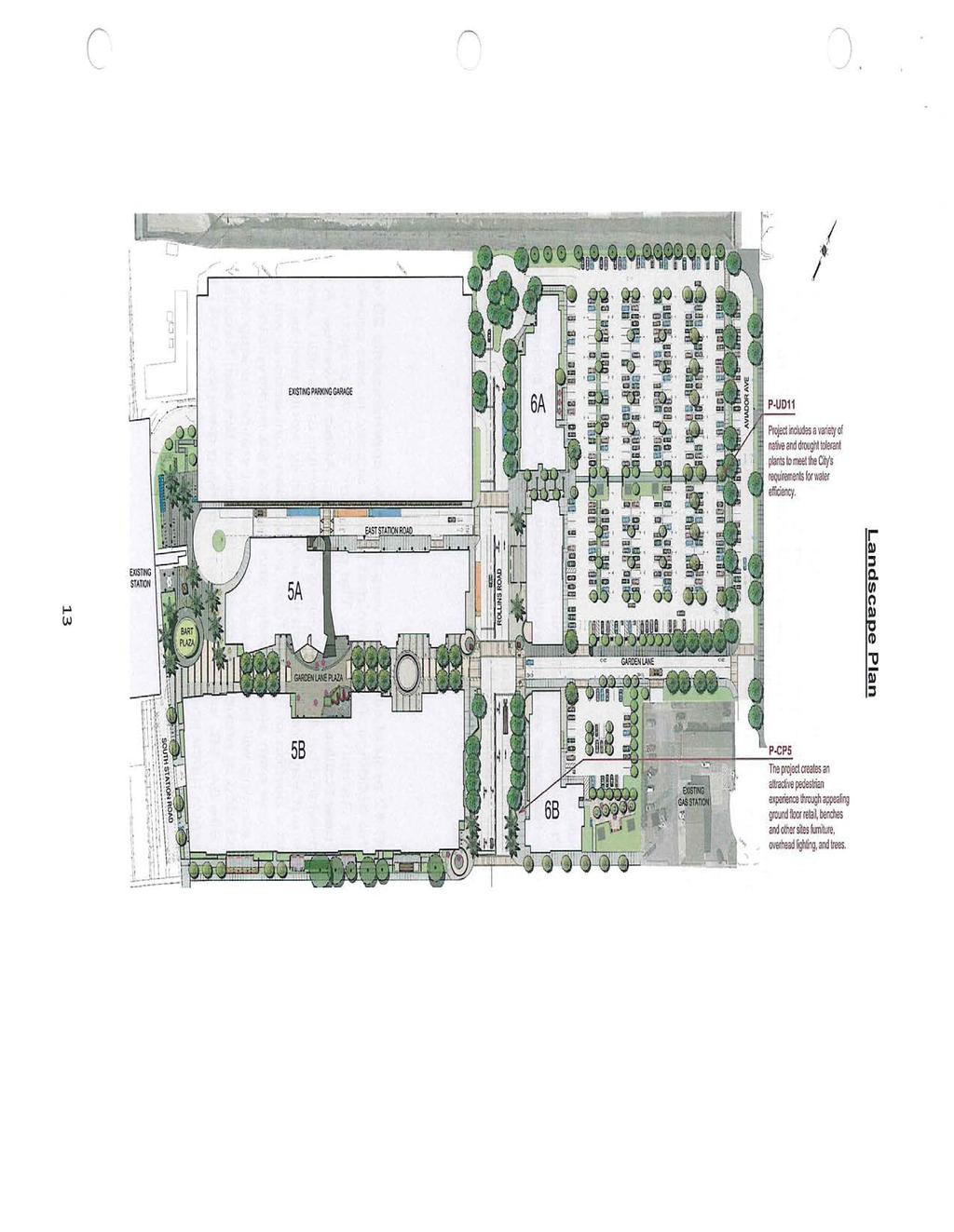
106
107
108
109
110
Millbrae TOD #2 Project Analysis
 Millbrae TOD #2 Project Analysis Project Description A Site Development Permit and Conditional Use Permit are proposed to allow for a mixed-use transitoriented development on approximately 9 Acres located
Gold Line Bus Rapid Transit Transit Oriented Development (BRTOD) Helmo Station Area Plan
 Helmo Station Area Plan") Appendix F Gold Line Bus Rapid Transit Transit Oriented Development (BRTOD) Helmo Station Area Plan Introduction and Purpose of the Plan The Gold Line Bus Rapid Transit facility is an eleven-mile dedicated
Appendix F Gold Line Bus Rapid Transit Transit Oriented Development (BRTOD) Helmo Station Area Plan Introduction and Purpose of the Plan The Gold Line Bus Rapid Transit facility is an eleven-mile dedicated
The transportation system in a community is an
 7 TRANSPORTATION The transportation system in a community is an important factor contributing to the quality of life of the residents. Without a sound transportation system to bring both goods and patrons
4 LAND USE DESIGNATIONS
 4 LAND USE DESIGNATIONS Chapter 4 describes the land use designations and densities that will implement the development vision for North Burlingame outlined in Chapter 3. Land use densities are described
MONTGOMERY COUNTY PLANNING DEPARTMENT THE MARYLAND-NATIONAL CAPITAL PARK AND PLANNING COMMISSION
 MONTGOMERY COUNTY PLANNING DEPARTMENT THE MARYLAND-NATIONAL CAPITAL PARK AND PLANNING COMMISSION MCPB Item No. Date: 05-22-14 Consent Item - Park Potomac: Site Plan Amendment No. 82004015K MCS. Molline
NOTICE OF AVAILABILITY (NOA) OF A DRAFT ENVIRONMENTAL IMPACT REPORT AND NOTICE OF PUBLIC HEARING 2190 Shattuck Avenue Mixed-Use Project
 OF A DRAFT ENVIRONMENTAL IMPACT REPORT AND NOTICE OF PUBLIC HEARING 2190 Shattuck Avenue Mixed-Use Project") Planning and Development Department Land Use Planning Division NOTICE OF AVAILABILITY (NOA) OF A DRAFT ENVIRONMENTAL IMPACT REPORT AND NOTICE OF PUBLIC HEARING 2190 Shattuck Avenue Mixed-Use Project Notice
Planning and Development Department Land Use Planning Division NOTICE OF AVAILABILITY (NOA) OF A DRAFT ENVIRONMENTAL IMPACT REPORT AND NOTICE OF PUBLIC HEARING 2190 Shattuck Avenue Mixed-Use Project Notice
Honorable Mayor and Members of the City Council. Submitted by: Eric Angstadt, Director, Planning and Development
 Office of the City Manager ACTION CALENDAR January 29, 2013 To: From: Honorable Mayor and Members of the City Council Christine Daniel, City Manager Submitted by: Eric Angstadt, Director, Planning and
Planning Commission Staff Report June 5, 2008
 Owner/Applicant Taylor Village Sacramento Investments Partners, LP c/o Kim Whitney 1792 Tribute Road #270 Sacramento, CA 95815 Staff Recommendation Planning Commission Staff Report Project: File: Request:
Right-of-Way Acquisitions and Relocations Technical Memorandum
 Right-of-Way Acquisitions and Relocations Technical Memorandum Southeast Extension Project Lincoln Station to RidgeGate Parkway Prepared for: Federal Transit Administration Prepared by: Denver Regional
CITY COUNCIL STUDY SESSION MEMORANDUM
 City and County of Broomfield, Colorado CITY COUNCIL STUDY SESSION MEMORANDUM To: From: Prepared by: Mayor and City Council Charles Ozaki, City and County Manager Kevin Standbridge, Deputy City and County
A. WHAT IS A GENERAL PLAN?
 I. Introduction A. WHAT IS A GENERAL PLAN? A general plan is the planning guideline for the future of a city. It contains goals and policies which regulate urban development, the protection of the natural
Glenborough at Easton Land Use Master Plan
 Implementation 114 9.0 IMPLEMENTATION 9.1 OVERVIEW This chapter summarizes the administrative procedures necessary to implement the proposed land use plan, infrastructure improvements, development standards,
SUBJECT: PREDEVELOPMENT PLAN REVIEW OF PROJECT LOCATED AT E. COLORADO BOULEVARD (PASEO COLORADO)
") TO: FROM: Honorable Mayor and City Council Planning & Community Development Department SUBJECT: PREDEVELOPMENT PLAN REVIEW OF PROJECT LOCATED AT 260-400 E. COLORADO BOULEVARD (PASEO COLORADO) RECOMMENDATION:
TO: FROM: Honorable Mayor and City Council Planning & Community Development Department SUBJECT: PREDEVELOPMENT PLAN REVIEW OF PROJECT LOCATED AT 260-400 E. COLORADO BOULEVARD (PASEO COLORADO) RECOMMENDATION:
AMEND DMENT H HOSPITAL
 AMEND DMENT TO LAND USE PLAN ELEMENT VILLAGE OF RIDGEWOOD MASTER PLAN H HOSPITAL ZONE DISTRICT Village of Ridgewood Planning Board February 28, 2014with technical revisions from June 9, 2014 Planning Board
CITY CLERK. Consolidated Clause in North York Community Council Report 8, which was considered by City Council on October 26, 27 and 28, 2004.
 CITY CLERK Consolidated Clause in Report 8, which was considered by City Council on October 26, 27 and 28, 2004. 28 Request for Direction Report - Site Plan Approval Application 03 200020 NNY 24 SA - Marek
Town Center (part of the Comprehensive Plan)
") Town Center (part of the Comprehensive Plan) Mercer Island Town Center Looking North (2014) In 1994, a year-long process culminated in a set of design guidelines and code requirements for the Town Center
Town Center (part of the Comprehensive Plan) Mercer Island Town Center Looking North (2014) In 1994, a year-long process culminated in a set of design guidelines and code requirements for the Town Center
CITY OF VACAVILLE PLANNING COMMISSION Agenda Item No. G.1 STAFF REPORT February 21, 2012 BRIGHTON LANDING SPECIFIC PLAN & DEVELOPMENT PROJECT
 CITY OF VACAVILLE PLANNING COMMISSION Agenda Item No. G.1 STAFF REPORT February 21, 2012 Staff Contact: Fred Buderi (707) 449-5307 TITLE: PURPOSE: BRIGHTON LANDING SPECIFIC PLAN & DEVELOPMENT PROJECT INFORMATIONAL
LOS ANGELES CITY PLANNING DEPARTMENT STAFF REPORT
 LOS ANGELES CITY PLANNING DEPARTMENT STAFF REPORT LOS ANGELES CITY PLANNING COMMISSION CASE NO: CPC 2006-9374 CRA CEQA: Exempt DATE: December 21, 2006 Location: Valley Plaza and Laurel Plaza TIME: after
STAFF REPORT TO THE CITY COUNCIL. Conduct Public Hearing to vacate certain public right of way adjacent to Sycamore Avenue and San Pablo Avenue
 STAFF REPORT TO THE CITY COUNCIL DATE: Adjourned Regular Meeting of December 16, 2014 TO: SUBMITTED BY: SUBJECT: Mayor and Members of the City Council Holly Smyth, Planning Director Conduct Public Hearing
REQUEST Current Zoning: O-15(CD) (office) Proposed Zoning: TOD-M(CD) (transit oriented development mixed-use, conditional)
 (office) Proposed Zoning: TOD-M(CD) (transit oriented development mixed-use, conditional)") Rezoning Petition 2016-117 Zoning Committee Recommendation January 4, 2017 REQUEST Current Zoning: O-15(CD) (office) Proposed Zoning: TOD-M(CD) (transit oriented development mixed-use, conditional) LOCATION
Rezoning Petition 2016-117 Zoning Committee Recommendation January 4, 2017 REQUEST Current Zoning: O-15(CD) (office) Proposed Zoning: TOD-M(CD) (transit oriented development mixed-use, conditional) LOCATION
A. Background Summary of Existing Challenges and Potential Possibilities. 1. Summary of Existing Assets and Potential Opportunities
 A. Background 1 A Main Street Master Plan Study was performed and completed in October of 2007. The study was initiated to review current land uses and development patterns along Main Street, from Parrish
Request Alternative Compliance to the prescribed criteria of the Oceanfront Resort District Form-Based Code. Staff Planner Kristine Gay
 Applicant/Owner Ocean Rental Properties, LLC Public Hearing April 13, 2016 City Council Election District Beach Agenda Item 1 Request Alternative Compliance to the prescribed criteria of the Oceanfront
Town of Portola Valley General Plan. Nathhorst Triangle Area Plan
 Town of Portola Valley General Plan Amended December 10, 1997 Table of Contents Introduction... 1 Planning Area... 1 Objectives... 2 Principles... 2 Standards... 4 Description... 4 Community Commercial...
Northwest Rail Corridor and US 36 BRT Development Oriented Transit Analysis 4.4 STATION AREA FINDINGS
 4.4 STATION AREA FINDINGS Each station is different, and each one requires a separate set of recommendations based on the vision for the site. This section outlines an initial TOD strategy and recommendations
Land Use Amendment in Southwood (Ward 11) at and Elbow Drive SW, LOC
 at and Elbow Drive SW, LOC") 2018 November 15 Page 1 of 10 EXECUTIVE SUMMARY This land use amendment application was submitted by Rick Balbi Architect on 2017 August 31 on behalf of Sable Developments Ltd, and with authorization from
2018 November 15 Page 1 of 10 EXECUTIVE SUMMARY This land use amendment application was submitted by Rick Balbi Architect on 2017 August 31 on behalf of Sable Developments Ltd, and with authorization from
Policies and Code Intent Sections Related to Town Center
 Policies and Code Intent Sections Related to Town Center The Town Center Vision is scattered throughout the Comprehensive Plan, development code and the 1994 Town Center Plan. What follows are sections
REPORT TO PLANNING COMMISSION
 CITY OF Meeting Date: October 25, 2011 Agenda Item: Community Development Department Planning Division P. O. Box 151560, San Rafael, CA 94915-1560 PHONE: (415) 485-3085/FAX: (415) 485-3184 Case Numbers:
ROAD CLOSURE AND LAND USE AMENDMENT SILVER SPRINGS (WARD 1) NORTHEAST OF NOSEHILL DRIVE NW AND SILVER SPRINGS ROAD NW BYLAWS 2C2018 AND 29D2018
 NORTHEAST OF NOSEHILL DRIVE NW AND SILVER SPRINGS ROAD NW BYLAWS 2C2018 AND 29D2018") Page 1 of 19 EXECUTIVE SUMMARY This application proposes redesignating two parcels in the community of Silver Springs from Special Purpose Future Urban Development (S-FUD) District and undesignated road
Page 1 of 19 EXECUTIVE SUMMARY This application proposes redesignating two parcels in the community of Silver Springs from Special Purpose Future Urban Development (S-FUD) District and undesignated road
Mississippi Skyway Preliminary Engineering Report
 EXECUTIVE SUMMARY Mississippi Skyway Preliminary Engineering Report CITY OF RAMSEY, MINNESOTA DECEMBER 2014 City of RAMSEY EXECUTIVE SUMMARY Project Need and Intent The Mississippi Skyway pedestrian bridge
DENVER DESIGN DISTRICT GDP
 DENVER DESIGN DISTRICT GDP Urban Design Standards and Guidelines November 17, 2008 Amended February 3, 2016 City and County of Denver CF Property Management, Inc. C/O Denver Design District - Starboard
Request Alternative Compliance to the prescribed criteria of the Oceanfront Resort District Form- Based Code. Staff Recommendation Approval
 Applicant Property Owner Steven H. Murden Public Hearing June 14, 2017 City Council Election District Beach Agenda Item 8 Request Alternative Compliance to the prescribed criteria of the Oceanfront Resort
ARLINGTON COUNTY, VIRGINIA
 ARLINGTON COUNTY, VIRGINIA County Board Agenda Item Meeting of April 23, 2019 DATE: April 12, 2019 SUBJECT: SP #413 SITE PLAN AMENDMENT to permit a fixed bar in a private outdoor café space with associated
MONTGOMERY COUNTY PLANNING DEPARTMENT THE MARYLAND-NATIONAL CAPITAL PARK AND PLANNING COMMISSION
 MONTGOMERY COUNTY PLANNING DEPARTMENT THE MARYLAND-NATIONAL CAPITAL PARK AND PLANNING COMMISSION MCPB Item No. Date: 3.10.2016 Site Plan 820160040 Nora School Parker Smith, Planning Technician, Area 1,
2.7 ac park. TOTAL 5,403 DU 1,297,900 sf 1,105,450 sf 3.87 ac 5,563 DU 1,121,200 sf 1,105,450 sf 3.87 ac
 PLAN AMENDMENT 2013-I-B1: SEVEN CORNERS SPECIAL STUDY Summary of Pre-staffing Comments Planner: Bernard Suchicital bsuchi@fairfaxcounty.gov (703) 324-1254 Background On October 29, 2013, the Board of Supervisors
TO: CITY COUNCIL DATE: MARCH 23,2009
 Report TO: CITY COUNCIL DATE: MARCH 23,2009 FROM: CITY MANAGER SUBJECT: MASTER DEVELOPMENT PLAN AMENDMENT FOR PASADENA CHRISTIAN SCHOOL AT 1515 NORTH LOS ROBLES AVENUE AND GENERAL PLAN AMENDMENT AND ZONE
REQUEST FOR COUNCIL ACTION 6A AGENDA ITEM ORIGINATING DEPT. AGENDA ITEM CITY ADMINISTRATOR APPROVAL
 DATE REQUEST FOR COUNCIL ACTION 6A AGENDA ITEM ORIGINATING DEPT. AGENDA ITEM CITY ADMINISTRATOR APPROVAL Community Development Territorial Greens PUD Concept Plan Development Stage Plan Subdivision (Preliminary
East Corridor Final Environmental Impact Statement
 East Corridor Final Environmental Impact Statement Alternatives Considered Operating Plan The requirements for opening day operations versus year 2030 are based on ridership and operations. Opening day
Request Alternative Compliance to the prescribed criteria of the Oceanfront Resort District Form-Based Code. Staff Recommendation Approval
 Applicant & Property Owner Public Hearing February 8, 2017 City Council Election District Beach Agenda Item D1 Request Alternative Compliance to the prescribed criteria of the Oceanfront Resort District
CHARLES PUTMAN CHARLES PUTMAN AND ASSOCIATES, INC
 MEMORANDUM CHARLES PUTMAN & ASSOCIATES, INC. LAND DEVELOPMENT CONSULTANTS PLANNING ZONING PERMITTING 4722 NW Boca Raton Boulevard, Suite C-106 Boca Raton, Florida 33431 Phone: 561/994-6411 FAX: 561/994-0447
DESIGN REVIEW COMMITTEE AGENDA ITEM
 DESIGN REVIEW COMMITTEE AGENDA ITEM AGENDA DATE: AUGUST 2, 2017 TO: THRU: FROM: SUBJECT: Chair Imboden and Members of the Design Review Committee Anna Pehoushek, Assistant Community Development Director
Stanley Greene District Downsview (80 Carl Hall Road) Zoning By-law Amendment and Draft Plan of Subdivision Applications Request for Direction Report
 Zoning By-law Amendment and Draft Plan of Subdivision Applications Request for Direction Report") STAFF REPORT ACTION REQUIRED Stanley Greene District Downsview (80 Carl Hall Road) Zoning By-law Amendment and Draft Plan of Subdivision Applications Request for Direction Report Date: December 16, 2011
STAFF REPORT ACTION REQUIRED Stanley Greene District Downsview (80 Carl Hall Road) Zoning By-law Amendment and Draft Plan of Subdivision Applications Request for Direction Report Date: December 16, 2011
A. INTRODUCTION B. PROJECT LOCATION
 Chapter 1: Project Description A. INTRODUCTION The Lower Manhattan Development Corporation (LMDC), a subsidiary of the New York State Urban Development Corporation, doing business as the Empire State Development
Staff Report to the North Ogden City Planning Commission
 Staff Report to the North Ogden City Planning Commission SYNOPSIS / APPLICATION INFORMATION Application Request: Concept review on a legislative application to rezone land located at approximately 1750
Executive Summary. NY 7 / NY 2 Corridor
 Executive Summary NY 7 / NY 2 Corridor Transportation and Land Use Study December 2005 Prepared for: Town of Colonie Capital District Transportation Committee Prepared by: Introduction: Land use decisions
ARLINGTON COUNTY, VIRGINIA
 ARLINGTON COUNTY, VIRGINIA County Board Agenda Item Meeting October 15, 2005 DATE: September 28, 2005 SUBJECT: Request to Advertise the adoption of the 2005 Clarendon Sector Plan C. M. RECOMMENDATION:
RESOLUTION NO. R Refining the route, profile and stations for the Downtown Redmond Link Extension
 RESOLUTION NO. R2018-32 Refining the route, profile and stations for the Downtown Redmond Link Extension MEETING: DATE: TYPE OF ACTION: STAFF CONTACT: Capital Committee Board PROPOSED ACTION 09/13/2018
MONTGOMERY COUNTY PLANNING DEPARTMENT THE MARYLAND NATIONAL CAPITAL PARK AND PLANNING COMMISSION
 MONTGOMERY COUNTY PLANNING DEPARTMENT THE MARYLAND NATIONAL CAPITAL PARK AND PLANNING COMMISSION MCPB Item No. 8 Date: 3.30.2017 Project Name: Lot 31/31A Bethesda, Site Plan Amendment, No. 82007018C Elza
PINE CURVE REZONING. BACKGROUND Purchased as two parcels in 2001 and 2002
 BACKGROUND Purchased as two parcels in 2001 and 2002 WHAT THE PROJECT IS AND IS NOT A Rezoning establishes the land use standards for Annexed and Zoned Greater Downtown District Historic Center September
SMALL LOT DESIGN STANDARDS. An Illustrated Working Draft for Test Implementation
 SMALL LOT DESIGN STANDARDS An Illustrated Working Draft for Test Implementation SMALL LOT DESIGN STANDARDS ILLUSTRATED WORKING FOR TEST IMPLEMENTATION OVERVIEW SMALL LOT CODE AMENDMENT & POLICY UPDATE
Planning Commission Staff Report March 15, 2007
 Planning Commission Staff Report Project: Request: Madeira East Tentative Subdivision Map, Design Review for Subdivision Layout & Abandonment of Easements Location: Phase IV of the Laguna Ridge Specific
APPENDIX D: Visual and Aesthetic Conditions for NCCU Station Refinement. Durham-Orange Light Rail Transit Project
 APPENDIX D: Visual and Aesthetic Conditions for NCCU Station Refinement Durham-Orange Light Rail Transit Project October 2016 1. Introduction The Combined FEIS/ROD summarizes the effects of the D-O LRT
PINE CURVE REZONING. Property does not meet criteria for open space preservation and is not a candidate for a park
 PINE CURVE REZONING BACKGROUND Purchased as two parcels in 2001 and 2002 Annexed and Zoned Greater Downtown District Historic Center September 25, 2002 and October 7, 2002 WHAT THE PROJECT IS AND IS NOT
PLANNING COMMISSION. Submitted
 PLANNING COMMISSION City Hall 1275 Main Street El Centro, CA 92243 Submitted PLANNING COMMISSION ACTION ITEM (1844) Meeting: 05/10/16 12:00 AM Department: Community Development Category: Public Hearing
Bloor St. W. Rezoning - Preliminary Report
 STAFF REPORT ACTION REQUIRED 1638-1644 Bloor St. W. Rezoning - Preliminary Report Date: April 1, 2008 To: From: Wards: Reference Number: Toronto and East York Community Council Acting Director, Community
Prepared by: Casey Kempenaar, Senior Planner
 CITY OF CITRUS HEIGHTS PLANNING DIVISION STAFF REPORT PLANNING COMMISSION MEETING September 13, 2017 Prepared by: Casey Kempenaar, Senior Planner REQUEST The applicant requests a Design Review Permit Modification
City Of Sparks Planning Commission Item
 Page 1 of 12 City Of Sparks Planning Commission Item Meeting Date: May17, 2012 Subject: PCN12009, Public Hearing, Consideration and possible action on a Master Plan Amendment and Rezoning request to change
Subject: 30 Otis Street, Evaluation of Shadow on Proposed 11th and Natoma Park
 Date: September 5, 2018 To: Recreation and Park Commission Capital Committee Through: Philip A. Ginsburg, General Manager Toks Ajike, Director, Capital & Planning Division From: Brian Stokle, Planner,
Community Development Department Planning Division 1600 First Street + P.O. Box 660 Napa, CA (707)
") Community Development Department Planning Division 1600 First Street + P.O. Box 660 Napa, CA 94559-0660 (707) 257-9530 PLANNING COMMISSION STAFFREPORT December 4, 2014 AGENDA ITEM 8.A. 14-0138; ALTAMURA
Community Development Department Planning Division 1600 First Street + P.O. Box 660 Napa, CA 94559-0660 (707) 257-9530 PLANNING COMMISSION STAFFREPORT December 4, 2014 AGENDA ITEM 8.A. 14-0138; ALTAMURA
SPECIFIC PLAN Requirements
 CITY OF LANCASTER PLANNING DEPARTMENT 44933 Fern Avenue, Lancaster, California 93534 (661) 723-6100 SPECIFIC PLAN Requirements Purpose The purpose of a specific plan is to provide for the logical development
D1 September 11, 2013 Public Hearing APPLICANT:
 D1 September 11, 2013 Public Hearing APPLICANT: BEACH MUNICIPAL FEDERAL CREDIT UNION PROPERTY OWNER: SISTERS II, LLC STAFF PLANNER: Karen Prochilo REQUEST: Conditional Change of Zoning (AG-2 Agriculture
MONTGOMERY COUNTY PLANNING DEPARTMENT
 MONTGOMERY COUNTY PLANNING DEPARTMENT THE MARYLAND-NATIONAL CAPITAL PARK AND PLANNING COMMISSION MCPB Item No.: Date: 5-03-18 Pike and Rose, Phase I: Site Plan Amendment No. 82012002D Rhoda Hersson-Ringskog,
MEMORANDUM. DATE: March 15, Chairman and Members Community Redevelopment Agency. Leif J. Ahnell, C.P.A., C.G.F.O. Executive Director
 MEMORANDUM DATE: March 15, 2019 TO: FROM: Chairman and Members Community Redevelopment Agency Leif J. Ahnell, C.P.A., C.G.F.O. Executive Director SUBJECT: Camino Square, IDA No. CRP-16-02, located at 171
PLANNING AND ZONING COMMISSION AGENDA MEMORANDUM
 PLANNING AND ZONING COMMISSION AGENDA MEMORANDUM City and County of Broomfield, Colorado To: Planning and Zoning Commission From: John Hilgers, Planning Director Anna Bertanzetti, Principal Planner Meeting
Walnut Creek BART Station
 Walnut Creek BART Station Mixed Use Transit Oriented Project Design Review Commission Study Session May 17, 2006 Applicant: Walnut Creek Transit Lifestyles Associates Joint Venture: Transit Village Associates
DRAFT Northeast Quadrant of Kipling Avenue and Highway 7 DRAFT AUGUST 29, Goals Land Use. The goals of this Plan are to:
 AUGUST 29, 2017 12.15 Northeast Quadrant of Kipling Avenue and Highway 7 12.15.1 Goals 12.15.2 Land Use The goals of this Plan are to: 12.15.2.1 General Provisions: a) Ensure the development of a compact
~P'~'~; SAN FRANCISCO
 ~o counr~, ~P'~'~; SAN FRANCISCO ~'.~ PLANNING DEPARTMENT a 2 757 O~~~S 0 Case No.: Project Address: Zoning: Certificate of Determination COMMUNITY PLAN EVALUATION UMU (Urban Mixed Use) District 58-X Height
Proposed Comprehensive Plan Strategies DRAFT for discussion June 28, 2017
 Proposed Comprehensive Plan Strategies DRAFT for discussion June 28, 2017 Land Use Rural Areas Refine the Farm and Forest area (FF) Update FF boundaries to account for existing lots less than five acres
Issues Requiring Future Study
 Issues Requiring Future Study Transportation planning is an ongoing process that tends to identify new issues as it finds solutions for others. Some issues are so complex that a solution to one problem
STAFF SUMMARY FOR S17-02 SPECIAL USE PERMIT APPLICATION
 APPLICATION SUMMARY Case Number: S17-02 Request: STAFF SUMMARY FOR S17-02 SPECIAL USE PERMIT APPLICATION SUP application in order to develop a convenience food store. Applicant: Property Owner(s): Cindee
CHAPTER 7: Transportation, Mobility and Circulation
 AGLE AREA COMMUNITY Plan CHAPTER 7 CHAPTER 7: Transportation, Mobility and Circulation Transportation, Mobility and Circulation The purpose of the Transportation, Mobility and Circulation Chapter is to
Urban Planning and Land Use
 Urban Planning and Land Use 701 North 7 th Street, Room 423 Phone: (913) 573-5750 Kansas City, Kansas 66101 Fax: (913) 573-5796 Email: planninginfo@wycokck.org www.wycokck.org/planning To: From: City Planning
R E S O L U T I O N. Single-Family Residence/ Church. 2,488 sq. ft. 2,488 sq. ft. Area Parking Required: Church
 R E S O L U T I O N WHEREAS, the Prince George s County Planning Board is charged with the approval of Detailed Site Plans pursuant to Part 3, Division 9 of the Zoning Ordinance of the Prince George s
OFFICE CONSOLIDATION SECONDARY PLAN AREA 22 THE BRAMALEA SOUTH INDUSTRIAL SECONDARY PLAN
 OFFICE CONSOLIDATION SECONDARY PLAN AREA 22 THE BRAMALEA SOUTH INDUSTRIAL SECONDARY PLAN November 2010 EXPLANATORY NOTES (Secondary Plan Area 22) General (pertaining to all secondary plan office consolidations)
Notice of Preparation (NOP) of an Environmental Impact Report and Public Scoping Meeting for the Alameda Shipways Residential Project
 of an Environmental Impact Report and Public Scoping Meeting for the Alameda Shipways Residential Project") Notice of Preparation (NOP) of an Environmental Impact Report and Public Scoping Meeting for the Notice is hereby given that the City of Alameda, Lead Agency, will prepare an Environmental Impact Report
Notice of Preparation (NOP) of an Environmental Impact Report and Public Scoping Meeting for the Notice is hereby given that the City of Alameda, Lead Agency, will prepare an Environmental Impact Report
CITY OF SANTA ROSA PLANNING AND ECONOMIC DEVELOPMENT DEPARTMENT STAFF REPORT FOR PLANNING COMMISSION JUNE 23, 2016 APPLICANT. Joseph Rubin MJP15-005
 Item No. 9 CITY OF SANTA ROSA PLANNING AND ECONOMIC DEVELOPMENT DEPARTMENT STAFF REPORT FOR PLANNING COMMISSION JUNE 23, 2016 PROJECT TITLE ADDRESS/LOCATION 3785 Cleveland Avenue ASSESSOR S PARCEL NUMBER
REPORT TO: Council FOR: Regular Meeting. PRESENTED: April 1, 2008 FILE: , Byl 1932 & 1936
 DISTRICT OF SQUAMISH REPORT TO: Council FOR: Regular Meeting PRESENTED: April 1, 2008 FILE: 2006-08, Byl 1932 & 1936 DEPARTMENT: Planning Department SUBJECT: First and Second Readings for Bylaws 1932 (rezoning)
New Auburn Village Center Study Auburn, Maine
 Auburn, Maine Option Review Summary Prepared for: Androscoggin Transportation Resource Center and City of Auburn Prepared by: T.Y. Lin International MRLD October 10, 2013 1. Introduction This memo summarizes
McDonald s Restaurant - Purcellville Town of Purcellville Special Use Permit Statement of Justification July 24, 2014
 Introduction / Written Statement McDonald s Restaurant - Purcellville McDonald s Corporation is proposing to redevelop the existing McDonald s eating establishment with a drive-through located at 121 N
TRANSPORTATION ELEMENT GOALS, OBJECTIVES, AND POLICIES
 TRANSPORTATION ELEMENT GOALS, OBJECTIVES, AND POLICIES GOAL 2 The City shall provide a safe, convenient, effective, and energy efficient multimodal transportation system which is coordinated with the Future
Tonight s Agenda. Summary Presentation Open House. Group Discussion Next Steps: online community wide survey
 Community Open House February 22, 2018 Tonight s Agenda Summary Presentation Open House Station 1: Project Overview and Community Input Station 2: Draft Vision and Guiding Principles Station 3: Western,
Planning Commission April 4, 2013 BOCC Workshop Page 1
 Planning Commission April 4, 2013 BOCC Workshop Page 1 Planning Commission April 4, 2013 BOCC Workshop Page 2 Planning Commission April 4, 2013 BOCC Workshop Page 3 Planning Commission April 4, 2013 BOCC
and services The protection and conservation of environmentally significant and sensitive natural heritage features and functions.
 6. Land Use 6.0 Preamble A healthy and livable city is one in which people can enjoy a vibrant economy and a sustainable healthy environment in safe, caring and diverse neighbourhoods. In order to ensure
Chapter 1.0 Introduction
 Chapter 1.0 Introduction 1.1 Background The North Metro commuter rail line is part of the RTD FasTracks regional transit system expansion program to build more than 100 miles of rail transit throughout
Ann Arbor Intermodal Station Environmental Review
 Ann Arbor Intermodal Station Environmental Review Park Advisory Commission September 19, 2017 AGENDA 1. Project Update 2. Draft Environmental Assessment 3. Draft Preferred Alternative 4. Next Steps 5.
Meeting Display Boards for Public Hearing on the Wilson Transfer Station Project held Tuesday, February 18, 2014.
 Meeting Display Boards for Public Hearing on the Wilson Transfer Station Project held Tuesday, February 18, 2014. Board 1: Welcome Welcome to the Wilson Transfer Station Project Public Hearing. The purpose
2900 Steeles Avenue East at Don Mills Road in the Town of Markham
 STAFF REPORT INFORMATION ONLY 2900 Steeles Avenue East at Don Mills Road in the Town of Markham Date: January 23, 2008 To: From: Wards: Reference Number: North York Community Council Director, Community
Mill Woods Town Centre Proposed Rezoning LDA
 Mill Woods Town Centre Proposed Rezoning LDA15 0649 The City of Edmonton has received an application for rezoning and an amendment to the Mill Woods Station Area Redevelopment Plan (ARP) for the Mill Woods
FUTURE LAND USE ELEMENT
 FUTURE LAND USE ELEMENT GOAL I: To create and sustain a great place to live, play, and prosper Objective 1: The City of Ocala shall incorporate the principles and strategies of the Ocala 2035 Vision into
Request Conditional Rezoning (R-15 Residential to Conditional A-24 Apartment) Staff Recommendation Approval. Staff Planner Jimmy McNamara
 Staff Recommendation Approval. Staff Planner Jimmy McNamara") Applicant Franklin Johnston Group Management & Development, LLC Property Owner Virginia Wesleyan College Public Hearing July 12, 2017 City Council Election District Bayside Agenda Item 3 Request Conditional
Applicant Franklin Johnston Group Management & Development, LLC Property Owner Virginia Wesleyan College Public Hearing July 12, 2017 City Council Election District Bayside Agenda Item 3 Request Conditional
City Center Specific Plan Amendments And Background Report City of Richmond. PLANNING COMMISION FINAL DRAFT January, 2001
 City Center Specific Plan Amendments And Background Report City of Richmond PLANNING COMMISION FINAL DRAFT January, 2001 TABLE OF CONTENTS Page LIST OF TABLES... LIST OF FIGURES... INDEX... OVERVIEW...
CITY OF LOS ANGELES INTER-DEPARTMENTAL CORRESPONDENCE
 CITY OF LOS ANGELES INTER-DEPARTMENTAL CORRESPONDENCE 20000 Prairie St. DOT Case No. 41443 Date: November 5, 2014 To: R. Nicolas Brown, Associate Zoning Administrator Department of City Planning From:
DISCUSSION ON VACAVILLE S2 INVESTORS PROPERTY IN URBAN RESERVE
 Agenda Item No. 9C April 25, 2017 TO: FROM: SUBJECT: Honorable Mayor and City Council Attention: Jeremy Craig, Interim City Manager Barton Brierley, AICP, Community Development Director (Staff Contact:
Allen Street Civic District Redevelopment Area Plan Redevelopment Plan & Proposal State College Planning Commission State College Redevelopment
 Allen Street Civic District Redevelopment Area Plan Redevelopment Plan & Proposal State College Planning Commission State College Redevelopment Authority September 17, 2015 Discussion Points Overview of
CITY OF CHARLOTTESVILLE, VIRGINIA CITY COUNCIL AGENDA
 CITY OF CHARLOTTESVILLE, VIRGINIA CITY COUNCIL AGENDA Agenda Date: December 16, 2013 Action Required: Adoption of Resolution Presenter: Staff Contacts: Title: James E. Tolbert, AICP, Director of NDS James
1071 King Street West Zoning Amendment Application - Preliminary Report
 STAFF REPORT ACTION REQUIRED 1071 King Street West Zoning Amendment Application - Preliminary Report Date: August 9, 2012 To: From: Wards: Reference Number: Toronto and East York Community Council Director,
Carlsbad Village Redevelopment Concept Summary of Features
 Carlsbad Village Redevelopment Concept Summary of Features Calthorpe Associates November 5, 2003 The Redevelopment Concept illustrates a vision for the future of Carlsbad Village. The overall vision of
The principal elements of the NTC Strategic Vision plan are as follows.
 The proposed project would improve the NTC site plan, circulation, visitor amenities, and landscaping, and would include construction of two new stadiums to replace the existing Louis Armstrong Stadium
Access Management: An Overview
 Figures 1-5 Below Evolution of development along a highway. In the early stages, land along the road is used for farming with little traffic generated. As time passes, the highway corridor becomes a de
The broad range of permitted and special uses allowed in the district remain, but some descriptions have been clarified.
 Memorandum To: Emily Fultz, AICP City Planner, City of Edwardsville From: Michael Blue, FAICP Principal, Teska Associates Date: January 24, 2019 RE: B-1 Zoning District Update A draft, updated B-1 Central
PLANNING COMMISSION STAFF REPORT
 PLANNING COMMISSION STAFF REPORT FOR THE PLANNING COMMISSION MEETING OF AUGUST 4, 2014 AGENDA ITEM F1 AND G1 EIR SCOPING SESSION AND STUDY SESSION LOCATION: 1300 El Camino Real APPLICANT AND PROPERTY OWNER: