PLANNING COMMISSION STAFF REPORT
|
|
|
- Harry Gilbert
- 6 years ago
- Views:
Transcription

1 PLANNING COMMISSION STAFF REPORT FOR THE PLANNING COMMISSION MEETING OF AUGUST 4, 2014 AGENDA ITEM F1 AND G1 EIR SCOPING SESSION AND STUDY SESSION LOCATION: 1300 El Camino Real APPLICANT AND PROPERTY OWNER: EXISTING USE: PROPOSED USE: Greenheart Land Company Vacant and Commercial APPLICATIONS: Architectural Control, Parcel Map and/or Related Non-Medical Office, Residential, and Retail/Restaurant Property Line/Right-of-Way Actions, Heritage Tree Removal Permits, Below Market Rate (BMR) Housing Agreement, Environmental Review ZONING: SP-ECR/D (El Camino Real/Downtown Specific Plan) GENERAL PLAN DESIGNATION: El Camino Real/Downtown Specific Plan PROPOSAL The applicant, Greenheart Land Company, is proposing to redevelop a 6.4-acre site on El Camino Real and Oak Grove Avenue with up to 210,000 square feet of commercial uses and up to 220 dwelling units. The proposal requires approval of Architectural Control for the new buildings, including a Public Benefit Bonus to exceed the Base level Floor Area Ratio (FAR), dwelling unit/acre, and height thresholds. As part of the project, approximately 37 heritage trees are proposed for removal. The proposal would also require changes to the current property and right-of-way lines. The August 4, 2014 meeting will serve as an Environmental Impact Report (EIR) scoping session as well as a study session, and represents a very preliminary phase of the project review. The proposal will require more analysis and additional public meetings prior to any potential action El Camino Real/Greenheart Land Company PC/ /Page 1
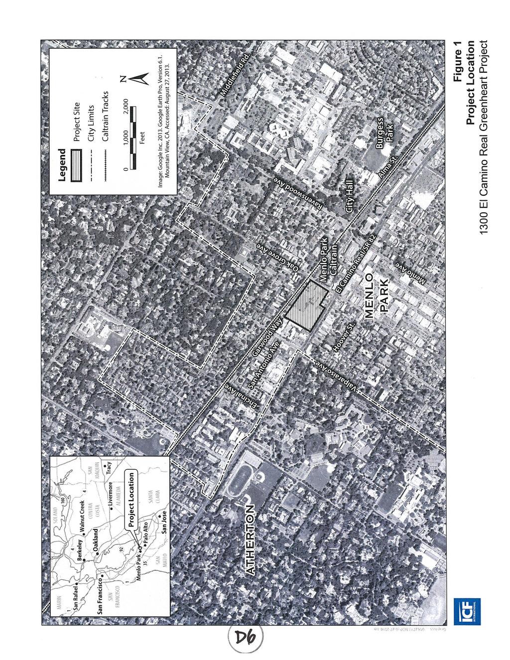
2 BACKGROUND Greenheart Land Company ( Greenheart ) is proposing to redevelop a multi-acre site on El Camino Real and Oak Grove Avenue with up to 210,000 square feet of nonresidential uses and up to 220 dwelling units. The project site consists of 15 legal parcels (11 assessor s parcels) addressed El Camino Real, Oak Grove Avenue, and Derry Lane. A location map is included as Attachment A. Conceptual project plans and a project description letter are included as Attachments B and C, respectively. The project site fully encompasses the sites of two earlier development proposals from different applicants: 1300 El Camino Real Project Sand Hill Property Company ( Sand Hill 1300 ECR ) Derry Lane Mixed-Use Development O Brien Group ( O Brien Derry Lane ) In addition, the current proposal includes a parcel at 1258 El Camino Real, which was not part of either of the earlier development proposals. The total site would be approximately 6.4 acres in size, after the proposed abandonment of Derry Lane, and dedication of a planned extension of Garwood Way and a partial widening of the Oak Grove Avenue right-of-way. The project site is within the El Camino Real/Downtown Specific Plan ( Specific Plan ) area. The overall intent of the Specific Plan is to preserve and enhance community life, character and vitality through public space improvements, mixed-use infill projects sensitive to the small-town character of Menlo Park, and improved connectivity. The Specific Plan reflects the outcome of an extensive community outreach and engagement process, which took place between 2007 and The Specific Plan process included the preparation of a program-level Environmental Impact Report (EIR), to consider the impacts of development throughout the Specific Plan area, in accordance with California Environmental Quality Act (CEQA) guidelines. When the Specific Plan EIR process originally commenced, the applicants for Sand Hill 1300 ECR and O Brien Derry Lane stated that these projects would continue their independent and previously-initiated project and environmental review processes. As such, both were considered background development for the purposes of the Specific Plan EIR, which meant that the impacts of these and other proposals were fully considered alongside any Specific Plan impacts as part of the required cumulative analysis. While the O Brien Derry Lane project was ultimately abandoned without comprehensive project/ceqa approvals, the Sand Hill 1300 ECR proposal was approved (including a project-level EIR), prior to the Specific Plan approvals. Under the Permit Streamlining Act, the City has an obligation to review and process development applications. Since the submittal of the initial project application by Greenheart, a ballot initiative was submitted to modify elements of the Specific Plan. At 1300 El Camino Real/Greenheart Land Company PC/ /Page 2
3 the July 15, 2014 City Council meeting, the Council conducted the following actions regarding the initiative measure: 1. Approved a resolution accepting the certification of the City Clerk as to the sufficiency of the initiative petition; 2. Received a report from an independent consultant, featuring an analysis of potential impacts of the initiative petition; and 3. Adopted a resolution calling and giving notice of a municipal election to be held on November 4, 2014, including the initiative measure. The project sponsor is aware that the ballot measure, if approved, would affect the project as currently proposed, but has requested that the project continue to be reviewed at this time. EIR SCOPING Initial Environmental Review The proposal requires consideration under CEQA. As noted in the Specific Plan EIR (page 1-3), the program EIR may be used to evaluate individual development proposals, with projects typically anticipated to fall into one of the following categories: Smaller buildings/additions may be categorically exempt under Class 1 or other provisions of the CEQA Guidelines, and no further review needs to be done; Projects that are not categorically exempt will be required to complete an Initial Study to determine if all potential impacts were reviewed in the Specific Plan EIR; and If the Initial Study identifies any impacts that were not analyzed in the Specific Plan EIR, then either a Mitigated Negative Declaration or a project-level EIR will be prepared, depending on whether all of the new impacts can be mitigated. In addition, all projects must incorporate feasible mitigation measures included in the Specific Plan Mitigation Monitoring and Reporting Program (MMRP). Since the submittal of the initial application for the Greenheart proposal, staff has focused on determining the applicable CEQA review process, assisted by an independent consulting firm (ICF International) that has extensive experience working with the City on CEQA-related projects. The Greenheart proposal has a number of unique characteristics, including the fact that separate developments had recently been proposed and/or approved on the project site, as well as the fact that the project would include changes to roadways (i.e., connection of Garwood Way to Oak Grove Avenue and the alignment to Merrill Street). As a result of these and other factors, staff and the consultant have determined that the proposal has the potential for impacts not previously analyzed in the Specific Plan EIR, and thus requires preparation of a projectlevel EIR El Camino Real/Greenheart Land Company PC/ /Page 3
4 As noted above, the need for additional project-level CEQA analysis is described as one of several typical outcomes of the Specific Plan EIR. The CEQA review process is unique for each proposal, depending on its attributes, and this determination for the Greenheart proposal does not necessarily indicate that a similar process will be required for any other proposal. Scoping Session The August 4, 2014 Planning Commission meeting will serve as a scoping session for the EIR. The scoping session is part of the EIR process, during which the City solicits input from the Planning Commission, agencies, organizations, and the public on specific topics that they feel should be addressed in the environmental analysis. The Notice of Preparation (NOP) is included as Attachment D. The NOP is supported by an Infill Environmental Checklist, which describes in detail which topic areas were adequately reviewed in the Specific Plan EIR, and which require additional analysis and discussion. Due to its length, the Infill Environmental Checklist is not attached to this report, but it is available for review at City offices and on the project page s CEQA subpage ( and is also being distributed in hard copy form to the Planning Commission. Verbal comments received during the scoping session and written comments received during the NOP comment period (from July 14, 2014 through August 13, 2014) on the scope of the environmental review will be considered while preparing the Draft EIR. NOP comments will not be responded to individually; however, all written comments on the NOP will be included in an appendix of the Draft EIR, and a summary of all comments received (both written and verbal) on the NOP will be included in the body of the Draft EIR. Based on the project description included in the NOP and the Infill Environmental Checklist, the EIR will analyze whether the proposed project would have significant environmental effects in the areas of: Air Quality (construction): Most air quality topics were adequately addressed in the Specific Plan EIR. However, due to the site s location, size, and relatively lengthy construction schedule, the EIR will quantify construction and demolitionrelated emissions and contain a health risk assessment (HRA) that evaluates potential health risks to existing sensitive receptors from toxic air contaminants (TACs). Hazards and Hazardous Materials: The Specific Plan EIR establishes detailed mitigation measures and procedures to address the majority of potential hazardous materials issues. However, because this site has an active Department of Toxic Substances Control (DTSC) remediation case that derives from a former dry cleaning business that operated at 570 Derry Lane, the topic has been identified for further environmental review in the EIR El Camino Real/Greenheart Land Company PC/ /Page 4
5 Noise (traffic noise): As a result of the need to conduct additional traffic analysis (see below), the associated traffic noise will also be the subject of additional review. Transportation and Traffic: Due to the unique relationship of the previous developments proposed and/or approved on the project site to the Specific Plan EIR, and the current project s proposed changes to roadways, a Transportation Impact Analysis (TIA) will be prepared. The NOP specifies the specific intersections and roadway segments that will be analyzed. As described in more detail in the Infill Environmental Checklist, the following topics will be scoped out of the EIR, since they have been adequately addressed in the Specific Plan EIR: Aesthetics Agricultural/Forestry Resources Air Quality (operational) Biological Resources Cultural Resources Geology and Soils Greenhouse Gas Emissions Hydrology/Water Quality Land Use Mineral Resources Noise (all but traffic noise) Population and Housing Public Services Utilities The EIR will also evaluate a reasonable range of alternatives to the project that would achieve most of the basic objectives of the project, but would avoid or reduce the project s significant environmental effects. CORRESPONDENCE Staff has not yet received any comments in response to the NOP. STUDY SESSION The August 4, 2014 Planning Commission meeting will also serve as a preliminary study session to review the project proposal. This is an initial opportunity for the Planning Commission and the public to become more familiar with the project, and to potentially ask questions about topics such as the conceptual building design or site layout El Camino Real/Greenheart Land Company PC/ /Page 5
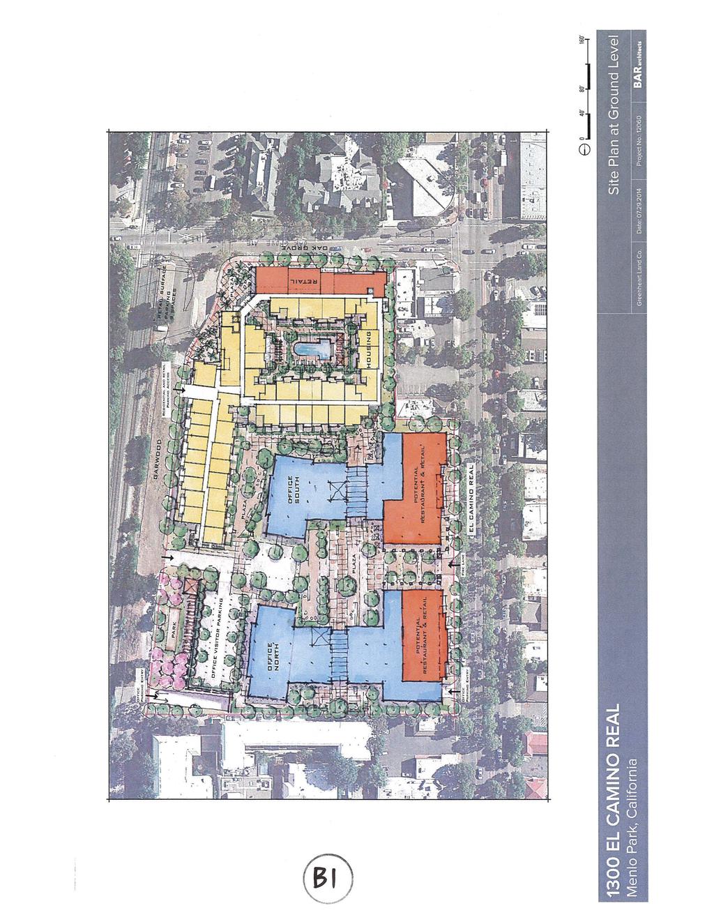
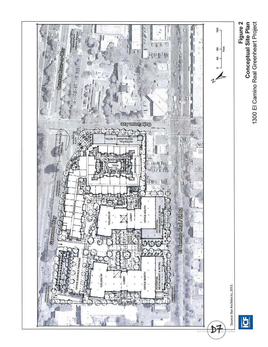
6 Site Location The project site is generally bound by residential and commercial development along Glenwood Avenue to the north, the Caltrain and Garwood Way right-of-ways to the east, Oak Grove Avenue to the south and El Camino Real to the west (for descriptive purposes, true northwest is project north with El Camino Real running in a north-south direction and Oak Grove Avenue running in an east-west direction). Regional access includes US 101, approximately 1.6 miles to the east, and State Route (SR) 82 (El Camino Real), which is adjacent to the project site to the west. In addition, the Menlo Park Caltrain Station is less than 300 feet south of the project site, between Alma Street and El Camino Real, providing daily service between San Francisco to Gilroy. Garwood Way connects to Glenwood Avenue and currently terminates along the eastern edge of the project site. Neighboring land uses include a former assisted living facility to the north, which is in the process of being converted into a hotel; single- and multi-family residential units east of the Caltrain right-of-way; the Menlo Park Caltrain Station and mixed-use development (including residential units) south of Oak Grove Avenue; and the El Camino Real commercial corridor to the west. The northeast corner of El Camino Real/Oak Grove Avenue, immediately adjacent to the project site, includes a Chevron gas station and a restaurant/cafe. Downtown Menlo Park is approximately 0.1 mile southwest of the project site. In total, the project site contains seven existing buildings, totaling approximately 25,800 square feet. In addition, the project site currently includes parking, pavement, and limited vegetative features. The entire project site is within the Specific Plan s El Camino Real Northeast Residential (ECR NE-R) District. The ECR NE-R District is located in the El Camino Real Mixed Use Residential General Plan land use designation, which supports a variety of retail uses, personal services, business and professional offices, and residential uses. The ECR NE-R District permits higher residential densities, in recognition of its location near the train station area and downtown. Project Description The project would demolish the existing structures in the southern portion of the site and construct approximately 420,000 square feet of mixed uses. In total, the project would include three mixed-use buildings, a surface parking lot, underground parking garages, onsite linkages, and landscaping. A breakdown of uses at the project site is provided on the following page El Camino Real/Greenheart Land Company PC/ /Page 6
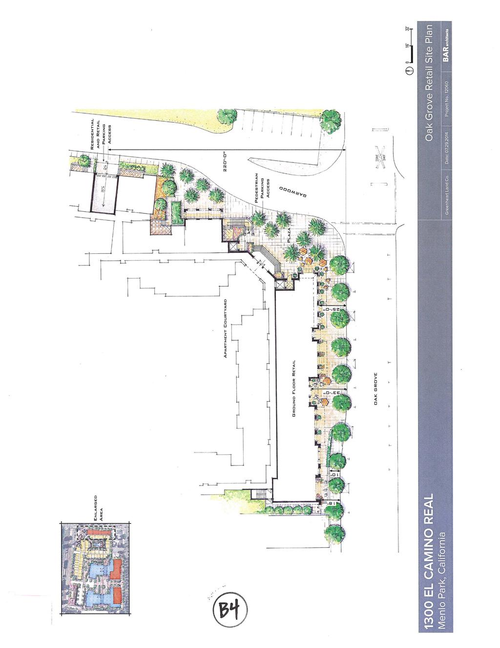
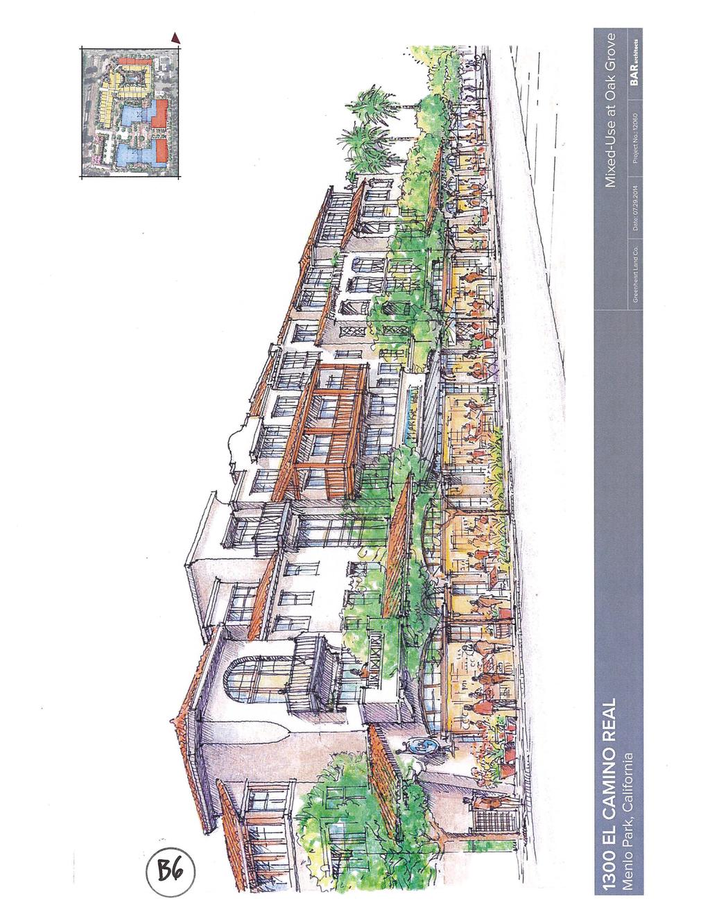
7 Residential Building Apartments (up to 220) Retail/Restaurant Total Office Buildings Non-Medical Office Flex Space (Non-Medical Office or Retail/Restaurant) Total 203,000 sf 7,000 sf 210,000 sf 188,000 sf 22,000 sf 210,000 sf The project would provide approximately 1,145 parking spaces, primarily underground. After street abandonment and dedication actions under the project, the total site area would consist of approximately 6.4 acres. The project would be consistent with the allowed development in the ECR NE-R District with a Public Benefit Bonus. The permitted Floor Area Ratio (FAR) is 1.10, but with a Public Benefit Bonus the FAR can increase to In either scenario, non-medical office is limited to no more than one-half the maximum FAR. The maximum height in the ECR NE-R district is 38 feet, although 48 feet is permitted with a Public Benefit Bonus. In either scenario, building facades cannot exceed a height of 38 feet. The project would be constructed at the maximum FAR and height as permitted with a Public Benefit Bonus. Up to 32 dwelling units per acre are allowed at the project site, but this can rise to 50 units per acre with a Public Benefit Bonus. The project would develop at an intensity of approximately 34.4 units per acre, and as such a Public Benefit Bonus would also be required for that element. All uses proposed under the project are permitted in the ECR NE-R District. The Public Benefit Bonus allows additional development beyond the base intensity and height in exchange for extra public benefits. The Public Benefit Bonus would be expected to increase profits from development in exchange for providing additional benefits to the public. Potential examples of public benefits listed in the Specific Plan include publicly accessible open space, senior housing, additional affordable residential units, hotel facilities, preservation/reuse of historic resources, public parks/plazas, shuttle services, or a public amenity fund contribution. Public Benefit Bonuses require case-by-case discretionary review, and if the Planning Commission and/or City Council ultimately determine that the proposed benefits are not appropriate, a project can be required to be revised to the lower Base Level development standards. Site Layout and Access The project would require the demolition of the existing buildings at the project site and would entail the construction of three mixed-use buildings, a surface parking lot, underground parking garages, onsite linkages, and landscaping. The conceptual site plan is shown as part of Attachment B El Camino Real/Greenheart Land Company PC/ /Page 7
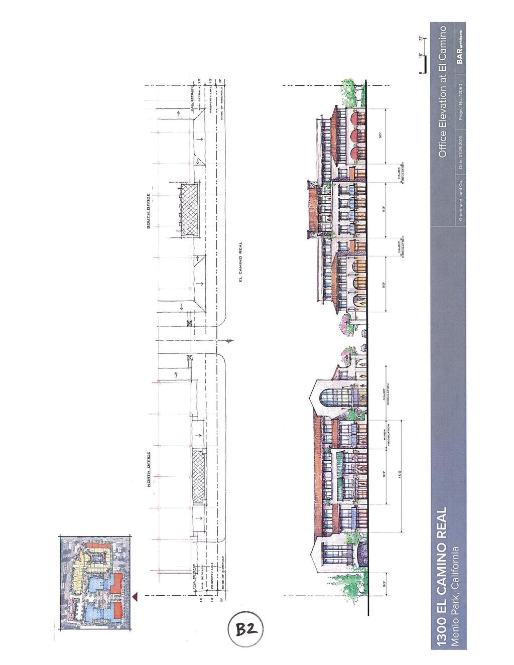
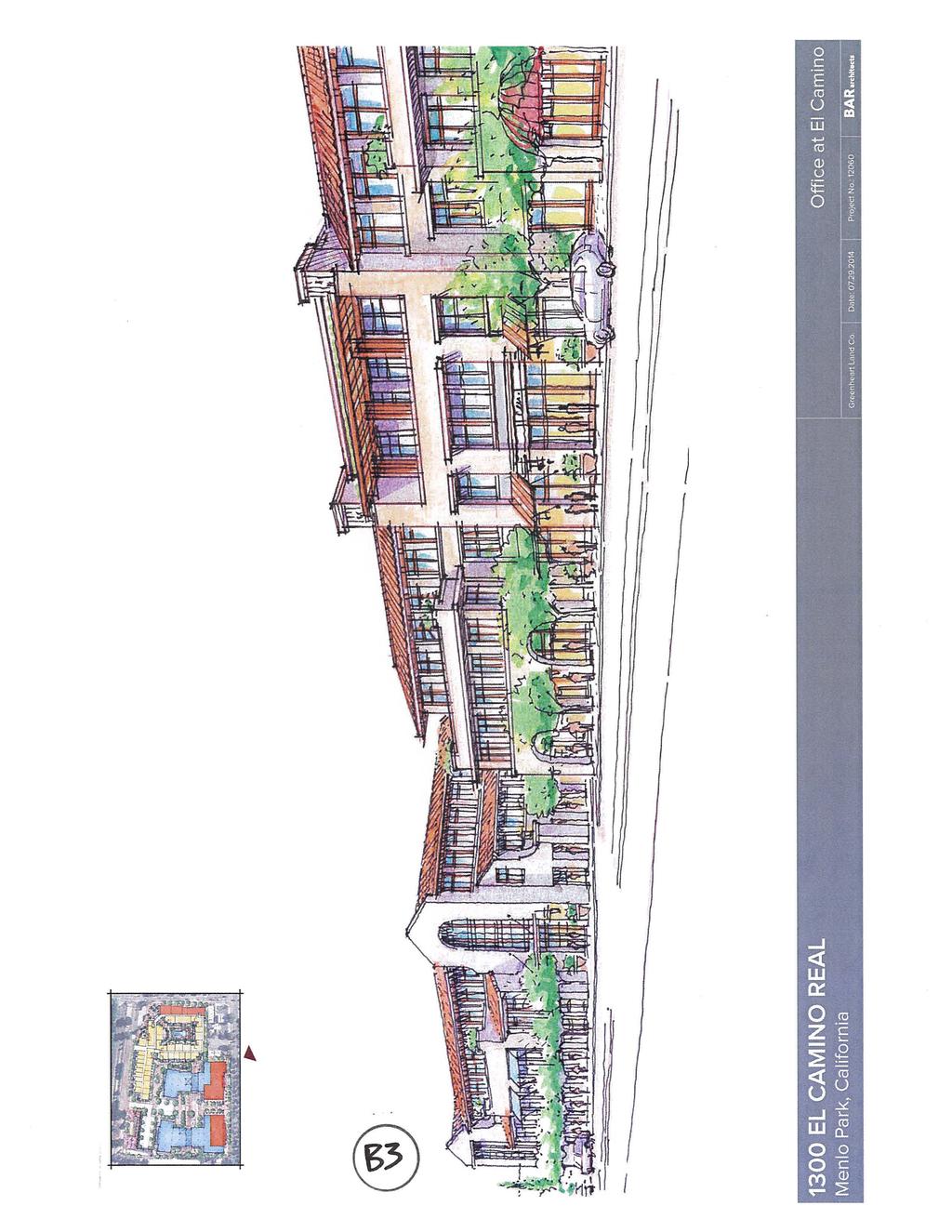
8 The buildings with the office components would be oriented in an east-west direction and would front onto El Camino Real. Both buildings would be three stories and would not exceed 48 feet in height (38 feet at the facades facing public rights-of-way). A plaza would be situated between the two buildings with landscaping, and outdoor dining areas. Each of these buildings would feature potential retail/restaurant space in the western frontages along El Camino Real. This would be flex space that could be either retail/restaurant or non-medical office at any particular time, depending on market interest and developer preference. The building with the residential component would front along Oak Grove Avenue and Garwood Way. Plazas would be located between this building and the office building to the north and west, and at the corner of Oak Grove Avenue and Garwood Way. The building would also wrap around a private center courtyard area with a pool. Retail/restaurant space would be located along the ground floor of the Oak Grove Avenue street frontage. The residential building would consist of four stories and would not exceed 48 feet in height (38 feet at the facades facing public rights-of-way). A public park would be located in the northeast corner of the project site adjacent to Garwood Way and the Caltrain right-of-way. The park would allow for public use and passive recreation. The project site would be accessible from five driveways: two driveways from El Camino Real to serve the office and retail development and three driveways from Garwood Way to serve the office, retail, and residential uses. From El Camino Real, one driveway (closest to Oak Grove Avenue) would provide drop-off access to the office/retail buildings and possible valet service to the retail/restaurant flex space, while the other driveway (closest to Glenwood Avenue) would lead to underground parking. On Garwood Way, one driveway (closest to Oak Grove Avenue) would provide access to the underground parking garage for residential uses and the Oak Grove Avenue retail/restaurant space, while the driveway closest to Glenwood Avenue would lead to the underground parking for the office buildings. A third Garwood Way driveway (at the middle of the site) would allow egress/ingress to a surface parking lot and drop-off access for the office uses. The surface connection between El Camino Real and Garwood Way is intended for emergency access, although it could be occasionally opened for special events. At all other times, the connection would be closed, to allow the center area to function as usable outdoor space. The project would include the completion of Garwood Way from the northeast edge of the project site to Oak Grove Avenue. This would connect Glenwood Avenue to the north with Oak Grove Avenue to the south and would allow additional access to the project site. The current Garwood Way plan line runs exactly parallel to the Caltrain right-of-way, which would create an off-center alignment with Merrill Street, on the opposite side of Oak Grove Avenue. For safety reasons, the Transportation Division has requested that the extended Garwood Way curve slightly, to align with Merrill Street and to increase the distance between the intersection and the Caltrain tracks. The applicant has conceptually agreed, and the current project plans show this alignment El Camino Real/Greenheart Land Company PC/ /Page 8
9 So that this safety-related change would not impact the parcel size more than the plan line would, a slight adjustment to the width of the new Garwood Way right-of-way (or another property line change) could be required. The Garwood Way extension would be constructed concurrently with the construction of the Project. Trees and Landscaping There are currently 37 heritage trees at the project site. Over 40 percent of the heritage trees are multi-stemmed Chinese trees of heaven that spread from root sprouts, creating a tree that meets the heritage tree definition, but in general is considered to have limited landscape value. Other tree species at the project site include blackwood acacia, African fern pine, Italian cypress, jacaranda, Canary Island data palm, coast live oaks, valley oaks, black locust, and coast redwoods. The project proposes to remove all of these trees. However, the conceptual landscape plan shows a minimum replacement of a two-to-one ratio. There are currently 19 street trees along the El Camino Real and Oak Grove Avenue frontages that are projected to remain with implementation of the Project. All proposed tree removals and construction effects will be subject to detailed review as the project review proceeds. Required Actions The following discretionary approvals by the City would be required prior to development at the project site: Environmental Review: Certification of the environmental review and approval of applicable mitigation measures; Architectural Control Review: Detailed design review, including consideration of a Public Benefit Bonus; to date, the applicant has not requested a Development Agreement; Parcel Map and/or Related Property Line/ROW Actions: The existing parcels would need to be merged/adjusted to permit the proposed construction, which can be accomplished through a number of mechanisms; in addition, the abandonment of Derry Lane and dedication of the Garwood Way extension would require similar/additional actions; Heritage Tree Removal Permits: A tree removal permit would be required for each heritage tree proposed for removal per Municipal Code Section ; and Below Market Rate (BMR) Housing Agreement: A BMR Housing Agreement would be required for the Project s compliance with the City s Below Market Rate Housing Program, as outlined in Chapter of the Municipal Code. BMR compliance can take several forms, although the applicant has proposed to meet the requirement through the provision of on-site units, which is generally the preferred option. During the project review process, there will be numerous discussion points and potential for project refinements El Camino Real/Greenheart Land Company PC/ /Page 9
10 PROJECT REVIEW PROCESS Following the August 4, 2014 scoping session and study session, the City Council will review and act on the EIR consultant contract (tentatively scheduled as a consent calendar item). Following the EIR contract approval, the project will focus on the CEQA analysis, which requires dedicated staff and consultant time. Substantive public review of the proposal will likely not occur until early The staff report for the EIR Contract Approval will include a proposed schedule for the project s review process. ENVIRONMENTAL REVIEW An EIR will be prepared for the project. The NOP for the EIR was released July 14, 2014, with comments requested by August 13, The NOP, included as Attachment D, is also available online on the City s website ( and at the Community Development Department during regular business hours. The City requests that written comments on the NOP be sent to the following address: Thomas Rogers, Senior Planner, City of Menlo Park Community Development Department, Planning Division, 701 Laurel Street, Menlo Park, CA, Comments may also be submitted via to: throgers@menlopark.org Following the release of the Draft EIR, a public hearing will be held by the Planning Commission to provide an opportunity for the Commission, agencies, organizations and members of the public to provide verbal comments on the Draft EIR. Written comments on the Draft EIR will also be solicited at this time. Comments will then be addressed as part of the Final EIR, which would be reviewed at a subsequent meeting. RECOMMENDED MEETING REVIEW PROCEDURE Agenda Item F1 1. Introduction by the City s Consultant Explaining the Role of the Scoping Session 2. Commission Questions on EIR Scope 3. Public Comment on EIR Scope 4. Commission Comments on EIR Scope 5. Close the Scoping Session Agenda Item G1 6. Project Introduction by City Staff 7. Project Presentation by Applicant 8. Commission Questions on Project Proposal 9. Public Comment on Project Proposal 10. Commission Comments on Project Proposal 1300 El Camino Real/Greenheart Land Company PC/ /Page 10
11 Report prepared by: Thomas Rogers Senior Planner Report reviewed by: Justin Murphy Development Services Manager PUBLIC NOTICE Public notification consisted of publishing a notice in the local newspaper and notification by mail of owners and occupants in the area within a quarter-mile of the project site. In addition, the 1300 El Camino Real project page is available at the following web address: This page provides up-to-date information about the project, allowing interested parties to stay informed of its progress. ATTACHMENTS A. Location Map B. Conceptual Project Plans C. Project Description Letter D. Notice of Preparation, dated July 14, 2014 AVAILABLE FOR REVIEW AT CITY OFFICES AND ON THE PROJECT WEB PAGE 1300 El Camino Real Greenheart Project Infill Environmental Checklist - dated July 2014 EXHIBITS TO BE PROVIDED AT MEETING None V:\STAFFRPT\PC\2014\ El Camino Real - Scoping and Study Session.doc 1300 El Camino Real/Greenheart Land Company PC/ /Page 11
12
13
14
15
16
17
18
19
20
21
22
23
24
25
26
27
28
29
30
31
32
REPORT TO PLANNING COMMISSION
 CITY OF Meeting Date: October 25, 2011 Agenda Item: Community Development Department Planning Division P. O. Box 151560, San Rafael, CA 94915-1560 PHONE: (415) 485-3085/FAX: (415) 485-3184 Case Numbers:
NOTICE OF AVAILABILITY (NOA) OF A DRAFT ENVIRONMENTAL IMPACT REPORT AND NOTICE OF PUBLIC HEARING 2190 Shattuck Avenue Mixed-Use Project
 OF A DRAFT ENVIRONMENTAL IMPACT REPORT AND NOTICE OF PUBLIC HEARING 2190 Shattuck Avenue Mixed-Use Project") Planning and Development Department Land Use Planning Division NOTICE OF AVAILABILITY (NOA) OF A DRAFT ENVIRONMENTAL IMPACT REPORT AND NOTICE OF PUBLIC HEARING 2190 Shattuck Avenue Mixed-Use Project Notice
Planning and Development Department Land Use Planning Division NOTICE OF AVAILABILITY (NOA) OF A DRAFT ENVIRONMENTAL IMPACT REPORT AND NOTICE OF PUBLIC HEARING 2190 Shattuck Avenue Mixed-Use Project Notice
Land Use Amendment in Southwood (Ward 11) at and Elbow Drive SW, LOC
 at and Elbow Drive SW, LOC") 2018 November 15 Page 1 of 10 EXECUTIVE SUMMARY This land use amendment application was submitted by Rick Balbi Architect on 2017 August 31 on behalf of Sable Developments Ltd, and with authorization from
2018 November 15 Page 1 of 10 EXECUTIVE SUMMARY This land use amendment application was submitted by Rick Balbi Architect on 2017 August 31 on behalf of Sable Developments Ltd, and with authorization from
COMMUNITY DEVELOPMENT SERVICES PLANNING AND BUILDING DEPARTMENT PLACERVILLE OFFICE:
 COMMUNITY DEVELOPMENT SERVICES PLANNING AND BUILDING DEPARTMENT http://www.edcgov.us/devservices/ PLACERVILLE OFFICE: LAKE TAHOE OFFICE: 2850 Fair Lane Court, Placerville, CA 95667 924 B Emerald Bay Rd.
ENVIRONMENTAL INITIAL STUDY BERKELEY CITYWIDE POOLS MASTER PLAN
 ENVIRONMENTAL INITIAL STUDY FOR THE BERKELEY CITYWIDE POOLS MASTER PLAN CITY OF BERKELEY PARKS RECREATION AND WATERFRONT DEPARTMENT SEPTEMBER 1, 2009 ENVIRONMENTAL INITIAL STUDY BERKELEY CITYWIDE POOLS
NOTICE OF PREPARATION OF AN ENVIRONMENTAL IMPACT REPORT AND SCOPING MEETING FOR THE LAND PARK COMMERCIAL CENTER PROJECT
 NOTICE OF PREPARATION OF AN ENVIRONMENTAL IMPACT REPORT AND SCOPING MEETING FOR THE LAND PARK COMMERCIAL CENTER PROJECT PUBLIC COMMENT PERIOD November 12, 2015 to December 14, 2015 INTRODUCTION The City
MEMORANDUM HONORABLE MAYOR AND CITY COUNCIL MEMBERS. SHERI REPP LOADSMAN, DEPUTY CITY MANAGER/ PLANNING & BUILDING DIRECTOR /s/
 MEMORANDUM Agenda Item #: 13 Meeting Date: 9/12/17 TO: THRU: FROM: SUBJECT: HONORABLE MAYOR AND CITY COUNCIL MEMBERS ANTON DAHLERBRUCH, CITY MANAGER /s/ SHERI REPP LOADSMAN, DEPUTY CITY MANAGER/ PLANNING
SECTION 2.0 INTRODUCTION
 SECTION 2.0 INTRODUCTION 2.1 PURPOSE AND SCOPE OF THE EIR Environmental Impact Reports (EIR) are informational documents which wil inform public agency decision-makers and the public generally of the significant
PG&E WINTERS GAS OPERATIONS AND TECHNICAL TRAINING CENTER
 PG&E WINTERS GAS OPERATIONS AND TECHNICAL TRAINING CENTER CEQA scoping Meeting March 19 th, 2014 Winters City Council Chambers - 6:30 pm AGENDA FOR THE MEETING 6:30 Welcome (John Donlevy) 6:40 Overview
AGENDA 07/14/11 PLANNING COMMISSION Meeting
 AGENDA 07/14/11 PLANNING COMMISSION Meeting MEETING DATE: Thursday, July 14, 2011 MEETING TIME: MEETING PLACE: VIDEO: 5:30 p.m. City Council Chambers, City Hall 350 Main Street El Segundo, California 90245-0989
Community Development
 Community Development STAFF REPORT Planning Commission Meeting Date: 4/23/2018 Staff Report Number: 18-040-PC Public Hearing: Environmental Impact Report Addendum, Specific Plan and Zoning Ordinance Amendment,
CITY OF VACAVILLE PLANNING COMMISSION Item No. 8.A STAFF REPORT July 18, 2016 STAFF CONTACT: Amy Feagans, Contract Planner (707)
") CITY OF VACAVILLE PLANNING COMMISSION Item No. 8.A STAFF REPORT July 18, 2016 STAFF CONTACT: Amy Feagans, Contract Planner (707) 449-5140 TITLE: THE FARM AT ALAMO CREEK ENVIRONMENTAL IMPACT REPORT (EIR)
CITY OF VACAVILLE PLANNING COMMISSION Item No. 8.A STAFF REPORT July 18, 2016 STAFF CONTACT: Amy Feagans, Contract Planner (707) 449-5140 TITLE: THE FARM AT ALAMO CREEK ENVIRONMENTAL IMPACT REPORT (EIR)
NOTICE OF PREPARATION OF A DRAFT ENVIRONMENTAL IMPACT REPORT AND NOTICE OF PUBLIC SCOPING MEETING: VERMONT CORRIDOR PROJECT
 NOTICE OF PREPARATION OF A DRAFT ENVIRONMENTAL IMPACT REPORT AND NOTICE OF PUBLIC SCOPING MEETING: VERMONT CORRIDOR PROJECT DATE: May 4, 2017 TO: FROM: PROJECT TITLE: PROJECT ADDRESS: All Interested Agencies,
~P'~'~; SAN FRANCISCO
 ~o counr~, ~P'~'~; SAN FRANCISCO ~'.~ PLANNING DEPARTMENT a 2 757 O~~~S 0 Case No.: Project Address: Zoning: Certificate of Determination COMMUNITY PLAN EVALUATION UMU (Urban Mixed Use) District 58-X Height
CITY OF CYPRESS 5275 Orange Avenue Cypress, California (714) DESIGN REVIEW COMMITTEE PERMIT PROCESS
 DESIGN REVIEW COMMITTEE PERMIT PROCESS") CITY OF CYPRESS 5275 Orange Avenue Cypress, California 90630 (714) 229-6720 DESIGN REVIEW COMMITTEE PERMIT PROCESS 1. Discuss project with Planning staff to determine zoning regulations, any unusual characteristics
CITY OF CYPRESS 5275 Orange Avenue Cypress, California 90630 (714) 229-6720 DESIGN REVIEW COMMITTEE PERMIT PROCESS 1. Discuss project with Planning staff to determine zoning regulations, any unusual characteristics
NOTICE OF PREPARATION
 NOTICE OF PREPARATION DATE: January 6, 2016 TO: LEAD AGENCY: Responsible Agencies, Organizations, and Interested Parties Contact: Tyler Barrington, Principal Planner Planning Department Community Development
PLANNING COMMISSION. Submitted
 PLANNING COMMISSION City Hall 1275 Main Street El Centro, CA 92243 Submitted PLANNING COMMISSION ACTION ITEM (1844) Meeting: 05/10/16 12:00 AM Department: Community Development Category: Public Hearing
Notice of Preparation (NOP) of an Environmental Impact Report and Public Scoping Meeting for the Alameda Shipways Residential Project
 of an Environmental Impact Report and Public Scoping Meeting for the Alameda Shipways Residential Project") Notice of Preparation (NOP) of an Environmental Impact Report and Public Scoping Meeting for the Notice is hereby given that the City of Alameda, Lead Agency, will prepare an Environmental Impact Report
Notice of Preparation (NOP) of an Environmental Impact Report and Public Scoping Meeting for the Notice is hereby given that the City of Alameda, Lead Agency, will prepare an Environmental Impact Report
CITY OF VACAVILLE PLANNING COMMISSION Agenda Item No. G.1 STAFF REPORT February 21, 2012 BRIGHTON LANDING SPECIFIC PLAN & DEVELOPMENT PROJECT
 CITY OF VACAVILLE PLANNING COMMISSION Agenda Item No. G.1 STAFF REPORT February 21, 2012 Staff Contact: Fred Buderi (707) 449-5307 TITLE: PURPOSE: BRIGHTON LANDING SPECIFIC PLAN & DEVELOPMENT PROJECT INFORMATIONAL
DESIGN REVIEW COMMITTEE AGENDA ITEM
 DESIGN REVIEW COMMITTEE AGENDA ITEM AGENDA DATE: AUGUST 2, 2017 TO: THRU: FROM: SUBJECT: Chair Imboden and Members of the Design Review Committee Anna Pehoushek, Assistant Community Development Director
OCEANSIDE DEVELOPER S CONFERENCE. 1. 9:30-10:30 a.m. Proposed hotel on a 12,000 sq. ft. site at the northeast corner of Topeka St. and Tremont St.
 1 AGENDA OCEANSIDE DEVELOPER S CONFERENCE Wednesday, February 1st, 2017, 9:30 a.m. City Hall South, 1 st Floor, Guajome Room 1. 9:30-10:30 a.m. Proposed hotel on a 12,000 sq. ft. site at the northeast
TO: CITY COUNCIL DATE: MARCH 23,2009
 Report TO: CITY COUNCIL DATE: MARCH 23,2009 FROM: CITY MANAGER SUBJECT: MASTER DEVELOPMENT PLAN AMENDMENT FOR PASADENA CHRISTIAN SCHOOL AT 1515 NORTH LOS ROBLES AVENUE AND GENERAL PLAN AMENDMENT AND ZONE
Gold Line Bus Rapid Transit Transit Oriented Development (BRTOD) Helmo Station Area Plan
 Helmo Station Area Plan") Appendix F Gold Line Bus Rapid Transit Transit Oriented Development (BRTOD) Helmo Station Area Plan Introduction and Purpose of the Plan The Gold Line Bus Rapid Transit facility is an eleven-mile dedicated
Appendix F Gold Line Bus Rapid Transit Transit Oriented Development (BRTOD) Helmo Station Area Plan Introduction and Purpose of the Plan The Gold Line Bus Rapid Transit facility is an eleven-mile dedicated
SAN FRANCISCO PLANNING DEPARTMENT
 PLANNING DEPARTMENT Certificate of Determination EXEMPTION FROM ENVIRONMENTAL REVIEW Case No.: Project Address: Zoning: UMU (Urban Mixed Use) Zoning District 68-X Height and Bulk District Life Science
NOTICE OF PREPARATION OF A DRAFT ENVIRONMENTAL IMPACT REPORT
 NOTICE OF PREPARATION OF A DRAFT ENVIRONMENTAL IMPACT REPORT TO: SUBJECT: Interested Parties Notice of Preparation of a Draft Environmental Impact Report for the Marywood Residential Development project.
2035 General Plan Update and Belmont Village Specific Plan. Joint Study Session with the City Council and Planning Commission April 12, 2016
 2035 General Plan Update and Belmont Village Specific Plan Joint Study with the City Council and Planning Commission April 12, 2016 Agenda 1. Welcome and Introductions 2. General Plan Update Status of
NOTICE OF PREPARATION OF ENVIRONMENTAL IMPACT REPORT
 NOTICE OF PREPARATION OF ENVIRONMENTAL IMPACT REPORT TO: State Clearinghouse, Responsible and Trustee Agencies, and Other Interested Parties DATE: May 18, 2017 SUBJECT: Notice of Preparation of Environmental
Prepared by: Casey Kempenaar, Senior Planner
 CITY OF CITRUS HEIGHTS PLANNING DIVISION STAFF REPORT PLANNING COMMISSION MEETING September 13, 2017 Prepared by: Casey Kempenaar, Senior Planner REQUEST The applicant requests a Design Review Permit Modification
PUBLIC EIR SCOPING MEETING
 MIRAMAR HOTELPROJECT PUBLIC EIR SCOPING MEETING PCR Services Corporation May 16, 2013 1 INTRODUCTION & MEETING PURPOSE Welcome and introductions City staff / PCR Services Corp., environmental consultant
Bloor St. W. Rezoning - Preliminary Report
 STAFF REPORT ACTION REQUIRED 1638-1644 Bloor St. W. Rezoning - Preliminary Report Date: April 1, 2008 To: From: Wards: Reference Number: Toronto and East York Community Council Acting Director, Community
ROAD CLOSURE AND LAND USE AMENDMENT SILVER SPRINGS (WARD 1) NORTHEAST OF NOSEHILL DRIVE NW AND SILVER SPRINGS ROAD NW BYLAWS 2C2018 AND 29D2018
 NORTHEAST OF NOSEHILL DRIVE NW AND SILVER SPRINGS ROAD NW BYLAWS 2C2018 AND 29D2018") Page 1 of 19 EXECUTIVE SUMMARY This application proposes redesignating two parcels in the community of Silver Springs from Special Purpose Future Urban Development (S-FUD) District and undesignated road
Page 1 of 19 EXECUTIVE SUMMARY This application proposes redesignating two parcels in the community of Silver Springs from Special Purpose Future Urban Development (S-FUD) District and undesignated road
- INVITATION - COURTESY INFORMATIONAL MEETING
 - INVITATION - COURTESY INFORMATIONAL MEETING Hosted by the Property Owner and Project Developer CAMELLIA COURT DEVELOPMENT WEDNESDAY, JANUARY 25, 2017, 7:00 9:00 P.M. BLOY CENTER 1441 S. BENITO AVE, ALHAMBRA,
Glenborough at Easton Land Use Master Plan
 Implementation 114 9.0 IMPLEMENTATION 9.1 OVERVIEW This chapter summarizes the administrative procedures necessary to implement the proposed land use plan, infrastructure improvements, development standards,
2. Form and Character. 2.1 Introduction. 2.2 The Downtown Addition Plan. 2.1 Introduction
 2.1 Introduction 2.1 Introduction This section of the Specific Plan describes and illustrates the desired form, character and uses of the Downtown Addition and explains the underlying design principles.
SUBJECT: PREDEVELOPMENT PLAN REVIEW OF PROJECT LOCATED AT 2632 EAST WASHINGTON BOULEVARD ('ST. LUKE MEDICAL CENTER')
") TO: FROM: Honorable Mayor and City Council Planning & Community Development Department SUBJECT: PREDEVELOPMENT PLAN REVIEW OF PROJECT LOCATED AT 2632 EAST WASHINGTON BOULEVARD ('ST. LUKE MEDICAL CENTER')
TO: FROM: Honorable Mayor and City Council Planning & Community Development Department SUBJECT: PREDEVELOPMENT PLAN REVIEW OF PROJECT LOCATED AT 2632 EAST WASHINGTON BOULEVARD ('ST. LUKE MEDICAL CENTER')
SAN FRANCISCO MUNICIPAL TRANSPORTATION AGENCY
 THIS PRINT COVERS CALENDAR ITEM NO. : 10.3 DIVISION: Sustainable Streets BRIEF DESCRIPTION: SAN FRANCISCO MUNICIPAL TRANSPORTATION AGENCY Approving the removal of Municipal Railway bus zones at various
1.0 Purpose of a Secondary Plan for the Masonville Transit Village
 Report to Planning and Environment Committee To: Chair and Members Planning & Environment Committee From: John M. Fleming Managing Director, Planning and City Planner Subject: Masonville Transit Village
A. WHAT IS A GENERAL PLAN?
 I. Introduction A. WHAT IS A GENERAL PLAN? A general plan is the planning guideline for the future of a city. It contains goals and policies which regulate urban development, the protection of the natural
Notice of Preparation and Notice of Public Scoping Meeting. At Dublin Project
 Notice of Preparation and Notice of Public Scoping Meeting Date January 17, 2018 To Project Title Project Application Number Project Location Project Applicant Contact For questions or submitting comments.
PINE CURVE REZONING. Property does not meet criteria for open space preservation and is not a candidate for a park
 PINE CURVE REZONING BACKGROUND Purchased as two parcels in 2001 and 2002 Annexed and Zoned Greater Downtown District Historic Center September 25, 2002 and October 7, 2002 WHAT THE PROJECT IS AND IS NOT
DESIGN REVIEW COMMITTEE AGENDA ITEM
 DESIGN REVIEW COMMITTEE AGENDA ITEM AGENDA DATE: DECEMBER 16, 2015 TO: THRU: FROM: SUBJECT: Chair McCormick and Members of the Design Review Committee Leslie Aranda Roseberry, Planning Manager Kelly Christensen
SAN FRANCISCO. x ~ OT`s 0~5` PLANNING DEPARTMENT. Certificate of Determination COMMUNITY PLAN EVALUATION PROJECT DESCRIPTION CEQA DETERMNATION
 y;~~~ counr~on u "'s' 9z x ~ OT`s 0~5` SAN FRANCISCO PLANNING DEPARTMENT COMMUNITY PLAN EVALUATION Case No.: Project Address: Zoning: RTO-M (Residential Transit Oriented-Mission) Use District Calle 24
Mill Woods Town Centre Proposed Rezoning LDA
 Mill Woods Town Centre Proposed Rezoning LDA15 0649 The City of Edmonton has received an application for rezoning and an amendment to the Mill Woods Station Area Redevelopment Plan (ARP) for the Mill Woods
NOTICE OF PREPARATION
 NOTICE OF PREPARATION To: All Interested Parties Subject: Notice of Preparation of an Environmental Impact Report From: City of Petaluma Address: 11 English Street, Petaluma, CA 94952-2610 Contact: Heather
Planning Commission Staff Report June 5, 2008
 Owner/Applicant Taylor Village Sacramento Investments Partners, LP c/o Kim Whitney 1792 Tribute Road #270 Sacramento, CA 95815 Staff Recommendation Planning Commission Staff Report Project: File: Request:
City of Del Mar. Del Mar Resort Specific Plan Environmental Impact Report Notice of Preparation
 City of Del Mar Del Mar Resort Specific Plan Environmental Impact Report Notice of Preparation Date: September 9, 07 To: From: Subject: State Clearinghouse, Responsible Agencies, Trustee Agencies, Interested
ORDINANCE NO
 ATTACHMENT CC-1 ORDINANCE NO. 13-2113 AN ORDINANCE OF THE CUPERTINO CITY COUNCIL APPROVING THE REZONING OF AN APPROXIMATELY 1.1 ACRE AREA FROM PARK AND RECREATION (PR) TO PLANNED INDUSTRIAL PARK (P(MP))
SAN RAFAEL GENERAL PLAN 2040 INTRODUCTION AND OVERVIEW
 SAN RAFAEL GENERAL PLAN 2040 INTRODUCTION AND OVERVIEW Steering Committee Presentation February 14, 2018 Purpose of General Plan Guide land use and development decisions Coordinate transportation, infrastructure,
Town Center (part of the Comprehensive Plan)
") Town Center (part of the Comprehensive Plan) Mercer Island Town Center Looking North (2014) In 1994, a year-long process culminated in a set of design guidelines and code requirements for the Town Center
Town Center (part of the Comprehensive Plan) Mercer Island Town Center Looking North (2014) In 1994, a year-long process culminated in a set of design guidelines and code requirements for the Town Center
Description of Preferred Alternative
 Chapter 2 Description of Preferred Alternative 2.1 Introduction This chapter of the programmatic Sammamish Town Center Sub-area Plan Final EIS provides a more detailed description of the Preferred Alternative
DATE: PLANNING COMMISSION MEETING OF APRIL 27, 2016 SUBJECT: REQUEST FOR THE REMOVAL OF FIVE HERITAGE TREES AT 95 MERCEDES LANE (APN )
") DATE: PLANNING COMMISSION MEETING OF APRIL 27, 2016 TO: FROM: THE PLANNING COMMISSION HALEIGH KING, ASSISTANT PLANNER SUBJECT: REQUEST FOR THE REMOVAL OF FIVE HERITAGE TREES AT 95 MERCEDES LANE (APN 070-230-150)
DATE: PLANNING COMMISSION MEETING OF APRIL 27, 2016 TO: FROM: THE PLANNING COMMISSION HALEIGH KING, ASSISTANT PLANNER SUBJECT: REQUEST FOR THE REMOVAL OF FIVE HERITAGE TREES AT 95 MERCEDES LANE (APN 070-230-150)
Subject: 30 Otis Street, Evaluation of Shadow on Proposed 11th and Natoma Park
 Date: September 5, 2018 To: Recreation and Park Commission Capital Committee Through: Philip A. Ginsburg, General Manager Toks Ajike, Director, Capital & Planning Division From: Brian Stokle, Planner,
Land Use. Hardware Street Vendor Mixed-Use
 Land Use Definition Land Use is the way a piece of real estate is utilized. Existing, proposed, and adopted land uses all play a role in the planning process. Once a land use plan is adopted, the next
Department of Community Development. Planning and Environmental Review Division Revised Notice of Preparation
 Department of Community Development Michael J. Penrose, Acting Director Divisions Building Permits & Inspection Code Enforcement County Engineering Economic Development & Marketing Planning & Environmental
A 3: Scoping Meeting Materials
 A 3: Scoping Meeting Materials SCOPING MEETING ACADEMY MUSEUM OF MOTION PICTURES SCOPING MEETING OBJECTIVES Provide information about Academy Museum of Motion Pictures Project Provide information
SAN FRANCISCO PLANNING DEPARTMENT ,~} DCfav~ 7_ ~/s' 1s5oM~ss~o~s~. Suite 400 San Francisco, CA
 ~~~~0 COUNlpom u 'Z x ~~ lb3s 0 61 v,~} SAN FRANCISCO PLANNING DEPARTMENT Certificate of Determination EXEMPTION FROM ENVIRONMENTAL REVIEW 1s5oM~ss~o~s~. Suite 400 San Francisco, CA 94103-2479 Case No.:
POLICY AMENDMENT AND LAND USE AMENDMENT TUXEDO PARK (WARD 9) CENTRE STREET N AND 26 AVENUE NE BYLAWS 36P2017 AND 234D2017
 CENTRE STREET N AND 26 AVENUE NE BYLAWS 36P2017 AND 234D2017") Page 1 of 11 EXECUTIVE SUMMARY This application proposes to redesignate a single parcel of land in the Community of Tuxedo Park from Commercial Corridor 2 (C-COR2 f1h10) District to Mixed Use Active Frontage
Page 1 of 11 EXECUTIVE SUMMARY This application proposes to redesignate a single parcel of land in the Community of Tuxedo Park from Commercial Corridor 2 (C-COR2 f1h10) District to Mixed Use Active Frontage
STAFF REPORT TO THE CITY COUNCIL. Conduct Public Hearing to vacate certain public right of way adjacent to Sycamore Avenue and San Pablo Avenue
 STAFF REPORT TO THE CITY COUNCIL DATE: Adjourned Regular Meeting of December 16, 2014 TO: SUBMITTED BY: SUBJECT: Mayor and Members of the City Council Holly Smyth, Planning Director Conduct Public Hearing
2019 Hillcrest Campus LRDP EIR Scoping Meeting
 2019 Hillcrest Campus LRDP EIR Scoping Meeting March 21, 2018 Agenda Scoping Meeting Purpose Hillcrest Campus Context What Is The Long Range Development Plan (LRDP)? Why A New Plan? Key LRDP Components
CITY OF PUYALLUP. Background. Development Services
 CITY OF PUYALLUP Development Services 333 South Meridian Puyallup WA 98371 To: City Council From: Katie Baker, AICP, Planning Division Re: South Hill Neighborhood Plan Adoption Date: (Meeting date: February
California Environmental Quality Act (CEQA) Environmental Review Process
 Environmental Review Process") California Environmental Quality Act (CEQA) Environmental Review Process Los Angeles Union Station Forecourt and Esplanade Improvements constitute a Project Los Angeles County Metropolitan Transportation
California Environmental Quality Act (CEQA) Environmental Review Process Los Angeles Union Station Forecourt and Esplanade Improvements constitute a Project Los Angeles County Metropolitan Transportation
SPECIFIC PLAN Requirements
 CITY OF LANCASTER PLANNING DEPARTMENT 44933 Fern Avenue, Lancaster, California 93534 (661) 723-6100 SPECIFIC PLAN Requirements Purpose The purpose of a specific plan is to provide for the logical development
MONTGOMERY COUNTY PLANNING DEPARTMENT
 MONTGOMERY COUNTY PLANNING DEPARTMENT THE MARYLAND-NATIONAL CAPITAL PARK AND PLANNING COMMISSION MCPB Item No.: Date: 5-03-18 Pike and Rose, Phase I: Site Plan Amendment No. 82012002D Rhoda Hersson-Ringskog,
North Downtown Specific Plan MEMORANDUM
 North Downtown Specific Plan MEMORANDUM MEETING DATE: November 13, 2017 TO: Members of the North Downtown Specific Plan Advisory Committee FROM: Jeanine Cavalli, Senior Planner SUBJECT: Materials for the
COMMUNITY DEVELOPMENT SERVICES PLANNING AND BUILDING DEPARTMENT
 COMMUNITY DEVELOPMENT SERVICES PLANNING AND BUILDING DEPARTMENT http://www.edcgov.us/devservices/ PLACERVILLE OFFICE: 2850 Fairlane Court, Placerville, CA 95667 BUILDING (530) 621-5315 / (530) 622-1708
4. ENVIRONMENTAL IMPACT ANALYSIS 7. LAND USE AND PLANNING
 4. ENVIRONMENTAL IMPACT ANALYSIS 7. LAND USE AND PLANNING 4.7.1 INTRODUCTION The following analysis discusses the consistency of the Proposed Project with the corresponding land use and zoning designations
SUBJECT: PREDEVELOPMENT PLAN REVIEW OF PROJECT LOCATED AT E. COLORADO BOULEVARD (PASEO COLORADO)
") TO: FROM: Honorable Mayor and City Council Planning & Community Development Department SUBJECT: PREDEVELOPMENT PLAN REVIEW OF PROJECT LOCATED AT 260-400 E. COLORADO BOULEVARD (PASEO COLORADO) RECOMMENDATION:
TO: FROM: Honorable Mayor and City Council Planning & Community Development Department SUBJECT: PREDEVELOPMENT PLAN REVIEW OF PROJECT LOCATED AT 260-400 E. COLORADO BOULEVARD (PASEO COLORADO) RECOMMENDATION:
Prosperity Hucks Area Plan. Transportation and Planning Committee May 11, 2015
 Prosperity Hucks Area Plan Transportation and Planning Committee May 11, 2015 Presentation Outline 1. Background and Location 2. Community Dialog Process 3. Activity Center Recommendations 4. Wedge Recommendations
NOTICE OF PREPARATION
 Date: June 30, 2017 CITY OF CITRUS HEIGHTS COMMUNITY & ECONOMIC DEVELOPMENT DEPARTMENT, PLANNING DIVISION 6360 Fountain Square Drive, Citrus Heights, CA 95621 (916) 727-4740 NOTICE OF PREPARATION To: Subject:
PLANNED DEVELOPMENT (MASTER PLAN & UNIT PLAN)
") Central Permit Center 555 Santa Clara Street Vallejo CA 94590 Business License Building Fire Prevention Planning Public Works 707.648.4310 707.648.4374 707.648.4565 707.648.4326 707.651.7151 PLANNED DEVELOPMENT
Central Permit Center 555 Santa Clara Street Vallejo CA 94590 Business License Building Fire Prevention Planning Public Works 707.648.4310 707.648.4374 707.648.4565 707.648.4326 707.651.7151 PLANNED DEVELOPMENT
RESOLUTION NO. R Refining the route, profile and stations for the Downtown Redmond Link Extension
 RESOLUTION NO. R2018-32 Refining the route, profile and stations for the Downtown Redmond Link Extension MEETING: DATE: TYPE OF ACTION: STAFF CONTACT: Capital Committee Board PROPOSED ACTION 09/13/2018
CITY OF KEIZER MASTER PLAN APPLICATION & INFORMATION SHEET
 CITY OF KEIZER MASTER PLAN APPLICATION & INFORMATION SHEET PRE-APPLICATION CONFERENCE Prior to the actual filing of a Master Plan application, it is strongly recommended that the applicant contact Planning
Introduction and Overview
 Introduction and Overview Articulate local values and priorities Guide land use and development decisions Coordinate transportation, infrastructure, and City services with expected growth and available
NOTICE OF PREPARATION
 NOTICE OF PREPARATION DATE: April 6, 2017 TO: FROM: Responsible Agencies Trustee Agencies Local and Public Agencies Interested Parties Contact: Brent Cooper, AICP, Community Development Director 4381 Broadway
SOUTHEAST AREA SPECIFIC PLAN. Planning Commission Study Session August 18, 2016
 SOUTHEAST AREA SPECIFIC PLAN Planning Commission Study Session August 18, 2016 Background: How did we get here? Directed by City Council to prepare Specific Plan (2012) Sustainability focused grant from
LAND USE AMENDMENT CORNERSTONE (WARD 3) 60 STREET NE AND COUNTRY HILLS BOULEVARD NE MAP 26NE BYLAW 22D2017
 60 STREET NE AND COUNTRY HILLS BOULEVARD NE MAP 26NE BYLAW 22D2017") Page 1 of 14 EXECUTIVE SUMMARY This Land Use Amendment application covers an area of 43.76 hectares ± (108.14 acres ±) located in northeast Calgary, bound by Country Hills Boulevard NE to the south and
Page 1 of 14 EXECUTIVE SUMMARY This Land Use Amendment application covers an area of 43.76 hectares ± (108.14 acres ±) located in northeast Calgary, bound by Country Hills Boulevard NE to the south and
4.8 LAND USE AND PLANNING
 4.8 LAND USE AND PLANNING 4.8.1 INTRODUCTION This section describes existing and planned land uses at the Hayward campus and analyzes the impact of implementation of the proposed Master Plan on land uses
TO: Denver Planning Board FROM: Analiese Hock, Senior City Planner DATE: March 13, 2018 RE:
 Community Planning and Development Planning Services 201 W. Colfax Ave., Dept. 205 Denver, CO 80202 p: 720.865.2915 f: 720.865.3052 www.denvergov.org/cpd TO: Denver Planning Board FROM: Analiese Hock,
AvalonBay Communities + BRIDGE Housing. Mission Housing Habitat for Humanity Pacific Union Development Corporation
 AvalonBay Communities + BRIDGE Housing Mission Housing Habitat for Humanity Pacific Union Development Corporation Tonight s Agenda Recap of discussion from last CAC meeting Updates on meetings with Stakeholders
RECOMMENDATION REPORT
 DEPARTMENT OF CITY PLANNING RECOMMENDATION REPORT City Planning Commission Case No.: CPC-2012-1165-GPA-ZC Date: August 9, 2012 Time: After 8:30 AM Place: City Hall, Room 350 Public Hearing: Required CEQA
SECTION 3: PROJECT DESCRIPTION
 San Ramon City Center - City of San Ramon Draft Subsequent EIR Project Description SECTION 3: PROJECT DESCRIPTION This section describes the proposed San Ramon City Center Project (proposed project) that
Honorable Mayor and Members of the City Council. Submitted by: Eric Angstadt, Director, Planning and Development
 Office of the City Manager ACTION CALENDAR January 29, 2013 To: From: Honorable Mayor and Members of the City Council Christine Daniel, City Manager Submitted by: Eric Angstadt, Director, Planning and
4.1.3 LAND USE CATEGORIES
 4.1.3 LAND USE CATEGORIES a. City Center District The City Center District incorporates the existing character and mix of uses in downtown Belmont to encourage redevelopment and new development in keeping
City Council Special Meeting AGENDA ITEM NO. C.
 City Council Special Meeting AGENDA ITEM NO. C. DATE: 01/04/2019 TO: Honorable Mayor and City Council Members SUBJECT: Transit Villages Specific Plan project Study Session (Development Services Director
DESIGN REVIEW COMMITTEE AGENDA ITEM
 DESIGN REVIEW COMMITTEE AGENDA ITEM AGENDA DATE: OCTOBER 17, 2012 TO: Chair Woollett and Members of the Design Review Committee THRU: FROM: SUBJECT: Leslie Aranda Roseberry, Planning Manager Daniel Ryan,
Scope of Services. River Oaks Boulevard (SH 183) Corridor Master Plan
 Corridor Master Plan") Scope of Services River Oaks Boulevard (SH 183) Corridor Master Plan PROJECT AREA The project area consists of the River Oaks Boulevard (SH 183) corridor bounded by SH 199 at the northern end and the Trinity
Scope of Services River Oaks Boulevard (SH 183) Corridor Master Plan PROJECT AREA The project area consists of the River Oaks Boulevard (SH 183) corridor bounded by SH 199 at the northern end and the Trinity
CHAPTER 2 SUMMARY 1. PROJECT SUMMARY DATA
 CHAPTER 2 SUMMARY This is an Initial Study format used to determine, pursuant to CEQA Guidelines Section 15177, whether a project 1) is within the scope of a Master EIR (MEIR), 2) may result in additional
CITY OF ALHAMBRA DEVELOPMENT SERVICES DEPARTMENT 111 S. First Street. Alhambra, CA (626) FAX (626)
 FAX (626)") CITY OF ALHAMBRA DEVELOPMENT SERVICES DEPARTMENT 111 S. First Street. Alhambra, CA 91801 (626) 570-5030 - FAX (626) 458-4201 NOTICE OF PREPARATION TO: SUBJECT: Agencies, Organizations and Interested Parties
CITY OF ALHAMBRA DEVELOPMENT SERVICES DEPARTMENT 111 S. First Street. Alhambra, CA 91801 (626) 570-5030 - FAX (626) 458-4201 NOTICE OF PREPARATION TO: SUBJECT: Agencies, Organizations and Interested Parties
Millbrae, CA Report No.: 8
 PLANNING COMMISSION AGENDA REPORT SUBJECT: Actions relative to the Gateway at Millbrae Station development located north of Millbrae Avenue, south of the Highline Canal and the Bayside Manor neighborhood,
Certificate of Determination EXEMPTION FROM ENVIRONMENTAL REVIEW
 / - \ 11ff SAN FRANCISCO PLANNING DEPARTMENT Certificate of Determination EXEMPTION FROM ENVIRONMENTAL REVIEW 1650 Mission St. Suite 400 San Francisco, CA 94103-2479 Case No.: Reception: Project Address:
Right-of-Way Acquisitions and Relocations Technical Memorandum
 Right-of-Way Acquisitions and Relocations Technical Memorandum Southeast Extension Project Lincoln Station to RidgeGate Parkway Prepared for: Federal Transit Administration Prepared by: Denver Regional
3.10 LAND USE SETTING PROJECT SITE EXISTING LAND USE DESIGNATIONS AND ZONING. General Plan Land Use Designations.
 This section of the Draft EIR addresses the existing land uses on and adjacent to the project site and discusses the potential impacts of the proposed project on existing land uses. Key issues addressed
12 January 12, 2011 Public Hearing APPLICANT: TAILWIND DEVELOPMENT GROUP,LLC PROPERTY OWNER: CITY OF VIRGINIA BEACH
 12 January 12, 2011 Public Hearing APPLICANT: TAILWIND DEVELOPMENT GROUP,LLC PROPERTY OWNER: CITY OF VIRGINIA BEACH STAFF PLANNER: Faith Christie REQUEST: Conditional Change of Zoning (from PD-H1 Planned
APPENDIX F. Mitigation Monitoring and Reporting Program
 APPENDIX F Mitigation Monitoring and Reporting Program APPENDIX F MITIGATION MONITORING AND REPORTING PROGRAM This Mitigation Monitoring and Reporting Program (MMRP) for the Creative Arts and Holloway
Jordan Harrison, Planner III, San Francisco Recreation and Park Department
 Date December 8, 2015 To: Through: From: Subject: Recreation and Park Commission Philip A. Ginsburg, General Manager Dawn Kamalanathan, Director, Capital & Planning Division Jordan Harrison, Planner III,
CITY OF SANTA ROSA PLANNING AND ECONOMIC DEVELOPMENT DEPARTMENT STAFF REPORT FOR PLANNING COMMISSION JUNE 23, 2016 APPLICANT. Joseph Rubin MJP15-005
 Item No. 9 CITY OF SANTA ROSA PLANNING AND ECONOMIC DEVELOPMENT DEPARTMENT STAFF REPORT FOR PLANNING COMMISSION JUNE 23, 2016 PROJECT TITLE ADDRESS/LOCATION 3785 Cleveland Avenue ASSESSOR S PARCEL NUMBER
DISCUSSION ON VACAVILLE S2 INVESTORS PROPERTY IN URBAN RESERVE
 Agenda Item No. 9C April 25, 2017 TO: FROM: SUBJECT: Honorable Mayor and City Council Attention: Jeremy Craig, Interim City Manager Barton Brierley, AICP, Community Development Director (Staff Contact:
4 LAND USE DESIGNATIONS
 4 LAND USE DESIGNATIONS Chapter 4 describes the land use designations and densities that will implement the development vision for North Burlingame outlined in Chapter 3. Land use densities are described
Report to City Council
 Attachment 4 BUDGET OFFICER CITY ATTORNEY APPROVALS CITY MANAGER Report to City Council TO: FROM: Mayor and City Council John C. Terell, Community and Economic Development Director AGENDA DATE: June 24,
County of Los Angeles
 SACHI A. HAMAI Chief Executive Officer County of Los Angeles CHIEF EXECUTIVE OFFICE Kenneth Hahn Hall of Administration 500 West Temple Street, Room 713, Los Angeles, California 90012 (213) 974-1101 http://ceo.lacounty.gov