APPENDIX F. Historic Assessment of A Street Bridge
|
|
|
- Adele Evans
- 6 years ago
- Views:
Transcription
1 APPENDIX F Historic Assessment of A Street Bridge
2
3
4

5
 Trinomial NRHP Status Code 6Z Other Listings Review Code Reviewer Date *a. County Sacramento *b. USGS 7.5 Quad Sacramento East Date 2012 T8N; R 5E; ¼ of Sec ; M.D.M. B.M. c. Address Post Mile 1.")
 *P3a. Description: (Describe resource and its major elements.")
 is a two span continuous concrete T-beam bridge, built in 1954, that carries a small paved portion of roadway over the Capital City Freeway [Business 80 / State Route (SR) 51] at post mile 1.")
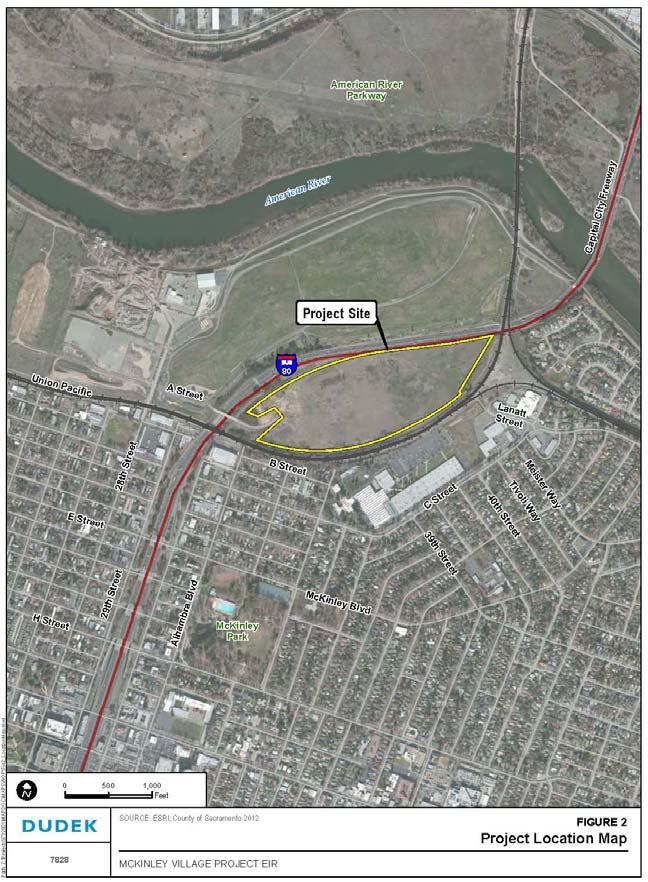
6 PRIMARY RECORD Page 1 of 7 P1. Other Identifier: Bridge *P2. Location: Not for Publication Unrestricted and (P2b and P2c or P2d. Attach a Location Map as necessary.) Trinomial NRHP Status Code 6Z Other Listings Review Code Reviewer Date *a. County Sacramento *b. USGS 7.5 Quad Sacramento East Date 2012 T8N; R 5E; ¼ of Sec ; M.D.M. B.M. c. Address Post Mile 1.77 Business 80 City Sacramento Zip d. UTM: (give more than one for large and/or linear resources) Zone ; me/ mn e. Other Locational Data: (e.g., parcel #, directions to resource, elevation, etc., as appropriate) *P3a. Description: (Describe resource and its major elements. Include design, materials, condition, alterations, size, setting, and boundaries) The A Street Overcrossing (OC) (Bridge No ) is a two span continuous concrete T-beam bridge, built in 1954, that carries a small paved portion of roadway over the Capital City Freeway [Business 80 / State Route (SR) 51] at post mile 1.77 (Photograph 1). The structure is generally perpendicular to the freeway and is supported on concrete wingwall abutments and a single two pier concrete bent. The bridge s roadway is flanked by short open panel railings with stepped ends and a sidewalk on its southern side (Photograph 2). The bridge s construction date is incised in the concrete curb at either end of the structure, and there is a metal guard rail adjacent to the bridge s northeast corner that likely dates to the bridge s original construction. The roadway that the structure carries runs parallel to B Street, which is situated south of the railroad tracks, and it aligns with A Street to the west. (See Continuation Sheet.) *P3b. Resource Attributes: (List attributes and codes) HP 19 (Bridge) *P4. Resources Present: Building Structure Object Site District Element of District Other (Isolates, etc.) P5a. Photo or Drawing (Photo required for buildings, structures, and objects.) P5b. Description of Photo: (View, date, accession #) Photograph 1. Camera facing south, 8/16/13 *P6. Date Constructed/Age and Sources: Historic Prehistoric Both 1954, Caltrans Records *P7. Owner and Address: Caltrans District B Street Marysville, CA *P8. Recorded by: (Name, affiliation, address) Christopher McMorris JRP Historical Consulting, LLC 2850 Spafford Street Davis, CA *P9. Date Recorded: 8/16/13 *P10. Survey Type: (Describe) Intensive *P11. Report Citation: (Cite survey report and other sources, or enter none. ) JRP Historical Consulting, LLC, Letter Report to Christine Kronenberg, Dudek, for McKinley Village Project Environmental Impact Report, September 4, 2013 *Attachments: None Location Map Sketch Map Continuation Sheet Building, Structure, and Object Record Archaeological Record District Record Linear Feature Record Milling Station Record Rock Art Record Artifact Record Photograph Record Other (list) DPR 523A (1/95)


7 BUILDING, STRUCTURE, AND OBJECT RECORD Page 2 of 7 *NRHP Status Code 6Z B1. Historic Name: A Street Overcrossing B2. Common Name: A Street Bridge B3. Original Use: Freeway Overcrossing B4. Present Use: Freeway Overcrossing *B5. Architectural Style: Utilitarian with Modern style enhancements *B6. Construction History: (Construction date, alteration, and date of alterations) Bridge constructed in 1954 as part of Elvas Freeway construction, Freeway widened from four to six lanes in 1965, but the bridge was not altered. *B7. Moved? No Yes Unknown Date: Original Location: *B8. Related Features: B9. Architect: California Division of Highways b. Builder: Ukropina, Polich, Kral, and Ukropina *B10. Significance: Theme n/a Area n/a Period of Significance n/a Property Type n/a Applicable Criteria n/a (Discuss importance in terms of historical or architectural context as defined by theme, period, and geographic scope. Also address integrity.) The A Street OC is listed as a Category 5 bridge (not eligible for the National Register of Historic Places) in the Caltrans Historic Bridge Inventory, available online at This conclusion is based on the department s state-wide historic bridge inventory update conducted in the early 2000s. This current inventory of the A Street OC agrees with Caltrans conclusion. The bridge also does not meet the criteria for listing in the California Register of Historical Resources (CRHR) or the Sacramento Register of Historic and Cultural Resources. Thus, the A Street OC is not a historical resource for the purposes California Environmental Quality Act (CEQA), as per CEQA Guidelines Section (a)(2)-(3). The following provides an evaluation of the A Street OC that includes criteria for the CRHR [Section of the California Public Resources Code] and Sacramento Register [Sacramento City Code, Chapter (A)(1)(a)]. (See Continuation Sheet.) B11. Additional Resource Attributes: (List attributes and codes) *B12. References: A.M. Nash, New Elvas Freeway and R. N. Brink, G.D. Gilbert, Elvas Freeway Bridges, California Highways and Public Works, November- December 1954, 14-20; Helen Halsted, Elvas Freeway: Governor Opens Another Approach to Sacramento, California Highways and Public Works, May-June 1955, 10-13; Andrew Hope, Caltrans Architectural Historian, Caltrans Statewide Historic Bridge Inventory Update, Survey and Evaluation of Common Bridge Types, (Sacramento: California Department of Transportation, November 2004); and see B10 footnotes. B13. Remarks: *B14. Evaluator: Christopher McMorris *Date of Evaluation: August 2013 (This space reserved for official comments.) DPR 523B (1/95)
8 CONTINUATION SHEET Trinomial Page 3 of 7 *Recorded by Christopher McMorris *Date 8/16/13 Continuation Update P3a. Description (continued): This road is not generally used by the public and only provides access to the property on the east side of the bridge. Access to this structure is through a gate on 28 th Street over property owned by the City of Sacramento. To the north and south of the A Street OC, flanking the freeway, there are earthen berms that link the B Street Underpass (Union Pacific Railroad bridge) located approximately 160 feet to the south with the floodgates that are situated approximately 500 feet to the north of the A Street OC (Photograph 3). B10. Significance (continued): Historic Context The historic context for the A Street OC is the development of the freeway system in Sacramento during the early 1950s and the use of T-beam concrete bridges in the mid-twentieth century. The California Division of Highways designed and built the A Street OC as part of its construction of the Elvas Freeway, which later became State Route 51, Business 80 (Business Loop 80), and the Capital City Freeway. The Elvas Freeway, constructed between 1950 and 1955, was the second freeway built north of the Sacramento s grid-pattern streets as part of the incremental development of the city and region s freeway system. Completed in 1954, the A Street OC was to provide access to the property on the east side of the bridge that was otherwise encircled by railroad tracks on the levee to the south and the new freeway to the north, as well as provide for future development in the area to the east of the structure. Sacramento s original grid street pattern of letter and number streets dates to 1848, however urban development at its east end by the A Street OC did not occur until the early twentieth century. Transportation to and from Sacramento in the late nineteenth and early twentieth centuries was via steamship on the Sacramento River, roadways that entered the city street grid mostly from the south and east, and the railroad, including the Southern Pacific Railroad line that entered the city at its northeast corner and ran along the levee north of B Street to the Sacramento Depot near the Sacramento River. There were also interurban rail lines that connected Sacramento to other cities in Northern California. Automobiles rapidly came into wide use after 1900, and with passage of a local roadway bond measure in 1907 and the creation of the California Highway Commission in 1909, various paved roadways and highways were built outward from Sacramento. The roadway connecting Sacramento to the north was on 16 th Street, with traffic carried on a wooden trestle over the American River overflow area that was replaced in 1925 with a concrete and steel viaduct. Development north of the American River began in the 1910s and rapidly grew in the 1920s with the creation of the City of North Sacramento (that later merged with the City of Sacramento in 1964). Sacramento s suburbs grew during the 1920s, 1930s, and 1940s with a great expansion of development following World War II. 1 1 Steven M. Avella, Sacramento: Indomitable City (Charleston, S.C.: Arcadia Publishing, 2003) 13, 80-81, 89-90; U.S. Geological Survey, Fair Oaks Quadrangle, California [map]. 1:62, Minutes Series. Washington D.C.:USGS, 1902; USGS, Brighton Quadrangle, California [map]. 1:31, Minutes Series. Washington D.C.:USGS, 1911; USGS, Sacramento East, California [map]. 1:24, Minutes Series. Washington D.C.:USGS, 1949; USGS, Sacramento East, California [map]. 1:24, Minutes Series. Washington D.C.:USGS, 1954; State of California, Department of Public Works, Division of Highways, Final Construction Report of a viaduct constructed over the American River Overflow Area and the tracks of the Sacramento Northern Railway and the Western Pacific Railroad between the American River Bridge and North Sacramento on Contract No. 414TCA, Road III-Sac-3-B,N, W.A. Perry, Earl W. Heple, Contractor, January 18, 1943, filed in Folder: Route 80-Sacramento County-Articles, contracts, etc., Caltrans Transportation Library & History Center, Sacramento; California Highways and Public Works, January-February 1948, 2; See also, John F. Burns, ed., Sacramento: Gold Rush Legacy, Metropolitan Destiny (Carlsbad, CA: Heritage Media Corp., 1999). DPR 523L (1/95)
9 CONTINUATION SHEET Trinomial Page 4 of 7 *Recorded by Christopher McMorris *Date 8/16/13 Continuation Update The State Division of Highways (predecessor to Caltrans) constructed Sacramento s freeways system incrementally from the 1940s to the 1970s. Initially freeways were constructed at the edge of the densely developed portions of the city, starting with construction of the North Sacramento Freeway (formerly US 40, now SR 160) in The plan for the Elvas Freeway was presented in the Sacramento Area Traffic Survey in , and the freeway was built between 1950 and 1955 as a means to provide additional access to the city across the American River from quickly developing suburban areas to the north and east, as well as to provide additional access to the then proposed new State Fairgrounds site that became CalExpo. The new river crossing was intended to relieve traffic congestion at the existing American River crossings at Jiboom Street, 16 th Street, and H Street. Demand for this new freeway was emphasized at the time by noting that traffic crossing the American River increased 85 percent between 1948 and The Division of Highways built the 2.9 mile Elvas Freeway as a four-lane divided highway (with provisions for a six-lane freeway) to connect with the North Sacramento Freeway in the vicinity of Arden Way (formerly Swanston Road). The new freeway s southern terminus was the surface roads at 29 th and 30 th streets (Photograph 4). At the time the Elvas Freeway was conceived and built, the Division of Highways was already considering an elevated freeway along the 29 th Street / 30 th Street corridor that would connect with the then proposed South Sacramento Freeway (SR99). Building the Elvas Freeway involved construction of three railroad grade separations, the A Street OC, undercrossings at Arden Way, the interchange between the Elvas and North Sacramento freeways, and parallel bridges over the American River, the last of which were the most demanding elements of the project to complete. Not only did flooding, strikes, and steel shortages during the Korean War in delay construction of the new American River Bridges, but the location of the new structures in the river flood plain proved challenging. Construction of the B Street Underpass, which carried the Southern Pacific Railroad transcontinental line on the city s northern levee, required additional measures to ensure continued flood protection for the city. The Division of Highways built a set of floodgates north of the A Street OC connecting those structures back to the levee with berms flanking the freeway. The project was completed under six different contracts, including one with the firm Ukropina, Polich, Kral, and Ukropina that included construction of the A Street OC. 2 The Elvas Freeway was considered at the time to be an incremental step in the development of Sacramento s freeway system. The Division of Highways went on to complete the South Sacramento Freeway, SR99, in 1961 and the Fort Sutter Viaduct along the 29 th Street / 30 th Street corridor in 1968, which led the Division of Highways to convert the Elvas Freeway from four to six lanes in The freeways were connected to the W-X corridor (I-80, now Business 80 / Capital City Freeway) to the west and US50 to the east, in 1968 and 1971 respectively. The freeway system through central Sacramento was completed in with construction of I-5 along the western edge of the city. 3 2 Arthur L. Elliott, North Sacramento Freeway Project Construction is Well Advanced, California Highways and Public Works, September-October 1946, 15-18, 31; J.D. Gallagher, Progress: Development on US40 and US99 Being Accelerated, California Highways and Public Works, September-October 1948,3 and 23; A.M. Nash, New Elvas Freeway and R. N. Brink, G.D. Gilbert, Elvas Freeway Bridges, California Highways and Public Works, November-December 1954, 14-20; Helen Halsted, Elvas Freeway: Governor Opens Another Approach to Sacramento, California Highways and Public Works, May-June 1955, Donald M. Young and Edward F. Silva, Jr., South Sacramento Freeway, California Highways and Public Works, January-February 1962, 16-18; William Burg, Sacramento s K Street: Where Our City Was Born, (Charleston: The History Press, 2012), ; Folder: Route 80-Sacramento County-Articles, contracts, etc., Caltrans Transportation Library & History Center, Sacramento; Caltrans, Log of Bridges on State Highways, online at: (accessed August 2013). DPR 523L (1/95)
10 CONTINUATION SHEET Trinomial Page 5 of 7 *Recorded by Christopher McMorris *Date 8/16/13 Continuation Update The Division of Highways included the A Street OC in the Elvas Freeway project not only to provide access to the property on the east end of the structure, but also for the purposes of carrying future A Street over the freeway. Schemes for the property on the east end of the A Street OC included the Centrage project that proposed a mixeduse development in The A Street OC is a common bridge type used in California and across the country. This structure type, a concrete T-beam, began to be used in California in the early twentieth century and was among bridge types frequently used for freeways in the mid-twentieth century. They were among the early bridge types that were standardized by state highway departments. Concrete T-beam (also referred to as tee beam) bridges were generally more economical than concrete arches or slabs for span lengths longer than 25 feet. They are the second most common bridge type on California roadways and highways built before Only concrete slab bridges are more common. The A Street OC has relatively modest span lengths (less than 60 feet). Multiple T-beam structures built in the 1930s had spans of 60 to 100 feet, and a few built in the 1940s with spans exceeding 100 feet. T-beam bridges that have been identified as historically significant represent early and innovative examples of the structure type, structures with architectural enhancement, and those that are contributors to historically significant highways. 5 The A Street OC was one of two concrete T-beam structures built in 1954 as part of the Elvas Freeway. The other is the Arden Way Undercrossing (Bridge No R), which is situated on the northbound lanes of the freeway approximately 2.25 miles northeast of the A Street OC. 6 Other examples of concrete T-beam bridges built for highways in Sacramento and its surrounding region include the North Sacramento Viaduct on SR 160 (Bridge No L) built in 1942 that replaced the previous viaduct constructed in 1925, as well as multiple overcrossings on SR 99 like the three in and near Galt constructed in 1958 (Bridges , , and ). 7 Evaluation The A Street OC is not significant for its association with the development of Sacramento s freeways, nor the development of its vicinity within the city. The bridge s construction was a minor component of the Elvas Freeway, which was an incremental project in the development of Sacramento s freeway system. The A Street OC was planned, in part, to allow for future development on the east side of the structure, which to date has not occurred. The structure is also not associated with any persons of historic significance. Thus, the bridge is not significant under NRHP Criteria A and B, nor under CRHR Criteria 1 and 2. Furthermore, it is not significant under Sacramento Register Criteria i and ii. 4 Brink and Gilbert, Elvas Freeway Bridges, California Highways and Public Works, 19; Paul E. Kasper, A 48-acre, $400 million proposal for Business 80, Sacramento Bee, April 21, 1989, B7. 5 Andrew Hope, Caltrans Architectural Historian, Caltrans Statewide Historic Bridge Inventory Update, Survey and Evaluation of Common Bridge Types, (Sacramento: California Department of Transportation, November 2004), 7-9; Parsons Brinckerhoff and Engineering and Industrial Heritage, A Historic Context For Common Bridge Types, NCHRP Project 25-25, Task 15, Prepared for The National Cooperative Highway Research Program Transportation Research Council National Research Council, October 2005, 3-88 to Caltrans, Log of Bridges on State Highways, online at: (accessed August 2013); Division of Highways, Final Construction Report of a viaduct constructed over the American River Overflow Area..., January 18, 1943, 3. 7 Caltrans, Log of Bridges on State Highways, online at: (accessed August 2013). DPR 523L (1/95)

11 CONTINUATION SHEET Trinomial Page 6 of 7 *Recorded by Christopher McMorris *Date 8/16/13 Continuation Update The A Street OC is also not significant for its architecture or engineering design. The structure does not embody distinctive qualities for its type, period, or method of construction, it is not an important example of a significant designer, and it does not possess high artistic values. With its modest span lengths and perpendicular relationship to the freeway, the bridge does not illustrate innovative engineering qualities. Also, as part of the Elvas Freeway project, the A Street OC did not pose an engineering challenge like that of the new American River Bridges. Furthermore, the bridge s simple aesthetic enhancements that derive from Modern style design do not represent significant architectural qualities. Therefore, the A Street OC is not significant for the NRHP under Criterion C, CRHR under Criterion 3, or Sacramento Register under Criteria iii / iv / v. The A Street OC also does not appear to be a significant or likely source of important information regarding history. It does not appear to have any likelihood of yielding important information about historic construction materials or technologies and, therefore, do not appear to be eligible for the NRHP under Criterion D, CRHR under Criterion 4 or Sacramento Register under Criterion vi. While the A Street OC has historic integrity by retaining design features from its original construction, and its setting in generally similar to when it was constructed, the structure lacks historic significance under NRHP, CRHR, and Sacramento Register criteria, as discussed above. Photographs (continued): Photograph 1: A Street OC deck, camera facing east, 8/16/13. DPR 523L (1/95)


12 CONTINUATION SHEET Trinomial Page 7 of 7 *Recorded by Christopher McMorris *Date 8/16/13 Continuation Update Photograph 2: A Street OC railing and view of freeway. B Street Underpass floodgates are in the background, 8/16/13. Photograph 4: A Street OC completed with Elvas Freeway, Division of Highways, Negative , August 5, 1960, Folder: Route 80-Sacramento County , Caltrans Transportation Library & History Center, Sacramento. DPR 523L (1/95)
PRIMARY RECORD Trinomial # NRHP Status Code 3S, 3CS, 5S3 Other Listings Review Code Reviewer Date
 PRIMARY RECORD # NRHP Status Code 3S, 3CS, 5S3 Other Listings Review Code Reviewer Date Page 1 of 6 1252 *Resource Name or # (Assigned by recorder) Old Topanga Canyon Road P1. Other Identifier: *P2. Location:
North River Mills Bridge Hampshire County State Project # S314-45/ Federal Project # ARRA-4520(003)D FR#: HM-1
D FR#: HM-1") North River Mills Bridge Hampshire County State Project # S314-45/20-2.40 02 Federal Project # ARRA-4520(003)D FR#: 10-1463-HM-1 STATE LEVEL OF HISTORIC DOCUMENTATION November 2010 West Virginia Department
North River Mills Bridge Hampshire County State Project # S314-45/20-2.40 02 Federal Project # ARRA-4520(003)D FR#: 10-1463-HM-1 STATE LEVEL OF HISTORIC DOCUMENTATION November 2010 West Virginia Department
Trinomial NRHP Status Code Other Listings Review Code Reviewer Date
 PRIMARY RECORD Page 1 of 6 *Resource Name or #: (Assigned by recorder) Woolsey Building P1. Other Identifier: None NRHP Status Code Other Listings Review Code Reviewer Date *P2. Location: Not for Publication
Trinomial NRHP Status Code Other Listings Review Code Reviewer Date
 PRIMARY RECORD Page 1 of 6 *Resource Name or #: (Assigned by recorder) Nish & McNeill Men s Furnishings P1. Other Identifier: Cloud Building *P2. Location: Not for Publication Unrestricted *a. County Alameda
MINNESOTA ARCHITECTURE - HISTORY INVENTORY FORM
 Identification Historic Name Nicollet Avenue Bridge Current Name Nicollet Avenue Bridge Field # Address Nicollet Avenue over Minnehaha Creek City/Twp Minneapolis SHPO Inventory Number Review and Compliance
MINNESOTA ARCHITECTURE - HISTORY INVENTORY FORM
 Identification Historic Name Dean Parkway Bridge Current Name Bridge 90661 Field # Address Midtown Greenway over Dean Parkway City/Twp Minneapolis County Hennepin Legal Desc. Twp 29N Range 24W Sec 32 QQ
IMPORTANT NOTICE. Architectural Inventory Form COLORADO CULTURAL RESOURCE SURVEY I. IDENTIFICATION th Street 5WL.5601
 IMPORTANT NOTICE OAHP1403 Rev. 9/98 COLORADO CULTURAL RESOURCE SURVEY Architectural Inventory Form Page 1 This survey form represents an UNOFFICIAL COPY and is provided for informational purposes only.
Architectural Inventory Form (page 1 of 5)
") OAHP1403 Rev. 9/98 COLORADO CULTURAL RESOURCE SURVEY (page 1 of 5) I. IDENTIFICATION 1. Resource number 5RT-2050 2. Temporary resource number: 145008005 3. County: Routt County 4. City: Steamboat Springs
OAHP1403 Rev. 9/98 COLORADO CULTURAL RESOURCE SURVEY (page 1 of 5) I. IDENTIFICATION 1. Resource number 5RT-2050 2. Temporary resource number: 145008005 3. County: Routt County 4. City: Steamboat Springs
Trinomial NRHP Status Code
 State of California C The Resources Agency Primary # PRIMARY RECORD Page 1 of 18 NRHP Status Code Other Review Code Reviewer Date Listings\ *Resource Name or #: (Assigned by recorder) 19277 Shubert Drive,
Architectural Inventory Form (page 1 of 5)
") OAHP1403 Rev. 9/98 COLORADO CULTURAL RESOURCE SURVEY (page 1 of 5) Official eligibility determination (OAHP use only) Date Initials Determined Eligible- NR Determined Not Eligible- NR Determined Eligible-
OAHP1403 Rev. 9/98 COLORADO CULTURAL RESOURCE SURVEY (page 1 of 5) Official eligibility determination (OAHP use only) Date Initials Determined Eligible- NR Determined Not Eligible- NR Determined Eligible-
2.1.8 Cultural Resources Regulatory Setting. Affected Environment, Environmental
 REVISED DRAFT ENVIRONMENTAL IMPACT REPORT/ Affected Environment, Environmental 2.1.8 Cultural Resources This section evaluates the potential for historical and archaeological resources within the proposed
6Z Other Listings Review Code Reviewer D a t e Resource Name or #: (Assigned by recorder)
") PRIMARY RECORD 1 o f HRI # Trinomial 6Z Other Listings Review Code Reviewer D a t e Resource Name or #: (Assigned by recorder) 6 S A ST P1. Other Identifier: 0- S A St P. Location: Not for Publication
PRIMARY RECORD 1 o f HRI # Trinomial 6Z Other Listings Review Code Reviewer D a t e Resource Name or #: (Assigned by recorder) 6 S A ST P1. Other Identifier: 0- S A St P. Location: Not for Publication
c,4 ~ 5' m -t:to3~o H
 (? -- 5o--cC()Oco ( c,4 ~ 5' m -t:to3~o H Since the time of its construction the San Joaquin mainline has served the San Joaquin Valley. At numerous points sidings, spurs and side tracks were added to
Architectural Inventory Form
 COLORADO CULTURAL RESOURCE SURVEY Page 1 of 8 Official Eligibility Determination (OAHP use only) Rev. 9/98 OAHP1403 Date Initials Determined Eligible National Register Determined Not Eligible National
MINNESOTA HISTORIC PROPERTY RECORD PART I. PROPERTY IDENTIFICATION AND GENERAL INFORMATION
 MINNESOTA HISTORIC PROPERTY RECORD PART I. PROPERTY IDENTIFICATION AND GENERAL INFORMATION Common Name: Fort Snelling-Mendota Bridge Bridge Number: 4190 Identification Number: Location: Feature Carried:
MINNESOTA ARCHITECTURE - HISTORY INVENTORY FORM
 Identification Historic Name Bridge L8849 Current Name Bridge L8849 Field # Address Municipal Road 99 over the Chippewa River City/Twp Montevideo County Chippewa Legal Desc. Twp 117N Range 40W Sec 07 QQ
Architectural Inventory Form
 COLORADO CULTURAL RESOURCE SURVEY Page 1 of 8 Official Eligibility Determination (OAHP use only) Rev. 9/98 OAHP1403 Date Initials Determined Eligible National Register Determined Not Eligible National
Architectural Inventory Form
 COLORADO CULTURAL RESOURCE SURVEY Page 1 of 7 Official Eligibility Determination (OAHP use only) Rev. 9/98 OAHP1403 Date Initials Determined Eligible National Register Determined Not Eligible National
I 5 South Multimodal Corridor Study. Appendix F. I 5 South Multimodal Corridor Study Cultural Resources Constraints Analysis (February 8, 2010)
") I 5 South Multimodal Corridor Study Appendix F I 5 South Multimodal Corridor Study Cultural Resources Constraints Analysis (February 8, 2010) 847 Jamacha Road, El Cajon, California 92019-3206 tel: (619)
I 5 South Multimodal Corridor Study Appendix F I 5 South Multimodal Corridor Study Cultural Resources Constraints Analysis (February 8, 2010) 847 Jamacha Road, El Cajon, California 92019-3206 tel: (619)
ATTACHMENT 1 DPR 523A AND B REPORTS
 ATTACHMENT 1 DPR 523A AND B REPORTS 824 University Avenue, Berkeley, Alameda County PRIMARY RECORD Page 1 of 10 Other Listings Review Code NRHP Status Code: 6Z Reviewer Date Resource Name: 824 University
Trinomial NRHP Status Code Other Listings Review Code Reviewer Date
 PRIMARY RECORD NRHP Status Code Other Listings Review Code Reviewer Date 3S Page 1 of 5 *Resource Name or #: (Assigned by recorder) Underwood Building P1. Other Identifier: Virginia Apartments *P2. Location:
Historical Assessment of Humphreys Elementary School Auditorium
 Humphreys Elementary School Auditorium Prepared for: Los Angeles Unified School District Office of Environmental Health & Safety 1055 West Seventh Street, 9 th Floor Los Angeles, CA 90017 Prepared by:
3.0 Cumulative Scenario and Methodology. 3.0 Cumulative Scenario and Methodology
 3.0 Cumulative Scenario and Methodology Under the CEQA Guidelines, a cumulative impact consists of an impact which is created as a result of the combination of the project evaluated in the environmental
PennDOT. single spann lanes and 3- mayy need to be to accommodate. any bridge. addition to III. Date: CRP 07/27/2015 CRP.
 (10/27/14) PennDOT Section 106 Field Assessments and Finding Combined Early tification/finding? Yes Concurrence required or requested: Yes MPMS: 51507 ER# (if consultation with PHMC required) ): County:
CEQA and Historic Preservation: A 360 Degree Review
 CEQA and Historic Preservation: A 360 Degree Review California Preservation Foundation Workshop February 11, 2015 Presented by Chris McMorris Partner / Architectural Historian CEQA and Historic Preservation
Architectural Inventory Form
 COLORADO CULTURAL RESOURCE SURVEY Page 1 of 8 Official Eligibility Determination (OAHP use only) Rev. 9/98 OAHP1403 Date Initials Determined Eligible National Register Determined Not Eligible National
Appendix G Response to Comments
 Appendix G Response to Comments This appendix contains the comments received during the public circulation and comment period (May 27, 2008 to July 11, 2008). The comments have been numbered (Comment Set
Architectural Inventory Form
 IMPORTANT NOTICE OAHP1403 Rev. 9/98 COLORADO CULTURAL RESOURCE SURVEY Page 1 This survey form represents a only. All information, particularly determinations of eligibility for the National Register, the
Chapter 19: Cultural Resources
 Chapter 19: Cultural Resources Introduction and Setting Traditionally the term "cultural resources" has been used rather narrowly to refer to archaeological remains and to historical structures. Archaeologists,
Architectural Inventory Form
 IMPORTANT NOTICE OAHP1403 Rev. 9/98 COLORADO CULTURAL RESOURCE SURVEY Page 1 This survey form represents a only. All information, particularly determinations of eligibility for the National Register, the
Creating Complete Roadway Corridors:
 Creating Complete Roadway Corridors: The AASHTO Guide to Transportation Landscape Architecture and Environmental Design NCHRP Project 15-33 Status Report AASHTO Standing Committee on Design Technical Committee
Contact: Teresa Haenggi, Associate Planner, (916) ; Roberta Deering, LEED AP, Preservation Director (916)
 ; Roberta Deering, LEED AP, Preservation Director (916)") Report to PRESERVATION COMMISSION City of Sacramento 915 I Street, Sacramento, CA 95814-2671 www. CityofSacramento.org 4 PUBLIC HEARING October 15, 2014 Members of the Preservation Commission: Subject:
Report to PRESERVATION COMMISSION City of Sacramento 915 I Street, Sacramento, CA 95814-2671 www. CityofSacramento.org 4 PUBLIC HEARING October 15, 2014 Members of the Preservation Commission: Subject:
Los Angeles River Bridges Staff Presentation. Office of Historic Resources September 2007
 Los Angeles River Bridges Staff Presentation Office of Historic Resources September 2007 Area of Study Historic Context: What makes the bridges historic? Why were they built? When were they built? Who
September 26, Ms. Elizabeth Hughes State Historic Preservation Officer Maryland Historical Trust 100 Community Place Crownsville MD
 September 26, 2018 Ms. Elizabeth Hughes State Historic Preservation Officer Maryland Historical Trust 100 Community Place Crownsville MD 21032-2023 Dear Ms. Hughes: Introduction and Project Description
Page. I. Introduction 1. II. Project Purpose and Need 2. IV. Description of Section 4(f) Property 2. V. Impacts to Section 4(f) property 3
 Property 2. V. Impacts to Section 4(f) property 3") Table of Contents Programmatic Section 4(f) Evaluation for use of a Historic Bridge Replacement of Route 30/130 Bridge over the Cooper River Structure No. 0405-153 City of Camden, Borough of Collingswood,
Table of Contents Programmatic Section 4(f) Evaluation for use of a Historic Bridge Replacement of Route 30/130 Bridge over the Cooper River Structure No. 0405-153 City of Camden, Borough of Collingswood,
Architectural Inventory Form
 OAHP1403 Rev. 9/98 COLORADO CULTURAL RESOURCE SURVEY Architectural Inventory Form Official eligibility determination (OAHP use only) Date Initials Determined Eligible- NR Determined Not Eligible- NR Determined
State of California The Resources Agency Primary # DEPARTMENT OF PARKS AND RECREATION BUILDING, STRUCTURE, AND OBJECT RECORD.
 State of California The Resources Agency Primary # DEPARTMENT OF PARKS AND RECREATION HRI# BUILDING, STRUCTURE, AND OBJECT RECORD Page 32 of 39 *NRHP Status Code 3D, 3CD *Resource Name or # (Assigned by
2. INTRODUCTION 2.1 AUTHORITY 2.2 PURPOSE AND INTENT 2.3 SITE LOCATION
 2. INTRODUCTION 2.1 AUTHORITY The City of Gardena initiated and prepared the Artesia Corridor Specific Plan pursuant to the provisions of California Government Code, Title 7, Division 1, Chapter 3, Article
MINNESOTA HISTORIC PROPERTY RECORD PART I. PROPERTY IDENTIFICATION AND GENERAL INFORMATION
 MINNESOTA HISTORIC PROPERTY RECORD PART I. PROPERTY IDENTIFICATION AND GENERAL INFORMATION Common Name: 3589 Bridge Number: 3589 Identification Number: Location: Feature Carried: TH 61 Feature Crossed:
Architectural Inventory Form
 COLORADO CULTURAL RESOURCE SURVEY Page 1 of 3 Official Eligibility Determination (OAHP use only) Rev. 9/98 OAHP1403 Date Initials Determined Eligible National Register Determined Not Eligible National
Middlebury RS 0174(8)
") Middlebury RS 0174(8) Preferred Alternative Meeting VT 125 Bridge #13 over Middlebury River August 6, 2012 Presented to Presented by Town of Middlebury VTrans & VHB Introductions: Jennifer Fitch VTrans
Middlebury RS 0174(8) Preferred Alternative Meeting VT 125 Bridge #13 over Middlebury River August 6, 2012 Presented to Presented by Town of Middlebury VTrans & VHB Introductions: Jennifer Fitch VTrans
Maryland Historical Trust Inventory No. PG: 71A-006 Maryland Inventory of Historic Properties Form
 Inventory No. PG: 71A-006 Maryland Inventory of 1. Name of Property (indicate preferred name) historic other 2. Location Concrete Railroad Bridge Washington, Baltimore, & Annapolis Electric Railway Bridge
MEMORANDUM. Attachment: 1. Village Historic Property Survey Map 2. Primary Record sheets from Arroyo Grande Historic Context Statement
 MEMORANDUM TO: FROM: HISTORICAL RESOURCES COMMITTEE MATTHEW DOWNING, PLANNING MANAGER DATE: JULY 14, 2017 SUBJECT: HISTORICAL RESOURCE SURVEYS The City has undertaken a number of surveys of local properties
IMPORTANT NOTICE. Architectural Inventory Form COLORADO CULTURAL RESOURCE SURVEY I. IDENTIFICATION. 655 Bryan Avenue 5BL.10460
 IMPORTANT NOTICE OAHP1403 Rev. 9/98 COLORADO CULTURAL RESOURCE SURVEY Architectural Inventory Form Page 1 This survey form represents an UNOFFICIAL COPY and is provided for informational purposes only.
Dallas Municipal Archives Archives Collections Finding Guides and Inventories
 Archives Collections Finding Guides and Inventories Guide No. 113 Municipal Utility Franchise Annual Reports, 1912-1922 Processed by: John H. Slate, CA City Archivist Office of the City Secretary City
SBCAG STAFF REPORT. MEETING DATE: March 17, 2016 AGENDA ITEM: 5I
 SBCAG STAFF REPORT SUBJECT: Cabrillo-UPRR Bridge Project MEETING DATE: March 17, 2016 AGENDA ITEM: 5I STAFF CONTACT: Fred Luna RECOMMENDATION: Authorize the chair to sign a Memorandum of Understanding
Appendix C Cultural Resources Analysis for Asphalt Plant No. 1
 Appendix C Cultural Resources Analysis for Asphalt Plant No. 1 TECHNICAL MEMORANDUM Cultural Resources Analysis for Asphalt Plan No. 1 PREPARED FOR: PREPARED BY: City of Los Angeles, Department of Public
7.5 Impacts on the Section 4(f) Properties
 Properties") constructive use, such as noise, air quality and visual impacts were also assessed. It was determined that this project would not introduce changes of an external nature that would affect the recreational
constructive use, such as noise, air quality and visual impacts were also assessed. It was determined that this project would not introduce changes of an external nature that would affect the recreational
COUNTY OF SACRAMENTO CALIFORNIA PLANNING COMMISSION REPORT
 COUNTY OF SACRAMENTO CALIFORNIA PLANNING COMMISSION REPORT TO: FROM: SUBJECT: COUNTY PLANNING COMMISSION DEPARTMENT OF COMMUNITY DEVELOPMENT GROWTH AREA PLANS UPDATE CONTACT: Cindy Storelli, Principal
HRER: Golden Gate Bridge Physical Suicide Deterrent System Project May APPENDIX B : DPR 523 Form Update
 HRER: Golden Gate Bridge Physical Suicide Deterrent System Project May 2008 APPENDIX B : DPR 523 Form Update Page 1 of 17 Continuation Update *Resource Name or # (Assigned by recorder) Golden Gate Bridge
Architectural Inventory Form
 COLORADO CULTURAL RESOURCE SURVEY Page 1 Official eligibility determination (OAHP use only) Date Initials Determined Eligible- NR Determined Not Eligible- NR Determined Eligible- SR Determined Not Eligible-
IMPORTANT NOTICE. Architectural Inventory Form COLORADO CULTURAL RESOURCE SURVEY I. IDENTIFICATION Eldorado Avenue 5BL.10487
 IMPORTANT NOTICE OAHP1403 Rev. 9/98 COLORADO CULTURAL RESOURCE SURVEY Architectural Inventory Form Page 1 This survey form represents an UNOFFICIAL COPY and is provided for informational purposes only.
3.10 LAND USE SETTING PROJECT SITE EXISTING LAND USE DESIGNATIONS AND ZONING. General Plan Land Use Designations.
 This section of the Draft EIR addresses the existing land uses on and adjacent to the project site and discusses the potential impacts of the proposed project on existing land uses. Key issues addressed
North Carolina Department of Transportation Project Development and Environmental Analysis Branch
 North Carolina Department of Transportation Project Development and Environmental Analysis Branch Citizens Informational Workshop I-85, from I-485 to NC 73 Mecklenburg and Cabarrus Counties October 30,
Clay Street Bridge Replacement Project
 Clay Street Bridge Replacement Project Frequently Asked Questions (FAQs) No. 2 April 4, 2018 The project is located in downtown Placerville on Clay Street between US Highway 50 and Main Street and Cedar
5S3 Other Listings Review Code Reviewer D a t e Resource Name or #: (Assigned by recorder)
") PRIMARY RECORD 1 o f HRI # Trinomial 5S3 Other Listings Review Code Reviewer D a t e Resource Name or #: (Assigned by recorder) 37 S C ST P1. Other Identifier: P. Location: Not for Publication Unrestricted
PRIMARY RECORD 1 o f HRI # Trinomial 5S3 Other Listings Review Code Reviewer D a t e Resource Name or #: (Assigned by recorder) 37 S C ST P1. Other Identifier: P. Location: Not for Publication Unrestricted
Bypass #16 - Bend Parkway (new alignment for US 97) (MP )
 (MP )") Bypass #16 - Bend Parkway (new alignment for US 97) (MP 134.76-141.83) Description: The Parkway is on new alignment for US 97 through Bend. US 97 is a Statewide Highway on the National Highway System that
Bypass #16 - Bend Parkway (new alignment for US 97) (MP 134.76-141.83) Description: The Parkway is on new alignment for US 97 through Bend. US 97 is a Statewide Highway on the National Highway System that
SEE INSTRUCTIONS IN HOW TO COMPLETE NATIONAL REGISTER FORMS TYPE ALL ENTRIES -- COMPLETE APPLICABLE SECTIONS. Fort Snelling--Mendota Bridge
 Form No. 10-300 AO-1 UNITED S DEPARTMENT OF THE INTERIOR NATIONAL PARK SERVICE NATIONAL REGISTER OF HISTORIC PLACES INVENTORY -- NOMINATION FORM SEE INSTRUCTIONS IN HOW TO COMPLETE NATIONAL REGISTER FORMS
COMMUNITY DEVELOPMENT SERVICES PLANNING AND BUILDING DEPARTMENT PLACERVILLE OFFICE:
 COMMUNITY DEVELOPMENT SERVICES PLANNING AND BUILDING DEPARTMENT http://www.edcgov.us/devservices/ PLACERVILLE OFFICE: LAKE TAHOE OFFICE: 2850 Fair Lane Court, Placerville, CA 95667 924 B Emerald Bay Rd.
Draft Environmental Assessment Appendix A. SHPO Correspondence, January 19, 2017
 Draft Environmental Assessment Appendix A. SHPO Correspondence, January 19, 2017 Rosecrans/Marquardt Grade Separation Project April 2018 Federal Railroad Administration U.S. Department 1200 New Jersey
2. AGENCY COORDINATION AND PUBLIC INVOLVMENT
 2. AGENCY COORDINATION AND PUBLIC INVOLVMENT This chapter discusses the process carried out for conducting agency coordination and public involvement activities. TECHNICAL ADVISORY COMMITTEE A Technical
1. Name of Property. historic name Lowe Building. other names/site number Iowa State Extension Office (current) 2. Location
 2. Location") Site Inventory Form State Inventory No. 61-03173 New Supplemental State Historical Society of Iowa Part of a district with known boundaries (enter inventory no.) 61-00001 (November 2005) Relationship:
Site Inventory Form State Inventory No. 61-03173 New Supplemental State Historical Society of Iowa Part of a district with known boundaries (enter inventory no.) 61-00001 (November 2005) Relationship:
Fall 2017 Construction Update
 Fall 2017 Construction Update Ward 4 Southeast Engineering Department Riverwalk Red Multi-Use Trail Bridge Rehabilitation The Riverwalk Red Multi Use Trail Bridge was awarded to Cramer and Associates,
In November and December, SACOG staff conducted the following Blueprint Implementation land use activities:
 SACOG Board of Directors Item #18-1-16 Receive & File January 11, 2018 Blueprint Implementation Activities The purpose of this item is to regularly inform the Board of SACOG land use related activities
REHABILITATION FEASIBILITY STUDY ER#
 REHABILITATION FEASIBILITY STUDY MILLER FARM ROAD BRIDGE PROJECT VENANGO COUNTY BRIDGE NO. 34 CARRYING S.R. 7212, SECTION L00 OVER OIL CREEK OIL CREEK AND CHERRYTREE TOWNSHIPS VENANGO COUNTY, PENNSYLVANIA
OMB v*m? No
 NPS Form 10-900 (Rev. 10-90) OMB v*m? No. 1024-001 United States Department of the Interior National Park Service NATIONAL REGISTER OF HISTORIC PLACES REGISTRATION FORW - -- - -- - 1. STOUTS MILL BRIDGE
No comments related to land use and planning issues were received in response to the Notice of Preparation.
 4.8 LAND USE AND PLANNING This section analyzes the impacts relative to land use and planning that would occur as a result of implementation of the proposed Facilities Master Plan (proposed project). This
MINNESOTA ARCHITECTURE - HISTORY INVENTORY FORM
 Historic Name Bridge R0437 Identification SHPO Inventory Number Review and Compliance Number Current Name Bridge R0437 (Stone Arch Bridge at Terrace Mill) Field # Address N/A Crossing over Chippewa River
City Council Special Meeting AGENDA ITEM NO. C.
 City Council Special Meeting AGENDA ITEM NO. C. DATE: 01/04/2019 TO: Honorable Mayor and City Council Members SUBJECT: Transit Villages Specific Plan project Study Session (Development Services Director
I-84 Hartford Project Open Planning Studio #12. April 25, 2017
 I-84 Hartford Project Open Planning Studio #12 April 25, 2017 Meeting Agenda 1. I-84 Hartford Project alternatives update 2. Multimodal station area planning 3. I-84 / I-91 Interchange Study coordination
Call to Artists Public Art for Los Angeles Metro Stations
 Conceptual Design for Call to Artists Public Art for Los Angeles Metro Stations Artesia Transit Center Union Station/Patsaouras Transit Plaza Los Angeles County Metropolitan Transportation Authority February
Page. I. Introduction 1. II. Project Purpose and Need 1. IV. Description of Section 4(f) Property 2. V. Impacts to Section 4(f) Property 3
 Property 2. V. Impacts to Section 4(f) Property 3") TABLE OF CONTENTS Programmatic Section 4(f) Evaluation for Use of a Public Park Replacement of Route 30/130 Bridge over the Cooper River Structure No. 0405-153 City of Camden, Township of Pennsauken Camden
TABLE OF CONTENTS Programmatic Section 4(f) Evaluation for Use of a Public Park Replacement of Route 30/130 Bridge over the Cooper River Structure No. 0405-153 City of Camden, Township of Pennsauken Camden
Project Description. Dear Ms. Roland-Nawi:
 U.S. Department of Transportation Federal Transit Administration REGION IX Arizona, California, Hawaii, Nevada, Guam American Samoa, Northern Mariana Islands 201 Mission Street Suite 1650 San Francisco,
Asbury Chapel Subdivision Sketch Plan
 Asbury Chapel Subdivision Sketch Plan PART 1: PROJECT SUMMARY Applicant: NVR Inc. Project Size: +/- 76.13 acres Parcel Numbers: 02101112,02116101,02116112, 02116113 Current Zoning: Transitional Residential
Stewardship. Streamlining. Consensus
 Stewardship Streamlining Consensus Translating Section 106: Building Consensus among Multiple Responsible Parties For the Doyle Drive Replacement Project in the Presidio of San Francisco National Historic
Linking Land Use and Transportation
 Linking Land Use and Transportation NJ s Experience January 18, 2006 NYMTC - PFAC Mark Stout Planning & Development New Jersey Department of Transportation Where We Are Los Angeles, CA San Francisco, CA
Los Angeles Department of City Planning RECOMMENDATION REPORT
 Los Angeles Department of City Planning RECOMMENDATION REPORT CULTURAL HERITAGE COMMISSION HEARING DATE: April 15, 2010 TIME: 10:00 AM PLACE: City Hall, Room 1010 200 N. Spring Street Los Angeles, CA 90012
National Register of Historic Places Inventory Nomination Form
 NPS Form 10.900-a OMB No. 1024-0018 (3.82) Exp. 10-31-84 United States Department of the Interior National Park Service National Register of Historic Places Inventory Nomination Form received date entered
CHAPTER 10 AESTHETICS
 CHAPTER 10 AESTHETICS CHAPTER 10 AESTHETICS This section identifies and evaluates key visual resources in the project area to determine the degree of visual impact that would be attributable to the project.
NOTICE OF PREPARATION
 NOTICE OF PREPARATION To: All Interested Parties Subject: Notice of Preparation of an Environmental Impact Report From: City of Petaluma Address: 11 English Street, Petaluma, CA 94952-2610 Contact: Heather
Historic Property Report
 Historic Name: Rutter Parkway Stone Structures Property ID: 706402 Location Address: GeographicAreas: W Rutter Pkwy, Spokane, Washington, USA Spokane,Spokane County,T26R42E03,DARTFORD Quadrangle Information
Southern Gateway Project and Public Green
 Southern Gateway Project and Public Green Transportation and Trinity River Project Committee May 23, 2016 Purpose of Presentation Provide the history and an overview of the Southern Gateway Project (SGP)
HAZARD MITIGATION GOALS AND OBJECTIVES
 SEWRPC Community Assistance Planning Report No. 282, 2nd Edition CITY OF MILWAUKEE ALL HAZARDS MITIGATION PLAN UPDATE Chapter IV HAZARD MITIGATION GOALS AND OBJECTIVES [NOTE: Throughout this plan update
SECTION 4(f) DE MINIMIS DOCUMENTATION
 DE MINIMIS DOCUMENTATION") SECTION 4(f) DE MINIMIS DOCUMENTATION Illinois Route 60/83 IL 176 to the intersection of IL 60 (Townline Road) Lake County P-91-084-07 Mundelein Park and Recreation District Project Limit SECTION 4(f)
SECTION 4(f) DE MINIMIS DOCUMENTATION Illinois Route 60/83 IL 176 to the intersection of IL 60 (Townline Road) Lake County P-91-084-07 Mundelein Park and Recreation District Project Limit SECTION 4(f)
16E. 24 th Street Corridor. A. Background
 A. Background The 24 th Street corridor plan includes both 24 th Street and 2550 South from 1900 West to Washington Boulevard, as shown in Map 1. 1. Development History The 24 th Street Corridor has been
WELCOME TO OPEN HOUSE TWO November 28, 2018
 Langstaff Road Weston Road to Highway 7 Class Environmental Assessment Study WELCOME TO OPEN HOUSE TWO November 28, 2018 Please sign in and join our mailing list Study Overview York Region is conducting
Architectural Inventory Form
 IMPORTANT NOTICE OAHP1403 Rev. 9/98 COLORADO CULTURAL RESOURCE SURVEY Page 1 This survey form represents a only. All information, particularly determinations of eligibility for the National Register, the
Architectural Inventory Form
 OAHP1403 Rev. 9/98 COLORADO CULTURAL RESOURCE SURVEY Architectural Inventory Form Official eligibility determination (OAHP use only) Date Initials Determined Eligible- NR Determined Not Eligible- NR Determined
Appendix E Preliminary Location Hydraulic Study
 Appendix E Prepared for: State of Alaska Department of Transportation and Public Facilities Prepared by: HDR Alaska, Inc. 2525 C Street, Suite 305 Anchorage, Alaska 99503 February 2014 This page intentionally
Mississippi Skyway Preliminary Engineering Report
 EXECUTIVE SUMMARY Mississippi Skyway Preliminary Engineering Report CITY OF RAMSEY, MINNESOTA DECEMBER 2014 City of RAMSEY EXECUTIVE SUMMARY Project Need and Intent The Mississippi Skyway pedestrian bridge
HISTORIC SITE FORM - HISTORIC SITES INVENTORY PARK CITY MUNICIPAL CORPORATION (10-08) 1 IDENTIFICATION
 1 IDENTIFICATION") HISTORIC SITE FORM - HISTORIC SITES INVENTORY PARK CITY MUNICIPAL CORPORATION (10-08) 1 IDENTIFICATION Name of Property: The New Park Hotel Address: 573 MAIN ST AKA: City, County: Park City, Summit County,
HISTORIC SITE FORM - HISTORIC SITES INVENTORY PARK CITY MUNICIPAL CORPORATION (10-08) 1 IDENTIFICATION Name of Property: The New Park Hotel Address: 573 MAIN ST AKA: City, County: Park City, Summit County,
PROJECT SITE The Proposed Project includes the Allen and Pike Street malls between Delancey and South Streets (see Figure 2C-1).
.") Chapter 2, Section C: A. INTRODUCTION This chapter considers the potential of the proposed Reconstruction of the Allen and Pike Street Malls project to affect the urban design characteristics and visual
Chapter 2, Section C: A. INTRODUCTION This chapter considers the potential of the proposed Reconstruction of the Allen and Pike Street Malls project to affect the urban design characteristics and visual
Downtown Redevelopment Project Update
 Downtown Redevelopment Project Update The redevelopment project will begin the week of September 4, 2017. It is anticipated that construction will be approximately 565 days, depending on weather. 7-6-18
DRAFT SECTION 4(f) EVALUATION INTERSTATE 73 FEIS: I-95 to I-73/I-74 in North Carolina
 EVALUATION INTERSTATE 73 FEIS: I-95 to I-73/I-74 in North Carolina") DRAFT SECTION 4(f) EVALUATION INTERSTATE 73 FEIS: I-95 to I-73/I-74 in North Carolina 1.0 INTRODUCTION Section 4(f) of the Department of Transportation Act of 1966, 49 U.S.C. 303, requires that prior to
DRAFT SECTION 4(f) EVALUATION INTERSTATE 73 FEIS: I-95 to I-73/I-74 in North Carolina 1.0 INTRODUCTION Section 4(f) of the Department of Transportation Act of 1966, 49 U.S.C. 303, requires that prior to
historic name: STARR MILL ROAD BRIDGE other name/site number: Beverly Heights Bridge. Bridge No. 4541
 NFS Form 10-900 < (Rev. 8-86)! REGISTRATION FORM RECEIVED OCT 2 8 1993 NATIONAL REGISTER *! 0 2 4 0 0 1 8 =============================================$======================= === 1. Name of Property '
ROAD CONSTRUCTION. 36 June 2014 ROADS&BRIDGES
 ROAD CONSTRUCTION 36 June 2014 ROADS&BRIDGES Young is full of life Recent expansion completes continuous, multilane arterial By Donald Hammack, P.E. Contributing Author The Florida Department of Transportation
Metro Orange Line Extension Four Years Early and $61 Million Under Budget
 White Paper: Metro Orange Line Extension Four Years Early and $61 Million Under Budget July 2013 Innovation for better mobility Metro Orange Line Extension Iteris, Inc. was the prime consultant leading
HISTORIC CONTEXT. Places, William Bushong, Rock Creek Park, Historic Resource Study, National Park Service, 1990.
 HISTORIC CONTEXT The review of Kensington Cabin benefits from an understanding of several interrelated historic themes: suburban development, outdoor recreation, City Beautiful movement, stream valley
PART 1: PROJECT SUMMARY. Proposed Land Use: 120 single-family lots. The application is Attachment A. The site plan is Attachment B.
 PART 1: PROJECT SUMMARY Applicant: JBH Development, LLC and Hopper Communities, INC Project Size: +/- 80.48 acres Parcel Number: 01513107, 01513108, 01513109, 01513113, 01513120, 01513121, 01513122, 01513124,
CITY OF DES MOINES LANDMARK REVIEW BOARD STAFF REPORT AND RECOMMENDATION Tuesday, June 13, 2017
 CITY OF DES MOINES LANDMARK REVIEW BOARD STAFF REPORT AND RECOMMENDATION Tuesday, June 13, 2017 AGENDA ITEM #1 20-2017-4.03 Applicant: Des Moines Streetcar Friends represented by Earl Short. The subject