Master in architecture. (Urban Landscape Design)
|
|
|
- Beatrix Wood
- 6 years ago
- Views:
Transcription


1 Master in architecture ()
2 1. Details of module and its structure Module detail Subject name Paper name Module name/title Objectives Keywords M.arch - architecture Urban landscape design Case study _ fort kochi, alleppey, sarovam 1. To learn about urbanism and the need for open space in urban areas. 2. Ecological design of open spaces like wetland, beach etc 3. Accommodation of local design language and vernacular solutions. Case study _ fort kochi, alleppey, sarovam
3 2. 2. Development team Role Name National coordinator Subject coordinator Paper coordinator Content writer/author (cw) Content reviewer (cr) Language editor (le) Dr. Monsingh d. Devadas Mr. K. Raghuraman Mr. K. Raghuraman Mr. Deepak rao


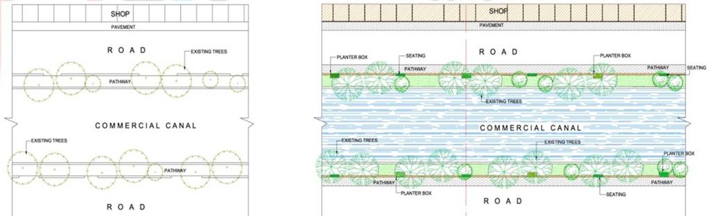
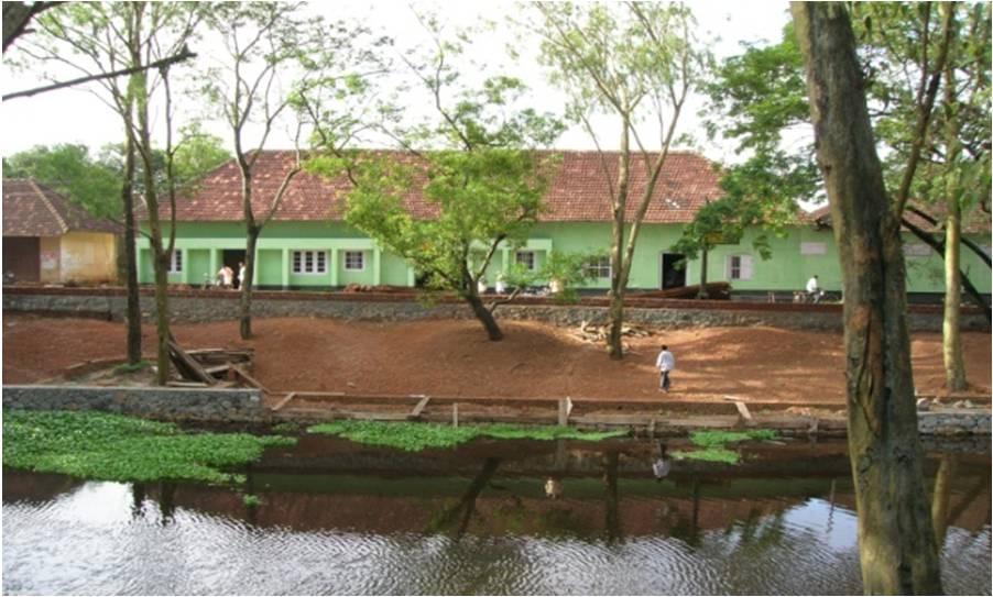
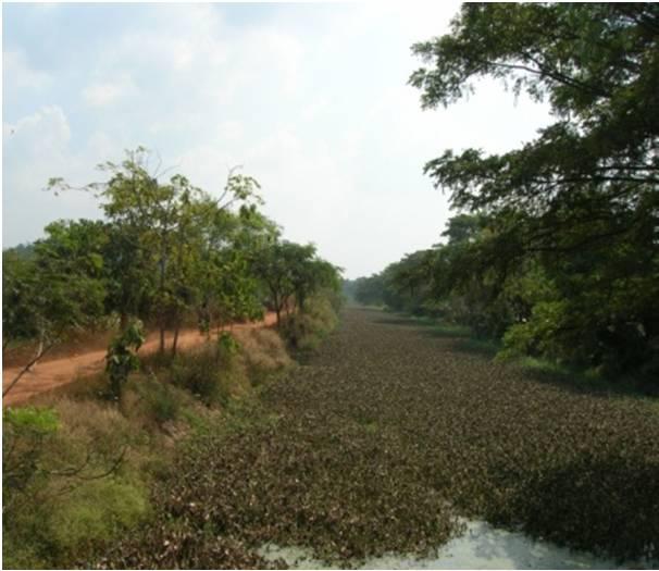
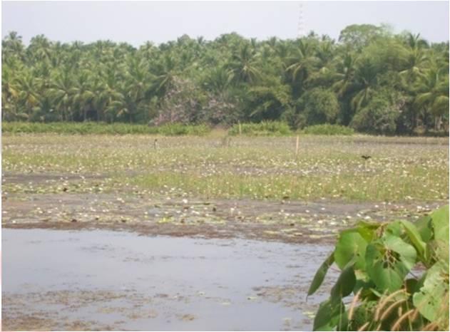
4 E-text & learn more Text Alleppey Waterfront development of alleppey canals the heritage canals Alleppey canals The town of alleppey has a network of canals included in the west coast canal system which are used for navigation. The important canals are vadai canal and commercial canals and the link canal between these two canals. The back water system and their adjoining areas are subjected to seasonal flooding and are utilized as filtration ponds for aquaculture and pokkali (salt resistant variety of paddy).

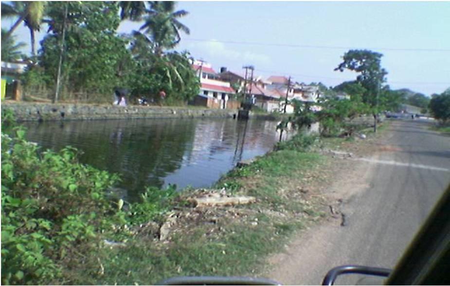
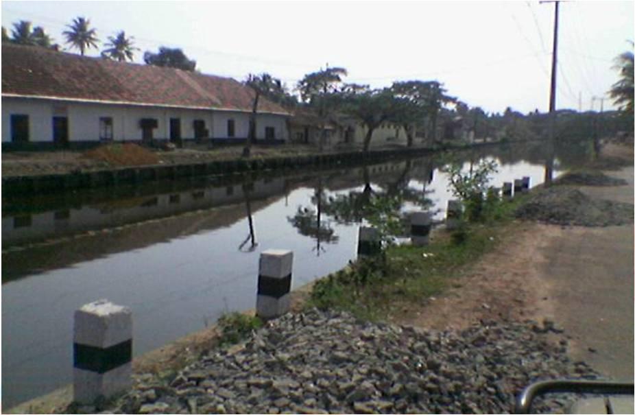
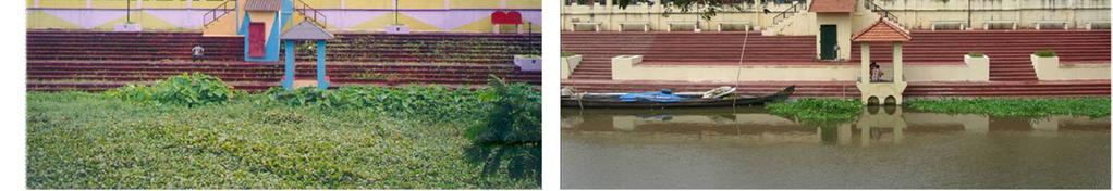
5 Alleppey canals then
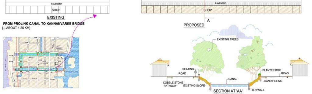
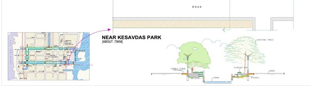
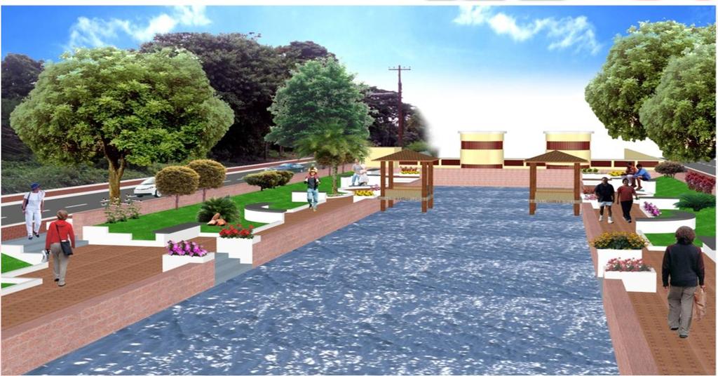
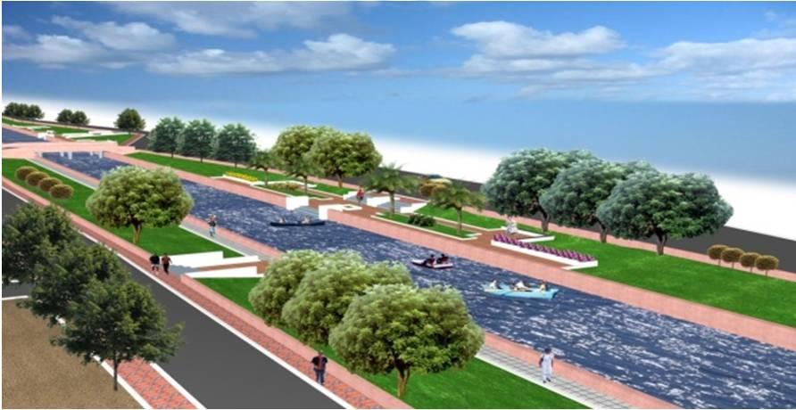
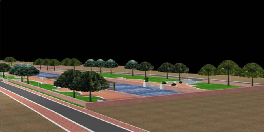
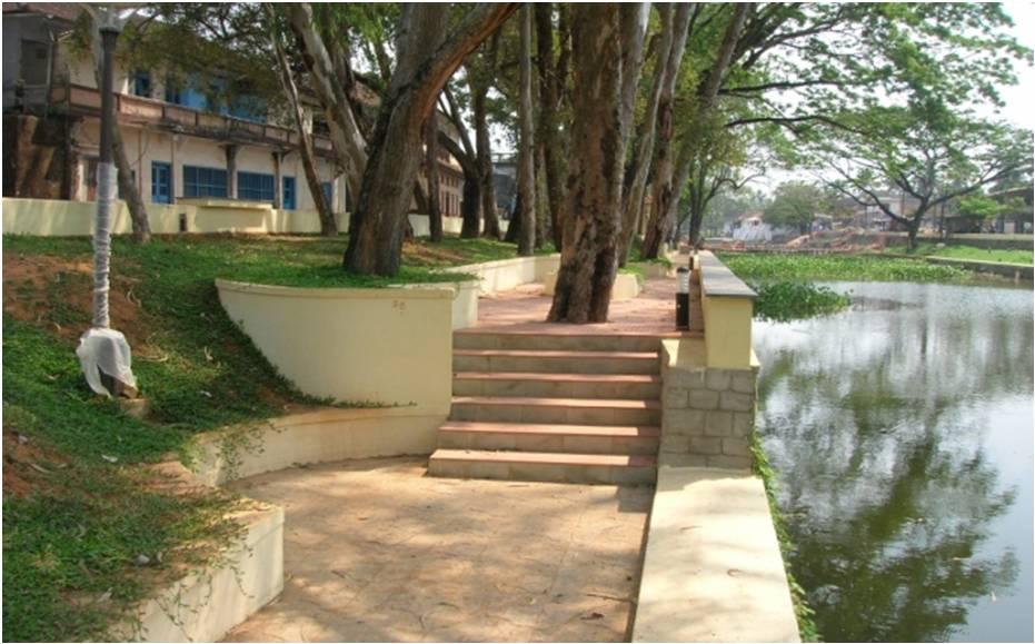
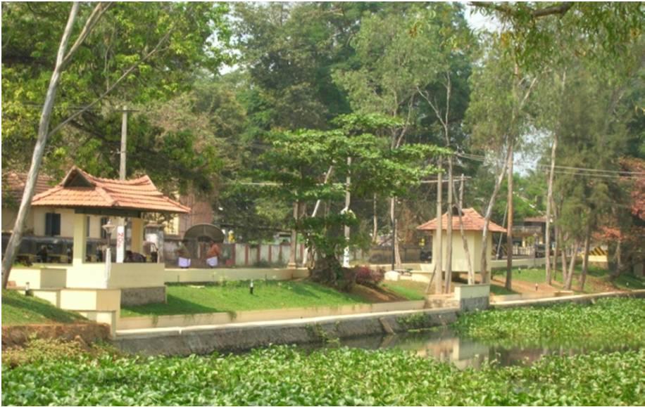
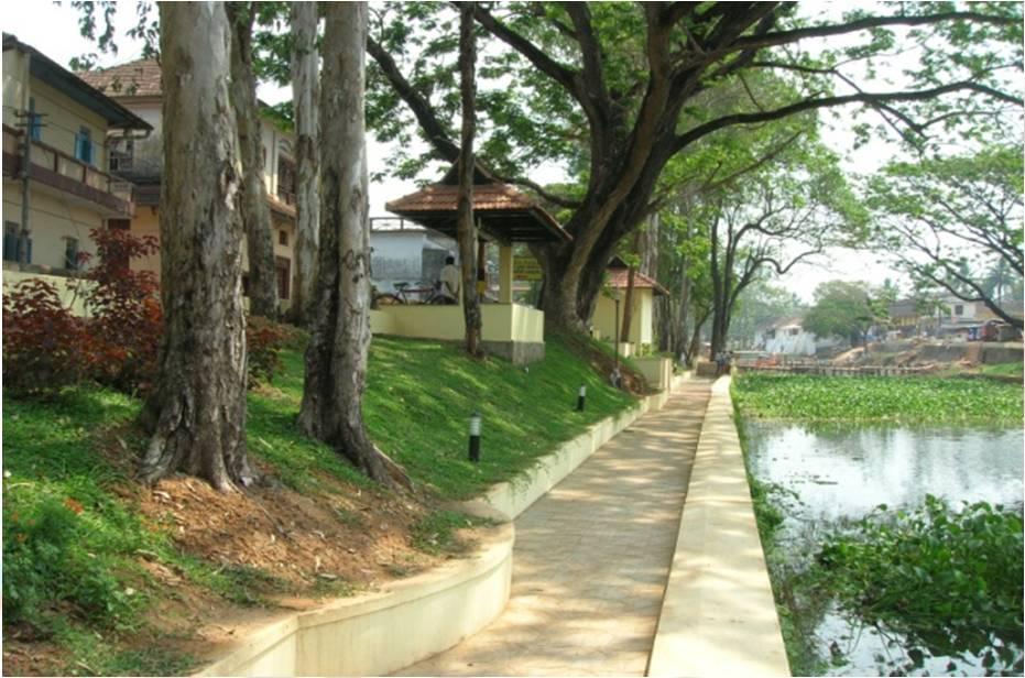
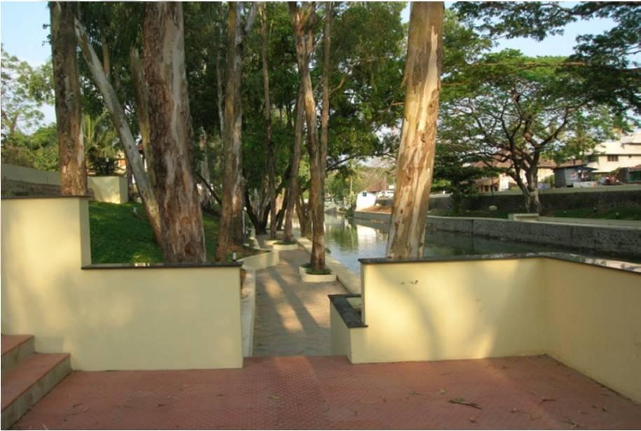
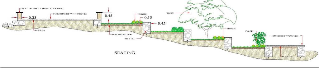
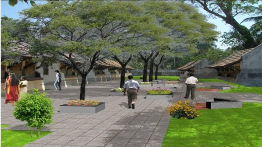
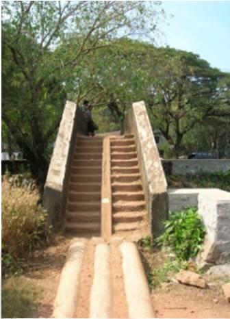
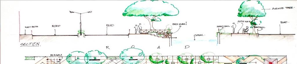
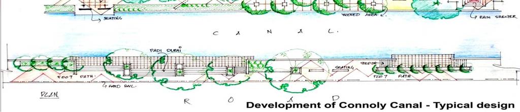
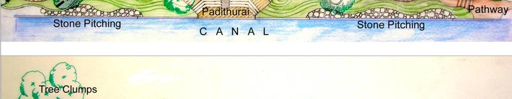
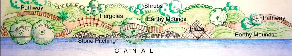
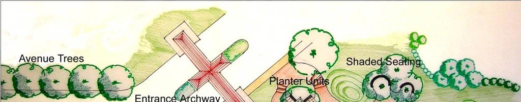
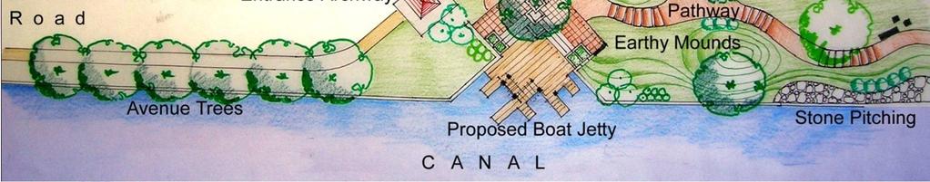
6 The design approach The landscape proposal for the canals of alleppey started not from the drawing board, instead, from the site itself. The canals were desilted & re-connected to the sea to revive the natural flushing of waters due to tidal activity. Sewage & wastes flowing into the canals was curtailed. Banks were stabilized to clearly define the canals. Tracts of land along the water, was identified as possible green recreation zones. These areas varied from 15m to barely a few feet in width. Walking trails were identified at various levels & were evolved in a way so as to retain the existing trees. Steps or padithurais were designed to connect all horizontal planes. Play spaces & other recreational zones were conceived along the stretch. Seatings & view-points were devised as both static & dynamic spaces to enhance the landscape design. A revised lighting scheme was formulated so as to avoid dark spots and thus prevent anti social activities. Vernacular style of architecture was followed in all structures used in the landscape design. Retain existing vegetative cover as much as possible. An urban landscape plan was formulated keeping in mind the street furniture, hoardings, imagery of the site. A suitable maintenanace strategy was also thought of, so as to make the project self sustaining.

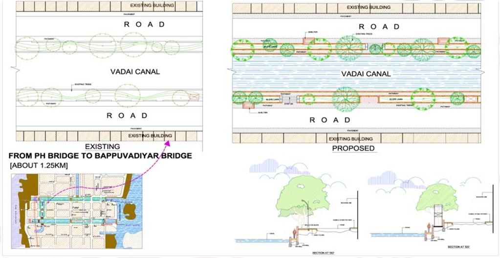
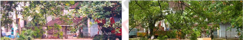
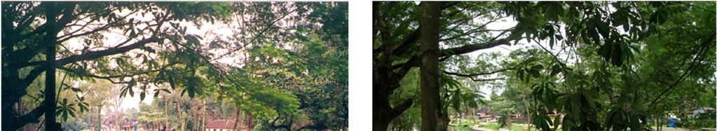
7 Initial schemes.

8

9
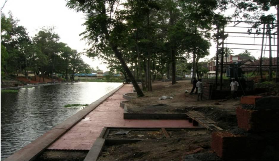
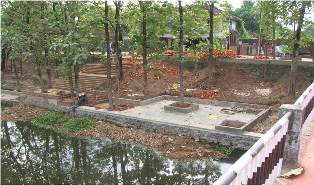
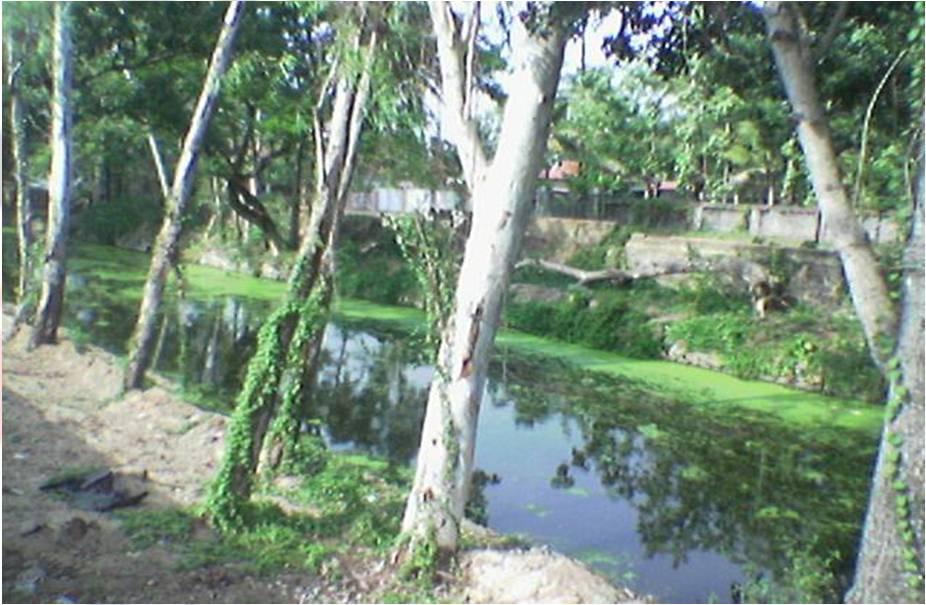
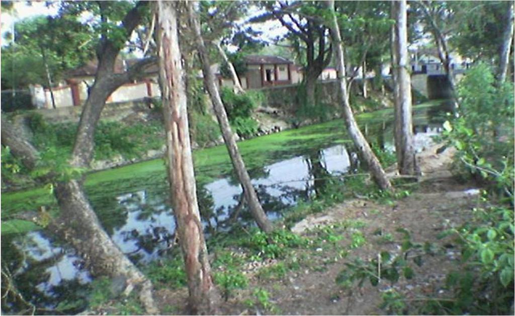
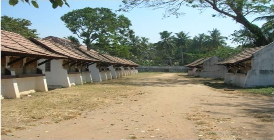
10 The construction phase Alleppey canals now
11

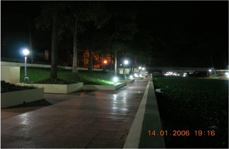
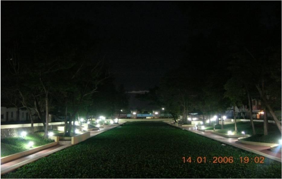
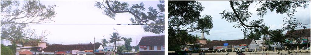
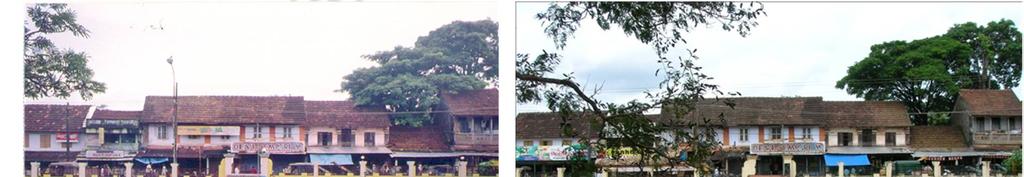
12 Alleppey a visual comparative canals
13


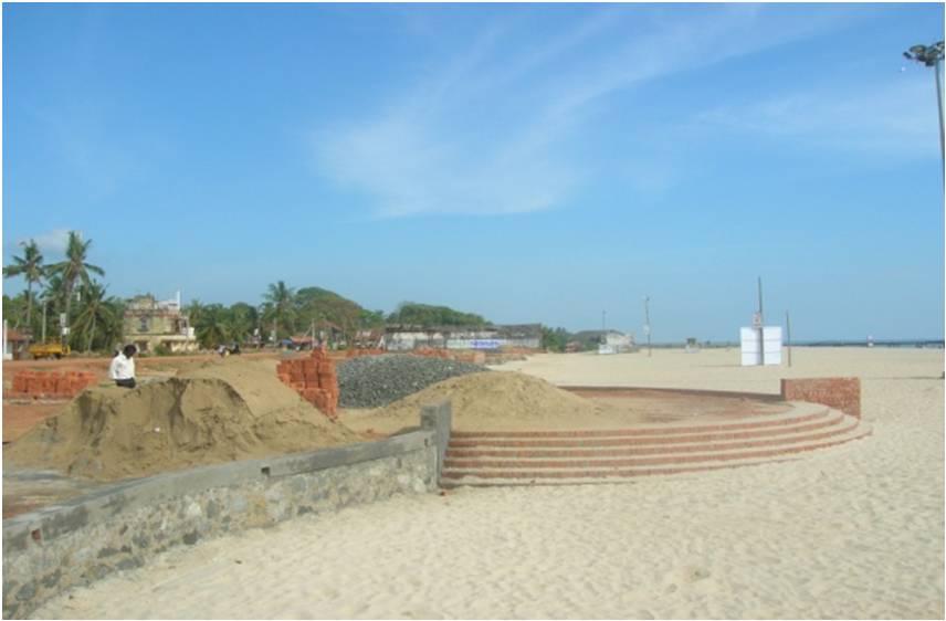
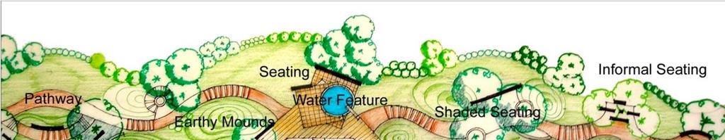
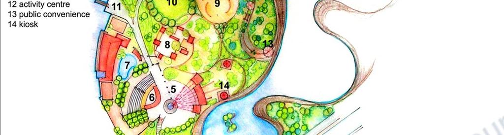
14 Alleppey beach Alleppey has large number of assets of varied nature, the beaches, backwaters, canals and the greeneries. All these characters have raised alleppey as a prime tourist destination area. They are at least fifty meters wide and sandy with rocky promontories and palm trees. These beaches are ideal for swimming so the beach area, which remains isolated and devoid of any development and facilities need to be revived. Quality & character of alleppey beach: Single large open space for the town of alleppey. Was once the port for the district of alleppey. Loading & unloading of goods happened here. Lack of character/ imagery. Design approach:

15 Creation of identity for alleppey. Establish a relevance to exisiting landscape. Creation of seating galleries, paved walkways, pedestrian plazas, etc. Design to accommodate existing proposals of road widening/ expressway. Salient features Meandering walkways have been created to add interest to the walking experience. Planter boxes and green pockets have been introduced. Plant selection to suit coastal areas. Area in front to accommodate future road expansion. The design approach: Creation of a paved walkway along the length of the beach. Creation of seating plazas along the walkway. Creation of multi level user spaces along the beach stretch. Creation of green zones. Introduction of pergolas, seaters, fountains, etc.

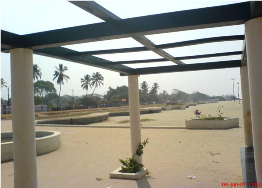
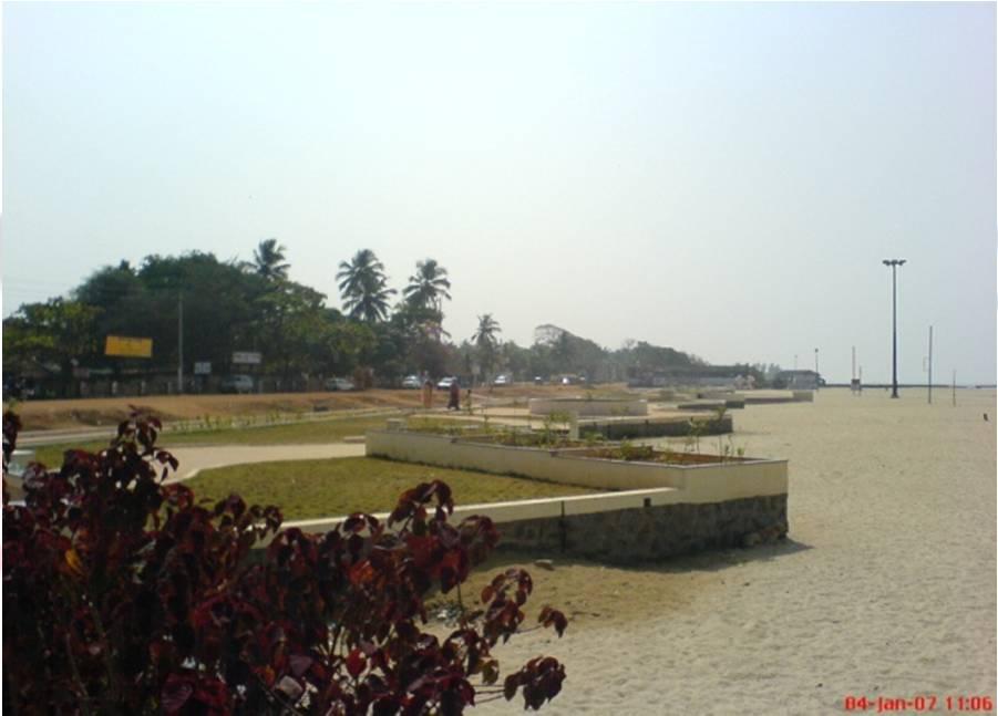
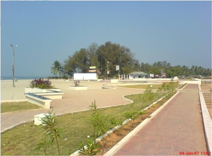
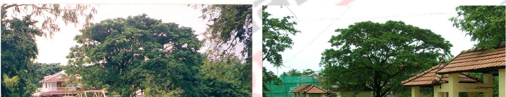
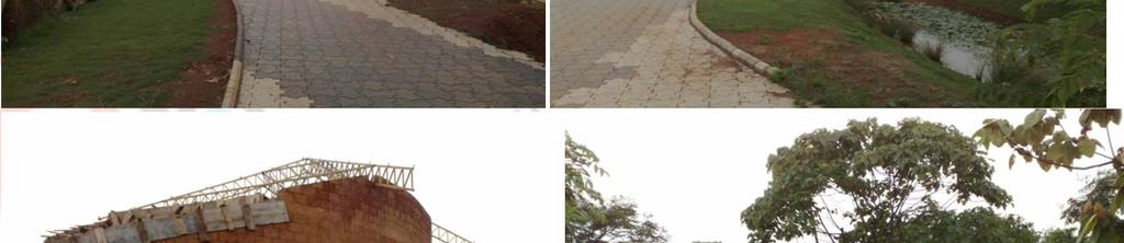
16 Alleppey now


17 Proposed urban landscaping of fort kochi beach A municipal town from 1866 to 1967, fort kochi now is one of the three main urban components that constitute the present day city of kochi in kerala, the other two being mattancherry and ernakulam. The jew town. The jew town is a narrow street between mattancherry palace and the synagogue. Jew town in mattancherry is famous for the antique shops all along its sides. The colonial buildings lining the street add to its oldworld charm. Jew town, a bustling port area and centre of the kochi spice trade. Scores of small firms huddle together in old, dilapidated buildings and aromas of spices. It is about 9 km from ernakulam town.. Earlier mattancherry was the trade link to ernakulam. Main trade was on spices such as pepper and turmeric


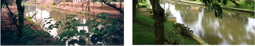
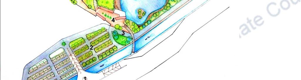
18 Tea is also traded. Mattancherry deteriorated mainly since the porters working at various firms had some unaccounted trouble with the merchants. Mattancherry is also home to the synagogue. The jew town. The landscape proposal for fort kochi comprises the following: Revitalisation of existing walkway. Creation of pedestrian decks or plazas as niodal junctions. Retaining the existing paving pattern and material as heritage paving. Introduction of slope lawns, tree pits and seating areas where possible. Creation of a large open space at southern end for cultural and gathering activities. Facilities planning like provision of information kiosk, poilice kiosk, amphitheatre, seater units, food courts, etc. Landscape layout part 01 at southern end


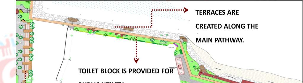
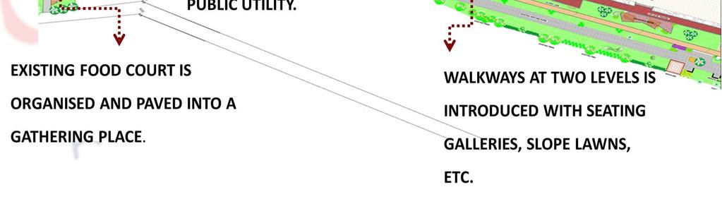
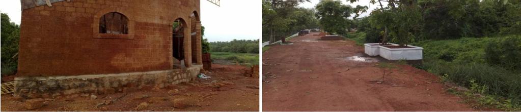
19 Landscape layout part 02 Lanscape layout part 03


20 Landscape layout part 04 Entry into the sandy beach from the parking area Parking bays are provided so as to facilitate better vehicular movement. Slope lawns and retaining walls are suggested on the sea side. Children s play area in park


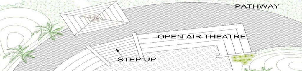
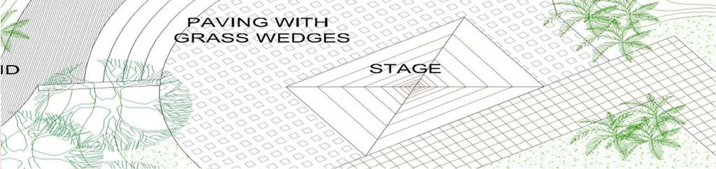
21 Open air theatre in park Stepped lawn area in park


22 Semi permanent structures in the park Pergola plaza with an entrance archway signifying the entry into the park. Section through proposed food court


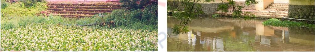
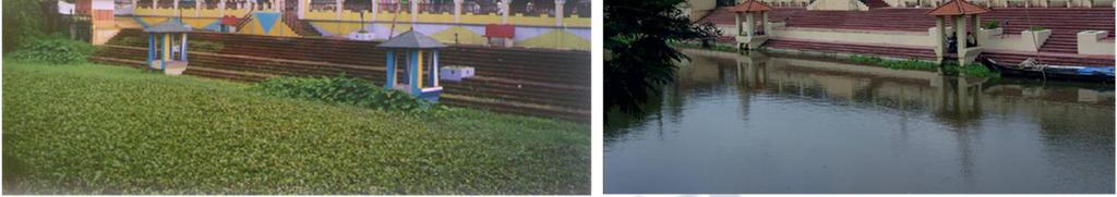
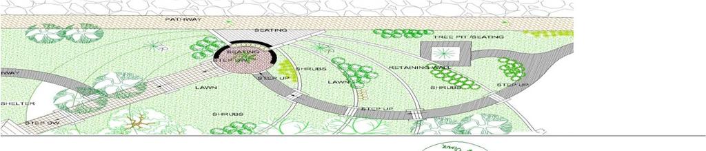
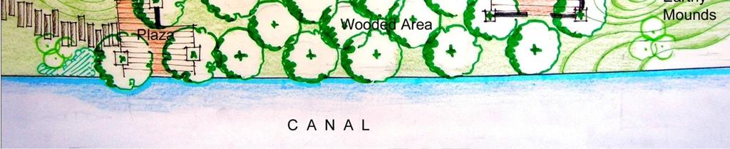
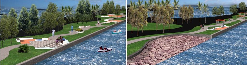
23 Existing walkway Existing food court Sarovaram - wetland development Sarovaram


24 The kottuli wetland of kozhikode is a coastal wetland, and functions on the principles of high tide & low tides of the arabian sea. It is the largest lung space in calicut. Most significant source of groundwater recharge. Rich source of bio-diversty. Home to many species of flora & fauna. Asset to the city that ought to be preserved and maintained for future generations. Bio-diversity conservation does not mean to just preserve. It implies effective use of the resource without reducing its potential to meet future demands. Development should be controlled and regulated so as to ensure constant interaction between the environment & the public. Existing photos.


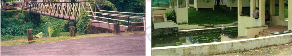
25 Sarovaram Walkway along canal

26

27 In progress


28 Master plan For effective planning strategies, the area is divided into the following zones: Zone i green belt Zone ii canals/ waterway Zone iii active recreation zone Zone iv water sports kalipozhigaiya Zone v existing mangrove/ wooded area/ wetlands. Zone vi bird sanctuary

29
6 PORT SYDNEY SETTLEMENT AREA
 Section 6 Port Sydney Page 61 6 PORT SYDNEY SETTLEMENT AREA 6.1 Basis and Principles Village of Port Sydney Waterfront Community Existing Services 6.1.1 Port Sydney is an historic settlement that has developed
EXISTING VEHICULAR & PEDESTRIAN CIRCULATION
 46 EXISTING CONDITIONS EXISTING VEHICULAR & PEDESTRIAN CIRCULATION Vehicular and pedestrian circulation patterns are illustrated on this graphic. Campus entry points and major vehicular circulation routes
10.0 Open Space and Public Realm
 10.0 Open Space and Public Realm 10.0 Open Space and Public Realm The Public Open Space System is comprised of: outdoor spaces available for public use that are either publicly owned (e.g., parks and
ARCHITECTURAL ALLIANCE LANDSCAPE WINTER
 ARCHITECTURAL ALLIANCE LANDSCAPE WINTER 2015 COMPANY PROFILE Formed in 1991, Architectural Alliance Landscape is a mid-sized firm in business in South Florida for over 24 years. Our goal is to bring new
Welcome! HORSESHOE BAY PARK. Welcome!
 Welcome! HORSESHOE BAY PARK Welcome! Where are we in the process? Today we would like your input on how Horseshoe Bay Park can be upgraded to serve the community s needs better. CONSULT STAKEHOLDERS TAKE
CHONGMING ISLAND SHANGHAI CENTRAL CITY
 Chongming Island CHONGMING ISLAND SHANGHAI CENTRAL CITY Chongming Island Shanghai, China THE VISION: A GREEN ISLAND Chongming Island benefits from a magnificent setting, adjacency to the vibrant center
EXISTING CONDITIONS 41. Existing Conditions
 EXISTING CONDITIONS 41 Existing Conditions The Existing Analysis phase of the planning process involved a study of the existing conditions on the campus in order to identify key planning issues to be addressed
BURTON STATION STRATEGIC GROWTH AREA PLAN UPDATE PUBLIC MEETING 3/26/18
 BURTON STATION STRATEGIC GROWTH AREA PLAN UPDATE PUBLIC MEETING 3/26/18 1 WHERE WE ARE? 2 PRIMARY OBJECTIVES OF THE PLAN UPDATE 1. Update the land use designation for Burton Station Village to reflect
Queensland Coastal Plan. Presented by John Lane Director Environment Planning
 Queensland Coastal Plan Presented by John Lane Director Environment Planning Queensland Coastal Plan - Status Released 7 April 2011, but NOT YET IN EFFECT Formatting & operational amendments required Yet
Master in Architecture. (Services in High Rise Buildings)
") Master in () 1. Details of Module and its Structure Module Detail Subject Name Paper Name - Module Name/Title Water Supply to High Rise Buildings - 1 Objectives To explain the need and the capacity of
Master in () 1. Details of Module and its Structure Module Detail Subject Name Paper Name - Module Name/Title Water Supply to High Rise Buildings - 1 Objectives To explain the need and the capacity of
KHARTOUM GARDEN CITY. Dietmar Kamphans
 KHARTOUM GARDEN CITY Dietmar Kamphans As most cities in the world have been set up at river banks and sea shores, even Khartoum is located at the confluence of the Blue and White Nile. Beside the regular
Overview Report. Proposed Development
 Overview Report Proposed Development the construction of a 1km cycle/pedestrian trail including a new footbridge, new car park and entrance road at Drumshanbo Lock and a new pedestrian/cycle road crossing,
COW BAY DEVELOPMENT LANDS
 PRINCE RUPERT PORT AUTHORITY COW BAY DEVELOPMENT LANDS MARCH 28TH, 2012 % of Completion 0 25 50 75 100 4 guiding principles & OBJECTIVES COMMUNITY FEEDBACK BUSINESS & COW BAY MERCHANT FEEDBACK COMMUNITY
Reconnecting to a Forgotten River St. Cloud MN. Aaron Hanson Design Design Thesis LA 572, Thesis, Spring 2012
 Reconnecting to a Forgotten River St. Cloud MN Aaron Hanson Design Design Thesis LA 572, Thesis, Spring 2012 site context 2.5 Miles Sartell St. Cloud to Fargo 170 Miles (2 hrs 45 mins) Hwy 10 infrastructure
UNIVERSITY TOWN NEIGHBOURHOODS 5.2 ECO-CORRIDOR MELBOURNE CAMPUS MASTER PLAN 2014
 5.2 ECO-CORRIDOR 37 ECO-CORRIDOR EXISTING CONDITIONS & VISION NEIGHBOURHOOD VISION Investment in the Eco-corridor Neighbourhood will signify the University s commitment to supporting local ecology and
Neighborhood Districts
 NEIGHBORHOOD DISTRICTS SEVEN MAIN DISTRICTS Neighborhood Districts While the Development Plan provides a broad-scale overview of the neighborhood, this section focuses on uses and relationships at the
PUBLIC RIGHT-OF-WAY IN THIS CHAPTER PUBLIC REALM
 PUBLIC RIGHT-OF-WAY This section provides design guidelines for improvements in the public right-of-way. The public right-of-way refers to streets, sidewalks, non-vehicular thoroughfares, parks and greenways
Tauranga City Centre Spatial Framework
 Tauranga City Centre Spatial Framework Stakeholder Engagement Workshop 15 October 2015 Project Design Team Beca & LandLAB Our team Henry Crothers (LandLab) Landscape Architect/Urban Designer Urban and
A CONCEPTUAL PROPOSAL BY THE UMDLOTI FORUM Representing the Umdloti Ratepayers and Residents Association and the emdloti UIP
 A CONCEPTUAL PROPOSAL BY THE UMDLOTI FORUM Representing the Umdloti Ratepayers and Residents Association and the emdloti UIP PRESENTATION STRUCTURE 1.0 Overview of Umdloti 2.0 Current challenges in Umdloti
Point Defiance Park. Master Plan Update. April 23 rd 2015
 Point Defiance Park Master Plan Update April 23 rd 2015 Public Participation 1/29, 2/26, 3/26 & 4/23 Tonight s Agenda: Introduction: March Meeting Recap: Overview Feedback Responses Presentation of Master
Norwich (United Kingdom), 9-10 September 2004
, 9-10 September 2004") THE CONGRESS OF LOCAL AND REGIONAL AUTHORITIES Council of Europe F 67075 Strasbourg Cedex Tel : +33 (0)3 88 41 20 00 Fax : +33 (0)3 88 41 27 51/ 37 47 http://www.coe.int/cplre COLLOQUIES, SEMINARS, FORUMS
THE CONGRESS OF LOCAL AND REGIONAL AUTHORITIES Council of Europe F 67075 Strasbourg Cedex Tel : +33 (0)3 88 41 20 00 Fax : +33 (0)3 88 41 27 51/ 37 47 http://www.coe.int/cplre COLLOQUIES, SEMINARS, FORUMS
New Brighton Park Shoreline Habitat Restoration Project
 Vancouver Board of Parks and Recreation and Port Metro Vancouver New Brighton Park Shoreline Habitat Restoration Project Conceptual Design Public Consultation August 26 September 9, 2015 Discussion Paper
WINDSOR GLEN DESIGN GUIDELINES
 WINDSOR GLEN DESIGN GUIDELINES Adopted by Council, 2006 WINDSOR GLEN REDEVELOPMENT DESIGN GUIDELINES August 2006 1.0 Master Plan Organization For this area of the Coquitlam Town Centre, a mix of high,
Granite Belt Arboretum Australia
 The design principles and guidelines of Granite Belt Arboretum Australia are outlined in this document. They encompass environmental, social and economic sensitivities with the prime focus of creating
Washington Plaza at the. Lake Anne Village Center
 Lake Anne Village Center Washington Plaza Design Charrette Washington Plaza at the Lake Anne Village Center Process and Recommendations Presentation to the Reston Association Board of Directors January
Creating an integrated waterfront. Recommendations
 Creating an integrated waterfront Recommendations Railway Square Post Office + Shell Station Post Office Square Civic Square Ilot Green Wakefield St Wakefield St (Tory Cars) Wakefield St (New World Supermarket)
Policies and Code Intent Sections Related to Town Center
 Policies and Code Intent Sections Related to Town Center The Town Center Vision is scattered throughout the Comprehensive Plan, development code and the 1994 Town Center Plan. What follows are sections
represented_by_who title age_bracket first_name last_name organisation position_in_organisation withhold_name address_1 suburb I am making a
 submission_details webform_serial webform_sid webform_time webform_completed_time webform_modified_time webform_draft webform_ip_address webform_uid webform_username 98 27841 03/19/2017-19:06 03/19/2017-19:06
Task Force on Kai Tak Harbourfront Development
 Task Force on Kai Tak Harbourfront Development For discussion on 29 March 2018 TFKT/04/2018 Study of Kai Tak Promenade Design Control and Guidelines Conceptual design scheme for Promenade at Runway Precinct
Port Macquarie Town Centre Landscape Architects
 Port Macquarie Town Centre Town Green Master Plan Review Tract Landscape Architects Urban Designers Town Planners A review of the Town Green Master Plan Port Macquarie, New South Wales Prepared by Tract
W O R K S H O P S U M M A R Y. Community Workshop #1: Visioning September 11th, 2007
 W O R K S H O P S U M M A R Y Community Workshop #1: Visioning September 11th, 2007 Upper Market Community Workshop Series and Design Plan Page 1 of 9 INTRODUCTION The Upper Market Community Workshop Series
Contents of Part 6. Part 6 Zones
 Contents of Part 6 Part 6 Zones... 6-1 6.1 Preliminary... 6-1 6.2 Zone codes... 6-3 6.2.1 Low density residential zone code... 6-3 6.2.1.1 Application... 6-3 6.2.1.2 Purpose and overall outcomes... 6-3
Ringsend & Irishtown Local Environmental Improvement Plan
 Ringsend & Irishtown Local Environmental Improvement Plan Study Area East Link Bridge St. Patrick s Boat Club Ringsend Technical Institute Stella Maris Boat Club St. Patrick s Church Ringsend Library Ringsend
VEHICULAR AND PEDESTRIAN CIRCULATION
 This perspective sketch communicates the intended character and quality of a proposed streetscape design. Locate benches near a major intersection where people tend to gather. Seating and lighting provide
Girdwood Cemetery Girdwood, Alaska
 Miners Pond Shelter Council Circle Woodl Trails Overlooks Committal Shelter Courts Woodl Burial Bridge to Beaver Pond Trail Protected Stream Valleys Columbarium Court Shelter Woodl Trails Woodl Cremation
SUNSET COVE WALKING TRACK PROJECT
 SUNSET COVE WALKING TRACK PROJECT MANAGEMENT PLAN 2013 2015 Prepared by: Paynesville Landcare/Coastcare Group Prepared for: East Gippsland Shire Council (Committee of Management of Crown Land) East Gippsland
The open space system should provide connective elements, relate to natural resources, and enhance the suburban character of the landscape..
 The open space system should provide connective elements, relate to natural resources, and enhance the suburban character of the landscape.. Mixed-use and infill development should maintain or enhance
TASK FORCE MEETING #6 SUMMARY
 TASK FORCE MEETING #6 SUMMARY CITY OF REDWOOD CITY INNER HARBOR SPECIFIC PLAN Tuesday, January 14, 2013 7:00 P.M. 9:30 P.M. Seaport Conference Center, 459 Seaport Court, Redwood City, CA 94063 I. WELCOME
The Vision. Photo provided by The Minervini Group. 46 Vision, Objectives & Strategies
 Vision, Objectives & Strategies The is the public framework and guide for future development of the Grand Traverse Commons. The establishes public polices for infrastructure, the preservation of natural
Mark-up of the effect of the proposed Bronte Village Growth Area OPA No.18 on the text of section 24, Bronte Village, of the Livable Oakville Plan
 Mark-up of the effect of the proposed Bronte Village Growth Area OPA No.18 on the text of section 24, Bronte Village, of the Livable Oakville Plan Notes: This document is provided for information purposes
Route 347. New York State Department of Transportation Region 10, Long Island. THE GREENING of ROUTE 347
 The GREENING of Route 347 The Greening of Route 347 The Greening of Route 347: History 3 The Greening of Route 347 4 The Greening of Route 347 5 The Greening of Route 347 Smith Haven Mall 6 The Greening
GUIDELINES EXHIBITION PLACE LOCATION: OBJECTIVES. Structure Plan URBAN DESIGN GUIDELINES
 Development in the Exhibition Place lands will be consistent with the following urban design guidelines. They provide a framework for new development of the lands and are to be read in conjunction with
Preliminary Sketch Plan for Fort Hunter Park
 Preliminary Sketch Plan for Fort Hunter Park Public Presentation November 19, 2009 Dauphin County Parks and Recreation 100 Fort Hunter Road Harrisburg, PA 17110 (717) 599-5188 www.dauphinc.org THOMAS COMITTA
WA PARKS FOUNDATION SWAN CANNING RIVERPARK
 WA PARKS FOUNDATION SWAN CANNING RIVERPARK Photograph: Giant Egret Large - Matt Kleczkowski SWAN CANNING RIVERPARK - RIVER JOURNEYS PROJECT Bringing Parks to our doorstep With the pace and demands of modern
SALEM FOREST RIVER PARK PRELIMINARY POOL AREA ASSESSMENT & MASTER PLAN STUDY. For the City of Salem
 SALEM PRELIMINARY POOL AREA ASSESSMENT & MASTER PLAN STUDY For the City of Salem 6-13-17 This process undertaken by Weston & Sampson is to outline preliminary ideas only of what possibilities exist for
Four Big Ideas. Three Key Opportunities. Principles. Draft Place Making Master Plan. 1. The Foreshore 2. Green Links. 3.
 project background Four Big Ideas 1. The Healthy Thriving Place. An International Focus 3. Reclaiming Mooloolaba 4. The Resort Heart of the Coast In November 01 a big ideas workshop was held involving
The University of Hong Kong s Centennial Campus: Growth and Sustainability in a City Environment
 The University of Hong Kong s Centennial Campus: Growth and Sustainability in a City Environment Dr. Sarah Liao Senior Advisor to the Vice Chancellor The University of Hong Kong ISCN Symposium Shanghai
Strategies/Actions Priority List
 Strengthening the Creative Sector: Build stronger relationships with, and between, cultural organizations and businesses and increase opportunities for working together to build capacity within organizations.
ELK GROVE TOWN CENTER DESIGN GUIDELINES
 ......... ELK GROVE TOWN CENTER DESIGN GUIDELINES LAGUNA RIDGE SPECIFIC PLAN... June 2008 ............ DESIGN GUIDELINES Table of Contents Contents Section A: Town Center Overview...1 A.1. Purpose and
Chapter 4: Jordan Road Character District
 4: Jordan Road Character District 4.1 Introduction The Jordan Road character district encompasses much of the former Jordan orchard and farmstead, which was a significant part of Sedona s history. The
PRELIMINARY DESIGN + DEVELOPMENT PLAN
 WELCOME! To The Public Open House May 30 th, 2017 HARBOUR WEST PARKS Vision Project Overview The City s vision for Port Credit Harbour West Parks is to develop a vibrant waterfront destination that integrates
Throughout. square. (Crystal City Vision Plan 2050)
") 1: Terms related to the PSMP document 1 public space (see also public realm, civic space) An open space designated on the regulating plan, accessible to all, including Plazas, Mini Parks, and Neighborhoods
1: Terms related to the PSMP document 1 public space (see also public realm, civic space) An open space designated on the regulating plan, accessible to all, including Plazas, Mini Parks, and Neighborhoods
EVALUATION OF MASTER PLAN ALTERNATIVES
 7 The Environmental Report is required to identify, describe and evaluate reasonable alternatives, taking into account the objectives and geographical scope of the Master Plan 2008. Three plan alternatives
B. Blocks, Buildings and Street Networks
 B. Blocks, Buildings and Street Networks Figure IV.4 A rational block pattern with connected streets Introduction The single most important element in the physical and functional integration of mixed use
PART 5 : TEXTURE : PUBLIC DOMAIN CONCEPTS
 ART : TEXTURE : UBLIC DOMAIN CONCETS ENTRANCE TOWN CENTRE MASTERLAN 37 MARINE ARADE 3i 1a 3d 4a 3 6 3e 4b 4 3g 3c 4c 3f 3b 3a 1a 1 2a 2 3h WATERFRONT RECINCT WEST MASTERLAN TUGGERAH LAKE - CHANNEL The
An Integrated Approach for Water Management Examples from The Netherlands. Addressing Climate Change and Sea Level Rise
 An Integrated Approach for Water Management Examples from The Netherlands Addressing Climate Change and Sea Level Rise Superstorm Sandy Forum College of Staten Island March 8 2013 Water: a challenge and
Chapter 5 Urban Design and Public Realm
 5.1 Introduction Public realm is all areas of the urban fabric to which the public have access. It is where physical interaction takes place between people. It therefore, includes buildings and their design,
Name of Action: Arrangement of beach locations on the River Vikhra
 COMUS PROJECT PILOT TOWN: MSCISLAŬ REFERENCE PLAN ACTION N 3.1 Name of Action: Arrangement of beach locations on the River Vikhra Location Image Summary: To develop recreation sites on the beaches of the
PUBLIC REALM STUDY AREA
 WELCOME PUBLIC REALM STUDY AREA WHAT IS PUBLIC REALM? Welcome to the Ballina Town Public Realm public consultation event. Mayo Council is in the process of producing a Public Realm Strategy for Ballina
Streets for All East of England
 Streets for All East of England Summary In 2017 Historic England published an updated national edition of Streets for All, a practical guide for anyone involved in planning and implementing highways and
MISSION STREETSCAPE PLAN. Neighborhood Commercial Streets handle continuous activity. Neighborhood Commercial STREET ROW: Main Design Treatments
 Neighborhood Commercial STREET ROW: 64-80 Main Design Treatments CORNER reduce crossing distance for pedestrians, create entrances to a residential area and slow cars down. help widen sidewalk allocating
Appendix E: Illustrative Green Infrastructure Examples
 Appendix E: Illustrative Green Infrastructure Examples Integrating LID into San Francisco s Urban Landscape Figure E. High-density Residential Figure E. Low-density Residential Figure E. Mixed Use 7 Figure
MASTER PLAN for the EARL NEWHOUSE WATERFRONT
 MASTER PLAN for the EARL NEWHOUSE WATERFRONT on RESERVOIR POND - CANTON, MA Community Meeting #2 - Thursday, January 11 th PROJECT INTRODUCTION Project Goals: To prepare a MASTER PLAN which develops the
Proposed Amendment to the
 Proposed Amendment to the Carrigaline Electoral Area Local Area Plan Amendment No 1: Carrigaline (T-02, O-02 & U-02) August 2012 Proposed Amendment to the Carriagline Electoral Area Local Area Plan 2011
lot flankage Y street 16m 6m landscape strip for large site 3m landscape strip for small medium site
 Commercial General Commercial Objectives Create developments compatible with adjacent land uses in scale, function and character Define a consistent and attractive street edge with quality landscaping,
TABLE OF CONTENTS PAGE
 1989 BROWARD COUNTY LAND USE PLAN Original adoption March 1, 1989 Text amendments adopted as of March 10, 2015, are incorporated herein. BROWARD COUNTY BOARD OF COUNTY COMMISSIONERS BROWARD COUNTY PLANNING
Chelsea Creek Municipal Harbor Plan
 Chelsea Creek Municipal Harbor Plan Public Meeting #1 June 11th, 2018 1 Presentation outline I. Introduction: Why are we doing this plan? II. Evolution of Chelsea Creek III. State of Chelsea Creek IV.
Official Community Plan Bylaw No. 4360, 2004, Amendment Bylaw No. 4897, 2016 (Sewell s Landing)
") District of West Vancouver Official Community Plan Bylaw No. 4360, 2004, Amendment Bylaw No. 4897, 2016 (Sewell s Landing) Effective Date: 1089612v1 District of West Vancouver Official Community Plan Bylaw
District of West Vancouver Official Community Plan Bylaw No. 4360, 2004, Amendment Bylaw No. 4897, 2016 (Sewell s Landing) Effective Date: 1089612v1 District of West Vancouver Official Community Plan Bylaw
Historic Yonge Street HCD Study Public Meeting #2
 Historic Yonge Street HCD Study Public Meeting #2 March 26, 2014 Archaeological Services Inc. Philip Goldsmith Architect Agenda: 7:00 p.m. Open House 7:30 p.m. Welcome and Presentation 8:00 p.m. Questions
4.9 Mendocino Avenue Corridor Plan Design Guidelines
 4.9 Mendocino Avenue Corridor Plan Design Guidelines The Mendocino Avenue Corridor Plan addresses the area between College Avenue and Steele Lane. Mendocino Avenue is a busy arterial that runs parallel
20 & 30 Frank Nighbor Place
 Engineering Land / Site Development Municipal Infrastructure Environmental / Water Resources Traffic / Transportation Structural Recreational Planning Land / Site Development Planning Application Management
Section 4 - Public Realm & Landscape proposals Landscape Masterplan. Section 4 52
 - Public Realm & Landscape proposals Landscape Masterplan 52 Proposed Masterplan - Green Infrastructure Strategy District Park 4.33 Ha to provide Passive and active recreation with a large play area which
Maplewood Avenue Downtown Complete Street Project
 Maplewood Avenue Downtown Complete Street Project Second Public Meeting January 24, 2018 Welcome and Introduction of Project Team City Planning and Public Works Staff City of Portsmouth Juliet Walker Planning
St Andrews House Burnham Market, Norfolk
 St Andrews House Burnham Market, Norfolk An attractive detached 4 bedroom traditional brick and chalk style house located down a private driveway with beautiful open views to the rear and only minutes
PCAL Case Study Open Spaces: Blayney Heritage Park
 PCAL Case Study Open Spaces: Blayney Heritage Park Introduction Blayney Heritage Park is an area of high quality open space that offers a range of active and passive recreation facilities. The multi-purpose
1999 Approval to replace World War I monument and relocate plaques Approval to rehabilitate the Chase Mill building and surrounding site
 Memorandum PLANNING DIVISION DEPARTMENT OF COMMUNITY AND NEIGHBORHOODS To: Historic Landmark Commission From: Katia Pace, Principal Planner Date: October 26, 2016 Re: Liberty Park Improvements The purpose
PART AOTEA PRECINCT
 CONTENTS... PAGE AOTEA PRECINCT...4 14.5.1 INTRODUCTION...4 14.5.2 RESOURCE MANAGEMENT ISSUES...4 14.5.3 RESOURCE MANAGEMENT OBJECTIVES AND POLICIES... 4 14.5.4 RESOURCE MANAGEMENT STRATEGY...5 14.5.5
Background Information
 Background Information view at site entrance THE LONDON BOROUGH OF SUTTON As the strategic local authority the Council is working with a range of partners to take forward various development sites in Hackbridge.
4. Parks, Open Space and Urban Forest
 4. Parks, Open Space and Urban Forest Goals 1. Enhance parks as public gathering places for the neighbourhood 2. Refresh park facilities to attract diverse ages and activities 3. Improve waterfront access
Bourne Downtown Site Planning
 Prepared for: The Town of Bourne, MA In Cooperation with: Bourne Financial Development Corporation Prepared by:, Inc. June 24, 2009 Table of Contents Introduction and Summary... 1 Site Existing Conditions...
RECOMMENDATIONS. Design Recommendations
 RECOMMENDATIONS While the San Diego River Park will serve to unify the river as a whole, each reach of the river park maintains distinct resources and character. Recommendations for each reach have been
Social Screening and Impact Assessment for Sub Projects
 Social Screening and Impact Assessment for Sub Projects Code No: 7 A. Sub Project Description: Rehabilitation of McCallum Lock Gates and Construction of Bank Protection Wall with Linear Walk Around Beira
Conceptual Design. Main Street Enhancement and Extension Project. Bothell, Washington. June 11, 2009
 Conceptual Design Main Street Enhancement and Extension Project Bothell, Washington June 11, 2009 Berger/ABAM Engineers and Cascade Design Collaborative, Inc For Main Street Bothell to succeed it must
Sub-committee on Harbour Plan Review of Harbour-front Enhancement Committee. Ninth Meeting
 Sub-committee on Harbour Plan Review of Harbour-front Enhancement Committee Ninth Meeting Date: 5 October 2005 Time: 3:30pm Venue: Conference Room 15/F, North Point Government Offices, 333 Java Road, North
Town of Cobourg Heritage Master Plan. Statutory Public Meeting
 Town of Cobourg Heritage Master Plan Statutory Public Meeting April 25 th 2016 Presentation Overview 1. Introduction 2. Project background and schedule overview 3. Review of strategic direction content
Ecological Reflection on the Current Development of Mainland
 Ecological Reflection on the Current Development of Mainland China s Urban Waterfront: a Case of Wuhan In the 21st century, urban waterfront construction is a hot issue of mainland China s urban development.
II. SINGLE FAMILY RESIDENTIAL
 II. SINGLE FAMILY RESIDENTIAL Castle Rock is made up of numerous individually built houses and subdivision tracts that have been developed during the past century. Some of the tracts are diverse in architectural
3.1 Existing Land Use
 3.0 Land Use This strategy has been developed taking into account the position of the Town of Sidney as the economic center of the Saanich Peninsula. It acknowledges existing land use patterns in the downtown
8.0 Design and Form of Development 43/
 42/ 8.0 Design and Form of Development 43/ Rothwells Farm, Golborne/ Development Statement Figure 7. Site Constraints Key 44/ Site Boundary 360 Bus Route/Stops Existing Trees Underground Water Pipe Sensitive
Design Considerations
 Essential to the development of a successful Master Plan for the Park Complex is input from the community that the park will serve. The community outreach component of the planning process included numerous
10 Principles for a Sustainable Development of Urban Waterfront Areas
 10 Principles for a Sustainable Development of Urban Waterfront Areas In the context of the initiatives for the Global Conference on the Urban Future (URBAN 21) held in Berlin in July 2000 and in the course
The Planning Partnership Baird + Associates TCI Management Consultants Ltd. Plan B Natural Heritage Wills Consulting Engineers Poulos & Chung Limited
 Little Lake Master Plan The Planning Partnership Baird + Associates TCI Management Consultants Ltd. Plan B Natural Heritage Wills Consulting Engineers Poulos & Chung Limited May 26, 2009 Purpose of Study
North Oakville East Parks Facilities Distribution Plan. November, 2009
 North Oakville East November, 2009 POLICY CONTEXT 1) Purpose a) The purpose of this document is to be a guide for the location, configuration, design and development of the parks system for the North Oakville
6.0 Development of Amenities,
 6.0 Development of Amenities, conservation of architectural heritage and other features This chapter outlines the Area's significant potential to provide for amenities of city wide and local importance
V. Gateways GATEWAYS / V-1
 V. GATEWAYS / V-1 Many of Chesapeake s gateways are located on highways and call for bold and attractive designs that motorists can understand, appreciate, and enjoy. can also take the form of natural
H7 Open Space zones. (a) provide for the needs of the wider community as well as the needs of the community in which they are located;
 provide for the needs of the wider community as well as the needs of the community in which they are located;") H7. Open Space zones H7.1. Background The majority of land zoned as open space is vested in the Council or is owned by the Crown. However some areas zoned open space are privately owned. While the open
H7. Open Space zones H7.1. Background The majority of land zoned as open space is vested in the Council or is owned by the Crown. However some areas zoned open space are privately owned. While the open
Design Specifications & Requirements Manual
 11 PARKS & OPEN SPACES 11.1 DEFINITIONS... 1 11.1.1 Neighbourhood Parks... 1 11.1.2 District Parks... 1 11.1.3. Sport Parks... 1 11.1.4 Urban Parks... 1 11.1.5 Civic Spaces... 1 11.1.6 Open Space System...
APPENDIX K WINDSOR OFFICIAL PLAN
 CEAA ENVIRONMENTAL ENVIRONMENTAL IMPACT ASSESSMENT AMBASSADOR BRIDGE ENHANCEMENT PROJECT Replacement Span and Plaza Expansion APPENDIX K WINDSOR OFFICIAL PLAN Avalon Consulting Professionals of Ontario,
CAMA LAND USE PLAN TOWN OF KITTY HAWK IMPLEMENTATION STATUS REPORT 2013
 Post Office Box 549 101 Veterans Memorial Drive Kitty Hawk, NC 27949 Phone (252) 261-3552 Fax (252) 261-7900 www.townofkittyhawk.org CAMA LAND USE PLAN TOWN OF KITTY HAWK IMPLEMENTATION STATUS REPORT 2013
LAKEVIEW VILLAGE VISION & MASTERPLAN PRESENTATION TO CITY OF MISSISSAUGA. April 9, 2018
 LAKEVIEW VILLAGE VISION & MASTERPLAN PRESENTATION TO CITY OF MISSISSAUGA April 9, 2018 AGENDA Introduction Vision Plan Comparison The Big Moves Trail Connections Plan Overview Districts Conveyance Comparison