Social Screening and Impact Assessment for Sub Projects
|
|
|
- Camron Wright
- 5 years ago
- Views:
Transcription
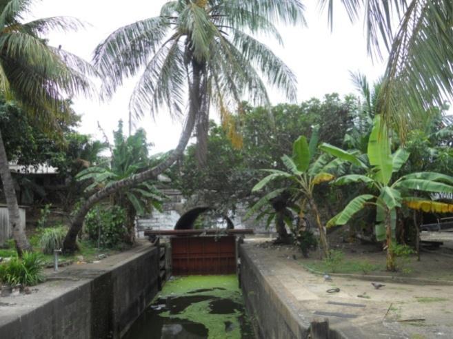
1 Social Screening and Impact Assessment for Sub Projects Code No: 7 A. Sub Project Description: Rehabilitation of McCallum Lock Gates and Construction of Bank Protection Wall with Linear Walk Around Beira Lake The main objective of this area based intervention is the protection of the shoreline of the lake from further deterioration, by constructing bank protection walls along 2.5 km of shoreline on the West and East Beira Lakes, and the preservation of the historic McCallum Lock Gates. The project aims at complementing the flood reduction measures being taken through Component 1, while providing opportunities for urban regeneration along the East and West Beira lake waterfronts with public access to the lake along a linear path/promenade with an average width of six meters to be constructed, once the lake shoreline has been stabilized. Currently, the lake is not accessible to the public due to inadequate bank protection and multiple uses along the shoreline. Once bank protection walls are constructed, a linear pedestrian path/promenade can be added on top of the protection walls, that will provide a natural connection of the East and West Beira Lake waterfronts with the already constructed walkways that connect to the South West Beira lake waterfront. This will provide a contiguous recreation space within the core area of the city that has potential for private sector investment. A phased approach will be adopted for this component, whereby the first phase which has been divided into two sections will focus on stabilization of lake shoreline and preservation of the McCallum lock gates. The second phase, will focus on the construction of the four kilometre linear path/promenade and nodal park along with foot bridges. To this end, a series of targeted interventions will be carried out under the project aimed at supporting these key objectives, as described in the following sections. This Social Screening focuses on the Phase 1, Sections 1 and 2, described as follows:
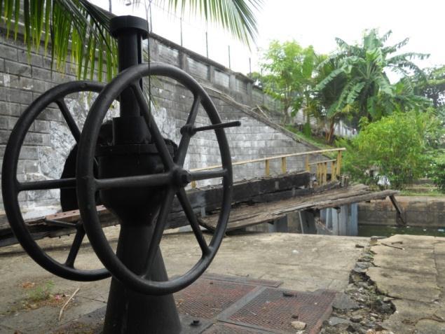
2 Phase 1 Section 1: Construction of Bank Protection Wall This sub-component will support the construction of gabion walls to stabilize the East and West Beira Lake shorelines that currently has no bank protection. Gabion walls will be constructed along a 1.5 km stretch of the West Beira Lake commencing from the Northern bank to the Western bank of the West lake. Gabion walls will be constructed on the East lake along a 1 km stretch of shoreline, commencing from the Air force fire department premises to the Hyde Park Corner. Therefore, a total of 2.5 km of lake shoreline will be strengthened. Specific interventions will comprise: (1) gabion wall construction, (2) railings at banks for safety. Phase 1 - Section 2: Preservation of the McCallum Lock Gates This sub-component will focus on the restoration and preservation of the McCallum Lock Gates, which has a historic value and will add to the cultural landscape of the city. Interventions will comprise of: (1) Restoration of lock gates, (2) refurbishment of old buildings of historic value, (3) hard and soft landscaping of area, (4) construction of underpass and footbridges to create access to site, (5) provision of street furniture, lighting and railings for safety of public, and (6) construction of sanitation and other facilities. These interventions are aimed at restoring the area to achieve an overall visual improvement and create public access to the lock gates.
3

4 B. Justification of project design and alternative analysis: The bank protection wall which will commence from the end of the Air Force fire department premises and continued up to Hyde Park corner, the other part of the protection wall will start from the Galle face end of the west lake and continued up to elephant house junction. Total length is 2.5 km. Designs,BOQs, specifications and construction supervision will be done with the consultation of Sri Lanka Land Reclamation & Development Corporation (SLLR & DC) which is the prime estate agency on similar works. Package II of the stage I, the McCollum Lock gates which is located in between Colombo International Sea Port and the East Beira Lake will be rehabilitated and the area will be landscaped and opened for public use. The key activities in stage I of the Package - I will be construction of gabions and rubble retaining wal at banks. In package II of stage 1 will be restoration of lock gates, refurbishment of old buildings, creating access to the site, paving and landscaping, under pass and foot bridge, illumination, street furniture and railings at banks. The sub project will make all necessary precautions to protect the lake banks and improve the quality of water of the lake. It is of prime importance to safeguard this water body which is located in the central part of the city.
5 C. Corridor of Impact: It will enhance the green image to the city and create a healthy breathing space instead of abandon background to many resident communities. It also will generate temporary business opportunities for people and the cliental will be the students, general public, local tourist and foreigners. In addition the indirect benefits will be the increase of land values of the area, designed built fabric instead of ad-hoc development and finally restoration of higher bio diversity of the area. This sub project will disconnect all sewer lines and polluting pipes to the lake and water quality will be improved.
6 D. Social Impact Screening Questions Probable Involuntary Resettlement Effects Yes No 1 Will the sub project include any physical construction work? 2 Does the sub project include upgrading or rehabilitation of existing physical facilities? 3 Is the sub project likely to cause partially or fully damage to, or loss of housing, shops, or other resource use? 4 Is the site for chosen for this work free from encumbrances and is in possession of the implementing agency? 5 If any land required for the work is privately owned, will this be purchased or obtained through voluntary donation? 6 If the Land parcel has to be acquired, is the actual plot size and ownership status known? 7 Is land for material mobilization or transport for the civil work available within the identified work site / Right of way? 8 Are there any non titled people (Squatters) who are living/ or doing business who may be partially or fully affected because of the civil works? 9 Will there be damage to agricultural lands, standing crops, trees? N.A. 10 Will there be any permanent or temporary loss of income and livelihoods as a result of the civil works? If so for what period? Not Known Details Gabion and rubble wall, paving, foot bridges Restoration and rehabilitation of functionality of Macculum lock gate No demolition or relocation, since the construction of gabions will be carried out along the embankments of the lake, with easy access from the water and from Government propserties. the project area is totally free from encumbrances and state owned lands. The project will be implemented along the shores and within the limits of the McCollum Gates. Does not arise as acquisition is not involved Public main roads will be used to transport materials. From public road, barges will be used to bring materials interior areas of the lake. The works will only be carried out on the edge of the embankments of the lake. No, badges will work from the water side 11 Have these people/ business who may suffer temporary loss of Does not arise, see above.
7 Probable Involuntary Resettlement Effects Yes No incomes or livelihoods been surveyed and identified for payment of any financial assistance? 12 Will people permanently or temporarily lose access to facilities, services, or natural resources? Not Known 13 Will there be any other temporary impacts? please describe As above 14 Have measures been planned to mitigate temporary impacts including ease of access? Give details 15 Does the urban local body have its own procedures for land acquisition? 16 Are any indigenous people affected? 17 Whether the affected land/structure owners likely to lose less than 10% of their land/structures area? 18 If so, are theses land/structure owners willing to voluntarily donate the required land for this sub- project? 19 Will there be any impacts on cultural, community properties or facilities? What mitigation measures will be taken? Details At the moment these lake shores are not accessible and/or usable, so none is using them along the project area. Not need The McCollum gate will be restored with minimal interventions of maintenance and the gates will be restored to their original functionality.
8 E. Estimates of Specific Impacts Components of the Sub Project Private land required in sq,mts. No of land owners losing more than 10% of land area Government land required in Sq,mts Forest land required in Sq mts No of houses affected No of shops affected No of other structures affected No of squatters affected Public utilities affected Lake bank protection Not applicable None None None None None None None None Rehabilitation of Lock gates Not applicable None None None None None None None None
9 F. Information on Affected persons Any estimate of the likely number of households that will be affected by the sub project? [ ] No. * + Yes. If yes, approximately how many?. None No. of HHs losing <10% of their productive assets (land/cowshed/shops/economic units) None No. of HHs losing 10% or more of their productive assets?... None Are any of them poor, female-headed households, or vulnerable to poverty risks? [ ] No. [ ] Yes. If yes, please briefly describe their situation with estimate numbers of HHs? G. Decision on categorization After reviewing the answers above, it is determined that the stage I of he sub project is categorized as an C project. H. Measures to minimize resettlement and mitigate impacts Identified scoters settlement is to relocate living with minimum facilities and they have not even proper means of access. Poor healthy situation. Therefore, they will be provided permanent housing units from the houses which are under construction by Resettlement of Underserved Settlements (RUS) project of the UDA. S N. Nature of Impact Mitigation Measures Implementation Arrangements 1. Transport of building materials along main roads could contribute to temporary increase traffic congestion along Wijewata Mawatha The transport of materials will be avoided during pick hours during the week. The Environmental Managemetn Plan will spell out mitigation measures as part of contract management and th supervision engineer from UDA and SLLRDC will monitor appropriate implementation of the EMP. Traffic Police will also provide support to improve traffic management in the are during works. I. Explanation of impacts and mitigation measures proposed Packaged I Construction of Bank Protection Wall will not be affected to private properties. It will not disturb to any family relocations. Only impact on traffic movement will be mitigated with the participation of Police Traffic Department.
10 Package II Rehabilitation of Macculum lock gated has no big impact for the public. The site is owned by Sri Lanka Ports Authority and SLPA is in agreement to implement the project. At moment, this area is free from public entry. No heavy construction involvement. To summarize, this sub-project will not generate any social impact beyond some basic one related to the safe management of the building site. These will be mitigated through the enforcement of the Environmental Management Plan that will be integral part of the construction contract.
IND: MFF - North Karnataka Urban Sector Investment Program - Tranche 2
 Resettlement Planning Document Project Number: 38254-043 January 2016 IND: MFF - North Karnataka Urban Sector Investment Program - Tranche 2 Subproject: Yadgir 02FES03 Submitted by Karnataka Urban Infrastructure
Vietnam Scaling up Urban Upgrading Project (SUUP)
") 1. Introduction Vietnam Scaling up Urban Upgrading Project (SUUP) Terms of Reference (TOR) Technical Advisory Services on Universally Accessible Infrastructure Design September 2018 The project is part
1. Introduction Vietnam Scaling up Urban Upgrading Project (SUUP) Terms of Reference (TOR) Technical Advisory Services on Universally Accessible Infrastructure Design September 2018 The project is part
6 Sub-Sector Strategies
 6 Sub-Sector Strategies 6.1 In accordance with the proposed goals and objectives for the Study Area until 2027, the sub-sector strategies have been itemized for fulfilling the requirements of the proposed
I-494 Rehabilitation Project SP (I-394 to Fish Lake Interchange) June 2014 Section 4(f) De Minimis Determination
 June 2014 Section 4(f) De Minimis Determination") I-494 Rehabilitation Project SP 2785-330 (I-394 to Fish Lake Interchange) June 2014 Section 4(f) De Minimis Determination State Project Number 2785-330 Federal Project No. NHPP-I494 (002) Trunk Highway:
I-494 Rehabilitation Project SP 2785-330 (I-394 to Fish Lake Interchange) June 2014 Section 4(f) De Minimis Determination State Project Number 2785-330 Federal Project No. NHPP-I494 (002) Trunk Highway:
INTEGRATED SAFEGUARDS DATA SHEET CONCEPT STAGE
 Public Disclosure Authorized Public Disclosure Authorized Public Disclosure Authorized Public Disclosure Authorized INTEGRATED SAFEGUARDS DATA SHEET CONCEPT STAGE Date ISDS Prepared/Updated: 28-Jan-2014
PROJECT INFORMATION DOCUMENT (PID) CONCEPT STAGE
 CONCEPT STAGE") Public Disclosure Authorized Public Disclosure Authorized Public Disclosure Authorized Public Disclosure Authorized PROJECT INFORMATION DOCUMENT (PID) CONCEPT STAGE Report No.: PIDC2498 Project Name EC
Public Disclosure Authorized Public Disclosure Authorized Public Disclosure Authorized Public Disclosure Authorized PROJECT INFORMATION DOCUMENT (PID) CONCEPT STAGE Report No.: PIDC2498 Project Name EC
Public Participation in Urban Planning Case of Lilongwe, Malawi
 Lilongwe City Council Public Participation in Urban Planning Case of Lilongwe, Malawi PRESENTED AT THE LILONGWE INTERNATIONAL MAYORS FORUM(LIMF). 16 TH TO 18 TH May, 2018. Dr. Desmond W. Bikoko, Ph.D LILONGWE
Making the case for Sustainable Transport Project Potential
 Making the case for Sustainable Transport Project Potential The Structural Investment Fund (SIF) Strategy for Greater Lincolnshire identifies the barriers to growth identified by having poor transport
Mississauga Waterfront. Parks Strategy - Draft
 Potential configuration for river s edge seating. Boating on Credit River: A regatta Boating on Credit River: Active enjoyment 5.2 Port Credit Memorial Park West Priority Park 5.2.1 Site Opportunities
Central Lake Ontario Conservation Conservation Lands Master Plan
 Conservation Lands Master Plan Top 13 Frequently Asked Questions 1. What are conservation lands? Where are these conservation lands located in the Central Lake Ontario Conservation watershed? Conservation
Overview Report. Proposed Development
 Overview Report Proposed Development the construction of a 1km cycle/pedestrian trail including a new footbridge, new car park and entrance road at Drumshanbo Lock and a new pedestrian/cycle road crossing,
Concord Community Reuse Project Goals and Guiding Principles. Overarching Goals (OG)
") Concord Community Reuse Project Goals and Guiding Principles Overarching Goals (OG) No priority is implied by the order of presentation of the goals and guiding principles. Overarching goals for the Concord
Concord Community Reuse Project Goals and Guiding Principles Overarching Goals (OG) No priority is implied by the order of presentation of the goals and guiding principles. Overarching goals for the Concord
Creating the Enabling Environment in. The Walled City of Lahore
 Creating the Enabling Environment in the Walled City of Lahore Supporting Historic Cities, Cultural Heritage, and Sustainable Tourism Urban Forum 2012 Shahnaz Arshad The Walled City of Lahore Traditional
Public Open House. Overview of the Downtown Plan Official Plan Amendment April 23, 2018
 Public Open House Overview of the Downtown Plan Official Plan Amendment April 23, 2018 1 A 25-Year Plan for Downtown To ensure growth contributes positively to Toronto s Downtown as a great place to live,
INTEGRATED SAFEGUARDS DATA SHEET CONCEPT STAGE
 INTEGRATED SAFEGUARDS DATA SHEET CONCEPT STAGE Date ISDS Prepared/Updated: 15-Jul-2015 Report No.: ISDSCIO64 Date ISDS Approved/Disclosed: 20-Jul-2015 I. BASIC INFORMATION A. Basic Project Data Country:
Social Monitoring Report
 Social Monitoring Report Due Diligence Report Four Bridges Improvement Project Ganja Region, Roads: R24 and Y-05-08 Involuntary September 2013 Azerbaijan: Road Network Development Program Tranche 4 Prepared
Sri Lanka Strategic Cities Development Project-Additional Financing (P157427) Environment Management Framework
 Environment Management Framework") Public Disclosure Authorized Executive Summary-Environmental Assessment & Management Framework - SCDP Sri Lanka Strategic Cities Development Project-Additional Financing (P157427) Environment Management
Public Disclosure Authorized Executive Summary-Environmental Assessment & Management Framework - SCDP Sri Lanka Strategic Cities Development Project-Additional Financing (P157427) Environment Management
STATEMENT OF OBJECTION TO THE PROPOSED DEVELOPMENT OF LAND AT CHURCH CLIFF DRIVE FILEY
 STATEMENT OF OBJECTION TO THE PROPOSED DEVELOPMENT OF LAND AT CHURCH CLIFF DRIVE FILEY You will be aware that Scarborough borough council have adopted a new local plan that includes land at Church Cliff
Right-of-Way Acquisitions and Relocations Technical Memorandum
 Right-of-Way Acquisitions and Relocations Technical Memorandum Southeast Extension Project Lincoln Station to RidgeGate Parkway Prepared for: Federal Transit Administration Prepared by: Denver Regional
Orcasur Market. Madrid Plaza del Pueblo-Avenida de Orcasur
 Orcasur Market. Madrid Plaza del Pueblo-Avenida de Orcasur The proposed site is a local market located on a plot of 1,880 m2 in the Orcasur neighbourhood, in the Usera district. Situated in the south of
C. Westerly Creek Village & The Montview Corridor
 C. Westerly Creek Village & The VISION Community Vision When the goals of the city are achieved Westerly Creek Village, a distinctive community defined by Montview Boulevard and Westerly Creek, is a strong
LEADERS IN URBAN TRANSPORT PLANNING. Ahmedabad Urban Development Authority
 LEADERS IN URBAN TRANSPORT PLANNING Ahmedabad Urban Development Authority Regional Context Gandhinagar Twin City 4 Growth centers and Satellite Towns Sanand SIR, Changodar SIR Dholera SIR, SEZs 2 What
MAIN STREET ECONOMIC DEVELOPMENT STRATEGY
 MAIN STREET ECONOMIC DEVELOPMENT STRATEGY A PATHWAY TO A BETTER POUGHKEEPSIE DRAFT Working Paper #2: Planning Strategies Submitted December 1 st, 2015 to the City of Poughkeepsie LAND USE LAW CENTER PACE
Preparing for Urban Expansion in Ecuadorian Intermediate Cities. Alexandra Ortiz (based on work by consultants Vitor Serra and Shlomo Angel)
") Preparing for Urban Expansion in Ecuadorian Intermediate Cities Alexandra Ortiz (based on work by consultants Vitor Serra and Shlomo Angel) Washington DC, March 21 2006 Outline 1. Project concept/components
Preparing for Urban Expansion in Ecuadorian Intermediate Cities Alexandra Ortiz (based on work by consultants Vitor Serra and Shlomo Angel) Washington DC, March 21 2006 Outline 1. Project concept/components
Sub-committee on Harbour Plan Review of Harbour-front Enhancement Committee. Ninth Meeting
 Sub-committee on Harbour Plan Review of Harbour-front Enhancement Committee Ninth Meeting Date: 5 October 2005 Time: 3:30pm Venue: Conference Room 15/F, North Point Government Offices, 333 Java Road, North
Pedestrian and Cycle Bridge Feasibility Study Report Summary
 Pedestrian and Cycle Bridge Feasibility Study Report Summary For London Borough of Richmond July 2018 OBJECTIVES The primary objective of introducing a new bridge across the Thames in Richmond is to improve
Chapter 27 Route Window SE7 Church Manorway Bridge. Transport for London
 Chapter 27 Route Window SE7 Church Manorway Bridge Transport for London CHURCH MANORWAY BRIDGE 27 Route Window SE7 Church Manorway bridge Introduction 27.1 The North Kent Line will be converted to four
BAGBY STREET RECONSTRUCTION PROJECT OCTOBER 2, 2015
 BAGBY STREET RECONSTRUCTION PROJECT OCTOBER 2, 2015 CLAIRE HEMPEL, PLA, AICP, LEED GA PREPARED BY Aspen Asheville Austin Chicago Denver Dubai Houston Lake Tahoe Los Angeles MIDTOWN : A MODEL OF URBAN DEVELOPMENT
10.0 Open Space and Public Realm
 10.0 Open Space and Public Realm 10.0 Open Space and Public Realm The Public Open Space System is comprised of: outdoor spaces available for public use that are either publicly owned (e.g., parks and
North Somerset Council Local Development Framework
 North Somerset Council Local Development Framework Sites and Policies Development Plan Document Evidence Paper Re-opening Portishead Railway Line and Options for the Location of Portishead Railway Station
APPENDIX K WINDSOR OFFICIAL PLAN
 CEAA ENVIRONMENTAL ENVIRONMENTAL IMPACT ASSESSMENT AMBASSADOR BRIDGE ENHANCEMENT PROJECT Replacement Span and Plaza Expansion APPENDIX K WINDSOR OFFICIAL PLAN Avalon Consulting Professionals of Ontario,
THE CORPORATION OF THE TOWN OF OAKVILLE BY-LAW NUMBER
 THE CORPORATION OF THE TOWN OF OAKVILLE BY-LAW NUMBER 20012-08530 A by-law to adopt an amendment to the Official Plan of the Oakville Planning Area (Official Plan Amendment 198) Land North of Dundas Street.
Energy Efficient Strategies for Urban Transportation Planning
 EinT2018 3 rd International Conference ENERGY in TRANSPORTATION 2018 Energy Efficient Strategies for Urban Transportation Planning Prof. Dr. Doaa M. El-Sherif, PhD, Arch. Email: doaa_elsherif@yahoo.com
Chapter 7 Route window W20 Dover Road and Leigh Road bridges. Transport for London
 Chapter 7 Route window W20 Dover Road and Leigh Road bridges Transport for London ROUTE WINDOW W20 7 Route window W20 Dover Road and Leigh Road bridges Transport for London 7.6 7.7 7.8 Baseline conditions
CORNUBIA RETAIL PARK- PLANNING REPORT REVERT 3
 CORNUBIA RETAIL PARK- PLANNING REPORT 19.04.2013 REVERT 3 1 FOR: BY: 28 DEVONSHIRE AVENUE GLENWOOD DURBAN 4001 P.O. BOX 17390 CONGELLA 4013 T +27 31 202 9550 F +27 31 202 9551 1st FLOOR THE MEDIA MILL
WELCOME! 8 8:30 6: TH STREET IMPROVEMENTS. Open House. Presentation & Q&A
 WELCOME! 168 TH STREET IMPROVEMENTS 6:30 Open House 7 8 Presentation & Q&A 8 8:30 Open House WELCOME Todd Pfitzer City of Omaha Engineer Bob Stubbe City of Omaha Public Works Director Jon Meyer Project
GUIDELINES FOR ENVIRONMENTAL SCREENING OF ROAD PROJECTS
 GUIDELINES FOR ENVIRONMENTAL SCREENING OF ROAD PROJECTS April, 1997 Juan Quintero The World Bank Latin America and Caribbean Region Type of Projects Much of the confusion as to the project environmental
SOUTH CAMBRIDGESHIRE DISTRICT COUNCIL. Planning and New Communities Director
 SOUTH CAMBRIDGESHIRE DISTRICT COUNCIL REPORT TO: Planning Committee 9 January 2013 AUTHOR/S: Planning and New Communities Director S/2270/12/FL FEN DRAYTON 850m long flood defence embankment ranging in
6 PORT SYDNEY SETTLEMENT AREA
 Section 6 Port Sydney Page 61 6 PORT SYDNEY SETTLEMENT AREA 6.1 Basis and Principles Village of Port Sydney Waterfront Community Existing Services 6.1.1 Port Sydney is an historic settlement that has developed
Midtown Greenway Land Use and Development Plan Executive Summary
 Midtown Greenway Land Use and Development Plan Executive Summary Introduction The Midtown Greenway Land Use and Development Plan sets policy direction for land use and development in the Midtown Greenway
Official Plan Review
 Official Plan Review Summary Report - The Built Environment August 2014 Part 1: Introduction Planning for a healthy, prosperous and sustainable community is an important goal for our municipality. From
UCL PRINCIPAL CONTRACTOR SITE FIRE SAFETY RISK REVIEW & MITIGATION MEASURES
 Mandatory Fire Safety Instruction UCL PRINCIPAL CONTRACTOR SITE FIRE SAFETY RISK REVIEW & MITIGATION MEASURES Principal Contractor fire safety considerations in shared occupancy project or refurbishments
Pennsy Greenway Trail
 Town of Schererville Pennsy Greenway Trail DES. #s: 0401062, 1173595 & 1382661 Construction of Pennsy Greenway Trail beginning at Wilhelm Street and continuing northwest along the former Penn Central railroad
5 PLANNING ANALYSIS 5.1 THE SITE AND ITS DEVELOPMENT CONTEXT
 5 PLANNING ANALYSIS 5.1 THE SITE AND ITS DEVELOPMENT CONTEXT The Azuri IRS River Villa Complex site is situated on the western margin of Azuri Phase 1, inland. The whole site borders Rivière du Rempart
3.9 Systems Interrelationships
 191 Sustainability Building Blocks: The Comprehensive Plan Systems Community Form Economy Social Transportation Natural Resources Housing and Neighborhoods Utilities and Infrastructure Institutions.9 Systems
Street Flooding Mitigation Plan KYOVA Interstate Planning Commission. Presented to AMPO National Conference October 18, 2017
 Street Flooding Mitigation Plan KYOVA Interstate Planning Commission Presented to AMPO National Conference October 18, 2017 Saleem Salameh, Ph.D., P.E., M.ASCE Chet Parsons, AICP CTP Agenda: Background
4- PA - LD - LIVELY DOWNTOWN. LD - Background
 4- PA - LD - LIVELY DOWNTOWN LD - Background The downtown has been the service centre for the community since the city s inception and the area continues to supply people with their personal services,
Chapter 5 Urban Design and Public Realm
 5.1 Introduction Public realm is all areas of the urban fabric to which the public have access. It is where physical interaction takes place between people. It therefore, includes buildings and their design,
DRAFT SECTION 4(F) EVALUATION STILLWATER MUNICIPAL BARGE FACILITY
 EVALUATION STILLWATER MUNICIPAL BARGE FACILITY") DRAFT SECTION 4(F) EVALUATION I. DESCRIPTION OF SECTION 4(F) RESOURCE The Section 4(f) resource discussed in this evaluation is known as the Stillwater Municipal Barge Facility property, known previously
DRAFT SECTION 4(F) EVALUATION I. DESCRIPTION OF SECTION 4(F) RESOURCE The Section 4(f) resource discussed in this evaluation is known as the Stillwater Municipal Barge Facility property, known previously
HOUSING ELEMENT GOALS, OBJECTIVES, AND POLICIES
 HOUSING ELEMENT GOALS, OBJECTIVES, AND POLICIES Goal 6 Maintain and enhance the supply of decent, safe, energy efficient and affordable housing and maximize viable options and opportunities for present
Case Study of Integrated Housing and Railway Development (Kohoku New Town and Yokohama City Metro Development)
") Case Study of Integrated Housing and Railway Development (Kohoku New Town and Yokohama City Metro Development) Project Division, Urban Development Bureau and Development Cooperation Division, International
Case Study of Integrated Housing and Railway Development (Kohoku New Town and Yokohama City Metro Development) Project Division, Urban Development Bureau and Development Cooperation Division, International
Table L-1 Summary Action Strategy. Action Item Timing Status Responsible Agency
 CHAPTER 4: CIRCULATION ELEMENT ISSUE #1: MAJOR THOROUFARES AND TRANSPORTATION ROUTES A balanced transportation system for Fontana is provided that meets the mobility needs of current and future residents
The Illinois Department of Transportation and Lake County Division of Transportation. Route 173, including the Millburn Bypass
 The Illinois Department of Transportation and Lake County Division of Transportation welcome you to this Public Hearing for U.S. Route 45 from Illinois Route 132 to Illinois Route 173, including the Millburn
Public realm strategy
 Mayor of London 71 new pedestrian bridge across the river strategic green links to the river Chapter 7 Public realm strategy new linear park improved road environment improved river walk indicative masterplan
Baselands Trails Master Plan Public Meeting. April 28, 2015 Fire Academy, 895 Eastern Avenue, Toronto 6:30 p.m. to 9:00 p.m.
 Baselands Trails Master Plan Public Meeting April 28, 2015 Fire Academy, 895 Eastern Avenue, Toronto 6:30 p.m. to 9:00 p.m. Baselands Trails Master Plan Meeting Purpose To present and get feedback on:
TOWN OF AURORA ARCHITECTURAL SALVAGE PROGRAM GUIDE
 PLANNING AND DEVELOPMENT SERVICES Development Planning Division Heritage Planning Section Phone: 905-727-3123 ext. 4226 Fax: 905-726-4736 Email: planning@aurora.ca Town of Aurora 100 John West Way, Box
MODULE 3 RESTRUCTURING THE ENVIRONMENT
 MODULE 3 RESTRUCTURING THE TOWNSHIP PHYSICAL ENVIRONMENT FOCUS OF THE MODULE The physical and spatial (locational) characteristics that prevent townships from developing Levels of intervention: Things
AGINCOURT SECONDARY PLAN
 1 AGINCOURT SECONDARY PLAN 1. AGINCOURT SECONDARY PLAN The following policies and principles apply to the area herein referred to as Agincourt, as outlined on Map 1-1. 1. GENERAL POLICIES 1.1 This Secondary
Notes from table discussions at the Metro North Regional Forum in Malden on April 30, 2014
 Notes from table discussions at the Metro North Regional Forum in Malden on April 30, 2014 These notes represent a summary of the themes, locations, and discussions that were discussed as part of the facilitated
Chapter 24 Route Window SE5 Arsenal Way shaft. Transport for London
 Chapter 24 Route Window SE5 Arsenal Way shaft Transport ARSENAL WAY SHAFT 24 Route Window SE5 Arsenal Way shaft Introduction Transport 24.1 South of the River Thames (see Route Window SE4), the tunnel
TOWN OF WHITBY REPORT RECOMMENDATION REPORT
 TOWN OF WHITBY REPORT RECOMMENDATION REPORT REPORT TO: Council REPORT NO: PL 95-09 DATE OF MEETING: October 13, 2009 PREPARED BY: Planning/Public Works Joint Report FILE NO(S): N/A LOCATION: N/A REPORT
DISCUSSION TOPIC: ST JOHNS RIVER & ITS TRIBUTARIES (BPII) 2030 COMPREHENSIVE PLAN POLICES AND REGULATORY FRAMEWORK
 2030 COMPREHENSIVE PLAN POLICES AND REGULATORY FRAMEWORK") DISCUSSION TOPIC: ST JOHNS RIVER & ITS TRIBUTARIES (BPII) 2030 COMPREHENSIVE PLAN POLICES AND REGULATORY FRAMEWORK St. John s River & Its Tributaries Issue Summary: The St. Johns River is an important
DISCUSSION TOPIC: ST JOHNS RIVER & ITS TRIBUTARIES (BPII) 2030 COMPREHENSIVE PLAN POLICES AND REGULATORY FRAMEWORK St. John s River & Its Tributaries Issue Summary: The St. Johns River is an important
Alma Road Rain Gardens, London
 Alma Road Rain Gardens, London SuDS used Rain gardens Permeable paving Tree planting Benefits 1. Location Reduction in flooding from intense rainfall. Reduced surface water pollution to receiving water
North Shore Trail. Council Meeting June 10, 2002
 North Shore Trail Council Meeting June 10, 2002 Process Guiding Principles Inventory and Analysis Preliminary Concepts (4) Final Concept Phasing Strategy Estimated Costs OVERVIEW Purpose: Prepare an overall
Variation No 1: Dundalk & Environs Development Plan Core Strategy
 Variation No 1: Dundalk & Environs Development Plan 2009-2015 Core Strategy Adopted on 29 th August 2011 CONTENTS Page Section 1 1.0 Synopsis 1 1.1 Background Document 1 1.2 Variation of Dundalk and Environs
Planning Districts INTRODUCTION
 INTRODUCTION To facilitate detailed examination of development prospects for all areas of the community, Delano has been divided into 14 planning districts. The location of these planning districts is
KHARTOUM GARDEN CITY. Dietmar Kamphans
 KHARTOUM GARDEN CITY Dietmar Kamphans As most cities in the world have been set up at river banks and sea shores, even Khartoum is located at the confluence of the Blue and White Nile. Beside the regular
Port Lavaca Future Land Use
 Port Lavaca Future Land Use Introduction The City of Port Lavaca is beginning to see sustained growth, after many years of relative stable population. New single family homes, apartments, and businesses
Volume 2: Implementation Plan
 Volume 2: Implementation Plan February 25 th 2002 Implementation Introduction This document outlines the steps that should be taken to implement the Washington Heights Neighborhood Plan. The City Council
Laberge Group. Town of Coeymans. Draft Comprehensive Plan. Overview of Planning Process
 Draft : Presentation of Goals & Strategies Laberge Group Benjamin H. Syden, A.I.C.P., E.D.P Director in Charge Nicole Allen, A.I.C.P. Senior Planner Anjali Malhotra Planner Presentation Outline Introductions
MOUNTAIN VIEW ELEMENTARY SCHOOL SITE REDEVELOPMENT OPEN HOUSE. MacPherson Room, 10 am 5 pm
 MOUNTAIN VIEW ELEMENTARY SCHOOL SITE REDEVELOPMENT OPEN HOUSE MacPherson Room, 10 am 5 pm MOUNTAIN VIEW SCHOOL SITE REDEVELOPMENT 1 WELCOME TO THE OPEN HOUSE FOR THE MOUNTAIN VIEW SCHOOL SITE WHY WE ARE
NORTHEAST RIVER CROSSING FUNCTIONAL PLANNING STUDY
 WELCOME Northeast River Crossing Functional Planning Study Phase 2 Public Meeting 4 to 8 PM Informal drop-in format and discussion tables Meeting Purpose Introduce the Northeast River Crossing Functional
Chapter 03 Planning framework
 Vauxhall Nine Elms Battersea Opportunity Area Planning Framework Chapter 03 Planning framework Mayor of London 25 preferred option - 16,000 residential units 20,000-25,000 jobs northern line extension
STAFF REPORT INFORMATION ONLY. Vacuum Waste Collection Systems SUMMARY. Date: March 19, Executive Committee. To: Deputy City Manager.
 Vacuum Waste Collection Systems STAFF REPORT INFORMATION ONLY Date: March 19, 2008 To: From: Wards: Reference Number: Executive Committee Deputy City Manager All Wards P:\2008\Cluster B\PLN\ec080020 SUMMARY
Tāhuhu whakaruruhau ā-taone The sheltering ridge pole
 B2. Tāhuhu whakaruruhau ā-taone - Urban growth and form B2.1. Issues Tāhuhu whakaruruhau ā-taone The sheltering ridge pole Auckland s growing population increases demand for housing, employment, business,
Chairman and Members of the Planning and Development Committee. Thomas S. Mokrzycki, Commissioner of Planning and Building
 LA.09.TOR (Toronto) DATE: TO: FROM: SUBJECT: Chairman and Members of the Planning and Development Committee Thomas S. Mokrzycki, Commissioner of Planning and Building Central Waterfront Secondary Plan
Page 1 of 19 URBAN DESIGN FRAMEWORK FOR BOLTON STREET WATERFORD
 Page 1 of 19 URBAN DESIGN FRAMEWORK FOR BOLTON STREET WATERFORD 1.0 Introduction: The relocation of the City Council stores and depot from Bolton Street creates an exciting opportunity for development
THE GARDEN CITY PLAN. City of St. Catharines Official Plan. City of St. Catharines
 THE GARDEN CITY PLAN City of St. Catharines Official Plan City of St. Catharines August 2010 APPROVAL INFORMATION This Official Plan of the City of St. Catharines Planning Area, known as the Garden City
A ROADMAP FRAMEWORK FOR EAST BIRMINGHAM
 A ROADMAP FRAMEWORK FOR EAST BIRMINGHAM A PRESENTATION BY STEFAN WEBB SCOTT CAIN JON BRODERICK 18 SEPTEMBER 2015 METHODOLOGY 1: TRADITIONAL APPROACH A ROADMAP FRAMEWORK FOR EAST BIRMINGHAM 2 METHODOLOGY
Capital Area Regional Planning Commission. DANE COUNTY LAND USE & TRANSPORTATION PLAN Amended Goals and Objectives
 Capital Area Regional Planning Commission DANE COUNTY LAND USE & TRANSPORTATION PLAN Amended Goals and Objectives CARPC Redline Review Draft 12/14/07 as amended and adopted on 2/28/08* *changes indicated
Name of Action: Arrangement of beach locations on the River Vikhra
 COMUS PROJECT PILOT TOWN: MSCISLAŬ REFERENCE PLAN ACTION N 3.1 Name of Action: Arrangement of beach locations on the River Vikhra Location Image Summary: To develop recreation sites on the beaches of the
SUSTAINABLE URBAN DEVELOPMENT PROJECT (SUDP)
") SUSTAINABLE URBAN DEVELOPMENT PROJECT (SUDP) STRATGIC CITIES DEVELOPMENT PROGRAME (SCDP) MINISTRY OF MEGAPOLIS AND WESTERN DEVELOPMENT Strategic Cities Development Programme (SCDP) SCDP Kandy Galle Jaffna
SUSTAINABLE URBAN DEVELOPMENT PROJECT (SUDP) STRATGIC CITIES DEVELOPMENT PROGRAME (SCDP) MINISTRY OF MEGAPOLIS AND WESTERN DEVELOPMENT Strategic Cities Development Programme (SCDP) SCDP Kandy Galle Jaffna
BACKGROUND INFORMATION DOCUMENT
 BACKGROUND INFORMATION DOCUMENT PROPOSED UPGRADING OF THE N2 NATIONAL ROAD FROM KRAAIBOSCH TO DIE VLEIE BASIC ENVIRONMENTAL IMPACT ASSESSMENT The South African National Roads Agency Society Limited (SANRAL)
2017 STRATEGIC PLAN CITY OF ST. AUGUSTINE
 2017 STRATEGIC PLAN CITY OF ST. AUGUSTINE WHO WE ARE CITY OF ST. AUGUSTINE VISION St. Augustine will be a diverse, livable, authentic waterfront city that builds upon its rich history and environment to
Pointe-Claire Community Destination
 Pointe-Claire Community Destination Lester John Vidal Sarah Gregoire-Caucci Gabriel Van Beverhoudt APRIL 2011 Table of Content 1. Executive Summary Problems & Solutions Current State Approach 2. Program
Witteveen+Bos. Strategy // Planning // Design for resilient urban places. Rachael Cox April 2017
 Healthy Witteveen+Bos: & Resilient Cities: Designing Urban Healthy Planning & and Resilient Engineering Cities 1 Witteveen+Bos Strategy // Planning // Design for resilient urban places Rachael Cox April
7.1 Area 1: Haslemere Conservation Area
 7.1 Area 1: Haslemere Conservation Area Detailed map of Haslemere Town Conservation Area as of 2006 Crown copyright and database right 2011 Ordnance Survey LA100025451 27 The Conservation Area is characterised
Stakeholders Advisory Working Groups (SAWGs) Smart Growth and TOD Land Use (#11) SAWG Meeting
 Smart Growth and TOD Land Use (#11) SAWG Meeting") Presentation - Part II Tappan Zee Bridge/I-287 Corridor Project July 21, 2010 Slide 1. David Kooris (Regional Plan Association) welcomed members of the Land Use Stakeholders Advisory Working Groups (SAWGs)
Presentation - Part II Tappan Zee Bridge/I-287 Corridor Project July 21, 2010 Slide 1. David Kooris (Regional Plan Association) welcomed members of the Land Use Stakeholders Advisory Working Groups (SAWGs)
SOUTH MAIN RIVER COMMUNITY REINVESTMENT PROJECT AREA PLAN DATED AUGUST 31, 2018
 SOUTH MAIN RIVER COMMUNITY REINVESTMENT PROJECT AREA PLAN DATED AUGUST 31, 2018 Redevelopment Agency of the City of Logan, Utah South Main River Community Reinvestment Project Area - 1 - INTRODUCTION 1.
RECREATION AND OPEN SPACE ELEMENT GOALS, OBJECTIVES, AND POLICIES
 RECREATION AND OPEN SPACE ELEMENT GOALS, OBJECTIVES, AND POLICIES Goal 7 To provide park facilities, recreation programs, and open space resources that are safe, adequate, and accessible to all City residents,
INTEGRATED SAFEGUARDS DATASHEET APPRAISAL STAGE
 Public Disclosure Authorized Public Disclosure Authorized Public Disclosure Authorized Public Disclosure Authorized I. Basic Information Date prepared/updated: 09/14/2006 INTEGRATED SAFEGUARDS DATASHEET
NICOSIA MASTER PLAN. A Bi-Communal Initiative to change the image of the city
 NICOSIA MASTER PLAN A Bi-Communal Initiative to change the image of the city Bi-Communal Projects Building bridges between the two communities 1978: Agreement for the preparation of a common sewerage system
elbridge Core Strategy
 C elbridge Core Strategy Celbridge is designated as a Moderate Growth Town in the RPGs. The County Development Plan reinforces this designation in its settlement strategy. Moderate Growth Towns within
The Planning Partnership Baird + Associates TCI Management Consultants Ltd. Plan B Natural Heritage Wills Consulting Engineers Poulos & Chung Limited
 Little Lake Master Plan The Planning Partnership Baird + Associates TCI Management Consultants Ltd. Plan B Natural Heritage Wills Consulting Engineers Poulos & Chung Limited May 26, 2009 Purpose of Study
REFERENCE: 15/01661/FUL Registered: 16 March 2015 Expiry date: 25 October 2016
 LOCATION: Land North Of Charcot Road, Colindale REFERENCE: 15/01661/FUL Registered: 16 March 2015 Expiry date: 25 October 2016 WARD: Colindale APPLICANT: PROPOSAL: Fairview New Homes (Colindale) Ltd Erection
Project introduction and relevance:
 Project introduction and relevance: Every city has a central area or district where, most of the social and commercial activity within the city is concentrated. Norzin Lam is in the process of becoming
Horwood Map of London, Westminster & Southwark First edition
 Barratt London is developing plans in tandem with Southwark Council and TfL to transform the southern end of Blackfriars Road. The residential-led, mixed-use scheme will deliver new private and affordable
Site Option 3: Te Matai
 Site Option 3: Te Matai Location Napier Drain looking south east Description The Te Matai growth option is located between the existing residential boundary (Ruamahanga Crescent) Napier Road (State Highway
VILLAGER SQUARE URBAN RENEWAL PLAN
 VILLAGER SQUARE URBAN RENEWAL PLAN City of Broomfield August 21, 1997 1 Table of Contents Villager Square Urban Renewal Project Urban Renewal Plan A. PREFACE 1 B, URBAN RENEWAL AREA BOUNDARIES 1 C. SUMMARY
Trinity Uptown - Peripheral Zones University Drive/ Jacksboro Highway Zone March 31, 2008
 Trinity Uptown - Peripheral Zones University Drive/ Jacksboro Highway Zone March 31, 2008 TRINITY UPTOWN CHARACTERISTICS Desirable density Residential and mixed uses Active waterfront Public spaces Pedestrian