Pointe-Claire Community Destination
|
|
|
- Chastity Page
- 5 years ago
- Views:
Transcription

1 Pointe-Claire Community Destination Lester John Vidal Sarah Gregoire-Caucci Gabriel Van Beverhoudt APRIL 2011
2 Table of Content 1. Executive Summary Problems & Solutions Current State Approach 2. Program Requirements Relevant Elements Approach Through Our Movement network Civic Center Village 3. Landscape 3.1 Analysis 3.2 Approach 4. Networks of Movements 4.1 Analysis 4.2 Approach 5. Concept 6. Details 7. Appendices
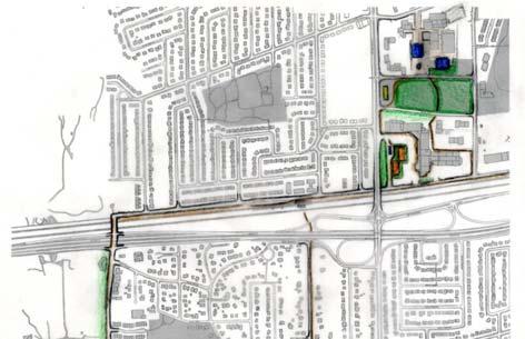
3 Summary (Executive) Problems: Great disconnect between areas of Pointe-Claire due to the intersects created by highway 20b Assets not being used to their full potential Lack of necessary housing type Solution: Improve connection between the Civic Centre and the Pointe-Claire Village while attracting a younger population and accommodating the growing demand for public transit and active transportation. Why these two areas? They are the centers for communal activities unique to Pointe-Claire and they contain many of the major assets associated to Pointe-Claire, thus attractive to the population. Current State: The Civic Centre is located North of highway 20 and East of Saint-Jean Boul. It is bordered to the South by a small shopping complex named the Pointe- Claire plaza. The Pointe-Claire Village is South of highway 20 at the end of Cartier avenue bordering Lake Saint-Louis. These two areas are roughly 2km apart from each other but their connection is significantly lacking because of the highway 20 separation and a poor network of movement. The Current bike path network is limited, mainly runs parallel to Donegani Avenue. Approach: Extending Cartier Avenue to connect with Donegani by making the AMT train line pass underneath the street parallel to that portion of highway 20. Donegani Avenue runs parallel to highway 20 on its north side, thus is a main access to Pointe- Claire s North-South corridors such as Saint-Jean. Donegani also provides direct access to the Pointe-Claire plaza and consequently to the Civic Centre. Cartier is the most straightforward access to the Village, therefore this extension is fundamental for the Civic Centre and the Village to be better connected. Addition of relevant residential, commercial, and public structures Expanding the bike and walking network: Through the plaza and to the core of the civic centre via the forested area between them Along the entire length of Cartier avenue and along the waterfront Along Cedar Avenue which is parallel to Cartier Avenue but geographically closer to the Civic Centre/Plaza area. It is limited to the North by a walkway passing underneath the highway to connect to Cedar Park train station and its south limit is the waterfront
4 Program Requirements Improve Connectivity Attract new populations to Pointe-Claire without displacement of people Use Assets to their Full Potential, such as: Lake Saint-Louis, the beauty of its landscapes, and recreational opportunities Cultural, Recreational, and Sporting Facilities Quality of its Architectural Heritage Abundance of large trees Country Ambience Family Character How our design achieves these goals: 1. Through our movement network The major barrier to movement between the Civic Centre and the Village is the lack of a straightforward path for pedestrians and cyclists. Furthermore, the most straightforward path for automobile users is via the highway 20 with the Saint-Jean exit (leading to the Civic Centre) and the Cartier exit (leading to the village). This connection is unsustainable and discourages active transportation. Our design proposes an extension of Cartier Avenue over the AMT train lines in order to connect with Donegani Avenue which runs parallel to highway 20, thus leading to the civic centre and creating a direct path between the two areas of roughly 2.5km. Donegani is a friendly residential street which already has a bicycle path along its length, it is also the location of the Cedar Park train station midway between the Cartier- Donegani extension and the Civic centre. An expansion of Pointe-Claire s current walking and biking paths is proposed on Cartier Avenue down to the Village as well as through the Pointe-Claire Plaza and to the Civic Centre which would increase the accessibility between both. Further expansion of the bike path along Cedar Avenue would also be an improvement because it is a direct connection to the train station to the south side of highway 20. Moreover, if the bike path extends along the entire length of the waterfront it would attract many more people who travel the bike path from Montreal s Old Port all the way to Lachine and then it could continue through Dorval (where it currently ends) to pass through Pointe-Claire and perhaps go all the way to Saint-Anne-de-Bellevue, which has the kind of active waterfront envisioned for Pointe-Claire. 2. In the Civic Centre Our proposal includes the addition of a bus terminal in the parking lot of the Pointe-Claire plaza, which is currently not used to capacity. This would be a common point for all the bus routes that currently serve the surrounding area giving people better access to our points of interest. The Area around the plaza and Civic Centre shows a demand for low income housing. The addition of low-income housing is also validated by the proximity of the bus terminal which would give means of transport to people who do not necessarily have the means to afford an automobile. The housing added in the plaza s parking lot would have consistent commercial shops on its ground-level. The addition of a community centre in the core of the Civic Centre would serve as the basis of Pointe-Claire s community life. Furthermore, the curling club, which is currently located in the Village, would move to the Civic Centre in order to gather all recreational and sporting facilities. A public square would be created around all buildings in the Civic Centre to give them a feeling of togetherness and to make space for events and various outdoor activities. 3. In the Village Cartier Avenue is the major gateway from the north side of highway 20 to the village. It borders the Beaconsfield Golf Club along most of its length and has lowdensity residential on its other side. We propose the addition of a commercial strip near its intersection with Lanthier Boul., marking the entrance to the Village. This commercial strip would be consistent with the Village architecture and would serve as a point of interest for pedestrians and cyclist while using our pathway along the Cartier Avenue s length of 1km. The following block is currently the location for the Curling Club which we moved to the Civic Centre, thus we propose and inn in its place as an accommodation for visitors to the area, which will presumably increase in numbers following our changes. The Cartier Avenue side of this same block would be developed into a public square as an official meeting point in the Village. This square would contain abundant seating as well as visual markers such as a fountain and a gazebo which could both double as extra seating. Closer to the waterfront, also bordering Carter Avenue, there would be a commercial boardwalk as an extension of the Pointe-Claire Yacht Club which would house restaurants and cafes as a point of interest to visitors. Closer yet to the waterfront, we propose the addition as a chalet for public use as well as lookout point for visitors to enjoy the scenery. Furthermore, in keeping with the character of the Village, we would add a market by Lakeshore, East of Cartier Avenue.

 and the unifying sense of community within the village. However there are a number of constraints which hamper this.")

5 Our areas of intervention include Pointe Claire s Civic Centre, Donegani Street, Cedar Avenue, Cartier Avenue including their adjoining intersections and Pointe Claire Village. These areas possess assets that have not been exploited to their full potential. With this in my mind intervening in these areas would improve the urban form (connectivity) and socio-economic conditions of Pointe Claire; such as commercial zones, green spaces, the waterfront (Lac Saint-Louis) and the unifying sense of community within the village. However there are a number of constraints which hamper this. The first and most important is the physical barrier created by highway 20, consequently dividing Pointe-Claire in half. The second constraint is the street network, a typical suburban environment with a significantly low intersection density. A large part of our area is composed of low density residential with a high rate of home ownership, detached, single family houses. The Civic Centre currently functions as a main activity generator, still by redesigning the Pointe Claire Plaza, which has sufficient space for new development, we will be able attract more people to this area thereby creating an even greater activity generator. Only one main road connects the North and South areas, Saint-Jean Boulevard. Secondary links include pedestrian underpasses on Cedar Avenue and a pedestrian/bike path under highway 20 connecting the golf course sections West of Cartier Avenue. These three linkages end intersecting Lakeshore Road following Lac Saint-Louis. These connections will be taken in consideration to improve connectivity within our intervention area. There is a small commercial area next to the Civic Centre and in the Village, and a few green and open spaces with great potential for redevelopment. The waterfront area boasts attractive scenery however lacks activity anchors as well as an inviting environment oriented towards walking and cycling that could not only attract people but keep people within the area, enhancing their sense of belonging. Landscape Analysis


6 Networks of Movement Projected Flows of Movement The area between the Civic Centre and the Village is currently connected by the STM bus line 211, whose route runs from Lionel-Groulx metro station all the way to Sainte-Anne-de-Bellevue via highway 20. It currently exits on Cartier and continues along Cartier Avenue up to Lakeshore Road. Another linkage is the Cedar pedestrian underpass and the pedestrian/bike path along the golf course. The rest and most of the movement currently in this area is by automobile. The major connection is through Highway 20 or by using Saint-Jean Boulevard as the only current links between the north area and the south area. Our proposal focuses on encouraging sustainable modes of transportation such as walking, biking and public transportation. A bus terminal is to be built in the parking area of the Pointe Claire Plaza, which will host bus lines coming from the north on Saint-Jean Boulevard and namely the from the north on Saint-Jean Boulevard and namely the 211 bus line. With our changes, this bus line would use the Saint- Jean exit in order to access our bus terminus and it would proceed onto Donegani Avenue and it would access Cartier Avenue by its extension that we are proposing instead of returning onto the highway. Another slight change to the 211 bus line route is within the Village, where instead of turning right on Lanthier avenue will continue straight to Lakeshore road to get people closer to the waterfront area. The redesign of Cartier Avenue will play also a key role regarding connectivity north to south, not only for cars but for cyclist too, keeping the existing golf course pedestrian/bike underpass as an alternative to the Cartier/highway 20 intersection. The Cedar underpass is to be refurbished to make it more inviting for people to use it, and our proposal includes also adding a bike path not only under highway 20 but along Cedar avenue to lakeshore road, and then going along the shore offering outstanding and relaxing views to the users and completing a circuit that will support the access to our points of interest.


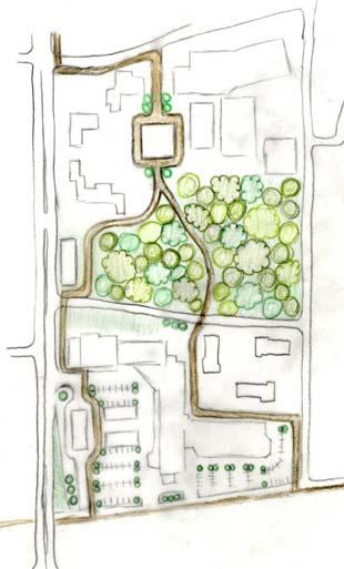
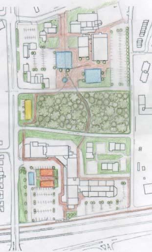
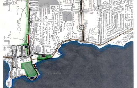
7 Concept Fig Civic Centre Concept Design Fig Cartier Extension Concept Design Fig Village Concept Design Fig Civic Center Massing Fig Cartier Extension Model Fig Village Massing


8 Details Fig 4.1 Train Track Slope Change Fig 4.2 Overpass Track Clearance Fig 5 Integrated Biking\Walking Street Concept
9 Appendices Fig 6 - Previous Concept Designs Civic Center & Plaza Fig 7 - Ground Plan
Public Consultation Summary: Lakeview Place Making Workshop January 30, 2008.
 Page 1 of 11 Public Consultation Summary: Lakeview Place Making Workshop January 30, 2008. 1.0 Introduction: On January 30, 2008 the City of Mississauga, in conjunction with the consulting team of Brook
Chairman and Members of the Planning and Development Committee. Thomas S. Mokrzycki, Commissioner of Planning and Building
 LA.09.TOR (Toronto) DATE: TO: FROM: SUBJECT: Chairman and Members of the Planning and Development Committee Thomas S. Mokrzycki, Commissioner of Planning and Building Central Waterfront Secondary Plan
Shared Principles and Emerging Plan Directions
 Shared Principles and Emerging Plan Directions Introduction Since the Fairfield Neighbourhood planning process launched in June 2016, we have heard from many residents, businesses, groups and other people
Moody Centre Station TOD Area Today
 Moody Centre Station TOD Area Today WHAT IS a transit-oriented Murray Street development area? A Transit-Oriented Development (TOD) Area is a dense, walkable residential and commercial area built to support
PROPOSED REDEVELOPMENT OF THE GLEN ABBEY GOLF CLUB. STREETSCAPE DESIGN STUDY (excerpt from the Urban Design Brief) TOWN OF OAKVILLE.
 TOWN OF OAKVILLE.") PROPOSED REDEVELOPMENT OF THE GLEN ABBEY GOLF CLUB STREETSCAPE DESIGN STUDY (excerpt from the Urban Design Brief) TOWN OF OAKVILLE OCTOBER, 2016 for 2.4.2 STREETS Streets are the single largest component
PROPOSED REDEVELOPMENT OF THE GLEN ABBEY GOLF CLUB STREETSCAPE DESIGN STUDY (excerpt from the Urban Design Brief) TOWN OF OAKVILLE OCTOBER, 2016 for 2.4.2 STREETS Streets are the single largest component
Mark-up of the effect of the proposed Bronte Village Growth Area OPA No.18 on the text of section 24, Bronte Village, of the Livable Oakville Plan
 Mark-up of the effect of the proposed Bronte Village Growth Area OPA No.18 on the text of section 24, Bronte Village, of the Livable Oakville Plan Notes: This document is provided for information purposes
Bourne Downtown Site Planning
 Prepared for: The Town of Bourne, MA In Cooperation with: Bourne Financial Development Corporation Prepared by:, Inc. June 24, 2009 Table of Contents Introduction and Summary... 1 Site Existing Conditions...
Transportation. Strategies for Action
 Transportation A major priority for the Overlake Neighborhood is to develop a multimodal transportation system. To achieve this system, a balance has to be found among travel, circulation and access needs;
7Page 91 CLEMMONS COMMUNITY COMPASS 7 COMMUNITY CHARACTER
 7 Community Character The beauty of Clemmons won t necessarily be a reflection of our past, but our future. This quote from Comprehensive Plan Steering Committee member Wayne Dodson captures the essence
Neighborhood Districts
 NEIGHBORHOOD DISTRICTS SEVEN MAIN DISTRICTS Neighborhood Districts While the Development Plan provides a broad-scale overview of the neighborhood, this section focuses on uses and relationships at the
The University District envisions, in its neighborhood
 Envisioning the University District Link Light Rail in Seattle s neighborhoods CIY OF SEALE CONCEP-LEVEL SAION AREA PLANNING RECOMMENDAION RESOLUION # 30165 EXHIBI L Vision 08.2000 he University District
3.1 Existing Land Use
 3.0 Land Use This strategy has been developed taking into account the position of the Town of Sidney as the economic center of the Saanich Peninsula. It acknowledges existing land use patterns in the downtown
Further input invited as Colchester Growth Strategy nears final phase
 IUE 3 / NOVEMBER 2015 Further input invited as Colchester Growth trategy nears final phase trathcona County is seeking public feedback as it enters the final phase of work on a Growth Management trategy
Policies and Code Intent Sections Related to Town Center
 Policies and Code Intent Sections Related to Town Center The Town Center Vision is scattered throughout the Comprehensive Plan, development code and the 1994 Town Center Plan. What follows are sections
Urban Analysis. Downtown Zanesville like any city, has been physically modified through time as it
 Urban Analysis As a part of the consulting team s reconnaissance effort, an urban analysis was performed. Before the future of a place can be envisioned, one must understand the physical characteristics
Seneca Meadows. Block 4 Locate office, technology, and medical development adjacent to I Screen views of garage structures from I-270.
 Seneca Meadows Seneca Meadows has an industrial park in its southern end and a mixed-use employment area planned for the north end. The district benefits from extensive I-270 visibility, stream valley
The Cambie Corridor 2015 Fall workshop series. What we heard WORKSHOP OUTLINE
 The Cambie Corridor 2015 Fall workshop series W 16 AVE Area 5 CAMBIE CORRIDOR Phase 3 What we heard ovember 21, 2015, 9am-noon, 1:30-4:30pm Peretz Centre 89 Participants* WORKSHOP OUTLIE Introductions
3. Urban Design in the Central Area
 3. Urban Design in the Central Area The Central Area Planning and Design Group assumes the responsibility to promote high quality urban and architectural design in the Central Area, plan and ensure the
Stockton Waterfront Master Plan. Waterfront Master Plan
 Stockton Waterfront Master Plan Presentation Objectives Process update Planning observations Planning Goals Planning Principles Review of planning activities Summary and next steps Planning Activities
Lambeth Main Street Streetscape Improvements
 Lambeth Main Street Streetscape Improvements Open House October 5th, 2017 Agenda 1. Introduction 2. Project Background 3. Context 4. Project Objectives 5. Design Principles & Approach 6. Streetscape Design
Anatomy of A Vibrant Downtown. Anatomy of a Vibrant Downtown
 Anatomy of A Vibrant Downtown The goal of MAIN ST. REVITALIZATION PLANNING is to provide a framework that will help transform your downtown into a VIBRANT DOWNTOWN a place where people love to LIVE, WORK,
Status Report: MD 355 Project
 Status Report: MD 355 Project OCTOBER 2006 M-NCPPC MONTGOMERY COUNTY PLANNING DEPARTMENT Summary of Community Comments, and break to the Results of the MD 355 Participation Session Brookside Gardens -
Appendix I ARLINGTON COUNTY SECTOR PLANS SUMMARY RECOMMENDATIONS RELATED TO PUBLIC SPACES
 Appendix I ARLINGTON COUNTY SECTOR PLANS SUMMARY RECOMMENDATIONS RELATED TO PUBLIC SPACES The County has developed Sector Plans for various planning areas within Arlington County s Metro corridors. Following
EXISTING COMPREHENSIVE PLAN
 EXISTING COMPREHENSIVE PLAN Town Center Land Use Element: V. LAND USE POLICIES Town Center Mercer Island's business district vision as described in "Your Mercer Island Citizen-Designed Downtown" was an
URBAN DESIGN BRIEF. 2136&2148 Trafalgar Road. Town of Oakville
 URBAN DESIGN BRIEF 2136&2148 Trafalgar Road Town of Oakville Prepared By: METROPOLITAN CONSULTING INC For 2500674 Ontario Inc November 2016 TABLE OF CONTENTS Page No. 1.0 Introduction/Description of Subject
DRAFT Land Use Chapter
 Stevens Creek Urban Village DRAFT 1 18 17 Land Use Chapter INTRODUCTION This Land Use Chapter describes how the Stevens Creek Urban Village will accommodate the growth that is planned for it in the Envision
HE VISION. Building a Better Connected Place
 HE VISION Building a Better Connected Place WALK INTO THE FUTURE. Life in Cranberry, 2030 Here s what our residents told us they wanted to see in their community by 2030: The Cranberry of 2030 is a place
Wayfinding. North Gateway: Integrate a vertical gateway marker on the west side of Ward Street at the south corner of Vernon Street.
 3.3.6.2 Wayfinding Existing Conditions Wayfinding signage is important to direct visitors and tourists to different locations in the downtown. A significant part of the wayfinding signage in the downtown
burlington mobility hubs study Downtown Burlington Mobility Hub
 burlington mobility hubs study Downtown Burlington Mobility Hub Draft Precinct Plan Workbook PIC #3, September 7, 2017 downtown mobility hub objectives City staff and their consultants are proposing an
YONGE STEELES CORRIDOR SECONDARY PLAN. Young + Wright / IBI Group Architects Dillon Consulting Ltd. GHK International (Canada) Ltd.
 Ltd.") PART A: PREAMBLE 1.0 PURPOSE The purpose of this Secondary Plan is to provide a development framework for intensification of the Yonge/ Steeles corridor including the north side of Steeles Avenue West
PART A: PREAMBLE 1.0 PURPOSE The purpose of this Secondary Plan is to provide a development framework for intensification of the Yonge/ Steeles corridor including the north side of Steeles Avenue West
Clairtrell Area Context Plan
 Clairtrell Area Context Plan March 2005 Urban Development Services City Planning Contents 1. Introduction... 4 2. Development Structure... 6 2.1 Streets... 7 2.1.1 Sheppard Avenue and Bayview Avenue...
ENVISIONING TOMORROW S FORT MYERS BEACH
 ENVISIONING TOMORROW S FORT MYERS BEACH NATURAL ENVIRONMENT... 2-1 MOBILITY... 2-1 TIMES SQUARE... 2-1 AVENUE OF PALMS... 2-2 RESIDENTIAL NEIGHBORHOODS... 2-2 A SECOND MAIN STREET... 2-4 FORT MYERS BEACH,
[PLANNING RATIONALE] For Site Plan Control and Lifting of Holding Zone By-Law 101 Champagne Avenue. May 23, 2014
![[PLANNING RATIONALE] For Site Plan Control and Lifting of Holding Zone By-Law 101 Champagne Avenue. May 23, 2014](/thumbs/75/71599615.jpg "[PLANNING RATIONALE] For Site Plan Control and Lifting of Holding Zone By-Law 101 Champagne Avenue. May 23, 2014") [PLANNING RATIONALE] For Site Plan Control and Lifting of Holding Zone By-Law 101 Champagne Avenue May 23, 2014 Contents 1.0 Introduction... 2 2.0 Site Context... 2 2.1 Adjacent Uses... 2 Figure 1: Site
[PLANNING RATIONALE] For Site Plan Control and Lifting of Holding Zone By-Law 101 Champagne Avenue May 23, 2014 Contents 1.0 Introduction... 2 2.0 Site Context... 2 2.1 Adjacent Uses... 2 Figure 1: Site
KAMPLAN City of Kamloops. Section D. Land Use Policies D-1
 KAMPLAN City of Kamloops Section D Land Use Policies D-1 City of Kamloops KAMPLAN D 1 Land Management and Development This section links to the following Community Values: D-2 develop complete neighbourhoods
Wadsworth Boulevard S TAT I O N A R E A P L A N
 Wadsworth Boulevard S TAT I O N A R E A P L A N City of Lakewood Adopted November, 2006 The Vision The City of Lakewood s overall vision is to transform the area around the light rail station into a mixed-use
ELMVALE ACRES SHOPPING CENTRE MASTER PLAN
 ELMVALE ACRES SHOPPING CENTRE MASTER PLAN Contents 1.0 INTRODUCTION... 2 2.0 LOCATION... 2 3.0 EXISTING CONTEXT... 2 4.0 VISION & GUIDING PRINCIPLES... 2 5.0 LAND USE AND BUILT FORM... 4 5.1 St. Laurent
b r a n c h av e n u e tr a n s it co r r i d o r r e vita lization pl a n a m o d el fo r s u b u r ban retro fit
 b r a n c h av e n u e tr a n s it co r r i d o r r e vita lization pl a n a m o d el fo r s u b u r ban retro fit P R I N C E G EO RG E S CO U NT Y, M D ADO PTED 0 p R O J E C T C AT E G O R Y : U R B
City of Farmington. Downtown Plan. Amendment to the 1998 Master Plan Adopted October 11, 2004
 City of Farmington Amendment to the 1998 Master Plan Adopted October 11, 2004 Introduction Planning Background 1 Scope and Components of the Plan Amendment 2 Concept Introduction 3 Plan Concepts 3 Conceptual
Principal development issues
 Principal development issues The transformation of the Bonaventure Expressway from Saint- Jacques to Brennan Streets will create a major urban boulevard with lanes located on either side of a string of
Town Center (part of the Comprehensive Plan)
") Town Center (part of the Comprehensive Plan) Mercer Island Town Center Looking North (2014) In 1994, a year-long process culminated in a set of design guidelines and code requirements for the Town Center
Town Center (part of the Comprehensive Plan) Mercer Island Town Center Looking North (2014) In 1994, a year-long process culminated in a set of design guidelines and code requirements for the Town Center
MEETING PURPOSE AND OVERVIEW
 MEETING PURPOSE AND OVERVIEW On February 23, 2012, the City of Elk Grove hosted the first of two community workshops related to the Southeast Policy Area. The workshop was held from 6:00 8:30 p.m. in the
New-Cast Mixed-use Development Proposal King Street West, Newcastle, Ontario
 URBAN DESIGN BRIEF New-Cast Mixed-use Development Proposal King Street West, Newcastle, Ontario TABLE OF CONTENTS: 1.0 Executive Summary 2.0 Creating Vibrant and Sustainable Urban Places: Excerpts from
V. Gateways GATEWAYS / V-1
 V. GATEWAYS / V-1 Many of Chesapeake s gateways are located on highways and call for bold and attractive designs that motorists can understand, appreciate, and enjoy. can also take the form of natural
Goals AND Guiding principles
 Historic photo of Eastlake Train Station sign Chapter 2: Goals AND Guiding principles 2-1 The Plan goals includes a desire to bridge present day conditions with a vision of the area s future. A central
Sheridan Boulevard S TAT I O N A R E A P L A N S H E R I D A N B O U L E VA R D S TAT I O N A R E A P L A N
 Sheridan Boulevard S TAT I O N A R E A P L A N 1 City of Lakewood Adopted November, 2006 S H E R I D A N B O U L E VA R D S TAT I O N A R E A P L A N The Vision The City of Lakewood s overall vision is
Mariposa Lakes. Planned Community. Project Overview. Stockton, CA
 Planned Community Stockton, CA Project Overview March 2007 Summary of Proposed Community is a master-planned community proposed for development on approximately 3,810 acres in southeast Stockton. In 2004,
Table of Contents. Elm Avenue Improvement Plan City of Waco, Texas. Introduction 1. Existing Context 1 Figure 1 2.
 Table of Contents Introduction 1 Existing Context 1 Figure 1 2 Plan Guidelines 3 Future Urban Form 4 The West-End 4 Main Street 6 The East-End 7 Figure 2 9 Public Improvement Recommendations 7 General
WELCOME and introduction
 1 WELCOME and introduction Mobility Hub Locations within Burlington STUDY OVERVIEW STUDY OBJECTIVES The City of Burlington is developing four Area Specific Plans, one for each of Burlington s Mobility
Forest Hills Improvement Initiative A Partnership for Building a Better Community. Use & Design Guidelines September 23, 2008
 Forest Hills Improvement Initiative A Partnership for Building a Better Community City of Boston Thomas M. Menino, Mayor Emerging Community Vision p. 2 Site Use & Design Guidelines p. 3 to 21 Arborway
South th E ast Communit ity Centre (SECC)
") South East Community Centre (SECC) 1 New Park Design & Community Centre Update Thursday, February 8, 2018 Public Open House Thank you for attending this Open House! The town and the Consulting Team will
South East Community Centre (SECC) 1 New Park Design & Community Centre Update Thursday, February 8, 2018 Public Open House Thank you for attending this Open House! The town and the Consulting Team will
Workshop #3 June 13, 2016
 Downtown Ocoee Master Plan Workshop #3 June 13, 2016 Our Team Our Team and Tonight s Goal Quick Recap: Why a Downtown Plan? How are we developing the plan? How can you still be involved? What s left to
PINE CURVE REZONING. Property does not meet criteria for open space preservation and is not a candidate for a park
 PINE CURVE REZONING BACKGROUND Purchased as two parcels in 2001 and 2002 Annexed and Zoned Greater Downtown District Historic Center September 25, 2002 and October 7, 2002 WHAT THE PROJECT IS AND IS NOT
Stakeholders Advisory Working Groups (SAWGs) Smart Growth and TOD Land Use (#11) SAWG Meeting
 Smart Growth and TOD Land Use (#11) SAWG Meeting") Presentation - Part II Tappan Zee Bridge/I-287 Corridor Project July 21, 2010 Slide 1. David Kooris (Regional Plan Association) welcomed members of the Land Use Stakeholders Advisory Working Groups (SAWGs)
Presentation - Part II Tappan Zee Bridge/I-287 Corridor Project July 21, 2010 Slide 1. David Kooris (Regional Plan Association) welcomed members of the Land Use Stakeholders Advisory Working Groups (SAWGs)
DRAFT ROOSEVELT ROAD. District Recommendations. Figure 5.23 The Roosevelt Road Corridor
 CHAPTER 5 Figure 5.23 The Road Corridor Road will develop as a mixed-use corridor, emphasizing regional retail, west of the river and mixed-use development east of the river. KEY RECOMMENDATIONS 1. High
Silverdale Regional Center
 Silverdale Regional Center Vision for Silverdale Regional Center The Silverdale Regional Center Plan (Plan) will guide the evolution of the Silverdale Regional Center from a collection of strip malls and
TSAWWASSEN TOWN CENTRE REDEVELOPMENT BLOCK A 004
 Current Context The context for the project includes storey multi-family residential to the northwest, a TD bank immediately north, highway oriented commercial to the east, a surface parking lot to the
A Plan for the Heart of the Region: Tukwila, WA
 : Tukwila, WA 1 The Plan orchestrates the Restructuring of a 1,000-acre Regional Shopping Area into a Social and Symbolic for the Region. REGIONAL CONTEXT Downtown Seattle (Metropolitan ) 20 miles Bellevue
Pedestrian and Bike Bridge LOGO
 6.2.2 Pedestrian and Bike Bridge The proposed pedestrian and bike crossing re-envisions the existing bridge at Pismo Creek on Cypress Street. The bridge is currently underutilized by vehicular through
NORTH COLLEGE PARK. Residential Neighborhood and Neighborhood Center OBJECTIVES EXISTING SITUATION AND ISSUES CONCEPT
 Greenbelt Metro Area Sector Plan - Subarea Design Policies and Guidelines - North College Park 119 NORTH COLLEGE PARK Residential Neighborhood and Neighborhood Center CONCEPT North College Park is envisioned
This Review Is Divided Into Two Phases:
 Semiahmoo Town Centre Review The purpose of this review: To review the Semiahmoo Town Centre Concept Plan, originally approved in 1993, to ensure that this centre will continue to serve the needs of South
McCowan Precinct Plan Study Background & Deliverables
 1 DRAFT & WITHOUT PREJUDICE McCowan Precinct Plan Study Background & Deliverables In September, 2011, City Planning (Scarborough District) began a study of an area within the Scarborough Centre, identified
Key Moves in the Plan
 Key Moves in the Plan 2 Add housing that fits the neighbourhood s character Make it easier to leave the car behind Oak Bay Avenue Village plan to be completed in future planning process Future active transportation
Small Area Plan. South Gateway
 Small Area Plan Adopted May 12, 2008 South Gateway Purpose. The South Gateway Small Area Plan defines the City s expectations for the future of the southern entrance to the City at Interstate 85 and Highway
Welcome. Community Consultation Meeting November 28, Review and discuss the Bathurst Quay Neighbourhood Plan Framework
 Welcome Community Consultation Meeting November 28, 2016 Why Are We Here Today? Review and discuss the Bathurst Quay Neighbourhood Plan Framework Review and discuss an Action Plan for Implementation Next
The Auburn Plan Designing the Future of Auburn February 28, 2005
 The Auburn Plan Designing the Future of Auburn February 28, 2005 Block-by-Block Bicycle Tour Aerial survey Focus Group Meetings September 7 and 8 Design Workshops October 11, 14, and 21 Revitalization
6 PORT SYDNEY SETTLEMENT AREA
 Section 6 Port Sydney Page 61 6 PORT SYDNEY SETTLEMENT AREA 6.1 Basis and Principles Village of Port Sydney Waterfront Community Existing Services 6.1.1 Port Sydney is an historic settlement that has developed
2.0 THE PLATINUM TRIANGLE VISION
 2.0 THE PLATINUM TRIANGLE VISION The envisions an exciting future for the area surrounding Angel Stadium of Anaheim, the Honda Center and The Grove of Anaheim. 2.1 Planning Principles In order to further
RESEDA - WEST VAN NUYS COMMUNITY PLAN
 RESEDA - WEST VAN NUYS COMMUNITY PLAN Executive Summary As part of the initial outreach effort, the Department of City Planning hosted two workshops for the Reseda-West Van Nuys Community Plan Area during
Access Management: An Overview
 Figures 1-5 Below Evolution of development along a highway. In the early stages, land along the road is used for farming with little traffic generated. As time passes, the highway corridor becomes a de
THE NEIGHBORHOOD TODAY
 THE NEIGHBORHOOD TODAY CORE AREA VISION How are we Good Urbanism A Site s DNA thinking about Elements of great Unique elements urban communities embedded in a place the site and design? ELEMENTS LIKE:
THE 355/270 CORRIDOR:
 THE 355/270 CORRIDOR: Strategic Ideas for Sustaining a Livable Work Place Project Summary ACCESS LIFE DESIGN HEALTH WORK Montgomery County Planning Department The Maryland-National Capital Park and Planning
Midtown Greenway Land Use and Development Plan Executive Summary
 Midtown Greenway Land Use and Development Plan Executive Summary Introduction The Midtown Greenway Land Use and Development Plan sets policy direction for land use and development in the Midtown Greenway
Corridor Transformation Strategy
 Corridor Transformation Strategy County Road 22 Special Planning Area Design Guidelines January 2012 D14-06017 Corridor Transformation Strategy County Road 22 Special Planning Area Corridor Design Guidelines
Appendix C: Interim Mixed-Use Evaluation Criteria
 Appendix C: Interim Mixed-Use Evaluation Criteria C-1 Appendix C: Interim Mixed-Use Evaluation Criteria PURPOSE: The implementation of numerous policies contained within the Master Plan hinges on the creation
hermitage town center
 hermitage town center A Community Vision prepared by Strada for The City of Hermitage and The Mercer County Regional Planning Commission January 2007 table of contents introduction 3 design principles
Rapid Transit Implementation Working Group Transit Oriented Development and Transit Villages January 12, 2017
 Rapid Transit Implementation Working Group Transit Oriented Development and Transit Villages January 12, 2017 Purpose of Presentation Highlight opportunities for Transit-Oriented Development in London
URBAN DESIGN BRIEF URBAN DESIGN BRIEF 721 FRANKLIN BLVD, CAMBRIDGE August 2018
 URBAN DESIGN BRIEF URBAN DESIGN BRIEF 721 FRANKLIN BLVD, CAMBRIDGE August 2018 DESIGN BRIEF CONTENTS PART A 1.0 INTRODUCTION 2.0 DESCRIPTION & ANALYSIS OF SITE CONTEXT 3.0 DESIGN CONSTRAINTS AND OPPORTUNITIES
Downtown North Las Vegas Demonstration Site Project. Project Update
 Downtown North Las Vegas Demonstration Site Project Project Update 7.16.14 Presentation Overview Project Purpose and Process Planning Context Opportunities and Barriers Summary Community Input Preliminary
Lakeview and Port Credit District Policies Review Public Engagement Process
 Lakeview and Port Credit District Policies Review Public Engagement Process Brook McIlroy Planning + Urban Design/PACE Architects MSAi Architects Poulos and Chung Transportation Engineers December 11,
PROTOTYPE DESIGN/INTRODUCTION
 PART III: PROTOTYPE DESIGN These concepts and guidelines described earlier were used to develop a prototype design for an emerging suburban area located west of the City of Milwaukee. This was done to
PRELIMINARY DESIGN + DEVELOPMENT PLAN
 WELCOME! To The Public Open House May 30 th, 2017 HARBOUR WEST PARKS Vision Project Overview The City s vision for Port Credit Harbour West Parks is to develop a vibrant waterfront destination that integrates
The Village. Chapter 3. Mixed Use Development Plan SPECIFIC PLAN
 The Village SPECIFIC PLAN Chapter 3 3.1 INTRODUCTION 3.1.1 Purpose This Chapter describes the development regulations applicable to the Mixed-Use and Transit Center Planning Areas. These form-based regulations
Regency Developments. Urban Design Brief. Holyrood DC2 Rezoning
 Regency Developments Urban Design Brief Holyrood DC2 Rezoning Stantec Consulting Ltd. 7-31-2017 1. Overview Regency Developments intends to rezone the lands located at 8510 and 8511 93 Avenue, within the
DRAFT. October Wheaton. Design Guidelines
 October 2011 DRAFT Wheaton Design Guidelines 2 Draft - Design Guidelines - Wheaton Sector Plan Contents 04 Section 1: Introduction 06 Section 2: Context 08 Section 3: Design Guidelines 09 Goal 1: Create
Glenborough at Easton Land Use Master Plan
 Vision Statement Sunrise Blvd. Hazel Ave. Prairie City Rd. Gencorp Property Lincoln Regional Airport 1.0 VISION STATEMENT The identifies City of the principles, goals, policies, and standards Lincoln that
 Health Sciences City The available land area, although limited, combined with the unique partnership between the primary institutions and the supporting partnerships of the development interests within
THE COMMUNITY-DRIVEN DESIGN PROCESS
 THE COMMUNITY-DRIVEN DESIGN PROCESS A PUBLIC DRIVEN PROCESS STEERING COMMITEE THE COMPREHENSIVE PLAN OPPORTUNITIES AND CONSTRAINTS THE COMMUNITY DRIVEN DESIGN PROCESS A Public Driven Process Beginning
PLAN ELEMENTS WORKSHOP. April 5, 2016
 PLAN ELEMENTS WORKSHOP April 5, 2016 needs more housing. But there is no one-size fits-all solution. Every neighborhood has its own character. In some places, density is not only appropriate it is badly
Workshop #1 Outcomes. The Planning Partnership
 Workshop #1 Outcomes The Planning Partnership 1 Background Review Planning Provincial Policy Statement Greenbelt Plan Places to Grow: Growth Plan York Region Official Plan York Region Draft Official Plan
Mississauga Waterfront. Parks Strategy - Draft
 Potential configuration for river s edge seating. Boating on Credit River: A regatta Boating on Credit River: Active enjoyment 5.2 Port Credit Memorial Park West Priority Park 5.2.1 Site Opportunities
Chapter 1: Introduction
 Chapter 1: Introduction The Penn Avenue Community Works Corridor Vision and Implementation Framework presents an integrated communitybased vision and a coordinated, long-term implementation framework for
public review draft Key objectives for this chapter are:
 5 - parks & open space Providing a rich collection of outdoor places for informal gathering and recreation, as well as planned promotional activities and community events, is a key concept for Midtown.
Create Policy Options Draft Plan Plan Approval. Public Consultation Events. Phase 2
 Background Grandview-Woodland Community Plan In the spring of 2012, the City of Vancouver embarked on a comprehensive community planning program in the Grandview-Woodland neighbourhood. The process has
GUIDELINES EXHIBITION PLACE LOCATION: OBJECTIVES. Structure Plan URBAN DESIGN GUIDELINES
 Development in the Exhibition Place lands will be consistent with the following urban design guidelines. They provide a framework for new development of the lands and are to be read in conjunction with
SQUAMISH 2010 AND BEYOND COMMUNITY VISION
 Our plan has been imagined and created to be both pragmatic and visionary. At the core of the strategy is a consideration of the highway s role and its impact on the community. First and foremost in creating
PINE CURVE REZONING. BACKGROUND Purchased as two parcels in 2001 and 2002
 BACKGROUND Purchased as two parcels in 2001 and 2002 WHAT THE PROJECT IS AND IS NOT A Rezoning establishes the land use standards for Annexed and Zoned Greater Downtown District Historic Center September
MARINWOOD VILLAGE GUIDING PRINCIPLES
 The conceptual design plan for the Marinwood Plaza property is the result of a joint effort between the Marinwood community, the Marinwood Plaza property owners and the County of Marin. These parties have
Contact: Alex Taranu ( ) or Karl Walsh ( )
 or Karl Walsh ( )") Date: 09 September 2005 File: Subject: P03.DUDS Downtown Urban Design Vision Study Report Contact: Alex Taranu (905 874 3454) or Karl Walsh (905 874 2331) OVERVIEW Staff has produced an Urban Design Vision
Date: 09 September 2005 File: Subject: P03.DUDS Downtown Urban Design Vision Study Report Contact: Alex Taranu (905 874 3454) or Karl Walsh (905 874 2331) OVERVIEW Staff has produced an Urban Design Vision
Metro. Activity Center Design Guidelines. Recommendations For Developing Focused, Mixed-Use Commercial/Residential Centers
 Metro Activity Center Design Guidelines Recommendations For Developing Focused, Mixed-Use Commercial/Residential Centers Metro Activity Centers What is a MAC? Legacy, the adopted guide for the future growth
Bel-Air Lexus Automobile Service Station
 Bel-Air Lexus Automobile Service Station Design Brief 443-447 McArthur Avenue Ottawa April 30, 2015 14-1299-MCA Site Details Application: Site Plan Control Legal Description and Municipal Addresses: 443