Poinciana Parkway Southport Connector Project Development and Environment (PD&E) Study
|
|
|
- Delilah Russell
- 6 years ago
- Views:
Transcription
 Meeting August 27, 2013 Date/Time")
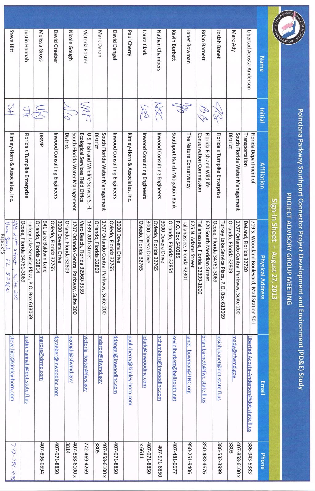
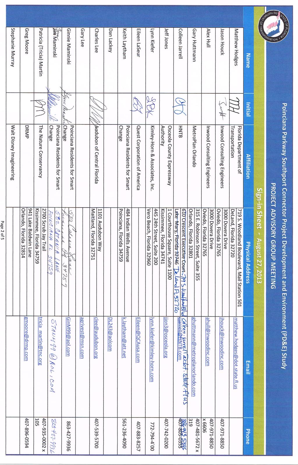
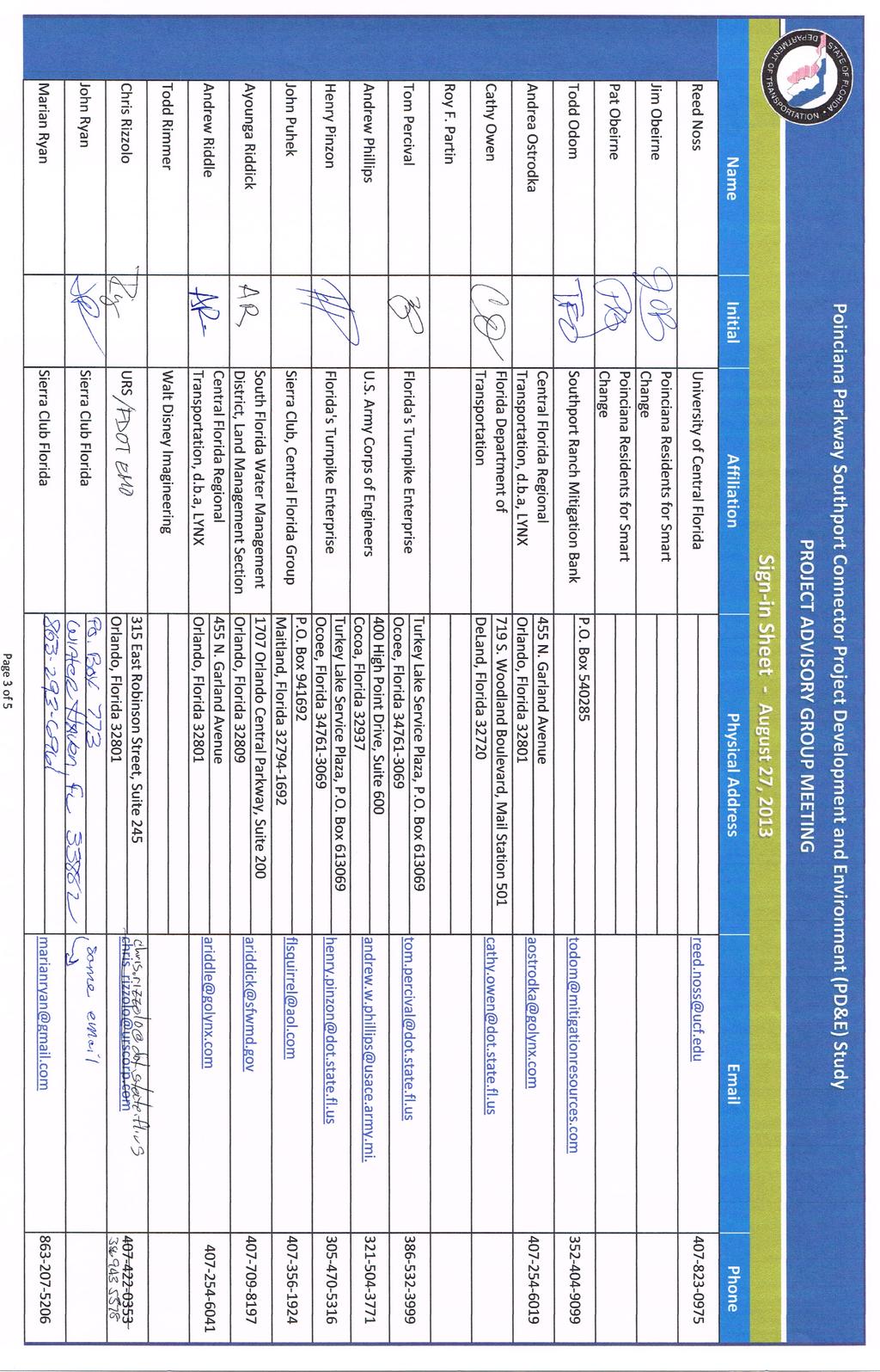
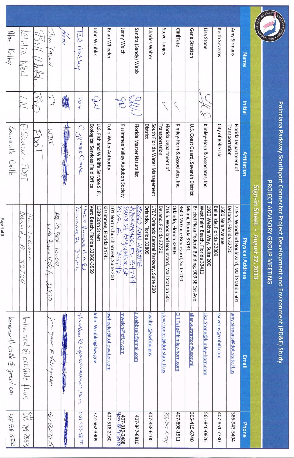
1 Poinciana Parkway Southport Connector Project Development and Environment (PD&E) Study From Florida s Turnpike to Pleasant Hill Road, Osceola County, Florida Financial Project Number: Agency Project Advisory Group (APAG) Meeting August 27, 2013 Date/Time: Location: Agenda: August 27, 2013, 10:15 a.m. to 12:00 p.m., Field Trip from 12:00 p.m. to 3:00 p.m. Disney Wilderness Resort, Disney Wilderness Preserve Conservation Learning Center 2700 Scrub Jay Trail, Kissimmee, Florida Attached Alex Hull from Inwood Consulting Engineers, Inc., began the meeting at 10:15 a.m. by asking the attendees to introduce themselves. The Poinciana Parkway Southport Connector (Southport Connector) Project Development and Environment (PD&E) Study Agency Project Advisory Group (APAG) is a diverse mix of representatives from various agencies, city and county staff, and private interest groups. Forty attendees signed in (see sign-in sheets attached) for this meeting. Mr. Hull gave a presentation about the project and encouraged discussion from the group throughout the meeting. Presentation Poinciana is ranked as one of the places in Florida with the longest commute. There is no direct connection to expressway routes, employment and business centers, and no evacuation route that directly serves the Poinciana community. The Southport Connector project is included in MetroPlan Orlando s Long Range Transportation Plan (LRTP) and Transportation Improvement Plan (TIP), and the Florida Department of Transportation s (FDOT) State Transportation Improvement Program (STIP), as well as the Osceola County Expressway Authority s (OCX) Master Plan. The purpose of the project is to reduce traffic and enhance traffic operations, provide connectivity with regional transportation networks, provide multi-modal facilities and enhance emergency evacuation by connecting to Florida s Turnpike. Comments: I ve experienced the traffic on Poinciana s local roads. Often, during peak travel periods in the morning and the evening, traveling northbound on Pleasant Hill Road and north on U.S to Kissimmee, there is gridlock. When there is an accident, these roadways can be completely shut down. This is an issue for emergency vehicles. Are all of the project alignments for this project going to run from west to east? There are issues on Poinciana Parkway in the morning. Traffic can come to a dead stop during peak hours.
 process was implemented by the Florida Environmental Land and Water Management Act of 1972.")
2 Poinciana Parkway Southport Connector PD&E Study Agency Project Advisory Group (APAG) Meeting August 27, 2013 Page 2 How did Poinciana get to this condition? The Development of Regional Impact (DRI) process was implemented by the Florida Environmental Land and Water Management Act of Prior to that time, development was simply done by the numbers with no local concurrency. Historically, development companies promised to build roads along with their new developments. Over time, some of the development companies changed hands and were re-named, etc. Some of the developers backed out of the projects, and some of the planned roads were never built. Poinciana is composed of ten (10) villages and governance has changed hands over the years. Polk County has recently amended their Comprehensive Plan from pre-dri to land use planning. There are some old DRIs in Osceola County. It has been suggested to local governments that development be brought up to the current standards in the Comprehensive Plan. If the purpose of this project is to relieve congestion, until there is a clear origin/destination that looks at traffic counts, how can you plan a project for congestion relief? Is there a destination point at Florida s Turnpike to the east and another destination that could be taken to the north? The Turnpike system is designed for inter-city travel; it s not designed to relieve local congestion or commuter travel. If the project is built as shown on the map, would it have a real effect on traffic conditions in Poinciana? The origins and destinations need to be examined. Alex Hull: Comment: Alex Hull: This is a four-year study. There will be time to discuss these issues and determine what the best answers will be. Another consulting firm is working with the FDOT to conduct the traffic analysis. Currently there is a preliminary purpose and need. The purpose and need will be finalized after the traffic analysis is completed. The traffic numbers will be a better indicator of what is needed to relieve congestion. There are large branches of the transportation system within the study area. There are commercial and residential properties to the west and agriculture and environmental lands with very little population to the east. Hopefully both Polk County and Osceola County will become engaged with this project. Three out of five of the DRIs in this area were developed at least 10 years ago and were not part of a Master Plan. Has the FDOT checked to see what DRIs are still out in the area? The South Lake Toho Master Plan looked at the Green Island DRI and members of this project team have met with Green Island. It is basically dormant until a Master Plan is developed.

3 Poinciana Parkway Southport Connector PD&E Study Agency Project Advisory Group (APAG) Meeting August 27, 2013 Page 3 Comment: Clif Tate: Comments: Southport Ranch has no current plans to develop the Bronson property. The Kelly family also prefers to continue ranching at this time. DRIs have no real planning value without encumbrances. Large-scale development may never happen in this area. This is a planning issue and subject to change until entitlements are awarded to land owners. The County has considered the impacts of the DRIs. The toll authorities rely on population density and land use. The DRIs that received entitlement were north of Lake Toho, not to the south. The land owners in the study area did not seek to get entitlements. Beyond entitlements, there is the issue of post-recession market value. Is there a marketability and viability that will lead ranchers to do something else with their land? For one, there is the Mitigation Bank at South Lake Toho. From the recession bubble up through 2013, is the viability the same? There s no guarantee that you could guarantee toll revenue. This comes into play with the other alignments as well. The DRIs need to be kept in the loop and be engaged in conversations. The best route would be more likely be to the northeast of Lake Toho. Alex Hull: Comment: The project team will continue to have conversations with land owners throughout the project. When will the traffic study be complete? Alex Hull: We anticipate completion of the Traffic Report in September Comment: There have been plans for an additional 20,000 to 30,000 homes south of St. Cloud. Several of the DRIs have changed ownership since the entitlements were obtained. Some have gone back on the agreements; others had a change in interest when ownership was transferred.
 screening process.")
4 Poinciana Parkway Southport Connector PD&E Study Agency Project Advisory Group (APAG) Meeting August 27, 2013 Page 4 Alex Hull: In the next few weeks, both of the Poinciana Parkway studies will be moving through the Efficient Transportation Decision Making (ETDM) screening process. This process will help determine the environmental Class of Action which is part of the federal process that is needed to comply with the National Environmental Policy Act (NEPA). It will determine the level of development that needs to be part of these studies; whether they will require an Environmental Impact Statement (EIS) or an Environmental Assessment (EA). An analysis or preliminary evaluation assessment will be conducted to determine the estimated level of environmental impacts. Corridors with the highest level of impact will be avoided. Alternatives will less potential impacts will be moved forward. The Federal Highway Administration (FHWA) has agreed to this type of corridor evaluation and a report will be submitted for FHWA review. It is anticipated that the Class of Action for this study will be determined by spring 2014; keeping in mind that this is a four-year study. The presentation explained the overall study process, the steps of the analysis and the NEPA documentation. The first step is to screen out the non-viable alternatives and carry the viable alternatives forward for further evaluation. Based on the land sustainability mapping process, the following steps will be taken during the study: The corridor study area will be defined. The study area will be screened using weighted Geographic Information System (GIS) layers. The most sensitive environmental corridors will be eliminated. The corridor width and design criteria will be identified. The corridor alignments will be identified and evaluated. Local government input and public input will be obtained. A corridor workshop will be held in spring The Corridor Report will be prepared and submitted to the FHWA and the Environmental Technical Advisory Team (ETAT) for approval. A large study area is being evaluated to determine the best way to tie into an existing roadway or build a new roadway to Florida s Turnpike. Comments: You should also consider a northern alignment. Look at the study areas west and east of the Cypress Parkway segment. There is a missing link. Cypress Parkway was between the design/build and approach to Pleasant Hill Road. Is there a regional Turnpike objective here? The

5 Poinciana Parkway Southport Connector PD&E Study Agency Project Advisory Group (APAG) Meeting August 27, 2013 Page 5 only real possibility for a Turnpike Connection is to the north, in order not to impact Downtown Poinciana. There are environmental issues south of Lake Toho, including a mitigation bank and smoke shed. We also need a route that is away from the Disney Preserve. Environmental Concerns The preliminary environmental screening is scheduled to begin next week (week of September 2, 2013). Environmentalists will go along each of the proposed corridors to see if there is anything that would preclude an alignment in those areas. There is a possibility that eagles, crested caracara and snail kites have established nests in some of these areas that may become an issue later on. This is the densest bald eagle nesting area in the world. We must do everything we can to avoid nesting areas so we don t end up with a conflict. South of the study area the Everglades Boundary encompasses the Disney Wilderness Preserve and the South Florida Water Management District (SFWMD). A second effect is the proximity of the road to the urban development line. This could push a potential alignment south to the eco system, which is a more perilous location. Routes across the lake could also be considered. There are critical nesting areas for the endangered snail kites and other birds along the lake. Comments: Lake Toho is a top fishing destination for major tournaments with hundreds of boats participating. A bridge would have to be lighted to allow operators of high speed boats to see the bridge in the early morning darkness. Lights on the bridge may have an impact on these areas. Lighting on deck is more common than underneath; however, there isn t a lot of data on light and noise pollution or other disturbances that may be caused by a bridge. There are also significant wetland issues south of Lake Toho with wading birds as well as potential issues of boat collisions with the bridge piles. The study team has had specific agency coordination regarding scrub jay habitat; however, none has been found within the study area to date. Field visits have noted caracara and eagles. Grasshopper sparrows have not been observed in the southeastern portion of the study area; however, no detailed surveys have been done. In spring 2014, the project team will coordinate with the FDOT and Reed Noss from the University of Central Florida to discuss wildlife surveys for these species and others, and a Listed Species Matrix will be prepared. A Draft Comparative Evaluation Matrix should be available by the end of September The U.S. Fish and Wildlife Service indicated they would be issuing an updated list of proposed and candidate endangered species within the next two to four years. Project team members requested a copy of the list so additional species, as required, can by included in the wildlife surveys for this project.
 review will be done to avoid conflict with public lands. Questions: Who should we submit comments to?")
6 Poinciana Parkway Southport Connector PD&E Study Agency Project Advisory Group (APAG) Meeting August 27, 2013 Page 6 Managed Lands A Cultural Resources evaluation will be done to assess archeological and historic properties. A Section 4(f) review will be done to avoid conflict with public lands. Questions: Who should we submit comments to? Comments can be submitted to Alex Hull, Consultant Project Manager from Inwood Consulting Engineers, Inc.; Amy Sirmans, FDOT Project Manager, or Eileen LaSeur, Public Involvement Coordinator from QCA. Comments can also be submitted from the website: Are you coordinating with the other Poinciana study? Yes there will be continuous coordination between the two projects. Representatives from both projects will be attending the public meetings. Poinciana area traffic needs a thorough analysis. Are you looking at all the pieces? Yes, we are working together to obtain traffic analysis throughout the area. Traffic is good at U.S at Pleasant Hill Road. Is that also part of the study? A regional traffic study is being done, so U.S at Pleasant Hill Road will be included. Public Involvement Public kick-off meetings for this project will be held on September 10, 2013 in Poinciana and September 12, 2013 in St. Cloud. A PowerPoint presentation with voice-over will be available on a continuous loop throughout both evenings. Display boards will include the project location map, the OCX Master Plan and Central Polk Parkway map and the project schedule. Members of the consultant project team and FDOT staff will be available to answer questions and discuss concerns with attendees. Representatives from the other Poinciana study currently determining potential corridors to Interstate 4 (I-4) will be at both public meetings for coordination between the two studies.
")

 to attendees planning to participate in a field visit following the meeting. Twenty-six people attended the field visit.")


. 5.")
7 Poinciana Parkway Southport Connector PD&E Study Agency Project Advisory Group (APAG) Meeting August 27, 2013 Page 7 Question: Alex Hull: The eastern terminus joins another corridor study, initiated by the Orlando-Orange County Expressway Authority (OOCEA) to begin in late September/October. This study will include the FDOT Central Office, OOCEA, Florida s Turnpike and Deseret Ranch. How will that study tie in with this one? Is there potential in that study for additional eastern movement? We will be coordinating with that study as well. The APAG meeting was adjourned at 12:00 p.m. A box lunch was available (at $5.00 each) to attendees planning to participate in a field visit following the meeting. Twenty-six people attended the field visit. Vans were available to transport participants. Stops were made at the following locations and the project team reviewed the areas and discussed potential issues at each. 1. Reedy Creek Swamp South representative habitat for the Reedy Creek Swamp. 2. Reedy Creek Swamp North additional habitat for the Reedy Creek Swamp. 3. Osceola County Environmental Education Center owned by SFWMD, education facility for the Legacy Program. 4. Osceola County Landfill (this site was observed from the vans as a potential contamination site). 5. Yoder Frey Auction Site heavy equipment auction site with minimal wildlife habitat Caracara nest location undocumented caracara nest; representative habitat for the corridor. 7. Southport Park view of Lake Toho and snail kite habitat. END OF MEETING SUMMARY
8 Poinciana Parkway Southport Connector Project Development and Environment (PD&E) Study Agency Project Advisory Group Kick-off Meeting Location: Disney Wilderness Preserve Meeting Room Date: August 27, 2013, Meeting Time: 10:00 a.m to 12:00 p.m. Optional Box Lunch and Field Trip: 12:00 p.m. to 3:00 p.m AGENDA I. Introductions II. III. IV. Project Overview PD&E Study Purpose ETDM Status V. Preliminary Corridor Analysis VI. Environmental / GIS Information Sharing VII. Other Discussion VIII. Box Lunch and Field Trip
9
10
11
12
13
I-4 Poinciana Parkway Connector Project Development and Environment (PD&E) Study. OCX Board Meeting
 Study. OCX Board Meeting") I-4 Poinciana Parkway Connector Project Development and Environment (PD&E) Study Presentation for: OCX Board Meeting January 14, 2014 Financial Project ID: 433693-2-22-01 ETDM No.: 13957 - Poinciana Parkway
I-4 Poinciana Parkway Connector Project Development and Environment (PD&E) Study Presentation for: OCX Board Meeting January 14, 2014 Financial Project ID: 433693-2-22-01 ETDM No.: 13957 - Poinciana Parkway
Poinciana Parkway Extension Project Development & Environment Study
 Poinciana Parkway Extension Project Development & Environment Study Nicole Gough, Dewberry Mary Brooks, Quest Corporation of America Clif Tate, Kimley-Horn and Associates February 19, 2019 Title VI Compliance
MDX SR 836/DOLPHIN EXPRESSWAY SOUTHWEST EXTENSION
 MDX SR 836/DOLPHIN EXPRESSWAY SOUTHWEST EXTENSION Project Development and Environment (PD&E) STUDY Miami-Dade County, Florida Preliminary Executive Summary Alternative Corridor Evaluation (ACE) Report
Northeast Connector Expressway Extension Concept, Feasibility and Mobility Study Environmental Advisory Group Meeting #1 June 26, 2018
 NORTHEAST CONNECTOR EXPRESSWAY EXTENSION (NECEE) ENVIRONMENTAL ADVISORY GROUP (EAG) MEETING #1 SUMMARY Date/Time: Tuesday, June 26, 2018; 1:30 p.m. 3 p.m. Location: Central Florida Expressway Authority
FEASIBILITY / PROJECT DEVELOPMENT & ENVIRONMENT STUDY LAKE / ORANGE COUNTY CONNECTOR (US 27 TO SR 429) ENVIRONMENTAL ADVISORY GROUP MEETING NO.
 ENVIRONMENTAL ADVISORY GROUP MEETING NO.") FEASIBILITY / PROJECT DEVELOPMENT & ENVIRONMENT STUDY LAKE / ORANGE COUNTY CONNECTOR (US 27 TO SR 429) ENVIRONMENTAL ADVISORY GROUP MEETING NO. 1 JULY 30, 2018 Title VI Compliance This meeting, project,
FEASIBILITY / PROJECT DEVELOPMENT & ENVIRONMENT STUDY LAKE / ORANGE COUNTY CONNECTOR (US 27 TO SR 429) ENVIRONMENTAL ADVISORY GROUP MEETING NO. 1 JULY 30, 2018 Title VI Compliance This meeting, project,
PD&E STUDY SR 9/I-95 FROM SOUTH OF SR 870/COMMERCIAL BOULEVARD TO NORTH OF CYPRESS CREEK ROAD FM # ETDM 14222
 PD&E STUDY SR 870/COMMERCIAL BOULEVARD TO NORTH OF CYPRESS CREEK ROAD FM # 435808-1-22-02 ETDM 14222 WELCOME TO THE KICK-OFF MEETING May 24, 2016 1 1 2 3 4 5 6 PLANNING PROJECT DEVELOPMENT AND ENVIRONMENT
AASHTO SUBCOMMITTEE ON DESIGN. June 15, 2006 MARK ROBINSON, P.E. DISTRICT 5 INTERSTATE PROGRAM MANAGER FLORIDA DEPARTMENT OF TRANSPORTATION
 AASHTO SUBCOMMITTEE ON DESIGN June 15, 2006 MARK ROBINSON, P.E. DISTRICT 5 INTERSTATE PROGRAM MANAGER FLORIDA DEPARTMENT OF TRANSPORTATION CENTRAL FLORIDA INTERSTATE 4 FACTS Trucks and Others 12% Tourist
Figure 5. Previously Identified Viable Corridors
 OVERVIEW The Central Florida Expressway Authority (CFX) is evaluating the potential to expand SR 408 from its current eastern terminus along SR 50 to SR 520 in northeastern Orange County, Fl. This new
OSCEOLA COUNTY PLANNING SERVICES SOUTH LAKE TOHO MASTER PLAN
 OSCEOLA COUNTY PLANNING SERVICES SOUTH LAKE TOHO MASTER PLAN STAKEHOLDER GROUP MEETING III Thursday, September 18, 2008 1:30pm 3:30pm Osceola Heritage Park ATTENDEES: OSCEOLA COUNTY Jeff Jones, Smart Growth
Appendix H ETDM Screening Results Meeting Minutes
 Appendix H ETDM Screening Results Meeting Minutes RECORD OF MEETING - DRAFT SR 7 Corridor Extension PD&E Study FPID No. 229664-2-22-01 ETDM #8127 SUBJECT: ETDM Screening Results Meeting DATE AND TIME:
Public Hearing. Charlotte County-Punta Gorda MPO - Meeting Rooms A and B March 14, open house at 4 p.m., formal presentation at 5 p.m.
 Public Hearing Charlotte County-Punta Gorda MPO - Meeting Rooms A and B March 14, 2019 open house at 4 p.m., formal presentation at 5 p.m. Welcome to the Public Hearing for the Harborview Road (CR 776)
Longmeadow Parkway Fox River Bridge Corridor. August 6, 2015
 Longmeadow Parkway Fox River Bridge Corridor August 6, 2015 Longmeadow Parkway Bridge Corridor 5.6 miles from Huntley Road to IL 62 Unique municipal/county/state/federal partnership Links Randall Road
Project Overview. Get Involved. Public Information Meeting. Contact Information
 Get Involved VDOT representatives will review and evaluate information received as a result of this meeting. Please fill out the comment sheet provided in this brochure if you have any comments or questions.
We d like to thank you for attending this Wekiva Parkway Section 8 Preliminary Design Update hosted by the Florida Department of Transportation.
 We d like to thank you for attending this Wekiva Parkway Section 8 Preliminary Design Update hosted by the Florida Department of Transportation. We will provide you information on the overall project and
Public Information/Cultural Resources Committee Workshop August 15, Florida Department of Transportation District One
 Public Information/Cultural Resources Committee Workshop August 15, 2012 Florida Department of Transportation District One SR 542 from 1 st Street to E. of Buckeye Loop Road Winter Haven, Polk County FPID#
PUBLIC HEARING. Thursday, December 14, 2017 FDOT Urban Office 2198 Edison Avenue Jacksonville, FL 32204
 DISTRICT TWO PUBLIC HEARING I 10 (SR 8) from I 295 to I 95 Project Development & Environment Study Duval County, Florida Financial Project Number 213326 2 22 01 Efficient Transportation Decision Making
Appendix E Memorandum of Agreement between FHWA and the SHPO
 Appendix E between FHWA and the SHPO MEMORANDUM OF AGREEMENT BETWEEN THE FEDERAL HIGHWAY ADMINISTRATION AND THE FLORIDA STATE HISTORIC PRESERVATION OFFICER PURSUANT TO 36 CFR PART 800 REGARDING THE WEKIVA
Photo by Carlton Ward Jr. Executive Summary
 Photo by Carlton Ward Jr. Executive Summary The Cooperative Conservation Blueprint (Blueprint) is a multi-partner strategic conservation process developed by the Florida Fish and Wildlife Commission (FWC)
RESOLUTION NO. R Refining the route, profile and stations for the Downtown Redmond Link Extension
 RESOLUTION NO. R2018-32 Refining the route, profile and stations for the Downtown Redmond Link Extension MEETING: DATE: TYPE OF ACTION: STAFF CONTACT: Capital Committee Board PROPOSED ACTION 09/13/2018
Kick-off Meeting. FM No: ETDM No: 14050
 Kick-off Meeting FM No: 433511-1-22-01 ETDM No: 14050 June 26, 2014 FM No. 433511 1 22 01 Project Location 2 Project Purpose and Need Improve traffic operations and safety conditions at the intersections
SUNBRIDGE PARKWAY PRELIMINARY DESIGN STUDY. Board of County Commissioners Public Hearing
 SUNBRIDGE PARKWAY PRELIMINARY DESIGN STUDY Board of County Commissioners Public Hearing March 20, 2018 Presentation Overview Study Overview Existing Conditions Project Development Plan Public Involvement
PROJECT STATEMENT LOCATION/DESIGN PUBLIC HEARING. 19 th AVENUE NORTH EXTENSION PROJECT FROM SPRINGDALE DRIVE TO NORTH 2 ND STREET/U.S.
 PROJECT STATEMENT LOCATION/DESIGN PUBLIC HEARING 19 th AVENUE NORTH EXTENSION PROJECT FROM SPRINGDALE DRIVE TO NORTH 2 ND STREET/U.S. 67 HEARING LOCATION: ERICKSEN COMMUNITY CENTER 1401 11 TH AVENUE NORTH
North Ranch Master Plan
 North Ranch Master Plan Presentation to: East Central Florida Corridor Task Force Presentation by: Osceola County Office of Strategic Initiatives and Deseret Ranches Planning Team Kissimmee, Florida Friday,
Panama City Beach Community Redevelopment Agency ON THE MOVE IN PCB
 Panama City Beach Community Redevelopment Agency ON THE MOVE IN PCB Program Goals, Activities and Accomplishments I. Beach Front Multi-modal Transportation, Aesthetic and Parking Improvements III. Connector
AGENDA ITEM 3A Red Hills Coastal Parkway
 March 26, 2007 AGENDA ITEM 3A Red Hills Coastal Parkway REQUESTED BY: CRTPA Members TYPE OF ITEM: Discussion STATEMENT OF ISSUE At the January 22, 2006 Capital Region Transportation Planning Agency (CRTPA)
DRAFT MAP AMENDMENT FLU 04-4
 DRAFT MAP AMENDMENT FLU 04-4 SW 24 TH AVENUE ROADWAY CORRIDOR The University of Florida participates with the Metropolitan Transportation Planning Organization (MTPO) in its responsibilities for the continuing,
Southern Gateway Project and Public Green
 Southern Gateway Project and Public Green Transportation and Trinity River Project Committee May 23, 2016 Purpose of Presentation Provide the history and an overview of the Southern Gateway Project (SGP)
All inquiries or complaints will be handled according to CFX procedure and in a prompt and courteous manner.
 We d like to thank you for attending tonight s community open house on Wekiva Parkway Section 2. The focus of tonight s meeting is the Central Florida Expressway Authority s second part of the parkway
SUMMARY Downtown Malabar Meeting on July 30, 2013 State Road (SR) 514 (Malabar Road) Project Development and Environment (PD&E) Study
 514 (Malabar Road) Project Development and Environment (PD&E) Study") SUMMARY Downtown Malabar Meeting on July 30, 2013 State Road (SR) 514 (Malabar Road) Project Development and Environment (PD&E) Study www.sr514malabar.com LOCATION: TIME: ATTENDEES: Malabar Town Hall 2725
SUMMARY Downtown Malabar Meeting on July 30, 2013 State Road (SR) 514 (Malabar Road) Project Development and Environment (PD&E) Study www.sr514malabar.com LOCATION: TIME: ATTENDEES: Malabar Town Hall 2725
FDOT/FTBA Construction Conference Work Plan
 FDOT/FTBA Construction Conference 19 2019 2023 Work Plan Ben Dreiling, P.E., Director of Construction Central Florida Expressway Authority January 18, 2019 Major Projects Map FY 2019-2023 Work Plan 2 FY
Interchange Justification Report (IJR) and PD&E for S.R. 8 C.R. 4 (Antioch Road) Interchange
 and PD&E for S.R. 8 C.R. 4 (Antioch Road) Interchange") Interchange Justification Report (IJR) and PD&E for S.R. 8 (I-10) @ C.R. 4 (Antioch Road) Interchange Presented by: Greg Moore, PE FDOT Project Study Team Project Overview 1. Interchange Justification
Interchange Justification Report (IJR) and PD&E for S.R. 8 (I-10) @ C.R. 4 (Antioch Road) Interchange Presented by: Greg Moore, PE FDOT Project Study Team Project Overview 1. Interchange Justification
SUNBRIDGE PARKWAY PRELIMINARY DESIGN STUDY. November 30, 2017
 SUNBRIDGE PARKWAY PRELIMINARY DESIGN STUDY November 30, 2017 Agenda Introductions and Overview Study Purpose Study Approach Key Analysis Components Study Context Existing Conditions Corridor Constraints
Community Conservation Workshop. Lake Placid
 Community Conservation Workshop Lake Placid 2 Community Conservation Program Welcome! We have designed a Community Conservation Program that listens to the needs of community members. We are conducting
WELCOME! 8 8:30 6: TH STREET IMPROVEMENTS. Open House. Presentation & Q&A
 WELCOME! 168 TH STREET IMPROVEMENTS 6:30 Open House 7 8 Presentation & Q&A 8 8:30 Open House WELCOME Todd Pfitzer City of Omaha Engineer Bob Stubbe City of Omaha Public Works Director Jon Meyer Project
Intergovermental Coordination
 Intergovermental Coordination CITY OF WINTER PARK CHAPTER 8: INTERGOVERNMENTAL COORDINATION ELEMENT INTERGOVERNMENTAL COORDINATION ELEMENT GOAL 8-1: PROVIDE FOR IMPROVED INTERGOVERNMENTAL COORDINATION
SR 836 Southwest Extension
 SR 836 Southwest Extension Miami-Dade County, Florida August 8, 2018 MDX WORK PROGRAM NO.: 83618 Project Need Population growth and traffic in southwest Miami-Dade has significantly increased without the
NORTHEAST RIVER CROSSING FUNCTIONAL PLANNING STUDY
 WELCOME Northeast River Crossing Functional Planning Study Phase 2 Public Meeting 4 to 8 PM Informal drop-in format and discussion tables Meeting Purpose Introduce the Northeast River Crossing Functional
Pennsy Greenway Trail
 Town of Schererville Pennsy Greenway Trail DES. #s: 0401062, 1173595 & 1382661 Construction of Pennsy Greenway Trail beginning at Wilhelm Street and continuing northwest along the former Penn Central railroad
2. AGENCY COORDINATION AND PUBLIC INVOLVMENT
 2. AGENCY COORDINATION AND PUBLIC INVOLVMENT This chapter discusses the process carried out for conducting agency coordination and public involvement activities. TECHNICAL ADVISORY COMMITTEE A Technical
SECTION 4(f) DE MINIMIS DOCUMENTATION
 DE MINIMIS DOCUMENTATION") SECTION 4(f) DE MINIMIS DOCUMENTATION Illinois Route 60/83 IL 176 to the intersection of IL 60 (Townline Road) Lake County P-91-084-07 Mundelein Park and Recreation District Project Limit SECTION 4(f)
SECTION 4(f) DE MINIMIS DOCUMENTATION Illinois Route 60/83 IL 176 to the intersection of IL 60 (Townline Road) Lake County P-91-084-07 Mundelein Park and Recreation District Project Limit SECTION 4(f)
Purpose of Tonight s Meeting
 Location Map 3 Purpose of Tonight s Meeting Explain to you the Alternatives considered Provide information about these Alternatives Engineering Environmental Present the Project Schedule Obtain your input
DRAFT SECTION 4(f) EVALUATION INTERSTATE 73 FEIS: I-95 to I-73/I-74 in North Carolina
 EVALUATION INTERSTATE 73 FEIS: I-95 to I-73/I-74 in North Carolina") DRAFT SECTION 4(f) EVALUATION INTERSTATE 73 FEIS: I-95 to I-73/I-74 in North Carolina 1.0 INTRODUCTION Section 4(f) of the Department of Transportation Act of 1966, 49 U.S.C. 303, requires that prior to
DRAFT SECTION 4(f) EVALUATION INTERSTATE 73 FEIS: I-95 to I-73/I-74 in North Carolina 1.0 INTRODUCTION Section 4(f) of the Department of Transportation Act of 1966, 49 U.S.C. 303, requires that prior to
Gadsden County Planning Commission Agenda Request
 Date of Meeting: November 16, 2017 To: From: Through: Subject: Gadsden County Planning Commission Agenda Request Honorable Chairperson and Members of the Board Jill A. Jeglie, AICP, Senior Planner Clyde
East Central Florida Corridor Task Force Study Area
 1 East Central Florida Corridor Task Force Study Area TRANSMITTAL LETTER Dear Governor Scott: I am pleased to submit the final report of the East Central Florida Corridor Task Force, which was established
PROJECT BACKGROUND. Preliminary Design Scope and Tasks
 PROJECT BACKGROUND Preliminary Design Scope and Tasks The purpose of this Study is the development of preliminary designs for intersection improvements for Trunk Highway (TH) 36 at the intersections of
SUMMARY. Support the Southeast Arkansas Regional Intermodal Facility.
 SUMMARY THE I-69 LOCATION STUDY The proposed I-69 Location Study from El Dorado to McGehee, Arkansas, represents one section (Section of Independent Utility No. 13) of the nationally designated I-69 Corridor
Ann Arbor Intermodal Station Environmental Review
 Ann Arbor Intermodal Station Environmental Review Park Advisory Commission September 19, 2017 AGENDA 1. Project Update 2. Draft Environmental Assessment 3. Draft Preferred Alternative 4. Next Steps 5.
MEMORANDUM AGENDA ITEM #6c
 South Florida Regional Planning Council MEMORANDUM AGENDA ITEM #6c DATE: FEBRUARY 1, 2010 TO: FROM: SUBJECT: COUNCIL MEMBERS STAFF CITY OF PARKLAND PROPOSED COMPREHENSIVE PLAN AMENDMENT (ALTERNATIVE REVIEW)
Community Conservation Workshop. Saranac River Basin Communities
 Community Conservation Workshop Saranac River Basin Communities 2 Community Conservation Program Welcome! We have designed a Community Conservation Program that listens to the needs of community members.
ARLINGTON COUNTY, VIRGINIA. County Board Agenda Item Meeting of January 28, 2017 SUPPLEMENTAL REPORT
 ARLINGTON COUNTY, VIRGINIA County Board Agenda Item Meeting of January 28, 2017 SUPPLEMENTAL REPORT DATE: January 26, 2017 SUBJECT: The Virginia Department of Transportation s Transform I-66 Inside the
CITY OF VAUGHAN EXTRACT FROM COUNCIL MEETING MINUTES OF NOVEMBER 15, 2016
 Item 11, Report No. 38, of the Committee of the Whole, which was adopted without amendment by the Council of the City of Vaughan on November 15, 2016. Regional Councillor Di Biase declared an interest
Rapid Transit Implementation Working Group
 Rapid Transit Implementation Working Group October 12, 2017 1 Agenda 1. Consultation Update 2. Technical Work Update 3. LTC Rapid Transit Integration 4. Next Steps 2 Consultation Update 3 Consultation
North Carolina Department of Transportation Project Development and Environmental Analysis Branch
 North Carolina Department of Transportation Project Development and Environmental Analysis Branch Citizens Informational Workshop I-85, from I-485 to NC 73 Mecklenburg and Cabarrus Counties October 30,
SAN MARTIN BOULEVARD OVER RIVIERA BAY PROJECT DEVELOPMENT & ENVIRONMENT (PD&E) STUDY
 STUDY") KICK-OFF PRESENTATION SAN MARTIN BOULEVARD OVER RIVIERA BAY PROJECT DEVELOPMENT & ENVIRONMENT (PD&E) STUDY PROJECT IDENTIFICATION NUMBER (PID): #001036A May 13, 2015 1 2 PROJECT LOCATION PROJECT HISTORY
KICK-OFF PRESENTATION SAN MARTIN BOULEVARD OVER RIVIERA BAY PROJECT DEVELOPMENT & ENVIRONMENT (PD&E) STUDY PROJECT IDENTIFICATION NUMBER (PID): #001036A May 13, 2015 1 2 PROJECT LOCATION PROJECT HISTORY
Project Overview. Fairfax County Parkway Widening Fairfax County. Get Involved. Public Information Meeting. Contact Information
 Get Involved VDOT representatives will review and evaluate information received as a result of this meeting. Please fill out the comment sheet provided in this brochure if you have any comments or questions.
112th Avenue Light Rail Options Concept Design Report JUNE 2010 PREPARED FOR PREPARED BY TBG PGH
 112th Avenue Light Rail Options Concept Design Report JUNE 2010 PREPARED FOR PREPARED BY TBG060310124909PGH C ontents Introduction 1 Project Overview 1 Public Involvement and Technical Coordination 4 Description
ARLINGTON COUNTY, VIRGINIA. County Board Agenda Item Meeting of January 28, 2017 SUPPLEMENTAL REPORT-2
 ARLINGTON COUNTY, VIRGINIA County Board Agenda Item Meeting of January 28, 2017 SUPPLEMENTAL REPORT-2 DATE: January 27, 2017 SUBJECT: The Virginia Department of Transportation s Transform I-66 Inside the
DRAFT Subject to Modifications
 TREASURE COAST REGIONAL PLANNING COUNCIL M E M O R A N D U M To: Council Members AGENDA ITEM 8 From: Date: Subject: Staff May 19, 2017 Council Meeting Florida Department of Transportation Complete Streets
Bypass #16 - Bend Parkway (new alignment for US 97) (MP )
 (MP )") Bypass #16 - Bend Parkway (new alignment for US 97) (MP 134.76-141.83) Description: The Parkway is on new alignment for US 97 through Bend. US 97 is a Statewide Highway on the National Highway System that
Bypass #16 - Bend Parkway (new alignment for US 97) (MP 134.76-141.83) Description: The Parkway is on new alignment for US 97 through Bend. US 97 is a Statewide Highway on the National Highway System that
SOUTHWEST CORRIDOR EXTENSION. Environmental Evaluation and Basic Engineering Results PUBLIC MEETING/OPEN HOUSE November 18, 2009
 SOUTHWEST CORRIDOR EXTENSION Environmental Evaluation and Basic Engineering Results PUBLIC MEETING/OPEN HOUSE November 18, 2009 AGENDA I. Welcome/Introductions II. Project Review and Status III. Environmental
Appendix E Agency Corridor Workshop Meeting Minutes
 Appendix E Agency Corridor Workshop Meeting Minutes Agency Workshop Meeting Summary On March 29, 2006, an agency workshop was held from 8 a.m. to 12 p.m. at the South Florida Water Management District,
MEETING SUMMARY. East Central Florida Corridor Evaluation Study MEETING PURPOSE Project Advisory Group Meeting #3 MEETING DATE
 PROJECT East Central Florida Corridor Evaluation Study MEETING PURPOSE Project Advisory Group Meeting #3 MEETING DATE December 6, 2016 1:30 3:30 pm MEETING LOCATION: FDOT District Five Lake Poinset Conference
~!VAUGHAN NOV Z November 21, Mr. Denis Kelly, Regional Clerk The Regional Municipality of York Yonge Street Newmarket, ON L3Y 6Z1
 ~!VAUGHAN NOV Z 5 2016 November 21, 2016 Mr. Denis Kelly, Regional Clerk The Regional Municipality of York 17250 Yonge Street Newmarket, ON L3Y 6Z1 Dear Mr. Kelly: RE: NEW KIRBY GO STATION IN BLOCK 27
TASK FORCE MEETING #10 SUMMARY
 TASK FORCE MEETING #10 SUMMARY CITY OF REDWOOD CITY INNER HARBOR SPECIFIC PLAN Tuesday, April 8, 2014 7:00 P.M. 9:30 P.M. Seaport Conference Center, 459 Seaport Court, Redwood City, CA 94063 TASK FORCE
Corridor Management Committee. September 29, 2017
 Corridor Management Committee September 29, 2017 1 Today s Topics Chair s Update Proposed Corridor Protection Wall Aesthetic Design Overview Public Outreach Environmental Review Civil Construction Update
ORANGE COUNTY IMPLEMENTING THE FOUR C s
 ORANGE COUNTY IMPLEMENTING THE FOUR C s East Central Florida Corridor Task Force O R A N G E COUN TY P LA N N I N G DIVISION C O M M U N I T Y, E N V I R O N M E N T A L A N D D E V E L O P M E N T S E
Rapid Transit Implementation Working Group September 14, 2017
 Rapid Transit Implementation Working Group September 14, 2017 BACKGROUND Council approved the Rapid Transit Master Plan and Updated Business Case on July 25, 2017. Approval of the RTMP confirmed the BRT
TREASURE COAST REGIONAL PLANNING COUNCIL M E M O R A N D U M. To: Council Members AGENDA ITEM 5H
 TREASURE COAST REGIONAL PLANNING COUNCIL M E M O R A N D U M To: Council Members AGENDA ITEM 5H From: Date: Subject: Staff October 17, 2008 Council Meeting Local Government Comprehensive Plan Review Draft
1.0 INTRODUCTION 1.1 TH 14 WEST STUDY AREA Project Description Functional Classification Purpose of the Project
 1.0 INTRODUCTION 1.1 TH 14 WEST STUDY AREA 1.1.1 Project Description The Trunk Highway (TH) 14 West Corridor is a two-lane roadway approximately 22 miles in length. Located in Nicollet County, the corridor
Issues Requiring Future Study
 Issues Requiring Future Study Transportation planning is an ongoing process that tends to identify new issues as it finds solutions for others. Some issues are so complex that a solution to one problem
Atlanta BeltLine Corridor Environmental Study. Scoping Meeting August 2008
 Atlanta BeltLine Corridor Environmental Study Scoping Meeting August 2008 What Will We Be Discussing Today? Study Overview - How Did We Get Here? - What Is the Study About? - Who Is Involved? - Where Is
The Illinois Department of Transportation and Lake County Division of Transportation. Route 173, including the Millburn Bypass
 The Illinois Department of Transportation and Lake County Division of Transportation welcome you to this Public Hearing for U.S. Route 45 from Illinois Route 132 to Illinois Route 173, including the Millburn
Meeting Purpose: Date and Time: Location: Attendance: Handouts:
 Meeting Purpose: Date and Time: Location: Attendance: Handouts: PA Turnpike / I-95 Interchange Project Design Advisory Committee (DAC)/Public Officials Meeting #8 April 12, 2012 at 1:30 p.m. Project Office,
APPENDIX I PUBLIC MEETING AT PROJECT INCEPTION
 APPENDIX I PUBLIC MEETING AT PROJECT INCEPTION OKLAHOMA DEPARTMENT OF TRANSPORTATION STATE HIGHWAY 10 ENVIRONMENTAL ASSESSMENT (MIAMI, OKLAHOMA) OPEN HOUSE SEPTEMBER 7, 2006 PROJECT OVERVIEW The Oklahoma
AWH REPORT OF THE PLANNING AND DEVELOPMENT DEPARTMENT FOR APPLICATION FOR REZONING ORDINANCE TO PLANNED UNIT DEVELOPMENT
 AWH REPORT OF THE PLANNING AND DEVELOPMENT DEPARTMENT FOR APPLICATION FOR REZONING ORDINANCE TO PLANNED UNIT DEVELOPMENT MAY 8, 2014 The Planning and Development Department hereby forwards to the Planning
Date: April 10, 2017 City Council Work Session April 24, 2017: Status Report on the Comprehensive Plan Update and Transportation Master Plan
 AGENDA REPORT To: From: By: Honorable Mayor and City Council Members Warren Hutmacher, City Manager Sharon Ebert, Director Community Development Date: April 10, 2017 Agenda: City Council Work Session April
Burloak Drive Grade Separation
 Burloak Drive Grade Separation Transit Project Assessment Process Public Meeting #1 March 30, 2017 GO Lakeshore West Service Plan Weekday Rush Hour 15-minute, two-way service between Aldershot* and Union
Welcome. Tina Fischer. East Tampa Area Community Working Group September 25, Collaborative Labs, St. Petersburg College
 Welcome East Tampa Area Community Working Group September 25, 2018 Tina Fischer Collaborative Labs, St. Petersburg College Tonight s Agenda Open House Area (6:00 - ongoing) Information about related studies,
California Environmental Quality Act (CEQA) Environmental Review Process
 Environmental Review Process") California Environmental Quality Act (CEQA) Environmental Review Process Los Angeles Union Station Forecourt and Esplanade Improvements constitute a Project Los Angeles County Metropolitan Transportation
California Environmental Quality Act (CEQA) Environmental Review Process Los Angeles Union Station Forecourt and Esplanade Improvements constitute a Project Los Angeles County Metropolitan Transportation
COLLIER BOULEVARD (CR 951) CORRIDOR
 CORRIDOR") Project(s) Goals Improve Traffic Circulation, Capacity & Safety Focus on Safety During Design & Construction Address Public Concerns Design an Aesthetically Pleasing Project Limit Environmental Impacts
Project(s) Goals Improve Traffic Circulation, Capacity & Safety Focus on Safety During Design & Construction Address Public Concerns Design an Aesthetically Pleasing Project Limit Environmental Impacts
Transportation Improvements
 Transportation Improvements 0 0 Volume II of the Final EIS for the DHS Headquarters consolidation at St. Elizabeths includes analysis to transportation improvements for the DHS Headquarters Consolidation
1. Planning and Development Approvals Commissioner s report dated 06 Oct 2000 is immediately attached.
 3. STATUS UPDATE ON PETRIE ISLAND COMMITTEE RECOMMENDATION AS AMENDED That Council approve that: the status quo continue with the annual lease with the Sand extraction operations (Grandmaitre); and further
Existing Transportation System 5-1
 5-1 The Jackson County transportation system is served by several modes of transportation including streets and highways, multi-modal, non-motorized, rail, and aviation. While the focus of the transportation
I-4 Beyond the Ultimate. Florida Transportation Builders Association February 9, 2018
 I-4 Beyond the Ultimate Florida Transportation Builders Association February 9, 2018 FDOT: Improving Mobility & Safety in Central Florida FDOT is Designing and building a better I-4 through Central Florida
1.0 Circulation Element
 5/9/18 1.0 Circulation Element 1.1 Introduction As growth and development occur in Apache County, enhancements to its circulation system will be necessary. With time, more roads will be paved and air and
I-66 EASTBOUND WIDENING INSIDE THE BELTWAY PARDON OUR DUST MEETING
 I-66 EASTBOUND WIDENING INSIDE THE BELTWAY From the Dulles Connector Road (Route 267) to Fairfax Drive (Route 237) PARDON OUR DUST MEETING Bill Cuttler, PE (VDOT District Construction Engineer, Northern
City Council Special Meeting AGENDA ITEM NO. C.
 City Council Special Meeting AGENDA ITEM NO. C. DATE: 01/04/2019 TO: Honorable Mayor and City Council Members SUBJECT: Transit Villages Specific Plan project Study Session (Development Services Director
HIGHWAY INFLUENCES ON REGIONAL DEVELOPMENT. Tony Hartzel, TxDOT Northeast Texas Public Information Mgr.
 HIGHWAY INFLUENCES ON REGIONAL DEVELOPMENT Tony Hartzel, TxDOT Northeast Texas Public Information Mgr. Feb. 2, 2018 Highways and Redevelopment Central Expressway LBJ Freeway 2 What is Dallas CityMAP? Process
DRAFT PLAN PRESENTATION
 DRAFT PLAN PRESENTATION 1.23.2018 AGENDA Process Project Schedule Results from Visioning Workshop Draft Plan Highlights Concept Plans Feedback Next Steps PROJECT SCHEDULE KICK-OFF WORKSHOP August 29 th
An Update on the Air Force Pilot Project: Developing the Florida Strategic Plan for Sustaining Military Readiness through Conservation Partnerships
 An Update on the Air Force Pilot Project: Developing the Florida Strategic Plan for Sustaining Military Readiness through Conservation Partnerships 18 November 2015 Quick Overview Pilot Project Background
Public Review Draft Oceanside Subarea Habitat Conservation Plan/ Natural Communities Conservation Plan
 Oceanside Subarea Habitat Conservation Plan/ Natural Communities Conservation Plan Prepared for City of Oceanside Planning Department 300 N. Coast Highway Oceanside, CA 92054 Prepared by Ogden Environmental
Meeting Agenda. City of Guelph. River Systems Advisory Committee. Agenda Items. Item 1, 2 and 3. Item 4 Ward to Downtown Pedestrian Bridge
 Meeting Agenda City of Guelph River Systems Advisory Committee September 19, 2018 City Hall, Meeting Room B From 4:00 to 6:00 p.m. Meeting Chair: Mariette Pushkar Agenda Items Welcome to all Item 1, 2
CITY OF CHARLOTTESVILLE, VIRGINIA CITY COUNCIL AGENDA
 CITY OF CHARLOTTESVILLE, VIRGINIA CITY COUNCIL AGENDA Agenda Date: December 16, 2013 Action Required: Adoption of Resolution Presenter: Staff Contacts: Title: James E. Tolbert, AICP, Director of NDS James
Overview of Southwestern Pennsylvania Commission s (SPC) 2040 Long Range Transportation Plan (LRTP)
 2040 Long Range Transportation Plan (LRTP)") Overview of Southwestern Pennsylvania Commission s (SPC) 2040 Long Range Transportation Plan (LRTP) Presented to Pennsylvania Agency Coordination Meeting May 27, 2015 Doug Smith & Ryan Gordon 1 Southwestern
Overview of Southwestern Pennsylvania Commission s (SPC) 2040 Long Range Transportation Plan (LRTP) Presented to Pennsylvania Agency Coordination Meeting May 27, 2015 Doug Smith & Ryan Gordon 1 Southwestern
STATE OF TENNESSEE DEPARTMENT OF TRANSPORTATION ENVIRONMENTAL DIVISION
 STATE OF TENNESSEE DEPARTMENT OF TRANSPORTATION ENVIRONMENTAL DIVISION Suite 900 - James K. Polk Building 505 Deaderick Street Nashville, Tennessee 37243-0334 MEMORANDUM TO: FROM: Files Joe W. Matlock,
SR 15 SECTION 088 CSVT SOUTHERN SECTION PUBLIC MEETING JUNE 16, 2015
 PUBLIC MEETING JUNE 16, 2015 AGENDA PROJECT HISTORY NORTHERN SECTION UPDATE SOUTHERN SECTION OVERVIEW INTERCHANGES PROJECT SCHEDULE UPCOMING ACTIVITIES OPEN DISCUSSION & GROUP QUESTIONS ONE-ON-ONE QUESTIONS
GEORGE DERBY COMMUNITY PLAN
 Planning and Building Department GEORGE DERBY COMMUNITY PLAN The following Council Report constitutes the George Derby Community Plan as adopted by Council in 1989. TO: MUNICIPAL MANAGER 1989 OCTOBER 17
GREEN SHEET ENVIRONMENTAL COMMITMENTS FOR THE IOWA HIGHWAY 100 EXTENSION
 County: Linn County, IA GREEN SHEET Location: IA 100, from its terminus at Edgewood Rd. to US 30 southwest of Cedar Rapids Route: IA 100 Extension Project No.: NHS-100-1(36) 19-57 OLE Project Managers:
State Project No Heroes Tunnel
 Public Scoping Meeting State Project No. 167-108 Bridge No. 00773 Heroes Tunnel Route 15 Wilbur Cross Parkway Through West Rock Ridge Towns of Hamden, Woodbridge City of New Haven Agenda Show Project Location
Northeast Everglades Natural Area
 Northern Palm Beach County Natural Areas Master Plan Northeast Everglades Natural Area August 3, 2006 GLATTING JACKSON KERCHER ANGLIN LOPEZ RINEHART, INC. Community Planning 1 Public Land Partners Agenda