An Ecological Framework for Wildlife Habitat Design for Oil Sands Mine Reclamation. December 2014
|
|
|
- Emil Bates
- 6 years ago
- Views:
Transcription

1 An Ecological Framework for Wildlife Habitat Design for Oil Sands Mine Reclamation B.R. Eaton 1, J.T. Fisher 1, G.T. McKenna 2, and J. Pollard 2 1 Alberta Innovates Technology Futures 2 BGC Engineering Inc. December 2014
2 Oil Sands Research and Information Network The Oil Sands Research and Information Network (OSRIN) is a university-based, independent organization that compiles, interprets and analyses available knowledge about managing the environmental impacts to landscapes and water impacted by oil sands mining and gets that knowledge into the hands of those who can use it to drive breakthrough improvements in regulations and practices. OSRIN is a project of the University of Alberta s School of Energy and the Environment (SEE). OSRIN was launched with a start-up grant of $4.5 million from Alberta Environment and a $250,000 grant from the Canada School of Energy and Environment Ltd. OSRIN provides: Governments with the independent, objective, and credible information and analysis required to put appropriate regulatory and policy frameworks in place Media, opinion leaders and the general public with the facts about oil sands development, its environmental and social impacts, and landscape/water reclamation activities so that public dialogue and policy is informed by solid evidence Industry with ready access to an integrated view of research that will help them make and execute reclamation plans a view that crosses disciplines and organizational boundaries OSRIN recognizes that much research has been done in these areas by a variety of players over 40 years of oil sands development. OSRIN synthesizes this collective knowledge and presents it in a form that allows others to use it to solve pressing problems. This report may be cited as: Citation Eaton, B.R., J.T. Fisher, G.T. McKenna, and J. Pollard An ecological framework for wildlife habitat design for oil sands mine reclamation. Oil Sands Research and Information Network, University of Alberta, School of Energy and the Environment, Edmonton, Alberta. OSRIN Report No. TR pp. Copies of this report may be obtained from OSRIN at osrin@ualberta.ca or through the OSRIN website at or directly from the University of Alberta s Education & Research Archive at i
3 Table of Contents LIST OF TABLES... iv LIST OF FIGURES... iv REPORT SUMMARY...v ACKNOWLEDGEMENTS... vii 1 INTRODUCTION Background The State of Practice for Wildlife Habitat Reclamation Oil Sands Mining International Experience Landscape Ecology Framework as an Opportunity Moving Beyond Designing for Species ECOLOGICAL FRAMEWORK Introduction Landscape Ecology for Reclamation Planners Emulating Natural Systems Targeting Whole Communities Emulating Boreal Forest Patches and Landscapes Data to Inform Design Learn by Doing Moving Forward PLANNING AND DESIGN Introduction Setting Goals and Targets for Wildlife Habitat Planning for Progressive Reclamation Design at Different Spatial Scales Design at a Lease/ Landscape Scale Design at a Landform Scale Designs for the Microsite Scale Example of Data Analysis to Inform Reclamation Design Snag Density Design at Different Temporal Scales...35 ii
4 3.7 Design Guidance DISCUSSION Adoption of this Framework Limitations What Can Reclamation Achieve? Monitoring and Adaptive Management CONCLUSIONS RECOMMENDATIONS REFERENCES GLOSSARY Terms Acronyms...58 APPENDIX 1: Wildlife Habitat Reclamation Guidance...60 iii
5 LIST OF TABLES Table 1. Spatial scales of the framework for wildlife habitat design Table 2. Landscape-scale ecological processes affecting reclamation in the boreal forest. 10 Table 3. Temporal scales of the framework for wildlife habitat design Table 4. Objectives and strategies for wildlife habitat design Table 5. The ABMI measures several key components of terrestrial and aquatic patches that can inform reclamation guidelines Table 6. Spatial scales and typical planning activities for oil sand mine reclamation Table 7. Temporal scales and typical planning activities for oil sand mine reclamation at various spatial scales LIST OF FIGURES Figure 1. Wildlife habitat elements naturally embed within each other as spatial scale increases Figure 2. Examples of landscape complementation and supplementation Figure 3. Examples of different type of corridors that can be used to provide connectivity across a landscape (adapted from Morrison (2009)) Figure 4. The adaptive management cycle Figure 5. Examples of patch shapes, distribution patterns and types of connectivity for oil sands mine reclamation on a single landform Figure 6. Example of terraced reclamation patches on an oil sand landform Figure 7. Example of a dendritic habitat patch the riparian zone edging a stream network Figure 8. An example of patch interfingering, in which the boundary between two habitat types is invaginated to avoid straight lines Figure 9. An example of a diffused patch boundary Figure 10. The distribution of snag densities among ABMI large plots in the boreal forest which contained snags iv
6 REPORT SUMMARY Oil sands companies are required to reclaim the land that has been disturbed during their operations to self-sustaining, locally common boreal forest. An important facet of the reclaimed landscape is support of locally-relevant wildlife communities. Wildlife communities are an important part of the biodiversity of the post-mining landscape, and are crucial elements of the traditional landscape for First Nations and other users of the land. The current philosophy of Build it and they will come (the Field of Dreams hypothesis) should be replaced by applying wildlife and landscape ecology principles to mine reclamation, to effectively achieve wildlife habitat and other end land-use goals. A new ecological framework for wildlife reclamation that fits with operational practices is needed. Here we provide this framework, and outline some of the first steps toward a research and demonstration program that will improve success in wildlife reclamation in the mineable oil sands region. Because natural systems are so complex, we do not have the ability to fully understand the intricacies of wildlife habitat and communities, or their interactions with each other and their environment. However, we can adopt natural analogs, using reference conditions and the range of natural variation, to guide our reclamation designs. For example, diversity in boreal forest habitat is largely driven by wildfire cycles. We can emulate the effects of natura; disturbances such as wildfire by designing a mosaic of interconnected patches with a diversity of sizes and shapes on the reclaimed landscape, adding in artificial snags as surrogates for structures that would naturally remain after fire, etc. By emulating natural systems, we are more likely to impart ecological form and function to the systems we design and build. Such wildlife design for oil sands mine reclamation needs to be done with explicit consideration of spatial and temporal scales: Spatial includes region, lease/landscape, landform, patch, and microsite. These scales are readily incorporated into normal mine planning frameworks which roughly align with these scales. Temporal project phases include planning, design and implementation; forest stand development stages include initiation, establishment, organization, maturity, and old growth. Considerations of temporal scale provide the opportunity for adjustments to vegetation and wildlife enhancements on the reclaimed landscape over time. Designing for connectivity is a key spatial feature of the new framework. The need has been long recognized but little guidance is available. Some methods are recommended here for addressing this need. Connectivity may be designed using a number of methods, including habitat corridors and stepping stones. The temporal aspects of reclamation are as important, though less developed here. It is recognized that revegetation of a site is not a one-time activity, but that there are opportunities to stage the revegetation for better emulation of natural systems, allowing better creation of midstory and understory over the first decades of mine reclamation. This v
7 mimics natural processes in which vegetation communities change over time since disturbance, with accompanying changes in faunal communities as sites age. We recommend formal active adaptive management, where sites will be monitored and vegetation and wildlife habitat elements will be adjusted over time based on performance data. As part of this approach, clear goals must be set at the closure planning levels; these goals must be measurable and defensible. Wildlife habitat creation goals in particular are needed. In moving to a new paradigm for reclaiming for wildlife habitat, we need to avoid the lure of designing for specific species and instead focus at the community level. Much of this can be accomplished through use of planting to ecosite in a more thoughtful and interconnected way. We provide a useful method for communicating reclamation guidance: design and element sheets. Each sheet is focused on a particular aspect of wildlife reclamation, such as habitat patch size and shape or how to prepare, distribute and install artificial snags. Approximately 40 to 60 sheets are proposed and drafts of the first two are supplied here. These sheets are aimed at designers (design sheets) and field practitioners (element sheets), and contain guidance supported by ecological data and extensive references. The first iteration of the wildlife habitat reclamation framework is offered here, but we acknowledge that there is considerable work needed to refine it, update it with new research, and populate the design sheets over time. Research and demonstration projects would address some of the most pressing data gaps and assist in technology transfer to oil sands operators and reclamation practitioners. vi
8 ACKNOWLEDGEMENTS The Oil Sands Research and Information Network (OSRIN), School of Energy and the Environment (SEE), University of Alberta, Alberta Innovates - Technology Futures provided funding for this project. Jordana Fair and Lynn Forest of BGC Engineering Inc. played a critical role in finding and summarizing literature related to this report, and their assistance is gratefully acknowledged. The authors also wish to thank Chris Powter (OSRIN) for his valuable suggestions and attention to detail when editing this report, and Erin Bayne and Andrea McGregor for their reviews, which helped improve the final version of the report. vii
9 1 INTRODUCTION Closure planning and landform design are rapidly maturing in areas of geotechnical, surface water, groundwater, soils and vegetation, but there is little focus on specifically designing for wildlife habitat (McKenna 2002) and only limited guidance in the general international mine reclamation literature. Improvements to planning, design, and operational practices for oil sands mines would benefit reclamation to wildlife habitat end land uses. Present reclamation efforts are largely limited to the creation of a mosaic of target ecosites using native species, then assessing those designs using simplified Habitat Suitability Index (HSI) models at the lease/landscape level - an if you build it they will come approach. The present report provides a new approach - based on landscape ecology - to allow oil sands operators to plan, design and construct landscapes for wildlife communities. The approach has been crafted to complement existing design and planning practices and to complement methods used in typical reclamation operations. A survey of mine closure plans submitted to Alberta Environment by oil sands operators in 2011 indicates that, while closure landscapes are targeting multiple end land uses, most reclaimed areas have wildlife habitat as one of the main goals / land uses. Given requirements in operators Environmental Protection Enhancement Act (EPEA) approvals, new requirements in the Lower Athabasca Regional Plan (LARP) (Government of Alberta 2012), and the desire by industry for better wildlife habitat (and traditional land use by First Nations), there is an interest in enhanced methods for reclamation for wildlife habitat that go beyond existing practices (e.g., Alberta Environment 2010, Cumulative Environmental Management Association 2005, 2014). The landscape ecology approach to wildlife habitat reclamation proposed here is designed to fit within a framework of landform design and closure planning (see McKenna 2002, An et al. 2013). This approach involves design at several spatial scales (regional, lease/landscape, landform, patch, and microsite) and various temporal scales. It also stresses an adaptive management component which includes specifying goals, monitoring, and both managing existing sites and improving design practices for future sites based on the outcomes of previous work. The landscape ecology approach includes a focus on design of patches for size, shape, vegetation planting patterns, connectivity with adjacent patches - both natural and reclaimed, and corridors. One of the major features is a focus on the use of natural analogs, and especially fire ecology in the boreal forest, to provide for guidance for designers. More specifically, this report provides an introduction to wildlife habitat design, the ecological framework and its application to in closure planning and landform design, and monitoring and adaptive management. It also provides examples of a design sheet and an element sheet and outlines a plan to create a suite of approximately 40 to 60 additional sheets to guide future oil sands reclamation activities. As mine reclamation occurs progressively, it is argued that providing direction and guidance now using available data and best judgement is preferable to waiting on the results of another decade of research and development. There is a call to adopt and improve both the overall approach to wildlife habitat reclamation, as well as specific design and monitoring methods as part of adaptive management. 1
10 1.1 Background Mine reclamation requirements are dictated by Alberta Environmental Enhancement Act (EPEA) approvals for oil sands mining operations, which state that the approval holder shall revegetate disturbed land to target the establishment of a self-sustaining, locally common, boreal forest integrated with the surrounding area (Alberta Environment 2007) 1. Accordingly, operators closure plans show most of the disturbed area being reclaimed to target boreal forest ecosites, with almost all the area intended to provide wildlife habitat with equivalent capability to that which existed prior to disturbance. Self-sustaining, locally-consistent wildlife communities are an important part of the biodiversity of the post-mining landscape, and are crucial elements of the traditional landscape for First Nations. But revegetating a landscape does not always result in recolonization and establishment of wildlife populations (Craig et al. 2012; Cristescu et al. 2013). That is due in part to current design methods that generally employ a build it and they will come strategy for wildlife habitat the notion that that physically creating a habitat patch (e.g., upland, wetland, riparian zone, creek, or lake) will automatically result in colonization by diverse and viable wildlife populations 2. However, this approach ignores the context of the surrounding landscape, which can be critical in determining the wildlife communities that recolonize a site. Moreover, what is built at a site will markedly affect what comes to recolonize that site; merely greening a site is not likely to support boreal communities in all of their complexity. While the Field of Dreams approach simplifies planning and reclamation operations, it overlooks many principles of landscape ecology specifically it is silent on the tenets that the size, shape, composition, and age of vegetation patches and their interconnection with each other and those of the surrounding landscape (both natural and that reclaimed by adjacent mines) are important. 1 Effectively this goal is similar to the concepts embodied in restoration, however we use the term reclamation in this document to better align with current legislative terminology. Notwithstanding the use of reclamation there is a considerable body of restoration knowledge that can be applied to oil sands wildlife habitat reclamation, which we have relied upon extensively in developing the framework. Ecological restoration has been defined as the process of assisting the recovery of an ecosystem that has been degraded, damaged, or destroyed (Society for Ecological Restoration International Science & Policy Working Group 2004). Reclamation, on the other hand, is the process of reconverting disturbed land to its former or other productive uses (Oil Sands Research Information Network, 2010). Both terms, along with others such as remediation, are often debated among professionals (Clewell and Aronson 2007). 2 The Field of Dreams hypothesis ( Build it and they will come ) is based on the idea that the return of appropriate physical structure and conditions (e.g. moisture levels) to a reclaimed site will result in the colonization of that site by flora and fauna that would be expected at a natural site of a similar type (Palmer et al. 1997). While this hypothesis is often invoked, especially with respect to faunal species which are rarely introduced during reclamation projects, it remains largely untested and can lead to false expectations. It ignores uncertainty, and assumes that communities and ecosystems will naturally assemble in a predictable way (Hilderbrand et al. 2005). On the other hand, the wildlife habitat reclamation framework we describe in this document explicitly acknowledges uncertainty, embraces the use of reference sites to inform reclamation, and stresses the need to integrate reclaimed sites with the surrounding landscape to enhance successful return of wildlife to reclaimed patches. 2
11 All of these elements are important to ecological performance in general, and to recolonization by wildlife communities in particular. There are numerous publications related to mining reclamation in the Alberta oil sands and elsewhere; these have been produced by a range of agencies, including engineering firms, petroleum companies, government departments, academic institutions, and collaborations between these various groups. Much of this research has concentrated on soils, landforms, and vegetation; less research has been conducted on restoring wildlife communities to post-mining sites. As described below, there is currently very little guidance available to practitioners and regulators on creation of reclaimed wildlife habitat in the oil sands region. 1.2 The State of Practice for Wildlife Habitat Reclamation This section provides a brief overview of the present state of practice in design of wildlife habitat for oil sands mine reclamation, including guidance from other jurisdictions Oil Sands Mining Progressive oil sands mine reclamation has been ongoing since the 1960s. In the past decade, the degree and sophistication of reclamation planning has increased dramatically with the advent of closure planning and landform design. Design for wildlife, as discussed below, lags behind these advances but is poised to benefit from these more rigorous design processes. The typical practice in oil sands closure planning design (see An et al. 2013) involves the following steps: Mine plans are developed by multidisciplinary teams with a focus on maximizing the recovery of the bitumen resource. The sequencing of mining (how the ore body is mined over many decades) and the positioning of landforms are influenced by the need to create a large end pit lake fed by a surface water drainage system that integrates surface water runoff and groundwater discharge from 12 to 20 mining landforms (tailings facilities, waste dumps, pit lakes, etc.) on each lease. Closure planning involves establishing land uses and landscape performance goals, and adjusting the footprint and shape of the mining landform to meet these goals. The process is highly iterative. Closure plans are developed for each lease/landscape approximately every five years. There is a focus on the design of the surface water drainage system, creating swales and creeks to bring the water from the uplands, through wetlands, reporting to an end pit lake - often for dilution or bioremediation - before discharge back to the environment (Cumulative Environmental Management Association 2012). This design involves integration of all areas of the landforms and landscape, and integration of neighbouring mine developments and immediately adjacent natural areas. It controls much of the design topography for the reclaimed landscape. Soil prescriptions (Alberta Environment and Water 2012) and revegetation plans (Alberta Environment 2010) are created for all disturbed locations on the lease landscape, typically using polygons in a Geographical Information System (GIS). There is some integration of design for soils and vegetation patterns between mine sites and with natural areas (e.g., McKenna et al. 2011). The revegetation polygons are soil and vegetation patches with target ecosites. Habitat suitability models, based on ecosite patch areas, are used to predict the suitability of the 3
12 reclaimed landscapes for specific species, and the results are compared to predisturbance conditions and goals. Results are reported in a series of maps and tables detailing the number of individuals of certain key wildlife species expected to be present in the closure landscape, based on the HIS models. Guidance from the Landscape Design Checklist (Cumulative Environmental Management Association 2005), Soils Manual (Alberta Environment and Water 2012), End Pit Lake Manual (Cumulative Environmental Management Association 2012), Revegetation Manual (Alberta Environment 2010), and Wetland Manual (Cumulative Environmental Management Association 2014) are used in design. Parallel to closure plan development, a number of other plans (reclamation plans, biodiversity plans, wetland plans) are submitted to regulators as required in each operators EPEA approval document (e.g., Alberta Environment 2007). As mining and tailings activities are completed in various areas of the mine, these areas are reclaimed progressively through re-grading, placement of soils, and revegetation to create uplands and wetlands. Practice in this area is fairly mature in the oil sands, while reclamation to riparian areas and streams is still in its infancy. Reclamation plans for each area include target landforms, ecosite types, and habitat elements. There is typically extensive use of coarse woody debris during upland reclamation, and some structural diversity elements, such as rock piles and snags, are employed to provide wildlife habitat. Revegetation usually involves a nurse crop (an annual grass), followed by uniform planting of trees and shrubs in patches according to ecosite phase prescriptions. Some roads and other infrastructure remain within the reclaimed areas and are reclaimed later when no longer required. When a reclaimed area has met certain vegetation standards, it is assessed, and an application for reclamation certification is made to the Alberta Energy Regulator. Some of these assessments may include wildlife habitat and wildlife use. Wildlife sightings in both reclaimed and active operational areas are routinely collected by operators, and some directed monitoring of wildlife use of these areas has been done using techniques such as trail cameras and track counts. However, little of this information has fed back into scientifically rigorous assessments of reclamation effectiveness. To the end of 2012, approximately 7800 ha (78 km 2 ) of land has been reclaimed in the mineable oil sands region (Alberta Environment n.d.). Most of this area has been reclaimed to upland forest, some to bison pasture, and some to wetlands. There are a large number of instrumented watersheds for reclamation research and hundreds of revegetation plots in the region these areas typically get a higher level of design and monitoring and may include additional wildlife habitat elements (e.g., Pollard et al. 2012). The present industry / regulatory paradigm for mine reclamation focuses on patch-scale target ecosites (and ecosite phases) and planting native vegetation (Alberta Environment 2010). According to Muir et al. (2011), simple, species-specific, ecosite-phase-based HSI models are generally used to assess the designs against wildlife goals with an eye to connectivity, largely 4
13 through interconnection of stream networks/riparian zones across the lease/landscapes and region. A few other wildlife models are also employed, but model validation has been limited 3. There is a wealth of information regarding baseline conditions for wildlife and wildlife habitat in the oil sands region 4. The Alberta Oil Sands Environmental Research Program (AOSERP) series of reports is particularly useful in this regard 5. The Cumulative Environmental Management Association (CEMA) has provided a series of reclamation manuals for the region. Environmental Impact Assessments (EIAs), conducted for industrial development in the region, provide a wealth of baseline information. There are challenges related to these data, however. They are rarely collected using protocols that are standardized across different projects; field-collected wildlife data are generally observational or anecdotal; sampling effort is generally low (e.g., one or two visits to a site); and sampling is rarely done within a statistical design framework that allows comparison between projects, across habitat types, or calculation of range of natural variation for parameters related to wildlife populations, communities or habitats. Reliance on HSI models has been cautioned against for decades, in favour of data-based species-habitat models (reviewed in Eaton and Fisher 2011). There are currently three main sources for guidance on oil sands reclamation for wildlife habitat. Axys Environmental Consulting Ltd. (2003) provided a literature review of available techniques for reclaiming habitat specific to caribou, moose, fisher, lynx, old growth forest bird communities, muskrat, Canadian toad, red-backed vole and snowshoe hare. As the authors pointed out, the only information available was for the stand and element levels, not the landscape level. Alberta Environment (2010, Appendix D) provides valuable information regarding species, habitat, and some information on patches and elements, but lacks a unifying framework and specific direction to designers. The recently released CEMA Wetland Manual (Cumulative Environmental Management Association 2014) provides guidance for wildlife habitat design for wetlands this guidance was developed in parallel to development of the present wildlife habitat framework report. In short, the planning and design basis for oil sands reclamation is making rapid gains, but design for wildlife habitat has lagged behind. However, the existing closure planning and landform design and field operations can easily be adapted to include the proposed ecological framework for wildlife habitat design. Given the focus on creation of wildlife habitat as the dominant end land use in the mineable oil sands region, increasing the sophistication of design and construction to enhance successful reclamation of wildlife habitat is warranted. 3 Muir et al. (2012) provide a strategy for validating wildlife models for oil sands reclamation for thirteen species. 4 For example, Teck Resources (2013) shows the location of moose and wolf populations in the oil sands region, and the relationship between moose locations and buffer distances along major rivers in the region. While speciesspecific, and gathered for other reasons, the data should be mined to develop specific guidance for landscape designers. 5 The AOSERP reports can be accessed through the Oil Sands Research Information Network (OSRIN) online collection at the University of Alberta ( 5
14 1.2.2 International Experience Many or most mines in North America seek to establish wildlife habitat (or otherwise create natural areas) over some or all of their reclaimed landscapes (McKenna 2002). In support of this goal, there is generally a focus on planting native plants (e.g., forbs, shrubs, trees). However, the research and grey literature provide only general approaches for wildlife reclamation and little practical guidance. Buehler and Percy (2012) provide an overview of typical, species-specific approaches. However, a few key papers highlight successes. A full literature review is outside of the scope of the present document, but a few examples are provided below: McKee (2007) provides a summary of 26 years of wildlife enhancements for coal mines in Wyoming. Beyond the practical applications, the paper also provides information on monitoring of wildlife use of the sites, allowing changes to techniques over time. MacCallum (2003) provides an overview of coal mine reclamation for wildlife in the Alberta foothills, with a six step program (develop short and long-term strategies, identify land use objectives, subdivide the mine disturbance into reclamation units, subdivide each reclamation unit into landscape units to determine post-reclamation attributes, design the reclamation program, determine how reclamation success will be evaluated). The paper goes on to document wildlife response at two open pit coal mines. Green et al. (1986) reviewed information on wildlife habitat in the mountain and foothills biomes, wildlife habitat reclamation techniques, potential problems in wildlife habitat reclamation, and potential assessment methodologies. Eccles et al. (1988) provide an assessment handbook for mountain coal mine wildlife habitat reclamation, including assessment scoresheets for 15 different habitat types. Green et al. (1991) provided guidance on reclamation of Alberta pits and quarries, with a section devoted to considerations for reclaiming to wildlife habitat. Tashe (2012) describes the impacts of acid rock drainage on habitat and provides an overview of reclamation to fulfil wildlife objectives. The conference presentation describes several successful case histories including the Mount Washington Copper Mine on Vancouver Island. At that mine, the four steps followed were (1) preparation and capping of the site, (2) designs to minimize flows through waste rock, (3) installation of wildlife habitat enhancement features and corridors, and finally (4) a monitoring program. Benson (2002) provides an overview of habitat reclamation at the Buckskin Coal Mine in Wyoming. Reclaimed landscape features for habitat for big game and small mammals, birds, reptiles and amphibians, fish, and threatened or endangered species are provided. The strategies and technologies described play to the strength of local mining materials, equipment, and geometries. Of particular note is the Handbook of Methods to Reclaim Wildlife Habitat on Surface Mines in Wyoming (Parrish and Anderson 1994). They provide specific direction on a wide variety of techniques including recontouring, cover soiling, microtopography, planting and seeding methods, vegetation patterns, rock piles, spoil ridges, highwall 6
15 modification, brushpiles and snags, nest structures, wetland and stream reclamation, all extensively supported with references. The proposed framework in this report adds to this earlier work, sometimes building upon it, but bringing a different approach based on ecological theory and real data. We segue from concepts into application, and our design sheet approach (see Sections 3.7 and A.2) will allow rapid and efficient tech transfer of previous work, adapted to the oil sands region and operations. More constructively, for the oil sands region specifically, we contend that: There is a relatively poor understanding of the relationships between habitats and many species, with the exception of some boreal songbirds ( and a few other well studied species such as woodland caribou. Without empirical-based knowledge of these relationships, templates for reclamation guidelines instead have relied on unvalidated, outdated habitat suitability indices. Reclamation to date has focused only on the disturbed site, and has largely ignored the context of the landform and landscape surrounding the disturbed site (nested spatial scales) with respect to wildlife ecology. Reclamation is usually typically treated as a one-time process, overlooking opportunities to conduct different reclamation activities (especially revegetation) at different times (overlapping temporal scales). There is little guidance to practitioners on how to design a reclaimed landscape to provide wildlife habitat, while taking into account ecological science and concepts of spatial and temporal scales, beyond the current build it and they will come approach. Although some wildlife species indicators for reclamation certification have been identified for the mineable oil sands region (e.g., wildlife habitat targets, wildlife species with important ecological roles) in almost all cases the actual measures, methods and thresholds for these indicators remain undeveloped (Poscente and Charette 2012). These indicators have not been incorporated into the reclamation certification process, and we collectively lack experience in their application in this context. Trying to reclaim to narrowly defined predisturbance conditions / natural trajectories is unlikely to be successful. It is expected that the landscape distribution of habitat types created by reclamation in the mineable oils sands region will differ from the original (Harris et al. 2006). For example, there will likely be a shift from peat wetlanddominated systems to areas with increased amounts of upland and non-peat forming wetlands (Johnson and Miyanishi 2008). Reclaimed sites themselves will have different hydrology, soil properties, and wildlife communities from those that existed previously (Brown 2005, Harris et al. 2006, Hobbs et al. 2009, Purdy et al. 2005, Richardson et al. 2010). Balancing these challenges is an enormous opportunity to create world-class wildlife habitat through the use of landscape ecology principles and planning / design / operational practices as outlined in this report. This opportunity is enhanced by the following positive features: The existing 7,800 hectares of reclaimed land provides an opportunity to understand wildlife use of reclaimed sites in the mineable oil sands region, albeit in discontinuous patches at the landform scale in proximity to major ongoing mine operations. 7
16 There are tens of thousands of hectares of land already disturbed and scheduled for progressive reclamation, allowing a learn-by-doing approach if reclamation techniques are well documented and reclaimed sites monitored appropriately. Most of the needed operational knowledge already exists. Within the mineable oil sands industry there is existing infrastructure, access, a highly skilled workforce, a functioning regulatory system, supportive educational and research institutions, and nurseries that provide native vegetation for reclamation. Hundreds of hectares are currently reclaimed each year. Given the magnitude of the reclamation effort facing the industry and its regulators and stakeholders over the next five to ten decades, there is both an urgency and an opportunity to test and improve new methods. Several mines will have large contiguous areas of mine reclamation - covering thousands of hectares - available to wildlife over the next decade, allowing testing of new and old mine reclamation design and operational methods to develop best practices. Mine reclamation investments totalling billions of dollars by the industry provide an opportunity for research and monitoring that will allow both a step change in wildlife habitat design processes and continuous improvements on current and future methods to increase wildlife reclamation success while increasing cost-effectiveness. 1.3 Landscape Ecology Framework as an Opportunity Landscape ecology examines the effects of space on species distribution, survival, and community composition. Landscape ecology recognizes that the pieces of an ecosystem, and the arrangement of those pieces in space, both affect an organism s survival (Forman 1995, Turner 2005, Wiens 1992). Pieces of an ecosystem are called patches, and an arrangement of patches is the landscape (Table 1). Past ecological reclamation has typically focused on reclaiming a single piece of land or waterway. However, it is now widely recognized that reclamation success also depends on the landscape in which reclaimed patches are embedded. Oil sands reclamation design operates at all important scales regional, lease/landscape, landform, patch, and microsite thus there is the opportunity (and need) for integration. Holl et al. (2003) defined a series of landscape-scale processes affecting successful restoration, and these can be adapted and modified to reclamation in Alberta s boreal forest (Table 2). Of course, natural systems change through time. Both anthropogenic and natural disturbance will alter the internal composition of a patch and its connections to the surrounding landscape. Even without disturbance, the natural process of succession will change a patch through time (Connell and Slatyer 1977, Peet and Christensen 1980). Fast-growing plants occupy a site shortly after disturbance, followed by slower-growing, shade-tolerant plants, leading to a change in vegetation communities through time. As the plants change, so too do the wildlife communities within that patch (Fisher and Wilkinson 2005, Schieck and Song 2006). Reclamation plans must recognize that patches will grow beyond the original plantings, sometimes along trajectories we cannot predict. Therefore, reclamation plans firmly seated in ecological theory must be long-lived and acknowledge temporal scales of change (Table 3). 8
17 Table 1. Spatial scales of the framework for wildlife habitat design. Scale Size Description Example Mine planning activity Microsite 0.1 A small physical feature of 0.25 m 2 importance to wildlife. Patch km 2 A connected system of microsites. A patch has consistent internal characteristics that make it unique from its surroundings, such as dominant tree canopy species. Landform 1 25 km 2 Landscape (Lease) Region 50, ,000 km 2 A connected system of patches that is topographically defined and is the major unit of specific design for mines. 100 A connected system of 1000 km 2 landforms that combine to create a functioning area, about the size of a company s lease. A connected system of landscapes that includes leases but also rivers, lakes, towns, and conservation areas, which together support diverse values. A snag, or a pile of coarse woody debris. A mixedwood forest stand, or an ephemeral pond. A creek watershed; Syncrude 30 Dump Christina River watershed; Syncrude Lease South Athabasca Oil Sands Region Construction plans and annual reclamation construction. Building block of all mine reclamation planning. Annual reclamation plans. Landform design, reclamation plans (McKenna and Cullen 2008) Closure planning (Cumulative Environmental Management Association 2014, An et al. 2013) Integrated regional closure planning (McGreevy et al. 2013) 9
18 Table 2. Landscape-scale ecological processes affecting reclamation in the boreal forest. Modified from Holl et al. (2003). Type Physical Population Anthropogenic Process Water flow rate and drawdown rate Flood frequency, timing, duration, magnitude Hydrogeological contribution (aquifer discharge and recharge) Sediment and nutrient deposition Insect outbreaks Fire (frequency and severity) Dispersal and colonization of fungal spores and plant seeds Movement of spore and seed dispersers and pollinators Movement of herbivores, seed predators, and parasites Movement of predators Dispersal and colonization of exotic plant species Metapopulation processes of all the above Forestry operations Oil and gas exploration and extraction Pipelines, roads, and other linear features Groundwater extraction Transportation Urban and recreational land-use Mining (e.g. sand and gravel, oil sands, etc.) Table 3. Temporal scales of the framework for wildlife habitat design. Scale (years) Successional Planning Stage Planning, design and implementation 1-10 Initiation Establishment Organization Maturity 80+ Old growth 1 See Fisher and Wilkinson (2005), and Schieck and Song (2006) for a description of these temporal scales. 10
19 More pointedly, it is recognized that creating patches by simply adjusting the initial planting prescriptions for revegetation will produce only temporary, and in many ways superficial, results. One of the challenges in designing wildlife habitat is to determine how best to create a useful, enduring, and dynamic mosaic of patches through a combination of landform design (focusing on creating the fundamental basis for patches with topography, hydrology, substrates, and reclamation material), initial revegetation plans, and subsequent management. It is not clear this has even been attempted at any large reclamation scale internationally, and any attempt to do so will undoubtedly have to accommodate a large number of practical operational challenges the trade-off for increased chances of success. Landscape theory can inform reclamation by providing guidance on the spatial arrangement of patches that will best facilitate wildlife recolonization and persistence. Bell et al. (1997) describe how landscape ecology principles have been employed in previous reclamation efforts, and how success was thereby enhanced. Likewise, landscape analysis can aid in the successful reintroduction of species to reclaimed sites (Armstrong and Ewen 2002, Holl et al. 2003). The potential for landscape theory to inform practical reclamation efforts has existed for at least two decades (e.g., Bell et al and references within). Unfortunately, landscape ecology theory has rarely been translated into specific reclamation recommendations, leaving a gap in current practice. We offer a conceptual framework for reclamation planning that overcomes our limited knowledge of individual species-habitat relationships, and incorporates landscape ecology theory into reclamation designs. 1.4 Moving Beyond Designing for Species The idea that ecologists possess an in-depth knowledge of living systems is a common misconception. Ecologists understand very limited pieces of a few ecological systems, and these only because they have been intensely studied. For example, the relationships between lynx, snowshoe hare, and vegetation in the boreal forest are well understood because of more than a decade s worth of intensive experimental research (Krebs et al. 2001a,b, O'Donoghue et al. 1997, 1998a, b, Sinclair et al. 2000, Stenseth et al. 1997, 1998). Likewise the relationship between recolonizing sea otters, sea urchins, and kelp forests is well known for the same reasons (Estes and Palmisano 1974, Estes et al. 1978, Estes 1990, Estes and Duggins 1995, Estes et al. 2003). Few species or natural systems enjoy this attention, and even in these special cases, we do not understand the entire system just a few selected pieces of it. Further study always reveals additional complex relationships. For example, a decade after the sea otter kelp forest system was worked out, ecologists discovered that sea otter recolonization is greatly affected by killer whale predation (Estes 1998, Springer et al. 2003) and local competitors (Fisher et al. 2014). In Alberta, few species or systems have been intensively studied. The national Boreal Songbird Initiative ( has created species-habitat models for most boreal songbird species, and is a great resource, though the mechanisms of most relationships remain unknown. Woodland caribou is probably the best-studied species in the province, but despite solid evidence that populations are declining (Hervieux et al. 2013) and that caribou abundance decreases with increasing landscape disturbance and fire (Sorensen et al. 2008), mechanisms behind the decline remain hotly debated. There is some evidence for two working hypotheses: linear features make it easy for wolves to find and kill caribou, and young vegetation in disturbed patches produces more ungulates, boosting wolf numbers (Latham et al. 2011a,b,c, Latham et al. 2013, McLoughlin et al. 2003, 2005). However, a direct mechanism remains to be proven. 11
20 Translating the needs of caribou, boreal birds, or other species into effective reclamation guidelines is both important and daunting, and hints at the need for a different approach to designing wildlife habitat. Moreover, although it has been suggested that conserving a single species would conserve a suite of others the umbrella species concept (Lambeck 1997) - there is little evidence this approach works for conservation, being instead an expensive mistake (Andelman and Fagan 2000). There is even less evidence that the umbrella species approach works for wildlife habitat reclamation (Lindenmayer et al. 2002). The inherent problem of creating species-specific reclamation guidelines is made clear by this lack of data for species that have been studied relatively extensively. If a lack of knowledge is a problem for well-studied species and systems, it is much worse for the thousands of less-studied species on the landscape. For these we have only natural history reports relating habitat to species occurrence, drawn from very few ad hoc observations (see Eaton and Fisher (2011)). These observations are often cloaked in mathematics as opinion-based habitat suitability models, and the flaws in this approach have been well known for decades (reviewed in Eaton and Fisher (2011)). Drawing inferences about species-habitat relationships from observational reports is akin to assuming coffee shops are critical to human survival based on the number of cars in the Tim Horton s lineup every morning. Even with little quantitative information about a particular system, managers and researchers typically hold intuitive beliefs about how a system works, and use this as a basis for reclamation guidelines (Holl et al. 2003, Walters et al. 1992). This belief lies at the heart of the If you build it, they will come (Field of Dreams) paradigm of reclamation, which has been shown to be fallacious but is still widely employed (Hilderbrand et al. 2005). The current practice is to reclaim a site based on available vegetation and perceived habitat requirements for key species, and then assume that site will function as part of the whole landscape, acquiring species and function from its surroundings. This approach is analogous to wrapping a wound with no understanding of a patient s vital signs, medical history, or how the wound was inflicted. This lack of context is compounded by the lack of knowledge about species-habitat relationships at the site itself. Given these two massive gaps, it is perhaps no wonder that there is much room for improvement. More specifically, for most species we wish to establish on a reclaimed site, we don t know (1) what it needs to eat and when; (2) what predator eats it, and how often; (3) where and how it finds mates; (4) where it needs to breed; (5) where it needs to nest or undergo larval development; (6) how or where it overwinters, (7) how it moves within and between habitat patches, and how movement changes at different spatial and temporal scales; finally, (7) why it does these things in one location and not another. These gaps make creating prescriptive blueprints for assembling a wildlife community on a reclaimed site using a species-by-species approach an impossible task. However, the absence of blueprints for each species does not mean that reclamation success is impossible. Instead, we need to shift our focus to creating an environment conducive to the establishment and persistence of a wildlife community. By emulating the structure and composition of intact, functioning, undisturbed systems, we can reclaim sites that are more likely to function as natural sites do. Emulating natural sites requires 12
21 data on site characteristics, but also an understanding of how those sites function as part of the entire landscape (White and Walker 1997). 2 ECOLOGICAL FRAMEWORK 2.1 Introduction This section provides an ecological basis for wildlife habitat design, with a focus on landscape ecology. It describes landscape ecology in the framework of mine planning, looks at emulating natural systems, targeting communities, and focussing on patches as the fundamental building blocks. It goes on to examine sources of data from elsewhere in the boreal and proposes a formal learning-by-doing approach to reclamation for wildlife habitat. 2.2 Landscape Ecology for Reclamation Planners Landscape ecology emphasizes the interaction between spatial pattern and ecological process, that is, the causes and consequences of spatial heterogeneity across a range of scale (Turner et al. 2001). When applied to mine reclamation, landscape ecology provides a framework for designing and constructing interacting ecosystems - and in particular, wildlife habitat - at landform, landscape, and regional scales, with the patch scale as the fundamental operational building block during reclamation. Habitat is a nebulous term (Hall et al. 1997, Morrison 2001, Morrison et al. 2006). For a caribou, habitat can mean digestible lichen for forage (Dunford et al. 2006) or predator-free space within its home range (James et al. 2004). While both lichen and predator-free space are important for caribou, they obviously differ in size, or spatial scale. Spatial scale is the size of the meter stick used to measure a piece of habitat (Fisher et al. 2011, Levin 1992, Schneider 2001, Wiens 1989), and habitats measured at different scales are important in different ways. For caribou, forage is selected at small scales, whereas predator-free space is selected at large scales (Johnson et al. 2001, Rettie and Messier 2000). Selection at these scales interact, resulting in the observed distribution of caribou on the landscape; for example, the most digestible caribou lichen will never be eaten if it grows too close to a wolf den. In this sense, habitats measured at different spatial scales are hierarchical (Kotliar and Wiens 1990); that is, they are nested within one another (Figure 1). To make these discussions of scale practical as a basis for reclamation planning, we give each spatial scale each level of the habitat hierarchy - some bounds, and a name (Table 1). These scales are based on ecological principles, but are relatable to operational implementation; throughout this framework we emphasize that ecological principles related to reclamation must be balanced with operational practicality and efficiency. It is intuitive that a snag on its own will not support an owl; rather a system of snags for nesting, perches for hunting, forest canopy for cover, and undergrowth for prey, are required. Likewise a single patch may support a single owl for a short period, but not over the long term. Owls forage over a system of patches, each offering different prey opportunities (Mazur et al. 1998). Many species use multiple patch types through their life cycle. Multiple patches of the same type provide landscape supplementation: if a patch is too small to supply an animal s needs, a few patches of the same type can be exploited (Dunning et al. 1992) (Figure 2). Multiple different patch types provide landscape complementation (Dunning et al. 1992): different patches fulfill different needs such as breeding, foraging, overwintering necessary for an animal to 13
22 complete their life cycle (Figure 2). Complementation is particularly important for species with biphasic life cycles, such as amphibians, and the fragmentation of different patches (habitat split) is a leading cause of amphibian declines (Becker et al. 2007). Many wildlife species, ranging from fully aquatic to fully terrestrial, require landscape complementation; for example, caribou often have different foraging and calving grounds. Patches need to interact to create an ecosystem that supports wildlife. It is therefore critical that patches are wired in to one another that they have connectivity (Goodwin and Fahrig 2002, Taylor et al. 1993, Tischendorf and Fahrig 2000a,b). Being spatially close to one another can functionally connect patches. Alternatively, patches that are farther apart can be physically connected via corridors across a landform (Figure 3). As many boreal birds and mammals are highly mobile with large home ranges, several landforms will interact to support populations across a landscape. For larger species with large home ranges (e.g., bears, moose, caribou, wolverines), populations cover vast areas and are supported across a collection of landscapes (the region). Many species exist as local populations within a landscape that interact as a population of populations a metapopulation - at the scale of a region (Hanski 1999). Therefore, both the cumulative impact of development by multiple resource sectors, and cumulative conservation and reclamation efforts across an entire region, will affect a population s persistence. In summary, regional planning decisions will cascade across scales, affecting the probability that a species will successfully recolonize a reclaimed site. For example, Alberta s foothills have topographically rugged sites with plenty of prey that should support wolverines, but do not because of pervasive landscape development at the regional scale (Fisher et al. 2013). In Alberta, planning for development starts (in theory) at the regional scale and is aimed at regional objectives (Government of Alberta 2008). Reclamation planning should begin at the lease / landscape scale, and hierarchically connect landforms across the landscape, patches within landforms, and microsites within patches. Guidance on what to actually design at the microsite, patch, and landform scale can be extracted from data on existing habitats and communities in the boreal forest. 2.3 Emulating Natural Systems Throughout this framework we suggest that emulating the composition and configuration of habitat patches common in other areas of the boreal forest provides the best chance of reclaiming functional wildlife habitat and wildlife communities in the mineable oil sands region of Alberta. Because natural ecosystems have evolved over time under local conditions, they generally exhibit resilience in the face of biotic and abiotic disturbance, maintaining form and function (Welham 2013). By designing reclamation projects to emulate relevant natural systems, therefore, it is hoped that the reclaimed systems will exhibit similar ecological properties. Although complete success in reclamation is rarely the case, it does provide a best-case scenario toward which to strive. We acknowledge there are challenges related to unprecedented change in environmental and ecological conditions which may require adjustment of final reclamation targets, or the path taken to achieve them. 14

23 Figure 1. Wildlife habitat elements naturally embed within each other as spatial scale increases. Reclamation plans must mirror this hierarchical construction to be effective. 15
, each different habitat type might be used by a species during the course of a day, season, or over its lifecycle; each habitat type is necessary for the survival")
24 Figure 2. Examples of landscape complementation and supplementation. In the upper panel (complementation), each different habitat type might be used by a species during the course of a day, season, or over its lifecycle; each habitat type is necessary for the survival of the species. In the lower panel (supplementation), the polygons with trees are the same habitat type; these different patches provide sufficient habitat to support a species, even though each individual patch would be too small on its own. It is critical, in this scenario, that there is connectivity between these habitat patches. 16
 within a certain")
25 Figure 3. Examples of different type of corridors that can be used to provide connectivity across a landscape (adapted from Morrison (2009)). Note that corridors do not necessarily have to be continuous for some species, which are able to cross suboptimal habitat if there are stepping stones (patches of acceptable habitat) within a certain distance of each other. This distance varies across species, and designs should cater to those needing the shortest distances. 2.4 Targeting Whole Communities We advocate an approach for reclaiming wildlife habitat based on a simple premise. If the microsite, patch, and landform structure of a reclaimed site emulate an undisturbed site, then the wildlife communities recolonizing that site should also be similar, provided the reclaimed sites are connected to appropriate patches (e.g. those supporting elements of the target wildlife community) within the surrounding landscape. Niche theory (Chase and Leibold 2003, Grinnell 1917, Hutchinson 1957, 1965) suggests that each species is evolutionarily adapted to a narrow range of environmental conditions, including the species assemblage with which it must compete, prey upon, or feed (MacArthur 1968). If we seek to establish functional wildlife communities in reclaimed habitats, we should design those habitats to fit within natural environmental ranges as much as possible. Our fundamental assumption is that a reclaimed habitat that mimics as many of the natural features of an existing habitat as possible will have a greater probability of sustaining wildlife communities consistent with those in undisturbed sites. The conditions under which this assumption holds has been much discussed (Hilderbrand et al. 17
26 2005, Morrison 2009) but as Eaton and Fisher (2011) explain, it remains the most logical assumption of all available alternatives. In addition, we also assume that the arrangement of habitat patches across the landscape will provide the necessary requirements for establishment and persistence of the species that make up the wildlife community; this includes connectivity between habitat patches within an area, between landscapes, and between regions (for migratory species). The major objectives and associated strategies for designing wildlife habitat during reclamation are summarized in Table 4. Table 4. Objective Objectives and strategies for wildlife habitat design. Strategy Plan hierarchically From the region, to the lease/landscape (closure plans), to the landform (landform design) to patches (reclamation plans) and down to microsites (operational plans). Emulate natural, undisturbed sites to the extent practicable Plan for wildlife communities rather than for individual species Create a diverse community Maximize structural and biological diversity Design the landscape and landforms with topographic diversity to mimic the natural ranges, distribution, and mosaic of patches. Set design goals for the region, lease/landscape, and landform scales. Focus designs on meeting these goals. Develop connectivity among patches within and between leases, emphasizing the critical role of connectivity for wildlife reclamation. Recognize the natural variability and unpredictability inherent in any designed landscape, as there is in natural landscapes. Depart from focal species. Design wildlife enhancements occurring in natural habitats to support a natural wildlife community, including species at risk and other focal species of interest. Nest microsites within patches, and patches within landforms. Enhance planting techniques. Create a diverse topography. Prescribe density and spacing of elements in the landscape. Develop standard designs for elements/microsites based on how those elements are currently distributed in undisturbed sites. Consider the possibility of transplanting wildlife, inoculating soil and wetlands, etc. 18
27 2.5 Emulating Boreal Forest Patches and Landscapes In support of enhanced planning, further work is required to quantify the environmental characteristics of neighbouring natural systems, defined here as those within the same natural region the boreal forest. The Boreal Forest Natural Region extends across Canada from Newfoundland to the Yukon, and comprises 77% of the total forested land within the country (Global Forest Watch Canada 2002). Within Alberta the boreal forest covers 58% of the province, and is a mosaic of the Central Mixedwood, Dry Mixedwood, and Northern Mixedwood natural subregions (Natural Regions Committee 2006). Summers are short, with average daily temperatures below 15 C in most summer months. Winters are long, with average daily temperatures below -10 C for four months per year. Approximately 60% to 70% of precipitation falls between April and August. Landforms in the boreal forest are flat or very gently undulating glacial till or lacustrine plains, with elevation ranging from 150 to 1,225 m. Small (half-metre) differences in elevation can generate different soil moisture regimes, resulting in a mixed mosaic of upland and wetland communities. Uplands cover 37% to 82% of boreal mixedwood subregions; wetlands occupy 15% to 60% of this landscape. Approximately 3% of the boreal is covered by lakes, rivers, and streams. Wetlands increase going north: they cover 15% of the Dry Mixedwood in the south, 45% of the Central Mixedwood, and 60% of the Northern Mixedwood. Wetlands have gleysols and organic soils; luvisolic soils occur on poorly drained areas (Natural Regions Committee 2006). Boreal forest communities vary with these subtle changes in topography and moisture. Forests of trembling aspen (Populus tremuloides) and balsam poplar (Populus balsamifera) dominate in the south, interspersed with small stands of white spruce (Picea glauca). Farther to the north, upland forests are a more even mix of spruce and aspen; stands are clumped as a result of highly variable natural disturbances such as fire and insect outbreaks (Stelfox and Wynes 1999). Jack pine (Pinus banksiana) stands grow on well drained sandy soils throughout the boreal (Natural Regions Committee 2006). Southern boreal wetlands are sedge fens, marshes, or shrubdominated. Wetlands are more common in the north - a mix of treed, shrubby, and sedge fens. Natural disturbances such as wildfire, adverse weather events, and beaver activity are prevalent in the boreal forest. Fire (Cumming et al. 2000, Cumming 2001, Krawchuk et al. 2006, Stocks et al. 2003) and insect outbreaks (McCullough et al. 1998, Neuvonen et al. 1999) are most frequent and intensive, but beaver activity (Eaton et al. 2013) and weather events also structure the landscape. Boreal forest species have evolved with these disturbances, and even benefit from the habitats they create (Fisher and Wilkinson 2005, Hossack and Corn 2007, Schieck and Song 2006). Wildfire is the most prevalent natural disturbance in the boreal forest. The area and distribution of forest burned in any year is highly variable (Armstrong 1999, Bergeron and Harper 2009, Kasischke and Turetsky 2006). Most wildfires in the western boreal are started by lightning strikes (Stocks et al. 2003); strikes are more likely to start fires in conifer than in aspen forests (Krawchuk et al. 2006). At the landscape scale, wildfire shapes forest age-class structure and composition (Stelfox and Wynes 1999). At the patch scale, wildfires influence plant community successional dynamics, forest structure, and microclimate regimes within mixedwood forests (Bergeron et al. 2002, Chen et al. 1999, Weir et al. 2000). 19
28 Insects, such as forest tent caterpillar (Malacosoma disstria), and pathogens like Armillaria root rot (Brandt et al. 2003, Hogg et al. 2002) can shape the boreal forest. In Alberta, approximately 7,700,000 m 3 of timber was lost to disease and insects between 1988 and 1992 (Brandt 1995). Major insect outbreaks tend to be synchronized in space, and occur at semi-regular intervals through time (Cooke and Roland 2000, Cooke et al. 2012). Finally, beavers engineer their environments by constructing dams along streams and in wetlands (Martell et al. 2006, Naiman et al. 1988). Beavers provide great benefits to boreal forest species, but need to be managed with reclamation plans (Eaton et al. 2013). Anthropogenic disturbances are increasingly prevalent in the boreal forest. Wildlife species native to the region are generally not adapted to these disturbances, which can lead to population declines for sensitive species such as caribou (Hervieux et al. 2013, Sorensen et al. 2008), or even extirpation. The magnitude of the effect of anthropogenic disturbance on boreal wildlife is an area of ongoing research. For the best-studied species, we know enough about anthropogenic impacts to inform reclamation plans; for example, reclaiming seismic lines is expected to reduce wolf movement and therefore reduce caribou predation. For the vast array of other boreal species, not enough is presently known to incorporate anthropogenic effects in reclamation plans. However, basic principles remain: (1) biodiversity loss can result in substantive alteration in ecosystem character and function; and (2) patch size and connectivity are vital to ecosystem function. The result of these multiple processes is a highly heterogeneous landscape consisting of many different patch types, with wildlife communities living within each patch and among systems of connected patches. The goal of reclamation is to design sites that emulate the complexity within natural patches, and are functionally connected to adjacent patches, thereby increasing the chances of supporting wildlife communities similar to those occurring in similar minimallydisturbed habitats and landscapes. It is critical that the characteristics and placement of reclamation sites are planned within a regional context to ensure that wildlife communities that occurred on the landscape prior to disturbance persist there after the landscape is reclaimed. Reclamation must be guided by careful design incorporating local and regional factors, emulating the natural range of variation, embracing diversity, and acknowledging the ecological context and history of the landscape. 2.6 Data to Inform Design To maximise the chances that a reclaimed patch has similar function and wildlife communities as natural patches, we advocate creating reclaimed boreal forest patches with the same soil, forest structure, vegetation composition, and microsite distribution as natural boreal patches. Fortunately, several data sources provide information on these parameters to guide reclamation. As previously noted, some values can be derived from the research literature. However, these values are often limited by small samples sizes, and derived from relatively small-scale studies, and/or taken from a small subset of the boreal forest. In contrast, the Alberta Biodiversity Monitoring Institute (ABMI) 6 provides a much more comprehensive, flexible (because the data 6 See 20
29 can be analysed to suit the needs of any particular project), and therefore powerful source of information to guide reclamation. The ABMI annually collects biodiversity and abiotic data from sites across Alberta, with a recent focus on sites across the boreal forest. ABMI s Raw Data Browser 7 allows one to select a natural region of Alberta, and download data on all the attributes of boreal forest stands measured by the program. Variables measured by the ABMI provide invaluable information on the composition of both terrestrial and aquatic sites (Table 5). The ABMI measures several key components of terrestrial and aquatic patches that can inform reclamation guidelines. Full descriptions of these components are available online 8. All data are freely available for download and analysis, and can be subsetted by natural region. ABMI has sampled 473 sites in the boreal forest of Alberta as of These sites span multiple subregions (subarctic, central, dry mixedwood, etc.) and data for multiple parameters of interest to reclamation are available for these sites 9. Table 5. The ABMI measures several key components of terrestrial and aquatic patches that can inform reclamation guidelines. Terrestrial vascular plants bryophytes (mosses) lichens live trees snags downed woody material ground cover soil Aquatic vascular plants physical characteristics water physiochemistry bank characteristics invertebrates phytoplankton zooplankton Reclamation of landforms in the mineable oil sands must integrate terrestrial, hydrological and aquatic systems. Returning hydrological function and connectivity to disturbed sites is a key component of reclamation; connecting into local hydrological features is particularly important. Existing creeks and rivers are obvious, but smaller draws flowing through soils are much less so. Technology has recently developed that allows us to examine these hidden flows using satellite data (Clark et al. 2009, Creed and Sass 2011, Creed et al. 2008, Hopkinson et al. 2005, Rooney et al. 2012, Sass and Creed 2008). This wet-areas mapping can also define changes in vegetation due to changes in hydrology (Sass et al. 2012). Using wet-areas mapping to examine the 7 See 8 See 9 CEMA s Long Term Plot Network continues to build a local database of soil and vegetation information on undisturbed and reclaimed sites in the mineable oil sands region. These data can supplement the ABMI data. 21
30 landscape surrounding a reclaimed patch, and designing a patch to connect into existing flows, will greatly enhance the probability of creating a reclaimed site that is hydrologically functional and mimics the vegetation communities in natural boreal patches, increasing the chances that local fauna will colonize and persist in these patches. This is particularly true of wildlife species, such as amphibians, that use wet areas, waterways (e.g., small streams), or riparian zones as travel corridors or refugia (Adams et al. 2005, Bull 2006, Mazerolle and Desrochers 2005, Perkins and Hunter 2006). These few examples show that data describing characteristics of natural systems in the boreal forest may be obtained sometimes for free and used in reclamation planning and design. These data can provide solid guidance for emulating natural systems during reclamation, designing connectivity and diversity across the landscape, integrating reclamation sites with surrounding landforms, and examining the trade-offs between expense and effectiveness. In the Design section of this document, we provide some concrete examples of how ABMI data can be used to inform reclaimed patch design. 2.7 Learn by Doing Our wildlife habitat reclamation philosophy is pragmatic: we advocate using the best information currently available to inform reclamation efforts now, rather than waiting until we know all the answers. We believe that much knowledge can be gained by adopting an intelligent tinkering approach (active adaptive management) to oil sands reclamation. Under this paradigm, each reclamation project is viewed as an experiment in which reclamation methods and materials are recorded, monitoring is carried out, and results are analyzed and adjustments are made, either to the original site or to reclamation at similar sites (Cabin 2011; Murcia and Aronson 2014). The main difference between this and the traditional scientific method is that control sites are not used in the intelligent tinkering approach. However, as with traditional science, it is critical that the treatment (e.g. reclamation) is followed by monitoring and analysis, and that the results of the reclamation project are communicated to others 10. Cooperation and communication between companies, academia, government, and consultants will vastly improve reclamation knowledge and practices in the region. In addition, integrated management between oil sands companies, and across other industries, within the region would increase reclamation success at a landscape scale, and would play a vital role in maintaining ecological form and function at a landscape scale. We also advocate the use of reference sites minimally-disturbed natural sites to provide quantifiable benchmarks to compare reclamation success. Information on the range of natural variation for key attributes (e.g., snag and tree density, patch size) derived from natural sites will enhance our ability to mimic natural ecological form and function during reclamation. We recognize that practicality (e.g., the minimum or maximum patch size that can be cost-effectively constructed) will limit how much of the range of natural variation can actually be mimicked 10 Better description of mining / tailing / reclamation activities (as built reports) is critical to understand reclamation performance and need to become part of the routine landform construction and reclamation process and made available to those people tasked with interpreting future performance. Such as-built reports are invaluable for preparation of the application for reclamation certification, which may occur decades after construction / initial reclamation. 22
31 during reclamation. However, by mimicking the range of natural variation to the greatest extent possible, we can promote wildlife diversity within individual reclaimed sites and across the entire mineable oil sands landscape. While use of reference sites has a chequered history in mine reclamation internationally, especially when success criteria are based on matching natural conditions, when used appropriately and seated within ecological theory reference sites do provide a valuable tool for understanding and comparing performance. We suggest that oil sands reclamation be done within a formal adaptive management framework (Figure 4) (Murray and Marmorek 2003), a multi-step process which provides flexibility to cope with the uncertainty inherent in attempting to manage ecological systems (Allen and Gunderson 2011). While adaptive management is frequently touted as a solution to difficult natural resource management challenges, success has been impeded by a number of obstacles, including lack of stakeholder engagement, lack of leadership, a focus on continual planning rather than action, little policy and management response to learnings, and avoidance of making hard decisions (Allen and Gunderson 2011). For adaptive management to play a role in successfully reclaiming the mineable oil sands region, companies should share ideas, techniques, and results from individual reclamation projects, leading to improved outcomes for all stakeholders, and for the region as a whole. Figure 4. The adaptive management cycle. For reclamation projects, this cycle would initially start with assessments of the area to be reclaimed. Modified from Murray and Marmorek (2003). We have argued throughout this document for a design approach wherein each landscape and landform is designed as wildlife habitat from the onset of planning. Simply creating vegetation planting designs is insufficient for long-term wildlife habitat success; landform shaping, soil placement, vegetation planning, wildlife habitat enhancements, and connections between upland, riparian, wetland and aquatic zones must all be included in initial planning and executed in tandem, guided by measurable targets derived from natural systems. We strongly advocate 23
32 taking a wildlife community approach, rather than focusing on single wildlife species as is commonly done elsewhere, often with limited success (Lindenmayer et al. 2002, 2014; Roberge and Angelstam 2004). 2.8 Moving Forward This document is a way station on the path toward practical and effective wildlife habitat reclamation in the mineable oil sands region. Useful knowledge has been collected in the past, and this can help construct the map to guide us forward. Still, the path forward will be convoluted and include dead ends; we will have to retrace our steps sometimes, explore new paths, and discover shortcuts. We therefore hope that this framework will be seen as a living document, one that grows and improves as we gain additional knowledge and experience. 3 PLANNING AND DESIGN 3.1 Introduction The CEMA Wetland Manual (Cumulative Environmental Management Association 2014) provides an overview of design for closure planning (lease / landscape scale), landform, and construction (akin to patch) scales and the common activities in each. Planning and design for wildlife habitat, as described below, follows the same format. Landform design (McKenna 2002), declares goals and objectives, sets out designs and techniques, provides volumes, and schedules, assesses the expected performance of these designs against the goals, and provides contingency measures should the goals not be achieved. Much of the design focus is on topography and substrates which bridges operations and reclamation. The ecological framework described in Section 2 of the present document fits nicely into these typical mine planning activities and, while it represents a fundamental shift, it is more an evolution - rather than a revolution - in mine planning. 3.2 Setting Goals and Targets for Wildlife Habitat Setting clear reclamation and objectives is critical to success. It provides direction and telegraphs the intentions against which success can be measured. Goals can be based on information collected from the literature, expert opinion, and by sampling reference sites. However, setting goals for reclamation projects including what determines when success has been achieved is done by regulators, industry, stakeholders, etc.; these are social or political decisions which fall outside the purview of science. Note, however, that landscape performance is complex and can only be partially controlled, as the recovery trajectory of a site is driven not only by local processes and management activities, but also by influences at landscape, regional, and global scales. In most cases our ability to predict the potential outcome of reclamation is modest at best, and we need to acknowledge that multiple endpoints are possible. While some endpoints may be considered better than others, there will often be multiple outcomes to a reclamation project which could be considered acceptable. 24
33 3.3 Planning for Progressive Reclamation Cumulative Environmental Management Association (2012) shows that most landforms in oil sands mine operation take 20 to 40 years from initial disturbance to final reclamation. Several landform types, such as end pit lakes, can take much longer and a century may pass from initial disturbance to final reclamation for most leases. This is a similar timeframe to the natural fire disturbance cycle in the boreal mixedwood region; statistically, occasional wildfires in reclaimed areas during operations are likely. Given the scale of other extractive operations in the boreal (e.g., in-situ extraction), the oil sands region could be industrially active for hundreds of years. The result will be a broad mosaic of stand ages for reclamation patches, but one largely based on mine planning rather than specific designs for diversity. However, many opportunities to incorporate temporal aspects of reclamation across the landscape remain largely unexplored. Six situations deserve highlighting: Surface mines have opened at the rate of about one or two mines per decade and progressive reclamation activities for each will span 60 to 100+ years. Across the region, hundreds of hectares may be reclaimed / revegetated at the patch scale every year. With so many mining companies and individuals involved, and with everchanging technologies, strategies, and regulations, diversity at the landscape scales in likely to occur. However, there is an opportunity to bring some structure to this temporal diversity at the lease/landscape level. Some operations (for example, the Suncor Tar Island Operation west of the Athabasca River, and the Syncrude Aurora North Operation) mine largely sequentially through the landscape. This approach incrementally creates large contiguous areas of reclaimed wildlife habitat and an opportunity for greater connectivity across the landscape. Much of this potential connectivity may be negatively impacted by the presence of roads and other infrastructure. Where costeffective, it may be possible to structure mining to provide large contiguous areas of reclaimed land early in the mining cycle, opportunities to limit fragmentation by infrastructure, and the potential to link reclaimed areas with existing corridors such as riparian buffers along water courses. Reclamation of linear infrastructure (roads, pipelines, powerlines) offers opportunities to create wildlife corridors. Similarly, patch-sized operational areas (laydown areas, substations, and other long-lived infrastructures) may be reclaimed to patches of young vegetation within areas dominated by mature reclamation sites. This situation is common in mine operations, but can be optimized for intelligent reclamation of wildlife habitat. Most oil sands mining landforms have the oldest reclamation at the toes of slopes (the perimeter) and the youngest on the plateaus, often forming a bulls-eye pattern of reclaimed sites of different ages. This pattern reflects the timing at which patch-sized sites become available for reclamation. Other mining landforms are in a spatial and temporal sequence, following the advance of the mine from one end of a lease to the other. This progression creates patches in more mature successional stages at one end, stepping in increments to patches in early successional stages at the other end. There may be an opportunity to incorporate planning for wildlife habitat and 25
34 communities into these natural mining patterns, or to modify them to suit habitat goals. To date, development of permanently flowing reclaimed streams and associated riparian areas has lagged behind upland reclamation. The timing for the creation of these watercourses may impact goals for wildlife habitat, and should be explored. There is an opportunity to stage the revegetation over multiple years, planting some species ten or twenty years after initial revegetation to facilitate development of an understory (Foster and Godwin 2012) for enhanced wildlife habitat. It may be necessary to revegetate some sites over similar time scales to correct reclamation trajectories or achieve targets (e.g., adaptive management). This presents an opportunity to develop methods and experience in planning for, and executing, staged planting. Landscape monitoring (including geotechnical, surface water, groundwater, soils, and especially vegetation and wildlife) is an integral part of planning and design (e.g. Crossley et al. 2011, Fair et al. 2014, Cumulative Environmental Management Association 2014). There are opportunities to structure monitoring programs around successional stages, especially in terms of vegetation and wildlife monitoring. As succession occurs, the forest changes and at these transitions the trajectory of reclaimed sites may depart significantly from planned states. Further reclamation activities at these transition stages may be necessary to achieve long-term objectives (e.g. mature conifer forest). The need for later-stage activities will never become known unless the sites and surrounding landscapes are monitored. 3.4 Design at Different Spatial Scales Different planning activities related to the different scales in the wildlife habitat framework are provided in Table 6. The CEMA Wetland Manual (Cumulative Environmental Management Association 2014), developed in parallel with the present report, embraces the temporal and spatial frameworks outlined here. Here we provide specific examples and opportunities for applying this framework Design at a Lease/ Landscape Scale As indicated in Section 1.2, mine closure planning design at the regional scale remains a future goal (McGreevy et al. 2013). The Lower Athabasca Regional Plan (Government of Alberta 2012) provides broad goals but few specifics. Mine closure planning at the lease/landscape scale attempts to address these issues and also focuses on connectivity between mine sites and between each mine site and the surrounding natural area. Much of the landscape scale connectivity is provided in the closure plans. Methods to practically enhance this aspect of closure planning await development and there is opportunity for learning by doing during ongoing closure planning activities. The surface water drainage system network (including riparian zones, wetlands, and end pit lakes) imparts a natural large scale structure to the landscape that can be enhanced with landform design to better connect all areas of the lease/landscape. 26
35 Table 6. Spatial scale Region Lease/ landscape Landform Patch Microsite Spatial scales and typical planning activities for oil sand mine reclamation. Typical mine planning activity Area covered by Lower Athabasca Regional Plan (Government of Alberta 2014). Long range mine plan and mine closure plan, typically updated every five years. Landform design, typically created prior to construction of a new landform and updated as needed as mining / construction progresses. Design includes the distribution and arrangement of patches on the landform. Reclamation plans, often updated every one to three years. Should be included with reclamation plans. Potential wildlife habitat design activities Designation of protected areas and corridors Description of predisturbance conditions Regional goal setting Characterization of predisturbance habitat and connectivity Declaration of wildlife habitat goals Conceptual designs for landforms, patches, and connectivity General description of reclamation methods and schedule Assessment of designs against goals Detailed design of topography, substrates, surface water drainage, groundwater / seepage Design of uplands, wetlands, and riparian systems Design of patches Design of wildlife enhancements (form, locations, densities) Using as-built conditions for re-graded landforms, the execution plans for cover soil placement, revegetation, and wildlife enhancements Placement of individual wildlife enhancements Comment Also incorporated into the long range and mine closure plans below. Plans are conceptual in nature and evolve considerably over time. Designing for connectivity is a major opportunity at this scale. Integration between leases is critical at this scale. Landform construction is executed based on construction drawings. Cover soil, revegetation, and wildlife enhancement plans are executed in the field. Should be included in reclamation plans, tailored to reclamation field activities. 27
36 The landform scale is likely the most important for wildlife habitat design for most species and communities. There are opportunities available to the designer for adjustments related to topography - and to some degree substrates and aspect - to influence wildlife habitat. In particular, the design of patches needs to include design of the topography and substrates in support of the target ecosite and wildlife habitat enhancements. In other words, the long-term effectiveness of the reclaimed wildlife habitat will be aided with a design that is more than simply a revegetation prescription. Again, the wildlife habitat framework provides a skeleton to be fleshed out by well-informed design guidance and experience with successful operations. By the time reclamation plans are drawn up, the landforms will have been largely regraded. Presently most of the reclamation material cover designs are prescriptive (various uniform thicknesses of various layers based on substrate) but there may be an opportunity in the future to argue for more creative design in support of development of enduring patches of wildlife habitat. The revegetation component of reclamation plans is critical to success, and minor modification to current design and planting processes will be required Design at a Landform Scale Patches (Table 1) are the fundamental building block of landscapes, and for reclamation for wildlife habitat in the oil sands region, both from an ecological basis and a mine planning / operational basis. In the oil sands mining context, patches are contiguous areas of reclaimed land with single soil and revegetation prescriptions, typically all planted in a single year. Patches of 5 to 50 ha are common. The design of patches is first done at the closure planning stage at the lease/landscape scale, with soils and revegetation targets typically assigned to polygons on the closure design surface that have similar substrates and topography (e.g., slope and aspect). The next level of detail comes at the landform design level, and in the three- and five-year reclamation plans. Note that, currently, these reclaimed patches are not optimized for wildlife habitat. Importantly, patches are not just about reclamation planting; to be enduring they need to be supported by the design and construction of the landform (e.g., substrate and topography) (Figure 5). Developing methods of adjusting such landform designs to facilitate creation of enduring reclamation landscapes supporting a variety of patch sizes 11, shapes, transitions and corridors is a significant next step toward future success in wildlife reclamation in the oil sands. Currently, most reclaimed patches are approximately rectangular, and often dissected by benches (very long narrow patches) and roads (Figure 6). Wildlife have not evolved to adapt to this patch shape, so reclamation design must also diligently avoid straight edges wherever possible, instead creating convoluted shapes and feathered edges for every patch. In natural areas patches are generally far from rectangular, though some habitat types such as riparian zones surrounding part of a surface water drainage system (Figure 7) - may naturally be long and thin. 11 See Wildlife Habitat Design Sheet #101 Patch Size and Shape in Appendix A (Section A.2) for more information on designing patches for wildlife habitat reclamation. 28

37 Figure 5. Examples of patch shapes, distribution patterns and types of connectivity for oil sands mine reclamation on a single landform. Note that patches must be designed within the context of the landscape to provide maximum effectiveness for wildlife habitat reclamation. 29
38 Figure 6. Example of terraced reclamation patches on an oil sand landform. Note that these patches are long and narrow and are likely far from optimal, but they are common on mining landforms, most of which are terraced. Figure 7. Example of a dendritic habitat patch the riparian zone edging a stream network. 30
 may be created by a series of shallow mounds and swales along the edge of two patches; the important point is to create a series of invaginations where two different")
39 Figures 8 and 9 show two types of patch edges interfingered and diffused. Interfingered edges (Figure 8) may be created by a series of shallow mounds and swales along the edge of two patches; the important point is to create a series of invaginations where two different types of habitat meet. Such a boundary avoids straight lines, which may be exploited by predators, and provides a high edge to area ratio, negating edge effects. The coves created by the interfingering that face the prevailing wind may trap wind-dispersed seeds, increasing the rate at which natural colonization by plant species may occur. The diffused boundary (Figure 9) provides a band of habitat between two patches where the vegetation and physical structures of the two patches intermingle to create a soft edge. This band may be created by interplanting of different vegetation types along the boundary between two patches (spatial), adjusting planting timing (temporal), through the creation of rough microtopography, or by using variable reclamation materials. The goal is to avoid creating a hard edge where one habitat stops and another begins, although this will sometimes occur. Figure 8. An example of patch interfingering, in which the boundary between two habitat types is invaginated to avoid straight lines. 31

40 Figure 9. An example of a diffused patch boundary. Note that patches of the habitat type in the upper left of the diagram bleed down, in ever-decreasing density, toward the habitat in the lower right of the diagram, creating a soft edge between the two habitat types Designs for the Microsite Scale Designs for the microsite scale for wildlife habitat elements such as snags (see Section A.3) must be part of the reclamation plans, executed by field staff as part of the cover soiling and revegetation activities. Field operators will make on-site decisions to suit the site, but must do so armed with strong guidance and well-defined bounds on those decisions, informed by data analysis (e.g., Section 3.5). Sequencing and scheduling will remain important, as discussed below in Section Design at Different Temporal Scales. 3.5 Example of Data Analysis to Inform Reclamation Design Snag Density Snags dead standing trees are known to be very important microsites within forest patches for fungi, insects, bats, birds, flying squirrels, and scores of other species (Cunningham et al. 1980, Mannan et al. 1980, Morrison and Raphael 1993, Raphael and White 1984, Schreiber and decalesta 1992), and the boreal forest is no exception (Drapeau et al. 2009, Harper and Macdonald 2002, Nappi et al. 2003). Snags are often emulated in reclamation by planting inverted trees or using (untreated) wooden poles (see Element Design Sheet 102, Appendix A.3). How many snags should be installed within a patch to emulate natural stands? At what density do they naturally occur? If we plot the ABMI data made available to date 12, we can plot the density of snags across the 448 sites that contain snags. At each site, four large plots (625 m 2 ) 12 Terrestrial data, Trees and snags, Accessed October
41 are sampled for snags (as well as other attributes). In this example, we calculated how frequently different snag densities occurred in each large plot at each sampling site across the boreal forest (Figure 10). Note that we did not include plots without snags in this analysis. Although some sites have as many as 684 snags/ha, these are the very rare exception; almost all most sites have less than 100 snags/ha. If we assume that 40 snags/ha is our operationally feasible maximum density, we can truncate the data at 40/ha and replot this distribution with this subset (Figure 10). Of those boreal forest sites with 1 to 40 snags/ha, the majority have 15 to 20 snags/ha. Aiming for this reclamation density will put us within the range of most boreal sites. If we decide that deploying this snag density will be too expensive, and we instead deploy only half or less of this density say 7 snags/ha the reclaimed patch will only emulate about 6.5% (29 of the 448 stands with snags exhibit densities of <7 snags/ha) of Alberta s natural boreal forest stands. Therefore, if we settle for 7 snags/ha everywhere, we will get it right only about 6.5% of the time. There is an obvious trade-off between cost and reclamation effectiveness, and ABMI data can provide guidance to inform some of these trade-offs. This analysis comes with the caveat that snag density varies with stand age, time since disturbance, last disturbance type, and several other factors that cannot be replicated in reclamation. Moreover, because artificial snags will fall down, it may be advisable to initially plant more snags than is desired to allow for this attrition until reclaimed sites reach the point where new snags are forming naturally. With these considerations in mind, ABMI data provide a guide to the range of snags occurring in natural stands that we wish to emulate. We earlier advocated for planning at regional and landscape scales, and this is where the distribution of snags becomes important. If we deploy 14 to18 snags/ha 13 in all reclaimed sites across the landscape, we are still only getting it right about 25% of the time. About 10% of sites have less than 7 snags/ha, whereas about 10% have over 30 snags/ha. Some sites will have no snags (these are not represented in our data here, but this value can be calculated). Distributing snag densities across multiple reclaimed patches, within multiple reclaimed landforms, requires regional-scale planning. This integrated planning lies at the heart of our top-down hierarchical reclamation framework. Thus, while operators will have some leeway for making on-site decisions to suit conditions, they must be armed with strong guidance and bounds for those decisions, informed by careful hierarchical planning. Note that snags are used here only as one of many possible examples, describing how data can be derived from natural systems to guide a specific reclamation practice; a similar approach could be applied to a variety of reclamation design considerations and operational elements (see Appendix A, Table A-1 for more examples). More information on snags, their ecological role, and how they can be emulated during reclamation is included in Appendix A (Section A.3) as an example of how ecological data can be operationalized during reclamation. 13 Snags are occasionally used in mine reclamation, but typically at low density. A different approach to design would be to look at the cost/benefit ratio of different snag densities in different habitats and monitoring these sites to better determine the benefits of these snags and their use by wildlife. Alternatively, designers may choose to create some high density and low density snags patches to meet specific goals. 33
42 Figure 10. The distribution of snag densities among ABMI large plots in the boreal forest which contained snags. All densities (upper panel) and densities less than 40/ha (lower panel). The Y axis indicates the proportion of sampling plots occupied by the density category for the number of snags/ha. 34
43 3.6 Design at Different Temporal Scales As shown in Table 6, spatial and temporal scales are already linked in the world of mine planning. Wildlife habitat design activities outlined in Table 6 are based on ecological principles and are most directly applicable to patch-scale mine reclamation activity. However, it is also important to think about the lease/landscape and landform scales and planning at these scales. Even though the challenges of planning and executing reclamation especially reclamation integrated across multiple companies and industries are greater at larger scales, it is at these scales that the opportunity to enhance regional wildlife and biodiversity truly emerges. An outline of temporal scales for reclamation planning, design and operations across patch to landscape scale is provided in Table 7. The natural progression of lease development and mining - including landform construction and reclamation - imparts certain temporal patterns on the landscape which may impact wildlife. Considerable landscape diversity naturally results from mining and reclamation practices as they currently occur, and as mining areas evolve over decades. Within logistic and cost constraints, there are many opportunities to enhance the pattern and timing of reclamation to benefit wildlife, particularly at the regional scale. Temporal scale is important during wildlife reclamation, in multiple ways. These include: (1) the timing and sequence of the reclamation activities themselves; (2) the period over which we can expect populations and communities to change at reclaimed sites (e.g., rate of change in vegetation communities, the speed with which a reclaimed site is colonized by small mammals, etc.); (3) how soon we can predict the recovery trajectory of a site with reasonable accuracy; (4) the frequency with which we can expect natural disturbances to impact a reclaimed site; and, (5) the period over which we must monitor to determine if reclamation has been successful or whether adjustments are required at a site. Some reclaimed systems have been found to self-organize with minimal intervention (Prach and Hobbs 2008, Tropek et al. 2010), or settle into predictable trajectories after just a few years of active reclamation (Grant and Koch 2007, Koch 2007). Other sites may settle into alternative states and may require intervention to return to an acceptable trajectory (Suding et al. 2004). Our current understanding of the impact of temporal processes on oil sands mine reclamation is less developed than for spatial processes and patterns. Natural systems are often highly variable, and reclaimed systems are likely to exhibit similar behaviour; indeed, many researchers argue that it is often difficult to predict the final state likely to be reached by a reclaimed site (Hobbs et al. 2009, Lake 2001, Pyper et al. 2013, Zedler and Callaway 1999). Monitoring and adaptive management are important tools for increasing our understanding of how wildlife communities change as a result of natural processes and/or management activities at a reclamation site over time, and for guiding periodic adjustments to the trajectory of reclamation sites in order to achieve end land-use targets. 35
44 Table 7. Temporal scales and typical planning activities for oil sand mine reclamation at various spatial scales. See Cumulative Environmental Management Association (2012) for typical leasescale timelines. Scale (years) Planning, design, and operational activities Lease / landscape scale Landform scale Patch scale 0-1 Long range mine and closure planning 1-10 Mine development (initial construction) Minor reclamation of a few construction areas, borrow pits Active mining, progressive reclamation starts on early overburden dump landforms and tailings pond dykes Some adjacent landforms reclaimed, landscape level ecological processes begin, landscape scale monitoring Large areas of lease/landscape reclaimed contiguously; landscape scale monitoring continues 80+ Mining ceases on lease, final reclamation of end pit lakes and linear infrastructure; landscape and regional scale monitoring for understanding Landform design Mine operations / landform construction Progressive reclamation, establishment of surface water drainage system, monitoring and maintenance Declining monitoring and maintenance followed by reclamation certification Monitoring for understanding for changes to future practices Monitoring for understanding for changes to future practices Re-grading and cover soil placement Nurse crop and initial vegetation planting, monitoring, weed control, wetland operation, maintenance of wildlife enhancement measures Supplementary plantings, monitoring, maintenance of wildlife enhancement measures Reclamation certification as part of landform; monitoring for understanding for changes to future practices Monitoring for understanding for changes to future practices Monitoring for understanding for changes to future practices 36
45 3.7 Design Guidance As a companion to the Ecological Framework presented in Section 2.0, we have developed specific Wildlife Habitat Design Guidance. Here we aim to provide guidance for the design and creation of several broad habitat classes, rather than for every individual ecosite or patch type possible. This approach is based on two premises: (1) Reclamation operators are unlikely to be able to control the trajectory of reclaimed sites such that they can ensure a particular ecosite type is achieved (e.g., aspen/low-bush cranberry); (2) Wildlife habitat reclamation designs are likely to be very similar for ecosites with similar plant composition and structure. Duplicating guidance would make documents for each potential ecosite type inefficient and cumbersome. Therefore, we identified eight broad habitat types that will serve as the focal point for our guidance document; note that this does not preclude the addition of more habitat types in the future, if warranted. The initial list of habitat types includes: 1. Pine forest 2. Mesic, deciduous, spruce or mixedwood 3. Horsetail - balsam poplar 4. Tamarack - black spruce 5. Ephemeral wetlands 6. Bogs / fens 7. Marshes 8. End pit lakes The reclamation guidance we offer consists of three parts: (1) a summary of the main characteristics of each broad habitat type, including parameters such as major abiotic characteristics, floral and faunal communities, disturbance factors, etc.; (2) a series of landscapescale design sheets which describe wildlife habitat reclamation planning; and, (3) a series of sitescale element sheets describing how to construct and distribute specific structures to increase the probability of recolonization and persistence by wildlife species. The summary documents for each habitat type will reference each design and element sheet containing information that pertains to that habitat type (see Table 8 for examples). This approach provides flexibility: design and element sheets can be developed over time, with those that are more generally applicable or which address priority needs being developed first. In addition, because a number of design principles and elements can be applied to multiple habitat types, this approach reduces duplication and allows easy addition of sheets to the list of those appropriate for any particular habitat type. It also makes it easy to add new habitat types and reference applicable design and element sheets which have already been completed. An example of a habitat type guidance document for Mesic, Deciduous, White Spruce or Mixedwood Stands, a landscape scale design sheet (patch design), and a site scale element sheet (snags) are provided in Appendix 1. 37
46 Table 8. habitat types. Design sheets Example design and element sheets and how they might be invoked for different Habitat type Mixedwood Tamarack - black spruce Marsh Landscape Design X X X Patch shape/size X X Wetland shape/size X Landform topography X X X Landform footprint X X X Wildlife corridors X X X Surface water drainage network X X X Haul roads X X Boundary management X X Landform grading X X X Element sheets Mounds X X Snags X X X Rock piles X Snake hibernacula X X Inoculating with material from natural sites X X X Ephemeral draws X X Micro-topography X X Tip-ups X X Floating logs X Brush piles X X Coarse woody debris X X X Islands / floating islands X 38
47 4 DISCUSSION This section provides some additional discussion on a few key features of this report. 4.1 Adoption of this Framework Operators are encouraged to adopt this new ecological framework for wildlife habitat reclamation and should consider the following tasks as the next steps: Apply the framework to existing closure planning, landform design and reclamation planning. There are opportunities for optimizing mine reclamation strategies and processes systems; in some cases this will require relatively minor adjustments, while others present opportunities to make substantial changes. The framework allows for incremental adoption geared toward the final goal of integrated data-based planning, as opportunities arise. Inventory current reclamation sites to examine how well they conform to the wildlife habitat reclamation framework and determine if they can be enhanced using the techniques provided in the framework and the design and element sheets. The design sheets provide an excellent opportunity for patch- and landscape- scale research and development of new techniques at the design / operations level. The initial design sheets can be based on existing data, and updated with additional experience in design, construction, reclamation, and performance. There is an opportunity to incorporate Traditional Environmental Knowledge in the development of these sheets. Future sheets and updates to these sheets will benefit from monitoring, observation, research and experimentation. The value of the new framework is predicated on an active adaptive management program to test wildlife response to reclamation practice, evaluate the efficacy of efforts, perform cost-benefit analysis, and make changes to future guides. 4.2 Limitations There are several limitations with the proposed framework, including: The framework is new. It has yet to be applied to oil sand mine reclamation, though many of the elements are derived from existing practices, and there is strong precedent for some elements in mine reclamation and wildlife habitat reclamation projects elsewhere. Monitoring of wildlife response as part of an adaptive management process is critical to success, and a central theme of this report. While some recommendations can be implemented with little or no additional cost, others may be more expensive to apply at large scales. Cost / risk / benefit analyses are indicated. There will be opportunities to tailor the level of effort to certain areas of the landscape for example, some areas may have a dense network of snags and other areas a low density. Despite our best intentions, variability in soils, weather and climate, and the influences of fire, pests, disease, and human activities (to name a few) in reclaimed 39
48 landscapes will affect efforts at wildlife habitat creation. These changes are anticipated but also indicate the importance of adjusting substrates, topography, and reclamation materials to site characteristics. Some of the concepts and examples for designing wildlife habitat may be in conflict with other proposed land-uses (such as ranching, industrial uses, recreation, and commercial forestry) and may complement or conflict with other First Nations land uses. Care must be taken to avoid over-promising in the area of multiple land uses. There is a risk that this framework will add unreasonable expectations in terms of reclamation certification. The intent of the framework is to develop design and adaptive management approaches to increase the success of wildlife reclamation by applying ecological principles to reclamation in a practical way. Issues of ecological risk assessment (and in particular ecotoxicity) are not dealt with explicitly in this framework, but it is assumed that the landform design and closure plan and operation will produce landscapes with acceptable soil and water quality for the intended land uses. There is ongoing work by others that continues to addresses these issues (see, for example, Cumulative Environmental Management Association (2014)). More will be learned about these limitations and potential trade-offs as the framework is applied to mine reclamation planning and operations if design, construction, reclamation, and ecological performance are monitored and adjusted over time. 4.3 What Can Reclamation Achieve? Complete recovery of degraded systems through reclamation is rarely achieved, at least over relatively short periods. For example, one review of 89 restoration projects found that biodiversity and ecosystem services were enhanced 44% and 25%, respectively, relative to degraded (unrestored sites) following restoration (Rey Benayas et al. 2009). Biodiversity and ecosystem services at restored sites did not reach the values found in reference systems, at least not in the time periods studied, which ranged from <5 to 300 years. However, there was a positive correlation between biodiversity and ecosystem services, suggesting that reclamation aimed at enhancing biodiversity should also increase the level of ecosystem services at a site (Rey Benayas et al. 2009). In another study, Moreno-Mateos et al. (2012) examined of the recovery of 621 wetland restoration sites throughout the world. They found that biological structure and biogeochemical functioning was still less than 26% and 23%, respectively, at restored vs. reference sites, even after 100 years. They speculated that recovery was a slow process, or that the impacted sites had moved toward alternative stable states that differed from reference conditions. It is possible that we may not be able to achieve reclaimed sites that are indistinguishable from natural sites, at least not within the first few decades. Not only does oil sands reclamation face the challenge of trying to create functioning patches, landscapes and watersheds, factors such as climate change (Welham 2010, 2014) and invasive species will influence the outcome of reclamation projects, in ways which are unpredictable and potentially uncontrollable. Therefore, we suggest that targets for reclamation sites should be based on the best-available science, but should be flexible and acknowledge that even failures may have ecological value and inform and improve our reclamation practices. 40
49 4.4 Monitoring and Adaptive Management Adaptive management is often promised to manage complex environmental problems but its benefits are seldom fully realized (e.g., Allen and Gunderson 2011). Cumulative Environmental Management Association (2012, Appendix D) proposes that successful adaptive management for oil sands reclamation will involve the iterative combination and careful execution of the following seven broad steps: 1. Define the problem and objectives 2. Establish governance 3. Design the landform/landscape and its monitoring plan 4. Implement the design (construct the landform/landscape) 5. Monitor and observe performance 6. Assess and evaluate performance of the design 7. Revise design / operation (cycle back) British Columbia Ministry of Forests and Range (2011) provides a useful definition: Adaptive management is a systematic process for continually improving management policies and practices by learning from the outcomes of operational programs. Its most effective form "active" adaptive management employs management programs that are designed to experimentally compare selected policies or practices, by evaluating alternative hypotheses about the system being managed. Design for wildlife habitat in oil sands reclamation is an excellent candidate for adaptive management, and to be ultimately successful wildlife habitat reclamation likely requires a very good adaptive management program. Such a program will allow specific patches and microsites to be monitored, assessed, and improved over time while also allowing design guidance and techniques to be similarly monitored, assessed and improved over even longer periods. It also adjusts for changing problems, objectives, and governance over the upcoming century of mine reclamation. Our vision is that the industry will embrace active adaptive management for its reclaimed landscapes, with a focus on wildlife habitat creation. It is our hope that a formal process will be developed, and that structured learning through experimentation and monitoring will be employed as part of a continuous improvement process. Ultimately, the result of such an approach will be reclaimed landscapes within the broader region that are well-suited for a variety of wildlife communities, landscapes that can be demonstrably shown to meet agreed-upon wildlife habitat goals. A crucial part of this adaptive management approach would be development of a system of design documents that provide practical guidance to reclamation practitioners and field operators to facilitate creation of a region reclaimed to world-class standards to meet the needs of future generations. 41
50 5 CONCLUSIONS It will be challenging to reclaim areas disrupted during oil sands mining to locally-common boreal forest habitats that support self-sustaining, locally-relevant wildlife communities. We suggest that current approaches to reclamation predominantly focus at the site scale, and are predicated on the idea that building habitat equates with successful colonization by wildlife populations and communities. Within the framework outlined here we suggest that a new approach should be adopted, one which applies wildlife and landscape ecology principles to mine reclamation to more effectively achieve wildlife habitat and other end land-use goals. This new ecological framework for wildlife reclamation integrates a range of spatial and temporal scales to accommodate the scales at which ecological, mining, and reclamation processes occur. We acknowledge that natural systems are complex, and that this complexity is compounded by natural and anthropogenic influences over which we exert little control. However, we believe that we can use information from reference sites to guide our reclamation efforts; by emulating natural systems, we are more likely to impart ecological form and function to the systems we design and build. While we advocate the collection of empirical data to inform our reclamation efforts, we also suggest that we can use our current knowledge to intelligently design reclamation projects now that benefit from landscape ecology principles and experience. An important part of improving our reclamation planning and execution over time will be incorporating sufficient monitoring into projects to permit learning through adaptive management. Our framework stresses the importance of planning and design, not just at the site, but also at the landscape scale. Connectivity across the landscape will be critical for the successful colonization of reclaimed sites by wildlife. We also suggest that we need to avoid the lure of designing for specific species and instead focus at the community level; it is only by creating functional communities that we can truly support rare and endangered species. Our approach to communicating reclamation guidance is based on design and element sheets. Each of these sheets is focused on a particular aspect of wildlife reclamation, and provides clear direction related to design or operational aspects of reclamation. These sheets contain guidance supported by ecological data and extensive references. The first iteration of the framework is offered here, but we acknowledge that there is considerable work needed to refine it, update it with new research, and populate the design sheets over time. Research and demonstration projects would address some of the most pressing data gaps and assist in technology transfer to oil sands operators and reclamation practitioners. 6 RECOMMENDATIONS The authors recommend that the oil sands industry, its regulators, stakeholders, and First Nations work together to: Evaluate this new ecological framework for oil sands wildlife habitat reclamation for adoption into lease/landscape designs (closure plans) and landform designs. Declare formal goals for wildlife habitat design based on this framework as one component of lease/landscape closure planning, landform design, and reclamation 42
51 planning. These goals may vary from lease to lease and landform to landform, or there may be opportunities to establish region-wide goals. Invest effort into analysing existing data (from ABMI and other sources) to set goals for reclamation that are based on appropriate natural boreal forest sites. Develop a wildlife habitat design guide, based on the data analysis, complete with a series of 40 to 60 design sheets patterned after those in Appendix 1 of this report. Establish research and demonstration sites to promote wildlife habitat and integrated landscape reclamation in the oil sands region. Establish a formal adaptive management system of monitoring, field adjustments, and adjustments to design practices for wildlife habitat reclamation. 7 REFERENCES Adams, S.B., D.A. Schmetterling and M.K. Young, Instream movements by boreal toads (Bufo boreas boreas). Herpetological Review 36: Alberta Environment and Water, Best management practices for conservation of reclamation materials in the mineable oil sands region of Alberta. Prepared by MacKenzie, D. for the Terrestrial Subgroup, Best Management Practices Task Group of the Reclamation Working Group of the Cumulative Environmental Management Association, Fort McMurray, Alberta. Alberta Environment and Water, Edmonton, Alberta. 161 pp. [Last accessed November 10, 2014]. Alberta Environment, Construction, operation and reclamation of the Mildred Lake Oil Sands Processing Plant and Mine, Aurora North Oil Sands Processing Plant and Mine and Aurora South Oil Sands Processing Plant and Mine. Alberta Environment, Edmonton, Alberta. 95 pp. [Last accessed November 10, 2014]. Alberta Environment, Guidelines for reclamation to forest vegetation in the Athabasca Oil Sands Region, 2nd Edition. Prepared by the Terrestrial Subgroup of the Reclamation Working Group of the Cumulative Environmental Management Association, Fort McMurray, Alberta. December pp. [Last accessed November 10, 2014]. Alberta Environment, n.d. Alberta s Oil Sands: Reclamation. [Last accessed September 11, 2014]. Allen, C.R. and L.H. Gunderson, Pathology and failure in the design and implementation of adaptive management. Journal of Environmental Management 92: An R., G. McKenna, E. Scordo and J. McGreevy, Toward effective closure planning: From progressive reclamation to sustainable mining. IN: Tailings and Mine Waste '13. Proceedings of the Seventeenth International Conference on Tailings and Mine Waste, November 3-6, Banff, Alberta. Wilson, G.W., D.C. Sego and N.A. Beier (Editors). University of Alberta Geotechnical Center, Edmonton, Alberta. pp
52 Andelman, S.J. and W.F. Fagan, Umbrellas and flagships: efficient conservation surrogates or expensive mistakes? Proceedings of the National Academy of Sciences 97: Armstrong, D.P. and J.G. Ewen, Dynamics and viability of a New Zealand robin population reintroduced to regenerating fragmented habitat. Conservation Biology 16: Armstrong, G.W., A stochastic characterisation of the natural disturbance regime of the boreal mixedwood forest with implications for sustainable forest management. Canadian Journal of Forest Research 29: Axys Environmental Consulting Ltd., Literature review of reclamation techniques for wildlife habitats in the boreal forest. Prepared for Biodiversity and Wildlife Subgroup of the Reclamation Working Group, Cumulative Enviromental Management Association, Fort McMurray, Alberta. Becker, C.G., C.R. Fonseca, C.F.B. Haddad, R.F. Batista and P.I. Prado, Habitat split and the global decline of amphibians. Science 318: Bell, S.S., M.S. Fonseca and L.B. Motten, Linking restoration and landscape ecology. Restoration Ecology 5: Benson, S.A., Reclaiming wildlife habitat at the Buckskin Mine. IN: Proceedings of the 19 th National Meeting of the American Society of Mining and Reclamation, Lexington Kentucky, June 9-13, pp. Bergeron, Y. and K.A. Harper, Old-growth forests in the Canadian Boreal: The exception rather than the rule? IN: Old-growth forests: Function, fate and value. Springer-Verlag, Berlin Heidelberg. pp: Bergeron, Y., A. Leduc, B.D. Harvey and S. Gauthier, Natural fire regime: A guide for sustainable management of the Canadian boreal forest. Silva Fennica 36: Brandt, J., H. Cerezke, K. Mallett, W. Volney and J. Weber, Factors affecting trembling aspen (Populus tremuloides Michx.) health in the boreal forest of Alberta, Saskatchewan, and Manitoba, Canada. Forest Ecology and Management 178: Brandt, J.P., Forest insect- and disease-caused impacts to timber resources of west-central Canada: Natural Resources of Canada, Canadian Forest Service, Northwest Region, Northern Forestry Centre, Edmonton, Alberta. British Columbia Ministry of Forests and Range, Defining adaptive management. Government of British Columbia, Victoria, British Columbia. [Last accessed December 17, 2014]. Brown, M.T., Landscape restoration following phosphate mining: 30 years of coevolution of science, industry and regulation. Ecological Engineering 24:
53 Buehler D.A. and K. Percy, Coal mining and wildlife in the eastern United States: A literature review. University of Tennessee, Institute of Agriculture, Knoxville, Tennessee. 37 pp. tern%20united%20states-final%20draft.pdf [Last accessed November 10, 2014]. Bull, E.L., Sexual differences in the ecology and habitat selection of western toads (Bufo boreas) in northeastern Oregon. Herpetological Conservation and Biology 1: Cabin, R.J., Intelligent tinkering: Bridging the gap between science and practice. Island Press, Washington, D.C. Chase, J.M. and M.A. Leibold, Ecological niches: Linking classical and contemporary approaches. University of Chicago Press, Chicago, Illinois. 221 pp. Chen, J., S.C. Saunders, T.R. Crow, R.J. Naiman, K.D. Brosofske, G.D. Mroz, B L. Brookshire and J.F. Franklin, Microclimate in forest ecosystem and landscape ecology - Variations in local climate can be used to monitor and compare the effects of different management regimes. BioScience 49: Clark, R., I. Creed and G. Sass, Mapping hydrologically sensitive areas on the Boreal Plain: A multitemporal analysis of ERS synthetic aperture radar data. International Journal of Remote Sensing 30: Clewell, A.F., and J. Aronson, Ecological restoration: principles, values and structure of an emerging profession. Island Press, Washington, D.C. 216 pp. Connell, J.H. and R.O. Slatyer, Mechanisms of succession in natural communities and their role in community stability and organization. American Naturalist 982: Cooke, B.J. and J. Roland, Spatial analysis of large-scale patterns of forest tent caterpillar outbreaks. Ecoscience 7: Cooke, B.J., C.J. MacQuarrie and F. Lorenzetti, The dynamics of forest tent caterpillar outbreaks across east central Canada. Ecography 35: Craig, M.D., G.E.S.J. Hardy, J.B. Fontaine, M.J. Garkakalis, A.H. Grigg, C.D. Grant, P.A. Fleming and R.J. Hobbs, Identifying unidirectional and dynamic habitat filters to faunal recolonisation in restored mine pits. Journal of Applied Ecology 49: Creed, I., G. Sass, M. Wolniewicz and K. Devito, Incorporating hydrologic dynamics into buffer strip design on the sub-humid Boreal Plain of Alberta. Forest Ecology and Management 256: Creed, I.F. and G.Z. Sass, Digital terrain analysis approaches for tracking hydrological and biogeochemical pathways and processes in forested landscapes. IN: Forest Hydrology and Biogeochemistry: Synthesis of Past Research and Future Directions, Ecological Studies 216. D. Carlyle-Moses, D.F. Levia, and T. Tanaka (Editors). Springer Netherlands. pp
54 Cristescu, R.H., J. Rhodes, C. Frere and P.B. Banks, Is restoring flora the same as restoring fauna? Lessons learned from koalas and mining rehabilitation. Journal of Applied Ecology 50: Crossley, C., B. Russell, D. van Zyl and G. McKenna, Developing an operation, maintenance and surveillance manual for the post-closure management of tailings facilities. IN: Proceedings of the Mine Closure 2011 Conference, Volume 2. Lake Louise, Canada. Australian Centre for Geomechanics, Perth, Australia. pp Cumming, S., Forest type and wildfire in the Alberta boreal mixedwood: What do fires burn? Ecological Applications 11: Cumming, S., F. Schmiegelow and P. Burton, Gap dynamics in boreal aspen stands: is the forest older than we think? Ecological Applications 10: Cumulative Environmental Management Association, Landscape Design Checklist, Revised RSDS Government Regulator Version. Landscape Design Subgroup, Reclamation Working Group, Cumulative Environmental Management Association, Fort McMurray, Alberta. 8 pp. Cumulative Environmental Management Association, Oil sands end pit lakes guidance document. Cumulative Effects Management Association, Fort McMurray, Alberta. 436 pp. Cumulative Environmental Management Association, Guidelines for wetland establishment on reclaimed oil sands leases. 3 rd Edition. Cumulative Effects Management Association, Fort McMurray, Alberta. 494 pp. Cunningham, J.B., R.P. Balda, and W.S. Gaud, Selection and use of snags by secondary cavity-nesting birds of the ponderosa pine forest. Rocky Mountain Forest and Range Experiment Station, USDA Forest Service. Research Paper RM pp. Drapeau, P., A. Nappi, L. Imbeau and M. Saint-Germain, Standing deadwood for keystone bird species in the eastern boreal forest: managing for snag dynamics. The Forestry Chronicle 85: Dunford, J.S., P.D. McLoughlin, F. Dalerum and S. Boutin, Lichen abundance in the peatlands of northern Alberta: Implications for boreal caribou. Ecoscience 13: Dunning, J.B., B.J. Danielson and H.R. Pulliam, Ecological processes that affect populations in complex landscapes. Oikos 65: Eaton, B., T. Muhly, J.T. Fisher and S-L. Chai, Potential impacts of beaver on oil sands reclamation success An analysis of available literature. Oil Sands Research and Information Network, University of Alberta, School of Energy and the Environment, Edmonton, Alberta. OSRIN Report No. TR pp. [Last accessed November 10, 2014]. Eaton, B.R. and J.T. Fisher, The state of existing empirical data and scientific knowledge on habitat species relationships for wildlife that occupy aquatic habitats, with a focus on the 46
55 boreal region of Alberta. Report to the Cumulative Environmental Management Association, Fort McMurray, Alberta. 121 pp. Eccles, T.R., R.E. Salter and J.E. Green, A proposed evaluation system for wildlife habitat reclamation in the mountains and foothills biomes of Alberta: Proposed methodology and assessment handbook. Alberta Land Conservation and Reclamation Council, Reclamation Research Technical Advisory Committee, Edmonton, Alberta. Report # RRTAC pp. plus appendix. [Last accessed November 10, 2014]. Estes, J., M. Riedman, M. Staedler, M. Tinker and B. Lyon, Individual variation in prey selection by sea otters: Patterns, causes and implications. Journal of Animal Ecology 72: Estes, J.A. and D.O. Duggins, Sea otters and kelp forests in Alaska: generality and variation in a community ecological paradigm. Ecological Monographs 65: Estes, J.A. and J.F. Palmisano, Sea otters: Their role in structuring nearshore communities. Science 185: Estes, J.A., Killer whale predation on sea otters linking oceanic and nearshore ecosystems. Science 282: Estes, J.A.,1990. Growth and equilibrium in sea otter populations. Journal of Animal Ecology 59: Estes, J.E., N.S. Smith and J.F. Palmisano, Sea otter predation and community organization in the western Aleutian Islands, Alaska. Ecology 59: Fair, J.M., J. Pollard and G.T. McKenna, Reclaimed closure landscapes: The importance and benefits of operations maintenance and monitoring. IN: BC Mine Reclamation Symposium. Prince George, British Columbia. Fisher, J.T. and L. Wilkinson, The response of mammals to forest fire and timber harvest in the North American boreal forest. Mammal Review 35: Fisher, J.T., B. Anholt and J.P. Volpe, Body mass explains characteristic scales of habitat selection in terrestrial mammals. Ecology and Evolution 1: Fisher, J.T., C. Pasztor, A. Wilson, J.P. Volpe and B. Anholt, Recolonizing sea otters spatially segregate from pinnipeds on the Canadian Pacific coastline: The implications of segregation for species conservation. Biological Conservation 177: Fisher, J.T., S. Bradbury, B. Anholt, L. Nolan, L. Roy, J.P. Volpe and M. Wheatley, Wolverines (Gulo gulo luscus) on the Rocky Mountain slopes: Natural heterogeneity and landscape alteration as predictors of distribution. Canadian Journal of Zoology 91: Forman, R.T., Some general principles of landscape and regional ecology. Landscape Ecology 10:
56 Foster, K.R. and C.M. Godwin, Monitoring avian productivity and survivorship in the oil sands region of Northeastern Alberta. IN: Proceedings of the Mine Closure 2012 Symposium, Brisbane, Australia. Australian Centre for Geomechanics, Perth, Australia. pp Global Forest Watch Canada, Canada s forests at a crossroads: An assessment in the year Edmonton, Alberta, Canada. 114 pp. Goodwin, B.J. and L. Fahrig, How does landscape structure influence landscape connectivity? Oikos 99: Government of Alberta, Land-use Framework. Government of Alberta, Edmonton, Alberta, Canada. 54 pp. [Last accessed November 10, 2014]. Government of Alberta, Lower Athabasca Regional Plan Government of Alberta, Edmonton, Alberta. 94 pp %20Approved% pdf [Last accessed November 10, 2014]. Grant, K. and J. Koch, Decommissioning Western Australia s first bauxite mine: Coevolving vegetation restoration techniques and targets. Ecological Management and Restoration 8: Green, J.E., R.E. Salter and D.G. Wa1ker, Wildlife habitat requirements and reclamation techniques for the mountains and foothills of Alberta. Alberta Land Conservation and Reclamation Council, Reclamation Research Technical Advisory Committee, Edmonton, Alberta. Report # RRTAC pp. [Last accessed November 10, 2014]. Green, J.E., T.D. Van Egmond, C. Wylie, I. Jones, L. Knapik and L.R. Paterson, A user guide to pit and quarry reclamation in Alberta. Alberta Land Conservation and Reclamation Council, Reclamation Research Technical Advisory Committee, Edmonton, Alberta. Report # RRTAC pp. [Last accessed November 10, 2014]. Grinnell, J., The niche-relationships of the California Thrasher. The Auk 34: Hall, L.S., P.R. Krausman and M.L. Morrison, The habitat concept and a plea for standard terminology. Wildlife Society Bulletin 25: Hanski, I., Metapopulation ecology. Oxford University Press, Oxford, UK. 324 pp. Harper, K.A. and S.E. Macdonald, Structure and composition of edges next to regenerating clear cuts in mixed wood boreal forest. Journal of Vegetation Science 13: Harris, J.A., R.J. Hobbs, E. Higgs and J. Aronson, Ecological restoration and global climate change. Restoration Ecology 14:
57 Hervieux, D., M. Hebblewhite, N.J. DeCesare, M. Russell, K. Smith, S. Robertson and S. Boutin, Widespread declines in woodland caribou (Rangifer tarandus caribou) continue in Alberta. Canadian Journal of Zoology 91: Hilderbrand, R.H., A.C. Watts and A.M. Randle, The myths of restoration ecology. Ecology and Society 10: 19. Hobbs, R. J., E. Higgs and J.A. Harris, Novel ecosystems: Implications for conservation and restoration. Trends in Ecology and Evolution 24: Hogg, E., J.P. Brandt and B. Kochtubajda, Growth and dieback of aspen forests in northwestern Alberta, Canada, in relation to climate and insects. Canadian Journal of Forest Research 32: Holl, K.D., E.E. Crone and C.B. Schultz, Landscape restoration: Moving from generalities to methodologies. BioScience 53: Hopkinson, C., L.E. Chasmer, G. Sass, I.F. Creed, M. Sitar, W. Kalbfleisch and P. Treitz, Vegetation class dependent errors in Lidar ground elevation and canopy height estimates in a boreal wetland environment. Canadian Journal of Remote Sensing 31: Hossack, B.R. and P.S. Corn, Responses of pond-breeding amphibians to wildfire: shortterm patterns in occupancy and colonization. Ecological Applications 17: Hutchinson, G.E., Concluding remarks. IN: Cold Spring Harbor Symposia on Quantitative Biology. Cold Spring Harbor Laboratory Press. pp Hutchinson, G.E., The ecological theater and the evolutionary play. Yale University Press, New Haven, Conneticut, USA. 172 pp. James, A.R., S. Boutin, D.M. Hebert, A.B. Rippin and J. White, Spatial separation of caribou from moose and its relation to predation by wolves. Journal of Wildlife Management 68: Johnson, C., K. Parker and D. Heard, Foraging across a variable landscape: Behavioral decisions made by woodland caribou at multiple spatial scales. Oecologia 127: Johnson, E. and K. Miyanishi, Creating new landscapes and ecosystems. Annals of the New York Academy of Sciences 1134: Kasischke, E.S. and M.R. Turetsky, Recent changes in the fire regime across the North American boreal region spatial and temporal patterns of burning across Canada and Alaska. Geophysical Research Letters 33: L doi: /2006gl Koch, J., Restoring a jarrah forest understorey vegetation after bauxite mining in Western Australia. Restoration Ecology 15 (issue supplement S4): S26-S39. Kotliar, N.B. and J.A. Wiens, Multiple scales of patchiness and patch structure: a hierarchical framework for the study of heterogeneity. Oikos 59:
58 Krawchuk, M., S. Cumming, M. Flannigan and R. Wein, Biotic and abiotic regulation of lightning fire initiation in the mixedwood boreal forest. Ecology 87: Krebs, C.J., R. Boonstra, S. Boutin and A.R. Sinclair, 2001a. What drives the 10-year cycle of snowshoe hares? BioScience 51: Krebs, C.J., S. Boutin and R. Boonstra, 2001b. Ecosystem dynamics of the boreal forest: The Kluane project. Oxford University Press Inc., Oxford, UK. 544 pp. Lake, P.S., On the maturing of restoration: Linking ecological research and restoration. Ecological Management & Restoration 2: Lambeck, R. J., Focal species: a multi-species umbrella for nature conservation. Conservation Biology 11: Landres, P.B., P. Morgan and F.J. Swanson, Overview of the use of natural variability concepts in managing ecological systems. Ecological Applications 9: Latham, A.D.M., M.C. Latham and M.S. Boyce, 2011a. Habitat selection and spatial relationships of black bears (Ursus americanus) with woodland caribou (Rangifer tarandus caribou) in northeastern Alberta. Canadian Journal of Zoology 89: Latham, A.D.M., M.C. Latham, K.H. Knopff, M. Hebblewhite, and S. Boutin, Wolves, white-tailed deer, and beaver: Implications of seasonal prey switching for woodland caribou declines. Ecography 36: Latham, A.D.M., M.C. Latham, M.S. Boyce, and S. Boutin, 2011b. Movement responses by wolves to industrial linear features and their effect on woodland caribou in northeastern Alberta. Ecological Applications 21: Latham, A.D.M., M.C. Latham, N.A. McCutchen and S. Boutin, 2011c. Invading white-tailed deer change wolf-caribou dynamics in northeastern Alberta. Journal of Wildlife Management 75: Levin, S.A., The problem of pattern and scale in ecology: The Robert H. MacArthur Award Lecture. Ecology 73: Lindenmayer, D.B. and J. Fischer, Habitat fragmentation and landscape change: an ecological and conservation synthesis. Island Press, Washington, D.C. 328 pp. Lindenmayer, D.B., A.D. Manning, P.L. Smith, H.P. Possingham, J. Fischer, I. Oliver and M.A. McCarthy, The focal species approach and landscape restoration: a critique. Conservation Biology 16: Lindenmayer, D.B., P.W. Lane, M.J. Westgate, M. Crane, D. Michael, S. Okada, and P.S. Barton, An empirical assessment of the focal species hypothesis. Conservation Biology 28: MacArthur, R.H., The theory of the niche. Population Biology and Evolution 159:
59 MacCallum, B., Reclamation to wildlife habitat Alberta's foothills. IN: 27th Annual British Columbia Mine Reclamation Symposium, Kamloops, British Columbia, September 15-18, pp. Mannan, R.W., E.C. Meslow and H.M. Wight, Use of snags by birds in Douglas-fir forests, western Oregon. Journal of Wildlife Management 44: Martell, K.A., A.L. Foote and S.G. Cumming, Riparian disturbance due to beavers (Castor canadensis) in Alberta's boreal mixedwood forests: Implications for forest management. Ecoscience 13: Mazerolle, M.J. and A. Desrochers, Landscape resistance to frog movements. Canadian Journal of Zoology 83: Mazur, K.M., S.D. Frith and P.C. James, Barred owl home range and habitat selection in the boreal forest of central Saskatchewan. The Auk 115: McCullough, D.G., R.A. Werner and D. Neumann, Fire and insects in northern and boreal forest ecosystems of North America. Annual Review of Entomology 43: McGreevy, J., G. McKenna, R. An, and E. Scordo, Regional mine closure plans the next improvement in closure planning. IN: Tailings and Mine Waste '13. Proceedings of the Seventeenth International Conference on Tailings and Mine Waste, November 3-6, Banff, Alberta. Wilson, G.W., D.C. Sego and N.A. Beier (Editors). University of Alberta Geotechnical Center, Edmonton, Alberta. pp McKee, G., Wildlife mitigation techniques at surface coal mines in northeast Wyoming. IN: National Meeting of the American Society of Mining and Reclamation, Gillette, Wyoming, USA, June 2-7, pp. McKenna G. and V. Cullen, Landscape design for soft tailings deposit. IN: Tailings and Mine Waste '08. Proceedings of the Twelfth International Conference on Tailings and Mine Waste Fort Collins, Colorado. pp McKenna G.T., Landscape engineering and sustainable mine reclamation. Ph.D. Thesis. University of Alberta, Department of Civil and Environmental Engineering, Edmonton, Alberta, Canada. 660 pp. [Last accessed November 10, 2014]. McKenna, G., E. Scordo, D. Shuttleworth, J. Straker, B. Purdy and J. Buchko, Aesthetics for mine closure. IN: Proceedings of the Mine Closure 2011 Conference, Volume 1. Lake Louise, Canada. Australian Centre for Geomechanics, Perth, Australia. pp McLoughlin, P.D., E. Dzus, B. and S. Boutin, Declines in populations of woodland caribou. Journal of Wildlife Management 67: McLoughlin, P.D., J.S. Dunford and S. Boutin, Relating predation mortality to broadscale habitat selection. Journal of Animal Ecology 74:
60 Moreno-Mateos, D., M.E. Power, F.A. Comín and R. Yockteng, Structural and functional loss in restored wetland ecosystems. PLoS Biol 10: e doi: /journal.pbio ; [Last accessed November 10, 2014]. Morrison, M. L., and M.G. Raphael, Modeling the dynamics of snags. Ecological Applications 3: Morrison, M.L., A proposed research emphasis to overcome the limits of wildlife-habitat relationship studies. Journal of Wildlife Management 65: Morrison, M.L., Restoring wildlife: ecological concepts and practical applications. Island Press, Washington, D.C. 351 pp. Morrison, M.L., B.G. Marcot and R.W. Mannan, Wildlife-habitat relationships: Concepts and applications. Island Press, Washington, D.C. 493 pp. Muir, J.E, M. d Entremont, J. Gatten, L. Ainsworth and D. Robichaud, Validation procedures for habitat models in the Oil Sands Region. Report prepared for the Cumulative Environmental Management Association (CEMA), Fort McMurray, Alberta by LGL Limited Environmental Research Associates, Sidney, British Columbia. LGL Report EA pp. Muir, J.E., V.C. Hawkes, K.V. Tuttle Mochizuki, Synthesis of habitat models used in the Oil Sands Region. Report prepared for the Cumulative Environmental Management Association (CEMA), Fort McMurray, Alberta by LGL Limited Environmental Research Associates, Sidney, British Columbia. LGL Report EA pp. Murcia, C. and J. Aronson, Intelligent tinkering in ecological restoration. Restoration Ecology 22: Murray, C. and D. Marmorek, Adaptive management and ecological restoration. IN: Freiderici, P. (ed.), Ecological Restoration of Southwestern Ponderosa Pine Forests. Island Press, Washington, D.C. pp Naiman, R.J., C.A. Johnston and J.C. Kelley, Alteration of North American streams by beaver. BioScience 38: Nappi, A., P. Drapeau, J-F. Giroux, J-P. L. Savard and F. Moore, Snag use by foraging black-backed woodpeckers (Picoides arcticus) in a recently burned eastern boreal forest. The Auk 120: Natural Regions Committee, Natural regions and subregions of Alberta. Compiled by D.J. Downing and W.W. Pettapiece. Government of Alberta, Edmonton, Alberta. Publication Number T/ pp. Neuvonen, S., P. Niemelä and T. Virtanen, Climatic change and insect outbreaks in boreal forests: the role of winter temperatures. Ecological Bulletins 47:
61 O'Donoghue, M., S. Boutin, C.J. Krebs and E.J. Hofer, Numerical responses of coyotes and lynx to the snowshoe hare cycle. Oikos 80: O'Donoghue, M., S. Boutin, C.J. Krebs, D.L. Murray and E.J. Hofer, 1998a. Behavioural responses of coyotes and lynx to the snowshoe hare cycle. Oikos 82: O'Donoghue, M., S. Boutin, C.J. Krebs, G. Zuleta, D.L. Murray and E.J. Hofer, 1998b. Functional responses of coyotes and lynx to the snowshoe hare cycle. Ecology 79: Oil Sands Research Information Network, Glossary of Terms and Acronyms Used in Oil Sands Mining, Processing and Environmental Management December 2014 Update. Oil Sands Research and Information Network, University of Alberta, School of Energy and the Environment, Edmonton, Alberta. OSRIN Report No. SR pp. Palmer, M.A., R.F. Ambrose and N.L. Poff, Ecological theory and community restoration ecology. Restoration Ecology 5: Parrish, T.L. and S.H. Anderson, Handbook of methods to reclaim wildlife habitat on surface mines in Wyoming. Wyoming Cooperative Fish and Wildlife Research Unit, Laramie, Wyoming. 123 pp. Peet, R.K. and N.L. Christensen, Succession: a population process. Advances in Vegetation Science 3: Perkins, D.W. and M.L. Hunter, Effects of riparian timber management on amphibians in Maine. Journal of Wildlife Management 70: Pollard, J., G.T. McKenna, J. Fair, C. Daly, C. Wytrykush and J. Clark, Design aspects of two fen wetlands constructed for reclamation research in the Athabasca Oil Sands. IN: Proceedings of the Mine Closure 2012 Symposium, Brisbane, Australia. Australian Centre for Geomechanics, Perth, Australia. pp Poscente, M., and T. Charette, Criteria and indicators framework for oil sands mine reclamation certification. Report prepared for the Cumulative Environmental Management Association, Fort McMurray, Alberta. 158 pp. Prach, K. and R.J. Hobbs, Spontaneous succession versus technical reclamation in the restoration of disturbed sites. Restoration Ecology 16: Purdy, B.G., S.E. Macdonald and V.J. Lieffers, Naturally saline boreal communities as models for reclamation of saline oil sand tailings. Restoration Ecology 13: Pyper, M.P., C.B. Powter and T. Vinge, Summary of resiliency of reclaimed boreal forest landscapes seminar. Oil Sands Research and Information Network, School of Energy and the Environment, University of Alberta, Edmonton, Alberta. OSRIN Report No. TR pp. [Last accessed November 10, 2014]. Raphael, M.G. and M. White, Use of snags by cavity-nesting birds in the Sierra Nevada. Wildlife Monographs 86:
62 Rettie, W.J. and F. Messier, Hierarchical habitat selection by woodland caribou: its relationship to limiting factors. Ecography 23: Rey Benayas, J.M., A.C. Newton, A. Diaz and J.M. Bullock, Enhancement of biodiversity and ecosystem services by ecological restoration: A meta-analysis. Science 325: Reynoldson, T B., R.H. Norris, V.H., Resh, K.E. Day and D.M. Rosenberg, The reference condition: a comparison of multimetric and multivariate approaches to assess water-quality impairment using benthic macroinvertebrates. Journal of the North American Benthological Society 16: Richardson, P.J., J.T. Lundholm and D.W. Larson, Natural analogues of degraded ecosystems enhance conservation and reconstruction in extreme environments. Ecological Applications 20: Roberge, J.-M., and P. Angelstam, Usefulness of the umbrella species concept as a conservation tool. Conservation Biology 18: Rooney, R.C., S.E. Bayley, I.F. Creed and M.J. Wilson, The accuracy of land cover-based wetland assessments is influenced by landscape extent. Landscape Ecology 27: Sass, G. and I. Creed, Characterizing hydrodynamics on boreal landscapes using archived synthetic aperture radar imagery. Hydrological Processes 22: Sass, G., M. Wheatley, D. Aldred, A. Gould and I. Creed, Defining protected area boundaries based on vascular-plant species richness using hydrological information derived from archived satellite imagery. Biological Conservation 147: Schieck, J. and S.J. Song, Changes in bird communities throughout succession following fire and harvest in boreal forests of western North America: Literature review and meta-analyses. Canadian Journal of Forest Research 36: Schneider, D.C., The rise of the concept of scale in ecology. BioScience 51: Schreiber, B. and D.S. decalesta, The relationship between cavity-nesting birds and snags on clearcuts in western Oregon. Forest Ecology and Management 50: Sinclair, A.R., C. Krebs, J. Fryxell, R. Turkington, S. Boutin, R. Boonstra, P. Seccombe Hett, P. Lundberg and L. Oksanen, Testing hypotheses of trophic level interactions: A boreal forest ecosystem. Oikos 89: Society for Ecological Restoration International Science & Policy Working Group, The SER International Primer on Ecological Restoration. & Tucson: Society for Ecological Restoration International. Sorensen, T., P.D. McLoughlin, D. Hervieux, E. Dzus, J. Nolan, B. Wynes and S. Boutin, Determining sustainable levels of cumulative effects for boreal caribou. Journal of Wildlife Management 72: Springer, A.M., J.A. Estes, G.B. van Vliet, T.M. Williams, D.F. Doak, E.M. Danner, K.A. Forney and B. Pfister, Sequential megafaunal collapse in the North Pacific Ocean: 54
63 An ongoing legacy of industrial whaling? Proceedings of the National Academy of Sciences 100: Stelfox, J.B. and B. Wynes, A physical, biological, and land-use synopsis of the boreal forest s natural regions of northwest Alberta. Daishowa-Marubeni International Ltd., Peace River, Alberta. Stenseth, N.C., W. Falck, K.-S. Chan, O.N. Bjørnstad, M. O Donoghue, H. Tong, R. Boonstra, S. Boutin, C.J. Krebs and N.G. Yoccoz, From patterns to processes: Phase and density dependencies in the Canadian lynx cycle. Proceedings of the National Academy of Sciences 95: Stenseth, N.C., W. Falck, O.N. Bjørnstad and C.J. Krebs, Population regulation in snowshoe hare and Canadian lynx: Asymmetric food web configurations between hare and lynx. Proceedings of the National Academy of Sciences 94: Stocks, B., J. Mason, J. Todd, E. Bosch, B. Wotton, B. Amiro, M. Flannigan, K. Hirsch, K. Logan and D. Martell, Large forest fires in Canada, Journal of Geophysical Research 107: FFR5-1 - FFR5-12. Suding, K.N., K.L. Gross and G.R. Houseman, Alternative states and positive feedbacks in restoration ecology. Trends in Ecology and Evolution 19: Tashe, N., Evolution of reclamation for wildlife habitat at sulphide mines in British Colmbia, Canada. Maine Metallic Minerals Conference, Orono, Maine, USA, November Taylor, P.D., L. Fahrig, K. Henein and G. Merriam, Connectivity is a vital element of landscape structure. Oikos 68: Teck Resources, Frontier Oil Sands Mine Project Integrated Application, Supplemental Information Request, Round 2. ESRD and CEAA Responses, Appendix 102b.1: Wildlife Habitat Effectiveness and Connectivity Research Program, 2010 report. 82 pp. [Last accessed November 10, 2014]. Thomas, J.W., R.G. Anderson, C. Maser and E.L. Bull, Snags. IN: Thomas, J.W. (editor), Wildlife habitats in managed forests the Blue Mountains of Oregon and Washington. USDA Forest Service, Washington, D.C. pp Tischendorf, L. and L. Fahrig, 2000a. How should we measure landscape connectivity? Landscape Ecology 15: Tischendorf, L. and L. Fahrig,. 2000b. On the usage and measurement of landscape connectivity. Oikos 90: Tropek, R., T. Kadlec, P. Karesova, L. Spitzer, P. Kocarek, I. Malenovshy, P. Banar, I.H. Tuf, M. Hejda and M. Konvicka, Spontaneous succession in limestone quarries as an effective restoration tool for endangered arthropods and plants. Journal of Applied Ecology 47:
64 Turner, M.G., Landscape ecology: What is the state of the science? Annual Review of Ecology, Evolution, and Systematics 36: Turner, M.G., R.H. Gardner and R.V. O Neill, Landscape ecology in theory and practice. Springer-Verlag, New York. 406 pp. Walters, C., L. Gunderson and C. Holling, Experimental policies for water management in the Everglades. Ecological Applications 2: Weir, J., E. Johnson and K. Miyanishi, Fire frequency and the spatial age mosaic of the mixed-wood boreal forest in western Canada. Ecological Applications 10: Welham, C., Oil Sands terrestrial habitat and risk modeling for disturbance and reclamation Phase I report. Oil Sands Research and Information Network, School of Energy and the Environment, University of Alberta, Edmonton, Alberta. OSRIN Report No. TR pp. Welham, C., Factors affecting ecological resilience of reclaimed oil sands uplands. Oil Sands Research and Information Network, School of Energy and the Environment, University of Alberta, Edmonton, Alberta. OSRIN Report No. TR pp. Welham, C., Risk and Uncertainty in Oil Sands Upland Reclamation: Best Management Practices within the Context of Climate Change. OSRIN Report No. TR pp. White, P.S. and J.L. Walker, Approximating nature's variation: selecting and using reference information in restoration ecology. Restoration Ecology 5: Wiens, J.A., Spatial scaling in ecology. Functional Ecology 3: Wiens, J.A., Ecological flows across landscape boundaries: a conceptual overview. IN: Landscape boundaries. Springer-Verlag New York Inc., New York, USA. pp Zedler, J.B. and J.C. Callaway, Tracking wetland restoration: do mitigation sites follow desired trajectories? Restoration Ecology 7: GLOSSARY 8.1 Terms Adaptive Management - A problem-solving process in which iterative cycles of assessment, design, implementation, monitoring, evaluation, and adjustment are used to improve practices such as reclamation. Under this model, existing knowledge is synthesized and potential alternative reclamation actions are considered, explicit predictions of the outcomes of each action are developed, and one or more actions are chosen for implementation. Trials are then monitored to determine which action (or actions) matched predictions or performed best, and the results from these trials are then used to adjust future reclamation plans. The cycle of 56
65 implementation, evaluation and adjustment continues until an acceptable endpoint is reached (Murray and Marmorek 2003). Biogeoclimatic Refers to a system used to classify sites on the basis of broad-scale ecosystem characteristics. These include the biological nature of the ecosystem (e.g. vegetation community), the soils and geology (e.g. soil type), and the overriding climatic factors (e.g. mean rainfall) at a site. Connectivity The degree to which elements of the landscape impede or facilitate the movement of organisms among resource patches (Tischendorf and Fahrig, 2000b). Structural connectivity (e.g. a corridor) does not necessarily equal functional connectivity (e.g. the corridor may be too narrow for a species to use). Note that connectivity differs among species. Corridor Strips of habitat which differ from adjacent habitat on both sides of the strip, and that connect two or more similar habitat patches (Lindenmayer and Fischer 2006). These strips provide physical connectivity between patches but are not necessarily used by all species; nor are they used in the same way by species. For some wildlife species, corridors provide core habitat, while for others they only provide a travel route between larger habitat patches. Habitat - An area with resources (e.g. food, cover) and environmental conditions (e.g. temperature, levels of predation pressure) that permit establishment and maintenance of viable populations of wildlife species or communities (Morrison et al. 2006). Habitat is necessarily different for each species. During reclamation we use a simpler operational definition: a habitat patch is an area that has consistent internal characteristics that make it unique from its surroundings, and which provide resources suitable for sustaining wildlife populations. Examples might include a jack pine stand or a marsh and its typical wildlife communities. Hierarchical The concept that spatial units of different scales (e.g., patch, landform, region) are nested within one another, such that processes and patterns that occur at one spatial scale are strongly influenced by factors at other spatial scales. See Figure 1 in the main body of this document. Landscape Complementation The use of multiple different patch types by an animal to fulfill the different needs, such as breeding, foraging, and overwintering, necessary to complete its life cycle (Dunning et al. 1992). Landscape Supplementation Multiple, non-contiguous patches of the same habitat type are exploited to satisfy the needs of an individual animal (Dunning et al. 1992). Metapopulation A metapopulation is a population of populations. A metapopulation exists when a species is distributed across its range as a constellation of populations which are to some degree geographically isolated from each other, but are interconnected through periodic gene flow, and local extinction and recolonization events. Individual populations will disappear (local extinction) and reappear (recolonization) over time, but the species will persist at the scale of the overall population. Natural Analog In cases where disturbance has altered the physical and chemical characteristics of an ecosystem to the point where it is impossible to recreate the former 57
66 ecosystem in any practical sense, it is possible to use minimally-disturbed sites or ecosystems occurring in similar biogeoclimatic settings as templates for designing reclamation plans. Note that target sites based on these natural analogs may never have existed locally, but are of high value at a regional scale (Richardson et al., 2010). Patch An area that has consistent internal characteristics that make it unique from the immediate surroundings. Patches are the fundamental building blocks of landscape ecology the mosaic of patches that form the reclaimed landscape provide wildlife nesting, foraging and overwintering habitat, as well as connectivity between these habitats. Range of Natural Variability (RNV) - The range of values (e.g., size, depth, hydroperiod, floral diversity) exhibited by naturally (non-anthropogenically) disturbed sites within sites of the same habitat in the same biogeoclimatic context (Landres et al., 1999). Reclamation should incorporate both site and regional scale information on RNV, minimizing the likelihood of substantial shifts in habitat quality from pre-impact to post-reclamation landscapes. Reference Condition A reference condition is a target for reclamation, derived from natural analogs, and estimated by sampling an array of minimally-impacted sites of a particular type to determine the ecological characteristics for that site type in a region (Reynoldson et al. 1997). This reference condition can be used to develop reclamation targets and assess recovery (White and Walker 1997). Reference Site A reference site is synonymous with a natural analog. It is a relatively unimpacted site that provides a template for a reclamation site (e.g., jack pine stand) and occurs in a similar context in terms of geology, climatic zone, and ecological region (Reynoldson et al. 1997). One or more reference sites may be used to guide a reclamation project by collecting baseline data at these sites on the natural type, abundance, and distribution of biota, and/or the type and rates of natural processes or functions. Refugia Areas where organisms are able to survive during periods when much or most of the range of the species becomes uninhabitable through natural (e.g., drought) or anthropogenic (e.g., habitat destruction) processes. The term, as used in this document, is applied to local to regional spatial scales. Snag A standing dead or dying tree of any species at least 10 cm in diameter at breast height (DBH) and at least 1.8 m tall (Thomas et al. 1979). Snags must be this minimum size to be used by most wildlife species. Spatial Scale A term for the description or classifying of the spatial extent (e.g., area, length) of an ecological or physical entity (e.g., patch, landform) over which different processes and patterns may occur. Spatial scales used in this document are outlined in Table Acronyms ABMI CEMA Alberta Biodiversity Monitoring Institute Cumulative Environmental Management Association 58
67 EIA EPEA HSI LARP OSRIN SEE Environmental Impact Assessment Environmental Protection and Enhancement Act Habitat Suitability Index Lower Athabasca Regional Plan Oil Sands Research and Information Network School of Energy and the Environment 59
68 APPENDIX 1: Wildlife Habitat Reclamation Guidance The main body of this report provides the framework for a detailed Wildlife Habitat Reclamation Guidance document that should be developed for the mineable oil sands. This Appendix provides an outline of the proposed content for the guidance document, as well as examples of two of the key features of the document: Design Sheets and Element Sheets. 60
69 A.1 Example Habitat Type Guidance Document A.1.1 Mesic, deciduous, white spruce or mixed wood stands Flora Tree communities on mesic sites in Alberta s Mixedwood Natural Subregion are a mosaic of aspen-dominated, mixedwood, and white spruce-dominated forests (Natural Regions Committee 2006); jack pine stands can occur on coarser substrates, but they will be covered as a separate habitat type in this reclamation framework. Mixedwood may be defined as tree communities in which no single tree species represents 80% of the basal area (MacDonald 1995). Wildfire has historically been the most important disturbance in the boreal forest (Johnson et al. 1998; Stocks et al. 2003), though it may affect stands of different composition at different frequencies. Larsen (1997), for example, found that fire cycles were 39 years duration for aspen forest, while they were 96 years in white spruce stands. Fire typically interrupts the natural succession that occurs in many areas in the boreal; in the absence of disturbance, forest communities in the region would typically proceed over time from hardwoods (largely aspen), to mixed deciduous / conifer stands, to coniferous-dominated stands (Bergeron 2000). However, as a result of periodic fires - which vary in size and intensity - forested stands in the boreal region actually exist as a mosaic of younger stands in which patches of older survivors of past fires are embedded (Johnson et al. 1998). Understory vegetation is also affected by fires. Species diversity increases rapidly after fire in response to nutrient release, increased light availability and colonization by species adapted to disturbance. Vascular plant diversity reaches its maximum level within the first 40 years after fire, and declines thereafter. In contrast, bryophytes are much slower to establish, but increase in diversity and abundance for an indefinite time. Small-scale disturbances, such as windthrow and insect outbreaks, can maintain understory diversity in maturing forests (Hart and Chen 2006). Mammal and bird communities also shift through time with changes in vegetation. Aspen and aspen-white spruce stands on sites with average nutrient and moisture regimes typically support understory communities of low bush cranberry, prickly rose, green alder, Canada buffaloberry, hairy wild rye, bunchberry, wild sarsaparilla and dewberry. Pure or mixed stands of aspen, balsam poplar and white spruce occur on sites characterized by higher soil nutrient and moisture status; these have understories of red-osier dogwood, prickly rose, and a variety of herbaceous species develop in mixedwood or deciduous stands. In coniferous stands, the understory typically develops as a carpet of feathermosses and horsetails (Natural Regions Committee 2006). Fauna A wide range of wildlife species occur in the Boreal Mixedwood, including the wood frog, boreal chorus frog, boreal and Canadian toads, red-sided garter snake, great grey owl, grey jay, red-breasted nuthatch, pine siskin, red and white-winged crossbills, boreal chickadee, red squirrel, northern flying squirrel, beaver, moose, snowshoe hare, least chipmunk, black bear, ermine, gray wolf and Canada lynx (Alberta Environment 1997, Russell and Bauer 2000). Many of these species are generalists, have large home ranges that encompass multiple habitat types, or use upland forest stands for at least some part of their lifecycles. 61
70 Some information is available regarding the use of mesic mixed, deciduous or white spruce stands by wildlife in Alberta or other areas of the mixedwood boreal forest. The primary scientific literature is one source, as are relevant graduate theses from projects undertaken in the oil sands and boreal regions. As well, there are several good summaries of the literature related to different species or habitat types in boreal Alberta. These include: (1) the reclamation to forest vegetation manual (especially Appendix D on wildlife; Alberta Environment 2010), (2) the CEMA wetland manual (Cumulative Environmental Management Association 2014), (3) a review of existing information on key wildlife species in northeast Alberta (Westworth 2002), (4) a summary of existing knowledge on habitat species relationships for wildlife using aquatic habtiats in boreal Alberta (Eaton and Fisher 2011), (5) traditional environmental knowledge of wildlife for the purpose of habitat reclamation (Garibaldi Heritage and Environmental Consulting 2006) and, (6) a summary of the potential impacts of beaver on mineable oil sands reclamation (Eaton et al. 2013). A.1.2 Reclamation guidance When reclaiming sites to mesic, deciduous, white spruce or mixed wood stands it is important to understand the basic concepts outlined in An Ecological Framework for Wildlife Habitat Design for Oil Sands Mine Reclamation (Eaton et al. 2014). Keeping the principles outlined in the framework in mind, it is then possible to invoke a series of design and element reclamation sheets to enhance reclamation of these forested stands (Table A-2). These sheets should initially be consulted at the planning and design stage; this should include the element sheets as well as the design sheets, as there may be planning considerations in terms of material storage and distribution, etc. The sheets may also be referenced throughout the life of the mine, as needed. During the reclamation phase, the element sheets in particular should be used for operational guidance. It will be important to consult other resources (e.g. the series of CEMA reclamation guides) as well. Remember that wildlife habitat is only one of many possible end land-uses for reclaimed areas; the decision to reclaim an area specifically to support wildlife habitat is a sociopolitical one which falls outside the purview of this framework. Note that other land uses (e.g. forestry) also represent an opportunity to provide wildlife habitat of some value, and this framework and design sheets may be useful in that context as well. 62
71 Table A-1. Design and element sheets related to reclamation to mesic, deciduous, white spruce or mixed wood stands. Note that most of these sheets have yet to be developed. Design sheets Patch shape/size Landform topography Landform footprint Wildlife corridors Surface water drainage network Haul roads Residual areas Boundary management Landform grading Landscape design (e.g., type and distribution of habitat patches) Element sheets Mounds Snags Rock piles Snake hibernacula Caves, burrows Ephemeral draws Micro-topography Tip-ups Brush piles Coarse Woody Debris Inoculation with forest soil from natural sites 63

72 A.2 Example design sheet Habitat Patch Size and Shape 64

73 65

74 66

75 67
76 68

77 A.3 Example element sheet Snags 69

78 70

79 71
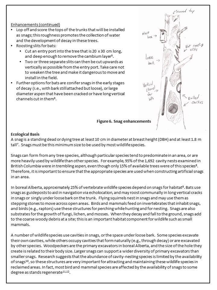
80 72

81 73
Oil Sands Reclamation From the Ground Up : A Suncor Energy Perspective
 Oil Sands Reclamation From the Ground Up : A Suncor Energy Perspective Lelaynia Cox, RPF and Cecilia Jeje, PhD College of Alberta Professional Forest Technologists April 14, 2011 Overview Oil sands mining
Chris Powter Executive Director Oil Sands Research and Information Network School of Energy and the Environment University of Alberta
 Chris Powter Executive Director Oil Sands Research and Information Network School of Energy and the Environment University of Alberta www.osrin.ualberta.ca OSRIN Creating and Sharing Knowledge 2 CRR provides
Great Lakes Conservation Blueprint for Terrestrial Biodiversity on the Canadian Shield
 Great Lakes Conservation Blueprint for Terrestrial Biodiversity on the Canadian Shield Bonnie L. Henson 1, Kara E. Brodribb 2 and John L. Riley 3 1 Ontario Ministry of Natural Resources 2,3 The Nature
Rocky Areas Project Guidance HABITAT
 Rocky Areas Project Guidance HABITAT Introduction Rocky habitats are surface areas dominated by exposed rock, such as mountain peaks, inland cliffs, buttes and rocky outcrops. In many cases, rocky areas
Land Use Regional Planning in Alberta Collaborating with Stakeholders
 Land Use Regional Planning in Alberta Collaborating with Stakeholders Trevor Lema, Land & Integrated Management Planner September 2018 Overview Why Regional Planning? An Integrated Perspective Integrated
Describing the Integrated Land Management Approach
 Describing the Integrated Land Management Approach ISBN No. 978-0-7785-8902-0 (Online Edition) Pub No. I/422 What is Integrated Land Management? Integrated land management (ILM) is the strategic, planned
A Landowner s Guide to Creating Woodland Pools for Amphibians and Other Wildlife
 Cornell Department of Natural Resources Conservation Education Program Fact Sheet Kristi L. Sullivan and Stephen J. Morreale A Landowner s Guide to Creating Woodland Pools for Amphibians and Other Wildlife
ADDENDUM TO BIOLOGICAL SCOPING SURVEY REPORT, BOTANICAL SURVEY AND WETLAND DELINEATION
 ADDENDUM TO BIOLOGICAL SCOPING SURVEY REPORT, BOTANICAL SURVEY AND WETLAND DELINEATION FOR AVALON INN (APN 069-241-27 & -04) 1201 & 1211 NORTH MAIN STREET FORT BRAGG, CA MENDOCINO COUNTY prepared for:
An Introduction to the Far North Land Use Strategy
 An Introduction to the Far North Land Use Strategy December, 2013 Ministry of Natural Resources Table of Contents PREFACE... 3 About the Far North... 3 Evolution of Land Use Planning in the Far North...
National Association of Conservation Districts. Kris Hoellen Vice President, Sustainable Programs The Conservation Fund September 19, 2013
 National Association of Conservation Districts Kris Hoellen Vice President, Sustainable Programs The Conservation Fund September 19, 2013 Our Mission The Conservation Fund forges partnerships to conserve
Road Ecology in Practice: Building Resiliency of Urban Ecosystems through Informed Road Network Planning
 Road Ecology in Practice: Building Resiliency of Urban Ecosystems through Informed Road Network Planning Outline What is road ecology? Why is road ecology important? TRCA and road ecology application Peel
Community Conservation Workshop. Saranac River Basin Communities
 Community Conservation Workshop Saranac River Basin Communities 2 Community Conservation Program Welcome! We have designed a Community Conservation Program that listens to the needs of community members.
TRCA Field Staking Protocol December 2016
 Page 1 of 6 TRCA Field Staking Protocol December 2016 This Protocol describes TRCA staff s current practice for field staking the physical top of bank, the physical toe of slope, and the limit of existing
APPENDIX 1: SCOPED ENVIRONMENTAL IMPACT STATEMENT (EIS) FORM
 FORM") APPENDIX 1: SCOPED ENVIRONMENTAL IMPACT STATEMENT (EIS) FORM This form is intended for use by applicants (primarily private landowners) who need to conduct a Scoped EIS in support of minor development
APPENDIX 1: SCOPED ENVIRONMENTAL IMPACT STATEMENT (EIS) FORM This form is intended for use by applicants (primarily private landowners) who need to conduct a Scoped EIS in support of minor development
Monitoring for Ecological Integrity and State of the Parks Reporting
 Monitoring for Ecological Integrity and State of the Parks Reporting Donald McLennan 1 and Paul Zorn 1 National Monitoring Biologist Parks Canada, Ecological Integrity Branch 25 Eddy Street Gatineau, Québec,
Community Conservation Workshop. Lake Placid
 Community Conservation Workshop Lake Placid 2 Community Conservation Program Welcome! We have designed a Community Conservation Program that listens to the needs of community members. We are conducting
7. Biodiversity & Conservation Areas
 7. & Conservation Areas 7.1. Objectives The objectives of biodiversity and conservation areas are founded on the need to recognise the importance of biodiversity and acknowledge the need to protect, restore
The scope of the plan will focus on the Prospect Heights Slough and Hillcrest Lake as one entity.
 Plan for Prospect Heights Natural Resources Commission Plan for Improved Public Access and Enjoyment of the Prospect Heights Slough and Hillcrest Lake July 23, 2018 The City Council has requested the Natural
LANDSCAPE SCALE PLANNING AND SITING FOR SHALE DEVELOPMENT
 LANDSCAPE SCALE PLANNING AND SITING FOR SHALE DEVELOPMENT An Energy by Design approach to reducing the overall environmental footprint. MICHELLE MCGREGOR SR. OIL & GAS DEVELOPMENT ADVISOR Agenda Introduction
Principles for Ecological Landscape Design in Brownfield Business Parks
 Principles for Ecological Landscape Design in Brownfield Business Parks Part of USDA Forest Service research project # 00-JV-11231300-033: Aligning Social and Ecological Drivers of Urban Landscape Change
Spencer Environmental 3.0 METHODS
 3.0 METHODS 3.1 General Methods Following is a summary of the main steps and activities employed in the preparation of this EISA. These were not necessarily sequential steps; many were iterative. We participated
General Manager of Planning, Urban Design and Sustainability
 ADMINISTRATIVE REPORT Report Date: May 2, 2017 Contact: Katherine Isaac Contact No.: 604.873.7167 RTS No.: 10847 VanRIMS No.: 08-2000-20 Meeting Date: May 16, 2017 TO: FROM: SUBJECT: Vancouver City Council
Mosaic of patches Agents of patch formation: Environmental constraints (Abiotic) Biotic processes Disturbances (natural and human induced)
 Biotic processes Disturbances (natural and human induced)") Landscape: Mosaic of patches Agents of patch formation: Environmental constraints (Abiotic) Biotic processes Disturbances (natural and human induced) Concepts for Quantification of a Landscape Landscape
Landscape: Mosaic of patches Agents of patch formation: Environmental constraints (Abiotic) Biotic processes Disturbances (natural and human induced) Concepts for Quantification of a Landscape Landscape
Cotswolds AONB Landscape Strategy and Guidelines. June 2016
 Cotswolds AONB Landscape Strategy and Guidelines June 2016 Cotswolds AONB Landscape Strategy and Guidelines Introduction The evolution of the landscape of the Cotswolds AONB is a result of the interaction
Resolution XII NOTING also that with the increasingly rapid urbanization, wetlands are being threatened in two principle ways:
 12 th Meeting of the Conference of the Parties to the Convention on Wetlands (Ramsar, Iran, 1971) Punta del Este, Uruguay, 1-9 June 2015 Resolution XII.10 Wetland City 1 Accreditation of the Ramsar Convention
I ll be talking about the Designing Sustainable Landscapes project today. This is a large integrated modeling effort our group at UMass has been
 1 I ll be talking about the Designing Sustainable Landscapes project today. This is a large integrated modeling effort our group at UMass has been working on for the past 5 years, in close collaboration
RECOMMENDED COURSE SEQUENCE
 RECOMMENDED COURSE SEQUENCE 3-Year Program First Professional Degree First Year LA 501 Studio I 3 LA 504 Studio III 3 LA 503 Studio II 3 LA 506 Studio IV 3 LA 592A & 696L Plants in the Landscape & Lab
3-2 Environmental Systems
 3-2 Environmental Systems 3.0 ENVIRONMENTAL SYSTEMS CONTENTS 3.1 GREENWAY SYSTEM 3.1.1 General Policies 3.1.2 Natural Heritage Network 3.1.3 Natural Heritage Network Enhancement Lands 3.1.4 Rouge Watershed
Landscape Ecology and Amphibians
 and Amphibians WFS 533 Wyn Miller March 26, 2009 Overview Introduction to landscape ecology Metapopulation dynamics Natural habitat fragmentation Anthropogenic habitat fragmentation landscape ecology Introduction
THE LANDSCAPE ECOLOGICAL ASSESSMENT MODEL AND ITS APPLICATIONS
 The 5 th International Conference of the International Forum on Urbanism (IFoU) 2011 National University of Singapore, Department of Architecture Global Visions: Risks and Opportunities for the Urban Planet
Section 3b: Objectives and Policies Rural Environment Updated 19 November 2010
 Page 1 of Section 3b 3b RURAL ENVIRONMENT 3b.1 Introduction The Rural Environment comprises all the land outside of the Residential, Town Centre and Industrial Environments. Most land within the District
1.0 Background. 1.1 Study Process
 1.0 Background Planning for Terwillegar Park began in 2005 with the preparation of A Vision for Terwillegar Park (Randall Conrad & Associates), a City wide public consultation and visioning exercise. The
Draft Resolution XII.10
 12 th Meeting of the Conference of the Parties to the Convention on Wetlands (Ramsar, Iran, 1971) Punta del Este, Uruguay, 1-9 June 2015 Ramsar COP12 DR10, Rev. 2 21:45, 8 June Draft Resolution XII.10
Roads and Ecological Integrity. Best Management Practices. September 2016: Version 1.1
 Roads and Ecological Integrity Best Management Practices September 2016: Introduction Most of the pressures on the ecological integrity of provincial parks can be linked to, or are made worse by roads.
ECONOMIC DEVELOPMENT DISTRICT MASTER PLAN
 ECONOMIC DEVELOPMENT DISTRICT MASTER PLAN E Orange Ave Legend for the CIT Y OF MOUNT DORA/LAKE COUNT Y County Boundary Wekiva Corridor (Proposed Alignment) Public Land and Parks Park Public CityLimits
Landscape Architecture (LARC)
") Landscape Architecture (LARC) 1 Landscape Architecture (LARC) Courses LARC 0841. Sustainable Design. 3 Credit Hours. What's the big deal about global warming and how should we respond to it? Explore the
Landscape Architecture (LARC) 1 Landscape Architecture (LARC) Courses LARC 0841. Sustainable Design. 3 Credit Hours. What's the big deal about global warming and how should we respond to it? Explore the
Evolution of Reclamation Practices in NE Alberta
 Evolution of Reclamation Practices in NE Alberta Alfred Burk Reclamation and Remediation Coordinator CAPFT Edmonton April 14, 2011 Agenda Introduction to Cenovus Energy Reclamation in the Green Zone Forestry
Conservation Corridor Planning and Green Infrastructure Themes
 Conservation Corridor Planning and Green Infrastructure Themes Prepared by the Green Infrastructure Center Inc. and the Northern Virginia Regional Commission February 22, 2011 Brief Overview Project Background
THE CORPORATION OF THE CITY OF WINDSOR Office of the City Solicitor Planning Department
 THE CORPORATION OF THE CITY OF WINDSOR Office of the City Solicitor Planning Department REPORT TO THE CITY OF WINDSOR PLANNING ADVISORY COMMITTEE DATE OF REPORT: August 19, 2010 SUBJECT: Official Plan
QUARRY REHABILITATION PLANS Specifications (version 1.3)
") For all our quarries, a rehabilitation plan must be developed from the outset. It is an integral part of the quarrying plan and provides for progressive and co-ordinated rehabilitation whenever possible.
For all our quarries, a rehabilitation plan must be developed from the outset. It is an integral part of the quarrying plan and provides for progressive and co-ordinated rehabilitation whenever possible.
systems is available on the Colorado Wetland Information Center (CWIC) website.
 website.") Colorado Natural Heritage Program Wetland Program Plan -- Dec 2015 Status Update and Addendum -- The Colorado Natural Heritage Program (CNHP) developed a Wetland Program Plan (WPP) in 2010 for the planning
Colorado Natural Heritage Program Wetland Program Plan -- Dec 2015 Status Update and Addendum -- The Colorado Natural Heritage Program (CNHP) developed a Wetland Program Plan (WPP) in 2010 for the planning
T H E I N T E R R E L A T I O N S H I P OF L A N D S C A P E E C O L O G Y & L A N D S C A P E A R C H I T E C T U R E:
 T H E I N T E R R E L A T I O N S H I P OF L A N D S C A P E E C O L O G Y & L A N D S C A P E A R C H I T E C T U R E: A P P L I C A T I O N S F O R T R E N D S I N U R B A N I Z A T I O N Prepared by
Chapter 5: Natural Resources and Environment
 NATURAL RESOURCES AND ENVIRONMENT 5-1 5 Chapter 5: Natural Resources and Environment BACKGROUND AND INTENT Urban expansion represents the greatest risk for the future degradation of existing natural areas,
Biodiversity Action Plan Background Information for discussion purposes
 Biodiversity Action Plan Background Information for discussion purposes Our commitment As directed by Council, The City of Calgary has agreed to sign the Durban Commitment, an international agreement on
PRESENTATION ON JOHANNESBURG S BIODIVERSITY PROGRAMME
 PRESENTATION ON JOHANNESBURG S BIODIVERSITY PROGRAMME Member of Mayoral Committee: Cllr Prema Naidoo Environmental Management & Johannesburg City Parks PRESENTATION OVERVIEW Jo burg Overview & Context
The Landscape Project. New Jersey Department of Environmental Protection Division of Fish and Wildlife Endangered and Nongame Species Program
 The Landscape Project New Jersey Department of Environmental Protection Division of Fish and Wildlife Endangered and Nongame Species Program New Jersey is One of the smallest states in the country Yet
2011 ASLA Design Awards
 2011 ASLA Design Awards Interstate 70 Mountain Corridor Aesthetic Guidance Honor Award Design Workshop, Aspen / THK Associates, Inc. / CH2MHill Planning and Urban Design Project Title: Interstate70 Mountain
Integrated Vegetation Management Project Guidance
 Integrated Vegetation Management Project Guidance Stakeholder Informed OTHER OPTIONS Introduction Integrated Vegetation Management (IVM) is a system of land management generally associated with infrastructure
A Network Theory Framework for Urban Cultural Heritage Conservation. Manal Ginzarly LEMA, Université de Liège
 A Network Theory Framework for Urban Cultural Heritage Conservation Manal Ginzarly LEMA, Université de Liège Objective Develop an ecological approach to the integration of heritage conservation and urban
Aim to Reclaim. Introduction
 Aim to Reclaim Introduction Welcome to Aim to Reclaim, a virtual lab that takes you inside the world of copper mining. You may remember that the mining process involves four important phases: Exploration,
Green Infrastructure Project Guidance
 OTHER OPTIONS Green Infrastructure Project Guidance Stakeholder Informed Introduction Green infrastructure is an approach to mitigating environmental challenges using vegetation, soils and natural processes
Phase I Ecological Network Report Terms of Reference
 Phase I Ecological Network Report Terms of Reference INTRODUCTION In 2007, the City of Edmonton created a new Natural Area Systems Policy (C-531) and a strategic plan, Natural Connections. Together, these
New Tools for Land Management: A Quick Introduction to Ecological Site Descriptions
 New Tools for Land : A Quick Introduction to Ecological Site Descriptions Land management agencies have the job of managing natural resources for multiple uses in a sustainable manner. A sound understanding
Supplementary Information for
 Supplementary Information for Area-based Analysis June 2018 Version 1.3 BC Oil & Gas Commission 1 About the Commission About Us The BC Oil and Gas Commission (the Commission) is the single-window regulatory
Planning Considerations for Wildlife Passage in Urban Environments. (Prepared by Tony Clevenger, PhD)
") Scope Planning Considerations for Wildlife Passage in Urban Environments. (Prepared by Tony Clevenger, PhD) As urban populations grow and expand into rural areas there are changes in land use patterns
Scope Planning Considerations for Wildlife Passage in Urban Environments. (Prepared by Tony Clevenger, PhD) As urban populations grow and expand into rural areas there are changes in land use patterns
Blue/Green Infrastructure Study Accomack County, VA
 Blue/Green Infrastructure Study Accomack County, VA Draft Asset Maps March 8-9, 2010 Green Infrastructure Center, Inc. 2 Overview What is Green and Blue Infrastructure Project Timeline & Tasks Literature
Canyon Lake Master Plan Revision Public Information Meeting March 18, 2016
 Canyon Lake Master Plan Revision Public Information Meeting March 18, 2016 Marcus Schimank Canyon Lake Manager Capital Regional Office U.S. Army Corps of Engineers Fort Worth District US Army Corps of
Minnesota Department of Natural Resource - Natural Resource Guidance Checklist Conserving Natural Resources through Density Bonuses
 Minnesota Department of Natural Resource - Natural Resource Guidance Checklist Conserving Natural Resources through Density Bonuses NRDB Why Use Density Bonuses & This Checklist Local units of government
FirstLight Power Shoreline Management Manual Sustainable Shoreline Designs: From Long Island to Lake Erie Webinar Series
 FirstLight Power Shoreline Management Manual Sustainable Shoreline Designs: From Long Island to Lake Erie Webinar Series Presented by Jason Williams, PLA, NCI February 19, 2017 Introduction Lakes (impoundments)
SUSTAINABILITY PLAN OTTAWA COUNTY PARKS AND RECREATION COMMISSION FALL 2017
 SUSTAINABILITY PLAN OTTAWA COUNTY PARKS AND RECREATION COMMISSION FALL 2017 Table of Contents Introduction Natural Resources Quality of Life Community Continuing the Mission Sustainability Measuring Sustainability
A global view of integrated closure and legacy planning
 18 September 2013 A global view of integrated closure and legacy planning Mine Closure 2013, Eden Project, Cornwall Dr. William Adams General manager, Legacy and Closure A changing business climate The
Draft Rhode Island Stormwater Design and Installation Standards Manual
 Draft Rhode Island Stormwater Design and Installation Standards Manual Summary The May 2009 Public Review Draft version of the RI Stormwater Design and Installation Standards Manual consists of approximately
Wingerworth, Chesterfield. February Surveyor: James Porter
 Report Wingerworth, Chesterfield February 2014 Surveyor: James Porter (Natural England Licence Number: CLS00241 Contents Contents Notice to readers 1.0 Introduction Background Information Site Description
PEOPLE, WATER, AND WILDLIFE: BLUE PRINCIPLES FOR RIVER DESIGN
 PEOPLE, WATER, AND WILDLIFE: BLUE PRINCIPLES FOR RIVER DESIGN Category One: People Protecting and Enhancing the Quality of Life Role of the Chicago River People and the River For many, the connection between
5. Initiating a restoration project
 5. Initiating a restoration project CONTRIBUTING TO CONSERVATION In many parts of the country, restoration planting is your last and only option for repairing or rebuilding damaged native communities so
DRAFT FOR PUBLIC REVIEW. Game Plan for a Healthy City
 DRAFT FOR PUBLIC REVIEW 2018 Game Plan for a Healthy City 2 Denveright. Parks & Recreation Game Plan Draft for Public Review Draft for Public Review Executive Summary Game Plan Overview Executive Summary
2.1 Principles & Objectives
 Designing With The Landform 2.1 Principles & Objectives Land planning which integrates the natural features of a site (i.e., designing with the landform ) into the site design is a major component of the
10.0 Open Space and Public Realm
 10.0 Open Space and Public Realm 10.0 Open Space and Public Realm The Public Open Space System is comprised of: outdoor spaces available for public use that are either publicly owned (e.g., parks and
GREEN NETWORK APPLICATIONS IN ESTONIA
 GREEN NETWORK APPLICATIONS IN ESTONIA Kalev Sepp, Tuuli Veersalu, Martk Külvik Estonian University of Life Sciences 1 WHY? BACKGROUND - POLITICAL By adopting the Pan-European Biological and Landscape Diversity
Coquitlam River Riparian Planting
 Coquitlam River Riparian Planting Year Four Year Four Report, March 2016 Prepared for: Fish and Wildlife Compensation Program Prepared by: Watershed Watch Salmon Society and the Kwikwetlem First Nation
Gather information from online resources covering the following topics:
 Assignment #1: Regional Analysis Project Site Location: Greater Boston Area What comprises a region? The many elements within a region comprise the region as a whole. Natural as well as manmade environmental
The Effects of Competition for Water and Light on the Establishment of Prairie Wildflower Seedlings
 The Effects of Competition for Water and Light on the Establishment of Prairie Wildflower Seedlings Project Description Background: Ecological restoration is the process of assisting the recovery of an
Chapter 4 - Preparation of Stormwater Site Plans
 Chapter 4 - Preparation of Stormwater Site Plans The Stormwater Site Plan is the comprehensive report containing all of the technical information and analysis necessary for the City to evaluate a proposed
Lecture: Landscape Ecology
 Borderland: Border Landscapes Across Europe 2013 Lecture: Landscape Ecology Dr Iwona Markuszewska Department of Landscape Ecology iwmark@amu.edu.pl Presentation schedule: Landscape ecology as a scientific
Policy & Procedure Effective Date: Parks Department Page of
 City of Arvada Policy & Procedure Effective Date: Parks Department Page of TITLE: City of Arvada Prairie Dog Habitat Plan APPROVAL: PURPOSE: To establish a plan for the preservation of black-tailed prairie
LANDSCAPE CHARACTER ASSESSMENT
 THE COUNTY DURHAM LANDSCAPE CHARACTER ASSESSMENT FOREWORD The landscape of County Durham is one of great contrast and diversity. From the North Pennines in the west to the Durham Coast in the east it contains
STEWARDSHIP OF LONG ISLAND SOUND S ECOLOGICAL AND RECREATIONAL RESOURCES
 STEWARDSHIP OF LONG ISLAND SOUND S ECOLOGICAL AND RECREATIONAL RESOURCES Robin Kriesberg, Save the Sound, Inc. Thomas Halavik, US Fish and Wildlife Service Coastal Program An Initiative to Identify, Protect
Lewisville Lake Master Plan Revision Public Information Meeting May 2 & 4, 2017
 Lewisville Lake Master Plan Revision Public Information Meeting May 2 & 4, 2017 Presented By Rob Jordan Lake Manager U.S. Army Corps of Engineers Fort Worth District US Army Corps of Engineers Purpose
Importance of Master Planning Marcy Colclough
 Importance of Master Planning Marcy Colclough Senior Planner Southwest Michigan Planning Commission WHERE and HOW we develop Land affects Water Quality! 43.2 Acres total 20 Homes 35.8 Acres of open space
Preface. Erie. Scranton. Allentown. Pittsburgh. Harrisburg. Philadelphia
 The Southern Alleghenies Region The Southern Alleghenies Region spans the Laurel Highlands and Allegheny Front in the west across the Appalachians to the east. It is comprised of Blair, Bedford, Cambria,
A Study on Landscape Design Paradigm from the Perspective of Visual Impact and Experience
 2017 3rd International Conference on Social Science, Management and Economics (SSME 2017) ISBN: 978-1-60595-462-2 A Study on Landscape Design Paradigm from the Perspective of Visual Impact and Experience
Arlington, Virginia is a worldclass
 EXECUTIVE S U M M A RY Arlington maintains a rich variety of stable neighborhoods, quality schools and enlightened land use policies, and received the Environmental Protection Agency s highest award for
building with nature - a new benchmark for green infrastructure
 building with nature - a new benchmark for green infrastructure Danielle Sinnett, Gemma Jerome, Sarah Burgess, Nick Smith and Roger Mortlock outline the aims, development and proposed operation of Building
Public Visioning City of Kelso Planning Commission
 Shoreline Master Program Update Public Visioning City of Kelso Planning Commission November 13, 2012 Schedule Jurisdiction Inventory Analysis Visioning Topics Process Governing Principles Structure of
Strategic Environmental Assessment Screening Report. Dublin Port Masterplan Review 2017
 Strategic Environmental Assessment Screening Report Dublin Port Masterplan Review 2017 Table of Contents 1 Introduction... 1 2 Purpose of the Masterplan... 2 3 Task 1.1 Pre-Screening Check... 5 4 Task
Cooperative Research in Water Management
 Proceedings of the 8 th International Conference on Applied Informatics Eger, Hungary, January 27 30, 2010. Vol. 1. pp. 273 281. Cooperative Research in Water Management Margit Horosz-Gulyás, Katalin Katonáné
Bangor - Sustainable post industrial land restoration and re-creation of high biodiversity habitats LIFE99 ENV/UK/000211
 Bangor - Sustainable post industrial land restoration and re-creation of high biodiversity habitats LIFE99 ENV/UK/000211 Project description Environmental issues Beneficiaries Administrative data Read
2011 ASLA Design Awards. Coyote Gulch Honor Award and Land Stewardship Designation Valerian LLC. Environmental Restoration and Reclamation
 2011 ASLA Design Awards Honor Award and Land Stewardship Designation Valerian LLC Environmental Restoration and Reclamation Project Name: Category : Project Location: 5 2011 Environmental Restoration and
Township of Adjala-Tosorontio Official Plan Review. Natural Heritage
 Township of Adjala-Tosorontio Official Plan Review 13 Natural Heritage Introduction What is an Official Plan? An official plan is a municipal policy document which sets out the community s vision and strategies
Nothing lasts forever planning for successful mine closure
 Nothing lasts forever planning for successful mine closure Tommi Kauppila, Geological Survey of Finland All mines eventually close All mines have a finite life-of-mine (LOM): Eight years for a typical
TOWN OF BRUDERHEIM Report to the capital region board
 TOWN OF BRUDERHEIM Report to the capital region board Introduction to the Town of Bruderheim Municipal Development Plan amendment and Relation to the CRB Evaluation Criteria 02 march 2017 1 Introduction
A Master Plan for High Park s Hillside Garden and other Ornamental Gardens: Recommendations from the High Park Natural Environment Committee
 www.highparknature.org mail@highparknature.org A Master Plan for High Park s Hillside Garden and other Ornamental Gardens: Recommendations from the High Park Natural Environment Committee September 2015
TERRESTRIAL NATURAL HERITAGE SYSTEM STRATEGY APPENDIX F: MODEL POLICIES FOR THE IMPLEMENTATION OF THE TARGET TERRESTRIAL NATURAL HERITAGE SYSTEM
 TERRESTRIAL NATURAL HERITAGE SYSTEM STRATEGY APPENDIX F: MODEL POLICIES FOR THE IMPLEMENTATION OF THE TARGET TERRESTRIAL NATURAL HERITAGE SYSTEM C H A P T E R 1 M O D E L P O L I C I E S F O R I M P L
Running head: LAND USE CHANGE IN EDMONTON Land Use Change in Edmonton Chelsey-Ann Cu GEOB 479 L2A
 Running head: LAND USE CHANGE IN EDMONTON 1966-1976 1 Land Use Change in Edmonton 1966-1976 Chelsey-Ann Cu 32482135 GEOB 479 L2A University of British Columbia Dr. Brian Klinkenberg 26 January 2018 LAND
City of Surrey Ecosystem Management Study. Integration of ecological processes with land use
 City of Surrey Ecosystem Management Study Integration of ecological processes with land use Natural areas in Surrey are changing as the City grows and evolves. Many important natural areas remain or may
Monitoring and evaluation of the restoration of a highly
 Monitoring and evaluation of the restoration of a highly degraded remnant of the endangered ecological community Eastern Suburbs Banksia Scrub: Potential lessons for how monitoring can guide a restoration
Joe Pool Lake Master Plan Revision Public Information Meeting May 23, 2017
 Joe Pool Lake Master Plan Revision Public Information Meeting May 23, 2017 Presented By Jason Owen Lake Manager U.S. Army Corps of Engineers Fort Worth District US Army Corps of Engineers Purpose of this
Central Lake Ontario Conservation Conservation Lands Master Plan
 Conservation Lands Master Plan Top 13 Frequently Asked Questions 1. What are conservation lands? Where are these conservation lands located in the Central Lake Ontario Conservation watershed? Conservation
GIS to Estimate Archaeological Site Loss and Develop Conservation Strategies
 GIS to Estimate Archaeological Site Loss and Develop Conservation Strategies Terry Jackson Office of Decision Support Systems Planning and Environmental Management Division Georgia Department of Community
Biodiversity and Urban Streets
 Biodiversity and Urban Streets Urban Street Design for Engineers CPD Session 3 Constituent Elements Engineers Ireland Maryann Harris BSLA MSc Dip Law Past-President, Irish Landscape Institute Parks Services