ACKNOWLEDGMENT. Regional Comprehensive Plan Advisory Committee
|
|
|
- Rachel Gilmore
- 6 years ago
- Views:
Transcription


1
2 ACKNOWLEDGMENT The Regional Comprehensive Plan for the Towns of Aurora, Elma, Holland and Wales and the Village of East Aurora was made possible through the efforts of: Regional Comprehensive Plan Advisory Committee Kim LaMarche, Village Administrator, Village of East Aurora Daniel R. Castle, Village of East Aurora Planning Commission Carol Smith, Village of East Aurora Planning Commission Thomas E. Cotton, Supervisor, Town of Aurora William S. Adams, Town of Aurora Planning Board John F. Dudek, Supervisor, Town of Elma Frederick M. Streif, Town of Elma Planning Board James A. Wyzykiewicz, Town of Elma Engineer Gordon B. Hessel, Jr., Supervisor, Town of Holland James L. Joyce, Councilman, Town of Holland Keith E. Schuessler, Town of Holland Planning Board Mary A. Weinman, Supervisor, Town of Wales Charles W. Lynch, Chairman of the Town of Wales Planning Board William A. Held, Town of Wales Planning Board Other Contributors Dale J. Morris, Erie County Department of Planning and Environment Patrick Richey, Former Village Administrator for the Village of East Aurora Audrey B. Murdoch, Former Supervisor for the Town of Elma Donald W. Owens, Town of Aurora Planning Board James H. Hewitt, Jr., Holland Planning Board Erie County Soil & Water Conservation District Erie County Water Authority (Map Data) Project Consultant Wendy E. Weber Salvati, AICP, Wendel Duchscherer Andrew C. Reilly, P.E., AICP, Wendel Duchscherer And the Citizens of the Towns of Aurora, Elma, Holland Wales and the Village of East Aurora
3 Table of Contents Acknowledgement 1.0 Executive Summary Goals and Objectives Public Input Existing Conditions Findings and Recommendations Implementation Environmental Review Annual Review Introduction 2.1 Regional and Local Setting Previous Comprehensive Planning Endeavors Reasons for Preparing a Regional Comprehensive Plan How the Plan Will be Utilized Goals and Objectives 3.1 Regional Goals and Objectives Town of Aurora Town of Elma Town of Holland Town of Wales Village of East Aurora Public Input Existing Conditions of the Communities in the Region 4.1 Existing Land Use Regional Overview Community Land Use Farmland and Agriculture Land Use Regulation Zoning Subdivision Regulations Local Regulations Natural Environment Topography and Steep Slopes Bedrock, Soils and Surficial Geology Stream Corridors and Watersheds Flooding and Erosion Wetlands, Wildlife and Significant Wildlife Habitats Scenic Resources Environmental Hazards
4 4.4 Demographics and Socioeconomic Conditions Existing Population and Projections Household Characteristics Age Distribution Employment Statistics Income Housing Characteristics Economic Development Regional Overview Towns and Village Transportation Roadways and Highway Access Highway Capacity / Safety Railroad Service Public Transportation Services Pedestrian and Bicycle Routes Utilities Water Supply Wastewater Disposal Stormwater Disposal Solid Waste Management Electric and Natural Gas Service Community Facilities Parks and Recreation Schools Emergency Services Government Facilities Historic and Archaeological Resources Findings and Recommendations 5.1 Introduction Generalized Findings Regional Perspective Summarized Regional Goals and Objectives Regional Needs and Desires and the County Guiding Principles Regional Assets and Constraints Summarized Needs/Desires of Communities Individual Communities - Opportunities/Constraints/Conclusions Zoning Issues of the Communities Preserving Community Character Regional Recommendations Town of Aurora Town of Elma Town of Holland Town of Wales Village of East Aurora
5 5.4 Management of Future Growth and Development Regional Recommendations Town of Aurora Town of Elma Town of Holland Town of Wales Village of East Aurora Provisions for Economic Development Regional Recommendations Town of Aurora Town of Elma Town of Holland Town of Wales Village of East Aurora Transportation System Management Regional Recommendations Protection of Significant Environmental Resources Regional Recommendations Recreational Opportunities Regional Recommendations Town of Aurora and Village of East Aurora Town of Elma Town of Holland Town of Wales Vision Plan Regional Vision Town of Aurora Town of Elma Town of Holland Town of Wales Village of East Aurora Community Vision Town of Aurora Town of Elma Town of Holland Town of Wales Village of East Aurora Implementation 6.1 Introduction Utilization of This Section Town of Aurora Town of Elma Town of Holland Town of Wales Village of East Aurora
6 7.0 Environmental Review 7.1 Potential Significant Adverse Environmental Impacts Adverse Environmental Impacts that Cannot be Avoided Growth Inducing Aspects of the Regional Comprehensive Plan Mitigation Measures Evaluation of Alternatives Annual Review Glossary Final Generic Environmental Impact Statement (printed under separate cover) Appendices (printed under separate cover) Publicity / Public Meeting Minutes (available at Town and Village Halls) List of Community Groups Contacted for Public Outreach Public Survey Results Recent NYSDOT Traffic Count Data Snowmobile Trails Maps East Aurora Streetscape Plan Rural Development Guidelines Hamlet Development Guidelines Sample Architectural Design Guidelines Traditional Neighborhood Development (TND) District - Definition Example - Traditional Neighborhood Design (TND) District Sample Zoning Overlay Districts - Creekside Open Space Overlay and Roadway Overlay Sample Planned Unit Development (PUD) Ordinance
7 LIST OF FIGURES Town of Aurora: Zoning Districts and Permitted Uses Town of Elma: Zoning Districts and Permitted Uses Town of Holland: Zoning Districts and Permitted Uses Town of Wales: Zoning Districts and Permitted Uses Village of East Aurora: Zoning Districts and Permitted Uses Residential Bulk Regulations General Soil Types Areas of Localized Flooding Population Trends Future Population Trends Household Trends Average Household Size Population Aged 18 Years and Younger Population Aged 65 Years and Older Total Employment (Community-based) Employment by Sector, 1990 (Community-based) Labor Force Participation Rates and Unemployment Labor Force Participation Rates, by Sex Income, Housing Occupancy, Tenure Patterns, Housing Stock Characteristics, Average Home Sales, Residential Building Permits Issued, Parks and Recreational Facilities: Town of Aurora & Village of East Aurora Recreational Programs: Town of Aurora Department of Parks &Recreation Parks and Recreational Facilities: Town of Elma Recreational Programs: Tri-Town & EMW in Elma Parks and Recreational Facilities: Town of Holland Parks and Recreational Facilities: Town of Wales School Districts, Total Enrollment by District Fire Companies Municipal Facilities Museums Historical Structures: Town of Aurora Historical Structures: Village of East Aurora Historical Structures: Town of Elma Historical Structures: Town of Holland Historical Structures: Town of Wales
8 LIST OF MAPS Following Page Map 1: Existing Land Use Map 2: Agricultural Districts Map 3: Agricultural Properties Map 4: USDA Prime Soils Map 5: Generalized Zoning Map 6: Steep Slopes Map 7: Bedrock Geology Map 8: Surficial Geology Map 9: Hydric Soils Map 10: Environmental Constraints Map 11: Streambank Erosion Map 12: Water Quality Map 13: Wetlands and Habitats Map 14: Rural Service Centers Map 15: Commercial and Industrial Land Uses Map 16: Transportation Map 17: Community Linkages Map 18: School Districts Map 19: Historic Sites Map 20: Vision Map Regional Map 21: Vision Map Town of Aurora Map 22: Vision Map Town of Elma Map 23 Vision Map Town of Holland Map 24: Vision Map Holland Hamlet Map 25: Vision Map Town of Wales Map 26: Vision Map Village of East Aurora
9 Section 1 Executive Summary
10 Section 1.0 Executive Summary This report is a Regional Comprehensive Plan for the Towns of Aurora, Elma, Holland and Wales, and the Village of East Aurora. This project was funded by Erie County as part of a larger program of encouraging communities to work in a regional or cooperative manner to identify joint opportunities and resolve joint concerns. These five communities have recognized the importance of such cooperation and have joined together to devise common solutions to achieve their goals and objectives. This Plan is designed to be consistent with the Guiding Principles for Countywide Land Use Planning that were developed by the Erie County Department of Planning and Development. The intent of the Regional Comprehensive Plan is to provide a regional planning document for the five communities. The Plan will be individually adopted by each municipality, and it will be the responsibility of the municipalities to act upon and implement the items pertaining to their respective communities. However, it is hoped that in implementing the Regional Comprehensive Plan, the communities will continue to work together, especially on those actions determined to have a cross-border influence or regional significance. 1.1 Goals and Objectives The Goals and Objectives section of the document represents the broad, general values that should guide future land use decisions in the region and in each municipality. These goals were strongly influenced by the comments gathered from residents and others during various public meetings and other means of eliciting public input throughout the planning process. Direction was also provided by the County's Guiding Principles for Countywide Land Use Planning. The goals and objectives were reviewed by the Regional Comprehensive Plan Advisory Committee and have received their approval. They represent the consensus of the community on the values and vision that will guide future land use decisions throughout the region and in the local communities. The major, overall goals are listed here. Section 3 of this document provides additional objectives and sub-goals under each of these major goals for the region and for each municipality. These more detailed objectives help provide further guidance as to how to achieve the vision articulated in the major goals. Regional Goals and Objectives Encourage a regional approach to development and planning in the regional plan area Maintain community character Enhance the economic climate of the region Protect and preserve natural resources Provide and improve recreational opportunities and parks Enhance the existing transportation system to improve regional access Ensure an appropriate and quality housing stock Provide clean, potable water to the residents of the region in an economical manner and in a manner that does not encourage sprawl Town of Aurora Preserve community character Properly manage future growth and development Preserve and promote recreational opportunities Provide for economic development Protect environmental resources Maintain and enhance the existing transportation system Town of Elma Preserve the rural community character Encourage orderly growth and development 1-1
11 Section 1.0 Executive Summary Preserve and promote recreational opportunities Provide for economic development Protect significant environmental resources Minimize the loss of remaining prime farmland soils to development. Provide a safe and efficient transportation system Town of Holland Preserve community character Properly manage growth and development Promote increased and diverse economic activity Improve opportunities for recreation Properly manage traffic and transportation Preserve and protect significant environmental resources Town of Wales Maintain the rural character of the community Properly manage future growth and development Provide for and encourage limited increases of economic activity in a rural setting Encourage opportunities for recreation Properly manage traffic and transportation Preserve and protect significant environmental resources Village of East Aurora Preserve traditional neighborhood character of the Village Properly manage future growth and development Encourage investment and economic development Provide a safe and efficient transportation network 1.2 Public Input The five communities involved in the Regional Comprehensive Plan are committed to the idea that a critical element of the planning process is effective public participation. From its inception, this Regional Comprehensive Plan was prepared with extensive public input. A variety of avenues were utilized to solicit input, including public information meetings, comment forms for written comments, hands-on design workshops (charrettes), two public opinion surveys, individual meetings with community interest groups and government officials, an internet website, and press releases. In addition, the entire process was closely overseen by an Advisory Committee, made up of representatives from each of the participating communities, who met on a regular basis to provide guidance and insight into the planning process and to ensure that the concerns of each community were being effectively addressed. 1.3 Existing Conditions Section 4 of the document summarizes existing conditions in each of the five communities of the region. It contains information about the various features that influence the lives of the residents of the area. The content of each subsection is as follows: Existing land use - this section of the document outlines how development has occurred throughout the region. It starts with a regional overview of the broad historic land use patterns (early settlement through suburbanization) and then discusses specific land use patterns for agricultural, recreational, residential, commercial and industrial uses in each individual community. Because farming has traditionally been an important component of land use in southern Erie County, the section concludes with a discussion of farmland and agriculture in the region. 1-2
12 Section 1.0 Executive Summary Land Use Regulations - this section summarizes the land use controls governing how land may legally be developed in each municipality. It describes the various zoning districts and the types of uses allowed in each district. It summarizes subdivision regulations controlling how land is divided into smaller parcels in each community. A subsection on local regulations describes the site plan review process for each municipality, and refers to any other regulations which may affect land development. Natural Environment - this section provides information about the environment where the communities are located. It describes the region s topography, and geological features (bedrock, soils and surficial geology). Features of the region s four major watersheds (Buffalo Creek, Cayuga Creek, Cazenovia Creek-Buffalo River and Smokes Creek) are discussed, including the major streams, characteristics of the lands in each watershed, areas of streambank erosion and water quality. Floodplains, wetlands, wildlife and significant habitats are identified, as are areas with significant scenic resources. This latter category includes important views (landscape), architectural resources (important buildings) and important scenic natural resources, such as the streams and falls located throughout the region. The final subsection on the environment identifies the two environmental hazards (inactive hazardous waste sites) in the region. Demographics and Socioeconomic Factors - this section describes the human resources of the region. It provides information about population trends, the age characteristics of area residents, and statistics on employment and income. It also provides an overview of the housing stock of the region, including number of units, vacancy rate, owner vs. renter, and the average sales prices of single-family homes by municipality. Economic Development - this section is a discussion about the economic life of the region. It provides an overview of broader regional influences on the area s economy, and a discussion of commercial and industrial activity in each community. Transportation - this section describes the transportation network serving the communities of the region, including roadways, highway capacity (areas of congestion or high accident rates), railroads, public transportation and pedestrian and bicycle routes. Public Utilities - this section provides information about the region s infrastructure, including water (public water supply and wells), wastewater disposal (sewers and septic), stormwater disposal, solid waste management (garbage collection and recycling), and electric and natural gas service. Community Facilities - this section identifies the community facilities available for the use of the residents of the region. These include area parks and recreational facilities, emergency services (police, fire and health care), governmental facilities (municipal buildings, libraries, and museums) and historic and archeological resources (historic buildings and important archeological sites). There is also a discussion about the three major school districts serving the region. 1.4 Findings and Recommendations The findings and recommendations section (Section 5) of this report represents the results of the planning process, and is the culmination of the analysis of existing conditions, public input, and the opportunities and constraints affecting the region and its communities. An introductory discussion (Generalized Findings) provides an overview of the major issues affecting the region and its communities. These include growth pressures, downtown preservation/economic development, rural character/environmental protection, traffic issues, farmland protection, stream corridor preservation, and watershed protection. This subsection also provides a listing of specific issues, concerns and factors affecting opportunities for each individual community. It concludes with a discussion of zoning issues affecting the communities. The remaining discussion is organized around the major goals of the plan. For each category, the report includes specific recommendations from a regional perspective, and for each individual community. The major points are highlighted here: 1-3
13 Section 1.0 Executive Summary Preserving Community Character - all five communities desire to preserve their unique rural character, although the nature of what this entails is different for each municipality. Elements of rural character include open space, active farmland, and scenic features (important views, such as the streams). Measures to protect these features are recommended. Management of Future Growth and Development - In order to preserve rural character, the communities must carefully manage future growth. The communities should consider establishing and adopting rural development standards to guide future development. These standards would be based on common ideals, but tailored to fit the individual needs of each municipality. These standards should be strictly enforced in areas, such as important agricultural lands, where growth should be controlled. Growth should be encouraged in and around the Village and the hamlets of the region, and discouraged where there are important environmental features, open space, views, or farmlands. Implementation actions, zonings and infrastructure improvements in any one community should be coordinated with adjacent communities. Ideally, the five municipalities will establish a regional comprehensive plan implementation committee to monitor future planning actions and provide continuing input and updates into the regional plan. Issues to be addressed jointly include stream corridor preservation and the creation of linkages between important open space and recreational features. Provisions for Economic Development - Economic development is needed to provide diverse job opportunities, provide needed services to residents, and balance the tax base, but the level of economic development appropriate for each community varies. In general, economic development efforts should be focused primarily on existing concentrations, such as the Village and hamlet commercial districts, and the existing industrial areas of Elma and, at a smaller scale, Holland. Infill, expansions and redevelopment are preferred, and business development, whether retail, commercial or industrial, should occur where there is sufficient infrastructure to support it. Tourism has the potential to provide job growth, building upon each community s assets (heritage tourism in East Aurora; outdoors recreation in Holland, etc.) but should be carefully planned to avoid negative impacts (congestion, etc.). Agriculture, forestry and associated support services should be recognized as important components of the region s economy. Transportation System Management - The region is heavily automobile-dependent. The five communities should cooperate on planning future traffic issues, including traffic volumes, access management, problem intersections, the Route 400 interchange configurations and related issues. A regional approach is more likely to result in effective solutions. Development proposals should be considered in regard to their potential impact on traffic. It should be a policy to encourage compact development and discourage sprawl. Industrial users generating truck traffic should be located within easy access to Route 400 to minimize the impacts of truck traffic in the region. There should be a greater emphasis on walking and biking, to encourage a more multi-modal transportation system in the region, with sidewalks in areas of denser development, such as the Village, and bike paths and trails connecting important community assets and facilities. Rail transportation is an important asset to economic development efforts. Existing rail service in the region should be protected, and rail corridors reserved for transportation uses wherever feasible. Public transportation is extremely limited creative alternative approaches, such as jitneys and/or paratransit, should be explored to increase opportunities. Protection of Significant Environmental Resources - The region contains a variety of environmental features: watersheds, creeks, wetlands, steep slopes, floodplains, woodlands and important habitats. The communities, particularly Aurora and Elma, should prepare open space plans to identify and prioritize important environmental features. Priority should be given to the major creek corridors. The creeks contribute to the rural character of the area, provide open space corridors for wildlife, and are connective features linking the region. The Towns should consider implementing site clearance standards, wetland protection regulations and erosion and sediment control measures. Water quality is a critical issue, especially since many areas of the region are 1-4
14 Section 1.0 Executive Summary dependent upon groundwater resources for potable water. Best management practices, stronger drainage requirements, and public education about proper maintenance of on-site sanitary waste disposal systems should be supported. The density of new development in areas without sewers should be dependent upon the ability of the site to support it (percolation testing). Recreational Opportunities - Recreation is an area where there is already a significant amount of multi-jurisdictional cooperation. Even greater coordination and cooperation, including the school districts and private facilities, is recommended, particularly for recreational needs with a regional basis, such as ice skating. Use of recreational facilities and open space should be compatible with the capacity of the resource, with more active uses designated for lands that can accommodate the usage. Overcrowding should be avoided. The municipalities should consider designating important parks and open space as Critical Environmental Areas (CEA s) under the provisions of the State Environmental Quality Review Act. There should be more trails and greenways connecting important features, such as parks, schools and activity centers to make access convenient for bicyclists and pedestrians. There should also be increased public access to the creeks in a manner compatible with the specific site. Vision Plan - The Vision Plan is a visual representation of the goals, objectives and recommendations for the region, based on the existing conditions, issues and constraints as identified through the planning process. The maps (region and individual communities) are not future land use maps or zoning maps. They are tools designed for use with the Comprehensive Plan to guide public decision-making. In general terms, the Vision Maps recommend the protection of streams from development pressures and their use for public recreation and open space where practical. Planning across jurisdictional boundaries should provide for a smooth transition between communities and the avoidance of land use conflicts. Open space preservation and natural resource protection are favored, as is regional cooperation on public services. Connective linkages should be strengthened throughout the region, particularly for recreational activities, connecting public parks and other public facilities. 1.5 Implementation The implementation section (Section 6) provides a strategy for how to implement the recommendations of the report, with a prioritized step-by-step approach for each community to accomplish its goals. Priority 1 Actions are those tasks that should be completed in the immediate term (one to two years). The initial emphasis should be on these Priority 1 Actions. Priority 2 Actions have a five-year time frame. For each jurisdiction, the Priority 1 and 2 Actions have been organized into four categories: Zoning; Other Codes and Regulations; Cooperative Actions; and Other Actions. The first two categories are self-explanatory the actions pertain to either zoning issues or other governmental regulations (e.g. site plan control, subdivision regulations). Cooperative Actions are actions that require intermunicipal cooperation, either with other regional planning communities, the County or some other agency. The final category contains all other types of actions to be undertaken by the community. The Implementation Plan also assigns primary responsibility for each action to a specific entity (e.g. Planning Board, committee, etc.), and provides an estimate of probable costs, and potential funding sources. The report also lists Priority 3 Actions items. These include long-term activities, optional additional recommendations, or actions that may or may not be necessary, depending upon future scenarios. Priority 3 Actions items can be considered Tool Box actions a list of alternative ideas to consider if Priority 1 or 2 Actions do not yield the desired results. This section also includes activities that may not have a strong priority, but which would enhance the community if the opportunity were presented. 1-5
15 Section 1.0 Executive Summary 1.6 Environmental Review Section 7 of the report is designed to assist with the environmental review for the document. It constitutes an assessment of potential environmental impacts deriving from the plan document itself. All development actions taking place after the adoption of the plan will be subject to the State Environmental Quality Review process on a site specific basis, but this section of the report will facilitate future assessment of planned development actions. The section also outlines recommended mitigation measures. It is determined that the plan is preferable to the No Action alternative. With the plan in place, the communities will be able to properly manage growth and development in the future and provide greater protection to the environment. 1.7 Annual Review To ensure the continued relevance of the Regional Comprehensive Plan, the five partnering communities need to establish a regular review of the document. It is through this process that the plan remains a dynamic and useful document. The annual review is also important to assess the accomplishments of the communities, individually and in partnership, toward implementing their goals and objectives as outlined in the Plan. This section of the report details the process and content of the Annual Review. All major site plan, subdivision approvals, and rezonings should be reviewed for consistency with the Regional Comprehensive Plan. Progress toward achieving the Priority Action items should be tracked and evaluated. The validity of the list of priority items should also be verified and updated, as needed. A statement regarding the accomplishments of the past year in each community, including joint efforts, should be provided to the Town and Village Boards for their review and approval. By utilizing this strategy on an annual basis, the communities will be able to keep the implementation process on track and make minor adjustments to the implementation plan. A more extensive review and formal re-adoption process is recommended every five years to ensure the continued relevancy of the Plan. 1-6
16 Section 2 Introduction
17 Section 2.0 Introduction This report is a Regional Comprehensive Plan for the Towns of Aurora, Elma, Holland and Wales, and the Village of East Aurora. This project was funded by Erie County as part of a larger program of encouraging communities to work in a regional or cooperative manner to identify joint opportunities and resolve joint concerns. These five communities have recognized the importance of such cooperation and have joined together to devise common solutions to achieve their goals and objectives. This Plan has been developed to be consistent with the County's Guiding Principles for Countywide Land Use Planning. 2.1 Regional and Local Setting The Towns of Aurora, Elma, Holland and Wales and the Village of East Aurora are located in southeastern Erie County (see Map). Holland, the most southerly community, is approximately 25 miles southeast of downtown Buffalo. The Town of Elma, the most northerly community, is approximately 15 miles from downtown Buffalo. The 2000 population of the region was 31,863 persons, with Elma comprising the most populous community with 11,304 persons. The Town of Aurora, including the Village of East Aurora with 6,673 persons, has a total population of 13,996 persons. Holland and Wales have 3,603 and 2,960 persons, respectively. Overall, the population of the region increased by 5.2 percent since 1990, with the majority of this growth occurring in Elma and Aurora. The study area is predominately rural in nature. Farming, once the predominant land use in the region, is slowly giving way to open land and rural residential growth. The Village of East Aurora functions as the primary rural service center for the region, with its influence extending into additional communities, such as Marilla and Colden, which are not included as part of the regional study area for this report. The hamlet of Holland also serves as an important retail, commercial and community center, and has also been designated a rural service center of Countywide significance by Erie County. 2.2 Previous Comprehensive Planning Endeavors Each of the five communities has undergone a previous comprehensive planning process, but in most cases, the effort occurred decades ago. The most recently prepared comprehensive plan in the region is the Town of Holland s Master Plan Update, prepared by Erie County s Department of Environment and Planning, and adopted in This project was an update of the 1972 Town of Holland Master Plan. The Towns of Aurora and Wales, and the Village of East Aurora had Comprehensive Plans prepared under the Urban Planning Assistance Program of the U.S. Department of Housing and Urban Development. For Wales and East Aurora, these plans were prepared in 1970, but never adopted. The Town of Aurora s Plan was prepared in 1980 (Basic Studies) and 1981 (Comprehensive Plan and Implementation Plan). The Town of Elma completed Comprehensive Plans in 1965 and 1983, and updated the Plan in Reasons for Preparing a Regional Comprehensive Plan It is important for each community to have an effective Comprehensive Plan to guide future growth and development. New York State Law indicates that Town and Village planning, zoning, capital budgeting and other decisions should be based on a current comprehensive plan that represents the community s vision for its future. The goal of the Regional Comprehensive Plan is to develop recommendations for future development in the Village and Towns, while recognizing each community's unique assets and considering impacts upon surrounding Towns. This Plan is intended to serve as a framework within which each community will be able to evaluate future land use and development issues. It examines the environmental, demographic, physical and development aspects of each community, and the regulatory setting guiding these factors. It addresses the issues and concerns specific to each community, based on citizen input from local residents through a variety of forums. The goals and objectives, recommendations and 2-1
18 Section 2.0 Introduction implementation steps included in this Plan are designed to address each community s individual concerns, and reflect its unique and distinctive vision for its future. At the same time, however, it is clear that the five communities share many of the same goals, and face many of the same challenges and opportunities. In particular, it became clear that many issues couldn't be adequately addressed from a purely local perspective. They cut across jurisdictional boundaries, and are best approached on an inter-municipal or regional basis. Therefore, this Plan identifies overarching regional issues and opportunities in all five communities and articulates goals, makes recommendations and suggests implementation items that apply to more than one municipality. Goals and objectives were developed for the region as well as the individual communities, and many of the recommendations and issues addressed in this Plan are specific to two or more municipalities; others are for the region as a whole. It is the intent of this plan that it be adopted, not solely as an aggregation of five individual comprehensive plans, but also as a true regional plan, with common principles agreed to by all. Once adopted by the five communities, the Plan will become a blueprint for the region's growth into the 21 st Century. 2.4 How the Plan Will be Utilized In accordance with Section 272-a of Town and Section of Village law, Town's and Village's have the power to undertake Comprehensive Planning and to adopt a plan to help promote the health, safety and general welfare of the Town or Village and to give due consideration to the needs of the people of the region of which the Town or Village is a part. By law, (Sections 272-a and 7-722) the adoption of a Comprehensive Plan has the following effect: a. All Town or Village land use regulations must be in accordance with a comprehensive plan adopted pursuant to 272-a.11.(a) or (a). b. All plans for capital projects of another government agency on land included in the Town or Village comprehensive plan, adopted pursuant to Section 272-a or 7-722, shall take such plan into consideration. Once adopted, the Town or Village would begin to implement the plan by amending its land use regulations to conform to the comprehensive plan, and consider the plan in all of its land use decisions (site plans, subdivisions, and rezonings). Yearly, the community would utilize the plan in determining its capital project plan and in helping to determine what projects and other implementation actions should be undertaken in the following year. Copies of the adopted Regional Comprehensive Plan must be filed with County and State agencies, and would be utilized by those agencies in planning projects and actions that could affect the planning community. Section 284 of Town law and of Village law allows communities to perform inter-municipal cooperation in comprehensive planning. Pursuant to these sections, the Towns of Aurora, Elma, Holland and Wales, and the Village of East Aurora completed this Regional Comprehensive Plan. The joint completion of this plan has promoted an intergovernmental partnership, resulting in increased cooperation and effectiveness of comprehensive planning and land use regulation, more efficient use of infrastructure and municipal revenues, as well as enhanced protection of community resources, especially where such resources spanned municipal boundaries. 2-2
19 Section 2.0 Introduction The purpose of the intergovernmental agreement was to complete a joint comprehensive plan, but per 284-4(c) of Town law and (c) of Village law, the plan will be adopted independently by each partnering community. There is no regional entity governing its adoption, and no individual community has any additional powers over any of the other communities. The agreement between the five communities ends at the completion of this comprehensive planning process. However, it is hoped that in implementing the Regional Comprehensive Plan the communities will continue to work together, especially on those actions determined to have a cross-border influence or regional significance. Future agreements would cover forthcoming projects and, possibly in the future, a more permanent cooperative planning agreement could be put in place in the region. Comprehensive Planning is a continuous process, and the comprehensive plans completed for the Town's of Aurora and Wales, and the Village of East Aurora in the 1970's and 1980's should be used as references associated with this plan. The Town of Elma Comprehensive Plan update of 1994 should also be referenced when utilizing this plan. As for the Town of Holland, their 1994 adopted plan is not being replaced by this plan, but will be a companion plan with this regional comprehensive plan. 2-3
20 Section 3 Goals and Objectives
21 Section 3.0 Goals and Objectives The purpose of taking a regional approach to planning on the part of the participating communities is to recognize that the region shares various natural resources, services and public infrastructure. Furthermore, preserving and enhancing the quality of life in the region requires a concerted effort to achieve agreed upon regional goals and objectives. The comments gathered at the public information meetings and workshops indicate that residents from the different communities share the same vision for the future of the region. Concerns about community character, infrastructure, open space and agricultural preservation, recreation, and economic development were mentioned in each community. Members of special interest groups voiced similar concerns. These comments are considered to be important with regard to developing measures for effectively managing future growth and development in the region. The following regional goals and objectives, as well as the subsequent goals and objectives prepared for the individual communities, were strongly influenced by the comments gathered from residents at the public meetings and from interest groups throughout the partnering communities, with direction provided by the Guiding Principles for Countywide Land Use Planning that were developed by the Erie County Department of Planning and Development. These goals and objectives have been reviewed by the Regional Comprehensive Plan Advisory Committee and shaped into a form that will guide future land use decisions throughout the region and in the local communities. 3.1 Regional Goals and Objectives Encourage a regional approach to development and planning in the regional plan area Promote intermunicipal cooperation and coordination among the five regional plan communities, and with Erie County. Investigate areas where shared services and/or costs between two or more communities are appropriate, and encourage joint efforts in these areas. Provide for coordination of economic development efforts within the region. Provide for a coordinated approach toward recreational opportunities and open space preservation in the region. Encourage greater collaboration and coordination of efforts among the municipalities and the school districts in the region. Create a regional system of natural stream corridors and open space. Encourage physical linkages, such as bike paths and pedestrian walkways between communities to link important regional assets such as parks and community services. Encourage cooperation between communities for the provision of necessary infrastructure. Provide for a coordinated approach toward development near municipal boundaries to minimize potential conflicts between new development and existing uses. Maintain community character Ensure new development is compatible with existing development within the communities. Manage growth in the region to ensure development occurs at an appropriate scale and pace, and in locations suitable for the type of development. Enhance the visual appearance of the region for residents and tourists. Provide scenic corridors to enhance property values and the rural character of the region. Protect important agricultural lands and open space. Protect important viewsheds, mature vegetation and other natural resources contributing to the rural character of the area. Maintain the existing high quality of life in the region. Preserve and protect important cultural and historic resources. 3-1
22 Section 3.0 Goals and Objectives Enhance the economic climate of the region Provide diverse job opportunities throughout the region. Support the existing economic base of the area and the expansion of existing businesses. Target new commercial and industrial growth for areas that can provide necessary public infrastructure. Promote the establishment and growth of new business enterprises. Encourage the adaptive reuse of existing structures. Strive to compete with outlying regions by working together to improve utility rates and other constraining factors. Protect and preserve natural resources Promote the use of storm water management techniques to minimize the impacts of non-point source pollution on surface water resources. Protect the quality and quantity of surface and groundwater resources, particularly through the employment of watershed management measures. Preserve natural habitats and open space corridors for wildlife preservation. Manage development throughout the region to provide and maintain corridors for wildlife to allow for continuity of habitat. Provide and improve recreational opportunities and parks Preserve and enhance existing parks and recreation facilities that serve the region. Investigate opportunities for expanding existing facilities, and where appropriate, acquire additional parkland or facilities that meet regional needs. Provide connections between recreational facilities in the region to enhance and increase opportunities for recreation. Improve public access to regional creek corridors. Encourage cooperation and coordination of recreational facilities and programming among the municipalities and school districts in the region. Enhance the existing transportation system to improve regional access Strive to better accommodate the regional needs of pedestrians, bicyclists and other non-vehicular modes of travel. Minimize automobile and pedestrian conflicts in the more densely developed areas of the region. Promote and ensure traffic safety and proper roadway maintenance throughout the region. Maintain and improve opportunities for public transportation. Ensure an appropriate and quality housing stock Maintain the high quality of the existing housing stock. Encourage the provision of a greater variety of housing styles and types to accommodate a wider range of housing preferences, income levels and household types (singles, seniors, emptynesters). Ensure that residential development does not occur in areas where infrastructure (particularly water and septic service) is inadequate. Encourage housing development to occur in a manner that discourages sprawl and enables residents to use existing infrastructure and services efficiently. 3-2
23 Section 3.0 Goals and Objectives Provide clean, potable water to the residents of the region in an economical manner and in a manner that does not encourage sprawl In areas where water quality threatens the public health, establish new service to residents and maintain existing service in a manner that does not spur excessive new development. Protect groundwater aquifers and natural recharge areas including wetlands and significant areas of upland open space on a watershed basis. Protect groundwater and surface water resources from contamination from failing septic systems and other sources of pollution. In each community, there were issues that related more specifically to that particular community. Comments related to local issues and concerns were utilized to formulate goals and objectives for each of the five partnering communities, as follows. 3.2 Town of Aurora Preserve community character Preserve the rural character of the Town through proper planning and development. Preserve significant areas of open space along roadsides and along property lines to maintain the rural character of the Town. Maintain, protect and enhance existing street trees and roadside foliage. Preserve and enhance existing cultural resources, including the library facilities. Preserve historic resources and promote architectural development styles consistent with the character of these resources and the area. Properly manage future growth and development Encourage increased collaboration between the Town and Village to improve cohesion between the communities and better plan for and coordinate future growth and development that will benefit both communities. Reduce the fiscal burden upon existing development when providing infrastructure for new development. Plan for and foster a balance and diversity of uses in the Town to control the cost of and need for public services and upgrades. Encourage the use of alternative development techniques that manage the density and adverse impacts of residential development, and control sprawl. Maintain efficient and responsive fire and emergency services. Provide adequate and accessible locations for affordable housing within the overall pattern of development, especially for the elderly. Effectively buffer residential uses from the impacts of commercial and industrial development. Properly plan development to preserve areas identified as important open space, stream corridors, wildlife habitat and corridors, and farmland. Allow for the provision of adequate infrastructure that addresses public needs without encouraging excessive growth. Focus commercial growth in the vicinity of the Village but at a size and scale that is compatible with the surrounding community and that doesn t induce sprawl. Promote the development of a diversity of housing alternatives to accommodate all age groups and incomes. Preserve and promote recreational opportunities Improve and maintain existing recreational facilities and increase opportunities for diverse recreational activity in the Town. 3-3
24 Section 3.0 Goals and Objectives Promote bike paths and interconnections between recreational facilities within the Town and the region. Encourage the provision of recreational space in all types of new residential development. Encourage better cooperation between the Town and the school district in order to improve recreational opportunities for the whole community. Provide increased and easily accessible recreational opportunities to address the needs of the Town's youth. Provide for economic development Designate sufficient areas to allow for a measured amount of commercial and industrial growth, at an appropriate size and scale, that is compatible with the character of the surrounding community. Effectively plan for new commercial business in a manner that promotes new business but manages its growth to prevent sprawl. Ensure that new commercial or retail development is compatible with existing adjacent uses. Focus new commercial and industrial growth on lands already set aside for these uses before designating new areas. Recognize the importance of the Village s role in commercial and retail development, and strive to maintain a balance between new development in the Town and the existing retail core. Provide for a diverse economy that offers opportunities to workers of all skills. Encourage and promote opportunities for start-up businesses and local entrepreneurial efforts. Protect environmental resources Preserve natural habitat areas to maintain biological diversity and properly manage wildlife populations. Protect groundwater aquifers, surface waters, and watershed lands such as wetlands and significant upland areas that recharge potable water sources. Protect groundwater resources from the impacts of failing septic systems. Minimize impacts of non-point pollutants on surface and groundwater resources. Preserve and protect important scenic viewsheds and resources. Encourage the use of and provide incentives for alternative energy sources to conserve natural resources. Maintain and enhance the existing transportation system Provide for a more pedestrian friendly transportation system. Promote safe roads for automobile travel with pathways to effectively accommodate bicycles, horses and pedestrians. Ensure proper roadway maintenance. Properly plan development to reduce automobile dependency for trips between the Town and Village. Properly manage growth to reduce and control highway congestion. Increase land use density around shopping and activity centers to promote pedestrian activity and alleviate traffic congestion. 3.3 Town of Elma Preserve the rural community character Properly manage growth and development to control sprawl and preserve the rural character of the Town. Maintain the existing quality of life by properly managing traffic and preserving open space areas. Promote the preservation and re-use of culturally and historically significant structures, such as the building that currently houses the Town Hall. 3-4
25 Section 3.0 Goals and Objectives Promote development that is at a size and scale compatible with the surrounding community. Encourage architectural designs and development styles that are in harmony with the character of the area. Seek to boost community pride and promote a focus on property maintenance. Encourage orderly growth and development Effectively buffer residential uses from the impacts of commercial and industrial development. Support and uphold the goals and objectives of the Comprehensive Plan to properly manage growth in the Town. Plan for a balance and diversity of uses in the Town to control the cost of and need for services. Encourage the use of alternative development techniques that manage density, minimize the adverse impacts of residential development, and control sprawl. Allow for the provision of adequate infrastructure that addresses public needs without encouraging excessive growth. Encourage the preservation of important natural and scenic features on lands that are proposed for commercial and industrial development. Promote the renovation and re-use of existing developed properties. Promote the development of affordable housing to accommodate the needs of senior citizens and other moderate-income residents. Preserve and promote recreational opportunities Maintain existing recreational resources and provide increased opportunities for public recreation. Promote the establishment of bike and pedestrian pathways and interconnections between recreational facilities within the Town and the region. Encourage the provision of recreational space in all types of new residential development. Provide increased and easily accessible recreational opportunities to address the needs of the Town's youth, as well as seniors. Provide for economic development Focus industrial and commercial development in existing facilities before new areas are established. Provide adequate areas for existing industrial and commercial enterprise to expand and grow in context with the overall development patterns of the Town. Coordinate industrial development with Route 400 and the railroad line. Ensure industrial growth occurs in areas with adequate utilities and infrastructure. Investigate the potential for an industrial incubator to promote new business and entrepreneurial development. Protect significant environmental resources Properly plan development to preserve areas identified as important open space, including stream corridors, wildlife habitat and corridors, and farmland. Protect and preserve important viewsheds and scenic resources in the Town. Discourage clear cutting to preserve natural vegetation on private lands sited for development and maintain the rural character of the Town. Preserve and protect lands that recharge groundwater resources. Minimize adverse impacts to surface and groundwater resources from non-point source pollution and failing septic systems. Minimize the loss of remaining prime farmland soils to development. 3-5
26 Section 3.0 Goals and Objectives Provide a safe and efficient transportation system Provide for a more pedestrian friendly roadway system by providing wider and safe right-of-way areas. Ensure safe roads for automobile travel as well as for bicycles, pedestrians and other modes of travel, through proper roadway maintenance throughout the Town and the improved enforcement of speed limits and other existing safety regulations. Properly manage growth and development to minimize existing traffic volumes on already congested roads, such as Clinton Street Bullis Road, and Bowen Road, and avoid congestion on other Town roadways. Encourage use of acceptable north-south and east-west travel routes to alleviate traffic congestion. Focus residential development around activity centers in the Town to encourage hamlet activity and reduce automobile dependency. Strive to better accommodate the transportation needs of the elderly population in the Town. 3.4 Town of Holland Preserve community character Preserve and protect the rural character of the Town. Maintain the high quality of life in the Town by controlling and properly managing traffic. Encourage the concentration of retail, commercial and residential activity in and around the hamlet area, allowing the remaining areas of the Town to remain more rural in character. Protect architecturally and historically significant sites and buildings in the Town. Encourage architectural designs and development styles that are in harmony with the existing character of the Town. Encourage community pride and promote a focus on property maintenance. Properly manage growth and development Foster a balance and diversity of land uses in the Town to control the cost of and need for public services and service upgrades. Allow for the provision of adequate infrastructure that addresses public needs without encouraging excessive growth. Strive to reduce the fiscal burden upon existing development when providing infrastructure for new development. Focus commercial growth in the vicinity of the hamlet center, but at a size and scale that is compatible with the surrounding community and that doesn t induce sprawl. Encourage the provision of a diversity of housing types for various age groups, family sizes, and income levels. Provide adequate and accessible locations for affordable housing within the overall pattern of development, especially for the elderly. Effectively buffer residential uses from the impacts of commercial and industrial development. Properly plan development to preserve areas identified as important open space, stream corridors, wildlife habitat and corridors, and farmland. Maintain efficient and responsive fire and emergency services. Promote increased and diverse economic activity Promote the revitalization of the central business district to increase spending and commercial activity within the Town. Effectively plan for new and responsible commercial and light industrial growth in a manner that promotes new business but wisely manages its growth. Encourage the reuse of existing structures in the central business district as well as in-fill development to promote activity in this area. 3-6
27 Section 3.0 Goals and Objectives Encourage future industrial development to locate in areas readily accessible to the existing highways and the railway corridor. Promote the re-use and redevelopment of vacant existing industrial facilities. Encourage and promote opportunities for start-up businesses and local entrepreneurial efforts. Protect the viability of well-established farming activities, and discourage non-agricultural uses on prime agricultural lands or forestry areas. Protect farmers from conflicts and nuisances caused by new residential and businesses development locating near active farms, croplands, and grazing lands. Improve opportunities for recreation Improve opportunities for recreation and promote recreational activities, particularly during the winter season, to increase economic activity in the area. Promote bike paths, hiking and equestrian trails, snowmobile trails and other interconnections between recreational resources within the Town and region, but in a manner that does not adversely impact local residents or private landholdings. Provide increased and easily accessible recreational opportunities, especially to address the needs of the Town's youth. Properly manage traffic and transportation Promote safe roads for automobile travel as well as for pedestrians, bicycles and other modes of travel. Ensure proper roadway maintenance. Alleviate traffic congestion problems in the central business district. Increase pedestrian safety around schools, public buildings, and local shopping establishments. Preserve and protect significant environmental resources Properly plan development to preserve areas identified as important open space, stream corridors, wildlife habitat and corridors and farmland. Protect wellhead areas, groundwater aquifers, surface waters and watershed lands such as wetlands and other significant upland areas that recharge potable water sources. Protect groundwater resources from the impacts of failing septic systems. Protect and preserve important viewsheds and scenic resources in the Town. Minimize the loss of remaining prime farmland soils to development. Promote the preservation of natural vegetation on private lands being developed to discourage clear cutting. 3.5 Town of Wales Maintain the rural character of the community Preserve and protect the rural character of the Town. Properly plan growth and development to control sprawl. Promote development that is at a size and scale compatible with the surrounding community. Encourage the concentration of retail, commercial and residential activity in the hamlets, allowing the remaining areas of the Town to remain more rural in character. Encourage architectural designs and development styles that are in harmony with the character of the area. Seek to boost community pride and promote a focus on property maintenance. Protect the intrinsic value of green space in the Town, which increases the overall value of the land. Reduce the visual impact of any new industrial and commercial development, particularly in wooded areas, areas adjacent local highways, and areas located within sight of residential neighborhoods. 3-7
28 Section 3.0 Goals and Objectives Properly manage future growth and development Allow for the provision of adequate infrastructure that addresses public needs without encouraging excessive growth. Strive to reduce the fiscal burden upon existing development when providing infrastructure for new development. Encourage the use of alternative development techniques that manage the density and adverse impacts of residential development, and control sprawl. Foster a balance and diversity of land uses in the Town to control the cost of and need for public services and service upgrades. Encourage the provision of a diversity of housing types for various age groups, family sizes and income levels. Provide adequate and accessible locations for affordable housing within the overall pattern of development, especially for the elderly. Properly plan development to preserve areas identified as important open space, stream corridors, wildlife habitat and corridors, and farmland. Properly landscape and buffer future commercial and light industrial development to minimize negative impacts on adjacent residential uses. Maintain efficient and responsive fire and emergency services. Provide for and encourage limited increases of economic activity in a rural setting Protect farmers from conflicts and nuisances caused by new residential and business development locating near active farms, croplands, and grazing lands. Protect the viability of well-established farming activities, and discourage non-agricultural use on prime agricultural lands or forestry areas. Encourage and promote opportunities for start-up businesses and local entrepreneurial efforts. Encourage the reuse of existing structures in the hamlet districts as well as in-fill development to promote economic activity in these areas. Encourage a limited amount of light industrial development that is located in areas readily accessible to the existing highways and infrastructure. Effectively plan for new and responsible, small-scale commercial and industrial development in a manner that promotes new business but wisely manages its growth. Encourage opportunities for recreation Promote bike paths, hiking and equestrian trails, snowmobile trails and other interconnections between recreational resources with the Town and region, but in a manner that does not adversely impact local residents and private landholdings. Improve access to and parking opportunities at popular recreational resources. Properly manage traffic and transportation Promote safe roads for automobile travel as well as for pedestrians, bicycles and other modes of travel. Ensure proper roadway maintenance. Provide wider roadway right-of-way areas for safer non-vehicular use. Increase pedestrian safety around schools, public buildings, and in the hamlet areas. Preserve and protect significant environmental resources Properly plan development to preserve and protect areas identified as important open space, stream corridors, wildlife habitat and corridors, and farmland. Protect wellhead areas, groundwater aquifers, surface waters and watershed lands such as wetlands and other significant upland areas that recharge potable water sources. Protect groundwater resources from the impacts of failing septic systems. 3-8
29 Section 3.0 Goals and Objectives Protect and preserve important viewsheds and scenic resources in the Town. Minimize the loss of remaining prime farmland soils to development. Promote the preservation of natural vegetation on private lands being developed to discourage clear cutting. 3.6 Village of East Aurora Preserve traditional neighborhood character of the Village Recognize that the unique character of the Village is an important asset to the region that should be supported and preserved. Ensure that development is compatible with the existing character of the Village in terms of style and scale, and is integrated into the surrounding area to promote community interaction. Encourage architectural designs and development styles that are in harmony with the existing character of the Village. Protect architecturally and historically significant sites and buildings in the Village. Promote streetscape and roadway improvements to further enhance the aesthetics and pedestrianoriented character of the business district. Maintain and promote the use of landscaping throughout the Village to improve and protect community character. Maintain the street-side social ambience of Main Street shopping district. Promote the preservation of existing and the development of new housing that provides alternatives to accommodate a range of incomes and age groups. Properly manage future growth and development Encourage increased collaboration between the Town and Village to improve cohesion between the communities and better plan for future growth and development. Foster a balance and diversity of land uses in the Village to control the cost of and need for public services and upgrades. Keep new and expanding development at a size and scale that is compatible with the character of the Village community. Encourage investment and economic development Provide opportunities for existing enterprises to expand within the Village. Encourage a diversity of retail and commercial uses in the Village business district. Promote and market the Village business district to enhance its vitality. Reduce the negative impacts and conflicts of commercial and industrial expansion. Promote the re-use of existing, vacant facilities for new and expanding retail, commercial and manufacturing establishments. Encourage and promote opportunities for start-up businesses and local entrepreneurial efforts. Encourage increased tourism development and expanded tourism services, but in a manner that does not negatively affect local residents. Provide adequate, safe parking in and around the central business district. Provide a safe and efficient transportation network Promote safe roads for automobile travel as well as for bicycles, pedestrians and other modes of travel. Ensure proper roadway maintenance. Better accommodate the needs of commuters moving throughout the Village during peak hour travel periods. Minimize the impacts of increased traffic congestion within the Village. Encourage walking and bicycling to reduce dependency on automobiles. 3-9
30 Section 3.0 Goals and Objectives Provide sidewalks and pathway connections to and between parks and community facilities, including the High School. Properly plan for the additional traffic from the Knox State Park and the growth of the Village as a cultural hub to minimize impacts to the Village. 3.7 Public Input The five communities involved in the Regional Comprehensive Plan are committed to the idea that a critical element of the planning process is effective public participation. From its inception, this Regional Comprehensive Plan was prepared with extensive public input. A variety of avenues were utilized to solicit input, including public information meetings, comment forms for written comments, hands-on design workshops (charrettes), public opinion surveys, individual meetings with community interest groups and government officials, an internet website, and press releases. In addition, the entire process was closely overseen by an Advisory Committee, made up of representatives from each of the participating communities, who met on a regular basis to provide guidance and insight into the planning process and to ensure that the concerns of each community were being effectively addressed. Public Information Kick Off Meetings - At the outset of the project, public information meetings were held in each of the five communities. These kick-off meetings were held in April of 2000 to introduce the public to the consultants, the Advisory Committee and the project. A brief overview of the project, the reasoning behind it, and an understanding of how it would be developed was provided. This was followed by an open discussion of important issues and opportunities, designed to gather public comments. An important goal of these kick-off meetings was to solicit as much public input as possible about what residents liked about their communities, where they had concerns, and what they saw as key opportunities for improving their quality of life. Brainstorming encouraged attendees to articulate their vision for their communities. Based on this input, a preliminary list of issues was prepared. Focus Meetings - Follow-up focus meetings were held in each of the five communities in May and June 2000 to invite the public to clarify and/or increase the preliminary list of issues and opportunities. Based on the discussions at these meetings, a finalized listing of issues and opportunities was generated. This listing provided the basis of the Goals and Objectives for the region and for each community, as outlined in the Subsections above. Community/Special Interest Group Meetings - A unique aspect of the public outreach program for this project was the number of community organizations who provided input into the planning process. Between July and October of 2000, over thirty groups were contacted, leading to nineteen individual meetings with these groups (some groups met jointly and others declined). These groups represented a broad spectrum of the community, including farmers, senior citizens, service organizations, environmental groups, historical societies, school district superintendents, and governmental boards. In addition, project staff met on a regular basis with the Greater East Aurora Chamber of Commerce to keep this group up-to-date on our progress. A list of the groups who were contacted is included in an Appendix. The input gathered from these special interest groups further helped to inform the process of revising the Goals and Objectives. Public Opinion Surveys - This project also included two rounds of public opinion surveys or questionnaires. The first survey was sent out in the Fall of Each municipality devised its own survey document to address their individual concerns. These surveys provided additional input, insight and clarification into the issues facing each community. The results of these surveys, which are provided in the Appendix, were utilized to further sharpen the Goals and Objectives. 3-10
31 Section 3.0 Goals and Objectives The second public opinion survey was conducted in the Fall of This survey was more regional in scope, with the same survey document administered in each community. This survey focused primarily on issues of common concern, such as community character, open space preservation, and public utilities. Results of this survey were utilized to further develop the regional and individual community recommendations for the Regional Comprehensive Plan (they are also provided in the Appendix). Public Design Charrettes - After the initial data collection, mapping and analysis of findings was completed, public design charrettes were held in each community. These hands-on meetings were very interactive and aimed at generating public comments on the Goals and Objectives, the data and preliminary recommendations. In addition to soliciting verbal comments, attendees were invited to draw on blank maps of their communities to visually illustrate their ideas. The results of the first public opinion survey were also presented to help generate additional ideas and comments. Citizens were informed of other avenues for input, including the website. The charrettes were very important for shaping the plan. The input received at these meetings was used to finalize the draft Goals and Objectives, to develop the vision maps for each community, and to help in formulating recommendations for the region and the communities. Additional Sources of Input - As noted above, a website was established for this plan. The website was used as a forum for providing the public with information about the progress of the plan. For example, data summaries, maps and survey results were posted, as were the goals and objectives and preliminary recommendations. The schedule of public meetings was also posted, as a supplement to the press releases and other methods used to advertise the meetings. A link on the webpage facilitated comments, and some input was obtained through this avenue. Following the drafting of the recommendations, meetings were held with public officials (Town Boards and Planning Boards) in each of the five communities to go over the report, and ensure that it was consistent with their vision for their communities. These public representatives will be responsible to adopt and implement the plan, and this step of public input is very important to help ensure the success of the project. Their comments were incorporated into the final draft of the report. Finally, the Advisory Committee was a very important source of input on the plan. These volunteers reviewed the report and oversaw its progress at each stage of the process. They helped to advertise and facilitate the public meetings. They were instrumental in developing and sending out the surveys. They served as important liaisons between the communities and the consultants, and provided invaluable substantive comments, feedback and revisions to the plan. The Appendix to this report, referred to above, provides examples of materials used to solicit public input, public opinion survey results, and additional information on the public input process for the Regional Comprehensive Plan. 3-11
32 Section 4 Existing Conditions of the Communities in the Region
33 4.1 Existing Land Use Regional Overview Section 4.0 Existing Conditions of the Communities in the Region Settlement in the region first occurred in the early 1800 s. Development initially concentrated in the small hamlets located throughout the area. These hamlets were generally located along major roadways for ease of access, and near waterways which could be used for power. The hamlets functioned as commercial and social centers for the communities surrounding them, and traditionally had a mix of uses, including residences, small stores, mills, churches, public buildings, and services. Vestiges of these original communities remain in places like West Falls, South Wales, Wales Center and other small hamlets in the area. The areas surrounding the hamlets were primarily agricultural or open space, with scattered residences. The Village of East Aurora was originally two separate hamlet areas: the west end of the Village was known as Willink (downtown) and the central business district near the railroad tracks was the east village, or uptown. Over time, the two hamlets were combined, and the Village of East Aurora emerged as the most prominent commercial and retail center for the surrounding area. On a smaller scale, the hamlet area of Holland became the commercial and public center for the communities in the southeastern portion of Erie County. These two communities remain the most important centers in the region, with a core of retail, service, commercial and public uses. The construction of the railroad through the region spurred traditional heavy industrial development in communities along the rail line, particularly East Aurora and Holland. The railroad also linked the Village of East Aurora to the City of Buffalo, and by the turn of the 20 th century, the Village was densely built up with mixed residential, commercial and industrial uses. The post-war development of Interstate highways and the completion of Route 400 in the 1960 s improved access to the greater Buffalo region, spurring a more suburban type of development, particularly in the Towns of Elma and Aurora. The Route 400 expressway also resulted in increased industrial development in the Town of Elma, with more modern, high-tech manufacturing uses located at the exits to the expressway. Suburbanization continued throughout the region in the post-war era, spreading outward from the Village core. The majority of the housing stock in Elma and Aurora outside the Village was built in the 1950 s and 1960 s, while Holland and Wales experienced the greatest post-war residential development in the 1960 s and 1970 s. Residential development continues to occur throughout the region at a significant level within the area context. An estimated 10 percent of the existing housing stock in the region was built since The strongest absolute growth (number of units) is occurring in Aurora and Elma, but percentage growth is strongest in Wales, where an estimated 14 percent of the housing stock has been built since Despite continued growth, the region remains predominately rural, and development remains at a modest scale compared to other communities in Erie County. Agricultural uses continue in Holland and Wales, and to a lesser degree, in Elma and the Town of Aurora. Some scattered small-scale commercial and convenience retail uses have developed in the more rural areas of the region, and some of the original hamlet areas retain mixed uses. However, East Aurora and the hamlet of Holland remain the retail and commercial centers of the region, and the surrounding communities are primarily rural and residential. Information on land uses throughout the region is summarized on Map 1: Existing Land Use. 4-1
34 4.1.2 Community Land Use Section 4.0 Existing Conditions of the Communities in the Region Town of Aurora The land use in Town of Aurora is still predominately rural. Agriculture is no longer a major industry in the Town, but there are a few lands still used for agricultural purposes, including nurseries and tree farms. There are several large parks in the Town, including Emery Park, a 489-acre County Park in South Wales, and J.P. Nicely Memorial Park, an 83-acre Town park in West Falls. The Town has also recently acquired a 160-acre parcel, located just south of the Village, known as the Majors parcel. This site is currently vacant open space, but plans are to develop a park on this site. In addition, there are two small playground parks in West Falls. The future 677-acre Knox State Park is partly located in the Town of Aurora and will provide continued passive recreational opportunities. Public uses in the Town of Aurora, outside the Village, are primarily educational, including East Aurora High School and a BOCES facility on Center Street, the Gow School in South Wales, and Christ the King Seminary on Knox Road west of the Village. Residential development in Aurora is characterized by low densities on medium to large parcels. There are a few small subdivisions throughout the Town, but the majority of residential uses front along the major rural roadways. Residential development is generally in a traditional street-front pattern, with lots that are relatively narrow but deep. Some denser residential development has taken place in the portions of the Town that border the Village of East Aurora, particularly north and east of the Village, where some subdivision style development has occurred. The Center Ridge subdivision was recently constructed near the high school, north of Sweet Road and west of Center Street. New senior citizen apartment complexes have recently been built off Maple Road and along US 20A, west of the Village. Denser residential land uses also occur in the hamlets of West Falls and South Wales. Commercial development is very limited in the Town of Aurora outside the Village. There are some scattered commercial parcels, primarily with low intensity uses, such as golf courses, and there are commercial uses (small-scale retail and personal services) in the hamlet of West Falls. There is also some limited commercial use along Route 16, particularly south of the Village. There are isolated commercial uses scattered along Center Street and Blakeley Road. Another pocket of commercial development occurs in an industrial zone along Buffalo Road (NYS Route 16/78), near the Town of Elma border. There is very little industrial development in the Town, and existing industrial uses are very small in scale. There are some small industrial uses along Route 240 in the western portion of the Town near the Orchard Park border, and a small publisher on Willardshire Road near the border with Elma. There are no other industrial uses in the Town. Town of Elma The Town of Elma is a mix of rural and suburban development. There are parcels still in agricultural use throughout the Town, and much of the residential development is low density. There are also a number of major subdivisions in the Town. Most of these subdivisions have a typically suburban style of development, with uniform lot sizes and housing styles on cul de sacs. Nearly all the housing is in single-family units, with some small two- to four-unit buildings, and lot sizes are generally 32,000 square feet or more. There are several parks, including Elma Town Park on Creek Road, the Senior Center Park on Bowen Road, Elma Meadows County Park, and an undeveloped Town Park on Knabb Road. The Iroquois Central School District has a campus on Girdle Road and an elementary school on Rice Road. Other public uses are small-scale Town facilities, such as Town Hall, the Senior Center, the Town Museum and the Public Works garage. 4-2
35 Section 4.0 Existing Conditions of the Communities in the Region Commercial development in Elma tends to be dispersed throughout the Town, primarily along the major roadways, such as Seneca Street, Transit Road, Bullis Road, and Seneca Street. Much of the commercial activity is centered in the former hamlet areas, and at major intersections. There is a plaza in Elma Center. There is also a concentration of retail and commercial activity at the Route 400/Maple Road interchange, which is developing in a strip commercial pattern. The Town of Elma has a major concentration of industrial uses located near the interchanges of Route 400. The most prominent industrial location is along Jamison Road off Route 400, where there are several large manufacturing, research and assembly plants. These businesses are large, modern, well-maintained facilities, and include such companies as Moog Incorporated, Servotronics and Motorola. A second, smaller and older industrial area is located along New Bullis and Pound Road near the Transit Road interchange. Town of Holland The Town of Holland is agricultural and rural, with a central hamlet that serves as a rural service center for southeastern Erie County. Its land use patterns reflect these roles, with very different styles of development within and outside the hamlet area. The hamlet area of Holland has a relatively dense development pattern. It contains a mix of uses, including retail, commercial, residential and industrial uses. Most public uses for the Town, including the schools and Town facilities, are located in the hamlet area. Residential development in the hamlet is typical village style development, with a higher density of houses on smaller lots. There is a variety of housing types, including apartments. Commercial development is concentrated along Route 16, with a mix of retail uses and services. Industrial development in Holland is concentrated within the hamlet, along the railroad east of Main Street. There is a manufacturing plant, a lumberyard and a construction warehouse in this vicinity. Outside the hamlet area, development tends to be sparse and rural in nature. There are a number of agricultural lands still being farmed, particularly in the northeast portion of the Town. There is also a significant amount of open space, including areas with steep slopes where development is unlikely to occur. A number of the commercial uses in the Town also tend to be low intensity, such as campgrounds and riding stables. Residential development outside the hamlet is on large lots, with most of the lots at least an acre in size, and many significantly larger. Commercial development outside the hamlet is located primarily along Route 16 in a strip development pattern. There are several small, independently owned businesses along this corridor. The Holland Speedway is located southwest of the hamlet area, off Holland-Glenwood Road. Town of Wales Wales is also very rural and agricultural. Much of the land use in the Town is large lots, used as open space, farms or very sparse residential development. There are also two large adjacent parcels that are preserved as public open space. Hunters Wilderness Creek Park is a 759-acre undeveloped County land bank, and Kenneglenn is a 141-acre parcel recently purchased by the Western New York Land Conservancy for use as a wildlife preserve. Both are located along Hunter Creek in the northwestern portion of the Town. Public uses, such as the Town Hall and the Fire Department, are concentrated in the hamlet of Wales Center. Residential development is generally individual homes on large parcels fronting on major roadways. Most lots are 3 acres or more. There is some denser development in the hamlets of Wales Center and South Wales, but there are no suburban style subdivisions. Commercial and industrial development is fairly limited in the Town of Wales. Uses tend to be small, independently owned businesses, with relatively low intensity uses. Most commercial and industrial 4-3
36 Section 4.0 Existing Conditions of the Communities in the Region development is located along Route 20A and Route 16. Retail development is concentrated in the South Wales and Wales Center hamlets, with some highway convenience retail spreading west toward East Aurora on Route 20A at the major intersections (Route 78 and Two Rod Road). Village of East Aurora East Aurora is the most densely developed community in the regional plan area. Nearly all of the land area in the Village is developed, and there are no agricultural uses within the Village limits. Virtually all of the undeveloped land in the Village is zoned for residential use. Much of it consists of small residential lots; some owned by neighbors and kept intentionally vacant. There are some larger vacant parcels, mostly near the Village borders, but the Village is close to being fully developed. There are several parks within the Village, including Hamlin Park, Aurora Community Pool Park, Warren Drive Park, Old Baldy (undeveloped) and Sinking Ponds Wildlife Sanctuary. In addition, the former Knox estate has been purchased by the State of New York for use as a State Park. This park is partly in the Village, and extends into the Town of Aurora outside the Village. There are also numerous public uses in the Village. Aurora Town Hall, East Aurora Village Hall, the Boys and Girls Club of East Aurora, the Senior Center, the Fire Department, cemeteries and several schools and churches are located throughout the Village. The highest concentration of public uses is in the center of the Village along Main Street. East Aurora is also the center of many cultural and tourism uses, including museums and the historic Roycroft Campus, which is a registered national landmark. East Aurora has the most diverse residential stock of the five communities. Residential development in the Village is at a denser scale than in the surrounding Towns, with houses on smaller lots and more multiple-family residential development. The majority of the houses in the Village are one- and twofamily homes, but there are also some larger apartment complexes and townhouse developments. Many of the commercial properties along Main Street have apartments on the second floors, and there is also some group housing, such as nursing homes or assisted living centers. A former industrial parcel on Riley Street in the center of the Village business district is being redeveloped as a residential project. Commercial development in East Aurora reflects its history as two separate hamlets. There is a traditional, densely developed Village center (also referred to as uptown), extending from near the railroad tracks eastwards along upper Main Street, which consists of smaller storefronts built up to the sidewalk. This is the historic Main Street area where uses such as Vidler s and the Aurora Theatre are located. A second concentration of retail development is located at the west end of the Village, near the traffic circle. Retail uses in this downtown area of the Village tend to be at a larger scale, with greater setbacks. This end of the Village is the location of the Village Shopping Plaza, a plaza built in the 1960 s anchored with an Ames Department store, and housing several other small retailers. There are two grocery stores located in the plaza, including a newly opened Tops on an outparcel. The former Tops location, on Main Street near the circle is currently vacant. Additional commercial and retail uses are located along Main Street between these two retail concentrations. A number of the businesses in the central area of the Village are located in converted residential properties, and residential use is intermixed with the commercial and retail uses in this area. A separate plaza, the Oakwood Square Plaza, is a small neighborhood convenience retail center located on Oakwood Avenue, and there are scattered stores and commercial buildings in other locations in the Village. Main Street east of the Pine Street intersection quickly becomes primarily residential, with large, well-kept older homes, some of which have some commercial uses, including a bed and breakfast inn. 4-4
37 Regional Comprehensive Plan Existing Land Use N W E S Key to Features Landuse Classification Agricultural Commercial Government/Public Parks/Recreation Industrial Multiple Residential/Accomodations Residential Rural Residential Undeveloped/Open Space Utilities/Infrastructure Vacant Missing Data Feet WENDEL DUCHSCHERER ARCHITECTS & ENGINEERS, P.C. SHALL ASSUME NO LIABILITY FOR: 1. ANY ERRORS, OMISSIONS, OR INACCURACIES IN THE INFORMATION PROVIDED REGARDLESS OF HOW CAUSED WITH THE EXCEPTION OF LANDUSE CLASSIFICATION; OR 2. ANY DECISION MADE OR ACTION TAKEN OR NOT TAKEN BY READER IN RELIANCE UPON ANY INFORMATION OR DATA FURNISHED HEREUNDER DATA SOURCES: ERIE COUNTY DEP Map 1 October 2001
38 Section 4.0 Existing Conditions of the Communities in the Region The Fisher-Price plant, located along the railway at the northern end of the Village on Girard Street, is one of the major industrial employers in the Village. This plant is a modern, well-maintained and landscaped facility, and is primarily a research and development center. The Toy Town Museum and a retail outlet for Fisher-Price toys are also located in this complex. Some additional industrial uses are located south of Main Street along the railroad corridor, and there are some older industrial buildings on Olean Road also. The other major concentration of industrial uses in the Village is Commerce Green, at the western border of the Village off Big Tree Road. Commerce Green is a modern-style limited access industrial park. It is occupied by a small number of businesses, and there is room for additional expansion Farmland and Agriculture Farming has traditionally been an important component of the land use, character and economy of the rural areas of the region. Maintaining and encouraging farming as an industry is difficult, however, due to economic pressures which have made it increasingly difficult for farms to be viable. Countywide between 1987 and 1997, the total number of farms declined 27 percent and the total acreage of land used for farming declined 17 percent, a loss of 28,500 acres of farmland. This trend is also evident in the communities of the regional plan area. The farms that remain in the region provide a variety of crops and products. By far, the largest type of farming is dairy and beef, followed by farms cultivating hay and straw, fruits and vegetables, horse stables, and tree nurseries 1. Erie County has established a number of agricultural districts within the region. Farms within an agricultural district receive incentives to keep their land in agricultural uses, such as property tax benefits. Any non-agricultural development within an agricultural district is subject to a higher level of scrutiny under the State Environmental Quality Review procedure, requiring an assessment of the impacts to agriculture of any action. Similarly, any governmental acquisition of land or extension of infrastructure within an agricultural district requires a Notice of Intent that addresses potential impacts and proposed mitigation measures. It is also a matter of Erie County policy to carefully control extension of sewer districts within agricultural districts in order to limit development pressures on farmland. It is estimated that over half of the land in the regional area lies within a designated agricultural district. (See Map 2: Agricultural Districts) Nearly all land in the Towns of Wales and Holland is within an agricultural district, and most of the areas not covered by the agricultural district in these Towns consist of the built up hamlets or land preserved as open space (Hunters Creek, County Forests, Kenneglenn). A significant proportion of Elma lies within the Elma Agricultural District, which also extends into a small part of the northwest corner of the Town of Aurora. Relatively little of the Town of Aurora and none of the Village of East Aurora are within an agricultural district. Map 2 also shows the location of the Agricultural Transition Zone. This Transition Zone was identified in the report, Erie County Farms for the Future, which outlines goals and objectives and strategies for farmland protection in Erie County. Based on this document, agricultural and open space lands in the Transition Zone should be given general priority in planning objectives. This zone marks the boundary between the urban/suburban core, where little, if any, farming is occurring, and the agricultural reserve zone, where lands should be reserved for agricultural and farm uses, if possible. The primary directions of development pressures on open and agricultural lands in the region are also depicted on Map 2. 1 Farm types were derived by reviewing the 2000 Agricultural Directory of the Erie County Farm Bureau. Actual acreage of cultivated fields and types are not currently tabulated or available. 4-5
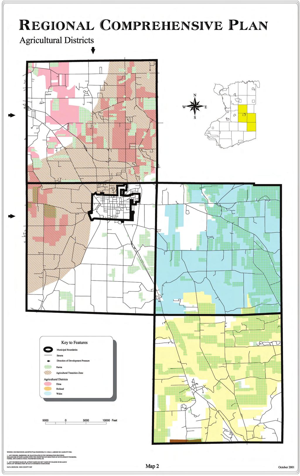
39
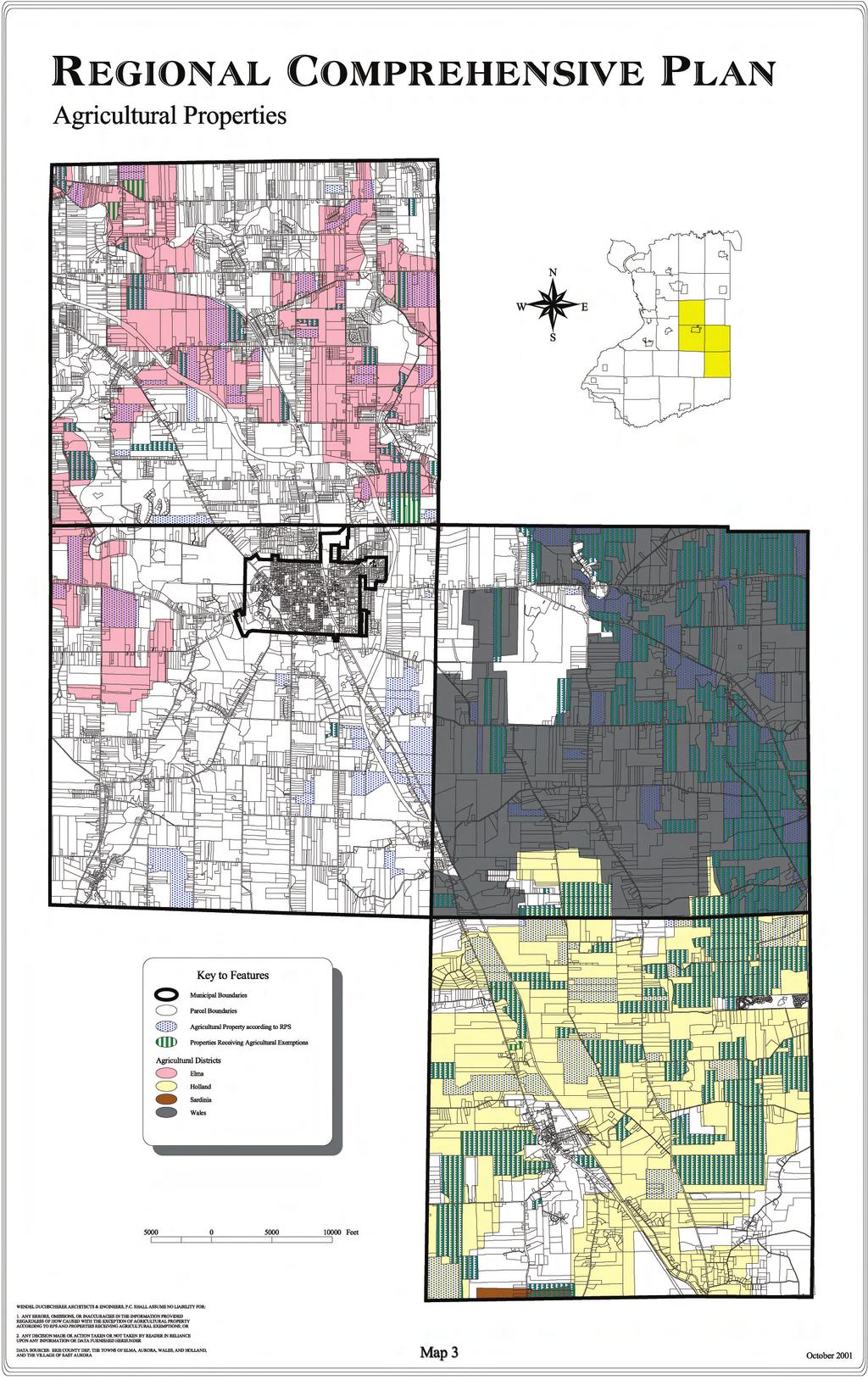
40
41 Section 4.0 Existing Conditions of the Communities in the Region Map 3 - Agricultural Properties shows all properties being actively farmed according to Real Property Services (RPS) Assessment data, and properties receiving agricultural property tax exemptions. The RPS data include any parcel that is categorized as an agricultural property by the assessor s office, regardless of size or level of agricultural activity. Properties receiving agricultural property tax exemptions must file an application for the exemptions and meet certain criteria regarding size and gross sales. Nearly all the properties receiving exemptions are within agricultural districts, although there are a few farms outside the districts benefiting from the exemptions. Farming is still a significant land use in the Towns of Holland and Wales, but relatively little land is being farmed in the other communities. The locations of prime soils for farming are identified on Map 4 - USDA Prime Soils. These represent soils that have Countywide Significance for farming. Within Wales and Holland, these soils lie primarily within designated agricultural districts. There are areas of Elma, Aurora, and East Aurora with significant soils which are outside the boundaries of agricultural districts. These lands are more likely to be developed for non-agricultural uses despite the presence of prime soils. In many cases, such as within the Village, these lands have already been developed. At the County level, Erie County is currently implementing its Agricultural Protection Program, Erie County Farms for the Future (1996). Among other recommendations, this program encourages local governments to adopt local right-to-farm laws in order to shield farmers from claims that their operations are a nuisance. In addition, the County has its own right-to-farm law to conserve, protect and encourage the development and improvement of agricultural land for the production of food and other products. Erie County also discourages policies that can negatively impact farming and farmland preservation, such as the extension of sewer lines into agricultural districts. At present, none of the communities in the regional study area have a Right-to-Farm Law. 4.2 Land Use Regulation Zoning Town of Aurora Zoning in the Town of Aurora is regulated through Chapter 116 of the Code of the Town of Aurora. The code establishes seven zoning districts: three residential districts (R1, R2, R3), an agricultural zone (A), two business districts (B1, B2) and an industrial zone (I). Map 5: Generalized Zoning shows the general locations of these zoning districts. 2 Permitted uses in each district are summarized in Figure The zoning districts are hierarchical with, for example, the R3 zone allowing R2 and R1 uses, and the I district allowing all of the B districts (excepting certain residential uses). Interesting characteristics are the fact that the A district is a higher zoning district allowing the R3 district uses, and the B1 district allowing R2 district uses, and the B2 district allowing A district uses. The Code includes a separate Table of District Regulations, which shows allowable uses and regulations for each zone regarding maximum height, minimum floor area, minimum lot sizes (width and area), and front, side and rear yard depths or setbacks. It also summarizes regulations regarding required off-street parking. 3 General information about residential bulk regulations for each of the five municipalities is summarized is Figure Map is provided for general information, and is not intended to be used for specific zoning queries. 3 This information is only provided in the Table of District Regulations, and is not included in the body of the Code. 4-6
42 Regional Comprehensive Plan USDA Prime Soils N W E S Key to Features Municipal Boundaries Streets Streams USDA Prime Soils Prime Farmland Prime Farmland (where drained) Important Where Applicable Not Prime or Important Feet WENDEL DUCHSCHERER ARCHITECTS & ENGINEERS, P.C. SHALL ASSUME NO LIABILITY FOR: 1. ANY ERRORS, OMISSIONS, OR INACCURACIES IN THE INFORMATION PROVIDED REGARDLESS OF HOW CAUSED; OR 2. ANY DECISION MADE OR ACTION TAKEN OR NOT TAKEN BY READER IN RELIANCE UPON ANY INFORMATION OR DATA FURNISHED HEREUNDER DATA SOURCES: ERIE COUNTY DEP Map 4 October 2001
43 Section 4.0 Existing Conditions of the Communities in the Region The code also lists Supplementary Regulations, which provide additional requirements, limitations and exceptions to the general regulations, such as limitations on accessory uses in R districts. The Supplementary Regulations also set forth regulations applying to all districts, such as signage, topsoil stripping, visibility at intersections, and sanitation facilities. Certain types of uses, such as excavations, mobile homes, mobile home parks, adult uses and shopping and industrial centers are subject to limitations and requirements as outlined in the Supplementary Regulations. In most cases, these uses require approvals from the Town Board. Adult uses are only allowed by non-transferable special use permit, and are subject to a number of requirements. Mobile home parks are allowed in the A district only, and require Planning Board and Town Board approval. Shopping or industrial centers are allowed as a special use in any non-residential zone, provided the site is at least five acres in area. According to the code, Town and Planning Board approval decisions for either mobile home parks or shopping or industrial centers are to be based on the following standards: 1. The relation of the proposed project to the long-range master plan of the Town, 2. The need for the proposed project (shopping centers and mobile home parks), and 3. The compatibility of the proposed project with adjacent land uses and other proposed developments, with particular reference to the probable effect on land values and the general purposes of zoning. The code also sets forth regulations regarding nonconforming uses, and contains a section controlling communications facilities, such as wireless transmitting towers, in the Town. The last four articles of the code detail provisions and procedures for administration and enforcement; the Zoning Board of Appeals; amendments to the code; and violations and penalties. Town of Elma Zoning in the Town of Elma is regulated through Chapter 144 of the Code of the Town of Elma. The Town has six zoning districts, which include three residential districts, two commercial districts and an industrial zone. Map 5: Generalized Zoning shows the general locations of these zoning districts. Permitted uses in each zone are shown in Figure The zoning districts are hierarchical in nature with the Residential zoning districts increasing in uses allowed from A up to C which allows most of the uses in the lower A and B districts. The Commercial district allows the uses in the A, B and C districts, and a list of commercial uses. The ordinance sets forth the uses permitted and not permitted in each zone. Any use not specifically authorized may be permitted only with approval of the Town Board after a public hearing. Any use prohibited in a less restricted zone is also prohibited in a more restricted zone. In addition to the uses explicitly permitted or prohibited within each zone, there are sections throughout the zoning code addressing specific types of uses. Regulations for specific uses may be included in the General Regulations (offensive businesses, hospitals, cemeteries); as separate sections within articles dealing with a specific zone (trailers, golf courses); and, in the case of multiple dwellings, in a separate article of the Code. Some uses, such as adult uses, collision shops and mobile home parks, are regulated under separate chapters of the General Legislation of the Town. The zoning ordinance establishes building heights, minimum floor space, maximum building size, minimum frontages and depths, minimum lot areas and setbacks applying to each zone. Properties in the Industrial zone are subject to further regulations regarding buffers, landscaping and performance standards, which are contained within the Industrial zone section of the code. Sections of the zoning code detail regulations regarding off-street parking and signage. The code also establishes the Zoning Board of Appeals, and describes its administration. It sets forth the process for amending the code; the procedures for administering and enforcing the zoning provisions; and the requirements and procedures governing building permits. 4-7
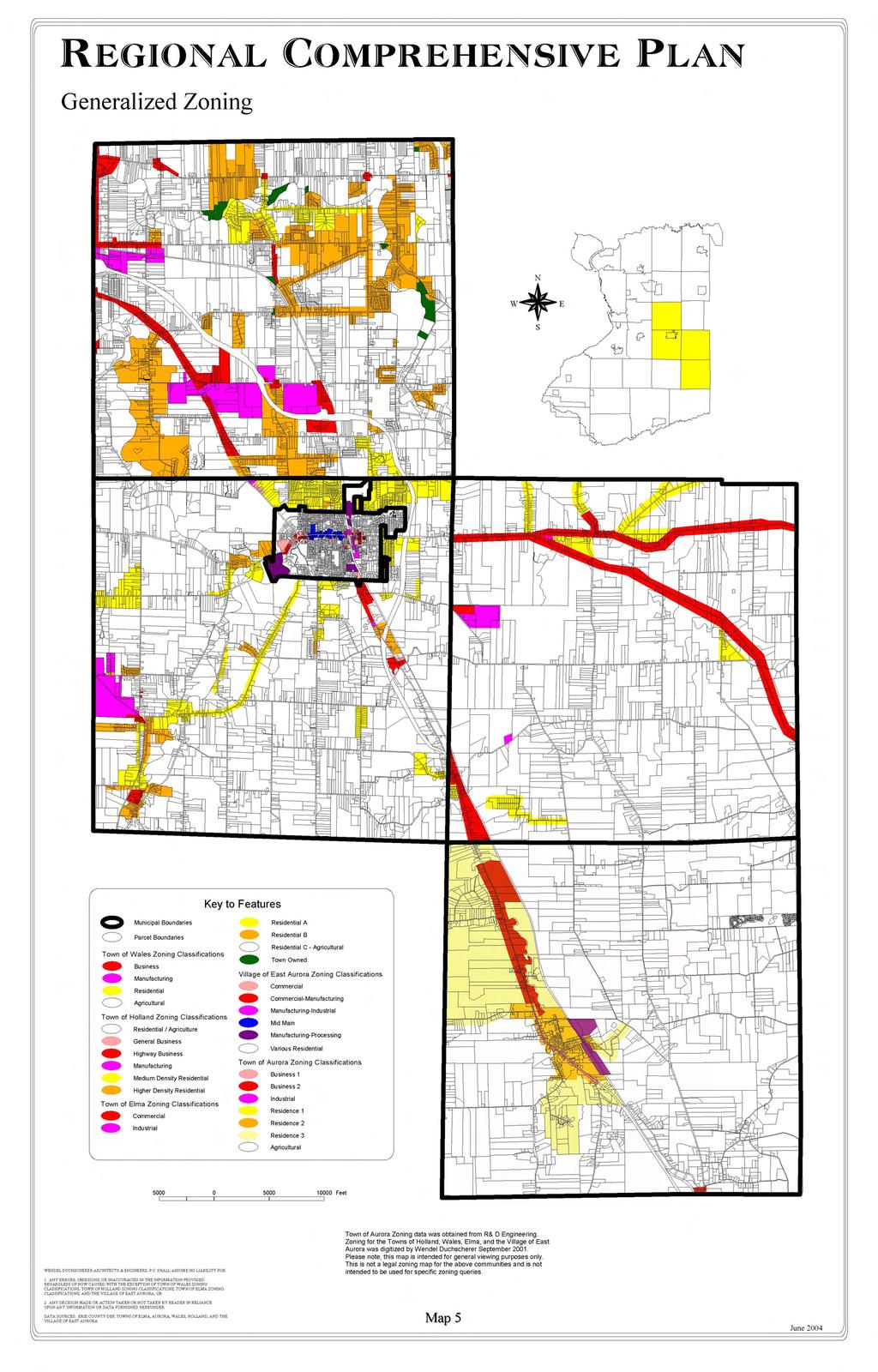
44
45 Section 4.0 Existing Conditions of the Communities in the Region Town of Holland Zoning in the Town of Holland is regulated by Chapter 120 of the Code of the Town of Holland. The code establishes six zoning districts. Three zones are primarily residential, including a Conservation/Open Space zone (COS), Rural Residential and Agricultural District (RA) and Medium- Density Residence (R1). There are two commercial zones (General Business (GB) and Highway Business (HB)) and a Manufacturing and Industry district (M). Map 5: Generalized Zoning shows the general locations of these zoning districts. Permitted uses for each zone are summarized in Figure The schedules of area, lot and bulk regulations for each zoning district are included as separate attachments at the end of the zoning chapter in the code. Certain regulations in the Town of Holland that apply to all districts, such as compliance with height and setback regulations, are enumerated in Article III of the Code. This article also mandates the preservation of topsoil and other natural features throughout the Town. Certain uses, such as the storage of waste material, are prohibited in all districts. Multifamily dwellings are allowed in several zones, but are subject to additional requirements governing the amount of open space, floor area, parking, etc. A site plan must be submitted and approved for any multifamily developments. The zoning code sets forth regulations guiding the application and issuance of special permits and provides additional requirements for the following uses: hospitals, nursing homes, nursery schools, outdoor commercial recreational uses, veterinarian offices, animal kennels and hospitals, mobile home courts, outdoor theatres, gasoline service stations, commercial garages, campgrounds, excavation operations, public utilities and electric generation wind towers. Mobile homes are further regulated by Chapter 83 of the Town Code. Cluster residential developments are permitted in R-A and R-1 districts, provided the site has a minimum of 25 acres, and all non-subdivided land, or at least 25 percent of the project area, is dedicated to permanent open space. Planning Board approval is required, and area and bulk regulations for the district must be met. Planned unit developments are allowed in the Residential-Agriculture district. The code requires a minimum of 100 units in the cluster residential portion of the development, and permits only convenience retail businesses. A maximum of 1 business for each 100 homes is allowed, and businesses must be compatible in style to nearby residences. Planned unit developments require Planning Board approval. Certain restricted types of business and industrial uses may be permitted in Residential-Agriculture, General Business, Highway Business and Manufacturing zones, provided the uses are similar to allowed uses, the site has adequate traffic capacity, and the area is not predominately residential in character. A special use permit is required, and the Town Board has complete discretion to approve or deny the use. If the use is not approved by the Town Board under these circumstances, an amendment to the zoning ordinance would be required to enable the proposed use. The code also allows for planned business areas within the General Business and Highway Business districts. These planned business areas, which require a special use permit, must initially consist of at least 8,000 square feet of ground floor area, or at least 4 permitted uses. Uses must be similar to those permitted within the zoning district. Additional design guidelines for planned business districts are provided within the code. The zoning code also establishes standards for several specific types of uses, including parking, sand and gravel pits, fences and signs. Procedures for enforcement and administration of the code, appeals, amendments and penalties are also provided. 4-8
46 Section 4.0 Existing Conditions of the Communities in the Region Town of Wales Zoning in the Town of Wales is regulated through Chapter 200 of the Code of the Town of Wales. There are four zoning districts in Wales: Agricultural (A), Residential (R), Business (B), and Manufacturing (M). Map 5: Generalized Zoning shows the general locations of these zoning districts. Permitted uses in each district are shown in Figure The ordinance enumerates permitted uses, accessory uses and special permit uses for each zone. In the Business zone, all non-residential uses, and in the Manufacturing zone all uses, require a special permit, and must conform to an approved site development plan. The zoning ordinance also prohibits certain uses, such as manufacturing of disinfectants or insecticides. The code establishes the application procedure for obtaining special permits. In addition to the specific standards for each use, the Town Board is directed to consider the following when evaluating whether to allow a special use permit: 1. Conformity with the Master Plan 2. Conformity with existing zoning regulations 3. Effect on adjacent property values 4. Aesthetic impact 5. Ecological impact 6. Traffic and parking limitations 7. Presence of odors, dust, smoke, refuse, vibration, outside lighting, safety hazards or other environmental factors incidental to the comfort, peace, enjoyment, health or safety of the surrounding areas. Each application for a special use permit must be accompanied by proof that adjacent property owners have been notified. If the owners of 20 percent or more of the land within 500 feet of the site protest the proposed use, at least ¾ of Town Board members must vote to issue the special use permit. Certain uses, such as multifamily housing, off-street parking, signs and fences, are subject to additional regulations that are specified in the zoning ordinance. Other uses, including adult uses, telecommunications facilities, junkyards, open development areas and mobile homes, are further regulated by separate chapters of the General Legislation. Procedures for appeals, amendments, enforcement and penalties are also provided. Village of East Aurora Zoning in the Village of East Aurora is regulated through Chapter 93 of the Village Code. This ordinance provides for nine zoning classifications or districts. There are three residential districts, three commercial zones, two manufacturing zones, and a mixed residential-commercial zone. Map 5: Generalized Zoning shows the general locations of these zoning districts. Permitted uses within each zone are outlined in Figure The ordinance establishes permitted uses and accessory uses for each district, as well as regulations regarding maximum building heights, minimum lot areas and widths, and required yards (setbacks) for allowable uses in each district. The Code does not allow more restricted uses in a less restricted district unless specifically enumerated, although in most cases, more restrictive uses are included. R district uses, for example, are allowed in all districts except M-P. The ordinance expressly forbids any uses not listed unless an amendment to the zoning code is made. Most districts require development plan approval for new construction (excluding interior renovations and exterior handicap access), demolitions of existing structures of 500 square feet or more, exterior 4-9
47 Section 4.0 Existing Conditions of the Communities in the Region alterations requiring a building permit and parking. 4 The development plan is intended to enable a more careful evaluation of the proposed use for a site, and requires review by the Village Board and Planning Commission. A public hearing may or may not be required. In considering the Development Plan, the Village Board is directed by the Code to consider: 1. The promotion of a unique Village identity; 2. The creation of architectural harmony between buildings and landscape features; 3. The preservation of the pedestrian and historical character of the Village; 4. The reduction of visual clutter; 5. The screening of the effects of commercial development from residential areas; 6. The maintenance of efficient traffic flow; 7. The maintenance of property values throughout the Village; and 8. The recognition of aesthetics as a value and standard throughout the Village. The code establishes the procedure for submitting a development plan, including the required elements that must be included. In addition to the nine zoning districts, the code also provides specific regulations regarding adult uses, detailed standards for off-street parking, and procedures for addressing dangerous and unsafe buildings and/or lots. Uses requiring special permits are listed, along with the regulations guiding these uses and the procedure for obtaining a special use permit. These uses include adult uses, gasoline service stations, rapid car washes and restaurants, as well as certain temporary uses, such as sidewalk sales and craft fairs. The code also sets forth the procedures for the administration and enforcement of the zoning code, as well as the process for appeals. It details the rules governing the Zoning Board of Appeals and its actions, and outlines the procedure for amending the zoning code Subdivision Regulations Town of Aurora The subdivision of land in the Town of Aurora is regulated through Chapter 99 of the Town Code (Subdivision of Land). Subdivision is defined as the division or redivision of any parcel during any consecutive three-year period into five or more lots for immediate or future sale for building development. Minor subdivisions consist of fewer than five lots, with existing frontage on a public roadway, and not requiring the extension of municipal water or sewer facilities. Subdivisions resulting in lots that are larger than five acres in size are exempt from being considered under the subdivision regulations, provided the lots have at least 200 feet of frontage on a public roadway. A major subdivision is defined as any division of a parcel, into five or more lots, or any subdivision requiring the construction of new streets or the extension of municipal water or sewer facilities. All subdivisions, including minor subdivisions, must be in conformance with any adopted Master Plan or zoning ordinance. Subdivisions must follow the public improvement permit application procedure, although this process may be waived by the Town Board for one-lot subdivisions. Also, the Town may require any development within the Town, whether or not it qualifies as a subdivision, to go through the public improvement permit process. The subdivision approval process is a three-phase process, requiring submittal of sketch, preliminary and final plats to the Town Board for approvals. The Town Board either rejects the application or submits it to the Planning Board for review and recommendations. All subdivision applications are subject to environmental review at the preliminary plat stage. Public hearings must be held within 60 days of receiving the preliminary plat, and again after receipt of the final plat. The Town Board is 4 Development plans are not required for single-family dwellings remaining in single-family use. 4-10
48 Section 4.0 Existing Conditions of the Communities in the Region authorized to consolidate the public hearings or waive the submission of any required items for minor subdivisions. The Ordinance outlines design criteria for streets, easements, blocks, lots, public sites and open spaces and drainage improvements. The Town Board may require one acre per 20 dwelling units, up to 10 percent of land in a subdivision, be set aside as parks or public open space. A one-acre minimum is established in the code, though the Town Board may approve smaller open spaces if the difference will be provided by the future subdivision of adjacent lands. The Town Board has the option of requiring a payment into a town recreational fund in lieu of dedication of parkland. The subdivision regulations explicitly require the preservation of existing features which add value to residential development or to the town as a whole, including trees, waterways, falls, historic sites and similar irreplaceable assets in the design of any subdivision. Cluster development is mentioned as an objective in the purpose section of the subdivision regulations, but there are no regulations pertaining to cluster development elsewhere in the Code. Town of Elma The Town of Elma regulates land division under Chapter 123 Subdivision of Land. Subdivision is the division of any parcel into two or more lots, including lots larger than five acres, for the purpose of transfer of ownership and building development. The ordinance defines major subdivisions as a land division of five or more lots, or any division that requires the construction of a street or an extension of town facilities. Minor subdivisions contain no more than four lots, each fronting an existing street, and not requiring the extension of any Town facilities. Minor subdivisions must not adversely affect the development of the remainder of the parcel or adjoining properties, and must not conflict with any surrounding development, the Master Plan, the Official Map, the Zoning Ordinance or any subdivision regulations. The first step in the approval process is the pre-application. The owner submits a sketch plan to the Planning Board for review. The Planning board classifies the subdivision as either major or minor, and makes any specific recommendations to be incorporated by the applicant. In the case of minor subdivisions, the Planning Board may obtain review and recommendations from the Town Highway and Water Superintendents and the Town Engineer at this stage. For minor subdivisions, the next step is application for approval of a minor subdivision plat. The statute outlines required information to be included on the plat, which must conform to the sketch plan and incorporate any recommendations made by the Planning Board. The Planning Board has the authority to approve, require modifications, or disapprove the plat. The Planning Board may also require a minor subdivision to comply with any or all of the requirements specified for major subdivisions. For major subdivisions, the applicant must submit a preliminary plat to the Planning Board, which holds a public hearing. The Planning Board then determines what changes it may require, including whether to waive any required improvements. Copies of their comments and changes are sent to the Town Board for approval, disapproval or modification. Following approval, the applicant then submits a final plat to the Planning Board. After Planning Board review and approval, it is forwarded to the Town Board for approval. The Planning Board may hold an additional public hearing on the final plat, although if there are no substantial changes from the preliminary plat, this requirement may be waived. The applicant must also inform, in writing, any agency that would provide service to the proposed subdivision of his plans, to ensure adequate capacity. This includes utilities, schools, the fire department, and if appropriate, State Department of Transportation or County Highway Engineer. If the Planning Board does not take action or disapproves the plat, the Town Board may hold a hearing to determine if the action was appropriate, and direct the Planning Board to take appropriate action. 4-11
49 Section 4.0 Existing Conditions of the Communities in the Region The regulations set forth require public improvements and standards for installation. Performance bonds are required to ensure these public improvements are completed. It is explicitly required under general requirements and design standards that the Planning Board may require the preservation of all natural features which add value to residential developments and the community, including trees, wooded areas, watercourses, historic spots and similar irreplaceable assets. Preservation of topsoil is also explicitly required. Specific design standards are provided for lots, streets, parks and open space, public improvements and utilities, and pedestrianways, although the Town Board may waive, by specific resolution, any requirements relative to provision or design of public improvements. The Town Board may require one acre per 20 dwelling units, up to 10 percent of land in a subdivision, be set aside as parks or public open space. A one-acre minimum is established in the code, though the Town Board may approve smaller open spaces if the difference will be provided by the future subdivision of adjacent lands. The Town Board has the option of requiring a payment into a town recreation site acquisition and improvement fund in lieu of dedication of parkland. The Planning Board may establish conditions as to access, use and maintenance of all lands designated as parkland or open space, in order to ensure their preservation for the intended purpose. Clustering is allowed under Article VIII. An applicant who wishes to do a clustered development must submit a standard sketch plat in addition to the clustered plat. Conditions for ownership, use and maintenance of any open space resulting from a clustered development must be provided. The proposed plat must comply with all regulations, including the zoning and subdivision ordinances, and undergo the standard procedure for approvals (sketch, preliminary and final plats, with public hearings). Under the Declaration of Policy set forth in Article II, it is required that all lots must have a percolation rate of one inch in 30 minutes or better. All major subdivisions are required to be in Residential A or B zoning districts, and Town Board approval is required to allow minor subdivisions to remain classified as Residential C. No septic systems are allowed in fill, and no more than 30 residences may be developed per farm plat unless public sewers are available. Town of Holland The Town of Holland regulates land division through Chapter 104 of the Town Code. The Town defines subdivision as a land division into five or more parcels along any existing or proposed street, easement, or right-of-way for sale or rent as residential lots. Any tract of land qualifies as a subdivision when the fifth residential building lot is sold or leased within any consecutive three-year period, regardless of whether the parcels were sold collectively or individually. Lots must be five acres or less to be classified as residential building lots. The ordinance does not classify subdivisions as major or minor. The standard review process consists of sketch, preliminary and final plat submittals and approval. Sketch plans are submitted to the Town Board, which refers it to the Planning Board for recommendation. Preliminary plats and final plats undergo a similar procedure. The ordinance provides a list of the specific information required to be included in the plats at each stage. Although the definition of minor subdivision has been repealed, the regulations still outline a separate process for minor subdivisions: preliminary and final plat submittals are condensed into one minor subdivision plat. Public hearings are required at the preliminary and final plat stage, although the second public hearing is not mandatory. The ordinance specifies what improvements are required, and a performance bond is required to ensure that they are satisfactorily completed. The ordinance includes design standards for streets, lots, and easements. It requires a liberal and functional landscaping scheme for the entire subdivision, including a minimum of two trees per lot in addition to street shade trees. The Town Board may require a landscaping screen to buffer the subdivision from adjacent land uses if the uses are incompatible with 4-12
50 Section 4.0 Existing Conditions of the Communities in the Region residential development. The ordinance specifically requires the preservation of natural features to the extent possible, including top soil, existing trees and shrubbery, unique physical features such as historic landmarks and sites, rock outcroppings, hilltop lookouts, or desirable natural contours. Attempts should be made to preserve any natural lakes, ponds or streams, unless the Planning Board agrees a change will enhance the development and beauty of the subdivision. Any proposed changes in watercourses must conform to the New York State Environmental Conservation Law. The applicant is also prohibited from leaving surface depressions or mounds of dirt on the tract, or from building in a floodway. Structures in a floodplain must conform to the Town s Flood Damage Protection Ordinance (Chapter 69). Lands must be reserved for park, playground or open space equal to 10 percent of the total land in the subdivision, with a minimum of five acres. Payment in to the Town of Holland Park, Playground and Open Space Trust Fund may be required in lieu of land. In addition to the design standards listed above, the Ordinance provides specifications for how the improvements must be installed, including a listing of permitted modifications. The Planning Board or the Town Board may waive compliance with specific regulations or provisions of certain improvements required under this ordinance, provided public interest, safety and general welfare is maintained, and such changes are not in conflict with the Official Map, the Comprehensive Plan, or the Zoning Ordinance. The Town Board is also authorized to require conditions to such variances or modifications. Town of Wales The division of land in Wales in governed by Chapter 181 in the Town Code. A subdivision is defined any tract of land divided into five or more parcels for sale or rent as residential lots or building plots. A parcel qualifies as a subdivision when the fifth residential building lot is sold or leased within any consecutive three-year period, regardless of whether the parcels were sold collectively or individually. Lots must be five acres or less to be classified as residential building lots. The ordinance does not classify subdivisions as major or minor. The division of any agricultural land transferred between farms for agricultural purposes is defined as an exempt subdivision and is not subject to subdivision regulations. The subdivision approval process is a two-phase process, requiring submission of preliminary plat and final plat to the Town Board. The Ordinance specifies that prior to preparing the preliminary plan, the applicant shall obtain input from the Planning Board regarding requirements for the subdivision, such as street improvements, drainage, sewerage, water, fire protection, etc. Required information to be included in both preliminary plats and subdivision plats are listed. The Town Board is directed to review the preliminary plat, with particular attention to streets, their relation to topography, sewerage disposal, drainage, lot sizes and arrangement, preservation of natural features, the future development of adjoining lands and the requirements of the Comprehensive Plan and the Official Map. The Town Board refers the preliminary plat to the Town Planning Board for review and recommendations. A public hearing is required, and the applicant must attend the Town Board meeting to discuss the plat. The Town Board must either conditionally approve, with or without modifications, or disapprove the plat within 45 days. Failure to act is defined as a conditional disapproval. The subdivision (final) plat must incorporate recommended changes. It must undergo environmentally quality review under New York State law, and a second public hearing is held. If zoning changes are required, this public hearing may be combined with the hearing required under the zoning law. The subdivision ordinance outlines what improvements are required, and specifies a performance bond be filed to ensure the satisfactory installation of these improvements. Development standards or design standards are provided for streets; lots; easements; landscaping or ground cover; preservation of 4-13
51 Section 4.0 Existing Conditions of the Communities in the Region natural features; floodplain areas; drainage improvements; and parks, playgrounds or open space. The developer is authorized to place stricter standards, and the Town Board is authorized to modify any specified requirements. Cluster development is not explicitly allowed, but under the design standards for lots, the Town Board is given discretion to determine lot sizes if the applicant is utilizing 278 of the Town Law, the authorizing statute under State law for cluster development. For the landscaping standards, each lot must have a minimum of two trees in addition to required street trees, although this condition will be waived in wooded areas where the applicant intends to maintain existing trees. The Town Board may require a landscaping screen as a buffer between the proposed subdivision and adjacent uses. In preserving natural features, the applicant is directed to preserve topsoil, and to the fullest extent possible, existing trees and shrubbery. Natural lakes, ponds or streams should be preserved, unless a change would, in the opinion of the Town Board, be an improvement. When feasible, the applicant is directed to consult with Erie County Soil and Water Conservation District regarding erosion control, stormwater management and vegetation protection plans. Unique physical features, such as historic landmarks and sites, rock outcroppings, hilltop lookouts, desirable natural contours and similar features shall be preserved if possible. The developer may not leave surface depressions or mounds of dirt or debris on the site. In terms of drainage requirements, facilities must be adequate to accommodate runoff from the site and any upstream areas, including those outside the proposed subdivision. The downstream effects must also be studied, and if needed, improvements may be required to mitigate any negative impacts. Lands must be reserved for park, playground or open space equal to 10 percent of the total land in the subdivision, with a minimum of five acres. Payment to the Town Park, Playground and Open Space Trust Fund of $50.00 per lot may be required in lieu of land. The Ordinance details specifications for required improvements, including permitted modifications. In many cases, (street construction, drainage structures, curbing, etc.) the ordinance does not specify actual standards, but refers the applicant to standards and specifications on file with the Town Clerk. Village of East Aurora The Village regulates land division through Section 81 of the Village Code. Subdivision is defined as the division of any parcel of land into lots for sale, transfer of ownership or development. A major subdivision consists of four or more lots, or any division of land requiring streets or infrastructure. The ordinance does not require a sketch plan, but does set forth an informal procedure allowing the applicant to submit general site information and a sketch plan to the Village Board with a request for informal consideration and advice. The ordinance states that all plats shall be submitted to the Village Board in final form. However, the Village Board may require, or the owner may chose to submit a preliminary plat. The information to be included in such a preliminary plat is listed in the ordinance, and the plat must be clearly labeled as preliminary. If a preliminary plat is submitted, environmental review is required, and the preliminary plat may not be considered complete until a negative declaration or a draft environmental impact statement has been filed. A public hearing is required on preliminary plats, but the hearing may be coordinated with any hearings required under SEQRA. If the final plat is in substantial agreement with the preliminary plat, the Village Board is authorized to conditionally approve, with or without modifications, or disapprove the plat without requiring further public hearings. If no preliminary plat was submitted, the final plat is not complete until a negative declaration or a draft environmental impact statement has been filed. Public hearings must be held, which may be held concurrent with hearings required under the environmental review. If the Village Board does not act upon the plat within the time period prescribed after the completion of the State Environmental Quality Review Act, it shall be deemed approved by default, unless an extension of time 4-14
52 Section 4.0 Existing Conditions of the Communities in the Region has been agreed upon by both the Board and the owner. For minor subdivisions, only one plat submission is required. Minor subdivisions are subject to SEQRA review and require a public hearing. The ordinance sets forth the information required to be included in the final plat, and the public improvements that must be included in the subdivision. The Village charges public improvement fees for inspecting public improvements in an amount equal to 5 percent or actual cost of inspection, whichever is greater, not to exceed 10 percent of the gross costs of the improvements. Design standards for streets, alleys, easements, blocks and lots are specified in the ordinance. Parklands or recreational land may be required if the Village Board determines a need for such facilities based on population growth resulting from the proposed subdivision. A payment of $ per lot may be made in lieu of actual land Local Regulations Town of Aurora The Town of Aurora requires site plan review under Chapter 95 in the Town Code. The code requires that all applications for building permits be accompanied by development site plans. Site plans are not required for one- or two-family homes, or for improvements on agricultural properties behind existing improvements if located on a parcel of 10 acres or more. Commercial improvements of less than 2,500 square feet are also exempt from site plan review, unless the cumulative square footage over a consecutive three-year period is of a scale to suggest an intent to circumvent site plan review, or if the improvement is within 500 feet of a residential zone. The Superintendent of Buildings reviews building permit applications and basic site design concepts, and informs applicants of potential concerns and required information. State Environmental Quality Review is required, and an optional public hearing may be scheduled by the Planning Board. The Planning Board reviews all submittals and makes a recommendation to the Town Board for approval, rejection or conditional acceptance. The Town Board makes the final determination of whether or not to approve the application. If an application is not approved, the Town Board must provide an explanation of the reasons for disapproval. The code sets forth a submittal checklist, which outlines required information. Site plans must include information on general legal data; impact on the environment; natural features; existing development and infrastructure; the proposed development; and any other information deemed necessary by the Town. The Code details what elements must be considered under each of these categories. The Town Board is given the authority to waive any or all of the site plan review process if it determines that it is not in the interest of public health, safety or general welfare, or is inappropriate to a particular project. The Code of the Town of Aurora includes ordinances regulating Flood Damage Prevention (Chapter 68) and junkyards (Chapter 72). Regulations concerning mobile homes, telecommunication towers and preservation of topsoil are included in the Zoning Ordinance. Town of Elma The Town of Elma requires site plan review under Chapter 117 of the Town Code. All applications for building or use permits must comply with the requirements of the ordinance, except for one- or twofamily dwellings, related accessory uses, or agricultural uses allowed by right under the zoning code. The applicant must meet with the Planning Board for a sketch plan conference to discuss the proposed site plan. The Planning Board then may determine no further site plan review is required; approve the project based on the sketch plan; require further information; or determine that the project should undergo full review. In the last case, the applicant must apply for preliminary site plan approval. The code sets forth a checklist of 20 items which must be included in the application, such as soils data, a 4-15
53 Section 4.0 Existing Conditions of the Communities in the Region grading and drainage plan, and the location and proposed design of buildings, lighting, landscaping, buffers, among other information. Additional items considered necessary by the Planning Board might also be required. The Planning Board is responsible for reviewing preliminary site plans. The ordinance includes a list of general considerations to guide the process. The Planning Board is authorized to obtain input from other local and County officials or consultants, or to require a public hearing. If required under General Municipal Law, the Planning Board shall forward the site plan to Erie County Department of Environment and Planning for advisory review. The Planning Board must provide a ruling within 60 days of receipt of a complete application. If the Board takes no action, the site plan is considered approved. The Planning Board may approve the site plan with conditions. If the site plan is rejected, the Planning board must provide the reasons for disapproval. If the preliminary site plan is approved, the applicant must apply for final site plan approval within six months. The final site plan shall conform to the preliminary site plan, and incorporate any changes recommended by the Planning Board. The Planning Board must act upon the final site plan within 45 days. Failure to act constitutes approval. Building permits may be issued upon completion of this procedure. When applicable, the ordinance provides for coordination of site plan review with any procedures required under zoning or subdivision regulations. The Town of Elma code includes a chapter entitled Acreage Lot Development (Chapter 100). This purpose of this chapter is regulate the development of land which does not percolate, and to ensure sufficient space between the proposed septic system and neighboring properties to protect neighbors in the event of a system failure. Owners of land that does not percolate in accordance with code provisions, and who intend to design a septic system in fill may sell or develop lots of at least 5 acres in size with approval from the Building Inspector, the Planning Board and the Town Board. The tile field of any septic system in fill must be at least 75 feet from a property line. If approved, the deed to the property must include restrictions limiting development to one one-family home (or two-family home if permitted) per lot, and prohibiting any multiple dwellings. The deed restrictions shall terminate when public sewers are available. The Acreage Lot Development ordinance also allows subdivision of land beyond the Town s four-split rule. One lot per year may be transferred by deed, provided the lot is on existing road frontage, has a minimum area of two acres, a minimum frontage of 150 feet, and a minimum depth of 350 feet. The septic system must be setback at least 25 feet from the property line. This section does not apply to lands that have septic systems in fill. The property must comply with all other requirements in the Code of the Town of Elma. The Code of the Town of Elma also has chapters regulating Adult Uses (Chapter 42); Communications Facilities (Chapter 59A); Collision Shops (Chapter 59); Dealers in Vehicles, Boats, and Trailers (Chapter 60); Dumps and Dumping (Chapter 68); Excavations (Chapter 75); Flood Damage Prevention (Chapter 82); Mobile Home Parks (Chapter 97); and Construction of Towers (Chapter 130). Town of Holland Site plan review in the Town of Holland is regulated through the Zoning Ordinance. Prior to constructing a new building or improvement, an applicant must receive a building zoning permit which ensures the improvement complies with building and zoning codes of the Town. Applications for a building zoning permit or for a special use permit must be accompanied by a site plan for the following types of development: residential developments of three or more dwelling units; new business, industrial or commercial facilities; alterations or additions to existing commercial properties which add 750 square feet or more; modifications to off-street parking, loading or stacking areas or structures; and all developments within a floodplain district. Site plans must also be submitted for all applications that 4-16
54 Section 4.0 Existing Conditions of the Communities in the Region change a previously approved site plan. The code details the types of information to be included in the site plan, including information on current conditions, infrastructure, proposed uses, etc. The Building Zoning Officer reviews site plans, and may approve or deny the application for a building zoning permit. In cases other than residential or agricultural, or where a significant change of use is proposed, he may refer the application to the Planning Board for recommendations. If the Planning Board does not act within 30 days, it is considered a waiver, and the application shall go before the Building Zoning Officer or the Town Board for action. The Town Board receives all applications for special use permits, and may refer them to the Planning Board for recommendations. All new development in GB, HB and M districts requires special permits. If the application for the special permit is approved, the Building Zoning Officer is then authorized to issue building zoning permits. If it is disproved, the Town Board must provide the reasons. Standards for special use permits are set forth within the Zoning Code, including standards for certain specific types of uses. Holland s code includes a Land Development ordinance (Chapter 77). This section provides for open development areas, and regulates any development without immediate frontage on an existing roadway. Applicants may submit a preliminary open development area plan to the Town Board, which refers the plan to the Planning Board for review and recommendations. After the Planning Board makes its recommendations, the Town Board shall either approve, conditional approve or disapprove the plan. Failure by the Town Board to act within 45 days constitutes a conditional approval. If the plan receives preliminary approval, with or without conditions, the applicant must submit a final open development area plan within 6 months, incorporating any recommendations. Planning Board review of the final plan is required. The plan must undergo New York State environmental quality review, and a public hearing is required. The Town Board makes the final determination of approval, modification or disapproval of the final open space development plan. The developer is required to provide access roadways, directional signs, utility lines and a storm drainage system within the open development area. The ordinance provides design standards for access roadways. The Town Board may grant waivers or exceptions where the modifications are in the public interest or will avoid unnecessary individual hardship. Other sections of the Town Code with an impact on land use within the Town of Holland include chapters regulating Flood Damage Prevention (Chapter 69); Junkyards and Junk Dealers (Chapter 75); Mobile Homes (Chapter 83); and Telecommunications Facilities (Chapter 110). Town of Wales The regulations pertaining to site plan review in the Town of Wales are contained within the Zoning Ordinance. All uses requiring a special use permit are subject to site plan review. In B-Business and M- Manufacturing districts, all uses except one- or two-family homes require special use permits. All multi-family development is subject to site plan review. Article VII of the Zoning Code establishes the process for receiving special permits. The Planning Board and the Conservation Board review site plans and make recommendations to the Town Board. The Town Board may hold a public hearing. The ordinance details the information to be included in the site plan, including the location of all buildings, roadways, walkways, open space, and a description and plans for water supply, sewage disposal and storm drainage, approved by the Erie County Department of Health. Chapter 150 of the Town of Wales Code provides for Open Development Areas. Any applicant for an open development area is directed to discuss requirements with the Town Board prior to submittal. The 4-17
55 Section 4.0 Existing Conditions of the Communities in the Region Code specifies information to be included in a preliminary plat, including existing features and structures and proposed improvements. After submitting the preliminary plat to the Town Board, the applicant also meets with the Planning Board, which makes recommendations to the Town Board. The Town Board must either conditionally approve or disapprove the preliminary plat. Failure to act within 45 days constitutes a conditional approval. The applicant must file with the Town Board an application for approval of the open development area plat within 6 months. It is referred to the Planning Board for review and recommendations. New York State Health Department endorsement is required, and an environmental quality review must be completed by the developer. The Town Board must hold a public hearing, but if the proposed open development also requires a rezoning, both public hearings may be combined. The Town Board has 45 days following the public hearing to recommend approval, modification or disapproval of the plat. The applicant is responsible to complete required improvements to the site prior to final approval by the Town Board, or file a performance bond sufficient to pay for these improvements. These improvements must include access roadway(s), street signs, monuments, bank stabilization and utility lines. The ordinance also establishes design standards for access roadways, lots, easements, preservation of natural features, floodplains, and drainage improvements. Streets must be designed either as a cul-desac or a circular way to preclude any use other than access or exit. The required street rights-of-way and paved areas are narrower than required under subdivision regulations for local residential roadways. Lots must be a minimum of 5 acres. Standards for preservation of natural features, floodplains and drainage mirror those under the subdivision regulations. The Town Board may waive or vary any of these requirements and regulations if appropriate. The Code of the Town of Wales also contains chapters on Adult Uses (Chapter 76); Telecommunications Facilities (Chapter 100); Flood Damage Protection (Chapter 103); Junkyards and Junk Dealers (Chapter 120); and Mobile Homes (Chapter 139). Village of East Aurora Site plan review in the Village of East Aurora is regulated through the requirement of a Development Plan for most development within the Village. Development in every zoning district with the exception of R and RG districts requires submission of a development plan to the Village Board for approval, unless it is for interior renovations, exterior handicap access facilities, or single-family homes. Demolitions of structures greater than 500 square feet, exterior alterations requiring a building permit, and any new or expanded parking areas also require development plans. Development Plans are rated based on the development s promotion of unique Village identity; architectural integrity; preservation of pedestrian and historic character; reduction of visual clutter; screening between commercial and residential uses; efficient traffic control; maintenance of property values; and the value of aesthetics. The Development Plan must include a site plan, schematic designs of facades of proposed structures, floor plans, and a completed Part One of the State Environmental Quality Review full Environmental Assessment Form (EAF). The Code specifies required information to be included in the site plan, and the Village Board may require additional information. After obtaining recommendations from the Planning Commission, the Village Board approves, modifies or disapproves the plan. A public hearing on the plan is optional. Certain uses, including some temporary uses, also require special use permits. Prior to allowing a special use permit, the Code requires that the Village Board hold a public hearing and notify adjacent property owners of the proposed use. There are several additional local regulations that govern land use. Chapter 15, Historic Preservation is enabling legislation for the East Aurora Historic Preservation Commission. The Commission is authorized to establish the criteria for designation of significant historic, architectural, and cultural landmarks or historic districts and to designate eligible structures or resources as local landmarks, 4-18
56 Section 4.0 Existing Conditions of the Communities in the Region subject to Village Board of Trustees approval. The procedure for this process is set forth in the ordinance. The Commission is also given the authority to issue Certificates of Appropriateness, which must be obtained before property owners are allowed to make exterior alterations or improvements to designated local landmarks. Chapter 85 (Trees) establishes the creation of the Village Tree Board and sets forth regulations regarding protection, planting and maintenance of the Village s trees. The Village of East Aurora Code also includes chapters on Flood Damage Prevention (Chapter 57); Signs (Chapter 77); and Stream Bank Stabilization (Chapter 78). 4-19
57 Section 4.0 Existing Conditions of the Communities in the Region FIGURE TOWN OF AURORA ZONING DISTRICTS AND PERMITTED USES District Permitted Uses Source: Code of the Town of Aurora, Chapter 116: Zoning R1: Residence Single-family dwellings, churches, schools, public parks or playgrounds, customary accessory uses. Also, on Rte. 20A and Route 16: professional offices in the home (permitted types listed; restrictions apply) Signs, as regulated. R2: Residence Any use permitted in R1 district, two-family dwellings, government buildings and uses, professional home offices, up to 3 roomers or transient guests, customary home occupations. R3: Residence Any use permitted in R2, (nameplates shall not exceed 4 square feet in area), multiple dwellings, dwelling groups of 2 or more dwellings on one lot*, boarding- or rooming houses, non-profits, excluding those for mental patients or correctional purposes. A: Agricultural Any use permitted in R3, agricultural, floricultural and horticultural pursuits, seasonal cottages, public utility buildings and other structures, quarries, clay, sand and gravel pits, as regulated, veterinary hospitals or clinics, customary accessory uses, including but not limited to roadside stands, signs as regulated. When approved by Board of Appeals: auto court, camp, cemetery, correctional institution, dog kennel, farm equipment sales, fur farm, drive-in theater, public stables, sanitarium, private club or private recreation area or building not open to the general public, golf links. B1: Business Any use permitted in R2, retail stores (permitted types listed), art gallery, bank, barbershop, beauty shop, dry-cleaning or laundry pickup station, pharmacy, photographer, sewing center, snack and soda bar (indoor service only), passenger depot, professional offices (permitted types listed), customary business accessory uses, incl. but not limited to parking. Signs, as regulated. B2: Business Any use permitted in B1 or A, except auto court, camp, cemetery, correctional institution, dog kennel, farm equipment sales, fur farm, drive-in theater, public stables, sanitarium, private club or private recreation area/building not open to the public. Retail stores, not limited to those listed in B1 district, assembly halls, auditoriums, cafés, restaurants or taverns, commercial recreation enterprises, when in-doors and lights and sounds controlled, dry-cleaning plants using only nonflammable fluids, hand laundries, bakeries, filling stations, public garages, hotels, shops for custom work (e.g. carpentry, tailoring) with restrictions, undertaking establishments, mortuaries, funeral homes, volatile materials storage (underground only and in quantities no more than 12,000 gallons). When approved by Board of Appeals: drive-in or outdoor service establishments (e.g. eating stands, outdoor theatre); storage yards, if fenced; used car lots, warehouses, clubs, forprofit campgrounds. Signs, as regulated I: Industrial Any use permitted in B districts, without limitations on employment and without requiring approval of Board of Appeals, but not including residences except for caretaker, unless land adjoins a residential district. Manufacturing or processing operations of an unobjectionable nature. Restrictions re. Nuisances (noise, light, smoke, etc.) apply. Town Planning Board may, after public hearing and Town Board approval, establish a list of conforming uses. In absence of such list, Town Board approval for building or use permits required. Volatile material storage (above ground or in quantities exceeding 12,000 gallons). When adequately screened by fence or wall: builders' supply yard, contractor s yard, junkyard (subject to restrictions), and lumberyard. When approved by Board of Appeals: all other uses not otherwise prohibited, except certain uses (listed) require Town Board approval. Adult uses when approved by Town Board. 4-20
58 District Residential A Residential B Residential C & Agricultural Commercial (see note) Restricted Commercial (see note) Industrial (see note) Regional Comprehensive Plan - Towns of Aurora, Elma, Holland and Wales and the Village of East Aurora *Restrictions apply Section 4.0 Existing Conditions of the Communities in the Region FIGURE TOWN OF ELMA ZONING DISTRICTS AND PERMITTED USES Uses Not Permitted or Permitted Uses Requiring Special Permits One-family home, private garage, accessory Not Permitted: taverns, clubs, building, professional home office, sign*, horses*. hospitals, nursing homes, domestic Trailers (<500 cubic ft, may not be occupied), animals other than house pets, swimming pools, with restrictions. boardinghouses, trailers, camps, commerce or industry. With Special One-family home, two-family home, private garage, professional home office, sign*, horses*. Trailers (<500 cu.ft, unoccupied), swimming pools, boarding and rooming houses, with restrictions. One-,two-family home, farm building, greenhouse, library, church, professional offices, school, park or playground, sign. With unanimous consent of adjacent owners: riding or boarding stables, kennels, fur farms. With restrictions: trailers*, swimming pools, boarding and rooming houses, farm buildings, utility structures, camps, institutions, golf courses, agricultural accessory uses. Any use permitted in A,B or C, retail stores, assembly hall, auditorium, signs*, bank, professional office, café, restaurant or tavern, commercial recreation establishment*, dry cleaners, hand laundry, filling station, public garage*, hotel or motel, passenger depot, personal service shop (e.g.barber), shop for custom work (e.g. carpentry), funeral home, builders supply, drive-in, outdoor service establishments, customary business accessory uses (parking), warehousing of non-toxic materials. Also, research laboratory*, assembly*. Trailers*, utility structures. Uses permitted in Commercial zone*, as listed above, except business accessory uses, warehousing. Also trailers*, utility structures. Manufacturing or processing operations, office, research, service establishments* (specific types listed) Permit: funeral homes. Not Permitted: taverns, clubs, hospitals, nursing homes, tourist homes, airports, dog kennels, fur farms, commerce or industry. With Special Permit: funeral homes Not Permitted: taverns, clubs, trailer camps, airports, industry and commerce, except where specifically permitted elsewhere in any Town of Elma ordinance. Not Permitted: any industry or use prohibited in industrial district; amusement park, circus, sales and storage of heavy equipment. Not Permitted: uses allowed in Residential A, B, C and Agricultural or Industrial zones Not Permitted: uses allowed in Residential A, B, C and Agricultural zones. Other prohibited uses listed. NOTE: Any new use in these zones requires a hearing and a permit from the Town Board. In the case of Industrial zone, Planning Board site plan review also required. Source: Code of the Town of Elma, Chapter 144: Zoning 4-21
59 District C-OS Conservation and Open Space R-A Rural Residential and Agricultural R-1 Medium Density GB General Business HB Highway Business M Manufacturing & Industrial Section 4.0 Existing Conditions of the Communities in the Region FIGURE TOWN OF HOLLAND ZONING DISTRICTS AND PERMITTED USES Permitted Uses One-family dwellings*, churches, schools, public parks, playgrounds, forests, recreation areas, public buildings, nursing homes, farms*, seasonal dwellings*. Accessory Uses: private garages, customary residential storage buildings, animal shelters for house pets, other customary residential structures (e.g. pools, lampposts), farm buildings for storage if on same parcel as a farm. Special Permit Uses: public utility use, campgrounds, outdoor quasi-public or commercial recreation areas, veterinarian office, animal kennel or hospital, excavation operations, farms (3-10acres) for livestock or fowl, electric generation wind tower, home occupation, professional office. Principal and Accessory Uses: Same as C-OS District. Special Permit Uses: Same as C-OS District, plus restricted industrial uses, cluster residential developments, planned unit developments, mobile homes*, multifamily dwellings. One-family and two-family dwellings*, churches, schools, municipal parks, playgrounds, public buildings. Accessory Uses: private garages, customary residential storage buildings and other structures, animal shelters for house pets, professional home offices. Special Permit Uses: public utility use, cluster residential developments, mobile homes*, multifamily dwellings, B & Bs, boarding houses, home occupations. All permitted and special uses by approval; governed by site development plan. Permitted: retail, general businesses**, personal services**, similar uses*, mixed dwelling and non-dwelling use*, churches, commercial off-street parking area, meeting halls, auditoriums, membership clubs Accessory Uses: off-street parking, loading areas, garage for commercial vehicles, customary accessory uses. Special Permit Uses: multifamily dwellings, gas stations, wholesale business*, public utility uses, shopping plazas, bed & breakfast, boarding houses. All permitted require special permit; are governed by site development plan. Permitted: retail and general business**, personal services**, meeting halls, auditoriums, membership clubs, drive-in restaurants, new and used car sales. Accessory Uses: off-street parking and loading areas, garage for commercial vehicles, customary accessory uses All permitted require special permit; are governed by site development plan. Permitted: light industrial uses* (examples given), office buildings (administrative, engineering), scientific or research laboratories, manufacturing of pharmaceuticals or cosmetics, wholesale businesses, contractor s yards, exterior storage, lumberyards, laundries, dry cleaners, veterinarian's office, kennel, animal hospital, farms and related farming activities*, gas stations, public utility uses, commercial garage. Accessory Uses: retail sales areas accessory to principal use, private garages and storage, customary accessory uses. * Restrictions apply ** Examples given, but uses not limited to those listed. Source: Code of the Town of Holland, Chapter 120: Zoning 4-22
60 Section 4.0 Existing Conditions of the Communities in the Region FIGURE TOWN OF WALES ZONING DISTRICTS AND PERMITTED USES District Permitted Uses Residential One-family, two-family dwelling, government building or use, school. Accessory Use: private garage, storage building, domestic animal shelter, swimming pool, home occupation, professional home office, sign*, satellite antenna*. Special Permit Use: farming or animal housing on less than 10 acres, telecommunications facility*, school, church, similar uses allowed by Town Board upon recommendation of the Planning Board. Agricultural One-family, two-family dwelling, farms and gardening, recreational use maintained by State, County or Town, other government building or use. Accessory Use: private garage, storage building, domestic animal shelter, swimming pool, home occupation, professional home office, roadside stand for products produced on premises, sign*, satellite antenna*. Special Permit Use: farming or animal housing on less than 10 acres, telecommunication facility*, private airport, school, church, nursing home, veterinary hospital or clinic, cemetery, outdoor commercial recreation, similar uses allowed by Town Board as recommended by Planning Board. Business One-family, two-family dwelling. All other uses require special permit and must have approved site development plan. Special Permit Use: school, church, government building or use, nursing home, veterinary hospital or clinic, library, retail store and customary incidental services, bank, business, professional office, assembly hall, membership club, tailor shop, dry-cleaner, laundry, restaurant, commercial recreational establishment (e.g.bowling), lodging, boarding house, automotive repair garage, personal service shop (e.g. beauty shops), undertaker, telecommunications facility*, similar uses allowed by Town Board upon recommendation of the Planning Board. Accessory Use: off-street parking area, professional home office, sign*, satellite antenna*, garage for commercial vehicles. Manufacturing All uses require special permit and must have approved site development plan. No use may cause objectionable environmental conditions or hazards. Special permit uses: shop for custom work (e.g.carpentry), light manufacturing, telecommunications facility*, adult uses*, lumberyard, building materials yard, tool and die operation, machine and sheet metal shop, demolition and junk yard*, similar uses allowed by Town Board. Accessory Uses: off-street parking area, professional offices connected to permitted use, signs*, satellite antenna*, garage for commercial vehicles in connection with the permitted use. *Restrictions apply Source: Code of the Town of Wales, Chapter 200: Zoning 4-23
61 District R: Single-Family Residential Regional Comprehensive Plan - Towns of Aurora, Elma, Holland and Wales and the Village of East Aurora R-G-N: Group/ New Townhouse Residential ** R-G: General Residential R-C: Residential- Commercial ** Section 4.0 Existing Conditions of the Communities in the Region FIGURE 4-5 VILLAGE OF EAST AURORA ZONING DISTRICTS AND PERMITTED USES Permitted Uses One-family dwellings, museums*, churches, schools, parks, agricultural operations*, land or buildings needed for water supply, sewerage facilities or fire protection. Accessory Uses: Home occupations (office or studio)*, private recreational courts or rinks*, bed & breakfast inns* (special use permit), pools. Single-family, multiple dwellings, townhouses. Mobile home parks by special use permit (restrictions apply) Any use permitted in R District, two-family dwellings, conversion of dwellings to apartments*, nursery schools. Accessory Use: Up to 4 roomers or lodgers. Any use permitted in R-G District, offices, studios within a dwelling, public libraries and museums*, telephone exchanges, professional offices (allowable types listed), mortuaries, non-profit clubs, studios, antique and/or gift shops, medical buildings, clinics*, nursing homes*, non-profit institutions*, temporary outdoor sales*. Existing buildings may be converted to a permitted use*. Accessory Uses: Dining rooms in clubs and medical bdgs*, other customary accessory uses incidental to permitted uses. Keeping, displaying, selling or storing goods by special use permit only. C: Commercial ** Any use permitted in R-C District, banks, post offices and general business offices not permitted in R-C District, Retail, wholesale sales*, personal services*, restaurants (special use), hotels, motels, food packaging, groomers*, commercial radio transmitting towers/ facilities, farm markets* (special use). Customary accessory uses. Must comply with signage and parking regulations. Permits must regulate maintenance, clean up. C-M: Commercial- Manufacturing ** M-M: Mid-Main ** M-I: Manufacturing- Industrial ** M-P: Manufacturing- Processing ** Any use permitted in C District, new auto sales, service, gas stations, car washes*, laundries, dry cleaning plants*, newspapers and print shops, heating, plumbing, woodworking, electrical shops*, passenger terminals, amusements*, repair garages*, building supply*, farm implement sales*, small animal hospitals*, secondhand stores*, storage*, manufacturing (assembly, R&D)*, outdoor or drive-in recreational businesses*. Accessory uses: used car sales accessory to new car sales, customary accessory uses. Must comply with signage, parking regulations. Whaley Ave. to N. Willow on north side of Main; Paine St. to S. Willow on south side. Class I Bdg: (existing w. ground floor area<5000sf): Uses permitted in C-M, M-P Districts. Class II Bdg: (existing w. ground floor area>5000sf): Uses permitted in C District, R&D, day care. Class III Bdg: (new): Uses permitted in C-M District, contingent on development plan approval. Parking, signage, tree requirements. Any use permitted in C-M District, bottling works, cement products, manufacture, lumberyards, planing mills, toy factories, machine shops, metal stamping shops, storage*, junk businesses*, tire recapping*, customary accessory uses, commercial kennels*. Must comply with parking requirements. Office buildings, scientific, research or development facilities, daycare. Accessory uses: dwellings for caretakers, signs, other customary accessory uses. Uses shall be conducted in an enclosed building. Restrictions re. nuisances, dangers. * Restrictions apply **NOTE: Development Plan required (single-family dwellings excepted). Source: Code of the Village of East Aurora, Chapter 93: Zoning 4-24
62 Section 4.0 Existing Conditions of the Communities in the Region FIGURE RESIDENTIAL BULK REGULATIONS - - ONE AND TWO-FAMILY HOMES Minimum Lot Size Min. Floor Area Min. Lot Width Min. Front Yd One-Family Aurora Town (1, 2) 16,000-30,000 SF SF ft ft. Elma 32,000-37,500 SF SF ft. 50 ft. Holland 2 acres 960 SF 200 ft. 50 ft. Holland: COS (3) 2 acres 960 SF 200 ft. 60 ft. Wales 3 acres 920 SF 250 ft. 75 ft. East Aurora 9,000-10,500 SF ft. 25 ft. Two-Family Aurora Town 20,000-25,000 1,200 SF ft ft. Elma 32,000-35,000 1,200-1,800 SF ft. 50 ft. Holland 1 acre 720/unit 200 ft. 25 ft. Wales 3-10 acres 720/unit ft. 75 ft. East Aurora 10, ft. 25 ft. (1) In all residential districts in Aurora, minimum lot width may be reduced by 10% and minimum lot area by 20% if lot is connected to public water and sewer. (2) In Aurora, setback may be guided by adjacent buildings; See Section (3) Conservation Open Space District. Only one-family homes allowed. MULTI-FAMILY HOUSING* Required Open Space Required Minimum Lot Size Parking Min. Floor Area Aurora 500 sf/unit No open space regs. Min. lot size: 16,000 sf sf /each add l unit Elma 650 sf/unit 500 sf/unit rec. space Max. 4 units/acre Min. lot size: 2 acre if 4 units/ bdg. or if on septic system Holland RA-960 sf; R1 or GB- 600 sf/unit 250 sf/unit open space; 200 sf/unit if mixed use. Min.lot: GB- 20,000 sf; RA, R1-40,000 sf Wales 600 sf/unit 250 sf/unit open space; Min. lot: 20,000 sf per unit if no sewers; 5,000 sf per unit with sewers. 3 acres required in A district. East Aurora NA In any C or M-I district: 400 sf/unit open space. Min. lot: RGN-4500 sf; RG- 5,000 sf/unit; Any C- 3,500 sf/unit ( mixed & other uses ) Comments 1 space/unit Allowed in R3, A, and B2 districts asof-right; allowed in I district if lot adjoins a residential district 3/unit, (at least one enclosed) Guest pkg also req d. 2 /unit; 1 off-street space/unit if mixed use * In all cases, site plan review is required for multi-family housing. Max. 4 units/bdg. Review by Planning and Town Board required. Allowed in Residential C, Ag. or Commercial zones only. No mixed commercial/res. use allowed Allowed in RA, R1, GB districts with special permit. Mixed res/nonresidential allowed in GB district. 2 /unit Not listed as allowed use in any district, but shown in table of bulk req. as special permit use in A, B districts. Bulk table provides for mixed res/ non-res. use in B district with 3-acre min. lot. 2 /unit Allowed in RGN. Apts from conversions allowed in RG, RC, C, CM, MM, MI. Special use permit and development plan approval required in all cases. Mixed use allowed. 4-25
63 4.3 Natural Environment Section 4.0 Existing Conditions of the Communities in the Region Topography and Steep Slopes The majority of the region is located on the Allegheny Plateau. This plateau consists of "U" shaped valleys outlined by steep slopes and separated by broad, gently sloping ridges. The most level portion of the region is the northern portion of the Town of Elma and the Village of East Aurora, and to a lesser degree, the northern portion of the Towns of Aurora and Wales. These areas are located within the Erie-Ontario Plain, with elevations ranging from approximately 730 to 980 feet above sea level. The Erie-Ontario Plain typifies the topography of a glacial lakebed and ground, with very little significant relief, except in the immediate vicinity of drainageways. Past planning efforts in the Towns of Elma and Aurora and the Village of East Aurora discuss these flat areas in these communities as being generally suitable for development. In the Town of Wales, only much smaller areas of the Town are discussed as being more suitable for development, due to the presence of more hills throughout much of the Town. The area is characterized by steep slopes in the southern part of the region. (See Map 6: Steep Slopes) Elevations range from approximately 1,000 to 1840 feet above sea level in the southern portion of the Towns of Aurora and Wales and throughout much of Holland. The Town of Holland in particular has a significant proportion of its land characterized by steep slopes. These slopes limit the amount, type and location of development within the Town, with most settlement, including the hamlet of Holland, occurring in the valleys between mountain ridges Bedrock, Soils and Surficial Geology The bedrock underlying the majority of the Towns of Aurora, Elma and Wales consists of Angola and Rhinestone Shales from the West Falls Group, ranging in thickness from 400 to 950 feet. This geology also underlies the entire Village of East Aurora. Most of the Town of Holland and small portions of the Towns of Aurora and Wales have bedrock geology consisting of South Wales and Dunkirk Shales from the Canadaway Group (700 to 1200 feet thick.) Bedrock in an area running through the center of the Town of Elma is comprised of Cashaqua and Middlesex Shales from the Sonyea Group (50 to 200 feet thick). A narrow stripe of bedrock from the Genesee Group (10 to 150 feet thick) runs through the center of this wider stripe. There are also areas of bedrock from the Java Group (100 to 200 feet thick) and the Hamilton Group (200 to 500 feet thick). (See Map 7: Bedrock Geology) The region's soils basically consist of glacial lake sediments, glacial outwash deposits, and glacial till deposits. As shown on Map 8: Surficial Geology, the region s streambeds and surrounding floodplains contain Lacustrine Beach, Lacustrine Sand and Lacustrine Silt and Clay, which originated from the region s glacial lakes. In addition, streambeds contain colluvium, bedrock, other recent deposits and outwash sand and outwash gravel deposits. The surface geology of the remaining portions of the region is till. Till consists of materials deposited directly by ice. It is a heterogeneous mixture of debris of great diversity, varying from rocks and boulders to clay. According to the Erie County Soils Survey General Soils Survey the Towns and Village have several major soil classifications. These soils vary from excessively well drained to poorly drained. These soil types are shown in Figure Another indicator of soil condition is the presence of hydric and potentially hydric soils. Hydric soils are characterized by extended periods of wetness (standing or ponded water conditions). They are strong indicators of potential Federal wetlands. Potentially hydric soils are soils that have a high likelihood of containing pockets of hydric soils. Map 9: Hydric Soils, illustrates the areas of hydric and potentially hydric soils in the region. Hydric soils amount for only small percentages of the planning communities and are spread throughout the region. Large amounts of potentially hydric soils are found throughout the region and indicate much greater areas of potentially poor drainage soils. The largest areas of 4-26
64 Regional Comprehensive Plan Steep Slopes N W E S Key to Features Municipal Boundaries Streets Streams 10-Foot Contours Steep Slopes 15-25% 25-35% 25-40% 25-50% 35-50% Feet WENDEL DUCHSCHERER ARCHITECTS & ENGINEERS, P.C. SHALL ASSUME NO LIABILITY FOR: 1. ANY ERRORS, OMISSIONS, OR INACCURACIES IN THE INFORMATION PROVIDED REGARDLESS OF HOW CAUSED; OR 2. ANY DECISION MADE OR ACTION TAKEN OR NOT TAKEN BY READER IN RELIANCE UPON ANY INFORMATION OR DATA FURNISHED HEREUNDER DATA SOURCES: ERIE COUNTY DEP Map 6 October 2001
65 Regional Comprehensive Plan Bedrock Geology N W E S Key to Features Municipal Boundaries Streets Bedrock Groups Canadaway Group ft ( m) thick Genesee Group ft (3-45m) thick Hamilton Group ft (60-150m) thick Java Group ft (30-60 m) thick Sonyea Group ft (15-60m) thick West Falls Group ft ( m) thick Feet WENDEL DUCHSCHERER ARCHITECTS & ENGINEERS, P.C. SHALL ASSUME NO LIABILITY FOR: 1. ANY ERRORS, OMISSIONS, OR INACCURACIES IN THE INFORMATION PROVIDED REGARDLESS OF HOW CAUSED; OR 2. ANY DECISION MADE OR ACTION TAKEN OR NOT TAKEN BY READER IN RELIANCE UPON ANY INFORMATION OR DATA FURNISHED HEREUNDER DATA SOURCES: ERIE COUNTY DEP Map 7 October 2001
66 Regional Comprehensive Plan Surficial Geology N W E S Key to Features Municipal Boundaries Streets Surficial Geology Alluvial fan Bedrock Colluvium Kame deposits Lacustrine beach Lacustrine sand Lacustrine silt & clay Outwash sand & gravel Recent deposits Till Till moraine Undifferentiated stratified dr Feet WENDEL DUCHSCHERER ARCHITECTS & ENGINEERS, P.C. SHALL ASSUME NO LIABILITY FOR: 1. ANY ERRORS, OMISSIONS, OR INACCURACIES IN THE INFORMATION PROVIDED REGARDLESS OF HOW CAUSED; OR 2. ANY DECISION MADE OR ACTION TAKEN OR NOT TAKEN BY READER IN RELIANCE UPON ANY INFORMATION OR DATA FURNISHED HEREUNDER DATA SOURCES: ERIE COUNTY DEP Map 8 October 2001
67 Regional Comprehensive Plan Hydric Soils N W E S Key to Features Municipal Boundaries Streets Streams Soils Hydric Hydric - site investigation necessary to confirm Potential For Hydric Inclusions Water Non Hydric Feet WENDEL DUCHSCHERER ARCHITECTS & ENGINEERS, P.C. SHALL ASSUME NO LIABILITY FOR: 1. ANY ERRORS, OMISSIONS, OR INACCURACIES IN THE INFORMATION PROVIDED REGARDLESS OF HOW CAUSED; OR 2. ANY DECISION MADE OR ACTION TAKEN OR NOT TAKEN BY READER IN RELIANCE UPON ANY INFORMATION OR DATA FURNISHED HEREUNDER DATA SOURCES: ERIE COUNTY DEP Map 9 October 2001
68 Section 4.0 Existing Conditions of the Communities in the Region lands not containing hydric or potentially hydric soils are located in Holland and Wales and generally follow an area around the major streams and creeks in the communities (Buffalo Creek, Hunters Creek, East Branch Cazenovia Creek, West Branch Cazenovia Creek, Cazenovia Creek, and Tannery Brook). Another category of soils relates to the US Department of Agriculture's (USDA) category of prime farmland soils. As noted in the discussion on agricultural properties, Map 4: USDA Prime Soils illustrates the areas of prime farmland soils and prime farmland soils (where drained). In general the prime soils follow the non-hydric soils described in the previous paragraph and follow the major streams and creeks of the region. As noted in the hydric soils mapping, much of Elma and Aurora contain hydric or potentially hydric soils. The USDA map though indicates that much of Elma contains prime soils, with a large portion of these prime soils needing drainage. Aurora has much less of these soils that require draining Stream Corridors and Watersheds There are four watersheds within the planning region: Buffalo Creek, Cayuga Creek, Cazenovia Creek- Buffalo River, and Smokes Creek. (See Map 10: Environmental Constraints) All four of these watersheds/creeks are listed as being of Countywide Significance. Of these four watersheds, Buffalo Creek and Cazenovia-Buffalo River represent over 90 percent of the land area in the five communities. Buffalo Creek Watershed This watershed touches each of the five communities, making up most of the Town of Wales, approximately half of Holland, and a significant portion of the Town of Elma (more than two-thirds). It also comprises the northeast corner of the Town of Aurora, and extends into the northernmost portion of the Village of East Aurora. Buffalo Creek runs through the southeastern corner of Holland, and east out of the County. It cuts back through the eastern center of Wales, through the southwest corner of Marilla, and loops through the Town of Elma into West Seneca and its confluence with the Buffalo River. One of its major tributaries is Pond Brook, which runs through some of the more heavily developed areas of Elma. Hunters Creek, another major tributary, originates in Holland Center and flows through Holland and Wales to its confluence with Buffalo Creek around Wales Center. Hunters Creek runs through two major open space parcels in the region: Hunters Wilderness Creek Park and Kenneglenn. The lands in the Buffalo Creek watershed include some very rural areas of the region, including State forestlands and large areas of agricultural land in Holland and Wales. This creek system also provides a connecting feature, linking parks and open space, particularly in Wales and Elma. Streambank erosion is a problem in several areas, most notably in Elma and Wales. There are also large areas of floodplains associated with Buffalo Creek and its tributaries. These locations are shown on Map 10: Environmental Constraints and Map 11: Streambank Erosion. Water quality for Buffalo Creek is generally excellent (Class A) throughout the Towns of Holland and Wales, and in the southern part of Elma. It is Class B through the northern part of Elma. Many of the small tributaries along its course have water quality of Class C or even Class D. Hunter Creek and Pond Brook both have Class B water quality. (See Map 12: Water Quality). Cazenovia Creek Buffalo River The Cazenovia Creek-Buffalo River watershed is located in all five communities. Approximately half of Holland, nearly all of Aurora and East Aurora, and small portions of Wales and Elma are within the Cazenovia Creek-Buffalo River watershed. Cazenovia Creek splits into the East and West Branch just west of the Village, with the West Branch coming north from Colden and Concord through the western part of Aurora. The East Branch begins near the Holland/Sardinia border and runs north through 4-27
69 Regional Comprehensive Plan Environmental Constraints LittleBuffaloCreek BuffaloCreek N W E PondBrook S CazenoviaC reek TanneryBrook BuffaloCreek ẈBran Creek chcazenovia Hunter Creek Key to Features Municipal Boundaries Streets Streams Solid Waste Sites Lakes/Ponds Floodplains 100 -Year Flood, Base Elevations Unknown Year Flood, Base Elevations are Determined Steep Slopes > 15% Ė BranchCa zenoviacreek Federal Wetlands NYS Wetlands BuffaloCreek Feet WENDEL DUCHSCHERER ARCHITECTS & ENGINEERS, P.C. SHALL ASSUME NO LIABILITY FOR: 1. ANY ERRORS, OMISSIONS, OR INACCURACIES IN THE INFORMATION PROVIDED REGARDLESS OF HOW CAUSED; OR 2. ANY DECISION MADE OR ACTION TAKEN OR NOT TAKEN BY READER IN RELIANCE UPON ANY INFORMATION OR DATA FURNISHED HEREUNDER DATA SOURCES: ERIE COUNTY DEP Map 10 October 2001
70 Section 4.0 Existing Conditions of the Communities in the Region Holland and the Town of Aurora. After the confluence of the East and West Branches, Cazenovia Creek continues northwesterly through the southwestern corner of Elma, where it continues through West Seneca and Buffalo to its confluence with the Buffalo River, just west of the Buffalo River s confluence with Buffalo Creek. The stream corridors of this watershed run through some of the more populated areas of the region, including the Village of East Aurora and hamlets in Holland, South Wales, West Falls, and the Transit Road/Seneca Street area in Elma. While there are farms located within this watershed, particularly along the East Branch of Cazenovia Creek, agricultural operations are not the predominant land use within this watershed in the regional plan area. Areas of floodplain exist around the Village of East Aurora (Tannery Brook and East Branch of Cazenovia Creek) and the Transit Road/Seneca Street area. Floodplains are not extensive in the southern reaches of the East Branch and most of the West Branch. There are areas where streambank erosion is a problem, particularly along the East Branch, where much of the streambank is disturbed or damaged. There are also several sill dams along the East Branch. Erosion is not a major problem along the West Branch or Cazenovia Creek north of the confluence of the two branches. (See Map 11: Streambank Erosion) Water quality in the creek varies. North of the confluence of the East and West Branches, Cazenovia Creek has Class B water quality, although many of the small tributaries running into it are Class C. The West and East Branches and their minor tributaries are generally rated Class B. A small portion of the West Branch in southern Aurora north of West Falls is Class A, and the East Branch from the Holland hamlet south is Class C. (See Map 12: Water Quality) Previous studies and observations include the following: According to the Cazenovia Creek Pilot Watershed Management Project: Phase III Report, monthly average fecal coliform concentrations in the Cazenovia Creek exceed the NYS standards for Class B streams. Concentrations of copper were also identified in Cazenovia Creek. Failing or leaking septic tanks from residential and rural-residential uses in the central portion of the Towns of Aurora, Wales, Boston, Colden and Holland are the most likely source of the fecal bacteria problem. More detailed field investigation would be necessary to confirm this conclusion. In order to meet New York State Standards, a 50 to 80 percent fecal bacteria load reduction from residential uses is necessary (J.V. De Pinto and B.M. Sibiga, 1998, p. vi-vii). Smokes Creek This watershed is located only in a small portion of western Aurora. Smokes Creek begins in Aurora and travels west through Orchard Park, into West Seneca, and then through Lackawanna, and into Lake Erie. There are no floodplains along Smokes Creek within the regional plan area, and no identified erosion problems. Water quality in Smokes Creek is Class C. Cayuga Creek This watershed is located in the extreme northeast corner of the Town of Elma, and extends along the northern border of the Town. Cayuga Creek itself does not run through the regional plan area, but the Little Buffalo Creek is a tributary to Cayuga Creek. Little Buffalo Creek runs from the Town of Marilla through the northeastern corner of the Town into Lancaster, where it flows in Cayuga Creek. Flooding and erosion are not problems along this creek. Water quality is Class C. 4-28
71 Regional Comprehensive Plan Streambank Erosion N W E S Key to Features Municipal Boundaries Streambank Erosion Streambank Erosion Intact and Stable Disturbed but Stable Active Non-severe Erosion Damaged - Low Repair Priority Damaged (or Missing) - High Repair Priority Missing Project - Low Repair Priority Sill/Dam Streams Streets Watersheds Buffalo Creek Cayuga Creek Cazenovia Creek-Buffalo River Smoke Creek Feet WENDEL DUCHSCHERER ARCHITECTS & ENGINEERS, P.C. SHALL ASSUME NO LIABILITY FOR: 1. ANY ERRORS, OMISSIONS, OR INACCURACIES IN THE INFORMATION PROVIDED REGARDLESS OF HOW CAUSED; OR 2. ANY DECISION MADE OR ACTION TAKEN OR NOT TAKEN BY READER IN RELIANCE UPON ANY INFORMATION OR DATA FURNISHED HEREUNDER DATA SOURCES: ERIE COUNTY DEP Map 11 October 2001
72 Regional Comprehensive Plan Water Quality N W E S Key to Features Municipal Boundaries Water Quality A B C D Streets Feet WENDEL DUCHSCHERER ARCHITECTS & ENGINEERS, P.C. SHALL ASSUME NO LIABILITY FOR: 1. ANY ERRORS, OMISSIONS, OR INACCURACIES IN THE INFORMATION PROVIDED REGARDLESS OF HOW CAUSED; OR 2. ANY DECISION MADE OR ACTION TAKEN OR NOT TAKEN BY READER IN RELIANCE UPON ANY INFORMATION OR DATA FURNISHED HEREUNDER Map 12 DATA SOURCES: ERIE COUNTY DEP, NYSDEC October 2001
73 Section 4.0 Existing Conditions of the Communities in the Region Flooding and Erosion This region contains flood zones that have been designated by the Federal Emergency Management Agency (FEMA) as areas subject to flood hazards. These areas or flood zones are depicted on FEMA Flood Insurance Rate Maps. The flood zones are established based upon the degree to which an area is susceptible to flood damage. The two general flood zones that exist within this region include: 100 Year flood zone, base elevations unknown (also called the A Zone and the area of special flood hazard) is that area of land that would primarily experience still water flooding, without significant wave activity, during the 100-year storm; 100 Year flood zone with base elevations determined (also called the AE Zone and the area of special flood hazard) is that area of land that would primarily experience still water flooding, without significant wave activity, during the 100-year storm; These natural flood zones or plains are flat areas surrounding streams that are periodically inundated with water due to overbank flow. As shown on Map 10: Environmental Constraints, most major streams within this region have associated 100-year floodplains, but most are contained to very small areas around the creeks. Development within floodplains is governed by the regulations of the Flood Damage Prevention Code. Each of the communities in the regional plan area has Flood Damage Prevention legislation within their municipal code. In addition to these floodplains, there are areas where localized flooding is a problem. Figure contains a listing of areas where localized flooding occurs during heavy rainfalls. As discussed in Section 4.7.3, Stormwater Disposal, the Towns and Village are working toward solutions to resolve some localized flooding and poor drainage conditions. Map 11: Streambank Erosion, shows areas where streambank erosion is a problem. The steeper gradient drainageways are subject to erosion and subsequent deposition downstream. The East Branch of Cazenovia Creek has the greatest difficulty with streambank erosion problems. Buffalo Creek also has several areas where there is identified erosion Wetlands, Wildlife and Significant Wildlife Habitats Considering the existence of numerous creeks, streams and floodplains, as well as hydric and potentially hydric soils in this region, wetlands would be expected to be found throughout the area. Upon review of Map 13: Wildlife and Wetlands, though, the region has only small, scattered mapped wetlands. It must be noted that these only represent regulated wetlands as mapped by the NYS Department of Environmental Conservation, which are a small portion of the potential Federal wetlands. Based on the soil maps and the presence of large areas of potentially hydric soils, we would conclude that there is a high potential for many, as of yet unmapped, small Federal wetland areas throughout the region. Wetlands are found in low-lying areas where water is retained and groundwater seeps to the surface for extended periods of time. The US Fish and Wildlife Service National Wetland Inventory classifies many areas in this region as potential wetland habitats. The Army Corps of Engineers regulates all activities that occur within or near a potential wetland area that is associated with a navigable stream or waterbody or tributaries to these waterbodies. The NYS Department of Environmental Conservation classifies and regulates all activities at the numerous state wetland locations. Fish and wildlife resources provide an indirect but important social benefit as indicators of the quality of the environment. The decline of certain species may be an early symptom of environmental stress and degradation. A habitat is an areas where there exists a unique combination of resources (food, shelter, living space) and environmental conditions (temperature, climate, salinity) needed for the survival of animals. When a vital resource is destroyed or an environmental condition is altered beyond an organism s range of tolerance, its habitat is lost. In the past, wetlands provided convenient and 4-29
74 Regional Comprehensive Plan Wetlands & Habitats LittleBuffaloCreek BuffaloCreek N PondBrook W E S CazenoviaC r e ek TanneryBrook BuffaloCreek ẈBran reek chcazenoviac HuntersCreek Key to Features Municipal Boundaries Streets Streams Lakes/Ponds Ẹ BranchCazenoviaCreek NYSDEC Wetlands Federal Wetlands Fish Habitats Good Habitat Poor or Limited Habitat BuffaloCreek Feet WENDEL DUCHSCHERER ARCHITECTS & ENGINEERS, P.C. SHALL ASSUME NO LIABILITY FOR: 1. ANY ERRORS, OMISSIONS, OR INACCURACIES IN THE INFORMATION PROVIDED REGARDLESS OF HOW CAUSED; OR 2. ANY DECISION MADE OR ACTION TAKEN OR NOT TAKEN BY READER IN RELIANCE UPON ANY INFORMATION OR DATA FURNISHED HEREUNDER DATA SOURCES: ERIE COUNTY DEP, NYSDEC Map 13 October 2001
75 Section 4.0 Existing Conditions of the Communities in the Region inexpensive sites for disposal of spoils and unwanted fill, resulting in the loss of these areas as vital habitat. Upland practices have also contributed to the loss of adjacent aquatic habitats by destroying necessary environmental conditions. There are no State or locally designated habitats in the study area region. According to the New York State Natural Heritage Program, the following species were identified as rare or endangered species within the region: bigeye chub, greater redhorse fish, harbinger-of spring (vascular plant), slipper shell (bivalve mollusk), northern brook lamprey, highbush blueberry bog thicket, false hop sedge, and silver maple ash swamp. The fish habitat information shown on Map 13 was obtained from an Erie County Department Environment and Planning map, which identified significant wildlife areas and good and poor habitats. A group in the communities has inquired as to whether the East Branch of Cazenovia Creek from the southeastern town boundary (Aurora) to the West Branch convergence should be noted as "potential for good wetlands habitat". We are unable to change this official map, but this issue is now noted in this document Scenic Resources The regional plan area has a wide range of significant scenic resources, which are important components of the character of the area. These include scenic vistas, architectural and historic resources, natural resources and other elements. In the Town of Aurora, there are a number of important viewsheds, including locations along Lapham Road, Mill Road, and Emery and Boise Road. Similarly significant views and overlooks can be found in each of the communities. The stream corridors that run through the region represent another important scenic resource. In many areas, the scenic quality of the streams is enhanced by the presence of ravines, cascades, waterfalls and other natural features. The falls in West Falls, and Mothers Falls in the Town of Aurora are examples of scenic areas. Many of the streams are intact natural corridors, often bordered by wooded properties, meadows, or other scenic landscapes. The topography of the region is characterized by scenic rolling hills that get steeper towards the southern portion of the region. In Holland, there are significant steep slopes that offer a variety of scenic views. As in the case of the stream corridors, many of these hills are characterized by scenic land uses, such as farmlands, woodlots, meadows or open fields. Agricultural properties with their fields and croplands located throughout the region also contribute to the scenic resources. In many cases, the buildings associated with these farms, including older barns, outbuildings and farmhouses, are also scenic resources. Many of the public parks contained within the region provide scenic views and resources. Sinking Ponds and Knox State Park in East Aurora and the Town of Aurora; Emery Park, Nicely Park, and the newly acquired Majors property in Aurora; the Town Parks in Elma; the County forests in Holland; and Kenneglenn and Hunters Wilderness Creek Park in Wales are examples of spaces with attractive views and other scenic features. The area also has several public and private golf courses that offer scenic vistas. In all the communities, the visual environment is enhanced by the presence of mature street trees and wooded areas. There are also open areas that are not parks, but provide important scenic views. In addition to the natural features contributing to the scenic quality of the region, there are many architecturally or historically significant buildings throughout the area. These include properties, such as the Roycroft Campus, that are on the National Historic register as well as locally significant buildings, and are discussed in more detail in section Historic and Archeological Resources. Other buildings, which may not be individually significant, nonetheless contribute to the overall visual character of the area. These include older homes throughout the Village of East Aurora and the historic storefronts along Main Street in the Village. The Village building stock is characterized by a variety of 4-30
76 Section 4.0 Existing Conditions of the Communities in the Region architectural styles ranging from elaborate Victorian houses to simpler colonial homes, and including numerous examples of Arts and Crafts Roycroft homes. Significant public buildings also contribute to the scenic quality of the Village, including the Main Street Elementary/Middle School, the numerous churches throughout the Village, and the West Falls Library, among others. The hamlet in Holland is similarly characterized by a variety of housing styles, and the Main Street business district has several older buildings that contribute to the visual character of the hamlet. These include the former Fire Hall, now home to the Holland Historical Society, the Boys and Girls Club, and the older storefronts along Route 16. On a smaller scale, the buildings comprising the historic hamlets throughout the region, such as West Falls, South Wales, Elma Center and Wales Center also contribute to the visual character of their communities Environmental Hazards Industrial waste sites, by federal law, must be called inactive hazardous waste sites. These sites may be disposal areas for toxic solid or liquid wastes that could threaten the health, safety or welfare of the public and the environment in general. Thorough soil and groundwater investigations must be undertaken prior to any development or redevelopment on these sites. There are two registered inactive hazardous waste sites within this region. Information on these sites was obtained from the NYS Department of Environmental Conservation. One site is a former dry cleaners in the Village of East Aurora. At this site, there is confirmation of groundwater and sanitary sewer contamination, and contamination affecting the air quality of a neighboring building. A ventilation system was installed to reduce odors and to lessen the potential for exposure by inhalation. The second site is associated with Moog, Inc. Building Number 11. At this site, groundwater has been contaminated with freon 113 and 1,1,1-trichloroethane above allowable standards, around the existing UST, east of Building 11. Suspected degradation products of these wastes also exceed standards. There is a sign of contamination leaving the site. Contamination has spread less than 150 feet from the source area. Exposure via drinking water is not expected because local residents are supplied with public water. A pump and treatment system is in operation to remove volatile organic compounds from the contaminated groundwater. The treatment system (air stripper) emissions are monitored quarterly to ensure ambient air standards are met. Although the site is not fenced, contact with contaminates is not expected to occur as contaminants are below the ground surface. These two sites are shown as on Map 10: Environmental Constraints, along with Solid Waste Sites. Based on the 1997 air quality data for Region 9 and a discussion with the New York State Department of Environmental Conservation, this region has no air quality concerns at this time. 4.4 Demographics and Socioeconomic Factors Existing Population and Projections The demographic profile of the five-community regional plan area has been changing over the past thirty years. These changes have an impact on the interests, needs and priorities of the area s residents, which in turn should influence the policies and actions made in response to these needs and priorities. For example, as the area s population ages, there will need to be more focus on issues relating to seniors, such as appropriate housing, social service provision and accessibility. This section of the report gives an overview of the changing character of the region s population. 4-31
77 Section 4.0 Existing Conditions of the Communities in the Region FIGURE GENERAL SOIL TYPES General Soil Name Municipality Drainage Slope Blasdell-Farnham-Alton East Aurora and Elma Moderately well drained to somewhat excessively drained Nearly level through sloping (Usually located in valleys or plains) Darien-Remsen-Angola Elma Somewhat poorly drained Nearly level and gently sloping Orpark-Manlius-Derb Aurora Somewhat poorly drained to Nearly level through Volusia-Mardin-Erie and Wales Holland and Wales excessively drained Somewhat poorly drained to moderately well drained very steep Gently sloping and sloping FIGURE Municipality Town of Aurora Town of Elma Town of Wales Village of East Aurora AREAS OF LOCALIZED FLOODING Location/Creek Tributaries to both branches of Cazenovia Creek; East Branch of the Cazenovia Creek Significant flooding of Buffalo Creek near South Blossom, Winnoa, King Road and Queens Way Localized flooding of driveways Tannery Brook Between 1970 and 1990, total population in the five-community area of consisting of Aurora, East Aurora, Elma, Holland and Wales remained relatively stable, fluctuating around 30,000 people. However, over the past ten years, the area has started to experience stronger growth trends, with the increase of 1,586 persons between 1990 and This represents a 5.2 percent increase over the past ten years. The strongest growth has been in the Town of Elma, which grew by 949 persons, or 9.2 percent, and the Town of Aurora outside the Village of East Aurora, which grew by 537 persons, or 7.9 percent. Growth in the other three communities was more modest, although all five communities saw increases in their population over the past decade. (See figure 4.4-1) Population projections for the Towns in Erie and Niagara County were prepared for the Greater Buffalo- Niagara Regional Transportation Council in the report Phase 2: Economic /Demographic Overview Study Final Report (1997). This study projected several regional growth scenarios, each of which made different assumptions regarding employment, infrastructure, local and regional land use, growth policies and a number of other factors that influence population change. A Study Review Team then selected the most appropriate forecast for each community, based on an assessment of regional growth trends, constraints and attitudes in each community. These projections are shown in Figure 4.4-2, with comparative Census figures for each Town. For the communities in the regional plan area, these projections suggest that the area will gain about 4,100 new residents over the next twenty years, with the Town of Elma experiencing the strongest absolute growth. With the exception of the Town of Holland, where growth has been modest, the most current Census figures suggest that these estimates are achievable. The projections are indicative of the types of growth pressures that are likely to face these communities over the next twenty years. 4-32
78 Section 4.0 Existing Conditions of the Communities in the Region Household Characteristics Between 1970 and 2000, the area gained over 3,360 new households, with the 1,151 new households added between 1990 and The number of households in the region grew by 10.6 percent over the past 10 years, with most of the growth occurring in Elma and Aurora. All of the five communities in the region have had a steady increase in the number of households since (See Figures and 4.4-4) The increase in the number of households is partly due to a decrease in the average number of persons per household. Between 1970 and 2000, average household size in the five-community region fell from 3.44 to 2.61 persons. This trend toward smaller households is expected to continue due to increasing numbers of one-person households, particularly among seniors. However, the pace of this decline has been slowing Age Distribution There have been significant shifts in the age distribution of the population in the five-community region. The number of children under the 18 in the region decreased by 35 percent between 1970 and 1990, a loss of 4,089 children. In 1970, children under 18 represented 38.5 percent of total population. By 1990, this group was 24.9 percent of the population. Within the region, the Towns of Elma and Aurora (outside the Village) saw the greatest decreases in the number of children, while the Towns of Holland and Wales experienced smaller losses in this age group. All five communities lost population in this age group, even in Towns where overall population increased over this time period. Over the past ten years, however, the number of children under 18 has increased in three of the five communities. The Town of Elma and the Town of Aurora outside the Village of East Aurora experienced increases of 15 percent and 14 percent respectively in population under 18 years old between 1990 and The Village s under 18 population increased by 7 percent over the past ten years. Holland and Wales experienced continued declines in this age group, although in Holland, the percentage of the population aged under 18 remains higher (28 percent) than in the other communities, where roughly one-quarter of the population is under 18. (See Figure 4.4-5) The number of seniors (age 65 and older) is also increasing. Between 1970 and 2000, the number of seniors in the region nearly doubled, increasing by 92.7 percent. Seniors made up 8.3 percent of the population in 1970, and now represent 15.2 percent of the population in the region. The Town of Elma saw the most dramatic increase in this age group, increasing from 671 seniors in 1970 to over 1,800 in 2000, an increase of 169 percent. The Village of East Aurora was the only community where the age 65 and older age group remained essentially unchanged as a proportion of the population. However, the proportion of seniors in the Village remains the highest in the region, with close to 19 percent of the population aged 65 and older. (See Figure 4.4-6) Employment Statistics Employment statistics showing how many people work within each of the five communities are available from the Greater Buffalo-Niagara Regional Transportation Council (GBNRTC). These figures are based on Census data, but are community, not resident, based. Residents who work outside the fivecommunity region would not be included in these figures. (See the discussion of labor force and participation rates for resident-based employment data.) According to the GBNRTC data, a total of 14,946 employees worked within the five communities in This represented 2.8 percent of employment in Erie County. In comparison, residents of the five-community region comprised 3.1 percent of Erie County s population in Jobs located within the five communities grew by 14.2 percent from 1980 to 1990 while the number of jobs in the County 4-33
79 Section 4.0 Existing Conditions of the Communities in the Region grew by 11.8 percent, suggesting that the region's position in County economic development is strengthening and job growth is increasing as a factor in the area. The Village of East Aurora is the largest employment center in the region, with total employment of 6,597 in 1990 (44.1 percent of the region). Employment in East Aurora declined from 1980 (7485 or 57.2 percent of the region), but the Village retains its prominence as the hub or center of regional economic activity. According to the GBNRTC s breakdowns of 1990 employment by sector, approximately 35 percent of the jobs in East Aurora were in manufacturing, represented by such companies as Fisher-Price, API Delevan (electronic components), Park Associates, Luminescent Systems and others. Another 23 percent of employment was in wholesale and retail trade. No further breakdown is available for the 42 percent of jobs in Other sectors. However, it is safe to say that the majority of the remaining employment in the Village is in the service, finance and governmental sectors. Development of the Commerce Green Industrial Park and the renovation of the Village Shopping Center suggest the continued prominence of East Aurora as the regional center. Elma is the second largest employment center in the region with 38.5 percent of the 1990 total regional employment, or 5,753 employees. Employment in Elma was concentrated primarily in the manufacturing sector, which accounted for 46.6 percent of the employment in Elma in Elma s employment has experienced strong growth, increasing percent between 1980 to The availability of rail service and the development of the Route 400 expressway through the Town has provided the appropriate elements for both the retention of old industries using rail transport and the growth of new highway oriented firms. Industries such as Moog (aerospace), Servotronics, Motorola and others located in Elma provide a strong regional employment base. This is complemented by the service industries located around Elma Center. The Town of Aurora outside the Village of East Aurora had a total employment in 1990 of 1,462, representing 9.8 percent of the jobs within the region. This represented a percent increase from 1980, when there were 699 employees in the Town. Manufacturing is a relatively small proportion of the Town of Aurora s employment base, comprising about 14.5 percent of all jobs within the Town outside the Village in About 17 percent of jobs were in wholesale and retail trade, and 59 percent of jobs were in other sectors. The Village of East Aurora has traditionally been the local employment center for Town of Aurora residents, and this is likely to continue in the future. Holland and Wales both lost employment between 1980 and Holland lost 25.2 percent total employment during that time, or 323 jobs. Employment in the Town of Holland now accounts for 6.4 percent of regional employment. About 12 percent of employment in the Town of Holland is in the manufacturing sector. About 24 percent of Holland s employment is in retail or wholesale trade, and the remaining 64 percent is in other sectors. Much of the other employment focuses on services and agricultural activities. There is relatively little employment base in the Town of Wales. In 1990, employment in Wales comprised 1.2 percent of the regional employment, with a total of 175 jobs in the Town. Only about 3 percent of the Town s employment is in the manufacturing sector, and 22 percent in the retail and wholesale trade sectors. Three-quarters of jobs in the Town are categorized as Other, including agricultural, construction and services sectors. (See Figures and 4.4-8) 4-34
80 Section 4.0 Existing Conditions of the Communities in the Region The Census provides data about the workforce status of residents living within the five communities. These figures represent all residents in the labor force, regardless of where they work. In , there were 23,651 residents aged 16 or older in the region. Of this total, 15,425, or 65 percent, were in the civilian labor force, which means they were either employed or actively looking for employment. While the population aged 16 and older grew by 2.2 percent from 1980 to 1990, the number of persons in the civilian work force grew by 8.4 percent, indicating that a larger proportion of the population was either employed or looking for work. Unemployment in the region in 1990 was 4.9 percent, or 750 persons. The Town of Wales had the highest increase in the number of residents in the labor force, with a 21.6 percent increase from 1980 to Wales also experienced the highest participation rate in 1990 with 71.2 percent of the population over the age of 16 in the labor force. Male labor force participation averaged 76.0 percent in Wales had the highest male labor force participation rate, with nearly 83 percent of males aged 16 or older either employed or actively seeking jobs. Female participation rates grew regionally from 46.4 percent in 1980 to 55.0 percent in 1990, following the national trend of increasing numbers of women in the labor force. Wales had the highest percentage women in the labor force with 59.4 percent in The lowest labor force participation in the region was in the Village of East Aurora, where the larger proportion of persons of retirement age tended to reduce labor force participation. Unemployment averaged 4.9 percent of the employed labor force in the region in Unemployment rates ranged from a low of 3.5 percent in Wales to a high of 7.7 percent in the Town of Holland. In comparison, unemployment among Erie County s residents in 1990 was 7.0 percent. According to data from the New York State Department of Labor, the unemployment rate in Western New York has dropped significantly from The rate for the Buffalo-Niagara Falls MSA averaged 5.0 percent in Given past trends, it is expected that current unemployment in the regional plan area is lower than that of the MSA. (See Figure 4.4-9, ) Income Wages and income of the resident population are useful in identifying the economic health of the area and establishing the available resources (from disposable household income) for the local support of retail goods and services. Median household income was strong in this region, and represents a good base for retail sales and the support of area services. In 1989, each of the communities had median household incomes significantly higher than the County figure. The Town of Elma had the highest median household income: at $43,780, the median household income in Elma was $15,775, or 56 percent, higher than the County median. Median household income in the Town of Holland, the closest to the County median, was still nearly 12 percent higher. Per capita income in the region ranged from a low of $12,422 in the Town of Holland, to $18,401 for the portion of the Town of Aurora outside the Village of East Aurora. Regionally, per capita income was $16,610. Total personal income in the region exceeded $500 million in 1989, and represented 3.8 percent of the County s total personal income. (See Figure ) The basis of income in the region is from a variety of sources, but overwhelmingly from wages and salaries. Nearly 81 percent of households in the area had income from wages and salaries in After interest, dividend or net rental income, which is received by 59 percent of households, the next most common source of income in the regional area is social security. Nearly 28 percent of households receive social security income, suggesting a high proportion of retired residents. This is further supported by the fact that 21 percent of households in the region received retirement income in 1989; it is anticipated that an even higher proportion is receiving retirement income currently. 5 Employment statistics from the 2000 Census are not yet available. 4-35
81 Section 4.0 Existing Conditions of the Communities in the Region More recent data on income levels at the community level is not available. However, the Bureau of Economic Analysis (BEA) estimates that the average per capita income of residents of Erie County was $26,183 in 1998, which represented 96 percent of the national average. This figure represents an increase of over 93 percent since 1989, although some of the increase is due to inflation. Assuming the region experienced a similar increase in per capita income between 1989 and 1998, it is estimated that current per capita income would be over $32,000. BEA estimates of total personal income for 1998 in Erie County was $24.45 billion, an increase of 4.1 percent from the previous year, and an increase of over 86 percent since Housing Characteristics There are 12,555 housing units in the five-community regional plan area. A total of 12,155 (96.0 percent) of these units are occupied, and 4 percent are vacant. Vacancy in the individual communities ranges from a high of 5.4 percent in Wales, to a low of 2.6 percent in the Town of Elma. All the vacancy rates are within the range considered normal to account for turnover. 6 Much of the vacancy in the region is in second homes kept intentionally vacant for seasonal use. If these units are excluded, vacancy rates are low, ranging from 2.2 percent to 4.0 percent. (See Figure ) The region is characterized by a high owner-occupancy rate. Regionally, about 17.5 percent of occupied housing units were rental units in By 2000, that proportion dropped to 16.7 percent. East Aurora has the highest proportion of rental housing (29.9 percent), and Elma has the lowest (11.1 percent). (See Figure ) The vast majority of the housing stock is in single-unit dwellings. According to the 1990 Census, between 70 percent to 94 percent of the housing stock in these communities are single-family homes or mobile homes. East Aurora has the greatest diversity of housing types, with 24 percent of units in twoto four-unit homes, and about 7 percent in apartment buildings with 5 or more units. There were 114 condominium units (1 percent) in the plan area, all of which were in the Village of East Aurora. Given building permit trends since 1990, it is expected that distribution of unit types has not changed significantly. (See Figure ) Information on housing sales was obtained from the Buffalo Niagara Association of Realtors. 7 According to this source, the average sale price of housing in the regional plan area ranges from $105,400 in Holland, to $166,200 in the Town of Aurora outside the village. The average sale price for a home in the five-community region is $143,500. In comparison, the average sale price in Erie County is $94,200. A total of 282 homes sold in the five communities, representing about 2.7 percent of all sales in the County. Homes sold in about 60 to 66 days in East Aurora, Elma and Wales. Sales were somewhat slower in Holland, with an average length of 88 days on the market, which is similar to the Erie County average of 85 days. The average length of time on the market for housing in the Town of Aurora was significantly higher, at 145 days, but this community also had the highest average sale prices. In all the communities, the ratio of the sale price to the list price was 92 percent or higher, indicating that homes in the area are selling for close to their listing price. (See Figure ) Nearly 1300 new units were permitted in the regional area between 1990 and Close to 90 percent of the units were for single-family homes. On average, building permits authorizing a total of 116 single-family units per year were issued, with most activity concentrated in the Towns of Elma and Aurora. (See Figure ) 6 A vacancy rate of about 5 percent is considered normal. 7 Data covers the 12-month period ending November 30,
82 Section 4.0 Existing Conditions of the Communities in the Region FIGURE POPULATION TRENDS Aurora (part) 7,393 7,069 6,786 7,323 East Aurora 7,033 6,803 6,647 6,673 Aurora (all) 14,426 13,872 13,433 13,996 Elma 10,011 10,574 10,355 11,304 Holland 3,140 3,446 3,572 3,603 Wales 2,617 2,844 2,917 2,960 Total 30,194 30,736 30,277 31,863 Change: Change: Change: Aurora (part) % % % East Aurora % % % Aurora (all) % % % Elma % % % Holland % % % Wales % % % Total % % 1, % Source: US Bureau of the Census Population Trends Aurora pt. Elma Holland Wales East Aurora FIGURE FUTURE POPULATION TRENDS 1990 Census 2000 Census 2020 GBNRTC Selected Trend Projected Growth Aurora (all) 13,433 13,996 15,000 1, % Elma 10,574 11,304 13,000 1, % Holland 3,446 3,603 5,000 1, % Wales 2,844 2,960 3, % Total 30,736 31,863 36,000 4, % Source: Bureau of the Census and Greater Buffalo-Niagara Regional Transportation Council: Phase 2 Economic/Demographic Overview Study: Final Report,
83 Section 4.0 Existing Conditions of the Communities in the Region FIGURE HOUSEHOLD TRENDS Aurora (part) 2,052 2,260 2,472 2,825 East Aurora (V) 2,255 2,374 2,488 2,596 Aurora (all) 4,307 4,634 4,960 5,421 Elma 2,764 3,386 3,668 4,186 Holland 878 1,141 1,259 1,332 Wales ,017 1,116 Total 8,693 10,103 10,904 12,055 Change: Change: Change: Aurora (part) % % % East Aurora % % % Aurora (all) % % % Elma % % % Holland % % % Wales % % % Total 1, % % 1, % Source: US Bureau of the Census Household Trends Aurora pt. Elma Holland Wales East Aurora FIGURE AVERAGE HOUSEHOLD SIZE Aurora (part) East Aurora Aurora (all) Elma Holland Wales Region Source: US Bureau of the Census 4-38
84 Section 4.0 Existing Conditions of the Communities in the Region FIGURE POPULATION AGED 18 AND YOUNGER Aurora (part) 2, % 2, % 1, % 1, % East Aurora 2, % 1, % 1, % 1, % Elma 4, % 3, % 2, % 2, % Holland 1, % 1, % 1, % % Wales 1, % % % % Region 11, % 8, % 7, % 8, % Source: US Bureau of the Census FIGURE POPULATION AGED 65 AND OLDER Aurora (part) % % % 1, % East Aurora % 1, % 1, % 1, % Elma % % 1, % 1, % Holland % % % % Wales % % % % Region 2, % 3, % 4, % 4, % Source: U.S. Bureau of the Census FIGURE TOTAL EMPLOYMENT (COMMUNITY-BASED) 1980 Percent of Region 1990 Percent of Region Percent Chg Aurora (part) % 1, % 109.2% Elma 3, % 5, % 165.1% Holland 1, % % -25.2% Wales % % -18.2% East Aurora 7, % 6, % -11.9% Region 13, % 14, % 14.2% Erie County 481, , % Source: Greater Buffalo-Niagara Regional Transportation Council, 1997 FIGURE EMPLOYMENT BY SECTOR, 1990 (COMMUNITY-BASED) Manufacturing Retail Wholesale Other* Aurora (part) % % % % Elma 2, % % % 2, % Holland % % % % Wales 5 2.9% % 5 2.9% % East Aurora 2, % 1, % % 2, % Region 5, % 2, % % 6, % Erie County 78, % 101, % 27, % 330, % * Includes all other sectors (Services, Insurance, FIRE, Government, etc.) Source: Greater Buffalo-Niagara Regional Transportation Council,
85 Aurora: Persons 16+ Years In Labor Force Participation Rate Elma: Persons 16+ Years In Labor Force Participation Rate Holland: Persons 16+ Years In Labor Force Participation Rate Wales: Persons 16+ Years In Labor Force Participation Rate East Aurora: Persons 16+ Yrs. In Labor Force Participation Rate Region: Persons 16+ Years In Labor Force Participation Rate Source: US Census Aurora: Persons 16+ Years In Labor Force Participation Rate Elma: Persons 16+ Years In Labor Force Participation Rate Holland: Persons 16+ Years In Labor Force Participation Rate Wales: Persons 16+ Years In Labor Force Participation Rate East Aurora: Persons 16+ Years In Labor Force Participation Rate Region: Persons 16+ Years In Labor Force Participation Rate Source: US Census Section 4.0 Existing Conditions of the Communities in the Region FIGURE LABOR FORCE PARTICIPATION RATES, UNEMPLOYMENT Labor Force Labor Force % Change, ,404 5,258 3,164 3, % 66.7% 8,006 5, % 2,488 1, % 2,049 1, % 5,192 3, % 23,139 14, % 8,348 5, % 2,629 1, % 2,195 1, % 5,221 3, % 23,651 15, % FIGURE LABOR FORCE PARTICIPATION RATES, BY SEX Males Unemployment, 1990 Persons Rate -2.7% 10.8% % 4.3% 8.4% % 5.7% 6.2% % 7.1% 21.6% % 0.6% 1.6% % 2.2% 8.4% % Females ,735 2,566 2,669 1,985 1,993 1, % 77.7% 44.2% 3,949 3, % 1, % 1, % 2,293 1, % 11,212 8, % 4,151 3, % 1, % 1, % 2,364 1, % 11,496 8, % 4,057 1, % 1, % 1, % 2,899 1, % 11,927 5, % 2,692 1, % 4,197 2, % 1, % 1, % 2,857 1, % 12,155 6, % 4-40
86 Section 4.0 Existing Conditions of the Communities in the Region Median HH Income FIGURE INCOME, 1989 As % of Erie Co. Per Cap. Income Total Personal Income Aurora (part) (Median includes Village)* $ 37, % $ 18,401 $ 124,868,133 East Aurora $ 37, % $ 15, ,297,330 Elma $ 43, % $ 18,315 89,651,825 Holland $ 31, % $ 12,422 44,371,384 Wales $ 36, % $ 14,304 41,724,768 Region (median estimated) $ 38, % $ 16, ,913,440 Erie County $ 28, % $ 13,560 $ 13,133,293,920 * Median income figures for the portion of the Town outside the Village are not available. Total personal income derived from per capita income multiplied by total population. Source: US Bureau of Census FIGURE HOUSING OCCUPANCY, 2000 # Units Occupied Vacant Vacancy Rate Modified Vac. Rate* Aurora (part) 2,957 2, % 3.2 % East Aurora 2,729 2, % 4.0 % Aurora (all) 5,686 5, % 3.6 % Elma 4,296 4, % 2.2 % Holland 1,408 1, % 3.7 % Wales 1,165 1, % 2.3 % Region 12,555 12, % 3.0 % *Excludes units held intentionally vacant for seasonal use Source: US Bureau of the Census FIGURE TENURE PATTERNS, 2000 Owner Occupied Units Renter Occupied Units Aurora (part) 2, % % East Aurora 1, % % Aurora (all) 4, % 1, % Elma 3, % % Holland 1, % % Wales % % Region 10, % 2, % Source: US Bureau of the Census 4-41
87 Section 4.0 Existing Conditions of the Communities in the Region FIGURE HOUSING STOCK CHARACTERISTICS, 1990 All single-unit Dwellings 2-4 units 5+ units One family Homes Mobile Homes % Aurora (part) 2, % % % East Aurora 1, % % % Aurora (all) 4, % % % Elma 3, % % % Holland 1, % % % Wales % % % Region 9, % 1, % % Source: US Bureau of the Census FIGURE AVERAGE HOME SALES, 2000 Number of Sales Average Sale Price Avg. Days on Market Aurora (part) 67 $166, East Aurora 72 $133, Elma 75 $165, Holland 43 $105, Wales 25 $110, Region 282 $143, Erie County 10,505 $94, Source: Buffalo Niagara Association of Realtors, 1/2001 FIGURE RESIDENTIAL BUILDING PERMITS ISSUED, * One-Family Units Two-family Units Apartment Units Total Units Avg Single Family Units/Yr Aurora (part) East Aurora Aurora (all) Elma Holland 151 5* Wales 179 1* Region 1, , * Apartments added to existing single family homes Note: Includes new units only, not renovations, additions, etc. Not all units permitted are built. Source: Municipal building departments 4-42
88 4.5 Economic Development Section 4.0 Existing Conditions of the Communities in the Region Regional Overview Western New York has traditionally relied on manufacturing as the basis of its economy, but by 1987, employment in the services sectors exceeded employment by manufacturing firms. In 1987, service industries in the Buffalo-Niagara Falls standard metropolitan statistical area employed 20.8 percent of the area s workforce, versus 18.6 percent in manufacturing. In 1997, this disparity had increased, with 26.5 percent of workers in services and only 15.4 percent in manufacturing. Overall job growth has remained stagnant (approximately 1 percent per year since 1989). The lower multiplier effect inherent in services industry jobs (relative to manufacturing) has resulted in a more stagnant economy and diminished opportunity for growth in the area. The government sector has remained constant at about 14.3 percent of the area jobs and the retail trade sector has grown to fill the remaining void left by the decline in factory jobs. Within Erie County, services represent an even greater proportion of the workforce. Nearly one-third of all jobs in Erie County (32.9 percent) were in the service sector in Retail trade was the second strongest sector, with 18.0 percent of employment. Manufacturing represented 13.1 percent of employment in the County, trailing government employment, which accounted for 13.7 percent of jobs. The increased diversity of the economy, however, can also be seen as a source of area strength, as a more diverse economy can better absorb a recession or other economic adversity. In Erie County, large area employers account for about 15 percent of the employment. These employers include Kaleida Health (services), Delphi-Harrison (manufacturing), Marine Midland/HSBC (FIRE), Tops Markets (retail trade), the U.S. Postal Service and Erie County Government (government). The cost of living in Western New York generally compares favorable to other parts of the country. The American Chamber of Commerce Researchers Association assessed metropolitan areas in the USA from 1997 to Their relative rating indicates that the cost of living in Buffalo-Niagara Falls area is 98 percent of the national average of metropolitan areas. Major factors affecting the cost of living in this area are the low cost of housing, health care and goods and services (food and utility costs were higher for the area). Also favorable for the area was the growth in export goods, which nearly doubled between 1993 and 1997 from $1.29 billion to $3.0 billion annually. Trade with Canada is an important source of this export trade. These advantages are diminished by the cost of doing business. The cost of business is generally higher in the area than in other metropolitan areas, particularly those located in the south. The cost of doing business in the Buffalo-Niagara Falls standard metropolitan statistical area is estimated to be 7.4 percent higher than the national average. This represents an increase from 1990, when the cost was identified as 5.6 percent higher than the national average. While building rent is favorable (18 percent below the national average in 1997), labor, energy and taxes range from 5.1 percent to 20.4 percent higher than the national average (1997; "Relative Cost of Doing Business Index"; Regional Financial Associates). The issuance of patents is an indicator of the innovation and entrepreneurial activity of the economy. Patent activity in Western New York has been steady, ranging from 300 to 350 per year, or 1.2 per 1000 population. The patents are primarily in the manufacturing sector (industrial processes or products, chemicals and automotive) which is declining in the area. The Buffalo area was substantially behind areas like Rochester, New York which produced an average of 6.5 patents per 1000 population from 1994 to Commercial and business centers are spread throughout the region. East Aurora and Holland are rural service centers of Countywide Significance. Additional hamlets throughout the area are locally significant, providing important services to local residents. (See Map 14: Rural Service Centers) East 4-43
89 Regional Comprehensive Plan Rural Service Centers #S Blossom #S Elma Village W N E #S #S Marilla S #S Springbrook Elma Center #S East Aurora #S Wales Center #S West Falls #S South Wales Key to Features # Colden Center Centers of Significance # #S #S Roads Countywide Local Rural Village Federal/State # Holland Roads Parks Municipal Boundaries Feet WENDEL DUCHSCHERER ARCHITECTS & ENGINEERS, P.C. SHALL ASSUME NO LIABILITY FOR: 1. ANY ERRORS, OMISSIONS, OR INACCURACIES IN THE INFORMATION PROVIDED REGARDLESS OF HOW CAUSED WITH THE EXCEPTION OF CENTERS OF SIGNIFICANCE; OR 2. ANY DECISION MADE OR ACTION TAKEN OR NOT TAKEN BY READER IN RELIANCE UPON ANY INFORMATION OR DATA FURNISHED HEREUNDER DATA SOURCES: ERIE COUNTY DEP Map 14 October 2001
90 Section 4.0 Existing Conditions of the Communities in the Region Aurora and Holland have the greatest concentration of commercial properties, while Elma has the greatest concentration of industrial users. (See Map 15: Commercial and Industrial Land Uses) Towns and Village Village of East Aurora The Village of East Aurora functions as the retail center for the surrounding towns. The Village has a density and diversity of retail and commercial activity not available in the other communities. There has been a shift in the mix of retail offerings in the Village, moving away from general merchandise and services and concentrating more heavily on specialty retail and tourism oriented goods and services. The loss of traditional general merchandising has been an area of concern among some citizens, who complain that they need to leave East Aurora to do basic shopping. However, the East Aurora downtown in relatively healthy, and this retail strength is an asset in the current retail environment where many small Village downtown areas have been unable to compete. Most businesses in the village are concentrated along Main Street, with a section of traditional villagestyle storefronts at the eastern end of the Village, and a retail plaza at the western end. The Mid-Main district, located along Main Street generally between Willow Street and Whaley Avenue/Paine Street, is a transitional area between these two retail concentrations, with a mix of residential and some retail and public uses. This transitional area has its own zoning district, intended to preserve the residential character and traditional architectural style of the area, including larger treed lots, deeper setbacks and landscaping to screen parking from the street. A number of major arterials converge in the Village, helping to solidify its importance as a commercial center, but also contributing to traffic problems and congestion. Through traffic forced onto Village streets by the existing transportation system contributes to congestion. For example, truck traffic from the east must travel through the Village to access Route 400 southbound because the entrance from Route 20A at the Village s edge only has northbound access. The traffic circle at the west end (downtown area) of the Village, where Routes 20A and 78/16 converge is another area where congestion is a problem. Another issue posing a potential threat to commercial activity in the Village is the national trend toward consolidation of retail into larger facilities, or big box retailers. These larger facilities (grocery, pharmacy, department store/wal-mart, etc.) cannot fit within the existing structures and land use patterns of the Village center because they require parcels of a size which is not available in the Village. The concern is that these uses will locate outside the Main Street retail corridor, potentially diverting retail sales from the Village center. Fisher-Price is the major existing industry in East Aurora, and Commerce Green is the major industrial park within the Village. All of the existing buildings within Commerce Green are fully occupied, but there are several sites parceled out and available for new business development. These are developing privately and offer a good base of available property. These sites have full services (water, sewer, gas, etc.). The Village also has excellent resources for tourism development, with the principal economic opportunity centered on the Roycroft Campus and the Fisher-Price Toyfest Weekend. These facilities attract 200, ,000 visitors annually and have encouraged substantial investment in renovation and tourist support facilities. They have also resulted in parking and congestion problems. The Toy Town Museum, the Millard Fillmore Museum, the Elbert Hubbard-Roycroft Museum (ScheideMantel 4-44
91 Regional Comprehensive Plan Commercial and Industrial Land Uses N W E S Key to Features Roads Municipal Boundaries Land Use Commercial Industrial Feet WENDEL DUCHSCHERER ARCHITECTS & ENGINEERS, P.C. SHALL ASSUME NO LIABILITY FOR: 1. ANY ERRORS, OMISSIONS, OR INACCURACIES IN THE INFORMATION PROVIDED REGARDLESS OF HOW CAUSED WITH THE EXCEPTION OF LAND USE; OR 2. ANY DECISION MADE OR ACTION TAKEN OR NOT TAKEN BY READER IN RELIANCE UPON ANY INFORMATION OR DATA FURNISHED HEREUNDER DATA SOURCES: ERIE COUNTY DEP Map 15 October 2001
92 Section 4.0 Existing Conditions of the Communities in the Region House) and the new State Park at the Knox Estate diversify and complement tourism opportunities in the area, as do the other special events held in the Village each year. Town of Aurora The Town is predominantly rural in character and development. Some suburbanization is occurring, but the lack of utilities has limited development opportunities in the Town. Traditionally, the Village has been the commerce center for the entire Town. The extension of commercial uses along Route 20A and Route 16 south present expansion opportunities, but also create the potential for retail services competing with the Village center, and the inefficient use of land through strip development. In general, the Town has been supportive of not extending infrastructure outside the Village in order to limit the potential for increased commercial development outside the Village. The exception has been strip development along Route 16 south of the Village. Poorly sited uses and flagrant driveway access have taken advantage of available land outside the Village where fewer restrictions have encouraged commercial uses that cannot gain a Village location. Development in this area should be limited with strong site plan and highway access consolidation regulations to manage traffic congestion. Town of Elma Economic development in the Town of Elma is concentrated in a corridor where the railroad line and the Route 400 Expressway provide a strong incentive for industrial development. This corridor, which is serviced by a force main tying into an Orchard Park sewer district, is also the only area within the Town of Elma with sewer service. Other areas within the Town are either reliant on septic systems or private package plants. Growth of industries in Elma has capitalized on the available land, infrastructure, labor access and interstate access via the Route 400 Expressway, and heavy transport from the railroad. Firms include aerospace engineering, electronic components, food processing and packaging and related industries. Some industrial and commercial strip development is still evident along Route 16 which is the traditional access to East Aurora. While some of these are inefficient land uses, development in the Jamison Road area seems substantial and is reasonably related to the Route 400 industrial area. The Maple Road Industrial Area (Jamison and Route 400) is the most promising industrial development area in the region. With access to Aurora Expressway (Route 400) and infrastructure, this area can be an attractive location for new industry and offers the opportunity for well-planned development sites. The area is already firmly anchored with Moog and other industries and has excellent expansion potential to provide for regional economic base. Commercial centers of the Town are primarily for convenience retail. They are located on Route 16, especially near Transit Road, and near Elma Center where auto service and a small plaza offer goods to the local market. As in the case of the Town of Aurora, residents of Elma rely primarily on East Aurora, Orchard Park and other communities for commercial and retail services. Town of Holland The Town of Holland, located at the southern end of the region, operates more independently from East Aurora than the other communities. The Town contains its own hamlet that functions as the rural service center for the Town and to some degree, the surrounding area. While not as strong or diverse a retail center as the Village of East Aurora, it is stable, and provides a range of retail services and goods for the resident population. Commercial development in the hamlet is traditional downtown style development, and represents the type of development that attracts people to the town and establishes the character of the community. Outside the hamlet, some sporadic strip development is occurring along Route 16 through the Town, particularly north of the hamlet. Additional economic activity in Holland is generated through the 4-45
93 Section 4.0 Existing Conditions of the Communities in the Region recreational services sector. The Holland Speedway, commercial campgrounds and riding stables are examples of this type of activity. Industrial development in Holland is concentrated in the industrial area located along the railroad east of Route 16 in the hamlet. Topography (steep slopes) limits available land for industrial development. Infrastructure (water and sewer) is available only within the hamlet area, and the Town water supply is from wells, requiring a wellhead protection area to protect water quality. For these reasons, additional economic and industrial development must be carefully controlled. The former Fisher-Price plant represents the best opportunity for new industrial development, and negotiations are currently underway with a potential tenant for this facility. Agriculture also remains an important component of the economy in Holland. Town of Wales There has been relatively little commercial development in the Town of Wales, which sees itself as primarily a rural, residential and agricultural community. The traditional convenience center remains associated in Wales Center near the Town Hall, but new commercial growth has occurred in the Route 20A/Strykersville Road/Two Rod Road area (fuel, restaurant, small plaza). If allowed to proliferate, this development has the potential to compete and threaten the traditional town center. Some additional commercial/industrial uses have developed along Route 20A in a sporadic fashion. These are largely small businesses on separate parcels, and consist primarily of low-intensity uses, such as mini-storage, a former auction center and a small auto body shop. This development has occurred on an ad-hoc basis, and is not limited to one particular area of the Town. There is no water or sewer service in the Town of Wales, and the dependence on individual wells and septic systems limits helps to control development pressures. The community of South Wales also exists on Route 16 on the border with the Town of Aurora. This community is predominantly residential and the commercial center is limited to a few convenience activities. The community identity of South Wales remains high, but the influence of the railroad, which probably originated this rural hamlet, is gone and has not been replaced by another economic influence. 4.6 Transportation Roadways and Highway Access The establishment of the Intermodal Surface Transportation Act of 1991 (ISTEA) provided for the establishment of Metropolitan Planning Organizations (MPOs). The National Economic Crossroads Transportation Efficiency Act (TEA 21) ended the ISTEA program and provided for renewed emphasis in developing regionalized transportation plans. The Greater Buffalo-Niagara Regional Transportation Council (GBNRTC), formerly known as the Niagara Frontier Transportation Committee, is the regional MPO. The GBNRTC reviews regional needs, existing conditions, projects future conditions, and analyzes alternatives in the process of improving the existing transportation network. These improvements are generally identified and published annually based on a five-year projected schedule commonly known as the Transportation Improvement Program (TIP). The NYSDOT, in conjunction with the GBNRTC, has developed a statewide highway functional classification system that was approved by the Federal Highway Administration (FHWA). A map of this classification system is provided in the appendix (or copies can be received from the GBNRTC or NYSDOT). It is important to note that all highways classified on this map, excepting rural minor collectors and local roads, are part of the Federal Aid System. 4-46
94 Section 4.0 Existing Conditions of the Communities in the Region Regional Overview The roadway transportation network in the Towns of Aurora, Elma, Holland, Wales and the Village of East Aurora consists of a combination of State Routes, a Federal Route and local and County highways. Route 400, a major four-lane, limited access expressway, traverses the region from northwest to southeast through the Towns of Aurora and Elma. At its terminus in southern Aurora, Route 400 becomes Route 16, a two-lane principal arterial. Route 16 cuts across the southwest corner of the Town of Wales and continues southeasterly through the Town of Holland and beyond. Other major roadways in the region include Routes 78, 240 and 20A. These are generally two-lane arterials with paved shoulders in each direction. Transportation features (roadways, bus routes, rail etc.) are shown on Map 16 - Transportation. Town of Aurora The Town of Aurora s roadway transportation system is comprised of a combination of State, County, and Local, roadways and highways. Routes 400 (Aurora expressway) is a four-lane, divided highway connecting into the New York State Thruway (I-90), providing access to the Interstate Highway system. Route 20A (Quaker Road/Main Street/Big Tree Road) runs east-west through the northern part of the Town and through the center of the Village. It connects the Town of Aurora to Orchard Park on the west and the Town of Wales to the east. Route 16/78 (Buffalo Street) connects Aurora to the City of Buffalo, running from Aurora north and east through Elma and West Seneca into the City. Southbound, this roadway splits in the Village, with Route 16 (Olean Road) running south roughly parallel with Route 400 until these two roadways merge in the southern part of the Town. Route 78 eastbound runs concurrent with Route 20A into the Town of Wales. Route 240 is the other State Route in the Town of Aurora. This road runs through the hamlet of West Falls south into Colden, and west into the Town of Orchard Park. These traffic routes are on the Federal Aid Highway System. Federal funding has provided for bridge rehabilitation along Route 400 under Project Identification Number (PIN) , and Bridge Replacements at the Mill Road bridge over the east branch of Cazenovia Creek (PIN ), Route 240 Bridge Replacements over the west branch of Cazenovia Creek, and US Route 20A over Cazenovia Creek (PIN ). Another major road in the Town is Center Street, which is a County road, and is a major north-south route connecting the Village, Town and High School. This road has been reported by many as being in poor condition and in need of safe pedestrian and bicycle access. Town of Elma As in the case of Aurora, the most prominent arterial in the Town of Elma is the Aurora Expressway (Route 400). Route 16/78, called Buffalo Road in Aurora, becomes Seneca Street in Elma. There are two other major roadways in Elma. Clinton Street (Route 354) runs east-west across the northern part of the Town, and Transit Road makes up the Town s western border. Federal funding has provided for bridge rehabilitation along State Route 400 (PINs and ) and at the Hall Road bridge over Little Buffalo Creek. In addition, a capacity and mobility study has been developed for Clinton Street (Route 354) under PIN Town of Holland Route 16 (Olean Road) is the major highway in the Town of Holland. This route runs north-south through the Town, and forms the Main Street of the hamlet. The remainder of the roadways in the Town are a combination of County and local roads. Route 16 is scheduled for roadwork by the New York State Department of Transportation under PIN due to current stressed pavement conditions. 4-47
95 Blossom Blossom Streif Beech Aurora Elderberry Bartlett Handy Pound North Davis Winspear Knox May Schultz Pearl Schwartz Stolle Tiffany Vermont Hill Hunters Creek Maple Hill Schang Regional Comprehensive Plan Transportation 20,900 AADT (1996) "8 "8 "8 Seneca Creek 18,700 (1997) Transit "8"8 26,000 (1997) "8 "8 "8 19,100 (1997) "8 "8 "8 13,800 (1998) "8 "8 Reserve Center 12,700 (1998) Homeward Queens Kings Kinsley Northrup 10,2000 (1997) Boll Old Pound Henry "8"8 Oakgrove Sullivan Knabb "8 "8 Conley 21,000 (1995) Seneca 10,000 (1996) Dellwood Clinton Jackman Hall (1996) (1996) "8"8 "8"8 "8 Cemetery Briggswood Rice Hessland Bridle "8 "8 5,000 Bullis Finnegan Bowen Oaknoll Clinton Heights Woodside Dorris Hilltop Crimson June Jerge Sigman Highland Chair Factory Woodard Hall Roycroft Kirkwood Girdle Jamison Fairway Griffin Terrace Rolling Green Hillside Valleyview Nanette 5,000 Hidden Valley Creek Fernott Easy Town Line Coleman Town Line W N S E Michael Mile Strip 6,000 (1995) "8 "8 Colony Stoneybrook Idlewood Quaker Private Davis North Star Mutifield Willardshire 9,300 (1997) Jewett Holmwood 6,700 (1993) Mint Meadow Sanford Oakridge Gypsy Blood "8 "8 10,500 (1996) 19,100 (1995) Greenwood Billington "8"8 Maple 16,000 Schultz Golfview Colony Meadow Esther Tracy "8"8 "8 (1998) "8"8 5,700 (1997) "8 "8 13,800 (1995) Summerdale Ostrander Kalla "8 "8 "8 "8 8,500 (1995) Kettle Run 8,500 (1997) 8,500 (1997) Pinewood Hemstreet Porterville "8 "8 Reiter 10,000 (1995) Big Tree Two Rod "8 "8 "8 Strykersville Four Rod Wales Marilla Old Big Tree Varysburg Woodchuck East Blood 4,400 (1995) Bear Watters 3,400 (1992) Woods "8 5,400 (1997) 4,300 Davis "8 (1991) "8"8 Short Snyder Mitchell Luther Grover Mill Blakeley Sweet Blakely Hubbard Underhill "8 "8 "8 Olean 8,200 (1991) Aurora Centerline Hunters Creek Centerline Merlau East Creek Creek Behm 1,900 (1996) "8 Ellis Old Glenwood "8"8 Tannery 3,600 (1993) West Falls Reading Falls Olden Hayes Hollow Grover Schopper Boies Center Bailey Emery Lewis 8,500 (1988) Cornwall Darling "8 "8 "8 Willis 12,600 (1997) Willow Depot "8 "8 Darien Carpenter Hill Goodleburg Warner Hill Fish Hill Chester "8 Church Church Key to Features Humphries Raiber Sanders Hill Municipal Boundaries Cherrywood Ridge 9,500 (1991) GBNRTC Proposed On-Road Bike Paths Blanchard Parker Roads Federal/State County Local Roads NFTA-METRO Bus Routes Knox Canada Whitney Owls Burough #Y #Y Route70 Route75 Priority Investigation Locations (PIL's) Priority Investigation Intersections (PII's) GBNRTC Traffic Count Delimiters Average Annual Daily Two- Way Traffic Counts by Road Segment Partridge Taylor Hts Rumsey Rumsey Park Pleasantview Pearl Main Water "8 Vermont Day East Holland Holland Glenwood Burlingham Protection Warner Gulf Feet Fuller Wind Pine Valley Pine Valley Protection Little Mountain Olean Hawks Hill Wilkins Fuller Geer Wagner Holland Ward Chaffee WENDEL DUCHSCHERER ARCHITECTS & ENGINEERS, P.C. SHALL ASSUME NO LIABILITY FOR: 1. ANY ERRORS, OMISSIONS, OR INACCURACIES IN THE INFORMATION PROVIDED REGARDLESS OF HOW CAUSED WITH THE EXCEPTION OF GBNRTC PROPOSED ON ROAD BIKE PATHS, ROADS, NFTA-METRO BUS ROUTES, PRIORITY INVESTIGATION LOCATIONS, PRIORITY INVESTIGATION INTERSECTIONS, AND GBNRTC TRAFFIC COUNTS; OR Savage 2. ANY DECISION MADE OR ACTION TAKEN OR NOT TAKEN BY READER IN RELIANCE UPON ANY INFORMATION OR DATA FURNISHED HEREUNDER Map 16 DATA SOURCES: ERIE COUNTY DEP, NFTA, GBNRTC, NYSDOT October 2001
96 Section 4.0 Existing Conditions of the Communities in the Region Town of Wales Route 20A (Big Tree Road) is the major thoroughfare through the Town of Wales. This route runs eastwest through the northern part of the Town. Route 78 runs concurrent with Route 20A in the western portion of the Town, and then splits off Route 20A to run southeasterly through the hamlet of Wales Hollow and south into Wyoming County. Route 16 cuts through the southwest corner of the Town in the South Wales hamlet area. The remainder of the streets in the Town of Wales are County or local roadways. A portion of Route 16 is currently scheduled for rehabilitation under PIN due to currently stressed pavement conditions. Village of East Aurora Route 20A is Main Street through the center of the Village of East Aurora. West of the traffic circle in the Village, Route 20A becomes known as Hamburg Street and then Quaker Road as it exits the Village. Route 16 runs diagonally through the Village, running concurrent with Route 78 in the northwest corner and 78 and 20A through the center of the Village. Route 16 turns south off Main Street at Olean Road. One prominent feature of the transportation system in the Village is the traffic circle at the west end of the Village where Routes 78, 16 and 20A converge. Reconstruction of Main Street (Routes 20A and 78), in the Village of East Aurora is scheduled under PIN (but has not been bid or constructed). Traffic calming elements, streetscape and pedestrian enhancements are also to be incorporated to the design of this historically sensitive area Highway Capacity / Safety The principal objective of a highway capacity analysis is to estimate the maximum amount of traffic that a given facility can effectively and smoothly accommodate. This analysis would be limited, however, if this were its only focus. Facilities are rarely designed to operate at full capacity, since functioning at this level would result in the facility performing poorly. Thus, capacity analysis is also used to estimate the maximum amounts of traffic that can be adequately accommodated by a facility. The New York State Department of Transportation (NYSDOT) establishes Priority Investigation Locations (PILs), and Priority Investigation Intersections (PIIs) to further examine safety conditions due to unusual conditions attributable to accident histories or complaints of extensive delays. The locations of PIL s and PII s within the study area are shown on Map 16: Transportation. Town of Aurora A PIL exists at the Route 400 (Aurora Expressway) beginning merge with Route 16. The Average Annual Daily Traffic (AADT) for this portion of Route 16 was 12,600 vehicles (1999 count). The AADT for this same segment in 1998 was 10,100 vehicles. In addition, a PIL exists on Route 400, in the vicinity of Route 16, North of Blakeley Corners Road (although the NYSDOT says that this listing is in error due to the miscoding of accidents). The most recent AADT for this location is 10,100 vehicles (1998), up from 8,750 vehicles in While these portions of roadway have experienced an increase in traffic volume, any intensifying of land uses in their vicinity may require capacity improvements at other locations within the Town in order to mitigate volume increases. Town of Elma According to the NYSDOT, there is a former PIL in the Town of Elma on the Route 20/16/78 overlap. The Average Annual Daily Traffic (AADT) for Route 78 at this location was 26,000 vehicles in This portion of roadway has exceeded its present functional capacity. A Priority Investigation Location (PIL) has been identified at the intersection of Clinton Street (Route 354) and Girdle Road/Schwartz Road (was originally designated in the late 1990's, but presently not listed). The present geometric configuration of the intersection does not provide for efficient traffic flow. 4-48
97 Section 4.0 Existing Conditions of the Communities in the Region Town of Holland The merging of the entrance and exits to Route 400 with Route 16 exists just outside of the Town limits. The PIL at this location affects traffic along Route 16 approaching the expressway merge. Town of Wales The Town of Wales includes two PIL s along Route 20A. These are located at the intersection of Route 20A with Two Rod Road, and at the intersection of Route 20A with Route 78 (Strykersville Road). The proximity of these two geometrically deficient intersections adds to the traffic problems. Village of East Aurora The Village of East Aurora contains a traffic circle at the westerly end of the Village. Project Identification Number reconstruction of Route 20A/78 Main Street, Village of East Aurora includes the redesign of this circle to a roundabout, repaving and drainage improvements. There is a need for traffic calming in the Village to ensure a proper balance between vehicular and pedestrian needs. Intensifying of land use at the westerly end of the Village may aggravate traffic congestion Railroad Service Only one active railroad line runs through the region from the City of Buffalo south to Olean and beyond. The Norfolk Southern line runs through the Towns of Holland (6.6 miles), Wales (1.8 miles), Aurora (4.9 miles), Elma (6.7 miles) and the Village of East Aurora (1.8 miles). The centerlinemeasured length of track through these communities is approximately twenty-two (22) miles. Right-ofway for this line varies from 60 to 100 feet wide. The line is currently owned by Pennsylvania Lines, LLC and operated by the Norfolk Southern Railway Company. The Buffalo & Pittsburgh Railroad, Inc. owns a second railroad line that runs through the southwestern corner of the Town of Aurora, traversing the west branch of Cazenovia Creek in the vicinity of West Falls hamlet. This line is inactive. The centerline-measured length of track is 3.1 miles. The railroad line has a 66-foot right-of-way. There are three active rail switches in the region. One is located in South Wales, one is in Holland and the other switch is located at an Industrial Development Agency facility on Jamison Road, near Maple, in Elma. The plant at this site is only using a small fraction of the track. The large railyard area is not being utilized at present Public Transportation Services The Niagara Frontier Transportation Authority (NFTA) currently operates public transportation throughout the region. The NFTA operates Bus Route 70 and Bus Route 75 along State and County roadways. Bus Route 75 travels into the region along Seneca Street (Route 16) through the Towns of Elma and Aurora and ending in the Village of East Aurora. Bus Route 70 travels along Clinton St., Bowen Rd., Jamison Rd., Maple St., Main St. and, Olean Rd. (Route 16). The bus routes generally service the significant traffic generators, such as local businesses, schools, and shopping centers. Public transportation remains a useful alternative to automobile traffic Pedestrian and Bicycle Routes The Niagara Frontier Transportation Committee (now known as the Greater Buffalo-Niagara Regional Transportation Council, or GBNRTC) made recommendations regarding designated on-street bicycle routes within the region in its 1998 Bicycle Master Plan. The majority of the recommended on-street bicycle routes were to be located within the Town of Aurora, but there were designated on-street bicycle routes in each of the five communities. In addition, some off-road bike facilities were proposed within the Village of East Aurora. The types of facilities recommended by the report are paved shoulders in most locations, although there are areas where wide curb lanes or even bike lanes are recommended. 4-49
98 Section 4.0 Existing Conditions of the Communities in the Region There are also areas designated as No Fit, where placement of facilities for bicyclists will require construction due to insufficient pavement widths. The NFTC also prepared a Regional Pedestrian Master Plan (1997). This document sets forth broad goals for the region regarding increased pedestrian activity, including the following: increase pedestrian mobility; improve safety and comfort for pedestrians; encourage pedestrian activity, provide pedestrian accessibility to all destinations, and educate bicyclists, pedestrians and motorists. 4.7 Public Utilities Water Supply Town of Aurora The Town provides public potable water supply to residents in the western portion of the Town as well as several areas in the northeastern part of the Town near the Village of East Aurora. Outside of these serviced areas residents must rely on private wells for their water supply. For those citizens on wells, there are no groundwater aquifers anywhere within the south central ridge area of the Town (the area between Route 240 and Route 16, south of the Village). Any available groundwater is contained in bedrock seams, and individual wells in this area can provide widely ranging yields, including no water at all. Even with drilling multiple wells, there is no assurance of obtaining sufficient water supply on any given site. Residents in many areas that rely on private wells have expressed concerns over the poor quality and quantity of water. According to the survey of residents in south central Aurora conducted in 1999, 36 percent of respondents who had their water tested indicated that their wells had failed water quality testing. Due to the potential health problems, some residents purchase bottled water or have water trucked in for consumption. In areas of poor quantity, residents do not have ample water for showers, laundry, cleaning, etc. In addition to the inadequate supply, the residents have had to overcome the burden of maintaining in-house water lines and plumbing fixtures being used with poor quality water. The useful life of fixtures, pumps and in-house plumbing is greatly reduced due to the impurities in the well water (where it is available). In the public water service areas, Water District 6 and its extensions utilize a Village storage facility and a Town owned booster pump station located on Center Street south of East Aurora Village line. The Town purchases water from the Village of East Aurora whose water source is a 20-inch Erie County Water Authority (ECWA) transmission main along Route 20 coming from the Town of Orchard Park. The Center Street facilities are fed by 12-inch transmission mains through the Village. This part of the town system is owned and operated by the Town of Aurora. The Town also controls the operation of Water Districts No. 8, 10, and 10 extension No. 1 to service the western portion of the Town. These Districts though are operated by the Erie County Water Authority (Leased Management System) and are supplied by the ECWA facilities located in the Town of Orchard Park. A study completed by R & D Engineering, in June 2000, discusses how the existing fire pump station has proven costly to operate due to a lack of storage in the existing distribution system. A large electricity demand charge is assessed to the district for electricity used in operating the pumps. The Town has expressed an interest in providing storage so that this fire pump is no longer needed. This preliminary study by R&D Engineering indicates favorable results on system operation and necessary reserve capabilities with the construction of a 600,000 gallon stand pipe on Center Street near the southern Town line. Included in the sizing of this tank would be service to Water District 6 and 4-50
99 Section 4.0 Existing Conditions of the Communities in the Region its extensions, a proposed Water Improvement Area (WIA) No. 5, and a proposed and future Water District 18. The Town is cognizant of the negative impacts on it residents relating to poor quality and quantity of water. Improvements and upgrades are ongoing, and since 1986 more than 120,000 linear feet of waterline (22 miles) has been installed in the Town of Aurora, with 80,000 feet (15 miles) installed since Target areas for future service include the Route 20-A corridor as well as along the path of the railroad and Route 240 in West Falls. Town of Elma The Town of Elma owns and operates and maintains its own water distribution system. Water for the Town is provided by bulk purchase from the Erie County Water Authority (ECWA), and is supplied from Lake Erie through ECWA s Sturgeon Point Treatment Plant and transmission mains. The system is supplied at Seneca and Transit through two 6" meters and a 10" meter currently not used. Average daily water consumption in the Town fluctuates throughout the year ranging between 1.4 and 1.5 million gallons per day under normal conditions with all residents and business within the Town serviced. The majority of the Town s watermains were constructed in approximately 1964 and are reported in good condition. Pipe sizes within the system range between six inches to twenty-four inches in diameter. Fifty percent of the Town s water distribution system is asbestos cement lined pipe and the remaining half is evenly divided between pre-stressed concrete transmission main, PVC, and cast iron piping. Storage within the distribution system is managed by a 750,000-gallon tank on Billington Road, a 500,000-gallon tank on Jamison Road, and a 1 million-gallon tank on Transit Road. Under peak demand, typically averaging around 1.7 million gallons per day (mgd), the hydraulics of the system allow the Transit Road tank to act as storage only. Even under a historic peak during a dry spell two years ago (where a 700,000-gallon quantity was removed over a two-day period, and peak demand reached 3.2 mgd) no problems or shortages were reported. A New York State Energy Research and Development Authority study performed by O Brien & Gere Engineers / R&D Engineering in 1998 recommended increasing the Jamison Road tank to 1.0 million gallons of storage. However, based on the analysis performed, a larger tank cannot be justified purely on an economic basis, but a need still exists for an increase in the system storage to meet present day standards. The study also shows that materials and sizes of the existing transmission system are appropriate for all intended and any envisioned usage and therefore no changes were recommended (E. Stevenson, Water Superintendent, October 19, 2000). Town of Holland Public water is available only within the Hamlet of Holland. Residents outside of this area rely on private wells as their source for potable water. The public water source for the Town of Holland is two deep wells drilled in 1934 at the end of Water Street. Water extracted from the aquifer is filtered, chlorinated and pumped through the distribution network which consists of 39,600± linear feet of waterlines plus two 200,000-gallon storage tanks. The system serves approximately 450 customers with an average consumption of 150,000 gallons per day. To meet this need, approximately 12 hours of pumping are required to maintain the desired levels in the storage tanks. The system is owned and operated by the Town and managed under the Holland Water District. Operation and maintenance costs are offset by user fees assessed to the direct customers of the water district only. Historically, the system has functioned well and has provided adequate supply to most of its customers at a relatively low cost. Various components of the systems are however, near or beyond the end of their service life, which in addition to causing maintenance problems invites microbial contamination. Additionally, there is a need to address the issues of quality and quantity of supply. Of even greater concern is the lack of redundancy in the system if the higher yield well is lost. 4-51
100 Section 4.0 Existing Conditions of the Communities in the Region The Town of Holland has recently been experiencing difficulties with their existing well system which has seen excessive well draw downs in the summer months. In response to this observation, the Town authorized a second phase of a wellhead study to be completed by the US Geological Service (USGS). The general findings of the study indicate that there is no reason to believe that the aquifer will not continue to be a viable source. With a discrepancy between the USGS finding and the observed well levels at the plant, the Town is seeking alternatives to the existing well system for a reliable long-term solution to their water supply. The current treatment system includes filtration through an aerator coke filter and chlorination. There have been complaints about the quality of the water delivered to households based on taste-related issues. This may be due to the fact that the treatment process is incapable of achieving the level of treatment necessary to produce the desired quality. There are also some concerns related to elements in the water that are subject to recent regulatory agency concerns. The water distribution system consists of a series of water mains, which measure between 4 and 10 inches in diameter. Additional quality problems reported by consumers are related to the age and condition of these distribution lines, many of which are over 65 years of age. Significant portions of the hamlet are still serviced by these older cast iron lines which require high levels of maintenance and are quite sensitive to changes in flow rates. Additionally, both of the storage tanks are in need of refurbishment, and may even be considered inadequate for fire flows and required storage. Further, a hydraulic evaluation has indicated that the Holland Glenwood tank is not at the proper elevation to effectively operate on the system. In recent years several line replacement or improvement projects have occurred along with additions to the system along Burlingham Road and Meadow Drive (Pratt & Huth Associates, LLP, April 3, 2000). Although the water system serving the hamlet of Holland is currently able to handle peak demands, it is not able to handle any future industrial development. The Town of Holland received Community Development Block Grant funding in 2000 for new filter equipment to eliminate iron and manganese as well as two waterline replacements. These replacements are located on North Main Street and include a 10-inch trunk main on the east side and an 8-inch service line on the west side of North Main Street. In addition the Town received funding to complete a waterline replacement project on Garfield Street. (P. D'Orlando, ECDEP, January 25, 2002). In reviewing the system as a whole, there is a need to develop a capital improvement plan, which will address the following concerns: Replacement of aged and undersized distribution lines Source water protection (the well field) Treatment system upgrading Replacement or rehabilitation of the storage tanks Demand increases within the existing service area (industrial/commercial growth) Possible expansion to the system Maintenance programs Operations and management practices develop contingency plans for water emergencies address changes in regulations or water quality standards (See the Holland Water System Master Plan and Summary Report, Pratt & Huth Associates, April 3, 2000). A general assessment of the factors involved in expanding the water supply for this system indicates the following reasonable alternatives for the future: 4-52
101 Section 4.0 Existing Conditions of the Communities in the Region Continue to utilize the existing system supplemented by future wells and treatment improvements as needed. Develop an alternative source of supply that will be owned and operated by the Town. There could be new wells in other locations or a surface water supply. Connect to an outside source. The most likely scenario would involve an extension of the Erie County Water Authority facilities. At present, the nearest main supply line is the 20 main on Route 20A, which terminates at the western approach to the Village of East Aurora. The extension of service to Holland would involve the Towns of Aurora and Wales and at least a booster pump would be required. Town of Wales The Town of Wales has no public water supply and residents must rely on private wells or truck hauled water as a potable water source. Residents have recently expressed interest in public water with the Town researching the possibility to establish a public water supply by: Performing an aquifer study for possible well development and distribution system, Connecting to Village of East Aurora/Town of Aurora via the Route 20A, Connecting to Marilla via Two Rod Road, Connecting to future Town of Holland districts. At this time, there are no solid plans. Any districts envisioned would most probably require approval from the State Comptrollers Office because of large capital dollars to furnish necessary infrastructure. The low number of residents may result in excessively high charges to finance the system. Village of East Aurora The water distribution system supplies water to all residents and businesses in the Village as well as additional districts in the Town. The Village of East Aurora bulk purchases all of its potable water supply from the Erie County Water Authority (ECWA). Treatment is provided by the ECWA s Sturgeon Point Water Treatment Plant that draws water from Lake Erie and provides finished water through filtration, and a chemical treatment with a combination of chlorine and a corrosion inhibitor. ECWA lease manages some of the Village s 17 water districts with the Village managing the remaining. The Village of East Aurora s water distribution system was originally constructed between the 1940 s and 1960 s. This system utilizes a series of ductile iron, asbestos cement, PVC, and concrete water mains that measure between 1.5 and 12 inches in diameter. Storage within the distribution system is managed by a 1 million-gallon standpipe that is located on Center Street just outside the Village, and a 1 million-gallon Water Tank on Castle Hill Road. In the event of emergency, these storage facilities can provide water to residents for up to two days. Over the past few years, waterlines along Grey Street, Elm Street, North Street and Elmwood have been upgraded during road reconstruction projects. The remainder of the system is reportedly adequate to accommodate present water service needs. Due to the age of the system, upgrades are likely but no long term comprehensive maintenance plan is in place at this time. A replacement is proposed during an upcoming road reconstruction project on Warren and Martin Drive. (Robert Urban, DPW Director, November 2000) Wastewater Disposal Town of Aurora With the exception of sewer on Geneva Road (Center Street) from the High School to the Village of East Aurora (Sewer District No. 2), Victoria Heights (Castle Hill & Glenridge - Sewer District No. 4e), and a few individual out of Village agreements, there is no public sewer in the Town of Aurora. Soil conditions for the majority of the areas within the Town are favorable for the operation of privately 4-53
102 Section 4.0 Existing Conditions of the Communities in the Region owned disposal systems (septic fields). Recent belief that elevated levels of e. coli bacteria contamination in Cazenovia Creek is the result of improperly operating septic fields caused the County to perform testing in this area. Results of the study made no direct correlation or tie with septic systems and it is believed that runoff from livestock may in fact be the contributing cause. To date, there has been minor interest from residents as to the possibility of obtaining public sewer service. Historically, this area has been the subject of studies to provide sewer service to along the Route 20A corridor. In the late 1980 s, an Erie County Sewer District study proposed the abandonment of the Village of East Aurora treatment plant and construction of a pumping facility and sewer lines along Route 20A into Orchard Park. Flows generated along this corridor, including the entire Village, would be carried to the Southtowns Sewage Treatment Plant located on Lake Erie. Although the creation of the sewer districts in the Town and accompanying bond proposal were passed by local referendum, the actual decision to construct the Aurora Extension was dependent on the Village s decision to replace, substantially modify or eliminate their treatment plant. Only through the Village s participation would the comprehensive regional Southtowns project be feasible. To date, the status of this proposal is uncertain, since the Village has not committed itself to participation in the regional system. Major improvements performed in 1987 at the Village owned treatment plant indicate that it will be unlikely for the regional plan to be instituted in the near future. Should this regional sewerage proposal eventually be implemented, it is anticipated that sewer service may also be available to large-scale developments along Route 20A in the Town. These developments would have to be sufficient size to make connection to a pressurized force main along Route 20A economically feasible. For the remainder of the Town, sanitary sewerage proposals focus on the continued use of septic systems, with the possibility of establishing smaller wastewater management systems in the hamlets of West Falls, Griffins Mills and South Wales. Although earlier regional plans called for the construction of extensive sewerage systems in the valleys of the Cazenovia Creek, current recommendations focus on more modest proposals for overcoming existing septic system failures within the Town. It is felt that community systems utilizing small diameter sewers and public soil absorption systems or small treatment plants could most cost-effectively correct existing rural pollution problems. This approach would require modifications at the State level enabling legislation that would permit the creation of onsite public management districts. At this time, no definite plans are in place to accomplish this. Town of Elma The Town of Elma currently owns, operates and maintains four wastewater treatment facilities. Three of these are extended aeration (package) plants while the fourth is a trickling filter. Jerge, Briggswoods, Elma Meadows, and Pondbrook are the four currently operating sewer districts (districts 1, 4, 5 and 7 respectively). These plants service approximately 280 homes. Each of these treatment facilities is a separate sewer district, with its own operating budget that is funded by a sewer district fee that is levied to each of the homeowners in the district. The combined operating budgets for the four sewer districts are approximately $160,000. Elma s Package plants discharge treated effluent into the Buffalo Creek and Pond Brook. Additionally, the Town operates its own State Certified laboratory used in conjunction with operation of the plants. Sewer District No. 1 services 35 single-family residential lots within the Jerge subdivision where dry weather flows average 8,000 to 10,000 gallons per day. The original package treatment plant, north of Chair Factory Road, was built in the 1950 s with a stone media trickling filter. In 1994, the District replaced this filter with a plastic media and added recirculation pumps. A review of operation records indicates that the plant has had permit violations, but only during wet weather periods which resulted in higher than permitted flow. Even at these levels of flow, treatment was maintained within the required permit limits. 4-54
103 Section 4.0 Existing Conditions of the Communities in the Region Proposed Sewer District No. 2 would service a restaurant at the Seneca Street/Transit Road intersection. Construction is not anticipated in the near future. Proposed Sewer District No. 3 would service a yet to be constructed single-family residential development at the Clinton Street/Knabb Road intersection. Construction is not anticipated in the near future. Sewer District No. 4 services 57 single-family residential homes within the Briggswood subdivision, west of Bowen Road. This package plant, built in the 1970 s, handles average daily flows of about 12,000 gallons. This plant has also had permit violations but are related only to flow during wet weather. Sewer District No. 5 services the Elma Meadows subdivision, east of Girdle Road, and adjoins the County Park and Golf Course. This district consists of two (2) package plants originally built in the 1970 s to service 108 homes with a total permitted flow of 50,000 gallons per day. In the early 1990 s work was performed on the collection system to help the infiltration problem, and in 1997, the plant was modified to handle 80,000 gallons per day. The capacity increase was done to allow for connection of 43 additional homes to the system. The modifications included changes to the exiting plants plumbing, the addition of a new (third) clarifier and new larger chlorine contact tanks sized to handle the additional flow. The exceedance of permit limits has also been documented at this facility, but for flow only. The plant s ability to properly treat waste has been consistent. Sewer District No. 7 Pondbrook built in This package plant handles average flows of about 5,000 gallons per day from 65 homes. This plant also has a flow equalization tank and rapid sand filters for better treatment (Timothy H. Walczyk, WWTP Superintendent, April 12, 2000). Erie County Sewer District (ECSD) No. 3 services a portion of the Town of Elma. Erie County s Division of Sewerage Management is a division of the County s Department of Environment and Planning which is responsible for the planning, design and construction, and subsequent operation of the County s sewerage facilities. The Sewer Districts are self-supporting entities with the power to assess appropriate service fees and levy local sewer charges. (Town of Elma Comprehensive Plan 1983). The sewer service provided by ECSD #3 has one trunk line (pressure sewer) along Jamison Road, which services only two industries (Stueber Foods and Motorola) and a child care business. The Town of Elma does not contribute to the costs or maintenance of this line. The Crag Burn treatment facility is located on North Davis Road. This privately owned package plant receives wastewater flows from Crag Burn Country Club, the Jeremy Jacobs Estate, and a 45-lot subdivision. The facility is run exclusively by the Crag Burn association with no contribution of funds or maintenance furnished by the Town. At the request of the owners association, consideration is being made by the Town to take over ownership, maintenance and operation of the facility. Currently, due to legal issues within the owner s association, and legal issues involving the taking over of the plant, little information is publicly available about the facility (Ned Booth, Crag Burn Grounds Superintendent, March 16, 2001). The balance and majority of the Town uses privately owned disposal systems. Native soil conditions in this area are, for the most part, reportedly favorable for construction of sewage treatment facilities. However, some areas do require construction with hauled materials (mound systems/raised beds). The Erie County Health Department has approval authority on private systems used for waste disposal (Timothy H. Walczyk, WWTP Superintendent, March 16, 2001). Town of Holland Erie County Sewer District No. 3 maintains a sewage treatment plant on Cazenovia Creek at the north end of the Hamlet on Route 16 near Partridge Road. The plant has an average daily design capacity flow of 180,000 gallons with current daily flows averaging 100,000 gallons. The entire Hamlet lies within the boundaries of the sewer district (County of Erie Department of Environment and Planning, 4-55
104 Section 4.0 Existing Conditions of the Communities in the Region February 1994). The plant, constructed in 1983, was designed for ammonia removal and post-aeration in addition to removal of conventional pollutants. The sewage collection system consists of approximately 8,870 feet of gravity sewer; 25,750 feet of lowpressure sewer; 250 grinder pump units; one pump station; and 1,660 feet force main. The main trunk line is an 8-inch gravity line originating at the Niagara Envelope Company plant that follows Pearl, Canada and Garfield Streets to the pump station on Route 16. From the pump station, sewage is carried by force main north along Route 16 to a 10-inch gravity line that terminates at the wastewater treatment plant. With the exception of the Mountain Meadows resort development on Parker Road, which was planned to be serviced by a small package treatment plant (presently utilizes holding tanks), sewage disposal in the remainder of Town is through private individual septic systems (Erie County Department of Environment & Planning, February 1994). Outside of the hamlet proper, population densities do not provide sufficient tax base to provide for construction of public sewer collection systems. Capacity available at the plant currently matches a build-out of the hamlet with no additional connection to out of hamlet entities. Additionally, extensions to outlying areas are limited by agricultural district designations on a majority of the land outside the hamlet. Town of Wales The Town of Wales has no public sewage disposal system. Community wide use of privately owned septic systems is the norm and even with the area being comprised mostly of soils that are not conducive to this type of system, little if any interest exists to provide public sewers. Village of East Aurora US Filter is a private operator who is under contract to maintain East Aurora s Sewage Treatment Plant. The plant discharges the treated effluent into the East Branch of Cazenovia Creek and has an average daily processing capacity of 3.5 million gallons per day. Current daily flows averaging 1.7 million gallons per day are reported with service provided to all residents of the Village, two sewer districts in the Town of Aurora, and numerous individual out of district service extensions. The existing sewage treatment plant, upgraded in 1987, provides tertiary treatment and improved nutrient removal capacity. This sewage treatment plant which began operation in 1983, is able to effectively handle peak flows. The sewage collection system ranges in size from 4 to 48-inches and is in poor condition due largely to its age. Having been constructed mostly in the 1920 s and 30 s, deterioration has taken its toll on the system resulting in higher than normal levels of inflow and infiltration (I/I). This contribution of clean water has reduced the capacity of the treatment plant to accommodate additional out of district service as well as requiring unnecessary operation of the plant. To correct this condition, the Elm Street sewer line was recently upgraded, and replacement sewer lines are proposed on Warren Drive and Martin Road during upcoming road reconstruction projects. No comprehensive plans are currently being implemented to address further reduction of I/I in the system. Even with higher than normal I/I levels, the Village s Sewage Treatment plant usually handles peak flows and has not exceeded its State Pollution Discharge Elimination System (SPDES) permit over the past year. Historically, an exceedance is due primarily to the aforementioned infiltration and inflow during heavy rainfalls (J. Hammon, US Filter, October 30, 2000). 4-56
105 4.7.3 Stormwater Disposal Section 4.0 Existing Conditions of the Communities in the Region Town of Aurora The Town of Aurora s stormwater is managed through a network of pipes, culverts, and roadside ditches which outfall into various creeks throughout the area. Localized problems in efficiently handling storm runoff, especially during heavy rainfalls, has been experienced along the East Branch of Cazenovia Creek with the largest problems on Underhill, Hubbard and Sweet Roads. The Town is looking for ways to fund the replacement of culverts along Sweet Road (Dennis W. Nourse, Aurora Town Highway Department, December 19, 2000). Town of Elma With the exception of a few major subdivisions that have closed systems, the majority of Elma s stormwater runoff is managed through open roadside ditches. Stormwater flows are carried from Elma to tributaries of Cazenovia Creek, Buffalo Creek, Pond Brook, and Little Buffalo Creek. During heavy rainfalls, areas near the Buffalo Creek have exhibited minor isolated drainage problems. Flooding in this area has minimal impact due mostly to the low density of housing with flooding taking place on predominantly uninhabited land. An exception to this is an area in the northwest corner of the Town between the Aurora Expressway (Route 400) and Seneca Street (Route 16). The overall opinion is that despite certain locations where storm drainage problems occur, the existing system is adequate to address the Town s overall stormwater disposal needs (J. Wyzykiewicz, Town of Elma, November 15, 2000). In 2001, the Town of Elma received Community Development Block Grant funding to alleviate drainage problems impacting South Blossom, Winnoa, King Road and Queens Way (P.D'Orlando, ECDEP, January 25, 2002). Town of Holland The hamlet s drainage is managed through storm sewers, pipe culverts and ditches which outfall into the East Branch of Cazenovia Creek and its tributaries. Improvements to some of these systems have been made during recent road reconstruction projects but problems still exist outside the hamlet area where ditches frequently overflow during heavy rainfalls. No comprehensive plan is in place at this time to address drainage, and problems are handled as they appear. Town of Wales Only Route 16 has stormwater sewers while the remaining areas of the Town manage stormwater though ditches and overland flow. The Town s drainage system discharges into Buffalo Creek Hunters Creek and the East Branch of Cazenovia Creek. During heavy rain events or rapid melt-off of snow, Buffalo Creek overflows, resulting in localized washouts of ditches and flooding of driveways. The New York State Department of Environmental Conservation in conjunction with the US Army Corps of Engineers is currently proposing streambank remediation for some of the small tributaries to Buffalo Creek to improve conditions and reduce frequencies of flooding. (R.Reed, Highway Department, Town of Wales, November 2000). Village of East Aurora Stormwater is collected along many roadways in the Village by curb gutters, curb inlets and manholes, and carried through closed drainage systems to outfalls along Cazenovia Creek and Tannery Brook. Stormwater also reaches the creek and other drainage channels through overland sheet flow. In other areas of the Village, stormwater is conveyed through drainage piping to open swales and ditches that discharge to outlying areas. Tannery Brook bisects the Village in an east to west direction north of Route 20A and is crossed by ten roadway bridges and one railroad overpass. Flood situations have routinely been a problem along the floodway and flood plain of Tannery Brook for decades. The need to address this issue received strong 4-57
106 Section 4.0 Existing Conditions of the Communities in the Region attention in 1958 and 1959 following five serious floods that resulted in the closing of one roadway and a railroad underpass, and flooding of 52 homes and businesses. At that time, a number of studies were initiated to determine the most feasible solution for solving these problems. In addition to the severe conditions experienced in the late 1950 s, yearly ice jams and seasonal heavy rains continue to threaten and damage property as well as jeopardize normal day to day operations of the Village. Results from the studies performed indicate five of the ten roadway culverts are undersized and require replacement to mitigate serious and recurring flooding problems. These drainage culverts are located beneath Shearer Avenue, North Grove Street, Whaley Avenue, Church Street and East Fillmore Avenue. In addition to being hydraulically deficient, the culverts are at least half a century old and substantially deteriorated (Robert Urban, Village of East Aurora, November 2000). The Village of East Aurora is seeking funding to rehabilitate and/or replace the deficient drainage culverts located along Tannery Brook. The project will include a study to establish hydraulic requirements and flood plain ramifications of the project in order to determine the most effective course of action. Although the application for funds has been filed, the State program that funds this type of small flooding project is currently on hold due to budget constraints. No action is expected in the near future Solid Waste Management Town of Aurora BFI of Kenmore collects garbage, yard waste, and recyclables within the Town of Aurora. Each resident is allowed to dispose of up to eight bags of garbage per pick-up. Glass, plastic and tin are transported to BFI s recycling facilities in Kenmore and chlorofluorocarbon (CFC) products are collected independently on the first week of every month. Town of Elma With the exception of yard waste and large items, the Town of Elma does not provide waste collection services. All residential property owners must transport their waste to Elma s transfer station located on Creek Road in the Town of Elma. Disposal of 55-gallon drums, hazardous materials and tires are prohibited at the transfer station. The transfer station is serviced by American Refuel who disposes of all garbage at their facilities in Niagara Falls and Cheektowaga. The Town collects yard waste and large items in April, June and October, with the collected yard waste then chipped and made available to residents. Elma s commercial and industrial property owners must contract privately with waste haulers for service. The Town is under contract with BFI to pick up all recyclables. (Renee Engles, Secretary to the Supervisor, Town of Elma, October 15, 2000). Town of Holland Natural Environment Inc. (NEI), located in Blasdell, collects garbage and recyclables within the Town of Holland. Glass, plastic and tin are transported to BFI s recycling facilities in Kenmore and newspaper is transported to Day Star in Canada for reprocessing. Holland s garbage is transported to Ellery Landfill in Chautauqua County. Each resident is allowed to dispose of four bags of garbage per pickup. Residents are responsible for transporting yard waste that is collected to Holland s composting pile that is located on Legion Drive. Town of Wales Waste Management is retained by contract with the Town to collect all of Wale s garbage and recyclables. Residents are allowed to dispose of up to four containers per week. Once a year, the Town brush and yard waste is chipped and made available to residents (S. Marfurt, Town Clerk, Town of Wales, November 16, 2000). 4-58
107 Section 4.0 Existing Conditions of the Communities in the Region Village of East Aurora The Village provides service for the collection of all garbage and recyclables. The garbage collected is disposed of at the CID landfill in Chaffee while materials for recycling are sorted and sold to individual recycling companies based on market prices. All yard waste is taken to the Department of Public Work s Composting Facility (P. Richey, Village Administrator, Village of East Aurora, November 15, 2000) Electric and Natural Gas Service Towns of Aurora; Elma; Holland; Wales & Village of East Aurora NYSEG and National Fuel Gas provide these areas with electric and gas service. Since utilities have been deregulated, some residents have chosen other providers, but stability in this market has left few opportunities of choice. Outlying areas in some instances must rely on bulk propane where house locations are far from roadside distribution or facilities are not available. 4.8 Community Facilities Parks and Recreation There are many parks located throughout the regional plan area. Each of the communities in the regional plan area owns and operates some park facilities, with the Town of Aurora containing the largest inventory of parkland. Erie County maintains three parks within the region: Emery Park in the South Wales area of the Town of Aurora; Elma Meadows Golf Course and County Park in Elma; and Hunters Wilderness Creek Park, land preserved as open space in the Town of Wales. There are also several sites that are designated as Erie County forests in the Town of Holland. No public use is currently allowed at the County forest sites, although the possibility of allowing passive activities is being considered. Finally, the State of New York has acquired the 677-acre Knox estate in the Village of East Aurora to develop as a State Park. Final plans for this facility have not been completed, although local residents currently utilize some portions of the site for recreational uses, including soccer and horseback riding. Parklands are shown on Map 17: Community Linkages. In addition to parkland, the five communities in the region have a variety of recreational programs available for residents. Recreational services in the area are provided in a number of ways: the Town governments directly provide some recreational programs; each of the school districts serving the region has facilities and programs for residents; not-for-profit groups, volunteer agencies and private organizations maintain facilities and/or administer recreational programs; and recreational programs are provided cooperatively through partnerships between public and private providers. Certain recreational programs in the region are provided cooperatively across municipal boundaries, providing recreational services to residents of several different communities. In addition to the general recreational programs, the Towns also offer recreational and social programs geared to specific populations, including seniors and youth. Town of Aurora and Village of East Aurora There are 15 recreational facilities in the Town of Aurora and the Village of East Aurora. The Town owns and operates six parks and the Senior Center. The Village of East Aurora owns Hamlin Park (which the Town of Aurora maintains and programs) and Sinking Ponds Wildlife Sanctuary, a passive park that is primarily comprised of open space. The School District has recreational facilities at each of the three school locations, including sports facilities and two indoor swimming pools. There is also Emery County Park and Knox Field in the Town, and the Boys and Girls Club of East Aurora in the Village. Figure summarizes the inventory of parks and facilities presently available for recreation in Aurora and East Aurora. 4-59
108 Section 4.0 Existing Conditions of the Communities in the Region The Town of Aurora Department of Parks and Recreation offers a variety of recreational programs (Figure 4.8-2). These programs are available to residents of both the Town and Village, and to any residents of the East Aurora School District who live in other communities (Elma, Wales and Colden). The Department uses facilities that are maintained by the Town of Aurora, including Hamlin Park in the Village of East Aurora, the J.P. Nicely Memorial Park in West Falls (the West Falls playground), the Aurora Senior Citizens Center and the Aurora Community Pool. On a limited basis, the Recreation Department also uses the BOCES Ormsby Center and the facilities and fields maintained by the East Aurora School District. In addition to programs offered through the Town Parks and Recreation Department, a number of private non-profit groups offer recreational opportunities to the residents of Aurora and East Aurora. The Boys and Girls Club of East Aurora, located on Paine Street in the Village, has recently undergone a major renovation and expansion. This facility includes a gymnasium, a game room, locker rooms, storage areas and a weight room. The Boys and Girls Club also offers a number of summer camp programs, and runs three major special events as fundraisers: the Polo Fest, the Fisher-Price 5K Run, and the Chowder Cup Golf Tournament. Other organizations that offer recreational or leisure activities in Aurora and East Aurora include non-profit sports leagues (softball, soccer, football, cheerleading); Girl Scouts; Boy Scouts; 4-H Cooperative Extension; and several arts and cultural institutions. Town of Elma There are seven parks and recreational facilities in the Town of Elma. The Town owns three facilities, including the Senior Center. The Iroquois School District has recreational facilities at its campus on Girdle Road and at the Elma Primary School on Rice Road. Erie County owns and operates Elma Meadows County Park. In addition, the Boys and Girls Club of Elma, Marilla and Wales operates a facility on Bowen Road. Figure summarizes the inventory of parks and facilities presently available in the Town of Elma. The Town of Elma Recreation Department offers recreational programs and summer camps for residents of the Town or the School District. 8 It is also responsible for managing the Tri-Town (Elma, Marilla and Wales) sports program, which offers organized sports leagues, summer day camps and winter activities (Figure 4.8-4). Most Tri-Town programs are offered at the Iroquois High School, although sports such as ice hockey, skiing and bowling are offered at private facilities, primarily outside the Town of Elma. Elma, Marilla and Wales (EMW) Sports Incorporated is a non-profit volunteer organization that runs intramural soccer, baseball, football, and cheerleading for residents of those three towns. The majority of their participants are from the Town of Elma. EMW sports organizations primarily use the Creek Road Town Park, maintained by the Town of Elma, due to its central location. The EMW leagues cover their operating expenses through user fees and concessions revenues, with some support by each of the three communities served by the leagues. The Boys and Girls Club of Elma, Marilla and Wales also provide recreational services for in the Town of Elma. Their recently constructed gymnasium facility on Bowen Road offers summer camps, voice and music lessons, crafts, special interest clubs (collectibles, writing, drawing, etc.) and organized sports (flag football, dodgeball, travel basketball, cheerleading). Other organizations offering recreational opportunities to residents of Elma include the Elma Tennis Club, the Elma Home Bureau (crafts), 4-H clubs, Scouts, the Elma Historical Society and the Elma Public Library. Town of Holland The Town of Holland has active recreational facilities available at several locations. The 16-acre Holland Town Park, which was purchased by the Town in the early 1990 s, has a number of facilities, 8 The Iroquois School District includes almost all of the Town of Elma and a large portion of the Town of Wales. It also includes portions of the Towns of Aurora, Lancaster, Marilla and Bennington. 4-60
109 # # # # # ## # # ## # # ## ### ## # # # # # #### # # # # ## # ## ## ## ## ## # # Regional Comprehensive Plan Community Linkages ## # # # # # # ## # # # # W N S E ## ## ## # # ## ## # ### # # # # # # # # # # ## ## # ## # # ## ## # ## ## ## ## ## ## # Key to Features Municipal Boundaries Streets Rail Parks GBNRTC Bike Paths NYSDOT Utility Information Streams PIPELINE Lakes POWERLINE Federal Wetlands Snowmobile Trails # # # # # NYS Wetlands # ### # # Feet WENDEL DUCHSCHERER ARCHITECTS & ENGINEERS, P.C. SHALL ASSUME NO LIABILITY FOR: 1. ANY ERRORS, OMISSIONS, OR INACCURACIES IN THE INFORMATION PROVIDED REGARDLESS OF HOW CAUSED; OR 2. ANY DECISION MADE OR ACTION TAKEN OR NOT TAKEN BY READER IN RELIANCE UPON ANY INFORMATION OR DATA FURNISHED HEREUNDER DATA SOURCES: ERIE COUNTY DEP Map 17 October 2001
110 Section 4.0 Existing Conditions of the Communities in the Region including sports fields, nature trails, picnic areas with shelters that can be rented, a band shell, a sledding hill and an ice skating area. The Holland Central School District and the Boys and Girls Club of Holland also own recreational sites in the Town. In addition, Erie County owns four County forests in Holland. Although current County policies do not allow any recreational use of these lands, a study is being conducted to develop a revised policy to enable some passive use of the County forests. Figure summarizes the recreational facilities presently available in the Town of Holland. The Town of Holland funds youth soccer, football and baseball during the summer. These leagues use fields maintained by the Holland School District at the Middle School and High School. During the school year, youth sports are funded and administered at the schools. The Boys and Girls Club of Holland also offers daily programming year round at their Main Street facility in the Town of Holland. Other organizations offering recreational programs and activities in Holland include the Boy Scouts, Girl Scouts, and 4-H. Town of Wales Town of Wales has three locations with recreational facilities. The Town owns and maintains the Wales Town Park, located behind the Town Hall on Big Tree Road (Route 20A) in Wales Center. The Iroquois Central School District has facilities at the Wales Primary School on Woodchuck Road, and there are some recreational facilities at the South Wales Community Center in South Wales. In addition to these three recreational sites, there are two major parcels of open space in the Town of Wales. Erie County owns Hunters Wilderness Creek Park. Designed to preserve the land as open space, no recreational use of this park is officially allowed. In addition, the Western New York Land Conservancy has recently purchased Kenneglenn, a 141-acre site situated adjacent to Hunters Wilderness Creek Park that was a private estate. Kenneglenn is currently not open to the public, although there are plans to make the site into a wildlife preserve open to limited public access for hiking and educational programs. Figure summarizes the parks and facilities presently available in Wales. The Town of Wales is a major participant in the Tri-Town Sports and EMW Sports programs, which offer the same programs available to the residents of Elma, as well as the Boys and Girls Club of Elma, Marilla and Wales and the Boys and Girls Club of Holland. Most of the programs operate on fields outside of the Town of Wales, although the Wales Town Park is used occasionally by EMW Sports and other local sports organizations. Residents of Wales who live within the East Aurora School District also may take advantage of the programs and services provided by the Town of Aurora. Senior Citizens in the Town of Wales meet the first Monday of each month at the Wales Center Fire Hall. Other organizations offering recreational activities in the Town of Wales include the Boy and Girl Scouts, the Town of Wales Historical Society, 4-H, and the Moonlighters Home Bureau Schools The region is served primarily by three major school districts: the East Aurora Union Free School District, Holland Central School District and Iroquois Central School District. (Map 18: School Districts) The East Aurora Union Free School District encompasses the entire Village of East Aurora, most of the Town of Aurora and portions of the Towns of Elma and Colden. The Iroquois Central School District serves most of Town of Elma residents, a large proportion of the Town of Wales, and a small portion of the Town of Aurora. It also extends into the Town of Marilla, and to a limited degree, the Towns of Lancaster and Bennington. The Holland School District serves eight towns in two counties, including the entire Town of Holland and parts of the Town of Wales. These three districts accommodate nearly all the students within the region. Students living in a small area in the northwest portion of the Town of Aurora and the southwest portion of Elma are in the Orchard Park School District, and a very small portion of Elma in the northwest corner (Blossom area) is within the Lancaster School District. 4-61
111 Section 4.0 Existing Conditions of the Communities in the Region Enrollment figures (Figure 4.8-7) indicate that each of the three major school districts in the region experienced modest increases in enrollment through the latter part of the 1990 s. Future enrollment is expected to remain relatively stable. In the short term, the Iroquois School District expects enrollment to reach 3,000 students in 2001, but to drop to current levels by The East Aurora District has projected a similar short term growth in enrollment, but in the long term projects a drop to pre-1999 enrollment levels. Holland School officials did not have any future projections available, but enrollment has remained essentially stable over the past decade; no dramatic changes in enrollment are anticipated. The East Aurora Union Free School District has three school buildings in use. East Aurora High School is located on Center Street in the Town of Aurora, south of the East Aurora Village. This building was built in 1970 and recently underwent a major renovation, expanding its capacity to 1,000 students. East Aurora Elementary and Middle School, which is on Main Street in the Village, was built in 1916 and is the oldest building in the system. This school building has a capacity of 1,000 students. Parkdale Elementary School is located at the western end of the Village, on Parkdale Avenue. This school was built in 1954 and has a capacity of 464 students. The school district also owns a fourth building, the former West Falls Elementary school, which in not currently in use as a school. The building, which was built in 1963, has a capacity of 550 students, and there are no plans to utilize it in the near term. By , the district expects its elementary enrollment to decrease by 7.3 percent and its middle school enrollment to decrease by 11.3 percent. High school enrollment is forecasted to increase 7.2 percent over the same time period. The Iroquois Central School District has a school campus on Girdle Road that encompasses separate buildings for the High School (grades 9-12), Intermediate School (grades 6-8) and Primary (grades 4-5) School. The district has three additional elementary schools located in Elma, Wales and Marilla. In recent years the Iroquois School District has undertaken several renovation projects at its schools in order to manage increasing enrollment and to meet changing Regents requirements. Enrollment forecasts for grades 9 through 12 project high school enrollment to reach 1,067 students by 2005, a 16.5 percent increase over the current enrollment level. The school is also under pressure from the State Board of Regents to reduce class sizes. To meet these needs, the district passed a capital project resolution for the 2000 budget. This capital program will enable the district to build new classrooms and a new gymnasium in the High School; enlarge the Middle School library; expand access to computer and technology facilities at all grade levels; and make a number of other renovations and improvements to the district facilities. The Holland School District maintains the Elementary and High School on Canada Road in the hamlet, and the Middle School on Partridge Road. The most recent Long-Range Facilities Plan was conducted in 1991, at which time an asbestos removal plan was underway. The high school, which was constructed in 1932, with additions dating from 1948, 1950 and 1954, is the oldest building in the system. It has a capacity of 500 students. This building underwent major renovation work in , and was reportedly in excellent condition in The elementary and the middle schools were also reported to be in good condition. The elementary school (c. 1960) has a capacity of 612 students and the middle school (c. 1971) has a capacity of 742 student. School enrollment has remained relatively stable over the past decade, and school officials reported no deficiencies that would prevent them from serving future enrollment with their existing facilities. All three school districts offer their facilities for use by the community for Continuing Education programs, recreational activities (both during and after school hours), and as meeting space for community groups. Groups that use the school facilities include the Scouts, local service organizations, 4-62
112 Regional Comprehensive Plan School Districts å å å å W N S E å å åå å å åå å Key to Features Municipal Boundaries å Parcel Boundaries Schools School Districts ATTICA EAST AURORA HOLLAND IROQUOIS LANCASTER ORCHARD PARK SPRINGVILLE-GRIFFITH YORKSHIRE-PIONEER å å Feet WENDEL DUCHSCHERER ARCHITECTS & ENGINEERS, P.C. SHALL ASSUME NO LIABILITY FOR: 1. ANY ERRORS, OMISSIONS, OR INACCURACIES IN THE INFORMATION PROVIDED REGARDLESS OF HOW CAUSED WITH THE EXCEPTION OF SCHOOLS; OR 2. ANY DECISION MADE OR ACTION TAKEN OR NOT TAKEN BY READER IN RELIANCE UPON ANY INFORMATION OR DATA FURNISHED HEREUNDER DATA SOURCES: ERIE COUNTY DEP Map 18 October 2001
113 Section 4.0 Existing Conditions of the Communities in the Region the Boys and Girls Clubs, sports teams, and the YWCA (for after school day care programs). In Holland, the High School also houses a library that coordinates use with the Erie County Public Library system and is open to Town residents. There is coordination and regional cooperation among the three major school districts in the regional plan area. There has been a long history of collaboration through BOCES programs that the school districts participate in both within and outside of the region. The districts have worked together with two other entities to establish a school and municipal energy consortium for utility services, including natural gas. They are working with the County to form a similar arrangement for electric service. They have also organized a health care consortium in order to save costs on health insurance coverage. The Superintendents report that in an effort to better quality service to students they coordinate on issues such as curriculum development, school management, instructional support and other potential shared services Emergency Services Police Protection Police services in the region are provided by the East Aurora Police Department, the Erie County Sheriff s Department and the New York State Police Department. The East Aurora Police has served both the Village and the Town of Aurora since The New York State Police provide patrol service to the Town of Holland and the Town of Wales through a police annex office, which is located in the Holland Town Hall. An additional, unmanned State Police sub-station is located in the Town of Aurora. The Town of Elma is principally serviced by the Erie County Sheriff s Department, which operates out of an office in the Elma Town Hall. Fire Protection There are nine individual fire districts and volunteer fire companies in the region (Figure 4.8-8). These companies cover the entire area, with the exception of a small portion of Holland, which is not in any fire district. Four companies are located in the Town of Elma. The Towns of Aurora, Wales, Holland and the Village of East Aurora are each protected by a volunteer fire company. An additional fire company in South Wales serves the Towns of Aurora and Wales in the vicinity of the hamlet of South Wales. Each fire company provides fire protection, emergency medical services and ambulatory transport. All of the fire companies, with the exception of Spring Brook in the Town of Elma and Holland, are private corporations that have contracts with the primary municipalities they serve. The fire companies operate under mutual aid agreements wherein they help each other in the event of a large emergency. The Holland Fire Company has a Board of Commissioners. Health Care Services Mercy Hospital operates a Diagnostic Center in the Village of East Aurora, and an Ambulatory Center in the nearby Town of Orchard Park. These are the closest health care facilities in the region. Although there are no full-scale hospitals within the region, Our Lady of Victory Hospital in Lackawanna and Mercy Hospital in south Buffalo are within 10 miles of the western borders of the Towns of Aurora and Elma. Bertrand Chaffee Hospital is located about 12 miles south of the Town of Aurora, in Springville. Bertrand Chaffee operates a satellite facility in Holland. Wyoming County Hospital is located 15 miles east of the Town of Wales in the Village of Warsaw Government Facilities Municipal Buildings Each of the communities within the region has a Town (or Village) Hall that houses municipal administrative offices. Each community also operates other buildings that house public works or highway departments, court facilities, senior citizen centers, and/or other public agencies. Figure summarizes the municipal facilities within the area. 4-63
114 Section 4.0 Existing Conditions of the Communities in the Region Libraries Libraries in the Towns of Aurora and Elma are a part of the Erie County public library system, including branches in the Village of East Aurora, the hamlet of West Falls (in the Town of Aurora) and on Bowen Road in the Town of Elma. These branches are funded through annual general appropriations made by the Erie County Legislature. In addition, a fourth library in the region is available to Holland residents at the Holland High School. This library operates on a limited basis in the summer, but maintains regular hours during the school year. This library cooperates with the Erie County Public Library system in sharing borrowing materials, but is not organizationally a part of the County system. There are no library facilities in the Town of Wales. According to officials and patrons, the County library facility in the Village of East Aurora is inadequate and heavily utilized. The space for shelving is limited and there is not enough off-street parking available for patrons. Under a recent plan prepared for the Erie County Library System, a single regional library to serve residents of the Town of Aurora and the Village of East Aurora was proposed to replace the two existing Town of Aurora libraries. Under this plan, the West Falls branch would have been closed, placing even greater pressure on the East Aurora branch to service the needs of the community. As a result of widespread public reaction to the regional library plan, the County has committed to retaining all the public library branches in the system. Future plans for a new library in the Village are uncertain at this time. Museums There are a number of museums in the region, with most centered in the Village of East Aurora. These museums are summarized in the Figure Historic and Archaeological Resources The first settlers to the area covered by the regional plan arrived in the early 1800 s. Many of the hamlets within the region were early pioneer settlements. In 1818, the Towns of Aurora, Holland and Wales were incorporated from land former known as the Town of Willink. The Town of Elma separated from Aurora in The Village of East Aurora was incorporated in 1874, after the Village of Willink merged with the east village and consolidated into the current village. There are many sites of local significance in each of the five communities in the regional plan area, and the Village of East Aurora has three sites included on the National Register of Historic Places. These sites are shown on Map 19: Historic Sites. There is one archeological site, the Simmons site, which is on the State and National Register. This site is not shown on a map in order to protect its integrity. The following sections summarize the major important historic or cultural sites in each community. Town of Aurora The Town of Aurora has many historic old homes and buildings. The Nathaniel Fillmore Farm, 512 Olean Road, was the home of Millard Fillmore s parents who were early settlers of the region. The Griffins Mills United Presbyterian Church (originally West Aurora Congregational Church), 1799 Mill Road, was one of the first churches built in the Town. Crockershire Mills, 1900 Davis Road, was one of the original gristmills in Aurora. Locations with cultural or historic importance include the 1848 Lecture Hall, at the intersection of Mill Road and Falls Road, which was a meeting site for abolitionists from across New York State, and the Henry C. Jewett horse farm, 438 Jewett-Holmwood Road. The Jewett horse farm was famous for being the location of the world s only one-mile covered racetrack. The Deacon Henry Moore House, at the intersection of Mill Road and Grover Road, was reported to be a stop on the Underground Railroad. 4-64
115 Section 4.0 Existing Conditions of the Communities in the Region There are also numerous older homes in the community. Properties with potential historic significance in the Town of Aurora are shown on Figure Village of East Aurora The Village of East Aurora has three locations listed on the National Register of Historic Landmarks. The Millard Fillmore house, 24 Shearer Street: former home of the 13th President of the United States. Currently a museum with collections associated with Fillmore and his Presidency. The ScheideMantel House, 363 Oakwood Avenue: built in 1910 by Roycroft craftsman as a private home, the home is now the Elbert Hubbard Roycroft Museum. The Roycroft Campus, South Grove Street: housed an arts and crafts community founded by Elbert Hubbard in the early 1900 s. The campus contains fourteen buildings listed on the National Register, including outbuildings. It is also considered a Local and State Historic District. The major structures on the campus are: The Roycroft Inn: extensively restored as 22-room hotel and restaurant; Guest House and former laundry: two buildings adjacent to Inn; currently vacant; The Chapel: currently the Aurora Town Hall and Aurora Town Museum; The Roycroft Print Shop: currently the Cornell Cooperative Extension offices; The Blacksmith/Copper Shop: now houses the Roycroft Shops and the Foundation for the Study of the Arts & Crafts Movement at Roycroft; The Foundry and Shipping Building: privately owned and not open to the public; The Furniture Shop and Book Bindery: currently occupied by a number of antiques, arts, crafts and gift shops; The Power Plant: extensively damaged by fire in the late-1990 s; future plans are uncertain. In addition, there are many other buildings of local importance in the Village. The former Penn Railroad Station, 27 Riley Street, which now houses Riley s bar, is eligible for State Landmark designation. A cluster of buildings along Olean Street (numbers 119, 227, 257, 263, 271, 281, and 297 Olean Street) is eligible to be a New York State historic district. The historic Main Street district in the Village contains several original commercial and residential buildings, including Vidler s Five and Dime. A portion of Main Street still maintains its original red brick surface. The first Fisher-Price Shop, 70 Church Street, was built in the 1930 s, and is another historic location in the Village. The Village also contains a large number of architecturally or culturally significant homes and buildings dating from the early 1800 s to the early 1900 s, especially along the original streets such as Main Street, Olean Street and Buffalo Street. There are excellent examples of early settlers houses, Victorian era homes and Arts and Crafts style bungalows throughout the Village. Specific historic homes include the Robert Persons house, located at 893 Main Street. This house was home of one of the first pioneers to Western New York and the builder of the Globe Hotel. The William Warren house, at 107 Pine Street, and the Aaron Riley House, 644 Oakwood Avenue, are homes of other early settlers. Riley was a Holland Land Company agent and military veteran. Additional properties with potential historic or architectural significance in East Aurora are listed in Figure The Village of East Aurora has a historic preservation ordinance in its local municipal code in order to protect significant historic, architectural and cultural resources in the Village. It establishes a Historic Preservation Commission, which is responsible to nominate eligible properties, and issue certificates of appropriateness for alterations to or demolitions of these structures (Section 15 of the Village Code). Town of Elma The Town of Elma contains several sites that may be eligible for inclusion on the New York State Register of Historic Places as examples of the state s pioneer settlement. A cluster of buildings at 3011 and 3030 Bowen Road that includes the Elma Historical Museum is listed in state records as being 4-65
116 Regional Comprehensive Plan Historic Sites ÊÚ ÊÚ ÊÚÊÚÊÚÊÚ ÊÚÊÚ ÊÚ ÊÚ ÊÚ ÊÚ N ÊÚ ÊÚ W S E ÊÚ ÊÚ ÊÚ ÊÚ ÊÚ ÊÚ ÊÚ ÊÚ ÊÚ ÊÚÊÚ ÊÚ ÊÚ ÊÚ ÊÚ ÊÚÊÚ ÊÚ ÊÚÊÚÊÚ ÊÚ ÊÚ ÊÚ ÊÚ ÊÚÊÚÊÚ ÊÚ ÊÚÊÚÊÚÊÚÊÚ ÊÚ ÊÚ ÊÚ ÊÚ ÊÚ ÊÚ ÊÚ ÊÚ ÊÚ ÊÚ ÊÚ ÊÚ ÊÚ ÊÚ Key to Features Municipal Boundaries ÊÚ ÊÚ ÊÚ ÊÚÊÚ ÊÚ ÊÚ ÊÚ Roads Streams ÊÚ Historic Sites ÊÚÊÚÊÚÊÚÊÚÊÚ ÊÚ Feet WENDEL DUCHSCHERER ARCHITECTS & ENGINEERS, P.C. SHALL ASSUME NO LIABILITY FOR: 1. ANY ERRORS, OMISSIONS, OR INACCURACIES IN THE INFORMATION PROVIDED REGARDLESS OF HOW CAUSED WITH THE EXCEPTION OF HISTORICAL SITES; OR 2. ANY DECISION MADE OR ACTION TAKEN OR NOT TAKEN BY READER IN RELIANCE UPON ANY INFORMATION OR DATA FURNISHED HEREUNDER Map 19 DATA SOURCES: ERIE COUNTY DEP, TOWN HISTORICAL SOCIETY'S October 2001
117 Section 4.0 Existing Conditions of the Communities in the Region eligible as part of a historic district. Other buildings identified by local historians that possess local historic significance include the Hatch House (1825), 251 Hempstreet Road, which is the oldest frame house in the Town, and the North Star Tavern (1831), 7340 Buffalo Road (Seneca Street), a popular historic tavern on the road from Aurora to Buffalo. The Ebenezer Prison House (1851), 2030 Woodard Road, now a private residence and greatly altered, was originally built by the Ebenezer Society, a religious group. In the mid-1850 s, a young couple disregarded the Society s rules requiring that newlyweds remain separate for a year before marriage. They were banished to this cabin for solitary confinement for one year as punishment. In addition, the Town Hall (1876), 1910 Bowen Road, is historically and culturally significant to the community. This building was originally a schoolhouse (Elma School House #6), and many local organizations, such as the Elma Library, the Men s Club and the Elma Historical Society had their origin in the building. There are also numerous other former schoolhouses and private residences throughout the Town of Elma that are potentially significant. These are listed in Figure Town of Holland The Town of Holland was first settled along Olean Road, which becomes Main Street as you enter the hamlet area. The historic structures in the Town represent some of the first buildings where early settlers lived and made a living. There are a number of structures that have local significance, and may have State significance. These include the Humphrey Cemetery, named after the first settlers, and a number of homes on Olean Road, including two neighboring homes at 7497 Olean Road and 7550 Olean Road Olean Road (1829) was the residence of one of the first settling families, the Wanamakers. These and other structures of potential historic or cultural significance are listed in Figure Town of Wales There are several structures in the Town that have local significance, and may be eligible for inclusion on the State Register of Historic Places. The Horace Holmes Homestead (1901?) at Centerline Road is one of the original settlements in the Town. The Richardson Homestead (1820) at 6846 Olean Road may be eligible as well. The home at Strykersville Road (c.1830) has architectural significance, and the Wales Memorial Building at Emery Road is also an important local site. These and other structures with potential significance are listed in Figure
118 Section 4.0 Existing Conditions of the Communities in the Region FIGURE PARKS & RECREATION FACILITIES, TOWN OF AURORA AND VILLAGE OF EAST AURORA Park Name Jurisdiction Facilities Available Hamlin Park Prospect & S. Grove East Aurora Aurora Community Pool South St. & Olean Rd. East Aurora J.P. Nicely Memorial West Falls Road West Falls Warren Drive Park East Aurora W. Falls Dam Site Park Rte 240, West Falls West Fall Tot Lot Falls Rd., West Falls Majors Park South St., Aurora Emery Park Emery Road South Wales Knox Field Buffalo Rd East Aurora Sinking Ponds, Pine St., East Aurora Boys & Girls Club of EA 24 Paine St East Aurora Aurora Senior Center 651 Oakwood Ave., EA East Aurora High School Center Rd, Aurora Parkdale Elementary Parkdale Ave, EA Main Street Elem/Middle Main Street, EA Owned by Village; maintained, programmed by Town of Aurora Town of Aurora Town of Aurora Town of Aurora Town of Aurora Town of Aurora Town of Aurora Erie County New York State Village of EA Boys and Girls Club of America Town of Aurora East Aurora School District East Aurora School District East Aurora School District 16-acre park with multi-purpose field, hardball diamond; volleyball court; playground; exercise equipment; basketball court; 4 tennis courts; 2 picnic shelters; grove area w. tables, grills; band stand; restrooms; running track; horseshoe pits; shuffleboard. Handicapped Accessible. 3-acre park with outdoor pool, wading pool; 2 baseball diamonds; playground; 2 tennis courts; picnic shelter; picnic tables, grills; restrooms. Handicapped Accessible acre multi-use park with 3 picnic shelters; picnic tables, grills; sand volleyball court; softball diamond; hardball diamond; playground; 2 tennis courts; walking paths; restroom facilities 2.5-acre park with playground; baseball diamond; picnic shelter; picnic tables Small roadside park with playground, picnic area Small roadside park with playground and picnic area 160-acre undeveloped park (open space) Recently acquired by Town 489 acres. Multi-use Trails; snowmobiling; picnic areas; shelters; tennis; playgrounds, baseball diamond; restrooms. Handicapped Accessible. 635 acres. New park, not fully developed. Existing uses include 2 soccer fields, walking and biking trails. 7.5-acre wildlife sanctuary with walking and cross country ski trails Indoor gymnasium, weight room, and activity room; also several summer camp programs and special events Senior Center with meeting/activity room; exercise room with treadmill and air-bicycle Baseball diamond; 4 tennis courts; 2 soccer fields; 2 multi-use fields; lighted football field; indoor pool; gymnasium; weight room; running track 2 baseball diamonds; playground Indoor pool; 2 gymnasiums; playground 4-67
119 Section 4.0 Existing Conditions of the Communities in the Region FIGURE RECREATIONAL PROGRAMS, THROUGH TOWN OF AURORA DEPARTMENT OF PARKS & RECREATION Aquatics Red Cross Swimming Instruction (all ages); East Aurora Swim Team; Aquacise Youth Programs Instructional T-Ball; Soccer; Wrestling; Tennis; French Lessons; Lacrosse; Gymnastics; Dance; Theater; Crafts and playground programs Youth/Teen Nature Study; Babysitting; Mountain Biking; Basketball; Volleyball; Lacrosse Programs Camps; Outdoor Ropes Course; In-Line Hockey; Golf; Tennis; Rent-a-Kid Adult Programs Golf; Yoga; Basketball; Sand Volleyball Special Events Tennis Tournaments; Racing Day Chalk Walk art contest; Amateur Band Night for Teens; National Night Out; Concerts; Independence Day Events Senior Adults Aurora Senior Center (open M-F); Senior Citizens Club; Exercise programs; Leisure Activities (crafts, computers, etc.) Transportation: Going Places Van (serves Aurora, Elma and Wales); Day Trips FIGURE PARKS & RECREATION FACILITIES TOWN OF ELMA Park Name Jurisdiction Facilities Available Elma Town Park Creek Road Knabb Road Town Park Knabb & Handy Roads Elma Senior Center Park (Elma Village Green) Bowen Road Iroquois Central Campus (Middle/ High Schools) Girdle Road Elma Elementary School Rice Road Boys and Girls Club of Elma, Marilla and Wales Elma Meadows County Park, Girdle Road Town of Elma Town of Elma Town of Elma Iroquois Central School District Iroquois Central School District Boys and Girls Club of America Erie County 63 acre park with 28 developed acres: 11 baseball fields; football field; community bldg (concessions, meeting room); restrooms; playground; 9 tennis courts, picnic areas, grills; gazebo 53 acre undeveloped park (open space) Bike and walking trails; football field; baseball diamonds; Senior Center with meeting rooms, kitchen and restroom facilities; performance gazebo; picnic areas; shelters. Handicap Acc. Football field; 5 soccer fields; 5 tennis courts; 3 baseball diamonds; indoor pool; 2 basketball courts; gymnasiums and playground Gymnasium, activity room 18-Hole golf course; trails for biking, walking, crosscountry skiing, snow shoeing; picnic areas; playground; baseball diamonds; snack bar; restrooms; sledding hill; Handicap Access 4-68
120 Section 4.0 Existing Conditions of the Communities in the Region FIGURE RECREATIONAL PROGRAMS TRI-TOWN & EMW IN ELMA Program Provider Activities Swim Programs Tri-Town Swim lessons; Recreational swim; Adult lap; Water exercise; Swim Team Summer Tri-Town Day camps; Gym & Swim; Adventure camp; Tennis lessons Programs Sports Leagues Tri-Town Ice hockey; Bowling; Ski Club; Tae Kwon Do, Travel Soccer Sports Leagues EMW Soccer, Football and Baseball Leagues Winter Programs Tri-Town Youth recreation (games, swimming, crafts); Basketball League; Family swim Senior Adults Senior Center Exercise programs; Clubs; Crafts; Games; Day Trips; Educational and health programs; self-defense training Special Events Town Concert Series FIGURE PARKS & RECREATION FACILITIES, TOWN OF HOLLAND Park Name Jurisdiction Facilities Available Holland Town Park Legion Drive Holland High School Holland Elem. School Canada Street Holland Middle School Partridge Road Erie County Forests E. Holland Rd; Park Rd; Wagner Rd; Protection Rd. Boys and Girls Club of Holland, S. Main St. Town of Holland Holland Central School District Holland Central School District Erie County Boys and Girls Clubs of America 16 acre site. Walking trails; nature center; soccer/ football field; volleyball courts; baseball diamonds; roller hockey area; horseshoe pit; sledding; ice skating; restrooms; playground; picnic areas with shelters; band shell. Handicapped Access. 2 multi-use fields; 2 softball diamonds; basketball court; playground; 2 gyms, 2 tennis courts; all-weather track 3 soccer fields; 2 softball diamonds; baseball diamond; 2 gyms; basketball court; 2 tennis courts; indoor pool Undeveloped County forest lands. Not open to the public. Meeting rooms; activity rooms 4-69
121 Section 4.0 Existing Conditions of the Communities in the Region FIGURE PARKS & RECREATION FACILITIES, TOWN OF WALES Park Name Jurisdiction Facilities Available Wales Town Park Big Tree Road Town of Wales Baseball diamonds; soccer field; picnic areas; volleyball court; basketball court; playground Wales Primary School Iroquois Central Baseball diamond; basketball court; playground Woodchuck Road South Wales Community Center, Olean Road Hunters Wilderness Creek Park, Hunters Creek Road School District South Wales Community Association Erie County Baseball diamond, multi-purpose field; playground and meeting hall 759 acre undeveloped park with trails. Officially not open to public use. School District Past Enrollment FIGURE SCHOOL DISTRICTS TOTAL ENROLLMENT BY DISTRICT Current Enrollment ( ) Forecasted Enrollment (Date Shown) Iroquois 2,872 ( ) 2,962 2,966 ( ) East Aurora 1,937 ( ) 2,040 1,965 ( ) Holland 1,376 ( ) 1,393 NA* *Although no projections available, Holland school officials expect no major changes in enrollment FIGURE FIRE COMPANIES Service Area Number of Volunteers * Blossom Road Volunteer Fire Company Elma 19 (low) Elma Volunteer Fire Company Elma 35 (low) Spring Brook Volunteer Fire Company Elma 50 (low) Jamison Road Volunteer Fire Company Elma 44 (low) East Aurora Fire Company East Aurora 65 (low) West Falls Volunteer Fire Company Aurora 39 (low) South Wales Volunteer Fire Company Aurora, Wales 35 Wales Center Volunteer Fire Company Wales 24 (low) Holland Fire Department Holland 47 * reported as of June,
122 Town of Aurora Town Hall (Administrative Offices) Town of Aurora History Museum Highway Garage Senior Citizen Center East Aurora Village Hall (Administrative Offices, Police, Courts) Public Works Department Sewage Treatment Plant Central Fire Hall Elma Town Hall (Administrative Offices) Town Museum Highway Garage Senior Citizens Center Water Department Holland Town Hall (Administrative Offices) Highway Department Wales Town Hall (Administrative Offices) Memorial Building/ Court Section 4.0 Existing Conditions of the Communities in the Region FIGURE MUNICIPAL FACILITIES 5 S. Grove Street, East Aurora 5. S. Grove Street, East Aurora Quaker Road, Aurora 651 Oakwood, East Aurora 571 Main Street, East Aurora Pine Street, East Aurora Mill Road, East Aurora Oakwood and King, East Aurora 1910 Bowen Road, Elma 3011 Bowen Road, Elma 2170 Bowen Road, Elma 3007 Bowen Road, Elma 5730 Seneca Street, Elma 47 Pearl Street, Holland Edgewood Drive, Holland Big Tree Road, Wales Center Emery Road, South Wales FIGURE MUSEUMS Museum Address Collection Elbert Hubbard Roycroft Museum (ScheideMantel House) 363 Oakwood Ave. East Aurora Historic home with library, collection of Roycroft items Explore & More 300 Gleed Ave., EA Children s museum Hawk Creek Wildlife Rehabilitation Center P.O. Box 662 East Aurora Educational programming & outreach to schools. Group tours, Open houses Millard Fillmore House Museum 24 Shearer Avenue East Aurora National Historic Landmark. Former Presidential home with collection of memorabilia Roycroft Campus and Shops South Grove Street East Aurora National Historic Landmark. Gift shops, art galleries, antiques, restored Roycroft Inn Town of Aurora History Museum South Grove Street East Aurora Part of Roycroft Campus: local historical museum Town of Elma Museum Bowen Rd, Elma Local history museum Toy Town Museum 636 Girard Ave, EA (Fisher Price) Exhibits and hand-on activities related to historic toys 4-71
123 Section 4.0 Existing Conditions of the Communities in the Region FIGURE HISTORIC STRUCTURES, TOWN OF AURORA Property Address Date Riley House/Old North Farmhouse* 299 Pine Street 1830 Cornwall Castle/Rushing Waters* 99 Gypsy Lane 1883 Clement Barn* 111 Beech Road 1895 Tillou House* 1014 Jewett Holmwood Road 1821 Henry C. Jewett House* 438 Jewett Holmwood Road 1878 Nathaniel Fillmore Farm* 512 Olean Road 1820 Brookins House* 806 Luther Road 1835 Old School House # 7 * Blakely & Olean Road 1850 Brick Adams House* 1231 Olean Road 1830 Ira Adams House* 1289 Olean Road 1860 former W. Aurora Congregational Church* 1799 Mill Road 1831 Griffin Bausch House* 1825 Mill Road 1810 Frank Yaw House * 1868 Mill Road 1880 Griffin Dougall House* 1848 Mill Road 1830 James Ives House* 1812 Mill Road 1823 Adams Paul House* 1778 Mill Road 1820 Deacon Henry Moore House Mill Road 1830 Josiah Emery House/Emery Park Inn* Emery Road Spooner Cornwall Gow House* 2426 Emery Road 1948 Crockershire Mills* 1900 Davis Road 1827 Samuel Hibbard House* Grover Road 1862 Josiah Jewett House* 390 Jewett Holmwood Road Munt Residence Big Tree Road Lecture Hall, West Falls* Mill Road at Falls Road Davis Road* 644 Davis Road 1846 Structure* 785 Quaker Road * Shown on Historic Sites Map Source: NYSOPRHP and Town Historian. 4-72
124 Section 4.0 Existing Conditions of the Communities in the Region FIGURE HISTORIC STRUCTURES, VILLAGE OF EAST AURORA Property Address Date William Warren House* 107 Pine Street 1816 Original Fisher Price Shop* 70 Church Street 1930's Residence- Paddington* 115 Buffalo Road 1870 Millard Fillmore House (National Register)* 24 Shearer Ave 1825 Old Penn RR Station* 27 Riley Street Dentist Office * 285 Main Street 1860 Roycroft Campus (National Register) * 5 South Grove Street 1897 Residence * 509 Main Street 1860 Robert Persons House * 893 Main Street 1811 ScheideMantel House (National Register)* 363 Oakwood Ave 1910 Aaron Riley House* 644 Oakwood Ave 1826 Apartments * 194 Olean Street 1819 Palmer Bowen House * 227 Olean Street 1832 Samuel Bowen House * 281 Olean Street 1842 C.G. Persons House* 119 Olean Street R. White Residence* 257 Olean Street C.P. Bowen Residence* 263 Olean Street Residence * 297 Olean Street Residence * 271 Olean Street Residence * 115 Buffalo Road Residence East Main Street Nathaniel Fillmore House 746 East Main Street Various Residences 700 block East Main Street Various Residences 800 block East Main Street Doctor's Office 836 East Main Street Residence* 853 East Main Street 1872 Residence Yoeman* 866 East Main Street 1885 Residence - Peek House* 898 East Main Street 1890 Marine Midland Bank Main Street Masonic Temple* Main Street 1906 Residence* 319 Main Street Torry Mansion 411 Main Street Hoyt Block/Vidler's store Main Street Residence* 92 North Grove Residence* 53 Elmwood 1894 Residence* 859 Oakwood Avenue 1887 Residence* 110 Pine Street 1879 Residence* 259 Main Street 1840 Residence* 34 Maple Street 1825 Residence* 340 Main Street 1828 Residence* 377 Main Street 1852 Residence* 319 Main Street 1826 Residence* 305 Main Street Residence* 411 Main Street Residence* 2343 Lapham Road 1890 Residence* 151 Pine Street 1824 * Shown on Historic Sites Map. Source: NYSOPRHP and Town Historian. 4-73
125 Section 4.0 Existing Conditions of the Communities in the Region FIGURE HISTORIC STRUCTURES, TOWN OF ELMA Property Address Date John Smaltz House Clinton Street 1840 Ronald Krane home * 5620 Clinton Street 1850 Joseph Briggs home* 3030 Bowen Road 1880 Wilbur Briggs home* 3000 Bowen Road 1840 Elon Clark home* 2980 Bowen Road 1853 United Methodist Church * 2991 Bowen Road 1876 James Hurd home* 2761 Bowen Road 1875 John Klumpp home* 2750 Bowen Road 1870 Myron Clark home* 2565 Bowen Road 1840 Residence * 2175 Bullis Road 1853 John Lee Estate (Children's Day Camp) * 2280 Bullis Road 1913 Aldrich Farm* 3581 Bullis Road Ebenezer Prison House * 2030 Woodward Road 1851 Rice Farm* 801 Rice Road 1913 Hatch House * 251 Hempstreet Road 1825 North Star Tavern * 7340 Seneca Street 1831 Century Cottage* 7710 Seneca Street 1870 Elma Town Hall (also former Sch.#6)* 1910 Bowen Road 1876 Elma Town Museum* 3011 Bowen Road 1846 Former Schoolhouse #1 (now residence)* Coleman Road Former Schoolhouse #2 (now residence)* 3321 Bullis Road Former School #3 (1st)(now residence)* 41 Hempstreet Road Former School #3 (2nd)(now residence)* 1961 Jamison Road Former School #4 (now business)* 1021 Maple Road Former School #5 (now business)* 7490 Seneca Street Former School #7 (now residence)* Bowen Road Former School #8 (now residence)* 422 Main Street, Blossom Former School #9 (now apartments)* 180 Winspear Road Former School #10 (now residence)* 6211 Seneca Street Mother Freiburger Chapel* 7580 Clinton Street 1854 Elma United Methodist Church* 2991 Bowen Road 1852 St. John's Lutheran Church* 2131 Woodward Road 1872 St. Paul's Lutheran Church* 360 Main Street, Blossom 1876 Louis Stitz home* 2020 Bullis Road 1869 Warren Jackman home* 2671 Bullis Road Louis Heitman home* 1891 Woodward Road 1870 Louis Reuther home* 1871 Woodward Road 1859 Edward Person home* 1642 Jamison Road 1858 Charles Hinterberger home* 421 Pound Road 1860s Henry Stitz home* 3020 Bullis Road 1869 * Shown on Historic Sites Map Source: NYSOPRHP and Town Historian. 4-74
126 Section 4.0 Existing Conditions of the Communities in the Region FIGURE HISTORIC STRUCTURES, TOWN OF HOLLAND Property Address Wanamaker Residence 7148 Olean Road Residence 7334 Olean Road Residence 7497 Olean Road Humphrey Cemetery Olean Road Residence 7550(?) Olean Road Structure 7737 Olean Road Residence 7810 Olean Road Structure 7898 Olean Road Holland Town Hall 47 Pearl Street Structure 24 Vermont Hill Road Structure 7 North Main Street Structure 30 North Main Street Structure 15 Capitol Heights Road Structure 33 Vermont Hill Road Structure 37 Vermont Hill Road Residence 8878 Vermont Hill Road Barn 69 Pearl Street * Shown on Historic Sites Map. Source: NYSOPRHP. FIGURE HISTORIC STRUCTURES, TOWN OF WALES Property Address Date Carpenter House Big Tree Road 1836 Dickson Residence Big Tree Road 1881 Wales Center Hotel Big Tree Road Wheeler General Store Big Tree Road 1860 Jones General Store Big Tree Road 1860 Gail Bleak House Strykersville Road 1830 Horace Holmes Homestead Centerline Road 1901 Wales Memorial Building Emery Park Road Richardson Homestead 6846 Olean Road 1820 Pease Farm 6552 East Creek Road 1837 Stratton Barber Homestead Fish Hill Road 1838 Reiters Craft Shop Big Tree Road Williston General Store Big Tree Road Community Baptist Church Big Tree Road Kelver General Store Big Tree Road Chester Road Bridge Chester Road Gothic Revival Residence NYS Route 78 Wright-White House Stock Farm 5866 Vermont Hill Road (building) Warner Hill Road * Shown on Historic Sites Map. Source: NYSOPRHP 4-75
127 Section 5 Findings and Recommendations
128 5.1 Introduction Section 5.0 Findings and Recommendations The following section of the Plan provides the Findings and Recommendations as they relate to the six major goals of the Regional Comprehensive Plan communities (summarized from the individual community goals): Subsection 5.3 Preserving Community Character Subsection 5.4 Management of Future Growth and Development Subsection 5.5 Provisions for Economic Development Subsection 5.6 Transportation System Management Subsection 5.7 Protection of Significant Environmental Resources Subsection 5.8 Recreational Opportunities Utilizing the information found in Section 4 (Existing Conditions of the Communities in the Region), opportunities and constraints to achieving the Goals and Objectives of each community and the region were found. Based on these opportunities and constraints, general findings were made covering the region and its communities. Utilizing ideas and recommendations generated in over one year of public input, community meetings, community surveys and research, a finalized listing of recommendations was generated for these goals. Ideas and recommendations were refined, evaluated, and/or built upon based on the Opportunities and Constraints analysis. Additional ideas and further revisions were formulated based on the Consultant's experience, topic research, and community and Advisory committee input. The generalized Findings (Opportunities and Constraints) are presented in subsection 5.2, which is followed by the Recommendations, subsections noted above. Each of these subsections has an information section that summarizes the findings as they relate to that specific goal. This methodology helps in illustrating which recommendations are most important. If a recommendation can help to achieve several goals, it will have a higher priority in the Implementation section. This is not the only factor in determining priority and the Implementation section should be referred to, to obtain more information on recommendation prioritization. The final subsection 5.9 contains the Vision Maps and supporting narrative, which are tools to help illustrate the ideas and recommendations generated in this section. 5.2 Generalized Findings Before providing the recommendations of this plan, the following subsections provide a synopsis of the major findings, opportunities/constraints/conclusions and issues dealing with the region and its communities. Subsection Regional Perspective Subsection Summarized Regional Goals and Objectives Subsection Summarized Regional Needs and Desires and the County Guiding Principles Subsection Regional Assets and Constraints Subsection Summarized Needs/Desires of Communities Subsection Individual Communities - Opportunities/Constraints/Conclusions Subsection Zoning Issues of the Communities Regional Perspective Typically a major city is surrounded by first ring suburbs. Transition communities (sometimes referred to as second ring suburbs) are the areas between the first ring suburban centers and rural and/or 5-1
129 Section 5.0 Findings and Recommendations agricultural uses. At the outskirts of the metropolitan area are rural and agriculture areas. Looking at Erie County under this typical scenario, Elma, Aurora and East Aurora would be considered second ring suburban communities, and Wales and Holland rural communities. As can be seen by the growth history of the region in the 1970's, 1980's and 1990's, the first ring suburbs are now more populous than the City. The built-out, urbanized area of the City is now represented not only by Buffalo, but also by Tonawanda, Amherst, Cheektowaga, Lackawanna and parts of West Seneca. The "first ring" of suburbs outside this urbanized area are now Towns that were previously transitional areas, such as Grand Island, Clarence, Lancaster, Hamburg, northern Orchard Park and parts of Elma and northern Aurora (including East Aurora). Thus, a transition zone can be placed on those more outlying Erie County communities like Newstead, Alden, Marilla, Wales, and southern Aurora. Holland may still be just outside of this new transitional area. This is due to the fact that the growth trends are pushing towards the northern communities more than the Southtowns. What does this mean for the Regional Comprehensive Plan communities? It means that Elma and Aurora are now beginning to come under direct growth pressures from the expanding growth ring around the City of Buffalo. This is illustrated in the higher growth rates of these two communities (Elma: 9.2 percent growth in population from ; Aurora: 7.9 percent growth in population from ). Holland and Wales saw 0.9 percent and 1.5 percent growth respectively. East Aurora is under a different sort of growth pressure, as can be seen in the business district which is experiencing pressures of change. Acknowledging this growth pattern, each community must plan properly to meet their goals and objectives and vision for the future. The Village of East Aurora acts as the regional service center for much of the Towns of Elma, Aurora and Wale, and for the northern areas of Holland. The Holland hamlet is a rural service center that is an important component of the Town of Holland. Locally important rural service centers exist at the fringe of the East Aurora service area, in the hamlets of Wales Center, West Falls, South Wales, and Springbrook/Blossom area (See Map 14 - Rural Service Centers). The rural character of the region is an important component of all five communities. Each community, though, has specific characteristics and concepts that drive this rural character goal and each community can affect the others character. Elma is under development pressures from the Towns of Lancaster, West Seneca and Orchard Park. Aurora is under some development pressure (less than Elma) from the Town of Orchard Park and from growth coming out of the Village of East Aurora. Wales and Holland are under little development pressure. Wales only development pressure comes from the Village of East Aurora and the Route 400 interchange. Holland's only development pressure comes down the Route 16 corridor. In Elma, spillover traffic from Lancaster and traffic along Transit Road are causing localized problems. Holland's traffic problems occur from pass through traffic and event traffic along Route 16 in the hamlet. Localized traffic problems in and around the Village of East Aurora have not been caused by development. Rather, there has been an overall increase in the number of cars on the roads and general traffic patterns that have an impact on the Village. The usage of the Main Street in the Village and other roads around the Village as highways accessing the Village business district and communities surrounding Aurora, have led to volume problems in certain locations. Increases in cars on the road (AADT) have also been due to the number of cars per household, which has continued to increase through the 1990's. The economics of farming and the lack of a next generation of farmers are resulting in a loss of active farmland in Wales and Holland. Aurora's active agricultural lands are limited, with a concentration 5-2
130 Section 5.0 Findings and Recommendations located along the Wales border. Elma's agricultural lands are spread throughout the Town and are also limited. The major connecting features between the regional plan communities (not including roads) are the stream corridors. Buffalo Creek and its tributaries flow from Holland through Wales and into Elma (small reaches extend into the Village of East Aurora and a small section of Aurora). Cazenovia Creek (the East and West Branches) and its tributaries flow from Holland through a corner of Wales into Aurora, the Village of East Aurora and Elma. Watersheds of these two creeks make up over 90 percent of the plan communities. Before dealing with each community individually, this plan focuses on how the five communities can work together, or at least not conflict with each other, as they properly manage their growth. To accomplish this, consideration must be given to each community's goals and objectives, their individual and regional constraints and assets, and the needs of their residents, the region, and the County Summarized Regional Goals and Objectives The following is a summarized version of the common goals and objectives or issues of the five communities. These issues were reiterated during the public meetings and through the public opinion surveys, and a full listing of the goals and objectives can be found in Section 3.0 of this Plan. All five communities want to maintain or preserve their community character. Each may perceive this slightly differently, but the overall sense is that the region is rural and has that small town/small village flavor. All understand the importance of the economy of the region and its needs, and are willing to encourage to some extent the growth of business within their community. The five communities understand that the natural environmental resources of their community are a major component of their character. Many of these resources cross municipal boundaries and each community's plan must reflect this. Recreational opportunities are important to the region, including the availability of these opportunities. Another common issue deals with passive recreation and how the public can utilize their open space assets. All consider transportation a key issue in their community. Addressing existing problem areas and preventing the creation of new problems or worsening of existing problems is part of this goal. The communities, to varying degrees, also acknowledge that the region is too automobile dependent and alternatives or solutions to this situation must be found. Although not a major individual goal for any of the communities, the issue of housing (affordable, senior, diversity in the housing stock, etc.) is a common area of concern. All acknowledge that residential growth will occur and that the region predominately is dominated by single family home construction. As the population continues to age, accommodations must be made for their housing needs. Finally, although each community is in a very different situation, public water is a major issue. In general, the region desires the benefits of public water in those areas of need, but is concerned over its effects Regional Needs and Desires and the County Guiding Principles The following are the needs and desires of the region from the perspective of its residents. Unlike the previous section of this plan that gave the summarized opinions of the residents as they relate to their own community, this section provides their opinions as they relate to the region. These comments are based on the public meetings and the surveys, especially the last survey (see the appendix for summaries of these meetings and surveys): 5-3
131 Section 5.0 Findings and Recommendations The most important issues relating to establishing the rural character of the region are open space and lot size (farming was a close third). The issues with the greatest support for a regional approach were natural resources, public services, drainage, agriculture, utilities and recreation. In those communities not having public water, the residents prefer that a variety of controls be put in place if waterlines are extended into those communities. Most residents in the region support the concept of regional cooperation (over 90 percent surveyed), but opinions vary on how to accomplish this. The residents in the surrounding Towns believe that the Village of East Aurora is integral to the region. The most common reasons to go into the Village include shopping and attractions (museums, etc.). In all cases except the Town of Holland, a majority of residents believe that large retail/commercial uses are not suitable for the region. A large majority of residents believe that there should be some level of public access along creek corridors. For residents of the Town of Wales, though, this majority was much smaller. As stated throughout this study, the most common expressed opinion about the region was the concept of preserving the character of the area. Many cited other more suburban communities as examples of what they wished to avoid in their own community. To obtain a more regional perspective, from the County level, the following goals are taken from the County of Erie's Guiding Principles for Countywide Land Use Planning. They represent some of the goals that were developed for the Regional Comprehensive Plan communities. Preserve/protect the rural service centers (and Villages) of the region. Protect farmland in the County's State Designated Agricultural Districts and those farms surrounding these districts. Recognize and protect regional environmental resources such as major stream corridors, ground water resources, steep slope areas, watersheds and wetlands. Incorporate the State and County Park System into local comprehensive planning. Identify and protect locally and regionally significant historic and cultural resources. Provide appropriate affordable and senior housing opportunities Regional Assets and Constraints The following are the major regional assets and constraints of the study area: Each community and the region as a whole have a very strong rural character feel. There are very few examples of what people would term suburban sprawl. Residents usually point to examples of sprawl in surrounding communities as something to avoid. Several large creek corridors run in the northwesterly direction across large areas of these communities. These creek corridors connect from the Town of Holland through the other communities. Large areas of agriculture exist in the Towns of Holland and Wales, and to a lesser extent in the Towns of Elma and Aurora. Large areas of vacant and undeveloped lands exist in all four Towns. The Village of East Aurora is almost completely built out. The Towns of Aurora, Wales and Holland have very few areas serviced by public water and sewer. The Town of Holland's hamlet area has both a Town-owned water and sewer system, but the remainder of the Town is unserviced. The Town of Wales has no public water or sewer systems, and the Town of Aurora has some areas of public water, and very small areas with public sewer. The Town of Elma, on the other hand, is completely watered, and the Town has some small sewer 5-4
132 Section 5.0 Findings and Recommendations districts. The Village is also completely watered and has a sewer system servicing the entire Village and parts of the Town of Aurora. It should be noted that all five communities are presently participating in a regional water study (Southtown's Water Consortium) that will help identify the best means of supplying water in the region. Route 400 services the region, with interchanges in Elma (Transit, Jamison and Maple), Aurora/East Aurora (Route 20A and Olean Road/Route 16), and ending at the Aurora/Wales/Holland boundary. Service is continued to the south via Route 16. Route 16 runs from the West Seneca area southeasterly through Elma, Aurora and the Village of East Aurora, connecting to the Route 400 terminus and continuing south through Wales and Holland. It then continues by Arcade, through Franklinville and Olean, and into Pennsylvania. The Norfolk Southern railroad (old Pennsylvania railroad) runs through all five communities, connecting the region and points to the south into Arcade, Olean and then Pennsylvania. It also extends westerly into the City of Buffalo. Route 20A ties the Towns of Hamburg and Orchard Park (including the Village) to the Town of Aurora, Village of East Aurora and the Town of Wales. Route 20A continues to the east into Warsaw and further east. The Village of East Aurora serves as the regional service hub of the communities. The Holland hamlet is also a rural service center and begins the transition of the southern part of Holland out of the service area of the Village of East Aurora. Other strong delineators of the Village s service region are the Village of Orchard Park to the west, and the Towns of West Seneca and Lancaster (especially the Transit Road corridor) to the north/northwest. To the south, the hamlet of Colden serves as a rural service center to the Town of Colden. Parts of Marilla are in the service region of East Aurora, but it is also serviced by Lancaster and Alden. Service centers to the east are miles away (see Map 14 - Rural Service Centers, for an illustration of these service centers). Large areas of residential housing are available in the surrounding communities to the west and north. Orchard Park, Hamburg, West Seneca and Lancaster have large housing stocks and are continuing to develop at high growth rates, with many available subdivisions. Marilla and areas to the east, southwest and south (Colden, Boston, Sheldon, Java, Sardinia) have much smaller housing stocks and are growing at slower rates. Elma and the northern portion of Aurora have better soils with only small areas of environmental limitations and therefore present fewer impediments to development. The Towns of Wales and Holland have much greater areas of environmental limitations (especially steep slopes) that limit development. All of the study communities have standard zoning codes with much of the lands zoned a form of rural residential or rural agricultural Summarized Needs/Desires of Communities The following is a summary of the specific Needs and Constraints of each community. It is based on the goals and objectives, the surveys, and extensive public outreach. Town of Aurora The Town is strongly in favor of preserving its rural character and controlling growth, although there are differing opinions on what this means. Economic opportunities are needed, but not at the sake of community character or the synergy with the Village. Development should be concentrated near the Village and in areas of proper infrastructure. The Village should be maintained as a focal point of the Town. Services should be provided in an efficient and economic manner, without impacting intrinsic resources such as character. 5-5
133 Section 5.0 Findings and Recommendations Town of Elma The residents are generally very satisfied with the community and want to preserve its character. Residential growth should be controlled at a low density, and commercial and industrial growth should occur in existing targeted areas. Residents support preserving the important open space features of the Town. Residents feel existing services in the Town are good, and need to be maintained as such. There is concern over change to the community, as they watch what is going on around them in adjacent, more suburbanized communities. Town of Holland Traffic problems in the hamlet need to be resolved. The residents would like Holland to remain the way it is (preserve the existing way life). They would like to improve the ability of the residents to enjoy the open space features of the Town without impacting property owners. Growth should be targeted in the hamlet area where infrastructure exists. Agriculture is an important component of the community, but there is not a consensus of what should be done to help maintain this resource. Town of Wales Agriculture is an important component of the community and should be left alone. Residents want to keep Wales the way it is by encouraging open space preservation and low growth rates. Concentrate limited business development in the hamlet areas and along major routes. Village of East Aurora Improve traffic and circulation problem areas within the Village. Maintain the Village as a desirable place to live, work and shop. The appearance (aesthetics) of the Village must be preserved and protected. Pedestrian and bicycle access throughout the Village is very important. Protect, promote and revitalize the uptown Main Street business district Individual Communities - Opportunities / Constraints / Conclusions Town of Aurora Lack of public infrastructure has limited growth within the community. The availability of public water will increase some opportunities for development, but is a public need. Sewer, if could be made available, should be very carefully planned for those targeted growth areas. Much of the land in the Town (+/- 90 percent) is located in the Agriculture zoning district. This zoning district allows all types of residential uses, as well as shopping and industrial centers by special use permit. Therefore, this zoning category, which applies to the majority of the land area in the Town, provides little direction on where different types of residential and commercial/industrial development should be placed. The Town has few designated commercial zoning districts. As previously discussed, however, the Agriculture zoning classification allows shopping and industrial centers by special use permit. There is a perception that the Town is a bedroom community (mostly rural residential), with little other land uses. West Falls is a locally significant rural service center with low growth potential. The residents have expressed a desire to stay rural, but would like to become more self-reliant, with more services and opportunities for business provided locally. Opportunities for growth could be established around the Village. This growth, if managed properly, would be beneficial to both the Town and the Village. Residential growth around the Village should 5-6
134 Section 5.0 Findings and Recommendations be undertaken in a manner that complements the aesthetics of the community and affords walking and bicycling opportunities. Areas where business and commercial development could occur, that would not conflict with the Village or adversely impact the character of the community are very limited. The location of the Village's Business Park, Commerce Green, at the Town's border is a possibility. This could be an area for the logical, long-term expansion of this business park. Another location is Route 16, south of the Village line to Blakeley Road. This area is rural, but due to existing conditions and uses, may be suitable for restricted commercial, small office and light industrial (agrarian/rural type) developments. This area is actually two areas split by the Route 400 (see discussions in other sections of the Plan). Development of these areas would require proper diligence to ensure project proposals that are in concert with the surrounding area, are timed so as to not compete with existing park development, and that would not result in any negative environmental impacts to the area. The accessibility issue in the Town of Aurora also limits development. The Maple Street and Route 20A exits off Route 400 provide a poor connection to much of the Town, funneling traffic through the Village. Route 20A and Jewett Holmwood also provide connections but through the Town of Orchard Park. Transit Road and Seneca Street provide some additional connections from the north. The planned State Park facility, Knox Park, may impact transportation patterns within the Town by drawing an increased number of visitors to this area of the Town and Village. Although not targeted for growth, the south central part of Aurora has few environmental constraints to restrict development. In other words, since the area has little environmental restrictions for development, restricting/controlling growth will have to be done through Town legislation. Growth pressures from Orchard Park are affecting the western portion of the Town, where large subdivisions abut the Town. Presently, Aurora buffers this suburban growth from the communities to the east and southeast. The combination of agricultural properties (and the Town's only State Agricultural District), the Cazenovia Creek corridor, rural atmosphere (beautiful views), and the corresponding rural area in Elma, make the northwest corner of the Town a prime area for conservation. This section of the Town is designated by the County as an agricultural transition zone. Subdivision regulations are fairly standard, and may need to be updated to include rural development type guidelines. Town of Elma Elma exhibits the greatest development pressures in the region. This pressure comes from Lancaster to the north and West Seneca and Orchard Park to the west. Development pressures have not resulted in large subdivision growth, though, due to lack of sewer services and more restrictive zoning. There are three exits to the Route 400 expressway in the Town: Transit Road, Jamison Road and Maple Street. This is beneficial in one respect, but also increases the chances of development pressures. The Town has a well-developed industrial area located around Route 400, between the Maple Street and the Jamison Road exit. This area is also accessible to the Norfolk Southern railroad and includes a major rail siding. This area is an important component of the community, providing jobs and tax dollars. It should be protected and areas for expansion determined. Although there are three rural service centers, or hamlets, in the Town (Blossom, Springbrook and Elma Center), there is really no Town center. The Village of East Aurora provides many needs of the Town of Elma residents, and to a great extent acts as its Village. Water service is provided throughout the Town of Elma, with little problems or complaints. It has been noted as one of the best water systems in the County. Sewer service is provided in several 5-7
135 Section 5.0 Findings and Recommendations small areas throughout the Town. There was little interest expressed in meetings or surveys to extend sewer service, except in and around existing commercial/industrial growth areas. Some interesting components of the Town's subdivision regulations help to direct growth: major subdivisions are only allowed in Residential A or B, and lots must have percolation of 1 inch in 30 minutes or better. If they do not, they can be split under the chapter entitled "Acreage Lot Development" (these require lot sizes of five acres or more). These regulations have helped to slow development in the Town. Three large stream corridors run through the Town. These corridors contain significant open space. The Buffalo Creek flows along the eastern boundary of the Town, where there are agricultural areas (within State Agriculture Districts), and environmental restrictions. This area is also abutted by the rural agrarian Town of Marilla. The stream then runs westerly through the northern part of Town, joining the Pond Brook branch of the creek and continuing westward into West Seneca. This stream corridor acts as a buffer to the development in Lancaster. The Pond Brook branch flows from the Village of East Aurora north through the Town and joins with the Buffalo Creek as described previously. The Pond Brook stream corridor contains important open space and acts as a buffer to the industrial areas in the Jamison Road area. Finally, the Cazenovia Creek runs through the southwest corner of the Town, providing an area of large open spaces. The Transit Road corridor (and areas off of this corridor), Seneca Street (Route 16), Bowen Road near Bullis, and the Maple Street exit area are the only commercial areas in the Town. Isolated commercial zonings have been removed over the years (some remaining along Clinton). Each area is unique. The Transit Road area contains more intensive uses. The Bowen Road area has a retail plaza. The Maple Road area has automobile-dependent businesses and mixed uses, and the Seneca Street corridor is characterized by small businesses. Agricultural properties are spread throughout the Town, but with concentrations along the eastern side of Town. This area also includes a State Agricultural District. Another grouping of farms exists in the western/northwestern part of Town. Again a State Agricultural District extends from the northwest corner into the southwest corner of the Town. The County considers much of the Town of Elma (excluding the northwest area) an agricultural transition zone. The northwest corner of the Town is the area most under development pressures and is therefore most likely to lose its farms and open space features. Most of the Town of Elma contains prime farmland soils or prime farmland soils (when drained). Typically prime farmland soils are also soils that are conducive for development. Residential C Agricultural zoning is the predominant zoning in the Town. This zoning is the least restrictive but generally results in residential development with homes on lots of one to five acres in size (due to percolation problems and avoiding reviews.) Residential C only allows residential and agricultural uses. Pockets of lower density residential zoning (Residential A and B) occur in the northeast corner of the Town (Elma Center to the north, south and west), the southern portion of the Town between the industrial area and the Town of Aurora, and in the southwest corner along North Davis Road. These zonings allow residential uses and business uses by special permit. Development usually occurs at lower densities, but changes to the code could better ensure these results. The residential zones allowing business by special use permit could be problematic. Town of Holland Holland is physically divided by three major creek corridors (Buffalo Creek, Hunter Creek and East Branch of Cazenovia Creek), whose valleys and corresponding hills (steep slopes) make it difficult to develop. Most of the Town is incorporated into a State Agricultural District, with concentrations of farming in the eastern/northeastern, southwestern, and central valley sections of the Town. The isolation of these areas helps limit development pressures. The Town's hamlet is considered a rural service center of regional significance. The hamlet downtown serves as the residential and business hub of the community. 5-8
136 Section 5.0 Findings and Recommendations Due to the Town's isolation, lack of infrastructure outside of the hamlet, and topography (steep slopes), the Town is under little development pressure. More than 90 percent of the Town is zoned either Conservation and Open Space (largest percentage) or Rural-residential/Agriculture. Much of Route 16 from Wales to the hamlet is zoned Highway Business. The hamlet area includes medium density residential, general business and an industrial area. The zoning is an attempt to focus development on the Route 16 corridor and in the hamlet. The Town's major transportation connection is Route 16. The Norfolk Southern railroad also runs through the Town, following a path generally parallel to Route 16. This singular access (Route 16) can become problematic to the residents in the hamlet on certain occasions (weekends, special events, etc.) because there are no good alternative routes when there is congestion. The Town's codes are fairly standard, but include provisions for cluster development and PUD's. However, the regulation's requirements for usage 25 acres for cluster and a minimum of 100 units for PUD clearly limit their use. Certain businesses are allowed in the residential-agricultural zone by special use permit, if they meet some restrictive requirements. Agriculture is beginning to disappear, not due to development pressures but for economic reasons (based on meetings with local farmers). Town of Wales Most of the Town lies in a State Agricultural District. Agricultural lands are concentrated in the eastern side of the Town, but other farms are scattered throughout the Town. Again, like Holland, farms are beginning to disappear, not from development pressures but for economic reasons. The major connective feature in the Town is the Route 20A corridor, which runs east and west through the Town, and links it to East Aurora, Route 400 and points to the west and east. Route 78, which runs concurrent with Route 20A in the western part of Town, splits off and runs southeasterly through the Town. Route 16 also runs through the southwestern corner of the Town. The Town has two hamlets of local significance (rural service centers): Wales Center and South Wales. Both are located along the major highways (Route 20A and Route 16) and provide minimal business services to the residents. The Town of Wales is primarily serviced by the Village of East Aurora (business, cultural, etc.). There is little development pressure in the Town of Wales. There is some pressure from the Village of East Aurora/Route 400 interchange/route 20A traffic, and Route 16 provides some minimal development pressures in the hamlet of South Wales. Other influences on South Wales are the Gow School, Emery Park in Aurora, and the Railroad. The Buffalo Creek corridor, which runs through areas of concentrated agriculture, provides an important open space and aesthetic component of the Town. The Hunters Creek corridor flows through other important open space features in the Town (including Hunters Wilderness Creek Park and Kenneglenn). Both corridors are important to the rural character of the community. The Town of Wales had the strongest "No Growth" sentiment in the region. Zoning in the Town is mostly agricultural. Residential zoning exists in small pockets and in the vicinity of the Wales Center, Wales Hollow and South Wales hamlets. Commercial zoning is located along the three state highways (Routes 20A, 78, and 16), but all commercial uses require special use permits. Village of East Aurora The redevelopment style of the Main Street business district is one of the most important issues in the community. Change will occur, but how that change occurs is the controversial issue. Transportation/traffic through the Village is also a major issue in the community. Traffic along Main Street, and avoiding this congestion by using alternative routes, greatly impacts the community. Development pressures mostly relate to the redevelopment pressures along Main Street, and the development pressures surrounding the Village in the Town. 5-9
137 Section 5.0 Findings and Recommendations Infrastructure is a major asset of the Village. It should be maintained and improved. Methodologies to improve efficiencies of providing these services must be found. Zoning modifications in the community have been focused on the commercial zoning codes and relate to aesthetics, transportation and other of issues, not changing zoning boundaries. The Village has a great image in the region, and represents to many the ideals of Village life. The mixture of uses, and the ability to access the uses by non-automobile means is an important component to the Village. The Village with its central business district is a regional service center for the communities of this study. It also has a larger draw due to features such as the Roycroft and the Fisher Price Toy Museum. Conflicts can be created between this local service role and the tourism aspects of the community Zoning Issues of the Communities The following are general observations made about the existing zoning of each community (the major land use control that a municipality utilizes to manage development), and some considerations about the existing zoning regulations: Town of Aurora The Agriculture zoning district, which covers approximately 90 percent of the land area in the Town, is problematic. The issue is that this zoning classification is hierarchical to other residential districts in the Town (e.g., it allows all other residential uses). The Agriculture zoning also allows commercial and industrial uses by special use permit. Thus, this classification provides loose regulation over development, and lends poor direction for land use management. The zoning ordinance needs more up-to-date (neo-traditional type) standards to address protection of rural character, such as cluster development regulations. Proper locations must be found for appropriate commercial and light industrial development, as recommended in Section The key words in locating commercial/industrial areas are "suitable" and "appropriate". Much discussion has taken place over where this type of development should take place and what it should consist of. Two areas have been identified for further investigation, the Commerce Park area and Route 16 south of the Village. The zoning regulations must better address road frontage development, which is the most common development pattern. Town of Elma Some creative sections of the Town's subdivision regulations help in controlling growth in the Town (restrictions on lots with poor soils). The Town's creative subdivision requirements typically result in large lot development. The perception may be that this controls growth within the Town. However, some would argue that this approach does not effectively control growth, it just encourages sprawl by promoting lower density and a greater consumption of land area. Commercial zones allow residential uses, with the exception of the Restricted Commercial district, which does not. To control the type and appearance of commercial development in the Transit Road area, an overlay zoning district could be considered. To create a hamlet center in the Elma Center area, zoning ordinance revisions and/or zoning district changes could be implemented. Zoning in the southwest corner of the Town should be looked at for changes. The area may be more suitable for a rural-estates type zoning. Instead of only lot size controls, the Town should consider creative techniques that may focus on density over lot size. 5-10
138 Section 5.0 Findings and Recommendations Town of Holland The names of the two major zoning districts in the Town are confusing considering the similarity of the bulk regulations (i.e., minimum lot size, setback requirements, lot width and depth requirements) and land uses permitted in these areas. The nomenclature is confusing as well, considering that many of the Town's farms are in the Conservation Open Space zone, and many of the important open space features are located in the areas zoned Agriculture. A zoning overlay along Route 16 could add extra guidance to development along that corridor and help preserve its character. Due to limited growth pressures, any code revisions would be long term plans, and only be implemented when necessary. Any code revisions in the central business district (hamlet) should address aesthetics and access management, but also not discourage redevelopment efforts. The existing (1994) comprehensive plan meets the needs of the Town and fits fairly well with this regional plan. Town of Wales In general, the Town is very satisfied with its present zoning and zoning codes. Commercial development along the state highways is controlled by special use permits. To provide more direction, the Town may consider additional standards (under the Special Use Permit), specific to certain areas, to control potential commercial development. Zoning overlays or other controls should be considered to add more protection around the Town's major open space features (stream corridors, etc.). Village of East Aurora Issues of standard zoning (uses, bulk requirements) are typically less important in built-up villages. More creative zoning techniques (such as overlay districts, incentive zoning, etc.) are needed to control redevelopment and changes in the community. One area in the Village that has been subject to zoning scrutiny over the past years is the Main Street business corridor. The Village has attempted to massage and revise the present zoning codes and districts to best protect the character of each section of the Main Street corridor (from uptown to downtown). Other zoning tools (overlay districts, etc.) or actions (legislative or projects) may be necessary to further guide this redevelopment. Recent discussions and actions would indicate that the Village prefers smaller, architecturally acceptable business uses in most of the community. Size, scale and design issues are particularly important in the uptown area, but all uses should be designed in context with the character of the Village. The zoning should be adjusted to reflect these desires. The southeastern part of the Village has some larger estate type parcels that may warrant a different zoning category or an overlay to protect the low-density character of the area. Traffic congestion problems appear to be localized. Traffic volumes are problematic during peak hour travel periods that bring a lot of pass through traffic to the area. Traffic problems in the Village are also seasonal in nature, with higher volumes experienced during the summer months. Findings and Recommendations for the Region and the Communities 5.3 Preserving Community Character The Regional Comprehensive Plan study area is characterized by its rural landscape. The area contains a wide variety of significant natural and man-made resources that enhance this rural character. Scenic vistas, agricultural land uses, historic structures and a range of natural resources can typically be found in each of the five communities. 5-11
139 Section 5.0 Findings and Recommendations The region contains four major watersheds with creek corridors that add to the quality and character of the area. Many creek corridors are enhanced by the presence of ravines, cascades, waterfalls and other natural features. The rolling hills and steeper topography in the southern portion of the region further highlight the quality of the area. Many of the hills are characterized by open fields and croplands, woodlands, and meadows. In many places, the buildings associated with farming activities, including older barns, outbuildings and farmhouses, contribute to the character and appeal of the area. The region also contains many public parks that offer open lands for recreation, walking trails and scenic features. In addition, the visual quality of the built environment is enhanced by mature street trees and wooded areas. The built environment also possesses a number of architecturally and historically significant elements that further complement the overall character of the communities. At the various meetings and public workshops that were held in the communities, the importance of preserving the rural character of the Regional Comprehensive Plan area was emphasized. Public opinion gathered throughout the planning process indicated strong support for the preservation of open space, farmland and rural character. This includes not just protecting and preserving cultural, historic and environmental resources, such as wetlands, but also managing growth and development in each community in a manner that protects and maintains the ambiance of the landscape Regional Recommendations The five communities must recognize the significance of community character and take the necessary steps, through the adoption and amendment of land use guidelines, standards and regulations to preserve the rural quality of the region. All five of the communities have a rural character, but each perceives it slightly differently. Elma has large lots and large areas of open space, but is aware of the development pressures and acknowledges that development could change the character of the community. Aurora has areas of open space and sparse development, with hamlets and areas around the Village that exhibit somewhat more dense development patterns. There are mixed feelings about the development that has occurred and that may occur in the future. Holland is a very rural community that does not have development pressures immediately around it. Therefore, there is less of an attitude that something needs to be done to preserve the Town. Wales is also a very rural community, buffered from development pressures by surrounding rural communities. Wales, however, perceives the possibilities of development changing the community and, thus, wants controls in place to preserve its rural character. East Aurora is a family-oriented, built-out community that is concerned about development taking place around it as well as redevelopment that is occurring within its boundaries. Recommendations: The regional planning communities must continue to cooperate together on land use decisions and controls to ensure that the character of the region is protected and that the communities do not approve actions that would negatively impact the character of another partnering community. Therefore, all zoning actions, new laws, and applications for large developments should be referred to neighboring communities within the regional plan area, as well as the County (through 239-m referrals), for their information and input. The communities with active farmland need to look at ways to help preserve these lands, as well as the important farm soils that cannot be replaced once they are developed. Adopting and utilizing more effective agricultural zoning regulations, right-to-farm laws, overlay districts, conservation easements and other such techniques are recommended. Although each of the five communities may approach these tools differently, there is overall agreement on the desire to protect farmland. Utilizing the vision maps, the communities should prioritize the protection of agricultural lands that are highlighted on these maps in an effort to keep as much contiguous agricultural land as possible. As 5-12
140 Section 5.0 Findings and Recommendations with the State Agriculture Districts, it is best to keep as much agricultural land in the region connected as possible. Agricultural committees, or groups from each community, should meet at least annually in an attempt to keep their plans complementary. Working together, and possibly on joint agricultural protection plans, may help in accomplishing this task (other Regional Farmland Protection Plans have been successful see recently completed "Brant, Evans and North Collins Plan"). Areas in the region with special regional scenic qualities need to be identified and preserved. As shown on the vision map, several of these major regional scenic features include the creek corridors and hilltops. Coordinated efforts to protect and preserve these features will greatly help in preserving the region's character. Also, the implementation of the land use pattern depicted on the vision map will also protect the character of the region. This general development pattern of rural agrarian and large lot zoning, with high-density development patterns in and around the Villages and hamlets of the region can be achieved with coordinated planning. Land use planning in the region should be continued by having the Regional Comprehensive Plan Advisory Committee meet annually to discuss implementation, issues and problems, the need for revisions to the Regional Comprehensive Plan, and joint projects. To keep the Advisory Committee intact and active, at the discretion of the Supervisor/Mayor of each community, a representative from the Town/Village Board and Planning Board/Commission should be designated to sit on the Committee. 5-13
141 5.3.2 Town of Aurora Section 5.0 Findings and Recommendations The Town of Aurora is characterized by rural open space. Land use in the Town is predominantly rural residential, with limited agricultural uses. Residential development is typically low-density, frontage lots, with few subdivisions, which are primarily located around the Village of East Aurora. Residential density increases in the vicinity of the Village and West Falls hamlet. There is limited commercial development in the Town. It is primarily located in the West Falls hamlet, and along Route 16 near the Elma Town border and to the south of the Village of East Aurora, along Route 16 out to Blakeley Road. There is also very limited industrial use, typically small-scale uses along Route 240. Land use in Aurora is enhanced by the many environmental features including creek corridors (primarily the East and West Branches of Cazenovia Creek) and tributary streams, steep slopes, open fields and woodlands. These features add to the character and aesthetic charm of the area. Scenic resources, accented by steep wooded hillsides and creeks, are an important asset to the community. Historic resources, which are scattered along Route 16 and in the western central portion of the Town (in the vicinity of Luther and West Falls Roads), also add character to the Town. With the exception of the Route 400 Expressway, which cuts through the eastern half of the Town, the major thoroughfares in the region include Route 20A, Route 16/78, and Route 240. The majority of the remaining roadways are two-lane rural roadways. Roads typically have open ditches with no curbing or sidewalks, limited street lighting and few areas with paved shoulders. There is also one active rail line that runs through East Aurora to South Wales and beyond, and an abandoned rail line that extends south from Orchard Park through West Falls. The preservation of rural character in the Town of Aurora through proper growth management and open space preservation is strongly supported by the public (although surveys indicate that there is an unwillingness to pay for this preservation). In an effort to help preserve the community character of the Town of Aurora certain measures should be undertaken. These include: revising the agriculture zoning district regulations to better manage residential growth (and rezoning some of the lands presently zoned agriculture); adopting architectural standards or guidelines to control aesthetic issues; preserving the character and quality of the West Fall hamlet area; managing future sewer line extensions; preserving natural barriers to growth; protecting important viewsheds; implementing non-traditional development techniques to control growth and preserve open space; adopting rural development guidelines to avoid sprawl characteristics; identifying significant areas for open space preservation (ensuring that development considers these features); and controlling development in a manner that will not necessitate roadway widening and the loss of street trees and roadway foliage. Recommendations: As identified in the Existing Conditions section of this Plan (Section 4.0), a large percentage of the land in the Town (approximately 90 percent) is zoned Agriculture. This zoning classification allows all residential uses and shopping and industrial centers by special use permit. This provides very little direction for land use and development in the Town. In the analysis of existing conditions of the community, and the goals and objectives for the Town and region, it was determined that areas zoned Agriculture should be reviewed and revised to designate land for rural residential development, under a new zoning classification, and for agriculture under the existing classification (which should be revised to eliminate the allowance of commercial and industrial uses by special use permit), or under a new classification. The areas in closer proximity to the Village of East Aurora should be considered in the future for more standard residential zoning and development, similar to Village requirements 5-14
142 Section 5.0 Findings and Recommendations For the rural residential areas, a new zoning district (as noted above) should be created that allows single-family residential development only, on lots with a minimum of two acres, and residences with barns and other facilities for keeping animals, such as horses. Properties with animals would have to be larger, based on the number of animals to be kept on site. Existing farms in the area that house animals would be grandfathered. This district would not be hierarchical to any other district and would not allow commercial, shopping or industrial development by special use permit. For agrarian areas, such as those found in the eastern portion of the Town, a new agricultural district could be created (or the existing one revised) to allow farms, associated agricultural uses and small family-operated businesses (in association with farming practices). Residential uses would be allowed separate from a farm, on property with a standard minimum lot size of five acres. This lot size actually represents the proposed residential density of the area (of one house per five acres). The Town should consider having this zone be a density zone and allow lot sizes down to one acre. This would allow a farmer to sell some smaller lots and in doing so reduce the development rights of the remainder of the land. For example, the idea is that for a farm of 50 acres, the farmer could sell 10 one-acre lots and then could not develop anymore of the remaining acreage. Therefore, 40 acres would be preserved as farmland or open space for the future. This land (the 40 acres) would have an agricultural conservation easement on it, protecting it from development. If would stay with the owner or could be included on one of the lots and sold with its deed restriction. The areas presently around the Village of East Aurora (see the vision map) noted as growth areas should be zoned rural residential until appropriate plans and utilities are made available. At that time, (when proper plans and utilities are provided) rezoning for higher density residential use could be considered. These plans would include elements for preserving community character, connection to the Village, and would meet the objectives of this Plan. Architectural standards or guidelines should be adopted to control aesthetics and bring about designs that are appropriate to the character of the area, particularly in the West Falls hamlet and around the Village of East Aurora. For areas close to East Aurora, these standards should be compatible with the character of the Village. To accomplish this control, zoning overlays should be created for the West Falls hamlet and the areas around the Village (stressing the major entranceways into the Village). These overlays will focus on the architectural standards or guidelines for these areas. These guidelines for residential structures will not be too restrictive for architecture, but focus more on setbacks, landscaping and parking features (closer allowable setbacks, trees at the right-of-way, etc.). Historic preservation standards or guidelines should be adopted to preserve and protect important structures, particularly in the West Falls hamlet and Griffin Mills areas. Future sewer line extensions, wherever feasible, should be controlled to manage growth and, in turn, preserve the character of the community. In areas where sewer lines may be extended, standard subdivision designs that are not consistent with the character of the surrounding area should be discouraged. Clustered development and other similar techniques that preserve open space and community character should be encouraged. Sewer extensions should be primarily focused on commercial or high-density residential development around the Village. In all other areas sewers should not be extended (unless significant public health and safety problems exist that warrant such action). Natural barriers to growth, such as creek corridors, steep slopes, wetlands, large stands of mature vegetation and other such natural features, should be preserved and protected. Such natural features should be integrated into proposed development plans to preserve the quality and character of the surrounding area. The preservation of these resources also aids in habitat conservation. See the following recommendations on non-traditional development techniques for methodologies to accomplish this. 5-15
143 Section 5.0 Findings and Recommendations Important viewsheds should be identified in the community and development should be managed in a way that preserves and protects these aesthetic resources. Many of these viewsheds relate to the stream corridors within the Town. Others can be identified through an open space/green space plan (see other recommendations) or a special committee. Once identified, these can be protected through requirements in the zoning and subdivision regulations. Non-traditional development techniques, such as open development areas, overlay districts and cluster development should be implemented, and the Town should adopt and enforce the use of rural development guidelines to control growth, manage sprawl and preserve open space. Such development guidelines are geared at avoiding typical sprawl-inducing development practices. Samples of these techniques are included in the appendix. An example of utilizing these tools is as follows: once the plan is adopted, the subdivision regulations can be amended to require reference to the comprehensive plan. Important features identified in the plan must be incorporated into any design. Some communities add overlays to reinforce this in certain areas, and then require the use of cluster developments to preserve these features. Identify significant areas for open space preservation. This can be accomplished through an up-todate Open Space/Green Space plan. The intensity, size and scale of development should be controlled through appropriate growth management standards and measures. Following the development strategies in this plan should help to avoid the need for roadway widening (that would result in loss of street trees and roadway foliage) and other such improvements to increase roadway capacity. Necessary roadway improvements to address drainage and safety concerns, that are undertaken in rural areas of the Town, should not include sidewalks, curbing and/or street lighting as part of the overall project, where the addition of such amenities would not be in keeping with the rural character of the area. Other means of improving safety and non-automotive accessibility must be found. 5-16
144 5.3.3 Town of Elma Section 5.0 Findings and Recommendations The Town of Elma is the most suburbanized of the four Towns in the regional plan area. It is characterized by a mix of low-density rural and some suburban development. Some agricultural parcels remain in use, but agriculture is no longer a predominant land use in the Town. Most of the residential land use is low-density, with some subdivision development at a slightly higher density. This newer housing in the Town, although occurring on larger lots, has a tendency to affect the rural character of the area; particularly those that have occurred in standard subdivision fashion on former agricultural property that lack mature vegetation. Due to pressures exerted from the Town of Lancaster to the north and the Town of West Seneca to the west, the character of the Elma community is under the greatest threat of development of the five communities in the region. Public sentiment indicates that the preservation of rural character, open space and natural resources is a prominent concern. Commercial development in the Town is centered in the vicinity of the Elma Plaza at Bullis and Bowen Roads, along Transit Road, and at or near intersecting roadways in the small hamlet areas. There is also some limited commercial development along Seneca Street. Elma also has a major concentration of industrial development in the vicinity of Jamison Road, Maple Road and Route 400. Older industrial uses are situated along New Bullis and Pound Roads, near Transit Road. Land use in Elma is characterized by open fields and meadows, woodlands, and creek corridors (Buffalo Creek and Cazenovia Creek in particular) and tributary streams, which are interspersed with housing. Cazenovia Creek has areas of State regulated wetlands and significant habitats, including a heron rookery. Much of the area in the Town maintains a rural quality. The original Elma Village Center area, along Bowen Road, just south of Clinton Street, contains numerous historic features that add to the character and appeal of this area of the Town. Roadways in Elma tend to be rural, two-lane thoroughfares with open ditches, no curbing or sidewalks, and limited street lighting and paved shoulders. These roadways are experiencing increasing levels of traffic associated with growth that is occurring to the north and west. There is also an active railroad line that runs through the center of the Town. In an effort to help preserve the rural community character of the Town of Elma, certain measures should be undertaken. Major issues of concern with regard to community character include limiting future (potential) sewer line extensions and preserving remaining agricultural uses and prime farm soils. Appropriate lands for open space preservation, including creek corridors, should be identified. To avoid sprawl-inducing development practices, rural development guidelines should be adopted and enforced. Site clearance standards should be considered to preserve open space. The establishment of design standards for industrial development would be useful to avoid uniformity of design and insure that these uses are designed to fit with the character of the community. Emphasis should also be placed on the preservation of historic structures in the Town. Growth in the Elma Plaza area should be encouraged to develop this area as a future Town center, but protection of significant environmental resources in this area should also be taken into account. Recommendations: Implement non-traditional development techniques, such as open development areas, overlay districts and cluster development, and adopt rural development guidelines, to control growth, manage sprawl and preserve open space. Open development area regulations should state limitations on usage and design guidelines. Overlay districts should be considered for the Elma Plaza (Town center) area, for Transit Road (north of Route 400), for the Maple Road/Route 400 interchange and for the Seneca Street (Route 5-17
145 Section 5.0 Findings and Recommendations 16) corridor. These overlays could also help to identify areas where cluster development regulations and rural development standards can be used. Future sewer line extensions should be controlled to manage growth and, in turn, preserve the character of the community. In areas where sewer lines may be extended or where for extenuating circumstances they are extended standard subdivision designs that are not consistent with the character of the surrounding area should be discouraged. The areas that should be considered for sewer are in the areas of the hamlet or to assist with industrial development expansion in the industrial corridor. Institute appropriate programs to preserve the remaining important areas of farmland and prime farm soils. Farming is no longer a dominant industry in Elma but certain farming uses and areas of important soils exist that should be protected through conservation easements and other such appropriate mechanisms. A farmland protection plan should be considered to identify the best ways of protecting the remaining aspects of this important resource. Creation of a purchase of agricultural conservation easements program (PACE) for agricultural lands should be considered. Local farmers and owners of large agricultural lands (including following properties) should be approached once a conservation easement program is established. Identify significant lands for open space preservation and protection, particularly along creek corridors, where limited access could be provided (in some areas). Emphasis should be added to those lands identified on the regional vision map. It is not the intent of this objective for the Town to own all of these lands; some may only require conservation easements. Most of these areas that are being protected will not have public access. Only areas around existing public spaces should be considered for public ownership and access. Adopt architectural guidelines to control the quality of design in the Town and to ensure that it is compatible with the character of existing development, and historic preservation standards to preserve and protect important structures, particularly in the historic Elma Village area. For nonresidential structures, the guidelines will provide general requirements to ensure that structures are complementary to surrounding uses. It is not the intent of these guidelines to require certain types of buildings. Residential structures will not be regulated, except under the zoning code that requires certain sizes, setbacks, etc. The Town's present zoning and density requirements, combined with the objectives of the vision map, should help in controlling the growth in the Town to levels that will not require major roadway improvements. Improvements to the industrial corridor should be evaluated for their impact to local roadways. Necessary roadway improvements to address drainage and safety concerns, that are undertaken in rural areas of the Town, should not include sidewalks, curbing and/or street lighting as part of the overall project, where the addition of such amenities would not be in keeping with the rural character of the area. 5-18
146 5.3.4 Town of Holland Section 5.0 Findings and Recommendations The Town of Holland is characterized by rural open space, steep slopes and wooded hillsides, creek corridors (in particular East Cazenovia Creek, Hunters Creek and Buffalo Creek) and tributary streams, open farmlands, and older residential structures mixed with newer homes on large lots. Residential development is dense in the vicinity of the hamlet of Holland, but is very low density throughout the remainder of the Town. There has been little to no major subdivision activity in Holland. There are a number of active farms in the Town and a great amount of open land. Much of this land is characterized by steep slopes and woodlands. There is strong public sentiment in Holland to preserve open space and protect farmland, particularly through the control of density and lot size. There was no strong sentiment to actively pursue the purchase of open space properties. The hamlet area is the primary location of the commercial development in the Town. This area is a designated rural service center for the surrounding community. Some commercial and retail uses are also spread sparsely along Route 16, particularly near the South Wales vicinity. With the exception of Route 16, which is the main thoroughfare, the roadways in the Town are very rural in nature and there are not a lot of them. These roadways have open ditches, no curbing or streetlights (with the exception of portions of the hamlet), and very few areas have paved shoulders. There is an active railroad line that runs in a northwest direction through the Town. The hamlet area contains a mix of commercial, retail and residential uses on small lots, as well as some small areas of industrial development. The hamlet contains a high number of historic structures. Historic features are also found along Route 16 as you move toward South Wales. These historic resources enhance the rural character and attraction of the area. In an effort to help preserve the community character of the Town of Holland (expressed by the residents as "keeping Holland the way it is"), certain measures should be undertaken. Major issues of concern with regard to community character include reassessing the zoning along Route 16 to avoid commercial sprawl and reinforce commercial development in the hamlet area. Preserving lands along the northeastern side of Route 16 that possess scenic vistas and good soils is very important. Preserving farmland and good farm soils and adopting a right to farm law would acknowledge the public's concern for these resources in the Town. Residential lot sizes should be reassessed and increased in certain areas to better manage future growth, and non-traditional development techniques should be implemented to preserve open space. Rural development guidelines should be instituted to avoid sprawl (e.g., better guidelines or standards for road frontage development and encouraging more creative development techniques). Also important is the protection of important viewsheds and improving the visual quality of the hamlet. Recommendations: Require the use of non-traditional development techniques, such as open development areas, overlay districts and cluster development, and adopt and enforce rural development guidelines, to control growth, manage sprawl and preserve open space and farmland. Unlike some of the other communities in the regional plan area, less emphasis should be placed on these tools due to the reduced level of development pressures and the small growth rates. The tools should be used as follows: - Enabling the Planning Board to utilize open development areas could be helpful along Route 16 and in areas that have important views or environmental resources that could be preserved. Using this tool (possibly combined with cluster development regulations) could allow minor subdivisions to be creatively designed and not just placed along the frontages. 5-19
147 Section 5.0 Findings and Recommendations - The overlay zoning tool could be used also along Route 16 to help identify these areas that should have more creative designs. It could also include other aesthetic requirements (landscaping, etc.) and setback requirements. - Rural development guidelines may not have as high of a priority if the other tools are utilized. However, the Town should begin the preparation of rural development guidelines by researching what they like and dislike in subdivision design. - Cluster development rules should primarily focus on small subdivision that are road frontage in nature. This tool could be used where some creativity could lead to a better layout of lots: preserving some feature or improving the looks of the road frontage development. Institute appropriate programs to preserve important areas of farmland and prime farm soils through a purchase of development rights program, conservation easements and other such mechanisms. Again, because of the levels of development pressures, the Town should begin this process by working with the County and/or other communities and drafting an agricultural protection plan. Agricultural conservation easements may be the first step to take, and long term plans can be made in case a full purchase of development rights (PDR) program is necessary. The Town would need to evaluate the economic impacts of a purchase of agricultural conservation easement (PACE) program on the community. (As mentioned in earlier sections of the Plan, this agricultural planning can be done in conjunction with other communities). Keep Route 16 zoned for controlled Highway Business and Agricultural Business use and reinforce commercial development in the hamlet area. Changes to the commercial zones outside the hamlet should restrict uses in those areas, and help to target appropriate businesses uses in the central business district. The Town should revise its commercial highway business zone to better reflect the type of usage desired along Route 16, outside of the hamlet. These uses should not only be rural (small scale) or agrarian in nature, but also be designed in a manner that does not compete with businesses in the hamlet center. A zoning overlay along Route 16 will further help to control this development outside the hamlet area. This overlay will help to ensure that the character of this development meets the rural nature of the area. The zoning and availability of infrastructure in the hamlet helps to target residential growth in this area. The Town is presently working with a $250,000 grant to improve the hamlet area. Residential housing programs coming out of this grant may also help to encourage residential development and redevelopment in the hamlet. Development should be undertaken in a manner that would preserve lands along the northeastern side of Route 16 that possess scenic vistas and good soils. This area will be helped by the suggested overlay, but conservation easements may be necessary to help preserve these features. Limit sewer extensions to manage growth. Sewer line extensions should be limited to the area in and around the hamlet and should not extend into designated agricultural districts. Institute programs to preserve farmland and good farm soils, and adopt a right to farm law. The right to farm law would be complementary to the county's law and offers more protections to unwarranted complaints about noise, odor, etc. Adopt historic preservation standards or guidelines to preserve and protect locally significant historic structures. Other important viewsheds in addition to the Route 16 viewshed should be identified in the community and development should be managed in a way that preserves and protects these aesthetic resources. For additional protection, beyond the identified Route 16 viewshed, the Town may consider general language in the subdivision regulations that provide guidance on preserving views. Reassess residential lot sizes in certain areas to manage growth. This suggested change tends to be a controversial issue within rural communities and may not result in effectively managing growth unless the lot sizes are made big enough (over a five-acre minimum) to keep large tracts of land in place. Otherwise the desired results for certain zones is the development of smaller lots residential 5-20
148 Section 5.0 Findings and Recommendations lots that do more to generate "larger lot" suburban sprawl than to preserve open space and rural character (which is the actual intent of large lot zoning). Improve the visual quality of the hamlet and adopt architectural standards to improve design aesthetics in this area. Necessary roadway improvements to address drainage and safety concerns, that are undertaken in rural areas of the Town, should not include sidewalks, curbing and/or street lighting as part of the overall project, where the addition of such amenities would not be in keeping with the rural character of the area. 5-21
149 5.3.5 Town of Wales Section 5.0 Findings and Recommendations Similar to Holland, the Town of Wales is characterized by rural open space and farmland. Wales includes the hamlets of Wales Center, Wales Hollow and South Wales, which each contain historic features that enhance their character. The Town has vast areas of open land and many scenic environmental resources, including steep wooded hillsides, creek corridors (primarily Buffalo Creek and Hunters Creek) and tributary streams. All of these features significantly contribute to the rural character and country atmosphere of the Town. There is also strong public sentiment in Wales to preserve and protect open space, farmland and the overall rural character of the Town. Residential development in the Town of Wales is very low density, with denser development in the vicinity of South Wales, Wales Hollow and Wales Center. Residential use outside of the hamlets is typically frontage development on large lots; many homes are associated with existing or former farm uses. There are no major subdivisions in Wales. Commercial and industrial uses are limited throughout the Town, and scattered along Routes 20A and 16. Retail and commercial uses are concentrated in South Wales and Wales Center. Commercial uses are also found at the intersections of 20A and Two Rod Road, and 20A and Route 78. Like Holland, the Town of Wales is not overdeveloped with roadways. Most roads are very rural in nature, with open ditches and no curbing, streetlights or paved shoulders. Routes 20A, 78 and 16 are the major thoroughfares; Route 400 also terminates at Route 16 in South Wales. In an effort to help preserve the community character of the Town of Wales, certain measures should be undertaken. Major issues of concern with regard to community character include controlling the influx of public water and water extensions that could have the effect of encouraging development and sprawl. Significant lands should be identified for open space preservation, including important farmlands, and for protecting important viewsheds. The Town should also continue its support of the County's Right-to-Farm Law and its commitment to farming. Lot size requirements should be reassessed in certain areas and non-traditional development techniques, including cluster development and planned residential development, should be implemented to control growth and preserve open space. Development should be concentrated in and around the hamlets and properly managed with architectural design standards to eliminate uniformity of design and enhance rural character. Rural development guidelines should also be adopted to avoid sprawl, eliminate the need for new roads, and aid in the maintenance of population density. Every planning effort undertaken in the Town should take the maintenance and protection of rural character into consideration, with a focus on historic preservation as well. Recommendations: Encourage non-traditional development techniques, such as overlay districts and cluster development, and adopt rural development guidelines, to control growth, preserve open space and farmland, and avoid typical sprawl-inducing development practices. In utilizing these tools, the Town should carefully design the regulations, so as not to encourage development but to discourage poorly planned development. Rural development guidelines may be the most important tool to show potential developers what type of development is desired in the community. Reference to these guidelines can be placed in the zoning text or subdivision regulations requiring their utilization. The zoning overlay tool can help in the areas along the state highways (see commercial development recommendation). Cluster regulations should be carefully designed to help preserve features in the community and to not allow over-development of long narrow farm lots. The cluster rules would not allow large reductions in lot sizes, but allow some other creativity as it relates to other dimensional requirements. 5-22
150 Section 5.0 Findings and Recommendations Support and encourage appropriate programs to preserve important areas of farmland and prime farm soils through a purchase of development rights program, conservation easements and other such mechanisms. To begin this, the Town should participate with the County and other surrounding communities in an agricultural protection plan. With this information, the Town could investigate a purchase of agricultural conservation easements program (PACE), and possibly look for other programs and funding sources. Limit water extensions in the Town to eliminate the potential for extensive growth. Water extensions should only be considered in the areas abutting the Town of Aurora that have potential public health and safety concerns. Consideration should be given to controlling development on individual parcels in these areas by utilizing tools such as lateral (water line) restrictions. Sewers are not an issue in the Town of Wales and none are anticipated in the foreseeable future. Identify significant lands for open space protection and develop mechanisms for protecting this land. Although this is an important objective, it is not a high priority. The Town should begin this task by first generating an inventory of open space lands. Attention should be paid to the vision map (see Subsection 5.9) to help focus on regionally significant open spaces. Long-term plans should include conservation easements and other creative solutions (such as Kenneglenn), with little focus on public ownership. Employ appropriate measures for preserving agricultural uses in the Town, and publicize and support the County's Right-to-Farm Law. Help farmers identify programs and incentives to help improve the financial success of their business. Reassess lot size/density requirements in certain areas to better manage the density of future growth and development. Consideration should be given to amending the agricultural zoning district for the areas predominated by farms and a creating rural residential/agricultural zoning district for the remaining areas within the existing agricultural zoning district. The rural residential/agricultural zoning district should have the same lot size requirements that exist now. The new agricultural zoning district should have larger lots or decreased density requirements (same lot size but reduced densities). Encourage reuse and redevelopment of existing structures, consistent with the character of the area, particularly in the Wales Center and South Wales hamlets. This can be done with the use of zoning overlays to identify additional requirements for redevelopment of structures. This overlay can also help to streamline the development process to encourage this type of development. Adopt historic preservation standards or guidelines to preserve and protect important structures. Important scenic vistas should be identified in the community and development in the vicinity of these features should be designed in a way that preserves and protects these aesthetic resources. Properly concentrate commercial and residential development in and around the hamlets to manage growth and avoid sprawl. Necessary roadway improvements to address drainage and safety concerns, that are undertaken in rural areas of the Towns, should not include sidewalks, curbing and/or street lighting as part of the overall project, where the addition of such amenities would not be in keeping with the rural character of the area. 5-23
151 5.3.6 Village of East Aurora Section 5.0 Findings and Recommendations East Aurora is a charming and picturesque community. Although more developed than the surrounding Town communities, it possesses rural appeal with a small-town atmosphere. The Village of East Aurora is densely developed and has an active commercial center that spans Route 20A. There are no agricultural uses and limited areas of undeveloped land. The commercial district along Main Street (Route 20A) historically reflects two separate hamlets. The uptown area, near the eastern end of the Village, is more traditional in nature, and the downtown area to the west has more newer storefronts and buildings. Residential development in the Village of East Aurora consists of one and two-family units on small lots. There is also a greater supply of multi-family residential development, exceeding what is found in the other four communities in the study area. A number of structures in the commercial district have second-story residential space. Most of the housing stock is older, enhancing to the character of the community. The commercial district functions as a rural service center for the surrounding region, and contains a high number of historic structures, as well as public uses. The business district supports a street side social ambiance that adds to the unique character of the Village. The area is pedestrian friendly, which also contributes to its appeal. The Village contains a number of natural resources that also accent its character. These include the east branch of Cazenovia Creek and the Tannery Brook tributary, which stretches east through much of the Village. The abundance of street trees and mature urban vegetation are also important to the area (reinforced by a recent tree survey performed in the Village). This is combined with the interesting architecture and historic features that all add up to make East Aurora an attractive and interesting community. Recommendations: Promote walking and the preservation of the pedestrian friendly atmosphere throughout the Village. This issue is closely linked with the community character of the Village. Adopt architectural design standards and historic preservation standards to preserve and protect important structures, and ensure that new development or redevelopment is designed in harmony with the character of the community. Architectural standards should be based around the vision plan contained in Subsection 5.9, and the Streetscape Plan, which both reflect distinct areas along Main Street. Outside of the Main Street areas noted on the vision map, the residential areas should not have any additional architectural guidelines. These proposed architectural guidelines could be referenced through the creation of a Main Street zoning overlay with separate area requirements. Emphasis on overlays shall be focused on the redevelopment of properties. New builds will have strong design requirements and limit standard franchise buildings (see the Appendix for a sample outline of this overlay and guidelines). Adopt landscaping standards to help improve the look and quality of commercial and industrial development and redevelopment in the Village. These landscaping standards should be referenced in the zoning text, and apply to all commercial and industrial development and redevelopment requiring Village approvals. Develop community gateways at the major entryways to the Village (see vision map and streetscape plan). Manage growth (as shown on the Vision Map) and properly plan highway projects to avoid roadway widening that could result in the loss of street trees and roadside foliage. Properly manage tourism to aid the local economy but at the same time preserve the character of the Village as a community. Tourism shall be focused in the cultural center/business support area 5-24
152 Section 5.0 Findings and Recommendations denoted on the vision map. Although this will provide a focal point, adjoining areas will also provide support and ancillary attractions. For example, the uptown/traditional Main Street business area provides shopping and retail support services. Design issues (aesthetics), parking and transportation impacts must be evaluated when planning tourism related facilities. Designs should reflect the character of the area, and non-automobile connective features to tourism areas must be provided. Parking issues can also be problematic, and the Village should begin to plan for the possible needs for a new public parking facility. Institute appropriate measures to manage traffic in the Village to preserve the quality of life and maintain a safe environment for pedestrian activity. Presently, the Village is working with the NYSDOT in designing the Route 20A improvement project. This project must accommodate bicycle and pedestrian access to the maximum extent possible. The project must also consider the parking needs of the area, and the need for a downtown pace of traffic. The Village should complement this plan by ensuring that proper pedestrian and bicycle access points from the surrounding neighborhoods tie into Main Street and its improvements. The Village should also investigate access management issues in the downtown (west end) business district. The traffic circle represents an excellent means of traffic calming and this combined with a good access management plan will help to properly manage traffic. Since traffic may continue to increase in the Village (tourism, new state park, development outside the Village, etc.), the Village will need to continue to work with the NYS Department of Transportation, the Town of Aurora, and others in planning how to accommodate these increases in traffic (access management planning new traffic control devices, signal timing, driveway conflicts, etc.). Road widening or by-pass projects should not be considered to solve the congestion problem, because they would create too many other problems. Preserve and diversify the housing stock. Since there are very limited areas for standard multifamily housing, creative methodologies to further diversify the housing stock should be utilized. The Village needs to provide for "in-law" apartments and other means of providing diverse housing in the community. Strive to maintain a mix of uses in the business district areas to contribute to the prosperity and social and economic environment of the area. However, uses permitted in these areas should be evaluated to avoid creating a competitive atmosphere between the Uptown and Downtown retail areas in the Village. Implement streetscape improvements along Main Street in the business district (see streetscape plan) to improve the aesthetic quality of the area and enhance social interaction in this area (continue the enforcement of the Tree Preservation Law in the mid-main area and consider expanding to other areas). 5-25
153 5.4 Management of Future Growth and Development Section 5.0 Findings and Recommendations At all points during this study, residents, committee members, community officials and others expressed strong opinions concerning the management of growth within their community. Each community listed as a major goal: "Properly manage future growth and development". Many of the other goals stated by the communities were also directly related to the management of future growth: community character, economic development, environmental resource protection, etc. To manage growth, you must understand the history of growth in your community, what is going on around you, and where the community appears to be going versus where you want to go. As discussed in the existing conditions section of this plan, and in general in section 5.2, the five communities of the regional plan area are in the outer rings of the City of Buffalo/Erie County growth areas. Elma, Aurora and East Aurora are seeing the affects of growth in the communities to their north and west, and Holland and Wales are buffered by these communities, and low growth communities to the east and south. This has resulted in larger growth rates in Elma and Aurora, smaller growth rates in Wales and Holland, and redevelopment pressures in East Aurora Regional Recommendations All four Towns should consider the adoption of rural development standards with common ideals but individual goals and methodologies. This can be accomplished by each community promulgating their own rural development standards. These standards or guidelines would be applied in general to all subdivisions and site plans, or more specifically to certain areas through the use of overlay zoning. In general these standards/ guidelines would be applied to those areas depicted on the regional vision map as low density/rural residential. In the areas on the regional vision plan denoted important agriculture and open space, these standards could be utilized, but the plan recommends stronger guidelines/regulations for these areas. Competing land uses in the service area of the Village should be discouraged in the surrounding communities. As noted on the regional vision map, and discussed in subsection 5.6, the communities around the Village want to build upon the Village regional service center by concentrating development around it. Each municipality, though, in building upon this feature should not try to compete with it, but provide complementary or non-competitive uses. - In Elma, the industrial area and commercial area around the Maple Road interchange of Route 400 should take advantage of the transportation features in that area, but not compete with the Village's central business district. Development in this area should compliment, and not duplicate, the types of development currently found in the Village of East Aurora. The small commercial area in Elma Center is a neighborhood type business area, and the Transit Road corridor is outside of the Village's service area. - In Wales, the business uses along Route 20A are rural commercial uses and in general do not compete with the Village. Future businesses would be controlled through the special use permit process. - In Aurora, the West Falls and South Wales hamlets have small rural business uses that do not compete with the Village. The Town would also like to plan for business uses in two other areas. At the west end of Route 20A, near the Village, the Town would like to see a future, complementary expansion of the Commerce Green Industrial Park. The Route 16 corridor, just outside the Village, also offers future opportunities for office, light industrial, and restricted retail uses. This area must be planned correctly to ensure that it does not compete with Village business district. Unique business zoning (uses) should be created to meet the needs of each community but not conflict with each other. Zoning revisions for each community should be coordinated with the other. As discussed previously, and in other subsections, some of the communities will be proposing 5-26
154 Section 5.0 Findings and Recommendations commercial and industrial code revisions and zoning amendments. These changes should be referred to adjoining communities for their input. A Regional Comprehensive Plan implementation committee should be formed with representatives of the legislative and planning boards of each community and the County, as noted in Section All implementation actions and zoning issues that would have a regional impact should be coordinated through this committee, and used to coordinate input from the County. This committee will also provide yearly reports to the communities on implementation items archived, implementation items in progress, plans for the coming years, and observations about successes or failures. They could also recommend any revisions to the plan. Infrastructure improvements should be coordinated with surrounding communities, the region and the County. - Water issues are the most important, and continuation of the Southtown's water consortium should be a priority. - Sewer issues should be coordinated between the Town of Aurora and the Village of East Aurora. Sewer will be very important to the Town of Aurora and its potential growth areas. To help with the preservation of rural character, the communities should jointly plan the preservation/protection of important open space features. - Stream corridor preservation should be prioritized and coordinated, and joint funding sought. - Active and passive recreation features should be tied between communities, as shown on the vision plans. This can be accomplished by on-road bicycle/walking lanes, off road trails, or a combination of both. The South Wales area, including the Emery Park area and the Gow School, should be planned together. Zoning issues should be coordinated and planned as a simple hamlet area. This will necessitate the Towns of Aurora and Wales working together, with the assistance of the County, to form a plan. 5-27
155 5.4.2 Town of Aurora Section 5.0 Findings and Recommendations In general, the Town of Aurora in defining their goal to "properly manage future growth and development", has provided objectives that include the need for proper development and the need to preserve rural character and features. Future development should provide a mixture of uses, be planned in such a way that is efficient and is coordinated with the Village, and does not change the character of the community, or destroy its important features. The Town would also like to cost effectively provide infrastructure and services in a way that does not induce improper growth (sprawl issues). Coordinate revisions to the zoning ordinance revisions and other regulation updates with the extension of public water. Although public water is being extended for public health and safety reasons, it will also arguably affect growth patterns in the Town. Therefore, the zoning revisions recommended in this plan should be prioritized in those areas receiving public water. This will help to assure that growth occurs in the way that the Town desires in that area. Related to the public water issue, as waterlines are extended throughout the Town, education programs concerning care and maintenance of septic systems should be started. In some cases the Town should help in seeking grants or low interest loans to help fix failing septic systems. This is a perfect time to do this, as people are planning infrastructure improvements. It is also known that when public water is first received, usage in households typically rise, and this could adversely affect the existing septic systems. The Town should take the lead in contacting the US Natural Resource Conservation Service (NRCS), County or other agencies to provide this education program. The Town could also help in researching the availability of grants or low interest loans for property owners to help fix older, potentially failing septic systems. The Town should continue its participation in a Southtown's water consortium group to ensure the effectiveness and economy of waterline improvement projects. Sewer extensions, if warranted and then determined to be feasible, should only be targeted in growth areas around the Village. Priority focus should be given to the potential commercial/ industrial/business areas surrounding the Village in the Town. This feasibility will also help to prioritize the potential business growth areas. The following types of zoning code and zoning district revisions should be considered: - The existing agricultural "A" zone should be removed from the zoning map and the zoning regulations. The areas noted on the vision map as agricultural protection areas and resource protection should have a new agricultural (residential) district. These areas either include a grouping of agricultural operations or are in the state agricultural district. - The area in the northwest portion of the Town has the last remaining state agricultural district in the Town, and several farms. On a regional level, it also connects to the agricultural lands in Elma, helps protect the stream corridor in the area (hence the name "Resource Protection"), and provides a buffer to the Town of Orchard Park and the growth occurring there. This new agricultural zoning is compatible with the large lot residential development in the area. - The other area is in the central eastern part of the Town. This area contains a concentration of agricultural properties and abuts to agricultural properties in the Town of Wales. This district would allow farms, associated with agricultural uses, and small family-run businesses (in association with the farming practice). Residential houses, not on a farm, would also be allowed based on a low-density requirement (see section for complete description). - The other areas, previously zoned agriculture ("A"), that are noted as rural residential areas on the vision map, should be zoned a new rural residential zoning category. This district would allow single family residential homes, and "estate" residences with barns and facilities for animals, such as horses (see section for a complete description). - Although the areas around the Village are noted as "growth areas", these areas would be rezoned the new rural residential district. These areas would only be rezoned to higher density residential districts when appropriate plans are provided that incorporate neo-urbanist 5-28
156 Section 5.0 Findings and Recommendations standards (walkability, connections to the Village, Village style housing, etc.). It will also be necessary to have sewer extensions, to achieve this higher density housing. Those areas adjoining the Village, with accessibility to sewers could also be considered for multi-family housing. These areas being considered for multi-family housing should also take into consideration the surrounding land uses in the Village. Some areas may not be suitable, or would require the use of buffers (setbacks, landscaped, or open-space features, etc.). These multi-family housing proposals would also have to include Village aesthetic standards and neo-urbanist concepts (see glossary for definition). Whether in the growth areas on the plans, or in any other district in the Town, there should be no rezoning to allow for standard-higher density existing road frontage development (i.e. strip-frontage zoning/development). If a rezoning is requested to accomplish smaller single-family lots along an existing road frontage in an appropriate area, then certain design standards should be imposed. Creative road frontage layouts and clustering should be considered along with Village type guidelines (aesthetics, houses closer to road, connectivity to Village, etc.). The Hamlet growth transition area in West Falls should not be treated like the area around the Village. This area would stay as it is presently zoned, unless a plan is presented that depicts a design that is rural in nature and provides connectivity to the Hamlet. Lot sizes will not be able to be reduced to less than 3/4 of an acre due to the lack of sewers. The following subdivision code changes should be considered: Subdivisions should provide for mandatory buffers along designated stream corridors identified in this plan. The buffers should be reasonable areas and sometimes can be accommodated through layouts of the project. It is not the intent of these buffers to make properties undevelopable, just change how they are developed (avoid "takings" issues). These corridors can be preserved through conservation easements. Dedication or access easements should only be considered for the two major creek corridors (east and west branch of Cazenovia Creek). The Town should create rural development guidelines that could apply to all proposed subdivisions in the agricultural zone and the rural residential zone. These rural development guidelines should focus on preserving certain features, improving aesthetics of road frontage development, and allow for creative designs without increasing densities (creative shaped lots, open development areas, flag lots, etc.). Like the Town of Elma, lots proposed in an area not getting adequate percolation test results, should be limited to very large lots (5 acres or greater) for major subdivisions. Creative cluster development regulations should be adopted to address rural subdivisions in nonsewer areas, with important environmental features. These regulations would address how to create a cluster subdivision without the need to construct a new road, and would accommodate larger sized lots (minimum of 1/2 acre for good percolation results). Normal cluster development regulations typically allow for much smaller lots. Subdivision of land taking place within or near the hamlet areas (West Falls, South Wales) should consider provisions for accessibility (walking, biking). It is imperative that non-automobile transportation be considered in these designs. This does not always mean sidewalks; but paths and other features should be considered. The Town should consider requiring all subdivisions to have Planning Board approval, including minor subdivisions and large lot divisions. Issues of future plans for the property and possible conservation can be discussed. This information can be used to better plan the community. Take actions to maintain and improve West Falls as a rural service center hamlet. Zoning modifications, Town actions and projects, and neo-urbanist techniques will help in keeping the West Falls community a vital hamlet. A hamlet zoning category surrounding the commercial frontage areas should be created. This zoning category would be flexible enough to allow mixed-uses that are in concert with and support 5-29
157 Section 5.0 Findings and Recommendations rural character of this area. The zoning would allow rural commercial uses (restrict sizes and types of uses), with pedestrian friendly designs (parking in rear), and allow second-story accessory residential uses. These commercial/mixed use areas should be targeted for limited areas such as at Route 240 at South Davis and Route 240 at Mill. A companion zoning change to the hamlet zoning category along the commercial-highway areas would be a West Falls hamlet zoning overlay over the entire hamlet area. This overlay would stress some of the issues discussed for this hamlet: rural character, aesthetics, landscaping, connective features, protection of resources, etc. Walkability of the area should be an important focus, with ties from Route 240 to the surrounding residential areas and important features. The West Falls library should remain in operation and services should be expanded, if warranted (address parking needs). Maintain the rural atmosphere and protect the surrounding environmental features of the area. Pursue possible streetscape improvements along the Route 240 corridor. Image and aesthetic issues can help to improve the hamlet appearance. The Waldorf School and Nicely Park are important features of the hamlet and should be recognized and utilized as important public facilities for the citizens of West Falls. Local merchants and the Town should work together to guide business development in the West Falls area. A business association should be formed to accomplish this and possible actions such as promoting the region to skiers, fall foliage tourists, and the historic qualities of the area should be emphasized. 5-30
158 5.4.3 Town of Elma Section 5.0 Findings and Recommendations The Town of Elma is under the greatest growth pressure of the five communities. Pressure points include the Town of Lancaster to the north, the Transit Road corridor, and West Seneca to the west. Although these pressures exist, the Town has seen only moderately small growth rates over the last ten to twenty years (compared to other communities in the regional plan area, the highest, but to other suburban communities it is very modest). The Town's present codes and regulations (and lack of sewers in many areas) have limited residential growth rates, and restricted commercial and industrial growth to targeted areas. The Town would like to accommodate continued directed commercial and industrial growth (very targeted areas) and allow for a mixture of residential uses. This residential growth should be controlled and be rural in nature (by density or design). Recommendations: Further sewer extensions in the Town should only be considered for commercial/industrial uses in the Jamison Road corridor, or within existing sewer districts. The top priority is for industrial uses in the area in the vicinity of Route 400 and existing light manufacturing uses, which has been targeted for additional uses of this nature. Large-scale commercial development should be limited to the northern Transit Road area. A zoning overlay along this corridor should address aesthetic issues (give it an Elma flavor different than West Seneca, possibly rural guidelines), access management, landscaping, signage, and size of structure. The commercial zoning that exists around the Maple Street exit of Route 400 should be continued, but should be evaluated to target appropriate uses and include aesthetic and improved design standards. In other words, create a new zoning category or design a zoning overlay district that would allow uses different from what is permitted along Transit Road. This area should accommodate more transportation dependent uses and small businesses rather than full-scale commercial uses (e.g., supermarkets, department stores, etc.) and not present direct competition with the Village of East Aurora. Commercial development along Seneca Street should also be controlled through a new commercial zoning category or a zoning overlay district specific to this area. It should limit the type and size of uses and structures. These zoning regulations should address buffers to residential properties, aesthetics, landscaping, separation of driveways, location of parking (rear and side of building), setback of the building, etc., to protect the character of the surrounding community and preserve the rural nature of this area. The Elma Plaza is in the Elma Center area and is the focus of this important rural service center. Expansion of this commercial area should be permitted in a focused manner, with no commercial rezoning outside of this area. This area should be targeted for developed as the Town center, with emphasis on improved walking and biking opportunities, and increased opportunities for commerce, convenience retail, and public services. Rural cluster development regulations should be created to address low-density residential clustering in non-sewered areas of Town. These regulations should allow for small decreases in lot sizes and creative lot layouts to accomplish the preservation of important open space features and rural atmosphere (non-standard lots). These clusters would not be allowed in areas with the poor soils. Additional lands should be targeted for industrial development (in a campus style) in the Maple/Jamison Road/Route 400 area. In determining these areas, care should be taken to buffer any surrounding residential uses (see vision map for areas to be studied). 5-31
159 Section 5.0 Findings and Recommendations Areas around the Aurora boundary near the Village should have improved non-automobile accessibility to the Village. This area, as denoted on the vision map, is an area under direct influence from the Village of East Aurora. Although this area is uniquely Elma, it should be tied into the village to afford the areas residents the ability to take advantage of the Village atmosphere (improved accessibility). The components of the subdivision regulations that limit major subdivisions to Residential A and B zones, and require a 1-inch in 30 minutes percolation, should continue to be enforced. These are excellent controls for residential growth issues, and the protection of resources. Zoning overlays should be established along the three major creek corridors (Buffalo Creek, Pond Brook and Cazenovia Creek). These overlays will establish buffer areas, incorporation of open space into designs, and requirements for access or conservation easements. They will not take away the right to develop, just control how it could be done. To accomplish protection of important environmental features, and agricultural and open space features, the Town should consider zoning modifications in the southwest corner, and along the eastern border of the Town. These areas should be considered for an agricultural/conservation zoning category or a zoning overlay (instead of the present mix of Residential B and Residential C.) The southwest corner of the Town could keep its present zoning layout if a zoning overlay were placed over the area. This overlay would accommodate the mixture of uses, zones and features (farms, Residential B and C categories, state agricultural district, creek corridors, etc.) of the area but provide a continuity of design and a protection of character. The eastern border of the Town, in areas presently zoned Residential C Agricultural, would also likely benefit from a strengthened Agricultural/Conservation zoning district. This area includes a state agricultural district, a grouping of farms, and is adjacent to the Town of Marilla (a strong agricultural community). This zoning could also help in the protection of the important stream corridor through this area. The Residential C agricultural zoning should remain in the areas through the center part of Town extending to the northwest corner. This area also has a state agricultural district and some remaining farms, and therefore should keep this zoning category. There are other areas of the Town with the Residential C agricultural zoning and these should remain. In the area along the Lancaster border (between the creeks and the border see Vision Map), the Town should also consider a zoning overlay. This overlay would give design and layout requirements (rural development guidelines) that would keep this area rural and help to buffer the suburban residential development taking place in Lancaster. The Residential C zone should be based on densities and allow a reduced density requirement, but still allow 3/4 to one-acre lots. In other words, the density could be 1 house per 2 acres, but the minimum lot size could still be 3/4 to one-acre lots. Theoretically, you could get 5 lots on a 10-acre parcel, but could build 5 one-acre lots and conserve the remaining 5 acres (provide a conservation easement or dedicate to the Town). 5-32
160 5.4.4 Town of Holland Section 5.0 Findings and Recommendations The Town of Holland is a rural agrarian community outside of the growth rings of the City of Buffalo and Erie County. It has seen minimal development pressures over the last 10 to 20 years, and its growth rates have been very small. It has an independent, regionally significant rural service center, the Holland hamlet, and would like to see growth and redevelopment in this hamlet area. Recommendations: The hamlet is a rural service center of regional significance and has recently been awarded a $250,000 grant to help revitalize the downtown. All actions taken in this area should be coordinated with this effort (see section 5.5 for additional recommendations). The hamlet's industrial area is an important component of this area, and should be protected from infringement from non-compatible uses. Expansion of industrial uses is a possibility. Improvements in infrastructure should be focused in this area (may need to bring water supply in from areas outside the Town). Working with the NYS Department of Transportation, the Town should consider streetscape improvements along Route 16. Traffic calming and other roadway improvements should also be investigated to improve safety issues. Traffic increases may continue and without the possibility of alternate roues, this road will need to accommodate this flow. Accessibility, sidewalks, and walkability of the hamlet should be targets for improvements. Parking issues must be considered in all roadway projects, and in development projects. The success of a rural hamlet is also related to the ability to provide a good mix of residential and commercial/business property (live and work in the community). Housing programs and zoning codes that allow mixed uses will help to keep a vibrant residential mix to the area. Agriculture is an important component of the community, but the farmers do not want interference in their land rights. The Town should experiment with loosening up of the zoning requirements to allow farmers to make ends meet with creative land uses (this could allow home occupations and other business pursuits, as long as they are associated with a working farm). Along with this, the Town should consider a purchase of agricultural easements program (PACE), and a limited purchase of development rights (PDR) program. The Town may not be under significant enough development pressures to warrant state assistance and the PDR program. The Town should join in with other surrounding communities to do a farmland protection plan. The Town should adopt rural development guidelines that will ensure that roadside development will occur in a way that won't destroy the character of the Town (these guidelines would apply to areas outside the hamlet). The Town's cluster development regulations should be reviewed, and updated as necessary, to include standards for smaller subdivisions. These regulations would limit the lot size reductions to fairly large lots, but help in providing more creative layouts of lots and preserving of important open space. The highway business district along Route 16 may need slight modifications to ensure the preservation of rural character, the aesthetics of the area, and access management issues. This could also be accomplished with a zoning overlay along this part of the corridor. This overlay would help to ensure rural character, preservation of views, and possibly limit uses. The Rural-Residential/Agricultural zoning does not match where the agricultural uses are located. In addition, the Rural-Residential/Agricultural classification and the Conservation Open Space classification have the same bulk regulations and essentially permit the same uses. The Town should look at revising the existing zoning to include only one district to eliminate the confusion and redundancy in the zoning. Otherwise, a review should be undertaken to properly redistrict lands that currently fall within these zoning districts. 5-33
161 5.4.5 Town of Wales Section 5.0 Findings and Recommendations The Town of Wales is fairly isolated from the growth pressures in Erie County, and represents a rural (sparsely populated) agrarian (much of the Town is in a state agricultural district) community. Its only development pressure comes from its proximity to the Village of East Aurora and the Route 400 interchange at Route 20A. Its zoning code, other regulations, and past actions all indicate that they would like to keep this rural character, and maintain a limited and targeted growth trend. In directing this limited growth, the Town wishes to maintain and effectively supply public services, and provide for the needs of its residents. These needs include: proper housing, preservation of open space, adequate water, places to work, and a balanced and well planned mix of business and residential uses. Recommendations: Areas for waterline extensions should be limited, and sewers are not needed in the Town. Areas that are in need of public water, due to the health and safety issues, and where it can be provided in a cost effective manner, will be investigated for public water. It is anticipated that these areas will be limited to areas along the Town of Aurora border. In areas that are provided public water, the zoning will not be changed to a higher residential zoning category (i.e. no smaller lots or greater density). It is not the intent of these waterline extensions to encourage residential development. In some instances (due to agricultural districts) it may be necessary to institute a lateral restriction policy (water only provided to existing residents). The Town should continue its participation in studies concerning its groundwater resources. The first choice will always be to improve groundwater conditions, prior to installing waterlines. The results of these studies may indicate ways of better protecting or improving this important groundwater resource. Educational programs should be sought to help the citizens in maintaining their septic systems and wells. Agencies such as the US Natural Resource Conservation Service, County and State agencies, and self-help groups may be able to provide this assistance. The Town may also look for grants to help with improving or replacing wells and septic systems. The Town should slightly amend its zoning maps and codes to better address the commercial zones and zoning along the state highway routes. Presently all commercial proposals require special use permits, but stronger guidelines should be set-up. For example there are three specific commercial areas in the Town: Route 20A from Aurora to approximately Hunters Creek Road, the hamlets, and the Route 78 corridor. Each should have a different special use requirements (aesthetics, distances from other uses, lot size, allowable uses, etc.). Another methodology would be to set up zoning overlays in these areas, each with different requirements. The Town should continue to give input and assistance in the development of Kenneglenn and Hunters Wilderness Creek Park. These should be properly developed as passive recreation facilities. Zoning overlays in the areas of Buffalo Creek and Hunters Creek should provide protective buffers to these important open space features. These overlays would not change the existing zoning in the area or take away development rights, they would just add additional requirements for development (distances to creeks, incorporation into design, drainage standards, etc.). Conservation easements should also be considered in these areas (the Town would promote their use). 5-34
162 5.4.6 Village of East Aurora Section 5.0 Findings and Recommendations The Village of East Aurora is a regionally significant rural service center and it is the hub of the fivecommunity area (the Holland hamlet and South Wales are under less influence). The Village is beginning to feel the pressures of growth as it projects from the City of Buffalo through Lancaster, West Seneca, Orchard Park, and on into Elma and Aurora. This development pressure manifests itself differently in the Village as redevelopment issues. There is a limited amount of land available for development in the Village, with infrastructure that is lacking in the surrounding Town of Aurora, therefore, there is pressure to convert existing uses in the Village to new uses. The Village is not adverse to these development/land use changes. However, there is a strong desire to properly manage where and how they occur. This effort will help to maintain the Village's character and quality of life. This is important because the Village has many roles and is many things to many people (place to live, work, play, retail center, tourism center, cultural resource, and industrial center) and must provide a proper balance to these many differing, and sometimes conflicting, roles and uses. Recommendations: The Village should continue its examination of the business district to amend the code to match the established vision. The Village has basically four business districts/areas along Main Street. Over the years, the Village has made minor changes to the regulations that have affected use and bulk (size, setbacks, etc.) requirements in this area. Additional changes will be necessary to provide better guidelines and regulations for each of these distinct areas. In the Uptown/traditional Main Street area (see vision map for exact location) redevelopment of existing structures should be stressed with minimized demolition. Architecture/façade standards, signage, sidewalks and other connective features, and parking issues need to be addressed. In the cultural center/business support area, which is centered around the Roycroft Campus, building design and appearance should complement (not match) the Roycroft elements. The Village commercial support area is a transition area between the cultural/business support area and the downtown/west end business district. This area is a mixed use area that should provide connectivity to the surrounding areas and the Village. Architecture and issues such as parking lots and signage should be consistent with the Village character and atmosphere. The downtown business district includes some of the newer commercial uses in the Village. Regulations in this area should guide new development and redevelopment to ensure development in this area is compatible with the character of the Village and surrounding area, that commercial and retail uses in this area are balanced with the Uptown district to avoid competition, and that adverse impacts, such as traffic, are adequately assessed. All of the districts along Main Street must address the streetscape issues shown in the Village's streetscape plan. Each area, although unique, needs to have the issues of parking, access management, pedestrian and bicycle access, and landscaping properly addressed. Overlay zoning districts could also be created for these districts to add another dimension of requirements for each specific area (architecture, landscape/streetscape issues, building finishes, etc.). These restrictions should also regulate how commercial and industrial buildings can be redeveloped. The development of the Knox State Park could have a major impact on the Village (traffic) and its business district (economic impacts). The Village should work closely with the NYS Office of Parks Recreation and Historic Preservation in determining the final usage of the property and site access, and the potential traffic patterns that may result from the use and access plans. Efforts should be made to manage park traffic in order to mitigate potential impacts to the Village. 5-35
163 Section 5.0 Findings and Recommendations Gateways to the Village should be created at the major entrances into the Village (see vision and streetscape design map). These gateways and other areas around the Village should provide connections to the surrounding communities and important features for walking and bicycles. Gateways from Buffalo Road should match the feel of the Knox State Park property. Traffic and parking will play a key role in the development/redevelopment of the downtown business district. A full traffic study and parking/circulation plan will be needed to lay the groundwork for this plan. Additional parking will most probably be needed in the "Cultural Center/Business Support District" and "Uptown/Traditional Main Street Business District". The Village should continue investigations into locating an area for a parking lot (possible in an area around the railroad tracks to service both areas). The Village should continue to work with the NYS Department of Transportation on the Main Street reconstruction project. On-street parking, aesthetics, drainage, public safety, pedestrian and bicycle access, and traffic flow are all important aspects in this project. Walkability of the Central Business District and its connections into the surrounding residential areas needs to be a high priority. Traffic generated outside the Village will be difficult to control, but traffic from within the Village should be minimized (give residents other options). The streetscape improvement plan provides some details to assist with this recommendation. The "Cultural Center/Business Support" district includes the Roycroft Campus. This area, like its name, should not be only focused on tourism aspects. Although tourism may be a component of the success of the business district, it should be only a part of it. The area should also continue to support the local needs. This area should be tied into the Uptown area and surrounding business areas to let tourists take advantage of the other areas of the Village. Typically, successful tourism involves overnight stays, and the ability to keep people in the community to spend money. This is a difficult issue: how to keep a proper balance between tourism (to help the local businesses) and yet not become a full fledged tourist community, which could destroy the character of the Village and create seasonal congestion. To accommodate this need, a small area should be set aside for overnight accommodations. Presently the Village has a proposal for a hotel, if it is approved, the Village should limit the location of additional hotels/motels. Another method to accommodate the issue of overnight stays is through the use of bed and breakfast facilities. Again, a targeted area near Main Street should be set aside for this use (allow by special use permit set appropriate use parameters). As the industrial office park area (Commerce Green) continues to fill, cooperative efforts with the Town should be explored to expand this area into the Town. A traffic study should be done to evaluate conditions within the entire Village and where improvements could be made. Although there are a few people that believe the traffic circle is problematic, it is a good traffic calming device and should be kept and improved upon. As discussed previously, there have been complaints about the level of traffic within the Village. This situation though is not easily solved. An "engineered" solution of creating a bypass around the Village, could do more harm than good. The Village although impacted by traffic travelling through it, would lose business if traffic were bypassed. Making the Route 20A/Route 400 interchange a full service interchange would reduce some traffic, including trucks, from the area. Some fear that this would cause development pressures in the Town of Aurora and Wales if this were to occur. It is recommended that, as a long-term objective, the redevelopment of the interchange for full access be investigated and modified if such action is found to be feasible. This would help traffic in the Village, and provide opportunities for directed growth (see economic section). The development pressures feared by some would be handled by the implementation of this plan, which 5-36
164 Section 5.0 Findings and Recommendations provides the land use direction for the region. However, it must be determined that the long-term benefits would far outweigh potential impacts to the character of the surrounding community. Estate residential zoning should be considered for the southeastern corner of the Village to match the conditions in the area (concern about redevelopment of large parcels into smaller ones). Multi-family, senior citizen type housing is needed within the Village and should be considered for the Buffalo Street and Main Street areas. Due to limited available areas within the Village, consideration should be given to accommodate this need through the use of in-law apartments and other multi-use options within existing structures. Again, it is very important to allow multi-uses in and around the Main Street area. 5-37
165 Section 5.0 Findings and Recommendations 5.5 Provisions for Economic Development There is a desire in the region to provide sufficient economic development activity to provide diverse job opportunities for residents, to provide needed services to the community, and to balance the tax base. What this means in each community, however, will differ. The type and scale of economic development that should be encouraged in each community must take into consideration the unique characteristics of each. At the same time, a regional approach strengthens each community s position in terms of economic development, in that collectively, the region has much greater clout (market, demographics, quality of life amenities) than any one community individually. Employment trends in Western New York have led to a decline in the proportion of manufacturing jobs, and an increase in the reliance on the service sector. With the loss of factory-based employment, employment tends to be more dispersed across the county. There has been a dramatic shift in the location of the Buffalo area s manufacturing employment, with a greater proportion of jobs located in suburban areas, in new industrial and office parks. Elma, and to a lesser degree, East Aurora, have benefited from this trend, with strong concentrations of employment in their industrial areas. The character of retailing in Western New York and the nation has also changed. Stores are no longer as concentrated in traditional downtown districts. Increasingly, retail outlets are located in strip plazas, easily accessible by car. Across Erie County, "big box" retailers comprise a larger share of the retail environment. These trends present new challenges to traditional community shopping centers, such as the Village of East Aurora and the hamlet of Holland. In terms of industrial development, the Town of Elma has the strongest competitive advantage, with the convergence of the Route 400 Expressway and the rail line. Elma also benefits from the availability of utilities, as well as the availability of larger parcels of land for industrial uses. It is expected that Elma will continue to be the primary location of industrial development in the region, with some in-fill development occurring in existing industrial areas in East Aurora and Holland. Industrial development in the remaining communities will most likely be small-scale. The Village of East Aurora is the primary retail service center in the area. Its influence extends into the Towns of Aurora, Elma, Wales, and to a lesser extent, Marilla and Orchard Park. The hamlet of Holland is a rural service center of countywide significance, although its market area is primarily confined to the Town of Holland. Smaller, locally important significant hamlet areas exist throughout the area, including South Wales, West Falls, Wales Center, Wales Hollow, Elma Center, Springbrook and Blossom. Although all the hamlets are important in terms of community identity, their importance as retail centers varies, with some, such as Wales Hollow, having little or no commercial activity, while others, such as Elma Center, having more retail prominence. Tourism is also an important component of the regional economy. This is most evident in the Village of East Aurora, which has a significant concentration of tourism related assets such as the Roycroft Campus and the Millard Fillmore National Historic Landmark, but tourism-related development is also possible in the other communities, particularly Holland. The new Knox State Park in Aurora and East Aurora will have some tourism implications. Agriculture and forestry are also important components of the region s economy Regional Recommendations The importance of the existing businesses in the region should be acknowledged and supported. It is easier to retain existing businesses than to recruit new industry. The emphasis of economic development in the region should be on strengthening existing business and industrial areas through in-fill, expansion and redevelopment. 5-38
166 Section 5.0 Findings and Recommendations New commercial and industrial development should only occur where there is sufficient capacity, in terms of roads, sewer, water and other infrastructure, to accommodate growth. Retail development should be concentrated primarily in the Village of East Aurora and in the hamlets that have traditionally provided retail services. Retail development outside these centers should be closely evaluated and well planned so as not to compete with the Village center. The sprawl of automobile-oriented retail outlets along major highways has not become a major problem in any of the five communities of Aurora, East Aurora, Elma, Holland or Wales, and steps should be taken to ensure it does not become a concern in the future. There needs to be careful controls on site planning, traffic access management and the size and scale of development that is allowed. On a longer-term basis, the municipalities may want to consider zoning changes that encourage more compact development and discourage sprawl, such as the creation of overlay districts that guide development standards along particular roadways. Non-retail commercial development has not been a major activity in the region, and there is potential for some commercial development of office space, business incubators, and business services. Tourism-related activity should build upon each community s inherent character: e.g. heritage tourism in East Aurora; eco-tourism and outdoors-related activities in Holland; agriculture-related tourism in Wales. The level of activity should be compatible with the capacity of the community to accommodate it. Agriculture and forestry and associated support services (e.g. farm equipment sales) should be recognized as an important part of the region s economy. Operators of these businesses should have access to the same type of support (financing, economic development incentives, etc.) available to commercial and industrial businesses. There should be greater coordination between the business community and the school system (particularly BOCES) to ensure the availability of a local labor pool with appropriate employee skills. 5-39
167 5.5.2 Town of Aurora Section 5.0 Findings and Recommendations The lack of utilities has limited economic development opportunities in the Town of Aurora, and traditionally, commercial activity in Aurora has centered in the Village. It is a goal of Town officials, however, to establish new areas for commercial and light industrial businesses within its borders outside the incorporated Village. In discussing this goal throughout the planning process, many issues were raised, with strong arguments both in favor and against this goal. Concerns about encouraging this type of development in the Town outside the Village include: This type of development could hurt the rural character of the area and lead to sprawl. Businesses outside the Village, particularly if retail in nature, would compete with Village businesses, drawing away market share and potentially leading to the failure of established businesses. The Town does not have the needed infrastructure (sewer and in some cases, water) to support business outside of the village. There are potential environmental impacts to consider. Arguments in favor of designating certain areas in the Town where commercial and light industrial development would be allowed include: The Town cannot be simply a bedroom community, and needs balanced development to help improve its tax base. Economic development is needed to provide employment opportunities, particularly for the younger residents so that they may have the option of remaining in the area. Residents of the Town need more diversity of shopping opportunities, and often have to travel to adjacent communities, such as Hamburg, for certain basic needs. Development of additional businesses in the Town can help support Village businesses. There are some small-scale commercial/retail uses within the hamlet of West Falls. These businesses are primarily service local surrounding area. North of the hamlet of West Falls there is a small industrial area where some additional in-fill development is feasible. Given the lack of infrastructure in this area, no significant changes to the existing character of the area are expected especially if the recommendations of this plan are implemented (overlay district, etc.). The only significant existing commercial development in the Town outside the Village has occurred along Route 16 south of the Village to Blakeley Road. This is also the best suited location for the expansion of commercial development in the Town, although the area is limited by environmental constraints, its rural atmosphere and the lack of sewers. Some additional areas may be considered for commercial or light industrial development in Aurora. The most promising of these locations is along Route 20A west of the Village. The Commerce Green Industrial Park in the Village is located off Route 20A near the Village-Town border. There are lands in the Town in this vicinity where similar type of development may be feasible, particularly if sewer infrastructure is extended. It is acknowledged that there is no present demand for this type of development (there are currently vacancies in Commerce Green), but based on the long term needs of the Town and County (guiding principals) this area should be set aside to accommodate future needs. Recommendations The Town of Aurora must acknowledge the importance of the Village as the focus of economic activity in the Town. The success of both communities depends on the recognition that the Village is an integral part of the Town, and the two communities need to maintain continual dialogue to ensure coordination and cooperation regarding economic development issues. 5-40
168 Section 5.0 Findings and Recommendations The West Falls area serves as a rural hamlet, and continued small business development should be supported within this area. There are some small areas zoned for commercial uses, and the Town should consider rezoning additional targeted areas for commercial and mixed uses to accommodate small-scale retail and service businesses. The business community should work with the Town in identifying specific goals for this hamlet area (tourism, community services, etc.), and ways to accomplish them. To more carefully control future commercial development within the West Falls hamlet, the Town should consider implementing an overlay district in the hamlet that would provide criteria and standards for commercial projects and also provide some direction on residential development. The intent should be to preserve the rural hamlet nature of the community, by encouraging an appropriate mix of uses characteristic of traditional small hamlets. It is important that any development that occurs along Route 16 south of the Village is compatible with surrounding uses, and does not directly compete with the Main Street corridor in the Village. Uncontrolled development along Route 16 could lead to inefficient strip development, sprawl, and traffic congestion. Issues such as site design, scale of development, highway access consolidation regulations (limit driveways and curb cuts) and allowable uses should be carefully controlled to ensure that appropriate development occurs. Environmental features, such as flood plains and wetlands, must also be taken into consideration in any development proposals in this area. It is recommended that the Route 16 corridor (from the Village line out to Route 400) be targeted for commercial uses, such as office parks, and limited retail development. This could also be the location for a start-up business incubator, an office facility with support services (in-house secretarial service, shared conference rooms, etc.), or possibly light industrial uses (warehousing, assembly etc.) Commercial recreational facilities, such as the existing driving range or a skating rink, are also compatible uses. Retail uses should be limited in scale and in type, and preferably be part of a mixed-use development. For example, if an incubator park were developed, small-scale retail catering to the tenants (e.g. coffee shop) would be appropriate. Large-scale retail uses (big boxes) should not be allowed along the Route 16 corridor, between the Village boundary and Blakeley Road. Route 16, as it continues south from Route 400 to Blakeley Road, contains a mixture of small commercial and residential properties. This area should also be zoned a new zoning category that allows low-density single family homes and small commercial businesses by special permit. In considering the special permit for a proposed commercial operation, the code would require consideration of the size and character of the use, how it fits into the rural character of the area, its buffering from residential uses and avoidance of agricultural uses. Throughout the Route 16 corridor, the Town should consider a road frontage overlay district that would help the Town address issues such as architecture, building and parking setbacks, location and layout of parking, landscaping/greenspace, and other design standards. The Town should also consider creating an overlay district for this area to address architectural standards, parking layouts, greenspace and other design issues. Alternatively, the Town could establish a unique Planned Business Area Development ordinance, which would include the types of commercial and/or industrial uses that would be allowed, and set forth other design requirements (setbacks, sizes, appearance, greenspace, protection of environmental features, etc.) As opposed to a new zoning district, the Planned Business Area would be a "floating" zone, not attached to any physical space in the Town. If an appropriate plan is submitted to the Town, the Town could rezone the land to Planned Business Area. This alternative provides more flexibility, but is less clear-cut than a physical rezoning. The Town should explore the feasibility of industrial park-style development on Route 20A near the western Village border, in the vicinity of the existing Commerce Green Industrial Park. This area provides the best opportunity in the near term for industrial development in the Town. There are existing water lines, and Route 20A is a major transportation route. Adjacent uses would be compatible (Commerce Green and Highway Garage), and there are some vacant lands available. 5-41
169 Section 5.0 Findings and Recommendations There is some potential for tourism-related development, particularly along the small stretch of Route 78/16 opposite the new Knox State Park. This area is presently zoned for business use. As in the case of Route 16 south of the Village to Blakeley Road, growth should be carefully controlled. In particular, consideration should be given to site design and highway access to ensure that any development is compatible with the surrounding area, and can be accommodated by the available infrastructure. Although there is relatively little agricultural activity in the Town of Aurora, farming should be supported. There are agricultural lands in the eastern part of the Town that are not within the protection of a designated Agricultural District. It should be determined whether extending the Agricultural District from Wales west to incorporate these properties would benefit these parcels. If so, the Town should support getting these lands included within the district. 5-42
170 5.5.3 Town of Elma Section 5.0 Findings and Recommendations The Town of Elma has strong economic development potential along the existing industrial corridor that runs along the Route 400 Expressway. This area has water, sewer and rail service, and excellent access to the interstate system via Route 400. The Maple Road industrial area (Jamison and Route 400) is the most promising industrial development area in the region. The presence of Moog and other industries provides an anchor for industrial development, creating an identifiable and marketable industrial area. Commercial centers in Elma are primarily convenience retail. Retail concentrations include the small plaza near Elma Center and scattered retail uses along Route 16, especially in the hamlet of Springbrook area near Transit Road. Some commercial uses also extend along Transit Road. These are not primarily geared to the convenience retail market, but consist of a mixture of larger uses, such as auto sales. Some retail and commercial development is also occurring in the vicinity of the Maple Road exit off Route 400. Recommendations: The area around the Jamison Road and Maple Road exits on the Route 400 Expressway should be reserved for industrial development, and land uses not compatible with industrial uses should be discouraged. In addition, consideration should be given to careful site planning to maximize the regional economic development potential of this area. Any new retail development in the Town of Elma should be concentrated near where existing retail is already located. These areas include the Elma Plaza area, Transit Road, Seneca Street in the vicinity of the Spring Brook hamlet, and in the immediate vicinity of the Maple Road exit of Route 400. The area in the vicinity of the Plaza should be developed as a Town center or more distinct hamletlike area. Additional retail development in this area should be encouraged in a manner that promotes a walkable scale, and serves surrounding residential uses. The area should contain a mix of land uses, including residential and public uses, to help support the retail and better form a Town center. As previously noted, additional commercial development could be accommodated at the Maple Road exit of Route 400, although such development should be balanced with the need for industrial land and should not include uses that would directly compete with the Village of East Aurora business districts. This location is appropriate for more automobile-oriented uses, such as those that already exist in the area. The possibility of allowing larger-scale retail development on Transit Road, in the northwest corner of the Town should be considered. Such development would be consistent with existing development along this corridor in adjacent communities. To control sprawl, however, it is recommended that larger scale retail uses be concentrated at the northern end of the Town only, and not be allowed south of the Route 16 intersection. Smaller scale commercial and retail uses are appropriate for Seneca Street (Route 16), particularly in the vicinity of the Spring Brook hamlet. However, these uses should be controlled and designed to be in character with the rural nature of the surrounding area. Commercial sprawl and strip development should be avoided along this roadway. There are a number of agricultural properties in Elma, providing large amounts of open space in the Town. These properties contribute significantly to the community s identity, and should be preserved. The Town should investigate how it can help support the farms, and preserve these lands as open space. 5-43
171 5.5.4 Town of Holland Section 5.0 Findings and Recommendations The hamlet in the Town of Holland is a rural service center of countywide significance. It is a mixed-use area, supporting retail, commercial and industrial development, surrounded by residential development. It is also the center of civic life for the Town. Commercial and retail uses in the hamlet serve primarily on a local market, providing goods and services for residents of the Town. The hamlet s economic value also contributes to the character and identity of the community. Several of the major goals of the Town relate to maintaining a vibrant and successful hamlet and central business district. The Town has done many things in trying to accomplish this goal. They completed a Comprehensive Plan in 1994 that addresses development in the hamlet, supporting an emphasis on services, specialty retailing and convenience retailing in a pedestrian-scale environment. The Town has also been working with the NYS Department of Transportation in planning improvements along Route 16 as part of a road project. The greatest opportunity lies with the $250,000 grant recently obtained by the Town from Erie County through the Village Center Reinvestment (VCR) initiative to help revitalize the Holland hamlet area. This grant supports a "circuit rider" planner to provide technical assistance. The Town s immediate challenge is to determine how best to invest the grant money to achieve their goals. Additional industrial development in Holland is limited by constraints of topography, utilities and available appropriately zoned-land. One asset the community does have is railroad access to the major industrial parcel in the Town. A tenant for the former Fisher-Price plant has been secured, filling the largest industrial vacancy in the Town. While there is additional land zoned for industrial use, it does not have adequate road access. The 1994 Town of Holland Master Plan Update recommends the creation of an industrial park adjacent to the existing industrial area in the hamlet with a new access road from Route 16. However, this access road must cross the Cazenovia Creek, and would be very expensive to build. Alternate access via an extension of Canada Street is not a satisfactory solution, because it would cause increased truck traffic on a predominately residential street. However, without new road access, any additional industrial development will be small-scale and incremental. Agriculture remains an important component of the economy in Holland. There is also significant potential to capitalize to a greater degree on tourism-related development. The area already is known for its Speedway, but spin-off benefits from this facility have been limited. There is also a base of recreational tourism, related to winter sports, outdoors activities, campgrounds and trails. Recommendations: This Regional Comprehensive Plan reinforces the Town s earlier Comprehensive Plan and also illustrates how the Town fits into the region. Both Plans acknowledge the importance of the Holland hamlet as a rural service center of regional significance. The health and vitality of the hamlet downtown district should be a priority. Economic development efforts should emphasize supporting the retail core, filling in vacancies and maintaining an appropriate mix of goods and services. Given the strategic importance of the hamlet, it is recommended that a more detailed "hamlet revitalization" project be pursued to explore market strengths and weaknesses, potential market niches, and issues affecting the central business district in more depth. These include physical factors such as traffic, parking, façades, and streetscape and landscaping standards, as well as factors relating to business support and operations such as marketing, merchandising, financing, and technical support to help existing businesses be more profitable, and to assist entrepreneurs in starting up new businesses. The grant money from the County VCR initiative gives the Town with the opportunity to provide support to local businesses to help ensure their continued viability. The Town should institute an 5-44
172 Section 5.0 Findings and Recommendations extensive outreach campaign to ensure all eligible parties are aware of all available programs and how they can take advantage of them. A common theme found with most successful downtown revitalization programs is the formulation of a local committee that takes responsibility for overseeing the process. Successful shopping centers must continually go through a process of adjusting to changing market conditions, identifying new niches and ensuring a proper mix of uses that meet market demand. It is recommended that a hamlet revitalization committee be established to take responsibility for this role in Holland. The make-up of the committee should include business and property owners and government officials. Its main focus should be monitoring what is going on, identifying problems and issues, and continually working to come up with appropriate solutions. It is recommended that all business and property owners in the hamlet be contacted to determine what their needs and concerns are. This will enable the Town and the hamlet revitalization committee to design programs that address the actual needs in a more effective manner. The Town should also consider targeting the 485-b exemptions on business improvements to help support upgrades and improvements in the hamlet area. One major issue is the need to upgrade the retail inventory while preserving the unique architectural character of the hamlet. With greater street appeal and more targeted merchandising, many of the existing businesses in the hamlet would be able to attract a greater proportion of shoppers from the through-traffic along Route 16. Façade and streetscape improvements, building restorations and sensitive infill development should be supported. The Town should consider targeted grant and loan programs to assist with this effort. Business support and retention should be the first priority, but targeted business recruitment/development should also occur. The goal is to provide a mix of businesses and services that meet local needs. For example, surveys suggest interest on the part of residents for a coffee shop or casual restaurant. If the hamlet revitalization committee verifies this demand, they should then work to try to bring such a use to the area. There are national groups that help support small downtowns. The National Main Street Center of the National Trust for Historic Preservation is probably the most prominent. The Town should take advantage of their materials for technical support and assistance. Traffic congestion and parking are also issues that must be addressed to fully realize the retail potential of the hamlet. On-street parking should be maintained for the convenience of customers, and encourage shoppers to stay in the hamlet. Additional off-street parking, preferably at the side or rear of businesses should also be available to provide more parking spaces. Measures to encourage pedestrian traffic to help limit congestion should be instituted. These include improved sidewalks, crosswalks, appropriate street lighting, landscaping and "streetscape" features that make walking more pleasant and convenient (shade trees, benches for resting, highquality design). Encouraging pedestrian traffic will also help support business development, by encouraging more activity on the street, and making the hamlet area a more vital and interesting and therefore more inviting place to frequent. The Town should continue to work with the NYS Department of Transportation on incorporating roadway design features that will support the hamlet. Improvements should not focus exclusively on traffic considerations, but also be sensitive to the needs of local businesses and residents. Particularly through the hamlet area, focus should be on traffic calming measures and aesthetics. Adequate parking and access must also be maintained. To the extent feasible, retail development should be concentrated in the hamlet. Commercial development may be allowed along Route 16 outside the hamlet, but it should be focused on services and businesses that are not retail-based. Supporting residential development in the hamlet will also help economic development efforts, particularly if the hamlet is pedestrian-friendly. Encouraging apartments over businesses (mixed dwelling and non-dwelling uses are allowed in the General Business zoning district), promoting 5-45
173 Section 5.0 Findings and Recommendations appropriate infill residential development, and creating strong links (walkways, crosswalks, landscaping) between residential and business areas will further help support the hamlet. Additional recreational-oriented economic activity (campgrounds, riding stables, etc.) should be supported. Support services for the recreational sector, such as restaurants, specialty retail and recreational services catering to visitors to the region, should also be encouraged. The Town of Holland should continue its participation in the Southtowns Water Consortium, with the ultimate goal of finding an improved or alternative source of public water in the Town and hamlet. The reliance on public well water limits industrial development potential. In order to encourage any further industrial development, the Town must also address the access problem for appropriately zoned industrial lands within its borders. The Town should consider a site study for its industrial parcels. The study would address issues such as access, site layout, extension of utilities, etc., and present scenarios showing how to develop the site(s) in the most effective manner. The study should provide guidance on phasing and preliminary cost estimates as well. An important component of the economy in Holland is agriculture, and the Town should do all it can to support agriculture and related support businesses. Issues of preserving agricultural lands as a land use for their open space characteristics are addressed in a separate section of this report. However, it is important to also acknowledge the importance of farming as an economic activity in Holland. Non-agricultural uses should be discouraged on prime agricultural lands, and any new residential or business development adjacent to agricultural lands should be properly buffered to protect farmers from conflicts. The Town should consider passing a right-to-farm law, and should investigate other methods of supporting agriculture as an important economic activity in Holland. Agri-tourism is another possible source of additional income to farm operators. The Town should also consider more creative and proactive means to support farming as an economic activity. For example, farms should be eligible for the same type of business incentive programs offered to other types of industry. Loan programs to fund farm equipment purchases, or even "loan equity" programs similar to home equity loans to enable farm operators to have access to investments tied up in capital purchases or equipment are other possibilities. 5-46
174 5.5.5 Town of Wales Section 5.0 Findings and Recommendations The Town of Wales prefers to remain rural in nature at this time. There is no water or sewer service in the Town of Wales, and the dependence on individual wells and septic systems helps to control development pressures. There has been relatively little commercial development in the Town of Wales, and this is consistent with the Town s vision for its community. Agriculture is the primary economic activity in the Town. If more extensive economic development were to occur, the most likely location would be along Route 20A in the western area of the Town. This area is already characterized by some commercial/industrial development. It also has easy access to Route 400, and could potentially connect to infrastructure services in the Village of East Aurora. Topological concerns (steep slopes), which limit development elsewhere in the Town, are not a great problem in this area, which is relatively flat along the road frontage. Recommendations: The Town should adopt policies and procedures that recognize the importance of agriculture to the local economy. Non-agricultural uses should be discouraged on prime agricultural lands, and the farmers right to farm should be affirmed through support of the County's Right-To-Farm Law. While recognizing that the primary economic base is agricultural, not tourism, there is some potential for a limited amount of tourism activity related to agri-tourism (e.g. farm tours, farmer s markets). New commercial development should not be encouraged, except to the extent that it meets local demand. It should be small in scale, and sited near existing retail areas. Re-use of existing structures and new in-fill development in the hamlets (Wales Center, Wales Hollow and South Wales) should be encouraged in preference over new strip development. Business development along the highways outside the hamlet areas should be primarily non-retail. All economic development that occurs within the Town of Wales should be screened and landscaped to minimize visual impacts and conflicts with surrounding non-commercial uses. The Town should consider the possibility of designating the area along Route 20A near the Town of Aurora border for potential future non-retail commercial or light industrial uses. As a long-term recommendation, the Town should consider the possibility of allowing a small industrial/business park in this area. This would tend to concentrate this type of activity in one location instead of having it scattered across the Town, and make it easier to adequately screen and landscape the site. 5-47
175 5.5.6 Village of East Aurora Section 5.0 Findings and Recommendations The Village of East Aurora is the primary retail service center in the regional plan area. It also serves as a community center, and its retail district is an important component of the community s character. Only the hamlet in Holland plays a comparably significant role. The retail district in the Village consists of two separate concentrations with distinct characters, and a transitional mixed-use zone separating them. Much of the retail core is built-out. However, there is significant potential for the re-use of existing structures, and for some in-fill development. The area in the vicinity of the traffic circle offers greater opportunities for new development, whereas the uptown region at the eastern end of the Village is better suited for re-use and controlled redevelopment. The challenge for the Village of East Aurora will be to maintain its unique identity, and provide a distinct retail experience that can successfully compete with large retailers on a wider regional basis. Stores like Vidler s and the Roycroft shops target a niche market and provide retail services that do not compete directly with large retailers. This effort will be facilitated by the traditional strength of the Village as a retail center, the culture of the community and the presence of the Roycroft Campus, which will help support the tourism base of the economy. Fisher-Price and Commerce Green are stable industrial areas. Additional industrial development can be accommodated within Commerce Green, where available sites are developing privately. No additional vacant lands suitable for industrial development were identified within the Village. There are some scattered buildings housing industrial uses elsewhere in the community, primarily along the rail line and Route 16. These are in older buildings that cannot easily be adapted to meet the type of space needs typically in demand by modern commercial and/or light industrial users (single story, campus setting, adjacent parking, landscaping, etc.) Recommendations: It should be a priority to support and preserve the vitality of the Main Street retail corridor in the Village. The Village Main Street (Uptown) business district actually consists of several distinct areas, and this differentiation should be preserved. It helps diversify retail offerings, and establish distinct areas that can target different retail niches. The Village has already taken steps, such as the zoning changes along Main Street, to achieve this goal. These efforts should be continued. The eastern end of the Village tends to be more tourist-oriented, given its mix of stores and services, including Vidler s, and its proximity to the Roycroft Campus. Architectural style, setbacks and scale are very important in this area, and emphasis should be on the reuse of existing structures and infill. Businesses in this area should consider adjusting their business operations to take advantage of the tourism market (e.g. adjusting hours of operation). Any new structures along the Uptown area of Main Street should be compatible with existing businesses in size, scale and setback. Diversity of architectural style should be allowed and even encouraged, as long as it is compatible with the character of the area. As noted above, however, design standards should be strictly enforced. Shopping in the western end of the Village is less tourism-oriented. Stores and lots tend to be somewhat larger, and new construction can be more easily accommodated in this area. While there can be more flexibility in size and scale at the west end of the Village than uptown, large, "big box" developments are not appropriate, and any new developments must be consistent in size and scale with surrounding uses. At the plaza in the Downtown area, any new development must be subject to careful site review, examining issues such as parking, accommodation of pedestrians and siting of buildings to minimize car-pedestrian conflicts and traffic impacts. 5-48
176 Section 5.0 Findings and Recommendations All new retail development should be assessed in terms of its impact on the area surrounding the Downtown, and land use regulations (zoning) should be evaluated to discourage the allowable uses and the development of retail centers that would compete with the Uptown Main Street business district. This is also an area where cooperation with the Town is necessary and essential, because given the fact that the Village is largely built-out, the most likely location of competing retail centers would be outside the Village limits along Olean Road (Route 16) and possibly Route 20A. The Village must continue to work closely with the Town of Aurora to ensure that development outside the Village does not undermine redevelopment efforts in the Village. The Town and the Village need to maintain a cooperative relationship, because the Village is part of the Town and contributes to its tax base. Efforts that are detrimental to the Village ultimately are detrimental to the Town as well. A certain level of congestion is a sign of a healthy retail district. If not carefully controlled, however, traffic congestion can have a negative effect on the economic vitality and character of the Main Street corridor. Projects and policies designed to encourage walking and biking in the Village will help alleviate traffic congestion and parking problems. The Village has the opportunity to address this issue with the proposed streetscape improvements accompanying the upcoming NYS Department of Transportation Main Street Reconstruction project. The Village should work with the NYS Department of Transportation to ensure that this project addresses important traffic safety issues. More specialized solutions are needed in specific areas where congestion is significant, such as the traffic circle and the west end of Route 20A. These areas would merit transportation studies to look at traffic patterns, turning motions and possible solutions. This issue is addressed more specifically in the transportation section of this Plan. Along these lines, the proposed Streetscape project should be pursued to the greatest degree feasible. In addition to helping mitigate traffic conditions, this project will help support economic and tourism development in the Village. The Village has excellent resources for additional tourism development, but this is a two-edged sword. The Village must plan for the increase in visitation, and carefully balance new tourismrelated development with the capacity of the community to accommodate it. In general, economic development efforts within the Village should target retail and commercial development. Industrial development efforts should focus primarily on ensuring the continued success and potential expansion of existing industries in the Village, such as Fisher Price. The Village should also support continued development within Commerce Green, which provides the major opportunity for new industrial development in the Village. The most appropriate uses for this property are small light industrial users who do not need easy interstate or rail access, or possibly office park development. For older industrial buildings in the Village, it may be difficult to find new industrial users when existing tenants vacate buildings. In many cases, redevelopment to a non-industrial use may be a preferred option, particularly in areas nearer the retail core. Business incubators, office buildings, or even retail uses should be considered in addition to industrial use, if the building s location and layout can accommodate such uses, and if appropriate industrial tenants cannot be identified. 5.6 Transportation System Management The major transportation routes through the regional planning area include State Routes 400 (a limited access highway), 16 and 78, and U.S. Route 20A. These roadways extent through or into portions of all five communities. Route 400 extends through Elma and Aurora. Route 400 (as well as Routes 20A and 16) is the major feature connecting this region to the rest of the County. This roadway has excess capacity and will adequately service the region for the foreseeable future. 5-49
177 Section 5.0 Findings and Recommendations Route 400 has four interchanges and it's southern terminus situated in the region. Only two of the four interchanges are full service; the Maple Road and Route 20A interchanges only allow travel in certain directions, forcing vehicles to seek alternative routes to reach their destinations. Neither of these interchanges have southbound entrance or northbound exit ramps. Thus vehicles, in particular trucks, must move through the Village of East Aurora, to reach southerly destinations, between the Village and Holland. More traffic is forced to utilize Olean Road (Route 16) as a result, which has precipitated the need for a left turn signal for southbound movements off of Main Street. Much of the roadway system in the region consists of rural, two-lane roads that support local travel. These roads typically have narrow shoulders, no curbing or street lighting, and are served by roadside drainage ditches. Public transportation services in the region are minimal and represented by bus service only. The region is heavily automobile dependent. There are several designated on-street bicycle routes in the region including: Town of Aurora - Center Street, Davis Road, Emery Road, Jewett Holmwood Road, NY 16/NY 78 (Buffalo Street), NY 78/US 20A (Main Street), NY 187 (Transit Road), NY 240 (Ellicott Road), and US 20A (Quaker Road); Village of East Aurora - Center Street, Pine Street, US 20A (Quaker Road), and NY 78/US 20A (Main Street); Town of Elma - East Aurora Porterville Road, Girdle Road, Rice Road, Schwartz Road, NY 16/NY 76 (Seneca Street), US 20/NY 78 (Transit Road), and NY 187 (Old Transit Road); Town of Holland - NY 16 (Olean Road); Town of Wales - NY 16 (Olean Road), and US 20A/NY6 78 (Big Tree Road). Local roads, particularly in Elma and Aurora, are handling increased volumes of traffic as a result of internal and external regional growth. Route 16 through Holland is also experiencing increased traffic flow, particularly during the summer months. The problem arises as to how to address the demands on local roadways without undertaking widening or other such improvements that would negatively impact the rural character of the communities. The NYSDOT continually identifies certain locations where accident rates and/or design deficiencies are resulting in congestion or other traffic problems. Since these priority investigation locations (PILs) and priority investigation intersections (PIIs) are always changing (those identified in this plan are already outdated), the communities should annually work with the NYSDOT to help prioritize these problem areas. The region is also traversed by a Norfolk Southern railroad line which runs through the Town of Elma, East Aurora and Aurora, and into Holland through the southwestern corner of Wales. This line has three active switches, one in South Wales, one in Holland and the one near Jamison Road in Elma. The railroad is an important asset to the region and provides opportunities for industrial development. It may provide long term opportunities for pedestrian/commuter travel in the future, as well Regional Recommendations Recommendations for transportation improvements are offered on a regional basis, rather than for each individual community, because traffic and transportation issues typically are not confined to one particular location or community. They cross municipal boundaries and are common to all communities in the region. These are also issues that should be collaborated on in an effort to develop more effective programs and solutions that will better serve the region. The railroad is a valuable asset of the region for the transport of freight (and the potential transport of people) and should be protected. Don't let incompatible uses that would not benefit from such a location encroach along the rail corridor. Municipalities should lobby to ensure that railway service is continued through the area. The system should be protected for possible use in the future for commuters. In addition, potential inter-modal transport services and opportunities should be explored as a means of improving economic development in the region. 5-50
178 Section 5.0 Findings and Recommendations The Town of Aurora and the Village of East Aurora, with input from the Town of Elma as well, should work with the New York State Office of Parks and Historic Preservation, on the planning and design for Knox State Park. These communities should have input into decisions for recreational activities at the park, and signage in an effort to properly manage traffic and other impacts that may result from future park operations. Signage is particularly important so that park users can be guided to the facility in a manner that best distributes traffic on local roadways to reduce impacts. The five communities should collaborate on a corridor/access management traffic study to effectively address future growth and roadway usage in the region. Although the Regional Comprehensive Plan has reviewed traffic and transportation conditions in the region, the scope of this Plan was not specific enough to properly study and analyze traffic problems and solutions. Together the five communities could comprise a sub-area of the Metropolitan Planning Organization (MPO) allowing for an examination of problems and issues on a regional and local basis. Funding would be sought from the State as well as the County, with the support of the Greater Buffalo Niagara Regional Transportation Council. A regional traffic study, that looks at the issues of increasing traffic flow on local roads, problem intersections, traffic congestion in East Aurora, heavy and increasing traffic volumes on Route 16, and other issues is the best way to address these problems. It will enable the communities to properly identify issues and devise and analyze appropriate solutions. This is important because the traffic and transportation problems that effect each communities are not necessarily just localized. Roadways in the region cross municipal boundaries and, in many cases, so to the traffic problems. Consideration should be given to reconstructing the Route 400 interchanges at 20A and Maple Road for full directional service at some point in the future (but only if shown to be feasible). The above recommended traffic study would better realize the need for this action. The Towns and Village should work closely with the NYS Department of Transportation to address issues on State roadways. This should be a continuous process, and should occur prior to, in conjunction with, and after the (previously noted) proposed regional traffic study is undertaken. The Route 20A corridor should be carefully planned for to continue its service as a major east/west corridor (bypassing the Village and widening of Main Street are not viable options). Route 16 also should be studied for additional ways of improving its service (a bypass of the Holland hamlet is not a viable option). Care should be taken in the Village and hamlets to preserve the character of each area. The Towns and Village should work closely with the County to address the issues of accessibility (bikes and pedestrians) and road improvement on County highways. Accessibility issues are focused on the Village, hamlet areas, and connections to important public facilities. Improvements should also be targeted in these important regions. In other sections of this Plan, the use of zoning overlay districts has been recommended. As these overlays are designed to address certain land use issues, there may be situations where traffic issues should be included in the planning process. Traffic issues go hand in hand with land use decision making. Therefore, access management should be considered as overlays are designed to address other relevant planning issues. In addition, in hamlet and village areas, overlay that specifically focus on access management issues (curb cuts, setbacks, timing/location of traffic lights, siting and separation distances, etc.) should be considered. Along the same lines, traffic issues should become a more prominent focus in overall decision making for development and redevelopment in the five communities, particularly in the Village and in and around the hamlet areas in the Towns. Protecting the character of the region (and each individual community) is a goal of the Plan and was explicitly brought to light by the public. Only through proper land use planning decisions, that start to incorporate smart growth thinking, can you effectively manage traffic and transportation impacts that result from new development. Each of the regional planning communities, in one way or another, is experiencing the impacts of growth in neighboring communities in the region and County. Each development decision has an incremental impact on traffic volumes and flow. The idea here is not to deny development opportunities, but to 5-51
179 Section 5.0 Findings and Recommendations plan them wisely so that a balance can be struck between economic development and land use planning. Therefore, good site planning and subdivision review that takes into account density, site orientation, existing roadway and capacity conditions, existing and proposed traffic patterns, the cumulative impacts of other proposed development and access management, is required. Plans should also be referred to the NYSDOT or County as early as possible in the process to elicit their input on any development projects. The SEQRA process is a perfect tool to begin this early evaluation. Non-traditional types of development, that avoid sprawl and foster efficient use of both land and transportation facilities should be strongly encouraged. Development that would result in excessive traffic, and inefficient and disruptive improvements or roadway expansion, should be discouraged. Roadway widening and other such capacity expansion projects should not be undertaken outside established sewer districts or within agricultural districts. Also, development should be encouraged to occur near already developed areas, where biking and walking are more feasible, and where services exist, through appropriate zoning measures. Industrial development should be directed to areas with easy access to Route 400. This would allow for efficiency and reduce truck traffic on local roadways. This planning should be tied to the examination of Route 400 interchange improvements. Retail development should be directed to areas in close vicinity to residential markets, and residential development to areas where services exist. This way vehicular traffic would not be the only means of access. In addition to working within the individual communities to be vigilant about transportation planning, it is important to share ideas and collaborate with your partnering communities, as well as your neighbors, to manage traffic issues. Cooperation is especially important for large-scale projects located near municipal boundaries. Input should be solicited from the adjoining communities that would be effected. To help facilitate these situations, the County, NYSDOT and/or GBNRTC should also be involved. The State and County should continue to accommodate bicycles in their roadway redesign plans. Pedestrian accessibility (sidewalks) should be highly considered in the Village, and certain areas of the hamlets. Outside the hamlets or designated growth areas around the Village, sidewalks should only be constructed if necessary to connect important features and when other methods for improving pedestrian access are not feasible. However, the communities should work with the County and State to devise appropriate measures to more safely accommodate bicycles and pedestrians (and in certain areas, equestrians) along their jurisdictional roadways (improved/widened shoulders, roadway striping and pavement treatments, signage). This same approach should be considered for local roads as well. Existing public transportation services should be maintained and creative alternative modes of transport, such as jitneys, para-transit services or loop buses should be explored to increase opportunities and address seasonal traffic and transportation problems. 5.7 Protection of Significant Environmental Resources As discussed in Section 4.3, the Regional Comprehensive Plan area contains a variety of significant environmental features. These include watersheds, creek corridors, tributary streams, wetlands and hydric soils, floodplains, steep slopes and large expanses of mature woodlands. Many of these resources provide important wildlife habitat for numerous species of fish, birds, amphibians, reptiles and mammals. Although the region contains significant environmental resources, it has relatively few environmental resources that would severely limit development. The region is traversed by a number of important creeks (see Map 10: Environmental Constraints, in Section 4.0). These include Buffalo Creek, which extends through Elma and Wales; and Cazenovia Creek, which extends through Elma into Aurora where it splits into the west branch that flows from the 5-52
180 Section 5.0 Findings and Recommendations Town of Colden, and the east branch that reaches east through South Wales and Holland. The watersheds of these two creeks make up more than 90 percent of the five communities. Hunters Creek, which flows through Wales from its headwaters in Holland, is a significant tributary of Buffalo Creek. Tannery Brook, a major tributary of Cazenovia Creek, branches east through the Village of East Aurora to its headwaters in Wales. A small portion of Little Buffalo Creek flows through the northeast corner of Elma. Pond Brook, which is tributary to Buffalo creek, flows north through Elma from its headwaters in the vicinity of Sinking Ponds. All of the large creeks and tributaries noted above have smaller tributary streams that extend throughout the region. The creeks are typically surrounded by floodplains (see Map 10: Environmental Constraints in Section 4.0). Significant areas of floodplains are situated along Buffalo Creek and Cazenovia Creek in Elma, Buffalo Creek in Wales and the East Branch of Cazenovia Creek in Aurora. Tannery Brook in East Aurora also has some extensive areas of floodplain, particularly in the vicinity of its confluence with Cazenovia Creek. There are, however, individual areas of flooding at street crossing culverts. The creek corridors are lined in many areas with steep slopes (Map 6: Steep Slopes in Section 4.0). Some of these slopes represent the actual boundaries of these corridors; others define the outer extent of valleys. The steep slopes in the region measure in excess of 15 percent, constraining land use in many areas in the Towns of Holland and Wales (see Map 6). Slopes over 15 percent are generally unsuited for development. Steep slopes are also present in the vicinity of the Sinking Ponds in East Aurora and Aurora, and in the southeastern and southwestern portions of the Town of Aurora. Wetlands are also present in the five communities (see Maps 10 and 13 in Section 4.0). Although all of the communities contain areas of wetlands regulated by the NYS Department of Environmental Conservation, they are limited in extent. Small areas of identified Federally regulated wetlands exist throughout the region as well. Many areas in the region derive their potable drinking water from private groundwater wells. Wales, much of the Town of Holland and portions of Aurora rely on groundwater resources. Presently, the five Regional Comprehensive Plan communities are among 18 Erie County communities that are participating in a regional water supply study to determine ways to optimize the delivery of a reliable and cost-efficient supply of water to current and future users in the overall study area. Much of the region does not have public sewers. East Aurora is the only community that is fully serviced by a public sewerage system; limited portions of Elma, Aurora and Holland also have public sewers. Wastewater disposal in the remaining portions of these Towns and in the Town of Wales is handled by on-site septic systems. The East Aurora wastewater treatment plant operates effectively, however, the collection system of underground piping was installed in the 1920's and 30's, and is subject to inflow and infiltration problems. This has reduced the capacity of the treatment plant to accommodate additional out of district service. Where feasible, some lines have been replaced, but additional replacement work is required to correct existing problems. In unsewered areas, failing and poorly maintained septic systems threaten water quality. Stormwater drainage in all of the regional planning communities is handled through a network of pipes, culverts and roadside ditches that discharge to local creeks and streams. In certain places due to heavy rainfall events or significant snowmelt, localized flooding is a problem. Undersized culverts along Tannery Brook in East Aurora have caused significant flooding problems. Wales also experiences problems along Buffalo Creek. Streambank erosion is also a problem along many of the creek corridors in the region (see Map 11: Streambank Erosion). As a means of preventing localized flooding problems in the five communities, drainage and erosion control measures should be implemented. 5-53
181 Section 5.0 Findings and Recommendations There are a number of other environmental issues that effect the communities in the region. These include the protection and limitation of development on steep slopes and in floodplain areas, and the protection of wetland areas through appropriate buffering. Of critical importance is the protection of groundwater and surface water quality. Other important issues are the preservation of habitat for wildlife and the provision of adequate corridors for wildlife movement as development occurs. The protection of environmental resources is directly tied to the preservation of community character and growth management. All planning decisions in the area, whether through the State Environmental Quality Review process or as a part of routine decision making, must take environmental impacts into account Regional Recommendations Recommendations for environmental protection are offered on a regional basis, rather than for each individual community. As with traffic and transportation issues, environmental issues typically are not confined to one particular location or community. They cross municipal boundaries and are common to all communities in the region. These are also issues that should be collaborated on in an effort to develop more effective programs and solutions that will better serve the region. The Towns of Aurora and Elma (targeted due to increasing development pressures) should prepare open space plans to assess where priority lands exist for protection and conservation, including areas along important creek corridors. The prominent creeks that flow through the region are important components of the rural character of the area. They should be preserved and utilized to tie the communities together, provide trail systems, connect other important resources (parks, wildlife areas, etc.) and provide corridors for wildlife movement. In the areas of the five communities that contain important resources, zoning overlay districts should be developed for environmental protection purposes (e.g., steep slopes, floodplains, wetlands and habitats, scenic vistas, mature woodlands, creek corridors, etc.). Methods for protecting the creek corridors, such as conservation easements, deed restrictions, zoning setbacks and restrictions, and land acquisition, should be examined by each community through closer study to determine where appropriate measures should be applied locally. The Towns should consider the adoption of local wetland regulations to protect State and Federal wetlands. This is particularly important for areas of hydric soils and isolated (non-jurisdictional) wetlands, particularly where septic systems and private wells are in use. Consideration should also be given to the adoption of site clearance standards to prevent sites from being completely cleared of vegetation during development or redevelopment. The preservation of on-site vegetation helps to maintain community character and connected areas of wildlife habitat. Extra measures should be taken to maintain and improve the water quality in the creeks. The communities should continue to cooperate with other agencies in studying and adopting watershed management strategies for these areas, including best management practices. As another means of protecting surface and groundwater quality, consideration should be given to adopting best management practices that would apply to site development, the use of fertilizers and pesticides, road salt use and application, and the disposal of hazardous materials. The US Natural Resource Conservation Service, in East Aurora, can lend assistance to the communities, particularly with helping to educate the public on ways to protect water quality. The Towns should also investigate alternative de-icing materials and work to reduce the quantities of road salt applied to local roadways. Creek corridors require protection from sources of erosion and sedimentation. Development should be limited near their banks through the adoption of setback standards to establish vegetated buffer areas along creek corridors. Communities should also be required and enforce the use of erosion and sediment control for all new development and redevelopment. In addition, stronger drainage requirements, based on State guidelines, should be adopted. These measures should be aimed at 5-54
182 Section 5.0 Findings and Recommendations reducing the erosion of roadway ditches (as well as the overall maintenance of these appurtenances) and exposed ground surfaces. Groundwater quality must be protected, particularly in areas dependent upon these resources for potable water. Efforts should be undertaken in communities with on-site sanitary waste disposal systems to ensure that these systems are properly maintained, and that failing systems are detected and properly mitigated. The communities should work with the Natural Resources Conservation Service office in East Aurora to address this problem through public education programs and the provision of technical assistance to help residents understand and address this important issue. In concert with the existing regulations in the Town of Elma, the Towns of Aurora, Holland and Wales should adopt standards to require percolation testing in areas with no public sewers. Development density for potential subdivision activity should be adjusted based on the outcome of this testing. Steep slopes are best used for open space and for recreational purposes. They also add to scenic quality and should be protected. The Towns should ensure, through appropriate regulations, that development does not occur on slopes in excess of 15 percent. The communities should pursue joint efforts (grant applications, pooling resources, joint studies, joint environmental conservation committees, etc.) as a unique and useful strategy for preserving and protecting resources and addressing other cross-jurisdictional environmental problems. 5.8 Recreational Opportunities As documented in Section 4.8.1, there are numerous parks and recreational facilities within the study area for the Regional Comprehensive Plan. These facilities are owned by each of the localities, by Erie County and by New York State. In addition, recreational programs and services are provided by the Towns, the school districts, and private organizations. Many of the recreational programs are offered on a multi-jurisdictional basis. For example, the Village of East Aurora relies on the recreational services provided through the Town of Aurora. The Tri-Town recreation program offers programs for residents of Elma, Wales and Marilla, as does the privately owned EMW sports organization. There is cooperation between the communities and the school districts, and many private organizations, such as the Boys and Girls Clubs, also serve residents from a number of communities. As these examples show, recreation is an area where there is already a significant degree of regional interaction. It is also an area where increased cooperation and interaction can help improve the quality and availability of recreational services to residents of the region. The parks and recreational umbrella covers a diverse array of activities. Facilities and services range from the County forests, which have no formal provision for public access, to heavily used athletic fields. These facilities are providing a variety of opportunities, including passive recreation (picnicking, nature study, and enjoyment of the outdoors), and more active recreational programs, such as sports and events. These purposes and activities can conflict, so appropriate programming of the facilities is important. Also, programming of park space must be sensitive to the conditions of the individual facilities. Active use, that would degrade resources, should be discouraged in environmentally sensitive areas, and steered toward facilities physically able to handle it, by virtue of topography and availability of support services such as adequate parking. The majority of facilities serve a populace based either locally, or within the immediate region. Other facilities, however, such as Hunters Creek County Land Bank, draw visitors from a wider area. Hamlin Park in East Aurora, hosts events such as the ToyFest, which attracts attendees from throughout Western New York. The number of visitors to parks in the region will be increasing, particularly with the development of Knox State Park. It is important that the region be prepared for these increased numbers, and for the communities to work with the County and State to plan for potential impacts. 5-55
183 Section 5.0 Findings and Recommendations Also, some parks in the region are overburdened. A more regional approach to programming and services may help alleviate this overcrowding. The quantity and quality of recreational opportunities in the region is a quality of life issue that is supported by the public. Citizens want the existing park system maintained, and where appropriate, improved. They want high quality recreational services, and there is demand for additional park space, for new facilities and for new programs and activities. The existing system is particularly strained in Elma, where the existing active athletic fields must be shared by a number of different sports organizations, creating capacity problems. Demand for recreational facilities is less strong in the more rural communities of Holland and Wales. There is also demand for a system of trails, bikeways or green ways. This linear recreational system would serve several purposes. It would be a recreational asset in its own right, providing opportunities for hiking, biking, and other trail uses (including horses). It could also be designed to better link existing recreational facilities and other community assets (schools, community centers, etc.), both within each community, and across the region. This would improve access to these facilities, alleviating some traffic and parking problems associated with some parks, and making the parks and athletic facilities more available to residents without access to vehicles. Another unique feature of the region is the abundance of equine activities. These activities are not only important as recreational activities but they also contribute to the economy and rural character of the region Regional Recommendations The capacity and usage of facilities should be analyzed from a regional perspective to determine if greater coordination and cooperation among communities, school districts and privately provided recreational opportunities would help improve service capacity and availability. The localities should also cooperate on any recreational needs with a regional basis. For example, it has been argued that there is a need for an indoor ice rink to provide skating and ice hockey programs. If such a facility is needed, it makes sense to share its cost and usage on a regional, rather than local, level. The local municipalities should consider designating important parks, creek corridors and open space areas as critical environmental areas, under the provisions of the State Environmental Quality Review Act. From a regional perspective, there is a need for greater connectivity between the communities through a multi-use trails and greenway system. Public resources, such as parks and schools, and other activity centers in each of the communities should be linked with a network of trails. Utility easements should be investigated as one option for connections. Railway corridors and stream corridors are other possibilities. Multi-use trails should consider the needs of hikers, bikers and equestrians. Where off-road facilities cannot be made available, safe and convenient routes for bicyclists and pedestrians should be provided along roadways. It is a strong recommendation that the communities work together in planning these connective features (multi-use trails, greenway corridors, etc.). A plan should be completed, areas prioritized and joint grant applications considered. There should be increased public access to the creeks. This can take the form of pocket parks, canoe launching areas, or even just scenic overlooks, depending on the circumstances of each potential access location. 5-56
184 Section 5.0 Findings and Recommendations Town of Aurora and Village of East Aurora The Town of Aurora and the Village of East Aurora cooperate on the provision of parks and recreational facilities for their residents. As noted on Figures and in Section 4.0, the two communities own a number of recreational facilities, and there are also County and State facilities in Aurora. The Town recently purchased land on South Street (the Majors property) to help further increase recreational offerings. Despite this large inventory of facilities, there are some problems with capacity, particularly at Hamlin Park and the Town Pool. These facilities are both located in the densely populated Village and are heavily used. There is evidence that the demand for sports facilities will continue to grow in Aurora, potentially further straining existing facilities. There are proposals for sports fields on the new Majors Park facility to help alleviate this demand. However, given the scenic nature of this park and its topography, any new active sports facilities on this property should be sensitive to its value as a passive recreational facility. The Town and Village should also actively pursue discussions with the State regarding the types of facilities that will be provided at the new Knox State Park. The State Park site may be more suited to sports fields, such as soccer, and could more easily accommodate an appropriate level of parking. This type of activity should be pursued with the NYS Office of Parks, Recreation and Historic Preservation. Residents want to maintain the high quality of recreational programs and facilities, and increase opportunities. There is strong support for increased opportunities for bicycling. Residents want to be able to safely bike to parks, schools, and other community facilities. This would have the additional benefit of alleviating some of the parking congestion at existing parks. Increased public access along the creeks is also supported. Recommendations: The Town of Aurora should prepare an Open Space/Recreation Plan to identify appropriate lands for future recreational use and/or environmental conservation. The plan should address demographic trends in an effort to accommodate the needs of local youth and the elderly in area, including use of local facilities by Village residents. This plan should also examine the current usage of existing Town recreational properties and other recreational facilities in the area, including the schools. There is strong demand for a more extensive trail system. Residents want to be able to walk or bike or horseback ride more easily between park facilities, local schools and other community facilities. Trails should also connect the population centers of the Village to outlying facilities (e.g. the High School). A multi-use trail system is required to satisfy this need. Based on the areas prioritized in this plan, a study should be done to assess feasibility and provide a schematic plan. Where trails are not provided, utility easements and roadway shoulders in the Town should be improved to enhance opportunities for hiking and biking. Opportunities should be examined to address the recreational needs (and demand) for facilities for youth (youth center), particularly in West Falls. The Town and Village should continue to cooperate with the School District in the provision of recreational opportunities. These opportunities should be provided for all segments of the population, including adults and seniors in addition to school-aged children. The Town and Village should encourage the School District to evaluate the potential for developing recreational facilities (such as sports fields) on the vacant property adjacent to Parkdale Elementary School in the Village of East Aurora. In response to increased demands for recreational opportunities, the Village should reevaluate existing facilities for expansion, improvements or modifications. These sites include Hamlin Park, Warren Park, Old Baldy Park and Sinking Ponds. 5-57
185 Section 5.0 Findings and Recommendations Points of access should be increased along the Cazenovia Creek corridor for scenic viewing and passive recreation. In some cases, this would simply be scenic overlooks. In other locations, more extensive access, such as pocket parks or canoe launching facilities may be appropriate. For example, some have suggested possible boat launching facilities next to the Willardshire Bridge, land along Grover between Jewett Holmwood and Luther, or at the Majors property. Emery Park (a County facility) needs to be revitalized. This park offers great opportunities for recreation, but suffers from a lack of maintenance. In particular, there is support for the reestablishment of the Emery Inn for some type of small commercial activities (catering, conferences, restaurant, lodge, etc.). Opportunities should be identified for use of the old railroad line in the Town for a rails-to-trails project. (Coordinate this effort with surrounding communities, the County and the State.) The State is preparing plans for the development of the Knox estate into a public park, with a focus on equestrian activities. The impacts of this project must be adequately assessed to avoid adverse impacts to the Town and Village. In particular traffic and parking are concerns. The Town and Village should proactively work with the State to ensure that the park master plan for this site is responsive to the demand for local recreation facilities (ball fields, trails, picnic space, etc.). New residential development should include some provision for increased recreational demand. Where feasible, land should be provided within the development for recreational use. Although most Tannery Brook sites are held in private ownership and/or the Brook is piped, there may be some opportunities for a pocket park along this important natural asset. The Village must keep an eye open for available properties for such use (for example, the abandoned vehicle repair shop at Riley and Fillmore). Any site, however, may be controversial and receive local opposition and must be properly assessed. A part of the passive recreational resources in the Town includes the scenic nature of many areas and roads throughout the area. Some such areas include Mill Road, Grover Road, Luther Road, Lower Underhill/Upper Hubbard Roads, Willardshire Road, Knox Road, and Sweet Road. Special attention should be made when approving any development in these areas. If needed in the future, the use of overlay zoning districts could be applied to protect these scenic resources or, as a more proactive action, acquiring some of these resources (a long-term plan). 5-58
186 5.8.3 Town of Elma Section 5.0 Findings and Recommendations The Town of Elma is very supportive of sports and recreation. The Town conducted a resident survey on recreation needs and adopted the Town of Elma Comprehensive Parks and Recreation Five-Year Plan in the mid-1990 s. On the basis of this report, the Town developed the Elma Senior Center and its adjacent park in The report also noted a need for additional sports fields for soccer, football and baseball. Usage of the Elma Town Park on Creek Road for these purposes has led to a serious capacity problem. Parking congestion, pedestrian safety and overuse of the park are concerns. Private fields and the Wales Town Park have met some of the excess demand. However, because the Town Park is where the concession stand is located, the sports organizations prefer this location over alternative sites. The third park owned by the Town, Knabb Road Town Park, is currently undeveloped open space with no recreational facilities. Much of recreational service in Elma is actually provided by privately operated organizations, such as EMW Sports. The Town-funded Tri-Town recreation organization provides sports leagues, swim programs, and other recreational services in Elma, Marilla and Wales. The Iroquois School District and the Boys and Girls Club of Elma, Marilla and Wales also have sports activities. Elma Meadows Park, a county facility, includes a public golf course and offers additional recreational opportunities to the public. Surveys conducted by the Town do not show support for the purchase of additional parklands in Elma. However, residents are supportive of improving facilities at existing parks, and increased passive recreational opportunities. Recommendations: The Town of Elma should prepare an Open Space/Recreation Plan to identify appropriate lands for future recreational use and/or environmental conservation. The plan should address demographic trends, which show increased in the number of young people and elderly in Elma. This plan should also examine the current usage of existing Town recreational properties and other recreational facilities in the area. There is a growing need (and demand) for additional sports fields. The Town needs to investigate other Town facilities as potential sites for active recreation. Cooperative use of local school facilities should also be explored. The Elma Town Park on Creek Road needs improvements. The ball fields at this site are heavily utilized and it is becoming difficult to meet demands. The Town must explore ways to meet this need, including increased use of other Town recreation facilities (as noted above), as well as offsite alternatives such as the Wales Town Park. The Town property owned on Knabb/Handy Roads is currently unimproved and could be developed with play fields and picnic areas. A plan should be developed for the improvement of this site. The lands behind the senior center should be considered for additional recreational opportunities, including picnicking and field sports. Where feasible, sites for public access should be identified and provided to the creek corridors for passive recreation and scenic viewing. Walkways should be provided wherever possible along creek corridors, especially along Buffalo Creek, where there is an existing pathway. Roadway shoulders should be improved to accommodate hiking and biking throughout the Town. Walking trails should be provided to link important community facilities. In particular, there should be a trail linking the Knabb Road Park, the Elma Village Green and the Iroquois School facilities on Girdle Road. Additional linkages along the creeks, and to major resources in other Towns (e.g. Knox State Park) should also be investigated. Utility easements should be examined as potential means of trail connections within the Town and between the other regional planning communities. 5-59
187 Section 5.0 Findings and Recommendations Provisions for recreational space should be incorporated in all new residential development. Where feasible, land should be provided within the development for recreational use. The Town should continue, and possibly expand, participation in the EMW Sports and Tri-Town Recreation Programs. 5-60
188 5.8.4 Town of Holland Section 5.0 Findings and Recommendations There is one Town Park in Holland, which was purchased and developed by the Town in the early 1990 s. This facility has vastly increased recreational opportunities within the Town. Other facilities within the Town are owned by Holland Central School District, and the Boys and Girls Club of Holland. In addition, the County maintains four public forests in the Town of Holland. While there are no formal provisions for public use of these lands, the County is exploring the possibility of allowing some passive use of the forests. Recreational resources in the Town of Holland tend to be more focused on outdoors activities. While there is some interest in sports leagues and other recreational programs, it is not as strong a priority as in Aurora and Elma. Instead, there appears to be greater interest in facilities, such as snowmobile trails, that can serve a dual purpose. They meet the recreational needs of the community, but also serve as a potential economic development tool by increasing recreational tourism. Interest in trails includes snowmobile trails, bike routes, equestrian trails, hiking trails, and other interconnections. It is important that these trails be designed in a manner that is sensitive to private landowners and local residents. There is also an interest in winter recreation (snowmobiling, snowshoeing, cross-country skiing, etc.). There is some conflict between some trail users and private landowners. In particular, dirt bike and allterrain vehicle (ATV) users are sometimes using private lands, and are creating a problem with noise. This problem could be addressed either by establishing appropriate, designated areas for this type of use, or by instituting stricter regulations to minimize their impacts. Recommendations: The hills in Holland provide ample opportunities for hiking and bike riding. Holland needs to capitalize on its existing snowmobile activities. It should create new, and improve existing, trails for this use. The existing link to the Finger Lakes Trail that runs through the Town should also be revitalized for multi-season use. Snowmobile trails should also be mapped and promoted. Trails in Holland should be rural in nature, and accommodate uses such as horseback riding. The trail system needs to be carefully planned to avoid conflicts among users. For example, snowmobile use is not compatible with equestrian trails. In some instances, separate systems may be required. The Town should investigate the feasibility of providing trails for horses and all-terrain vehicles, or adopt standards to regulate these uses. Access should be provided at identified locations along the creek corridors for passive recreation and scenic viewing. The potential for trail linkages along the creeks connecting to the Town of Wales should be examined. Capitalize upon the winter activities for recreational tourism in the Town. The Town needs to ensure adequate recreational facilities for the Town s youth. 5-61
189 5.8.5 Town of Wales Section 5.0 Findings and Recommendations The Town of Wales, like Elma, relies to a great extent on recreational facilities and services provided through EMW and Tri-Town recreation organizations. The Town itself has one park, which is used by these local residents and these sports organizations. Trails and outdoors recreation is a recreational priority in Wales. Although currently, recreational use of Hunters Wilderness Creek Park or Kenneglenn is not officially permitted, it is anticipated that use of these facilities will gradually increase in the future. Although these facilities are not Town-owned, the Town will need to make accommodations for this increased usage. Recommendations: Outline appropriate and restricted passive recreational uses (such as hiking, bird watching, limited picnicking) for the Kenneglenn property, which is owned by the Western New York Land Conservancy, as well as the Hunters Wilderness Creek Park property. Active recreation should not be permitted on these sites. Opportunities to connect the Town of Wales with Holland and Aurora, whether along roadway, creek corridors and/or utility easements should be identified. Recreational access should be provided for fishing along Cazenovia Creek; appropriate sites should be identified for such public access. Continue, and possibly expand, participation in the EMW Sports and Tri-Town Recreation Programs. 5-62
190 Section 5.0 Findings and Recommendations 5.9 Vision Plan Based upon the findings and recommendations outlined in the previous sections, and in consideration of identified environmental constraints and opportunities, the following Vision Plan (Map 20) was developed for the Regional Comprehensive Plan area. It was created to illustrate how the vision for the five communities fits together and to ensure that conflicts are minimal. Individual plans have also been developed for the communities to more specifically illustrate vision concepts applicable to these areas (see Section 5.10). The individual vision maps must be utilized as the reference tool for recommendations and not the regional map (which is too difficult to read at this scale). Overall, the vision map was developed to illustrate the vision and desire for proper management of growth and development in the regional planning communities. The vision map is a visual representation of the goals and objectives for the Regional Comprehensive Plan. The recommendations portrayed on this map is based upon an analysis of the existing land use patterns and roadway system, economic conditions and environmental resources and constraints, in conjunction with the issues and opportunities identified by the public. This map is not a future land use map or a zoning map. The vision map is a guidance tool that represents overall vision for the region and can help with the recommendations outlined in the plan. It should not be used independently of the Regional Comprehensive Plan. The general reasoning behind the vision planning for each community is outlined below Regional Vision Streams should be protected from development and, where practicable, utilized for public recreation through the establishment of limited access corridors. Planning along community boundaries should be considerate of land use conditions and desires in adjoining communities to allow for a smooth transition of uses and to avoid use conflicts. Open space preservation is strongly favored in all five communities. Planning efforts should be focused on managing growth and encouraging non-traditional development practices that preserve open space as well as rural character. The five communities should work together to protect natural resources through the consistent use and adoption of guidelines and standards that benefit the region and provide cohesive protection that extends across municipal boundaries. Regional efforts to provide public services are recommended. Whether it is utility services, recreational services or other types of municipal programs, there are benefits to finding innovative ways for the communities to work together, including joint agreements and possibly cost sharing programs. Community linkages should be strengthened, particularly for recreational activities. Cross-Town multi-use pathway and trails for a variety of uses (biking, jogging, walking, horseback riding, crosscountry skiing, snowmobiling, etc.) should be developed. These linkages should be aimed at connecting public parks and other public facilities in the region. 5-63
191 5.9.2 Town of Aurora Section 5.0 Findings and Recommendations Aurora is subject to growth pressures from Orchard Park (Route 20A) and pressures from the Village of East Aurora. Orchard Park is experiencing growing residential subdivision activity; East Aurora is pushing out beyond the Village boundary. Growth areas should be established around the Village to concentrate growth around the rural service center, but managed to avoid the continuation of residential sprawl from the west. The rural character of the area north and south of Route 20A, in the vicinity of Transit Road (Route 187) near the Orchard Park border, should be protected from growth pressures from Orchard Park. This area contains remnants of farms and prime farmland soils. This area could support limited, and effectively designed office park or light industrial activity in the vicinity of Stoney Brook Road, uses that are more compatible with rural farm uses. Denser residential development should be avoided. Any new development around Stoney Brook Road should be sited and designed to be in concert with the potential use of the surrounding area for continued farming or other similar rural land uses. Establish a growth area around the Village to form a logical support area to the Village business district. Planning for, and encouraging, growth in this area helps to avoid sprawl throughout the center of the Town, and keeps development in closer proximity to the Village for walking and biking. The area of the Town situated south of Village, out to the High School in the vicinity of Center Street, should be developed as a growth transition area to help tie the communities together. The area around West Falls, which is a hamlet of local significance, could accommodate some moderate growth. The idea is to keep the area a small, functioning hamlet with denser residential development, and a variety of housing styles to satisfy the needs of varying household types. Commercial uses should be small-scale, targeted commercial/retail and community support type uses. Development decisions should be sensitive to this area, limiting size and scale. The West Falls area is buffered to the east by the Creek corridor, and this buffer area should be protected and maintained. A zoning overlay district would be well suited for this hamlet. Limit commercial and targeted retail uses in the Town out Route 16, south of the Village to Blakeley Road. This growth should consist of uses that complement the Village center (non-competitive) and should be limited in size and scale to be consistent with the character of the surrounding area. Light industrial and office park development is suited (over the long term) for the area adjoining the Commerce Green Business Park. Other areas suitable for business growth are both located on Route 16; one situated between the Village line and the Route 400, and the other located between the Route 400 and Blakeley Road. Long range vision for the interchange of Route 20A and Route 400 includes full operation with northbound ingress and southbound egress (pending a regional transportation study). This study would need to show how this could be done, whether it would resolve existing problems, and that it would not create problems. If this could be accomplished, the Town would need to ensure that steps (zoning, etc.) were taken to preserve the character of the surrounding area. The south central portion of the Town of Aurora should remain rural and should be considered for a different zoning category (rural residential). The current zoning in this area does not effectively restrict the type and density of residential development that should occur in this area and would not allow for the protection of the rural character of the area. The area east and southeast of the Village of East Aurora, south of Route 20A, should stay rural to blend into Wales. Agricultural uses should continue and be supported in this area. 5-64
192 5.9.3 Town of Elma Section 5.0 Findings and Recommendations Development pressure is coming from Lancaster and West Seneca. Pressure from Lancaster is overflow residential development (sprawl) with resulting transportation impacts. Pressure from West Seneca is commercial development and population migration (West Seneca is 90 percent built out). Open space preservation is highly favored in Elma and, therefore, growth needs to be redirected to areas better suited for growth. Creek corridors constitute a physical buffer to Lancaster, and should remain as such to retain a rural residential atmosphere in this area. Zoning should be adjusted to encourage these conditions. The area north of Buffalo Creek, around Clinton Street should be managed to avoid the continuation of residential sprawl from Lancaster, which would negatively impact the rural character of this part of the Town. A commercial center area should be established around the Elma Plaza area to encourage the establishment of a more formalized Town center. South of this, below the railroad corridor, rural residential conditions should exist. The area around this center, north and east of the railroad corridor, could accommodate more development that would benefit from its proximity to the Town center. Growth in this area, however, should be guided to ensure that it is compatible with the overall rural character of the Town and is respectful of existing natural resources. The area south and west of the railroad corridor, and north of the industrial area, contains good soils, active farms and important resources. This area should be preserved and protected from intense development activity. Marilla is an agricultural community. The creek corridors, agriculture uses and open space areas in the eastern portion of the Town, along with existing low-density residential uses, help to blend the area into Marilla. The area also corresponds with the existing agricultural districts. Growth in this part of the Town should be properly managed to preserve and protect this existing character. The creek corridor and low-density residential uses and golf course in southwest portion of the Town provide a buffer for areas to the west (West Seneca). This area should remain rural with lowdensity residential uses and open space. This would transition well into the Town of Aurora, which has a land area in the northwest portion of the Town (particularly in the vicinity of Cazenovia Creek) that should be treated in the same manner. An environmental overlay district should be considered for this area to protect existing resources, particularly the creek, and manage growth. The hamlet of Springbrook, which includes the Transit Road corridor and Seneca Street corridor, is an area that will likely experience growth pressures from the west. The Route 400 Expressway exit at Transit Road is a growth factor. Land use along Seneca Street should be managed to control the type of uses that develop here, as well as the size and scale. The area along Transit Road, which extends south from Lancaster, will eventually be built with more intensive commercial uses. Smaller scale, rural character businesses could spread south of the Route 400 Expressway to Seneca Street and down along the Seneca Street corridor. The area around Seneca Street, north of Jamison Road, is also suitable for denser residential development that does not infringe on the creek corridor or natural resources in that vicinity. The area immediately east of Transit Road, to the north of the Route 400 Expressway could accommodate light industrial development and some limited higher density residential development, but this growth should be controlled to not extend beyond Winspear Road. This area is considered more of a mixed use area. The industrial corridor is centered around Jamison Road, in the vicinity of the Route 400 Expressway. It is bordered to the west by Seneca Street and the east by the 400 exit at Maple Road, with West Blood Road to the south. This area has access to a railroad spur. The agriculture/open space areas to the north and Seneca Street to the west provides a good buffer around this area. 5-65
193 Section 5.0 Findings and Recommendations The area south of the industrial corridor, which lies generally east of Seneca Street and west of Girdle Road, is a natural growth area for the future expansion of the Village. This area could accommodate medium density residential uses that would support the Village of East Aurora and provide a transition to the industrial area. The area around the Maple Road interchange with Route 400 should be developed with commercial uses, similar in nature to what exists there now. These uses could blend with the industrial uses, extending north toward Jamison Road. Long range vision for this area includes the full operation of the interchange, allowing northbound ingress and southbound egress. 5-66
194 5.9.4 Town of Holland Section 5.0 Findings and Recommendations Growth pressure in Holland is currently non-existent. Issues in the Town are centered more on farmland preservation and economic development. Growth should be centered around the hamlet and well managed to revitalize this area. Agricultural areas extend through the valleys from Wales into Holland. Much of eastern Holland is open space and agricultural lands that should be preserved. Route 16 transitions from South Wales hamlet/small businesses to continued small business growth along the Route 16 corridor in Holland. The stretch of Route 16 that extends between south Wales and Holland hamlet should be developed with small scale agricultural related and roadside commercial uses. These uses should not compete with the hamlet. Care should be taken to protect scenic quality of the areas along this roadway that contain significant viewsheds. Holland hamlet is the primary growth area of the community. However, issues exist around the need to protect the quality and quantity of groundwater resources in this area. Thus, growth in this area must be designed cognizant of this resource. Revitalization and improvement of the hamlet area is important. Any future industrial growth in this area should be light industrial in nature and properly controlled. Extensive development of this nature is constrained by the need for a creek and railway crossing and additional roadway access to allow for efficient operation and to reduce impacts to the hamlet and local roadways. 5-67
195 5.9.5 Town of Wales Section 5.0 Findings and Recommendations The only growth pressure in the Town of Wales is from the Route 400 interchange, to the east, extending down Route 20A. Wales is rural America. This should not change. The vision map identifies large areas of important agricultural lands and open space that should be planned for wisely to preserve the rural nature of the Town. Growth along Route 20A, west of Wales Center, should include a blend of commercial and light industrial uses. These uses should be in character with the area (size and scale) and, where necessary, buffered from residential uses. Out Route 20A, east of Wales Center, and along Route 78, commercial uses should be targeted and consistent with the rural character of the surrounding area. Limited growth will occur along the Route 20A corridor into Wales Center. Wales Center is a rural service center of local significance and will accommodate some growth. This growth should be controlled and focused on small neighborhood retail and commercial uses that support the community. The development that occurs along Route 20A to the east should transition into this area. A zoning overlay district would be well suited to achieve specific objectives for this hamlet. Large areas of agricultural lands and important open spaces are predominant throughout the Town. Agriculture areas border Marilla and Bennington to the north, Sheldon to the east and Holland to the south. These areas also contain stream corridors, steep slopes and important natural resources. The preservation of these areas, through effective zoning and planning decisions, is important to the overall maintenance of the character of the Town of Wales. South Wales is a rural hamlet of local significance. This area will experience limited growth spreading into both the Towns of Wales and Aurora. The idea is to keep the area a small, functioning hamlet with denser residential development and some alternative housing styles to satisfy the needs of varying household types. Commercial uses should be limited to neighborhood retail and community support type uses. Development decisions, however, should be sensitive to this area, limiting size and scale. Here again, a zoning overlay district should be established. The Village of East Aurora provides essential retail and commercial services too much of the Town of Wales. This relationship should continue, eliminating the need for extensive commercial development in the Town of Wales to satisfy resident needs. 5-68
196 5.9.6 Village of East Aurora Section 5.0 Findings and Recommendations The Village is the regional service center for the five community areas. Therefore, the vision map should guide land use, particularly commercial uses along the Main Street corridor, to be consistent with historic growth pattern, but at the same time to accommodate the need for focused growth. The traditional commercial business area is centered on the Main Street and along the railroad corridor. This area should allow for expansion of commercial activity within the presently zoned commercial areas and supply the necessary support services, such as parking areas, to supplement this commercial activity. There are distinct areas along Main Street to be planned for and around. These include the cultural center, which contains the Roycroft campus and the Millard Fillmore house, as well as a number of area churches. This area should be treated as a support area to the Uptown and Downtown commercial areas and as an area for tourism. The Village functions as a cohesive community with no barriers or boundaries that separate or isolate community interaction. Ties with the Town of Aurora should be strengthened through consistent planning and through the establishment of growth transition areas in the Town, around the Village, to accommodate future growth in a managed fashion. The walkability of the Village is important and linkages should be developed within the Village and to outlying areas. Areas of greenspace should be linked as well. There are a number of critical transportation connections linking the Village with the outlying communities. Support should be given to the construction of north and southbound ramps at the Route 20A interchange of the Route 400 Expressway. This would enable traffic, particularly trucks, easier access to the expressway, eliminating the need to enter the Village and reducing traffic flows along Route 16. The Village residential areas and the existing housing stock should be preserved and protected to enhance and continue the unique character of the area. Infill residential development should be encouraged and, where possible, the provision of affordable, alternative housing opportunities to serve the needs of varying household types, should be provided. 5-69
197 5.10 Community Vision Section 5.0 Findings and Recommendations The community vision maps provide a closer look at the five communities, and in particular the Village of East Aurora and the Holland hamlet. Overall, the vision maps were developed to illustrate the vision and desire for proper management of growth and development in the regional planning communities. These maps are a visual representation of the goals and objectives for the Regional Comprehensive Plan. As with the regional vision map, the recommendations portrayed on these community maps are based upon an analysis of the existing land use patterns and roadway system, economic conditions and environmental resources and constraints, in conjunction with the issues and opportunities identified by the public. Keep in mind, however, that these maps are not future land use maps or zoning maps. They are guidance tools that represent the overall vision for the individual communities and the region, and can help with the recommendations outlined in Sections 5 and 6 of the Plan. These maps should not be used independently of the Regional Comprehensive Plan. 5-70
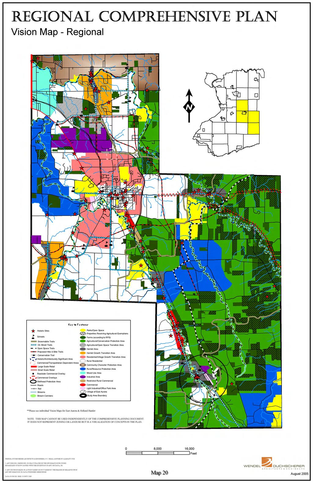
198
199 Town of Aurora Section 5.0 Findings and Recommendations The major features affecting the vision of the Town of Aurora include the Village of East Aurora, the rural agrarian character of the adjoining Town of Wales, the Route 400 Expressway, the Route 20A corridor, West Falls and South Wales hamlets, and the Cazenovia (east and west branch) creek corridors. These features, the community's goals and objectives, and environmental and regional objectives have lead to the following vision components, depicted on Map 21, for the Town of Aurora. Growth areas around the Village of East Aurora (residential growth area), extending south to the schools and southwest to west branch of Cazenovia creek. This growth area also extends northward into the Town of Elma (towards the Route 400 Maple Street exit), west to Seneca Street (and the Knox Estate Park), and east to the Route 20A/Route 400 interchange. This area concentrates future development around the Village to support local businesses and to afford logical infrastructure extensions (sewer). This area of the Town should remain rural residential in nature until infrastructure is made available and proper plans maintaining the character of the area are presented to the Town (also look for neo-urbanist designs). Park features are concentrated in the growth area and around the two hamlets. The area denoted as "agricultural/conservation protection area" abuts a very rural/agrarian area in the Town of Wales and includes a concentration of agricultural properties and the east branch of Cazenovia creek corridor. This area is bounded by the Emery County Park and the South Wales community, Lapham Road in the north and Underhill Road to the west. This area should include the proposed new agricultural zoning district, and environmental protection standards. The West Falls hamlet includes two distinct areas: the linear hamlet area along Route 240 and the hamlet growth transition area surrounding this corridor. The linear hamlet area is a mixed use area of residential, rural commercial businesses and hamlet support features (community facilities). It is not the intent of this area to provide a linear commercial strip corridor. There are pockets of commercial use along this road corridor with residential uses in the remaining areas. A zoning overlay (road based) could help to address redevelopment in these mixed use areas and the zoning should only allow new commercial uses in very targeted areas. The hamlet growth transition area includes the residential area supporting this hamlet and includes the area that has been historically called Griffin Mills. This area is not an area of higher density development (lack at sewers), but an area that should be tied into the hamlet area. The entire area should be kept "walkable" by including sidewalks in selected areas, widened roadway shoulders and bike lanes. The plan for this area (both areas) should include the use of rural development guidelines to maintain the character of the area. The northwestern protection area includes another area of the Town that contains farms, and is traversed by west branch of Cazenovia Creek. This area provides a buffer to the growth occurring to the west in Orchard Park, and provides a rural character feature that leads to the westerly entrance into the Village of East Aurora. This area is intended to be mainly rural residential and agrarian in nature, and could include a zoning overlay to help protect the character and features of the area (see also the discussion of business growth in the community). Although Aurora is overall a rural-residential community, the Town would like to have some balance of proper commercial and industrial usage. These uses, though, should be targeted and strategically located to best service the community, protect its rural character, and to compliment the Village and the surrounding region. To accomplish this, the plan proposes the following: - As mentioned previously, two hamlet areas (one in West Falls and one in South Wales) provide opportunities for rural commercial uses, mixed with residential, to help keep these hamlets vital and viable. These areas would provide small commercial convenience services to the surrounding area. - A targeted commercial area just outside the Village on Route 16 is proposed. From the Village to the Route 400 crossing would provide an area of restricted commercial growth in an 5-71
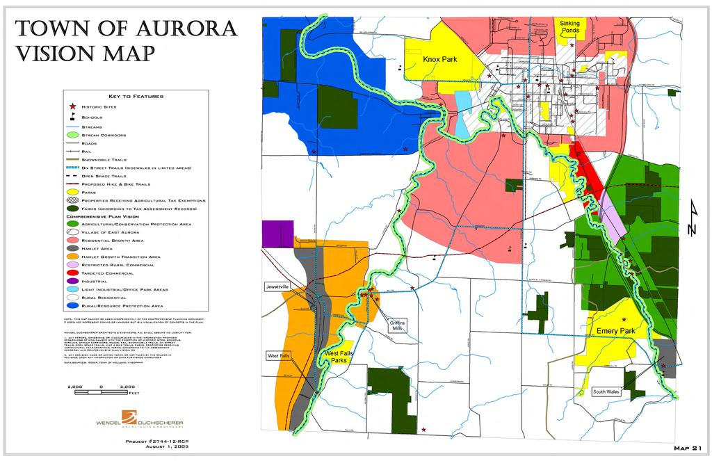
200
201 Section 5.0 Findings and Recommendations environmentally limited area. A new commercial zoning category would restrict the size, scale and type of business operation. This area is not intended to compete with the Village uptown business district or be developed as a major retail center. - This commercial corridor would also extend further south on Route 16, from the Route 400 Expressway to Blakeley Road. This area would be zoned with another new commercial zoning category that would allow residential homes and very targeted rural type commercial businesses on larger lots (mixed use district). These businesses would be rural in nature and be designed in such a way (large lots, setbacks, parking in the back, etc.) to preserve the character of the area. These uses could also be controlled through a special use permit. - An area in the Town is also noted as light industrial/office park on the plan. This area is targeted for possible expansion of light industrial uses. These uses would be off the road, screened from the road, or be very rural in nature. This area would be a logical extension to Commerce Green as the existing park begins to fill in; it could help to meet the future demand for office and light industrial uses. Design standards would be strict (including buffers) to help maintain the image of the entranceway to the Village. The remainder of the Town denoted as rural residential, includes low-density residential areas that are anticipated to see more limited growth of single-family homes. The areas will remain rural in nature and include vestiges of its agricultural past. The final features of the Aurora vision map are the trails and stream corridors. The stream corridors highlighted on the Plan are the regionally significant corridors that should be protected. The plan suggests a zoning overlay or identification of these areas in an open space/greenspace plan. Development in these areas would have to take into account these natural features (preserving to the maximum extent possible), and include conservation easements, dedication or other means of permanent protection. These areas, at a minimum, should be conserved for the movement of wildlife, and only in specific instances should be considered for public access (noted as open space trails). The on-street trails represent roadways that tie major features of the community, and are typically identified in regional plans. These areas should be considered for bike lanes, widened shoulders, or in some cases sidewalks (focused in hamlets, Village area, and around public facilities). The hike and bike trails are typically off-road features (some on road) that are usually associated with some existing utility rights-of-way or easement. They also provide connections within the community and to other communities in the region. 5-72
202 Town of Elma Section 5.0 Findings and Recommendations The major features affecting the vision of the Town of Elma include: the rural nature of the Town, with large areas of open space, some lingering agricultural uses and the rural nature of existing development; the Cazenovia Creek, Buffalo Creek and Pond Brook stream corridors; the Route 400 Expressway that extends through the Town; and the light industrial development that has occurred in the vicinity of this major highway. These features, the community's goals and objectives (which emphasize a desire to maintain the rural character of the Town), and environmental and regional objectives have lead to the following vision components depicted on Map 22. To effectively manage growth pressures exerted from the Town of Lancaster, an area is proposed that lies north of Buffalo Creek, for the protection of rural character (see Map 22). In this area, rural development guidelines would be implemented to control how development occurs. Emphasis would be placed on preserving open space and the rural nature of this area, encouraging clustered development, open development areas (280A designs) and other non-traditional development practices that do not promote sprawl. This is also an area that lacks sewer service, so water quality, particularly in the vicinity of Buffalo Creek, should be considered. Zoning changes that would permit standard subdivision designs, with increased development densities, should be discouraged in this area. The area situated near the border with the Town of West Seneca has been designated for mixed use development. This area is closer to Transit Road and the Route 400 Expressway, and is more suitable for a mixture of land uses, including residential, small businesses and limited light industrial (if properly placed). Commercial development is envisioned for Transit Road, from the Lancaster Town boundary to Seneca Street. Transit Road would be the only area in the Town where larger scale commercial development should be permitted. Seneca Street has been designated for smaller scale retail development, which is designed and operated in character with the surrounding area. This area has remained somewhat rural in nature and this character should be protected. Commercial uses along this roadway should be neighborhood business type uses that service the nearby residential uses, with denser development encouraged in and around the Spring Brook hamlet. Further to the south and east along Seneca Street, the extent and intensity of commercial use should be reduced, particularly in the vicinity of Knox State Park. Since the entire Seneca Street corridor is zoned for commercial use, the idea is to better manage how commercial development occurs along this roadway to avoid sprawl and strip development. This way, character and appeal of roadway development is improved and more in line with the character of the surrounding area. The area around the Elma Plaza is proposed for long term development as a Town center. Elma currently lacks a distinct, identifiable center, where commerce and services are provided. This area along Bowen Road, at Bullis Road, provides such an opportunity. This is where convenience retail and professional/personal services, as well as public services, should be centered. Growth would be encouraged around this area, with a focus placed on walkability and easy access to the centralized services. The Town center hamlet would encompass the area that extends along Bowen Road, north from Woodard Road to Clinton Street. This area would include the plaza and other commercial establishments in the vicinity, the Pond Brook apartment complex, and the historic Elma Village area (including the senior center complex, area churches and other facilities). In addition, the area between Clinton Street and Bullis Road would be designated as historically significant, as it contains a number of structures with historic character that warrant recognition and preservation. Moving away from the proposed Town center and the surrounding hamlet growth transition area, rural residential development would be encouraged. The area situated south and west of the railroad corridor has been designated as an agricultural and open space transition area. This area supports some active farming and contains high quality soils, which are good for farming as well as 5-73
203 N DAVIS RD BOWEN RD SCHULTZ RD TRANSIT RD HANDY RD WINSPEAR RD N BLOSSOM RD BLOSSOM RD HOMEWARD PL AURORA ST N DAVIS RD RIDLE LA CLINTON HGTS E JERGE DR PEARL TERR GIRDLE RD HICKORY HILL RD STOLLE RD Town of Elma Vision Map CLINTON RD CAROL LA MIDWAY LA SCHWARTZ RD HALL RD RANSOM RD EXT SENECA CREEK RD CLINTON RD NANETTE DR TOWN LINE RD Historic Sites Schools Key to Features E CENTER RD KNABB RD BRIGGSWOOD DR CEMETERY RD CHAIR FACTORY RD CRIMSON LA TREE HAVEN RD CHAIR FACTORY RD Streams CLARK CT JERGE DR Stream Corridors Snowmobile Trails On Street Trails Open Space Trails Proposed Hike & Bike Trails Commercial Roads Large Scale Retail Small Scale Retail Roads Rail Historic/Architecturally Significant Area Commercial/Transportation Dependent Areas Parks Properties Receiving Agricultural Exemptions Farms (according to RPS) Comprehensive Plan Vision Agricultural Protection Area Agricultural/Open Space Transition Area Hamlet Area Hamlet Growth Transition Area Village Transition Area Rural Residential Community Character Protection Area Rural/Resource Protection Area Mixed Use Area Industrial Area TRANSIT RD NORTHRUP RD QUEENS WAY WINONA RD KINGS RD BOLL DR AURORA EXPWY KINSLEY RD SULLIVAN DR WINSPEAR RD POUND RD OLD POUND RD HENRY DR CONLEY RD BULLIS RD SENECA ST CLOVER LA DELLWOOD DR RICE RD AURORA EXPWY JAMISON RD GAYLORD CT HESSLAND CT FINNEGAN RD ELDERBERRY RD BOWEN RD DORRIS DR HILLTOP DR SIGMAN LA JAMISON RD MAPLE ST WOODARD RD BULLIS RD KIRKWOOD TERR FAIRWAYS DR OLD BULLIS RD ELMA MEADOWS LA GRIFFIN LA HILLSIDE DR OSTRANDER RD VALLEYVIEW DR ROLLING GREEN LA JAMISON RD JAMISON RD WENDEL DUCHSCHERER ARCHITECTS & ENGINEERS, P.C. SHALL ASSUME NO LIABILITY FOR: 1. ANY ERRORS, OMISSIONS, OR INACCURACIES IN THE INFORMATION PROVIDED REGARDLESS OF HOW CAUSED WITH THE EXCEPTION OF HISTORIC SITES, SCHOOLS, STREAMS, STREAM CORRIDORS, SNOWMOBILE TRAILS, ON STREET TRAILS, OPEN SPACE TRAILS, HIKE & BIKE TRAILS, COMMERCIAL ROADS, ROADS, RAIL, HISTORICALLY/ ARCHITECTURALLY SIGNIFICANT AREAS, COMMERCIAL/TRANSPORTATION DEPENDENT AREAS, PARKS, PROPERTIES RECEIVING AGRICULTURAL EXEMPTIONS, FARMS (ACCORDING TO RPS), AND COMPREHENSIVE PLAN VISION; OR 2. ANY DECISION MADE OR ACTION TAKEN OR NOT TAKEN BY THE READER IN RELIANCE UPON ANY INFORMATION OR DATA FURNISHED HEREUNDER DATA SOURCES: ECDEP, TOWN OF ELMA, NYSOPRHP WILLARD SHIRE RD NORTH STAR RD BARTLETT RD SOUTH RD W BLOOD RD KALLA LA HEMSTREET RD TRACY DR 2, ,000 4,000 6,000 Feet MILE STRIP RD BILLINGTON RD BOWEN RD COLONY CT MAPLE ST GOLFVIEW DR MEADOW DR ESTHER DR BILLINGTON HEIGHTS DR SUMMERDALE DR S OSTRANDER RD E AURORA PORTERVILLE RD REITER RD Project # RCP April 2002 Map 22
204 Section 5.0 Findings and Recommendations residential development. However, residential development in this area should be approached with consideration to the protection and preservation of these soils. Clustered development and other such techniques that protect resources and preserve open space should be considered for this area. Once good farming soils are lost to development, they can never be recovered, so care should be taken to preserve what remains of these resources in the Town for the future. South of the agricultural/open space transition area is the area designated for light industrial/industrial development. This area currently supports a number of industrial facilities and has been deemed suitable for a continuance of such use. The area has ready access to the Route 400 Expressway and an active railroad line. The transition area to the north creates a good buffer between this area and the proposed Town center. To the west, along the border with the Town of Orchard Park, an area has been designated for resource protection. This is an area of the Town that contains a significant creek corridor, important habitat (including a heron rookery), and rural open space. It is an area of the Town that should be protected from intense development to protect existing resources as well as to provide a barrier from development pressure that may arise in the future from the west. This area extends and is consistent with the rural nature of the northwestern area of the Town of Aurora. Development practices that preserve open space and avoid sprawl should be encouraged here, including clustering and open development areas. More progressive techniques to control development density should also be explored. Zoning changes and standards subdivision designs should be discouraged in this area. The area north of the Village of East Aurora, out to the Route 400 Expressway, is envisioned as a village growth transition area. Over time, as growth and development push out beyond the Village, this is the area most suited to absorb this activity. This area could accommodate medium density residential uses that would support the Village of East Aurora, and provide a transition from the light industrial area to the north. Finally, the area to the east, that lies proximate to the Town of Marilla, contains significant open space, farms and the Buffalo Creek corridor. This area is very rural in nature and should be preserved. This area provides a transition of land use into Marilla and should be developed in a manner consistent with this neighboring community. As with the areas to the far north and west in Elma, this area should be protected from over development and intensive land use practices that would promote sprawl and result in denser residential development. Zoning changes and standard subdivision practices should be discouraged in this area. To improve connectivity to other communities and enhance recreational opportunities in the Town, a trail system should be developed. This system should include both on and off-road trails, utilizing existing roadways, utility easements and creek corridors. With respect to the creek corridors, the Town should devise a means of establishing a continuous trail system along Buffalo Creek and Cazenovia Creek, linking with the Towns of Wales and Aurora. 5-74
205 Town of Holland Section 5.0 Findings and Recommendations The major features affecting the vision of the Town of Holland include: the very rural agrarian nature of the Town (concentration of farms in the central and eastern portion of the Town); extensive areas of steep slopes; the east branch of Cazenovia Creek, Hunters Creek and Buffalo Creek stream corridors; and the Route 16 State highway corridor, which extends from Wales Center and Holland hamlets. These features, the community's goals and objectives, and environmental and regional objectives have lead to the following vision components depicted on Map 23 (Holland hamlet is also detailed on Map 24). Much of the Town of Holland is comprised of steep slopes, and agricultural lands and undeveloped open space. The Town is very rural, with the exception of the developed hamlet area and areas along Route 16. The vision map for this community shows that much of the Town is designated for agricultural and open space protection and the preservation of rural character is an important issue. Much of the area outside the hamlet is characterized by steep slopes and lacks public sewer and water. Development that occurs in this area should be low-density residential, with larger minimum lot sizes, and care should be taken to protect and enhance the rural natural of the Town. Techniques should also be developed and implemented to protect and continue the agricultural industry in the Town. Higher density residential development should be confined to the area around the hamlet, where public services are available to support it, and where retail and commercial services exist. The hamlet center should be the primary location for commercial and retail uses, with noncompetitive retail uses locating along portions of Route 16, outside the hamlet. The goal is to revitalize commercial activity in the hamlet center to make the area more prosperous, and provide greater benefit to the surrounding community. Commercial uses along the section of Route 16, between Cazenovia Creek and North Canada Street, should be restricted to agrarian support services and uses and other retail uses that would not compete with the hamlet. The size and scale of these uses should be regulated to ensure that such development is in keeping with the character of the surrounding community. Forethought should also be given to managing the number of curb cuts to Route 16 over the long term. Consideration should be given establishing an historic district in the hamlet, acknowledging the numerous structures that possess historic and architectural significant, and add to the character of this area. Although certain of these structures have been inventoried by the NYS Office of Parks, Recreation and Historic Preservation, there are other noteworthy structures in the hamlet that warrant recognition. An area in the hamlet, along the railroad corridor, has been designated for light industrial development, complementing the existing industrial development to the northwest. An on-road trail should be developed that links the hamlet and the middle school, on Partridge Road, with Wales Hollow, Emery Park and other parts of Wales and Aurora. Buffers around creek corridors should be maintained and required as properties are sited for development. These corridors provide habitat, protection to streambanks and avenues for wildlife. They also could provide future public access via a connected trail system. 5-75
206 WARNER GULF RD WARNER GULF RD HUNTER CREEK RD RAIBER RD DARIEN RD Town of Holland Vision Map CHURCH RD SAUNDERS HILL RD HUMPHRIES HILL RD SAUNDERS HILL RD Historic Sites Key to Features BLANCHARD RD PARKER RD Schools Roads Rail Snowmobile Trails Conservation Trail On Street Trails Open Space Trails Streams Stream Corridors N CANADA ST WHITNEY RD WHITNEY RD Parks/County Forests Preserves/Open Space OWLS BURROUGH RD Wellhead Protection Area Roadside Commercial Overlay Agricultural Properties Receiving Agricultural Exemptions Comprehensive Plan Vision Agricultural Protection Area Agrarian Commercial Hamlet (see separate plan) PARTRIDGE RD ROUTE 16 RUMSEY RD LEGION DR PARK ST CANADA ST GARFIELD ST PEARL ST EDGEWOOD DR WATER ST HILLSIDE TERRACE RD HOLLAND COUNTY RD DAY RD DAY RD Rural/Resource Protection Area Medium Density Residential Industrial E HOLLAND RD Light Industrial PLEASANT VIEW DR NOTE: THIS MAP CANNOT BE USED INDEPENDENTLY OF THE COMPREHENSIVE PLANNING DOCUMENT. IT DOES NOT REPRESENT ZONING OR LANDUSE BUT IS A VISUALIZATION OF CONCEPTS IN THE PLAN. N PROTECTION RD VERMONT HILL RD WENDEL DUCHSCHERER ARCHITECTS & ENGINEERS, P.C. SHALL ASSUME NO LIABILITY FOR: 1. ANY ERRORS, OMISSIONS, OR INACCURACIES IN THE INFORMATION PROVIDED REGARDLESS OF HOW CAUSED WITH THE EXCEPTION OF HISTORICT SITES, SCHOOLS, ROADS, RAIL, SNOWMOBILE TRAILS, CONSERVATION TRAIL, ON STREET TRAILS, OPEN SPACE TRAILS, STREAMS, STREAM CORRIDORS, PARKS/COUNTY FOREST PRESERVES/ OPEN SPACE, WELLHEAD PROTECTION AREA, ROADSIDE COMMERCIAL OVERLAY, PROPERTIES RECEIVING AGRICULTURAL EXEMPTIONS, FARMS (ACCORDING TO RPS), AND COMPREHENSIVE PLAN VISION; OR HOLLAND GLENWOOD RD BURNINGHAM RD 2. ANY DECISION MADE OR ACTION TAKEN OR NOT TAKEN BY THE READER IN RELIANCE UPON ANY INFORMATION OR DATA FURNISHED HEREUNDER S PROTECTION RD DATA SOURCES: ECDEP, TOWN OF HOLLAND, NYSOPRHP 2, ,000 4,000 6,000 Feet PHILLIPS RD SAVAGE RD ROUTE 16 GEER RD E HOLLAND RD WILKINS RD WAGNER RD Project # RCP E HOLLAND RD WARD RD June 2004 Map 23
207 Legion Town of Holland - Hamlet Area Vision Map Middle School Partridge N Main Rumsey Taylor Heights Garfield Canada High School Hillcrest Key to Features Park Pearl Roads Rail On Street Trails Open Space Trails Continental Vermont Water Hillside Streams Schools Wellhead Capitol Heights Wellhead Protection Area Agricultural Related Businesses S Main Historic Sites Comprehensive Plan Vision Historic Preservation Overlay Commercial/Retail Light Industrial Pleasant View Industrial Low Density Residential Medium Density Residential Rural Residential Park NOTE: THIS MAP CANNOT BE USED INDEPENDENTLY OF THE COMPREHENSIVE PLANNING DOCUMENT. IT DOES NOT REPRESENT ZONING OR LANDUSE BUT IS A VISUALIZATION OF CONCEPTS IN THE PLAN. 1, ,000 Feet Project # RCP WENDEL DUCHSCHERER ARCHITECTS & ENGINEERS, P.C. SHALL ASSUME NO LIABILITY FOR: 1.ANY ERRORS, OMISSIONS, OR INACCURACIES IN THE INFORMATION PROVIDED REGARDLESS OF HOW CAUSED WITH THE EXCEPTION OF HAMLET BOUNDARY, ROADS, RAIL, ON STREET TRAILS, OPEN SPACE TRAILS, STREAMS, SCHOOLS, WELLHEADPROTECTION AREA, WELLHEAD, AGRICULTURAL RELATED BUSINESSES, ANDCOMPREHENSIVE PLAN VISION; OR 2. ANY DECISION MADE OR ACTION TAKEN OR NOT TAKEN BY READER IN RELIANCE UPON ANY INFORMATION OR DATA FURNISHED HEREUNDER DATA SOURCES: ERIE COUNTY DEP, TOWN OF HOLLAND April 2002 Map 24
208 Town of Wales Section 5.0 Findings and Recommendations The major features affecting the vision of the Town of Wales include the influences of the Village of East Aurora, the very rural agrarian nature of the Town (concentration of farms in the easterly portion of the Town), the large open space feature of Hunters Creek, the two major stream corridors; Buffalo Creek and Hunters Creek, the two major state highways (Route 20A and Route 78), and the Wales Center and South Wales Hamlets. These features, the community's goals and objectives (including their strong objective of remaining rural), and environmental and regional objectives lead to the following vision components depicted on Map 25. Much of the Town is shown as an agricultural protection area. These areas should remain agricultural - low-density residential areas. These areas would include zoning techniques (overlays, rural development guidelines, reduced density) to protect the rural character and the agricultural operations in the Town. Other proactive measures have also been recommended to protect this area, including restricting infrastructure improvements and possibly some agricultural land preservation techniques such as purchase of development rights (PDR), purchase of agricultural conservation easements (PACE), and Right-to-Farm legislation. The area noted as rural/resource protection area is also a rural residential area, but has a smaller concentration of farming, and some significant environmental features. A zoning overlay would help to protect these features, and direct any development to incorporate rural guidelines. The two hamlets, Wales Center and South Wales, are identified and represent areas of mixed uses in a village-type atmosphere. These areas also include the only areas for on-street trails. These on-street features (bike lanes, widened shoulders or limited sidewalks) help keep the connectivity of the hamlets. As noted above, the hamlets are mixed use areas and include commercial uses. Outside of these areas the Route 20A corridor and Route 78 corridor are denoted as commercial overlays. These areas presently allow commercial uses by special use permit. These areas should also continue to allow commercial uses by special use permit, but additional guidelines should be added through the use of zoning overlays along these important corridors. The remaining features of this map include stream corridors, open space trails, hike and bike trails, conservation trails and snowmobile trails. These features provide wildlife corridors, connections to surrounding communities and community features, and for passive recreational opportunities. 5-76
209 BIG TREE RD VERMONT HILL RD FOU R ROD R D WOODCHUCK RD MAPLE HILL RD E CREEK RD STRYKERSVILLE RD Town of Wales Vision Map BLOOD RD BEAR STREET RD TWO ROD RD WATTERS RD OLD BIG T REE RD WOODS RD Key to Features Historic Sites Schools Snowmobile Trails Conservation Trail HUNTER C REEK RD STRYKERSVILLE RD SCHANG RD On Street Trails Open Space Trails Proposed Hike & Bike Trails Streams Stream Corridors REITER RD Roads Rail Parks/Open Space Commercial Overlays E CREEK RD Properties Receiving Agricultural Exemptions CORNERS RD CENTER LINE RD Farms (according to RPS) CENTER LINE RD Comprehensive Plan Vision Agricultural Protection Area CREEK RD Hamlet Area Rural/Resource Protection Area Rural Residential HUNTER C REEK RD MERLAU R D WARNER HILL RD WARNER HILL RD WENDEL DUCHSCHERER ARCHITECTS & ENGINEERS, P.C. SHALL ASSUME NO LIABILITY FOR: 1. ANY ERRORS, OMISSIONS, OR INACCURACIES IN THE INFORMATION PROVIDED REGARDLESS OF HOW CAUSED WITH THE EXCEPTION OF HISTORIC SITES, SCHOOLS, SNOWMOBILE TRAILS, CONSERVATION TRAIL, ON STREET TRAILS, OPEN SPACE TRAILS, HIKE & BIKE TRAILS, COMMERCIAL OVERLAYS, STREAMS, STREAM CORRIDORS, ROADS, RAIL, COMMERCIAL OVERLAYS, PARKS/OPEN SPACE, PROPERTIES RECEIVING AGRICULTURAL EXEMPTIONS, FARMS (ACCORDING TO RPS), AND COMPREHENSIVE PLAN VISION; OR GOODLEBERG RD CHESTER RD 2. ANY DECISION MADE OR ACTION TAKEN OR NOT TAKEN BY THE READER IN RELIANCE UPON ANY INFORMATION OR DATA FURNISHED HEREUNDER DATA SOURCES: ECDEP, TOWN OF HOLLAND, NYSOPRHP EMERY RD DEPOT ST 2, ,000 4,000 6,000 Feet MEADOW LA WILLOW TER R DARLING RD CAR PENTER R D FISH HILL RD Project # RCP April 2002 DAR IEN RD Map 25
210 Village of East Aurora Section 5.0 Findings and Recommendations The major features affecting the vision of the Village of East Aurora include the influences of the surrounding Towns, the more densely developed, urban (built out) nature of the Village, the functioning of the area as a center for regional commerce, Route 20A (Main Street) and the concentration of public services and civic/cultural land uses. These features, the community's goals and objectives (including their strong desire to protect the unique character of the Village), and environmental and regional objectives lead to the following vision components depicted on Map 26. Most of the Village is depicted as "Village residential", which illustrates the major residential areas in the community that will experience little or no change over the next 15 to 20 years. These areas may be different in style, layout or housing type, but they represent the overall residential stability of the community. Two other dominant residential areas exist in the Village and are denoted on the vision map. The area in the southeast section (estate/large lot residential) has an abundance of large lots. The lowdensity nature of this area should be preserved, possibly through a new zoning classification or a zoning overlay district. This would help to preserve and limit subdivision activity in this area. The area on Main Street, east of the Uptown business district, is noted as historic Main Street residential on the map. This area should be protected for its historic significance and as a gateway into the Village. Higher standards for redevelopment should be utilized in this area (limiting the resubdivision of the lands and control of the aesthetics). The Village includes one major industrial area the existing Fisher Price area. It is an important element of the community and should be protected. The Village should work with Fisher Price to possibly create a new zoning category for this property that limits major industrial uses on the property but focuses on light industrial, research and development, office, etc. (representing the present usage). There are two areas in transition in the Village. The first is the office/small business district, which is along the railroad corridor, south of the Uptown business district. This area is changing into an area of small businesses and offices, with an evident lack of retail uses. An example of this is the current use of the former school building as an office building. The other transition area is the developing Commerce Green business park, which has been promoted over the years as the last vacant land area available for light industrial and office development. Both of these areas are employment centers that can help to bring people into the Village center. The backbone of the Village is Main Street, which extends through the center of the Village from one end to the other. This area includes four distinct districts/areas. As discussed previously and noted on the vision plan, these areas do not directly relate to zoning but are used for reference for the common issues and ideas relating to these areas. The Village's streetscape plan should also be utilized in any actions planned in these four areas. 1. Downtown (West End) Area This area represents the part of the Village that includes some larger, more suburban-style uses such as a supermarket, shopping plaza, franchise fast food restaurants, etc. This part of the Village contains some older, smaller commercial uses, residential uses, public uses and a traffic circle. It is located in close proximity to the Commerce Green Business Park area, and surrounding residential areas. It is an area truly in transition, and has seen some significant changes in the recent past (new supermarket, abandonment of some existing businesses, more drive through establishments, the addition of "chain-stores", etc). This area also represents an important gateway into the community from the west, and the traffic circle is an important feature of this gateway. It is not only a destination for those outside the Village, but it also draws people from the Village (supermarket, business park, retail chains, 5-77
211 Section 5.0 Findings and Recommendations etc.), and, therefore, is subject to transportation related issues. Although there are distinct areas depicted on the vision map along Main Street, one of the challenges is to ensure continuity between these areas. The recommendations for this area do not include any major zoning district boundary changes, but zoning changes that could help with the aesthetics, transportation related issues, and for helping to ensure continuity with the adjoining Main Street area. The recommendations include an overlay zoning district that addresses issues such as aesthetics (landscaping, streetscaping, architecture, etc.), and transportation (access management, walkability, bike access, etc.). The area around the traffic circle should have special requirements that encourage revitalization of this area and continuity with the Main Street area to the east (Village commercial area). For this revitalization area, the overlay may need to restrict the type, size and aesthetics of any proposed use to better match the Main Street character. To compliment these restrictions, some incentives should be added to encourage desired uses. 2. Village Commercial Support Area This area, which is located between the Downtown business district and the Cultural Center on Main Street, is somewhat a mixed-use area that includes some residential uses and small commercial operations. The plan does not recommend any changes to the zoning district boundaries in this area. When commercial redevelopment takes place in the designated commercially zoned parcels on Main Street, it must be designed in relation to abutting residential uses and the character of the surrounding area. It is important that the aesthetics of this area are maintained and kept consistent with the character of the Village, allowing for a visual connection with other areas along Main Street. 3. Cultural Center/Business Support Area This area of Main Street includes small businesses, schools, churches, residential housing and government services. The area's flavor is set by the Roycroft campus. Although this component of the area is focused on tourism, it should continue to serve the Village community. Connections to the surrounding areas, especially the Uptown business district, are crucial. This area should be preserved as the cultural center of the community and capitalized on in this regard. The area depicted on the vision map generally extends south to Oakwood Avenue and north to Fillmore Avenue, but does not include the residential dwelling located along either of these roadways (see Map 26). This area includes properties that will be influenced by the development and redevelopment of the business and cultural features of this area. Again, the plan is not calling for any zoning boundary changes, but an overlay to address aesthetic, cultural and transportation related issues. Other government actions may also be needed to properly guide this development and redevelopment in this area. 4. Uptown/Traditional Main Street Hamlet This area of Main Street represents the traditional business district or downtown, as seen in many villages. The Main Street area consists of retail and service oriented businesses. The character of the area must be preserved though appropriate design standards that would direct any development or redevelopment of the area. These standards should be established with sufficient public input to ensure that the area is designed in a manner that portrays the desires of the community. The area surrounding the downtown is also vital to the district. This surrounding mixed-use area provides support to the downtown (parking, patrons, complimentary support uses). Again, it is important to note that there is also a synergistic relationship between this area and the cultural center/business support district. These areas support and benefit one another through an exchange of services and people. This relationship should be recognized and protected. It is important to note that the plan does not specifically 5-78
212 Section 5.0 Findings and Recommendations call for any zoning boundary changes in this area. This area, as stated previously, is a large mixed use area that acts somewhat like a small hamlet within the Village (thus the name given it). The Village should take extreme care in considering any future rezoning requests in this area and avoid impacts to surrounding uses. Any actions in this area should consider aesthetic, transportation, and accessibility issues. An overlay zoning district in the Main Street portion of this area should also restrict the removal of the existing structures, have strong design standards and incentives for the improvement of the existing structures. Parking, streetscape issues, lighting, signage, bike and pedestrian access, and compatibility with surrounding areas are some of the other issues that need to be addressed in any future actions or zoning text amendments (or overlays). The vision map illustrates a wide system of on-street trails. These trails are essential to preserving, protecting and diversifying the "walkability" of the Village. Focus needs to be placed on making it easier and more convenient to move around the area in a non-motorized fashion (without a car). Trails that link internal features and components in the Village, as well as the Village with the adjoining Town, are vital. Over the long-term, a means of utilizing the existing railroad corridor as a multi-purpose trail should also be considered. A buffer should be established and maintained along Cazenovia Creek for streambank protection, wildlife habitat and travel, and public access. 5-79

213 Village of East Aurora Vision Map Sinking Ponds Key to Features Municipal Boundary Parcel Boundaries Streams Piped Streams Paper Streets Proposed Hike & Bike Trails Community Features Government Buildings Schools Senior Center Millard Fillmore House Roycroft Campus Transportation Connections/Gateways Knox State Park Buffalo Rd Hamlin Ave Girard Ave Maple Rd Tannery Brook Fillmore Ave Warren Dr Old Baldy Park Major Minor Comprehensive Plan Vision Knox Rd Main St Cultural Center/Business Support Area West End Revitalization Area *Please Note: Downtown (West End) Area Estate/Large Lot Residential Historic Main Street Residential Restricted Industrial/R&D Light Industrial/Office Park Office/Small Business Area Uptown/Traditional Main Street Hamlet Village Commercial Support Area Village Residential Open Space & Recreation/Public Facilities This is not a zoning map and should not be used to interpret zoning or to directly correlate to zoning. This map should be used in conjunction with the Text in Section 5-9 of the Regional Comprehensive Plan. Hamburg St Caz enovia Creek S Willow St Center St Oakwood Ave Hamlin Park Olean Rd Elmwood Ave S Grove St WENDEL DUCHSCHERER ARCHITECTS & ENGINEERS, P.C. SHALL ASSUME NO LIABILITY FOR: 1. ANY ERRORS, OMISSIONS, OR INACCURACIES IN THE INFORMATION PROVIDED REGARDLESS OF HOW CAUSED WITH THE EXCEPTION OF PIPED STREAMS, PAPER STREETS, PROPOSED HIKE & BIKE TRAILS, COMMUNITY FEATURES, TRANSPORTATION CONNECTIONS/GATEWAYS, COMPREHENSIVE PLAN VISION; OR 2. ANY DECISION MADE OR ACTION TAKEN OR NOT TAKEN BY THE READER IN RELIANCE UPON ANY INFORMATION OR DATA FURNISHED HEREUNDER DATA SOURCES: ECDEP, VILLAGE OF EAST AURORA Project # RCP ,000 1,500 Feet March 27, 2003 Map 26
DRAFT REGIONAL COMPREHENSIVE PLAN AND DRAFT GENERIC ENVIRONMENTAL IMPACT STATEMENT. Applicant:
 DRAFT REGIONAL COMPREHENSIVE PLAN AND DRAFT GENERIC ENVIRONMENTAL IMPACT STATEMENT Applicant: Towns of Aurora, Elma, Holland and Wales and the Village of East Aurora Lead Agency: Village of East Aurora
Town of Peru Comprehensive Plan Executive Summary
 Town of Peru Comprehensive Plan Executive Communities that plan grow by choice, not by chance. A plan makes growth thoughtful, understandable, and predictable. A plan shows that a community is managing
TABLE OF CONTENTS. Transportation Chapter 1 - Introduction and Purpose of Planning to 1-3. Utilities
 Chapter 1 - Introduction and Purpose of Planning... 1-1 to 1-3 Pennsylvania Municipalities Planning Code (Act 247)...1-1 Previous County Planning Activities...1-1 Objectives of the Plan...1-2 Elements
CHAPTER 12 IMPLEMENTATION
 CHAPTER 12 IMPLEMENTATION The 2010 Town of Denton Comprehensive Plan is intended to capture a vision of the future of Denton. As such, it provides a basis for a wide variety of public and private actions
3. VISION AND GOALS. Vision Statement. Goals, Objectives and Policies
 Vision Statement Queen Creek s interconnected network of parks, trails, open spaces and recreation opportunities provide safe and diverse activities and programs that sustain its unique, small town, equestrian
Improve Neighborhood Design and Reduce Non Point Source Water Pollution
 HOW TO Planning Guide Improve Neighborhood Design and Reduce Non Point Source Water Pollution This document was funded by a grant from the New Hampshire Coastal Program with funding from the National Oceanic
4-Town Comprehensive Plan DRAFT 7/30/07
 4-Town Comprehensive Plan DRAFT 7/30/07 Acknowledgements ning Committee Town of Harrisburg Norman Roof Randy Nicol Town of Martinsburg Terry Thisse Paul Kelly Town of Montague Jan Bagdanowicz Wendy Perry
Implementation Guide Comprehensive Plan City of Allen
 Implementation Guide 2030 Comprehensive Plan City of Allen DRAFT 2015 Implementation Guide Allen 2030 Comprehensive Plan INTRODUCTION The Comprehensive Plan serves as a guide for the growth and development
PSRC REVIEW REPORT & CERTIFICATION RECOMMENDATION
 PSRC REVIEW REPORT & CERTIFICATION RECOMMENDATION KITSAP COUNTY COUNTYWIDE PLANNING POLICIES July 2, 2012 BACKGROUND A major emphasis of the Washington State Growth Management Act (GMA) is the need to
SECTION II SECTION II STATEMENT OF GOALS, OBJECTIVES, PRINCIPLES, ASSUMPTIONS, POLICIES AND STANDARDS
 STATEMENT OF GOALS, OBJECTIVES, PRINCIPLES, ASSUMPTIONS, POLICIES AND STANDARDS 1 2 STATEMENT OF GOALS, OBJECTIVES, PRINCIPLES, ASSUMPTIONS, POLICIES AND STANDARDS INTRODUCTION The New Jersey Municipal
Chapter 10 IMPLEMENTATION RECOMMENDATIONS
 Chapter 10 IMPLEMENTATION RECOMMENDATIONS The recommended land use plan presented in the previous chapter provides a design for the attainment of the urban and rural development and open space preservation
CHAPTER 7: Transportation, Mobility and Circulation
 AGLE AREA COMMUNITY Plan CHAPTER 7 CHAPTER 7: Transportation, Mobility and Circulation Transportation, Mobility and Circulation The purpose of the Transportation, Mobility and Circulation Chapter is to
A BLUEPRINT FOR BROCKTON A CITY-WIDE COMPREHENSIVE PLAN
 A BLUEPRINT FOR BROCKTON A CITY-WIDE COMPREHENSIVE PLAN Public Meeting October 2016 1 Plan Summary and Discussion Public Meeting May 4 2017 City of Brockton Bill Carpenter, Mayor Department of Planning
LAND USE ELEMENT. Purpose. General Goals & Policies
 LAND USE ELEMENT Purpose This Land Use Element contains the goals and policies necessary to support the City s responsibility for managing land resources and guiding development through implementing regulations,
Executive Summary. NY 7 / NY 2 Corridor
 Executive Summary NY 7 / NY 2 Corridor Transportation and Land Use Study December 2005 Prepared for: Town of Colonie Capital District Transportation Committee Prepared by: Introduction: Land use decisions
The transportation system in a community is an
 7 TRANSPORTATION The transportation system in a community is an important factor contributing to the quality of life of the residents. Without a sound transportation system to bring both goods and patrons
Port Lavaca Future Land Use
 Port Lavaca Future Land Use Introduction The City of Port Lavaca is beginning to see sustained growth, after many years of relative stable population. New single family homes, apartments, and businesses
Living in Albemarle County s Urban Places
 Living in Albemarle County s Urban Places ALBEMARLE COUNTY, VIRGINIA A Closer Look at Albemarle s Approach to Managing Growth and Creating Quality Urban Environments www.albemarle.org Page 2 Living in
Sorted citizen input comments in review of Blount County plans July, August, and September 2007
 Sorted citizen input comments in review of Blount County plans July, August, and September 2007 The following presents sorted citizen input comments from three sessions held in July, August and September
This page intentionally blank.
 This page intentionally blank. Parks, Recreation, and Open Space Chapter Relationship to Vision Vision Parks, Recreation and Open Space Chapter Concepts County Government. County government that is accountable
Secrest Short Cut and Monroe Expressway Small Area Plan AUGUST 29, 2018
 Secrest Short Cut and Monroe Expressway Small Area Plan AUGUST 29, 2018 Background and Process Monroe Expressway will be open by the end of 2018 Union County and Indian Trail identified a need to revisit
Warren County/Bowling Green Focus 2030 Comprehensive Plan VOLUME 1 INDEX
 Appendix 5: Index VOLUME 1 INDEX A Aesthetics ES-6, FLU-15, FLU-17, FLU-24, NCR-7 Agricultural Base FLU-18, FLU-20 Agricultural Centers, Rural FLU-11 Agricultural District NCR-17-NCR-18 Agricultural Economy
Concord Community Reuse Project Goals and Guiding Principles. Overarching Goals (OG)
") Concord Community Reuse Project Goals and Guiding Principles Overarching Goals (OG) No priority is implied by the order of presentation of the goals and guiding principles. Overarching goals for the Concord
Concord Community Reuse Project Goals and Guiding Principles Overarching Goals (OG) No priority is implied by the order of presentation of the goals and guiding principles. Overarching goals for the Concord
Preliminary Plan Framework: Vision and Goals
 Preliminary Plan Framework: Vision and Goals Draft: May 2015 Introduction Since the Town of Milliken s comprehensive plan was last updated in 2010, the community was heavily impacted by the 2013 flood,
NEW CASTLE COUNTY S ZONING DISTRICTS
 NEW CASTLE COUNTY S ZONING DISTRICTS This is general information about New Castle County s zoning districts. The information included is by no means exhaustive or complete. Before designing plans to develop
CHAPTER 7: VISION AND ACTION STATEMENTS. Noble 2025 Vision Statement
 CHAPTER 7: VISION AND ACTION STATEMENTS This chapter presents the vision, policy and action statements that transform the comprehensive planning study, an analysis of Noble s past, future trends and community
CHAPTER 1. Ms. Guajardo s Class - Central Elementary CH 1 1
 INTRODUCTION CHAPTER 1 Ms. Guajardo s Class - Central Elementary CH 1 1 1.1 SETTING South Centre City is a linear corridor south of Downtown Escondido paralleling Centre City Parkway and South Escondido
Westport Master Plan. Town of Westport. Master Plan Master Plan Update Committee. Westport, Massachusetts
 Town of Westport Master Plan 2004 Master Plan Update Committee Westport, Massachusetts Open Space and Recreation 5-1 Table of Contents Table of Contents... i List of Tables... ix List of Figures... ix
Regional Context Statement
 Regional Context Statement REGIONAL CONTEXT STATEMENT 3. REGIONAL CONTEXT STATEMENT In 1995, the Provincial Government passed into law the Growth Strategies Act. The purpose of this provincial initiative
The Five Components of the McLoughlin Area Plan
 The Five Components of the McLoughlin Area Plan This documents contains the complete language of the five components of the McLoughlin Area Plan: The Vision Statement The Values The Guiding Principles
Subject: Hendry County Evaluation and Appraisal Report Letter of Understanding - Identification of Major Issues
 HENDRY COUNTY PLANNING & ZONING DEPARTMENT POST OFFICE BOX 2340 165 S. LEE STREET LABELLE, FLORIDA 33975 (863) 675-5240 FAX: (863) 675-5317 SUNCOM 744-4750 November 16, 2007 Mr. Mike McDaniel, Chief Office
INTRODUCTION PLANNING HISTORY
 INTRODUCTION The Upper Rock Creek Master Plan Area lies in the east central part of Montgomery County. The Master Plan Area is adjacent to the City of Rockville to the south, the Olney Planning Area to
CHAPTER 2 GOALS, OBJECTIVES AND POLICIES
 CHAPTER 2 GOALS, OBJECTIVES AND POLICIES The goals, objectives and policies of this Comprehensive Plan Update serve as guidelines for directing future growth, revitalization, development, adaptive reuse
1 Introduction. Chapter. In this chapter:
 Chapter 1 Introduction In this chapter: 1.1 A Snapshot of the Region 1.2 Towards a Sustainable Region 1.3 The Provincial Context 1.4 Purpose and Organization The Regional Municipality of York Official
2018 Northampton Township Comprehensive Plan
 2018 BUCKS COUNTY, PENNSYLVANIA What is a? A comprehensive plan is a municipality s main policy document that details the collective vision for the future, the historic, environmental, and cultural facilities
Chapter 2: Vision, Goals and Strategies
 Chapter 2: Vision, Goals and Lake Elmo Today & Tomorrow Comprehensive Plan 2040 2 VISION, GOALS & STRATEGIES - DRAFT 4-6-2018 INTRODUCTION Comprehensive Plan Purpose Perhapse the most important objective
2030 Comprehensive Plan VISION STATEMENT
 RESOURCE DOCUMENT for Steering Committee Meeting #2 July 12, 2017 2030 Comprehensive Plan VISION STATEMENT Steering Committee from 2008 Established the Lauderdale s Vision as: Creating a livable, lovable
Municipal Plan*Assessment
 Municipal Plan*Assessment This tool was developed to assist in reviewing municipal master plans and in determining if these plans are consistent with smart growth principles, neighboring municipal plans,
City of Royalton Comprehensive Land Use Plan 2005 to Revision February 8, 2011
 City of Royalton Comprehensive Land Use Plan 2005 to 2015 2011 Revision February 8, 2011 PART ONE: INTRODUCTION TO THE COMPREHENSIVE PLAN 1.0 Purpose and Introduction The Comprehensive Land Use Plan provides
Intergovermental Coordination
 Intergovermental Coordination CITY OF WINTER PARK CHAPTER 8: INTERGOVERNMENTAL COORDINATION ELEMENT INTERGOVERNMENTAL COORDINATION ELEMENT GOAL 8-1: PROVIDE FOR IMPROVED INTERGOVERNMENTAL COORDINATION
implementation10 Village of Greendale Comprehensive Plan: Greendale, Wisconsin. Revisiting a Greenbelt Community
 implementation10 Village of Greendale Comprehensive Plan: 2010 - Village of Greendale Comprehensive Plan: 2010 - Implementation The recommendations of this Plan must be implemented by the Village of Greendale,
North Fair Oaks Community Plan Summary and Information
 North Fair Oaks Community Plan Summary and Information WHAT IS THE NORTH FAIR OAKS COMMUNITY PLAN? The North Fair Oaks Community Plan is part of the San Mateo County General Plan, and establishes policies
Comprehensive Plan. Faribault, Minnesota. Hoisington Koegler Group Inc. Claybaugh Preservation Architecture Inc. Howard R. Green Company Bonz/REA
 Comprehensive Plan Faribault, Minnesota Adopted by the Faribault City Council July 8, 2003 prepared for: prepared by: Hoisington Koegler Group Inc. Claybaugh Preservation Architecture Inc. Howard R. Green
SAN RAFAEL GENERAL PLAN 2040 INTRODUCTION AND OVERVIEW
 SAN RAFAEL GENERAL PLAN 2040 INTRODUCTION AND OVERVIEW Steering Committee Presentation February 14, 2018 Purpose of General Plan Guide land use and development decisions Coordinate transportation, infrastructure,
CITY OF LANGLEY OFFICIAL COMMUNITY PLAN BYLAW, 2005, NO APPENDIX II - REGIONAL CONTEXT MAP
 CITY OF LANGLEY OFFICIAL COMMUNITY PLAN BYLAW, 2005, NO. 2600 APPENDIX II - REGIONAL CONTEXT MAP ± Legend Agricultural Mixed Employment Industrial Conservation & Recreation Regional City Centre Urban Containment
Introduction. Chapter 1. Purpose of the Comprehensive Plan Plan Organization Planning Process & Community Input 1-1
 Chapter 1 Introduction Lakewood 2025: Moving Forward Together Purpose of the Comprehensive Plan Plan Organization Planning Process & Community Input 1-1 Purpose of the Comprehensive Plan The Comprehensive
6 Growth Management Challenges and Opportunities
 6 Growth Management Challenges and Opportunities The Town has established a goal of attaining a 50% participation rate with respect to employment opportunities versus residential population. The Town s
S A C R A M E N T O C O U N T Y JACKSON HIGHWAY & GRANT LINE EAST VISIONING STUDY
 JACKSON HIGHWAY & GRANT LINE EAST S A C R A M E N T O C O U N T Y P L A N N I N G D E P A R T M E N T SUMMARY AND WORKBOOK November 19, 2008 History of the Visioning Study Sacramento County has two growth
Plano Tomorrow Vision and Policies
 Plano Tomorrow Vision and Policies PLANO TOMORROW PILLARS The Built Environment The Social Environment The Natural Environment The Economic Environment Land Use and Urban Design Transportation Housing
Gloucester County s Comprehensive Plan. The Community Connection
 Gloucester County s Comprehensive Plan The Community Connection Current Comp Plan Adopted in 1991 with a 20 year planning horizon Updated in 1995 with Part V- Implementation Recommendations and Appendix
Planning Districts INTRODUCTION
 INTRODUCTION To facilitate detailed examination of development prospects for all areas of the community, Delano has been divided into 14 planning districts. The location of these planning districts is
Rural Land Use Designations Kittitas County December 6, 2007 Draft
 KITTITAS COUNTY COMMUNITY DEVELOPMENT SERVICES 411 N. Ruby St., Suite 2, Ellensburg, WA 98926 CDS@CO.KITTITAS.WA.US Office (509) 962-7506 Fax (509) 962-7682 Rural Land Use Designations Kittitas County
4.1.3 LAND USE CATEGORIES
 4.1.3 LAND USE CATEGORIES a. City Center District The City Center District incorporates the existing character and mix of uses in downtown Belmont to encourage redevelopment and new development in keeping
Laberge Group. Town of Coeymans. Draft Comprehensive Plan. Overview of Planning Process
 Draft : Presentation of Goals & Strategies Laberge Group Benjamin H. Syden, A.I.C.P., E.D.P Director in Charge Nicole Allen, A.I.C.P. Senior Planner Anjali Malhotra Planner Presentation Outline Introductions
CHAPTER 2: PLANNING PRINCIPLES
 CHAPTER 2: PLANNING PRINCIPLES 2 Comprehensive Principles The following overarching Principles provide the basis for the goals and policies included in the Mendocino County General Plan. These Principles
BROOKHILL NEIGHBORHOOD MODEL ZONING MAP AMENDMENT PREFACE TO APPLICATION
 BROOKHILL NEIGHBORHOOD MODEL ZONING MAP AMENDMENT PREFACE TO APPLICATION June 15, 2015 Revised: August 1, 2016 I. VISION Brookhill is a proposed community based upon the principles of Albemarle County
This page has been intentionally left blank.
 This page has been intentionally left blank. Chapter 3 3-2 3. Employment 3.A Niagara Economic Gateway 3.A.1 General The Niagara Economic Gateway comprises: a) The Gateway Economic Zone which includes all
Visioning Statement and Guiding Principles
 Visioning Statement and Guiding Principles Planning for the Future The General Plan The General Plan represents Woodland's shared vision of the future and defines a path to lead the community toward its
ARTICLE 6: Special and Planned Development Districts
 ARTICLE 6: Special and Planned Development Districts 6-10 Traditional Neighborhood Development (TND) District 6-10.10 Purpose and Intent The Traditional Neighborhood Development (TND) District provides
2040 LUP is a part of the Comprehensive Plan and carries the same legal authority. Economic Challenges
 1.1. Guiding Anchorage s Growth Where will new residents settle over the next two decades? Where will people work, shop, and play? Will there be enough room to grow? How will Anchorage look? Will growth
Final Generic Environmental Impact Statement for Adoption of the Town of New Hartford Comprehensive Plan Update
 for Adoption of the Town of New Hartford Comprehensive Plan Update Name of Action: Adoption of the Town of New Hartford Comprehensive Plan Update by the Town of New Hartford Town Board Location: Lead Agency:
Hibbing. Land Use. Hibbing Comprehensive Plan 8.1. Land Use
 Hibbing 8.1 Introduction 8.3 Information and Assessment 8.5-8.14 Recommendations 8.15-8.17 Implementation 8.18-8.19 8.2 Introduction Although land use was not identified as a discrete goal during the community
Chapter 1 Vision Statement & Goals
 Chapter 1 Section 1.1 Section 1.2 Section 1.3 Section 1.4 Section 1.5 Introduction Vision Statement Visioning Exercise Prioritization of Land Use Issues Goals of the Comprehensive Plan CHAPTER 1 SECTION
1.0 Circulation Element
 5/9/18 1.0 Circulation Element 1.1 Introduction As growth and development occur in Apache County, enhancements to its circulation system will be necessary. With time, more roads will be paved and air and
VILLAGE & TOWN OF BERGEN: COMPREHENSIVE PLAN
 VILLAGE & TOWN OF BERGEN: COMPREHENSIVE PLAN CPC Public Hearing April 21, 2016 History 1996 Comprehensive Plan Comprehensive Plan Update Committee Consultant (LaBella Associates): December 2014 Residents
FUTURE LAND USE PLAN 7
 FUTURE LAND USE PLAN 7 The recommendations of each of the preceding chapters can be combined to present an overall Future Land Use Plan for Wilton. The Future Land Use Plan, presented on the following
4 Sustainability and Growth Management
 4 Sustainability and Growth Management Introduction Traditionally, has assumed growth and development with limited consideration for the long-term negative social, environmental or economic impacts on
Chapter 9 Community Facilities & Services Plan. Introduction. Cooperative Efforts. Monitoring of Needs
 Chapter 9 Community Facilities & Services Plan Introduction The location of key community facilities such as water, sewer, schools, parks, and roads is important to the provision of the necessary services
Capital Area Regional Planning Commission. DANE COUNTY LAND USE & TRANSPORTATION PLAN Amended Goals and Objectives
 Capital Area Regional Planning Commission DANE COUNTY LAND USE & TRANSPORTATION PLAN Amended Goals and Objectives CARPC Redline Review Draft 12/14/07 as amended and adopted on 2/28/08* *changes indicated
Urban Planning and Land Use
 Urban Planning and Land Use 701 North 7 th Street, Room 423 Phone: (913) 573-5750 Kansas City, Kansas 66101 Fax: (913) 573-5796 Email: planninginfo@wycokck.org www.wycokck.org/planning To: From: City Planning
Guiding Principles, Objectives, Strategies and Policies
 Guiding Principles, Objectives, Strategies and Policies Section 1 Introduction These Guiding Principles were adopted as part of the 1999 Athens-Clarke County Comprehensive Plan and are carried over, in
3 Vision and Goals. Vision and Goals. Blueprint for Bloomsburg. Vision. Town of Bloomsburg Comprehensive Plan,
 Vision and Goals 3 Vision and Goals Citizens of the Town of Bloomsburg clearly value their natural and cultural heritage, the walkable, mixed use pattern of downtown, the access to education, and the community
A larger version of this map is located on the last page of this PDF.
 MAP Committee Input McLoughlin Area Draft Vision Map A larger version of this map is located on the last page of this PDF. 1. The map above is intended to portray a vision for the McLoughlin area. It highlights
PART 1: PROJECT SUMMARY. The application is Attachment A. The site plan is Attachment B.
 Belleterre Subdivision Sketch Plan Town Board 8.7.17 Belleterre Subdivision Sketch Plan PART 1: PROJECT SUMMARY Applicant: Bowman Development Project Size: +/- 20.85 acres Parcel Number: 01115104 and 01115121
FOUR MILE RUN VALLEY WORKING GROUP AND CHARGE
 FOUR MILE RUN VALLEY WORKING GROUP AND CHARGE Adopted April 16, 2016 Amended July 19, 2016 Overview of Integrated Effort The overall goal of the Four Mile Run Valley (4MRV) initiative is to develop a comprehensive
Public Open House. Overview of the Downtown Plan Official Plan Amendment April 23, 2018
 Public Open House Overview of the Downtown Plan Official Plan Amendment April 23, 2018 1 A 25-Year Plan for Downtown To ensure growth contributes positively to Toronto s Downtown as a great place to live,
WATERFORD Plan of Preservation, Conservation and Development Supplement Part 1 - Policy Element
 WATERFORD 2012 Plan of Preservation, Conservation and Development 2015 Supplement Part 1 - Policy Element Effective June 11, 2015 2015 Plan Update GOAL To respond to the evolving land use needs and continually
TRANSPORTATION AND LAND USE
 CHAPTER 10 TRANSPORTATION AND LAND USE Transportation and land use are intimately linked. The expansion of a highway typically spurs housing, employment growth and land development in the communities that
Woodburn Comprehensive Plan Growth Management Goals and Policies
 Goal Woodburn Comprehensive Plan Growth Management Goals and Policies G-1. The City's goal is to manage growth in a balanced, orderly and efficient manner, consistent with the City s coordinated population
3. ELEMENTS OF THE METRO VISION 2035 PLAN
 3. ELEMENTS OF THE METRO VISION 2035 PLAN What is Metro Vision and why does it matter? For more than 50 years, DRCOG has championed a regional perspective on key issues facing the metropolitan area and
Executive Summary. The Mebane CLP is not a regulatory document, but is intended to guide land development decisions. The plan includes:
 Executive Summary P URPOSE AND O RGANIZATION OF THE P LAN The City of Mebane, with input from citizens and an appointed CLP Advisory Committee, adopted Mebane by Design, a Comprehensive Land Development
Major Subdivision Sketch Plan Checklist
 This checklist provides specific requirements that are apart of the Sketch process. The entire process is described by the Huntersville Subdivision Review Process which details all the submittal and resubmittal
Whitemarsh Comprehensive Plan Update: Housing & Land Use. Public Workshop #3: September 20, 2018
 Whitemarsh Comprehensive Plan Update: Housing & Land Use Public Workshop #3: September 20, 2018 Agenda Welcome Process Recap What We ve Heard The Plan Framework Review of Recommended Actions Land Use Housing
495/MetroWest Development Compact Plan Citizen Planner Training Collaborative Conference. March 17, 2012
 495/MetroWest Development Compact Plan Citizen Planner Training Collaborative Conference March 17, 2012 Project Process Local and Regional Priority Areas Growth Scenarios Transportation Investment Categories
COMMUNITY DESIGN. GOAL: Create livable and attractive communities. Intent
 COMMUNITY DESIGN Intent An attractive, well-designed County will attract quality development, instill civic pride, improve the visual character of the community, and create a strong, positive image for
EXECUTIVE SUMMARY DRAFT CHAPTER 1 INTRODUCTION EXECUTIVE SUMMARY
 CHAPTER 1 EXECUTIVE SUMMARY INTRODUCTION Through the joint efforts of the City of Tulsa planning staff and the Land Services division of Indian Nations Council of Governments (INCOG), the Berryhill Land
LU Encourage schools, institutions, and other community facilities that serve rural residents to locate in neighboring cities and towns.
 Application No. 891627: Comprehensive Plan Text Amendment - Rural School Policies - Amend policies consistent with State Legislation allowing schools in the rural area and extension of sewer service to
CITY COUNCIL AGENDA REPORT
 CITY COUNCIL AGENDA REPORT Subject: COUNCIL MOTION LRT ALIGNMENT REMOVAL FROM THE TRANSPORTATION MASTER PLAN On February 10, 2016 Councillor Hughes provided notice in accordance with Section 23 of Procedure
9 CITY OF VAUGHAN OFFICIAL PLAN AMENDMENT NO BOCA EAST INVESTMENTS LIMITED
 9 CITY OF VAUGHAN OFFICIAL PLAN AMENDMENT NO. 631 - BOCA EAST INVESTMENTS LIMITED The Planning and Economic Development Committee recommends the adoption of the recommendations contained in the following
Purpose of the Master Plan
 Purpose of the Master Plan 4 Master Plan Purpose The Master Plan is a policy framework for decisions that affect the physical, social and economic environment of the Town. The Parker 2035: Master Plan
Volume 2: Implementation Plan
 Volume 2: Implementation Plan February 25 th 2002 Implementation Introduction This document outlines the steps that should be taken to implement the Washington Heights Neighborhood Plan. The City Council
Keyport. Vision for Keyport
 Keyport Vision for Keyport Keyport is a rural, historic waterfront village bounded and limited in size by its natural borders of water and the Naval Undersea Warfare Center. The community consists primarily
13. VANDORF-PRESTON LAKE SECONDARY PLAN 13.1 INTRODUCTION
 13. VANDORF-PRESTON LAKE SECONDARY PLAN 13.1.1 Purpose 13.1 INTRODUCTION The Vandorf-Preston Lake Secondary Plan establishes the principles, objectives and general policies, as well as specific strategies
Town Center (part of the Comprehensive Plan)
") Town Center (part of the Comprehensive Plan) Mercer Island Town Center Looking North (2014) In 1994, a year-long process culminated in a set of design guidelines and code requirements for the Town Center
Town Center (part of the Comprehensive Plan) Mercer Island Town Center Looking North (2014) In 1994, a year-long process culminated in a set of design guidelines and code requirements for the Town Center
IMPLEMENTING SOMERSET COUNTY S INVESTMENT FRAMEWORK
 IMPLEMENTING SOMERSET COUNTY S INVESTMENT FRAMEWORK SMART CONSERVATION THROUGH SMART GROWTH NJ LAND CONSERVATION RALLY March 22, 2014 Laurette Kratina, PP, AICP, Supervising Planner Somerset County Planning
2010 Plan of Conservation and Development
 2010 Plan of Conservation and Development Wilton Planning and Zoning Commission Adopted November 2, 2009 Effective January 1, 2010 WILTON 2010 PLAN OF CONSERVATION & DEVELOPMENT PARTICIPANTS Planning &
AGENDA. I. Roll Call Page
 VILLAGE OF POPLAR GROVE A GREAT PLACE TO CALL HOME Special Joint Meeting of The Village Board and The Planning and Zoning Commission January 31st, 2015 8:00 AM Village Board Room: 200 Hill Street, Poplar
Plan-It Greenville (2009) Comprehensive Plan 5-Year Update
 Comprehensive Plan 5-Year Update") Plan-It Greenville (2009) Comprehensive Plan 5-Year Update What is the comprehensive plan: Collecting communitywide data Projecting future population growth Setting communitywide goals Framing policies
Plan-It Greenville (2009) Comprehensive Plan 5-Year Update What is the comprehensive plan: Collecting communitywide data Projecting future population growth Setting communitywide goals Framing policies
SALISBURY TOMORROW Our Vision
 SALISBURY TOMORROW Our Vision Salisbury is committed to supporting a high quality of life and sense of community for all residents. These commitments need to be reflected in our community programs, services
Silverdale Regional Center
 Silverdale Regional Center Vision for Silverdale Regional Center The Silverdale Regional Center Plan (Plan) will guide the evolution of the Silverdale Regional Center from a collection of strip malls and