Ministère du Tourisme, de la Culture et du Sport
|
|
|
- Erick Casey
- 5 years ago
- Views:
Transcription
1 APPENDIX B
2 Page 1 of 1 Ministry of Tourism, Culture and Sport Culture Programs Unit Programs and Services Branch Culture Division 401 Bay Street, Suite 1700 Toronto ON M7A 0A7 ArchaeologyReports@ontario.ca Ministère du Tourisme, de la Culture et du Sport Unité des programmes culturels Direction des programmes et des services Division de culture 401, rue Bay, bureau 1700 Toronto ON M7A 0A7 ArchaeologyReports@ontario.ca Apr 1, 2015 Philip Woodley (P018) New Directions Archaeology Ltd Sandhill Ancaster ON L9G 4V5 RE: RE: Entry into the Ontario Public Register of Archaeological Reports: Archaeological Assessment Report Entitled, "STAGE 1 ARCHAEOLOGICAL ASSESSMENT OF WONDERLAND ROAD, CITY OF LONDON, FORMER GEOGRAPHIC TOWNSHIP OF WESTMINSTER, MIDDLESEX COUNTY ", Dated Jan 16, 2015, Filed with MTCS Toronto Office on Jan 29, 2015, MTCS Project Information Form Number P Dear Mr Woodley: The above-mentioned report, which has been submitted to this ministry as a condition of licensing in accordance with Part VI of the Ontario Heritage Act, R.S.O. 1990, c 0.18 has been entered into the Ontario Public Register of Archaeological Reports without technical review. 1 Please note that the ministry makes no representation or warranty as to the completeness, accuracy or quality of reports in the register. Should you require further information, please do not hesitate to send your inquiry to ArchaeologyReports@Ontario.ca. cc. Archaeology Licensing Officer Gillian Thompson,MMM Group Limited Maged Elmadhoon,City of London 1In no way will the ministry be liable for any harm, damages, costs, expenses, losses, claims or actions that may result: (a) if the Report(s) or its recommendations are discovered to be inaccurate, incomplete, misleading or fraudulent; or (b) from the issuance of this letter. Further measures may need to be taken in the event that additional artifacts or archaeological sites are identified or the Report(s) is otherwise found to be inaccurate, incomplete, misleading or fraudulent.
3 STAGE 1 ARCHAEOLOGICAL ASSESSMENT OF WONDERLAND ROAD, CITY OF LONDON, FORMER GEOGRAPHIC TOWNSHIP OF WESTMINSTER, MIDDLESEX COUNTY Original License Report Submitted to: MMM Group Limited 2655 North Sheridan Way, Suite 300 Mississauga, ON Canada L5K 2P8 Phone: Submitted by: New Directions Archaeology Ltd Sandhill Drive, Unit 3 Ancaster, Ontario L9G 4V5 Phone (905) License Holder: Philip Woodley (P018) Project # P January 16, 2015
4 EXECUTIVE SUMMARY This report details the Stage 1 archaeological assessment of the proposed future widening of Wonderland Road South, City of London, Former Geographic Township of Westminster, Middlesex County. The Wonderland Road subject corridor project limits are from Southdale Road West to Highway 401 (approximately 7.4 km), and 40 m each side of the existing Wonderland Road Right-of-Way (ROW). The Stage 1 assessment included a background study and visual assessment to determine the potential of the subject corridor for recovering archaeological resources. The subject corridor is along a transportation corridor which is dominated by commercial development in the north and agricultural land use in the south. It is in close proximity to multiple historic roadways and waterways, as well as 31 registered archaeological sites. The Stage 1 assessment visually determined that while sections of the subject corridor exhibit disturbances primarily associated with commercial development, road construction and driveways, undisturbed portions of the subject corridor have been identified beyond the ROW limits. The existing ROW is disturbed from previous road construction activities. Given the high probability of finding archaeological materials within the identified undisturbed portions of the subject corridor, it is recommended to the Ministry of Tourism, Culture, and Sport that a Stage 2 assessment consisting of either a test-pit survey at a 5 m interval of fallow areas, woodlots, and lawns or the pedestrian survey of cultivated fields (dependent on field conditions) is required for all undisturbed portions of the subject corridor. i
5 PROJECT PERSONNEL Project Director Field Director Report Graphics Report Preparation Editor Philip Woodley (P018) Philip Woodley Andrew Turner Andrew Turner Philip Woodley ACKNOWLEDGEMENTS New Directions Archaeology Ltd. would like to thank Gillie Thompson, MMM Group Limited, for providing the plans. ii
6 TABLE OF CONTENTS EXECUTIVE SUMMARY... i PROJECT PERSONNEL... ii ACKNOWLEDGEMENTS... ii LIST OF FIGURES... iii LIST OF PLATES... iv PROJECT CONTEXT: DEVELOPMENT... 1 PROJECT CONTEXT: HISTORICAL... 1 PROJECT CONTEXT: ARCHAEOLOGICAL... 3 FIELD METHODOLOGY... 4 DISCUSSION AND CONCLUSIONS... 5 RECOMMENDATIONS... 6 REFERENCES... 7 ADVICE ON COMPLIANCE WITH LEGISLATION... 8 FIGURES... 9 PLATES APPENDIX I: Development Plans for Subject Corridor APPENDIX II: Inventory of Documentary Record LIST OF FIGURES Figure 1: Location of the subject corridor (NTS map 40 I/14) Figure 2: Location of the subject corridor on 1878 map of Township of Westminster (Page & Co. 1878: 16-17) (Not to scale) Figure 3: Development plan (2013) indicating existing ROW and 40 m buffer, with plate locations and directions, and recommendation Figure 4: Development plan (2013) indicating existing ROW and 40 m buffer, with plate locations and directions, and recommendation Figure 5: Development plan (2013) indicating existing ROW and 40 m buffer, with plate locations and directions, and recommendation Figure 6: Development plan (2013) indicating existing ROW and 40 m buffer, with plate locations and directions, and recommendation Figure 7: Development plan (2013) indicating existing ROW and 40 m buffer, with plate locations and directions, and recommendation Figure 8: Development plan (2013) indicating existing ROW and 40 m buffer, with plate locations and directions, and recommendation Figure 9: Development plan (2013) indicating existing ROW and 40 m buffer, with plate locations and directions, and recommendation Figure 10: Development plan (2013) indicating existing ROW and 40 m buffer, with plate locations and directions, and recommendation Figure 11: Development plan (2013) indicating existing ROW and 40 m buffer, with plate locations and directions, and recommendation Figure 12: Development plan (2013) indicating existing ROW and 40 m buffer, with plate locations and directions, and recommendation iii
7 LIST OF PLATES Plate 1: Field conditions along the subject corridor, view facing N Plate 2: Field conditions along the subject corridor, view facing S Plate 3: Field conditions along the subject corridor, view facing N Plate 4: Field conditions along the subject corridor, view facing SE Plate 5: Field conditions along the subject corridor, view facing NW Plate 6: Field conditions along the subject corridor, view facing SE Plate 7: Field conditions along the subject corridor, view facing NW Plate 8: Field conditions along the subject corridor, view facing N Plate 9: Field conditions along the subject corridor, view facing SE Plate 10: Field conditions along the subject corridor, view facing SE Plate 11: Field conditions along the subject corridor, view facing NW Plate 12: Field conditions along the subject corridor, view facing SW Plate 13: Field conditions along the subject corridor, view facing NW Plate 14: Field conditions along the subject corridor, view facing SE Plate 15: Field conditions along the subject corridor, view facing NE Plate 16: Field conditions along the subject corridor, view facing SE Plate 17: Field conditions along the subject corridor, view facing NW Plate 18: Field conditions along the subject corridor, view facing NW Plate 19: Field conditions along the subject corridor, view facing NW Plate 20: Field conditions along the subject corridor, view facing SE Plate 21: Field conditions along the subject corridor, view facing W Plate 22: Field conditions along the subject corridor, view facing SE. Note disturbed due to development, utilities Plate 23: Field conditions along the subject corridor, view facing NW. Note disturbed due to development, utilities Plate 24: Field conditions along the subject corridor, view facing SE Plate 25: Field conditions along the subject corridor, view facing NW. Note disturbed due to development, utilities Plate 26: Field conditions along the subject corridor, view facing SE. Note disturbed due to development, utilities Plate 27: Field conditions along the subject corridor, view facing SE. Note disturbed due to development, utilities iv
8 Stage 1 Archaeological Assessment of Wonderland Road, London 1 PROJECT CONTEXT: DEVELOPMENT This report discusses the rationale, methods and results of the Stage 1 archaeological assessment of the proposed future widening of Wonderland Road South, Part of Lots 35 and 36, Concession 2; Part of Lot 24, Concession 3, 4 and 5; Part of Lot 23, Concession 6; and Lots 59 to 70 East of Talbot Rd, City of London, Former Geographic Township of Westminster, Middlesex County. The Wonderland Road subject corridor project limits are from Southdale Road West to Highway 401 (approximately 7.4 km), and 40 m each side of the existing Wonderland Road Right of Way (Figure 1). The assessment was undertaken on behalf of MMM Group Limited for the City of London as part of the Class Environmental Assessment for the future development of Wonderland Road. Stage 1 is the background study of archaeological sites located within or near the subject corridor and visual assessment of the subject corridor to assess archaeological potential. For this aspect of the project, the archaeological site registry database files at the Ministry of Tourism, Culture and Sport, in Toronto will be examined to determine if there are any registered archaeological sites located within or near the subject corridor. Historic documents will also be examined to determine if any possible historic sites are located within the project limits, as well as to determine the proximity of historic transportation routes. Assessment activities were conducted in accordance with the provisions of the Ontario Heritage Act (R.S.O. 1990, c.o. 18) in compliance with the Standards and Guidelines for Consultant Archaeologists (2011) under an archaeological consulting license (#P018) issued to Philip Woodley of New Directions Archaeology Ltd. Permission to access for the visual assessment was granted by the City of London. The field notes, photos and related documents will be curated at the office of New Directions Archaeology Ltd. PROJECT CONTEXT: HISTORICAL The subject corridor is located in the Township of Westminster in what was originally Middlesex County, but is now part of the City of London. The first permanent settlement in Middlesex County was at Delaware Village near the Thames River, and began in 1793 (H. R. Page & Co. 1878: 5). From there, the first road was constructed and opened and extended to Chatham, and in 1812 was used for the passage of artillery and baggage (H. R. Page & Co. 1878: 5-6). Steady settlement in the County did not increase until after the War of 1812.
9 New Directions Archaeology Ltd 2 Westminster Township, south-central Middlesex County, is the second oldest settled township in Middlesex. Most of the earlier settlers were farmers and patents were issued in Westminster as early as 1812 (H. R. Page & Co. 1878). Westminster historically encompassed several small villages: Lambeth, Glanworth, Belmont, Nilestown, Byron, and New Brighton (H. R. Page & Co. 1878). An examination or the 1878 map of the Township of Westminster (Page and Co.1878: 16-17) reveals that the subject corridor, at this time, runs through Part of Lots 35 and 36, Concession 2; Part of Lot 24, Concession 3, 4 and 5; Part of Lot 23, Concession 6; and Part of Lots 59 to 70 East of Talbot Road. Table 1 lists the property owners by lot and concession, as well as any houses, orchards, or other points of interest indicated on the 1878 map of the Township of Westminster. Due to the narrow nature of the subject corridor, many of the structures on the properties fall far outside the project limits and as such were not included in Table 1. Even so, multiple farmhouses and orchards fall within or immediately adjacent to the subject corridor. Considering the close proximity of historic structures, presence of major historical roadways, and waterways, there is a high probability of locating historic artifacts in the subject corridor. Table 1: Past Owners by Lot and Concession for Subject Corridor with Number of Structures, Orchards or Other Points of Interest Indicated. Lot Concession Owner(s) Structures, Orchards, Other 35 2 B. Bryant, F.C. White 2 Farmhouses, 2 Orchards 36 2 W. Walter, Walter Nixon 3 Farmhouses, 1 Orchard 24 3 James Davey, J McDonnell 1 Farmhouse, 1 Orchard 24 4 Cha. Gerard, Richard Stephens 3 Farmhouses, 1 Orchard 24 5 Heirs of Wm. McGregor 23 6 Peter Milne, Wm. Forbes 59 East of Talbot Road Rich J. Wilson, John Inglis 60 East of Talbot Road J. K. Little 61 East of Talbot Road J. F. Little 62 East of Talbot Road James Benson Little, Soveski Little 63 East of Talbot Road Henry Mill, William Piper 64 East of Talbot Road Hiram Jones, Isaac Hunt, Waller Hunt 65 East of Talbot Road Jones, Dav Jones 66 East of Talbot Road Hiram Jones Jr. 67 East of Talbot Road Hiram Jones Jr. 68 East of Talbot Road Richard Thomas 69 East of Talbot Road Heirs of S. Nichol, J.J. Lancaster M.D., E. Disbro 70 East of Talbot Road James Swift 1 Farmhouse, 1 Orchard
10 Stage 1 Archaeological Assessment of Wonderland Road, London 3 PROJECT CONTEXT: ARCHAEOLOGICAL The subject corridor is located along Wonderland Road South, Part of Lots 35 and 36, Concession 2; Part of Lot 24, Concession 3, 4 and 5; Part of Lot 23, Concession 6; and Lots 59 to 70 East of Talbot Rd, City of London, Former Geographic Township of Westminster, Middlesex County. The subject corridor is dominated by commercial land use in the north, and agricultural land in the south. The Stage 1 visual assessment was conducted on November 20th, 2013 under cool and sunny conditions. The subject corridor is located on the Mount Elgin Ridges physiographic region (Chapman and Putnam 1984: 144). The topography of the Mount Elgin Ridges consists of successions of ridges (950 to 1,000 feet a.s.l) and vales ( feet a.s.l.) (Chapman and Putnam 1984). The vales are alluvium of gravel, sand or silt while the ridges are comprised of pale brown calcareous clay or silty clay (Chapman and Putnam 1984). The topography of the subject corridor is fairly flat to gently undulating and is mostly farmland in the south with some commercial development in the north. A survey of the Ministry of Tourism, Culture and Sport archaeological site registry database files in Toronto revealed that there are 31 registered sites within 1 km of the subject corridor. In addition, an examination of the subject corridor using Ontario Base Mapping (OBM) 1: was performed to identify potential. In summary, only three of the sites have an undetermined temporal or cultural affiliation, and four an undetermined site type. Of the sites with a determined temporal or cultural affiliation, 25 can be classified under Pre-Contact (with further divisions within this category; Late Archaic, Woodland, Late Woodland, etc.), two as strictly Euro Canadian, and one site that had both Pre-Contact and Euro Canadian components. Ten of the 27 with site type listed are identified as campsites, six as hamlets, five as findspots, three as lithic scatters, one as a longhouse, one as a homestead and one as a village. Given the amount of sites within the vicinity, as well as the abundant waterways (both for potable water and transportation), there is a high potential for locating archaeological material within the subject corridor.
11 New Directions Archaeology Ltd 4 Table 2. Registered Archaeological Sites Within 1 km of the Subject Corridor* Borden Number Site Name Temporal or Cultural Affiliation Type of Site AfHh-3 Thomas Power - - Line AfHh-5 Wodrich - - AfHh-11 Dale - - AfHh-12 Ontario Hydro Pre-Contact Lithic Scatter Tower 30 AfHh-24 Pincombe 2 Woodland Hamlet AfHh-25 - Pre-Contact Campsite AfHh-26 Pincombe 3 Pre-Contact, Euro Canadian Campsite AfHh-27 Pincombe 1 Late Woodland, Neutral Village AfHh-30 Pincombe 4 Pre-Contact Campsite AfHh-31 - Early Woodland, Adena Campsite AfHh-32 - Late Woodland, Iroquoian Findspot AfHh-33 - Late Woodland, Iroquioan Findspot AfHh-34 - Pre-Contact Campsite AfHh-43 - Pre-Contact Campsite AfHh-65 Cassandra Late Woodland Hamlet AfHh-66 Matthew William Late Woodland Hamlet AfHh-67 Little Willow Pre-Contact Campsite AfHh-68 Missing Late Woodland Campsite AfHh-69 Marna Late Woodland Hamlet AfHh-70 Grant Late Woodland Hamlet AfHh-71 Pincombe 5 Late Woodland Campsite AfHh-72 Pincombe 6 Late Woodland Longhouse AfHh-74 Radio Tower Woodland Hamlet AfHh-75 Corvette Pre-Contact Campsite AfHh-217 Alice Pre-Contact Lithic Scatter AfHh-227 Field of Dreams Late Archaic Findspot AfHh-286 Worldwide Pitch N Putt PreContact Findspot AfHh Early Archaic Findspot AfHh Euro Canadian - AfHh Pre-Contact Lithic Scatter AfHh Euro Canadian Homestead *Information is from the MTCS Archaeological Site Registry Database, Toronto. FIELD METHODOLOGY The Stage 1 visual assessment was conducted on November 20th, 2013 under cool and sunny conditions resulting in excellent visibility. The entire subject corridor was visually assessed and photo documented, and the details of the field survey are presented in Figures 3 to 12. The digital copy of the aerial mapping is the most accurate digital mapping available and has been provided to indicate field methodology. The Stage 1 assessment determined that much of the northern portion of the subject corridor has been disturbed by commercial development and construction activities (Figures 10-12, Plates 22-23, Plates 25-27), with additional disturbance where Highway 402 transects Wonderland Road (Figures 6 and 7). The remainder of the subject corridor is vacant lots or agricultural land and appears to be undisturbed (Figures 3 to 11, Plates
12 Stage 1 Archaeological Assessment of Wonderland Road, London , Plate 24). A stage 2 assessment will be required for these identified undisturbed areas within the subject corridor. A pedestrian survey may be feasible for agricultural fields, depending on field conditions. Test pit survey would be required for the woodlots, residential properties, and fallow or agricultural fields that are unable to be ploughed. The test pit survey would be conducted at a 5 m interval with all soil shoveled into a 6 mm mesh and screened for artifacts, with all the test pits backfilled. Each test pit will need to be approximately 30 cm in diameter and hand excavated 5 cm into potential subsoil with the profiles of each test pit examined for stratified layers and/or disturbance. DISCUSSION AND CONCLUSIONS The Ministry of Tourism, Culture and Sport has provided a 2011 Standards and Guidelines for Consultant Archaeologists to assist in identifying archaeological potential. Under these guidelines all property is identified as having archaeological potential that is within: 300 m of registered archaeological sites; 300 m of water sources (primary, secondary, historic and glacial); elevated topography; well drained soils; distinctive land formations; resource areas (food, medicinal plants, source raw materials and early Euro-Canadian industry); 100 m of early Euro-Canadian settlement; 100 m of historic transportation routes; areas containing Ontario Heritage designated properties; and properties identified by local informants as having potential (MTCS 2011: 17-18). The subject corridor meets several of these criteria. The subject corridor is located along Wonderland Road, bounded by Southdale Road West and Highway 401, in an area of early Euro-Canadian settlement. It appears to be in close proximity to water sources and historic transportation routes (roads, tributaries) (Figure 2). As previously discussed, 31 registered archaeological sites are located near the study corridor. While portions of the subject corridor in the north have been disturbed by commercial development and a section has been disturbed by Highway 402 transecting Wonderland Road, much of the rest of the subject corridor appears undisturbed. Given the high probability of finding archaeological materials within undisturbed portions of the subject corridor it is recommended to the Ministry of Tourism, Culture and Sport that a Stage 2 assessment will be required for identified undisturbed areas (Figures 3-11). The Stage 2 assessment would consist of either a test-pit survey of fallow areas, woodlots and lawns, for the pedestrian survey of cultivated fields (dependent on field conditions) for all undisturbed portions of the subject corridor.
13 New Directions Archaeology Ltd 6 RECOMMENDATIONS On the basis of the above information, the following recommendations can be made: 1. Stage 1 archaeological assessment of the proposed future widening of Wonderland Road South, Part of Lots 35 and 36, Concession 2; Part of Lot 24, Concession 3, 4 and 5; Part of Lot 23, Concession 6; and Lots 59 to 70 East of Talbot Rd, City of London, Former Geographic Township of Westminster, Middlesex County determined that the study area is in close proximity to areas of archaeological potential and therefore the potential for recovering archaeological materials is high. Given this, it is recommended to the Ministry of Tourism, Culture, and Sport that a Stage 2 archaeological assessment be required for all undisturbed areas within the subject corridor. This would involve either a test-pit survey of fallow areas, woodlots, and lawns or a pedestrian survey of cultivated fields, dependent on field conditions, in order to identify all archaeological resources or materials that may be present. Both the test-pit survey and pedestrian survey would be conducted at a 5 m interval and for the test-pit survey all soil would be shoveled into 6 mm mesh and screened for artifacts and the test-pits backfilled. 2. The remainder of the subject corridor has been identified as disturbed due to commercial development and road construction. Given this, it is recommended to the Ministry of Tourism, Culture, and Sport that the remainder of this subject corridor is disturbed and that no further archaeological assessment is required. 3. Construction should not proceed before receiving confirmation that the Ministry of Tourism, Culture and Sport has entered the report into the provincial register of reports. This report is filed with the Minister of Tourism, Culture and Sport in compliance with sec. 65 (1) of the Ontario Heritage Act. The ministry reviews reports to ensure that the licensee has met the terms and conditions of the license and archaeological resources have been identified and documented according to the standards and guidelines set by the ministry, ensuring the conservation, protection and preservation of the heritage of Ontario. 4. Should previously unknown or unassessed deeply buried archaeological resources be uncovered during development, they may be a new archaeological site and therefore subject to Section 48 (1) of the Ontario Heritage Act. The proponent or person discovering the archaeological resources must cease alteration of the site immediately and engage a licensed archaeologist to carry out archaeological fieldwork, in compliance with sec. 48 (1) of the Ontario Heritage Act. 5. Any person discovering human remains must immediately notify the police or coroner and the Registrar of Cemeteries, Ministry of Government Services. Contacts: Culture Unit, Programs and Services, Ministry of Tourism, Culture and Sport: (416) Registrar of Cemeteries, Cemeteries Regulation Unit: Michael D Mello (416) or (416)
14 Stage 1 Archaeological Assessment of Wonderland Road, London 7 REFERENCES Chapman, L.J. and D.F. Putnam 1984 The Physiography of Southern Ontario, Third Edition. Ontario Geological Survey Special Volume 2, Ontario Ministry of Natural Resources, Toronto. Government of Ontario 1990 The Heritage Act RSO Queen s Printer, Toronto Planning Act SO Queen s Printer, Toronto. Ministry of Tourism, Culture and Sport 1993 Archaeological Assessment Technical Guidelines (Stages 1-3 & Reporting Format). Ministry of Culture, Tourism and Recreation, Cultural Programs Branch, Archaeology and Heritage Planning, Toronto Standards and Guidelines for Consulting Archaeologists. Ministry of Tourism and Culture, Queen s Printer, Toronto Archaeological Site Registry Database. Toronto. Page, H.R., and Co Illustrated Historical Atlas of Middlesex County. Toronto.
15 New Directions Archaeology Ltd 8 ADVICE ON COMPLIANCE WITH LEGISLATION 1. This report is submitted to the Minister of Tourism, Culture and Sport as a condition of licensing in accordance with Part VI of the Ontario Heritage Act, R.S.O. 1990, c The report is reviewed to ensure that it complies with the standards and guidelines that are issued by the Minister, and that the archaeological fieldwork and report recommendations ensure the conservation, protection and preservation of the cultural heritage of Ontario. When all matters relating to archaeological sites within the project area of a development proposal have been addressed to the satisfaction of the Ministry of Tourism, Culture and Sport, a letter will be issued by the ministry stating that there are no further concerns with regard to alteration to archaeological sites by the proposed development. 2. It is an offence under Sections 48 and 69 of the Ontario Heritage Act for any party other than a licensed archaeologist to make any alteration to a known archaeological site or to remove any artifact or other physical evidence of past human use or activity from the site, until such times as a licensed archaeologist has completed archaeological fieldwork on the site, submitted a report to the Minister stating that the site has no further cultural heritage value or interest, and the report has been filed in the Ontario Public Register of Archaeology Reports referred to in Section 65.1 of the Ontario Heritage Act. 3. Should previously undocumented archaeological resources be discovered, they may be a new archaeological site and therefore subject to Section 48 (1) of the Ontario Heritage Act. The proponent or person discovering the archaeological resources must cease alteration of the site immediately and engage a licensed consultant archaeologist to carry out archaeological fieldwork, in compliance with Section 48 (1) of the Ontario Heritage Act. 4. The Cemeteries Act, R.S.O c. C.4 and the Funeral, Burial and Cremation Services Act, 2002, S.O. 2002, c.33 (when proclaimed in force) require that any person discovering human remains must notify the police or coroner and the Registrar of Cemeteries at the Ministry of Consumer Services.

16 Stage 1 Archaeological Assessment of Wonderland Road, London 9 FIGURES Figure 1: Location of the subject corridor (NTS map 40 I/14).

17 New Directions Archaeology Ltd 10 Figure 2: Location of the subject corridor on 1878 map of Township of Westminster (Page & Co. 1878: 16-17) (Not to scale).
 indicating existing ROW and 40 m buffer, with plate locations and")
18 Stage 1 Archaeological Assessment of Wonderland Road, London 11 Figure 3: Development plan (2013) indicating existing ROW and 40 m buffer, with plate locations and directions.

19 New Directions Archaeology Ltd 12 Figure 4: Development plan (2013) indicating existing ROW and 40 m buffer, with plate locations and directions.
 indicating existing ROW and 40 m buffer, with plate locations and")
20 Stage 1 Archaeological Assessment of Wonderland Road, London 13 Figure 5: Development plan (2013) indicating existing ROW and 40 m buffer, with plate locations and directions.

21 New Directions Archaeology Ltd 14 Figure 6: Development plan (2013) indicating existing ROW and 40 m buffer, with plate locations and directions.
22 Stage 1 Archaeological Assessment of Wonderland Road, London 15 Figure 7: Development plan (2013) indicating existing ROW and 40 m buffer, with plate locations and directions.

23 New Directions Archaeology Ltd 16 Figure 8: Development plan (2013) indicating existing ROW and 40 m buffer, with plate locations and directions.
 indicating existing ROW and 40 m buffer, with plate locations and")
24 Stage 1 Archaeological Assessment of Wonderland Road, London 17 Figure 9: Development plan (2013) indicating existing ROW and 40 m buffer, with plate locations and directions.

25 New Directions Archaeology Ltd 18 Figure 10: Development plan (2013) indicating existing ROW and 40 m buffer, with plate locations and directions.
 indicating existing ROW and 40 m buffer, with plate locations and")
26 Stage 1 Archaeological Assessment of Wonderland Road, London 19 Figure 11: Development plan (2013) indicating existing ROW and 40 m buffer, with plate locations and directions.
27 New Directions Archaeology Ltd 20 Figure 12: Development plan (2013) indicating existing ROW and 40 m buffer, with plate locations and directions.


28 Stage 1 Archaeological Assessment of Wonderland Road, London 21 PLATES Plate 1: Field conditions along the subject corridor, view facing N. Plate 2: Field conditions along the subject corridor, view facing S. Plate 3: Field conditions along the subject corridor, view facing N. Plate 4: Field conditions along the subject corridor, view facing SE. Plate 5: Field conditions along the subject corridor, view facing NW. Plate 6: Field conditions along the subject corridor, view facing SE.


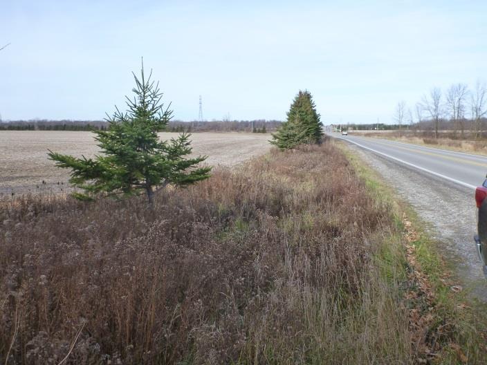
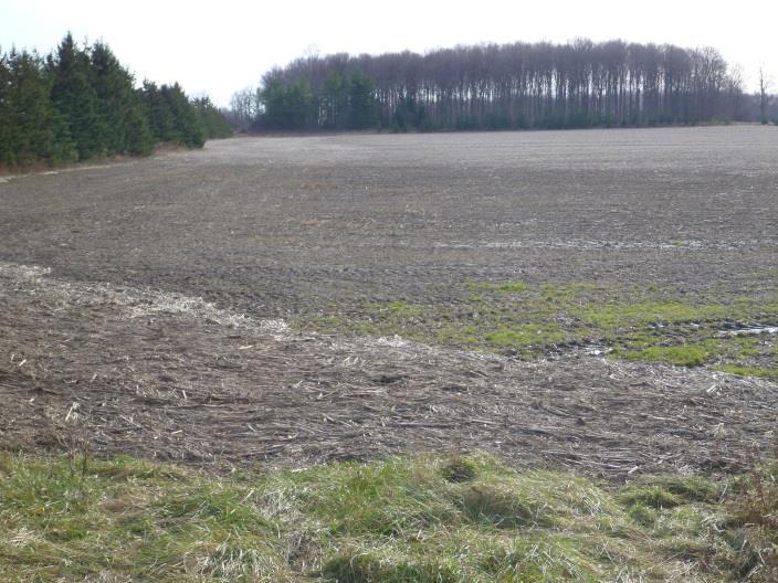
29 New Directions Archaeology Ltd 22 Plate 7: Field conditions along the subject corridor, view facing NW. Plate 8: Field conditions along the subject corridor, view facing N. Plate 9: Field conditions along the subject corridor, view facing SE. Plate 10: Field conditions along the subject corridor, view facing SE. Plate 11: Field conditions along the subject corridor, view facing NW. Plate 12: Field conditions along the subject corridor, view facing SW.


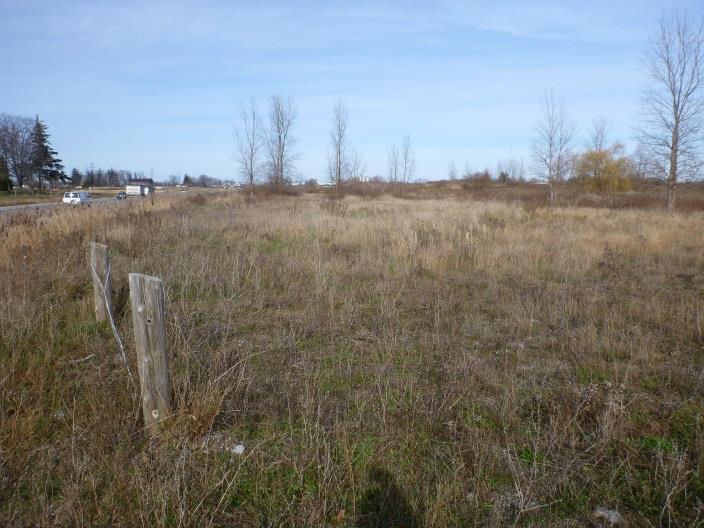
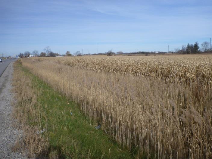
30 Stage 1 Archaeological Assessment of Wonderland Road, London 23 Plate 13: Field conditions along the subject corridor, view facing NW. Plate 14: Field conditions along the subject corridor, view facing SE. Plate 15: Field conditions along the subject corridor, view facing NE. Plate 16: Field conditions along the subject corridor, view facing SE. Plate 17: Field conditions along the subject corridor, view facing NW. Plate 18: Field conditions along the subject corridor, view facing NW.


31 New Directions Archaeology Ltd 24 Plate 19: Field conditions along the subject corridor, view facing NW. Plate 20: Field conditions along the subject corridor, view facing SE. Plate 21: Field conditions along the subject corridor, view facing W. Plate 22: Field conditions along the subject corridor, view facing SE. Note disturbed due to development, utilities. Plate 23: Field conditions along the subject corridor, view facing NW. Note disturbed due to development, utilities. Plate 24: Field conditions along the subject corridor, view facing SE.


32 Stage 1 Archaeological Assessment of Wonderland Road, London 25 Plate 25: Field conditions along the subject corridor, view facing NW. Note disturbed due to development, utilities. Plate 26: Field conditions along the subject corridor, view facing SE. Note disturbed due to development, utilities. Plate 27: Field conditions along the subject corridor, view facing SE. Note disturbed due to development, utilities.

33 New Directions Archaeology Ltd 26 APPENDIX I: Development Plans for Subject Corridor

34 Stage 1 Archaeological Assessment of Wonderland Road, London 27

35 New Directions Archaeology Ltd 28

36 Stage 1 Archaeological Assessment of Wonderland Road, London 29

37 New Directions Archaeology Ltd 30

38 Stage 1 Archaeological Assessment of Wonderland Road, London 31

39 New Directions Archaeology Ltd 32

40 Stage 1 Archaeological Assessment of Wonderland Road, London 33

41 New Directions Archaeology Ltd 34

42 Stage 1 Archaeological Assessment of Wonderland Road, London 35
43 New Directions Archaeology Ltd 36 APPENDIX II: Inventory of Documentary Record Assessment Field Documents Total Nature Location Wonderland Road, London, Class EA Photographs 38 Digital On server at 1480 Sandhill Drive, Unit 3, Ancaster; Folder Wonderland Road, Field Notes 10 Digital and Hard Copy Field Maps 10 Digital and Hard Copy London, Class EA On server and on file at 1480 Sandhill Drive, Unit 3, Ancaster; Folder Wonderland Road, London, Class EA On server and on file at 1480 Sandhill Drive, Unit 3, Ancaster; Folder Wonderland Road, London, Class EA
Revised License Report
 STAGE 1 2 ARCHAEOLOGICAL ASSESSMENT OF THE EGLINTON CROSSTOWN LIGHT RAIL TRANSIT CORRIDOR, EGLINTON AVENUE FROM JANE STREET TO BRICKNELL STREET, CONCESSION 5, LOT 11, CONCESSION 6, LOT 41, YORK TOWNSHIP,
STAGE 1 2 ARCHAEOLOGICAL ASSESSMENT OF YONGE STREET SUBWAY EXTENSION, LOTS 37-41, CONCESSION EYS, TOWNSHIP OF MARKHAM, CITY OF TORONTO, YORK COUNTY
 STAGE 1 2 ARCHAEOLOGICAL ASSESSMENT OF YONGE STREET SUBWAY EXTENSION, LOTS 37-41, CONCESSION EYS, TOWNSHIP OF MARKHAM, CITY OF TORONTO, YORK COUNTY Original License Report Submitted to: Ecoplans Limited
Original License Report. Submitted to: New Horizon Development Inc. 69 John Street South, Suite 304 Hamilton, Ontario L8N 2B9 Phone (905)
") STAGE 1 ARCHAEOLOGICAL ASSESSMENT OF 2480-2496 OLD BRONTE ROAD, PART OF LOT 31, CONCESSION 1 SOUTH OF DUNDAS STREET, GEOGRAPHIC TOWNSHIP OF TRAFALGAR, TOWN OF OAKVILLE, REGIONAL MUNICPALITY OF HALTON Original
STAGE 1 ARCHAEOLOGICAL ASSESSMENT OF 2480-2496 OLD BRONTE ROAD, PART OF LOT 31, CONCESSION 1 SOUTH OF DUNDAS STREET, GEOGRAPHIC TOWNSHIP OF TRAFALGAR, TOWN OF OAKVILLE, REGIONAL MUNICPALITY OF HALTON Original
STAGE 1 ARCHAEOLOGICAL ASSESSMENT OF RATHBURN ROAD, FROM DUKE OF YORK BOULEVARD TO SHIPP DRIVE, CITY OF MISSISSAUGA. Submitted to:
 STAGE 1 ARCHAEOLOGICAL ASSESSMENT OF RATHBURN ROAD, FROM DUKE OF YORK BOULEVARD TO SHIPP DRIVE, CITY OF MISSISSAUGA Submitted to: McCormick Rankin Corporation 2655 North Sheridan Way, Suite 280 Mississauga,
Environmental Assessment for a New Landfill Footprint at the West Carleton Environmental Centre
 Waste Management of Canada Corporation Environmental Assessment for a New Landfill Footprint at the West Carleton Environmental Centre ARCHEOLOGY DETAILED IMPACT ASSESSMENT Prepared by: Archeoworks Inc.
STAGE 1 ARCHAEOLOGICAL ASSESSMENT OF THE MISSISSAUGA BRT (EAST), CITY OF MISSISSAUGA. Submitted to:
, CITY OF MISSISSAUGA. Submitted to:") STAGE 1 ARCHAEOLOGICAL ASSESSMENT OF THE MISSISSAUGA BRT (EAST), CITY OF MISSISSAUGA Submitted to: Ecoplans Limited 2655 North Sheridan Way, Suite 280 Mississauga, Ontario L5K 2P8 Telephone (905) 823-4988
STAGE 1 ARCHAEOLOGICAL ASSESSMENT OF THE MISSISSAUGA BRT (EAST), CITY OF MISSISSAUGA Submitted to: Ecoplans Limited 2655 North Sheridan Way, Suite 280 Mississauga, Ontario L5K 2P8 Telephone (905) 823-4988
Detritus Consulting Ltd.
 Archaeological Assessment (Stages 1, 2) Plan 55, Part Lot 18 RP 17R2952, Parts 1, 2, 3 and 4, Geographical Township of West Grey, Formerly Part of Lot 1 and 2, Concession 2, Historical Township of Bentick,
APPENDIX H. Stage 1 Archaeological Assessment
 APPENDIX H Stage 1 Archaeological Assessment THE STAGE 1 ARCHAEOLOGICAL ASSESSMENT FOR THE MUNICIPAL CLASS EA FOR HARVIE ROAD/BIG BAY POINT ROAD/HIGHWAY 400, CITY OF BARRIE, SIMCOE COUNTY Prepared for
Environmental Assessment for a New Landfill Footprint at the West Carleton Environmental Centre
 Waste Management of Canada Corporation Environmental Assessment for a New Landfill Footprint at the West Carleton Environmental Centre ARCHAEOLOGY EXISTING CONDITIONS REPORT Prepared by: Archaeological
Appendix I. Stage 2 Archaeological Assessment Report
 Appendix I Stage 2 Archaeological Assessment Report Stage 2 Archaeological Assessment for: Region of Waterloo Rapid Transit Project Regional Municipality of Waterloo Ontario Transit Project Assessment
ARCHEOWORKS INC. Project Number: Licence/CIF#: P June 2006
 ARCHEOWORKS INC. ADDENDUM to CIF# P029-088: Stage 2 Archaeological Assessment of Two parcels within Proposed Green Ginger Developments Subdivision: A) Fallow Field/Wooded Parcel (16.3-acres) & B) Holdout
Ministère du Tourisme, de la Culture et du Sport
 Page 1 of 1 Ministry of Tourism, Culture and Sport Archaeology Programs Unit Programs and Services Branch Culture Division 401 Bay Street, Suite 1700 Toronto ON M7A 0A7 Archaeology@ontario.ca Ministère
Cultural Heritage Resources
 Cultural Heritage Resources An Information Bulletin for Projects Subject to Ontario Regulation 359/09 - Renewable Energy Approvals Ministry of Tourism, Culture and Sport 2011 (updated August 2013) Disclaimer:
APPENDIX 'D' Archaeological Investigation
 City of Peterborough Lansdowne Street West Our File: 6552 ENVIRONMENTAL STUDY REPORT ADDENDUM APPENDIX 'D' Archaeological Investigation March 2008 Lansdowne Street West Widening / Reconstruction Class
Submitted: July 23, 2009
 Stage I and II Archaeological Assessment Jock River Estates Phase 2 PML Project No. 0801-01 Client: 773804 Ontario Inc. Lot 21, Concession 2 Geographic Township of Goulbourn City of Ottawa Submitted: July
1.0 PROJECT REPORT COVER PAGE
 1.0 PROJECT REPORT COVER PAGE LICENSEE INFORMATION: Contact Information: Licensee: Ontario Archaeology Licence: Michael B. Henry CD BA FRAI FRSA Marilyn E. Cornies BA CAHP Southwestern District Office
THE REGIONAL MUNICIPALITY OF YORK BYLAW NO A bylaw to adopt Amendment No. 6 to the Official Plan for The Regional Municipality of York
 THE REGIONAL MUNICIPALITY OF YORK BILL NO. 13 BYLAW NO. 2014-13 A bylaw to adopt Amendment No. 6 to the Official Plan for The Regional Municipality of York WHEREAS the Planning Act, R.S.O. 1990, c.p.13,
A. M. Archaeological Associates
 THE STAGE 1 AND 2 ARCHAEOLOGICAL ASSESSMENT OF THE 393 DUNDAS STREET WEST PROPERTY, TOWN OF OAKVILLE (PART LOT 19, CONCESSION 1, GEO. TWP. TRAFALGAR NORTH, HALTON COUNTY) Prepared for Emil Toma, Distrikt
Submitted to. Armel Corporation Suite Spectrum Way, Mississauga, Ontario L4W 5N5 Telephone: Facsimile:
 The 2006 Stage 1-2 Archaeological Assessment of the Proposed Elmira West Development, Lot 6, Concession 1, B Division, Guelph Township, City of Guelph, Wellington County, Ontario Submitted to Armel Corporation
MONITORING STRATEGY. CRM Lab Archaeological Services
 CRM Lab Archaeological Services MONITORING STRATEGY Archaeological Monitoring and Mitigation Strategy submitted to City Planning - for project 587-599 Yonge Street, 7 & 9 Gloucester Street, 4 Dundonald
AN ARCHAEOLOGICAL SURVEY FOR THE RICHARDS, TEXAS FARM-TO-MARKET ROAD 149 FIBER OPTIC CABLE PROJECT IN MONTGOMERY COUNTY, TEXAS
 AN ARCHAEOLOGICAL SURVEY FOR THE RICHARDS, TEXAS FARM-TO-MARKET ROAD 149 FIBER OPTIC CABLE PROJECT IN MONTGOMERY COUNTY, TEXAS Antiquities Permit 6097 By William E. Moore Brazos Valley Research Associates
APPENDIX G. Historical Resources Overview Documentation
 APPENDIX G Historical Resources Overview Documentation Statement of Justification for Historical Resources Act Requirements for projects other than small-scale oil and gas This document contains sensitive
TOWN OF AURORA HERITAGE IMPACT ASSESSMENTS AND CONSERVATION PLANS GUIDE
 PLANNING AND DEVELOPMENT SERVICES Development Planning Division Heritage Planning Section Phone: 905-727-3123 ext. 4226 Fax: 905-726-4736 Email: planning@aurora.ca Town of Aurora 100 John West Way, Box
Garden District Heritage Conservation District Study
 Garden District Heritage Conservation District Study Community Consultation Meeting September 24 th, 2013 What is a Heritage Conservation District? A defined area of heritage significance and character
Ivol Buildings, Woodcote Road, South Stoke, Oxfordshire
 Ivol Buildings, Woodcote Road, South Stoke, Oxfordshire An Archaeological Watching Brief For Christ Church, Oxford by Pamela Jenkins Thames Valley Archaeological Services Ltd Site Code IBSS 04/03 March
Municipal Heritage Bridges Cultural, Heritage and Archaeological Resources Assessment Checklist Revised April 11, 2014
 Municipal Heritage Bridges Cultural, Heritage and Archaeological Assessment Checklist Revised April 11, 2014 This checklist was prepared in March 2013 by the Municipal Engineers Association to assist with
Land adjacent to Dingle Dock, Front Street, East Garston
 Land adjacent to Dingle Dock, Front Street, East Garston An Archaeological Watching Brief for Dr J Davies by Jo Pine Thames Valley Archaeological Services Site Code DEG99/82 January 2000 Summary Site name:
a) buildings, structures and artifacts of historical significance;
 buildings, structures and artifacts of historical significance;") 12.3.2. Definition Heritage Resources: There are two classes of heritage resources: monumental or landmark heritage that is considered to reflect exemplary architecture and style of a particular area or
12.3.2. Definition Heritage Resources: There are two classes of heritage resources: monumental or landmark heritage that is considered to reflect exemplary architecture and style of a particular area or
ARCHEOWORKS INC. EXECUTIVE SUMMARY
 Archeoworks Inc. i ARCHEOWORKS INC. Stage 1 Archaeological Assessment for the: Trafalgar Road (Regional Road 3) Improvements Class EA Study From Cornwall Road to Highway 407 Town of Oakville Regional Municipality
Ministère du Tourisme, de la Culture et du Sport
 Page 1 of 2 Ministry of Tourism, Culture and Sport Archaeology Programs Unit Programs and Services Branch Culture Division 401 Bay Street, Suite 1700 Toronto ON M7A 0A7 Tel.: (416) 314-2120 Email: Andrea.Williams@ontario.ca
BIG COOK S POND COTTAGE DEVELOPMENT PLAN ENVIRONMENTAL ASSESSMENT REGISTRATION
 GOVERNMENT OF NEWFOUNDLAND AND LABRADOR Department of Environment and Conservation Lands Branch, Land Management Division BIG COOK S POND COTTAGE DEVELOPMENT PLAN ENVIRONMENTAL ASSESSMENT REGISTRATION
Phase One Archaeological Investigation Results, James Madison Park Master Development Plan Project, City of Madison, Dane County, Wisconsin
 Phase One Archaeological Investigation Results, James Madison Park Master Development Plan Project, City of Madison, Dane County, Wisconsin Prepared for the City of Madison Parks Department 28 January
PennDOT. single spann lanes and 3- mayy need to be to accommodate. any bridge. addition to III. Date: CRP 07/27/2015 CRP.
 (10/27/14) PennDOT Section 106 Field Assessments and Finding Combined Early tification/finding? Yes Concurrence required or requested: Yes MPMS: 51507 ER# (if consultation with PHMC required) ): County:
CULTURAL HERITAGE ASSESSMENT REPORT CULTURAL HERITAGE LANDSCAPE & BUILT HERITAGE FEATURES
 CULTURAL HERITAGE ASSESSMENT REPORT CULTURAL HERITAGE LANDSCAPE & BUILT HERITAGE FEATURES DUNTROON QUARRY EXPANSION LOT 25 AND PART LOT 26, CONCESSION 12 & PART LOT 25, CONCESSION 12 CLEARVIEW TOWNSHIP
ARCHAEOLOGIX INC. 14 Oxford Street West, London ON N6H 1P9 ~ T: (519) F: (519) ~
 F: (519) ~") ARCHAEOLOGIX INC. 14 Oxford Street West, London ON N6H 1P9 ~ T: (519)642-7836 F: (519) 642-7733 ~ jimarch@rogers.com Archaeological Assessment (Stages 1, 2 & 3), Addendum Report Lowndes Holdings Corp.,
ARCHAEOLOGIX INC. 14 Oxford Street West, London ON N6H 1P9 ~ T: (519)642-7836 F: (519) 642-7733 ~ jimarch@rogers.com Archaeological Assessment (Stages 1, 2 & 3), Addendum Report Lowndes Holdings Corp.,
Chapter 6 cultural heritage
 6 Cultural Heritage 6.1 Protecting Vaughan s Cultural Heritage 165 6.1.1 Protecting Vaughan s Cultural Heritage 165 6.1.2 Maintaining a Heritage Inventory 166 6.1.3 Promoting Vaughan s Cultural Heritage
Northbury Farm, Castle End Road, Ruscombe, Berkshire
 Northbury Farm, Castle End Road, Ruscombe, Berkshire An Archaeological Watching Brief For Sir Colin and Lady Southgate by Danielle Milbank Thames Valley Archaeological Services Ltd Site Code NFR 07/120
Archaeological Monitoring of Land at 29 Royal Pier Road, Gravesend, Kent
 Archaeological Monitoring of Land at 29 Royal Pier Road, Gravesend, Kent Site Code ROY/WB/15 Report for Dr Maxted Date of report 06/10/2015 SWAT ARCHAEOLOGY Swale and Thames Archaeological Survey Company
MUNICIPALITY OF NORTH GRENVILLE. PROPOSED WATERFRONT TRAILS AND PEDESTRIAN BRIDGE ON THE SOUTH BRANCH OF THE RIDEAU RIVER Kemptville, Ontario
 MUNICIPALITY OF NORTH GRENVILLE PROPOSED WATERFRONT TRAILS AND PEDESTRIAN BRIDGE ON THE SOUTH BRANCH OF THE RIDEAU RIVER Kemptville, Ontario MUNICIPAL CLASS ENVIRONMENTAL ASSESSMENT, SCHEDULE B Project
Municipal Obligations Archaeological Heritage Screening. Heritage Conservation Branch Ministry of Parks, Culture and Sport November 14, 2018
 Municipal Obligations Archaeological Heritage Screening Heritage Conservation Branch Ministry of Parks, Culture and Sport November 14, 2018 Legislative Authority: The Heritage Property Act, 1980 Impact
ORIGINAL REPORT: STAGE 1 & 2 ARCHAEOLOGICAL ASSESSMENT PART OF LOT 9, CONCESSION 4, COUNTY OF WELLINGTON, NOW IN 233 JANEFIELD AVENUE, GUELPH, ONTARIO
 ORIGINAL REPORT: STAGE 1 & 2 ARCHAEOLOGICAL ASSESSMENT PART OF LOT 9, CONCESSION 4, COUNTY OF WELLINGTON, NOW IN 233 JANEFIELD AVENUE, GUELPH, ONTARIO Submitted to: Rockwater Group PO Box 38017 256 King
Appletree, Thames Street, Sonning Berkshire
 Appletree, Thames Street, Sonning Berkshire An Archaeological Watching Brief for Mr and Mrs A Popham by Sian Anthony Thames Valley Archaeological Services Ltd Site Code ATS 02/83 October 2002 Summary Site
Meales Farm, Sulhamstead, West Berkshire
 Meales Farm, Sulhamstead, West Berkshire An Archaeological Watching Brief For Mr. Robert Astor by Steve Ford Thames Valley Archaeological Services Ltd Site Code CHH02/29 May 2002 Summary Site name: Meales
Chitty Farmhouse Extension, Wall Lane, Silchester, Hampshire
 Chitty Farmhouse Extension, Wall Lane, Silchester, Hampshire An Archaeological Watching Brief For In Touch by Andrew Mundin Thames Valley Archaeological Services Ltd Site Code CFS 08/52 May 2008 Summary
APPENDIX E. Appendix E Stage 1 Archaeological Assessment
 APPENDIX E Appendix E Stage 1 Archaeological Assessment ORIGINAL Stage 1 Archaeological Assessment Background Study and Property Inspection Parkside Drive Road Improvements Class Environmental Assessment
Archaeological evaluation at Stables, Hatch Farm, Fen Lane, Bulphan, Essex, RM14 3RL
 Archaeological evaluation at Stables, Hatch Farm, Fen Lane, Bulphan, Essex, RM14 3RL November-December 2016 by Laura Pooley figures by Ben Holloway and Emma Holloway fieldwork by Ben Holloway and Alec
Original License Report. Submitted to: MMM Group Ltd 610 Chartwell Road, Suite 300 Oakville, ON L6J 4A9 Phone (905)
") STAGE 1-2 ARCHAEOLOGICAL ASSESSMENT OF THE GLEN ROAD PEDESTRIAN BRIDGE PROJECT ON LOT 4 CONCESSION I FROM THE BAY AND LOT 20 CONCESSION II FROM THE BAY IN THE GEOGRAPHIC TOWNSHIP OF YORK, YORK COUNTY,
STAGE 1-2 ARCHAEOLOGICAL ASSESSMENT OF THE GLEN ROAD PEDESTRIAN BRIDGE PROJECT ON LOT 4 CONCESSION I FROM THE BAY AND LOT 20 CONCESSION II FROM THE BAY IN THE GEOGRAPHIC TOWNSHIP OF YORK, YORK COUNTY,
VILLAGE OF BOLTON HERITAGE CONSERVATION DISTRICT PLAN
 Page 1 1. INTRODUCTION AND BACKGROUND 1.1 THE PROJECT VILLAGE OF BOLTON HERITAGE CONSERVATION DISTRICT PLAN TERMS OF REFERENCE The Town of Caledon (Town) is a large, predominantly rural municipality with
Appendix C Draft Cultural Heritage Self-Assessment DRAFT
 Appendix C Draft Cultural Heritage Self-Assessment Whitesand First Nation Cogeneration and Pellet Mill Project Draft Cultural Heritage Self-Assessment Prepared By: Neegan Burnside Ltd. 292 Speedvale Avenue
Station Street/Haig Road Extension Environmental Assessment (EA)Study. Welcome
Study. Welcome") Station Street/Haig Road Extension Environmental Assessment (EA)Study Welcome Welcome to this Public Information Centre (PIC) meeting. Please record your attendance and obtain a comment sheet at the registration
Station Street/Haig Road Extension Environmental Assessment (EA)Study Welcome Welcome to this Public Information Centre (PIC) meeting. Please record your attendance and obtain a comment sheet at the registration
Submitted to. Canada Building Materials Company 55 Industrial Street, Toronto, Ontario, M4G 3W9 Phone: (416) , Fax: (416)
 , Fax: (416)") Archaeological Assessment (Stages 1 & 2) Huxley Pit Part of Lots 29 and 30, Concession 8 Geographic Township of Erin, Town of Hillsburgh, Wellington County, Ontario Submitted to Canada Building Materials
Archaeological Assessment (Stages 1 & 2) Huxley Pit Part of Lots 29 and 30, Concession 8 Geographic Township of Erin, Town of Hillsburgh, Wellington County, Ontario Submitted to Canada Building Materials
Baby Point Heritage Conservation District Study. Kick-off Community Meeting March 27, 2017 Humbercrest United Church
 Baby Point Heritage Conservation District Study Kick-off Community Meeting March 27, 2017 Humbercrest United Church Agenda 7:00 Welcome 7:10 HCD Study Overview and Process 8:00 Interactive Discussion /
APPENDIX E ARCHAEOLOGICAL INVESTIGATION
 Municipal Class Environmental Assessment Study Burlington / Oakville Interconnecting Water Main Zone 3 Environmental Study Report APPENDIX E APPENDIX E ARCHAEOLOGICAL INVESTIGATION R.V. Anderson Associates
Appendix E Study Area Archaeological Assessment
 Appendix E Study Area Archaeological Assessment ARCHEOWORKS INC. Stage 1 Archaeological Assessment (AA): Proposed Zone 5 Sub-Transmission Main Preliminary Alternatives City of Brampton Regional Municipality
The MSII reports for the bridge indicate that the Annual Average Daily Traffic at the bridge is 100. The road can be considered a low volume road.
 Page 1 1 INTRODUCTION 1.1 Background The Bronk Road Bridge is located on Bronk Road about 0.2 km north of Thrasher Road and spans Parks Creek, a tributary of the Moira River. Bronk Road is the road allowance
Archaeological Evaluation and Assessment of Land at Kent Cottage, 19 Chapel Street, Hythe, Kent
 Archaeological Evaluation and Assessment of Land at Kent Cottage, 19 Chapel Street, Hythe, Kent Planning Application Y13/0463/SH Date of Report: 29/04/2015 Report for Marc Carney SWAT. ARCHAEOLOGY Swale
1.0 PROJECT REPORT COVER PAGE
 1.0 PROJECT REPORT COVER PAGE LICENSEE INFORMATION: Contact Information: Licensee: Ontario Archaeology Licence: Michael B. Henry CD BA FRAI FRSA Southwestern District Office 553 Dufferin Avenue London,
Spadina Subway Extension Downsview Station to Steeles Avenue Environmental Assessment
 Spadina Subway Extension Downsview Station to Steeles Avenue Environmental Assessment APPENDIX G ARCHAEOLOGICAL ASSESSMENT REPORT Spadina Subway Extension Downsview Station to Steeles Avenue Environmental
APPENDIX F CULTURAL HERITAGE RESOURCE ASSESSMENT
 APPENDIX F CULTURAL HERITAGE RESOURCE ASSESSMENT TO Katherine Jim, MRC DATE February 28, 2013 (Revised March 6 2013, May 27 2013, June 24 2013) FROM Lindsay Popert, ASI ASI FILE 12EA-084 RE Dundas Street
COUNTY OF LAMBTON OFFICIAL PLAN UPDATE BACKGROUND REPORT NO.
 COUNTY OF LAMBTON OFFICIAL PLAN UPDATE BACKGROUND REPORT NO. 7 TELECOMMUNICATIONS Image Source: (Word Clip Art Stock Photos, 2011) Date: May, 2015 PLANNING AND DEVELOPMENT SERVICES DEPARTMENT 789 Broadway
An Archaeological Evaluation at Granta Cottages, Newmarket Road, Great Chesterford, Essex. August 2015
 An Archaeological Evaluation at Granta Cottages, Newmarket Road, Great Chesterford, Essex August 2015 by Pip Parmenter and Ben Holloway on behalf of Mr G Elmer and Mrs L King CAT project ref.: 15/06a NGR:
APPENDIX 1: SCOPED ENVIRONMENTAL IMPACT STATEMENT (EIS) FORM
 FORM") APPENDIX 1: SCOPED ENVIRONMENTAL IMPACT STATEMENT (EIS) FORM This form is intended for use by applicants (primarily private landowners) who need to conduct a Scoped EIS in support of minor development
APPENDIX 1: SCOPED ENVIRONMENTAL IMPACT STATEMENT (EIS) FORM This form is intended for use by applicants (primarily private landowners) who need to conduct a Scoped EIS in support of minor development
New Swimming Pool,West Meon House, West Meon, Hampshire
 New Swimming Pool,West Meon House, West Meon, Hampshire An Archaeological watching brief and building recording for Mr and Mrs Younger by Danielle Milbank Thames Valley Archaeological Services Ltd Site
OCEAN POND COTTAGE DEVELOPMENT PLAN
 Edinburgh Group Limited 36 Cabot Avenue St. John s, NL A1A 5L9 OCEAN POND COTTAGE DEVELOPMENT PLAN ENVIRONMENTAL ASSESSMENT REGISTRATION JULY, 2014 TABLE OF CONTENTS Page 1. NAME OF UNDERTAKING... 1 2.
MONITORING REPORT: No. 283
 MONITORING REPORT: No. 283 Dunluce Castle Visitor Centre Option Site D Magheracross Co. Antrim AE/14/109E Dermot Redmond List of Contents Site Specific Information 1 Account of the Monitoring 2 Discussion
Archaeological evaluation at Willowdene, Chelmsford Road, Felsted, Essex
 Archaeological evaluation at Willowdene, Chelmsford Road, Felsted, Essex August 2013 report prepared by Ben Holloway on behalf of Mr Anthony McGurren Planning reference: UTT/13/0235 CAT project ref.: 13/07g
ARTICLE IV: DEVELOPMENT STANDARDS 404 MASTER PLANNING
 IV 13 404 MASTER PLANNING Master Planning through the Site Analysis (Master Planning Site Analysis) or Planned Development (Master Planning Planned Development) is provided to encourage development which
Land at Downsview Avenue, Storrington, West Sussex
 Land at Downsview Avenue, Storrington, West Sussex An Archaeological Evaluation for Bellwinch Homes Limited by Andy Taylor Thames Valley Archaeological Services Ltd Site Code DAS 04/21 March 2004 Summary
Intention to Designate under Part IV, Section 29 of the Ontario Heritage Act 844 Don Mills Road and 1150 Eglinton Avenue East
 STAFF REPORT ACTION REQUIRED Intention to Designate under Part IV, Section 29 of the Ontario Heritage Act 844 Don Mills Road and 1150 Eglinton Avenue East Date: September 7, 2016 To: From: Toronto Preservation
Purpose of Report...1. Planning Framework Provincial Policy Statement Draft PPS...2. Ontario Heritage Act...3
 Cultural Heritage Policy Discussion Paper November 4 th, 2013 Table of Contents Purpose of Report...1 Planning Framework...1 2005 Provincial Policy Statement...1 2012 Draft PPS...2 Ontario Heritage Act...3
APPENDIX 9: Archaeological Assessment by Ken Phillips
 APPENDIX 9: Archaeological Assessment by Ken Phillips ARCHAEOLOGICAL ASSESSMENT PROPOSED SERVICE STATION DEVELOPMENT BRUCE ROAD, PAPAMOA TAURANGA Prepared by KEN PHILLIPS (MA HONS) MARCH 2016 ARCHAEOLOGY
F2. Draft Archaeological and Cultural Heritage Net Effects Analysis & Comparative Evaluation Report
 F2. Draft Archaeological and Cultural Heritage Net Effects Analysis & Comparative Evaluation Report Clean Harbors Canada Inc. Lambton Landfill Expansion Environmental Assessment Draft Archaeological and
Archaeological evaluation: land to the rear of Clare Road, Braintree, Essex
 Archaeological evaluation: land to the rear of 41-45 Clare Road, Braintree, Essex March 2014 commissioned by Mr Mark Plummer report prepared by Ben Holloway and Howard Brooks Planning reference: 13/000585/FUL,
Submitted to: Mr. Sam Greenwood Greenwood Construction Dufferin County Road 109 Orangeville, ON L9W 2Y9 Tel:
 A Stage 1 and 2 Archaeological Resource Assessment of Part of Lot 32, Concession 4 (East of Hurontario Street), Mono Township, County of Dufferin, Ontario. Submitted to: Mr. Sam Greenwood Greenwood Construction
1 STATUTORY PUBLIC MEETING INFORMATION REPORT PROPOSED AMENDMENT NO 6 TO THE YORK REGION OFFICIAL PLAN, 2010 ARCHAEOLOGICAL RESOURCES
 Clause No. 1 in Report No. 5 of Committee of the Whole was adopted, without amendment, by the Council of The Regional Municipality of York at its meeting held on November 21, 2013. 1 STATUTORY PUBLIC MEETING
Archaeological Evaluation and Assessment of Land at Minnis Beeches, Canterbury Road, Swingfield, Dover, Kent
 Archaeological Evaluation and Assessment of Land at Minnis Beeches, Canterbury Road, Swingfield, Dover, Kent NGR: TQ 6307 1545 Site Code: MB-EV-10 (Planning Consent Y10/0311/SH) Report for Thorndene Ltd.
Provincial Heritage Places Recognition Program
 Prince Edward Island Provincial Heritage Places Recognition Program A guide for heritage property owners Contents 1 1) Contents 2) The Island s Heritage 3) Historic Places Initiative 4) Heritage Recognition
London s Bus Rapid Transit System
 London s Bus Rapid Transit System HERITAGE WORKSHOP November 7, 2017 1 Agenda 1. Introductions 2. Overview of Transit Project Assessment Process 3. Archaeology and Heritage Approval Process 4. Role of
Examination of South Cambridgeshire Local Plan
 Matter SC6A - Policy SS/5 Waterbeach New Town Historic England( formerly English Heritage) 874 Rep Nos 59748, 60250, 60253 Examination of South Cambridgeshire Local Plan Historic England, Hearing Statement
Neighbourhood Planning Site Assessment Pro-forma and Guide Version 2
 Neighbourhood Planning Site Assessment Pro-forma and Guide Version 2 September 2014 Site HNP 006 Land East of Stanbridge Road and North of Lower Road 1. Background information Site location and use Site
Merrowdene, Earleydene, Sunninghill, Berkshire
 Merrowdene, Earleydene, Sunninghill, Berkshire An Archaeological Watching Brief For Mr and Mrs Jackson by Andy Taylor Thames Valley Archaeological Services Ltd Site Code MES 05/88 January 2006 Summary
June 22, 2018 Project No /2100
 June 22, 2018 Project No. /2100 Riotrin Properties (Gloucester 3) Inc. c/o Riocan Management Inc. Riocan Yonge Eglinton Centre 2300 Yonge Street, Suite 500 Toronto, Ontario M4P 1E3 PHASE I ENVIRONMENTAL
Archaeological evaluation at Redbank, Bury Water Lane, Newport, Essex, CB11 3TZ
 Archaeological evaluation at Redbank, Bury Water Lane, Newport, Essex, CB11 3TZ March 2017 by Laura Pooley figures by Ben Holloway and Emma Holloway fieldwork by Ben Holloway with Harvey Furniss and Elliott
Bostwick Road. Municipal Class Environmental Assessment. October 13, City of London. Bostwick Road Municipal Class Environmental Assessment
 Bostwick Road Municipal Class Environmental Assessment October 13, 2016 Welcome! Welcome to the first Public Information Centre for the Bostwick Road Municipal Class Environmental Assessment. Representatives
ARCHAEOLOGICAL S E R V I C E S. Hurley Manor, High Street, Hurley, Berkshire. Archaeological Evaluation. by James McNicoll-Norbury
 T H A M E S V A L L E Y ARCHAEOLOGICAL S E R V I C E S Hurley Manor, High Street, Hurley, Berkshire Archaeological Evaluation by James McNicoll-Norbury Site Code: HMH14/51 (SU 8252 8378) Hurley Manor,
Commissioners Road West Realignment Environmental Assessment
 City of London Commissioners Road West Realignment Environmental Assessment Public Information Centre No. 1 March 30, 2017 Welcome to the Public Information Centre This first Public Information Centre
Gryme s Dyke, Stanway Green
 Gryme s Dyke, Stanway Green A short assessment of the archaeological impact of contractor s groundworks at the southern end of the Gryme s Dyke Middle earthwork February 2000 Archive report on behalf of
L 3-1. Heritage Report: Reasons for Heritage Designation. Peter Archdekin Farmhouse Mayfield Road
 L 3-1 Heritage Report: Reasons for Heritage Designation Peter Archdekin Farmhouse 4585 Mayfield Road December 2011 1 L 3-2 Profile of Subject Property Municipal Address 4585 Mayfield Road PIN Number 142250084
Centre for Archaeological Fieldwork, School of Archaeology and Palaeoecology, Queen s University Belfast.
 Centre for Archaeological Fieldwork, School of Archaeology and Palaeoecology, Queen s University Belfast. Monitoring Report No. 04 Duneight Motte and Bailey, May 2004. On behalf of Monitoring Report: Duneight
Summary of Other State Archeological Guidelines
 Summary of Other State Archeological Guidelines This is a summary all guidelines for archeology from 17 other states. This information was gathered in order to see what type of guidelines other states
Appendix D DRAFT. Stage 1 Archaeological Assessment Report. Appendix D
 Appendix D Stage 1 Archaeological Assessment Report Appendix D REPORT: Stage 1 Archaeological Assessment Town of Perth Landfill part Lots 27 and 28, Concession 10, Geographic Township of Elmsley North,
HERITAGE REPORT: REASONS FOR HERITAGE DESIGNATION. 62 Union Street. Prepared By:
 L 3-1 1 Brampton Heritage Board Date: January 18, 2011 HERITAGE REPORT: REASONS FOR HERITAGE DESIGNATION 62 Union Street Prepared By: Prepared by: Antonietta Minichillo, Heritage Coordinator Planning,
L 2-1 HERITAGE REPORT: REASONS FOR HERITAGE DESIGNATION. Cheyne Family Cemetery. Main Street South
 L 2-1 HERITAGE REPORT: REASONS FOR HERITAGE DESIGNATION Cheyne Family Cemetery Main Street South October 2013 L 2-2 PROFILE OF SUBJECT PROPERTY: Municipal Address Main Street South (Lot 14, Con 1, EHS)
ENBRIDGE GAS DISTRIBUTION INC. Proposed Relocation for Ninth Line, Markham and Whitchurch-Stouffville. Environmental Screening Report
 Page 1 of 18 ENBRIDGE GAS DISTRIBUTION INC. Proposed Relocation for Ninth Line, Markham and Whitchurch-Stouffville Environmental Screening Report July 2011 Page 2 of 18 Table of Contents 1.0 INTRODUCTION
DRAFT PLAN OF SUBDIVISION PLANNING RATIONALE 5100 KANATA AVENUE CITY OF OTTAWA. Hawthorn Retirement Group MALONE GIVEN PARSONS LTD.
 DRAFT PLAN OF SUBDIVISION PLANNING RATIONALE 5100 KANATA AVENUE CITY OF OTTAWA Prepared By: MALONE GIVEN PARSONS LTD. Prepared For: Hawthorn Retirement Group July 2015 Draft Plan of Subdivision 5100 Kanata
Rezoning. Rezone from A-1 to RH to create 9 suburban single family residential lots. Approval to Proceed
 City of Surrey PLANNING & DEVELOPMENT REPORT Rezoning Proposal: Rezone from A-1 to RH to create 9 suburban single family residential lots. Recommendation: Approval to Proceed Location: 18712 and Portion
McCormick Property Part Lot 12, Concession 2 EHS, Town of Caledon, Region of Peel For Blueland Farms Limited
 McCormick Property Part Lot 12, Concession 2 EHS, Town of Caledon, Region of Peel For Blueland Farms Limited BUILT HERITAGE AND CULTURAL HERITAGE LANDSCAPE ASSESSMENTS February 2013 TABLE OF CONTENTS 1.0
STAFF REPORT FOR STANDARD COASTAL DEVELOPMENT PERMIT #CDP FEBRUARY 26, 2015 CPA - 1 PO BOX 238 APTOS, CA 94001
 STAFF REPORT FOR STANDARD COASTAL DEVELOPMENT PERMIT #CDP 2014-0030 FEBRUARY 26, 2015 CPA - 1 OWNER/APPLICANT: AGENT: REQUEST: HANS HEIM PO BOX 238 APTOS, CA 94001 JAMES HAY PO BOX 762 MENDOCINO, CA 95460
ASI ORIGINAL REPORT. Prepared for: Golden Arch Tech Investment Corporation 1092 Argyle Drive Oakville, ON L6J 1A7 T
 STAGE 1 ARCHAEOLOGICAL ASSESSMENT OF 2418 KHALSA GATE PART OF LOT 31, CONCESSION 1, SOUTH OF DUNDAS STREET GEOGRAPHIC TOWNSHIP OF TRAFALGAR, COUNTY OF HALTON NOW IN THE TOWN OF OAKVILLE, REGIONAL MUNICIPALITY
43: 2165 Dundas St. West, Smith-Carrique Barn and Shed
 1. Description of Property Municipal Address Name (if applicable) Legal Description Location of Property Ownership Access Current Use Existing Designation General Description Priority Level 43: 2165 Dundas