City of Durango 4.4 DEFINING OPEN SPACE IN DURANGO
|
|
|
- Clarence Norman
- 5 years ago
- Views:
Transcription
1 City of Durango 4.4 DEFINING OPEN SPACE IN DURANGO Because open space can represent so many different types of landscapes, and mean different things to different people, establishing a specific definition of open space for the City Durango is an important consideration. The 2001 Open Space Plan set the foundation for a revised definition, with the 2009 community survey and public input process clarifying issues and establishing community priorities that shape the definition of open space for the future. The 2001 Durango Open Space Plan defined open space as:... land permanently preserved from development. Open Space also implies land that is preserved in a natural, or near natural condition. Open Space also usually has one or more physical characteristic that are deemed valuable, such as wildlife habitat, views or opportunities for passive recreation. Thus Open Space is usually considered to be in a natural, or primarily natural state, containing significant natural, visual or cultural features that warrant protection, and permanently protected. In addition to addressing the resources to preserve and protect, the definition should also recognize the lifestyle that makes Durango such a unique community to live, work and to raise a family. Durango s open space lands and waters set the standard for the prevailing lifestyle of the community which leans heavily on embracing the outdoors as part of daily living. To balance the extraordinary pressure development and human activity has on the natural environment, and to ensure future generations have continued access to high quality open spaces close to home, Durango recognizes the need to protect the unique landscapes around town. Protecting open space around Durango will lead to an interconnected system of greenspaces that will enhance the community s quality of life and economic vitality, support clean water in our rivers and streams, and maintain fresh air, fertile soils and biologically diverse landscapes. Investment in the preservation of working lands (farms and forests) would also help support a vibrant farm to market local economy that has historically defined a sense of place for Durango KEY FINDINGS OF 2009 COMMUNITY SURVEY The City s 2009 Community Attitude and Interest Survey included several questions relating to the preservation of open space. Open space opportunities that the highest percentage of households value or desire include: river and stream corridors, trails for hiking and biking, wildlife habitats with trails, and viewsheds/scenic vistas. There are four areas that more than 50% of respondents strongly agree should be preserved for open space: Ridgeline property within and around Durango, Animas River greenway north of town, Horse Gulch, and Animas River greenway south of town. Ridgeline property within and around Durango had the highest percentage of respondents select it as their first choice as the area they feel is most important for the City to preserve as open space. Fifty eight percent of respondents felt the City of Durango open space preservation efforts should include lands located outside of its comprehensive planning areas. Open Space Plan 44
2 Parks, Open Space, Trails and Recreation Master Plan DEFINITION OF OPEN SPACE AND PASSIVE RECREATION WHAT IS OPEN SPACE? The purpose of Durango s Open Space/Natural Lands Program is to preserve the significant natural, scenic, and cultural characteristics that help to define Durango as a community, and lend to the quality of life and lifestyle of current and future residents. City of Durango Open Space is defined as: Natural lands and waters permanently preserved in a natural state, or restored and enhanced using native species consistent with the surrounding landscape. Open Space may also include working agricultural ranch land and cultural and historic sites. Open Space lands possess values important to the community including: Unique scenery, views and landscapes; Sites for low impact passive recreation; Ecological function; Habitat for wildlife and flora; Wetlands, rivers, streams, and lakes; Sites for outdoor environmental education; and Agricultural lands. Uses of Open Space will vary depending upon resource sensitivity, location and management objectives. This definition of Open Space satisfies Goal 16 of the adopted Durango Comprehensive Plan, which states: Develop an open space system consisting of green belts, greenways, special feature parcels, parks and trails that together serve one or more of the following purposes: 1) preserve scenic vistas; 2) serve as buffers between land uses; 3) provide increased human access to adjacent public lands, the Animas River and other drainage corridors; 4) provide a mix of active and passive use areas; 5) preserve and enhance important wildlife habitats and migration routes; 6) provide opportunities for environmental education; 7) protect habitat corridors for movement of wildlife in Durango and /or 8) preserve and develop an interconnected trail system throughout the planning area. Open Space Plan 45
3 City of Durango WHAT IS NOT OPEN SPACE? Open Space is not developed formal park sites, irrigated turf, playgrounds, ball fields, golf courses or other developed facilities that would support organized, scheduled recreational activities or uses such as league sports WHAT IS PASSIVE RECREATION? Passive recreation is any activity typically undertaken on an individual or small group basis that is a non motorized, trail oriented activity requiring only limited modification to the natural landscape in order to occur. Passive recreation may include activities such as hiking, running, bicycling, and horseback riding. Non trail oriented activities such as non motorized boating, fishing, environmental education, nature observation, and picnicking may also be considered passive recreation. 4.5 OPEN SPACE PROGRAM OBJECTIVES AND PRIORITIES The primary objective of the Open Space Program shall be to continue the establishment and stewardship of a comprehensive system of open spaces and natural lands consisting of the unique landscapes surrounding Durango that have been identified by the community as important for preservation. Below is an overview of primary landscapes surrounding Durango that the community is interested in preserving: Most of the unconstrained areas in Durango have already been developed. As pressure increases to develop more constrained sites, the community is faced with decisions to balance the demand for additional urban land with issues of public safety, environmental integrity and community character. Natural Environment Element, 2007 Comprehensive Plan SCENIC MOUNTAIN BACKDROP Preserve and protect the ring of mountain backdrop and ridgeline landscapes that are the signature feature of Durango. Encourage and promote cooperation with key land owners to protect the integrity of these lands, especially the visual and aesthetic quality. Limit visual and physical encroachment through land use restrictions, acquisition, strategic planning, design and development. Given Colorado s statutory 35 acre lot subdivision exemption that greatly limit s local government regulation of residential lots 35 acres or greater, Durango should work proactively with La Plata County, State of Colorado, BLM and USFS, and willing private landowners to protect the ecological and aesthetic value of the remaining large tracts of lands that make up the communities scenic mountain backdrop. While most of these areas have already been preserved, there are a number of large in holding parcels west of downtown along the highway 160 west corridor that should be considered for Open Space Plan 46
4 Parks, Open Space, Trails and Recreation Master Plan preservation through fee title acquisitions, clustered development, or private conservation easements RIVERS, STREAMS, AND LAKES Of particular interest to the City should be the remaining undeveloped parcels along the Animas River as well as parcels along the Lightner Creek drainage between downtown and Twin Buttes area as it redevelops. Adequate buffer zones are needed to protect desired floodplain, riparian vegetation, trail corridors, and other aesthetic or wildlife benefits MEADOWS AND MESAS The meadows and mesas of Durango, situated in different parts of the community, deserve special consideration for stewardship and protection as they are easily targeted for land development. These important landscapes including the edges and slopes of mesas should be protected as they offer some of the few remaining flat parcels of land that support wildlife and human recreation. They may also provide community buffers. To accomplish this, it will be necessary to work creatively with landowners to set aside the remaining signature landscapes that comprise this category. This may require trade offs in density, acquisition and other creative measures to permanently protect these landscapes. Given the limited amount of undeveloped, open and flat land in and around Durango, this may be one of the most threatened open space landscapes. While many of these areas have already been protected as part of State and Federal land holdings, or as part of existing deed restricted developments, the community will need to work proactively to ensure the protection of remaining parcels. Horse Gulch, in particular, provides a unique opportunity to protect significant meadow lands surrounded by the urban development of the City. The Animas Valley just north of the Durango city limits should also continue to be recognized for its important high value meadows URBAN INTERFACE AND WILDLANDS Durango has done an exceptional job preserving urban wildlands around town to date but will need to continue this effort as the community expands. Continued efforts will need to be made within Horse Gulch and along Highway 160 west as the community expands. Due to high land values inside and adjacent to the City, preserving these properties may require a blending of conservation methods including land use regulation, dedication, and fee title acquisition when necessary to provide public access. The City should actively work to identify potential parcels of land that would be eligible under this category HERITAGE AND ICONIC WORKING RANCHES Preservation and conservation of these resource lands will have to occur in partnership with local ranch land owners, many of whom will be tempted to sell off ranch holdings for future subdivision and land development. Ranches are expensive to own and operate and without creative conservation strategies will become targets for future development. Particular attention should be focused on the ranchlands in the Animas Valley north of town which establish a viewshed gateway and open space buffer as one enters the City from the north. Open Space Plan 47
5 City of Durango STEEP SLOPES AND HAZARDOUS LANDSCAPES While not recognized as a priority, these areas should remain undeveloped where possible. Maintain sufficient buffer to allow these high hazard landscapes to function in a natural way with minimal human intervention/modification. Recognize that these are natural processes. Allow the geomorphology of the creeks and rivers to meander naturally. For steep slopes, allow adequate separation between developed landscapes. For fire zones, provide demarcation or buffer zones between developed landscapes and natural forests. 4.6 PRESERVATION PROCESS Since the adoption of the City s first Open Space Master Plan in 2001 and the formal establishment of the Open Space Advisory Board in 2002 (predecessor to the Natural Lands Preservation Advisory Board), the City has worked closely with the Advisory Board and the City Council to prioritize preservation efforts based on the criteria established in the adopted plan. It is the role of the Advisory Board to meet on a monthly basis to review and consider open space preservation proposals, management activities, and planning efforts affecting open space and to provide feedback to the City Council. Prior to the establishment of the dedicated funding source in 2005, most preservation projects resulted from City initiative guided by the 2001 Master Plan or the review of new developments in the community. With the passage of the Open Space, Parks, and Trails Fund ballot measure in 2005 the City has established a formal application process for land owners to follow if interested in selling their property to the City. This process requires application, staff review and then submission to the Natural Lands Preservation Advisory Board for Initial review and consideration. Evaluation of the project merits will be based on the preservation values, goals and policies outlined within the adopted Open Space Master Plan. If support exists for continued consideration of the project, it is forwarded to the City Council for initial feedback before further evaluation is undertaken. If a project is consistent with the adopted Master Plan and the final details of the preservation effort have been presented to the Natural Lands Preservation Advisory Board, the project is forwarded to the City Council with a Board recommendation for final consideration. While it is project by project specific as to what will be evaluated, each project will be go through some form of environmental evaluation either prior to or after acquisition. A Phase I Environmental Assessment is a typical due diligence item. In some instances biological, cultural and mineral resource assessments are undertaken based on the issues and preservation values associated with the specific parcel. Open Space Plan 48
6 Parks, Open Space, Trails and Recreation Master Plan 4.7 GREENPRINTING ASSESSMENT (SPATIAL ANALYSIS) Greenprinting is a Geographic Information System (GIS) tool that can be used for informed decision making and public support in relation to open space, preservation and resource conservation. The process can graphically depict areas within the City s jurisdictional and comprehensive plan boundaries that display potentially high value resources that should be considered for protection. Greenprinting can be a dynamic process, one which a community can adjust and refine, over time, as new data becomes available and as changing community priorities dictate. Information that can be utilized for the Greenprinting process include: Parcel data or census block data (for interpolation) Habitat areas and migration corridor Existing trail corridors and passive recreational lands Wetlands and floodplain including studied and unstudied floodplain and floodways Rivers, creeks, streams, and other waterways Easements including conservation, access, drainage, greenways, open space, utility Transportation including roads, railroads, and trails Future zoning, Plans, or Districts including land use plans Figure 5 on the following page depicts the landscapes around the community with high value greenprint scores. In Chapter 8, section 8.3 of this plan is a full summary report of the greenprint assessment undertaken as part of the planning process. Open Space Plan 49


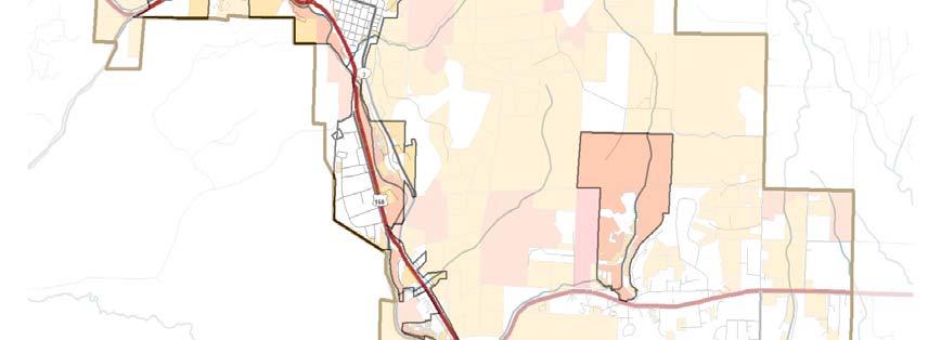
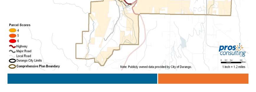
7 City of Durango Figure 5 High Value Greenprint Areas Open Space Plan 50


.")
8 Parks, Open Space, Trails and Recreation Master Plan 4.8 PRIORITY PRESERVATION AREAS Utilizing the Greenprint spatial assessment in conjunction with other information gathered during the planning process including public meetings; the community survey; established preservation objectives; and the revised definition of open space, a map of priority preservation areas has been produced and is shown below (Figure 6). Figure 6 Priority Preservation Areas Open Space Plan 51
9 City of Durango The numbers identified on the map reflect the following preservation areas: 1. Animas River Greenway North: This area includes a variety of preservation values including the Animas River, riparian river frontage, floodplain, and viewshed from Highway Greenway working ranches and riparian areas: This area is part of the Animas River Greenway north with the cottonwood peninsula/beach and former Kroeger Ranch property specifically identified. 3. Twin Buttes: The iconic Twin Buttes are located within this category along with additional acreage that is important to the scenic and wildlife values on the west side of Durango. 4. U.S. Highway 160 West corridor: This area sits on a prominent bench located above and to the immediate south of U.S. Highway 160 west. This area has viewshed and wildlife values associated with it. 5. Animas River Greenway through Durango: The Animas River Greenway through Durango is identified as the highest priority for protecting due to the vast array of values important to the community including the role it serves as a primary component to the City s identity; its role as the primary watershed and fishery for the community; and for the scenic, recreational and habitat values it offers. 6. Raider Ridge: A prominent ridge paralleling Goeglein Gulch Road and Jenkins Ranch Road with significant viewshed values. It establishes the western edge of Horse Gulch and overlooks Durango. 7. Horse Gulch: This is a high priority preservation area seen by many as Durango s central park. An area close to town with significant recreational, habitat and scenic values. While the City has preserved a large portion of the Horse Gulch meadow and ridges, the southern half of the meadow is privately owned, split into 35 acre parcels, and not protected against development. Additionally, County Road Right of Way (CR237) passes through Horse Gulch at the base of Raider Ridge as it travels to CR 234 to the east. While currently closed to traffic, this route could pose a threat to Horse Gulch if opened as an arterial road. 8. Elmore s Ridge: The is a prominent hill top located east of Grandview that is an integral part of the mountain backdrop/viewshed that is seen as you enter Durango from the east on Highway Animas River Greenway South: Like the Animas River Greenway north of town, this area also provides a variety of preservation values including the Animas River, riparian river frontage, and floodplain south of Durango. It is important to note that these priority areas have been identified as such because of their unique values that have been identified as important to the community. The desire to protect these areas does not mean that the City or its partners will pursue public ownership of all of these lands. In some cases, that may be the preferred method of protection. In other cases, continued private ownership and stewardship, coupled with site sensitive land development techniques, may be the most appropriate means for protecting the values called out in this plan. Under any scenario, it is in the best interest of the overall community Open Space Plan 52
10 Parks, Open Space, Trails and Recreation Master Plan that the City, its partners, and private land owners work together in a spirit of cooperation to ensure an outcome that meets everyone s needs and desires. 4.9 SUMMARY OF OPEN SPACE PRIORITIES The City of Durango has placed a high priority on the preservation of open space, including the permanent protection of important landscapes and the stewardship of the City s existing inventory of open space/natural lands. Priorities of the Open Space Program are as follows: Preservation of natural lands in the Animas River Greenway, ridgeline properties, and Horse Gulch should be the community s highest priority. Continue to preserve land that protects the mountain backdrop and viewsheds surrounding Durango. Other preservation opportunities should be prioritized based on preservation value, threat of loss and available resources. Develop a regional approach to partnerships with Fort Lewis College, open space conservancies, La Plata County, Bureau of Land Management, U.S. Forest Service, Colorado Division of Wildlife, Bureau of Reclamation and the land development community. Continue to expand upon preservation techniques to include methods other than fee title acquisitions. Continue to refine and expand upon the management and stewardship activities within the open space system. Establish operation and maintenance Best Management Practices (BMP s) based on need and available resources. Establish and implement a healthy forest management plan. Continue to enhance volunteer opportunities within the open space system. Consider placing preserved lands having separated mineral rights into conservation easements as an additional control measure over possible surface disturbance associated with potential future mineral extraction activities. Evaluate other strategies to minimize surface disturbance associated with potential mineral extraction activities CONSERVATION TOOLBOX The City has successfully used a set of tools to preserve open space over the past two decades. Some of the greatest successes of the 1990s and early 2000s came through the land use review and approval process with land dedications, deed restrictions, setback requirements and sensitive site design ensuring protection of important landscapes around the community. This regulatory approach, coupled with more traditional land acquisition techniques has resulted in significant preservation success that has allowed for many of the community goals to be met. Open Space Plan 53
11 City of Durango In the appendix to this plan are additional tools that may be of value to the City in its efforts to enhance its preservation capabilities. These tools are grouped into the following categories: regulatory, acquisition, land donation and management strategies. For each strategy, benefits and drawbacks are listed to help clarify the most appropriate strategy for a given opportunity FUNDING THE OPEN SPACE PROGRAM The City has been successful in establishing local funding sources and leveraging these funds with grant funds to protect valued open space and natural lands around the community. However, additional funding partners are imperative if the City is to create enough buying power to continue to expand the open space program CITY OF DURANGO FUNDING The 2001 Master Plan recommended full utilization of available funding sources for open space acquisition. Since adoption of the 2001 Plan, the City has expanded its local funding sources: DEDICATED SALES TAX FUNDING Two separate sales tax measures have been approved by the citizens of Durango that can be used in preserving open space and natural lands around the community. They include: 1) Recreation Complex/Trails Fund: In 1999, City residents approved a one half of one percent sales and use tax (one half penny of every dollar spent) to support construction of the Durango Community Recreation Center and completion of the Animas River Trail. The resolution enacting the approved ballot measure, in part, reads after construction (of the Community Recreation Center) has been completed, any tax revenues generated in excess of amounts required to make annual payments on the debt may be used for the operation and maintenance of the Community Recreation Center and for the development and construction of the Animas River Trail, including adjacent greenway areas. This tax sunsets in This fund has been used successfully to preserve lands within the Animas River Greenway that have trail connectivity to the Animas River Trail. This has included the Dallabetta Park Property, the Gardella Open Space Parcel, and the Rea Open Space Parcel. 2) Open Space, Parks and Trails Fund: In 2005 City residents approved a second ballot measure to provide one quarter penny of every dollar spent to be used to finance the preservation, acquisition, and maintenance of natural lands including but not limited to, land to preserve water quality in rivers and streams, wildlife habitat, land for hiking and biking, and the creation of maintenance of parks and trails This tax sunsets in This funding source has allowed for significant non greenway acquisitions to occur including the Dalla Mountain Park, the Cliff Rock parcel, and land in Horse Gulch. Prior to the sunset of the Recreation Complex/Trails Fund and the Open Space, Parks and Trails Fund, the City should ask voters to permanently continue the dedicated funding source. Open Space Plan 54
12 Parks, Open Space, Trails and Recreation Master Plan An additional and viable source of funds that the City utilizes is the Great Outdoors Colorado (GOCO) Open Space Preservation Program. Since 2005, the City has received in excess of 3.5 million dollars in grants from GOCO to assist with land preservation efforts in Durango. A summary of other funding sources and strategies that may prove useful to the City of Durango in leveraging local dollars are included as an appendix to this Plan OPEN SPACE POLICIES GENERAL OPEN SPACE POLICIES The Open Space Master Plan identifies four primary policy categories governing the open space program. These included the purpose and uses of open space; acquisition and protection of open space land; improvements of open space land; and management of open space land USES OF OPEN SPACE Open Space in Durango is intended to accommodate passive recreation, such as hiking, running, and bicycling to the degree they are compatible with the other resource values being protected. Recreational facilities in open space typically should be limited to trails and supporting picnic areas, interpretive facilities, restrooms, and parking lots. Not appropriate on Open Space land are developmentintensive uses such as playgrounds, baseball diamonds, soccer fields, and swimming pools. The City will not dispose of or convert to another use, land acquired as open space unless the City receives in exchange land equal or greater in monetary and environmental value. In certain cases, it may be necessary to acquire a total property when only a portion of the property is desired for Open Space purposes. In such cases, and when identified prior to acquisition, the City may separate the undesired portion of the parcel for disposal or alternate uses. Any funds generated from the sale of the undesired portion of land shall be refunded to the appropriate City fund used in the original acquisition ACQUISITION AND PROTECTION OF OPEN SPACE Promote open space buffers as part of new developments, to provide recreational opportunities and visual buffers, and to protect ecological systems. When appropriate, open spaces lands shall be used to link residential and commercial areas, activity centers, recreation areas and other open spaces to the larger community. Land not suitable for development or passive recreation within new development proposals (e.g. steep grades, poor soils, floodplain areas, etc.) should be maintained as deed restricted private open space and not accepted as publicly dedicated open space. The City will work cooperatively with and encourage other public and non profit groups and private property owners to preserve open space. Open Space Plan 55
13 City of Durango The City will utilize a variety of means to protect open space, including but not limited to: donations, intergovernmental agreements, acquisition of whole or partial fee interests (easements, development rights, etc.), land use regulations and development guidelines. Purchase the fee title to land for open space when public access is desired and no other approach is possible that will meet the open space objective. The City will seek a permanent long term dedicated funding source for open space expenditures. Open Space expenditures include the preservation of land; activities to protect or restore natural resources and improvements; to facilitate public access and to protect users and property. Funding for the preservation of open space and related projects are appropriate to come from the recently passed one quarter cent sales tax. Prior to the sunset of this tax in 2026, efforts should be taken to make this tax a permanent long term dedicated funding source. Potential acquisitions will be evaluated consistently by staff using the open space process identified within this plan in consultation with the Natural Lands Preservation Advisory Board. The open space preservation process may not be modified in the same meeting as they are used to evaluate a specific parcel of land. Decisions to purchase open space will be made by the Durango City Council based on the directions and policies of the Durango Comprehensive Plan and an evaluation of the open space needs of the community that will include, but not necessarily be limited to, recommendations from the Natural Lands Preservation Advisory Board. Open space preservation will include, when possible, preservation of mineral and water rights. The City will undertake baseline assessments of new and/or proposed open space parcels to identify primary resources and issues of importance. The City will encourage and pursue private dedications of open space land or conservation easements in areas adjacent to public Open Space, the Animas River, or in other locations that support the community s open space objectives. The City will work cooperatively with other public and non profit groups and private property owners to help establish a green belt around the City consisting of a network of public lands, hillsides and private lands. Open Space Plan 56
14 Parks, Open Space, Trails and Recreation Master Plan IMPROVEMENTS OF OPEN SPACE LANDS The City may, in special circumstances, use open space lands for rights of way for roads, provided that such uses are consistent with the City s comprehensive plan. Water, sewer and other below ground utilities may be installed on open space lands with adequate financial guarantees in place to assure that the disturbed area will be restored to a rehabilitated natural appearance. Improvements on acquired open space land should be limited to actions required to manage/protect habitat and native vegetation, continuation of agriculture, and to provide passive recreational amenities. Landscape conditions caused by destructive natural phenomena (flooding, erosion, wildfires) may be modified for habitat restoration, public safety or the reconstruction of public facilities such as trails or cultural resources. Naturalappearing methods should be utilized for all such modifications MANAGEMENT OF OPEN SPACE LANDS The City should inventory in detail all land that is acquired (i.e. collect existing data, photographic record, and specific studies as warranted to document unique conditions) and monitor the land at least annually. Management objectives will be identified for all newly preserved lands as part of an overall management plan. All utility and public works projects shall be consistent with the City s open space objectives for the property. Wherever feasible, utility corridors, easements, drainage crossings, transportation corridors and associated development projects shall be designed and constructed to minimize impacts. The City should establish a land dedication education and incentive program in partnership with organizations like the La Plata Open Space Conservancy, La Plata County, Colorado State Forest Service, Bureau of Land Management, Natural Resource Conservation Service and the Colorado Division of Wildlife. When agricultural lands are acquired, the City may allow continued agricultural uses. Agricultural leases may afford limited public access for passive use when not in conflict with the primary use of the property. The City will strive to maintain the integrity of water delivery and storage structures on its open space lands. The City should responsibly manage water for beneficial uses to ensure the protection of water rights. The natural ecosystem of open space lands should be protected. Viable communities of native plants, animals, birds, fish and reptiles should be preserved. Non native species may be introduced only if they do not eliminate or displace native species and only with the approval of appropriate agencies. The City may close an open space property temporarily if necessary to protect a natural resource, establish management objectives or to make a property safe for public enjoyment. Open Space Plan 57
15 City of Durango The City may modify landscape conditions caused by destructive natural phenomena (flooding, erosion, wildfires) for habitat restoration, public safety or the reconstruction of public facilities such as trail or cultural resources. Naturalappearing methods should be utilized for all such modifications. The City will seek to protect significant historic, archaeological and ethnographic (rock art) resources on open space lands. Potential resources will be evaluated in accordance with Durango s Historic Preservation Board and State and National Register standards. Archaeological resources shall be left undisturbed unless removal is justified for protection. Historic areas, structures or landscapes will be preserved in their present condition if that condition allows satisfactory maintenance and use within the financial constraints of the program. Cultural resources not identified as having local, state or national significance may be permitted to deteriorate naturally, unless their removal is necessary for public safety or to restore land to its natural condition. The City will actively encourage volunteers as a resource. The Open Space Program should support volunteer work that is meaningful, productive and satisfying for the volunteers. The City should update the Parks, Open Space, Trails and Recreation Master Plan routinely in conjunction with Durango Comprehensive Plan reviews. The City should monitor and evaluate all State and Federal agency proposals within the City's planning area that could affect the City open space goals MANAGEMENT PRINCIPLES The City of Durango has managed open space resources for several decades. Management plans and/or objectives are developed for all newly preserved lands. The purpose of management plans is to document and quantify the resource values being preserved and to establish stewardship protocol for each site that will ensure the long term sustainability of the resources. All open space properties should be managed to protect the natural resources including the removal of trash and invasive noxious weeds, maintenance of the formal trail system and trailheads, elimination of social or unauthorized trails and other illegal activities including camping. Specific management goals should include: Monitor and respond to community concerns, especially where a threat to the resource impacts ecologic, recreational or scenic values Deed, zoning and easement compliance to ensure that land use is in keeping with ownership rights Promote protection of wildlife habitat to ensure health of the ecosystem Maintain trails, trailheads, access points and signage for public access and use Debris and litter removal so that the resource is clean and accessible Trash removal from river put ins and other shoreline access points Flood and erosion hazard reduction to protect public health and safety Open Space Plan 58
16 Parks, Open Space, Trails and Recreation Master Plan Aquatic habitat protection (fish, amphibians, etc.) to ensure health of the ecosystem In stream flow monitoring to determine major and minor seasonal changes Vegetation management/restoration including weeds and invasive plant removal Maintain portage and fishing trails/access points Remedy social trails to reduce impact to the resource Ongoing fire management and healthy forest initiatives STEWARDSHIP RESOURCE CONSIDERATIONS As the City s open space inventory expands, the City of Durango will need to give consideration to the staffing and organizational structure of the open space program. As of 2009, two staff positions are identified within the organizational framework for open space acquisition and trail development in the Parks, Open Space and Trails Development Division. Care and stewardship of open space parcels falls under the purview of the Parks and Recreation Department s Parks Maintenance Division, which has 7 full time and 8 part time seasonal staff. The City is fortunate to also have a strong relationship with community volunteers who have provided significant assistance over the years. In particular, Trails 2000, an organization dedicated to the preservation of open space and the establishment and stewardship of the community s natural surface trail system has been of critical importance to the City, helping to establish and care for the natural surface trails in the community since As of 2009, City staffing was generally consistent with what other communities have provided during the early years of open space program establishment. Initially a community will put its primary focus on acquisition, with the stewardship and education aspect of the program following later as the program expands. As the primary preservation goals of the program are met, stewardship and education take on more emphasis and a higher percentage of the program resources. An evaluation of several larger open space, park and trail programs around Colorado that have been in existence for a number of decades provides insight into the traditional evolution of an open space program. These programs began with limited staff, eventually progressing to more staff dedicated to a diversified program of stewardship, outreach, education and operation. In order for the City to meet the future needs of the open space program as it evolves, a thorough review of staff capacity, responsibilities, and duties should be conducted on a regular basis. The eventual addition of staff to focus on resource stewardship, outreach, volunteer coordination and environmental education would be consistent with other programs around Colorado. Open Space Plan 59
17 City of Durango MINERAL EXTRACTION Mineral rights pose a unique problem for the preservation, protection and stewardship of open space lands within and surrounding the City of Durango. Most large tracts of land in and around Durango have had their mineral rights separated from the surface rights. What this means is that the City can acquire surface rights for land preservation purposes but will, in most cases, not own or control the minerals that are located below the surface. As such, successful land preservation in Durango will be dependent upon effectively addressing this issue. A mineral right is a right to extract mineral(s), or to receive payment for the extraction of minerals. In general a "mineral" refers to fossil fuels (oil, natural gas, coal), metals (gold, copper, silver, iron), mineable rock products (limestone, gypsum, salt), as well as sand, gravel, or peat. The concern for open space conservation is that when purchasing a parcel of land, finding out who owns the mineral rights and what they intend to do with those rights could affect the long term conservation and stewardship priorities for the parcel. It can also be difficult to assemble all rights (surface and below surface) under single ownership. Mineral rights are part of property rights and may be sold, transferred, or leased as with other property rights. For the most part, the City of Durango, and for that matter La Plata County, are purchasing surface rights when they protect and steward open space resources. Mineral Rights are typically not included in the sale of surface rights, and can be sold separately or retained by the seller. Mineral Rights may be owned in their entirety or in fractions. In addition, an owner of mineral rights might own one or more than total minerals on the land, or may only own the rights to certain minerals by a specified depth below the ground. A mineral right owner has the right to extract the mineral deposit, though it is seldom done due to the high costs associated with exploration and production activities. Typically, a mineral owner leases mineral rights to a company through a lease that grants the company the right to develop and produce minerals in the leased parcel of the land. The mineral owner is usually paid a set amount of money when the lease is signed. In addition, a lease normally specifies agreements as to use the land for extraction of the minerals, as well as what compensation will be if any damage to land or vegetation occurs. When a land owner refuses a mineral right owner the opportunity to extract minerals, the mineral right owner typically petitions the State to compel the non consenting land owner to participate in the exploration and development of the land's minerals. Because mineral extraction can generate money for the mineral rights owner, a land owner's best interests are served by an understanding the history and all existing contracts associated with a parcel of land. There are two resource publications that are of great value to the City of Durango in dealing with the current and future mineral rights issue as it pertains to open space conservation and stewardship. The first is the Colorado Coalition of Land Trusts Mineral Development and Land Conservation handbook, available for purchase from the Coalition. The second is the Mineral Extraction Policy Plan used by Jefferson County, Colorado since 1977 to guide land use decision making. The City of Durango should have both of these publications on file and utilize these resources to implement both policy and practice when it comes to Open Space Plan 60
18 Parks, Open Space, Trails and Recreation Master Plan resolving open space conservation and stewardship plans and programs for lands that contain mineral rights. Most importantly, the City should prepare and publish a program of action for how it will effectively accommodate mineral right extraction, while at the same time conserving and stewarding open space resources. This policy should address how surface rights and surface features are protected while at the same time accommodating mineral extraction activities. The two publications offer the City ample guidance on crafting such a policy statement. In addition, such language should be made part of the zoning and land use development codes, and codified as part of doing business within the City. Open Space Plan 61
The following principles guide the development of goals and strategies to protect and promote these amenities:
 OPEN SPACE/PARKS/TRAILS/RECREATION GOALS/STRATEGIES Cherry Hills Village is a living environment that offers low density development, open areas, public scenic vistas, public trails and public parks. This
Durango Parks & Recreation Department. Strategic Plan
 Durango Parks & Recreation Department Strategic 2019-2023 Adopted April 2019 Overview The purpose of the adopted 2010 Parks, Open Space, Trails and Recreation Master is to provide a 10-year road map for
This page intentionally blank.
 This page intentionally blank. Parks, Recreation, and Open Space Chapter Relationship to Vision Vision Parks, Recreation and Open Space Chapter Concepts County Government. County government that is accountable
OPEN SPACE CHAPTER 7: OVERVIEW. Preserve open space to protect natural resources, enhance character and provide passive recreation opportunities
 CHAPTER 7: OPEN SPACE OVERVIEW Ridgefield has made tremendous progress permanently preserving areas of town as open space. Open space preservation can serve many important purposes, including: protect
RECREATION AND OPEN SPACE ELEMENT GOALS, OBJECTIVES, AND POLICIES
 RECREATION AND OPEN SPACE ELEMENT GOALS, OBJECTIVES, AND POLICIES Goal 7 To provide park facilities, recreation programs, and open space resources that are safe, adequate, and accessible to all City residents,
Dalla Mountain Park Management Plan
 Dalla Mountain Park Management Plan Adopted by Durango City Council February 7, 2006 I. INTRODUCTION Dalla Mountain Park, located on the southwestern slope of Animas Mountain, is a 177.8 acre tract rich
3. VISION AND GOALS. Vision Statement. Goals, Objectives and Policies
 Vision Statement Queen Creek s interconnected network of parks, trails, open spaces and recreation opportunities provide safe and diverse activities and programs that sustain its unique, small town, equestrian
The City shall enhance and improve the accessibility of parks and recreational facilities while protecting their quality. by:
 GOALS, OBJECTIVES AND POLICIES GOAL 1: To provide open space and recreation as an essential element needed for the betterment of the City s character and quality of urban life. The City shall plan for
Member Service Plan Sierra Nevada AmeriCorps Partnership
 Member Service Plan Sierra Nevada AmeriCorps Partnership Service plans lay the framework for what each Member will be doing during their service. Service plans detail the major projects and expected results
Executive Summary Purpose of the Plan Defining Open Space and Greenways
 Executive Summary Bucks County possesses a vast array of open space resources including natural areas, parks, farmland and historic and cultural resources that contribute to a high quality of life valued
I. STAFF POLICY RECOMMENDATIONS. The following RMP policy strategies are proposed by staff in support of a Scenic Resource Protection Program:
 Policy Consideration: Scenic Resource Protection Program Status: For Consideration by the Highlands Council at September 14, 2006 Work session Date: September 12, 2006 I. STAFF POLICY RECOMMENDATIONS The
Arlington, Virginia is a worldclass
 EXECUTIVE S U M M A RY Arlington maintains a rich variety of stable neighborhoods, quality schools and enlightened land use policies, and received the Environmental Protection Agency s highest award for
1. Parks & Recreation Neighborhood Parks Community Parks Special Use Sites 2. Open Space 3. Trails
 Appendix A: Park Classifications The intent of parks and recreation classifications is to aid in making acquisition and design decisions for park sites, facilities and the organization of recreation space
THREE-STEP DESIGN PROCESS FOR OPEN SPACE SUBDIVISIONS
 00216106.DOC NMA/RRK 1/30/14 THREE-STEP DESIGN PROCESS FOR OPEN SPACE SUBDIVISIONS Open space subdivisions, sometimes called cluster developments, maintain a significant portion of a development site in
ARTICLE IV: DEVELOPMENT STANDARDS 404 MASTER PLANNING
 IV 13 404 MASTER PLANNING Master Planning through the Site Analysis (Master Planning Site Analysis) or Planned Development (Master Planning Planned Development) is provided to encourage development which
EL DORADO COUNTY GENERAL PLAN PARKS AND RECREATION ELEMENT PRINCIPLE INTRODUCTION STATE AUTHORIZATION
 EL DORADO COUNTY GENERAL PLAN PARKS AND RECREATION ELEMENT PRINCIPLE The General Plan must identify the types of governmental services, including parks and recreation facilities, which are necessary to
Provide and maintain sufficient public parks, recreation facilities, and open space to meet the recreational needs of County residents and visitors.
 (ROS) Goal Provide and maintain sufficient public parks, recreation facilities, and open space to meet the recreational needs of County residents and visitors. OBJECTIVE ROS.01 The County shall acquire,
Parks, Trails, and Open space Element
 Parks, Trails, and Open space Element Parks, Trails, and Open Space element Parks, Recreation, and Open Space are important components of the quality of life desired by the residents of Elk Grove. This
Mendota Heights 2040 Comprehensive Plan Draft Vers
 4 Parks and Trails The City of Mendota Heights boasts a variety of recreational and open space opportunities. Few cities can claim access to regional trails, riverside and lakeside parks, scenic bluffs
Draft Stillwater 2030 Comprehensive Plan- Goals and Policies
 Draft Stillwater 2030 Comprehensive Plan- Goals and Policies Instructions- Review each goal and policy and discuss with group any changes, deletions for additions to the list using your groups pen. Keep
Chapter 5: Natural Resources and Environment
 NATURAL RESOURCES AND ENVIRONMENT 5-1 5 Chapter 5: Natural Resources and Environment BACKGROUND AND INTENT Urban expansion represents the greatest risk for the future degradation of existing natural areas,
RECREATION, OPEN SPACE AND GREENWAYS ELEMENT GOALS, OBJECTIVES, AND POLICIES
 RECREATION, OPEN SPACE AND GREENWAYS ELEMENT GOALS, OBJECTIVES, AND POLICIES GOAL R-1: DEVELOP A RECREATION, OPEN SPACE AND GREENWAYS SYSTEM AS AN INTEGRAL COMPONENT OF AN OVERALL, COUNTY-WIDE ECONOMIC
E X E CU T IV E SUMMARY: OUR FUTURE. Recreation & Conservation Choices for Northern Colorado
 E X E CU T IV E SUMMARY: OUR LANDS OUR FUTURE Recreation & Conservation Choices for Northern Colorado Cover images (clockwise from top): photo by David Coulson; photo by Harry Strharsky; photo by Walt
Town of Peru Comprehensive Plan Executive Summary
 Town of Peru Comprehensive Plan Executive Communities that plan grow by choice, not by chance. A plan makes growth thoughtful, understandable, and predictable. A plan shows that a community is managing
Yadkin River Greenway Feasibility Study Fact Sheet Village of Clemmons, Town of Lewisville, Town of Bermuda Run
 Fact Sheet Village of Clemmons, Town of Lewisville, Town of Bermuda Run Project Background The Yadkin River Greenway Feasibility Study is a joint project with the Village of Clemmons, the Town of Bermuda
G. RECREATION AND OPEN SPACE ELEMENT. The following summarizes the Recreation and Open Space Element:
 G. RECREATION AND OPEN SPACE ELEMENT The purpose of the Element is to provide the framework and direction for a comprehensive system of public and private sites for recreation, including, but not limited
Recreation, Open Space, Greenway Plan & Smart Agriculture Initiative
 Recreation, Open Space, Greenway Plan & Smart Agriculture Initiative This portion of the Plan represents a follow-up to Section 2, which addressed the natural environment of the two townships. This portion
Parks, Trails, and Open Space Element
 P arks, Recreation, and Open Space are important components of the quality of life desired by the residents of Elk Grove. This Element of the General Plan addresses the City s goals, policies, and actions
Natural Resource Protection
 VISION Our Parker community will enhance the quality of life by avoiding development in environmentally hazardous areas and by safeguarding the natural environment. Natural Resource Protection Introduction
OPEN SPACE AND RECREATION
 OPEN SPACE AND RECREATION The Town celebrates and maintains the spectacular visual character of our Sonoran Desert setting and we value our open space, mountain views, washes, vegetation, and wildlife.
CHAPTER 7: Transportation, Mobility and Circulation
 AGLE AREA COMMUNITY Plan CHAPTER 7 CHAPTER 7: Transportation, Mobility and Circulation Transportation, Mobility and Circulation The purpose of the Transportation, Mobility and Circulation Chapter is to
The transportation system in a community is an
 7 TRANSPORTATION The transportation system in a community is an important factor contributing to the quality of life of the residents. Without a sound transportation system to bring both goods and patrons
CONSERVATION ELEMENT GOALS, OBJECTIVES, AND POLICIES
 CONSERVATION ELEMENT GOALS, OBJECTIVES, AND POLICIES Goal 4 To conserve, manage, appropriately use and protect the natural resources of the City ensuring continued resource availability and environmental
Support the implementation of Cape Coral's Comprehensive Plan. Protect and utilize the unique natural resources in the City.
 7.0 OVERVIEW - RECOMMENDATIONS Chapter 7 The preparation of the Cape Coral Parks and Recreation Master Plan spanned a period of approximately 12 months. Plan preparation included the input of a wide range
Preface. Erie. Scranton. Allentown. Pittsburgh. Harrisburg. Philadelphia
 The Southern Alleghenies Region The Southern Alleghenies Region spans the Laurel Highlands and Allegheny Front in the west across the Appalachians to the east. It is comprised of Blair, Bedford, Cambria,
RESPONSES TO PUBLIC CONCERNS AND QUESTIONS
 RESPONSES TO PUBLIC CONCERNS AND QUESTIONS Stations and Summary Questions for Public Meeting #2 June 23, 2015 General Questions / Concerns: 1. Is there any way this development can raise revenue for the
Exhibit A. 8:9 Scuffletown Rural Conservation District
 Exhibit A 8:9 Scuffletown Rural Conservation District 8:9.1 Intent and Purpose The Scuffletown Rural Conservation (SRC) District is intended to provide for residential development that supports the development
San Diego River Coalition 2012 Work Plan
 San Diego River Coalition 2012 Work Plan Adopted November 18, 2011 The mission of the San Diego River Coalition is preserve and enhance the San Diego River, its watershed, and its natural, cultural and
TOWN OF BETHLEHEM OPEN SPACE CONSERVATION PLAN PUBLIC MEETING: OCTOBER 12, 2017
 TOWN OF BETHLEHEM OPEN SPACE CONSERVATION PLAN PUBLIC MEETING: OCTOBER 12, 2017 Welcome and Agenda 6:00 6:45: Open House, Part One 6:45 7:15: Presentation and Questions 7:15 8:00: Open House, Part Two
Open Space, Natural Areas, Parks, and Recreation
 Open Space, Natural Areas, Parks, and Recreation WHAT ARE THE CITY S CURRENT VALUES? This section addresses open spaces, natural areas, parks and recreation, and stormwater multi-use projects under separate
Chapter 5: Recreation
 Chapter 5: Recreation Introduction and Setting Recreational opportunities within Nevada County are varied, ranging from public parks with intensively used active recreational facilities, to vast tracts
RIDGES TO RIVERS OPEN SPACE NETWORI< OF THE MID-COLUMBIA DRAFT ACTION PLAN
 RIDGES TO RIVERS OPEN SPACE NETWORI< OF THE MID-COLUMBIA DRAFT ACTION PLAN Ridges to Rivers Open Space Network of the Mid-Columbia Region Draft Action Plan (8/6/08) The goals of the propose
TERRESTRIAL NATURAL HERITAGE SYSTEM STRATEGY APPENDIX F: MODEL POLICIES FOR THE IMPLEMENTATION OF THE TARGET TERRESTRIAL NATURAL HERITAGE SYSTEM
 TERRESTRIAL NATURAL HERITAGE SYSTEM STRATEGY APPENDIX F: MODEL POLICIES FOR THE IMPLEMENTATION OF THE TARGET TERRESTRIAL NATURAL HERITAGE SYSTEM C H A P T E R 1 M O D E L P O L I C I E S F O R I M P L
Parks, Open Space and Trails
 Introduction Parks have often been referred as the lungs of our cities, cleansing the air of pollutants and particulate matter. Parks are also gathering places for families and community. They offer spaces
SECTION FOUR: MISSION STATEMENT, GOALS & OBJECTIVES
 SECTION FOUR: MISSION STATEMENT, GOALS & OBJECTIVES Chapter Summary Chapter Ten: Mission Statement, Goals & Objectives To fulfill its mission, the Parks and Recreation Commission has identified four basic
10.0 Open Space and Public Realm
 10.0 Open Space and Public Realm 10.0 Open Space and Public Realm The Public Open Space System is comprised of: outdoor spaces available for public use that are either publicly owned (e.g., parks and
City of Missoula and Missoula County Open Space Planning Open House
 City of Missoula and Missoula County Open Space Planning Open House FEBRUARY 6, 2018 The following slides contain the display board content from the open house. Please use boards to answer questions in
Rural Land Use Designations Kittitas County December 6, 2007 Draft
 KITTITAS COUNTY COMMUNITY DEVELOPMENT SERVICES 411 N. Ruby St., Suite 2, Ellensburg, WA 98926 CDS@CO.KITTITAS.WA.US Office (509) 962-7506 Fax (509) 962-7682 Rural Land Use Designations Kittitas County
Executive Summary. Parks and Recreation Plan. Executive Summary
 Parks and Recreation Plan Executive Summary The Whitemarsh Township Parks and Recreation Plan sets forth a vision for how Whitemarsh Township can provide a premiere parks and recreation system reflective
OPEN SPACE, PARKS, AND HISTORIC SITES
 OPEN SPACE, PARKS, AND HISTORIC SITES The conservation of land, water, and historic resources, and the related provision of recreation opportunities, is one of the most important factors in maintaining
City of Mahtomedi Park System Plan Public Hearing Draft: September 13, 2006
 Chapter 6: IMPLEMENTATION INTRODUCTION Earlier chapters of this Plan analyzed existing conditions, identified park and recreation needs, and proposed park, trail, and open space recommendations. This chapter
JACKSON COUNTY, COLORADO COMPREHENSIVE MASTER PLAN
 JACKSON COUNTY, COLORADO COMPREHENSIVE MASTER PLAN Adopted and certified by the Jackson County Planning Commission the 28th day of June, 1978, as the Jackson County, Colorado Comprehensive Master Plan..."
Chapter 6. Overall Vision RECOMMENDATIONS. More Trail and Trail. Connections. Equal Access to Park. Facilities and Programs. Water Access.
 Overall Vision More Trail and Trail Connections Equal Access to Park Facilities and Programs Water Access Environment Variety Chapter 6 RECOMMENDATIONS Chapter 6 The following recommendations for park,
Planning for and Managing Open Space and Natural Areas
 Planning for and Managing Open Space and Natural Areas Increasingly, development proposals in Delaware include large amounts of open space and natural areas. While open space is important as a community
Town of Rico Three Mile Plan for Annexation
 Town of Rico Three Mile Plan for Annexation 10.20.2010 Adopted by Resolution 2010-2 Produced with funding support from the Colorado Department of Local Affairs 2 Content Guide Introduction. 3 Annexation
Riparian Buffer on the Bushkill Creek. Policies
 Riparian Buffer on the Bushkill Creek Riparian buffers provide numerous benefits to landowners and the community by protecting groundwater recharge areas, providing flood control, providing stormwater
Whitemarsh Township Greenway Plan
 Whitemarsh Township Greenway Plan Prepared for: Whitemarsh Township August 16, 2007 Table of Contents Table of Contents... i Introduction... 1 Study Area Setting... 2 Regional Setting... 2 Township Character...
An Ambitious Plan: Transforming the blighted South Platte River and surrounding environment into Denver s greatest natural resource.
 CONNECTING THE PEOPLE TO THEIR RIVER SOUTH PLATTE RIVER VISION IMPLEMENTATION PROGRAM: GRANT-FRONTIER PARK TO OVERLAND POND PARK REACH The South Platte River Vision Implementation Program (River Vision)
PARTF Scoring System for Grants
 PARTF Scoring System for Grants The members of the N.C. Parks and Recreation Authority use the PARTF scoring system as one of several tools to select grant recipients. Please provide all of the information
Policy & Procedure Effective Date: Parks Department Page of
 City of Arvada Policy & Procedure Effective Date: Parks Department Page of TITLE: City of Arvada Prairie Dog Habitat Plan APPROVAL: PURPOSE: To establish a plan for the preservation of black-tailed prairie
Applicant Name Phone / Fax / Address City State Zip Code . Property Owner Phone / Fax / Address City State Zip Code
 Master Development Plan Application Community Development Department City of Redmond 411 SW 9 th Street Redmond, Oregon 97756 541-923-7721 541-548-0706 FAX Master Development Plan Fee $38,862.52 File Number
Minnesota Department of Natural Resource - Natural Resource Guidance Checklist Conserving Natural Resources through Density Bonuses
 Minnesota Department of Natural Resource - Natural Resource Guidance Checklist Conserving Natural Resources through Density Bonuses NRDB Why Use Density Bonuses & This Checklist Local units of government
Rocky Areas Project Guidance HABITAT
 Rocky Areas Project Guidance HABITAT Introduction Rocky habitats are surface areas dominated by exposed rock, such as mountain peaks, inland cliffs, buttes and rocky outcrops. In many cases, rocky areas
Purpose of the Master Plan
 Purpose of the Master Plan 4 Master Plan Purpose The Master Plan is a policy framework for decisions that affect the physical, social and economic environment of the Town. The Parker 2035: Master Plan
TOWN OF SPRINGFIELD, NEW HAMPSHIRE
 TOWN OF SPRINGFIELD, NEW HAMPSHIRE NATURAL RESOURCES INVENTORY EXECUTIVE SUMMARY March 2008 Prepared by: Watershed to Wildlife, Inc. Natural Resource Consultants 42 Mill Street, Suite 3 Littleton, NH 03561
Corridor Vision. 1Pursue Minnehaha-Hiawatha Community Works Project. Mission of Hennepin County Community Works Program
 1Pursue Minnehaha-Hiawatha Community Works Project Minnehaha-Hiawatha Community Works is a project within the Hennepin Community Works (HCW) program. The mission of the HCW program is to enhance how the
Purpose of the Master Plan
 Purpose of the Master Plan 4 Master Plan Purpose The Master Plan is a policy framework for decisions that affect the physical, social and economic environment of the Town. The Parker 2035: Master Plan
Lewisville Lake Master Plan Revision Public Information Meeting May 2 & 4, 2017
 Lewisville Lake Master Plan Revision Public Information Meeting May 2 & 4, 2017 Presented By Rob Jordan Lake Manager U.S. Army Corps of Engineers Fort Worth District US Army Corps of Engineers Purpose
EXHIBIT A CITY OF FORT WALTON BEACH, FLORIDA COASTAL MANAGEMENT & CONSERVATION
 EXHIBIT A CITY OF FORT WALTON BEACH, FLORIDA INTRODUCTION The Coastal Management and the Conservation Elements required by Chapter 9J-5.012 and 5.013, F.A.C., respectively, have been combined into one
PREVIOUS PUBLIC PARTICIPATION BRIEF October 2014
 Comprehensive Planning During the development of the county comprehensive plan, Cultivating Community: A Plan for Union County s Future from 2007 through 2009, and three concurrent multi municipal plans
CHAPTER 22 Rural Open Space Community Developments
 CHAPTER 22 Rural Open Space Community Developments Section 22.1 Description and Purpose The intent of this Chapter is to offer property owners an alternative to traditional zoning requirements for rural
Parks and Open Space Preservation and Dedication. January 26, 2016 Fort Worth City Council Pre-Council Meeting Randle Harwood and Richard Zavala
 Parks and Open Space Preservation and Dedication January 26, 2016 Fort Worth City Council Pre-Council Meeting Randle Harwood and Richard Zavala Purpose How does the City of Fort Worth preserve and protect
Chapter 10 IMPLEMENTATION RECOMMENDATIONS
 Chapter 10 IMPLEMENTATION RECOMMENDATIONS The recommended land use plan presented in the previous chapter provides a design for the attainment of the urban and rural development and open space preservation
13 Maintenance and Operations Plan 223
 222 13 Operations Maintenance and Plan 223 Chapter 13 MAINTENANCE AND OPERATIONS PLAN 13.1 Stewardship The Minneapolis Park and Recreation Board (MPRB) is the steward of a nationally-acclaimed park system.
RECREATION AND OPEN SPACE ELEMENT
 RECREATION AND OPEN SPACE ELEMENT Last amended August 19, 2008 Table of Contents Objective Page 5.1 Park system defined... 5-1 5.2 Access to parks and recreational facilities... 5-2 5.3 Recreation and
Regional Context Statement
 Regional Context Statement REGIONAL CONTEXT STATEMENT 3. REGIONAL CONTEXT STATEMENT In 1995, the Provincial Government passed into law the Growth Strategies Act. The purpose of this provincial initiative
Objectives and Strategies for the Integration of Recreation, Parks and Open Space in Regional Plans
 BULLETIN 2 Objectives and Strategies for the Integration of Recreation, Parks and Open Space in Regional Plans TABLE OF CONTENTS Introduction 3 Land-use Framework Outcomes 1 4-8 Land-use Framework Outcomes
systems is available on the Colorado Wetland Information Center (CWIC) website.
 website.") Colorado Natural Heritage Program Wetland Program Plan -- Dec 2015 Status Update and Addendum -- The Colorado Natural Heritage Program (CNHP) developed a Wetland Program Plan (WPP) in 2010 for the planning
Colorado Natural Heritage Program Wetland Program Plan -- Dec 2015 Status Update and Addendum -- The Colorado Natural Heritage Program (CNHP) developed a Wetland Program Plan (WPP) in 2010 for the planning
7.0 OPEN SPACE 7.1 OPEN SPACE DEDICATION CHAPTER 7: OPEN SPACE
 7.0 OPEN SPACE The intent of these requirements is to allow for the usage of centrally located unencumbered land as neighborhood open spaces and not to permit the use of leftover or otherwise unusable
Joe Pool Lake Master Plan Revision Public Information Meeting May 23, 2017
 Joe Pool Lake Master Plan Revision Public Information Meeting May 23, 2017 Presented By Jason Owen Lake Manager U.S. Army Corps of Engineers Fort Worth District US Army Corps of Engineers Purpose of this
Growth Management: Common Value 2 of Community Character
 Growth Management: Common Value 2 of Community Character 24 Why is Growth Management a Common Value? Effective Growth Management is essential to protecting our surrounding ecosystem and reinforcing our
City of Tacoma Planning and Development Services
 Agenda Item D-1 City of Tacoma Planning and Development Services To: Planning Commission From: Elliott Barnett, Planning Services Division Subject: Application #2014-08 Open Space Element Update Meeting
SCORP THE 2019 STATEWIDE COMPREHENSIVE OUTDOOR RECREATION PLAN EXECUTIVE SUMMARY
 THE 2019 STATEWIDE COMPREHENSIVE OUTDOOR RECREATION PLAN EXECUTIVE SUMMARY SCORP Statewide Comprehensive Outdoor Recreation Plan 1 December 11, 2018 Dear Fellow Coloradans, It gives me great pleasure to
Master Plan Objectives and Policies
 Master Plan Objectives and Policies Introduction This chapter identifies the Park issues and recommended policies established by this Master Plan. The issues were identified through meetings with staff,
Planned Development Review Revisions (Project No. PLNPCM )
") Planned Development Review Revisions (Project No. PLNPCM2014-00139) Standard residential development Planned Development Example: Smaller lot sizes than what is allowed to create open space amenity. What
Planned Development Review Revisions (Project No. PLNPCM2014-00139) Standard residential development Planned Development Example: Smaller lot sizes than what is allowed to create open space amenity. What
Working together to leverage limited Funds
 Working together to leverage limited Funds ARAPAHOE COUNTY OPEN SPACES 10 County Budget Conference September 20, 2013 The Power of Partnerships 2013 SORP Conference 5/23/2014 Why Talk About Open Space?
National Association of Conservation Districts. Kris Hoellen Vice President, Sustainable Programs The Conservation Fund September 19, 2013
 National Association of Conservation Districts Kris Hoellen Vice President, Sustainable Programs The Conservation Fund September 19, 2013 Our Mission The Conservation Fund forges partnerships to conserve
12.2 CONCEPT DEVELOPMENT
 12 12.0 Final Concept Plan & Development Scenarios 12-1 12.1. Introduction 12-1 12.2. Concept Development 12-1 12.3. Concept Evaluation 12-2 12.4. Development Scenarios 12-2 12.1 INTRODUCTION Though the
2.4 FUTURE LAND USE ELEMENT Goals, Objectives and Policies
 GOAL 1: To create developmental patterns that direct future growth to appropriate areas on campus, in a manner that promotes the educational mission of the University, the protection of environmentally
DRAFT MAP AMENDMENT FLU 04-4
 DRAFT MAP AMENDMENT FLU 04-4 SW 24 TH AVENUE ROADWAY CORRIDOR The University of Florida participates with the Metropolitan Transportation Planning Organization (MTPO) in its responsibilities for the continuing,
Ten Mile Creek Planning Area
 PLANNING AREA POLICIES TEN MILE CREEK Ten Mile Creek Planning Area Location and Context The Ten Mile Creek Planning Area ( Ten Mile Creek area ) is located south of the current Boise AOCI, generally south
Call for Artists for: Design and Construction of Environmental Art Activation Story Mill Community Park, Bozeman, MT
 Call for Artists for: Design and Construction of Environmental Art Activation Story Mill Community Park, Bozeman, MT Seeking artists to design, fabricate and install art elements in the nature sanctuary
PARKS. Chapter Introduction
 Chapter 4. PARKS 4.1. Introduction This Parks Element of the 2016 Comprehensive Plan Update provides direction and guidance, based on citizen input, in order to improve and maintain the City s existing
Goals and Action Items
 Goals and Action Items Developing goals and action items is an important part of the recreation planning process. The overall goals of a recreation department are to provide recreation opportunities for
CHAPTER 4 FUTURE LAND USE AND URBAN SERVICES DISTRICTS
 CHAPTER 4 FUTURE LAND USE AND URBAN SERVICES DISTRICTS Introduction This chapter discusses how Benzie County should grow and change in the future. A community can grow and change in many different ways.
3-2 Environmental Systems
 3-2 Environmental Systems 3.0 ENVIRONMENTAL SYSTEMS CONTENTS 3.1 GREENWAY SYSTEM 3.1.1 General Policies 3.1.2 Natural Heritage Network 3.1.3 Natural Heritage Network Enhancement Lands 3.1.4 Rouge Watershed
4 Sustainability and Growth Management
 4 Sustainability and Growth Management Introduction Traditionally, has assumed growth and development with limited consideration for the long-term negative social, environmental or economic impacts on
SECTION II SECTION II STATEMENT OF GOALS, OBJECTIVES, PRINCIPLES, ASSUMPTIONS, POLICIES AND STANDARDS
 STATEMENT OF GOALS, OBJECTIVES, PRINCIPLES, ASSUMPTIONS, POLICIES AND STANDARDS 1 2 STATEMENT OF GOALS, OBJECTIVES, PRINCIPLES, ASSUMPTIONS, POLICIES AND STANDARDS INTRODUCTION The New Jersey Municipal
Comprehensive Plan ADOPTED APRIL 2014
 Comprehensive Plan ADOPTED APRIL 2014 8 8. Outstanding Recreational & Cultural Opportunities We are proud of our community s parks and recreation system. Our community will ensure that the legacy of our
2011 ASLA Design Awards. Coyote Gulch Honor Award and Land Stewardship Designation Valerian LLC. Environmental Restoration and Reclamation
 2011 ASLA Design Awards Honor Award and Land Stewardship Designation Valerian LLC Environmental Restoration and Reclamation Project Name: Category : Project Location: 5 2011 Environmental Restoration and