First Generation Suburbs (Traditional Growth Pattern) Second Generation Suburbs (CSD) Retrofit/Infill of CSD (TNDs and TODs)
|
|
|
- Gabriella Porter
- 5 years ago
- Views:
Transcription


1 First Generation Suburbs (Traditional Growth Pattern) Second Generation Suburbs (CSD) Third Generation Suburbs (CSD) Retrofit/Infill of CSD (TNDs and TODs) Today we are faced with an overwhelming quantity of suburbia. We need to transform this quantity it into pockets of quality. Sprawl will not mature independently into vibrant, sustainable communities; sprawl is inflexible. It may simply evolve into different patterns, though not necessarily benevolent walkable urbanism. Therefore, transformation needs to be guided through a conscious act of will. Without an aggressive intervention, suburbia may become, as James Kunstler predicts, a devalued agglomeration of enclaves and slums. Given the sheer amount of resources used to propagate and abandon suburban development, the prevention of such consequences benefits society not only socially and economically, but also environmentally. The New Urbanists have a responsibility to provide alternatives to the tragic perception that sprawl is irreversible. Not as optimistic as suburban polycentrists, nor as pessimistic as the survivalists, the New Urbanists are pragmatic. Sprawl may never be as well-balanced and as urbane as traditional American towns and cities, but it must be retrofitted and transformed into sustainable and livable centers. In recent years, many New Urbanists have been working on a range of design, implementation and finance techniques to enable suburban retrofit and infill. At the regional level, they have master-planned suburbanized counties and municipalities, rationalizing a new system of urban growth patterns and connecting multi-modal transportation networks. At the community scale, New Urbanists have introduced neighborhood structure and dense, mixed-use land utilization, repairing worn suburban fabric. This will not necessarily transform suburbia into urban density, but it will introduce urban foci in order to serve the surrounding ring, and balance the often dysfunctional nature of suburbia. Lastly, New Urbanists have introduced new transitional typologies at the scale of the block, street, and building, and existing structures (such as malls, shopping centers, suburban houses, townhouse and apartment enclaves, and office parks) have been retrofitted or reused, ultimately included within a coherent neighborhood fabric. This direct, empirical knowledge will be translated into practical steps for retrofitting and redeveloping the full range of prototypical suburban conditions.


2 S1 RURAL FARMLAND HELD IN SPECULATION S2 RANCHETTES Suburban transect prepared by Dan Zack S3 SINGLE FAMILY RESIDENTIAL S4 GARDEN APART- MENT RESIDENTIAL S5 STRIP COMMERCIAL / BIG BOX COMMERCIAL S6 OFFICE PARK S7 SKYSCRAPER DIS- TRICT / EDGE CITY Suburbs of Austin T1 natural T2 RURAL T3 SUB-URBAN T4 GENERAL URBAN T5 URBAN CENTER T6 URBAN CORE SD SPECIAL district City of Austin
3 Conventional Suburban Development Descriptions. The following are general descriptions of the character of suburban sprawl s. s-1 Natural/ Open Space Consists of lands approximating or reverting to a wilderness condition, including lands unsuitable for settlement due to topography, and other existing conditions. Natural Landscape and/or agricultural use Parks and greenways S-2 Rural Farmland Consists of agricultural land and other large land tracts, often held speculatively near the encroaching edge of Conventional Suburban Development. Primarily agricultural, but may include woodlands, wetlands, other natural features and scattered buildings (farms,barns,sheds,silos) 1-to-2-storey Farmland and greenways S-3 Rural Sprawl Consists of single-family detached houses located on 1/2 acres or larger. Setbacks are relatively deep and the infrastructure is sporadic. Automobile access is crucial. Landscaped and naturalistic planting, large lawns, rural roads, limited pedestrian activity, no city services, rural sprawl Large and variable front and side yards Setbacks Yards, fences, naturalistic tree plantings 1-to-2-storey Parks and Greenways S-4 Housing PoD Consists predominantly of single-family detached housing pods on small or medium or large lots. Segregated by market segment. Medium front Setbacks yield front lawns and large backyard. Dendritic street network, cul-de-sacs and collector roads, snouthouses and dingbats, occasional pedestrian activity, lack of block structure Variable front and side yard Setbacks Yard, fences, manicured lawns and landscaping 1-to-2 storey, some 3-storey Remnant open space S-5 Garden Apartments Pod Sector of attached and detached multifamily housing. Townhouses without towns, auto-dependent Large parking lots, homogenous, occasional pedestrian activity, lack of block structure Random, train wreck pattern Parking lot 2-to-4-storey Privatized resident gyms, tennis courts, and pools S-6 Big Box Retail Sector of large retail stores, typically over 35,000 sq. ft. offering wide choice at reduced price. Also contains strip retail and fast-food and/or gas station outparcels. Traffic congestions, pedestrian unfriendly, underutilized parking lots, limited connectivity Random, parking dominates Parking lot 1-storey Parking lot S-7 Business Park Sector containing large-footprint buildings dedicated exclusively to commerical use -- class A office to warehouse. Homogenous, auto-dependent, limited connectivity, lack of relationship between building and street Random, train-wreck pattern Lawn 1-to-multistorey Lunch Cafeteria S-7 Edge City Suburbs inclusive of business parks shopping centers, hotels, apartments, and condominiums. Statistical equivalent, but not the functional equal of a city. Large arterials and highway interchanges, pedestrian unfriendly, limited connectivity, increased density/intensity Random Parking Lot 1-to-multistorey None SC Suburban Campus Suburban superblock campuses consisting of education facilities, offices, mega-churches and other institutions. Building placement and campus design determined by parking requirements. Large arterials, auto-dependency, occasional pedestrian activity between buildings, well-landscaped Pseudo-campus, parking dominated Lawns, parking lots 1-to-3-storey Common Lawn, parking lot


4 Transect Zone Descriptions. This table provides descriptions of the character of each T-.. T-1 Natural T-1 Natural Zone consists of lands approximating or reverting to a wilderness condition, including lands unsuitable for settlement due to topography, hydrology or vegetation. Natural landscape with some agricultural use Parks, Greenways T-2 Rural T-2 Rural Zone consists of sparsely settled lands in open or cultivated states. These include woodland, agricultural land, grassland, and irrigable desert. Typical buildings are farmhouses, agricultural buildings, cabins, and villas. Primarily agricultural with woodland & wetland and scattered buildings Variable Setbacks 1- to 2-Story Parks, Greenways T-3 Sub-Urban T-3 Sub-Urban Zone consists of low density residential areas, adjacent to higher s that some mixed use. Home occupations and outbuildings are allowed. Planting is naturalistic and setbacks are relatively deep. Blocks may be large and the roads irregular to accommodate natural conditions. Lawns, and landscaped yards surrounding detached single-family houses; pedestrians occasionally Large and variable front and side yard Setbacks Porches, fences, naturalistic tree planting 1- to 2-Story with some 3-Story Parks, Greenways T-4 General Urban T-4 General Urban Zone consists of a mixed use but primarily residential urban fabric. It may have a wide range of building types: single, sideyard, and rowhouses. Setbacks and landscaping are variable. Streets with curbs and sidewalks define medium-sized blocks. Mix of Houses, Townhouses & small Apartment buildings, with scattered Commercial activity; balance between landscape and buildings; presence of pedestrians Shallow to medium front and side yard Setbacks Porches, fences, Dooryards 2- to 3-Story with a few taller Mixed Use buildings Squares, Greens T-5 Urban Center T-5 Urban Center Zone consists of higher density mixed use building that accommodate etail, offices, rowhouses and apartments. It has a tight network of streets, with wide sidewalks, steady street tree planting and buildings set close to the sidewalks. Shops mixed with Townhouses, larger Apartment houses, Offices, workplace, and Civic buildings; predominantly attached buildings; trees within the public right-of-way; substantial pedestrian activit Shallow Setbacks or none; buildings oriented to street defining a street wall Stoops, Shopfronts, Galleries 3- to 5-Story with some variation Parks, Plazas and Squares, median landscaping T-6 Urban Core T-6 Urban Core Zone consists of the highest density and height, with the greatest variety of uses, and civic buildings of regional importance. It may have larger blocks; streets have steady street tree planting and buildings are set close to wide sidewalks. Typically only large towns and cities have an Urban Core Zone. Medium to high-density Mixed Use buildings, entertainment, Civic and cultural uses. Attached buildings forming a continuous street wall; trees within the public right-of-way; highest pedestrian and transit activity Shallow Setbacks or none; buildings oriented to street, defining a street wall Stoops, Dooryards, Forecourts, Shopfronts, Galleries, and Arcades 4-plus Story with a few shorter buildings Parks, Plazas and Squares; median landscaping


")
")


5 S5 S6 S7 S8 Campus Plan CSD WITH POTENTIAL FOR RETROFIT AND INFILL S4 S3 S5 S4 S6 S3 S1 O1 PRESERVED OPEN SECTOR (PRIMARILY OPEN SPACE) (PRIMARILY NEW COMMUNITIES) (SUCCESSIONAL COMMUNITIES) O2 RESERVED OPEN SECTOR G1 RESTRICTED GROWTH SECTOR G2 CONTROLLED GROWTH SECTOR G3 INTENDED GROWTH SECTOR G4 INFILL GROWTH SECTOR T1 T2 T3 T4 T5 T6


6 Suburban Inner City Retrofit Campus Transformation Big Box Liner & Conversion Mall Conversion Mall/Shopping Center Transformation Golf Course Infill Housing Pod Transformation


7 R E T R O SUBURBAN RETROFIT AND F I L L INFILL A LEXICON D u a n y P l at e r - Z y b e r k & C o m pa n y April 02, 2008 O F A D VA N C E D T E C H N I Q U E S


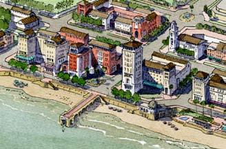


8 Service Station Retail Development Highrise Waterfront Townhouse Pod Housing Pod

9

10
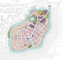
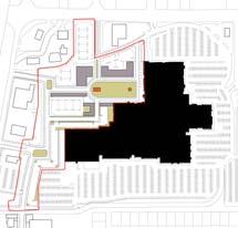
The Village at Hospital Hill
 The Village at Hospital Hill Design Intention: Create a compact, mixed-use neighborhood which creates a genuine village, consistent with what was originally intended for the redevelopment of Hospital Hill.
DESIGN 4 Design Guide
 4 Design Guide DESIGN Introduction 86 Introduction Design guide FOR ROUND ROCK This guide attempts to realize high-quality design on an individual project basis by setting forth recommendations for architecture
4: THE FRAMEWORK PLAN
 4: THE FRAMEWORK PLAN The American Transect. Drawing by James Wassell FRamework Plan: Purpose and Philosophy The Framework Plan is a land use policy map intended to provide guidance to Boone s leaders
New Town Mixed Use District
 New Town Mixed Use District Montgomery County Planning Commission 2009 Annual Conference PA Chapter of the American Planning Association October 6, 2009 What is NTMU? More urban style of development Complementary
Chapter 1 - General Design Guidelines CHAPTER 1 GENERAL DESIGN GUIDELINES
 CHAPTER 1 GENERAL DESIGN GUIDELINES 1.0 INTRODUCTION This Publication has been developed to provide current, uniform procedures and guidelines for the application and design of safe, convenient, efficient
, C-MS I June 3, 2016 $1500 pd chk #216918
 , C-MS-8 LOTS 21 THROUGH 40, INCLUSIVE, BLOCK 299 CLEMENTS ADDITION TO THE CITY OF DENVER SOUTHEAST QUARTER OF SECTION 34, TOWNSHIP 3 SOUTH, RANGE 68 WEST, SIXTH PRINCIPAL MERIDIAN, CITY
CHAPTER 2: FUTURE LAND USE CONCEPTS
 CHAPTER 2: FUTURE LAND USE CONCEPTS INTRODUCTION The future land use concepts presented in this chapter are an expression of community support for a viable and vital US 50 Corridor. Land use recommendations
E. RURAL COMMERCIAL/INDUSTRIAL PARK MODEL
 E. RURAL COMMERCIAL/INDUSTRIAL PARK MODEL 1. PURPOSE The purpose of the Rural Commerce/Industrial Park Model is to provide parameters within which a grouping of business buildings with parking, loading
II. SINGLE FAMILY RESIDENTIAL
 II. SINGLE FAMILY RESIDENTIAL Castle Rock is made up of numerous individually built houses and subdivision tracts that have been developed during the past century. Some of the tracts are diverse in architectural
4.1.3 LAND USE CATEGORIES
 4.1.3 LAND USE CATEGORIES a. City Center District The City Center District incorporates the existing character and mix of uses in downtown Belmont to encourage redevelopment and new development in keeping
EAST QUADRANT INTRODUCTION TRANSECT THEORY DRAFT IN PROGRESS
 EAST QUADRANT THE TRANSECT AND THE FORM-BASED CODING RURAL I I I I I I I I I I TRANSECT I I I I I I I I I I URBAN NATURAL TRANSECT ZONES URBAN TRANSECT ZONES T1 NATURAL T3 SUB-URBAN T2 RURAL DISTRICTS
A Healthy Future Walkability Through Community Design. Fit Families North Carolina October 18, 2004
 A Healthy Future Walkability Through Community Design Fit Families North Carolina October 18, 2004 Joe Morris, AICP Planning & CD Manager jmorr@salisburync.gov 704-638-5324 Dan Mikkelson, PE Land Management
The Village. Chapter 3. Mixed Use Development Plan SPECIFIC PLAN
 The Village SPECIFIC PLAN Chapter 3 3.1 INTRODUCTION 3.1.1 Purpose This Chapter describes the development regulations applicable to the Mixed-Use and Transit Center Planning Areas. These form-based regulations
PROTOTYPE DESIGN/INTRODUCTION
 PART III: PROTOTYPE DESIGN These concepts and guidelines described earlier were used to develop a prototype design for an emerging suburban area located west of the City of Milwaukee. This was done to
CHAPTER 3. Growth Management
 CHAPTER 3 Growth Management Photo courtesy of J. Sinclair Photography/Visit Winston-Salem Chapter 3. Growth Management Plan Goal: Manage growth and development to reduce sprawl, create a more compact and
A Plan for the Heart of the Region: Tukwila, WA
 : Tukwila, WA 1 The Plan orchestrates the Restructuring of a 1,000-acre Regional Shopping Area into a Social and Symbolic for the Region. REGIONAL CONTEXT Downtown Seattle (Metropolitan ) 20 miles Bellevue
5.1 Site Plan Guidelines
 5. Community Core Guidelines Development of the Community Core will take place by plan of subdivision and site plan approval. It will occur in a phased manner that will reflect the timing of residential
NEIGHBORHOOD CONSERVATION CODE
 NEIGHBORHOOD CONSERVATION CODE Neighborhood Conservation Code A Tr a n s e c t -B a s e d I n f i l l C o d e P r e pa r e d NCC v 1.0 adapted by S andy S orlien. I llustrations by DPZ & C o. from S mart
6. BUILDINGS AND SPACES OF HUMAN SCALE
 The Neighborhood Model: Building Block for the Development Areas Design Approaches 79 6. BUILDINGS AND SPACES OF HUMAN SCALE There are many elements of buildings and spaces that contribute to the creation
FUTURE LAND USE ELEMENT
 FUTURE LAND USE ELEMENT GOAL I: To create and sustain a great place to live, play, and prosper Objective 1: The City of Ocala shall incorporate the principles and strategies of the Ocala 2035 Vision into
Downtown Bonita Springs
 W Terry St T-3 O T-5 C Wilson St T-3 O T-3 R CIVIC Pennsylvania Ave T-4 Childers St Ragsdale St T-4 Kentucky St Front St Felts Ave Hampton St Dortch Ave Introduction to a: T-5 E Form-Based Code for CIVIC
Chapter 4. Linking Land Use with Transportation. Chapter 4
 Chapter 4 Linking Land Use with Transportation Chapter 4 59 Chapter 4 Linking Land Use with Transportation Community Design and Transportation Program Introduction Since the 1950s, the predominant development
Clairtrell Area Context Plan
 Clairtrell Area Context Plan March 2005 Urban Development Services City Planning Contents 1. Introduction... 4 2. Development Structure... 6 2.1 Streets... 7 2.1.1 Sheppard Avenue and Bayview Avenue...
SECTION TWO: Urban Design Concepts
 SECTION TWO: Urban Design Concepts The Gardnerville Plan for Prosperity shapes economic opportunities presented by regional growth. The Urban Design Concepts provide policies and concepts for land use,
Lower Merion Commercial Districts Issues and Characteristics Handbook November 2013
 Lower Merion Commercial Districts Issues and Characteristics Handbook November 2013 DRAFT TOWNSHIP-WIDE VISION: To maintain and enhance commercial areas to complement the surrounding high-quality residential
Planned Residential Neighborhoods Land Use Goals
 Planned Residential Neighborhoods Land Use Goals Issue: Guidelines that provide for diverse high quality residential areas that include a variety of housing styles and layouts are needed. Goal 1: Create
FUTURE DEVELOPMENT AREAS
 FUTURE DEVELOPMENT AREAS Refer to the Future Development Map on Page 2. Suburban Residential (Less than 3 units/acre) Suburban Residential neighborhoods form the backbone of Smyrna. While growth and redevelopment
Future Land Use and Development Policies
 Future Land Use and Development Policies Introduction This section presents policies for future development and land use, given the consensus identified through the extensive public participation process.
Policies and Code Intent Sections Related to Town Center
 Policies and Code Intent Sections Related to Town Center The Town Center Vision is scattered throughout the Comprehensive Plan, development code and the 1994 Town Center Plan. What follows are sections
RESIDENTIAL DISTRICTS
 RESIDENTIAL DISTRICTS The residential district standards have been revised to reflect on-the-ground conditions, while continuing to respect the use patterns established within the neighborhoods. This will
What Does It Take To Create A Town Center?
 What Does It Take To Create A Town Center? Context, Design, and Process The Prince Frederick Master Plan Update 1 Background and Overview A Brief History of Town Centers in Calvert County 2 Background
SECTION ONE: INTRODUCTION. introduction
 introduction 1 INTRODUCTION Since it was first established in 1843 as a trading post for the Hudson s Bay Company, Victoria has evolved into a Provincial capital city that is recognized across Canada and
Section 9 NEIGHBORHOOD DESIGN
 Section 9 NEIGHBORHOOD DESIGN City of Lancaster Comprehensive Plan D u n k i n, S e f k o & A s s o c i a t e s, I n c. NEIGHBORHOOD DESIGN INTRODUCTION There are many ways in which a neighborhood can
Trafalgar Road Corridor Planning Study Open House
 Trafalgar Road Corridor Planning Study Open House June 24, 2013 6:30-8:30 p.m. Oakville & Trafalgar Rooms Overview The Livable Oakville Plan identifies the lands along Trafalgar Road, between the QEW and
Additional information about land use types is given in Chapter 5. Design guidelines for Centers and Neighborhoods are given in Chapter 7.
 4. Place Types Introduction In Albemarle County s Development Areas, the Neighborhood is the fundamental unit of community planning. The County s Neighborhood Model, an adopted part of the Comprehensive
A Plan to Create Transformational Change in
 Green City A Plan to Create Transformational Change in Raleigh s Western Gateway Area Defining the Area The Green City Area is Surrounded by Some of the Most trapidly Developing Districts in the City Boylan
for Master Planned Development Framework Design Standards & Guidelines
 B L A C K D I A M O N D DE S I G N G U I D E L I N E S for Master Planned Development Framework Design Standards & Adopted June 18, 2009 Introduction and Purpose The Master Planned Development (MPD) Framework
4 C OMMUNITY D ISTRICTS
 4 C OMMUNITY D ISTRICTS N ew development in the Area will include many different types of land uses, including a destination retail area that attracts people from all over the region; recreation opportunities
Chapter 5: Land Use. Land Use Planning Practices
 Many people think of land use as the most important element of a comprehensive plan. The Future Land Use Map is usually the component of a comprehensive plan that is most extensively discussed and most
Stakeholders Advisory Working Groups (SAWGs) Smart Growth and TOD Land Use (#11) SAWG Meeting
 Smart Growth and TOD Land Use (#11) SAWG Meeting") Presentation - Part II Tappan Zee Bridge/I-287 Corridor Project July 21, 2010 Slide 1. David Kooris (Regional Plan Association) welcomed members of the Land Use Stakeholders Advisory Working Groups (SAWGs)
Presentation - Part II Tappan Zee Bridge/I-287 Corridor Project July 21, 2010 Slide 1. David Kooris (Regional Plan Association) welcomed members of the Land Use Stakeholders Advisory Working Groups (SAWGs)
GUIDELINES. Transit Oriented Development. Approved by Edmonton City Council on February 15, 2012 in tandem with City Policy C565
 Transit Oriented Development GUIDELINES Prepared by the City of Edmonton Sustainable Development and Transportation Services Departments Approved by Edmonton City Council on February 15, 2012 in tandem
Complete Neighbourhood Guidelines Review Tool
 Complete Neighbourhood Guidelines Review Tool Prepared By: City of Regina Planning Department October 2014 Page 1 of 14 Community Development Review Checklist for Secondary Plans and Concept Plans The
Silver Line CPAM UPDATE. Transportation and Land Use Committee October 14, 2016
 Silver Line CPAM UPDATE Transportation and Land Use Committee October 14, 2016 Purpose Recap Project History and Map Changes Provide Overview of CPAM Components Discuss Transportation Impacts Discuss Fiscal
SECTION UNIFIED DEVELOPMENT ORDINANCE SECTION Part 1 Ordinance. ARTICLE 1 Zoning Districts
 SECTION 1-100 UNIFIED DEVELOPMENT ORDINANCE SECTION 1-300 Part 1 Ordinance SECTION 1-100. Introduction. ARTICLE 1 Zoning Districts Crystal Lake strives to maintain a balance of various land uses for a
From Vision to Policy Making urban transformation work
 Image Source: NBC Washington From Vision to Policy Making urban transformation work Montreal, November 8, 2018 Marina Khoury, Partner DPZ CoDesign WHO WE ARE DPZ CoDESIGN International leaders in urban
PROPOSED WATERFRONT DISTRICT DESIGN STANDARDS
 PROPOSED WATERFRONT DISTRICT DESIGN STANDARDS 20.25 DESIGN REVIEW. 20.25.080 WATERFRONT DISTRICT A. Purpose. This section is intended to implement The Waterfront District Subarea Plan by: 1. Creating a
Reconnecting. Charlottesville: What is a FBC? Source: Charlottesville s Strategic Investment Area ELLIOTT RIDGE MONTICELLO GARRETT 6TH AVON
 RIDGE ELLIOTT Reconnecting MONTICELLO Charlottesville: AVON 6TH GARRETT What is a FBC? Source: Charlottesville s Strategic Investment Area DOWNTOWN MALL Presented by: Marina Khoury DPZ Partners March 21,
PORT WHITBY COMMUNITY
 PORT WHITBY COMMUNITY SECONDARY PLAN UPDATE COMMUNITY IMPROVEMENT PLAN URBAN DESIGN GUIDELINES September 2015 DRAFT PROPOSED AMENDMENT NUMBER # to the Whitby Official Plan PURPOSE: The intent of this Amendment
WATERFRONT DISTRICT DESIGN STANDARDS
 WATERFRONT DISTRICT DESIGN STANDARDS 20.25.080 WATERFRONT DISTRICT A. Purpose. This section is intended to implement The Waterfront District Subarea Plan by: 1. Creating a safe, vibrant mixed-use urban
Citizen Comment Staff Response Staff Recommended Revision Planning Committee
 Citizen Comment Staff Response Staff Recommended Revision Planning Committee Area No. 1: Owner desires retail land uses. Area No. 1a: Owner of two small parcels adjacent to Area No. 1 desires retail land
ARTICLE 13 STREETS General
 ARTICLE 13 STREETS 13.1 General Streets shall be designed to suit their functions. Many streets have purposes other than vehicular traffic. As an alternative to current N.C. Department of Transportation
URBAN DESIGN BRIEF. 2136&2148 Trafalgar Road. Town of Oakville
 URBAN DESIGN BRIEF 2136&2148 Trafalgar Road Town of Oakville Prepared By: METROPOLITAN CONSULTING INC For 2500674 Ontario Inc November 2016 TABLE OF CONTENTS Page No. 1.0 Introduction/Description of Subject
Land Use and Urban Form
 CHAPTER 8 LAND USE CONSIDERATIONS Planners and community leaders across the country recently have observed increased public interest in reducing or reversing the trend of urban sprawl and its consequences.
CHAPTER 3 VISION, GOALS, & PLANNING PRINCIPLES. City of Greensburg Comprehensive Plan. Introduction. Vision Statement. Growth Management Goals.
 CHAPTER 3 VISION, GOALS, & PLANNING PRINCIPLES Introduction The Greensburg Comprehensive Plan is intended as a working community document. A combination of long and short-term goals, this document is intended
Seneca Meadows. Block 4 Locate office, technology, and medical development adjacent to I Screen views of garage structures from I-270.
 Seneca Meadows Seneca Meadows has an industrial park in its southern end and a mixed-use employment area planned for the north end. The district benefits from extensive I-270 visibility, stream valley
Metro. Activity Center Design Guidelines. Recommendations For Developing Focused, Mixed-Use Commercial/Residential Centers
 Metro Activity Center Design Guidelines Recommendations For Developing Focused, Mixed-Use Commercial/Residential Centers Metro Activity Centers What is a MAC? Legacy, the adopted guide for the future growth
EXISTING COMPREHENSIVE PLAN
 EXISTING COMPREHENSIVE PLAN Town Center Land Use Element: V. LAND USE POLICIES Town Center Mercer Island's business district vision as described in "Your Mercer Island Citizen-Designed Downtown" was an
Silverdale Regional Center
 Silverdale Regional Center Vision for Silverdale Regional Center The Silverdale Regional Center Plan (Plan) will guide the evolution of the Silverdale Regional Center from a collection of strip malls and
City of Long Beach. creating vibrant and exciting places
 City of Long Beach creating vibrant and exciting places Land Use Element Urban Design Element Overview of the two draft General Plan elements Discuss areas of change Economic goals of the plans Case study
Description of Preferred Alternative
 Chapter 2 Description of Preferred Alternative 2.1 Introduction This chapter of the programmatic Sammamish Town Center Sub-area Plan Final EIS provides a more detailed description of the Preferred Alternative
Town Center. Block 5 Existing multifamily residential units are expected to remain.
 Area Guidelines Germantown s districts should be developed as distinct communities with unique features that are supported through the guidelines. The guidelines not only help distinguish these districts
3.1 community vision. 3.3 required plan elements
 Chapter 3 Community Form 3.1 community vision 3.2 Parks & landscaping concepts 3.3 required plan elements D R A F T 20 Community Form Chapter 3 3.0 Community form 3.1 community vision The Specific Plan
SOUTH FLORIDA TOD GRANT UPDATE
 Palm Beach Transportation Planning Agency October 2018 SOUTH FLORIDA TOD GRANT UPDATE Presented by Treasure Coast Regional Planning Council in partnership with SFRTA & SFRPC What is Transit Oriented Development
C. Westerly Creek Village & The Montview Corridor
 C. Westerly Creek Village & The VISION Community Vision When the goals of the city are achieved Westerly Creek Village, a distinctive community defined by Montview Boulevard and Westerly Creek, is a strong
One of the components of the sustainable, traditional neighborhood is the neighborhood center.
 One of the components of the sustainable, traditional neighborhood is the neighborhood center. The neighborhood center defines a community s identity and is the place for events, leisure activities, public
III - design standards
 III - design standards The Circulation Classification and Character section of the Design Standards chapter prescribes the types of circulation routes, the location of the circulation routes, the connections
OVERVIEW OF PLANS FOR THE JEFFERSON COUNTY COUNTRYSIDE FARM In the Context of Quality Place Characteristics
 OVERVIEW OF PLANS FOR THE JEFFERSON COUNTY COUNTRYSIDE FARM In the Context of Quality Place Characteristics By Steve Grabow, Professor and Community Development Educator University of Wisconsin-Extension,
Lambeth Main Street Streetscape Improvements
 Lambeth Main Street Streetscape Improvements Open House October 5th, 2017 Agenda 1. Introduction 2. Project Background 3. Context 4. Project Objectives 5. Design Principles & Approach 6. Streetscape Design
PILLAR FOUR INTEGRATE LAND USE & TRANSPORTATION
 PILLAR FOUR INTEGRATE LAND USE & TRANSPORTATION 8 Scarborough Centre on the Move Transportation Master Plan 123 8 Transportation Pillar Four Integrate Land Use & The fourth pillar focuses on the relationship
NEW CASTLE COUNTY S ZONING DISTRICTS
 NEW CASTLE COUNTY S ZONING DISTRICTS This is general information about New Castle County s zoning districts. The information included is by no means exhaustive or complete. Before designing plans to develop
2. Form and Character. 2.1 Introduction. 2.2 The Downtown Addition Plan. 2.1 Introduction
 2.1 Introduction 2.1 Introduction This section of the Specific Plan describes and illustrates the desired form, character and uses of the Downtown Addition and explains the underlying design principles.
Gloucester Point / Hayes Village
 Gloucester Point / Hayes Village Development Area Plan Gl!cester C!nty, Virginia Table of Contents 1. Executive Summary and Map i iv 2. Background 1 2 3. Location 2 4 4. Goals 4 6 5. Land Use Recommendations
Access Management: An Overview
 Figures 1-5 Below Evolution of development along a highway. In the early stages, land along the road is used for farming with little traffic generated. As time passes, the highway corridor becomes a de
PINE CURVE REZONING. Property does not meet criteria for open space preservation and is not a candidate for a park
 PINE CURVE REZONING BACKGROUND Purchased as two parcels in 2001 and 2002 Annexed and Zoned Greater Downtown District Historic Center September 25, 2002 and October 7, 2002 WHAT THE PROJECT IS AND IS NOT
Chapter 6--Urban Design
 6.1 Introduction... 6-1 6.1.1 Background & Scope... 6-1 6.1.2 Relationship to State Law... 6-2 6.1.3 Relationship to Other General Plan Chapters... 6-2 6.2 Guiding Principles... 6-2 6.3 Urban Design Guidelines...
CENTERS CORRIDORS WEDGES GLOSSARY
 Affordable Housing: Generally defined as housing for which the occupant is paying no more than 30 percent of their gross income for housing costs, including utilities. The City of Charlotte defines affordable
4. Shape Transitions. 4. Shape Transitions
 4. Shape Transitions 49 Zoning District Policies Overall Intent: Maintain neighborhood character by creating compatible transitions that minimize land use conflicts. Strategy: Define the character of zoning
DRAFT. 10% Common Open Space
 % OF CHARLOTTE IS CATEGORIZED AS A. LAND USES : Placeholder map displaying location of Place Type GOALS: Accommodate XX% of future growth. Provide a concentration of primarily commercial and civic activity
Guiding Principles, Objectives, Strategies and Policies
 Guiding Principles, Objectives, Strategies and Policies Section 1 Introduction These Guiding Principles were adopted as part of the 1999 Athens-Clarke County Comprehensive Plan and are carried over, in
3.0 URBAN DESIGN. December 6, OVERVIEW
 Urban Design 3.0 URBAN DESIGN December 6, 2007 3.1 OVERVIEW The highly urban character of Easton Place is defined by the overall design of the community. The following sections provide an overview of the
4.0 Design Guidelines For The Village Centre. South fields Community Architectural Design Guidelines Town of Caledon
 4.0 Design Guidelines For The Village Centre 4.0 Design Guidelines for the Village Centre The Village Centre is the focal point of the entire South Fields Community and is designed as a traditional commercial
Vision Statement for the Town of Flower Mound Master Plan The Town of Flower Mound Master Plan furthers the established community based vision to:
 Vision Statement for the The furthers the established community based vision to: Preserve the country atmosphere and natural environment that makes Flower Mound a unique and desirable community; Mitigate
Citizen Advisory Group Meeting 5: Land Use April 14, 2011
 Citizen Advisory Group Meeting 5: Land Use April 14, 2011 Meeting Agenda 1. Background Review 2. Transportation Follow-up 3. PED Overlay Approach 4. Land Use Mapping 5. Group Exercise 6. Wrap-up and Next
Section 3: Land Use M C H E N R Y K A N E. Figure 3.1: Potential Future Municipal Boundaries. Future Municipal Boundaries. County Land Use Plans
 Section 3: Land Use Figure 3.1: Potential Future Municipal Boundaries Land use and transportation are intertwined; yet, land use and transpor- tation planning are often undertaken as separate disciplines.
Table of Contents. Elm Avenue Improvement Plan City of Waco, Texas. Introduction 1. Existing Context 1 Figure 1 2.
 Table of Contents Introduction 1 Existing Context 1 Figure 1 2 Plan Guidelines 3 Future Urban Form 4 The West-End 4 Main Street 6 The East-End 7 Figure 2 9 Public Improvement Recommendations 7 General
East Central Area Plan
 East Central Area Plan Steering Committee Meeting March 8 th, 2018 CHUN Tears McFarlane House Vision Statement Development Opportunities Analysis Vision Elements 1. Equitable, Affordable and Inclusive
6 PORT SYDNEY SETTLEMENT AREA
 Section 6 Port Sydney Page 61 6 PORT SYDNEY SETTLEMENT AREA 6.1 Basis and Principles Village of Port Sydney Waterfront Community Existing Services 6.1.1 Port Sydney is an historic settlement that has developed
1.0 Future Land Use. 1.1 Introduction. 1.2 Future Land Use Objectives
 1.0 Future Land Use 1.1 Introduction Can Holly Springs continue to accommodate significant growth while retaining and enhancing a Village-like atmosphere? Can enough commercial land be set aside for business
Future Land Use Pottstown Metropolitan Regional Comprehensive Plan. Future Land Use
 Future Land Use Pottstown Metropolitan Regional Comprehensive Plan Chapter 5 Future Land Use New housing in Upper Pottsgrove Township Farmland in North Coventry Township Abandoned building in Pottstown
Mix of Uses Guide for Transit-Oriented Development MIX OF USES
 MIX OF USES Creating a Destination Magnet A diversity of uses such as retail, housing, offices, civic and entertainment within the TOD creates a destination magnet for transit users and TOD neighbors.
Aesthetics and Design
 University of Connecticut Department of Geography Urban and Regional Planning Lecture 8. Adjunct Lecturer: Donald J. Poland, MS, AICP E-mail: don@donaldpoland.com Web: www.donaldpoland.com Aesthetics and
Be it enacted by the Town Board of the Town of Guilderland that the following new A (Transit Oriented Development (TOD) District) is adopted:
 District) is adopted:") Local Law No. 4 of 2018 (Adoption of 280-18A (Transit Oriented Development District) Be it enacted by the Town Board of the Town of Guilderland that the following new 280-18A (Transit Oriented Development
Local Law No. 4 of 2018 (Adoption of 280-18A (Transit Oriented Development District) Be it enacted by the Town Board of the Town of Guilderland that the following new 280-18A (Transit Oriented Development
Strategic Growth Area #1 Northampton Boulevard Corridor Area
 Strategic Growth Area #1 Northampton Boulevard Corridor Area Description Strategic Growth Area #1 has established itself as a major employment center in Southside Hampton Roads. Opportunities exist to
5.0 VILLAGE AREAS. February 2008 Municipality of West Elgin ~ Official Plan 5-1
 5.0 VILLAGE AREAS This section of the Official Plan deals with the villages of Rodney and West Lorne being the two largest and only fully serviced settlement areas in West Elgin and the most logical and
CHAPTER 5: GUIDING PRINCIPLES
 CHAPTER 5: GUIDING PRINCIPLES The following 10 principles were developed based on public consultation, planning policy and the background analysis conducted during Phase 1. The Guiding Principles significantly
8 Future Land Use Plan
 The Plan provides a land use framework for future development in the county through 2020. Future Land Use Plan The Future Land Use Plan provides a land use framework for future development in the county
Bourne Downtown Site Planning
 Prepared for: The Town of Bourne, MA In Cooperation with: Bourne Financial Development Corporation Prepared by:, Inc. June 24, 2009 Table of Contents Introduction and Summary... 1 Site Existing Conditions...
Status Report: MD 355 Project
 Status Report: MD 355 Project OCTOBER 2006 M-NCPPC MONTGOMERY COUNTY PLANNING DEPARTMENT Summary of Community Comments, and break to the Results of the MD 355 Participation Session Brookside Gardens -
DENVER DESIGN DISTRICT GDP
 DENVER DESIGN DISTRICT GDP Urban Design Standards and Guidelines November 17, 2008 Amended February 3, 2016 City and County of Denver CF Property Management, Inc. C/O Denver Design District - Starboard
ARTICLE 13 STREETS General
 ARTICLE 13 STREETS 13.1 General Streets shall be designed to suit their functions. Many streets have purposes other than vehicular traffic. As an alternative to current N.C. Department of Transportation