LEOPOLD STRUCTURE PLAN. Prepared by the City of Greater Geelong September 2011 (Amended Jan 2013)
|
|
|
- Francine Clark
- 5 years ago
- Views:
Transcription

1 LEOPOLD STRUCTURE PLAN Prepared by the City of Greater Geelong September 2011 (Amended Jan 2013)
2 Table of Contents PART A STRUCTURE PLAN 1.0 Introduction How will this plan be used? Plan Components The Study Area Key Influences Policy Context Natural and Urban Environment Demographics and Social Profile Township Facilities and Services Transport and Physical Infrastructure Commercial Growth, Residential Lot Supply and Further Development The Plan Vision Role of the Township Principles and Directions... 8 PART B IMPLEMENTATION AND REVIEW 1.0 Implementation of the Structure Plan Review of Structure Plan PART C BACKGROUND 1.0 Introduction Background Location Indigenous Heritage Post-Contact History Role of the Township Policy Context Key Strategies and Local Strategic Studies Planning Scheme Provisions Key Influences Natural and Urban Environment Natural Environment Leopold Structure Plan June 2011 (amended Jan 2013) 1
3 3.2 Urban Environment Key Influences Demographics and Social Profile Past Population Growth Age Structure Dwellings & Household Size Labour Force & Income Socio-Economic Index Journey to Work Population Projection Key Influences Township Facilities and Services Local Community Services and Facilities Open Space, Leisure and Recreation Facilities Key Influences Physical Infrastructure and Transport Water Supply Sewer Stormwater Transport Infrastructure Key Influences Commercial Growth, Residential Lot Supply and Further Development 7.1 Commercial Growth Residential Lot Supply Further Development Key Influences References Leopold Structure Plan June 2011 (amended Jan 2013) 2
4 PART A STRUCTURE PLAN 1.0 Introduction 1.1 Purpose of the Structure Plan The 2011 Leopold Structure Plan is a strategic framework for the future planning and development of the township. The Structure Plan has been developed as a partial review of the 2006 Leopold Structure Plan. The Structure Plan was subject to Planning Scheme Amendment C254 and was re-adopted in January 2013 with changes resulting from the amendment process. The purpose of the Structure Plan is to: Identify the key strategic planning issues facing the township, including community aspirations and needs; Articulate the preferred future directions for the townships, including the location of Settlement Boundaries; and Identify appropriate planning controls which will protect and enhance the distinctive elements of the township, biodiversity and landscape features. 1.2 How will this plan be used? The Structure Plan is to be used by the City of Greater Geelong to determine the application of local planning policies, planning zones and overlays. It will guide Council s consideration of proposed rezonings and applications for planning permits. Council will also use the Structure Plan to determine the future provision of infrastructure and services in the townships. 1.3 Plan Components The Structure Plan contains three parts, Part A Structure Plan, Part B Implementation & Review and Part C Background Report. Part A contains the Structure Plan which includes principles and directions in response to the key influences identified in the background report, for each of the following key themes: Urban Growth Infrastructure Housing Natural Environment Economic Development and Employment Rural Areas Part B contains a program for implementing the Structure Plan including the undertaking of other strategic work and future review of this Structure Plan. Part C provides the foundation and contextual information for the Structure Plan and identifies the issues, opportunities and constraints facing the township, under the following headings: Policy Context Natural and Urban Environment Demographics & Social Profile Township Facilities and Services Transport and Physical Infrastructure Commercial Growth, Residential Lot Supply and Further Development Leopold Structure Plan June 2011 (amended Jan 2013) 3
5 1.4 The Study Area Leopold Structure Plan June 2011 (amended Jan 2013) 4
6 2.0 Key Influences The background report identifies and discusses in detail key issues, opportunities and constraints under the following headings which assist in determining the key directions of the Structure Plan. 2.1 Policy Context Leopold is a designated growth area but is subject to a number of constraints. There is a need to nominate a clear Settlement Boundary for the township to provide a compact urban form and protect its rural setting. There is a need to ensure retail growth is consistent with the established retail hierarchy. There is a need to consolidate and improve sporting and recreation opportunities within the township. Community facilities should be provided commensurate with communities needs. Strong State and Local Planning Policies provide directions for: - diverse and affordable housing - the protection of the rural environment and agricultural activities - enhancement of the design and built form of the township - climate change 2.2 Natural and Urban Environment The opportunity to rehabilitate and protect the key environmental and landscape values such as Reedy Lake, Lake Connewarre, Gateway Sanctuary, Bellarine Rail Trail, Port Phillip Bay and remnant vegetation. The need to support public land managers to assist in the on-going management of the environment. Opportunities exist for enhancement and provision of additional open space, recreational and cultural facilities and linkages. The need to protect and interpret aboriginal and post contact heritage values. Climate change and resultant sea level rise could have significant impacts on low lying areas, coastal environments and infrastructure. There is a need and demand for increased retail space within Leopold if it is to fulfil its role as a potential sub-regional centre for the Bellarine Peninsula. The opportunity to create a high quality and functional retail and community precinct as part of the potential sub-regional centre development. 2.3 Demographics and Social Profile Leopold will continue to receive strong population growth. Leopold will continue to have a high proportion of families and also has an ageing population which is an important consideration when planning for community infrastructure, facilities, services and housing diversity. Employment and journey to work data indicates that the majority of Leopold residents in the workforce are employed outside the township. The residents of the township rely almost entirely upon private cars for transport. Leopold Structure Plan June 2011 (amended Jan 2013) 5
7 2.4 Township Facilities and Services There is a need to carefully plan the expansion of the existing shopping centre into a potential sub-regional shopping centre to cater for Leopold and the Bellarine Peninsula. The local neighbourhood centres at Ash Road and Dorothy Street provide an important service to the local community. With an increase in population there is a need to provide additional community and recreation services, facilities and infrastructure. There is an identified shortfall in both kinder and childcare placements. There are a number of studies and strategies which identify services, facilities and infrastructure which could be upgraded or provided to better serve the community. The town is well serviced by a primary education facility with the DEECD looking for a second primary school site. 2.5 Transport and Physical Infrastructure Opportunity to improve pedestrian and bicycle linkages throughout the township and within the open space areas through the implementation of the Leopold Strategic Footpath Network. The location of commercial and recreation at the edge of the township provides challenges for more sustainable, non-vehicle reliance travel. Opportunity to support improved and more frequent public transport options. Opportunity to improve traffic issues at key sites such as the Christies Road and Bellarine Highway intersection and Melaluka Road. Barwon Water is satisfied that the capacity of the water and sewerage systems will be capable of accommodating the identified future growth. There are drainage issues in Leopold given the flat low lying nature of land on the western edge of the township. 2.6 Commercial Growth, Residential Lot Supply and Further Development There is a need to plan for Leopold s role as a potential sub-regional centre to ensure it provides a town centre for Leopold community as well as retail needs of the wider Bellarine Peninsula. There is a need to recognise the important role of the local neighbourhood shopping strips at Ash Road and Dorothy Street. There is an opportunity to provide greater housing diversity around the Ash Road and Dorothy Street shopping strips and to extend the housing diversity area around the Sub-Regional Activity Centre. State and Local Planning Policy designate Leopold as an urban growth area. The present lot supply will accommodate modest future growth. Leopold Structure Plan June 2011 (amended Jan 2013) 6
8 3.0 The Plan 3.1 Vision A vision for the township was derived from the Bellarine Peninsula Strategic Plan, and reads as follows: Leopold is the gateway to the Bellarine Peninsula In 2016 Leopold will be retained as an urban island, which offers clean air, health, education, recreation, employment and tourism opportunities for the community. Vital areas of biodiversity will be recognised and managed through wildlife corridors including a large variety of flora, fauna and well managed wetlands and coastal area. Leopold provides all residents a comprehensive range of housing, shopping, cultural and recreational enterprises which are environmentally friendly and respect our local features. Leopold is a diverse community offering residents the advantages of urban and rural living and a strong sense of community. This vision is still considered to be valid and appropriately reflect community aspirations. The Structure Plan will help deliver this vision by: Providing for sustainable growth; Protecting heritage values, identified landscape features and rural land; Providing opportunities for the creation of a potential sub-regional retail centre which serves the Bellarine Peninsula but also creates a town centre for Leopold residents; Providing for local employment opportunities; Identifying traffic improvements to key routes including key intersections with the Bellarine and Portarlington Highways; Improving pedestrian and cycle connections & public transport facilities; Supporting improvements to public parks; and Retaining opportunities for the expansion of community infrastructure and recreational and cultural facilities to match the needs of the growing community. 3.2 Role of the Township Leopold is regarded as the gateway to the Bellarine Peninsula and is well located to both the coastal townships of the Bellarine Peninsula (Ocean Grove ~15km) and central Geelong (~10km). The town is a distinct urban community located on a hillside bounded by Lake Connewarre to the south, drainage basin, wetlands and shopping centre to the west, Port Phillip Bay to the north and farmland to the east. The major services within the town include a shopping centre, two small retail shopping strips, a recreation park (netball, tennis, cricket and football), primary school, kindergartens and neighbourhood centre. Leopold has a range of services to support the local community with Geelong providing higher end services. The Municipal Strategic Statement in the Greater Geelong Planning Scheme has identified Leopold as a potential sub-regional centre. A subregional role would see retail expanded to a level which would serve the Bellarine Peninsula. Leopold Structure Plan June 2011 (amended Jan 2013) 7
9 Leopold is still a relatively affordable place to live on the Bellarine Peninsula and the town is attractive to many first home buyers and families. It has a mostly permanent population and residents generally travel to Geelong or Melbourne for work. Local Planning Policy has identified Leopold as a town that has growth capacity and as such it has been designated as one of the urban growth areas, along with Ocean Grove and Drysdale, for the Bellarine Peninsula. While Leopold is earmarked for growth it must also be acknowledged that matters such as drainage, landscape values, maintaining a compact urban form and environmental values will influence and potentially constrain growth opportunities. It is noted each town on the Bellarine Peninsula does not need to continually provide a year lot supply. This scenario would see the continual loss of rural land, no incentive to pursue consolidation within settlement boundaries and the loss of township identity. The City of Greater Geelong should achieve a 15 year lot supply across the whole municipality which is being achieved with land releases at Armstrong Creek, Drysdale, Ocean Grove, Lara and Leopold. The G21 Regional Land Use Plan project should be completed by the next Structure Plan review. This will provide a context and directions around future growth on the Bellarine Peninsula including the roles of the various townships in accommodating future growth. 3.3 Principles and Directions The Structure Plan identifies principles (objectives) and directions (strategies) relating to the key planning themes: Urban Growth Settlement and Housing Economic Development and Employment Infrastructure Natural Environment Rural Areas Urban Growth Leopold has been identified as a growth area in Geelong s Municipal Strategic Statement and the township has experienced strong growth recently due to various land releases. According to the ABS census in 2001 the population of Leopold was 6,783 and in 2006 it was 8,161. This represents an increase of 1,378 or a growth rate of 2.94%. The population in 2010 is estimated to be between 9,433-9,646. The current lot supply in Leopold is approximately 23 years (9 years existing plus 14 years of land identified for future development). These figures are based on the average lot take-up of 110 lots per year. A higher take up of 250 lots per year provides a total lot supply around of around 10 years (4 years existing plus 6 years future supply). A higher lot take up may provide a more realistic demand figure given recent land releases and building activity. A municipality should typically designate years lot supply, taking into account areas identified for urban growth (Residential 1 zoning) as part of Structure Plans or other land use plans. The land nominated within the settlement boundary in Leopold will provide around 23 years of lot supply (based on average lot take-up). A lot supply of 23 years is considered more than adequate for Leopold given its identified role as a growth area, albeit with constraints, and taking into account other major land releases on the Bellarine Peninsula at Drysdale and Ocean Grove and in Armstrong Creek. Leopold Structure Plan June 2011 (amended Jan 2013) 8
10 While Leopold is a designated urban growth location within the City of Greater Geelong, it is subject to a range of physical constraints, both natural and artificial which influence the opportunities and directions of urban growth. These constraints have been considered in the selection of areas proposed in this Structure Plan for residential development. Recent Residential Development The 2006 Leopold Structure Plan identified 4 areas as appropriate for urban development. Three of these areas have been or are in the process of being rezoned: Christies Road (area 1), east of Melaluka (area 2) and Moss Road (area 3). The Ash Road area (area 4) remains in the Farming Zone. It is likely planning will commence to rezone all or part of this land for residential purposes in 2011/12. Conventional Residential Development Opportunities Ash Road Area This area was known as Area 4 in the 2006 Structure Plan. It is within the Farming Zone and is considered a future residential development opportunity. The Structure Plan Map confirms the extent of this area. Generally, the area is bound by conventional residential land along The Court to the north, Mollers Lane to the east (first 5 properties), the developing Estuary conventional residential estate to the west and rural living zoned properties to the south. The area is around 94 hectares and capable of yielding around 1,400 residential allotments based on a yield of 15 dwellings per hectare. However, the actual yield may be considerably lower given road, drainage and open space requirements. The area comprises a number of rural allotments generally developed with single dwellings. The productive capacity of this land is limited because of the fragmented land holdings and the proximity to residential areas to the north and west and the established rural living allotments to the south. It is important an appropriate interface is provided to this rural living area as part of any development proposal. Land on the Bellarine Peninsula including Leopold has a history of potato growing and in some cases this included the use of dieldrin and DDT. Council must be satisfied there are no contamination issues with the land in accordance with Ministerial Direction No. 1 Potentially Contaminated Land. An Environmental Audit may be required as part of a rezoning proposal to satisfy this requirement. The highest point of this land is west of Ash Road and a portion of this land drains to the west towards Reedy Lake. The remainder of the land slopes downwards generally in a south-easterly direction with stormwater draining to Lake Connewarre. Reedy Lake and Lake Connewarre are ecologically sensitive areas and planning for residential development in this area will have to be carefully managed with regard to storm water with consideration to best practice sustainability principles and water sensitive urban design. The designing of drainage basins should also have regard to best practice mosquito management. It is also noted there are odours associated with decaying plant life around the shores of the Lakes, particularly during summer and at this time there are limited options to deal with this. There is an area of higher ground on the east side of Ash Road just south of The Court. This area is considered the most appropriate location for a local park (around 2 hectares) which will be able to take advantage of available views. It is important there are adequate connections to the park from existing and proposed residential areas and other key destinations such as Lake Connewarre. The park should be provided with good passive surveillance including dwellings fronting the park and avoiding high, solid residential fencing along the boundaries. Connections should include footpaths and/or shared paths and shoulder sealing along Ash Road as well as Leopold Structure Plan June 2011 (amended Jan 2013) 9
11 connections with the developing residential estate to the east. The provision of medium density housing opportunities around this site would also be encouraged. Where a residential area abuts a rural (Farming Zone) area an appropriate interface should be provided which avoids large sections of rear boundary fences. Development of the Mollers Lane area should include a connection through to the area of open space off Myuna Street, which would provide a convenient connection through to the Ash Road local neighbourhood shopping centre. Future development along Mollers Lane should also have regard to the areas of land covered by Significant Landscape Overlay 10- Lake Connewarre Escarpment. Particular attention should be given to the integration of future development into the landscape character of the area, including the preparation of robust landscape strategy informed by a landscape and visual assessment. The Department of Early Education & Childhood Development (DEECD) has indicated a second primary school site may need to be found in the future. The possibility of locating it within this growth area adjacent to the proposed public open space should be considered. There may also be an opportunity to co-locate other early childhood services such as a kindergarten. It is recommended this area be rezoned from Farming Zone to Residential 1 Zone with an Outline Development Plan and/or a Development Plan Overlay. The Development Plan will need to address: Community Design (subdivision design, lot diversity, interface treatments, open space locations, key links etc.) Water Sensitive Urban Drainage Master Plan (stormwater management and treatment, reuse opportunities, ongoing maintenance etc.) Open Space Landscape Master Plan (plantings, playgrounds, paths, earthworks, seats, bollards, fencing, drainage, connections etc.) Road Network and Traffic Management Plan (impacts on the arterial and local road network, proposed internal layouts, road traffic safety audit etc.) Landscape and Visual Impact Assessment And potentially a: Environmental Management Plan Environmental Audit Native Vegetation Plan Cultural Heritage Plan Construction Management Plan As part of the rezoning a Development Contributions Plan or similar mechanism should be also be developed to provide for infrastructure (physical and community). Urban Consolidation Opportunities Melaluka Road (north and south) There are four precincts of Low Density Residential Zoned land along Melaluka Road. The precincts around Barrabool Crescent and Cypress Crescent provide a reasonable opportunity to increase residential densities within reasonable proximity to the Sub-Regional Activity Centre. These precincts are largely developed with substantial houses and outbuildings and established gardens. These precincts also provide housing choice in the Leopold market with larger lot sizes available. Should these areas be further investigated for further consolidation opportunities there would have to be strong support from the majority of landholders before Council would consider a rezoning proposal. An Outline Development Plan (or similar mechanism) would be required to coordinate planning over multiple land ownerships. Leopold Structure Plan June 2011 (amended Jan 2013) 10
12 681 & 683 Bellarine Highway These two lots are currently zoned Low Density Residential Zone with a combined area of around 2,537sqm. Each lot contains a dwelling, outbuildings and garden. These lots adjoin the recreation reserve and are within 150 metres of the Sub-Regional Activity Centre site. The site is also with close proximity to bus stops, primary school, medical centre and Gateway Sanctuary. These sites are considered to provide an opportunity for higher density housing options (integrated housing) beyond traditional detached housing in the township. The development of the site should consider a design, which facilitates natural surveillance to the recreation reserve and considers the privacy and amenity of neighbouring lots to the east. It is recommended the site be rezoned to the Residential 1 Zone, subject to consideration of access and servicing arrangements. Areas Not Recommended for Rezoning for Residential Development (R1Z, LDRZ, RLZ) Within the nominated settlement boundary there is approximately 23 years of lot supply (based on 15 lots per hectare and take up of 110 per year). This is considered appropriate given other significant land releases on the Bellarine Peninsula including Drysdale-Clifton Springs (Jetty Road) and Ocean Grove (north east growth area) and land releases in Armstrong Creek. Given the current lot supply, the need to consolidate development within settlement boundaries, the need to protect rural land and the need to protect the rural landscape and township identities on the Bellarine Peninsula, land outside the settlement boundary is unlikely to be supported for residential development as part of this Structure Plan. Development constraints in Leopold include the low-lying, flat land on the western edge of the township which is prone to extensive sheet water coverage in periods of significant rainfall. This means there is poor natural drainage in this area making it unsuitable for urban development without significant works and infrastructure to manage drainage and flooding. The cost of such works would have to balanced against social, economic and environmental considerations. The north side of Portarlington Road also contains low lying land which will have similar drainage considerations as those listed above, it could also be impacted upon by sea level rise/climate change which is currently being investigated. This area provides an important rural vista looking over Port Phillip Bay which plays an important role in the character and attractiveness of the township. The Open Space Networks Study recommends that the existing limited access to the northern shoreline of the Peninsula between Point Henry and Clifton Springs (including north of Leopold) be maintained to protect this area because of its environmental significance and the potential location of culturally significant sites. Portarlington Road carries high volumes of traffic and urban development on the north side of the road would create a community that is separated from the main township. For these reasons this area is not considered appropriate for urban development. The current southern extent of the township boundary should not be expanded any further. This area is adjacent to Lake Connewarre, which is environmentally sensitive. This area is also covered by Significant Landscape Overlay 10 Lake Connewarre Escaprment, which aims to maintain the largely unbuilt and partially vegetated character of the area. The eastern edge of the town is proposed to expand to incorporate a further 5 properties. If developed, these properties will add a further 30ha and will extend the Residential 1 zoned land on the south side of the Bellarine Highway to generally correspond to the Residential 1 zoned land directly to the north with Mollers Lane acting as a logical boundary. Further east and south of these properties should be maintained for rural landscape and farming values. Leopold Structure Plan June 2011 (amended Jan 2013) 11
13 As part of the next Structure Plan review, if it determined Leopold is to continue to provide for growth, land east of the settlement boundary, particularly north of the Bellarine Highway could be investigated for future residential growth. Land in this area is not constrained by the issues affecting land to the south, north and west. At this time, the focus of residential development should occur within the settlement boundary where as part of this Structure Plan additional increased housing diversity areas have been nominated. The current lot supply for the town is around 23 years (based on average growth) and there is considered to be no need to further extend the settlement boundary at this time. Principles To facilitate appropriate growth inline with Councils policy on urban growth areas. To identify appropriate locations for residential development. To ensure adequate infrastructure (physical & community) is provided to growth areas. To protect areas identified for longer term urban growth from inappropriate development. To ensure all new urban development is undertaken in a sustainable manner having regard to matters such as water conservation, stormwater treatment and reuse and energy conservation. Directions Identify a settlement boundary. Direct conventional residential development to the Ash Road area and support the rezoning of this land subject to a Outline Development Plan and/or a Development Plan Overlay which addresses the matters raised in the Structure Plan. Support the inclusion of Increased Housing Diversity Areas around the Ash Road and Dorothy Street shopping centres. Support the development of Development Contributions Plans or similar mechanisms to provide for, or contribute to, identified infrastructure needs. Support rezoning of Bellarine Highway from a Low Density Residential Zone to a Residential 1 Zone. Support the objectives and principles set out in the City of Greater Geelong Infrastructure Development Guidelines 2010 in relation to new subdivisions. Ensure new subdivision proposals include Environmental Sensitive Design, Water Sensitive Urban Design principles and stormwater re-use principles. Further investigate consolidation opportunities in the nominated Low Density precincts (north and south Melaluka Road) if the majority of landholders within an area are supportive of a rezoning Settlement and Housing Council s adopted Housing Diversity Strategy supports the development of medium density housing within 400 metres walking distance of local activity centre and 800 metres walking distance of a sub-regional centre subject to consideration of any site specific constraints. The extent of the Increased Housing Diversity Area in Leopold is shown on the map below. Leopold Structure Plan June 2011 (amended Jan 2013) 12

14 Map 2 Leopold Existing Increased Housing Diversity Areas Given the shopping centre is on the edge of town, the 400 metres incorporates two areas of less than 100 lots. The walkability of the nominated areas to the shopping centre is extremely poor given the lack of footpaths, the need to cross busy roads and subdivision patterns which include many cul-du-sacs. The nominated areas have also been developed recently with new, large dwellings (dwellings that have a large footprint and take up most of the lot) which are unlikely to be re-developed in the near future. It is noted the increased housing diversity area around the existing shopping centre can be increased from a 400 metre radius to a 800 metre radius as part of the centre becoming a Sub- Regional Activity Centre. It is considered this should not be done until the first stage of the centre expansion is completed. Increased Housing Diversity Area Opportunities around Local Centres The Ash Road and Dorothy Street shopping strips each have over 10 shops/tenancies including a small supermarket and are defined as a local centre under the Geelong Retail Strategy. The Housing Diversity Strategy does not nominate local centres for increased housing diversity. The Leopold Footpath Strategy has mapped the walkabilty of the town (see map 3 below). The map shows the areas around these local centres are highly walkable (shown in darker hatching) and include a number of services within a 400m radius including: significant bus routes / stops; well constructed footpath network; local parks; aged care; churches; hall; kindergartens; Maternal and Child Health Service and doctors surgery / other medical practices. Leopold Structure Plan June 2011 (amended Jan 2013) 13


15 Map 3 Walkability Index around the local shopping centres Source: David Lock Associates, 2007 The majority of housing stock around these centres was developed in the s and s and is more suitable and likely to be re-developed over time. This contributes to the likelihood of increased housing diversity being achieved in these areas. Increased housing diversity is important in Leopold given the 2006 census revealed almost 95% of housing in Leopold is traditional detached housing. It is recommended areas within a 400 metres walking distance of the neighbourhood shopping centres be included as housing diversity areas. The proposed maps for these areas are shown over the page. Leopold is expected to receive growth in all age cohorts and particularly the 50+ and lone person households cohorts. It is important to ensure the town has a range of housing types to serve the needs of all residents. It is the strong preference of Council s Aged and Disability Department and Social Planning Units to support older residents to live independently within their own home for as long as possible. Housing options for older people should be located within close proximity to activity centres or shopping precincts (or at least within commuting distance for a gofer ). The proposed inclusion of the additional Increased Housing Diversity Areas around the Ash Road and Dorothy Street local shopping strips should assist with this objective. Residential Aged Care Facilities should be located within residential areas, activity centres and new residential areas to be close to services and public transport. The Structure Plan does not support aged care facilities or accommodation on the edge of townships or in locations which segregate older people from the rest of the community. It is important to ensure that new development contributes positively to the Leopold township through increased landscaping, including the provision of street trees, accessibility and quality community and architectural design. Leopold Structure Plan June 2011 (amended Jan 2013) 14


16 Maps 4 & 5 - Proposed Increased Housing Diversity Areas: Leopold Structure Plan June 2011 (amended Jan 2013) 15
17 Principles Ensure that future housing development complements the character of the town and provides for a variety of housing sizes and types. Ensure that new subdivisions incorporate sustainability principles including energy efficiency, connectivity and water management. Ensure that new subdivisions provide for community safety and crime prevention. Directions Encourage medium density housing development within a 400 metres walking distance of the Ash Road and Dorothy Street neighbourhood centres and 800 meters around the Sub- Regional Activity Centre (once first stage of expansion is completed) by including them as increased housing diversity areas in the incorporated document and removing the DDO14 control. Support higher density housing on the sites known as 681 & 683 Bellarine Highway subject to the considerations set out in the Structure Plan. Encourage housing development that complements the character of the area. Support aged care facilities and accommodation that is centrally located within the community and close to facilities, services and public transport. Support the preparation and implementation of the G21 Affordable Housing Strategy including the appointment of a Registered Housing Association. Ensure new subdivision and development proposals include Environmentally Sustainable Design, Water Sensitive Urban Design and stormwater re-use design techniques. Ensure new subdivision and development proposals incorporate Crime Prevention through Environmental Design (CPTED) and Safer by Design principles Economic Development and Employment The economic future and generation of employment within Leopold will be largely reliant on the existing shopping centre and its potential role as a sub-regional centre for the Bellarine Peninsula. Council has prepared a number of reports to investigate the role of Leopold as a subregional centre and what this centre might comprise of. The Leopold Sub-Regional Activity Centre (LSRAC) area includes the existing shopping centre and the vacant rural land directly adjacent to the north and west, Leopold Memorial Recreation Reserve, Gateway Sanctuary and the southeast corner precinct up to the service station. Land Use Directions Retail The Leopold Sub-Regional Activity Centre Assessment prepared by Tim Nott economic analysis and strategy in January 2010 provides an economic analysis of the current and potential retail situation of Leopold and the Bellarine Peninsula. The report concludes: There is likely to be sufficient demand to accommodate expansion of the Leopold Gateway to a sub-regional activity centre over the period to This would involve development of a DDS, a further supermarket and specialty shops. It could also include the development of an adjacent peripheral sales precinct providing wholesale trade, light industry and storage as well as bulky goods retailing. It also notes: There is likely to be demand in the precinct for non-retail activities such as offices, community services, recreation and entertainment, wholesale trade and light industry. Provision of these Leopold Structure Plan June 2011 (amended Jan 2013) 16
18 activities is desirable, providing a range of additional employment opportunities, and generating multi-purpose trips that reduce costs and energy use. The assessment suggests an additional 45,000 sq m of floorspace could be accommodated in the centre to 2021 as seen in Table 1. Table 1 Retail Floorspace to 2021 Location Retail sqm Nonretail sqm Total floorspace sqm In-centre space 17,700 7,600 25,300 Peripheral sales precinct 10,000 10,000 20,000 (Highway) Total 27,700 17,600 45,300 Source: Tim Nott This floor space would require between 9 and 11 ha of land, depending on the extent of multistorey development and has the potential to create 1,100 jobs. The assessment acknowledges the expansion of the centre at Leopold is likely to be at the expense of investment in the proposed Business 4 zoned precinct in Ocean Grove, since there will be insufficient demand in the period to 2021 for both areas to develop significantly. Other things being equal, development at Leopold in order to support a viable sub-regional centre should provide higher community benefits than development at Ocean Grove. The Geelong Retail Strategy recommends a maximum floorspace of 35,000sqm of retail (shop) for a sub-regional centre and that this would cater to a population between 40,000 80,000 people. The Retail Analysis prepared by Tim Nott as part of the LSRAC master plan estimates the trade area population for the LSRAC at 2021 to be 65,600 people. At this time, it is recommended a retail (shop) cap of 35,000sqm be applied to the Leopold Sub-Regional Activity Centre in the schedule to the Business 1 Zone. Urban Design Framework (UDF) Council engaged Beca consultants to develop a framework to guide the future development of the Leopold Sub-Regional Activity Centre (LSRAC). The Framework includes a background report, planning report, urban design framework and recreation reserve master plan. The Urban Design Framework sets out to provide directions on how to achieve sustainable design outcomes for the LSRAC that reflect Council and community aspirations for the area. The features of the UDF include: Sustainability; Character and identity; Social and cultural wellbeing and Connectivity and accessibility. The key objectives are: Establish a pedestrian friendly environment; Establish strong connections between the LSRAC and Leopold Township; Activate frontages along the Bellarine Highway and Melaluka Road; Establish a safe, legible urban structure; and Provide for a range of community amenities integrated through a strong landscape strategy. The UDF then goes onto provide general principles and strategies in the areas of: Establishing a connected community; Sustainability; Open space and pedestrian movement; Land use; Vehicle movement and parking; and Leopold Structure Plan June 2011 (amended Jan 2013) 17
19 Built Form. Two concepts were developed to show how these principles might be applied should the existing retail centre expand. The north option (Concept 1) is Council s preferred option and is shown in Map 6. The north option is considered to provide a superior option in terms of creating a compact, walkable environment, providing an attractive, legible entrance to the township and providing better connections to the existing township. It is noted the plans are conceptual only and may not reflect a formal proposal. However, any formal proposal should achieve the key objectives identified in the UDF. To implement the north option, it is recommended the land known as Bellarine Highway (~6.5ha) and Melaluka Road (~6.55ha) be nominated as appropriate for rezoning to facilitate the development of the Sub-Regional Centre, generally in accordance with the principles of the UDF and included within the settlement boundary. At this time, specific zones and areas have not been nominated to allow flexibility in relation to providing a mix of retail and non-retail uses. A separate planning scheme amendment will be required to rezone the Sub-Regional site and this will need to be accompanied by a planning report, which demonstrates how the proposal addresses the economic analysis in relation to retail and non-retail floor space demand, meets the needs of the community and generally meets the principles of the UDF. Commercial development west of Clifton Avenue is not preferred. Clifton Avenue is seen as the logical settlement boundary. As part of a rezoning application, a Development Plan Overlay should be included to ensure an integrated centre is achieved that generally meets the key objectives identified in the UDF. It should also consider possible staging, multiple land ownership and key issues such as drainage and traffic and a Development Contribution Plan or 173 Agreement to manage infrastructure provision and any developer contributions. A Design and Development Overlay should also be applied to ensure the built form principles expressed in the UDF are achieved. A rezoning proposal could be considered alongside a development proposal in the form of a section 96A application. The matters that will need to be considered as part of a rezoning include (but are not limited to): Relevant State and Local policies; Assessment against clause and any other relevant section of the planning scheme; Leopold Sub-Regional Activity Centre Urban Design Framework; Issues of drainage and water management including on-site and off-site impacts (catchment wide) and discharge to Port Phillip Bay; Infrastructure and servicing; Movement network (traffic, intersections, roads, shared paths, footpaths); Integration with the existing centre and future stages; Developer contributions; and Staging plan. The matters that will need to be considered as part of a development proposal include (but are not limited to): Relevant State and Local policies Business 1 Zone considerations (use and development) including amenity, application requirements and decision guidelines; Leopold Sub-Regional Activity Centre Urban Design Framework; Leopold Structure Plan June 2011 (amended Jan 2013) 18
20 Assessment criteria for retail planning applications; Car parking; Loading and unloading of vehicles; Bicycle facilities; Advertising signs; Land adjacent to a Road Zone; and Integrated public transport planning. Leopold Structure Plan June 2011 (amended Jan 2013) 19

21 Map 6 Preferred North Concept for the Sub-Regional Shopping Centre Expansion Leopold Structure Plan June 2011 (amended Jan 2013) 20
22 Proposed Mixed Use Local Centre There is a Low Density Residential zoned precinct on the south-east corner of Melaluka Road and the Bellarine Highway. This area currently comprises a pizza restaurant and a number of convenience restaurants under constriction, five residential properties, a service station and the CFA station. The Leopold Sub Regional Activity Centre Urban Design Framework Plan has identified this area for a mix of retail and residential land uses which includes retail uses and car parking fronting the Bellarine Highway, a service laneway at the rear of the retail properties and a separate vehicle laneway to serve potential medium density residential development to the rear of the lots. Given the current and proposed mix of land uses in this precinct, it is recommended this area be rezoned to the Mixed Use Zone. A Design and Development Overlay should be applied to ensure development is integrated in relation to parking areas, setbacks, access (including laneway), servicing etc. The Overlay should promote the principles identified as part of the Urban Design Framework. Neighbourhood Shopping Strips (Ash Road & Dorothy Street) Neighbourhood activity centres are located within Leopold at Ash Road and Dorothy Street. The Ash Road centre is situated on the southern side of the Bellarine Highway and comprises 12 shops including a bakery, news agency, milk bar, butcher and chemist. The Dorothy Street centre is located north of the Bellarine Highway and includes 13 shops including a supermarket, opportunity shop, café and real estate agent. These centres are well located within residential areas, are highly accessible and provide an important function in the community. It is recommended the land around these centres (a 400m radius) be designated as increased housing diversity areas. Principles Support the role of Leopold as a Sub-Regional Activity Centre. Encourage the creation of service hubs within the town to accommodate community, health, education, civic services/facilities. To provide opportunities for employment and investment to the region. Directions Support the integrated and staged development of the Leopold Sub-Regional Activity Centre. Ensure the development of the potential Sub-Regional Activity Centre is generally consistent with the principles and directions set out in the adopted Urban Design Framework. Support the rezoning of land to facilitate the development of the Sub-Regional Activity Centre as identified on the Structure Plan map and include a Development Plan Overlay and Design and Development Overlay to apply the principles of the UDF. Apply the Mixed Use Zone to the precinct on the south-east corner of Melaluka Road and the Bellarine Highway. Encourage a diverse mix of uses and activities within the proposed Leopold Sub- Regional Activity Centre providing a wide range of goods and services including retail, Leopold Structure Plan June 2011 (amended Jan 2013) 21
23 office, entertainment, community, recreation etc. Encourage the development of the proposed Sub-Regional Activity Centre so it will integrate with the existing centre and enhance its appearance and functionality. Support increased housing densities around the Sub-Regional Activity Centre and the neighbourhood shopping strips at Ash Road and Dorothy Street. Provide appropriate pedestrian and cycle links to key destinations and routes throughout the town Infrastructure Development Contributions The most significant infrastructure requirements for the township over the life of this Structure Plan include drainage, strategic footpath construction, funding for the community hub which includes a library and funding the works identified for the Leopold Memorial Recreation Reserve sports precinct. Funding of infrastructure is increasingly based on user pays principles, which is accepted as a legitimate means of providing the necessary capital for new infrastructure and maintenance of existing infrastructure. It is Council policy to make maximum use of special rates and charges schemes under the provisions of the Local Government Act These schemes are applied in existing developed or subdivided areas which lack necessary urban infrastructure, such as sealed roads, footpaths, kerb and channel, and drainage. A common factor of such schemes is that where property owners benefit from the works, they contribute to the cost. Council has formulated a policy, known as the Comprehensive Infrastructure Funding Policy (CIFP) to guide levels of landowner and Council contributions toward the cost of works. To provide equitable assistance with infrastructure funding in the municipality, the City of Greater Geelong has resolved to implement Development Contributions Plans (DCPs) or 173 agreements in appropriate locations. A DCP is a statutory tool used to impose levies on the proponents of new developments, to obtain fair and reasonable contributions towards specified, prescheduled infrastructure, including facilities and works. Such schemes could be implemented in Leopold to assist meeting the infrastructure requirements of the township. As part of rezoning applications, Council will pursue a $900 per residential lot as a minimum contribution towards community facilities or upgrades. A minimum area of 10% unencumbered land (unless otherwise negotiated) of public open space will also need to be provided. Stormwater The City of Greater Geelong Stormwater Management Plan aims to improve the environmental management of urban stormwater to protect the environmental values within the region. Urbanisation can result in increased runoff volumes and the introduction pollutant, nutrient and sediment which can have a negative impact on the environment. Leopold consists of two subcatchments: Leopold Structure Plan June 2011 (amended Jan 2013) 22

24 Leopold sub-catchment This extends east from Point Henry towards Clifton Springs sub catchment and drains into the highly valued environment of Port Philip Bay. The value of the marine and foreshore habitat in this area is due to the presence of seagrass beds in the intertidal and immediate sub-tidal areas, and, to a lesser extent the habitat provided by the saltworks. The Reedy Lake sub-catchment This is located between the urban area of Geelong and Leopold. It drains entirely into the Ramsar listed Reedy Lake and continues into the environmentally significant areas of the Barwon River, Hospital Swamp, Lake Connewarre and the Barwon River Estuary. The sub-catchments bisect the township roughly along an east west axis so stormwater runoff generated north of the Bellarine Highway typically drains into Corio Bay and stormwater south of the Bellarine Highway typically drains to Reedy Lake. The environmental values of the receiving areas in both sub-catchments are defined as very high in the Stormwater Management Plan. Stormwater Management Management of stormwater is critical in order to protect the environmental values of the receiving areas from pollutants and sedimentation. It is essential that future urban areas such as those designated for urban development in this Structure Plan are developed in accordance with best practice stormwater management principles including water sensitive urban design techniques. In order to ensure the highest possible level of stormwater quality, future developments will be required to set aside areas for pre-treatment of stormwater using methods such as artificial wetlands and sediment basins. All developments will be required to model the treatments proposed to outline the levels of Nitrogen, Phosphorous, suspended sediments and litter that will drain from the site. All new developments will also be required to incorporate stormwater re-use into the design so as to reduce total volumes draining from new developments. The potential sub-regional site is located on the west side of Melaluka Road which is flat, low lying land. These conditions make achieving elevation to transmit storm water flows very difficult. The existing shopping centre site and the site directly abutting the centre was subject to filling a number of years ago. This raised the level of these sites above the level of surrounding land. The fill has subsequently displaced flood storage onto lots to the north and west and obstructed flood conveyance towards the Bellarine Highway (& Gateway Sanctuary) as shown by the map below. As a result of this, flood waters and drainage flows within the southern sub-catchment now overflow more readily to the north and the drainage line discharging to Port Phillip Bay at Moss Road. Map 7 Flood Mapping around existing shopping centre catchment Leopold Structure Plan June 2011 (amended Jan 2013) 23
25 Any development proposal should be able to demonstrate on a catchment-wide basis that no adverse flooding impacts occur on any property within the catchment as a result of development. It is likely storm water from the development site will need to be discharged into Port Phillip Bay and that existing infrastructure will not be able to cater to the additional volumes resulting from increased development. A catchment wide flooding and storm water management plan addressing on-site and off-site impacts would need to be provided as part of a rezoning/development proposal. The projected sea level rise impacts of climate change will almost certainly affect existing drainage systems and outfalls that discharge into the tidal frontages of Lake Connewarre and Port Phillip Bay. Impacts such as localised flooding, storm rainfall and surges could also have an impact. It is recommended Council continue to develop its Climate Change Adaptation Strategy and monitor the situation. Community and Recreation Needs The Bellarine Peninsula Community Service Plan establishes a plan for improved community and social service provision within the town. The actions include the provision of pedestrian and community linkages, providing children focused services including additional maternal and child health services, childcare/kindergarten services, library facilities and improved playground facilities. The Plan also identifies the need to provide appropriate housing options for older people to address issues such as walkability, affordability, access to shops, services, public transport, facilities and capacity of footpath network (width and grade for gofers ). Early Childhood Council has identified a shortfall in both kinder and childcare placements, with only 2 kindergartens (Allanvale and Leopold) and 1 childcare facility serving an estimated population of around 9,500 with the 0-4 age group accounting for approximately 7% of that population. There is a proposal to double Allanvale s existing capacity subject to funding and approvals which will provide a short-medium term solution the demand. The development of the community hub (discussed below) will be vital to providing adequate early childhood services including an additional kindergarten room, 60 place child care centre, toy library, playgroup and Maternal Child Health. There may also be opportunities to develop early childhood facilities in conjunction with a potential new primary school in the Ash Road growth area. Education Facilities DEECD have indicated the existing primary school is nearing capacity and with further growth in the town likely to occur another primary school may be required in the near future. The Department s requirements for a new site states that a new Primary School should be: Located on 3.5ha of land that is not constrained by environmental, health or physical concerns; Bounded by three street frontages to facilitate safe and efficient pedestrian movement, including an allowance for indented parallel roadside parking; Located on a connector street rather than an arterial road, with sufficient width to provide student drop off zones, bus parking and on-street parking; Integrated with the neighbourhood and located near neighbourhood activity centres; Located adjacent to public open space network and/or community and sporting facilities (including preschools) to provide for collection, integration and sharing; Located on walking and cycling networks; and Situated no closer than 400m from Extra High Voltage Transmission Lines. Leopold Structure Plan June 2011 (amended Jan 2013) 24

26 The Department currently owns a parcel of land at Koonangurt Rd, however they are currently in the process of disposing of this surplus piece of land due to it proximity to the existing Leopold Primary School. The Department have not identified a potential site at this time however have raised the possibility of land located south of the existing urban area. Council has identified access to special education programs and facilities for children and parents living on the Bellarine Peninsula and eastern suburbs of Geelong are extremely limited. As the population on the Bellarine increases, consideration should be given to providing additional special education facilities in a location that is accessible to families living on the Bellarine. The provision of such a program would need to be considered in conjunction with DEECD. Given the current policy direction to co-locate early childhood services with primary schools a new school site should consider setting an area aside for a minimum 2 room kindergarten service. An integrated approach to co-locating children s services is supported by the Victorian Government through its Blueprint for Education and Early Childhood Development, Victorian Early Years Learning and Development Framework and Victoria s Plan to Improve Outcomes in Early Childhood policy documents. Leopold Community Hub Council owns a 2.5ha parcel of land on Kensington Road which provides a major opportunity given the site is centrally located and close to the school and Leopold Indoor Neighbourhood Centre (LINC), see map 4 below. Map 8 - Leopold Community Hub Site Source: Leopold Community Hub Concept Design, DLA, February 2008 The Leopold Community Hub Concept Design, 2008 report identified community needs and set out a vision for the hub which included matters such as: providing the relevant social infrastructure to support the community s wellbeing and changing needs; improving the co-ordination and accessibility of a range of community services; creating high quality open space and buildings; showcasing sustainable development; providing a place the Leopold community value and are proud of; and providing an important walking destination as well as a link for a wide range of east-west pedestrian and cycle movements. Leopold Structure Plan June 2011 (amended Jan 2013) 25


27 As planning for the site has progressed, the hub is likely to include a library, meeting rooms, youth space, and an integrated children s service which incorporates preschool/kindergarten, toy library, playgroup, flexible space, Maternal Child Health and specialist consulting rooms. Project construction is likely to be staged over a number of years to facilitate funding/resourcing. A number of developer contributions have been put towards this project however further funding sources are still required. Sport and Recreation Facilities The Study of Open Space Networks 2001 and the Bellarine Peninsula Leisure and Recreation Needs Study 2005 established recommendations relating to the provision of new facilities and enhancement and improvement of existing recreation spaces. A large number of Leopold recommendations have now been implemented. The remaining action is: Acquire a two-hectare Informal Park site via developer contributions, in the Ash Road area. A more detailed study has been prepared by Beca consultants for Memorial Reserve known as the Draft Leopold Recreation Master Plan, The Master Plan provides options for the provision and the upgrade of facilities to cater for the community and user groups now and into the future. Draft Leopold Memorial Recreation Reserve Master Plan The Master Plan was developed following initial consultations with key users and stakeholders and an analysis of industry trends and standards. As a result two options were developed. Option 1 retained most of the existing uses while rationalising and improving facilities and amenities. Option 2 planned for the relocation of the Sportsmans Club to the site, and the generation of a Sports-hub central to Reserve facilities. Following the consultation period the preferred option is option 1. A master plan showing the key features of the plan can be seen on Map 9 below. Football/Cricket clubrooms, Skate Park and Playground facilities at Memorial Park As a result of public consultation, option 1 has been identified as the preferred option and Council will be seeking funding to carry out the identified works. Leopold Structure Plan June 2011 (amended Jan 2013) 26

28 Map 9 Leopold Memorial Recreation Reserve Master Plan - rationalising and improving facilities and amenities Leopold Structure Plan June 2011 (amended Jan 2013) 27
 and landscaping. The remainder of the open space will provide recreation parkland for casual use.")
29 Estuary Open Space As part of the Estuary estate (area 2) a 5 hectare sub-regional open space has been provided in the form of a grasses oval and a soccer pitch, access and carparking (up to 30 spaces) and landscaping. The remainder of the open space will provide recreation parkland for casual use. Stormwater Re-use Opportunities Given the recent drought conditions and the issue of watering sporting fields, stormwater re-use opportunities should be investigated. New sporting facilities requiring watering should be located near a reliable source of stormwater where possible. This practice is currently used at Memorial Park where stormwater collected at Gateway Sanctuary and is pumped across the Highway for watering purposes. The design of new subdivisions and open space areas should be designed to maximise stormwater re-use opportunities. Lake Connewarre The link to Lake Connewarre, which was a recommendation of the Open Spaces study, has recently been completed. The link allows access to a new reserve which includes a viewing platform, picnic table, car park, paths, landscaping and information. Rail Trail The Bellarine Rail Trail is a recreational trail developed for use by walkers, runners, cyclists and horse riders. The 2.5 metre wide trail is constructed primarily of compacted road base material, with sections of the trail sealed between South Geelong Station and the Bellarine Hwy, and between Kensington Rd and Christies Rd, Leopold. The surrounding reserve features areas of remnant and native vegetation creating a safe and tranquil environment for users. There is a native revegetation program that is actively supported by volunteers from the Friends of The Bellarine Rail Trail. The trail will link the areas of existing vegetation to create a continuous green corridor through the heart of the Bellarine Peninsula. Preserving the rail corridor for the potential reinstatement of a rail service is also considered an important objective in the context of increasing fuel prices, traffic congestion, energy efficiency and environmental outcomes. Bellarine Rail Trail Port Phillip Bay Access Council s Open Space Networks Study and Bellarine Peninsula Recreation & Leisure Needs Study have identified the need for managed access to the northern shoreline of the Bellarine Leopold Structure Plan June 2011 (amended Jan 2013) 28
30 Peninsula and the importance of regaining public ownership of the foreshore where possible in Leopold/Curlewis. The latter study also notes the need to protect the north shore of the Peninsula (particularly between Pt Henry and Clifton Springs) as an area of existing limited access and as a location of environmental significance, containing sites of potential cultural significance. The further investigation of Bay access and regaining public ownership of foreshore land, particularly between Clifton Avenue and Grand Scenic Drive which incorporates two existing and one proposed caravan park, is a supported direction of the Structure Plan. Boat access in this area would need to be considered alongside boating needs in the region. Movement Roads VicRoads is responsible for the Bellarine Highway and the Geelong-Portarlington Road. Post the 2006 Structure Plan, traffic control signals have been installed at the Geelong-Portarlington Road and Christies Road intersection and the Bellarine Highway and Melaluka Road intersection. This financial year signals will be installed at the Bellarine Highway and Christies Road intersection. No other major works or polices are proposed for Leopold. Given residents in Leopold generally travel outside of the town for work, secondary school etc there is a need to provide improved public transport services to and within the town which could include: Increase frequency and improve services to provide a better, safer and more convenient public transport service in order to promote transport options for all residents, encourage the use of more sustainable forms of transport and reduce car reliance. Develop the provision of public transport appropriate to Leopold s role as a gateway for the Bellarine Peninsula as well as access to Geelong and Greater Melbourne including increased frequency and services 7 days a week. Cycle Strategy The Greater Geelong Cycle Strategy 2008 has recommendations for Leopold including the installation of road bicycle lanes on Christies Road which would include signage. It also recommends bicycle lanes along Melaluka Road. A shared path is currently being planned by Council s Infrastructure Management Unit along the north section of Melaluka Road. Leopold Strategic Footpath Network The Leopold Strategic Footpath Network October (2007) identifies a number of improvements and recommendations for implementing the improvements including focusing on strategic footpaths, retrofitting key routes in existing areas and providing adequate footpaths in new subdivisions. These can be seen in Map 10. Leopold Structure Plan June 2011 (amended Jan 2013) 29

31 Map 10 Strategic Footpaths Leopold Structure Plan June 2011 (amended Jan 2013) 30
32 Principles To encourage the provision of a range of social and community services that complements the size and role of the township. To provide public open space within existing and proposed residential areas to cater for the passive and active recreation needs of the community. To provide appropriate physical infrastructure such as stormwater, drainage, water supply, sewerage, electricity, gas, telecommunications and footpaths to new residential areas. To provide adequate community infrastructure and services. To provide an improved transport network which includes better traffic movements, pedestrian and cyclist linkages and public transport options. Directions Support the use of Developer Contribution Plans and/or 173 Agreements to provide community and other infrastructure. Pursue a $900 per lot contribution and a 10% unencumbered open space contribution (unless otherwise negotiated) as part of residential rezoning applications. Encourage the use of best practice water sensitive urban design measures including water conservation and reuse within all new residential and commercial developments. Encourage new subdivision and open space design to maximise stormwater re-use opportunities, walkability and passive surveillance. Support the expansion of existing kindergarten facilities to cater for short-medium term demands. Support the development of the Council owned land at Kensington Road to provide a range of community services and facilities. Investigate options for a potential primary school and kindergarten location with DEECD including the potential for a special education program in the Ash Road growth area. Investigate and pursue funding opportunities from development contributions and other sources to facilitate the development of community infrastructure and services. Support the development and implement the findings of the adopted Leopold Memorial Recreation Reserve Master Plan. Support the ongoing upgrading of existing open space, leisure and recreation areas undertaken for and on behalf of public land managers. Support investigations into opportunities for public access to Port Phillip Bay and regaining public ownership of the foreshore particularly between Clifton Avenue and Grand Scenic Drive. Support future traffic works identified by VicRoads. Support the development, and implement the findings of the Leopold Strategic Footpath Network, 2007 to achieve better pedestrian and cycle linkages throughout the town. Advocate for improved bus services (frequency and routes) and upgrade bus stop infrastructure. Leopold Structure Plan June 2011 (amended Jan 2013) 31

33 3.3.5 Natural Environment The landscape around Leopold provides an attractive rural setting and gives the town its distinct urban island character. Port Phillip Bay and the Lake Connewarre and Reedy Lake complex form a major part of the natural environment in Leopold which are also important cultural and recreational features. Areas with environmental and landscape values often have cultural heritage significance particularly around waterways so it is essential to manage and protect these areas in a way that respects the indigenous community. Parks Victoria is the land manager of the Lake Connewarre State Game Reserve. Lake Connewarre is a shallow estuarine lake forming part of a complex wetland system on the Barwon River. It forms part of the Port Phillip Bay (Western Shoreline) and Bellarine Peninsula Ramsar Site and includes a significant number of flora and fauna species. The Lake Connewarre system has been modified through the use of weirs which stop saline water moving upstream. Water pollution and reduced flows have also impacted on the quality of the system. Most of the land surrounding Lake Connewarre has been cleared for agricultural purposes resulting in environmental degradation. Odours that have been associated with the Lake are caused by the breakdown of naturally occurring marine algae species (Ruppia megacarpa and Enteromorpha paradoxa) which have washed onto the shoreline. Parks Victoria has indicated options for treatment of the odour appear to be limited. Algal blooms have also been recorded in the Lake. A number of Management Plans have been developed to assist in managing this site which includes input from Parks Victoria, DSE, Corangamite CMA and Council. Lake Connewarre viewing platform at the end of Ash Road. It is important new residential development incorporates best practice water sensitive urban design principles to manage stormwater, drainage and flood mitigation to ensure polluted runoff or contaminants are permitted to enter waterways. This is particularly important in Leopold where stormwater and urban development could affect the Connewarre Lake system and Port Phillip Bay. The Residential Character study notes the absence of street planting in some of the more recent residential subdivisions in Leopold and the sparse landscape that resulted. Council is currently undertaking a street tree planting program in accordance with the Street Tree Strategy. The Strategy details street tree planting including matters such as species selection, numbers, establishment, maintenance, costs etc. Council s Open Space Study also recommends undertaking landscaping and planting programs in open space areas including sporting grounds and parks. It is recommended a combined planting program be undertaken to ensure consistency in planting throughout the town. The landscape theme established could be continued in new residential areas. Leopold Structure Plan June 2011 (amended Jan 2013) 32
34 Principles To protect, rehabilitate, enhance and interpret the towns environmental attributes for current and future generations. To ensure environmentally sensitive areas including the Lake Connewarre and Reedy Lake systems are protected from localised development pressures. Directions Provide for the protection of Aboriginal cultural heritage areas, through community interpretation, education and awareness. Encourage the retention and enhancement of remnant and existing vegetation, in particular on private land. Protect indigenous vegetation on roadsides and reserves and undertake planting programs using local indigenous species. Ensure no further subdivision or inappropriate development occurs within highly sensitive areas. Limit nutrient and sediment-laden water run-off into natural waterways through the appropriate treatment of storm water and best practice land management principles. Support the recommendations and actions of management plans in relation to the Lake Connewarre system including the Ramsar wetlands. Encourage the use of best practice water sensitive urban design measures, energy conservation and water conservation and reuse within all new residential and commercial developments. Encourage street tree and open space plantings that contribute to the character of the town as well as providing environmental benefits Rural Areas The rural hinterland surrounding Leopold is a key component to its landscape setting and character. The Rural Land Use Strategy (2007) proposes the Bellarine Peninsula (which includes Leopold) retain its unique, high quality rural landscapes associated with viticulture, horticulture, cropping and grazing. This is consistent with the findings of the Bellarine Peninsula Strategic Plan, which proposes that the unique, high quality rural landscapes of the Bellarine Peninsula be maintained through the ongoing support for agriculture in the rural areas. It states the rural character of the Bellarine Peninsula is highly valued by local residents and visitors, and is a fundamental part of the livability and identity of Geelong. An area adjacent to Lake Connewarre (north-east) is now covered by Significant Landscape Overlay 10 Lake Connewarre Escaprment which among other things aims to maintain the largely unbuilt and partially vegetated character of the area. This overlay will seek to maintain the landscape values of the area. Leopold Structure Plan June 2011 (amended Jan 2013) 33
35 The designation of a Settlement Boundary in Leopold is consistent with the objectives of State Planning Policy and Council s adopted Local Policy of protecting valuable agricultural land and maintaining Leopold as an urban island within a rural setting. It will also enure that rural land is protected from the ad-hoc conversion to residential activity. If the development of the potential sub-regional centre extends the existing shopping centre to the west the rural setting will rely on the large rural living precinct in Moolap which separates urban Leopold from urban Newcomb. Implementation of the Rural Land Use Strategy will involve supporting the right to farm of local land owners, preserving non urban breaks between towns, ensuring dwelling development and subdivision will not remove properties from agricultural use, managing the location and scale of tourist facilities so that they do not undermine the rural character of land beyond the towns and protecting and enhancing environmental assets to improve the overall condition of the natural resource base. Rural surrounds of Leopold There has been interest from a landholder in the area north of Portarlington Road to consider rezoning the area to the Special Use Zone (SUZ). This area contains 2 caravan parks, an approved caravan park which should commence construction shortly, a nursery, aquaculture facility and a large artificial wetland. The purpose of the SUZ would be to give this area a tourism focus, which is limited under the current Farming Zone. The wetland was illegally constructed as a harbour in 2004/2005.Consequently, the Council took enforcement action requiring the remediation of the land, which included rocks blocking off water flow from Port Phillip Bay. The landholder has indicated a desire to pursue a harbour style development. There are constraints that prevent urban development crossing Portarlington Road. This area is valued for its rural landscape and for providing an attractive outlook for the Leopold township. The area may also have some coastal, environmental and cultural sensitivities. The SUZ is not considered appropriate for large areas of land north of Portarlington Road. The SUZ provides for the use and development of land for specific purposes, including urban type uses, that are not considered to be consistent with the low key, rural landscape vision for this area. Recreation studies prepared for Council have indicated managed access to the Bay and the potential to regain public access/ownership to the northern shoreline of the Bay as being desirable outcomes. These principles have been included in the Structure Plan as matters for further investigation. In relation to a harbour style facility, a needs assessment/study would be required. If there is a need, the type and scale of facility that would best meet the identified need (local boat ramp, regional boat ramp etc) would need to be investigated with consideration to the Corio Coastal Action Plan, South West Port Phillip & Adjacent Ocean Coast Public Boat Launching Review and other applicable documents which state among other things: Leopold Structure Plan June 2011 (amended Jan 2013) 34
36 Support existing policies and directions of the Greater Geelong Planning Scheme to restrict further development of the coastline for rural living, caravan/holiday parks or intensive recreation facilities. Boating infrastructure and facilities are to be located in defined activity nodes. Geelong has been identified as a Primary node with Portarlington recommended as a Secondary node. A focus on contained tourism development should be low impact rural based development. Built form within this precinct should be minimised to protect the rural landscape viewed both from the water and land. Dwellings and other structures in this precinct should be low profile and sit within the topography of the land as detailed in the Victorian Design and Siting Guidelines for the Coast (1998). Other considerations include coastal acid sulfate soils, climate change impacts, cultural heritage, native vegetation, Environmental Effects Statement, public land consents and approvals including EPA, Parks Victoria, DSE, securing public access and future management regimes. Principles To ensure that the surrounding rural landscape and setting of Leopold is preserved. To support farming activities in Farming Zoned areas. To support value added agricultural pursuits. Directions Identify a settlement boundary. Retain the existing Farming Zone outside the settlement boundary. Discourage any new or further expansion to the Rural Living Zone. Ensure land use activities within the Farming Zone retain an agricultural focus and preserve the rural, environmental and landscape qualities. Support the establishment of farm based tourism activities that retain an agricultural focus and preserve the rural, environmental and landscape qualities of the land. Identify the need for a study into public access to Port Phillip Bay The above principles and directions for each of the key themes are summarised on the Structure Plan Map 11. Leopold Structure Plan June 2011 (amended Jan 2013) 35

37 Map 11 Leopold Structure Plan Leopold Structure Plan June 2011 (amended Jan 2013) 36
38 PART B IMPLEMENTATION AND REVIEW The Implementation and Review Section identifies Review provisions and key Planning Scheme alterations, or supporting strategic work, necessary to attain the principles and directions identified in the Structure Plan including: Introduction of Planning Policy; Application of Zones and Overlays; Further strategic work required to support additional planning controls; Other Actions critical to attaining key principles directions. 1.0 Implementation of the Structure Plan Implementation Plan Using policy and the exercise of discretion Apply a Planning Policy reflecting the directions and principles of Part A of the Leopold Structure Plan, incorporating the Structure Plan as a reference document at clause Amend Clause City of Geelong Retail Activity Centre Hierarchy to recognise Leopold as a Sub Regional centre. Update the incorporated documents known as Key Development and Increased Housing Diversity Areas, City of Greater Geelong, July 2009 under clause to include the Ash Road and Dorothy Street Housing Diversity Areas. Applying Zones and Overlays Apply the Residential 1 Zone with a Development Plan Overlay (or similar mechanism) based on the principles identified in the Structure Plan to those areas identified on the Structure Plan map as appropriate for residential development. Apply appropriate zones to facilitate the development of the Sub-Regional Activity Centre identified on the Structure Plan map and include a Development Plan Overlay and Design and Development Overlay to apply the principles of the UDF. Rezone the Mixed Use Zone with a Design and Development Overlay to the areas identified on the Structure Plan map on the corner of Melaluka Road and the Bellarine Highway. Rezone properties 681 & 683 Bellarine Highway from the Low Density Residential Zone to the Residential 1 Zone. Rezone Council owned local parks and reserves to the Public Park and Recreation Zone. Leopold Structure Plan June 2011 (amended Jan 2013) 37
39 Update the incorporated document at clause to include Increased Housing Diversity Areas around the Ash Road and Dorothy Street neighbourhood activity centres (400 metre radius) and the Sub-Regional Activity Centre (800 metre radius). Undertaking further strategic work Other Actions Delete the Design and Development Overlay 14 from the areas to be included as Increased Housing Diversity Areas around the neighbourhood and Sub- Regional activity centres. Flood Study to introduce controls over areas identified as appropriate for FO, LSIO. As part of the rezoning and subdivision processes negotiate with developers to achieve the open space areas at the locations recommended in the Structure Plan. As part of the rezoning and subdivision processes negotiate appropriate developer contributions to provide for community infrastructure and facilities. Support and implement the draft Leopold Sub- Regional Activity Centre Master Plan recommendations. Support and implement the Leopold Memorial Recreation Reserve Master Plan recommendations. Support development of the Community Hub. Consult with DEECD in relation to a potential primary school site. Investigate opportunities to achieve public access to Port Phillip Bay. Engage with Department of Transport to seek improved bus services, particularly to new residential areas and the sub-regional centre. 2.0 Review of Structure Plan As with all other areas in the municipality the take-up of land and redevelopment within Leopold needs to be regularly monitored. It is appropriate that the Structure Plan be reviewed every five years. At the next review consideration should be given to the findings of the G21 Regional Land Use Plan and whether the settlement boundary needs to expand to accommodate further residential growth and whether further stages of the Sub-Regional Activity Centre should be released. Leopold Structure Plan June 2011 (amended Jan 2013) 38
40 PART C 1.0 Introduction 1.1 Background BACKGROUND REPORT Land use and development in Leopold has been guided by the 2006 Structure Plan prepared by the City of Greater Geelong. Many of the recommendations to come out of that Plan have been implemented including a number of identified development opportunities. The purpose of this Structure Plan is to identify the key strategic issues and opportunities facing the township and articulate the preferred future directions including the location of settlement boundaries, future residential and commercial growth and future community service provision, as well as identifying appropriate planning controls. 1.2 Location Map 12 indicates the location of Leopold in the context of the rest of the municipality. Leopold is located approximately twelve kilometres east of Geelong. It traverses the Bellarine Highway and is bound to the north by the Portarlington Road and to the south by Lake Connewarre. The urban growth boundary has typically been constrained on the western side by poorly drained flood prone land beyond Melaluka Road. The eastern boundary of the town was defined in the 1990 Structure Plan but this has changed over time and residential development has since extended beyond the boundary of the previous 1990 and 2006 Structure Plan. Leopold Structure Plan June 2011 (amended Jan 2013) 39

41 Map 12 - Locality Map Leopold Structure Plan June 2011 (amended Jan 2013) 40
42 1.3 Indigenous Heritage Aborigines of the Wathaurong tribe, whose territory stretched between the Werribee River and the Otway Ranges, occupied the land before European settlement. The Leopold area was inhabited by the Bengalat balug (Clan). Campbell Point protrudes into Lake Connewarre and contains the oldest dated Aboriginal archaeological remains on the Bellarine Peninsula. The deposits have been dated at between 3,600 and 5,200 years old and are considered significant for their demonstration of shellfish gathering which was uncommon on the central coast of Victoria. The regulations of the new Aboriginal Heritage Act specify the circumstances in which a Cultural Heritage Management Plan (CHMP) is required for an activity or class of activity, which is specified as high impact in areas of Aboriginal cultural sensitivity and also prescribes standards for the preparation of such plans. Advice from Aboriginal Affairs Victoria (AAV) will be essential to ascertain when and if a CHMP is required for different activities and for different areas. According to the Municipal Association of Victoria in essence, if an activity is both in an area of cultural heritage sensitivity and is a high impact activity on land not previously significantly disturbed, it will require a CHMP before any planning permit can be determined. Significantly for Leopold, Cultural Heritage Sensitive Areas under the regulations include, but are not limited to, the following: Registered cultural heritage place or land within 50 metres of a registered place; Waterways (& within 200m) unless subject to significant ground disturbance; Prior waterways (& within 200m); Ancient lakes (& within 200m); Greenstone outcrops unless subject to significant ground disturbance. 1.4 Post-Contact History The Bellarine Historical Society has provided information on the history of Leopold. Leopold was originally called Kensington and was established in 1852 after other small subdivisions had failed. Kensington's proximity to Point Henry helped the settlement - other settlers were people who had been to the Ballarat diggings and returned to buy small farms. Schools were quickly established with a church school opened in 1854 on the present St Marks site. In 1885, Kensington was described as a good fruit growing area with a population of 100 people living within a mile of the Post Office. In 1892 the name was changed to Leopold, after Queen Victoria 's son, the Duke of Albany to stop confusion with Kensington in Melbourne. By that time, Leopold had a Free Library (established 1882), a Temperance Hall, pound, 2 churches, school and brass band. The first school at Leopold was the Church of England Denominational School situated on the site of the present St Mark's Sunday School. It was opened on 1st of April 1854, with Thomas Richards as the Head Teacher with an enrolment of 19 boys and 14 girls. In 1869, the Correspondent, Thomas Sutterby applied for a grant of land for the Government school. In April of the following year, 2 acres of land was granted and became the site of the present Leopold Primary School. Early postal activities were conducted from early shops in the area. There was also a hotel (Help me through the World) on the Portarlington Road, and the Union Hotel, also on the same road. The first Post Office in the Kensington (Leopold) district was in 1858 and was known as the Kensington Post Office. This name was later changed to the Kensington Hill Post Office, then Leopold Hill Post Office, and finally just the Leopold Post Office. Leopold Structure Plan June 2011 (amended Jan 2013) 41

43 The original Post Office was destroyed by fire and a new one built in the year the name was changed to Leopold Post Office. The Post Office was situated next to the school in Queenscliff Road, and today there is no evidence to show where the building stood. Leopold remained a rural community until the 1960s, when industrial development at Moolap and Point Henry made Leopold an attractive place to live. Its population doubled between 1961 and 1971 and doubled again in the following decade. Original Post Office at Leopold Source: Leopold Historical Society. 1.5 Role of the Township Leopold is an urban island surrounded by a rural environment. The services within the town include shopping, recreation and community facilities that are not only used by the local community but also play a service town role for residents in Moolap and Wallington. Given Leopold is still a relatively affordable place to live, the town is attractive to many families and first home buyers. It has a mostly permanent population and residents generally travel to Geelong or Melbourne for work. Planning Policy has identified Leopold as a town that has growth capacity and as such it has been designated as one of the urban growth areas for the Bellarine Peninsula. Leopold has also been identified as a potential subregional activity centre site which would see major retail expansion that would serve the needs of the Bellarine Peninsula. The draft Structure Plan supports Leopold as a potential sub-regional site and supports the principles set out as part of the draft Leopold Sub-Regional Framework Plan which was developed to further explore the sub- regional role and how a centre might develop. 2.0 Policy Context 2.1 Key Strategies and Local Strategic Studies Corio Bay Coastal Action Plan (CAP) April 2005 Coastal Action Plans play a key role in the implementation of the Victorian Coastal Strategy (VCS) and are developed in accordance with the Coastal Management Act The purpose of a Coastal Action Plan (CAP) is to enable the broader principles and priorities of the VCS to be further developed and applied at a regional or local level. The City of Greater Geelong and the Central Coastal Board have undertaken the preparation of a CAP for Corio Bay and part of the Port Phillip Bay coastal foreshore areas. As with the VCS, the Corio Bay Coastal Action Plan 2005 is referenced in the Local Planning Policy Framework of the Greater Geelong Planning Scheme, to guide the planning authority when considering use and development proposals in coastal areas. Leopold falls within Precinct Six - Leopold/Curlewis (LC). This precinct extends from Clifton Avenue, Leopold to the urban edge of Clifton Springs. As a non-urban area, this area provides a mix of rural and rural-residential land uses as well as providing an important marine environment for aquaculture. Leopold Structure Plan June 2011 (amended Jan 2013) 42
44 The CAP has recently been updated and is likely to be re-released to allow all remaining actions to be completed. Corangamite Regional Catchment Strategy (Corangamite Catchment and Land Protection Board) The Regional Catchment Strategy (RCS) for provides long-term direction for managing the future of land, water resources, biodiversity and seascape of the Region, and the foundation for investment decisions to ensure improved natural resource outcomes. The Strategy identifies opportunities for improving natural resource management, new planning tools, monitoring and evaluation. Decision making by the planning authority must have regard to this strategy as required by the State and Local Planning Policy Framework in the Greater Geelong Planning Scheme. The Corangamite Wetland & River Health Strategy (Corangamite Catchment Management Authority) These studies acknowledge the lower reaches of the Barwon River including Lake Connewarre as having high to very high environmental and social significance, supporting a number of vulnerable flora and fauna species. It also notes that Lake Connewarre forms part of the significant Port Phillip Bay (Western Shoreline) and Bellarine Peninsula Ramsar site. A number of recommendations are made in order to protect and manage these sites. Port Phillip Bay (Western Shoreline) & Bellarine Peninsula Ramsar Site Strategic Management Plan, DSE, 2003 The primary purpose of the Strategic Management Plan (SMP) for the Port Phillip Bay Ramsar site is to facilitate conservation and wise use of the site so as to maintain, and where practical restore, the ecological values for which it is recognised as a Ramsar wetland. This will be achieved by implementing Site Management Strategies under each of the key objectives (derived from the Strategic Directions Statement). Areas relevant to Leopold include Lake Connewarre and Reedy Lake Environment City of Greater Geelong Environment Management Strategy (EMS) The aim of the EMS is to actively promote sustainability in all the actions and activities undertaken by the City. The EMS includes an Action Plan, which comprises an assessment of the issues affecting key themes, including: Biodiversity Management; Sustainable Agriculture; Coastal & Marine; Waterways & Wetlands; Air Quality; Resource Use; Waste, Recycling and Reuse and; Urban Settlements. The Strategy establishes the City s environmental and sustainability policy framework. The Geelong Sustainability Framework establishes the City s approach to sustainable development and sound environmental management. City of Greater Geelong Biodiversity Strategy The vision of this strategy is for the City to be a place within which biodiversity plays an important role, where the right of future generations to healthy, complete and vibrant biodiversity is Leopold Structure Plan June 2011 (amended Jan 2013) 43
45 entrenched, and to be a City that actively protects its biological wealth and prioritises long term responsibility over short-term gains. A number of Strategic Objectives are identified in order to ensure the long term protection and enhancement of biodiversity in Geelong. These strategic objectives include: Primary Biodiversity Conservation protection of formal conservation areas, waterways, coastal areas and wetlands and threatened indigenous vegetation recognising the importance of ecological systems, corridors and links. Secondary Biodiversity Conservation the role that general open space and protection of native and some exotic vegetation may play in the enhancement and protection of biodiversity, linkage functions and greenhouse reduction opportunities. Biodiversity planning and legal protection The need for appropriate planning controls, incentives, zoning and policies to safe-guard biodiversity. City of Greater Geelong Stormwater Management Plan 2003 The Stormwater Management Plan 2003 has been developed to guide Council in improving the environmental management of stormwater. The Plan identified a number of sub-catchments within the municipality, with the township of Leopold located in the Reedy Lake and Leopold subcatchments. The plan identifies key threats facing stormwater quality and its management Urban Growth and Land Use Planning Leopold Structure Plan 2006 This Structure Plan replaces the 1990 Leopold Structure Plan. The Plan states Leopold s primary role has been as a commuter settlement for Geelong and is recognised in the City of Greater Geelong Urban Growth Strategy 1996 as an area that will accommodate limited residential expansion. This Structure Plan re-examines the existing boundary to urban growth and assesses the potential for further limited expansion given the natural constraints such as flooding and drainage and the man-made barriers such as the Portarlington Road. The plan makes recommendations in relation to the future growth of the township including residential and retail development. Melbourne 2030 Melbourne 2030 is the State Government s planning strategy for metropolitan Melbourne and its surrounding regions for the next thirty years. One of the core directions of the strategy is to develop Metropolitan Melbourne and the surrounding regional cites as a network of cities. This objective is to be achieved through the implementation of the following strategies: Planning and supporting regional centres such as Geelong as viable alternative urban locations to Metropolitan Melbourne. Ensuring that infrastructure services are in place so that centres such as Geelong are able to take advantage of opportunities for growth. Encouraging planning for regional areas and cities that: o Delivers an adequate supply of land for housing and industry to meet forecast growth. o Limits the impact of urban development on non-urban areas and supports development in those areas that can accommodate growth. o Protects conservation and heritage values and the surrounding natural resource base. o Develops and reinforces the distinctive roles and character of each city. To control development in rural areas to protect agriculture and avoid inappropriate rural residential development by reducing new housing development provided in rural areas and encouraging the consolidation in existing settlements. Leopold Structure Plan June 2011 (amended Jan 2013) 44
46 Ensuring planning for rural living avoids or significantly reduces adverse economic, social and environmental impacts by: o Maintaining the long-term sustainable use and management of existing natural resource attributes in activities such as agricultural production. o Protecting existing landscape values and environmental qualities such as water quality, native vegetation, biodiversity and habitat. Melbourne@5 million 5 million provides policy initiatives that are complementary to the directions of Melbourne 2030 and the two documents should be considered together. 5 million is an important refinement to some of the key directions of Melbourne The policy covers transport planing, developing multiple major activity centres, identifying employment corridors, identifying how to accommodate growth in established, growth and investigation areas and infrastructure provision. Ready for Tomorrow, A Blueprint for Regional and Rural Victoria, 2010 This is a plan for growth and development of regional cities and centres as Victoria s population grows. Regional cities, centres, towns and communities will be networked with each other and the regions around them. Over time regional cities will develop improved connections with each other and with their hinterlands. Five strategies have been identified including: investing in skills and young people; backing jobs and industry; building infrastructure & connecting communities; supporting the regional and rural way of life and planning better regions a new partnership. Each strategy contains a suite of actions, including initiatives to help grow regional industries and create jobs; programs to build the skills of the regional workforce through better education and training opportunities for young people; new investment in vital regional infrastructure; and specific support to preserve the culture and amenity of the small towns that give regional Victoria much of its distinctive character. Geelong is identified as a major regional city for urban growth. City of Greater Geelong Housing Diversity Strategy 2007 The Housing Diversity Strategy recommends that residential areas which are within 400 metres of an identified activity centre should be subject to Increased Housing Diversity. It recommends that areas identified for Increased Housing Diversity should: Encourage increased residential densities, particularly within defined business zones and immediately adjoining business zones where mixed use and higher use of residential land can support the concepts of urban villages and activity centre planning. This may include the redevelopment of under-utilised commercial and industrial sites to provide additional housing. The intensity and scale of such development will need to be in keeping with the scale of individual centres; Acknowledge that residential character in these areas will adapt and evolve over time, particularly close to the centre of business areas; Ensure that greater consideration is given to the existing and preferred residential character (as defined by the Greater Geelong Residential Character Study Precinct Brochures ) at the edges of Increased Housing Diversity Areas, where the existing and preferred character of adjoining incremental change areas will dominate; Promote greater use of walking and non private vehicle transport through design of new development that supports safe and accessible pedestrian environments to and through activity centres and Increased Housing Diversity Areas. Leopold Structure Plan June 2011 (amended Jan 2013) 45
47 City of Greater Geelong Rural Land Use Strategy 2006 The purpose of the Rural Land Use Strategy is to establish a new policy regime for appropriately regulating rural land use and development in the context of changing agricultural practices and continued rural land development pressures. It identifies key directions in relation to the application of the State Government s new Rural Zones and planning policies for the rural areas, including policies for animal keeping and training, dwellings and subdivisions, and tourism development in rural areas. A number of key issues and findings are identified in the Strategy, including: Rural land has values and opportunities over and above agricultural values. Importance of protecting opportunities for agricultural activities that can contribute to the regional economy. Recognising the value of the rural areas and the farming landscape to the liveability of Geelong, wellbeing of the community and the ability to attract tourists and visitors. The vision for the Peninsula (including Leopold) outlined in the Strategy is to maintain it as an agricultural/farming area as these activities contribute to the unique landscape and character of this area, the regional agricultural economy, the liveability of Geelong, community wellbeing and the ability to attract tourists and visitors to the municipality Community Development Bellarine Peninsula Strategic Plan The Bellarine Peninsula Strategic Plan (BPSP) aims to respond to local communities aspirations to proactively and sustainability manage the range of pressures that are present on the Bellarine Peninsula. The BPSP was undertaken in consultation with the community with the aim of developing a strong framework for future planning and provision of services and infrastructure. As part of developing the BPSP the Leopold community developed a Community Vision which identifies key strengths and concerns which include: Strengths: Strong sense of community by being an urban island ; proximity to both coast and town, local natural environment including Lake Connewarre, Corio Bay, rural landscapes, Gateway Sanctuary, family and community support; access to recreational facilities and open spaces Concerns: Protection of natural environment, drainage, no recognised community meeting place, need to extend open spaces / walking trails, limited opportunities for social and passive recreation activities, limited access to health services. Key actions to come out of the plan include: encourage participation in recreation, establish a neighbourhood house, develop/upgrade reserve to take advantage of natural features, encourage best practice water management, develop suitable housing for older people and provide community bus options. City of Greater Geelong Municipal Early Years Plan: Creating Communities for Children 2006 Council s Municipal Early Years Plan (MEYP) provides a social planning and policy framework aimed at strengthening the support available to young children and families across the municipality. The City has a role to facilitate and plan services and facilities for children and to provide high quality and accessible early childhood services. Leopold Structure Plan June 2011 (amended Jan 2013) 46
48 The range of services will respond to the diverse and differing needs of children, families and communities and include: long day care, outside school hours care, vacation care, occasional care, family day care, inclusion support services, maternal and child health services, immunisation, kindergartens, playgroups, toy libraries, playgrounds, parent education, information and referral services, along with other community amenities. Recommendations include consolidating future development of early childhood services around early learning hubs that facilitate improved integration of planning and service provision. Bellarine Peninsula Community Service Plan : This proposes the building of a branch library at Leopold and location for provision of additional community facilities such as family support, parent support, family and child services, maternal and child health, youth health, community meeting rooms. It also recommends the promotion of housing for older people in appropriate locations and improved public transport. Draft City of Greater Geelong Delivering Sustainable Communities Infrastructure Development Guidelines 2010 The aim of these Guidelines is to facilitate the development of sustainable communities through quality planning, design and construction of infrastructure in the City. The Guidelines set out Council s expectations and standards in relation to transport, landscaping, water management, sport and open space, community facilities and the environment. Leopold Community Hub Concept Design, 2008 David Lock Associates prepared a report of behalf of Council to prepare a concept plan for an integrated community hub on a Council owned parcel of land adjacent to the Leopold Primary School. This report discusses the design methodology (six stages are included), the vision of the hub (policy and physical context) and the components that should be incorporated into the hub. The report includes many graphics including the design rationale and introducing the concept design for the hub. Leopold Strategic Footpath Network October 2007 This report identifies the key strategic interventions within Leopold, known as Strategic Footpaths that will help unlock Leopold s potential to become a more walkable community and thus facilitate the people of Leopold to enjoy the social, economic and environmental benefits of walking. The study locates these interventions and provides design insights into how they can be achieved. This should have the effect of making walking (and active transport generally) the most desirable mode of transport for more journeys than at present. The report further seeks to provide insights into the scope, benefits and challenges of candidate projects in order to enable an informed decision to be made as to where to focus resources to get the most value for money invested. Leopold Strategic Footpath Network, Health Impact Assessment, City of Greater Geelong, March 2008 This report identifies how a strategic footpath network can impact positively on the health of the community. It includes a study of urban design, demographics, policy, lifestyle etc. The Assessment also identifies an Impact Appraisal which assesses the validity and level of risk that the identified impact will adversely or, in an unintended way, unequally impact on identified at risk resident populations and then some recommendations are identified as solutions to be implemented to address the high, medium and short and longer-term impacts raised in the Impact Appraisal. Leopold Structure Plan June 2011 (amended Jan 2013) 47
49 Leopold Youth Needs Study 2006 This study identifies the key priority needs of young people living in Leopold and surrounding area and developed recommendations for action. This report outlines a three phase implementation plan that features the strategic development of ownership by young people. The study recommended new facilities (skate park), the upgrading of existing facilities, providing more information for young people, improved transport options and providing youth spaces. Leopold Social Infrastructure Plan Redevelopment Discussion Paper, 2007/08 This study reviews the existing distribution of community facilities, services and the demographic characteristics of Leopold to inform the design brief for the development of a community hub. It also documents specific service requirements of the various service providers. These include the current shortage of doctors and need for a medical centre (particularly with increase of elderly population), the need for a coffee shop, very little for teenagers to do, and outlines a desire for gym and swimming pool etc. The paper provides a preliminary discussion on the concept and key drivers of a Community Hub. It proposes co-location of activities in the hub that would be complementary to the existing school activities, providing a community focus and remains consistent with Leopold Community Vision Uses proposed include co-location of family and children s services, such as Leopold Maternal and Child Health Services, and youth facilities, along with other compatible functions such as a library facility. The plan highlights the following underlying principles that must be adhered to, in order to create a well-functioning Community Hub: Provide equity and accessibility for all people; Connect to key activity centres and to public transport; Integrate multiple functions to foster community partnerships and efficient sharing of resources; Showcase tenets of ecological sustainability and Incorporate Safe Design Principles including surveillance, legibility, integrated lighting, appropriate signage etc. Creativity +, City of Greater Geelong Culture Strategy This strategy identifies a number of actions across five areas, being cultural infrastructure, nurturing individual creativity, culture for all, cultural leadership and cultural economy to ensure Geelong becomes a vibrant and creative regional centre Infrastructure and Economics Draft Leopold Sub Regional Activity Centre (LSRAC) - Urban Design Framework 2010 The key aims of this urban design framework are: To provide a design vision and framework to guide the development of the LSRAC. To enhance safe legible connections between the LSRAC and the Leopold community. To reinforce the sense of place within the study area. To address and respond to locational attributes (e.g. edge of town location of the proposed LSRAC). To provide direction relating to built form, streetscape and landscape treatment, movement and car parking, pedestrian requirements and water sensitive urban design treatments. To ensure improved integration between the informal recreation opportunities of the Gateway Reserve Sanctuary, the Leopold Recreation Memorial Reserve and the wider LSRAC area. Leopold Structure Plan June 2011 (amended Jan 2013) 48
50 Leopold Sub-Regional Activity Centre Assessment, Tim Nott, January 2010 This assessment was prepared by Tim Nott economic analysis + strategy and forms part of the Leopold Sub Regional Centre Framework. The assessment looks at: the existing activity in the centre and its present trade area the proposal to develop a sub-regional activity centre at Leopold, the hierarchy of activity centres in the area and the likely retail trade area of a sub-regional centre the supply of retail floor space in the trade area and the extent of retail sales the likely demand for retail sales in the trade area as a result of growth in population and visitors the current and future balance between retail demand and supply retail development potential non-retail development potential The report concludes there is likely to be sufficient demand to accommodate the expansion of the existing Leopold Gateway shopping centre to a sub-regional activity centre over the period to Leopold North Flood Mapping Project, City of Greater Geelong, March This project assessed historical flood events and the findings of flood studies undertaken in conjunction with development applications, to produce a flood map for the 100 year Average Recurrence Interval flood event within the Leopold North catchment s main valley. The Study found that at least 16 properties (mostly rural) were affected by the 100 year Average Recurrence Interval flood event. It recommends designating the area under the Victorian Building Regulations 2006 and implementing a flood zone/overlay into the Greater Geelong Planning Scheme. This would enable control of development via assessment of planning permit applications in accordance with best practice guidelines for development within or upstream of flood-prone areas. Geelong Transport Strategy December 2003 The Geelong Transport Strategy was prepared to provide clear direction on developing and managing existing and emerging transport issues in the City over the next decade. The Strategy recommends specific transportation measures for the Bellarine Peninsula, including the construction of a regional public transport interchange in Leopold to provide the focus for services to Geelong and services between the townships. Geelong Economic Development Strategy The Geelong Economic Development Strategy provides a framework for Council activities in economic development by identifying priority actions for the next five years. The Strategy encourages the pursuit of activities that will maximise the Region s competitive advantages, encourage investment and secure employment opportunities for the future. A number of Strategic Growth Sectors are identified in the Strategy, with prioritised actions and objectives for each Sector. Geelong Otway Tourism Strategic Business Plans Focuses on strategies to achieve a sustainable industry and visitor experience, address the seasonal nature of visitation and long term tourism industry viability, increasing visitor expenditure and length of stay. Tourism trends for the region include: Tourism growth in the region is strong despite stagnant domestic market growth and employment growth in accommodation businesses Improvements in length of stay and off peak visitation Leopold Structure Plan June 2011 (amended Jan 2013) 49
51 Going to the beach remains a strong activity with some shift to commercial and indoor activities (eating out, shopping etc) Area seen as holiday area as opposed to a day trip destination Increased use of visitor information centres Over supply of some accommodation styles Increasing demand for experiential and education holiday experiences Visitor satisfaction eroded through overcrowding during the summer period. The Plan has the role of establishing the role of Bellarine Peninsula Tourism in representing the tourism industry, provide advice and set strategic direction by achieving a range of goals including: Visitor services including improve tourism signage and develop adequate visitor amenities Industry development Product development encourage development of new tourism attractions and accommodation, touring routes and support infrastructure. Geelong Retail Strategy 2006 The foundation of the Strategy is to support the established retail hierarchy within the municipality to provide for a viable and accessible retail sector having regard to population growth, socioeconomic and demographic characteristics, retailing trends and growth in new residential areas. The Strategy recommends that an investigation be made of the potential or otherwise for the existing (then proposed) shopping centre site to be the location for a new sub-regional centre. In preliminary terms, Leopold was identified as being an appropriate site in the medium-term for further retail development for the following reasons: The site offers the potential for retail and associated expansion in view of available vacant land (although Council engineers indicate flooding and drainage constraints may exist). The site would serve the entire Bellarine Peninsula and would reduce the travel requirement of Bellarine residents to access this type of centre (compared with a centre at say, Newcomb). The site at Leopold is located 8.5km from Central Geelong, and would not be expected to undermine Central Geelong s core primary catchment, although the potential for adverse trading impacts would have to be the subject of an economic impact assessment if and when any development proposal for a sub-regional centre at Leopold is put forward for Council consideration. By around 2016, the forecast population on the Bellarine Peninsula should support subregional retail facilities without having an undue adverse effect on retailing in Central Geelong (although this will be determined by the Retail Planning Assessment Criteria at the appropriate time) Open Space and Recreation City of Greater Geelong Study of Open Space Networks 2001 This Study provides an analysis of the existing open space within the municipality and aims to identify future uses for open space and linkages between open space areas, to maximise their relevance and accessibility to the community. The Study noted that the southern portion of the Bellarine Peninsula (all land on the Bellarine Peninsula, east of Moolap) is strongly oriented to the sea with a series of villages dotted along the foreshore. The connectivity between villages is described as limited which is said to create a sense of isolation between settlements. This landscape characteristic is valued by the community Leopold Structure Plan June 2011 (amended Jan 2013) 50
52 as something to be preserved and is reflected in the recommended actions for the Peninsula zone (including Leopold) which seeks to retain the Council policy of urban containment to the existing townships to maintain a sense of rural landscape and open scenic vistas. The gap and needs analysis for Leopold was undertaken and as a result a number of recommendations for the future development of open space in Leopold were produced including: Develop local Linear and Linkage routes in residential areas to the north and south of the Bellarine Highway and establish links across the Highway. Develop sub-regional linear and linkage routes to Lake Connewarre in the south, Corio Bay in the north and the Barwon River in the southwest. Develop an integrated informal parks, linear and linkage, landscape and amenity and informal sports site on the undeveloped land bounding the south of Warrawee Road. In doing so the land should be formally zoned Public Park and Recreation. Maintain the rural character of land between Melaluka Road and Clifton Avenue for landscape and amenity purposes as the western edge of the town. Undertake a landscape and planting program to ensure that the quality of local Informal park and sports sites is enhanced so that they fill a landscape and amenity role as well. Create a civic space as a landscape and amenity/informal park in conjunction with the Leopold Community Centre and Commercial Centre. It also notes the need to protect the north shore of the Peninsula (particularly between Pt Henry and Clifton Springs) as an area of existing limited access and as a location of environmental significance, containing sites of potential cultural significance. It also recognises the need for managed access to areas of sensitivity such as the Moolap Saltworks, Point Wilson, areas of Lake Connewarre, Reedy Lake, Limeburners Bay and the northern shoreline of the Bellarine Peninsula between Pt Henry and Clifton Springs. City of Greater Geelong Bellarine Peninsula Recreation & Leisure Needs Study 2005 This Study investigated and quantified the recreation, open space and leisure needs of the current and future Peninsula communities and provides a broad direction on future resource allocation. Most of the recommendations have now been implemented. Remaining projects include: Improve public facilities (picnic tables, chairs, and maintenance) of public reserves overlooking Lake Connewarre, in particular at the end of Lake Road, A.G. McCorkell Reserve and end of Ash Road (see earlier recommendation under Leopold section in relation to Ash Road). Improve directional signage to these key viewing points once improvements have been made. Acquire a two-hectare Informal Park site via developer contributions, in the area bordered by Ash Road (Leopold) in the west, The Court in the north, Mollers Road in the east and Como Road in the south. This site provides an opportunity for a local park positioned to take advantage of viewscapes provided on high ground, capturing views over Lake Connewarre. Review public vehicle access to the southern end of Ash Road (Leopold) to facilitate its development as a public viewing area for Lake Connewarre, include landscaping, seating and path works (NB: Emergency vehicle access to the waters edge may still need to be maintained). Leopold/Curlewis Wherever possible, promote opportunities to either regain public ownership or public access along the foreshore. City of Greater Geelong Cycle Strategy 2008 The City of Greater Geelong Cycle Strategy has been developed to provide Council with Leopold Structure Plan June 2011 (amended Jan 2013) 51
53 guidance on expanding Geelong s regional on and off road cycle network, improving bicycle facilities, enhancing cyclist education and delivering promotions that encourage people to cycle as a means of transport, recreation and sport. Works identified for Leopold include installing road bicycle lanes on Christies and Melaluka Roads. Strategic Footpaths Policy, City of Greater Geelong 2007 The City of Greater Geelong has developed a Strategic Footpaths Policy to provide direction to the provision of footpath infrastructure that promotes walkability, accessibility and that can be shared by a range of users in a safe manner. The Policy identifies an approach for identifying infrastructure gaps, funding, establish standards for new infrastructure (including standards for new subdivision development) and asset management. Draft Memorial Park Sporting Master Plan 2010 The draft Recreation Reserve Master Plan presents a blueprint for further development and capital upgrades at the reserve. The plan takes into consideration a range of existing conditions, emerging issues and long term needs. Two options have been presented in the Master Plan report for the purpose of seeking further Council, stakeholder and community feedback; the first option retains most of the existing uses while rationalising and improving facilities and amenities; the second option plans for the relocation of the Sportsmans Club to the site, and the generation of a Sports-hub central to Reserve facilities. Consideration has also been given to the potential of completing option one in the short term and then progressively developing the site towards option two in the longer term. 2.2 Planning Scheme Provisions Many of the strategies and guidelines detailed above form part of the Greater Geelong Planning Scheme, and are included as reference documents to guide the exercise of discretion when considering applications for uses and/or development within the municipality. The key State and Local Planning Policies, together with the zone/overlay provisions are summarised in the following tables: State and Local Planning Polices Clause Key Objectives & Provisions Implications for the study area. 11: Settlement 12: Environment and Landscape Values Seeks to anticipate and respond to the needs of existing and future communities through provision of zoned and serviced land for housing, employment, recreation and open space, commercial and community facilities and infrastructure. Planning should help to protect the health of ecological systems and the biodiversity they support (including ecosystems, habitats, species and genetic diversity) and conserve areas with identified environmental and landscape values. Relates to urban growth and land supply, regional development, structure plans. Relates to native vegetation, water quality and landscapes particularly in relation to urban growth. Leopold Structure Plan June 2011 (amended Jan 2013) 52
54 13: Environmental Risks 14.01: Natural Resource Management 15: Built Environment and Heritage 16: Housing 17: Economic Development 18: Transport Planning should adopt a best practice environmental management and risk management approach which aims to avoid or minimise environmental degradation and hazards. Planning should identify and manage the potential for the environment, and environmental changes, to impact upon the economic, environmental or social wellbeing of society. Planning is to assist in the conservation and wise use of natural resources including energy, water, land, stone and minerals to support both environmental quality and sustainable development. Planning should ensure all new land use and development appropriately responds to its landscape, valued built form and cultural context, and protect places and sites with significant heritage, architectural, aesthetic, scientific and cultural value. Planning should provide for housing diversity, and ensure the efficient provision of supporting infrastructure, access to services and affordability. Development of rural living and rural residential areas restricted by application of Ministerial Direction No 6. Establishes a framework for the development of activity centres, protection of productive agricultural land and development of appropriate tourism opportunities. Establishes objectives for the provision of physical and Relates to areas that could be affected by climate change, flooding and soil degradation. Protect productive farmland, protect waterways and water quality. Ensure quality designed communities through the implementation of principles in relation to subdivision, urban design, safety, character etc. Provides for housing to be located in appropriate areas. Recommendations relating to future residential and rural residential development must be consistent with state policy. Any recommendations relating to the further development of the retail area must be consistent with the broader municipal/regional retail hierarchy. Provides opportunity to establish objectives and policy relating to improvements to town centres and development of tourism based facilities commensurate with the scale and role of the town. Infrastructure provision must be efficient, sustainable and relate to key needs. Leopold Structure Plan June 2011 (amended Jan 2013) 53
55 19: Infrastructure 21.05: Natural Environment 21.06: Settlement and Housing 21.07: Economic Development and Employment 21.08: Development and Community Infrastructure 21.14: The Bellarine Peninsula community infrastructure. Establishes a framework for ensuring high quality urban design and architecture. The municipality includes a rich diversity of flora and fauna, including rare and unique species and communities, major waterways, large coastal areas and complex freshwater and marine wetlands. Between 2006 and 2031, it is estimated that the municipality will need to accommodate an additional 63,000 persons. This level of population growth will generate demand for approximately 41,000 new dwellings. The provision of high quality living, working and recreational environments is critical to attracting and retaining highly skilled people and the businesses in which they work. Establishes the need to provide social and community infrastructure and other key infrastructure such as utilities, roads, rail, port, public transport in an efficient and timely manner The Bellarine Peninsula is one of the fastest growing areas in Geelong. Population growth is being driven by the a relaxed lifestyle destination within Urban design and architecture must reflect the characteristics, aspirations and cultural identity. Urban development should consider and minimise impacts on waterways, water quality, native vegetation, flooding etc. Leopold is one of the designated growth areas of the Bellarine Peninsula. Designate a settlement boundary. New subdivisions target 15 dwellings per hectare. Increased housing density in Increased Housing Development Areas. Ensure that new retail development is directed to activity centres and is consistent with the role and function described in the Retail Activity Centre Hierarchy. Leopold is a potential sub regional centre. Support the development of food, horticulture and viticulture industries in appropriate locations, particularly on the Bellarine Peninsula. Leopold - Enhance key entrances to townships and urban areas through gateway urban design treatments and landscaping. Ensure that development and community infrastructure is provided in a sustainable and timely manner in all areas, with particular regard to the servicing of new communities in new urban growth areas and large urban infill areas. Require land provided as open space to be usable for its intended recreational purpose. Discourage further expansion of the two existing local shopping centres in Ash Road and Dorothy Street. Support acquisition of additional school land on Ferguson Road and Kensington Leopold Structure Plan June 2011 (amended Jan 2013) 54
56 22.01: Discretionary Uses in Residential Areas Assessment criteria for Retail Planning Applications 22.09: Cultural Heritage close proximity to urban Geelong. Managing urban growth will be critical to retaining the Peninsula s identity and attributes. Protecting of the amenity of the City s residential areas requires a balance between the need for goods and services that serve local residents and workers and the potential for negative impacts on residential amenity. This policy applies where a planning scheme amendment or planning permit application is required for new or expanded provision of retail floor space. This policy applies to all properties covered by a Heritage Overlay. Zones Road for the development of additional school facilities. Support rezoning of Areas 1, 2 and 3 as shown on the Structure Plan map for short term urban development. Support Area 4, as shown on the Structure Plan map, for longer term residential growth, after the preparation of an outline development plan. Maintain a non-urban break between Geelong and Leopold. Prevent urban development crossing north of Portarlington Road. Where appropriate, ensure new development contributes to the provision of a bicycle pedestrian path throughout Leopold linking key community sites. Non-residential uses are located so as to benefit and be convenient to local residents. Non-residential uses generally be encouraged to locate on sites which have access to a Road Zone. To ensure that applications for new centres establish the retail need for such use and development and demonstrate that there are no adverse impacts on the operation of the retail activity centres hierarchy. The policy provides direction to Council when considering planning permit application for buildings and works within the HO. The policy requires the consideration of impacts on heritage. Residential 1 Zone (R1Z) Farming Zone (FZ) Business 1 Zone (B1Z) The majority of the residential land in Leopold is zoned R1Z. The purpose of this zone is to provide for residential development at a range of densities with a variety of dwellings. The majority of the land beyond the residential township is zoned FZ. The purpose of this zone is to provide for the sustainable use of land for extensive animal husbandry and crop raising. The shopping centre and two neighbourhood shopping strips are zoned B1Z, The purpose of the zone is to encourage the intensive development for retailing and other complementary commercial, entertainment and community uses. Public Park and Recreation Zone The majority of public open space areas throughout the township are zoned PPRZ. The purpose of this zone is to recognise areas for public Leopold Structure Plan June 2011 (amended Jan 2013) 55
57 (PPRZ) Public Conservation and Resource Zone (PCRZ) Rural Living Zone (RLZ) Low Density Residential Zone (LDRZ) Public Use Zone (PUZ1) & (PUZ5) Road Zone (RDZ1 & RDZ2) recreation and open space, protect and conserve areas of significance where appropriate and to provide for commercial uses where appropriate. Areas around Lake Connewarre are zoned PCRZ. The purpose of this zone is to protect and conserve the natural environment and natural processes for their historic, scientific, landscape, habitat or cultural values, to provide facilities which assist in public education and interpretation of the natural environment with minimal degradation of the natural environment or natural processes and to provide for appropriate resource based uses. Leopold has three pockets of land rural living land, this occurs on the fringes of the residential zone. The purpose of the Rural Living Zone is to: To provide for residential use in a rural environment. To provide for agricultural land uses which do not adversely affect the amenity of surrounding land uses. To protect and enhance the natural resources, biodiversity and landscape and heritage values of the area. To encourage use and development of land based on comprehensive and sustainable land management practices and infrastructure provision. Leopold has four pockets of Low Density Residential areas. The purpose of the zone is to provide for low-density residential development on lots which, in the absence of reticulated sewerage, can treat and retain all wastewater. The cemetery and Barwon Water assets are all zoned Public Use. The purpose of which is to: Recognise public land use for public utility and community services and facilities. Provide for associated uses that are consistent with the intent of the public land reservation or purpose. Bellarine Highway and Portarlington Road are the main roads in Leopold. The purpose of the zone is to identify significant existing roads and identify land which has been acquired for a significant proposed road. Overlays Design and Development Overlay Schedule 14 (DDO 14) Development Plan Overlay Schedule (DPO 4, 10, 14, 17 & 18) Heritage Overlay (HO) Public Acquisition This overlay applies to most residential areas within the City of Greater Geelong. This overlay aims to ensure new dwellings and extensions are compatible with the existing scale and character of adjoining dwellings and aims to ensure that the height and visual bulk of dwellings are acceptable in the neighbourhood setting. A planning permit is required to construct or extend a dwelling over 7.5 metres. This overlay is due to expire in June This overlay applies to larger areas to be rezoned and developed for residential purposes and aims to identify areas which require the form and conditions of future use and development to be shown on a development plan before a permit can be granted to use or develop the land. There are around 12 heritage sites in Leopold including the rail trail, residences, cemetery, hall, St Marks Church. This overlay applies to the proposed land with a Barwon Water asset Leopold Structure Plan June 2011 (amended Jan 2013) 56
58 Overlay Schedule 1 & 7 (POA1 & PAO7) Environmental Significance Overlay Schedule 2 (ESO2) Vegetation Protection Overlay Schedule 1 (VPO1) Flood Overlay and land adjacent to Leopold Primary School. The purpose of the overlay is to identify land proposed to be acquired by an authority and to reserve the land for this purpose. This overlay applies to Lake Connewarre. The purpose of the overlay is: To conserve and protect areas of flora and fauna habitat and geological and natural interest. To ensure that development does not impact on the environmental significance of the land. To ensure that siting and design of any buildings and works maintains the environmental integrity of the land. This overlay affects the Geelong Portarlington Highway roadside. The overlay triggers a planning permit requirement for the removal, destruction or lopping of any vegetation. The objectives of the overlay are: To protect areas of significant indigenous vegetation. To maintain habitat corridors for indigenous flora and fauna. To ensure that all development and works minimise the loss of indigenous vegetation. This overlay applies to Lake Connewarre. The purpose of the overlay is to identify waterways, major flood paths, drainage depressions and high hazard areas which have the greatest risk and frequency of being affected by flooding and to manage these areas and risks. 2.3 Key Influences Leopold is a designated growth area and a potential sub-regional centre. Need to nominate a clear Settlement Boundary for the township and provide a compact urban form. Need to provide adequate zoned land for identified residential, recreation and commercial purposes. Need to ensure retail growth is consistent with the established retail hierarchy. Opportunities exist for enhancement and provision of additional open space, cultural, recreational facilities and linkages. A need to provide community services, facilities and infrastructure commensurate with communities needs. Need to protect indigenous and post contact heritage values. Strong State and Local Planning Policies provide directions for: - providing adequate zoned land for a variety of land uses. - the protection of rural environment and agricultural activities. - enhancement of design and built form of the township. - considering potential climate change impacts 3.0 Natural and Urban Environment The rural land surrounding Leopold and the lakes and wetland system to the south is a distinctive feature of the township and contributes to its character. Leopold is a largely residential suburb with most services and facilities located on the northern side of the township. Leopold Structure Plan June 2011 (amended Jan 2013) 57
59 3.1 Natural Environment Key Environmental Features Leopold has a number of environmental attributes, including natural and artificial environments including (see also Map 8): Gateway Sanctuary Gateway Sanctuary features wildlife, wetland retreats, picnic spots, parkland areas, trails, a playground, toilets, BBQs and shelter. Reedy Lakes Reedy Lake is a shallow 5.5 sqkm freshwater lake on the lower reaches of the Barwon River. It is included in the Lake Connewarre State Game Reserve, which is managed by Parks Victoria. It is the largest freshwater swamp in central Victoria, and is part of a wetland complex which includes Hospital Swamp, Lake Connewarre, Salt Swamp and the Barwon estuary. Its outlet to the tidal lower Barwon River is controlled by a weir. It is listed under the Ramsar Convention as a wetland of international significance, as part of the Port Phillip Bay (Western Shoreline) and Bellarine Peninsula Ramsar Site. The lake includes some 50 native freshwater aquatic vascular plants, freshwater, sub-saline and saline plant communities, with zones of salt marsh and sedge land around the perimeter of the lake shifting in response to changing water levels. Other plant communities are Muehlenbeckia shrubland, samphire herbland and Phragmites australis reed swamp. A wide variety of waterbird species use the lake, many of them breeding there, sometimes in large numbers. In spring Straw-necked Ibis, Australian White Ibis and Royal Spoonbills form large breeding colonies, sometimes of up to 10,000-20,000 birds. Other waterbirds with recorded counts of over 1000 at some time include the Australian Shelduck, Pacific Black Duck, Australasian Shoveler, Grey and Chestnut Teal, Purple Swamphen, Eurasian Coot, Red-necked Stint, Sharp-tailed Sandpiper, Silver Gull and Whiskered Tern. Other species of which the lake is recorded as holding regionally high numbers are Magpie Geese, Glossy Ibis, Brolga, Australian Spotted Crake, Black-tailed Godwit, Marsh Sandpiper, Black-winged Stilt, Red-kneed Dotterel and White-winged Black Tern. The lake is also a stronghold of the endangered Australasian Bittern. Lake Connewarre Lake Connewarre is a shallow estuarine lake located on the Barwon River. It is adjacent to, and downstream from, the freshwater Reedy Lake. Lake Connewarre is linked to the sea by the mangrove-fringed channel of the lower Barwon River estuary, resulting in the lake being subject to tidal flows, with a weir at the inflow to the lake preventing saline water progressing upstream. Most of the land surrounding Lake Connewarre has been cleared for agricultural purposes resulting in environmental degradation. Water pollution from upriver has also resulted in a drop in water quality, and reduced inflows to the lake have caused silting problems. The lake is fished commercially for short-finned eel. It also usually contains yellow-eye mullet, black bream and Australian salmon. Other fish may be present, depending on salinity levels. In the mid 1990s European Carp populations in the lake increased to the point where most of the aquatic vegetation in the lake was denuded. Water levels are now being actively managed to control carp and more closely resemble the natural, seasonal filling and drying cycle of the lake. Lake Connewarre State Wildlife Reserve (LCSWR) is a ha park that contains a diverse Leopold Structure Plan June 2011 (amended Jan 2013) 58

60 range of unique and significant ecosystems including a river, tidal delta, lakes, swamps, salt marshes and grasslands. The Reserve holds the largest area of remnant vegetation on the Bellarine Peninsula and contains the most extensive example of Wilsonia herblands and Distichlis grasslands in Victoria. Lake Connewarre also forms part of the Port Phillip Bay (Western Shoreline) and Bellarine Peninsula Ramsar Site as a wetland of international importance. It is home to over 150 bird species including some migratory species listed the Japan Australia Migratory Bird Agreement and the China Australia Migratory Bird Agreement. The Ramsar listing commits Australia to ensuring the protection of wetland habitats for native flora and fauna. The area within the State Game Reserve is available for duck and quail hunting each year. Other recreational uses include fishing, windsurfing, canoeing and nature study. Council is implementing a Significant Landscape Overlay 10 Lake Connewarre Escarprment which among other things aims to maintain the largely unbuilt and partially vegetated character of the area. This overlay will seek to maintain the landscape values of the area. Map 13 - Extent of Significant Landscape Overlay 10 - Lake Connewarre Escarpment Port Phillip Bay Port Phillip Bay is the northern backdrop to the township and a key aesthetic and environmental feature. The Bay has numerous environmental features and functions and also provides areas for recreation. Storm water discharge can impact upon the health of the Bay and its management will help ensure these impacts are minimised. Bellarine Rail Trail The Bellarine Rail Trail starts at Strong Street, near South Geelong Railway Station and finishes in Queenscliff. The trail length Km (Geelong to Queenscliff) and the track surface is mostly fine compacted gravel with some bitumen sections at South Geelong, Leopold and Queenscliff (approx 8 kms in total). The Bellarine Peninsula Railway still operates between Drysdale & Queenscliff. Leopold Structure Plan June 2011 (amended Jan 2013) 59
61 Along the Rail Trail there are views across Corio Bay to the You Yangs as well as rural views of the Bellarine Peninsula. Sections of the trail feature remnant and indigenous vegetation including red gums, sheoaks. The Rail Trail has an active friends group Friends of the Bellarine Rail Trail which attend regular meetings and carry out activities such as tree propagation and planting. Flooding Leopold North Flood Mapping The Leopold North drainage catchment is located north of the Bellarine Highway, with its main valley east of Clifton Avenue. This relatively wide catchment has an area of over 700 hectares and two outfalls to Port Phillip Bay, in line with Kensington Road and Moss Road. The catchment has 12 council retarding basins, designed to reduce stormwater discharges from residential areas. Flooding occurs along the drainage lines within the catchment, particularly within flat and lowlying areas such as the main valley. The flood-prone nature of the main valley has been highlighted within the current and previous structure plans for Leopold. A number of flood studies, using computer modelling, have been undertaken by specialist consulting engineers in conjunction with rezoning or development applications in the Melaluka Road/Portarlington Road area to produce flood mapping for the 100 year Average Recurrence Interval (ARI) flood event (see map 9). A total of 16 properties are earmarked for designation as a result of the findings of the Leopold North flood mapping project. Further flood mapping is required away from the main valley where significant overland flows have been observed within developed and rural areas. This situation is reflective of the size, development density and age of the contributing sub-catchments, i.e. significant developed subcatchments with pre-1980 drainage systems. A pre-1980 drainage system typically has underground drainage with limited capacity (lower order minor storms) and a lack of clear overland flow paths for surcharge or excess flows. Map 14 Extent of flooding in Leopold North Flood Mapping Leopold Structure Plan June 2011 (amended Jan 2013) 60
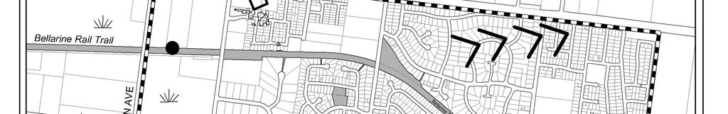
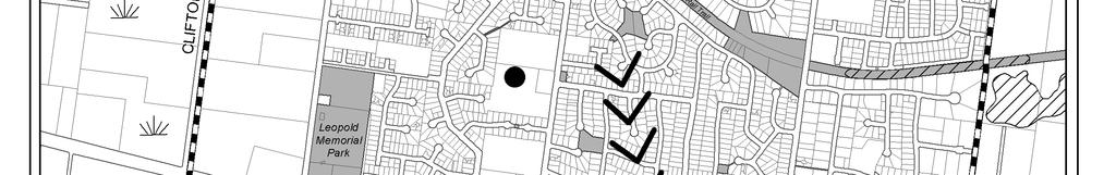
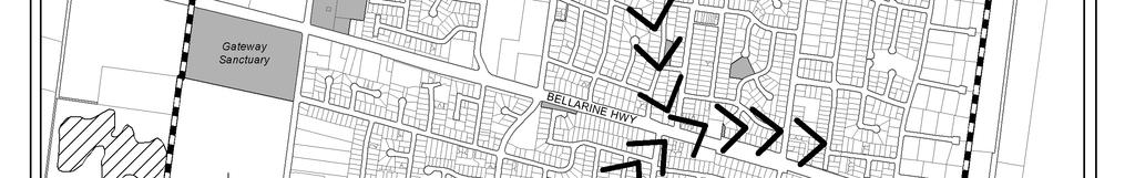
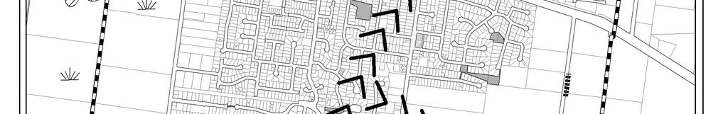
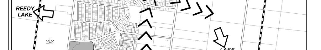
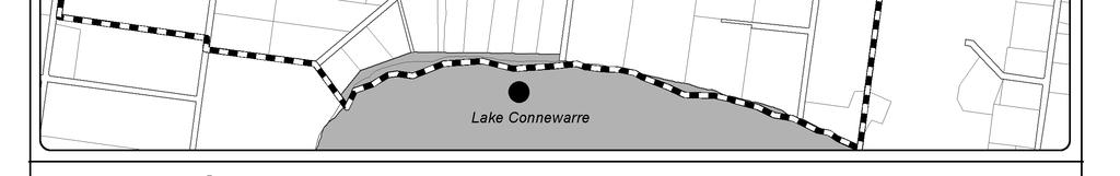
62 Map 15 - Significant Landscape and Environmental Features Leopold Structure Plan June 2011 (amended Jan 2013) 61


63 3.1.2 Climate Change The Council has a draft Climate Change Adaptation Strategy to look at the issues of climate change. Some of the risks identified include: Physical damage to property from inappropriately sited development existing infrastructure; Physical damage to property from inappropriately sited development future development; Loss of infrastructure; Increased cost or inability to obtain insurance for residential and business properties; Council liability associated with approval of inappropriately located development; Community expectations as to what is required from Council to protect private assets; Timing and extent of sea level rise; Timing and extent of increased severe weather, which may result in more extensive storm surges. In relation to Leopold, issues around drainage infrastructure, stormwater reuse opportunities and street tree species selection have been considered in the Structure Plan with regard to climate change. Map 16 - Land vulnerable to inundation during a 1 in 100 year storm tide Source: The Effect of Climate Change on Extreme Sea Levels along Victoria s Coast, 2009 Commonwealth Scientific and Industrial Research Organisation (CSIRO) as part of the Future Coasts program Protection and Management of the Natural Environment The following table provides a simplified explanation of the roles and responsibilities for each area and the basic objectives for their on-going management. Table 2 Management of the Environment: Roles and Objectives Area Lead Agency Objectives DSE / Parks Victoria Lake Connewarre and Reedy Lake Improve, interpret and protect the environmental values, whilst allowing appropriate public access for passive recreation. Bellarine Rail Trail City of Greater Geelong Protect, interpret and manage the areas environmental values. Small local parks and roadside. City of Greater Geelong Maintain the environmental and biodiversity values whilst providing for passive and active recreation spaces and access. Leopold Structure Plan June 2011 (amended Jan 2013) 62
64 3.2 Urban Environment The urban environment of Leopold is dominated by housing with two local neighbourhood strip shopping centres with approximately 10 shops including small supermarkets and one large neighbourhood retail centre, Gateway Plaza. Single dwelling allotments dominate the residential area, although medium density developments are increasing Retail Centre As part of the Leopold Sub-Regional Centre Framework, economic consultant Tim Nott, provided a report Leopold Sub-Regional Activity Centre Assessment, 2010 on the current and potential retail situation for Leopold. The key points and conclusions of this report are set out below: Existing Retail Centre Gateway Plaza Gateway Plaza is a neighbourhood activity centre which is anchored by a Coles supermarket and contains a number of specialty stores and a doctor s surgery. The centre is a more or less traditional single-owner shopping centre with car-parking to the front and has good visibility to traffic passing on the Bellarine Highway. The total commercial space in the centre is approximately 5,800 sq m (including activities on the Bellarine Highway). Of this, 4,900 sq m is retail space and the remainder is in banking, doctor s surgery, travel agent and other services. Approximately 240 sq m (3 shop units) of the Gateway Plaza Centre is vacant. The table below shows the floor space and activities. The current population of the trade area is approximately 10,000 people. Based on current commercial floor space, there are approximately 150 jobs in the centre. Table 3 Current Commercial Activity in Leopold Gateway Activity Centre Activity Enterprises Floorspace no. sq m Supermarkets and grocery stores 2 3,290 Specialty food Clothing and footwear 1 70 Homeware, hardware and electrical goods Recreational goods 1 80 Other retail Food service Retail services Total retail 15 4,920 Non-retail commercial services (bank, doctor, post office, travel agent etc) Vacant shops Total commercial space 23 5,800 Source: Essential Economics, 2008; survey by Tim Nott, 2009 Note: This table includes activity in the Gateway Plaza and on the Bellarine Highway The expansion of this centre to a potential sub-regional centre is discussed in section 7.1. Leopold Structure Plan June 2011 (amended Jan 2013) 63
65 3.2.2 Streetscapes and Residential Character A Residential Character Study for the City of Greater Geelong was prepared in 2001, in consultation with the local community, which includes Preferred Character Statements and Design Guidelines for each area. It also establishes a Vision Statement for the Leopold township which states: The diverse dwelling and streetscape styles of the township will be unified, and the urban island within an unspoilt rural setting strengthened by: Encouraging the use of appropriate native coastal vegetation species; Encouraging the use of appropriate building materials; Ensuring the siting of buildings to reflect spacing patterns; Ensuring building form and scale reflects predominant patterns; and Encouraging common public domain street treatments. Avoid: Large, bulky buildings with high site coverage. High and solid front fences. Most new residential development/estates (post 2001) are not included within an identified character precinct Protecting Residential Streetscapes and Character A number of existing controls are included within the Planning Scheme to assist in protecting the valued elements of the streetscapes and residential character The Residential Character Precinct Brochures are tool which applies to Leopold. The Residential Character Brochures outlined above are a reference document within the Greater Geelong Planning Scheme and should be considered where applicable. The importance of street tree planting to enhance the township has also been raised as an issue of this Structure Plan. The increased housing diversity areas will also help direct medium density residential development around activity centres Recommended Planning Scheme Controls for Residential Areas The adopted Housing Diversity Strategy seeks to support Increased Housing Diversity Areas (medium density housing) within a 400m walkable catchment of the town centre. It is proposed to include Increased Housing Diversity Areas around the local neighbourhood shopping centres at Ash Road and Dorothy Streets. Council s Municipal Strategic Statement includes a further work clause to investigate the application of Design and Development Overlay 14 Dwellings over 7.5m in height. This review would need to look at a more strategic application of the overlay to areas with views and coastal areas. This may have some implications for the township of Leopold. 3.3 Key Influences The opportunity to improve the key environmental and landscape values of areas such as Lake Connewarre, Reedy Lake, Gateway Sanctuary and Rail Trail and other parkland and open space. The need to support public land managers in the on-going management of the environment. The need to protect aboriginal and post contact heritage values. Climate change and resultant sea level rise could have significant impacts on low lying areas. Leopold Structure Plan June 2011 (amended Jan 2013) 64
66 There is an existing retail centre which will require expansion to serve a potential sub-regional role for the Bellarine Peninsula. The opportunity to provide increased housing diversity around local activity centres. There is a need to beatify some existing and new residential areas with street trees. 4.0 Demographics & Social Profile Just as the physical and strategic conditions, capabilities and constraints are important to the future planning for Leopold, the population profile is equally vital to understanding the needs for growth and future service provision for the local community. This section documents the population, residential lot supply and provides a brief Leopold community profile. 4.1 Past Population Growth Data from the Australian Bureau of Statistics census demonstrates that during the period between 1986 and 2006 the population of Leopold (Urban Centre) has increased from 3,452 people to 8,161 people, an increase of 4,709 over 20 years. The population growth from the 2001 census to the 2006 census was 2.94%. 4.2 Age Structure Census data provides information on the demographics of the township including age distribution. In 2006, 41.2% of the Leopold population was aged between 25 and 54 with the median age being 36 years old. The table below shows statistics from the 2006 census. Table 4 Age Structure Age Number of People 0-4 years % 5-14 years 1, % years % years 3, % years % 65 years and over 1, % Source: 2006 census 4.3 Dwellings & Household Size % of total persons in Leopold The average household size within the town in 2006 was 2.7 persons. In the 2006 Census, there were 2,357 families including: Table 5 Family Types Family Type % Couple families with children 48.7 Couple families without children 39.5 One parent families 11.0 Other families 0.7 Source: 2006 census Leopold Structure Plan June 2011 (amended Jan 2013) 65
67 Family households accounted for 88.2% of total households in Leopold while lone person households comprised 17% (compared to 68.7% and 25.9% respectively for the City of Greater Geelong). In Leopold 38.3% of occupied private dwellings were fully owned, 45.8% were being purchased and 12.5% were rented. There were 2,888 occupied private dwellings counted in Leopold of which 94.8% were separate houses, 1.5% were semi-detached, row or terrace houses, townhouses etc, 3.7% were flats, units or apartments. These statistics show that Leopold is very popular with families and there is a high proportion of home ownership. It also shows housing diversity is limited with a high proportion separate detached housing. 4.4 Labour Force & Income ABS Census data identifies the labour force as consisting of persons aged 15 years and over who are employed, or those who do not have a job but are actively looking for work. In ,016 people were in the labour force including: Table 6 Labour Force Employment Type % Full-time 59.8 Part-time 30.7 Employed but away from work 3.9 Employed but did not state their hours worked 2.3 Unemployed 3.4 Source: 2006 census In the 2006 Census, the most common responses for occupation for employed were: Technicians and Trades Workers %, Clerical and Administrative Workers %, Professionals %, Sales Workers % Labourers %. In the 2006 Census, the most common industries of employment were Hospitals 4.6%, School Education 4.2%, Supermarket and Grocery Stores 3.7%, Cafes, Restaurants and Takeaway Food Services 3.6% and Motor Vehicle and Motor Vehicle Part Manufacturing 2.8%. Details of income for residents of Leopold are provided below: Table 7 Income Area Individual Income Weekly Household Income Median Weekly Family Income Leopold $460 $1,072 $1,158 Australia $466 $1,027 $1,171 Leopold Structure Plan June 2011 (amended Jan 2013) 66
68 4.5 Socio-Economic Index The ABS produces a Socio Economic Index for the Areas which considers Advantage/Disadvantage and takes into account variables relating to income, education, occupation, wealth and lining conditions. Leopold has a SEFIA score of Relative disadvantage is associated with a low number (below 1,000). Enrolment information routinely collected for children attending kindergarten in Leopold indicate that almost 1 in 4 families are eligible for a Commonwealth Health Benefits Card and participation by Indigenous children is slightly above the average for Greater Geelong. According to the ABS Census Leopold has a comparatively low population of young people who are parents aged under 25 years at 0.2 per cent. 4.6 Journey to Work ABS Census data for 2006 demonstrates that the private car is the dominant mode of transport for those residents of Leopold who must travel to work. On census night the private car was used by 94.2% of employed persons in Leopold who travel to work. These statistics include both drivers and passenger, and the statistics also demonstrate that as little as 1.5% of the Leopold work force walk to work. Therefore it could be assumed that the majority of the town s workforce would be employed outside the township, utilising private vehicles to travel to work. Table 8 Travel Modes Method (one method only) Number Train 27 Bus 20 Car, as driver 2,773 Car, as passenger 179 Truck 41 Motorbike/scooter 11 Bicycle 21 Other 14 Walked only 47 Total one method 3, Population Projection 2021 Two methods of population projection have been used to estimate the population in 2021 including dwelling approvals and growth rate. These indicate with average population growth a 2021 population is expected to be between 12,597 and 12,616 and with higher growth levels is expected to be around 16,261. Dwelling Approvals Table 9 Dwelling Approvals Population Projection A Population 2006 census 8,161 B House hold Size 2006 census 2.7 C Average Dwelling approvals per year 110 D Medium growth scenario approvals per year 200 Leopold Structure Plan June 2011 (amended Jan 2013) 67
69 E High growth scenario approvals per year 250 F Population growth per year average approvals (B x C) 297 G Population growth per year medium scenario approvals 540 (B x D) H Population growth per year high scenario approvals (B x E) 675 Year Additional Population Average Growth Total Population - Average Growth Additional Population Medium Growth Total Population -Medium Growth Additional Population with High Growth Total Population -with High Growth ,485 9,646 2,700 10,861 3,375 11, ,970 11,131 5,400 13,561 6,750 14, ,455 12,616 8,100 16,261 10,125 18,286 These figures indicate based on average dwelling approvals (110) and household size the population could reach 12,616 by Based on a higher growth scenario of dwelling approvals (200) the population could reach 18,286 by Growth Rate Based on the census growth rate between for Leopold which is 2.94 and the 2006 population of 8,161 the following population figures have been extrapolated: Table 10 Growth Rate Population Projection Year Increase in Population Total Population (+2.94%) , ,272 9, ,468 10, ,696 12, Key Influences Leopold will continue to receive strong population growth. Leopold will continue to have a high proportion of families and over 55s which is important when considering community infrastructure, facilities and housing diversity. Employment and journey to work data indicates that the majority of Leopold residents in the workforce, are employed outside the township. The residents of the township rely almost entirely upon private cars for transport. 5.0 Township Facilities & Services 5.1 Local Community Services and Facilities The following is a list of the key local facilities available within the township (summarised on Map 10 below): Community Hall Leopold Indoor Neighbourhood Centre (LINC) Churches Leopold Structure Plan June 2011 (amended Jan 2013) 68
70 Country Fire Authority (CFA) Station Bus Services Aged Accommodation (Leopold Lodge - 58 low level beds, 15 high care beds and 2 respite beds, Bellrise - 24 hour nursing care for all residents, Kensington Retirement Village (no medical care). Child Care Centre (Melaluka Child Care & Kindergarten Centre 0-3 & 3-5 age groups) Kindergarten (Leopold Kindergarten & Allanvale Kindergarten) Primary School County Fire Authority Station Two Shopping Strips (Ash Road & Dorothy Street) Medical Centres (Leopold Medical Centre, Kensington Hill Medical Centre & Gateway Plaza Medical Centre) Privately owned Swim school The Barwon Health and City of Greater Geelong provide a wide range of services including medical, nursing and home-based allied health, youth, maternal and child health and adult day programs, including socialisation, respite and rehabilitation. Early Childhood As of June 2010, a total of 516 children aged 0-4 were enrolled at the Leopold Maternal and Child Health Centre, this includes new birth notifications of 140 in the year 2009/10. There has been a consistent increase in new births for the Leopold area over the past ten years including a 36% increase in the last four year period. This does not include immigration which means the number of families with young children is likely to be substantially higher than indicated by the figures above. Based on these figures Leopold will require additional kindergarten capacity including additional supports for families with children in the 0-4 age group (i.e. MCH, Long Day Care, health and family support). The Maternal and Child Health Service will also require expansion to cope with increasing birth notifications. Leopold currently has two kindergartens Allanvale and Leopold. There is also a small independent Long Day Care service located in Leopold providing a total of 46 places for children 0-5. The Long Day Care Centre provides a funded kindergarten program for 30 children. Both kindergartens are operating at capacity and are struggling to accommodate existing needs. Plans are being developed to expand the provision of kindergarten accommodation at Allanvale Kindergarten to double the kindergarten s existing capacity. The proposed Community Hub is likely to incorporate an integrated Children s Centre including an additional kindergarten room and 60 place child care centre. This will need to be implemented if the future requirements of the population are to be accommodated. The kinders and MCH do not conform to modern service requirements, community expectations, occupational health and safety standards, or the delivery of quality service outcomes or environments. The kinders were also identified as a high priority for expansion and development given the increasing demand and limited supply of kindergarten places available in the area. The Leopold Toy Library presently operates from the Leopold Guide Hall in Melaluka Road. This site is considered inadequate and it is proposed to build a new purpose design toy library facility as part of Community Hub, which will integrate with other early childhood services. Playgroups currently operate from St Marks Anglican Church Hall. This is a valuable community service however the site does not provide an appropriate outdoor play space. A new playgroup facility is proposed as part of the Community Hub which will also better integrate with other early childhood services. Leopold Structure Plan June 2011 (amended Jan 2013) 69
71 Education Facilities Leopold Primary School has a history spanning back to 1851 when the first school in the community of Kensington (Leopold) was established. A brand new school was opened in 2004 and featured: 16 Large permanent classrooms and 15 well resourced portable classrooms Administration area Leopold Indoor Neighbourhood Centre gymnasium (LINC) Well equipped Art room, Computer lab, Library and L.O.T.E room Modern administrative block The school currently has an enrolment of over 680 students which is one of the largest enrolments within Greater Geelong. Council s School Holiday Program operates from existing school facilities during term breaks, and the school provides a successful Outside School Hours Care program. The Department of Early Education and Childhood Development has indicated a new primary school site should be identified as part of the planning of the future residential growth area. The Department s requirements for a new site states that a new Primary School should be: Located on 3.5ha of land that is not constrained by environmental, health or physical concerns; Bounded by three street frontages to facilitate safe and efficient pedestrian movement, including an allowance for indented parallel roadside parking; Located on a connector street rather than an arterial road, with sufficient width to provide student drop off zones, bus parking and on-street parking; Integrated with the neighbourhood and located near neighbourhood activity centres; Located adjacent to public open space network and/or community and sporting facilities (including preschools) to provide for collection, integration and sharing; Located on walking and cycling networks; and Situated no closer than 400m from Extra High Voltage Transmission Lines. Emergency Services Leopold has a CFA Station but other services such as police and ambulance are provided by services in Geelong and on the Bellarine Peninsula (Drysdale & Ocean Grove). Leopold Structure Plan June 2011 (amended Jan 2013) 70

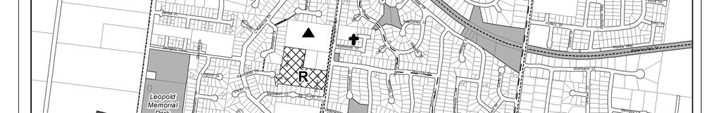
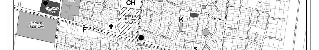
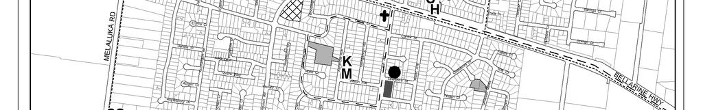
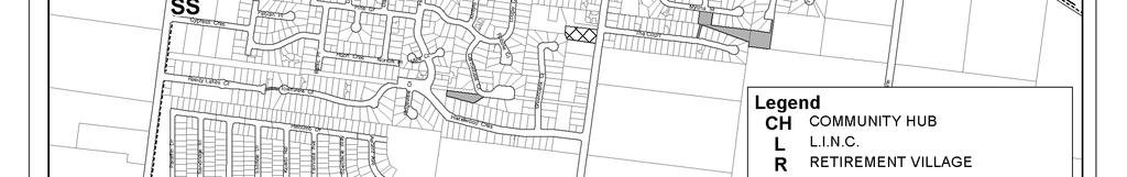
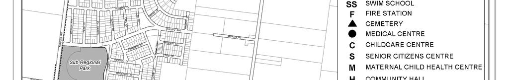
72 Map 17 - Existing Community Facilities Leopold Structure Plan June 2011 (amended Jan 2013) 71
73 Other Community Facilities and Services The availability of community services and facilities in Leopold should be considered in the context of its proximity to Geelong and the range of services offered there. Leopold is served by the mobile library service and fixed library services are also available in Newcomb, Drysdale and Ocean Grove. The City of Greater Geelong is currently developing a community hub which is proposed to include a permanent library as well as additional child services and community meeting rooms. Community Hub In 2007 David Lock Associates (DLA) prepared a concept plan for an integrated community hub on a the land adjacent to the Leopold Primary School. After consultation and a community infrastructure analysis it was determined the following might make up the community hub: Core Uses High quality open space incorporating public art, children's play area, town square and performance space around which are located: A Lifelong Learning facility, including a Library, an information technology hub and café. Family and Children services, including a Pre-school, day and occasional care. A wellness facility, including Health facilities, Maternal & Child Health Care and a space, incorporating rooms for specialists, GP s and other health care professionals. Social & Recreational facilities including a youth centre and meeting rooms with kitchen facilities. Supporting Uses These core uses are supported and complemented by a range of other uses that add to the appeal and vitality of the Hub and reinforce its contribution to the well-being of the community. The proposed supporting uses are: Workshop/ Studio facilities Bookshop Community Office Interpretive Centre for Sustainable Design Community Garden Sustainable indigenous landscape demonstration garden Public art Enterprise hub incorporating incubator units with access to business facilities, printing, computers, internet access, meeting rooms Community Bus/ Bus stop Housing, either medium density, such as villa or townhouses or self care/independent living units for older people - This requires careful consideration to ensure it contributes to the hub as much as it can and justifies the setting of public land for private housing Car parking Multi purpose space for farmers markets, public meetings etc. Leopold Structure Plan June 2011 (amended Jan 2013) 72

74 Map 18 Concept Community Hub Design (2007) Source: DLA, 2007 The design for the hub has now progressed and has moved away from the original DLA concept. 5.2 Open Space, Leisure and Recreation Facilities A number of public leisure and recreation facilities are provided in Leopold. The following is a list of leisure and recreation facilities within the township which are also illustrated on Map 19 below. Leopold Memorial Park - Facilities Open Space Football/Cricket Ovals (2) Netball Courts (2) Tennis Courts (9) Skateboard facility Facilities (club houses, toilets, parking) Leopold Memorial Park - User Groups Leopold Football Netball Club Approximately 820 members. Experiencing growth anticipates well over 1000 in five years. Leopold Cricket Club Approximately 237 players. Experiencing growth juniors 30-40% increase and seniors 20-30% increase from five years ago. Leopold Tennis Club Senior and junior (Saturday), ladies midweek. Approximately 76 members. Experiencing decline in membership. Leopold Girl Guides Approximately 30 members - girls 6-18 years of age. Membership is stable, having doubled in the past five years. Leopold Toy Library Uses some of the space that is leased to the girl guides. Happy with current arrangement lots of parking for members. Leopold Structure Plan June 2011 (amended Jan 2013) 73
75 Leopold Scouts Has a hall in site north of cricket nets. Leopold Lions Club Has a storage shed and small car park to the north of the Recreation Reserve. Informal Park Users Spectators of sporting and formal events in the reserve. Skate park users. People informally using the half netball court and hitting wall. Families and children using playground. General public casually using two tennis courts that are open for the general public. People walking and exercising dogs within the reserve. General public walking and cycling through reserve. Sportsmans Club (private) - Facilities Bowls Greens Squash Courts Aerobics and Indoor Bowls Facilities 250 seat bistro Area Function room Bars Parking and other facilities Leopold Sportsmans Club User Groups The Club s 2160 membership (2008) consists of 400 sports members and 1700 club members. Of the sports members: 220 are bowlers, competing in the Geelong and District Bowls Association and the Bellarine and District Ladies Bowls Association; 85 are golfers playing at various golf courses across the region; 70 are squash/racquetball players playing in the Geelong Racquetball Association and Geelong Squash Association; and Others participate in dance, indoor bowls and other activities. The trends indicate that while Leopold is projected to experience modest population growth, there will continue to be growth in the key sports of football, netball and cricket with a stable participation trend in tennis, particularly if the facilities are upgraded to meet both the needs of each sport and the expectations of the local communities. Increase in participation in lawn bowls is possible with the high membership of current activities and the ageing of the population that may encourage greater interest in this sport. LINC The Leopold Indoor Neighbourhood Centre (LINC) was opened in September The facility was developed as a result of the community need for a centre to cater for active and passive recreational pursuits of people of all ages. The project was jointly funded by the State Government, the City of Greater Geelong and the Education Department. The LINC has a large hall/court area, a multi-purpose room and a number of meeting rooms available for public use. In addition, as part of a joint user agreement between the Education Department and the LINC, programs also utilize facilities in the Leopold Primary School and the Kensington room. Leopold Structure Plan June 2011 (amended Jan 2013) 74
76 The operation of the LINC is managed by the LINC Committee of Management, an incorporated body, which is responsible for the day to day operation of the LINC as well as the development of the business and strategic plan. The LINC has employed a part time Community Liaison Officer to source, advertise, organize and implement a wide variety of programs and activities. The Bellarine Rail Trail Located in the northern half of the town this is a east-west linear link used by cyclists, pedestrians, horse riders. The trail has a mix of gravel and sealed surfaces and runs from South Geelong to Queenscliff. Gateway Sanctuary, The Sanctuary is a constructed wetland providing an opportunity for informal recreation including walking tracks, BBQ facilities, playground, toilets and open space. The Curlewis Golf Club and the Bellarine Lakes Golf Club These courses are located within a four-kilometre radius of Leopold. Local Parks A number of smaller open space areas also exist within the residential areas of Leopold serving a more localised population. These open spaces typically contain landscaping and a playground. A number of the parks are located in the Residential 1 Zone. Council management of these parks would be assisted if they were rezoned to the Public Park and Recreation Zone. Leopold Structure Plan June 2011 (amended Jan 2013) 75
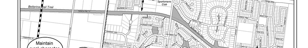
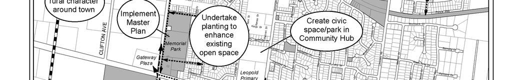
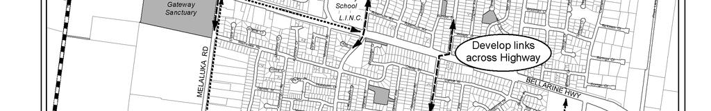
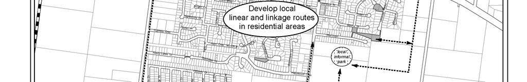
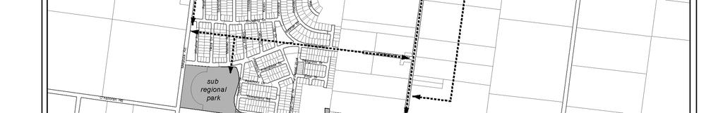
77 Map 19 Recreation and Open Space Leopold Structure Plan June 2011 (amended Jan 2013) 76
78 5.2.1 Identified Improvements to Open Space, Leisure and Recreation Facilities A number of studies have been undertaken by, or on behalf of Council which have identified potential improvements in relation to open space, leisure and recreation provision and the linkages within the township. The draft Structure Plan broadly supports the key actions of these studies as detailed below: Draft Memorial Park Master Plan Some of the key opportunities identified include: Rationalising many (often duplicated) facilities within the park, thereby minimising the operational and Maintenance costs to Council and the community. Maximising its future flexibility to cater for changing demographics and sports requirements, providing (where possible) for future flexibility to accommodate unforeseeable trends and changes in user s needs. Providing a sustainable design that gives the park a structure, to provide much needed activity nodes centred around shared facilities while enhancing existing links with adjacent areas such as the retail centre, rail trail and residential areas. Providing landscaping to enhance the existing character of the reserve while providing a dynamic and living framework within which spaces and places can be organised. Retaining and maintaining of the current dynamic of volunteer organisation of sport for social and cultural reasons, while potentially providing opportunities for revenue generation. Broad objectives for redevelopment of the Reserve in the Master Plan include the following:- Improve access by offsetting the currently direct connection across the Melaluka Road into the shopping centre. Improve the entrance layout to positively assist way-finding, to also enhance the sense of arrival at the Recreation Reserve and the town itself and to create a street presence that identifies this key gateway site to Leopold. Promote relationships with neighbouring uses, through permeable Reserve boundaries. Better visual and physical connections will encourage shared use of the Reserve and in turn enhance the standard of facility able to be offered. Capitalise on the large amounts of available space and organise it better, to create more parking. Utilise and enhance the strength of the ovals as distinctive landscape features, with informal parking and seating under large trees, and a great cricket wicket / football field. The central location of the number one oval provides opportunities for various synergies to be explored. Take a coordinated approach to co-locate and cluster uses to take advantage of shared facilities at the same time open up more spaces for active uses. Create a more appropriate / useable pavilion arrangement for the main oval. Create a destination that has a point of difference rather than looking to duplicate facilities currently already provided elsewhere. Make more legible connections into and through the Reserve linking the different uses within the reserve and to those adjoining it. Draw on the flat topography and the adjacent street grid to support multiple cycle / footpath connections. Create improved and new tracks including to and along the cycle trail, to any new residential subdivision, commercial areas and existing and future development around the Reserve. Utilise the additional parking across the road at the shopping centre for large events parking. Leopold Structure Plan June 2011 (amended Jan 2013) 77
79 Option 1 Upgrading Existing Facilities Improve and expand the existing pavilion to also include female player and umpire change facilities, storage facilities and community spaces to replace the community building (and accommodate the girl guides, scouts, Lions, gymnasium, and toy library (if they are not relocated to the Community Hub) Extend the tennis clubroom to incorporate change and public toilet facilities to provide for tennis, netball and the casual recreation users of the reserve. This allows for the removal of all netball courts and clubroom from the eastern section of the reserve to make way for good pedestrian access and defined car parking. Locate public toilets in the pavilion and tennis/netball facility this makes way for the demolition of the three stand alone public toilets in the reserve. Redevelop tennis courts in current location with two synthetic courts multi-lined for netball and two asphalt courts multi-lined for netball. Cricket nets remain in their current location there may be extensions to wire fencing to ensure safety of vehicles and pedestrians from flying balls. Leave the skate park and playground in their current locations, with walking pathways developed to provide good access through the informal parkland. Develop a pedestrian access from the highway frontage that leads to the tennis/netball clubroom. Develop sufficient car parking on the reserve to meet the needs of all users (estimated at 240 spaces). This will be achieved by constructing a sealed car park with new entrance at the existing entrance near the cricket nets and complementing this with unsealed defined car parking as shown. Upgrade the existing car park adjacent to the Lions Shed with a small sealed and defined car parking, and define an unsealed overflow car parking area to the north-west corner of the reserve. Define walking and cycling paths throughout the reserve to connect to the formal entry/exit points, including a well defined pedestrian access path from Split Court (the residential area to the east) through the reserve to the Leopold Shopping Centre entrance. Relocate the memorial sign from the highway corner to the new pedestrian entrance on Melaluka Road. Retain the existing water tank in its current location and develop an additional storm water retention pond in the north-east corner of the reserve for increased water re-use for irrigation in the Reserve. Use landscaping to define playing fields and provide increased shade and amenity. Parking - Option 1 delivers approximately 250 carparks on gravel and tarmac areas, with the use of the grass area to the north west of the #2 oval, a further potential for a further 80+ overflow parks is achievable, thus comfortably providing for current peak parking requirements. Option 2 Sportsman s Club Model Redevelop the existing pavilion (by potentially demolishing the existing one) on the western edge of the oval as a significant two-storey building to provide all built requirements for the Sportsmans Club and field sports. A two-storey building will be required with a lift and stairs/ramps. This is likely to include: Administration and Office Areas / Reception / Meeting Room/s Change Rooms for all sports users six multi-purpose change facilities plus unisex umpires change room Gaming Room / Sports Bar and TAB / Pool Room / Lounge Bar Bistro and Lounge Commercial Kitchen / Cool Store and Kiosk / Canteen Multi-purpose Community Room/s with separate kitchenette and possible access to bar Leopold Structure Plan June 2011 (amended Jan 2013) 78
80 Toilet facilities for social / community rooms plus public toilets with internal/external access all accessible, family friendly and unisex Two Squash/Racquetball Courts First Aid and supporting areas Spectator and viewing areas from ground level and first floor, with an undercover spectator area similar to existing for oval one Substantial storage areas to cater for all the current uses in the community building, scout hall and lions storage shed as well as the maintenance / storage requirements for the Sportsmans Club. Relocation of cricket nets to the north-west corner of the reserve. Extension of tennis clubroom as indicated in option one to cater for tennis, bowls and netball and provide public toilets. Developing four synthetic courts for netball and tennis as shown in option one, but instead of the further four courts to the east, place of two multi-line courts to the north of the synthetic courts and potentially two tennis only courts on the eastern side of the reserve, further south than the existing netball courts. This makes way for two lawn bowls greens towards the front of the reserve. A third green could be placed where the 7th and 8th tennis courts are proposed, or (if Council is in a position to purchase the residential properties in the south-east corner at some future date), a south-east location could also be considered. Car parking similar to that proposed for option one Retention of the skate park and playground in their current locations, with walking pathways developed to provide good access through the informal parkland. Developing a pedestrian access from the highway frontage that leads to the tennis / netball / bowls clubroom. Existing water tank remains in its current location and developing an additional storm water retention pond in the north-east corner of the Reserve for increased water re-use for irrigation in the Reserve. Landscaping to define playing fields and provide increased shade and amenity. Parking - Option 2 delivers over 320 carparks on gravel and tarmac areas, with the potential use of the grass area adjacent to the north west of the #2 oval and new nets, a further 40+ overflow parks is achievable, thus comfortably providing for current peak parking requirements. When used in conjunction with carparks available across Melaluka Road at the retail park, future peak event demand could also be incorporated comfortably. Preferred option 1 can be seen on plan 3 in the Structure Plan. 5.3 Key Influences The Council owned land at Kensington Road presents a strategic opportunity to provide more community facilities. Predicted increases in population means there is a need to provide additional community and recreation facilities, infrastructure and services. Developer contributions may be able to contribute to the funding of physical and community infrastructure. The town requires a second primary school site to be identified. Council s Bellarine Peninsula Community Service Plan identifies key services which could be provided to better service the community and cater for all age cohorts. Leopold Structure Plan June 2011 (amended Jan 2013) 79
81 6.0 Physical Infrastructure and Transport 6.1 Water Supply Barwon Water advises that reticulated water to Leopold is supplied from the Pettavel Basin. There is sufficient capacity in the system to cater for the current proposed residential growth. Barwon Water advised this would need to be re-evaluated should Council decide to extend the township boundary or change the land uses dramatically within the existing township. Barwon Water has identified a number of projects which will improve water supply to Leopold and cater for the currently identified growth. 6.2 Sewer Barwon Water have provided the following comments on sewer infrastructure and servicing: Christies Road Area (area 1) This infill area is currently being serviced by the extension of existing infrastructure which has capacity for the lots envisaged with the rezoning. Estuary Estate, Melaluka Road (area 2) This 655 lot estate will be serviced via a 2.6km long 300mm diameter sewer along Melaluka Road as shown on map 12 below. The sewer is to be constructed in 2011 and will have capacity for an estimated 950 lots from the adjoining Ash Road area (area 4) to the east. The sewer will have some capacity for further connections in the order of 300 lots. Moss Road (area 3a) This area is currently being developed with developer funded sewers and a pumping station discharging to the Leopold Melaluka trunk sewer. The trunk sewer is to be duplicated in 2014/2015 to accommodate future flows from both Leopold and Clifton Springs over the next 35 years. Ash Road Area (area 4) The area east of area 2 will require a sewerage pumping station at the lowest point along the east of the area 4 boundary. Barwon Water have no plans to sewer this area in the current Water Plan, however provision will be made for servicing the area in the 2013/ /18 Water Plan. Should the urban area boundary be moved further east to Mollers Lane, Barwon Water could amend its servicing strategy to suit the shift. Gateway Shopping Centre (area 5) This area encompasses the Gateway Shopping Centre and is serviced by a sewerage connection to the existing 300mm diameter sewer along Melaluka Road. This area is being considered for expansion to incorporate a sub-regional activity centre with an overall ninefold increase in floor area. Neither the existing 300mm sewer nor the proposed 300mm sewer from area 2 will be able to command this expanded retail area and ultimately additional sewerage infrastructure will be necessary to service the area most likely along Clifton Avenue. Leopold Structure Plan June 2011 (amended Jan 2013) 80

82 Bellarine Peninsula Upgrades The major sewer upgrade on the Bellarine Peninsula that impacts the Leopold township is the upgrade of the Northern Transfer System. This involves the duplication of the Clifton Springs and Leopold Rising Main along the Bellarine Rail Trail and upgrading the Leopold No 1 sewerage pump station at the corner of Melaluka Road and the Bellarine Rail Trail. The upgrade of the sewer pump station is to be scheduled for 2011 and the Leopold Rising Main project is nearing completion. The pump station upgrade has made allowance for growth in Leopold as outlined in the 2006 Structure Plan plus connection of a proposed 200 site caravan park at the northern end of Moss Road. Recycled Water Recycled water investigations are undertaken against a range of financial, social, environmental and economic criteria to determine feasibility. The provision of recycled water to the Leopold area has not been investigated as there are no sources of recycled water in the vicinity. The cost to make provision for the supply of recycled water is unlikely to be financially viable at this time. Map 20 Barwon Water Infrastructure Existing and Proposed Source: Barwon Water Leopold Structure Plan June 2011 (amended Jan 2013) 81

83 6.3 Stormwater The City of Greater Geelong prepared a Stormwater Management Plan to improve the environmental management of urban stormwater within the municipality to protect the environmental values within the region. Urban development results in changes to catchment areas. Typically urbanisation results in increased runoff volumes and the introduction of a variety of pollutant sources. The Stormwater Management Plan identified a number of sub-catchments within the municipality and the township of Leopold is represented in two sub-catchments, Leopold and Reedy Lake. The sub-catchments bisect the township roughly along an east west axis. Thus stormwater runoff generated north of the Bellarine Highway typically drains into Corio Bay and stormwater south of the Bellarine Highway typically drains to Reedy Lake. The environmental values of the receiving areas in both sub-catchments are defined as very high in the Stormwater Management Plan. The Leopold sub-catchment extends east from Point Henry towards Clifton Springs subcatchment and drains into the highly valued environment of Port Philip Bay. The value of the marine and foreshore habitat in this area is due to the presence of seagrass beds in the intertidal and immediate sub-tidal areas, and, to a lesser extent the habitat provided by the saltworks. The Reedy Lake sub-catchment is located between the urban area of Geelong and Leopold. It drains entirely into the Ramsar listed Reedy Lake and continues into the environmentally significant areas of the Barwon River, Hospital Swamp, Lake Connewarre and the Barwon River Estuary. Management of stormwater is critical in order to protect the environmental values of the receiving areas from pollutants and sedimentation. It is essential that future urban areas such as those designated for urban development in this Structure Plan be developed in accordance with best practice stormwater management principles including water sensitive urban design techniques. In order to ensure the highest possible level of stormwater quality, future developments will be required to set aside areas for pre-treatment of stormwater using methods such as artificial wetlands and sediment basins. All developments will be required to model the treatments proposed to outline the levels of Nitrogen, Phosphorous, suspended sediments and litter that will drain from the site. All new developments will also be required to incorporate stormwater re-use into the design so as to reduce total volumes draining from the expanding areas of the township. Example of a swale drainage system Leopold Structure Plan June 2011 (amended Jan 2013) 82
84 6.4 Transport Infrastructure The transport network within Leopold is heavily reliant on road based movements. The provision of formal pedestrian paths and linkages between open space areas and to the shopping centre from adjoining residential areas could be improved to enhance walkability of the township Roads Leopold has direct access to urban Geelong via the two major arterial routes that serve the Bellarine Peninsula. The Portarlington Road forms the town s northern boundary. It comprises two through lanes and a bicycle lane in each direction separated by a wide central median strip. Four breaks in the median strip are present at Clifton Avenue, Melaluka Road, Kensington Road and Christies Road. Christies Road is the only intersection which has traffic lights. The community has expressed concern about the difficulties faced by motorists trying to enter the traffic flow at peak hours at the Portarlington Road intersections with Melaluka Road and Kensington Road. Vic Roads advise that signals are not planned for Melaluka or Kensington Roads at this time. The Bellarine Highway bisects the town. It is a four-lane highway divided by a narrow median strip. Bicycle lanes are provided in both directions. This road has the undesirable impact of a physical barrier segregating the northern and southern sections of the town. It is important to facilitate safe access between the two areas of the town particularly as the majority of local community services including the primary school, the new community centre, the Leopold Sportsman s Club and the shopping centre are all located on the northern side of the Highway. There are three signalised intersections with pedestrian facilities on the Bellarine Highway in Leopold at the Kensington Road, Ash Road/Simons Road and Melaluka intersections. Vic Roads has indicated new signals are planned for the Bellarine Highway and Christies Road intersection in These are the major cross-town links in the town. There is a need to co-ordinate the timing of the traffic signals in Leopold to provide for efficient vehicular movement through the town Public Transport There are approximately 15 bus services (generally hourly) per day on weekdays and 11 services on the weekend connecting Leopold to central Geelong on a dedicated route. This route includes a loop service whereby buses leave the arterial road and enter the residential areas, as indicated on map 10. Buses travelling to the coastal towns of Ocean Grove, Queenscliff and Portarlington/St Leonards also stop on the key intersections in Leopold. Thus the town is reasonably well connected with urban Geelong and with other towns on the Bellarine Peninsula. At this stage no recommendation is made for changes to the public transport system in Leopold. However as residential development occurs particularly in the southern part of the town, it may be necessary to consider extending the bus route southwards to serve those areas. The frequency of bus services in Leopold is not substantial but that is likely to be a product of the demand for buses in the area Pedestrian and Bicycle Network Bicycle Links The only off-road bicycle route in Leopold is the Bellarine Rail Trail, which extends from Queenscliff through Leopold and terminates at the Geelong Showgrounds. This route is typically used for recreation and not as a direct transport route. There are a number of on-road bicycle routes in Leopold, along the two major arterial roads (Bellarine Highway and Portarlington Road), Christies Road and along Kensington Road where the primary school is located. Leopold Structure Plan June 2011 (amended Jan 2013) 83
85 An additional route is proposed along Melaluka Road. Bicycle lanes service the key sites in the town such as the primary school. The Cycling Strategy identifies the following as being appropriate to improve cycling in Leopold: Install 1.5m wide on-road bicycle lanes and signage on Christies Road as a medium priority action; and Installation of 1.5m on-road bicycle lanes and signage on Melaluka Road as a mediumlow priority action. Council is looking to install a shared pathway along the west side of Melaluka Road to improve connections from the rail trail and the increasing number of residents along Melaluka Road. Pedestrian Links Pedestrian movement is generally facilitated in Leopold with footpaths on the majority of non culde-sac roads. The new growth areas will continue with this pattern of development through the subdivision process. The Leopold Strategic Footpath Network Report identifies numerous challenges and opportunities which are show on the map 21 below. These works will need to be prioritised, listed on work plans and budgeted for. In relation to the proposed sub-regional site the following challenges and opportunities have been identified: Gateway Plaza is identified as key trip generator within Leopold. However the shopping centre is isolated from the township. The intersection between the Bellarine Highway and Melaluka Road is a vehicle priority crossing point and considered unsafe and slow for pedestrians/disabled. Melaluka Road and the Bellarine Highway are physical barriers to the pedestrian and cycle network. Melaluka Road is identified as a barrier to the pedestrian network due to the high speed traffic which travels along this road, absence of footpaths and roadside swales. Furthermore members of the community identified Melaluka Road as a key concern area within the township. Leopold Memorial Recreation Reserve is a key open space within the township. Barriers to walkability at this location include the convoluted layout of sports facilities which obstructs connection to the shopping centre. The existing pedestrian/cycling network is considered to be poorly understood, unwelcoming and disconnected. Leopold Structure Plan June 2011 (amended Jan 2013) 84

86 Map 21 Walkability Challenges and Opportunities Leopold Structure Plan June 2011 (amended Jan 2013) 85
87 6.5 Key Influences Barwon Water is satisfied that the capacities of water and sewerage systems are, or will be capable of accommodating future growth. The drainage infrastructure is under increasing pressure in some areas and climate change may be an issue in the future. New developments will require best practice storm water management to protect the environment and provide re-use opportunities. Opportunity to provide improved and more frequent public transport options as new residential areas develop. Opportunity to improve the limited pedestrian and bicycle linkages throughout the township and within the open space areas. The location of retail and recreation facilities provides challenges for more sustainable, non-vehicle reliance travel. The opportunity to improve the connection of the shopping centre to the rest of the township particularly the recreation reserve and community hub. 7.0 Commercial Growth, Residential Lot Supply and Further Development 7.1 Commercial Growth Leopold was identified in the Geelong Retail Strategy, 2006 as having the potential to develop into a sub-regional centre. The following is taken from the Retail Strategy:- In view of the current proposal for a neighbourhood centre at Leopold [the now constructed Gateway Plaza], the Strategy recommends that an investigation be made of the potential or otherwise for this site to be the location for a new sub-regional centre. In preliminary terms, Leopold may be an appropriate site in the medium-term for further retail development for the following reasons: The site offers the potential for retail and associated expansion in view of available vacant land (although Council engineers indicate flooding and drainage constraints may exist). The site would serve the entire Bellarine Peninsula and would reduce the travel requirement of Bellarine residents to access this type of centre (compared with a centre at say, Newcomb). The site at Leopold is located 8.5km from Central Geelong, and would not be expected to undermine Central Geelong s core primary catchment, although the potential for adverse trading impacts would have to be the subject of an economic impact assessment if and when any development proposal for a sub-regional centre at Leopold is put forward for Council consideration. By around 2016, the forecast population on the Bellarine Peninsula should support subregional retail facilities without having an undue adverse effect on retailing in Central Geelong (although this will be determined by the Retail Planning Assessment Criteria at the appropriate time). Population growth on the Bellarine Peninsula is likely to be sufficient to support a sub-regional activity centre in the coming decade according to the Geelong Retail Strategy (Essential Economics, 2006). Leopold has been put forward as the most logical location for such a centre largely because it is accessible via the Bellarine Highway (serving Queenscliffe and Ocean Grove) as well as the Geelong-Portarlington Road (serving Drysdale, Portarlington, Indented Heads and St Leonards). Leopold Structure Plan June 2011 (amended Jan 2013) 86

88 Map 22 Trade area for Leopold Sub-regional Centre Key Boundary of main trade area regional/subregional centre community centre neighbourhood centre small neighbourhood centre Source: Tim Nott economic analysis + strategy A report titled Leopold Sub-Regional Activity Centre Assessment prepared by Tim Nott economic analysis + strategy identified the trade area has approximately 54,000sqm of retail floorspace, including 20,400sqm providing food and groceries, 7,000 providing hardware and homewares, and 12,700 sq m providing other non-food goods. There are a number of proposals also being planned in the area which would add an additional 28,900sqm of additional retail floor space, bringing the total to around 82,900sqm. Retailing to 2021 In addition to the proposed expansion of retail space in the trade area (the base case), Nott s report identified room for significant further space if it is in the form of a sub-regional centre. By 2021, the trade area could support the following elements of a sub-regional centre without encroaching on the demand required to support existing and already planned shops: 4,800sqm of food and grocery space, which would be sufficient to support a further fullline supermarket and specialty food stores 8,900sqm of other non-food goods (clothes, recreational goods, pharmacy goods jewellery etc), which would be sufficient to support a DDS of 7,000sqm (except for the homeware function) plus specialty stores 2,200sqm of cafes, restaurants and take-away food establishments and hairdressers, beauticians and video rental stores The analysis by Nott found a substantial part of the additional space could be provided early in the planning period. The principal difficulty in the scenario is the provision of homeware and hardware shops. A DDS would need to have some space dedicated to electrical and household goods and other homewares but spare demand over the planning period appears to be inadequate. In addition, the sub-regional centre operators may expect to develop a home-makers precinct in conjunction with the centre. However, the planned B4 zone in Ocean Grove is likely to soak up the demand for this type of space. Any significant provision of homeware/hardware space at a sub-regional centre in Leopold is likely to detract from investment in the Ocean Grove site. Leopold Structure Plan June 2011 (amended Jan 2013) 87
89 In terms of community benefit, it would be preferable to maximise the viability of retail space at a sub-regional centre in order to ensure its provision so that travel costs for residents of the trade area can be reduced and local employment can be created. And since no planning permits have been granted for bulky goods retailing on the B4 site at Ocean Grove perhaps the most appropriate course of action is to leave the location of homeware/hardware shops to the market, noting that the two choices of location are at Grubb Road in Ocean Grove or at the Leopold subregional centre. In summary Nott states the trade area could support the crucial elements of a sub-regional centre including: A large DDS A further full-line supermarket Specialty stores A home-maker function Table 11 Estimate of potential additional floorspace at a sub-regional centre in Leopold, 2021 Shop type Floorspace sq m Supermarket 3,800 Specialty food 800 DDS 8,000 Specialty non-food 2,900 Food service 1,800 Other services 400 Bulky goods 10,000 Total retail space 27,700 Source: Tim Nott economic analysis + strategy Given these additions to retail and non-retail floorspace it is possible to provide a broad estimate of additional employment at the centre. Based on an average of 40sqm per job, the centre would provide approximately 1,100 additional jobs. The table below proposes two scenarios of the requirement for additional land to accommodate activities in the sub-regional centre at Leopold over the period to Scenario 1 assumes that all new development will be provided at ground level. Scenario 2 assumes that some of the nonretail space can be provided on a second level (including, for example, offices and cinema screens) and that the car-parking is partly decked. Leopold Structure Plan June 2011 (amended Jan 2013) 88
90 Table 12 Notional demand for land, Leopold sub-regional centre, 2009 to 2021 Scenario 1 Ground level development Scenario 2 Some 2- storey development Additional floorspace demand (sq m) 45,300 45,300 Plot ratio for buildings 100% 90% Land area required for building (sq m) 45,300 40,800 Car parking requirement (spaces per 100 sq m) Car spaces 2,000 2,000 Area for car parking (@ 30 sq m per space) 60,000 60,000 Plot ratio for car park 100% 70% Area for car parking (sq m) 60,000 42,000 Area for landscaping (@10% of car-parking) 6,000 4,200 Total land area required (sq m) 111,300 87,000 Source: Tim Nott economic analysis + strategy These two scenarios produce a requirement for between 8.7 and 11.1 hectares of additional land at the sub-regional centre, depending on the extent of 2 storey development. Retail Conclusions: In conclusion, Tim Nott economic analysis + strategy determined:- Even after taking into account the planned and proposed expansions of retailing on the Bellarine Peninsula, there is likely to be sufficient demand to accommodate expansion of the Leopold Gateway to a sub-regional activity centre over the period to This would involve development of a DDS, a further supermarket and specialty shops. It could also include the development of an adjacent peripheral sales precinct providing wholesale trade, light industry and storage as well as bulky goods retailing. Expansion of the centre at Leopold is likely to be at the expense of investment in the proposed B4 precinct in Ocean Grove, since there is insufficient demand in the period to 2021 for both areas to develop significantly. Other things being equal, development at Leopold in order to support a viable sub-regional centre will provide higher community benefits than development at Ocean Grove. Whilst many single owner centres focus almost exclusively on the provision of shops, there is likely to be demand in the precinct for non-retail activities such as offices, community services, recreation and entertainment, wholesale trade and light industry. Provision of these activities is desirable, providing a range of additional employment opportunities, and generating multi-purpose trips that reduce costs and energy use. The assessment has suggested that total additional floorspace in the centre to 2021 could be of the order of 45,000 sq m as detailed in the table 13 below. Leopold Structure Plan June 2011 (amended Jan 2013) 89
91 Table 13 Retail Floorspace to 2021 Location Retail Nonretail Total floorspace sq m sq m sq m In-centre space 17,700 7,600 25,300 Peripheral sales precinct 10,000 10,000 20,000 Total 27,700 17,600 45,300 This additional floorspace could accommodate a further 1,100 jobs at the centre providing a very substantial increase in the number and breadth of local employment opportunities. Allowing for car-parking and landscaping, this additional floorspace would be likely to require between 9 and 11 ha of land, depending on the extent of multi-storey development. Draft Urban Design Framework (UDF) The draft UDF investigates the possible direction for growth for the potential sub-regional centre. As part of the background research constraints and opportunities were considered. Constraints Sustainable Development Large scale retail development has the potential to contribute to climate change and sustainability issues, particular those associated with water management and energy use. Future development within the LSRAC will requires innovative solutions to stormwater management and energy conservation. To date, the development of Leopold has occurred in a way that the township currently lacks an identifiable local character. Leopold contains a growing proportion of families and retirees who require local services with ease of access. The study area is located at the western edge of the Leopold township boundary with rural land sounding the site to the west. The future activity centre has the potential to significantly affect the existing rural living character and amenity (particularly with regard to traffic impacts from circulation, parking and servicing). Public realm and open space Screening along the southern edge of the Leopold recreation reserve and the northern edge of the Gateway Sanctuary creates poor visibility and connection with the Bellarine Highway, resulting in a lack of passive surveillance and public awareness / appreciation of the facility within. The built form within the recreation reserve is currently disjointed. Pedestrian movement and connectivity The pedestrian environment within the Gateway Plaza is fairly poor, with car parking dominating the plaza surrounds. No footpaths exist along either side of the Bellarine Highway west of Melaluka Road. The Bellarine Highway currently acts as a barrier to pedestrian movement due to the traffic and speed limit; width of road and median strip. There are no formed footpaths located on either side of Melaluka Road (except directly in front of the plaza). The intersection between Melaluka and Bellarine Highway currently represents an area of Leopold Structure Plan June 2011 (amended Jan 2013) 90
92 vehicle and pedestrian conflict. Residential areas are poorly connected to the Recreation Reserve / Gateway Sanctuary / and existing plaza. Land use Leopold s community hub is disconnected from the LSRAC, with limited through connections. There is currently a lack of night time activities within the Leopold township. Few restaurants and cafes can currently be found within Leopold. Visual permeability is also limited, reducing the ability for residential properties, thoroughfares to provide passive surveillance to areas such as the recreation reserve or Gateway Sanctuary. Pockets of residential zoned land are currently located within the recreation reserve area, reducing the amount of space available for community facilities. Urban form The existing height throughout Leopold is two storeys, encouraging sprawl of development as opposed to a slight increase in density in strategic locations. There is currently little relationship between the plaza and the two streets that it connects to (Bellarine Highway and Melaluka Road). Vehicle movement and parking The car parking available at the recreation reserve is currently insufficient for local demand, with overflow parking encroaching into the parking available across the road at the plaza. The speed limit along Melaluka road reduces the appeal of this street for pedestrian and cyclist use and limits the ability for pedestrians to cross over between the plaza and the recreation reserve. The speed limit along Bellarine Highway reduces the appeal of this street for pedestrian and cyclist use and reduces the ability for pedestrians to cross over between the plaza / recreation reserve and the Gateway Sanctuary and residential areas to the south. Opportunities Identity and character Establish a sustainable LSRAC that adds character and identity to Leopold. Sustainability has the potential to become an identifying character element of the future retail centre. Create a strong gateway to the township, enhancing its role as a gateway to the Bellarine Peninsula. Maintain the rural edge of the town, strengthening the existing character of the township. Enhance views within the township optimizing the topography of Leopold. Meet the retail, social, cultural and recreational needs of the direct community and eventually peripheral towns. Visually and physically strengthen connections and cues for the Recreation Reserve, as an important community asset and point of difference for Leopold. Public realm and open space Create linkages between the Bellarine Rail Trail, the recreation reserve, plaza and Gateway Sanctuary. Provide for a LSRAC with a heart, in the form of an attractive community plaza with a strong relationship to surrounding land uses, including the adjoining Recreation Reserve. Improve the interface between the Gateway Sanctuary / recreation reserve with Bellarine Highway. Landscape to create a strong sense of place and improve the public realm. Rationalise the land uses and built form within the Recreation Reserve. Leopold Structure Plan June 2011 (amended Jan 2013) 91
93 Broaden uses at the recreation reserve to include opportunities for passive recreation. Improve amenity and appearance of the recreation reserve and improve potential for passive surveillance from neighbouring residential land. Pedestrian movement and connectivity Create connections between the Gateway Sanctuary and Recreation Reserve. Create linkages between the community hub, Recreation Reserve and plaza. Improve pedestrian connections between the plaza and Recreation Reserve. Reduced speed limits along Melaluka Road and Bellarine Highway would greatly improve the pedestrian and cycle environment. Create clear pedestrian link between the shopping centre and associated car parking. Land use Provide for a broad range of uses within the sub-regional activity centre. Create a strip of commercial development south of the highway, east of Melaluka Road. Urban form Development potential for the north-western corner of the Bellarine Highway and Melaluka Road. This development should better address the neighbouring streets. Define the future preferred layout and sequence for development of the sub-regional activity centre. Vehicle movement and parking Undergrounding parking within the plaza should be explored as an alternative. Reduce the amount of frontage to the street edge to a maximum of 22m in width. Buffer parking areas with landscaping. Development Options Two possible expansion options were considered which include developing the existing centre to either the north or the west. Both options require a range of additional services to be included within the centre including an additional supermarket, specialty food, discount department store, specialty non-food, food services, bulky goods and trade supplies. The key principles of the framework are: Sustainability Protect and enhance ecological values within the Leopold Activity Centre area by ensuring that future development contributes positively to landscape and nature values. Develop a landscape strategy that establishes a green infrastructure to link existing and future open spaces and recreation nodes throughout Leopold, and provides outdoor shade in urban areas during the summer. Provide for compact urban form that encourages pedestrian and cycling within, to and from the Leopold Activity Centre Establish water sensitive urban design initiatives to that reduce peak flows and runoff from urban development, while continuing to enhance the biodiversity and aesthetic values of the Leopold Activity Centre. Provide guidelines for future development that seek to minimise energy use and waste associated with buildings and their uses. Establish a legible edge to Leopold s urban environment through an appropriate landscape structure that recognises the urban / rural boundary. Character and identity Provide for the growth of the Leopold Activity Centre as a regional centre and gateway to Leopold that provides for a variety of commercial and recreation activities within a sustainable, high amenity environment. Leopold Structure Plan June 2011 (amended Jan 2013) 92

94 Integrate landscape, recreation and commercial uses to provide for a unique, vibrant urban environment that is both functional and an attractive place for people work and visit. Provide for built form that adds positively to the character of the Leopold s western gateway and complements the surrounding landscape and existing built character of the town. Example of proposed active frontages and streetscaping Social and cultural wellbeing Provide for a variety of commercial land uses within the Leopold Activity Area that provide for local needs and contribute to ongoing employment opportunities within Leopold and the surrounding area. Provide for built form that contributes to public safety through active frontages and a strong relationship with the public domain. Provide for a Leopold Activity Centre community space that acts as a meeting place and attracts people of all ages to gather and interact, without compromising the viability of the Leopold Community Hub. Ensure that future development protects and enhances views to the surrounding landscape. Connectivity and accessibility Place emphasis on the development of safe, legible pedestrian and cycle routes and opportunities to enhance public transport networks: Establish and enhance pedestrian, cycle and vehicle connections between the Leopold Activity Centre, Memorial Recreation Reserve, Gateway Sanctuary, the Leopold community hub, and existing and future residential areas. Provide for filtered permeability throughout the Leopold Activity Centre, enhancing pedestrian and cycle access throughout the development and minimising walking time to public transport. Provide for a safe, legible connection with the Bellarine Rail Trail, providing potential for regional cycle connections with the Leopold Activity Centre. The Strategies to achieve these include: Establish a pedestrian friendly environment Providing a safe, convenient pedestrian network to enhance and encourage the opportunities for locals and visitors walk. Ensuring integration between activities to the east and west of Melaluka Road by significantly reducing the speed limit in the vicinity of the Gateway Plaza and (Recreation Reserve as well as upgrades and additions to crossing points, pedestrian and cycle routes including footpaths or shared paths. Establish strong connections between the LSRAC and Leopold Township Ensuring there are legible links between the sub-regional site, Gateway Plaza, Gateway Sanctuary, recreation reserve, community hub on existing routes to ensure successful Leopold Structure Plan June 2011 (amended Jan 2013) 93
95 integration with the Leopold community is achieved. Improving existing footpaths and cycle links along the Bellarine Highway, and the development of safe, legible routes along secondary streets and through the Memorial Recreation Reserve to provide movement choices and integration opportunities. Routes should be designed so as to maximise passive surveillance and safety for users. Activate frontages along the Bellarine Highway and Melaluka Road Promoting active frontages along the Bellarine Highway and Melaluka to provide visual interest and activity at this key entry point. This will also assist in enhancing the relationship between commercial areas and adjoining recreation areas. Active frontages mean frequent doors and windows; avoiding blank walls; giving rhythm to facades through the addition of bays and porches and diversity in facade treatment; and providing lively internal uses that spill out to the street, engaging people who pass by, whether it be on foot, cycle or vehicle. Establish a safe, legible urban structure Promoting an urban structure (i.e. movement frameworks; block patterns; and open space provision) that is integrated, functional, offers a sense of place and is commercially viable. Designing walkable, pedestrian friendly block sizes. The street network should be designed to interconnect with existing street patterns and be able to facilitate potential future connections. Promoting a distinct development and character for Leopold through high quality architecture and high amenity landscapes. Integrating the variety of community amenities/uses in the area (recreation, community, retail) through a strong landscape strategy which will provide greater opportunities for social interaction; add to safety through passive surveillance; bring vitality to the street; and increase the viability of local amenities such as sports facilities and small businesses. It could also reduce the reliance on vehicles for local resident trips. 7.2 Residential Lot Supply To determine lot supply, an understanding of the dwelling approvals is required. The figures for Leopold are shown in table 14 below. Table 14 Dwelling Approvals Year Approvals Year Approvals Year Approvals Source: City of Greater Geelong, Economic Indicators Bulletin To determine the years of lot supply, the take-up of land per year has been based on the average Leopold Structure Plan June 2011 (amended Jan 2013) 94
96 new dwelling approvals per annum of a specific timeframe ( ), to provide a reliable pattern of development activity. The average number of approvals has been 110. Council s urban growth policies promote a target of 15 dwellings per hectare in new residential growth areas. Figures have been provided for this density. Table 15 Estimated Current Supply of Residential 1 Zoned Land in Leopold Lot Type Lots Vacant residential Lots (at October 2010) 81 Lots recently created (inc. Kensington & Estuary Estates) 925 Total zoned land (@ 15 lots per ha unless actual subdivision known) 1,006 *This excludes lots which are zoned residential but have established non-residential uses with no potential of being redeveloped. Based on this supply, an average 110 building approvals per annum and a 100% building commencement, the number of years lot supply is 9.1 years. If we take into account Leopold is a growth area and has a number of residential estates releasing lots to the market it is also useful to look at a higher growth scenario based on 200 dwellings per year which would give Leopold a supply of 5 years. The following table identifies future residential development opportunities identified in the Structure Plan and the potential lot and year supply they will generate. Table 16 Growth Opportunities and Lot Supply Future Residential Development Opportunities Number of Lots (15 per ha unless actual known) Years supply average growth scenario (110 dwellings per year) Years supply medium growth scenario (200 dwellings per year) Years supply high growth scenario (250 dwellings per year) Short Medium Term Moss Road (C202) Cnr Melaluka Rd & Portarlington Rd Reedy Lakes Crt (C193) Long term Ash Road 1, Totals Existing lots 1, Future lots (short/ medium + long term) Total existing & future 1, , Based on an average growth scenario these figures indicate there is years lot supply available in Leopold including a current supply of 9.1 years and a further years identified for future development. Based on a higher growth scenario there is years lot supply available in Leopold including a Leopold Structure Plan June 2011 (amended Jan 2013) 95

97 current supply of 4 years and a further 6.41 years identified for future development. Leopold residential development within a rural setting. The areas identified for future development can be seen on map 18 below. A lot supply of between years is considered appropriate for Leopold given its identified role as a growth area and taking into account other major land releases on the Bellarine Peninsula at Drysdale and Ocean Grove. The forecast does not consider the requirements of public open space, drainage reserves, roads etc which could reduce the actual yield. The forecast does also not take into account when this land may become available given it is privately owned and rezoning will be proponent driven. 7.3 Further Development Recent Approvals The 2006 Leopold Structure Plan identified 5 areas as appropriate for urban residential development, of these four have been or are in the process of being rezoned: Area 1 Christies Road This area comprises of approximately 6 hectares (3 land titles) and was rezoned Residential 1 zone with a DPO17 in 2008 as part of amendment C148. A subdivision has been approved (PP1092/2009) on two of the titles creating 57 lots. Area 2 East of Melaluka This area comprises of around 58 hectares and was rezoned to Residential 1 with a DPO18 in 2006 as part of amendment C139. A subdivision has been approved (PP128/2009) creating approximately 680 lots known as the Estuary estate incorporating a sub regional reserve incorporating ovals, carparking and associated infrastructure and other open space areas. Area 3a Moss Road This area comprises of approximately 25 hectares. There has been one approved rezoning in this area, C131 which should yield approx 80 lots and two proposed amendments C178 & C202 which are currently being considered which should yield lots if approved. There are 2 lots remaining in this area that are yet to be/proposed to be rezoned. These comprise just over 3 hectares and could yield around lots. Area 5 North West Corner of Melaluka Road and Bellarine Highway This site was rezoned land from Rural Zone to Business 1 Zone as part of Amendment C65. The site is now developed with a shopping centre. Leopold Structure Plan June 2011 (amended Jan 2013) 96
98 Other Infill sites Reedy Lakes Court Amendment C193 proposes 10 lots at the west end of Reedy Lakes Court. Benita Place - Central Park Estate Amendment C140 currently consists of 34 lots. There is still vacant residential zoned land to the south which could also yield around 34 lots. Swamphen Drive Amendment C178 consists of 15 lots at the end of Swamphen Drive north of the rail trail. Former DEECD primary school site This land on Koonangurt Road could yield around 60 lots if developed for conventional residential development Rezoning Requests and Interest The areas identified in the 2006 Structure Plan as being appropriate for residential development have been rezoned or have a current rezoning application. The only remaining area within the settlement boundary is located on the south east side of the township and is currently zoned Farming Zone. This area is approximately 87ha. There has been some landholder interest in commencing the planning for this area. 7.4 Key Influences There is a demand for additional retail floor space if Leopold is going to serve its identified role as a potential sub-regional centre. The Leopold sub-regional centre could cater for an additional 45,000sqm of retail and associated commercial space. The Urban Design Framework provides objectives and principles for the potential development of a sub-regional retail centre including how the existing centre may expand to cater for this role. State and Local Planning Policy designates Leopold as an urban growth area however there are some constraints to development in some areas. The present lot supply will accommodate moderate growth within the proposed settlement boundary. Leopold Structure Plan June 2011 (amended Jan 2013) 97
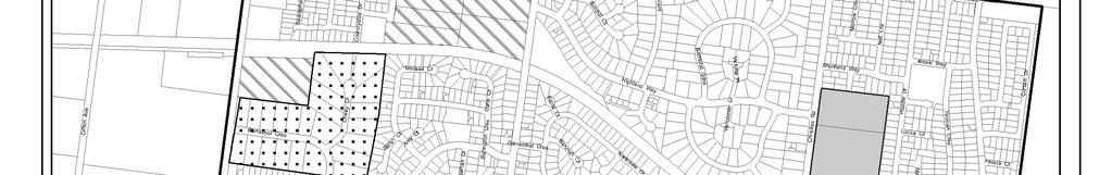
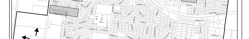
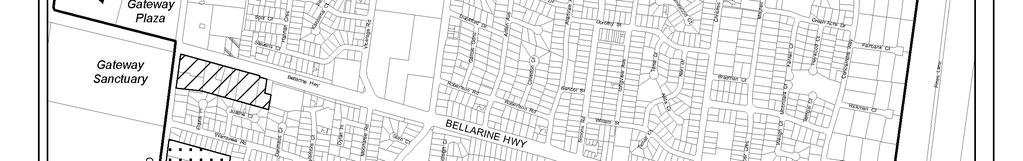
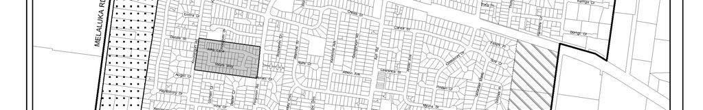
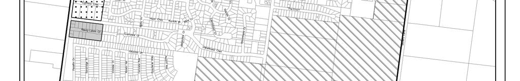
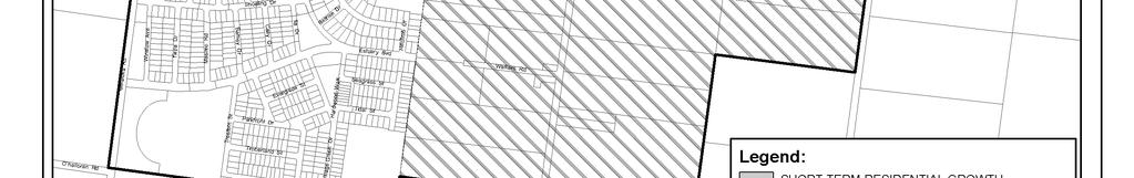
99 Map 23 - Residential Lot Supply Leopold Structure Plan June 2011 (amended Jan 2013) 98
INCREMENTAL CHANGE AREA REVIEW March 2015 Page 1
 INCREMENTAL CHANGE AREA REVIEW March 2015 Page 1 Table of Contents Introduction... 3 Background to Review... 3 Comparison of the Schedules to the General Residential Zone... 7 Methodology... 7 Policy Context...
Leopold Sub-Regional Activity Centre Master Plan - Background Report
 Report Leopold Sub-Regional Activity Centre Master Plan - Background Report Prepared for City of Greater Geelong (Client) By Beca Pty Ltd (Beca) 3 June 2011 Beca 2011 (unless Beca has expressly agreed
OCEAN GROVE STRUCTURE PLAN
 OCEAN GROVE STRUCTURE PLAN December 2015 1 WWW.GEELONGAUSTRALIA.COM.AU 2 Contents Part A Structure Plan 1 Introduction... 5 1.1 Purpose of the Structure Plan 5 1.2 How will this plan be used? 5 1.3 Plan
LEOPOLD LAND CAPABILITY AND BAY ACCESS REPORT
 LEOPOLD LAND CAPABILITY AND BAY ACCESS REPORT JULY 2015 Prepared by Spiire for City of Greater Geelong This report has been prepared by the office of Spiire Level 2 10 Moorabool Street PO Box 4032 Geelong
Mollers Lane, Leopold, Victoria Significant Landscape Overlay Re-assessment
 XURBAN Mollers Lane, Leopold, Victoria Significant Landscape Overlay Re-assessment For: TGM Group November 2016 Final Mollers Lane, Leopold, Victoria Significant Landscape Overlay Re-assessment Client
Combined Planning Scheme Amendment Request and Planning Permit Application
 Combined Planning Scheme Amendment Request and Planning Permit Application Rezone land from the Farming Zone to the Commercial 1 Zone and develop a SubRegional Activity Centre Bellarine Gateway Plaza,
I615. Westgate Precinct
 I615. Westgate Precinct I615.1. Precinct Description The Westgate Precinct is located approximately 18km west of the Auckland city centre. There are seven Sub-precincts in the Westgate Precinct: Sub-precinct
Northern Territory Compact Urban Growth Policy
 Northern Territory Compact Urban Growth Policy A Reference Policy Document to clause 2.7 (Reference to Policy) of the NT Planning Scheme May 2015 Table of Contents 1 Policy Setting... 3 1.1 Context for
DRYSDALE - CLIFTON SPRINGS STRUCTURE PLAN Prepared by the City of Greater Geelong Adopted September 2010
 DRYSDALE - CLIFTON SPRINGS STRUCTURE PLAN Prepared by the City of Greater Geelong Adopted September 2010 Table of Contents PART A STRUCTURE PLAN 1 1.0 Introduction... 1 1.1 Purpose of the Structure Plan...
Tāhuhu whakaruruhau ā-taone The sheltering ridge pole
 B2. Tāhuhu whakaruruhau ā-taone - Urban growth and form B2.1. Issues Tāhuhu whakaruruhau ā-taone The sheltering ridge pole Auckland s growing population increases demand for housing, employment, business,
Keystone Business Park Precinct Structure Plan North East Industrial Precinct. Part 2 Design Principles
 Keystone Business Park Precinct Structure Plan North East Industrial Precinct Part 2 Design Principles Context Issues Services Landform Issues Geotech and contamination Ecology Traffic and access Issues
LARA STRUCTURE PLAN Prepared by the City of Greater Geelong Adopted April 2011
 LARA STRUCTURE PLAN Prepared by the City of Greater Geelong Adopted April 2011 PART A STRUCTURE PLAN...5 1.0 Introduction...5 1.1 Purpose of the Structure Plan...5 1.2 How will this plan be used?...5
DAREBIN PLANNING SCHEME AMENDMENT C137
 Who is the planning authority? Planning and Environment Act 1987 DAREBIN PLANNING SCHEME AMENDMENT C137 EXPLANATORY REPORT This amendment has been prepared by the Darebin City Council, who is the planning
GREENBANK DEVELOPMENT MASTERPLAN
 DEVELOPMENT MASTERPLAN POTENTIAL TRAIN STATION COMMUNITY CENTRE Greenbank will be a connected masterplanned community providing easy access to local and surrounding amenity. Affordable quality homes, green
Plan Modification to Chapter B2 of the Auckland Unitary Plan(AUP) Operative in part (15 November 2016)
 Operative in part (15 November 2016)") UNITARY PLAN UPDATE REQUEST MEMORANDUM TO FROM Phill Reid Linley Wilkinson DATE 25 September 2018 SUBJECT Plan Modification to Chapter B2 of the Auckland Unitary Plan(AUP) Operative in part (15 November
UNITARY PLAN UPDATE REQUEST MEMORANDUM TO FROM Phill Reid Linley Wilkinson DATE 25 September 2018 SUBJECT Plan Modification to Chapter B2 of the Auckland Unitary Plan(AUP) Operative in part (15 November
HOROWHENUA DEVELOPMENT PLAN June create a safe crossing for children moving to and from the school and other areas. 7.8 Ohau
 7.8 Ohau create a safe crossing for children moving to and from the school and other areas. Ohau has a traditional village form with a collective of school, church and reserve at the main road intersection.
PORT WHITBY COMMUNITY
 PORT WHITBY COMMUNITY SECONDARY PLAN UPDATE COMMUNITY IMPROVEMENT PLAN URBAN DESIGN GUIDELINES September 2015 DRAFT PROPOSED AMENDMENT NUMBER # to the Whitby Official Plan PURPOSE: The intent of this Amendment
4 RESIDENTIAL ZONE. 4.1 Background
 4 RESIDENTIAL ZONE 4.1 Background The residential areas within the City are characterised by mainly lowrise dwellings sited on individual allotments. Past architectural styles, settlement patterns and
Appendix 1 Structure plan guidelines
 Appendix 1 Structure plan guidelines This appendix forms part of the regional policy statement [rps]. 1.1. Introduction Structure plans are an important method for establishing the pattern of land use
WELCOME GYPSY LANE. Wider Site Location plan. Proposals for the development of LAND OFF FOXLYDIATE LANE WEBHEATH. Proposals for the development of
 WELCOME The developers are preparing an outline planning application for a residential led development and need the community s views in order to develop the proposals further WHAT IS PROPOSED? A high
STRATEGIC IMPLEMENTATION PANEL SUBMISSION
 STRATEGIC IMPLEMENTATION PANEL SUBMISSION AMENDMENT C375 to the GREATER GEELONG PLANNING SCHEME BARWON HEADS STRUCTURE PLAN IMPLEMENTATION Part A Submission to the Independent Panel Panel: Con Tsotsoros
CITY OF FREMANTLE LOCAL PLANNING SCHEME NO. 4 AMENDMENT NO. 68 SCHEME AMENDMENT REPORT
 CITY OF FREMANTLE LOCAL PLANNING SCHEME NO. 4 AMENDMENT NO. 68 SCHEME AMENDMENT REPORT CITY OF FREMANTLE PLANNING AND DEVELOPMENT SERVICES 8 WILLIAM STREET FREMANTLE WA 6160 PLANNING AND DEVELOPMENT ACT
SCHEDULE THREE TO THE DEVELOPMENT PLAN OVERLAY EASTERN GOLF COURSE KEY REDEVELOPMENT SITE
 DD/MM/YY SCHEDULE THREE TO THE DEVELOPMENT PLAN OVERLAY Shown on the planning scheme map as DPO3 EASTERN GOLF COURSE KEY REDEVELOPMENT SITE 1.0 A permit may be granted before a development plan has been
SCHEDULE 10 TO THE URBAN GROWTH ZONE. Shown on the planning scheme map as UGZ10. Truganina Precinct Structure Plan. 1.0 The Plan
 SCHEDULE 10 TO THE URBAN GROWTH ZONE Shown on the planning scheme map as UGZ10 Truganina Precinct Structure Plan 1.0 The Plan Map 1 shows the future urban structure proposed in the Truganina Precinct Structure
Draft Ada Street Cardiff Area Plan
 Draft Ada Street Cardiff Area Plan (Draft Amendment to Lake Macquarie Development Control Plan 2014) Exhibition: The draft Area Plan is on public exhibition from 29 February 2016 to 29 March 2016. Submissions:
Barwon Heads Road. REGIONAL ACTIVE PUBLIC OPEN SPACE - Indicative Concept Only FIGURE C. Armstrong Creek East Precinct Structure Plan
 0 50 150 metres KEY Arterial Road (existing) Walking / Cycling link Residential Conventional Mixed Use Residential Medium Density Farming Drainage and Floodway Public Open Space Armstrong Creek Watercourse
SECTION 7A: WHAKARONGO RESIDENTIAL AREA
 SECTION 7A: WHAKARONGO RESIDENTIAL AREA CONTENTS 7A.1 Introduction 1 7A.2 Resource Management Issues 1 7A.3 Objectives and Policies 1 7A.4 Methods 4 7A.5 Residential Zone 4 7A.5.1 Rules: Controlled Activities
Draft Drysdale. Urban Design Framework. June
 Draft Drysdale June 2012 WWW.GEELONGAUSTRALIA.COM.AU Draft Drysdale Prepared by Planning Strategy, City of Greater Geelong 131 Myers St Geelong, 3220, Australia www.geelongaustralia.com.au June 2012 Version
THREE PARKS ZONE Three Parks Special Zone The process of applying for resource consents in the zone.
 .25 Three Parks Special Zone The purpose of this zone is to provide for growth and to give effect to the Wanaka 2020 Community (2002) and the more recent Wanaka Structure (2007) and Wanaka Transport Strategy
Land Use Amendment in Southwood (Ward 11) at and Elbow Drive SW, LOC
 at and Elbow Drive SW, LOC") 2018 November 15 Page 1 of 10 EXECUTIVE SUMMARY This land use amendment application was submitted by Rick Balbi Architect on 2017 August 31 on behalf of Sable Developments Ltd, and with authorization from
2018 November 15 Page 1 of 10 EXECUTIVE SUMMARY This land use amendment application was submitted by Rick Balbi Architect on 2017 August 31 on behalf of Sable Developments Ltd, and with authorization from
The Proposed Auckland Unitary Plan (notified 30 September 2013)
") 3 Business zones Introduction There are 10 business zones in the Unitary Plan: City Centre Metropolitan Centre Town Centre Local Centre Neighbourhood Centre Mixed Use General Business Business Park Light
3 Business zones Introduction There are 10 business zones in the Unitary Plan: City Centre Metropolitan Centre Town Centre Local Centre Neighbourhood Centre Mixed Use General Business Business Park Light
Newcourt Masterplan. November Exeter Local Development Framework
 Newcourt Masterplan November 2010 Exeter Local Development Framework Background The Exeter Core Strategy Proposed Submission sets out the vision, objectives and strategy for the development of Exeter up
URBAN DESIGN BRIEF URBAN DESIGN BRIEF 721 FRANKLIN BLVD, CAMBRIDGE August 2018
 URBAN DESIGN BRIEF URBAN DESIGN BRIEF 721 FRANKLIN BLVD, CAMBRIDGE August 2018 DESIGN BRIEF CONTENTS PART A 1.0 INTRODUCTION 2.0 DESCRIPTION & ANALYSIS OF SITE CONTEXT 3.0 DESIGN CONSTRAINTS AND OPPORTUNITIES
Appendix A. Planning Processes. Introduction
 1 Planning Processes Introduction This appendix outlines a number of planning processes which are used in the Auckland Region to support the effective management of development in the region s rural and
sm` Planning Report in support of s96a application KINGFISHER ESTATE - FIRST DEVELOPMENT STAGES June 170 LANCEFIELD ROAD, SUNBURY
 sm` Planning Report in support of s96a application June 2015 KINGFISHER ESTATE - FIRST DEVELOPMENT STAGES 170 LANCEFIELD ROAD, SUNBURY TPG Ref: 1595 Client: Wincity Development Pty Limited ADVISE I PLAN
Planning Proposal Charlestown Swim and Leisure Centre LEP Amendment
 Planning Proposal Charlestown Swim and Leisure Centre LEP Amendment Amendment No. 4 to Lake Macquarie Local Environmental Plan 2014 (PP_2014_LAKEM_005_00) Local Government Area: Name of Draft LEP: Lake
MAYFIELD WEST SECONDARY PLAN PHASE 2
 MAYFIELD WEST SECONDARY PLAN PHASE 2 Public Open House #3 February 25, 2010 Draft Preferred Land Use Scenario TOWN OF CALEDON PLANNING & DEVELOPMENT DEPARTMENT Open House Agenda TOWN OF CALEDON 1. Welcome
Part 12 Precinct Area Plans - Wyee West
 TABLE OF CONTENTS 1 INTRODUCTION... 1 1.1 BACKGROUND... 1 1.2 EXTENT OF AREA PLAN... 1 1.3 EXISTING CHARACTER... 2 1.4 ENVIRONMENTAL ATTRIBUTES AND CONSTRAINTS... 2 1.5 DESIRED FUTURE CHARACTER... 3 1.6
Rochford District Council Allocations Development Plan Document: Discussion and Consultation Document Sustainability Appraisal
 Option SWH1 Balanced Communities Option SWH1 1 To ensure the delivery of high quality sustainable communities where people want to live and work Will it ensure the phasing of infrastructure, including
Greater Geelong Planning Scheme Proposed Planning Scheme Amendment C and 5-19 Princes Highway, Norlane
 Greater Geelong Planning Scheme Proposed Planning Scheme Amendment C253 PLANNING SUBMISSION prepared for Bunnings Group Ltd by SJB Planning Pty Ltd Level 1, Building D 80 Dorcas Street SOUTHBANK VIC 3006
COMMUNITY ACTIONS for a SUSTAINABLE BARWON HEADS. February 2016
 COMMUNITY ACTIONS for a SUSTAINABLE BARWON HEADS February 2016 Acknowledgements Traditional Owners We acknowledge the traditional owners of this land and pay our respects to their elders past and present,
Wetland Design Manual. A1: Vision, core outcomes and aspirational outcomes
 Wetland Design Manual A1: Vision, core outcomes and aspirational outcomes Table of contents Introduction 5 Vision 6 Core outcomes 7 Effective pollutant removal and flow management... 7 Community safety...
Neighbourhood Planning Local Green Spaces
 Neighbourhood Planning Local Green Spaces Introduction... 2 1. Why green space is important... 4 2. Neighbourhood plans and green space... 6 3. Evidence... 8 Statutory designations... 9 Green space audit...
Subdivision Design Criteria. Penihana North GUIDELINES TO THE RULES
 Created September 2013 Penihana North Subdivision Design Criteria GUIDELINES TO THE RULES This part of the Plan sets out the design criteria for subdivision in Penihana North. The criteria will be considered
RURAL ZONE - POLICY. Rural Zone Policy. Issue: Rural Environment. Ruapehu District Plan Page 1 of 8
 Rural Zone Policy RU2 RURAL ZONE - POLICY RU2.1 Introduction The natural resources of the rural environment in the Ruapehu District provide the basis for the existing and potential character, intensity
7.2.9 Eudlo local plan code
 7.2.9 local plan code 7.2.9.1 Application (1) This code applies to assessable development:- (a) within the local plan area as shown on Map ZM29 contained within Schedule 2 (Mapping); and (b) identified
Part 10 Other plans
 Contents of Part 10 Part 10 Other plans... 10-1 10.1 Preliminary... 10-1 10.2 Palmview Structure Plan... 10-2 10.2.1 Preliminary... 10-2 10.2.2 Master Strategic Framework... 10-6 10.2.3 Master Precincts
TABLE OF CONTENTS. Human Habitats, 155 Dorcas St South Melbourne, Victoria 3205
 TARNEIT JUNCTION Town Planning Report DECEMBER 2013 TABLE OF CONTENTS Table of contents... 1 1 Introduction... 2 2 SIte context and surrounds... 4 2.1 Site Features... 4 2.2 Surrounding land uses... 4
10.0 Open Space and Public Realm
 10.0 Open Space and Public Realm 10.0 Open Space and Public Realm The Public Open Space System is comprised of: outdoor spaces available for public use that are either publicly owned (e.g., parks and
Complete Neighbourhood Guidelines Review Tool
 Complete Neighbourhood Guidelines Review Tool Prepared By: City of Regina Planning Department October 2014 Page 1 of 14 Community Development Review Checklist for Secondary Plans and Concept Plans The
6 Growth Management Challenges and Opportunities
 6 Growth Management Challenges and Opportunities The Town has established a goal of attaining a 50% participation rate with respect to employment opportunities versus residential population. The Town s
North Oakville East Parks Facilities Distribution Plan. November, 2009
 North Oakville East November, 2009 POLICY CONTEXT 1) Purpose a) The purpose of this document is to be a guide for the location, configuration, design and development of the parks system for the North Oakville
I539. Smales 2 Precinct
 I539. Smales 2 Precinct I539.1. Precinct Description The Smales 2 Precinct applies to a 4.8 hectare block of land located on the southern side of Northcote Road and fronting Lake Pupuke, Takapuna. The
Session 4 New Urban Regions and Major Urban Extensions. Tackling Western Sydney s Urban Growth
 Session 4 New Urban Regions and Major Urban Extensions Tackling Western Sydney s Urban Growth Stephanie Barker Rohan Dickson & Associates and consultant to NSW Growth Centres Commission Friday 8 February
WINCHESTER TOWN 3.1 LOCATION, CHARACTERISTICS & SETTING
 WINCHESTER TOWN 3.1 LOCATION, CHARACTERISTICS & SETTING 3.1.1 The area referred to by the City Council, as Winchester Town, consists of the Winchester Wards plus the adjoining built up areas of Badger
Introduction How to read this document Land to which this Precinct Structure Plan applies Background information...
 Introduction... 4 How to read this document... 6 Land to which this Precinct Structure Plan applies... 6 Background information... 6 Shepparton North East Development Contributions Plan... 7... 8 OUTCOMES...
and services The protection and conservation of environmentally significant and sensitive natural heritage features and functions.
 6. Land Use 6.0 Preamble A healthy and livable city is one in which people can enjoy a vibrant economy and a sustainable healthy environment in safe, caring and diverse neighbourhoods. In order to ensure
CASEY PLANNING SCHEME AMENDMENT C188
 Who is the planning authority? Planning and Environment Act 1987 CASEY PLANNING SCHEME AMENDMENT C188 EXPLANATORY REPORT This amendment has been prepared by the Growth Areas Authority (now known as the
Development Control Plan
 Development Control Plan Liberty Grove Development Control Plan Date of Adoption: 4 September 2007 Effective Date: 7 March 2008 Index 1 INTRODUCTION... 3 1.1 NAME OF PLAN... 3 1.2 AREA TO WHICH THIS PLAN
Appendix 7 Precinct Analysis Carlton
 Appendix 7 Precinct Analysis Carlton (Andover Street) Rezone from R2 Low Density Residential to R3 Medium Density Residential Retain existing B1 Neighbourhood Centre zone Existing Zoning Map (R2 Low Density
2A District-wide Policies
 2A Introduction This Chapter contains policies which are relevant to subdivision, use and development activities occurring across all zones and areas of the District. The policies in this Chapter implement
DRAFT TARNEIT WEST Outline Development Plan MAY 2007
 DRAFT TARNEIT WEST Outline Development Plan MAY 2007 Department of Strategy and Tourism Draft May 2007 Page 1 Table of Contents 1.0 Introduction...4 1.1 Overview...4 1.2 Land and Locality...4 1.3 Purpose
14.5 HOPEFIELD: (REFER PLAN 39 AND PLAN 40)
") URBAN DYNAMICS WESTERN CAPE INC. 248 14.5 HOPEFIELD: (REFER PLAN 39 AND PLAN 40) FIGURE 83: LOCALITY - HOPEFIELD Within the context of the Saldanha Bay Municipal area, Hopefield, an historical agricultural
URBAN DYNAMICS WESTERN CAPE INC. 248 14.5 HOPEFIELD: (REFER PLAN 39 AND PLAN 40) FIGURE 83: LOCALITY - HOPEFIELD Within the context of the Saldanha Bay Municipal area, Hopefield, an historical agricultural
4.0 Zones and Overlays
 4.0 Zones and Overlays The following section details the existing zones and overlays within the Mooroopna West Growth Corridor. Revision 1 7 July 2009 Page 27 Due to the overall size (260 ha) and geographical
MASTER PLAN N0. 76 (SITE DEVELOPMENT PLAN DETAILED PLANNING AREA 12 PRECINCT 13) 2013
 2013") MASTER PLAN N0. 76 (SITE DEVELOPMENT PLAN DETAILED PLANNING AREA 12 PRECINCT 13) 2013 TABLE OF CONTENTS 1.0 ADMINISTRATION... 5 1.1 Preliminary... 5 1.2 Location and Description... 6 1.3 Zoning Map Description...
MASTER PLAN N0. 76 (SITE DEVELOPMENT PLAN DETAILED PLANNING AREA 12 PRECINCT 13) 2013 TABLE OF CONTENTS 1.0 ADMINISTRATION... 5 1.1 Preliminary... 5 1.2 Location and Description... 6 1.3 Zoning Map Description...
DRAFT FOR YOUR FEEDBACK DRAFT LOGAN RESERVE PLAN
 DRAFT FOR YOUR FEEDBACK CONTENTS INTRODUCTION... BACKGROUND... State Government... Council... PLANNING LEGISLATION AND RULES... CONSULTATION PROCESS...... ENVIRONMENT AND CONSERVATION... HOUSING... Proposed
Public Consultation. Land at Monks Farm, North Grove. Welcome
 Welcome Welcome to our public exhibition for development on Land at Monks Farm, orth Grove. Gallagher Estates and Gleeson Strategic Land are preparing an outline planning application for new homes, open
Memorial Business Park Site. Proposed Future Development. Design guidelines. August
 Memorial Business Park Site Proposed Future Development Design guidelines August 2014 www.designenvironment.co.nz 0064 3 358 3040 Contents 1.0 Background 1.1 Introduction 3 1.2 Objectives 4 2.0 Context
WATERLOO STATE SIGNIFICANT PRECINCT SUMMARY OF STUDIES
 WATERLOO STATE SIGNIFICANT PRECINCT SUMMARY OF STUDIES Technical studies will be undertaken to inform the master planning process for the Waterloo precinct to develop a Precinct Proposal to redevelop the
5.0 VILLAGE AREAS. February 2008 Municipality of West Elgin ~ Official Plan 5-1
 5.0 VILLAGE AREAS This section of the Official Plan deals with the villages of Rodney and West Lorne being the two largest and only fully serviced settlement areas in West Elgin and the most logical and
Leduc Industrial Outline Plan SE W4
 Leduc Industrial Outline Plan SE 1-50-25-W4 Within the North Leduc Industrial ASP Prepared for: Leduc Energy Park Ltd. Prepared by: Stantec Consulting Ltd. File No. 1161 104655 V5 Table of Contents 1.0
AOTEA SUPERMARKET ZONE. Zone Introduction
 C18 AOTEA SUPERMARKET ZONE Zone Introduction C18.1 Objective This zone identifies a specific area in Aotea for a stand alone supermarket. The zone is site specific and has a range of objectives, policies
Planning Proposal Concurrent DA/LEP Amendment for Belmont North Pharmacy Amendment No. 24 to Lake Macquarie Local Environmental Plan (LMLEP) 2014
 2014") Planning Proposal Concurrent DA/LEP Amendment for Belmont North Pharmacy Amendment No. 24 to Lake Macquarie Local Environmental Plan (LMLEP) 2014 Local Government Area: Name of Draft LEP: Subject Land:
Planning Proposal Concurrent DA/LEP Amendment for Belmont North Pharmacy Amendment No. 24 to Lake Macquarie Local Environmental Plan (LMLEP) 2014 Local Government Area: Name of Draft LEP: Subject Land:
RE: AMENDMENT C375 GEELONG PLANNING SCHEME 1900 BARWON HEADS ROAD, BARWON HEADS
 Reference: #V157080 14 August 2018 Barwon Heads Lifestyle Group Pty Ltd C/- Best Hooper Lawyers Level 9, 451 Little Bourke Street MELBOURNE VIC 3000 Attention: Mr. Edward Mahony (Lawyer) Dear Edward RE:
EAST WERRIBEE EMPLOYMENT PRECINCT PRECINCT STRUCTURE PLAN
 3.2 East Werribee Town Centre East Werribee Town Centre Vision The East Werribee Town Centre will complement the Werribee City Centre in providing an employment, service, retail and entertainment focus
Briefing Document of CNP. June 2017
 Cholsey Parish Council Cholsey Neighbourhood Plan Briefing Document of CNP June 2017 Cholsey Neighbourhood Plan Page! 1 of! 8 Cholsey Plan Briefing v1.4 Page Left Intentionally Blank Cholsey Neighbourhood
Smart Growth Development Checklist
 2004 Smart Growth Development Checklist Smart Growth Development Checklist Corporation of the City of New Westminster Guide and manage growth in a manner which is consistent with the principles of sustainable
LAND AT DALESTON, MAMBOURIN
 LAND AT DALESTON, MAMBOURIN Planning Report in Support of s96a Application Application for Subdivision Daleston, Mambourin October 2014 Daleston, Mambourin Our ref: 01486 Client: Phileo Australia Limited
REMARKABLES PARK ZONE
 .10 Remarkables Park Zone.10.1 Resources, Activities and Values The Remarkables Park Area comprises approximately 150 hectares of perimeter urban land in the vicinity of Frankton and occupies a strategic
GREENVALE CENTRAL PRECINCT STRUCTURE PLAN
 76 Conservation area boundary. Low Fence to exclude vehicles but allow pedestrian access Front boundary of allotment 5.0m MINIMUM SETBACK Path providing public access to dwellings fronting Conservation
I403 Beachlands 1 Precinct
 I403. Beachlands 1 I403.1. Precinct Description Beachlands is a rural and coastal village located on the eastern side of Auckland, adjoining the Tamaki Strait coastline. The original Beachlands village
SCHEDULE 12 TO THE DESIGN AND DEVELOPMENT OVERLAY GLEN WAVERLEY ACTIVITY CENTRE STRUCTURE PLAN
 DD/MM/YY Proposed C120 SCHEDULE 12 TO THE DESIGN AND DEVELOPMENT OVERLAY Shown on the planning scheme map as DDO12. GLEN WAVERLEY ACTIVITY CENTRE STRUCTURE PLAN 1.0 Design objectives DD/MM/YY Proposed
C176. Amendment C176 Riverdale Precinct Structure Plan List of Document Changes for Planning Panels Victoria. Version th November 2013
 C176 Amendment C176 Riverdale Precinct Structure Plan List of Document Changes for Planning Panels Victoria Version 1.0 18 th November 2013 Amendment C176 Riverdale Precinct Structure Plan List of Document
ARTICLE 6: Special and Planned Development Districts
 ARTICLE 6: Special and Planned Development Districts 6-10 Traditional Neighborhood Development (TND) District 6-10.10 Purpose and Intent The Traditional Neighborhood Development (TND) District provides
Welcome to our exhibition
 Welcome to our exhibition The Homes & Communities Agency (HCA) welcomes you to this public exhibition explaining our proposals for the redevelopment of the former Lea Castle Hospital site. About the Homes
The West Vaughan Employment Area Secondary Plan Policies
 Part 2: The West Vaughan Employment Area Secondary Plan Policies 2.1 General Policies It is the policy of Council: 2.1.1. That the West Vaughan Employment Area (the WVEA), identified on Schedule 1, will
QUEENSTOWN LAKES DISTRICT COUNCIL SUBDIVISION DESIGN GUIDELINES
 Attachment C: Draft QLDC Subdivision Design Guidelines QUEENSTOWN LAKES DISTRICT COUNCIL DESIGN GUIDELINES A DESIGN GUIDE FOR AND DEVELOPMENT IN THE URBAN ZONES QUEENSTOWN OFFICE 10 Gorge Road Queenstown
WELCOME. Land North of STEVENAGE. We would like to thank you for attending our public exhibition today.
 WELCOME We would like to thank you for attending our public exhibition today. The purpose of this event is to share our proposals and hear your thoughts on our ideas. Members of the project team are on
Next Steps / Development Process. Structure Plan. June submitted to City of Fremantle. Structure Plan. July supported for advertising
 overview What is today about? In July 0, the City of Fremantle resolved that the be advertised for public comment. Today is about: Understanding the history and context of the site Having your say on the
Ten Mile Creek Planning Area
 PLANNING AREA POLICIES TEN MILE CREEK Ten Mile Creek Planning Area Location and Context The Ten Mile Creek Planning Area ( Ten Mile Creek area ) is located south of the current Boise AOCI, generally south
The Uplands Area Structure Plan. City of Cold Lake, NE & SE W4
 City of Cold Lake, NE & SE 13-63-2-W4 July 2009 1 Contents 1 Background information... 1 1.1 Foreword... 1 1.2 Purpose... 1 1.3 Plan Area and Location... 1 1.4 Ownership... 2 2 Factors Influencing Development...
JETTY ROAD URBAN GROWTH PLAN
 JETTY ROAD URBAN GROWTH PLAN Adopted 26 June 2007 (Amended 23 September 2008) WWW.GEELONGAUSTRALIA.COM.AU PREFACE STATUS AND ROLE OF THE URBAN GROWTH PLAN The Jetty Road Urban Growth Plan (UGP) sets the
3.1 The hybrid planning application proposes the following description of development:
 CHAPTER 3: PROPOSED DEVELOPMENT 3.1 The hybrid planning application proposes the following description of development: Hybrid (part-outline/part-full) planning application for a single composite development
APPENDIX 1 - OCEAN GROVE SIGNIFICANT TREE PROJECT SIGNIFICANT TREE AREA DEVELOPMENT PATTERNS 1960 S TO 2013
 APPENDIX 1 - OCEAN GROVE SIGNIFICANT TREE PROJECT SIGNIFICANT TREE AREA DEVELOPMENT PATTERNS 1960 S TO 2013 1966 1977 APPENDIX 1 - OCEAN GROVE SIGNIFICANT TREE PROJECT 1984 1990 APPENDIX 1 - OCEAN GROVE
Welcome. Walk Around. Talk to Us. Write Down Your Comments
 Welcome This is an information meeting introducing the applications for proposed redevelopment of the Yorkdale Shopping Centre site at 3401 Dufferin Street and 1 Yorkdale Road over the next 20+ years,
Section 3b: Objectives and Policies Rural Environment Updated 19 November 2010
 Page 1 of Section 3b 3b RURAL ENVIRONMENT 3b.1 Introduction The Rural Environment comprises all the land outside of the Residential, Town Centre and Industrial Environments. Most land within the District
A VISION FOR BLAIRGOWRIE
 Welcome to the Westpark Partnership and Lidl UK GmbH Community Presentation. The purpose of this presentation is for you to view and comment upon the revised and updated proposals for the allocated development
LAND USE AMENDMENT CORNERSTONE (WARD 3) 60 STREET NE AND COUNTRY HILLS BOULEVARD NE MAP 26NE BYLAW 22D2017
 60 STREET NE AND COUNTRY HILLS BOULEVARD NE MAP 26NE BYLAW 22D2017") Page 1 of 14 EXECUTIVE SUMMARY This Land Use Amendment application covers an area of 43.76 hectares ± (108.14 acres ±) located in northeast Calgary, bound by Country Hills Boulevard NE to the south and
Page 1 of 14 EXECUTIVE SUMMARY This Land Use Amendment application covers an area of 43.76 hectares ± (108.14 acres ±) located in northeast Calgary, bound by Country Hills Boulevard NE to the south and
Improve Neighborhood Design and Reduce Non Point Source Water Pollution
 HOW TO Planning Guide Improve Neighborhood Design and Reduce Non Point Source Water Pollution This document was funded by a grant from the New Hampshire Coastal Program with funding from the National Oceanic
Town Planning Report. Combined Planning Permit and Planning Scheme Amendment Request under Section 96A of the Planning and Environment Act 1987
 Town Planning Report Combined Planning Permit and Planning Scheme Amendment Request under Section 96A of the Planning and Environment Act 1987 1 Henry Street, Belmont Prepared by Tract Consultants for