APPROVED BY THE JEFFERSON COUNTY COMMISSIOM DATE: l 0 - I 9-10 RESOLUTION
|
|
|
- Lucas Cunningham
- 5 years ago
- Views:
Transcription

1 RESOLUTION WHEREAS, the Jefferson County Commission is charged, by the adopting resolution of the Zoning Resolution of, with promoting the public health, safety, convenience, order, prosperity, and general welfare of the County through zoning and subdivision regulations; and, WHEREAS, in December of 2006, the County Commission directed the Planning & Zoning Commission, with the assistance of the Land Planning & Development Services Department, to begin the process of developing a new Comprehensive Plan for Jefferson County; and, WHEREAS, in August of 2008, the County Commission endorsed the first installment of the new Comprehensive Plan as approved and adopted by the Planning & Zoning Commission; and, WHEREAS, a major component of that Comprehensive Plan focuses on building healthier, livable, more self-sufficient mixed-use neighborhoods and communities rather than simply rezoning individual properties for single-pwpose uses; and, WHEREAS, the Comprehensive Plan called for the adoption of new development regulations patterned after the SmartCode, created by Andres Duany and others, as being the best tool for achieving the goals and objectives of the Neighborhood and Community Planning element of the Plan; and, WHEREAS, the Comprehensive Plan itself was based on the principles set forth in the SmartCode, and adoption of a SmartCode constitutes the final step in the implementation of that Plan; and, WHEREAS, the Land Planning & Development Services Department has, through an extensive research and development effort, prepared a version of the SmartCode that is tailored specifically to meet the unique needs and issues of ; and, WHEREAS, the Jefferson County Planning & Zoning Commission, having duly held a public hearing regarding the proposed SmartCode Floating Overlay District, has recommended that the County Commission amend the Zoning Resolution of Jefferson County, Alabama, to include said District as an option that can be used in lieu of the standard zoning districts and regulations; and, WHEREAS, the Jefferson County Commission has also duly advertised and held a public hearing regarding the proposed SmartCode Floating Overlay District (as amended); NOW, THEREFORE, BE IT RESOLVED by the Jefferson County Commission that the SmartCode Floating Overlay District (as amended) is hereby adopted and enacted as an amendment to the Zoning Resolution of, effective this day october t9, APPROVED BY THE JEFFERSON COUNTY COMMISSIOM DATE: l 0 - I 9-10 MINUTE bokz NlNON ォ AHN セ o セ M PAGEtsl: ZU セ
2
3 FLOATING OVERLAY DISTRICT TABLE OF CONTENTS ARTICLE 1. GENERAL TO ALL PLANS 1.1 AUTHORITY 1.2 APPLICABILITY 1.3 INTENT 1.4 PROCESS 1.5 WARRANTS AND ECEPTIONS 1.6 SUCCESSION 1.7 INCENTIVES 1.8 PRE-EISTING AND POST- EMERGENCY CONDITIONS ARTICLE 2. REGIONAL SCALE PLANS ARTICLE 3. NEW COMMUNITY SCALE PLANS 3.1 INSTRUCTIONS 3.2 SEQUENCE OF COMMUNITY DESIGN 3.3 COMMUNITY UNIT TYPES 3.4 TRANSECT ZONES 3.5 CIVIC ZONES 3.6 SPECIAL DISTRICTS 3.7 ENVIRONMENTAL STANDARDS 3.8 THOROUGHFARE STANDARDS 3.9 DENSITY CALCULATIONS 3.10 SPECIAL REQUIREMENTS ARTICLE 4. INFILL COMMUNITY SCALE PLANS 4.1 INSTRUCTIONS 4.2 COMMUNITY UNIT TYPES 4.3 TRANSECT ZONES 4.4 CIVIC ZONES 4.5 SPECIAL DISTRICTS 4.6 PRE-EISTING CONDITIONS 4.7 SPECIAL REQUIREMENTS 5.5 SPECIFIC TO T1 NATURAL ZONE 5.6 BUILDING DISPOSITION 5.7 BUILDING CONFIGURATION 5.8 BUILDING FUNCTION 5.9 PARKING AND DENSITY CALCULATIONS 5.10 PARKING LOCATION STANDARDS 5.11 LANDSCAPE STANDARDS 5.12 SIGNAGE STANDARDS ARTICLE 6. STANDARDS AND TABLES TABLE 1 TRANSECT ZONE DESCRIPTIONS TABLE 2 SECTOR/COMMUNITY ALLOCATION TABLE 3A VEHICULAR LANE DIMENSIONS TABLE 3B VEHICULAR LANE & PARKING ASSEMBLIES TABLE 4A PUBLIC FRONTAGES - GENERAL TABLE 4B PUBLIC FRONTAGES - SPECIFIC TABLE 4C THOROUGHFARE ASSEMBLIES TABLE 5 PUBLIC LIGHTING TABLE 6 PUBLIC PLANTING TABLE 7 PRIVATE FRONTAGES TABLE 8 BUILDING CONFIGURATION TABLE 9 BUILDING DISPOSITION TABLE 10 BUILDING FUNCTION & PARKING TABLE 11 PARKING CALCULATIONS TABLE 12 SPECIFIC FUNCTION & USE TABLE 13 CIVIC SPACE TABLE 14 SMARTCODE SUMMARY TABLE 15A FORM-BASED CODE GRAPHICS - T3 TABLE 15B FORM-BASED CODE GRAPHICS - T4 TABLE 15C FORM-BASED CODE GRAPHICS - T5 TABLE 16 SPECIAL DISTRICT STANDARDS TABLE 17 DEFINITIONS ILLUSTRATED ARTICLE 7. DEFINITIONS OF TERM ARTICLE 5. BUILDING SCALE PLANS 5.1 INSTRUCTIONS 5.2 PRE-EISTING CONDITIONS 5.3 SPECIAL REQUIREMENTS 5.4 CIVIC ZONES SC1
4 ARTICLE 1. GENERAL TO ALL PLANS 1.1 AUTHORITY The action of in the adoption of this Code as an overlay zone is authorized under: Act 344, General Acts of Alabama 1947; Subdivisions 27 & 28 of the Appendix to the Code of Alabama 1958; and any amendments thereto; and As Found in the Acts of Alabama This Code is adopted as one of the instruments of implementation of the public goals and objectives of the adopted Comprehensive Plan of Jefferson County, Alabama. This Code is declared to be in accord with the County Comprehensive Plan This Code was adopted to promote the health, safety and general welfare of and its citizens, including environmental sustainability, conservation of land, energy and natural resources, reduction in vehicular traffic congestion, more efficient use of public funds, health benefits of a pedestrian environment, historic preservation, education and recreation, reduction in sprawl development, and improvement of the built environment This Code was adopted and may be amended by vote of the Jefferson County Commission following recommendation of the Jefferson County Planning and Zoning Commission ("Planning and Zoning Commission"). 1.2 APPLICABILITY Provisions of this Code are activated by shall when required; should when recommended; and may when optional. In addition, the Planning & Zoning Commission shall have the authority to require provisions which are herein stated as recommended or optional per the Code as the Planning and Zoning Commission deems necessary and appropriate The provisions of this Code, when in conflict, shall take precedence over those of other codes, ordinances, regulations and standards except State and Federal Laws or Permits, and the Local Health, Safety, Building and Fire, and Historic Preservation Ordinances The existing Zoning Resolution of and the Subdivision and Construction Regulations of (the "Existing Local Codes") shall continue to be applicable to issues not covered by this Code except where the Existing Local Codes would be in conflict with Section 1.3 Intent Capitalized terms used throughout this Code may be defined in Article 7 Definitions of Terms. Article 7 contains regulatory language that is integral to this Code. Those terms not defined in Article 7 shall be accorded their commonly accepted meanings. In the event of conflicts between these definitions and those of the Existing Local Codes, those of this Code shall take precedence The specifications of Article 6 Standards and Tables are an integral part of this Code. However, the diagrams and illustrations that accompany them should be SC3
5 ARTICLE 1. GENERAL TO ALL PLANS considered guidelines, with the exception of those on Table 15 Form-Based Code Graphics, which are also legally binding Where in conflict, numerical specifications shall take precedence over graphic illustrations. 1.3 INTENT The intent and purpose of this Code is to enable, encourage and qualify the implementation of the following policies: THE REGION a. That the region should retain its natural infrastructure and visual character derived from topography, woodlands, farmlands, and riparian corridors. b. That growth strategies should encourage Infill and redevelopment in parity with New Communities. c. That development contiguous to urban areas should be structured in the pattern of Infill Traditional Neighborhood Development (TND) or Infill Regional Center Development (RCD) and be integrated with the existing urban pattern. d. That development non-contiguous to urban areas should be organized in the pattern of Clustered Land Development (CLD), Traditional Neighborhood Development (TND), or Regional Center Development (RCD). e. That Affordable Housing should be distributed throughout the region to match job opportunities and to avoid concentrations of poverty. f. That transportation Corridors should be planned and reserved in coordination with land use. g. That green corridors should be used to define and connect the urbanized areas. h. That the region should include a framework of transit, pedestrian, and bicycle systems that provide alternatives to the automobile THE COMMUNITY a. That neighborhoods and Regional Centers should be compact, pedestrianoriented and Mixed Use. b. That neighborhoods and Regional Centers should be the preferred pattern of development and that Districts specializing in a single use should be the exception. c. That ordinary activities of daily living should occur within walking distance of most dwellings, allowing independence to those who do not drive. d. That interconnected networks of Thoroughfares should be designed to disperse traffic and reduce the length of automobile trips. e. That within neighborhoods, a range of housing types and price levels should be provided to accommodate diverse ages and incomes. f. That appropriate building Densities and land uses should be provided within walking distance of transit stops. g. That Civic, institutional, and Commercial activity should be embedded in SC4
6 ARTICLE 1. GENERAL TO ALL PLANS downtowns, not isolated in remote single-use complexes. h. That schools should be sized and located to enable children to walk or bicycle to them. i. That a range of Open Space including Parks, Squares, Greenways, and playgrounds should be distributed within neighborhoods and downtowns THE BLOCK AND THE BUILDING a. That buildings and landscaping should contribute to the physical definition of Thoroughfares as Civic places. b. That development should adequately accommodate automobiles while respecting the pedestrian and the spatial form of public areas. c. That the design of streets and buildings should reinforce safe environments in harmony with accessibility. d. That architecture and landscape design should grow from local climate, topography, history, and building practice. e. That buildings should provide their inhabitants with a clear sense of geography and climate through energy and water efficient methods. f. That Civic Buildings and public gathering places should be provided as locations that reinforce community identity and support self-government. g. That Civic Buildings should be distinctive and appropriate to a role more important than the other buildings that constitute the fabric of the city. h. That the preservation and renewal of historic buildings should be encouraged, to affirm the continuity and evolution of society. i. That the harmonious and orderly evolution of urban areas should be secured through form-based codes THE TRANSECT a. That Communities should provide meaningful choices in living arrangements as manifested by distinct physical environments. b. That the Transect Zone descriptions on Table 1 shall constitute the Intent of this Code with regard to the general character of each of these environments. 1.4 PROCESS The Jefferson County Department of Land Planning and Development Services shall include a Consolidated Review Committee ( CRC ) comprised of the President of the Jefferson County Association of Fire Departments, a traffic engineer and a drainage engineer from the Department of Roads and Transportation, a representative from the Department of Environmental Services, a representative from Land Planning and Development Services Inspection Services Division, an engineer from Land Planning and Development Services Watershed Section, a landscape architect from Land Planning and Development Services, representatives from Land Planning and Development Services Planning Division, the chairman of the Jefferson County Planning and Zoning Commission, and the Planning and Zoning Commission members who represent the district in which the Code is sought, to process administratively applications SC5
7 ARTICLE 1. GENERAL TO ALL PLANS and plans for proposed projects. Representatives of other departments, agencies, authorities, boards or the community should be consulted as deemed appropriate by the CRC The geographic locations of the Growth Sectors and parallel Plansect Zones shall be determined by the Watershed-based Sector Plans as set forth in the Comprehensive Plan. The geographic locations of village designations shall be determined by the Watershed-based Sector Plans or plan amendments. The standards for Community Types and the standards for Transect Zones shall be determined as set forth in the Jefferson County Comprehensive Plan, and Article 3, Article 4, and Article 5 of this Code through a process of public consultation with approval by the Jefferson County Planning and Zoning Commission. Once these determinations have been incorporated into this Code and its associated plans, then projects in a village designation which require no Exceptions or Warrants, or only Warrants, may be processed administratively without further recourse to public hearing An owner may appeal a decision of the CRC to the Jefferson County Planning and Zoning Commission. Issues relating to engineering and construction requirements should be directed to the respective departments Should a violation of an approved Regulating Plan occur during construction, or should any construction, site work, or development be commenced without an approved Regulating Plan or Building Scale Plan, Jefferson County has the right to require the owner to stop, remove, and/or mitigate the violation. A Variance may be required to cover the violation before construction, site work, or development may be resumed Upon approval by the CRC, a New Community Plan or an Infill Plan shall, upon request in writing submitted to the CRC by the landowner or the landowner's agent, be placed on the next available agenda for subdivision plat approval by the Planning and Zoning Commission. 1.5 WARRANTS AND ECEPTIONS There shall be two types of deviation from the requirements of this Code: Warrants and Exceptions. Whether a deviation requires a Warrant or Exception shall be determined by the CRC A Warrant is a ruling that would permit a practice that is not consistent with a specific provision of this Code but is justified by the provisions of Section 1.3 Intent. The CRC shall have the authority to approve or disapprove administratively a request for a Warrant pursuant to regulations established by the CRC A Exception is any ruling on a deviation other than a Warrant. Exceptions permit a practice that is not consistent with a provision or the Intent Section 1.3, as determined by the CRC. Exceptions shall be granted only by the Jefferson County Planning and Zoning Commission. SC6
8 ARTICLE 1. GENERAL TO ALL PLANS The request for a Warrant disapproved by the CRC or an Exception shall not subject the entire application to public hearing, but only that portion necessary to rule on the specific issue requiring the relief The following standards and requirements shall not be available for Warrants or Exceptions: a. [Reserved] b. The required provision of Rear Alleys and Rear Lanes. c. The minimum Base Residential Densities. (See Table 14b.) d. The permission to build Accessory Dwellings. e. [Reserved] 1.6 SUCCESSION [Reserved] 1.7 INCENTIVES To encourage the use of this Code, the County Commission grants the following incentives, to the extent authorized by state law: a. Applications in village designations which meet the requirements of this Code may be processed administratively by the CRC rather than through public hearing. b. The County may increase Density by Exception in exchange for an easement or conveyance of property to the County or Land Trust, which will preserve land as a greenway, park, or open space as deemed appropriate by public hearing of the Planning and Zoning Commission. c. The County shall maintain those Internal Thoroughfares that through-connect to adjacent sites. d. [Reserved for additional incentives.] 1.8 PRE-EISTING AND POST-EMERGENCY CONDITIONS [Reserved} SC7
9 ARTICLE 1. GENERAL TO ALL PLANS ARTICLE 2. REGIONAL SCALE PLANS 2.1 [Reserved] SC8
10 ARTICLE 3. NEW COMMUNITY SCALE PLANS 3.1 INSTRUCTIONS Within areas designated as village sites on an adopted Area or Watershed-based Sector Plan ( Sector Plan ), Article 3 (New Community Plans) is available as an Overlay by Right pursuant to the requirements set forth in this Code. Article 3 may be used in areas where there is not already an adopted village designation subject to public review and public hearing before the Planning and Zoning Commission to amend the Plan by establishing a new village site under the process set forth in the Comprehensive Plan. The Planning and Zoning Commission will make a determination on the plan amendment and may permit the usage of Article Prior to application for a plan amendment or preparation/ submittal of development plans under the SmartCode, the land owner or designated agent of said proposal should meet with County staff to discuss the proposal and determine the appropriate manner of proceeding. Such procedure may include review by the Planning and Zoning Commission for determination as to whether a plan amendment is required. New Community Plans may contain more than one Community Unit and/or more than one Community Unit type Once the CRC or Planning and Zoning Commission approves a New Community Plan, the parcel shall become a Community Planning Area and shall be marked as such on the Zoning Map of Jefferson County. Within the Community Planning Area, this Code shall be the exclusive and mandatory zoning regulation, and its provisions shall be applied in their entirety New Community Plans submitted in accordance with the provisions of this Code, for the appropriate Growth Sector of a Watershed-based Sector Plan and requiring no Exceptions, may be approved administratively by the CRC New Community Plans may be prepared by a land owner or by the Department of Land Planning and Development Services New Community Plans shall include a Regulating Plan consisting of one or more maps showing the following for each Community Unit in the plan area, in compliance with the standards described in this Article: a. Transect Zones (as per Section 3.4 and Tables 1, 2, & 14, while accommodating the environmental requirements as specified in Section 3.7 ) b. Civic Zones (as per Section 3.5 and Tables 13 & 14) c. Thoroughfare network (as per Section 3.7 and Tables 3A, 3B, 4A, 4B, 5, 6, 7 & 14) d. Special Districts, if any (as per Section 3.6) e. Special Requirements, if any (as per Section 3.9) f. Number of Warrants or Exceptions, if any (as per Section 1.5) New Community Plans shall include one set of preliminary site plans for each Transect Zone, as provided by Table 15 and Section 5.1.3a. SC9
11 ARTICLE 3. NEW COMMUNITY SCALE PLANS 3.2 SEQUENCE OF COMMUNITY DESIGN The site shall be structured using one or several Pedestrian Sheds, which should be located according to existing conditions, such as traffic intersections, adjacent developments, and natural features. The site or any Community Unit within it may be smaller or larger than its Pedestrian Shed The Pedestrian Sheds may be adjusted to include land falling between or outside them, but the extent of each shall not exceed the acreage limit specified in Section 3.3 for the applicable Community Unit type. An Adjusted Pedestrian Shed becomes the boundary of a Community Unit Areas of Transect Zones (Section 3.4) shall be allocated within the boundaries of each Community Unit as appropriate to its type. See Section 3.3 and Table 14a Civic Zones shall be assigned according to Section Special Districts, if any, shall be assigned according to Section The Thoroughfare network shall be laid out according to Section Density shall be calculated according to Section Remnants of the site outside the Adjusted Pedestrian Shed(s) shall be assigned to Transect Zones or Civic Space by Warrant or Special District by Exception. 3.3 COMMUNITY UNIT TYPES (CLD, TND, RCD, TOD) CLUSTERED LAND DEVELOPMENT (CLD) a. A Clustered Land Development (CLD) may be within areas designated as village sites on an adopted Area or Sector plan. The developer must provide sanitary sewer if not already available, or install a similar community sewage disposal system. b. A CLD should be structured by one Standard Pedestrian Shed and consist of no fewer than 30 acres and no more than 80 acres. CLD s less than 30 acres may be by Warrant. c. A CLD shall include Transect Zones as allocated on Table 2 and Table 14a. A minimum of 50% of the Community Unit (i.e., the CLD) shall be permanently allocated to a T1 Natural Zone and/or T2 Rural Zone TRADITIONAL NEIGHBORHOOD DEVELOPMENT (TND) a. A Traditional Neighborhood Development (TND) may be within areas designated as village sites on an adopted Area or Sector plan. The developer must provide sanitary sewer if not already available, or install a similar community sewage disposal system. b. A TND shall be structured by one Standard or Linear Pedestrian Shed and shall be no fewer than 80 acres and no more than 160 acres. See Article 4 for Infill TND acreage requirements in the G-4 Infill Growth Sector. c. A TND shall include Transect Zones as allocated on Table 2 and Table 14a. SC10
12 ARTICLE 3. NEW COMMUNITY SCALE PLANS d. Larger sites shall be designed and developed as multiple Communities, each subject to the individual Transect Zone requirements for its type as allocated on Table 2 and Table 14a. The simultaneous planning of adjacent parcels is encouraged. e. In the T-4 General Urban Zone, a minimum Residential mix of three Building Disposition types (none less than 20%) shall be required, selected from Table REGIONAL CENTER DEVELOPMENT (RCD) a. [Reserved] TRANSIT ORIENTED DEVELOPMENT (TOD) a. Any TND or RCD on an existing or projected rail or Bus Rapid Transit (BRT) network may be redesignated in whole or in part as TOD and the higher Density represented by the Effective Parking allowance in Section 5.9.2d. b. The use of a TOD overlay requires approval by Exception. 3.4 TRANSECT ZONES Transect Zones shall be assigned and mapped on each New Community Plan according to the percentages allocated on Tables 2 and 14a A Transect Zone may include any of the elements indicated for its T-zone number throughout this Code, in accordance with Intent described in the Jefferson County Comprehensive Plan and Table 1 of this Code, and the metric standards summarized in Table 14 of this Code. 3.5 CIVIC ZONES GENERAL a. Civic Zones dedicated for public use shall be required for each Community Unit and designated on the New Community Plan as Civic Space (CS) and Civic Building (CB). b. Civic Space Zones are public sites permanently dedicated to Open Space. c. Civic Building Zones are sites dedicated for buildings generally operated by not-for-profit organizations dedicated to culture, education, religion, government, transit and municipal parking, or for a use approved by the Planning and Zoning Commission. d. A Civic Zone may be by Warrant if it does not occupy more than 20% of a Pedestrian Shed; otherwise it is subject to the creation of a Special District. See Section 3.6. e. Parking for Civic Zones shall be determined by Warrant. Civic parking lots may remain unpaved if graded, compacted and landscaped by Warrant CIVIC ZONES SPECIFIC TO T1 & T2 ZONES a. Civic Buildings and Civic Spaces within T1 Natural and T2 Rural Zones shall be only by Exception. b. Parking for Civic Zones shall be determined by Warrant. Civic parking lots may remain unpaved if graded, compacted, and landscaped. SC11
13 ARTICLE 3. NEW COMMUNITY SCALE PLANS CIVIC SPACE (CS) SPECIFIC TO T3-T6 ZONES a. Each Pedestrian Shed shall assign at least 5% of its Urbanized area to Civic Space. b. Civic Spaces shall be designed as generally described in Table 13, approved by Warrant, and distributed throughout Transect Zones as described in Table 14e. c. Those portions of the T1 Natural Zone that occur within a development parcel shall be part of the Civic Space allocation and should conform to the Civic Space types specified in Table 13a or 13b. d. Each Pedestrian Shed shall contain at least one Main Civic Space. The Main Civic Space shall be within 800 feet of the geographic center of each Pedestrian Shed, unless topographic conditions, pre-existing Thoroughfare alignments or other circumstances prevent such location. A Main Civic Space shall conform to one of the types specified in Table 13b, 13c, or 13d. e. Within 800 feet of every Lot in Residential use, a Civic Space designed and equipped as a playground should be provided. A playground shall conform to Table 13e. f. Each Civic Space shall front a Thoroughfare and should have a minimum of 50% of its perimeter fronting a Thoroughfare, except for playgrounds. g. Civic Spaces may be within Special Districts by Warrant. h. Parks may be in Transect Zones T4, T5 and T6 by Warrant CIVIC BUILDINGS (CB) SPECIFIC TO T3-T6 ZONES a. The owner shall covenant to construct a Meeting Hall or a Third Place in proximity to the Main Civic Space of each Pedestrian Shed. Its corresponding Public Frontage shall be equipped with a shelter and bench for a transit stop. b. One Civic Building Lot should be reserved for an elementary school. Its area shall be one (1) acre for each increment of 100 dwelling units provided by the Community Plan, with a minimum of three (3) acres. The school site may be within any Transect Zone. Any playing fields should be outside the Pedestrian Shed. c. One Civic Building Lot suitable for a childcare building should be reserved within each Pedestrian Shed. The owner or a homeowners association or other community council may organize, fund and construct an appropriate building as the need arises. d. Civic Building sites shall not occupy more than 20% of the area of each Pedestrian Shed. e. Civic Building sites should be located within or adjacent to a Civic Space, or at the axial termination of a significant Thoroughfare. f. Civic Buildings shall not be subject to the standards of Article 5. The particulars of their design shall be determined by Warrant. g. Civic Buildings may be within Special Districts by Warrant. 3.6 SPECIAL DISTRICTS SC12
14 ARTICLE 3. NEW COMMUNITY SCALE PLANS Special District designations shall be assigned to areas that, by their intrinsic size, Function, or Configuration, cannot conform to the requirements of any Transect Zone or combination of zones. Conditions of development for Special Districts shall be determined in public hearing of the Planning and Zoning Commission and recorded on Table ENVIRONMENTAL STANDARDS GENERAL a.transect Zones manifest a range of natural and urban conditions. In case of conflict, the natural environment should have priority in the more rural zones (T1-T3) and the built environment should have priority in the more urban zones (T4-T6). All Transect Zones should utilize low impact development practices and green infrastructure practices to the maximum extent practical. b. These standards shall apply to the encroachment and modification of areas, which include but are not limited to the conditions listed in the description of the O1-Preserved Open Space Sector and O2-Reserved Open Space Sector of the Jefferson County Comprehensive Plan. c. There shall be two classes of Streams: Class I Perennial and Class II Intermittent, each generating a Stream Buffer subject to a standard for crossing and protection of its riparian condition as specified below for each Transect Zone. d. There shall be two classes of Wetlands: Class I Connected and Class II Isolated, each subject to a standard of restoration, retention, and mitigation as specified below for each Transect Zone SPECIFIC TO ZONES T1, T2 a. Within T1 Zones and T2 Zones, the encroachment and modification of natural conditions listed in Section shall be limited according to applicable local, state and federal law. b. The Stream Buffers for Class I Streams shall be a minimum of an average of 150 feet in width each side, and maintain a minimum setback of 120 feet at any point, respective of resources, site design and topography. Class II Streams shall be a minimum of an average of 100 feet in width each side and maintain a minimum setback of 80 feet at any point, respective of resources, site design and topography. Stream Buffers shall be maintained free of structures or other modifications to the natural landscape. Thoroughfare and pedestrian crossings shall be by Exception only. c. Class I and Class II Wetlands shall be retained (and restored if in degraded condition). Additional Buffers shall be maintained at a minimum of 100 feet for Class I and II Wetlands. Wetland Buffers shall be maintained free from structures or other modifications to the natural landscape. Thoroughfare and SC13
15 ARTICLE 3. NEW COMMUNITY SCALE PLANS pedestrian crossings shall be by Exception only SPECIFIC TO ZONES T1, T2 a. Stormwater management along Thoroughfares shall be primarily through retention, detention, and percolation, channeled by low impact development practices and green infrastructure practices SPECIFIC TO ZONE T3 a. Stormwater management along Thoroughfares should be primarily through retention, detention, and percolation, channeled by low impact development practices and green infrastructure practices b. Within T3 Zones, the continuity of the urbanized areas shall be subject to the precedence of the natural environmental conditions listed in Section The alteration of such conditions shall be limited according to local, state and federal law. c. The Stream Buffers for Class I and Class II Streams shall be a minimum of an average of 100 feet in width from each side, and maintain a minimum setback of 80 feet at any point, respective of resources, site design and topography. Stream Buffers shall be maintained free of structures or other modifications to the natural landscape. Thoroughfare and pedestrian crossings shall be by Warrant. d. Class I and Class II Wetlands shall be retained (and restored if in degraded condition). Additional Buffers shall be maintained at a minimum of 50 feet for Class I and II Wetlands. Wetland Buffers shall be maintained free from structures or other modifications to the natural landscape. Thoroughfare and pedestrian crossings shall be only by Exception SPECIFIC TO ZONE T4 a. Within T4 Zones, the continuity of the urbanized areas shall take precedence over the natural environmental conditions listed in Section The alteration of such conditions should be mitigated off-site, and the determination for modification and mitigation shall be made by Warrant. b. The Stream Buffers for Class I and Class II Streams shall be a minimum of an average of 50 feet in width each side, and maintain a minimum setback of 40 feet at any point, respective of resources, site design and topography. Stream Buffers and Streams of all Classes may be crossed by Thoroughfare and pedestrian crossings as required by the thoroughfare network. c. Class I and Class II Wetlands shall be retained and maintained free of structures or other modifications to the natural landscape [and restored if in degraded condition.] Thoroughfare and pedestrian crossings may be by Warrant SPECIFIC TO ZONE T5 a. Within T5 Zones, the continuity of the urbanized areas shall take precedence over the natural environmental conditions listed in Section The alteration of SC14
16 ARTICLE 3. NEW COMMUNITY SCALE PLANS such conditions should be mitigated off-site, and the determination for modification and mitigation shall be made by Warrant. b. The Stream Buffers for Class I and Class II Streams shall be a minimum of 25 feet in width each side, with the exception that Stream Buffers and Streams of all Classes may be embanked and crossed by Thoroughfare and pedestrian crossings as required by the Thoroughfare network. c. Class I and Class II Wetlands may be modified if mitigated off-site at a two to one ratio. Thoroughfare and pedestrian crossings as required by the thoroughfare network shall be by Right SPECIFIC TO ZONE T6 a. [Reserved] SPECIFIC TO ZONES T4, T5 a. Stormwater management along Thoroughfares and Lots should be primarily through underground storm drainage channeled by raised curbs, and there may be no retention or detention required on the individual Lot. Additional runoff generated and water quality may be mitigated off-site, and the determination for modification and mitigation shall be made by Warrant. 3.8 THOROUGHFARE STANDARDS GENERAL a. Thoroughfares are intended for use by vehicular and pedestrian traffic and to provide access to Lots and Open Spaces. b. Thoroughfares shall generally consist of vehicular lanes and Public Frontages. c. Thoroughfares shall be designed in context with the urban form and desired design speed of the Transect Zones through which they pass. The Public Frontages of Thoroughfares that pass from one Transect Zone to another shall be adjusted accordingly or, alternatively, the Transect Zone may follow the alignment of the Thoroughfare to the depth of one Lot, retaining a single Public Frontage throughout its trajectory. d. Within the most rural Zones (T1 and T2) pedestrian comfort shall be a secondary consideration of the Thoroughfare. Design conflict between vehicular and pedestrian generally shall be decided in favor of the vehicle. Within the more urban Transect Zones (T3 through T6) pedestrian comfort shall be a primary consideration of the Thoroughfare. Design conflict between vehicular and pedestrian movement generally shall be decided in favor of the pedestrian. e. The Thoroughfare network should be designed to define Blocks not exceeding the size prescribed in Table 14c. The perimeter shall be measured as the sum of Lot Frontage Lines. Block perimeter at the edge of the development parcel shall be subject to approval by Warrant. SC15
17 ARTICLE 3. NEW COMMUNITY SCALE PLANS f. All Thoroughfares shall terminate at other Thoroughfares, forming a network. Internal Thoroughfares shall connect wherever possible to those on adjacent sites. Cul-de-sacs shall be subject to approval by Warrant to accommodate specific site conditions only. g. Each Lot shall front a vehicular Thoroughfare, except that 20% of the Lots within each Transect Zone may front a Passage. h. Thoroughfares along a designated Secondary-Grid may be exempted by Warrant from one or more of the specified Public Frontage or Private Frontage requirements. See Table 7. i. Standards for Paths and Bicycle Trails shall be approved by Warrant. j. The standards for Thoroughfares within Special Districts shall be determined by Exception VEHICULAR LANES a. Thoroughfares may include vehicular lanes in a variety of widths for parked and for moving vehicles, including bicycles. The standards for vehicular lanes shall be as shown in Table 3A. b. A bicycle network consisting of Bicycle Trails, Bicycle Routes and Bicycle Lanes should be provided throughout as defined in Article 7 Definitions of Terms and allocated as specified in Table 14d. Bicycle Routes should be marked with Sharrows. The community bicycle network shall be connected to existing or proposed regional networks wherever possible PUBLIC FRONTAGES a. GENERAL TO ALL ZONES T1, T2, T3, T4, T5 i. The Public Frontage contributes to the character of the Transect Zone, and includes the types of Sidewalk, Curb, planter, bicycle rack, and street trees. ii. Public Frontages shall be designed as shown in Table 4A and Table 4B and allocated within Transect Zones as specified in Table 14d. iii. Within the Public Frontages, the prescribed types of Public Planting and Public Lighting shall be as shown in Table 4A, Table 4B, Table 5 and Table 6. The spacing may be adjusted by Warrant to accommodate specific site conditions. iv. Trees should be planted below the grade of the sidewalk and the street in structural cells with sufficient root space. v. Rain gardens and Bioswales should be installed to infiltrate runoff from parking lots, Thoroughfares, Plazas and other impervious surfaces. vi. Where vegetative solutions are not feasible, porous concrete or porous asphalt should be specified for Sidewalks, parking lots, and Plazas to infiltrate stormwater. b. SPECIFIC TO ZONES T1, T2, T3 i. The Public Frontage shall include trees of various species, naturalistically clustered, as well as understory. SC16
18 ARTICLE 3. NEW COMMUNITY SCALE PLANS ii. The introduced landscape shall consist primarily of native species requiring minimal irrigation, fertilization and maintenance. c. SPECIFIC TO ZONE T3, T4 i. Native plant perennial landscapes should replace turf grass where possible and be very diverse. They should be placed lower than walkways, not mounded up. d. SPECIFIC TO ZONE T4, T5 i. The introduced landscape shall consist primarily of durable species tolerant of soil compaction. e. SPECIFIC TO ZONE T4 i. The Public Frontage shall include trees planted in a regularly-spaced Allee pattern of single or alternated species with shade canopies of a height that, at maturity, clears at least one Story. f. SPECIFIC TO ZONES T5 i. The Public Frontage shall include trees planted in a regularly-spaced Allee pattern of single species with shade canopies of a height that, at maturity, clears at least one Story. At Retail Frontages, the spacing of the trees may be irregular, to avoid visually obscuring the shopfronts. ii. Streets with a Right-of-Way width of 40 feet or less shall be exempt from the tree requirement. 3.9 DENSITY CALCULATIONS All areas of the New Community Plan site that are not part of the O-1 Preserved Sector shall be considered cumulatively the Net Site Area. The Net Site Area shall be allocated to the various Transect Zones according to the parameters specified in Table 14a Density shall be expressed in terms of housing units per acre as specified for the area of each Transect Zone by Table 14b. For purposes of Density calculation, the Transect Zones include the Thoroughfares but not land assigned to Civic Zones. At least ten percent (10%) of housing units should be in the Affordable Housing Range Within the percentage range shown on Table 14b for Other Functions, the housing units specified on Table 14b shall be exchanged at the following rates: a. For Lodging: 2 bedrooms for each unit of Net Site Area Density. b. For Office or Retail: 1000 square feet for each unit of Net Site Area Density. c. The number of units exchanged shall be subject to approval by Warrant The housing and other Functions for each Transect Zone shall be subject to further adjustment at the building scale as limited by Table 10, Table 11 and Section SPECIAL REQUIREMENTS A New Community Plan may designate any of the following Special Requirements: SC17
19 ARTICLE 3. NEW COMMUNITY SCALE PLANS a. A differentiation of the Thoroughfares as a Primary Grid (P-Grid) and a Secondary Grid (S-Grid). Buildings along the P-Grid shall be held to the highest standard of this Code in support of pedestrian activity. Buildings along the S-Grid may be more readily considered for Warrants allowing automobileoriented standards. The Frontages assigned to the S-Grid shall not exceed 30% of the total length of Frontages within a Pedestrian Shed. b. Designations for Mandatory and/or Recommended Retail Frontage requiring or advising that a building provide a Shopfront at Sidewalk level along the entire length of its Private Frontage. The Shopfront shall be no less than 70% glazed in clear glass and shaded by an awning overlapping the Sidewalk as generally illustrated in Table 7 and specified in Article 5. The first floor shall be confined to Retail use through the depth of the Second Layer. (Table 17d) c. Designations for Mandatory and/or Recommended Gallery Frontage, requiring or advising that a building provide a permanent cover over the Sidewalk, either cantilevered or supported by columns. The Gallery Frontage designation may be combined with a Retail Frontage designation. d. Designations for Mandatory and/or Recommended Arcade Frontage, requiring or advising that a building overlap the Sidewalk such that the first floor Facade is a colonnade. The Arcade Frontage designation may be combined with a Retail Frontage designation. e. A designation for Coordinated Frontage, requiring that the Public Frontage (Table 4A) and Private Frontage (Table 7) be coordinated as a single, coherent landscape and paving design. f. Designations for Mandatory and/or Recommended Terminated Vista locations, requiring or advising that the building be provided with architectural articulation of a type and character that responds visually to the location, as approved by the CRC. g. A designation for Cross Block Passages, requiring that a minimum 8-foot-wide pedestrian access be reserved between buildings. h. A designation for Buildings of Value, requiring that such buildings and structures may be altered or demolished only in accordance with Alabama Historical Commission and Jefferson County Historical Commission Standards and Protocols. SC18
20 ARTICLE 4. INFILL COMMUNITY SCALE PLANS 4. 1 INSTRUCTIONS Within the G-4 Infill Growth Sector of the Sector Plan, or other areas designated as Infill, the Department of Land Planning and Development Services may prepare, or have prepared on its behalf, Infill Regulating Plans to guide further development. Infill Regulating Plans shall be prepared in a process of public consultation subject to approval by the Planning and Zoning Commission Infill Regulating Plans shall regulate, at minimum, an area the size of the Pedestrian Shed commensurate with its Community Unit type as listed in Section 4.2. The Department of Land Planning and Development Services shall determine a Community Unit type based on existing conditions and intended evolution in the plan area Infill Regulating Plans shall consist of one or more maps showing the following: a. The outline(s) of the Pedestrian Shed(s) and the boundaries of the Community Unit(s) b. Transect Zones and any Civic Zones within each Pedestrian Shed, assigned according to an analysis of existing conditions and future needs c. a Thoroughfare network, existing or planned (Table 3A, Table 3B, Table 4A, Table 4B, and Table 4C) d. any Special Districts (Section 4.5) e. any Special Requirements (Section 4.7) f. a record of any Warrants or Exceptions Within any area subject to an approved Infill Regulating Plan, this Code becomes the exclusive and mandatory regulation. Property owners within the plan area may submit Building Scale Plans under Article 5 in accordance with the provisions of this Code. Building Scale Plans requiring no Exceptions shall be approved administratively by the CRC The owner of a parcel, or abutting parcels, who owns contiguous lots within an area subject to an Infill Regulating Plan may apply to prepare a Special Area Plan, if ownership consists of a minimum of 10 acres and a minimum of 10% of the total acreage of the Special Area Plan. In consultation with the Department of Land Planning and Development Services, a Special Area Plan may assign new Transect Zones, Civic Zones, Thoroughfares, Special Districts and/or Special Requirements as provided in this Code, with appropriate transitions to abutting areas. Special Area Plans may be approved by Warrant The owner of a parcel, or abutting parcels, consisting of 30 acres or more of contiguous lots, whether inside or outside an area already subject to an Infill Regulating Plan, may initiate the preparation of a New Community Plan. New Community Plans for the G-4 Sector, or other areas designated as Infill by Land Planning and Development Services, shall regulate, at minimum, an area the size of the Pedestrian Shed commensurate with its Community Unit type as listed in Section 4.2, even if it overlaps adjacent parcels. Both the site and plan SC19
21 ARTICLE 4. INFILL COMMUNITY SCALE PLANS area shall connect and blend with surrounding urbanism. 4.2 COMMUNITY UNIT TYPES Infill Regulating Plans shall encompass one or more of the following Community Unit types. The allocation percentages of Table 14a do not apply INFILL TND (TRADITIONAL NEIGHBORHOOD DEVELOPMENT) a. An Infill TND should be assigned to neighborhood areas that are predominantly residential with one or more Mixed Use Corridors or centers. An Infill TND shall be mapped as at least one complete Standard Pedestrian Shed, which may be adjusted as a Network Pedestrian Shed, oriented around one or more existing or planned Common Destinations. b. The edges of an Infill TND should blend into adjacent neighborhoods and/or a downtown without buffers. c. An Infill TND shall be developed consistent with the Jefferson County Comprehensive Plan and developed in accordance with its designation as a Hamlet, Village, Urban Village, or Town INFILL RCD (REGIONAL CENTER DEVELOPMENT) a. [Reserved] INFILL TOD (TRANSIT ORIENTED DEVELOPMENT) a. Any Infill TND on an existing or projected rail or Bus Rapid Transit (BRT) network may be redesignated in whole or in part as TOD and the higher Density represented by the Effective Parking allowance in Section 5.9.2d. b. The use of a TOD overlay shall be approved by Exception. 4.3 TRANSECT ZONES Transect Zone standards for Infill Regulating Plans should be calibrated by means of a survey of exemplary existing and intended conditions, as identified in a process of public consultation and subject to the approval of the Planning and Zoning Commission. Specifications shall be recorded on Table 14 and Table A Transect Zone shall include elements indicated by Article 3, Article 5, and Article CIVIC ZONES GENERAL a. Infill Plans should designate Civic Space Zones (CS) and Civic Building Zones (CB). b. A Civic Zone may be by Warrant if it does not occupy more than 20% of a Pedestrian Shed, otherwise it is subject to the creation of a Special District. See Section 4.5. c. Parking provisions for Civic Zones shall be determined by Warrant CIVIC SPACE ZONES (CS) SC20
22 ARTICLE 4. INFILL COMMUNITY SCALE PLANS a. Civic Spaces shall be generally designed as described in Table 13, their type determined by the surrounding or adjacent Transect Zone in a process of public consultation subject to the approval of the Planning and Zoning Commission CIVIC BUILDING ZONES (CB) a. Civic Buildings shall be by Exception in any Transect Zone or by Warrant on Civic Zones reserved in the Infill Regulating Plan. b. Civic Buildings shall not be subject to the Requirements of Article 5. The particulars of their design shall be determined by Warrant. 4.5 SPECIAL DISTRICTS Areas that, by their intrinsic size, Function, or Configuration, cannot conform to the requirements of any Transect Zone or combination of zones shall be designated as Special Districts by the CRC in the process of preparing an Infill Plan. Conditions of development for Special Districts shall be determined in public hearing of the Legislative Body and recorded on Table PRE-EISTING CONDITIONS Existing buildings and appurtenances that do not conform to the provisions of this Code may continue in the same use and form until a Substantial Modification occurs or is requested, at which time the Consolidated Review Committee (CRC) shall determine the provisions of this Section that shall apply [Reserved] The modification of existing buildings is By Right if such changes result in greater conformance with the specifications of this Code Where buildings exist on adjacent Lots, the CRC may require that a proposed building match one or the other of the adjacent Setbacks and heights rather than the provisions of this Code Any addition to or modification of a Building of Value that has been designated as such by the Jefferson County Historical Commission or the Alabama Historical Commission, or to a building actually or potentially eligible for inclusion on a state, local or national historic register, shall be subject to approval by the CRC with consideration of the Alabama Historical Commission s comments The restoration or rehabilitation of an existing building may not require the provision of (a) parking in addition to that existing or (b) on-site stormwater retention/detention in addition to that existing. Existing parking requirements that exceed those for this Code may be reduced as provided by Tables 10 and SPECIAL REQUIREMENTS An Infill Community Plan may designate any of the following Special Requirements: SC21
23 ARTICLE 4. INFILL COMMUNITY SCALE PLANS a. A differentiation of the Thoroughfares as a Primary Grid (P-Grid) and a Secondary Grid (S-Grid). Buildings along the P-Grid shall be held to the highest standard of this Code in support of pedestrian activity. Buildings along the S-Grid may be more readily considered for Warrants allowing automobileoriented standards. The Frontages assigned to the S-Grid shall not exceed 30% of the total length of Frontages within a Pedestrian Shed. b. Designations for Mandatory and/or Recommended Retail Frontage requiring or advising that a building provide a Shopfront at Sidewalk level along the entire length of its Private Frontage. The Shopfront shall be no less than 70% glazed in clear glass and shaded by an awning overlapping the Sidewalk as generally illustrated in Table 7 and specified in Article 5. The first floor shall be confined to Retail use through the depth of the Second Layer. (Table 17d.) c. Designations for Mandatory and/or Recommended Gallery Frontage, requiring or advising that a building provide a permanent cover over the Sidewalk, either cantilevered or supported by columns. The Gallery Frontage designation may be combined with a Retail Frontage designation. d. [Reserved] e. A designation for Coordinated Frontage, requiring that the Public Frontage (Table 4A) and Private Frontage (Table 7) be coordinated as a single, coherent landscape and paving design. f. Designations for Mandatory and/or Recommended Terminated Vista locations, requiring or advising that the building be provided with architectural articulation of a type and character that responds visually to the location, as approved by the CRC. g. A designation for Cross Block Passages, requiring that a minimum 8-foot-wide pedestrian access be reserved between buildings. h. A designation for Buildings of Value, requiring that such buildings and structures may be altered or demolished only in accordance with the Alabama Historical Commission and Jefferson County Historical Commission Standards and Protocols. SC22
24 ARTICLE 5. BUILDING SCALE PLANS 5.1 INSTRUCTIONS Lots and buildings located within a New Community Plan or Infill Community Plan governed by this Code and previously approved by the Planning and Zoning Commission shall be subject to the requirements of this Article Owners and developers may have the design plans required under this Article prepared on their behalf. Such plans require administrative approval by the CRC Building and site plans submitted under this Article shall show the following, in compliance with the standards described in this Article: a. For preliminary site and building approval: Building Disposition Building Configuration Building Function Parking Location Standards b. For final approval, in addition to the above: Landscape Standards Signage Standards Special Requirements, if any Natural Drainage Standards Architectural Standards Special Districts that do not have provisions within this Code shall be governed by the standards of the pre-existing zoning. 5.2 PRE-EISTING CONDITIONS Existing buildings and appurtenances that do not conform to the provisions of this Code may continue in use as they are until a Substantial Modification is requested, at which time the CRC shall determine the provisions of this section that shall apply [Reserved] The modification of existing buildings is By Right if such changes result in greater conformance with the benchmarks of this Code Where buildings exist on adjacent Lots, the CRC may require that a proposed building match one or the other of the adjacent Setbacks and heights rather than the provisions of this Code Any addition to or modification of a Building of Value that has been designated as such by the Alabama Historical Commission or the Jefferson County Historical Commission, or to a building actually or potentially eligible for inclusion on a state, local or national historic register, shall be subject to approval by the CRC with consideration of the Alabama Historical Commission s comments The restoration or rehabilitation of an existing building shall not require the provision of (a) parking in addition to that existing nor (b) on-site stormwater retention/detention in addition to that existing. Existing parking requirements that SC23
25 ARTICLE 4. INFILL COMMUNITY SCALE PLANS exceed those for this Code may be reduced as provided by Table 10 and Table SPECIAL REQUIREMENTS To the extent that a Regulating Plan for either a New Community Plan or an Infill Community Plan designates any of the following Special Requirements, standards shall be applied as follows: a. A differentiation of the Thoroughfares as a Primary Grid (P-Grid) and a Secondary Grid (S-Grid). Buildings along the P-Grid shall be held to the highest standard of this Code in support of pedestrian activity. Buildings along the S-Grid may be more readily considered for Warrants allowing automobileoriented standards. The Frontages assigned to the S-Grid shall not exceed 30% of the total length of Frontages within a Pedestrian Shed. b. Designations for Mandatory and/or Recommended Retail Frontage requiring or advising that a building provide a Shopfront at Sidewalk level along the entire length of its Private Frontage. The Shopfront shall be no less than 70% glazed in clear glass and shaded by an awning overlapping the Sidewalk as generally illustrated in Table 7 and specified in Article 5. The first floor shall be confined to Retail use through the depth of the Second Layer. (Table 17d.) c. Designations for Mandatory and/or Recommended Gallery Frontage, requiring or advising that a building provide a permanent cover over the Sidewalk, either cantilevered or supported by columns. The Gallery Frontage designation may be combined with a Retail Frontage designation. d. [Reserved] e. A designation for Coordinated Frontage, requiring that the Public Frontage (Table 4A) and Private Frontage (Table 7) be coordinated as a single, coherent landscape and paving design. f. Designations for Mandatory and/or Recommended Terminated Vista locations, requiring or advising that the building be provided with architectural articulation of a type and character that responds visually to the location, as approved by the CRC. g. A designation for Cross Block Passages, requiring that a minimum 8-foot-wide pedestrian access be reserved between buildings. h. A designation for Buildings of Value, requiring that such buildings and structures may be altered or demolished only in accordance with the Alabama Historical Commission and Jefferson County Historical Commission Standards and Protocols. SC24
26 ARTICLE 5. BUILDING SCALE PLANS 5.4 CIVIC ZONES GENERAL a. Civic Zones are designated on Community Plans as Civic Space (CS) or Civic Building (CB). b. Parking provisions for Civic Zones shall be determined by Warrant CIVIC SPACES (CS) a. Civic Spaces shall be generally designed as described in Table CIVIC BUILDINGS (CB) a. Civic Buildings shall not be subject to the requirements of this Article. The particulars of their design shall be determined by Warrant. 5.5 SPECIFIC TO T1 NATURAL ZONE Buildings in the T1 Natural Zone are only by Exception. Permission to build in T1 and the standards for Article 5 shall be determined concurrently as Exceptions, in public hearing of the Planning and Zoning Commission. 5.6 BUILDING DISPOSITION SPECIFIC TO ZONE T2 a. Building Disposition shall be determined by Warrant SPECIFIC TO ZONES T3, T4, T5 a. Newly platted Lots shall be dimensioned according to Table 14f and Table 15. b. Building Disposition types shall be as shown in Table 9 and Table 14i. c. Buildings shall be disposed in relation to the boundaries of their Lots according to Table 14g, Table 14h, and Table 15. d. One Principal Building at the Frontage, and one Outbuilding to the rear of the Principal Building, may be built on each Lot as shown in Table 17c. e. Lot coverage by building shall not exceed that recorded in Table 14f and Table 15. f. Facades shall be built parallel to a rectilinear Principal Frontage Line or to the tangent of a curved Principal Frontage Line, and along a minimum percentage of the Frontage width at the Setback, as specified as Frontage Buildout on Table 14g and Table 15. g. Setbacks for Principal Buildings shall be as shown in Table 14g and Table 15. In the case of an Infill Lot, Setbacks shall match one of the existing adjacent Setbacks. Setbacks may otherwise be adjusted by Warrant. h. Rear Setbacks for Outbuildings shall be a minimum of 12 feet measured from the centerline of the Rear Alley or Rear Lane easement. In the absence of Rear Alley or Rear Lane, the rear Setback shall be as shown in Table 14h and Table 15. i. To accommodate slopes over ten percent, relief from front Setback requirements is available by Warrant. 5.7 BUILDING CONFIGURATION SC25
27 5.7.1 GENERAL TO ZONES T2, T3, T4, T5 a. The Private Frontage of buildings shall conform to and be allocated in accordance with Table 7 and Table 14j. b. Buildings on corner Lots shall have two Private Frontages as shown in Table 17. Prescriptions for the second and Third Layers pertain only to the Principal Frontage. Prescriptions for the First Layer pertain to both Frontages. c. All Facades shall be glazed with clear glass no less than 30% of the first Story. d. Building heights, Stepbacks, and Extension Lines shall conform to Table 8 and Table 14j. e. Stories may not exceed 14 feet in height from finished floor to finished ceiling, except for a first floor Commercial Function, which shall be a minimum of 11 feet with a maximum of 25 feet. A single floor level exceeding 14 feet, or 25 feet at ground level, shall be counted as two (2) stories. Mezzanines extending beyond 33% of the floor area shall be counted as an additional Story. f. In a Parking Structure or garage, each above-ground level counts as a single Story regardless of its relationship to habitable Stories. g. Height limits do not apply to Attics or raised basements, masts, belfries, clock towers, chimney flues, water tanks, or elevator bulkheads. Attics shall not exceed 14 feet in height SPECIFIC TO ZONES T2, T3, T4, T5 a. The habitable area of an Accessory Unit within a Principal Building or an Outbuilding shall not exceed 500 square feet, excluding the parking area SPECIFIC TO ZONE T3 a. No portion of the Private Frontage may Encroach the Sidewalk. b. Open porches ma y Encroach the First Layer 50% of its depth. (Table 17d) c. Balconies and bay windows may Encroach the First Layer 25% of its depth except that balconies on porch roofs may Encroach as does the porch SPECIFIC TO ZONE T4 a. Balconies, open porches and bay windows may Encroach the First Layer 50% of its depth. (Table 17d) Galleries may Encroach 80% of the First Layer for commercial uses SPECIFIC TO ZONES T5, T6 a. Awnings may Encroach the Sidewalk to within 2 feet of the Curb but must clear the Sidewalk vertically by at least 8 feet. b. Stoops, Lightwells, balconies, bay windows, and terraces may Encroach the First Layer 100% of its depth. (Table 17d) c. Loading docks and service areas shall be on Frontages only by Warrant. d. In the absence of a building Facade along any part of a Frontage Line, a Streetscreen shall be built co-planar with the Facade. SC26
28 e. Streetscreens should be between 3.5 and 8 feet in height. The Streetscreen may be replaced by a hedge or fence by Warrant. Streetscreens shall have openings no larger than necessary to allow automobile and pedestrian access. f. A first level Residential or Lodging Function shall be raised a minimum of 2 feet from average Sidewalk grade. 5.8 BUILDING FUNCTION GENERAL TO ZONES T2, T3, T4, T5 a. Buildings in each Transect Zone shall conform to the Functions on Table 10, Table 12 and Table 14l. Functions that do not conform shall require approval by Warrant or Exception as specified on Table SPECIFIC TO ZONES T2, T3 a. Accessory Functions of Restricted Lodging or Restricted Office shall be within an Accessory Building. See Table SPECIFIC TO ZONES T4, T5 a. Accessory Functions of Limited Lodging or Limited Office shall be within an Accessory Building. See Table SPECIFIC TO ZONE T5 a. First Story Commercial Functions shall be and shall be required at mandatory shop front frontages. b. Manufacturing Functions within the first Story may be by Exception. 5.9 PARKING AND DENSITY CALCULATIONS SPECIFIC TO ZONES T2, T3 a. Buildable Density on a Lot shall be determined by the actual parking provided within the Lot as applied to the Functions in Table 10 and Table SPECIFIC TO ZONES T4, T5 a. Buildable Density on a Lot shall be determined by the sum of the actual parking calculated as that provided (1) within the Lot (2) along the parking lane corresponding to the Lot Frontage, and (3) by purchase or lease from a Civic Parking Reserve within the Pedestrian Shed, if available. b. The actual parking may be adjusted upward according to the Shared Parking Factor of Table 11 to determine the Effective Parking. The Shared Parking Factor is available for any two Functions within any pair of adjacent Blocks. c. Based on the Effective Parking available, the Density of the projected Function may be determined according to Table 10. d. Within the overlay area of a Transit Oriented Development (TOD) the Effective Parking may be further adjusted upward by 30%. e. The total Density within each Transect Zone shall not exceed that specified by an approved Regulating Plan based on Article 3 or Article 4. f. Accessory Units do not count toward Density calculations. SC27
29 g. Liner Buildings less than 30 feet deep and no more than two Stories shall be exempt from parking requirements PARKING LOCATION STANDARDS GENERAL TO ZONES T2, T3, T4, T5 a. Parking shall be accessed by Rear Alleys or Rear Lanes, when such are available on the Regulating Plan. b. Open parking areas shall be masked from the Frontage by a Building or Streetscreen. c. For buildings on Secondary-Grids, open parking areas may be allowed unmasked on the Frontage by Warrant, except for corner lots at intersections with the Primary-Grid SPECIFIC TO ZONES T2, T3 a. Open parking areas shall be located at the second and third Lot Layers, except that Driveways, drop-offs and unpaved parking areas may be located at the first Lot Layer. (Table 17d) b. Garages shall be located at the Third Layer except that side- or rear-entry types may be allowed in the first or Second Layer by Warrant SPECIFIC TO ZONES T3, T4 a. Driveways at Frontages shall be no wider than 10 feet in the First Layer. (Table 3B.f) SPECIFIC TO ZONE T4 a. All parking areas and garages shall be located at the second or Third Layer. (Table 17d) SPECIFIC TO ZONES T5, T6 a. All parking lots, garages, and Parking Structures shall be located at the second or Third Layer. (Table 17d) b. Vehicular entrances to parking lots, garages, and Parking Structures shall be no wider than 24 feet at the Frontage. (Table 3B.f) c. Pedestrian exits from all parking lots, garages, and Parking Structures shall be directly to a Frontage Line (i.e., not directly into a building) except underground levels which may be exited by pedestrians directly into a building. d. Parking Structures on the P-Grid shall have Liner Buildings lining the first and second Stories. e. A minimum of one bicycle rack shall be provided within the Public or Private Frontage at a ratio of one bicycle parking space for every ten vehicular parking spaces LANDSCAPE STANDARDS GENERAL TO ZONES T2, T3, T4, T5 a. Impermeable surface shall be confined to the ratio of Lot coverage specified in Table 14f. SC28
30 SPECIFIC TO ZONES T2, T3, T4 a. The First Layer may not be paved, with the exception of Driveways as specified in Section and Section (Table 17d) SPECIFIC TO ZONE T3 a. A minimum of two trees shall be planted within the First Layer for each 30 feet of Frontage Line or portion thereof. (Table 17d) b. Trees may be of single or multiple species as referenced in Table 6. c. Trees shall be naturalistically clustered. d. The landscape installed shall consist primarily of native species requiring minimal irrigation, fertilization, and maintenance SPECIFIC TO ZONE T4 a. A minimum of one tree shall be planted within the First Layer for each 30 feet of Frontage Line or portion thereof. (Table 17d) b. Trees shall be a single species to match the species of Street Trees on the Public Frontage, or as referenced in Table 6. c. Lawn shall be By Right, and the species of landscape installed shall consist of durable species tolerant of soil compaction SPECIFIC TO ZONE T5 a. Trees shall not be required in the First Layer. b. The First Layer may be paved to match the pavement of the Public Frontage. c. The species of landscape installed shall consist of durable species tolerant of soil compaction. d. Trees shall be a species with shade canopies that, at maturity, remain clear of building frontages SIGNAGE STANDARDS GENERAL TO ZONES T2, T3, T4, T5 a. There shall be no signage additional to that specified in this section. b. The address number, no more than 6 inches measured vertically, shall be attached to the building in proximity to the Principal Entrance and/or at a mailbox SPECIFIC TO ZONES T2, T3 a. Signage shall not be illuminated SPECIFIC TO ZONE T5 a. Signage shall be externally illuminated, except that signage within the Shopfront glazing may be neon lit SPECIFIC TO ZONES T2, T3, T4 a. One blade sign for each business may be permanently installed perpendicular to the Facade within the First Layer. Such a sign shall not exceed a total of 4 square feet and shall clear 8 feet above the Sidewalk SPECIFIC TO ZONES T5, T6 SC29
31 a. Blade signs, not to exceed 6 square ft. for each separate business entrance, may be attached to and should be perpendicular to the Facade, and shall clear 8 feet above the Sidewalk. b. A single external permanent sign band may be applied to the Facade of each building, providing that such sign not exceed 3 feet in height by any length STORMWATER MANAGEMENT standards GENERAL TO ZONES T3, T4, T5 a. Impermeable surface by building shall be minimized and confined to the ratio of lot coverage by building shown on Table 14F SPECIFIC TO ZONE T3 a. The management of storm water shall be primarily through retention, detention and percolation on the individual lot or through low impact development and green infrastructure practices SPECIFIC TO ZONES T3, T4 a. Native plant perennial landscapes should replace turf grass wherever possible and be highly diverse. These should be placed lower than walkways, not mounded up SPECIFIC TO ZONES T4, T5 a. The management of storm water should be primarily off-site through underground storm drainage. There may be no retention or detention required on the individual Lot. Additional runoff generated and water quality shall be mitigated off-site, and the determination for modification and mitigation shall be made by Warrant For ARCHITECTURAL standards GENERAL TO ALL ZONES a. Building wall materials may be combined on each Façade only horizontally, with the heavier being below the lighter. b. Streetscreens should be between 3.5 and 8 feet in height and constructed of a material matching the adjacent building Façade. The Streetscreen may be a hedge or fence by Warrant. Streetscreens shall have openings no larger than necessary to allow automobile and pedestrian access. In addition, all Streetscreens over 4 feet high should be 30% permeable or articulated. c. All openings, including porches, galleries, arcades and windows, with the exception of storefronts, shall be square or vertical in proportion. d. Openings above the first story shall not exceed 50% of the total building wall area, with each Façade being calculated independently. e. The Facades on retail frontages shall be detailed as storefronts and glazed with clear glass no less than 70% of the sidewalk-level story. f. Doors and windows that operate as sliders are prohibited along frontages. g. Pitched roofs, if provided, shall be symmetrically sloped no less than 5:12, except that porches and attached sheds may be no less than 2:12. SC30
32 h. Flat roofs shall be enclosed by parapets a minimum of 42 inches high, or as required to conceal mechanical equipment to the satisfaction of the CRC SPECIFIC TO ZONES T3, T4 a. Buildings shall have sloped roofs SPECIFIC TO ZONE T5 a. Buildings may have flat roofs enclosed by parapets or sloped roofs. b. Streetscreens shall be located coplanar with building Façade line as shown in Table 17e. SC31


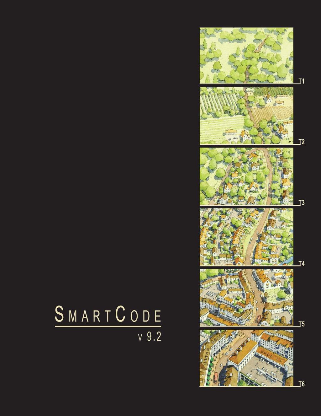
33 TABLE 1: Transect Zone Descriptions. This tables provides descriptions of the character of each Transect Zone. T-1 NATURAL T-1 Natural Zone consists of lands approximating or reverting to a wilderness condition, including lands unsuitable for settlement due to topography, hydrology or vegetation. General Character: Building Placement: Frontage Types: Typical Building Height: Type of Civic Space: Natural landscape with some agricultural use Not applicable Not applicable Not applicable Parks, Greenways T-2 RURAL T-2 Rural Zone consists of sparsely settled lands in open or cultivated states. These include woodland, agricultural land, grassland, and irrigable desert. Typical buildings are farmhouses, agricultural buildings, cabins, and villas. General Character: Building Placement: Frontage Types: Typical Building Height: Type of Civic Space: Primarily agricultural with woodland & wetland and scattered buildings Variable Setbacks Not applicable 1- to 2-Story Parks, Greenways T-3 SUB-URBAN T-3 Sub-Urban Zone consists of low density residential areas, adjacent to higher zones that have some mixed use. Home occupations and outbuildings are allowed. Planting is naturalistic and setbacks are relatively deep. Blocks may be large and the roads irregular to accommodate natural conditions. General Character: Building Placement: Frontage Types: Typical Building Height: Type of Civic Space: Lawns and landscaped yards surrounding detached single-family houses; pedestrians occasionally Large and variable front and side yard Setbacks Porches, fences, naturalistic tree planting 1- to 2-Story with some 3-Story Parks, Greenways T-4 GENERAL URBAN T-4 General Urban Zone consists of a mixed use but primarily residential urban fabric. It may have a wide range of building types: single, Sideyard, and Rowhouses. Setbacks and landscaping are variable. Streets with curbs and side-walks define medium-sized Blocks. General Character: Building Placement: Frontage Types: Typical Building Height: Type of Civic Space: Mix of Houses, Townhouses and small Apartment buildings with scattered Commercial activity; balance between landscape and buildings; presence of pedestrians Shallow to medium front and side yard Setbacks Porches, fences, Dooryards 2- to 3-Story with a few taller Mixed Use buildings Squares, Greens, Greenways T-5 URBAN CENTER T-5 Urban Center Zone consists of higher density mixed use building that accommodate Retail, Offices, Row- houses and Apartments. It has a tight network of streets, with wide sidewalks, steady street tree planting and buildings set close to the sidewalks. T-6 URBAN CORE T-6 Urban Core Zone consists of the highest density and height, with the greatest variety of uses, and civic buildings of regional importance. It may have larger Blocks; streets have steady street tree planting and buildings are set close to wide sidewalks. Typically only large towns and cities have an Urban Core Zone. General Character: Building Placement: Frontage Types: Typical Building Height: Type of Civic Space: General Character: Building Placement: Frontage Types: Typical Building Height: Type of Civic Space: Shops mixed with Townhouses, larger Apartment houses, Offices, work place and Civic buildings; predominantly attached buildings; trees within the public right-of-way; substantial pedestrian activity Shallow Setbacks or none; buildings oriented to street defining a street wall Stoops, Shopfronts, Galleries 2- to 5-Story with some variation Parks, Plazas, Squares, median landscaping, Greenways Medium to high-density Mixed Use buildings, entertainment, Civic and cultural uses. Attached buildings forming a continuous street wall; trees within the public right-of-way; highest pedestrian and transit activity Shallow Setbacks or none; buildings oriented toward the street, defining a street wall Stoops, Dooryards, Forecourts, Shopfronts, Galleries and Arcades 4-plus Story with a few shorter buildings Parks, Plazas and Squares; median landscaping


 (PRIMARILY NEW")

34 TABLE 2: Sector/Community Allocation. Table 2 defines the geography including both natural and infrastructure elements, determining areas that are or are not suitable for development. Specific Community Types of various densities are allowable in specific Sectors. This table also allocates the proportions of Transect Zones within each Community Type. ALREADY DEVELOPED AREAS PROIMITY TO MAJOR THOROUGHFARES AND TRANSIT PROIMITY TO THOROUGHFARES MEDIUM SLOPES WOODLANDS FLOODPLAIN OPEN SPACE TO BE ACQUIRED CORRIDORS TO BE ACQUIRED BUFFERS TO BE ACQUIRED LEGACY WOODLAND LEGACY FARMLAND LEGACY VIEWSHEDS CLD RESIDUAL OPEN SPACE SURFACE WATERBODIES PROTECTED WETLANDS PROTECTED HABITAT RIPARIAN CORRIDORS PURCHASED OPEN SPACE CONSERV. EASEMENTS LAND TRUST TRANSPORT. CORRIDORS CLD OPEN SPACE RURAL GROWTH BOUNDARY URBAN GROWTH BOUNDARY (PRIMARILY OPEN SPACE) (PRIMARILY NEW COMMUNITIES) (SUCCESSIONAL COMMUNITIES) O1 PRESERVED OPEN SECTOR O2 RESERVED RESTRICTED CONTROLLED INTENDED OPEN SECTOR G1 GROWTH SECTOR G2 GROWTH SECTOR G3 GROWTH SECTOR G4 INFILL GROWTH SECTOR T1 T2 T3 T4 T5 CLD CLD TND TND RCD TND RCD NO MINIMUM NO MINIMUM 50% MIN. 50% MIN. NO MINIMUM NO MINIMUM NO MIN. NO MIN % 10-30% 10-30% 10-30% 20-40% 20-40% 30-60% 30-60% 10-30% VARIABLE VARIABLE 10-30% 10-30% 10-30% VARIABLE VARIABLE T % VARIABLE VARIABLE
35 TABLE 3A: Vehicular Lane Dimensions. This table assigns lane widths to Transect Zones. The Design ADT (Average Daily Traffic) is the determinant for each of these sections. The most typical assemblies are shown in Table 3B. Specific requirements for truck and transit bus routes and truck loading shall be decided by Warrant. DESIGN SPEED TRAVEL LANE WIDTH T1 T2 T3 T4 T5 T mph 9 feet mph 10 feet BY RIGHT BY WARRANT mph 11 feet Above 35 mph 12 feet DESIGN SPEED PARKING LANE WIDTH mph (Parallel) 8 feet Above 35 mph (Parallel) 9 feet DESIGN SPEED EFFECTIVE TURNING RADIUS (See Table 17b) Below 20 mph 10 feet mph feet mph feet Above 35 mph feet


36 TABLE 3B: Vehicular Lane/Parking Assemblies. The projected design speeds determine the dimensions of the vehicular lanes and Turning Radii assembled for Thoroughfares. ONE WAY MOVEMENT TWO WAY MOVEMENT a. NO PARKING T1 T2 T3 T1 T2 T3 T1 T2 T1 T2 T1 T2 Design ADT Pedestrian Crossing Design Speed b. YIELD T3 T4 T3 T4 PARKING 300 VPD 600 VPD 2,500 VPD 22,000 VPD 36,000 VPD 3 Seconds 5 Seconds 5 Seconds 9 Seconds 13 Seconds MPH Below 20 MPH MPH 35 MPH or above Design ADT Pedestrian Crossing Design Speed c. PARKING T3 T4 T3 T4 T5 T4 T5 T4 T5 T6 T5 T6 ONE SIDE PARALLEL 1,000 VPD 1,000 VPD 5 Seconds 7 Seconds Design ADT Pedestrian Crossing Design Speed 5,000 VPD 18,000 VPD 16,000 VPD 15,000 VPD 32,000 VPD 5 Seconds 8 Seconds 8 Seconds 11 Seconds 13 Seconds MPH MPH MPH d. PARKING T4 T4 T5 T6 T4 T5 T6 T5 T6 T5 T6 BOTH SIDES PARALLEL Design ADT Pedestrian Crossing Design Speed e. PARKING T5 T6 T5 T6 T5 T6 T5 T6 T5 T6 BOTH SIDES DIAGONAL (FOR PRIVATE ROADS ONLY) 8,000 VPD 20,000 VPD 15,000 VPD 22,000 VPD 32,000 VPD 7 Seconds 10 Seconds 10 Seconds 13 Seconds 15 Seconds Below 20 MPH MPH MPH MPH 35 MPH and above Design ADT Pedestrian Crossing Design Speed 18,000 VPD 20,000 VPD 15,000 VPD 22,000 VPD 31,000 VPD 15 Seconds 17 Seconds 17 Seconds 20 Seconds 23 Seconds Below 20 MPH MPH MPH MPH MPH f. PARKING T5 T6 T5 T6 ACCESS Design ADT Pedestrian Crossing Design Speed 3 Seconds 6 Seconds


37 TABLE 4A: Public Frontages General. The Public Frontage is the area between the private Lot Line and the edge of the vehicular lanes. Dimensions are given in Table 4B. a. (HW) For Highway: This Frontage has open Swales drained by percolation, Bicycle Trails and no parking. The landscaping consists of the natural condition or multiple species arrayed in naturalistic clusters. Buildings are buffered by distance or berms PLAN LOT R.O.W. PRIVATE FRONTAGE PUBLIC FRONTAGE T1 T2 T3 b. (RD) For Road: This Frontage has open Swales drained by percolation and a walking Path or Bicycle Trail along one or both sides Yield parking. The landscaping consists of the multiple species arrayed in naturalistic clusters. T1 T2 T3 c. (ST) For Street: This Frontage has raised Curbs drained by inlets and Sidewalks separated from the vehicular lanes by individual or continuous Planters, with parking on one or both sides. The landscaping consists of street trees of a single or alternating species aligned in a regularly spaced Allee, with the exception that Streets with a right-of-way (R.O.W.) width of 40 feet or less are exempt from tree requirements. T3 T4 T5 d. e. f. (DR) For Drive: This Frontage has raised Curbs drained by inlets and a wide Sidewalk or paved path along one side, related to a Greenway or waterfront. It is separated from the vehicular lanes by individual or continuous Planters. The landscaping consists of street trees of a single species or alternating species aligned in a regularly spaced Allee. (AV) For Avenue: This Frontage has raised Curbs drained by inlets and wide Sidewalks separated from the vehicular lanes by a narrow continuous Planter with parking on both sides. The landscaping consists of a single tree species aligned in a regularly spaced Allee. (CS) (AV) For Commercial Street or Avenue: This Frontage has raised Curbs drained by inlets and very wide Sidewalks along both sides separated from the vehicular lanes by separate tree wells with grates and parking on both sides. The landscaping consists of a single tree species aligned with regular spacing where possible but clears the storefront entrances. T3 T4 T5 T6 T3 T4 T5 T6 T5 T6 g. (BV) For Boulevard: this Frontage has slip Roads on both sides. It consists of raised Curbs drained by inlets and Sidewalks along both sides, separated from the vehicular lanes by Planters. The landscaping consists of double rows of a single tree species aligned in a regularly spaced Allee. T3 T4 T5 T6


38 TABLE 4B: Public Frontages - Specific. This table assembles prescriptions and dimensions for the Public Frontage elements - Curbs, walkways and Planters - relative to specific Thoroughfare types within Transect Zones. Table 4B-a assembles all of the elements for the various street types. Locally appropriate planting species should be filled in to the calibrated Code. a. TRANSECT ZONE T1 T2 T3 T1 T2 T3 T3 T4 T4 T5 T5 T6 T5 T6 Public Frontage Type Assembly: The principal variables are the type and dimension of Curbs, walkways, Planters and landscape. RURAL I I I I I I I I I I I I I I I I I I I I I I TRANSECT I I I I I I I I I I I I I I I I I I I I I URBAN HW & RD RD & ST ST-DR-AV ST-DR-AV-BV CS-DR-AV-BV CS-DR-AV-BV Total Width feet feet feet feet feet feet b. Curb. The detailing of the edge of the vehicular pavement incorporating drainage. Type Radius Open Swale Open Swale Raised Curb Raised Curb Raised Curb Raised Curb feet feet 5-20 feet 5-20 feet 5-20 feet 5-20 feet c. Walkway. The hard surface dedicated exclusively to pedestrian activity. d. Type Width Planter: The layer which accommodates street trees and other landscape materials. Path Optional Path Sidewalk Sidewalk n/a 4-8 feet 4-8 feet 4-8 feet Sidewalk Sidewalk feet feet Arrangement Species Planter Type Planter Width Clustered Clustered Regular Regular Regular Opportunistic Clustered Clustered Alternating Single Single Single Continuous Swale Continuous Swale Continuous Planter Continuous Planter Continuous Planter Tree Well 8 feet - 16 feet 8 feet - 16 feet 8 feet - 12 feet 8 feet - 12 feet 4 feet - 6 feet 4 feet - 6 feet e. Landscape. The recommended plant species. (See Table 6) f. Lighting. The recommended Public Lighting. (See Table 5)

39 RESERVED TABLE 4C: Thoroughfare Assemblies: These Thoroughfares are assembled from the elements that appear in Tables 3A and 3B and incorporate the Public Frontages of table 4A. The key gives the Thoroughfare type followed by the right-of-way width, followed by the pavement width, and in some instances followed by specialized transportation capability. KEY Thoroughfare Type Right-of-Way Width Pavement Width Transportation ST BL THOROUGHFARE TYPES Highway Boulevard Avenue Commercial Street Drive Street Road Rear Alley Rear Lane Bicycle Trail Bicycle Lane Bicycle Route Path Passage Transit Route HW BV AV CS DR ST RD RA RL BT BL BR PT PS TR Thoroughfare Type Transect Zone Assignment Right-of-Way Width Pavement Width Movement Design Speed Pedestrian Crossing Time Traffic Lanes Parking Lanes Curb Radius Walkway Type Planer Type Curb type Landscape Type Transportation Provision ST ST Street Street T4, T5, T6 T4, T5, T6 50 feet 50 feet 26 feet 28 feet Slow Movement Yield Movement 20 MPH 20 MPH 7.4 seconds 7.6 seconds 2 lanes 2 lanes One 8 feet marked Both 8 feet unmarked 10 feet 10 feet 5 foot Sidewalk 5 foot Sidewalk 7 foot continuous Planter 6 foot continuous Planter Curb Curb 30' o.c. Avg. 30' o.c. Avg. BR BR


40 TABLE 5: Public Lighting. Lighting varies in brightness and also in the character of the fixture according to the Transect. The table shows five common types. A listed set of streetlights corresponding to these types would be approved by the utility company and listed on the page. Cobra Head T1 T2 T3 T4 T5 T6 SD Specifications Pipe Post Column Double Column


41 TABLE 6: Public Planting. This table shows five common types of street tree types and their appropriateness within the transect zones. This table may be calibrated further within a specific development and its associated plan submittal provided that it can be demonstrated that selected tree and vegetation types are not invasive and are compatible with Jefferson County s climate and environment. Oval T1 T2 T3 T4 T5 T6 SD Specifications Ball Pyramid Umbrella Vase


42 TABLE 7: Private Frontages. The Private Frontage is the areas between the building Facades and the Lot lines. a. Common Yard: a planted Frontage wherein the Façade is set back substantially from the Frontage Line. The front yard created remains unfenced and is visually continuous with adjacent yards, supporting a common landscape. The deep Setback provides a buffer from the higher speed Thoroughfares. SECTION PLAN LOT R.O.W. LOT R.O.W. PRIVATE PUBLIC PRIVATE PUBLIC FRONTAGE FRONTAGE FRONTAGE FRONTAGE T2 T3 b. Porch & Fence: a planted Frontage where the Façade is set back from the Frontage Line with an attached porch to Encroach. A fence at the Frontage Line maintains street spatial definition. Porches shall be no less than 8 feet deep. T3 T4 c. Terrace or Lightwell: a frontage wherein the Façade is setback back from the Frontage Line by an elevated terrace or sunken Lightwell. This type buffers Residential use from urban Sidewalks and removes the private yard from public encroachment. Terraces are suitable for conversion to outdoor cafes. Syn: Dooryard. T4 T5 d. Forecourt: a Frontage wherein the Façade is close to the Frontage Line and the central portion is set back. The forecourt created is suitable for vehicular drop-offs. This type should be allocated in conjunction with other Frontage types. Large trees within the Forecourts may overhang the Sidewalks. T4 T5 T6 e. Stoop: a Frontage wherein the Façade is aligned close to the Frontage Line with the first Story elevated from the Sidewalk sufficiently to ensure privacy for the windows. The entrance is usually an exterior stair and landing. This type is recommended for ground-floor Residential use. T4 T5 T6 f. Shopfront: a Frontage wherein the Façade is aligned close to the Frontage Line with the building entrance at Sidewalk grade. This type is conventional for Retail use. It has substantial glazing on the Sidewalk level and an awning that should overlap the Sidewalk to within 2 feet of the Curb. Syn: Retail Frontage. T4 T5 T6 g. Gallery: a Frontage wherein the Façade is aligned with the Frontage Line with an attached cantilevered shed or lightweight colonnade overlapping the Sidewalk. This type is conventional for Retail use. The Gallery should be no less than 10 feet wide and should overlap the sidewalk to within 2 feet of the Curb. T4 T5 T6


43 T2 T3 T4 T5 TABLE 8: Building Configuration. This table shows the configurations for different building heights for each Transect Zone. It must be modified to show actual calibrated heights for local conditions. Recess Lines and Expression Lines shall occur on higher buildings as shown. N = maximum height as specified in Table 14k.
44 TABLE 9: Building Disposition. This table approximates the location of the structure relative to the boundaries of each individual Lot, establishing suitable basic building types for each Transect Zone. a. Edgeyard: Specific Types - single-family House, Cottage, villa, Estate House, urban villa. A building that occupies the center of its Lot with Setbacks on all sides. This is the least urban of types as the front yard sets it back from the Frontage, while the side yards weaken the spatial definition of the public Thoroughfare space. The front yard is intended to be visually continuous with the yards of adjacent buildings. The rear yard can be secured for privacy by fences and a well placed Backbuilding and/or Outbuilding. T2 T3 T4 b. Sideyard: Specific Types - Charleston single-house, double house, zero-lot-line house, twin. A building that occupies one side of the Lot with the Setback to the other side. A shallow Frontage Setback defines a more urban condition. If the adjacent building is similar with a blank side wall, the yard can be quite private. This type permits systematic climatic orientation in response to the sun or the breeze. If a Sideyard House abuts a neighboring Sideyard House, the type is known as a Twin or double house. Energy costs, and sometimes noise, are reduced by sharing a party wall in this disposition. T4 T5 c. Rearyard: Specific Types - Townhouse, Rowhouse, Live-work unit, loft building, Apartment House, Mixed use Block, Flex Building, perimeter Block. A building that occupies the full Frontage, leaving the rear of the Lot as the sole yard. This is a very urban type as the continuous Facade steadily defines the public Thoroughfare. The rear Elevations may be articulated for functional purposes. In its Residential form, this type is the Rowhouse. For its Commercial form, the rear yard can accommodate substantial parking. T4 T5 T6 d. Courtyard: Specific Types - patio House. A building that occupies the boundaries of its Lot while internally defining one or more private patios. This is the most urban of types, as it is able to shield the private realm from all sides while strongly defining the public Thoroughfare. Because of its ability to accomodate incompatible activities, masking them from all sides, it is recommended for workshops, Lodging and schools. The high security provided by the continuous enclosure is useful for crime-prone areas. T5 T6 e. Specialized: A building that is not subject to categorization. Buildings dedicated to manufacturing and transportation are often distorted by the trajectories of machinery. Civic buildings, which may express the aspirations of institutions, may be included. SD

45 TABLE 10: Building Function. This table categorizes Building functions within Transect Zones. Parking requirements are corelated to functional intensity. For Specific Function and Use By Right or by Warrant, see Table 12. a. RESIDENTIAL T2 T3 T4 T5 T6 Restricted Residential: The number of dwellings on each Lot is restricted to one within a Principal Building and one within an Accessory Building, with 2 parking spaces for each. Both dwellings shall be under single ownership. The habitable area of the Accessory Unit shall not exceed 440 sf, excluding the parking area. Limited Residential: The number of dwellings on each Lot is limited by the requirement of 1.5 parking spaces for each dwelling, a ratio which may be reduced according to the the shared parking standards (See Table 11). Open Residential: The number of dwellings on each Lot is limited by the requirement of 1.0 parking places for each dwelling, a ratio which may be reduced according to the shared parking standards (See Table 11). b. LODGING Restricted Lodging: The number of bedrooms available on each Lot for lodging is limited by the requirement of 1.0 assigned parking place for each bedroom, up to five, in addition to the parking requirement for the dwelling. The Lodging must be owner occupied. Food service may be provided in the a.m. The maximum length of stay shall not exceed ten days. Limited Lodging: The number of bedrooms available on each Lot for lodging is limited by the requirement of 1.0 assigned parking place for each bedroom, up to twelve, in addition to the parking requirement for the dwelling. The Lodging must be owner occupied. Food service may be provided in the a.m. The maximum length of stay shall not exceed ten days. Open Lodging: The number of bedrooms available on each Lot for lodging is limited by the requirement of 1.0 assigned parking place for each bedroom. Food service may be provided at all times. The area allocated for food service shall be calculated with parking according to Retail Function. c. OFFICE Restricted Office: The building area available for office use on each Lot is restricted to the first Story of the Principal or the Accessory Building and by the requirement of 3.0 assigned parking places per 1,000 square feet of net office space in addition to the parking requirement for each dwelling. Limited Office: The building area available for office use on each Lot is limited to the first Story of the Principal Building and/or the Accessory Building, and by the requirement of 3.0 assigned parking places per 1,000 square feet of net office space in addition to the parking requirement for each dwelling. Open Office: The building area available for office use on each Lot is limited by the requirement of 2.0 assigned parking places per 1,000 square feet of net office space. d. RETAIL Restricted Retail: The building area available for Retail use is restricted to one Block corner location at the first Story for each 300 dwelling units and by the requirement of 4.0 assigned parking places per 1,000 square feet of net Retail space in addition to the parking requirement of each dwelling. The specific use shall be further limited to neighborhood store, or food service seating no more than 20. Limited Retail: The building area available for Retail use is limited to the first Story of buildings at corner locations, not more than one per Block, and by the requirement of 4.0 assigned parking places per 1,000 square feet of net Retail space in addition to the parking requirement of each dwelling. The specific use shall be further limited to neighborhood store or food service seating no more than 40. Open Retail: The building area available for Retail use is limited by the requirement of 3.0 assigned parking places per 1,000 square feet of net Retail space. Retail spaces under 1,500 square feet are exempt from parking requirements. e. CIVIC f. OTHER See Table 12 See Table 12 See Table 12 See Table 12 See Table 12 See Table 12 TABLE 11: Parking Calculations. The Shared Parking Factor for two Functions, when divided into the sum of the two amounts as listed on the Required Parking table below, produces the Effective Parking needed for each site involved in sharing. Conversely, if the Sharing Factor is used as a multiplier, it indicates the amount of building allowed on each site given the parking available. RESIDENTIAL LODGING OFFICE RETAIL CIVIC OTHER REQUIRED PARKING (See Table 10) T2 T3 T4 T5 T6 2.0 / dwelling 1.5 / dwelling 1.0 / dwelling 1.0 / dwelling 1.0 / dwelling 1.0 / dwelling 3.0 / 1,000 sq.ft. 3.0 / 1,000 sq.ft. 2.0 / 1,000 sq.ft. 4.0 / 1,000 sq.ft. 4.0 / 1,000 sq.ft. 3.0 / 1,000 sq.ft. To be determined by Warrant To be determined by Warrant REQUIRED PARKING FACTOR
46 TABLE 12: Specific Function and Use. This table expands the categroies of Table 10 to delegate specific Functions and uses within Transect Zones. Table 12 should be customized for local character and requirements. a. RESIDENTIAL T1 T2 T3 T4 T5 T6 SD f. OTHER: AGRICULTURE T1 T2 T3 T4 T5 T6 SD Mixed Use Block Grain Storage Flex Building Livestock Pen Apartment Building Greenhouse Live/Work Unit Stable Row House Kennel Duplex House f. OTHER: AUTOMOTIVE Courtyard House Gasoline Sideyard House Automobile Service Cottage Truck Maintenance House Drive-Through Facility Villa Rest Stop Accessory Unit Roadside Stand b. LODGING Billboard Hotel (no room limit) Shopping Center Inn (up to 12 rooms) Shopping Mall Bed & Breakfast (up to 5 rooms) f. OTHER: CIVIL SUPPORT S.R.O. Hostel Fire Station School Dormitory Police Station c. OFFICE Cemetery Office Building Funeral Home Live/Work Unit Hospital d. RETAIL Medical Clinic Open-Market Building f. OTHER: EDUCATION Retail Building College Display Gallery High School Restaurant Trade School Kiosk Elementary School Push Cart Other - Childcare Center Liquor Selling Establsihment f. OTHER: INDUSTRIAL Adult Entertainment Heavy Industrial Facility e. CIVIC Light Industrial Facility Bus Shelter Truck Depot Convention Center Laboratory Facility Conference Center Water Supply Facility Exhibition Center Sewer and Waste Facility Fountain or Public Art Electric Substation Library Wireless Transmitter Live Theater Cremation Facility Movie Theater Warehouse Museum Produce Storage Outdoor Auditorium Mini-Storage Parking Structure Passenger Terminal Playground Sports Stadium Surface Parking Lot Religious Assembly BY RIGHT BY WARRANT


47 TABLE 13: Civic Space. a. Park: A natural preserve available for unstructured recreation. A park may be T1 independent of surrounding building Frontages. Its landscape shall consist of Paths and trails, meadows, water bodies, woodland and open shelters, all T2 naturalistically disposed. Parks may be lineal, following the trajectories of natural T3 corridors. The minimum size shall be 8 acres. Larger parks may be approved by Warrant as Special Districts in all zones. b. Green: An Open Space, available for unstructured recreation. A Green may be T3 spatially defined by landscaping rather than building Frontages. Its landscape shall consist of lawn and trees, naturalistically disposed. The minimum size shall be 1/2 acre and the maximum shall be 8 acres. T4 T5 c. Square: An Open Space available for unstructured recreation and Civic T4 purposes. A Square is spatially defined by building Frontages. Its landscape shall consist of paths, lawns and trees, formally disposed. Squares shall be located at T5 the intersection of important Thoroughfares. The minimum size shall be 1/2 acre T6 and the maximum shall be 5 acres. d. Plaza: An Open Space available for Civic purposes and Commercial activities. A T5 Plaza shall be spatially defined by building Frontages. Its landscape shall consist primarily of pavement. Trees are optional. Plazas should be located at the T6 intersection of important streets. The minimum size shall be 1/2 acre and the maximum shall be 2 acres. e. Playground: An Open Space designed and equipped for the recreation of T1 children. A Playground should be fenced and may include an open shelter. Playgrounds shall be interspersed within Residential areas and may be placed within a Block. Playgrounds may be included within parks and greens. There shall be no minimum or maximum size. T2 T3 T4 T5 T6
48 TABLE 14: SmartCode Summary Note: All requirements in this Table are subject to calibration for local context. T1 NATURAL ZONE T2 RURAL ZONE T3 SUB-URBAN T4 GENERAL URBAN CENTER URBAN CORE T5 T6 SD SPECIAL ZONE URBAN ZONE ZONE ZONE DISTRICT a. ALLOCATION OF ZONES per Pedestrian Shed (applicable to Article 3 only) (See Table 16) CLD requires TND requires RCD requires no minimum no minimum no minimum 50% min. no minimum no minimum 10-30% 10-30% not 20-40% 30-60% 10-30% not 10-30% 10-30% not not 40-80% b. BASE RESIDENTIAL DENSITY (See Section 3.9) By Right By Exception Other Functions c. BLOCK SIZE Block Perimeter not applicable by Variance by Variance no maximum 1 unit / 20 ac. avg. by Variance by Variance no maximum 2 units / ac. Gross 6 units / ac. Gross 10-20% 3,000 ft. max. 4 units / ac. Gross 12 units / ac. Gross 20-30% 2,400 ft. max. 6 units / ac. Gross 24 units / ac. Gross 30-50% 2,000 ft. max. 12 units / ac. Gross 96 units / ac. Gross 50-70% 2,000 ft. max. * d. THOROUGHFARES (See Table 3 and 4) * 3,000 ft. max. with parking structures HW BV AV CS DR ST RD Rear Lane Rear Alley Path Passage Bicycle Trail Bicycle Lane Bicycle Route e. CIVIC SPACES (See Table 13) Park Green Square Plaza Playground f. LOT OCCUPATION Lot Width Lot Coverage not not not not not not not not not not not applicable not applicable not not not not not not not not not not by Warrant by Warrant not not not 72 ft. min 120 ft. max. 60% max. not not not required not * by Warrant not 18 ft. min 96 ft. max. 70% max. not not not required not not not by Warrant 18 ft. min 180 ft. max. 80% max. not not not not required not not not * with Open Spaces by Warrant not 18 ft. min 700 ft. max. 90% max. g. SETBACKS - PRINCIPAL BUILDING (See Table 15) (g.1) Front Setback Principal (g.2) Front Setback Secondary (g.3) Side Setback (g.4) Rear Setback Frontage Buildout not applicable not applicable not applicable not applicable not applicable 48 ft. min. 48 ft. min. 96 ft. min. 96 ft. min. not applicable 24 ft. min. 12 ft. min. 12 ft. min. 12 ft. min. 40% min. 6 ft. min. 18 ft. max. 6 ft. min. 18 ft. max. 0 ft. min. 3 ft. min. * 60% min. 2 ft. min. 12 ft. max. 2 ft. min. 12 ft. max. 0 ft. min. 24 ft. max. 3 ft. min. * 80% min. 2 ft. min. 12 ft. max. 2 ft. min. 12 ft. max. 0 ft. min. 24 ft. max. 0 ft. min. 80% min. h. SETBACKS - OUTBUILDING (See Table 15) Front Setback not applicable 20 ft. min. + bldg. setback 20 ft. min. + bldg. setback 20 ft. min. + bldg. setback 40 ft. max. from rear prop not applicable Side Setback Rear Setback not applicable not applicable 3 ft. or 6 ft. 3 ft. min. 3 ft. or 6 ft. 3 ft. min. 0 ft. min. or 3 ft. 3 ft. 0 ft. min. 3 ft. max. not applicable not applicable i. BUILDING DISPOSITION (See Table 9) Edgeyard Sideyard Rearyard Courtyard not not not not not not not not not not not not not j. PRIVATE FRONTAGES (See Table 7) Common Yard Porch & Fence Terrace, Dooryard Forecourt Stoop Shopfront Gallery Arcade Parking Lot not applicable not applicable not applicable not applicable not applicable not applicable not applicable not applicable not applicable not not not not not not not not not not not not not not not not not not not not not not k. BUILDING CONFIGURATION (See Table 8) Principal Building Outbuilding not applicable not applicable 2 stories max. 2 stories max. 2 stories max. 2 stories max. 3 stories max. 2 stories max. 5 stories max. 2 min. 2 stories max. 8 stories max. 2 min. not applicable l. BUILDING FUNCTION (See Table 10 and Table 12) Residential Lodging Office not applicable not applicable not applicable restricted use restricted use restricted use restricted use restricted use restricted use limited use limited use limited use open use open use open use open use open use open use Retail not applicable restricted use restricted use limited use open use open use ARTICLE 5 ARTICLE 2,3,4 DISPOSITION CONFIGURATION FUNCTION

 Residential Lodging Office restricted use restricted use restricted use SETBACKS - PRINCIPAL BLDG. 1. The Facades and Elevations of Retail restricted use Principal Buildings shall be distanced from the Lot lines as shown.")
 Lot Width Lot Coverage 72 ft. min. 120 ft. max. 60% max. i. BUILDING DISPOSITION (See Table 9) Edgeyard Sideyard Rearyard not not SETBACKS - OUTBUILDING 1.")
 Front Setback Secondary (g.3) Side Setback (g.4) Rear Setback Frontage Buildout 24 ft. min. 12 ft. min. 12 ft. min. 12 ft. min. * h. SETBACKS - OUTBUILDING (See Table 14h) (h.")
 PARKING PLACEMENT Common Lawn 1.")
49 TABLE 15A: Form-Based Code Graphics - T3 BUILDING CONFIGURATION Building height shall be measured in number of Stories, excluding Attics and raised basements. Stories may not exceed 14 feet in height from finished floor to finished ceiling, except for a first floor Commercial function which must be a minumum of 11 ft with a maximum of 25 feet. Height shall be measured to the eave or roof deck as specified on Table 8. (See Table 1) l. BUILDING FUNCTION (See Table 10 & Table 12) Residential Lodging Office restricted use restricted use restricted use SETBACKS - PRINCIPAL BLDG. 1. The Facades and Elevations of Retail restricted use Principal Buildings shall be distanced from the Lot lines as shown. k. BUILDING CONFIGURATION (See Table 8) Principal Building 2 stories max. 2. Facades shall be built along the Outbuilding 2 stories max. Principal Frontage to the minimum specified width in the table. f. LOT OCCUPATION (See Table 14f) Lot Width Lot Coverage 72 ft. min. 120 ft. max. 60% max. i. BUILDING DISPOSITION (See Table 9) Edgeyard Sideyard Rearyard not not SETBACKS - OUTBUILDING 1. The Elevations of the Outbuilding shall Courtyard not be distanced from the Lot lines as shown. g. SETBACKS - PRINCIPAL BUILDING (See Table 14g) (g.1) Front Setback Principal (g.2) Front Setback Secondary (g.3) Side Setback (g.4) Rear Setback Frontage Buildout 24 ft. min. 12 ft. min. 12 ft. min. 12 ft. min. * h. SETBACKS - OUTBUILDING (See Table 14h) (h.1) Front Setback Principal (h.2) Front Setback Secondary (h.3) Side Setback 40% min. at setback 20 ft. min. + bldg. setback 3 ft. min. or 6 ft. at corner 3 ft. min. j. PRIVATE FRONTAGES (See Table 7) PARKING PLACEMENT Common Lawn 1. Uncovered parking spaces may be Porch & Fence Terrace or Lightwell Forecourt Stoop not not not provided within the second and third Layer as shown in the diagram (see Table 17d). 2. Covered parking shall be provided Shopfront & Awning Gallery not not within the third Layer as shown in the diagram (see Table 17d). Side- Arcade or rear-entry garages may be not allowed in the first or second Layer Refer to Summary Table 14 by Warrant PARKING PROVISIONS 3. Trash containers shall be stored (See Table 10 & 11) within the third Layer. * or 15 feet from center line of alley "N" stands for any Stories above those shown, up to the maximum. Refer to metrics for exact minimums and maximums.

 Residential Lodging Office limited use limited use limited use SETBACKS - PRINCIPAL BLDG. 1. The Facades and Elevations of Retail limited use Principal Buildings shall be distanced from the Lot lines as shown.")
 Lot Width Lot Coverage 18 ft. min., 96 ft. max. 70% max. i. BUILDING DISPOSITION (See Table 9) Edgeyard Sideyard Rearyard SETBACKS - OUTBUILDING 1.")
 Front Setback Secondary (g.3) Side Setback (g.4) Rear Setback Frontage Buildout 6 ft. min., 18 ft. max. 6 ft. min., 18 ft. max. 0 ft. min. 3 ft. min.* h. SETBACKS - OUTBUILDING (See Table 14h) (h.")
 PARKING PLACEMENT Common Lawn not 1.")
50 TABLE 15B: Form-Based Code Graphics - T4 BUILDING CONFIGURATION 1. Building height shall be measured in number of Stories, excluding Attics and raised basements. 2. Stories may not exceed 14 feet in height from finished floor to finished ceiling, except for a first floor Commercial function which must be a minumum of 11 ft with a maximum of 25 feet. 3. Height shall be measured to the eave or roof deck as specified on Table 8. (See Table 1) l. BUILDING FUNCTION (See Table 10 & Table 12) Residential Lodging Office limited use limited use limited use SETBACKS - PRINCIPAL BLDG. 1. The Facades and Elevations of Retail limited use Principal Buildings shall be distanced from the Lot lines as shown. k. BUILDING CONFIGURATION (See Table 8) Principal Building 3 stories max., 2 min. 2. Facades shall be built along the Outbuilding 2 stories max. Principal Frontage to the minimum specified width in the table. f. LOT OCCUPATION (See Table 14f) Lot Width Lot Coverage 18 ft. min., 96 ft. max. 70% max. i. BUILDING DISPOSITION (See Table 9) Edgeyard Sideyard Rearyard SETBACKS - OUTBUILDING 1. The Elevations of the Outbuilding shall Courtyard not be distanced from the Lot lines as shown. g. SETBACKS - PRINCIPAL BUILDING (See Table 14g) (g.1) Front Setback Principal (g.2) Front Setback Secondary (g.3) Side Setback (g.4) Rear Setback Frontage Buildout 6 ft. min., 18 ft. max. 6 ft. min., 18 ft. max. 0 ft. min. 3 ft. min.* h. SETBACKS - OUTBUILDING (See Table 14h) (h.1) Front Setback Principal (h.2) Front Setback Secondary (h.3) Side Setback 60% min. at setback 20 ft. min. + bldg. setback 0 ft. min. or 3 ft. at corner 3 ft. min. j. PRIVATE FRONTAGES (See Table 7) PARKING PLACEMENT Common Lawn not 1. Uncovered parking spaces may be Porch & Fence Terrace or Lightwell Forecourt Stoop provided within the third Layer as shown in the diagram (see Table 17d). 2. Covered parking shall be provided Shopfront & Awning Gallery Arcade not within the third Layer as shown in the diagram (see Table 17d). PARKING PROVISIONS (See Table 10 & 11) Refer to Summary Table Trash containers shall be stored within the third Layer. * or 15 feet from center line of alley "N" stands for any Stories above those shown, up to the maximum. Refer to metrics for exact minimums and maximums.

 Lot Width Lot Coverage 18 ft. min., 180 ft. max. 80% max. i. BUILDING DISPOSITION (See Table 9) Edgeyard Sideyard Rearyard not SETBACKS - OUTBUILDING 1.")
 Front Setback Secondary (g.3) Side Setback (g.4) Rear Setback Frontage Buildout 2 ft. min., 12 ft. max. 2 ft. min., 12 ft. max. 0 ft. min., 24 ft. max. 3 ft. min.* h.")
 PARKING PLACEMENT Common Lawn not 1.")
.")
51 TABLE 15C: Form-Based Code Graphics - T5 (See Table 1) 4. Expression Lines shall be as shown on l. BUILDING FUNCTION (See Table 10 & Table 12) Table 8. Residential Lodging Office open use open use open use SETBACKS - PRINCIPAL BLDG. 1. The Facades and Elevations of Retail open use Principal Buildings shall be distanced from the Lot lines as shown. k. BUILDING CONFIGURATION (See Table 8) Principal Building 5 stories max., 2 min. 2. Facades shall be built along the Outbuilding 2 stories max. Principal Frontage to the minimum specified width in the table. f. LOT OCCUPATION (See Table 14f) Lot Width Lot Coverage 18 ft. min., 180 ft. max. 80% max. i. BUILDING DISPOSITION (See Table 9) Edgeyard Sideyard Rearyard not SETBACKS - OUTBUILDING 1. The Elevations of the Outbuilding shall Courtyard be distanced from the Lot lines as shown. g. SETBACKS - PRINCIPAL BUILDING (See Table 14g) (g.1) Front Setback Principal (g.2) Front Setback Secondary (g.3) Side Setback (g.4) Rear Setback Frontage Buildout 2 ft. min., 12 ft. max. 2 ft. min., 12 ft. max. 0 ft. min., 24 ft. max. 3 ft. min.* h. SETBACKS - OUTBUILDING (See Table 14h) (h.1) Front Setback Principal (h.2) Front Setback Secondary (h.3) Side Setback 80% min. at setback 40 ft. max. from rear prop. 0 ft. min. or 2 ft. at corner 3 ft. max. j. PRIVATE FRONTAGES (See Table 7) PARKING PLACEMENT Common Lawn not 1. Uncovered parking spaces may be Porch & Fence Terrace or Lightwell Forecourt Stoop not provided within the third Layer as shown in the diagram (see Table 17d). 2. Covered parking shall be provided Shopfront & Awning Gallery Arcade within the third Layer as shown in the diagram (see Table 17d). PARKING PROVISIONS (See Table 10 & 11) Refer to Summary Table 14 BUILDING CONFIGURATION Building height shall be measured in number of Stories, excluding Attics and raised basements. Stories may not exceed 14 feet in height from finished floor to finished ceiling, except for a first floor Commercial function which must be a minumum of 11 ft with a maximum of 25 feet. Height shall be measured to the eave or roof deck as specified on Table Trash containers shall be stored within the third Layer. * or 15 feet from center line of alley "N" stands for any Stories above those shown, up to the maximum. Refer to metrics for exact minimums and maximums.

 Residential Lodging Office open use open use open use SETBACKS - PRINCIPAL BLDG. 1. The Facades and Elevations of Retail open use Principal Buildings shall be distanced from the Lot lines as shown.")
 Lot Width Lot Coverage 18 ft. min., 700 ft. max. 90% max. i. BUILDING DISPOSITION (See Table 9) Edgeyard Sideyard Rearyard not not PARKING PLACEMENT 1.")
 Front Setback Secondary (g.3) Side Setback (g.4) Rear Setback 2 ft. min., 12 ft. max. 0 ft. min., 24 ft. max. 0 ft. min.* within the third Layer as shown in the diagram (see Table 17d).")
52 TABLE 15D: Form-Based Code Graphics - T6 RESERVED BUILDING CONFIGURATION Building height shall be measured in number of Stories, excluding Attics and raised basements. Stories may not exceed 14 feet in height from finished floor to finished ceiling, except for a first floor Commercial function which must be a minumum of 11 ft with a maximum of 25 feet. Height shall be measured to the eave or roof deck as specified on Table 8. (See Table 1) 4. Stepbacks, Recess Lines, and Extension Lines shall be as shown on Table 8. l. BUILDING FUNCTION (See Table 10 & Table 12) Residential Lodging Office open use open use open use SETBACKS - PRINCIPAL BLDG. 1. The Facades and Elevations of Retail open use Principal Buildings shall be distanced from the Lot lines as shown. k. BUILDING CONFIGURATION (See Table 8) Principal Building 8 stories max., 2 min. 2. Facades shall be built along the Outbuilding N/A Principal Frontage to the minimum specified width in the table. f. LOT OCCUPATION (See Table 14f) Lot Width Lot Coverage 18 ft. min., 700 ft. max. 90% max. i. BUILDING DISPOSITION (See Table 9) Edgeyard Sideyard Rearyard not not PARKING PLACEMENT 1. Uncovered parking spaces may be Courtyard provided within the third Layer as shown in the diagram (see Table g. SETBACKS - PRINCIPAL BUILDING (See Table 14g) 17d). (g.1) Front Setback Principal 2 ft. min., 12 ft. max. 2. Covered parking shall be provided (g.2) Front Setback Secondary (g.3) Side Setback (g.4) Rear Setback 2 ft. min., 12 ft. max. 0 ft. min., 24 ft. max. 0 ft. min.* within the third Layer as shown in the diagram (see Table 17d). 3. Trash containers shall be stored Frontage Buildout 80% min. at setback within the third Layer. h. SETBACKS - OUTBUILDING (See Table 14h) (h.1) Front Setback Principal (h.2) Front Setback Secondary (h.3) Side Setback j. PRIVATE FRONTAGES (See Table 7) Common Lawn Porch & Fence Terrace or Lightwell Forecourt Stoop Shopfront & Awning Gallery Arcade PARKING PROVISIONS (See Table 10 & 11) N/A N/A N/A not not not Refer to Summary Table 14 * or 15 feet from center line of alley "N" stands for any Stories above those shown, up to the maximum. Refer to metrics for exact minimums and maximums.
53 TABLE 16: Special District Standards. The metrics for each column of this table (SD1, SD2, etc.) are to be filled in for each Special district as they currently exist, or as they are. More pages can be added. Special Districts that do not have provisions within this code shall be governed by the standards of the pre-existing zoning. SD1 SD2 SD3 SD4 SD5 SD6 SD7 a. ALLOCATION OF ZONES CLD TND TOD b. BASE RESIDENTIAL DENSITY By Right By TDR Other Functions c. BLOCK SIZE Block Perimeter d. THOROUGHFARES HW BV AV CS DR ST RD Rear Lane Rear Alley Path Passage Bike Trail Bike Lane Bike Route e. CIVIC SPACES Park Green Square Plaza Playground f. Lot Width Lot Coverage g. SETBACKS - PRINCIPAL BUILDING Front Setback Side Setback Rear Setback h. BUILDING DISPOSITION Edgeyard Sideyard Rearyard i. j. LOT OCCUPATION PRIVATE FRONTAGES Common Yard Porch & Fence Terrace, Dooryard Forecourt Stoop Shopfront Gallery Arcade Parking Lot BUILDING CONFIGURATION Principal Building Outbuilding k. BUILDING FUNCTION Residential Lodging Office Retail DISPOSITION CONFIGURATION FUNCTION


54 TABLE 17: Definitions Illustrated. a. THOROUGHFARE & FRONTAGES b. TURNING RADIUS c. BUILDING DISPOSITION d. LOT LAYERS e. FRONTAGE & LOT LINES f. SETBACK DESIGNATIONS g. NETWORK-BASED PEDESTRIAN SHED
T1 T2 T3 H U T T O, T X T4 S M A R T C O D E T6 T5
 T T T3 H U T T O, T T4 S M A R T C O D E T5 T6 SMARTCODE TABLE OF CONTENTS ARTICLE. GENERAL TO ALL PLANS. AUTHORITY. APPLICABILITY.3 INTENT.4 PROCESS.5 WARRANTS AND VARIANCES.6 SUCCESSION ARTICLE. RESERVED
ARTICLE 6: Special and Planned Development Districts
 ARTICLE 6: Special and Planned Development Districts 6-10 Traditional Neighborhood Development (TND) District 6-10.10 Purpose and Intent The Traditional Neighborhood Development (TND) District provides
Introduced and amended by the Land Use and Zoning Committee and amended on the floor by the Council: ORDINANCE E
 AMENDED & ENACTED 3/10/09 1 2 3 4 5 6 7 8 9 10 11 12 13 14 15 16 17 18 19 20 21 22 23 24 25 26 27 28 29 30 31 Introduced and amended by the Land Use and Zoning Committee and amended on the floor by the
NEIGHBORHOOD CONSERVATION CODE
 NEIGHBORHOOD CONSERVATION CODE Neighborhood Conservation Code A Tr a n s e c t -B a s e d I n f i l l C o d e P r e pa r e d NCC v 1.0 adapted by S andy S orlien. I llustrations by DPZ & C o. from S mart
ORDINANCE WHEREAS, this Ordinance is consistent with the City of Winter Garden Comprehensive Plan; and
 ORDINANCE 17-06 AN ORDINANCE OF THE CITY COMMISSION OF THE CITY OF WINTER GARDEN, FLORIDA, CREATING ARTICLE XIV OF CHAPTER 118 OF THE CITY OF WINTER GARDEN CODE OF ORDINANCES PROVIDING FOR THE EAST PLANT
4.1.3 LAND USE CATEGORIES
 4.1.3 LAND USE CATEGORIES a. City Center District The City Center District incorporates the existing character and mix of uses in downtown Belmont to encourage redevelopment and new development in keeping
5.1.1 The streetscape along US Highway 64 (Brevard Road); and, The built environment within new residential developments; and,
; and, The built environment within new residential developments; and,") Article 5. Landscaping 5.1 Purpose The Town of Laurel Park s landscape standards are designed to create a beautiful, aesthetically pleasing built environment that will complement and enhance community
Article 5. Landscaping 5.1 Purpose The Town of Laurel Park s landscape standards are designed to create a beautiful, aesthetically pleasing built environment that will complement and enhance community
Section 9 NEIGHBORHOOD DESIGN
 Section 9 NEIGHBORHOOD DESIGN City of Lancaster Comprehensive Plan D u n k i n, S e f k o & A s s o c i a t e s, I n c. NEIGHBORHOOD DESIGN INTRODUCTION There are many ways in which a neighborhood can
Planned Development Review Revisions (Project No. PLNPCM )
") Planned Development Review Revisions (Project No. PLNPCM2014-00139) Standard residential development Planned Development Example: Smaller lot sizes than what is allowed to create open space amenity. What
Planned Development Review Revisions (Project No. PLNPCM2014-00139) Standard residential development Planned Development Example: Smaller lot sizes than what is allowed to create open space amenity. What
PORT WHITBY COMMUNITY
 PORT WHITBY COMMUNITY SECONDARY PLAN UPDATE COMMUNITY IMPROVEMENT PLAN URBAN DESIGN GUIDELINES September 2015 DRAFT PROPOSED AMENDMENT NUMBER # to the Whitby Official Plan PURPOSE: The intent of this Amendment
COMMUNITY DESIGN. GOAL: Create livable and attractive communities. Intent
 COMMUNITY DESIGN Intent An attractive, well-designed County will attract quality development, instill civic pride, improve the visual character of the community, and create a strong, positive image for
AWH REPORT OF THE PLANNING AND DEVELOPMENT DEPARTMENT FOR APPLICATION FOR REZONING ORDINANCE TO PLANNED UNIT DEVELOPMENT
 AWH REPORT OF THE PLANNING AND DEVELOPMENT DEPARTMENT FOR APPLICATION FOR REZONING ORDINANCE TO PLANNED UNIT DEVELOPMENT MAY 8, 2014 The Planning and Development Department hereby forwards to the Planning
MIXED-USE VILLAGE OVERLAY FLOATING DISTRICT
 MIXED-USE VILLAGE OVERLAY FLOATING DISTRICT Zoning regulations developed by committee to the Planning Board for the Town of DeWitt, NY Issue date: 13 July 2017 revised 3/12/2018, revised 4/26/2018, 5/9/2018
Ranson,West Virginia LAND DEVELOPMENT PLAN AND PLAT APPLICATION MARCH 12, 2012
 C L A Y H I L L F A R M Ranson,West Virginia LAND DEVELOPMENT PLAN AND PLAT APPLICATION MARCH, OWNER / APPLICANT Strider, LLC Brandywine Drive Charlottesville, VA APPLICATION PREPARATION PlaceMakers, LLC
Complete Neighbourhood Guidelines Review Tool
 Complete Neighbourhood Guidelines Review Tool Prepared By: City of Regina Planning Department October 2014 Page 1 of 14 Community Development Review Checklist for Secondary Plans and Concept Plans The
ARTICLE 13 STREETS General
 ARTICLE 13 STREETS 13.1 General Streets shall be designed to suit their functions. Many streets have purposes other than vehicular traffic. As an alternative to current N.C. Department of Transportation
RECREATION AND OPEN SPACE ELEMENT GOALS, OBJECTIVES, AND POLICIES
 RECREATION AND OPEN SPACE ELEMENT GOALS, OBJECTIVES, AND POLICIES Goal 7 To provide park facilities, recreation programs, and open space resources that are safe, adequate, and accessible to all City residents,
CHAPTER 12 IMPLEMENTATION
 CHAPTER 12 IMPLEMENTATION The 2010 Town of Denton Comprehensive Plan is intended to capture a vision of the future of Denton. As such, it provides a basis for a wide variety of public and private actions
VEHICULAR AND PEDESTRIAN CIRCULATION
 This perspective sketch communicates the intended character and quality of a proposed streetscape design. Locate benches near a major intersection where people tend to gather. Seating and lighting provide
Incentive Zoning Regulations Florida Municipal City of Orlando
 Topic: Resource Type: State: Jurisdiction Type: Municipality: Year (adopted, written, etc.): 2002 Community Type applicable to: Title: Incentive Zoning Regulations Florida Municipal City of Orlando Document
Landscaping Standards
 CHAPTER 29 ARTICLE 403 29.403 Landscaping Standards Purpose: The purpose of this section is to protect and promote the public health, safety and general welfare by requiring landscaping in relation to
ATTACHMENT A. SILVERDALE DESIGN STANDARDS Amendments to the Waaga Way Town Center Chapter
 ATTACHMENT A SILVERDALE DESIGN STANDARDS Amendments to the Waaga Way Town Center Chapter Chapter 10. Waaga Way Town Center 10.1 Physical Identity Elements & Opportunities The Waaga Way Town Center includes
2025 COMPREHENSIVE PLAN PASCO COUNTY, FLORIDA
 GOAL FLU 6: PASADENA HILLS FUTURE LAND USE: PASADENA HILLS AREA PLAN GOALS, OBJECTIVES, AND POLICIES PASADENA HILLS AREA PLAN: OVERVIEW The Pasadena Hills Area Plan Goals, Objectives, and Policies are
ARTICLE 13 STREETS General
 ARTICLE 13 STREETS 13.1 General Streets shall be designed to suit their functions. Many streets have purposes other than vehicular traffic. As an alternative to current N.C. Department of Transportation
SECTION UNIFIED DEVELOPMENT ORDINANCE SECTION Part 1 Ordinance. ARTICLE 1 Zoning Districts
 SECTION 1-100 UNIFIED DEVELOPMENT ORDINANCE SECTION 1-300 Part 1 Ordinance SECTION 1-100. Introduction. ARTICLE 1 Zoning Districts Crystal Lake strives to maintain a balance of various land uses for a
ARTICLE V PLANNED UNIT DEVELOPMENT DISTRICT
 ARTICLE V PLANNED UNIT DEVELOPMENT DISTRICT A. Purpose and Objective The Planned Unit Development (PUD) procedure provides a flexible land use and design regulation through the use of performance criteria
STREAM BUFFERS
 88-415 STREAM BUFFERS 88-415-01 PURPOSE In the Kansas City region and throughout the nation, vegetated stream buffers have been clearly shown to protect stream stability and related infrastructure, improve
CHAPTER 22 Rural Open Space Community Developments
 CHAPTER 22 Rural Open Space Community Developments Section 22.1 Description and Purpose The intent of this Chapter is to offer property owners an alternative to traditional zoning requirements for rural
2025 COMPREHENSIVE PLAN PASCO COUNTY, FLORIDA
 GOAL FLU 6: PASADENA HILLS FUTURE LAND USE: PASADENA HILLS AREA PLAN GOALS, OBJECTIVES, AND POLICIES PASADENA HILLS AREA PLAN: OVERVIEW The Pasadena Hills Area Plan Goals, Objectives, and Policies are
Gold Line Bus Rapid Transit Transit Oriented Development (BRTOD) Helmo Station Area Plan
 Helmo Station Area Plan") Appendix F Gold Line Bus Rapid Transit Transit Oriented Development (BRTOD) Helmo Station Area Plan Introduction and Purpose of the Plan The Gold Line Bus Rapid Transit facility is an eleven-mile dedicated
Appendix F Gold Line Bus Rapid Transit Transit Oriented Development (BRTOD) Helmo Station Area Plan Introduction and Purpose of the Plan The Gold Line Bus Rapid Transit facility is an eleven-mile dedicated
KEIZER STATION PLAN INTRODUCTION
 KEIZER STATION PLAN INTRODUCTION Planning for this area began in 1987 when the Keizer Comprehensive Plan established the Chemawa Activity Center and McNary Activity Center. The first Chemawa Activity Center
Staff Report and Recommendation
 Community Planning and Development Planning Services 201 W. Colfax Ave., Dept. 205 Denver, CO 80202 p: 720.865.2915 f: 720.865.3052 www.denvergov.org/cpd TO: City Council Neighborhoods and Planning Committee
Applicant Name Phone / Fax / Address City State Zip Code . Property Owner Phone / Fax / Address City State Zip Code
 Master Development Plan Application Community Development Department City of Redmond 411 SW 9 th Street Redmond, Oregon 97756 541-923-7721 541-548-0706 FAX Master Development Plan Fee $38,862.52 File Number
Major Subdivision Sketch Plan Checklist
 This checklist provides specific requirements that are apart of the Sketch process. The entire process is described by the Huntersville Subdivision Review Process which details all the submittal and resubmittal
Chapter PEDESTRIAN COMMERCIAL (PC) ZONING DISTRICT
 ZONING DISTRICT") Chapter 11-17 PEDESTRIAN COMMERCIAL (PC) ZONING DISTRICT Sections: 11-17-01 GENERAL PURPOSE 11-17-02 PERMITTED BUILDING TYPES 11-17-03 USES PERMITTED WITH DESIGN REVIEW 11-17-04 USES PERMITTED BY CONDITIONAL
Chapter 11-17 PEDESTRIAN COMMERCIAL (PC) ZONING DISTRICT Sections: 11-17-01 GENERAL PURPOSE 11-17-02 PERMITTED BUILDING TYPES 11-17-03 USES PERMITTED WITH DESIGN REVIEW 11-17-04 USES PERMITTED BY CONDITIONAL
PLANNED UNIT DEVELOPMENT & SUBDIVISION STAFF REPORT Date: May 18, 2017
 & PUD-0000102-2017 PLANNED UNIT DEVELOPMENT & SUBDIVISION STAFF REPORT Date: May 18, 2017 NAME SUBDIVISION NAME Dauphin Creek Estates Subdivision Dauphin Creek Estates Subdivision LOCATION CITY COUNCIL
City of Redmond. Urban Holding Area Master Planning Requirements and Approval Process
 City of Redmond Urban Holding Area Master Planning Requirements and Approval Process June 21, 2006 City of Redmond: Urban Holding Area Master Planning Requirements and Approval Process Table of Contents
SECTION II SECTION II STATEMENT OF GOALS, OBJECTIVES, PRINCIPLES, ASSUMPTIONS, POLICIES AND STANDARDS
 STATEMENT OF GOALS, OBJECTIVES, PRINCIPLES, ASSUMPTIONS, POLICIES AND STANDARDS 1 2 STATEMENT OF GOALS, OBJECTIVES, PRINCIPLES, ASSUMPTIONS, POLICIES AND STANDARDS INTRODUCTION The New Jersey Municipal
ARLINGTON COUNTY, VIRGINIA
 ARLINGTON COUNTY, VIRGINIA County Board Agenda Item Meeting October 15, 2005 DATE: September 28, 2005 SUBJECT: Request to Advertise the adoption of the 2005 Clarendon Sector Plan C. M. RECOMMENDATION:
North Oakville East Parks Facilities Distribution Plan. November, 2009
 North Oakville East November, 2009 POLICY CONTEXT 1) Purpose a) The purpose of this document is to be a guide for the location, configuration, design and development of the parks system for the North Oakville
Planned Residential Neighborhoods Land Use Goals
 Planned Residential Neighborhoods Land Use Goals Issue: Guidelines that provide for diverse high quality residential areas that include a variety of housing styles and layouts are needed. Goal 1: Create
VILLAGE OF CLEMMONS PLANNING BOARD DRAFT STAFF REPORT. Single Family Residential, Townhomes
 VILLAGE OF CLEMMONS PLANNING BOARD DRAFT STAFF REPORT PETITION INFORMATION Docket # C-212 Staff Megan Ledbetter Petitioner(s) Peacehaven Development LLC Owner(s) Larry Jarvis, William Alexander and Peacehaven
TOWN OF FAIRVIEW. CPDD Commercial Planned Development District
 TOWN OF FAIRVIEW CPDD Commercial Planned Development District Adopted: September 11, 2014 TOWN OF FAIRVIEW Commercial Planned Development District BACKGROUND This Planned Development District ( PDD ) governs
PART 1: PROJECT SUMMARY. The application is Attachment A. The site plan is Attachment B.
 Belleterre Subdivision Sketch Plan Town Board 8.7.17 Belleterre Subdivision Sketch Plan PART 1: PROJECT SUMMARY Applicant: Bowman Development Project Size: +/- 20.85 acres Parcel Number: 01115104 and 01115121
CHAPTER FIVE COMMUNITY DESIGN
 CHAPTER FIVE COMMUNITY DESIGN CHAPTER FIVE - COMMUNITY DESIGN Assumptions Frazier Park and Lebec have historically developed according to different patterns of spatial form. While both communities are
The open space system should provide connective elements, relate to natural resources, and enhance the suburban character of the landscape..
 The open space system should provide connective elements, relate to natural resources, and enhance the suburban character of the landscape.. Mixed-use and infill development should maintain or enhance
TOP TEN LIST OF COMMUNITY CONCERNS REGARDING PROPOSED AMENDMENTS TO CHAPTER 42
 TOP TEN LIST OF COMMUNITY CONCERNS REGARDING PROPOSED AMENDMENTS TO CHAPTER 42 1. Extend the urban area to Beltway 8 in stages, over say a three-year period, prioritizing development in transit and declining
VILLAGE OF CLEMMONS PLANNING BOARD DRAFT STAFF REPORT
 VILLAGE OF CLEMMONS PLANNING BOARD DRAFT STAFF REPORT PETITION INFORMATION Docket # C-226 Staff Megan Ledbetter Petitioner(s) JBJH Properties, LLC Owner(s) JBJH Properties, LLC Subject Property 5892-49-1766
The West Vaughan Employment Area Secondary Plan Policies
 Part 2: The West Vaughan Employment Area Secondary Plan Policies 2.1 General Policies It is the policy of Council: 2.1.1. That the West Vaughan Employment Area (the WVEA), identified on Schedule 1, will
Policies and Code Intent Sections Related to Town Center
 Policies and Code Intent Sections Related to Town Center The Town Center Vision is scattered throughout the Comprehensive Plan, development code and the 1994 Town Center Plan. What follows are sections
FORMER CANADIAN FORCES BASE (CFB) ROCKCLIFFE SECONDARY PLAN. Official Plan Amendment XX to the Official Plan for the City of Ottawa
 ROCKCLIFFE SECONDARY PLAN. Official Plan Amendment XX to the Official Plan for the City of Ottawa") FORMER CANADIAN FORCES BASE (CFB) ROCKCLIFFE SECONDARY PLAN Official Plan Amendment XX to the Official Plan for the City of Ottawa 1 INDEX THE STATEMENT OF COMPONENTS PART A THE PREAMBLE PAGE Purpose...
FORMER CANADIAN FORCES BASE (CFB) ROCKCLIFFE SECONDARY PLAN Official Plan Amendment XX to the Official Plan for the City of Ottawa 1 INDEX THE STATEMENT OF COMPONENTS PART A THE PREAMBLE PAGE Purpose...
Guiding Principles, Objectives, Strategies and Policies
 Guiding Principles, Objectives, Strategies and Policies Section 1 Introduction These Guiding Principles were adopted as part of the 1999 Athens-Clarke County Comprehensive Plan and are carried over, in
4-Town Comprehensive Plan DRAFT 7/30/07
 4-Town Comprehensive Plan DRAFT 7/30/07 Acknowledgements ning Committee Town of Harrisburg Norman Roof Randy Nicol Town of Martinsburg Terry Thisse Paul Kelly Town of Montague Jan Bagdanowicz Wendy Perry
Corridor Identity. Section 9. Introduction. Corridor Guiding Principles
 Corridor Identity An attractive and healthy community is a critical element of a quality place, and the design of quality places is a balance between environmental, economic, and social considerations.
REQUEST Current Zoning: O-15(CD) (office) Proposed Zoning: TOD-M(CD) (transit oriented development mixed-use, conditional)
 (office) Proposed Zoning: TOD-M(CD) (transit oriented development mixed-use, conditional)") Rezoning Petition 2016-117 Zoning Committee Recommendation January 4, 2017 REQUEST Current Zoning: O-15(CD) (office) Proposed Zoning: TOD-M(CD) (transit oriented development mixed-use, conditional) LOCATION
Rezoning Petition 2016-117 Zoning Committee Recommendation January 4, 2017 REQUEST Current Zoning: O-15(CD) (office) Proposed Zoning: TOD-M(CD) (transit oriented development mixed-use, conditional) LOCATION
Future Land Use and Development Policies
 Future Land Use and Development Policies Introduction This section presents policies for future development and land use, given the consensus identified through the extensive public participation process.
S A C R A M E N T O C O U N T Y JACKSON HIGHWAY & GRANT LINE EAST VISIONING STUDY
 JACKSON HIGHWAY & GRANT LINE EAST S A C R A M E N T O C O U N T Y P L A N N I N G D E P A R T M E N T SUMMARY AND WORKBOOK November 19, 2008 History of the Visioning Study Sacramento County has two growth
Asbury Chapel Subdivision Sketch Plan
 Asbury Chapel Subdivision Sketch Plan PART 1: PROJECT SUMMARY Applicant: NVR Inc. Project Size: +/- 76.13 acres Parcel Numbers: 02101112,02116101,02116112, 02116113 Current Zoning: Transitional Residential
2. Would the proposed project comply with the Land Use map? 3. Would the proposed project require a rezoning? 4. What is the proposed zoning district?
 TOWN OF CHAPEL HILL Planning and Sustainability Department 405 Martin Luther King Jr. Blvd. Chapel Hill, NC 27514 www.townofchapelhill.org phone (919) 968 2728 Concept Plans are intended to be an opportunity
CITY OF PUYALLUP. Background. Development Services
 CITY OF PUYALLUP Development Services 333 South Meridian Puyallup WA 98371 To: City Council From: Katie Baker, AICP, Planning Division Re: South Hill Neighborhood Plan Adoption Date: (Meeting date: February
EXISTING COMPREHENSIVE PLAN
 EXISTING COMPREHENSIVE PLAN Town Center Land Use Element: V. LAND USE POLICIES Town Center Mercer Island's business district vision as described in "Your Mercer Island Citizen-Designed Downtown" was an
ARTICLE 9: LANDSCAPING AND FENCING REQUIREMENTS
 ARTICLE 9: LANDSCAPING AND FENCING REQUIREMENTS Section 9.01 Intent The intent of the landscaping requirements are to improve the appearance of lot areas and soften paved areas and buildings; to provide
PLANNED UNIT DEVELOPMENT Date: April 5, 2018
 PLANNED UNIT DEVELOPMENT Date: April 5, 2018 DEVELOPMENT NAME SUBDIVISION NAME LOCATION Robert Myers Robert Myers 2955 and 2989 Dauphin Street (Southeast corner of Dauphin Street and Sage Avenue) CITY
Chapter 10 IMPLEMENTATION RECOMMENDATIONS
 Chapter 10 IMPLEMENTATION RECOMMENDATIONS The recommended land use plan presented in the previous chapter provides a design for the attainment of the urban and rural development and open space preservation
E. RURAL COMMERCIAL/INDUSTRIAL PARK MODEL
 E. RURAL COMMERCIAL/INDUSTRIAL PARK MODEL 1. PURPOSE The purpose of the Rural Commerce/Industrial Park Model is to provide parameters within which a grouping of business buildings with parking, loading
POLICY AMENDMENT AND LAND USE AMENDMENT KILLARNEY/GLENGARRY (WARD 8) NW CORNER OF RICHMOND ROAD AND 33 STREET SW BYLAWS 1P2015 AND 7D2015
 NW CORNER OF RICHMOND ROAD AND 33 STREET SW BYLAWS 1P2015 AND 7D2015") Page 1 of 13 EXECUTIVE SUMMARY This application seeks to redesignate an RC-2 (Residential Contextual One/Two Dwelling) parcel to MC-Gd72 (Multi-Residential Contextual Grade-Oriented) to allow for multi-residential
Page 1 of 13 EXECUTIVE SUMMARY This application seeks to redesignate an RC-2 (Residential Contextual One/Two Dwelling) parcel to MC-Gd72 (Multi-Residential Contextual Grade-Oriented) to allow for multi-residential
F. The following uses in the HR District: attached single-family dwellings, condominiums, and institutional uses; and
 1102 DESIGN REVIEW 1102.01 PURPOSE AND APPLICABILITY Section 1102 is adopted to provide standards, criteria, and procedures under which design review may be approved. Design review is required for: A.
Glenborough at Easton Land Use Master Plan
 Implementation 114 9.0 IMPLEMENTATION 9.1 OVERVIEW This chapter summarizes the administrative procedures necessary to implement the proposed land use plan, infrastructure improvements, development standards,
7.0 OPEN SPACE 7.1 OPEN SPACE DEDICATION CHAPTER 7: OPEN SPACE
 7.0 OPEN SPACE The intent of these requirements is to allow for the usage of centrally located unencumbered land as neighborhood open spaces and not to permit the use of leftover or otherwise unusable
CITY PLANNING COMMISSION AGENDA. ITEM NO(s): C.1 C.3 STAFF: STEVE TUCK
: C.1 C.3 STAFF: STEVE TUCK") Page 34 CITY PLANNING COMMISSION AGENDA ITEM NO(s): C.1 C.3 STAFF: STEVE TUCK FILE NOS: CPC ZC 12-00035 QUASI-JUDICIAL CPC NV 12-00036 QUASI-JUDICIAL AR DP 12-00039 QUASI-JUDICIAL PROJECT: APPLICANT: OWNER:
Page 34 CITY PLANNING COMMISSION AGENDA ITEM NO(s): C.1 C.3 STAFF: STEVE TUCK FILE NOS: CPC ZC 12-00035 QUASI-JUDICIAL CPC NV 12-00036 QUASI-JUDICIAL AR DP 12-00039 QUASI-JUDICIAL PROJECT: APPLICANT: OWNER:
Access Management: An Overview
 Figures 1-5 Below Evolution of development along a highway. In the early stages, land along the road is used for farming with little traffic generated. As time passes, the highway corridor becomes a de
Improve Neighborhood Design and Reduce Non Point Source Water Pollution
 HOW TO Planning Guide Improve Neighborhood Design and Reduce Non Point Source Water Pollution This document was funded by a grant from the New Hampshire Coastal Program with funding from the National Oceanic
At first Work Session on October 22, At second Work Session on November 19, At third Work Session on December 3, 2015
 At first Work Session on October 22, 2015 Staff Reviewed Infrastructure: Transportation Capacity School Capacity Willett Branch Proposed Staging Language At second Work Session on November 19, 2015 Land
5.1 Commercial and Industrial Development. (Effective April 1, 2006)
") 5.1 Commercial and Industrial Development. (Effective April 1, 2006) A. Applicability: The requirements of this section (5.10) shall apply to all uses within the LB Local Business; HB Highway Business;
5.1 Commercial and Industrial Development. (Effective April 1, 2006) A. Applicability: The requirements of this section (5.10) shall apply to all uses within the LB Local Business; HB Highway Business;
GUS THOMASSON CORRIDOR REVITALIZATION CODE
 GUS THOMASSON CORRIDOR REVITALIZATION CODE Adopted by Ordinance No. 4022 on December 15, 2008 First Amended by Ordinance No. 4187 on November 7, 2011 The images and diagrams appearing in the Gus Thomasson
STAFF REPORT INTRODUCTION
 STAFF REPORT SUBJECT: DATE: Application for Master Land Use Plan Modification Southern Village Master Land Use Plan (Project No. 12-101) May 22, 2013 (Community Design Commission) May 23, 2013 (Transportation
REZONING GUIDE. Zone Map Amendment (Rezoning) - Application. Rezoning Application Page 1 of 3. Return completed form to
 - Application. Rezoning Application Page 1 of 3. Return completed form to") Zone Map Amendment (Rezoning) - Application COMMUNITY PLANNING & DEVELOPMENT REZONING GUIDE Rezoning Application Page 1 of 3 PROPERTY OWNER INFORMATION* CHECK IF POINT OF CONTACT FOR APPLICATION Property
Zone Map Amendment (Rezoning) - Application COMMUNITY PLANNING & DEVELOPMENT REZONING GUIDE Rezoning Application Page 1 of 3 PROPERTY OWNER INFORMATION* CHECK IF POINT OF CONTACT FOR APPLICATION Property
CHAPTER SPECIAL PURPOSE AND OVERLAY ZONING DISTRICTS
 Special Purpose and Overlay Zoning Districts 106.28.010 CHAPTER 106.28 - SPECIAL PURPOSE AND OVERLAY ZONING DISTRICTS SPECIAL PURPOSE AND OVERLAY ZONING DISTRICTS Sections: 106.28.010 - Purpose 106.28.020
THE POLICY FRAMEWORK FOR WALKABLE COMMUNITIES. Community Technical Assistance Program Building Active Communities Institute March 2016
 THE POLICY FRAMEWORK FOR WALKABLE COMMUNITIES Community Technical Assistance Program Building Active Communities Institute March 2016 ACTIVE COMMUNITIES BACK THEN ACTIVE COMMUNITIES BACK THEN Lifestyle
EXHIBIT B PROJECT NARRATIVE POULSBO MEADOWS
 EXHIBIT B PROJECT NARRATIVE POULSBO MEADOWS Name of Project: Poulsbo Meadows; A Planned Residential Development (PRD)/Plat Applicants Name: PBH Group LLC/Byron Harris PO Box 1010 Silverdale, WA 98038 Description
Planning Commission Staff Report June 5, 2008
 Owner/Applicant Taylor Village Sacramento Investments Partners, LP c/o Kim Whitney 1792 Tribute Road #270 Sacramento, CA 95815 Staff Recommendation Planning Commission Staff Report Project: File: Request:
MIAMI 21 CODE MAY This document is amended as of May 26, 2011.
 CODE MAY 2011 This document is amended as of May 26, 2011. THIS PAGE LEFT INTENTIONALLY BLANK. TABLE OF CONTENTS PREAMBLE ARTICLE 1. DEFINITIONS OF TERMS AND USES 1.1 Definitions of Building Function:
9 th Street Sub Area Plan
 9 th Street Sub Area Plan In the 1990 s, when the Township prepared the last Master Plan, the 9 th Street corridor was studied as part of a larger 9 th Street Focus Area that included the West Main Street
COLVER ROAD INDUSTRIAL CONCEPT PLAN
 COLVER ROAD INDUSTRIAL CONCEPT PLAN A CONCEPTUAL LAND USE AND TRANSPORTATION PLAN FOR TA-4 AN URBAN RESERVE AREA OF THE CITY TALENT City of Talent Adopted by City Council Resolution No., June, 2015 PART
DRAFT DESIGN GUIDELINES
 IHZ Booklet #7 May 6, 2010 DRAFT DESIGN GUIDELINES CANTERBURY 7 Overview During the recent planning process for the Plan of Conservation and Development community character was identified as an important
CONCEPT PLAN APPLICATION
 CONCEPT PLAN APPLICATION TOWN OF CHAPEL HILL Planning Department 405 Martin Luther King Jr. Blvd phone (919) 968-2728 fa (919) 969-2014 www.townofchapelhill.org Parcel Identifier Number (PIN): 9880267455
Town of Portola Valley General Plan. Nathhorst Triangle Area Plan
 Town of Portola Valley General Plan Amended December 10, 1997 Table of Contents Introduction... 1 Planning Area... 1 Objectives... 2 Principles... 2 Standards... 4 Description... 4 Community Commercial...
SPRINGHILL LAKE TRANSIT VILLAGE
 Greenbelt Metro Area Sector Plan - Subarea Design Policies and Guidelines - Springhill Lake Transit Village 113 SPRINGHILL LAKE TRANSIT VILLAGE Residential Neighborhood and Village Center CONCEPT Springhill
BROOKHILL NEIGHBORHOOD MODEL ZONING MAP AMENDMENT PREFACE TO APPLICATION
 BROOKHILL NEIGHBORHOOD MODEL ZONING MAP AMENDMENT PREFACE TO APPLICATION June 15, 2015 Revised: August 1, 2016 I. VISION Brookhill is a proposed community based upon the principles of Albemarle County
Harmony Technology Park Third Filing, Second Replat Custom Blending, Project Development Plan/Final Development Plan - FDP #130021
 ITEM NO FDP #130021 MEETING DATE July 23, 2013 STAFF Pete Wray ADMINISTRATIVE TYPE I HEARING STAFF REPORT PROJECT: APPLICANT: OWNER: Harmony Technology Park Third Filing, Second Replat Custom Blending,
FUTURE LAND USE ELEMENT
 FUTURE LAND USE ELEMENT GOAL I: To create and sustain a great place to live, play, and prosper Objective 1: The City of Ocala shall incorporate the principles and strategies of the Ocala 2035 Vision into
ORDINANCE NO. City of Bellingham City Attorney 210 Lottie Street Bellingham, Washington INFILL HOUSING ORDINANCE Page 1
 ORDINANCE NO. AN ORDINANCE RELATING TO LAND USE PLANNING AND ZONING, CREATING A NEW BMC CHAPTER 20.28 INFILL HOUSING, AND NEW SUBSECTION BMC 20.12.030.E, GREEN FACTOR LANDSCAPING STANDARDS, AND AMENDING
LAND USE AMENDMENT CORNERSTONE (WARD 3) 60 STREET NE AND COUNTRY HILLS BOULEVARD NE MAP 26NE BYLAW 22D2017
 60 STREET NE AND COUNTRY HILLS BOULEVARD NE MAP 26NE BYLAW 22D2017") Page 1 of 14 EXECUTIVE SUMMARY This Land Use Amendment application covers an area of 43.76 hectares ± (108.14 acres ±) located in northeast Calgary, bound by Country Hills Boulevard NE to the south and
Page 1 of 14 EXECUTIVE SUMMARY This Land Use Amendment application covers an area of 43.76 hectares ± (108.14 acres ±) located in northeast Calgary, bound by Country Hills Boulevard NE to the south and
MIDTOWN MIXED-USE VILLAGE. TECHNICAL DATA SHEET COMPONENT C-1 FOR PUBLIC HEARING - PETITION NUMBER Project No RZ1.1. Issued.
 N MIDTOWN MIXED-USE VILLAGE TECHNICAL DATA SHEET COMPONENT C- FOR PUBLIC HEARING - PETITION NUMBER 04-00 Project No. 496 Issued Revised SCALE: " = 0' N 0 0 0 40 RZ. c GENERAL PROVISIONS: a. SITE LOCATION.
Project Name: MELWOOD HOTEL. Date Accepted: 1/12/04. Waived. Planning Board Action Limit: Plan Acreage: 1.7 Zone: Dwelling Units:
 The Maryland-National Capital Park and Planning Commission Prince George's County Planning Department Development Review Division 301-952-3530 Note: Staff reports can be accessed at www.mncppc.org/pgco/planning/plan.htm.
Vision Statement for the Town of Flower Mound Master Plan The Town of Flower Mound Master Plan furthers the established community based vision to:
 Vision Statement for the The furthers the established community based vision to: Preserve the country atmosphere and natural environment that makes Flower Mound a unique and desirable community; Mitigate
R E S O L U T I O N. Single-Family Residence/ Church. 2,488 sq. ft. 2,488 sq. ft. Area Parking Required: Church
 R E S O L U T I O N WHEREAS, the Prince George s County Planning Board is charged with the approval of Detailed Site Plans pursuant to Part 3, Division 9 of the Zoning Ordinance of the Prince George s
BUILDING SCALE AND SETBACKS 5 ELEMENTS:... 5 FAÇADES (COMMERCIAL/RESIDENTIAL) 5
 5") VISION STATEMENT 3 UTILIZATION OF THE GUIDELINES 3 IMPLEMENTATION 3 PROCEDURES FOR DESIGN REVIEW 3 LAND USE AND ZONING 4 LAND USE 4 ELEMENTS:... 4 ZONING 4 ELEMENTS:... 4 BUILDING SCALE AND SETBACKS 5
VISION STATEMENT 3 UTILIZATION OF THE GUIDELINES 3 IMPLEMENTATION 3 PROCEDURES FOR DESIGN REVIEW 3 LAND USE AND ZONING 4 LAND USE 4 ELEMENTS:... 4 ZONING 4 ELEMENTS:... 4 BUILDING SCALE AND SETBACKS 5
LAND USE ELEMENT. Purpose. General Goals & Policies
 LAND USE ELEMENT Purpose This Land Use Element contains the goals and policies necessary to support the City s responsibility for managing land resources and guiding development through implementing regulations,
Chapter 19A SmartCode DRAFT 4: MAR
 T1 T2 T3 T4 Chapter 19A SmartCode R a n s o n, West Virginia T5 : MAR09 2012 Article 1 General ARTICLE 1. GENERAL TO ALL PLANS... 1 1.1 AUTHORITY AND APPLICABILITY...1 1.2 INTENT...1 1.3 REZONING...3