& 035; ; ;
|
|
|
- Britton Riley
- 5 years ago
- Views:
Transcription
1 County of Sacramento Community Planning & Development Department th Street, Room 230 Sacramento, CA (916) Planning Application Form This application form is required as part of any planning development request. Other required items are indicated on the accompanying instructions and checklists. It is the applicant s responsibility to ensure that application packages are complete and accurate. PLEASE CALL (916) TO SCHEDULE AN APPOINTMENT TO FILE. Application Requests (check all that apply) General Plan Amendment Zoning Ordinance Amendment Mather Field Specific Plan Amendment Site address: None Project Name: Mather South Community Master Plan Gross Acres: 885 +/- acres Contact Information Indicate Billing Party in check box below Name: Mather South LLC Applicant Address: 9216 Kiefer Blvd Assessor s Parcel Number(s) & 035; ; ; Contact: Phil Rodriguez City: Sacramento State/Zip: Phil.rodriguez@lewisop.com Name: Sacramento County Clark Whitten Owner Address: th Street, 6 th Floor Sacramento CA WhittenC@saccounty.net Phone: Name: Brian Masterman Contact: Address: 1800 Avenue of the Stars, 3 rd Floor Los Angeles Other State/Zip: CA bmasterman@kaynecapital.com
2 County of Sacramento Community Planning & Development Department th Street, Room 230 Sacramento, CA (916) Legal Authority and Consent to File Application Hyperlink to direction: instructions.doc The submitted information and accompanying documents are true and accurate to the best of my knowledge. I agree to pay all fees required to complete processing of this application. I understand that the initial deposit for the Planning Department is a deposit to be applied against actual costs based on set hourly rates and actual time and materials used. I understand that additional fees may be required if actual costs exceed the amount of the deposit. I also understand that a cost estimate will be prepared at the time of initial review, and if actual time and material costs reach 80% of the initial deposit, and if the Planning Department determines that the final actual cost will exceed the initial deposit, an additional deposit will be required in order for work on the project to continue. I understand that additional fees for the preparation of required environmental documentation pursuant to the California Environmental Quality Act may be required based on set hourly rates and actual time and materials used. I also understand that once this application is deemed complete, I will receive a separate letter from the Department of Environmental Review and Assessment, if necessary, requiring a deposit of 100% of the estimated costs of environmental document preparation in order to continue with my application process. I hereby give permission to County staff and other authorized personnel to conduct site inspections and post public notification signs on my property during the processing of this application. I consent to the posting of my address and contact information and the address and contact information of all parties to this application on any website maintained by the County of Sacramento. I also agree not to alter the physical condition of the property during the processing of this application by removing trees, demolishing structures, altering streams, and grading or filling. I understand that such alteration of the property may result in the imposition of criminal, civil or administrative fines or penalties, or delay or denial of the project. Applicant shall defend, indemnify and hold harmless Sacramento County and its agents, including consultants, officers and employees from any claim, action or proceeding against the County of Sacramento or its agents, including consultants, officers or employees to attack, set aside, void, or annul the approval of this application or adoption of the environmental document which accompanies it. This indemnification obligation shall include, but not be limited to, damages, costs, expenses, attorneys fees, or expert witness costs that may be asserted by any person or entity, including the applicant, arising out of or in connection with the approval of this application, including any claim for private attorney general fees claimed by or awarded to any party against the County. The County shall promptly notify the applicant of any claim, action or proceeding. Notwithstanding the foregoing, the County shall control the defense of any such claim, action or proceeding unless the settlement is approved by the applicant and that the applicant may act in its own stead as the real party in interest in any such claim, action or proceeding. The subject property is not on the Hazardous Waste and Substances Site List developed pursuant to AB APPLICATIONS WILL NOT BE ACCEPTED WITHOUT SIGNATURE(S) OF LEGAL OWNERSHIP OR OFFICIAL AGENT. AUTHORITY TO FILE (check one) Ownership Option Agreement *Must Attach Evidence Owners/Agents* Name: Phil Rodriguez Signature: Owners Name: Sacramento County (Clark Whitten) Signature: County of Sacramento Community Planning & Development Department th Street, Room 230 Sacramento, CA Date: Date: 2
3 (916) Statement of Applicant Responsibility Hyperlink to direction: instructions.doc Please read the following statement outlining your responsibilities in the application hearing process. An amendment to California Law (AB 884), adopted in 1977 and effective January 1, 1978, requires the County of Sacramento and all other jurisdictions in the state to take final action to approve or disapprove a request like yours within one year of the County s acceptance of your application as complete. In most cases, the County has approved requests like yours in significantly less time. However, the legislation now requires the County to count down the days so that requests are not inadvertently approved without approval by the Board of Supervisors or a designated body. The law requires Sacramento County to inform you within 30 days after the application is submitted if your application is incomplete for our needs. If the application is complete and has all the information we need, the processing will be initiated immediately. If additional data is needed, a letter will be sent to your specifically stating the information needed. The staff will not certify the applications completed until all the requested items have been submitted to the County the required fees have been paid. PLEASE BE ADVISED THAT THIS APPLICATION IS NOT APPROVED UNTIL THE ULTIMATE HEARING BODY HAS TAKEN ITS FINAL ACTION AND ALL APPEALS EXHAUSTED. ANY RECOMMENDATIONS OR COMMENTS BY STAFF OR ACTIONS BY INTERMEDIATE HEARING BODIES ARE ONLY ADVISORY AND SHOULD NOT BE RELIED ON FOR THE PURPOSES OF MAKING FINANCIAL COMMITMENTS. Your application will be heard in a public hearing, and it is important that a reasonable effort be made to advise your neighbors or adjoining property owners (those within 500 feet of your property with a minimum of 20 property owners) of the time and date that your application will be heard. This provides an opportunity for those most affected by a proposed use to provide input to the hearing body. The County is required by law to notify all those property owners within 500 feet with a minimum of 20 property owners that are shown on the latest assessment roll. It is the responsibility of the applicant to contact the Assessor s Office and list the names and addresses on a form that is attached to the application. Following is a statement for the applicant to read and sign. I understand that it is my responsibility to pay the initial deposit at time of submittal. Also, the application is not considered complete until the total Planning Department initial deposit has been collected. I understand that it is my responsibility to prepare a 500-foot radius map as described on the Instructions to Applicant sheet, to list all the parcel numbers within the 500-foot radius with a minimum of 20 property owners, and to record the name and address (including zip codes) of the property owners of all parcels. I certify that a) the property owner s list is complete and accurate as shown on the latest assessment roll in the County Assessor s Office, and b) I have read and understand the above information regarding application processing. [Note: The radius may expand to greater than 500 feet to reach all property owners.] My mailing list includes a total of pages and property owners. (PREVIOUSLY SUBMITTED ) Signed Date 3
4 County of Sacramento Community Planning & Development Department th Street, Room 230 Sacramento, CA (916) Additional Requirements X I understand that pursuant to State Fish and Games Code Section 711.4, a filing fee is required for all projects processed with a Negative Declaration or Environmental Impact Report unless it has been determined by the California Department of Fish and Game that the project will have no effect on fish and wildlife. The fees are collected by the Sacramento County Department of Environmental Review and Assessment for payment to the State. I understand that I will be notified of the fee amount upon release of the environmental document for the project. To avoid this fee I understand I must complete a NO Effect Determination Form with the California State Department of Fish and Game. Contact DERA for more information. X I understand that all applicants are required to provide a Neighborhood Outreach Plan. I will include my neighborhood outreach plan in my Justification Statement. Contact the Sacramento County Department of Neighborhood Services for more information at Norden Ave Sacramento, CA Phone: (916)
5 County of Sacramento Community Planning & Development Department th Street, Room 230 Sacramento, CA (916) Justification Statement and Neighborhood Outreach Plan The Justification Statement is a comprehensive explanation of the applicant s project/request. It should include background information, reasoning and the goal(s) of the project/request. The Neighborhood Outreach Plan describes how the applicant plans to inform the neighbors (owners within the 500 foot radius map) about the project and address community concerns. Please see direction for more information. Justification Statement This request would permit the development of approximately 3,545 dwelling units including a mixed use commercial / residential center, three neighborhood parks, two elementary schools, a water tank storage facility, a University and a Regional Sports Complex. The site is designated Urban Development Area, Recreation and Public-Quasi Public. The site is also within the Mather Field Specific Plan, within the Mather Field Special Planning Area and is currently zoned SPA. The application will amend the General Plan to change the Urban Development Area (UDA) portion of the project site to the Low Density Residential, and the Commercial and Office land use categories. The application will amend the Mather Field Specific Plan by adoption of an amendment to the Mather Field Specific Plan for the Urban Development Portion of the site. The application will modify the existing zoning ordinance (SPA) to incorporate additional zoning regulations and design requirements applicable to the Urban Development Area District, the sports complex and the University portions of the project. The project will also include additional guidance with respect to development of the Sports Complex and the proposed University Site. The site lies entirely within the Urban Policy Area. The UPA is so designated based upon the anticipation that all of the job and housing demand for the General Plan horizon (2030) can be accommodated within the boundaries of the UPA. The UPA was projected to have the ability to accommodate between 52,000 and 74,000 dwelling units. The General Plan, based upon the Regional Blue Print (2006), would need to accommodate 100,000 dwelling units through The MTP/SCS projections (2011) prepared for regional planning purposes, projected a much lower overall demand for housing and reduced the housing demand projection for the unincorporated Sacramento County to approximately 51,000 units. In either case, the proposed housing would contribute to the ability to meet the demand for housing within the UPA through 2030 without requiring expansion of the Urban Policy Area. Development of the University and the Sports Complex portions of the site are considered amenities/enhancements to the site but are not necessary to the accomplishment of the mixed use residential portion of the project. The site is integral with the existing and planned office, retail and industrial employment within the Mather Field Specific Plan area. 5
6 Neighborhood Outreach Plan The applicant has met or will meet with related public agencies including: The County Water Agency The Sacramento County Regional Sanitation District The Sacramento Area Sewer District The Cordova Recreation and Park District The City of Rancho Cordova Sacramento County Recreation and Parks District The applicant has met or will meet with adjoining property owners including: The Koehler Family/Rendering Plant The United State Bureau of Reclamation The Independence Neighborhood Association The applicant has met or will meet with the following County appointed area planning councils The Cordova Community Council The Vineyard Community Council The applicant is participating in the sub-regional traffic study directed by the County of Sacramento Transportation Department 6
7 County of Sacramento Community Planning & Development Department th Street, Room 230 Sacramento, CA (916) Rezone Application General Plan Amendments Entire parcel(s) to be rezoned? No Urban Development Area Gross Acres being rezoned 0 ± acres (technically no re-zoning will take place; however a revision of the existing SPA ordinance, as described below, will affect roughly 600 acres of the site) Rezone: Amend the current SPA Zone to include additional standards and uses applicable to the project site. Description of existing zoning: The current zoning is SPA. Description of the Amendment Request. Ordinance SZC (as amended) (hereinafter Ordinance ) established a Special Planning Area known as the Mather Field Special Planning Area. The ordinance divides the Mather Field Specific Plan area, including the project site, into separate districts. The Public-Quasi Public and the Recreation Districts Urban Development Area will be replaced by a single Master Plan Community designation. The development standards and design requirements for each use within the Master Plan District will be contained in the Mather South Community Master Plan and by addition of a new subsection (603-21) to the SPA Zone ordinance. 7
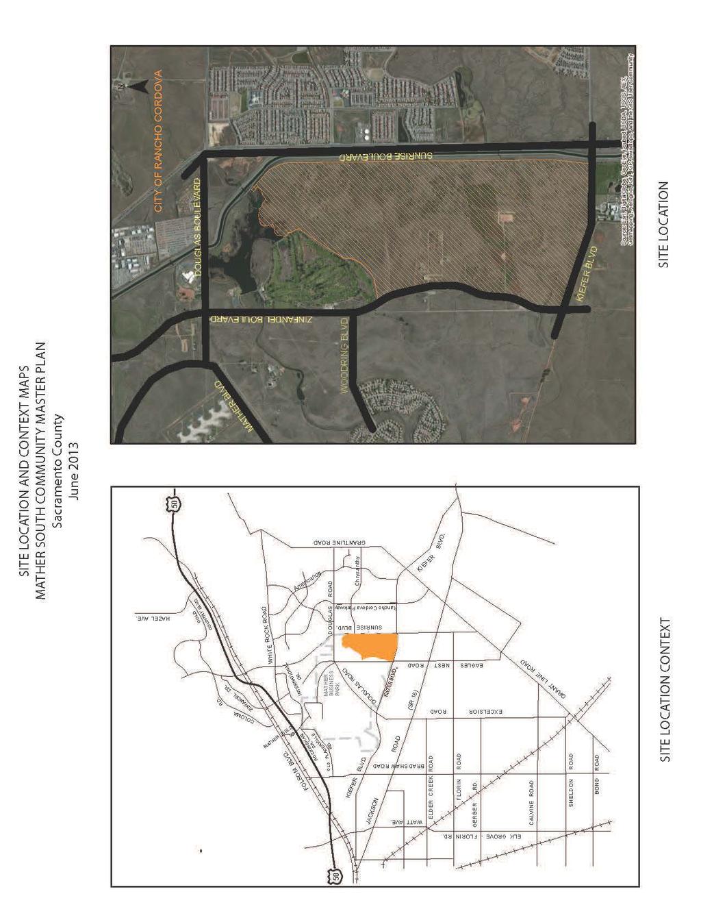
8 MATHER SOUTH COMMUNITY MASTER PLAN PROJECT DESCRIPTION September 10, 2013 Project Location The plan area consists of 885 acres south of Mather Airport between Kiefer Boulevard and Mather Lake, east of Zinfandel Drive. The east boundary is the Folsom South Canal. Project Setting The site is describable in three parts. Those parts include the eastern portion which served as a recipient area for deposition of overburden during the construction of the Folsom South Canal, the central portion which contains buildings which once were used to store ordnance and related activities; and the balance of the site which contains primarily non-native grasses and some cotton wood trees in groves. Within the grassy areas are vernal pools, swales, and seasonal wetlands. There are two large concentrations of wetlands. One occurs adjacent to Kiefer Blvd and the other is a large pool and associated wetlands just north of the southerly branch of Morrison Creek and adjacent to Zinfandel Drive. The site drains entirely to the Morrison Creek tributaries which cross or emanate from the site. The immediate upstream drainage conditions are a series of concrete bridges (chutes) over the Folsom South Canal. The streams experience ephemeral drainage. Adjacent Uses The Folsom South canal, along with a road side regional serving biking trail, runs parallel with the eastern edge of the site. Kiefer Boulevard defines the south edge of the site. To the south of Kiefer Blvd is the Sacramento Rendering Company plant and open lands currently used for agricultural related uses. The area to the west is the Mather Field Wetland Preserve. To the north are Mather Lake site and the Mather Golf Course. General Plan Designations The project site is located within the Urban Services Boundary (USB), within the Urban Policy Area (UPA) and within the Mather Field Specific Plan. The 2011 General Plan Land Use Diagram designated the site as entirely Recreation Land Use. A pending application would modify the 2011 diagram. The pending application would designate the site for three land use categories. Those categories are: Public Quasi Public for the University Site; Recreation for the proposed Sports complex site; and Urban Development Area. Zoning The site is zoned Special Planning Area (SPA). The SPA zone provides uses and regulation of uses consistent with the Mather Field Specific Plan. The site will continue to be zoned SPA 8
9 9
10 Cordova Community Plan The project site is located within the Cordova Community and designated on the Community Plan as Special Planning Area reflective of the Mather Field Specific Plan (1997). The site will continue to be designated as a Special Planning Area on the Cordova Community Plan. Entitlement Request The project represents a second step in a two step process of amendments to the current General Plan Land Use Map, the current Mather Field Specific Plan and the current Mather Field SPA Ordinance applicable to the site. The first step is intended to modify land uses with respect to the entire Mather Field Planning Area and is in process under Control Number PLNP This project, the second step, would further modify the General Plan, the Mather Field Specific Plan and the Mather Field SPA Ordinance to reflect a level of detail applicable to a Master Planning and Specific Plan effort but only as to an 885 acre portion of the 5,200 acre plus Mather Field area. The Mather South Community Master Plan proposes the following: 1. A General Plan Amendment to amend the General Plan Land Use Diagram from Urban Development Area (526 acres), Recreation (199 acres) and Public/Quasi Public (160 acres) to Low Density Residential (478 acres), Commercial and Office (69 acres), and Recreation (179 acres) and Public/Quasi Public (160 acres). The request is depicted in tabular form and illustrated, by comparison, on page Amendment of the General Plan Transportation Diagram to effect a proposed realignment of Zinfandel Drive south of Woodring Road and extended to Kiefer Blvd to conform to the westerly boundary of the Mather Wetlands Preserve. 3. Amendment of the General Plan Circulation Plan to change the post 2030 designation for construction of four lanes on Kiefer Blvd to construction pre A General Plan Amendment to amend the General Plan Bicycle Master Plan to add internal and external bicycle facilities within and through the Mather South Community Master Plan Area as shown on in the Bicycle Master Plan Amendment Diagram. 5. A Specific Plan Amendment to amend the Mather Field Specific Plan to change a portion of the South Base Area (885 + acres) from Urban Development Area (526 + acres), Recreation (33 + acres); and Commercial Recreation (326 + acres) to Mather South Community Master Plan (885+ acres). 10
11 6. Adoption of the Mather South Community Master Plan as an amendment to the Mather Field Specific Plan for the area generally south of Mather Lake and north of Kiefer Blvd including text, a Master Plan land use diagram, Design Guidelines and Development Standards. 7. A Zoning Ordinance Amendment to amend Zoning Ordinance SZC to incorporate the Mather South Community Master Plan and Related Design Guidelines and Development Standards into the ordinance. 8. Acceptance of an Affordable Housing Plan for the Mather South Community Master Plan. 9. Adoption of a Development Agreement(s) for the Mather South Community Master Plan by and between the County of Sacramento and landowners. 10. Amendment of the Mather Field Public Facilities Financing Plan. Additional permitting requirements of the project include: 1. Approval of a Water Supply Assessment by the Sacramento County Water Agency. 2. Federal Clean Water Act Section 404 Permit (U.S. Army Corps of Engineers and U.S. Environmental Protection Agency). 3. Federal Endangered Specifies Act Section 7 Consultation (U.S. Fish and Wildlife Service). 4. Section 401 Water Quality Certification (Regional Water Quality Control Board Central Valley Region). 5. Section 402 Natural Pollutants Discharge Permit (Regional Water Quality Control Board Central Valley Region). 11

12 TABULAR REPRESENATION OF GENERAL PLAN AMENDMENT REQUEST Existing General Plan Land Use Diagram (2013 Amendment) Acres Proposed General Plan Land Use Diagram Acres Urban Development Area 526 Low Density Residential 478 Recreation 199 Commercial and Office 69 Public / Quasi Public 160 Recreation 179 Public / Quasi Public 160 TOTALS 885 TOTALS

13 13
14 14

15 TABULAR REPRESENATION OF SPECIFIC PLAN AMENDMENT REQUEST Base Mather Field Specific Plan Designations (2013 Amendment) Acres Requested Mather Field Specific Plan Designations Acres Urban Development Area 547 Master Plan Community 885 Recreation 179 Public Quasi Public 160 TOTALS 885 TOTALS 885 Project Components A Specific Plan amendment prepared as the Mather South Community Master Plan, consistent with Sections through of the California Government Code, The Specific Plan 15
16 amendment will be consistent with the County s Specific Plan Ordinance (Title 21, Chapter of the County Municipal Code) and the County s Master Plan Procedures and Preparation Guide (January 14, 2012). The specific plan document will guide development of the project site and describe the regulatory framework, land use plan, land uses, development standards, and design guidelines, housing plan, circulation plan, resource management, public facilities, public services, utilities and implementation strategy. The Mather South Community Master Plan planning document will include the 885 acres immediately adjacent to Kiefer Blvd. (south); Zinfandel Drive (west); Folsom South Canal (east) and the Mather Golf Course / Mather Lake on the north. Residential The Mather South Community Master Plan proposes 3,545 residential dwelling units on approximately 379 double net acres (478 gross). The density of the project is 9.3 dwelling units per acre based on a double net density calculation. Commercial, Mixed Use and Office The Mather South Community Master Plan includes 69 acres of Commercial and Office Mixed Use which will include approximately 91,500 square feet of commercial uses, 1,086 residential units, and detention basin which may be integrated as an open space/water feature. The commercial site would accommodate neighborhood serving commercial uses including small scale grocery, drug store, personal services, cafes, and restaurants. The site is integral with development of high density residential planned adjacent to Zinfandel Drive and the Sports Complex. Open Space and Parks The plan has four types of Open Space including the natural areas along the creek corridors, water management basins, neighborhood parks, and a sports complex. Open space uses account for 256 acres and are planned by five use types: Circulation Creek Corridor Neighborhood Parks Landscape Pedestrian Corridors Sports Complex Water Management Basins Primary access to the site will be provided by Zinfandel Drive. Internal circulation is built upon the backbone roadway running north to south with three connecting roadways between Zinfandel and the north to south backbone roadway. In addition, the internal circulation may provide for the usage of neighborhood electric vehicles (NEVs) on roadways with a posted speed limit of 35 miles per hour or less. 16
17 Pedestrian circulation will be accomplished by way of the street frontage sidewalk system, with connections to the off street trails (constructed with the project) running along the south branch of Morrison Creek and to the trail along the Folsom South Canal. The Bicycle system will include Class II trails along the north to south central road, along the roads which intersect with Zinfandel Drive and along Zinfandel Drive. A Class I trail will run parallel with the eastern border of the site and will provide circulation between Kiefer Blvd and Douglas Road. Transit The General Plan Circulation Map and Sacramento Regional Transit (RT) Transit Action Plan do not indicate high volume routes along Zinfandel, Douglas Road or Kiefer Blvd. Bus/shuttle service in the Project area could connect to RT bus stops and/or the Light Rail system at the Mather/Mills, Zinfandel, Cordova Town Center or Sunrise light rail stations. Public Uses The plan also includes 27 acres of public uses to accommodate two elementary schools, a SMUD sub-station and a pair of large water storage tanks. Mather Airport The Plan has been designed to be consistent with the continued operations of the airport. The project proposes to record an avigation easement over residential development within the project and provide future homeowners with disclosures regarding airport operations, over-flights and noise exposure. Public Utilities Water: The project is within the Zone 40 service area of the Sacramento County Water Agency (SCWA). Sewer: The project is within the Sacramento Area Sewer District (SASD) and Sacramento Regional County Sanitation District (SRCSD) service area. 17
18 The Plan and the California Environmental Quality Act and County Ordinances. The project proposed will require a project level environmental review in conformity with the California Environmental Quality Act. The Mather South Community Master Plan, as an amendment to the Mather Field Specific Plan, has been prepared in conformance with the Specific Plan Ordinance, Title 21, Chapter of the County Code The Mather South Community Master Plan, as an amendment to the Mather Field Specific Plan has been prepared pursuant to the Master Plan Procedures and Preparation Guide (January 2012). LAND USE TOTALS FOR MATHER SOUTH COMMUNITY MASTER PLAN Acres Units Sq. Feet Open Space / Detention Basins East Side Trail Creek Corridor Parks Schools Sports Complex University Public Streets Landscape Corridors Neighborhood Commercial Mixed Use ,476 Residential RD RD RD RD RD RD RD RD , Totals ,545 91,476 18

19 19
20 DISCUSSION OF LU 120 GUIDELINES (PC) MATHER SOUTH COMMUNITY MASTER PLAN PC - 1 VISION FOR CONNECTION TO OTHER ADJACENT EXISTING AND POTENTIAL FUTURE DEVLEOPMENT AREAS Planning as an Extension of Existing Development 1. Connection / Historical Context. The portion of the Mather Field Specific Plan east of the extension of Zinfandel Drive has been the subject of planning efforts since The planning efforts include: The establishment of 1,894,896 square feet of office and commercial uses including offices for the County Parks Department, and a conference center. In addition, the plan identified the potential for a destination theme park, university campus and/or correctional facility. (1997) As the culmination of several years of effort to define the extent of a wetland preserve, The Board of Supervisors initiated a general plan amendment and preparation of a federal Environmental Impact Statement (EIS) to establish the preserve. The Board initiation included designation of the area east of Zinfandel beginning approximately 1,200 feet south of the Woodring Drive intersection for Commercial and Office land use. The area north of this line remained Recreation. Within the Commercial and Office designation the initiation speaks to the potential for a University subject to design review. (2006) An Environmental Impact Statement (EIS) prepared in response to the 2006 initiation further detailed the Board action and included 2,530 homes, a 273 acre sports complex including a 320,000 square foot event center and 175,000 square feet of sports fields, 8 acres of retail commercial and other support uses and a 175 acre University campus. The area affected by the proposal extended from Mather Lake South to Kiefer Blvd. (2012) The County of Sacramento and the Mather South LLC (applicant herein) entered into an amendment to a prior purchase agreement in January That amendment will prepare a plan for development of the application area to include a University site, a Sports Complex and a mixed use development. (2013) General Plan Land Use amendments and General Plan Circulation Plan amendments related to the relocation of the Zinfandel extension right of way are anticipated in late This application builds upon the 2013 amendments. (2014) 20
21 21
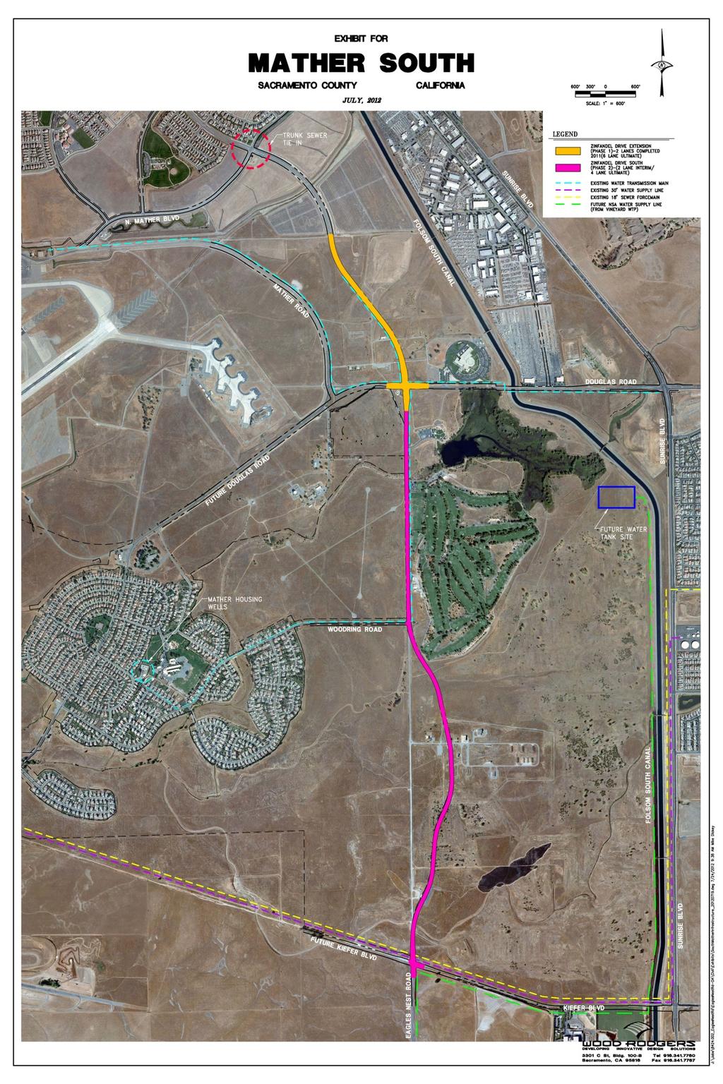
22 Planning as an Extension of Existing Development (continued) 2. Infrastructure Sanitary Sewer Extensive and detailed sanitary sewer improvement plans were prepared in 2002 and served as the basis for the Mather Field Financing Plan (2002). In intervening years, re-evaluations of the manner by which the Mather Field Planning Area will be provided sanitary sewer service have taken place. Initially, and reflected in the plan, it was anticipated that service to the site would be accomplished by extending a 12 inch line westerly to connect to the Bradshaw interceptor near Happy Lane. In part, as a result of the establishment of the Mather Natural Preserve to the west of the site, the plan has been changed to providing service by extending a line north to connect with the trunk line in Zinfandel Lane to the north. Preliminary engineering for that extension of a trunk line to serve the south of Mather Area has been completed and the environmental review for the facility is in process and scheduled for completion in late Water A detailed Water Facility Improvement plan was prepared in 2002 and served as the basis for the Mather Field Financing Plan (2002). The plan included a looping system of water transmission mains (12 to 16 diameter pipes). While much of the system remains to be constructed, the 16 main in Woodring Drive has been built. The project site is the subject of a pending Water Supply Assessment. The site is currently in the service area of several water sources. Those sources include the Mather Well Field (by way of the Woodring Drive main) as well as the 30 inch raw water line in Kiefer Blvd. This line extends from the Excelsior well field to the southwest. While the Water Supply Assessment for the plan area is pending, it is anticipated that the water transmission system will be comprised, initially, by connections to the existing 16 line in Woodring Drive and the 30 pipe in Kiefer Blvd on the south of the site. The Water Agency will also construct a water storage facility at the northeast corner of the site as part of the overall water delivery system. Ultimately, service will be provided from a large transmission main, likely 54 inches in diameter, running north to south along the easterly portion of the project site. Circulation - Zinfandel Drive will be extended to Kiefer Blvd. The extension will occur in phases defined by a project specific traffic study. Phasing will be dependent upon the location of development and the rate of development. The 2002 Mather Field Financing Plan contemplated and identified the means for funding all major arterial roads within the Mather Field Planning Area. The plan includes the Zinfandel extension. The design of streets, landscaping, medians, and widths, including those for Zinfandel Road, were established by the Mather Field Specific plan (pp 63 to 65). This plan will utilize those design standards. 22
23 Transit Service is not currently available in the vicinity of the site. However, The General Plan Circulation Map and Sacramento Regional Transit (RT) Transit Action Plan each identify Jackson Road and Sunrise Boulevard as Bus Rapid Transit (BRT)/Hi Bus routes. With the extension of Zinfandel Drive, it is anticipated that transit service would be extended to serve the Zinfandel corridor in the future. Bus/shuttle service in the Project area could connect to RT bus stops or Sacramento Light Rail system at the Mather/Mills, Zinfandel, Cordova Town Center or Sunrise light rail stations. Bus/shuttle service could be extended into the Project in looping pattern that would provide service within one quarter mile of 90% of residents. Bus/shuttle services could utilize proposed transit stops within the Project. The secure funding sources for transit will be funded by the Project through fees and assessments. The project will pay the Sacramento County Transportation Development Fee (SCTDF) and the Sacramento Countywide Transportation Mitigation (SCTMF) both of which fund roadway and transit improvements, including transit improvements on Sunrise Boulevard. Drainage Nearly 30 acres are set aside for detention/flow duration control basins. The basins will serve triple duty. In addition to limiting damaging flows in the stream bed, the basins will attenuate the runoff peaks to no more than the runoff peaks from design storms. The basins will also serve as runoff kidneys to reduce the levels of urban pollutants entering stormwater. Regional Bike Trail The Folsom South Canal regional trail runs parallel with the Mather South Community Master Plan. Access to the trail is anticipated at two points. One location will occur, at the southeast corner of the University site and a second location will occur, at the northeast corner of the site between the canal and Mather Lake. Access at both points will require coordination with the Bureau of Reclamation. 3. Natural Preservation Preserve Establishment the nearly decade long natural resource planning process has concluded with agreement between federal and local partners with respect to the establishment of a 1,272 acre natural resource preserve. The project reflects the consensus reached in the process. The easterly relocation of Zinfandel Drive has been accomplished to maximize preservation of the existing resources. Wetland Restoration An element of the preserve management plan going forward will be rehabilitation / restoration of the vernal pool, vernal swale and stream habitats within the preserve. Funding - The Mather Field Wetland Preserve is an ambitious undertaking to maintain and preserve in perpetuity the vernal pool and related wetlands over a 1,272 acre site. The funding for this effort is anticipated to come from developed lands within the Mather Specific Plan area. The proposed land uses are considered very important as the financial contributors to the effort and they thus increase the stability of that funding source. 23
24 24
25 25
26 PC - 2 Housing Choice demonstrate the variety of housing types anticipated as well as alternative contexts. The development provides for a range of housing types from executive housing to mixed use form based code environments. The northerly edge of the site occurs adjacent to the Mather Golf Course and provides an opportunity for an enclave of executive housing. In that the site is without native oaks or significant topography the landscape uniqueness of neighborhoods will be the accomplished by neighborhood design, building architecture and the introduced landscape. The range of housing contemplated for the site includes: 1. Executive housing in two gated neighborhoods adjacent to the Mather Golf Course. The two neighborhoods one comprised of homes built at 3.5 units per acre and a second at 5 per acre. The approach contemplated for each is similar to that used in the Gold River Community (a County success story) in the Promontory Point and Crocker Grove Villages. 2. Single Family Residential on small lots in configurations approximating. 3. Cluster housing in various configurations and densities ranging from 8 to 12 units per acre 4. Multiple Family housing at 28 units per acre. PC 3 Quality -- provide a quality of design by way of development standards. The Specific Plan contains over 115 significant detail statements, a detailed development standards table and supportive illustrations with respect to neighborhood design, and architectural detailing of buildings. To illustrate: Residential lots should be organized in short block layouts with a modified grid/curvilinear pattern that encourage walking, biking, and the use of alternative modes of transportation Each block elevation contains at least four different models and if necessary, up to three elevations for each floor plan. Different models are defined as those with significant variation in floor plans, configurations, heights, and massing, and minor variations in size or number of bedrooms; Variations in first-level building massing will be achieved by introducing entry porches and courtyards. Integrating higher vaulted or cathedral ceilings into the building facade at the entry can provide a transitional element that adds distinction to the front elevation; Homes should be oriented toward the street, with entry areas and major indoor activity spaces facing onto the street; 26
27 Large expanses of blank walls, garage doors, and utilities along the front areas of buildings and lots will be avoided; Lots, blocks, trails, and walkways should be organized to encourage residents to walk and enjoy the neighborhood setting and nearby amenities such as parks, open spaces, schools, and shopping; Building facades should be designed to provide visual surveillance of the public streets, public spaces, sidewalks, and open space areas from inside the buildings to promote safety and security of the public realm with eyes on the street ; The table on the following page illustrates how the mixed use zone can be formulated. 27

28 Mixed Use Standards Illustration 28
29 PC 4 ACCOMMODATE THE PERCENTAGE OF LOW AND VERY LOW INCOME RESIDENTIAL UNITS REQUIRED BY THE COUNTY HOUSING ELEMENT The General Plan guideline for this Master Plan is to set aside 33% (1,170) of all residential units as high density attached units. The 33% guideline is met by provision of a sufficient amount of land to accommodate those units. To qualify, such lands must be zoned for at least 20 units per acre. This plan provides 1,068 units on land zoned for 28 units to the acre. In addition, fortyseven (47) additional residential units are zoned within the commercial mixed use area. The total of residential units countable toward meeting the General Plan guideline is 1,115 of which a portion can be designated as low and very low income residential units. Further, the project will be required to submit and obtain approval of an affordable housing plan to further identify means by which affordable units may be constructed. PC 5 PEDESTRIAN AND TRANSIT ACCESS Sidewalks and Bicycle Routes Sidewalks and bike routes along interconnected streets with short block lengths and high intersection density. Sidewalks on all public streets (County Improvement Standards) Bike Routes will be provided along the North to South central street and on the outlet streets to Zinfandel Drive. The central street route will extend from the park adjacent to Mather Lake south to the intersection with Kiefer Blvd. Class I Pedestrian / Bicycle Paths along the stream corridor Connection to the existing regional Class I trail at two locations; one at the southeast corner of the site by way of Kiefer Blvd and the other at the point of the Folsom Canal Crossing which accommodates the creek entry into Mather Lake. Block Lengths Residential Streets will not exceed 600 feet in block face length Cul De Sacs None planned; may be permitted only within executive housing area. Basic street system is gridded Transit Access Complete sidewalk access from all homes in the project site to the street connection points with Zinfandel Drive. No pedestrian will be required to cross a street with more than two through lanes to access Zinfandel Drive 29
30 PC 6 INFRASTRUCTURE MASTER PLAN AND FINANCE PLAN The project is a portion of and is an amendment to the Mather Field Specific Plan (1997). The plan also includes a financing plan (EPS, 2002). As a result of the plan fees are collected within the planning area for a variety of improvements including road, sewer, water, drainage, fire services, and schools. The plan will require a significant update in that a portion of the funding on an ongoing basis was to come from redevelopment revenues which are no longer available. Prior to adoption of the Mather South Community Master Plan this plan will be updated. The table above is illustrative of the detail contained in the current finance plan. PC 7 SERVICES PLAN Services Plan once the plan is completed and the environmental review has begun it will be timely to prepare a cost of services plan with respect to the public services provided to the site. The plan will utilize as its baseline of service requirement the current levels of service within the unincorporated area. 30
31 PC 8 PLAN CONSISTENCY WITH ADOPTED COUNTY PLANS The project has been planned to conform to adopted County plans. While the application includes a General Plan amendment for conversion of the area designated Urban Development Area (UDA) to low density residential the amendment conforms to the intent and process determined by the UDA. General Plan Circulation Plan Zinfandel Drive 4 Lanes Kiefer Blvd. 2 Lanes Bikeway Master Plan General Plan Land Use Element Urban Development Area Amended to Development Cordova Community Plan Consistent Consistent Consistent /Adds to the plan Consistent Consistent Mather Field Specific Plan Consistent (2013) Climate Action Plan Design consistent Further illustration: General Plan UDA designation and Mather Field Specific Plan. The Urban Development Area consistency assertion arises from: the 2011 definition/purpose statement for the UDA as well as language added to the plan in The definition/purpose statement for the Urban Development area: (2011). Urban Development Area. The Urban Development Area (UDA) designation indicates where the County will conduct studies leading to the appropriate configuration of urban land uses for the area. These are areas that will be converted to urban uses to accommodate the growth that is projected to occur during the 25 year planning period. (For example) One area shown as UDA on the Diagram is the West of Watt area (between McClellan Park and Watt Avenue North). Urban development and/or rezones cannot occur in this area until a master plan has been approved and the UDA designation has been removed. (italics added) General Plan. An amendment contemplated to occur prior to Mather South Community Master Plan and Mather Field Specific plan amendment: Urban Development Area. The Urban Development Area (UDA) designation indicates where the County will conduct studies leading to the appropriate configuration of urban land uses for the area or will accept applications to prepare a Master Plan (such as a Specific Plan) for the 31
32 area. These are areas that will be converted to urban uses to accommodate the growth that is projected to occur during the 25 year planning period. For UDA areas within the Urban Policy Area (UPA) The Master Plan(s) shall conform to Land Use Policy 121. Two areas within the Urban Policy Area are currently shown as UDA on the Diagram. One area is the West of Watt area (between McClellan Park and Watt Avenue North) and the second is a portion of the Mather South Specific Plan intended to accommodate mixed use residential development (between Zinfandel Drive and the Folsom South Canal, north of Kiefer Blvd) as indicated by 2006 Board of Supervisor s initiation of a General Plan amendment for his area and reflective of the purchase and sale agreement between the County and Mather South LLC. Urban development and/or rezones cannot occur in this area until a master plan has been approved and the UDA designation has been removed. Mather Field Specific Plan. The plan currently provides for a wide range of uses of the site including offices, residential (by use permit), recreation, open space preservation, a theme park and a university. The plan will be amended prior to public review of this application to include the following language: Mather South Community Master Plan. The designation provides for development as allowed by the Mather South Community Master Plan. The Bikeway Master Plan consistency assertion arises from the inclusion of the regional trail along Folsom South Canal, just east of and not within the planning area as well as Class II trails on both Kiefer and Zinfandel Drive. The additions, though not amendments to the general plan, include the Class I trail along the stream corridor at the south of the overall site and Class II trails within the site inclusive of a trail which will extend from Kiefer Blvd on the south passing through the University site, the Sports complex and the multi-use Mather South Community Master Plan. Extensions of this trail will connect directly with the Class II trail along Zinfandel Drive. Connections to the Folsom South trail will occur at Kiefer and at a point adjacent to Mather Lake. PC 9 RELATIONSHIP BETWEEN REGIONAL PLANNING EFFORTS AND THE PROPOSED PLAN Nothing in an SCS or APS shall be interpreted as superseding or interfering with the exercise of the land use authority of cities and counties within the region Nothing in this bill requires a city or county's land use policies and regulations, including its general plan, to be consistent with the RTP or an APS. Several planning efforts cited in this policy are not inclusive of the Mather South Community Master Plan area (e.g. the Jackson Corridor Study or the Habitat Conservation Plan). However, as to regional planning: 32
33 MTP / SCS The site is designated as an established community subject to development in both the near term (through 2020) and the long term (2030). The extension of Zinfandel Drive to Jackson Highway is included in the MTP (2012) Transportation projects list (#SCA for construction 2014.) BLUEPRINT The site designation is Retail Commercial, Business Professional Office and Recreation PC 10 CONSIDERATION OF JOBS-HOUSING BALANCE The Mather South Community Master Plan is a portion of the Mather Field Specific Plan (MFSP). The MFSP includes 11,816,835 square feet of existing and planned employment land uses. Within the portion of the MFSP, the planned employment includes the Sports Complex, an Elementary School, the planned mixed use commercial area, fifty acres of retail commercial, the existing TRACON offices, the proposed University and over 2,000,000 square feet of industrial/airport support development. Conservatively the plan has the ability to accommodate in excess of 6,000 jobs within three actual driving miles of the site. With approval of the Mather South Community Master Plan the current imbalance of Jobs to houses (5:1) will be improved to a ratio of five jobs for every four dwellings for the south of Mather portion of the MFSP. There are 1,272 residential units currently within the Independence neighborhood of the plan area. Additionally, the Mather Field Specific Plan includes the County operated housing facility for those in transition out of homelessness. The plan area is also located within a five mile radius of 76,522 existing jobs. 33

34 34
35 Affordable Housing Plan Specific Plan / SPA Zoning Amendment Mather South Community Master Plan Affordable Housing Policy The County of Sacramento ( County ) adopted an Ordinance adding Chapter of Title 22 to the Sacramento County Code ( Ordinance ) on December 8, This Ordinance requires that Developers seeking Project Level Approvals for new Development Projects include or provide for an affordable housing component. Affordable Housing Plan This document constitutes the Plan for this application and is intended to provide preliminary information for the Development Project. As a Specific Plan amendment and Zoning Map Amendment application with pending discussions with respect to the details for each application, there is insufficient information at this time to describe the residential portion of the development and Affordable Housing Plan cannot be fully developed. That ability will be resolved in the process of development of the application materials. Consequently, the acceptance of this Plan is conditioned upon the Developer s providing a revised Affordable Housing Plan at the time when project level approval is sought for the residential subdivision component of this Development Project. Gross Acreage Mather South, LLC is the developer ( Developer ) of that certain real property in the County of Sacramento ( County ) in which the Developer proposes to develop and construct the Mather South Community Master Plan ( Development Project ). This proposed 885 gross acre Development Project site is located north Kiefer Blvd. along the east side of Zinfandel Drive extended and south of Mather Lake and the Mather Golf Course. The current SPA zoning will be amended to provide for additional uses and re-location of uses relative to that contained in the adopted SPA Ordinance and Mather Specific Plan. Proposed Residential Uses The proposed residential use densities, acreages and units are provided in the table at the top of the following page. 35
36 Residential Acres Units Actual Assumed Required Acres Zoning Zoning Acres RD RD RD RD RD RD RD RD30/NMU , Totals ,545 Total Land Dedication Requirement Residential Land Use Acreage and Land Dedication Requirements Table Note that acres excludes public parks, public schools, open space areas, habitat mitigation or other similar public non-residential features as defined in Section Preliminary Land Suitability Findings Pursuant to Section (A) of the Ordinance, the Developer shall construct the standard affordable housing component or dedicate land and donate additional land to comply with the affordable housing obligation if the County and SHRA have determined that there are four or more net buildable acres in the Development Project. Pursuant to Section (B), the land obligation of the Development Project is based on the formula below. Options to Meet Affordable Requirement The land suitability findings above results in a total net acreage required for dedication of four (4) or more net buildable acres and the Developer intends to dedicate suitable land and pay affordability fees subject to changes which may occur to the Ordinance and/or the calculation of the land dedication requirements later derived. Accessibility Pursuant to Section , a minimum of five percent (5%) of the affordable dwelling units (but not less than one unit) in a multifamily project constructed to meet an affordable housing obligation shall be made accessible for persons with mobility impairments. A unit that is on an accessible route and is adaptable and otherwise in compliance with the standards set forth in 24 CFR Section 8.32, or any successor statute, is accessible for purposes of this section. An additional two percent (2%) of the affordable dwelling units (but not less than one unit) in such a multifamily project shall be accessible for persons with hearing or vision impairments. In that the Development Project will include a multifamily rental, condominium, or similar housing types the accessibility requirements will apply to that portion of the overall project. 36
Department of Community Development. Planning and Environmental Review Division Revised Notice of Preparation
 Department of Community Development Michael J. Penrose, Acting Director Divisions Building Permits & Inspection Code Enforcement County Engineering Economic Development & Marketing Planning & Environmental
NEWBRIDGE SPECIFIC PLAN PROJECT DESCRIPTION SEPTEMBER 24, 2012
 PROJECT DESCRIPTION SEPTEMBER 24, 2012 Project Location The NewBridge Specific Plan project area consists of 1,095.3 acres south of Mather Airport between Kiefer Boulevard and Jackson Road, west of Sunrise
Jackson Highway Master Plans
 Jackson Highway Master Plans West Jackson Highway Master Plan (PLNP2008-00240) Jackson Township Specific Plan (PLNP2011-00095) NewBridge Specific Plan (PLNP2010-00081) Mather South Community Master Plan
COUNTY OF SACRAMENTO CALIFORNIA PLANNING COMMISSION REPORT
 COUNTY OF SACRAMENTO CALIFORNIA PLANNING COMMISSION REPORT TO: FROM: SUBJECT: COUNTY PLANNING COMMISSION DEPARTMENT OF COMMUNITY DEVELOPMENT GROWTH AREA PLANS UPDATE CONTACT: Cindy Storelli, Principal
Glenborough at Easton Land Use Master Plan
 Implementation 114 9.0 IMPLEMENTATION 9.1 OVERVIEW This chapter summarizes the administrative procedures necessary to implement the proposed land use plan, infrastructure improvements, development standards,
SPECIFIC PLAN Requirements
 CITY OF LANCASTER PLANNING DEPARTMENT 44933 Fern Avenue, Lancaster, California 93534 (661) 723-6100 SPECIFIC PLAN Requirements Purpose The purpose of a specific plan is to provide for the logical development
01 PROJECT DESCRIPTION
 01 PROJECT DESCRIPTION PROJECT LOCATION The proposed Barrett Ranch East project (the Project) site is in northern Sacramento County in the Antelope community, north of the intersection of Don Julio Boulevard
Gold Line Bus Rapid Transit Transit Oriented Development (BRTOD) Helmo Station Area Plan
 Helmo Station Area Plan") Appendix F Gold Line Bus Rapid Transit Transit Oriented Development (BRTOD) Helmo Station Area Plan Introduction and Purpose of the Plan The Gold Line Bus Rapid Transit facility is an eleven-mile dedicated
Appendix F Gold Line Bus Rapid Transit Transit Oriented Development (BRTOD) Helmo Station Area Plan Introduction and Purpose of the Plan The Gold Line Bus Rapid Transit facility is an eleven-mile dedicated
1.0 VISION STATEMENT. December 6, PRINCIPLES
 Vision Statement Lincoln Regional Airport 1.0 VISION STATEMENT 1.1 City LOCATION of AND OVERVIEW The Easton Lincoln Place Land Use Master Plan identifies the principles, goals, policies, and standards
Applicant Name Phone / Fax / Address City State Zip Code . Property Owner Phone / Fax / Address City State Zip Code
 Master Development Plan Application Community Development Department City of Redmond 411 SW 9 th Street Redmond, Oregon 97756 541-923-7721 541-548-0706 FAX Master Development Plan Fee $38,862.52 File Number
Ten Mile Creek Planning Area
 PLANNING AREA POLICIES TEN MILE CREEK Ten Mile Creek Planning Area Location and Context The Ten Mile Creek Planning Area ( Ten Mile Creek area ) is located south of the current Boise AOCI, generally south
Planning Commission Staff Report June 5, 2008
 Owner/Applicant Taylor Village Sacramento Investments Partners, LP c/o Kim Whitney 1792 Tribute Road #270 Sacramento, CA 95815 Staff Recommendation Planning Commission Staff Report Project: File: Request:
AWH REPORT OF THE PLANNING AND DEVELOPMENT DEPARTMENT FOR APPLICATION FOR REZONING ORDINANCE TO PLANNED UNIT DEVELOPMENT
 AWH REPORT OF THE PLANNING AND DEVELOPMENT DEPARTMENT FOR APPLICATION FOR REZONING ORDINANCE TO PLANNED UNIT DEVELOPMENT MAY 8, 2014 The Planning and Development Department hereby forwards to the Planning
CITY OF KEIZER MASTER PLAN APPLICATION & INFORMATION SHEET
 CITY OF KEIZER MASTER PLAN APPLICATION & INFORMATION SHEET PRE-APPLICATION CONFERENCE Prior to the actual filing of a Master Plan application, it is strongly recommended that the applicant contact Planning
COUNTY OF SACRAMENTO CALIFORNIA
 COUNTY OF SACRAMENTO CALIFORNIA For the Agenda of: December 11, 2012 Timed: 10:15 a.m. To: From: Subject: Supervisorial District: Contact: Board of Supervisors Department of Community Development PLNP2010-00081
ARTICLE 6: Special and Planned Development Districts
 ARTICLE 6: Special and Planned Development Districts 6-10 Traditional Neighborhood Development (TND) District 6-10.10 Purpose and Intent The Traditional Neighborhood Development (TND) District provides
Appendix PD-1. Mather South Community Master Plan
 Appendix PD-1 Mather South Community Master Plan DRAFT Diverse Housing Environmental Education Campus Healthy Lifestyle, Active Recreation Natural Resources In the Community Mather South Community Master
Developer s Program. The Station at East 54
 Developer s Program The Station at East 54 Existing Conditions The Station at East 54 is proposed for a 1.12 acre site at the northeast corner of Hamilton Road and Prestwick Road, tucked between the East
OP Council Resolution June 16, Planning and Development Services
 OP-08-01 Council Resolution June 16, 2008 Planning and Development Services Kingsgate Landing Outline Plan Table of Contents 1.0 Introduction 1 1.1 Purpose of Plan 1 1.2 Plan Area Location 1 1.3 Ownership
Glenborough at Easton Land Use Master Plan
 Vision Statement Sunrise Blvd. Hazel Ave. Prairie City Rd. Gencorp Property Lincoln Regional Airport 1.0 VISION STATEMENT The identifies City of the principles, goals, policies, and standards Lincoln that
8 Oak Street - Official Plan and Zoning By-law Amendment Application - Preliminary Report
 STAFF REPORT ACTION REQUIRED 8 Oak Street - Official Plan and Zoning By-law Amendment Application - Preliminary Report Date: March 17, 2014 To: From: Wards: Reference Number: Planning and Growth Management
S A C R A M E N T O C O U N T Y JACKSON HIGHWAY & GRANT LINE EAST VISIONING STUDY
 JACKSON HIGHWAY & GRANT LINE EAST S A C R A M E N T O C O U N T Y P L A N N I N G D E P A R T M E N T SUMMARY AND WORKBOOK November 19, 2008 History of the Visioning Study Sacramento County has two growth
PLANNED UNIT DEVELOPMENT & SUBDIVISION STAFF REPORT Date: May 18, 2017
 & PUD-0000102-2017 PLANNED UNIT DEVELOPMENT & SUBDIVISION STAFF REPORT Date: May 18, 2017 NAME SUBDIVISION NAME Dauphin Creek Estates Subdivision Dauphin Creek Estates Subdivision LOCATION CITY COUNCIL
REQUEST Current Zoning: O-15(CD) (office) Proposed Zoning: TOD-M(CD) (transit oriented development mixed-use, conditional)
 (office) Proposed Zoning: TOD-M(CD) (transit oriented development mixed-use, conditional)") Rezoning Petition 2016-117 Zoning Committee Recommendation January 4, 2017 REQUEST Current Zoning: O-15(CD) (office) Proposed Zoning: TOD-M(CD) (transit oriented development mixed-use, conditional) LOCATION
Rezoning Petition 2016-117 Zoning Committee Recommendation January 4, 2017 REQUEST Current Zoning: O-15(CD) (office) Proposed Zoning: TOD-M(CD) (transit oriented development mixed-use, conditional) LOCATION
SOUTH NATOMAS COMMUNITY PLAN
 SOUTH NATOMAS Community Plan Part Three : COMMUNITY PLAN AREAS AND SPECIAL STUDY AREAS SACRAMENTO 2030 GENERAL PLAN Contents Community Location... 3-SN-3 Community Vision... 3-SN-4 Community Profile...
COUNTY OF SACRAMENTO CALIFORNIA. PLNP Jackson Township Specific Plan. Workshop And Initiation of Environmental Review Process
 COUNTY OF SACRAMENTO CALIFORNIA #102 For the Agenda of: June 18, 2013 Timed: 2:00 PM To: From: Subject: Supervisorial District(s): Board of Supervisors Department of Community Development PLNP2011-00095.
Baumgarten MPUD. Exhibit 3 Evaluation Criteria
 Pursuant to LDC subsections 10.02.13 B, 10.02.08 F and Chapter 3 G. of the Administrative Code, staff s analysis and recommendation to the Planning Commission, and the Planning Commission s recommendation
2.0 AREA PLANS. Lakeside Business District. Lakeside Business District Land Use Categories:
 Lakeside Business District Lakeside Business District Land Use Categories: Campus Commercial Campus Commercial means a mixture of uses which includes corporate offices, office parks, hotels, commercial,
CONCEPT PLAN APPLICATION
 CONCEPT PLAN APPLICATION TOWN OF CHAPEL HILL Planning Department 405 Martin Luther King Jr. Blvd phone (919) 968-2728 fa (919) 969-2014 www.townofchapelhill.org Parcel Identifier Number (PIN): 9880267455
COLVER ROAD INDUSTRIAL CONCEPT PLAN
 COLVER ROAD INDUSTRIAL CONCEPT PLAN A CONCEPTUAL LAND USE AND TRANSPORTATION PLAN FOR TA-4 AN URBAN RESERVE AREA OF THE CITY TALENT City of Talent Adopted by City Council Resolution No., June, 2015 PART
A BILL FOR AN ORDINANCE TO AMEND CHAPTER 9, KAUAI COUNTY CODE 1987, RELATING TO STREET REQUIRE:MENTS FOR SUBDIVISIONS
 ORDINANCE NO. BILL NO. { vy"yj1j A BILL FOR AN ORDINANCE TO AMEND CHAPTER 9, KAUAI COUNTY CODE 1987, RELATING TO STREET REQUIRE:MENTS FOR SUBDIVISIONS BE IT ORDAINED BY THE COUNCIL OF THE COUNTY OF KAUA'I,
2.0 PROJECT DESCRIPTION
 2.0 PROJECT DESCRIPTION 2.1 PROJECT LOCATION The proposed Arboretum project (hereafter referred to as the proposed project ) is located on 1,349 acres within the Grant Line North Planning Area of the City
CHAPTER 12 IMPLEMENTATION
 CHAPTER 12 IMPLEMENTATION The 2010 Town of Denton Comprehensive Plan is intended to capture a vision of the future of Denton. As such, it provides a basis for a wide variety of public and private actions
Prepared by: Casey Kempenaar, Senior Planner
 CITY OF CITRUS HEIGHTS PLANNING DIVISION STAFF REPORT PLANNING COMMISSION MEETING September 13, 2017 Prepared by: Casey Kempenaar, Senior Planner REQUEST The applicant requests a Design Review Permit Modification
that the Town Board of the Town of East Greenbush will hold a public hearing on April 11,
 TOWN OF EAST GREENBUSH NOTICE OF PUBLIC HEARING PLEASE TAKE NOTICE that the Town Board of the Town of East Greenbush will hold a public hearing on April 11, 2018, at 5:45 p.m. at the East Greenbush Town
Natomas Vision Plan and PLNP
 Natomas Vision Plan 20030171 and PLNP2014-00172 Department of Community Development Planning and Environmental Review Leighann Moffitt Sub-Agenda 1. Staff Presentation Leighann Moffitt, County Planning
CONSENT CALENDAR CITY PLANNING COMMISSION AGENDA ITEM NO: A.1, A.2 STAFF: LARRY LARSEN
 Page 8 CONSENT CALENDAR CITY PLANNING COMMISSION AGENDA ITEM NO: A.1, A.2 STAFF: LARRY LARSEN FILE NO: CPC PUZ 14-00013 - QUASI-JUDICIAL FILE NO: CPC PUD 14-00014 QUASI-JUDICIAL PROJECT: APPLICANT: OWNER:
CITY PLANNING COMMISSION AGENDA ITEM: C STAFF: ROBERT TEGLER FILE NO: CPC PUD QUASI-JUDICIAL
 CPC AGENDA June 8, 2006 Page 37 CITY PLANNING COMMISSION AGENDA ITEM: C STAFF: ROBERT TEGLER FILE NO: CPC PUD 05-294 - QUASI-JUDICIAL PROJECT: APPLICANT: OWNER: PARKWOOD AT WOLF RANCH NASS DESIGN ASSOCIATES
Staff Report and Recommendation
 Community Planning and Development Planning Services 201 W. Colfax Ave., Dept. 205 Denver, CO 80202 p: 720.865.2915 f: 720.865.3052 www.denvergov.org/cpd TO: City Council Neighborhoods and Planning Committee
PLANNING COMMISSION. Submitted
 PLANNING COMMISSION City Hall 1275 Main Street El Centro, CA 92243 Submitted PLANNING COMMISSION ACTION ITEM (1844) Meeting: 05/10/16 12:00 AM Department: Community Development Category: Public Hearing
TOWNSHIP OF LOGAN SOIL & FILL IMPORTATION AND PLACEMENT APPLICATION SUBMITTAL CHECKLIST
 TOWNSHIP OF LOGAN SOIL & FILL IMPORTATION AND PLACEMENT APPLICATION SUBMITTAL CHECKLIST Applications: 5 copies of application - Applicant will reproduce the copies at his/her costs. The Township Clerk
Planned Development Review Revisions (Project No. PLNPCM )
") Planned Development Review Revisions (Project No. PLNPCM2014-00139) Standard residential development Planned Development Example: Smaller lot sizes than what is allowed to create open space amenity. What
Planned Development Review Revisions (Project No. PLNPCM2014-00139) Standard residential development Planned Development Example: Smaller lot sizes than what is allowed to create open space amenity. What
Dwelling Units Max 12 dwelling units per acre/min 8 dwelling units per acre. Development Mix 80% non residential/20% residential
 13. OSTEEN LOCAL PLAN Background: The Osteen Local Plan area is located in southwest Volusia County along the SR 415 corridor between Lemon Bluff Road and Acorn Lake Road and includes 3,990 acres. The
CHAPTER 7: Transportation, Mobility and Circulation
 AGLE AREA COMMUNITY Plan CHAPTER 7 CHAPTER 7: Transportation, Mobility and Circulation Transportation, Mobility and Circulation The purpose of the Transportation, Mobility and Circulation Chapter is to
City Of Sparks Planning Commission Item
 Page 1 of 12 City Of Sparks Planning Commission Item Meeting Date: May17, 2012 Subject: PCN12009, Public Hearing, Consideration and possible action on a Master Plan Amendment and Rezoning request to change
MIXED-USE VILLAGE OVERLAY FLOATING DISTRICT
 MIXED-USE VILLAGE OVERLAY FLOATING DISTRICT Zoning regulations developed by committee to the Planning Board for the Town of DeWitt, NY Issue date: 13 July 2017 revised 3/12/2018, revised 4/26/2018, 5/9/2018
RESOLUTION NO. R Refining the route, profile and stations for the Downtown Redmond Link Extension
 RESOLUTION NO. R2018-32 Refining the route, profile and stations for the Downtown Redmond Link Extension MEETING: DATE: TYPE OF ACTION: STAFF CONTACT: Capital Committee Board PROPOSED ACTION 09/13/2018
D1 September 11, 2013 Public Hearing APPLICANT:
 D1 September 11, 2013 Public Hearing APPLICANT: BEACH MUNICIPAL FEDERAL CREDIT UNION PROPERTY OWNER: SISTERS II, LLC STAFF PLANNER: Karen Prochilo REQUEST: Conditional Change of Zoning (AG-2 Agriculture
KASPER. City of Georgetown, Texas PUD Planned Unit Development. December 30, 2015 Revised January 27, 2016
 KASPER City of Georgetown, Texas PUD Planned Unit Development December 30, 2015 Revised January 27, 2016 Applicant: Sentinel Land Company, LLC 4910 Campus Drive Newport Beach, CA Prepared by: SEC Planning
PART 1: PROJECT SUMMARY. The application is Attachment A. The site plan is Attachment B.
 Belleterre Subdivision Sketch Plan Town Board 8.7.17 Belleterre Subdivision Sketch Plan PART 1: PROJECT SUMMARY Applicant: Bowman Development Project Size: +/- 20.85 acres Parcel Number: 01115104 and 01115121
The Illinois Department of Transportation and Lake County Division of Transportation. Route 173, including the Millburn Bypass
 The Illinois Department of Transportation and Lake County Division of Transportation welcome you to this Public Hearing for U.S. Route 45 from Illinois Route 132 to Illinois Route 173, including the Millburn
Mitchell Ranch South MPUD Application for Master Planned Unit Development Approval Project Narrative. Introduction
 Mitchell Ranch South MPUD Application for Master Planned Unit Development Approval Project Narrative Introduction Mitchell Ranch South is a proposed single family (detached) residential development on
CHAPTER 22 Rural Open Space Community Developments
 CHAPTER 22 Rural Open Space Community Developments Section 22.1 Description and Purpose The intent of this Chapter is to offer property owners an alternative to traditional zoning requirements for rural
Major Subdivision Sketch Plan Checklist
 This checklist provides specific requirements that are apart of the Sketch process. The entire process is described by the Huntersville Subdivision Review Process which details all the submittal and resubmittal
HAZARD MITIGATION GOALS AND OBJECTIVES
 SEWRPC Community Assistance Planning Report No. 282, 2nd Edition CITY OF MILWAUKEE ALL HAZARDS MITIGATION PLAN UPDATE Chapter IV HAZARD MITIGATION GOALS AND OBJECTIVES [NOTE: Throughout this plan update
CHARLES PUTMAN CHARLES PUTMAN AND ASSOCIATES, INC
 MEMORANDUM CHARLES PUTMAN & ASSOCIATES, INC. LAND DEVELOPMENT CONSULTANTS PLANNING ZONING PERMITTING 4722 NW Boca Raton Boulevard, Suite C-106 Boca Raton, Florida 33431 Phone: 561/994-6411 FAX: 561/994-0447
The transportation system in a community is an
 7 TRANSPORTATION The transportation system in a community is an important factor contributing to the quality of life of the residents. Without a sound transportation system to bring both goods and patrons
Drexel, Barrell & Co.
 Drexel, Barrell & Co. June 18, 2018 Engineers/Surveyors Boulder Colorado Springs Greeley 3 South 7 th Street Colorado Springs, Colorado 80905-1501 719 260-0887 719 260-8352 Fax El Paso County Planning
Right-of-Way Acquisitions and Relocations Technical Memorandum
 Right-of-Way Acquisitions and Relocations Technical Memorandum Southeast Extension Project Lincoln Station to RidgeGate Parkway Prepared for: Federal Transit Administration Prepared by: Denver Regional
EXHIBIT B PROJECT NARRATIVE POULSBO MEADOWS
 EXHIBIT B PROJECT NARRATIVE POULSBO MEADOWS Name of Project: Poulsbo Meadows; A Planned Residential Development (PRD)/Plat Applicants Name: PBH Group LLC/Byron Harris PO Box 1010 Silverdale, WA 98038 Description
13. PRELIMINARY PLAT NO MILLS FARM - Vicinity of the southeast corner of 159 th Street and Quivira Road
 13. corner of 159 th Street and Quivira Road 1. APPLICANT: HNTB Corporation is the applicant for this request. 2. REQUESTED ACTION: The applicant is requesting approval of a preliminary plat for a 383-lot
12 January 12, 2011 Public Hearing APPLICANT: TAILWIND DEVELOPMENT GROUP,LLC PROPERTY OWNER: CITY OF VIRGINIA BEACH
 12 January 12, 2011 Public Hearing APPLICANT: TAILWIND DEVELOPMENT GROUP,LLC PROPERTY OWNER: CITY OF VIRGINIA BEACH STAFF PLANNER: Faith Christie REQUEST: Conditional Change of Zoning (from PD-H1 Planned
LU Encourage schools, institutions, and other community facilities that serve rural residents to locate in neighboring cities and towns.
 Application No. 891627: Comprehensive Plan Text Amendment - Rural School Policies - Amend policies consistent with State Legislation allowing schools in the rural area and extension of sewer service to
14 October 10, 2012 Public Hearing APPLICANT: MPB, INC
 14 October 10, 2012 Public Hearing APPLICANT: MPB, INC PROPERTY OWNER: MUNDEN & ASSOCIATES, LP STAFF PLANNER: Karen Prochilo REQUEST: Conditional Change of Zoning (AG-1 & AG-2 to Conditional O-2) ADDRESS
CHAPTER 2 SUMMARY 1. PROJECT SUMMARY DATA
 CHAPTER 2 SUMMARY This is an Initial Study format used to determine, pursuant to CEQA Guidelines Section 15177, whether a project 1) is within the scope of a Master EIR (MEIR), 2) may result in additional
Asbury Chapel Subdivision Sketch Plan
 Asbury Chapel Subdivision Sketch Plan PART 1: PROJECT SUMMARY Applicant: NVR Inc. Project Size: +/- 76.13 acres Parcel Numbers: 02101112,02116101,02116112, 02116113 Current Zoning: Transitional Residential
PLANNED UNIT DEVELOPMENT Date: April 5, 2018
 PLANNED UNIT DEVELOPMENT Date: April 5, 2018 DEVELOPMENT NAME SUBDIVISION NAME LOCATION Robert Myers Robert Myers 2955 and 2989 Dauphin Street (Southeast corner of Dauphin Street and Sage Avenue) CITY
S o u t h C e n t r a l O u t l i n e P l a n. Leduc Business Park. North Leduc Industrial Area Structure Plan C it y of Led u c.
 Leduc Business Park North Leduc Industrial Area Structure Plan C it y of Led u c Prepared for Farm Air Properties Inc. January, 2007 Table of Contents Page Number 1.0 Purpose of Plan and Definition of
SECTION 39. Title V, Chapter 6, Article 2, added to the Zoning Code of Sacramento County shall read as follows: GREENBACK LANE SPECIAL PLANNING AREA
 SECTION 39. Title V, Chapter 6, Article 2, added to the Zoning Code of Sacramento County shall read as follows: GREENBACK LANE SPECIAL PLANNING AREA 506-20. INTENT. It is the intent of the Board of Supervisors
City of Fort Lupton Administrative Site Plan Process
 City of Fort Lupton Administrative Site Plan Process Purpose The Site Plan process is meant to promote orderly and sound development standards as they apply to the City. These site development standards
Easton. Smart Growth Through Innovation. Easton
 Hazel Ave. Sunrise Blvd. Prairie City Rd. Smart Growth Through Innovation offers a unique opportunity to meet the region s future need for jobs and housing. It embodies smart growth principles advocated
McDonald s Restaurant - Purcellville Town of Purcellville Special Use Permit Statement of Justification July 24, 2014
 Introduction / Written Statement McDonald s Restaurant - Purcellville McDonald s Corporation is proposing to redevelop the existing McDonald s eating establishment with a drive-through located at 121 N
Parks, Trails, and Open space Element
 Parks, Trails, and Open space Element Parks, Trails, and Open Space element Parks, Recreation, and Open Space are important components of the quality of life desired by the residents of Elk Grove. This
BROOKHILL NEIGHBORHOOD MODEL ZONING MAP AMENDMENT PREFACE TO APPLICATION
 BROOKHILL NEIGHBORHOOD MODEL ZONING MAP AMENDMENT PREFACE TO APPLICATION June 15, 2015 Revised: August 1, 2016 I. VISION Brookhill is a proposed community based upon the principles of Albemarle County
SHEFFIELD PARK Paulding County, GA DRI #588
 SHEFFIELD PARK Paulding County, GA DRI #588 Supplemental Information for RDC s DRI (Form 2) Review August 16, 2004 Prepared for: Mr. David Howerin Coosa Valley RDC 1 Jackson Hill Drive Rome, GA 30161 P.O.
Ridgefield and the Growth Management Act
 1 2 Ridgefield and the Growth Management Act 3 Why Do We Plan History of Planning in Ridgefield Washington experiences rapid growth in the late 1980 s that began to change the perceived quality of life.
STAFF REPORT TO THE CITY COUNCIL. Conduct Public Hearing to vacate certain public right of way adjacent to Sycamore Avenue and San Pablo Avenue
 STAFF REPORT TO THE CITY COUNCIL DATE: Adjourned Regular Meeting of December 16, 2014 TO: SUBMITTED BY: SUBJECT: Mayor and Members of the City Council Holly Smyth, Planning Director Conduct Public Hearing
East Corridor Final Environmental Impact Statement
 East Corridor Final Environmental Impact Statement Alternatives Considered Operating Plan The requirements for opening day operations versus year 2030 are based on ridership and operations. Opening day
LAND USE AMENDMENT CORNERSTONE (WARD 3) 60 STREET NE AND COUNTRY HILLS BOULEVARD NE MAP 26NE BYLAW 22D2017
 60 STREET NE AND COUNTRY HILLS BOULEVARD NE MAP 26NE BYLAW 22D2017") Page 1 of 14 EXECUTIVE SUMMARY This Land Use Amendment application covers an area of 43.76 hectares ± (108.14 acres ±) located in northeast Calgary, bound by Country Hills Boulevard NE to the south and
Page 1 of 14 EXECUTIVE SUMMARY This Land Use Amendment application covers an area of 43.76 hectares ± (108.14 acres ±) located in northeast Calgary, bound by Country Hills Boulevard NE to the south and
Town of Portola Valley General Plan. Nathhorst Triangle Area Plan
 Town of Portola Valley General Plan Amended December 10, 1997 Table of Contents Introduction... 1 Planning Area... 1 Objectives... 2 Principles... 2 Standards... 4 Description... 4 Community Commercial...
Drexel, Barrell & Co.
 Drexel, Barrell & Co. December 21, 2018 Engineers/Surveyors Boulder Colorado Springs Greeley 3 South 7 th Street Colorado Springs, Colorado 80905-1501 719 260-0887 719 260-8352 Fax El Paso County Planning
FORMER CANADIAN FORCES BASE (CFB) ROCKCLIFFE SECONDARY PLAN. Official Plan Amendment XX to the Official Plan for the City of Ottawa
 ROCKCLIFFE SECONDARY PLAN. Official Plan Amendment XX to the Official Plan for the City of Ottawa") FORMER CANADIAN FORCES BASE (CFB) ROCKCLIFFE SECONDARY PLAN Official Plan Amendment XX to the Official Plan for the City of Ottawa 1 INDEX THE STATEMENT OF COMPONENTS PART A THE PREAMBLE PAGE Purpose...
FORMER CANADIAN FORCES BASE (CFB) ROCKCLIFFE SECONDARY PLAN Official Plan Amendment XX to the Official Plan for the City of Ottawa 1 INDEX THE STATEMENT OF COMPONENTS PART A THE PREAMBLE PAGE Purpose...
City of Redmond. Urban Holding Area Master Planning Requirements and Approval Process
 City of Redmond Urban Holding Area Master Planning Requirements and Approval Process June 21, 2006 City of Redmond: Urban Holding Area Master Planning Requirements and Approval Process Table of Contents
Chesapeake Bay Critical Area Conservation Plan
 The Maryland-National Capital Park and Planning Commission Prince George s County Planning Department Development Review Division 301-952-3530 Note: Staff reports can be accessed at www.mncppc.org/pgco/planning/plan.htm.
A. WHAT IS A GENERAL PLAN?
 I. Introduction A. WHAT IS A GENERAL PLAN? A general plan is the planning guideline for the future of a city. It contains goals and policies which regulate urban development, the protection of the natural
CITY OF ZEELAND PLANNING COMMISSION
 APPLICATION FOR SITE PLAN REVIEW AND SPECIAL LAND USE Date City Official App. Filing Fee Rec'd ($350) NOTE TO APPLICANT: Please submit this application for Site Plan Review along with twenty (20) copies
EXHIBIT A. Tax Increment Reinvestment Zone No. 1 (Town Center) First Amended Project Plan 1
 First Amended Project Plan 1") EXHIBIT A Tax Increment Reinvestment Zone No. 1 (Town Center) First Amended Project Plan 1 1 As amended by Resolution No. 2008-02-001(TR1R) of the Tax Increment Reinvestment Zone No.1, and approved to
EXHIBIT A Tax Increment Reinvestment Zone No. 1 (Town Center) First Amended Project Plan 1 1 As amended by Resolution No. 2008-02-001(TR1R) of the Tax Increment Reinvestment Zone No.1, and approved to
Urban Planning and Land Use
 Urban Planning and Land Use 701 North 7 th Street, Room 423 Phone: (913) 573-5750 Kansas City, Kansas 66101 Fax: (913) 573-5796 Email: planninginfo@wycokck.org www.wycokck.org/planning To: From: City Planning
Planning Commission April 4, 2013 BOCC Workshop Page 1
 Planning Commission April 4, 2013 BOCC Workshop Page 1 Planning Commission April 4, 2013 BOCC Workshop Page 2 Planning Commission April 4, 2013 BOCC Workshop Page 3 Planning Commission April 4, 2013 BOCC
Watertown City Council
 City of Watertown Watertown City Council April 14 th, 2015 Agenda Item: City Comment on Sun Share CUP Application Request for Action: Motion to Approve City Comments regarding CUP Application Department:
2.7 ac park. TOTAL 5,403 DU 1,297,900 sf 1,105,450 sf 3.87 ac 5,563 DU 1,121,200 sf 1,105,450 sf 3.87 ac
 PLAN AMENDMENT 2013-I-B1: SEVEN CORNERS SPECIAL STUDY Summary of Pre-staffing Comments Planner: Bernard Suchicital bsuchi@fairfaxcounty.gov (703) 324-1254 Background On October 29, 2013, the Board of Supervisors
F. The following uses in the HR District: attached single-family dwellings, condominiums, and institutional uses; and
 1102 DESIGN REVIEW 1102.01 PURPOSE AND APPLICABILITY Section 1102 is adopted to provide standards, criteria, and procedures under which design review may be approved. Design review is required for: A.
9 CITY OF VAUGHAN OFFICIAL PLAN AMENDMENT NO BOCA EAST INVESTMENTS LIMITED
 9 CITY OF VAUGHAN OFFICIAL PLAN AMENDMENT NO. 631 - BOCA EAST INVESTMENTS LIMITED The Planning and Economic Development Committee recommends the adoption of the recommendations contained in the following
ALBEMARLE COUNTY CODE CHAPTER 18 ZONING SECTION 20A NEIGHBORHOOD MODEL - NMD
 CHAPTER 18 ZONING SECTION 20A NEIGHBORHOOD MODEL - NMD Sections: 20A.1 PURPOSE AND INTENT 20A.2 STATUS AS A PLANNED DEVELOPMENT DISTRICT 20A.5 CODES OF DEVELOPMENT 20A.6 PERMITTED USES 20A.7 RESIDENTIAL
Description of Preferred Alternative
 Chapter 2 Description of Preferred Alternative 2.1 Introduction This chapter of the programmatic Sammamish Town Center Sub-area Plan Final EIS provides a more detailed description of the Preferred Alternative
CHAPTER 7: VISION AND ACTION STATEMENTS. Noble 2025 Vision Statement
 CHAPTER 7: VISION AND ACTION STATEMENTS This chapter presents the vision, policy and action statements that transform the comprehensive planning study, an analysis of Noble s past, future trends and community
City of Grande Prairie Development Services Department
 City of Grande Prairie Development Services Department ROYAL OAKS NORTH OUTLINE PLAN OP-07-03 NW 35-71-6 W6M May 7, 2007 Royal Oaks North Outline Plan TABLE OF CONTENTS 1.0 INTRODUCTION........ 3 1.1 Purpose
Westwood Shopping Center Sketch Plan, Plan # February 23, 2017 Item # 9
 Westwood Shopping Center Sketch Plan, Plan # 320170010 February 23, 2017 Item # 9 Westwood II Site 64,111 s.f. Manor Care site: vacant two story building HOC-Westwood Towers, 15 story tower To be considered
12 Intergovernmental Coordination
 Intergovernmental Coordination Supporting Data The purpose of the Intergovernmental Coordination Element is to identify and resolve incompatible goals, objectives, policies and development proposed in
Glenborough at Easton Land Use Master Plan
 Land Use Framework November 30, 2007 2.0 LAND USE FRAME- WORK 2.1 LAND USE HISTORY and Setting Glenborough at Easton is located on property that was used for mining in the 19th and 20th centuries and rocket