COUNTY OF SACRAMENTO CALIFORNIA
|
|
|
- Claud Barnett
- 5 years ago
- Views:
Transcription
1 COUNTY OF SACRAMENTO CALIFORNIA For the Agenda of: December 11, 2012 Timed: 10:15 a.m. To: From: Subject: Supervisorial District: Contact: Board of Supervisors Department of Community Development PLNP NewBridge Specific Plan. Workshop Prior To Initiation Of Environmental Review Process Nottoli Jessica Brandt, Planner III, , Overview The purpose of this workshop is to provide the Board of Supervisors (Board) with an update on the NewBridge Specific Plan application (NewBridge) prior to initiation of the environmental review process. Staff will also provide a summary of comments received at the County Planning Commission (Commission) workshop held October 22, 2012 (Attachment 1 and Attachment 2), the Cordova CPAC meeting held September 20, 2012 and the Vineyard CPAC meeting held October 2, Recommendation Review draft application and provide comments as necessary. environmental review process. Direct staff to begin the Measures/Evaluation Processing of this Specific Plan is pursuant to the 2030 General Plan and Master Plan Guidelines. Project approval will ultimately allow for urban development with housing, commercial, and open space uses and provide for employment opportunities, as indicated in the General Plan. Fiscal Impact Application costs will be borne by the applicant. BACKGROUND On November 9, 2011, the Board of Supervisors adopted the 2030 Sacramento County General Plan (General Plan). The General Plan includes a new policy framework for acceptance and approval of private applications to expand the Urban Policy Area (UPA) and create a master plan for the area. On January 24, 2012, the Board adopted Master Plan Guidelines (Guidelines) to assist applicants and staff in processing these master plans. The Guidelines break the process into four (4) phases; at each phase, there is a check-in with the appropriate CPAC, the Planning Commission and the Board to ensure adequate outreach to the public and hearing bodies.
2 PLNP NewBridge Specific Plan. Workshop Prior To Initiation Of Environmental Review Process Page 2 The NewBridge Specific Plan (NewBridge) is in Phase 3 of the process (Master Plan Preparation Phase). Board check-in is a requirement during this phase and occurs prior to initiation of the environmental review. The application for the Plan was accepted and initiated by the Board on February 7, Prior to that date, an informational item was scheduled at both the Cordova and Vineyard CPACs to review the proposed application. NewBridge encompasses 1,095 acres, consisting of 853 acres owned by East Sacramento Ranch (ESR), 132 acres owned by Triangle Rock/Vulcan Minerals, and 110 acres clustered in the southwest corner of the Specific Plan area owned by a number of individuals. The northeastern portion of the property contains the Sacramento Rendering Company facility on approximately sixty acres. The remaining project area is rangeland with a cluster of smaller agricultural-residential properties in the vicinity of Jackson Highway. An entitlement requesting adoption of a Specific Plan was mistakenly left off of the entitlement list included with the Planning Commission staff report. A corrected version is included with this report as Attachment 3. DISCUSSION The applicant presented the proposed project to the Cordova CPAC on September 20, 2012 and the Vineyard CPAC on October 2, Minutes from both CPAC meetings are included with this report as Attachment 4. A comment letter from a Vineyard community resident is included in this report as Attachment 5. Both CPACs and community members in attendance asked a number of questions about the following: the master planning process and proposed timeline; the entitlements being requested via this application; the timing of potential development in the area; and what studies would need to be conducted to address key issues such as water, sewer and transportation. Members of the public in both communities also expressed concern about potentially being required to connect to public water and sewer facilities. Planning and Environmental Review staff provided two key pieces of information to the CPACs and members of the public regarding these concerns: The Sacramento Area Sewer District (SASD) recently adopted new rules for septic system repair permits. Under this new approach, if sewer is considered not available, a septic system repair permit may be approved and a homeowner exempted from connection to a public sewer system if the County s Environmental Management Department (EMD) has determined a repair would adequately protect public health and the environment. A flyer providing further detail on this new policy, including the new definition of not available, is included as Attachment 6. The Sacramento County Water Agency (Agency) currently has no policy requiring property owners that have an operating well providing domestic water service to their property to connect to the Agency s water system once that service becomes available. Planning and Environmental Review staff presented the project to the Planning Commission as a workshop item on October 22, The attached Planning Commission staff report summarizes the proposed project and discusses the initial review of the consistency of the project with General Plan Land Use Element Policy LU-120. Commissioners asked the applicant to further discuss plans
3 PLNP NewBridge Specific Plan. Workshop Prior To Initiation Of Environmental Review Process Page 3 for relocation of the rendering facility. They also recommended a coordinated review effort for all current master plan applications within the Jackson Highway corridor. Planning and Environmental Review staff will conduct a coordinated review effort through the Master Plan Technical Advisory Committee, which will be an instrumental tool for facilitating an efficient and effective review of master plan applications in the County s new growth areas. As part of the environmental review process, the County will require a joint traffic impact study to analyze the traffic impacts of the four projects within the Jackson Highway corridor. Each project will also require a Water Supply Assessment pursuant to California Water Code. One member of the public commented that the infrastructure financing plans related to the project should be well integrated into existing financing plans for already approved projects in the Vineyard community. The member of the public also commented that the requirements for sewer and water hookups for property owners in the Vineyard community should be reviewed. Additional CPAC meetings will be held throughout the process to provide updates to the community and to allow the community members to provide on-going feedback. MEASURES/EVALUATION Processing of this Specific Plan is pursuant to the 2030 General Plan and Guidelines. Project approval will ultimately allow for urban development with housing, commercial, and open space uses and provide for employment opportunities, as indicated in the General Plan. FINANCIAL ANALYSIS Application costs will be borne by the applicant. Respectfully submitted, LORI A. MOSS Director, Community Development APPROVED: BRADLEY J. HUDSON County Executive By: ROBERT B. LEONARD Chief Deputy County Executive Attachments 1 Planning Commission Transmittal 2 Planning Commission Staff Report and Attachments 3 Revised (Corrected) Entitlement List 4 CPAC Meeting Minutes - September 20, 2012 Cordova CPAC and October 2, 2012 Vineyard CPAC 5 Comment letter from Sherry Rondoni, resident of the Vineyard Community 6 Sewer Policy Flyer
4
5 COUNTY OF SACRAMENTO CALIFORNIA PLANNING COMMISSION REPORT TO: FROM: SUBJECT: COUNTY PLANNING COMMISSION DEPARTMENT OF COMMUNITY DEVELOPMENT PLNP NewBridge Specific Plan. Return with Revised NewBridge Specific Plan Project and Initiation of Environmental Review Process. CONTACT: Jessica Brandt, Planner III, , Overview The purpose of this update is to inform the Planning Commission (Commission) about the status of the NewBridge Specific Plan (NewBridge) prior to initiation of the environmental review process through release of a Notice of Preparation (NOP) pursuant to CEQA statute. As part of the General Plan update, policies were added to the Land Use Element that require any expansion of the UPA to be accompanied by a request for a master plan consistent with policies in the General Plan. Master Plan Guidelines (Guidelines) were also adopted to assist applicants and staff in processing these master plans. The Guidelines break the process into four (4) steps and as the project moves between steps, there is a check-in process with both the Commission and the Board. Today s workshop is intended as a check-in with the Commission prior to initiation of the environmental review process. Recommendation Staff will forward comments from the Planning Commission on the project to the Board of Supervisors. Measures/Evaluation Processing of this Specific Plan is pursuant to the 2030 General Plan and Guidelines. Project approval will ultimately allow for urban development with housing, commercial, employment, and open space uses. Fiscal Impact Costs related to this application are borne by the applicant.
6 NEWBRIDGE NOP INITIATION I. BACKGROUND On November 9, 2011, the Board of Supervisors adopted the 2030 Sacramento County General Plan (General Plan). The General Plan includes a new policy framework for acceptance and approval of private applications to expand the Urban Policy Area (UPA) and create a master plan for the area. On January 24, 2012, the Board adopted Guidelines to assist applicants and staff in processing these master plans. The Guidelines break the process into four (4) steps; at each step, there is a check-in with the appropriate CPAC, the Planning Commission and the Board to ensure adequate outreach to the public and hearing bodies. The NewBridge Specific Plan (NewBridge) application was accepted and initiated by the Board on February 7, Prior to that date, an informational item was scheduled at both the Cordova and Vineyard CPACs. NewBridge encompasses 1,095 acres, consisting of 853 acres owned by East Sacramento Ranch (ESR), 132 acres owned by Triangle Rock/Vulcan Minerals, and 110 acres clustered in the southwest corner of the Specific Plan area owned by a number of individuals. The northeastern portion of the property contains the Sacramento Rendering Company facility on approximately sixty acres. The remaining project area is rangeland with a cluster of smaller agricultural-residential properties in the vicinity of Jackson Highway. Pending master plan areas within the City of Rancho Cordova are located across Sunrise Boulevard to the east, and the Mather Field Specific Plan area is located adjacent to the project site to the north. A Project Description Packet with more information and diagrams provided by the applicant is provided as Attachment A. The application includes requests for General Plan Amendments to move the Urban Policy Area (UPA) boundary and amend the Land Use Diagram, Transportation Diagram and Bikeway Master Plan; a Community Plan Amendment to create a Specific Plan Area; adoption of a Development Agreement; approval of an Affordable Housing Plan, and; adoption of a Public Facilities Financing Plan. A full description of the proposed entitlements can be found in Attachment B. II. DISCUSSION A. NewBridge Specific Plan: At the NewBridge Specific Plan initiation hearing in February 2012, the Board accepted the application and directed staff to return to the Commission and the Board to discuss this project in greater detail prior to the issuance of the Notice of Preparation (NOP) by the Department of Community Development. The NewBridge application is now at a point that the environmental review process can begin. A detailed land use and circulation plan has been developed for the area bounded by Kiefer Boulevard to the north, Sunrise Boulevard to the east, Jackson Highway to the south, and Zinfandel Drive to the west. A Project Description Packet with more information and diagram provided by the applicant is included as Attachment A. JCB srnewbridgenopinitiation 2
7 NEWBRIDGE NOP INITIATION Should this Specific Plan application be approved, at least one additional round of entitlements will be necessary to rezone and subdivide the project as contemplated by the Land Use Plan. B. Agricultural-Residential parcels in southwest area of proposed project boundary: During the initiation hearings, the exact boundary of the master plan on the western side was noted as an issue to be resolved in coming months prior to the start of the environmental review. This area contains parcels that were originally not part of either the Jackson Township or NewBridge pre-application processes. Since the initiation in February, staff has held three meetings with the affected property owners and resolved the issue by including all of the parcels into one of the two master plans. The applicant integrated these additional properties by including them in the request for an expansion of the UPA and to amend the Vineyard Community Area Plan to change all properties within the NewBridge Specific Plan to a Specific Plan Area designation. The land use plan for the western properties will not show future land uses. Although the land use map being processed via this application will reflect existing land uses in this western area, the technical studies will assume the potential for 6 units per gross acre to ensure infrastructure for the area is right sized for eventual build out after a future master planning effort for that western area is conducted. Inclusion of the independent properties in this way provides a number of benefits to the land owners while protecting them from unintended consequences that could result from changes to their allowed uses and zone. Should NewBridge be approved, the independent properties would be within the Urban Policy Area boundary and have been included in initial infrastructure and service planning for the area. In addition, they would be part of the environmental analysis relating to projects impacts. All of these actions serve to make future applications for changes to their General Plan land use designations and ultimately, for development, more streamlined, while protecting them from premature land planning that may impact their existing activities or trigger a change in taxation. C. Environmental Review Process: The application materials have been deemed complete to initiate the NOP for the Environmental Impact Report (EIR). However, a number of documents and studies will either need to be completed by the applicant or by the County, with information provided by the applicant, before the EIR review can be completed. A table outlining the anticipated EIR data needs is included as Attachment C. The environmental review process is expected to take approximately one year to complete and will include additional public review and comment as required by CEQA. D. Public Outreach: Since the formal application initiation by the Board of Supervisors in February 2012, the applicant has met three times with the affected landowners in the western portion of the project site. These meetings were focused on discussing the proposed project s JCB srnewbridgenopinitiation 3
8 NEWBRIDGE NOP INITIATION boundaries, how these independent properties would be integrated into the application, and expected timelines for processing. The applicant also presented the proposed project to the Cordova CPAC on September 20, The Cordova CPAC and community members in attendance asked a number of questions about: the master planning process and proposed timeline; the entitlements being requested via this application; the timing of potential development in the area, and; what studies would need to be conducted to address key issues such as water, sewer and transportation. Some residents in the area also expressed concern about potentially being required to connect to public water and sewer facilities. The applicant is scheduled to present the proposed project to the Vineyard CPAC on October 2, Planning and Environmental Review staff will provide an update regarding that meeting to the Planning Commission at the project hearing. E. Preliminary Review of Project Consistency with General Plan Policy LU-120: The materials submitted by the applicant include a draft land use plan and an analysis of the project s compliance with the requirements of General Plan Policy LU-120 under the Criteria-Based performance metric-alternative #1 (see Attachment D). The applicant is still preparing the text of the specific plan that will contain the policies and performance criteria for ultimate development of the master plan. The project contemplated by the applicant contains a broad spectrum of uses including commercial and mixed uses, recreational uses, schools, parks, and a diverse range of housing types from suburban type residential neighborhoods to medium density multiple family communities. The criteria in LU-120 also look at community design aspects that ensure that the master plan area will have features that promote walkable, pedestrianoriented neighborhoods that ensure accessibility to the community amenities and transit. Planning and Environmental Review staff have reviewed the analysis provided by the applicant and have made a preliminary determination that the project appears to comply with the criteria of LU-120. Therefore, Planning and Environmental Review staff is recommending that the project continue to the next step in the project review process: issue the NOP and begin the environmental review process. Staff will do a full analysis of the project s conformance with the criteria of LU-120 and all other relevant land use policies, plans, and codes during the subsequent planning review process. F. Conclusion: Planning and Environmental Review staff has reviewed the applicant s analysis and have made a preliminary determination that the project has the ability to comply with the criteria of LU-120. Additionally, the applicant has provided and/or will be able to provide all necessary technical studies needed for the environmental analysis. Therefore, Community Development staff is recommending that NewBridge continue to the next step in the project review process: issue the NOP and begin the environmental review. Staff will do a full analysis of the project s conformance with the criteria of LU-120 and all other relevant land use policies, plans, and codes during the subsequent review process. JCB srnewbridgenopinitiation 4
9 NEWBRIDGE NOP INITIATION III. ATTACHMENTS A. Applicant Prepared Project Description Packet B. Entitlement Requests C. Anticipated EIR Data Needs Table D. Applicant Prepared Analysis- Project Conformance with LU-120 This staff report was prepared on October 2, JCB srnewbridgenopinitiation 5
10 Attachment A - Page 1 of 25 NEWBRIDGE SPECIFIC PLAN PROJECT DESCRIPTION SEPTEMBER 24, 2012 Project Location The NewBridge Specific Plan project area consists of 1,095.3 acres south of Mather Airport between Kiefer Boulevard and Jackson Road, west of Sunrise Boulevard. The west boundary of the project area is approximately 2,000 feet west of Eagles Nest Road (future Zinfandel Drive), as shown on Figure 1. Within the NSP, East Sacramento Ranch, LLC, owns approximately 806 acres, Vulcan Materials Company/Triangle Rock Products owns approximately 117 acres, the United States (Bureau of Reclamation Folsom South Canal) owns approximately 60 acres and 110 acres west of Eagles Nest Road/Zinfandel Drive consist of small parcels owned by a variety of owners. Project Setting The northeastern portion of the property contains the Sacramento Rendering Company facility on approximately sixty acres. The facility includes several structures, settling ponds, paved parking areas, concrete flatwork and landscaping. Sacramento Rendering Company has operated the rendering plant at this location since The rendering plant operation is accessed from Kiefer Boulevard. Figure 2 is an aerial photo of the project site. West of Eagles Nest Road and south of Kiefer Boulevard there is a 188+ acre undeveloped parcel. South of the undeveloped parcel and north of Jackson Road there is a 110 acre of rural uses including agriculturalresidential home sites, a Muslim cemetery and a pet cemetery. These uses are accessed from Eagles Nest Road. High voltage electrical lines traverse the northern portion of the site in a northeast to southwest direction. The Folsom South Canal and parallel bike trail are located adjacent to Sunrise Boulevard along the eastern edge of the site. Sacramento Municipal Utility District (SMUD) has a small electric facility in the southeast corner of the site adjacent to the Folsom South Canal. The property is located in the gently rolling to almost flat portions of the southern and eastern Sacramento Valley at elevations between 126 and 150 feet above sea level. Most of the project site contains nonnative annual grassland. Vernal pools, swales, and seasonal wetlands occur in the annual grassland that covers much of the property and are concentrated in the north and northwest portions of the site. Seasonal wetlands that do not function as either pools or swales also occur on the site. The site contains approximately 8.61 and acres of wetland features, west and east of Eagles Nest Road, respectively. Aside from landscaping around the rendering plant, very little woody vegetation occurs on the property. A row of eucalyptus trees was planted along Kiefer Boulevard as a screen to the rendering plant. Small clusters of walnut and locust trees grow in scattered locations. No woody species are present adjacent to the tributary or Frye Creek drainage.


11 Attachment A - Page 2 of 25 NEWBRIDGE SPECIFIC PLAN Figure 1: Project Location Project Description 2 PLNP

12 Attachment A - Page 3 of 25 NEWBRIDGE SPECIFIC PLAN Figure 2: Aerial Photo with NewBridge Specific Plan Boundary Project Description 3 PLNP
13 Attachment A - Page 4 of 25 NEWBRIDGE SPECIFIC PLAN The eastern portion of the site drains directly into Laguna Creek east of Sunrise Boulevard. The northwest corner drains into Morrison Creek tributary. The portion of the property along Eagles Nest Road drains to a tributary of Elder Creek, which is a tributary of Morrison Creek. Most of the central portion of the site is drained by the Frye Creek drainage. On site, the Frye Creek drainage and a tributary to Morrison Creek both carry winter/spring flows and are dry in the summer and neither supports riparian vegetation. The Frye Creek drainage flows through a culvert under Eagles Nest Road and is tributary to Laguna. Vernal pools, swales and seasonal wetlands are scattered throughout the site with a concentration in the northwestern portion of the site. Adjacent Uses Kiefer Boulevard is located at the northern edge of the site. North of Kiefer Boulevard is the Mather Airport, Mather preserve and the Mather South community proposed for a mixed use residential development including a university site. Lands east of Sunrise Boulevard are within the City of Rancho Cordova and include urban uses within the Sunrise Douglas Community Plan (Anatolia, Sunridge) and the proposed Arboretum and Suncreek Specific Plans. The Jackson Township Master Plan is proposed west of the project site, between Kiefer Boulevard and Jackson Road. South of the project, south of Jackson Road, Triangle Rock operates an aggregate mining operation. General Plan Designations The project site is located within the Urban Services Boundary (USB) and outside the Urban Policy Area (UPA). The project is coterminous with the existing UPA boundary on Kiefer Boulevard and Sunrise Boulevard. The General Plan Land Use Diagram designates the site as Extensive Industrial, General Agriculture (20 acres) and Recreation. Resource Conservation Area and Aggregate Resource Area combining zones are designated in the southern portion of the site. Zoning The northern portion of the site is zoned Light Industrial (M 1) and Heavy Industrial (M 2) and the southern portion of the site is zoned Agriculture (AG 20, AG 80, AG 160). The Folsom South Canal is zoned Recreation (O). Existing zoning is shown on Figure 3. Vineyard Community Plan The project site is located within the Vineyard Community and designated on the Community Plan as Permanent Agricultural (AG 160), Permanent Agriculture (AG 80), Permanent Agriculture (AG 20), Heavy Industrial, Light Industrial, and Recreation. Project Description 4 PLNP


14 Attachment A - Page 5 of 25 NEWBRIDGE SPECIFIC PLAN Figure 3: Existing Zoning Project Description 5 PLNP
15 Attachment A - Page 6 of 25 NEWBRIDGE SPECIFIC PLAN Williamson Act Contract The southern portion of the site (approximately 115+ acres) is subject to a Land Conservation Contract (Contract 72 AP 026) under the state Williamson Act, which restricts the use of the property to agricultural for the duration of the contract period, in exchange for a reduction in assessed value for property tax purposes. The Williamson Act contract will terminate on March 1, 2022, as a result of the non renewal request filed on January 3, The area covered by the Williamson Act contract is shown in Figure 4. Entitlement Request The NSP includes the following entitlement request: 1. A General Plan Amendment to move the Urban Policy Area (UPA) boundary south and west to include approximately 1, acres within the NewBridge Specific Plan area which includes (Figure 5: NewBridge North Planning Area ( acres) NewBridge South Planning Area ( acres) NewBridge West Planning Area ( acres) 2. A General Plan Amendment to amend the Land Use Diagram to (Figure 6): a. Change the land use designations from Extensive Industrial ( acres), General Agriculture (20 acres) ( acres), Recreation (64.4+ acres) to Low Density Residential ( acres), Medium Density Residential (52.0+ acres), Commercial & Offices (56.8+ acres), Mixed Use (14.3+ acres), Natural Preserve ( acres), Cemetery, Public & Quasi Public (3.1+ acres), and Recreation ( acres); and b. Remove the Aggregate Resource Areas combining land use designation on the area designated General Agriculture (20 acres). 3. A General Plan Amendment to amend the Transportation Plan to (Figure 7): a. Change the designation of Kiefer Boulevard between Eagles Nest Road/Zinfandel Drive and Sunrise Boulevard from Post Lane Arterial to Pre Lane Arterial; b. Change the designation of Jackson Road between Eagles Nest Road/Zinfandel Drive and Sunrise Boulevard from Post 2030 Thoroughfare to Pre 2030 Thoroughfare; and c. Change the designation of Sunrise Boulevard between Kiefer Boulevard and Jackson Road from Post 2030 Thoroughfare to Pre 2030 Thoroughfare 4. A General Plan Amendment to change the Bicycle Master Plan to add on and off street bikeways and modify the alignments of bikeways for the NewBridge Specific Plan (Figure 8). Project Description 6 PLNP
16 Attachment A - Page 7 of 25 NEWBRIDGE SPECIFIC PLAN 5. A General Plan Amendment to amend the General Plan, including the Land Use Diagram, to include a Mixed Use Land Use Diagram Designation. 6. A Community Plan Amendment to amend the Vineyard Community Area Plan to change the Community Plan designation of the parcels located within the NewBridge Specific Plan area (1, acres) from Permanent Agricultural (AG 160) ( acres), Permanent Agriculture (AG 80) ( acres), Permanent Agriculture (AG 20) (4.8+ acres), Heavy Industrial ( acres), Light Industrial ( acres) and Recreation (59.6+ acres) to NewBridge Specific Plan Area (1, acres) (Figure 9). 7. Adoption of the NewBridge Specific Plan for the 1, acre NewBridge Specific Plan Area including a Specific Plan Land Use Diagram, Design Guidelines and Development Standards (Figure 10). 8. An Affordable Housing Plan for the NewBridge Specific Plan consisting of on site construction of affordable units and/or dedication of land. 9. A Development Agreement(s) for the NewBridge Specific Plan by and between the County of Sacramento and landowners. 10. Adoption of a Public Facilities Financing Plan for the NewBridge Specific Plan area. The project will require annexation into the following districts: 1. County Service Area #10 (CSA 10) for the purpose of funding transportation improvements and air quality mitigation. Requires Local Agency Formation Commission (LAFCo) approval. 2. Sacramento Area Sewer District (SASD) and Sacramento County Regional Sanitation District (SRCSD) Additional project permitting requirements include the following: 1. Approval of Water Supply Assessment 2. Federal Clean Water Act Section 404 Permit (U.S. Army Corps of Engineers and U.S. Environmental Protection Agency). 3. Federal Endangered Specifies Act Section 7 Consultation (U.S. Fish and Wildlife Service). 4. Section 401 Water Quality Certification (Regional Water Quality Control Board Central Valley Region). 5. Section 402 Natural Pollutants Discharge Permit (Regional Water Quality Control Board Central Valley Region). Project Description 7 PLNP

17 Attachment A - Page 8 of 25 NEWBRIDGE SPECIFIC PLAN Figure 4: Williamson Act Contract Project Description 8 PLNP

18 Attachment A - Page 9 of 25 NEWBRIDGE SPECIFIC PLAN Figure 5: General Plan Amendment Urban Policy Area Expansion Project Description 9 PLNP
19 Attachment A - Page 10 of 25 NEWBRIDGE SPECIFIC PLAN Figure 6: General Plan Amendment Land Use Diagram Project Description 10 PLNP
20 Attachment A - Page 11 of 25 NEWBRIDGE SPECIFIC PLAN Figure 7: General Plan Amendment Transportation Plan Project Description 11 PLNP
21 Attachment A - Page 12 of 25 NEWBRIDGE SPECIFIC PLAN Figure 8: General Plan Amendment Bicycle Master Plan Project Description 12 PLNP
22 Attachment A - Page 13 of 25 NEWBRIDGE SPECIFIC PLAN Figure 9: Community Plan Amendment Vineyard Community Plan Project Description 13 PLNP


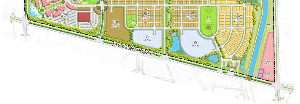
23 Attachment A - Page 14 of 25 NEWBRIDGE SPECIFIC PLAN Figure 10: NewBridge Specific Plan Land Use Plan Project Description 14 PLNP
24 Attachment A - Page 15 of 25 NEWBRIDGE SPECIFIC PLAN Project Components A Specific Plan, consistent with Sections through of the California Government Code, will be prepared for the NewBridge Specific Project. The Specific Plan will be consistent with the County s Specific Plan Ordinance (Title 21, Chapter of the County Municipal Code) and the County s Master Plan Procedures and Preparation Guide (January 14, 2012). The specific plan document will guide development of the project site and describe the regulatory framework, land use plan, land uses, development standards, design guidelines, housing plan, circulation plan, resource management, public facilities, public services, utilities and implementation strategy. The NewBridge Specific Plan planning document will address the entire 1,095.3 acre project area and its three planning areas as shown on Figure 11: NewBridge North Planning Area NewBridge South Planning Area NewBridge West Planning Area Total Specific Plan Area acres acres acres 1, acres No development plans are proposed at this time for the portion of the NSP within the NewBridge West Planning Area. Development plans are proposed for the NewBridge North and South Planning Areas as shown on the land use illustrative on Figure 12. Project Description 15 PLNP

25 Attachment A - Page 16 of 25 NEWBRIDGE SPECIFIC PLAN Figure 11: Specific Plan Boundary and Planning Areas Proposed Units Acreage NewBridge North Planning Area 2, NewBridge South Planning Area NewBridge West Planning Area NewBridge Specific Plan Total 3,135 1,095.3 Project Description 16 PLNP


26 Attachment A - Page 17 of 25 NEWBRIDGE SPECIFIC PLAN Figure 12: NewBridge North and NewBridge South Illustrative Land Use Plan Project Description 17 PLNP
27 Attachment A - Page 18 of 25 NEWBRIDGE SPECIFIC PLAN Table 1: NewBridge Specific Plan Land Use Summary NewBridge North NewBridge South NewBridge West NewBridge Specific Plan Total DU AC SF DU AC SF DU AC SF DU AC SF Residential LDR Low Density Residential 1, , (<7 du/ac) MDR Medium Density Residential ( du/ac) HDR High Density Residential (23 40 du/ac) Subtotal 2, , Commercial & Office C Commercial , , ,000 MU Mixed Use , ,000 O Office , ,000 Subtotal , , ,000 Open Space & Park OS Open Space Preserve OS Open Space Multi Use Area OS Open Space Folsom South Canal OS Open Space Comm Garden OS Open Space Landscape Pkwy P Park Subtotal Public/Quasi Public P/QP Elementary School Site P/QP Electric Facility P/QP Fire Station Site Subtotal Roadway RW Major Roadway LI Light Industrial AG Agriculture Total 2, , , ,135 1, ,000 Residential The NSP proposes 3,135 residential dwelling units on approximately acres. The density of the project is 9.6 dwelling units based on a double net density calculation. Residential units are proposed in three density ranges listed on Table 2. Project Description 18 PLNP
28 Attachment A - Page 19 of 25 NEWBRIDGE SPECIFIC PLAN Table 2: Specific Plan Residential Densities Residential Type Residential Density per Acre Low Density Residential (LDR) 1 7 units/acre Medium Density Residential (MDR) 7 23 units/acre High Density Residential (HDR) 23 units/acre and greater Nine housing types are planned in three density ranges. Low and medium density housing types are detached and high density units are attached. The variety of housing types in the project will provide high quality choices for various household characteristics, preferences and income levels. Table 3: Housing Types Density Range Low Density Residential < 7 units/acre Housing Type Single Family Alley Load Single Family Courtyard Attached/ Detached Detached Lot Size Typical Density Number of Units Percentage of Housing Stock 50 x % 40 x % 32 x % 38.3% % Medium Density Residential 7 22 units/acre High Density Residential > 23 units/acre Courtyard % Detached Greencourt % Condominiums/ Townhomes (for sale) Garden Style Apartments (rental) Mixed Use (rental or for sale) Attached % % > % 26.7% 35.0% 3, % 100% Fifteen percent of the units (471 units) are planned to meet the County s affordability requirements for low, verylow and extremely low income households. The affordable units would be designated within high density residential (HDR) parcels. Assuming 2.71 persons per household (SACOG), the project would will provide housing a residential population of 8,496. Project Description 19 PLNP
29 Attachment A - Page 20 of 25 NEWBRIDGE SPECIFIC PLAN Commercial, Mixed Use and Office The NSP includes 24.5 acres (approximately 190,000 square feet) of commercial uses in three commercial sites (Parcels N 20, S 20, S 21). The commercial sites would accommodate neighborhood serving commercial uses including grocery, drug store, personal services, cafes and restaurants. One 10.5 acre mixed use site (Parcel S 5) is planned near the intersection of Zinfandel Drive and Jackson Road. The vertically integrated mixed use area will include 160 high density residential units, and approximately 130,000 square feet of commercial and office space. The mixed use site is adjacent to a proposed transit stop and urban park (Parcels N 57 and S 50). The NSP includes 14.0 acres of office uses adjacent to Jackson Road in two sites (Parcels S 22 and S 23). The office uses will accommodate approximately 180,000 square feet of office uses. Office uses are planned adjacent to Jackson Road for visibility and accessibility by transit. Open Space and Parks Over forty percent (330.3 acres) of the development area (NewBridge North and NewBridge South) are planned in open space and park uses. Open Space Open space uses account for acres and are planned in five categories: Open Space Preserve. A 95.4 acre open space preserve (Parcels N 30 and N 31) is planned east of Zinfandel Drive. The open space preserve area was designed in collaboration with SSHCP to optimize the avoidance of habitat resources and to provide connectivity among existing and future preserve areas off site. The NSP will include resource management principles to implement the policies and requirements of the SSHCP. A trail is planned within the 50 foot buffer to the open space preserve. Open Space Multi Use Area. The 76.6 acre multi use area will provide multiple functions including water quality, detention and floodwater conveyance. The multi use area will be well designed and provide limited riparian value and improved habitat value. Open Space Folsom South Canal. The 59.6 acre Folsom South Canal and adjacent bike trail area located along the eastern edge of the NSP. Open Space Community Garden. A 5.4 acre community garden (Parcel N 36) is planned in the northeast portion of the NSP beneath the overhead high voltage power lines. Open Space Landscape Parkway. Expanded landscaped areas adjacent to roadways, within traffic circles and landscaped connections between neighborhoods account for 39.5 acres. Project Description 20 PLNP
30 Attachment A - Page 21 of 25 NEWBRIDGE SPECIFIC PLAN Parks There are 53.8 acres of parkland proposed in ten neighborhood parks. Nine of the parks (42.0 acres) are proposed to be public, within the Cordova Recreation and Park District. One 11.8 acre park (Parcel N 56) is proposed as a private park which will be owned and maintained by homeowner s association or other similar entity. Park sites range from 1.3 to 11.8 acres and include passive and active recreation facilities to serve adjacent residential areas. A 10.5 acre neighborhood park is planned adjacent to the elementary school for joint use opportunities. Public/Quasi Public Elementary School. One public elementary school is planned within the NSP. A two story school facility is planned on the 9.4 acre site (Parcel N 60). The project site is within the Elk Grove Unified School District and students in the project will attend junior high school and high school at schools outside of the project. Electric Facility. Sacramento Municipal Utility District (SMUD) has a small electric facility on a 0.3 acre site (Parcel S 61) in the southeast corner of the site adjacent to the Folsom South Canal. Fire Station Site. One 2.5 acre fire station site (Parcel S 60) is planned on Jackson Road near the intersection with Sunrise Boulevard. The project site is within the Sacramento Metropolitan Fire District. The site location is conceptual and subject to additional discussions with the Fire District. Light Industrial (LI) The 188 acre parcel (Parcel W 80) west of Zinfandel Drive and south of Kiefer Boulevard is designated for Light Industrial uses within the NSP. The parcel is undeveloped. The parcel is within the NewBridge West Planning Area and, at this time, no development is proposed. This parcel may be used in the future as an open space and habitat preserve. Agriculture (AG) The acre area west of Zinfandel Drive and north of Jackson Road is designated Agriculture (AG) in the NSP. These parcels are within the NewBridge West Planning Area and, at this time, no development is proposed. Uses in this area include agricultural residential home sites, a Muslim cemetery and a pet cemetery. These existing uses will be incorporated into the NSP as permitted uses within the AG specific plan designation. Project Description 21 PLNP
31 Attachment A - Page 22 of 25 NEWBRIDGE SPECIFIC PLAN Circulation The NSP site is accessed by Kiefer Boulevard, Sunrise Boulevard, Jackson Road and Eagles Nest Road/Zinfandel Drive. The primary internal circulation consists of Bridgewater Drive, Northbridge Drive and Southbridge Drive. The NSP would provide a pedestrian/bikeway network consisting of on street bike lanes along major roadways and neighborhood streets and off street (Class I) bikeways adjacent to the open space preserve, east of Zinfandel Drive and across the NSP in an east west direction. The bikeway system is shown on Figure 13. At three locations, the Class I bikeway is proposed to link with the existing bike trail adjacent to the Folsom South Canal. Transit The General Plan Circulation Map and Sacramento Regional Transit (RT) Transit Action Plan identify Jackson Road and Sunrise Boulevard as Bus Rapid Transit (BRT)/Hi Bus routes. With the extension of Zinfandel Drive, development of South Mather and nearby Jackson corridor projects, it is anticipated that transit service would be extended to serve the Zinfandel corridor in the future. Bus/shuttle service in the Project area could connect to RT bus stops or Sacramento Light Rail system at the Mather/Mills, Zinfandel, Cordova Town Center or Sunrise light rail stations. Bus/shuttle service could be extended into the Project on NorthBridge Drive and looped from Jackson Road into the Project adjacent to high density residential and mixed used areas as shown on Figure 14. Bus/shuttle services could utilize the proposed transit stops within the NSP. Proximity to Mather Airport Mather Airport is located 3.6 miles north of the project site. Formerly Mather Air Force Base, Mather Airport is one of four airports operated by the County Airport System and serves as the region s primary air cargo airport. The project is being designed to be consistent with the continued operations of the airport. The project proposes to record an avigation easement over residential development within the project and provide future homeowners with disclosures regarding airport operations, overflights and noise exposure. Public Utilities Infrastructure technical studies (water, wastewater, drainage) will be prepared for the project to demonstrate how public utilities will serve the project. The project is within the Zone 40 service area of the Sacramento County Water Agency (SCWA). The project will need to be annexed to into the Sacramento Area Sewer District (SASD) and Sacramento Regional County Sanitation District (SRCSD). Project Description 22 PLNP
32 Attachment A - Page 23 of 25 NEWBRIDGE SPECIFIC PLAN Figure 13: Bikeway System Project Description 23 PLNP
33 Attachment A - Page 24 of 25 NEWBRIDGE SPECIFIC PLAN Figure 14: Transit Plan Project Description 24 PLNP
34 Attachment A - Page 25 of 25 NEWBRIDGE SPECIFIC PLAN Land Use Assumptions for NewBridge West Planning Area No development plans are proposed at this time for the portion of the NSP within the NewBridge West Planning Area. Nonetheless, inclusion within the NSP and Urban Policy Area would indicate that some type and level of development similar to that proposed in the NewBridge North and South areas could occur within the NewBridge West area in the future. In analyzing the effects of the proposed project, the EIR must reasonably account for the development that could occur in the NewBridge West Planning Area, recognizing that no entitlements will be granted at this time, so future development could differ somewhat from the EIR assumptions. While no development is proposed for the NewBridge West Planning Area at this time, assumptions regarding general density and intensity of development have been made to allow a programmatic analysis of the environmental impacts that would occur as a result of development of the entire specific plan area. Table 4 lists the land use assumptions for the NewBridge West Planning Area that will be used in the programmatic analysis in the EIR and in the infrastructure technical studies for the project. Table 4: Land Use Assumptions for NewBridge West Planning Area NewBridge West Planning Area Acreage acres acres Existing Zoning Light Industrial (M 1) Agricultural (AG 80) Existing General Plan Designation Extensive Industrial General Agriculture (20 acres) NewBridge Specific Plan Designation Light Industrial Agricultural Current Uses Undeveloped Agricultural residential home sites, a Muslim cemetery and a pet cemetery Assumptions Open space conservation easement consistent with South Sacramento Habitat Conservation Plan. Consistency with General Plan Growth Management Criteria, including: o Minimum net density of 8 units/acre (double net) (CB 1) o Proximity to amenities (CB 2) o Mixed use site (CB 3) o Consistency with RHNA Requirements (PC 4) Provide habitat linkage/open space corridor of approximately 300 to 700 feet in width; Include elementary school site of approximately 9.5 acres; Residential unit allocation of 660 units (six units/gross acre) Project Description 25 PLNP
35 Attachment B Attachment B NewBridge Specific Plan Proposed Entitlement Requests A General Plan Amendment to move the Urban Policy Area (UPA) boundary south and west to include approximately 1,095.3 acres encompassing the NewBridge Specific Plan area which includes: o NewBridge North Planning Area (664.8 acres) o NewBridge South Planning Area (132.3 acres) o NewBridge West Planning Area (298.2 acres) A General Plan Amendment to amend the Land Use Diagram to o Change the land use designations from Extensive Industrial (314.2 acres), General Agriculture (20 acre) (418.5 acres), Recreation (64.4 acres) to Low Density Residential (459.5 acres), Medium Density Residential (52 acres), Commercial & Offices (56.8 acres), Mixed Use (14.3 acres), Natural Preserve (100.5 acres), Cemetery, Public & Quasi-Public (3.1 acres), and Recreation (110.9 acres). Note: The NewBridge West Planning Area (298.2 acres) will retain all existing General Plan Land Use Designations. o Remove the Aggregate Resource Areas combining land use designation on the area designated General Agriculture (20 acre) Aggregate Resource Areas. A General Plan Amendment to change the Bikeway Master Plan to add and amend onand off-street bikeways as shown in the Bikeways Master Plan Amendment Diagram. Amend the General Plan Transportation Diagram to change Kiefer Boulevard from developing post-2030 to developing pre-2030, as shown in the Transportation General Plan Amendment Diagram. A Community Plan Amendment to amend the Vineyard Community Area Plan to change the Community Plan designation of the parcels located within the NewBridge Specific Plan area (1,095.3 acres) from Permanent Agriculture (AG-160) (418.5 acres), Permanent Agriculture (AG-80) (110.2 acres), Permanent Agriculture (AG-20) (4.8 acres), Heavy Industrial (314.2 acres), Light Industrial (188 acres), and Recreation (59.6 acres) to NewBridge Specific Plan Area (1,095.3 acres). Acceptance of an Affordable Housing Plan for the NewBridge Specific Plan consisting of on-site construction of affordable units and/or dedication of land. Adoption of a Development Agreement for the NewBridge Specific Plan by and between the County of Sacramento and the landowners. Adoption of a Public Facilities Financing Plan for the NewBridge Specific Plan area.
36 Technical Studies for EIR Attachment C NewBridge TECHNICAL STUDY STUDY DATE CONSULTANT Biological Resources Wetland Delineation North Fork Assoc Special Status Species Survey EIR analysis will also rely on CNDDB and USFWS species lists Arborist Report Sierra Nevada Arborists Cultural Resources Cultural Resources Assessment Noise Mather Airport Noise analysis Infrastructure Ric Windmiller County will do County will do Drainage Study MacKay & Somps Sewer Study MacKay & Somps Water Supply Analysis MacKay & Somps Reclaimed Water MacKay & Somps Water Supply Assessment Traffic TIS Air Quality Analysis & AQMP Climate Change Analysis Haz Mat Per Water Code Sections ; County (SCWA) can do Pending County will do County will do Phase Wallace Kuhl Geotechnical Report Engineering Report Wallace Kuhl \\pwnd2\pldfolders\shared Folders\Work Groups (W Drive)\PROJECTS\PLNP NewBridge\NewBridge_NOP_Initiation\PLNP Attachment C EIR Tech Studies_Sept2012_StaffRpt.doc
37 Attahment D - Page 1 of 28 NewBridge Specific Plan Compliance with General Plan Land Use Policy LU 120 September 6, 2012 East Sacramento Ranch, LLC proposes the NewBridge Specific Plan project (NSP). The project area consists of 1,095.3 acres south of Mather Field between Kiefer Boulevard and Jackson Road, west of Sunrise Boulevard. The west boundary of the project area is approximately 2,000 feet west of Eagles Nest Road (future Zinfandel Drive). The NSP consists of three planning areas: NewBridge North, NewBridge South and NewBridge West, as shown in Figure 1. The NSP is a master planned residential community with 3,135 residential units with commercial, mixed use, office uses, open space, park and school uses, as shown in Figure 2. The NSP is a Master Plan (Specific Plan) located outside of the existing UPA and, therefore, must demonstrate its consistency with General Plan Policy LU 120. No development plans are proposed at this time for the portion of the NSP within the NewBridge West Planning Area (298.2 acres). Consequently, this area is not considered in the following Policy LU 120 consistency analysis. The NewBridge Specific Plan will designate these areas with a land use category consistent with the existing zoning and uses and will include requirements for development proposals in the future to be consistent with the requirements of Policy LU 120. For the purpose of this LU 120 compliance analysis, the project (Project) consists of the acre area within the NewBridge North and NewBridge South Planning Areas only, as shown on Figure 1. General Plan Policy LU 120. General Plan Policy LU 120 requires that the County shall only consider approval of a proposed UPA expansion and/or Master Plan outside of the existing UPA if the Board finds that the proposed project is planned and will be built in a manner that 1 : meets all of the requirements per PC 1 through PC 10 as summarized in Table 1 below, and; meets ONE of two alternative performance metrics: o Alternative #1 Criteria Based (summarized in Table 2 below) o Alternative #2 VMT/Greenhouse Gas Emissions Reduction Metric 1 Some areas within a Master Plan may have existing uses that are not likely to change and are appropriate to remain. If the Master Plan designates such areas with a land use category that reflects the existing use, the Board may exclude these areas for purposes of determining consistency with these criteria. Page 1


38 Attahment D - Page 2 of 28 Figure 1 NewBridge Specific Plan Boundary and LU 120 Analysis Area Acreage NewBridge Specific Plan Area Project for Purpose of LU 120 Analysis NewBridge North Planning Area NewBridge South Planning Area NewBridge West Planning Area Total NewBridge Specific Plan 1, Page 2


39 Attahment D - Page 3 of 28 Figure 2 Project Land Use Illustrative Page 3
40 Attahment D - Page 4 of 28 Table 1 Project Land Use Summary NewBridge NewBridge Project Total North South DU AC SF DU AC SF DU AC SF Residential LDR Low Density Residential 1, , (<7 du/ac) MDR Medium Density Residential ( du/ac) HDR High Density Residential (23 40 du/ac) Subtotal 2, , Commercial & Office C Commercial , , ,000 MU Mixed Use , ,000 O Office , ,000 Subtotal , , ,000 Open Space & Park OS Open Space Preserve OS Open Space Multi Use Area OS Open Space Folsom South Canal OS Open Space Comm Garden OS Open Space Landscape Pkwy P Park Subtotal Public/Quasi Public P/QP Elementary School Site P/QP Electric Facility P/QP Fire Station Site Subtotal Roadway RW Major Roadway Total 2, , ,000 3, ,000 Page 4
41 Attahment D - Page 5 of 28 Table 2 Summary of Consistency with PC 1 through PC 10 PC 1 Criteria Vision for connection to other adjacent existing and potential future development areas. Project Consistency The Project is linked to existing and planned development adjacent to the Project. The Project provides linkages via transit, preserve connectivity, infrastructure and makes use of existing regional roadways which provide connections to adjacent areas. PC 2 Housing choice. The Project provides nine housing choices to meet the needs of a diverse range of households, lifestyles, and income levels. PC 3 Quality. The NewBridge Specific Plan will include design guidelines and development standards to ensure a high quality of design and consistency of design in the Project. PC 4 PC 5 PC 6 Accommodate the percentage of low and very low income residential units required by state law per the County's current Housing Element based on the Regional Housing Needs Allocation (RHNA). Pedestrian and transit oriented design. Infrastructure Master Plan And Financing Plan. 1,100 residential units in the Project (35.1%) are designated with densities of 23 units per acre or denser. These units contribute to satisfying the County s overall obligation under the Regional Housing Needs Allocation ( ). The Project emphasizes pedestrian and bicycle connections between uses and minimizes barriers among uses. All residential units are within 1,000 feet of a neighborhood park, open space, elementary school, and/or bicycle/pedestrian trail. Pedestrian and bicycle planning will be further developed with preparation of the NewBridge Specific Plan. The Project will prepare a comprehensive Infrastructure Financing Plan which will identify funding mechanisms and demonstrate that infrastructure requirements and financing structures are reasonably balanced throughout project buildout. PC 7 Services Plan A Services Plan will be prepared to demonstrate that operations and maintenance within the Project are cost neutral to the County s General Fund and that existing levels of municipal services will not be impacted by implementation of the Project. Page 5
42 Attahment D - Page 6 of 28 PC 8 PC 9 Consistency with County adopted plans. Consideration of regional planning efforts. The Project is consistent with County adopted plans that affect the Project area including the General Plan, Vineyard Community Area and Climate Action Plan (2011). The Project is being prepared with consideration of regional planning efforts. The Project is generally consistent with the SACOG Preferred Blueprint Scenario and Blueprint Planning Principles. PC 10 Consideration of jobs housing balance. The Project includes employment generating land uses that will accommodate approximately 2,527 employees. The Project s internal jobs/housing ratio is 0.81 job per housing unit. The Project makes a positive contribution to the achieving the local jobs/housing balance. Table 3 Summary of Consistency with Criteria Based Points (CB 1 through CB 5) Criteria Points Scored By Project CB 1 Minimum density >9 dwelling units per net acre if using "double net" methodology, or >12 dwelling units per acre if using "triple net" methodology. 4 points CB 2 Proximity to Amenities >90 percent of all units located within one mile of at least four of the amenity categories. 4 points CB 3 Mixed Use At least 5 percent of the residential units will be located and built within vertically integrated mixed use buildings. CB 4a Transit Proximity >80 percent of residential units located within 1/2 mile of existing or planned transit service. 4 points 4 points CB 4b Transit Headway Transit service with headways of 60 minutes or less during peak hours (Monday through Friday from 7 9 am. and 4 6 pm). 1 point CB 5 Employment Proximity Between 50, ,000 existing employees/jobs within a five mile radius of the proposed project. 3 points Total 20 points Page 6
43 Attahment D - Page 7 of 28 PERFORMANCE CRITERIA (PC) PC 1. Vision for connection to other adjacent and existing and potential future development areas. Required: Include a vision of how the development will connect to other adjacent existing and potential future development areas within the USB, including how roadways, transit, sewer, and water could occur within all adjacent areas. Land Use Compatibility with Existing and Proposed Development. Sacramento Rendering Company (SRC) and the County have a shared land use problem in that SRC has operated an industrial rendering plant on the project site at Kiefer/Sunrise Boulevards since The County, over the years, has approved development projects (Independence at Mather, Mather Specific Plan, Sunrise Douglas) that have created a condition of urban encroachment and land use incompatibility. Relocating the rendering plant and redevelopment of the site with the Project is an economic development strategy for the County in that it would eliminate the incompatibility issue created by urban encroachment and enable the County to move forward with its plans for a university and urban uses planned for the Mather South site and surrounding area. Further, the Project would create land use compatibility and share infrastructure costs burdens with County planned land uses at Mather South. The Project is surrounded by existing and proposed development in the County and City of Rancho Cordova. Within a mile radius of the Project, approximately 8,600 units are planned or approved/built and, within a two mile radius, approximately 19,000 units are planned or approved/built. Major Roadway Connectivity. Existing roadways define the Project site on four sides Kiefer Boulevard, Sunrise Boulevard, Jackson Highway and Eagles Nest Road/Zinfandel Drive. The Project is not coterminous with an adjacent development project. Jackson and Sunrise are arterial roadways which provide circulation through the region. The extension of and renaming of Eagles Nest Road to Zinfandel Drive will establish Zinfandel Drive as a more significant north/south roadway with connections to Highway 50. Preserve Connectivity. The NSP land use plan includes two open space preserves totaling acres, which are identical to the preserves identified in the SSHCP for the site. Within the Project Area, one of the two preserves, the 95.4 acre preserve, is located east of Zinfandel Drive. The open space preserve areas were designed in collaboration with County staff to optimize the avoidance and preservation of habitat resources and to provide connectivity among existing and future preserve areas off site to the west, north and south. The connectivity of the preserves will increase function and contribute to the establishment of a regional preserve system, consistent with the objectives of the SSHCP. Transit Connectivity. The General Plan Circulation Map and Sacramento Regional Transit (RT) Transit Action Plan identify Jackson Road and Sunrise Boulevard as Bus Rapid Transit (BRT)/Hi Bus routes. With the extension of Zinfandel Drive, development of Mather South and nearby Jackson corridor Page 7


44 Attahment D - Page 8 of 28 Figure 3 Project Context Page 8
45 Attahment D - Page 9 of 28 projects, it is anticipated that transit service will be extended to serve the Zinfandel corridor in the future. Bus/shuttle systems servicing planned transit stops in the Project could connect to RT bus stops or the light rail system at the Mather/Mills, Zinfandel, Cordova Town Center or Sunrise stations. Infrastructure Connectivity. Infrastructure capacity and service availability exist and can be easily extended to the project site from existing facilities in Eagles Nest/Zinfandel Drive. The Project s infrastructure technical studies and NSP will describe how proximate infrastructure will serve the Project. PC 2. Housing choice. Required: A variety of housing types and densities, including single family homes. duplexes, triplexes, accessory dwelling units, townhomes, condominiums, apartments and similar multi family units, in a variety of settings including both residential neighborhoods and mixed use nodes. The Project includes 3,135 residential units in a variety of housing types and densities. Nine housing types are planned in three density ranges. Low and medium density housing types are detached and high density units are attached. The variety of housing types in the Project will provide high quality choices for various household characteristics, preferences and income levels. Table 4 Housing Choices Density Range Low Density Residential < 7 units/acre Housing Type Single Family Alley Load Single Family Courtyard Attached/ Detached Detached Lot Size Typical Density Number of Units Percentage of Housing Stock 50 x % 40 x % 32 x % 38.3% % Medium Density Residential 7 22 units/acre High Density Residential > 23 units/acre Courtyard % Detached Greencourt % Condominiums/ Townhomes (for sale) Garden Style Apartments (rental) Mixed Use (rental or for sale) Attached % % > % 26.7% 35.0% 3, % 100% Page 9


46 Attahment D - Page 10 of 28 Figure 4 Housing Choices Page 10
47 Attahment D - Page 11 of 28 Distribution of Residential Unit Types Single Family Alley Load 50' x 100' Single Family Alley Load 40' x 100' Single Family Alley Load 32' x 100' Single Family Courtyard Courtyard Greencourt Condominiums/Townhomes Garden Style Apartments Mixed Use High Density Residential Units by Density Range Detached and Attached Units High Density 35% Medium Density 26.7% Low Density 38.3% Attached Units 35% Detached Units 65% Page 11
48 Attahment D - Page 12 of 28 PC 3. Quality. Required: Design guidelines, development standards and/or similar assurances that will require high quality development consistent with the vision set forth in the Master Plan. The NewBridge Specific Plan will include development standards and design guidelines to ensure consistent high quality development throughout the Project. The development standards will describe applicable zoning and land use regulations and specifications for land use designations within the NewBridge Specific Plan. Development standards from the County Zoning Code will be utilized where appropriate and augmented with additional standards in the NewBridge Specific Plan. For each of the Specific Plan land use designations, the development standards will identify permitted and conditionally permitted uses as well as land use regulations (setbacks, height limits and other standards to define the building envelope). Design guidelines will describe design principles and attributes for consistent streetscapes, entry features, walls and fencing, identification signage, landscape elements, residential design and other site specific considerations. The design guidelines utilize components of the County s Community Design Guidelines for Commercial & Mixed Use (2006) and the Interim Multi Family Design Guidelines (2008). PC 4. Accommodate the percentage of low and very low income residential units required by state law per the County's current Housing Element based on the Regional Housing Needs Allocation (RHNA). Required: Accommodate >90 percent of the obligation per RHNA (currently 33% of units accommodated in RD 20 or higher). The Project is required to accommodate greater than 90% of the unincorporated County s proportional obligation of the Regional Housing Needs Allocation (RHNA) on land zoned for 20 dwelling units per acre (RD 20) or greater. The current RHNA obligation ( ) for low and very low income units is 38.7% of the housing stock. Ninety percent of that obligation would require 34.8% of the housing stock be suitable for low and very low income units. The Project includes 1,100 residential units in six parcels (listed in Table 5) designated High Density Residential or Mixed Use with planned densities of 23 units/acre or denser. These parcels account for 1,100 units which is 35.1% of the units in the Project. These parcels contribute to satisfying the County s overall obligation under the Regional Housing Needs Allocation. Page 12
49 Attahment D - Page 13 of 28 Table 5 High Density Parcels Consistent with RHNA Obligation Specific Plan Parcel Specific Plan Land Use Designation Acres Units Density N 11 High Density Residential N 12 High Density Residential N 13 High Density Residential N 14 High Density Residential S 4 High Density Residential S 5 Mixed Use > 30 1,100 PC 5. Pedestrian and transit oriented design. Required: Pedestrian and transit oriented design, including: Sidewalks and bike routes along interconnected streets with short block lengths and a high intersection density. Prominent pedestrian and bicycle network. Few if any cul de sacs. Pedestrian and bike connections at the ends of all cul de sacs unless infeasible due to topography or similar impediments inherent in the project site. The Project is being designed with an emphasis on the pedestrian and bicyclist to improve connectivity among uses. Additional design components of the bikeway and pedestrian system will evolve as the NewBridge Specific Plan is prepared. Bikeway System. The bikeway system consist of Class I, Class II and Class III facilities as shown in Figure 5. The bikeway system makes use of the existing north/south Folsom South Canal trail west of Sunrise Boulevard which provides regional connections to the American River Biketrail. Bikeways within the project link to the Folsom South Canal trail to create a looped Class I system within the Project. Greenlinks Provide Pedestrian Connections. The Project includes greenlinks which are landscaped pedestrian linkages in a variety of settings. Greenlinks connect residents to adjacent nearby land uses and adjacent open spaces. Through the use of greenlinks, all residential units are within 1,000 feet of a neighborhood park, elementary school, open space area or trail. Expanded landscape corridors along collectors and residential streets which include a pedestrian walk More direct routes for pedestrians on trails within landscaped segments (i.e. paseos) Pedestrian connections at the end of cul de sacs to adjacent open space areas or to link to trail systems. Page 13
50 Attahment D - Page 14 of 28 Figure 5 Bikeway System Page 14
51 Attahment D - Page 15 of 28 Minimize Cul De Sacs. The use of cul de sacs has been limited in the project design, as shown on the Illustrative Land Use Plan in Figure 2. Where cul de sac bulbs occur, they are adjacent to open space and include a greenlink connection to the adjacent bikeway/pedestrian trail system. PC 6. Infrastructure Master Plan and Financing Plan Required: Inclusion of an Infrastructure Master Plan and Financing Plan that include the following: The Infrastructure Master Plan shall identify required public facilities and infrastructure (including roads, transit, water, sewer, storm drainage, schools, fire, park, library, and other needed community facilities) and associated costs for the development of the proposed UPA expansion/master Plan; The Financing Plan shall: Include a infrastructure phasing analysis that examines development through buildout taking into consideration potential development activities, facilities requirements and constraints; Identify the phase or timing for when the facilities are needed; Identify the funding mechanisms proposed to pay for the identified infrastructure and facilities; Demonstrate that infrastructure requirements and the associated costs are reasonably balanced throughout each development phase and outline solutions for any potential constraints and/or shortfalls for any given phase. The NewBridge Specific Plan will describe the infrastructure (sewer, water drainage, recycled water, dry utilities) plans for the Project. Infrastructure technical studies will provide additional detail regarding infrastructure sizing, design and timing. An Infrastructure Financing Plan will be prepared for the Project which will identify funding mechanisms and demonstrate that infrastructure requirements and financing structures are reasonably balanced throughout project buildout. PC 7. Services Plan Required: Inclusion of a Services Plan to demonstrate: that provision of services to the proposed UPA expansion/master Plan are cost neutral to the County's General Fund and existing ratepayers; that the operations and maintenance costs stemmed from the required public facilities and infrastructure for the development of the proposed UPA expansion/master Plan are cost neutral to the County's General Fund and existing ratepayers, and; that existing levels of municipal services will not be negatively impacted by approval and build out of the proposed UPA expansion/master Plan. A Services Plan will be prepared to demonstrate that operations and maintenance of the Project are cost neutral to the County s General Fund and that existing levels of municipal services will not be impacted by implementation of the Project. Page 15
52 Attahment D - Page 16 of 28 PC 8. Consistency with County adopted plans. Required: Consistency with all applicable County adopted plans not sought to be amended by the proposed project. The Project is being designed to be consistent with County adopted plans that affect the Project area. General Plan. The Project is being designed to be consistent with the County General Plan ( ) with the exception of four General Plan Amendments necessary to implement the project: 1. to move the Urban Policy Area (UPA) boundary south and west to include approximately 1, acres within the NewBridge Specific Plan. 2. to amend the Land Use Diagram to change the land use designations consistent with the land uses proposed in the Specific Plan. 3. to amend the Transportation Plan to change the designation of segments of Kiefer Boulevard, Jackson Road and Sunrise Boulevard from Post 2030 to Pre 2030 roadways. 4. to change the Bicycle Master Plan to add on and off street bikeways and modify the alignments of bikeways for the NewBridge Specific Plan. 5. to amend the General Plan, including the Land Use Diagram, to include a Mixed Use Land Use Diagram Designation. Vineyard Community Area Plan. The Project is being designed to be consistent with the Vineyard Community Plan with the exception of an amendment to the Vineyard Community Area Plan (map) to change the land use designations in the Community Plan to a new designation known as NewBridge Specific Plan. Climate Action Plan. The Project is being designed consistent with the County s Climate Action Plan Strategy and Framework Document (October 2011). PC 9. Consideration of regional planning efforts. Required: Inclusion of a discussion/analysis of how the proposed UPA expansion/master Plan relates to broad based and regional planning efforts, such as SACOG's adopted Blueprint Vision and Metropolitan Transportation Plan, Sacramento County's Visioning documents created for the Jackson Highway and Grant Line East Areas, any applicable Habitat Conservation Plan(s), the Sacramento Metropolitan Air Quality Management District's State Implementation Plan, and Regional Transit's Master Plan. SACOG Blueprint: The Sacramento Area Council of Governments (SACOG) Preferred Blueprint Scenario (2004) depicts an approach for the region to grow through the year The purpose of the Page 16
53 Attahment D - Page 17 of 28 Preferred Blueprint Scenario mapping is to illustrate, generally, the amount and locations for these types of growth. The Preferred Blueprint Scenario identifies the project site for Single Family Small Lot, High Density Mixed Residential and Vacant Urban Designated Lands. The types of uses shown on the Preferred Blueprint Scenario are generally consistent with the uses proposed in the Project. The Preferred Blueprint Scenario illustrates an approach for the region to grow in a manner generally consistent with seven Blueprint growth principles. The Project is being designed to implement the Blueprint growth principles as follows: 1. Transportation Choices. The Project design features an efficient roadway system and provides options for non vehicular transportation modes including walking, bicycling and transit (bus, carpool, light rail). 2. Mixed Use Developments. The Project is a mixed use development with residential, commercial, office, open space, park and public uses. A 10.5 acre vertical mixed use site is proposed which could include residential, office and commercial uses. 3. Compact Development. The Project is designed with compact and efficient land uses. Residential neighborhoods are dense and efficiently designed to facilitate linkages among uses. The compact design of neighborhoods encourages more walking and use of public transportation. The elementary school is proposed as a two story school to make more efficient use of the site. 4. Housing Choice and Diversity. The Project includes 3,135 residential units in a variety of housing types and densities. Nine housing types are planned in three density ranges. Low and medium density housing types are detached and high density units are attached. The variety of housing types in the Project will provide high quality choices for various household characteristics, preferences and income levels. 5. Use of Existing Assets. The Project incorporates existing wetland resources in proposed open space preserves. The project location makes use of existing assets including nearby infrastructure (sewer, water) and roadways (Jackson, Kiefer, Sunrise and Eagles Nest/Zinfandel). 6. Quality Design. The NSP will include development standards and design guidelines to ensure consistent high quality development throughout the Project. 7. Natural Resources Conservation. The Project includes a 95.4 acre open space preserve which will avoid and preserve existing natural resources including high quality vernal pool complexes, seasonal drainages and grasslands suitable for Swainson s hawk foraging habitat. The Preferred Blueprint Scenario is part of SACOG s Metropolitan Transportation Plan/Sustainable Communities Strategy (2035), the long term transportation plan for the six county region. Page 17
54 Attahment D - Page 18 of 28 Metropolitan Transportation Plan: The Project is not included in the land use scenario for the Metropolitan Transportation Plan/Sustainable Communities Strategy (MTP/SCS) However, the Project is being designed consistent with SACOG Blueprint principles and the sustainability and transportation principles of the MTP/SCS. In reviewing the Project, the County will make a determination regarding the Project s consistency with the SCS, and therefore, eligible for CEQA benefits based on consistency with the SCS. Jackson Visioning Area Plan (November 2008) envisions a land use pattern similar to that proposed in the Project. This includes a predominantly residential project with low, medium and high density residential uses, mixed use, community commercial and open space uses. In addition to the open space area shown in the Jackson Visioning Area Plan, the Project includes an additional 95.4 acre open space preserve area east of Zinfandel Drive, consistent with the South Sacramento Habitat Conservation Plan. The NewBridge Specific Plan will consider Policies for Jackson & Grant Line East Visioning Areas" (November 2008) including smart growth, sustainability, and planning principles. South Sacramento Habitat Conservation Plan: The Applicant is an active participant in the South Sacramento Habitat Conservation Plan (SSHCP). The NSP land use plan includes two open space preserves totaling acres, which are identical to the preserves identified in the SSHCP for the site. Within the Project Area, one of the two preserves, the 95.4 acre preserve is located east of Zinfandel Drive. The open space preserve areas were designed in collaboration with County staff to optimize the avoidance of habitat resources and to provide connectivity among existing and future preserve areas off site. The NSP will include resource management principles to implement the policies and requirements of the SSHCP. Sacramento Metropolitan Air Quality Management District's (AQMD) State Implementation Plan: An Air Quality Mitigation Plan (AQMP) and Greenhouse Gas Plan will be prepared for the Project to demonstrate the Project s air quality mitigation and greenhouse gas reduction features. Sacramento Regional Transit Action Plan. The General Plan Circulation Map and Sacramento Regional Transit (RT) Transit Action Plan identify Jackson Road and Sunrise Boulevard as Bus Rapid Transit (BRT)/Hi Bus routes. The Project proposes transit facilities complementary to the bus rapid transit routes planned on Jackson Road, including transit routes through and stops within the Project. With the extension of Zinfandel Drive, development of South Mather and nearby Jackson corridor projects, it is anticipated that transit service would be extended to serve the Zinfandel corridor in the future. Bus/shuttle service in the project area could connect to RT bus stops or Sacramento Light Rail system at the Mather/Mills, Zinfandel, Cordova Town Center or Sunrise light rail stations. Page 18
55 Attahment D - Page 19 of 28 PC 10. Consideration of jobs housing balance. Required: Inclusion of a discussion/analysis of the proposed UPA expansion/master Plan's jobs housing balance. Master Plans should provide an internal jobs housing balance and/or improve the jobs housing balance within the project's vicinity. Internal Jobs/Housing Balance. Employment generating land uses within the Project will accommodate approximately 2,527 jobs/employees as shown on Table 6. The jobs/housing ratio within the Project is 0.81 job per housing unit (2,527 jobs/3,135 housing units). Table 6 Project Employment Estimates Land Uses Unit Employees/Unit Employees Commercial 24.5 acres 50 employees/acre 1,225 Mixed Use 10.5 acres 55 employees/acre for 347 comm and office Office 14.0 acres 55 employees/acre 770 (mix of one and two story) Elementary School 1 school 160 employees/ school 160 Fire Station 1 station 25 employees/station 25 Estimate of Employees 2,527 Source: SACOG Blueprint PLACE Type Menu employment generators External Jobs/Housing Balance. The Project is within five miles of approximately 62,276 existing jobs in the Highway 50/Sunrise/Mather corridor (Staff Report to the Board of Supervisors, September ) The Project improves the planned jobs housing balance within a five mile radius. Approximately 4,192 jobs are located at the regional employment hub at Mather, which is located within three miles of the Project (Sacramento County Economic Development, 2011). The 50 Corridor/Rancho Cordova area boasts the region s highest jobs/housing ratio of 2.7 jobs per housing unit, as shown on Table 7. Housing growth in Rancho Cordova and the unincorporated County in the Mather area is projected to move the jobs/housing ratio toward balance. The Project s 3,135 residential units will contribute toward reaching a local jobs/housing balance. Table 7 Jobs/Housing Ratio in Sacramento Region Sacramento Region Sacramento County City of Sacramento Rancho Cordova SACOG, MTP 2035, DEIR Page 19
56 Attahment D - Page 20 of 28 CRITERIA BASED (CB) APPROACH (Alternative #1) To satisfy this alternative, the Board must find that the proposed project is planned and will be built in a manner that: meets all of the requirements per the criteria above (PC I 10) and; qualifies for a minimum of 18 points (out of a possible 24) per the criteria below The Project achieves 20 points in the following analysis of CB 1 through CB 5. Table 8 Summary of NewBridge Specific Plan Criteria Based Points (CB 1 through CB 5) Criteria Points Scored by Project CB 1 Minimum density >9 dwelling units per net acre if using "double net" methodology, or >12 dwelling units per acre if using "triple net" methodology. 4 points CB 2 Proximity to Amenities >90 percent of all units located within one mile of at least four of the amenity categories. 4 points CB 3 Mixed Use At least 5 percent of the residential units will be located and built within vertically integrated mixed use buildings. CB 4a Transit Proximity >80 percent of residential units located within 1/2 mile of existing or planned transit service. 4 points 4 points CB 4b Transit Headway Transit service with headways of 60 minutes or less during peak hours (Monday through Friday from 7 9 a.m. and 4 6 p.m.). 1 point CB 5 Employment Proximity Between 50, ,000 existing employees/jobs within a five mile radius of the proposed project. 3 points Total 20 points Page 20
57 Attahment D - Page 21 of 28 CB 1. Minimum net density. Required: Minimum density of at least 7 dwelling units per net acre if using "double net" methodology or 9.3 dwelling units per acre if using "triple net" methodology. 1. >8 dwelling units per acre of using double net methodology, or > 10.6 dwelling units per acre if using triple net methodology. 2. >9 dwelling units per acre of using double net methodology, or > 12 dwelling units per acre if using triple net methodology. 3. >10 dwelling units per acre of using double net methodology, or > 13.3 dwelling units per acre if using triple net methodology. 3 points Project Points 4 points 4 points 5 points The Project achieves a density of 9.6 dwelling units per acre based on a double net density calculation and, therefore, scores four points for this criterion. No accessory dwelling units are assumed for the density calculation. Table 8 demonstrates the residential density calculation. Table 9 Residential Density Calculation Density = Total Units = 3,135 units = 3,135 units = 9.6 units Net Residential Acreage acres 10% 328 acres acre Page 21
58 Attahment D - Page 22 of 28 CB 2. Proximity of residential units to amenities. Required: >80 percent of all residential units located within one mile of at least three of the following existing or planned amenity categories: Public elementary, middle, or high school Park or recreational facility Grocery store, drug store or commercial center Office or industrial employment center Civic use (e.g. library, post office, community garden, urban farm) Preschool, childcare or senior care facility Medical offices or facilities 1. >85 percent of all units located within one mile of at least three of the amenity categories. 2. >90 percent of all units located within one mile of at least three of the amenity categories. 3. >90 percent of all units located within one mile of at least four of the amenity categories. 2 points 3 points Project Points 4 points 4 points 100% of the Project s residential units are planned within one mile of three planned amenity categories (public elementary school, parks, and commercial center), 93% of units are within one mile of a fourth amenity category (community garden), and 81% are within one mile of an office/employment center. The Project scores four points for this criterion. Figure 6 illustrates the proximity of residential uses to amenities in the Project. The criterion requires 90 percent of all units to be located within one mile of four amenity categories. The Project significantly exceeds the requirements as demonstrated in Table 10. Table 10 Proximity of Residential Uses to Amenities Percentage of Units Within One Mile of Amenity Percentage of Units Within One Half Mile of Amenity Elementary school 100% 55% Park or recreational facility 100% 100% Commercial center 100% 100% Office/employment center 81% 52% Civic uses (community garden) 93% 33% In addition, residential units in the Project will be within one half mile (and closer, in some cases) to amenities proposed in the proposed Jackson Township, Mather South and Arboretum projects. Page 22
59 Attahment D - Page 23 of 28 Figure 6 Proximity to Amenities + Page 23
60 Attahment D - Page 24 of 28 CB 3. Mixed use. Required: Include a mixed use designation, overlay, and/or zoning category that allows vertical mixed use by right, provides uninterrupted pedestrian connections, and prohibits barriers between different uses. Project Points 1. At least 5 percent of Master Plan s developable land zoned for mixed use (horizontal or vertical). 2. At least 10 percent of Master Plan s developable land zoned for mixed use (horizontal or vertical). 3. At least 15 percent of a Master Plan s developable land zoned for mixed use (horizontal or vertical) or assurances that at least 5 percent of the residential units will be located and built within vertically integrated mixed use buildings. 2 points 3 points 4 points 4 points The Project proposes 160 residential units (5.1% of total units) within vertically integrated mixed use buildings in the proposed Mixed Use Zone. The units are proposed in the 10.5 acre Mixed Use site in the NewBridge South area (Parcel S 5). The Project scores four points for this criterion. One of the entitlements for the Project is a General Plan Amendment to create a new General Plan designation known as Mixed Use which will allow a mix of uses (i.e. attached residential uses, office, commercial, and civic uses). The NSP will include a Mixed Use (MU) Specific Plan designation with permitted and conditionally permitted uses and development standards for the mixed use site. The Mixed Use Specific Plan land use designation will allow vertical mixed use and will define required pedestrian connections. Page 24
61 Attahment D - Page 25 of 28 CB 4. Transit. Required: > 65 percent of all residential units located within one half mile of existing or planned transit service, which consist of light rail, streetcars, buses, vanpools and/or shuttles that connect with regional public transit service. Project Points Proximity 1. >70 percent of residential units located within ½ mile of existing or planned transit service. 2. >75 percent of residential units located within ½ mile of existing or planned transit service. 3. >80 percent of residential units located within ½ mile of existing or planned transit service. Headways 1. Transit service with headways of 60 minutes or less during peak hours (Monday through Friday from 7 9 am and 4 6 pm) 2. Transit service with headways of 30 minutes or less during peak hours (Monday through Friday from 7 9 am and 4 6 pm) 3. Transit service with headways of 15 minutes or less during peak hours (Monday through Friday from 7 9 am and 4 6 pm) 2 points 3 points 4 points 4 points 1 points 1 point 2 points 3 points The Project scores four points for proximity to existing or planned transit service and one point for headways of transit service. Transit Service. The General Plan Circulation Map and Sacramento Regional Transit (RT) Transit Action Plan identify Jackson Road and Sunrise Boulevard as Bus Rapid Transit (BRT)/Hi Bus routes. With the extension of Zinfandel Drive, development of South Mather and nearby Jackson corridor projects, it is anticipated that transit service would be extended to serve the Zinfandel corridor in the future. Bus/shuttle service in the Project area could connect to RT bus stops or Sacramento Light Rail system at the Mather/Mills, Zinfandel, Cordova Town Center or Sunrise light rail stations. Bus/shuttle service could be extended into the Project on NorthBridge Drive and looped from Jackson Road into the Project adjacent to high density residential and mixed used areas as shown on Figure 7. Bus/shuttle services could utilize proposed transit stops within the Project. Funding. The secure funding sources for transit will be funded by the Project through fees and assessments. The project will pay the Sacramento County Transportation Development Fee (SCTDF) and the Sacramento Countywide Transportation Mitigation (SCTMF) both of which fund roadway and transit improvements, including transit improvements on Sunrise Boulevard. The Project proposes to Page 25
62 Attahment D - Page 26 of 28 Figure 7 Transit Facilities Page 26
63 Attahment D - Page 27 of 28 annex to a new benefit zone within County Service Area No. 10 (CSA No. 10) for the provision of transportation related services. CSA No. 10 was established in 2003 to provide transportation related services to developing areas until such time as RT could provide transit services. Through various benefit zones, CSA No. 10 provides transportation services (shuttle, vanpool services, subsidies, rideshare initiatives, guaranteed ride home, and alternative mode promotion, etc.) to developed areas. Through CSA No. 10, the Project would provide a funding mechanism through an annual charge on parcels for bus/shuttle and supplemental transportation services. Transit services would be administered by the 50 Corridor Transportation Management Association or similar entity. Proximity to Transit. 96% of residential units will be within a one half mile walk of a planned bus stop where transit services are planned. The Project proposes three transit stops as shown in Figure 7: Adjacent to commercial site on Northbridge Drive Adjacent to HDR/Mixed Use/Park site near Southbridge Drive Adjacent to office uses on Jackson Road Depending on Regional Transit s plans for service on Zinfandel Road, Kiefer Boulevard, Sunrise Boulevard and Jackson Road, the proximity of transit to residential units could be reduced. The Project scores four points for proximity to transit. Headways. Headways for bus/shuttle service will be a minimum of 60 minutes during peak hours, assuming two two hour peak periods on weekdays (7 9 am and 4 6 pm). The Project scores one point for transit headways. Transit Plan. The Applicant will refine the details of the transit proposal and funding with County Transportation and Infrastructure Finance Staff. Transit stops and transit service will be described in the NewBridge Specific Plan and NewBridge Development Agreement. Page 27
64 Attahment D - Page 28 of 28 CB 5. Proximity to employment. Required: Analysis of existing employment/jobs within a five mile radius of the proposed UPA expansion/master Plan boundary. 1. <50,000 existing employees/jobs within a 5 mile radius of the proposed project. 2. Between 50, ,000 existing employees/jobs within a 5 mile radius of the proposed project. 3. >100,000 existing employees/jobs within a 5 mile radius of the proposed project. 2 points Project Points 3 points 3 points 4 points The Project is within five miles of 62,276 existing jobs (2011) in the Highway 50/Sunrise/Mather corridor. The Project scores three points for proximity to employment. Project Table 11 Employment within 5 Mile Radius Employment within 5 mile Radius (2008 data) Points NewBridge 62,276 jobs/employees 3 Source: Staff Report to the Board of Supervisors September Page 28
65 Attachment 3 NewBridge Specific Plan Proposed Entitlement Requests REVISED A General Plan Amendment to move the Urban Policy Area (UPA) boundary south and west to include approximately 1,095.3 acres encompassing the NewBridge Specific Plan area which includes: o NewBridge North Planning Area (664.8 acres) o NewBridge South Planning Area (132.3 acres) o NewBridge West Planning Area (298.2 acres) A General Plan Amendment to amend the Land Use Diagram to o Change the land use designations from Extensive Industrial (314.2 acres), General Agriculture (20 acre) (418.5 acres), Recreation (64.4 acres) to Low Density Residential (459.5 acres), Medium Density Residential (52 acres), Commercial & Offices (56.8 acres), Mixed Use (14.3 acres), Natural Preserve (100.5 acres), Cemetery, Public & Quasi-Public (3.1 acres), and Recreation (110.9 acres). Note: The NewBridge West Planning Area (298.2 acres) will retain all existing General Plan Land Use Designations. o Remove the Aggregate Resource Areas combining land use designation on the area designated General Agriculture (20 acre) Aggregate Resource Areas. A General Plan Amendment to change the Bicycle Master Plan to add and amend onand off-street bikeways as shown in the Bicycle Master Plan Amendment Diagram. Amend the General Plan Transportation Diagram to change Kiefer Boulevard from developing post-2030 to developing pre-2030, as shown in the Transportation General Plan Amendment Diagram. A Community Plan Amendment to amend the Vineyard Community Area Plan to change the Community Plan designation of the parcels located within the NewBridge Specific Plan area (1,095.3 acres) from Permanent Agriculture (AG-160) (418.5 acres), Permanent Agriculture (AG-80) (110.2 acres), Permanent Agriculture (AG-20) (4.8 acres), Heavy Industrial (314.2 acres), Light Industrial (188 acres), and Recreation (59.6 acres) to NewBridge Specific Plan Area (1,095.3 acres). Adoption of the NewBridge Specific Plan for the approximately 1,095.3 acre NewBridge Specific Plan Area including a Specific Plan Land Use Diagram, Design Guidelines and Development Standards. Acceptance of an Affordable Housing Plan for the NewBridge Specific Plan consisting of on-site construction of affordable units and/or dedication of land. Adoption of a Development Agreement for the NewBridge Specific Plan by and between the County of Sacramento and the landowners. Adoption of a Public Facilities Financing Plan for the NewBridge Specific Plan area.
66 CORDOVA COMMUNITY PLANNING ADVISORY COUNCIL Thursday, September 20, :00 p.m. County of Sacramento Branch Center OB3, Conference Room Branch Center Road Sacramento, CA Note: Applicant or appointed representative should be present. If unable to attend, please contact the Cordova CPAC Chairman, Paul Bowers at To contact the Sacramento County Planning Division representative for the Cordova area, please call Cindy Storelli at or Jeff Gamel at (or send to storellic@saccounty.net or gamelj@saccounty.net ) To speak with the CPAC support staff, call Eleanor Tyler at , address is: tylere@saccounty.net CALL MEETING TO ORDER EXPLANATION OF ROLE OF THE COUNCIL ROLL CALL INTRODUCTION OF MEMBERS, STAFF, AND COUNTY REPRESENTATIVES OFFICERS: MEMBERS: P PAUL W. BOWERS (CHAIR) E GAY JONES (VICE CHAIR) P JON MONEY (SECRETARY) E DENNIS DEAN E REBECCA GARRISON E MICHAEL KAST E DWIGHT HELMICK DEE P DEE GAVALDON COUNTY REPRESENTATIVES: P DAVID DEFANTI Senior Planner, County Planning Division EXA EXCUSED ABSENCE R RESIGNED U - UNEXCUSED ABSENCE TE - TERM EXPIRED P PRESENT QUORUM DETERMINATION: NO COUNTY REPRESENTATIVE: YES Matters under the jurisdiction of the CPAC and not on the posted agenda may be addressed by the general public following completion of the regular agenda. The CPAC may limit the length of any off-agenda testimony. PLANNING ITEMS FOR REVIEW: POSTPONED TO OCTOBER 18 th MEETING 1. Control No.: PLNP2012-UPP-DRS Assessor s Parcel No.: Applicants: Yesco, 875 National Drive, Suite #107, Sacramento, CA 95834, Attention: Nate Buchaklian Owners: Storage Quest Holdings Amer Limited Partnership, Flora Road, Palm Desert, CA 92211
67 CORDOVA COMMUNITY PLANNING ADVISORY COUNCIL Page 2 County Contact: Project Name: Corinna Sandmeier, Planner II; sandmeierc@saccounty.net BOAT AND RV STORAGE SIGN (I-STORAGE.COM SELF STORAGE) USE PERMIT AND DESIGN REVIEW Location: The property is located at Amalgam Way, on the south side of Amalgam Way, approximately 475 feet east of the intersection of Gold River Road and Amalgam Way, in the Cordova community. Request: A Use Permit to allow an approximately square foot sign attached to a building, which will exceed the approximately square foot total allowed for building signage on the site, on approximately 3.61 net acres in the M-2 (Heavy Industrial) zone, pursuant to Sacramento County Zoning Code Section (a)(1)(aa). The project site is located within the Special Sign Corridor due to its location along U.S. Highway 50. A Design Review to comply with the County s Commercial and Mixed Use Community Design Guidelines. Investigating Member: AgendaCOR
68 CORDOVA COMMUNITY PLANNING ADVISORY COUNCIL Page 3 PRESENTATIONS: 1. NEW BRIDGE SPECIFIC PLAN East Sacramento Ranch, LLC proposes the NewBridge Specific Plan Project. The project area consists of approximately 1,095 acres south of Mather Field between Kiefer Boulevard and Jackson Highway, west of Sunrise Boulevard. The NewBridge Specific Plan is a proposed master planned community with approximately 3,135 residential units and commercial, mixed use, office, open space, park and school uses. The Project entitlement requests are likely to include General Plan Amendments to move the UPA and amend the Land Use Diagram, Circulation Diagram and Bikeway Master Plan, a Community Plan Amendment to change the Vineyard Community Plan designation, and other entitlements necessary for the proposed Specific Plan 2. WEST JACKSON PUBLIC COMMENT: StoneBridge Properties, LLC and Granite Construction Company propose the West Jackson Highway Master Plan Project. The Project area consists of approximately 5,900 acres bound generally by Jackson Highway and Kiefer Boulevard to the north; portions of Elder Creek Road and Florin Road to the south; the City of Sacramento to the west; and Excelsior Road to the east. The West Jackson Highway Master Plan is a proposed master planned community with residential, commercial, mixed use, office, open space, park and school uses. The Project entitlement requests are likely to include General Plan Amendments to move the UPA and amend the Land Use Diagram, a Community Plan Amendment to change the Vineyard and Cordova Community Plan designations, and other entitlements necessary for the proposed Master Plan. 1. George Phillips displayed and discussed a preliminary map of the New Bridge Development. The development is within the jurisdiction of the Vineyard CPAC, but will present to CORPAC because of its located in an adjacent CPAC. Current estimates are to begin vertical rising no earlier than 2016 with the exception of the portion owned by Triangle Rock which is restricted under the Williamson Act until at least The West Jackson project is proceeding as a joint effort to redevelop properties owned by Granite Construction and Teichert. Stonebridge Properties recently initiated a Master Plan Process for not only the Granite and Teichert properties, but for all properties within the planning area. Concerns expressed by residents as the project proceeds include possible mandatory water and sewer hookup fees, drainage and flooding potential, future water supply sources, and ongoing modifications and mining of Morrison Creek. Property owners also expressed concerns regarding how conditions of an approved master plan would affect property rights of additional owners within the plans boundaries. Residents were encouraged to participate in the upcoming notice of preparation (NOP) which will help to define topics that are discussed in the environmental impact report (EIR) as the project proceeds. Development of a project website was requested by homeowners to facilitate communication in the future. Stonebridge announced their intention to attend several more CORPAC meetings in the near future as the project proceeds through the entitlement process. 3. David Defanti from the County Planning Department was present and was able to answer questions regarding both projects and the master plan Process. He discussed the recent adoption of the County s General Plan, master plan guidelines, proposed master plans within Sacramento County, summaries of the New Bridge and West Jackson master plans, a sample timeline of the approval process, and potential next steps in the approval process including planning workshops, hearings, and public outreach. AgendaCOR
69 CORDOVA COMMUNITY PLANNING ADVISORY COUNCIL Page 4 APPROVAL OF MINUTES: Approval of minutes from April 19th, May 17th, and June 21st meetings. ADJOURNMENT: CPAC Member forwarding minutes to County Planning: The meeting facility is accessible to persons with disabilities. Request for interpreting services, assistive listening devices, or other considerations should be made through the County Planning Division at (916) or (TTY), no later than five working days prior to the meeting. California Relay Service (CRS) is a third party interpretation service for deaf, hard-of-hearing, and/or speech-impaired persons. CRS can be reached by dialing 711 or AgendaCOR
70
NEWBRIDGE SPECIFIC PLAN PROJECT DESCRIPTION SEPTEMBER 24, 2012
 PROJECT DESCRIPTION SEPTEMBER 24, 2012 Project Location The NewBridge Specific Plan project area consists of 1,095.3 acres south of Mather Airport between Kiefer Boulevard and Jackson Road, west of Sunrise
Jackson Highway Master Plans
 Jackson Highway Master Plans West Jackson Highway Master Plan (PLNP2008-00240) Jackson Township Specific Plan (PLNP2011-00095) NewBridge Specific Plan (PLNP2010-00081) Mather South Community Master Plan
COUNTY OF SACRAMENTO CALIFORNIA PLANNING COMMISSION REPORT
 COUNTY OF SACRAMENTO CALIFORNIA PLANNING COMMISSION REPORT TO: FROM: SUBJECT: COUNTY PLANNING COMMISSION DEPARTMENT OF COMMUNITY DEVELOPMENT GROWTH AREA PLANS UPDATE CONTACT: Cindy Storelli, Principal
Department of Community Development. Planning and Environmental Review Division Revised Notice of Preparation
 Department of Community Development Michael J. Penrose, Acting Director Divisions Building Permits & Inspection Code Enforcement County Engineering Economic Development & Marketing Planning & Environmental
COUNTY OF SACRAMENTO CALIFORNIA. PLNP Jackson Township Specific Plan. Workshop And Initiation of Environmental Review Process
 COUNTY OF SACRAMENTO CALIFORNIA #102 For the Agenda of: June 18, 2013 Timed: 2:00 PM To: From: Subject: Supervisorial District(s): Board of Supervisors Department of Community Development PLNP2011-00095.
Natomas Vision Plan and PLNP
 Natomas Vision Plan 20030171 and PLNP2014-00172 Department of Community Development Planning and Environmental Review Leighann Moffitt Sub-Agenda 1. Staff Presentation Leighann Moffitt, County Planning
ACTION SUMMARY VINEYARD CPAC Smedberg Middle School Library 8239 Kingsbridge Drive Sacramento, CA 95829
 ACTION SUMMARY VINEYARD CPAC Smedberg Middle School Library 8239 Kingsbridge Drive Sacramento, CA 95829 TUESDAY August 7, 2018 7:00 PM MEMBERS: JOHN COSTA(CHAIR), BARTLEY BAER(VICE-CHAIR), SOPHIA TROTTER-GOETZE(SECRETARY),
2.0 PROJECT DESCRIPTION
 2.0 PROJECT DESCRIPTION 2.1 PROJECT LOCATION The proposed Arboretum project (hereafter referred to as the proposed project ) is located on 1,349 acres within the Grant Line North Planning Area of the City
DEPARTMENT OF COMMUNITY DEVELOPMENT Planning and Environmental Review Division DRAFT NOTICE OF PREPARATION
 Department of Community Development Lori A. Moss, Director Divisions Building Permits & Inspection Code Enforcement County Engineering Economic Development & Marketing Planning & Environmental Review [CLICK
DEPARTMENT OF COMMUNITY DEVELOPMENT Planning and Environmental Review Division NOTICE OF PREPARATION
 Department of Community Development Lori A. Moss, Director Divisions Building Permits & Inspection Code Enforcement County Engineering Economic Development & Marketing Planning & Environmental Review SEPTEMBER
Jackson Township Specific Plan Applicant Prepared Project Description Revised
 Jackson Township Specific Plan Applicant Prepared Project Description Revised 4-11-13 Project Location The proposed Plan Area, approximately 1391 acres, is located in southeastern Sacramento County, lying
III. PROJECT DESCRIPTION
 III. PROJECT DESCRIPTION A. PROJECT LOCATION Regional Setting The project site is located in the southeast quadrant of the City of Chico in Butte County, California and is comprised of four parcels totaling
Ten Mile Creek Planning Area
 PLANNING AREA POLICIES TEN MILE CREEK Ten Mile Creek Planning Area Location and Context The Ten Mile Creek Planning Area ( Ten Mile Creek area ) is located south of the current Boise AOCI, generally south
Gold Line Bus Rapid Transit Transit Oriented Development (BRTOD) Helmo Station Area Plan
 Helmo Station Area Plan") Appendix F Gold Line Bus Rapid Transit Transit Oriented Development (BRTOD) Helmo Station Area Plan Introduction and Purpose of the Plan The Gold Line Bus Rapid Transit facility is an eleven-mile dedicated
Appendix F Gold Line Bus Rapid Transit Transit Oriented Development (BRTOD) Helmo Station Area Plan Introduction and Purpose of the Plan The Gold Line Bus Rapid Transit facility is an eleven-mile dedicated
& 035; ; ;
 County of Sacramento Community Planning & Development Department 827 7 th Street, Room 230 Sacramento, CA 95814 (916) 874-6141 Planning Application Form This application form is required as part of any
01 PROJECT DESCRIPTION
 01 PROJECT DESCRIPTION PROJECT LOCATION The proposed Barrett Ranch East project (the Project) site is in northern Sacramento County in the Antelope community, north of the intersection of Don Julio Boulevard
Planning Commission Staff Report June 5, 2008
 Owner/Applicant Taylor Village Sacramento Investments Partners, LP c/o Kim Whitney 1792 Tribute Road #270 Sacramento, CA 95815 Staff Recommendation Planning Commission Staff Report Project: File: Request:
4.0 INTRODUCTION TO THE ENVIRONMENTAL ANALYSIS AND ASSUMPTIONS USED
 The following is an introduction to the environmental analysis of project-specific and cumulative impacts and general assumptions used in the analysis. The reader is referred to the individual technical
S A C R A M E N T O C O U N T Y JACKSON HIGHWAY & GRANT LINE EAST VISIONING STUDY
 JACKSON HIGHWAY & GRANT LINE EAST S A C R A M E N T O C O U N T Y P L A N N I N G D E P A R T M E N T SUMMARY AND WORKBOOK November 19, 2008 History of the Visioning Study Sacramento County has two growth
Land Use element LAND USE POLICY AREAS ESTATE AND RURAL RESIDENTIAL AREAS/RURAL SHELDON AREA OLD TOWN ELK GROVE
 Land Use element Land Use is often considered the heart of the General Plan. The statement of future land uses describes how the City believes it should develop in the future where housing, shopping, open
CITY OF ROHNERT PARK CITY COUNCIL AGENDA REPORT
 Mission Statement We Care for Our Residents by Working Together to Build a Better Community for Today and Tomorrow. CITY OF ROHNERT PARK CITY COUNCIL AGENDA REPORT ITEM NO. 5 Meeting Date: July 23, 2013
Glenborough at Easton Land Use Master Plan
 Implementation 114 9.0 IMPLEMENTATION 9.1 OVERVIEW This chapter summarizes the administrative procedures necessary to implement the proposed land use plan, infrastructure improvements, development standards,
CITY OF VACAVILLE PLANNING COMMISSION Agenda Item No. G.1 STAFF REPORT February 21, 2012 BRIGHTON LANDING SPECIFIC PLAN & DEVELOPMENT PROJECT
 CITY OF VACAVILLE PLANNING COMMISSION Agenda Item No. G.1 STAFF REPORT February 21, 2012 Staff Contact: Fred Buderi (707) 449-5307 TITLE: PURPOSE: BRIGHTON LANDING SPECIFIC PLAN & DEVELOPMENT PROJECT INFORMATIONAL
Glenborough at Easton Land Use Master Plan
 Vision Statement Sunrise Blvd. Hazel Ave. Prairie City Rd. Gencorp Property Lincoln Regional Airport 1.0 VISION STATEMENT The identifies City of the principles, goals, policies, and standards Lincoln that
CHAPTER 2 SUMMARY 1. PROJECT SUMMARY DATA
 CHAPTER 2 SUMMARY This is an Initial Study format used to determine, pursuant to CEQA Guidelines Section 15177, whether a project 1) is within the scope of a Master EIR (MEIR), 2) may result in additional
Mitchell Ranch South MPUD Application for Master Planned Unit Development Approval Project Narrative. Introduction
 Mitchell Ranch South MPUD Application for Master Planned Unit Development Approval Project Narrative Introduction Mitchell Ranch South is a proposed single family (detached) residential development on
City Of Sparks Planning Commission Item
 Page 1 of 12 City Of Sparks Planning Commission Item Meeting Date: May17, 2012 Subject: PCN12009, Public Hearing, Consideration and possible action on a Master Plan Amendment and Rezoning request to change
PLANNING COMMISSION. Submitted
 PLANNING COMMISSION City Hall 1275 Main Street El Centro, CA 92243 Submitted PLANNING COMMISSION ACTION ITEM (1844) Meeting: 05/10/16 12:00 AM Department: Community Development Category: Public Hearing
Glenborough at Easton Land Use Master Plan
 Land Use Framework November 30, 2007 2.0 LAND USE FRAME- WORK 2.1 LAND USE HISTORY and Setting Glenborough at Easton is located on property that was used for mining in the 19th and 20th centuries and rocket
Land Use Element. policy areas are discussed in this Element:
 Land Use Element Land Use is often considered the heart of the General Plan. The statement of future land uses describes how the City believes it should develop in the future where housing, shopping, open
Planning Commission Staff Report March 15, 2007
 Planning Commission Staff Report Project: Request: Madeira East Tentative Subdivision Map, Design Review for Subdivision Layout & Abandonment of Easements Location: Phase IV of the Laguna Ridge Specific
AWH REPORT OF THE PLANNING AND DEVELOPMENT DEPARTMENT FOR APPLICATION FOR REZONING ORDINANCE TO PLANNED UNIT DEVELOPMENT
 AWH REPORT OF THE PLANNING AND DEVELOPMENT DEPARTMENT FOR APPLICATION FOR REZONING ORDINANCE TO PLANNED UNIT DEVELOPMENT MAY 8, 2014 The Planning and Development Department hereby forwards to the Planning
CHUGIAK-EAGLE RIVER SITE-SPECIFIC LAND USE PLAN
 CHUGIAK-EAGLE RIVER SITE-SPECIFIC LAND USE PLAN JUNE 2010 Final Prepared for The Heritage Land Bank, Municipality of Anchorage by Agnew: :Beck Consulting www.agnewbeck.com 907.222.5424 Chugiak-Eagle River
DISCUSSION ON VACAVILLE S2 INVESTORS PROPERTY IN URBAN RESERVE
 Agenda Item No. 9C April 25, 2017 TO: FROM: SUBJECT: Honorable Mayor and City Council Attention: Jeremy Craig, Interim City Manager Barton Brierley, AICP, Community Development Director (Staff Contact:
Appendix PD-1. Mather South Community Master Plan
 Appendix PD-1 Mather South Community Master Plan DRAFT Diverse Housing Environmental Education Campus Healthy Lifestyle, Active Recreation Natural Resources In the Community Mather South Community Master
3.10 LAND USE SETTING PROJECT SITE EXISTING LAND USE DESIGNATIONS AND ZONING. General Plan Land Use Designations.
 This section of the Draft EIR addresses the existing land uses on and adjacent to the project site and discusses the potential impacts of the proposed project on existing land uses. Key issues addressed
3.0 PROJECT DESCRIPTION
 3.0 PROJECT DESCRIPTION This section of the Draft Environmental Impact Report (Draft EIR) is the Project Description of the proposed General Plan. The purpose of the Project Description is to describe
LOS ANGELES CITY PLANNING DEPARTMENT STAFF REPORT
 LOS ANGELES CITY PLANNING DEPARTMENT STAFF REPORT LOS ANGELES CITY PLANNING COMMISSION CASE NO: CPC 2006-9374 CRA CEQA: Exempt DATE: December 21, 2006 Location: Valley Plaza and Laurel Plaza TIME: after
2.7 ac park. TOTAL 5,403 DU 1,297,900 sf 1,105,450 sf 3.87 ac 5,563 DU 1,121,200 sf 1,105,450 sf 3.87 ac
 PLAN AMENDMENT 2013-I-B1: SEVEN CORNERS SPECIAL STUDY Summary of Pre-staffing Comments Planner: Bernard Suchicital bsuchi@fairfaxcounty.gov (703) 324-1254 Background On October 29, 2013, the Board of Supervisors
Staff Report and Recommendation
 Community Planning and Development Planning Services 201 W. Colfax Ave., Dept. 205 Denver, CO 80202 p: 720.865.2915 f: 720.865.3052 www.denvergov.org/cpd TO: City Council Neighborhoods and Planning Committee
Major Subdivision Sketch Plan Checklist
 This checklist provides specific requirements that are apart of the Sketch process. The entire process is described by the Huntersville Subdivision Review Process which details all the submittal and resubmittal
CORDOVA HILLS COMPLIANCE WITH THE SACRAMENTO COUNTY GROWTH MANAGEMENT STRATEGY CRITERIA NOVEMBER 2011
 CORDOVA HILLS COMPLIANCE WITH THE SACRAMENTO COUNTY GROWTH MANAGEMENT STRATEGY CRITERIA NOVEMBER 2011 I. ACCEPTANCE OF CORDOVA HILLS APPLICATION TO EXPAND THE UPA: The application for the processing of
TREASURE COAST REGIONAL PLANNING COUNCIL M E M O R A N D U M. To: Council Members AGENDA ITEM 5H
 TREASURE COAST REGIONAL PLANNING COUNCIL M E M O R A N D U M To: Council Members AGENDA ITEM 5H From: Date: Subject: Staff October 17, 2008 Council Meeting Local Government Comprehensive Plan Review Draft
7 PUBLIC SERVICES ELEMENT
 7 PUBLIC SERVICES ELEMENT 7.1 PURPOSE The (RDOSP) will provide public services necessary to meet the needs of the Plan Area residents, in accordance with the policies of the City of Rancho Cordova s General
2035 General Plan Update and Belmont Village Specific Plan. Joint Study Session with the City Council and Planning Commission April 12, 2016
 2035 General Plan Update and Belmont Village Specific Plan Joint Study with the City Council and Planning Commission April 12, 2016 Agenda 1. Welcome and Introductions 2. General Plan Update Status of
Chapter 13: Implementation Plan
 Implementation A. Introduction The Implementation Plan, in table form on the following pages, provides a summary of all the Action Items recommended in Chapters 2 through 12. The table also indicates which
COLVER ROAD INDUSTRIAL CONCEPT PLAN
 COLVER ROAD INDUSTRIAL CONCEPT PLAN A CONCEPTUAL LAND USE AND TRANSPORTATION PLAN FOR TA-4 AN URBAN RESERVE AREA OF THE CITY TALENT City of Talent Adopted by City Council Resolution No., June, 2015 PART
APPENDIX X. Analysis of Project Consistency with City Policies
 APPENDIX X Analysis of with City Policies Land Use Policy LU.1.3 Maintain a strong jobs-housing ratio, with a diverse job base and corresponding housing stock, within the Planning Area. Improve the relationship
ENVIRONMENTAL SETTING
 II. ENVIRONMENTAL SETTING EXISTING CONDITIONS The 208.87-acre Project site is located in the western portion of the City (refer to Figures II-1 and II-2). The Project site comprises Assessor s Parcel Number
Silver Line CPAM UPDATE. Transportation and Land Use Committee October 14, 2016
 Silver Line CPAM UPDATE Transportation and Land Use Committee October 14, 2016 Purpose Recap Project History and Map Changes Provide Overview of CPAM Components Discuss Transportation Impacts Discuss Fiscal
Baumgarten MPUD. Exhibit 3 Evaluation Criteria
 Pursuant to LDC subsections 10.02.13 B, 10.02.08 F and Chapter 3 G. of the Administrative Code, staff s analysis and recommendation to the Planning Commission, and the Planning Commission s recommendation
Public may provide comments on the GDP within the next two weeks (December 24)
") 25/70 General Development Plan (GDP) Public Meeting Wednesday, December 10, 2014 6:00 8:00 P.M. District 1 Police Station Community Room 1311 W 46th Ave, Denver, CO 80211 Council Woman Montero: This particular
25/70 General Development Plan (GDP) Public Meeting Wednesday, December 10, 2014 6:00 8:00 P.M. District 1 Police Station Community Room 1311 W 46th Ave, Denver, CO 80211 Council Woman Montero: This particular
NOTICE OF PREPARATION
 NOTICE OF PREPARATION DATE: January 6, 2016 TO: LEAD AGENCY: Responsible Agencies, Organizations, and Interested Parties Contact: Tyler Barrington, Principal Planner Planning Department Community Development
MEMORANDUM AGENDA ITEM #6c
 South Florida Regional Planning Council MEMORANDUM AGENDA ITEM #6c DATE: FEBRUARY 1, 2010 TO: FROM: SUBJECT: COUNCIL MEMBERS STAFF CITY OF PARKLAND PROPOSED COMPREHENSIVE PLAN AMENDMENT (ALTERNATIVE REVIEW)
Subject: City of Richfield Cedar Avenue Corridor Plan Comprehensive Plan Amendment, Review File No
 Committee Report Business Item No. 2017-21 Community Development Committee For the Metropolitan Council meeting of January 25, 2017 Subject: City of Richfield Cedar Avenue Corridor Plan Comprehensive Plan
ROAD CLOSURE AND LAND USE AMENDMENT SILVER SPRINGS (WARD 1) NORTHEAST OF NOSEHILL DRIVE NW AND SILVER SPRINGS ROAD NW BYLAWS 2C2018 AND 29D2018
 NORTHEAST OF NOSEHILL DRIVE NW AND SILVER SPRINGS ROAD NW BYLAWS 2C2018 AND 29D2018") Page 1 of 19 EXECUTIVE SUMMARY This application proposes redesignating two parcels in the community of Silver Springs from Special Purpose Future Urban Development (S-FUD) District and undesignated road
Page 1 of 19 EXECUTIVE SUMMARY This application proposes redesignating two parcels in the community of Silver Springs from Special Purpose Future Urban Development (S-FUD) District and undesignated road
Asbury Chapel Subdivision Sketch Plan
 Asbury Chapel Subdivision Sketch Plan PART 1: PROJECT SUMMARY Applicant: NVR Inc. Project Size: +/- 76.13 acres Parcel Numbers: 02101112,02116101,02116112, 02116113 Current Zoning: Transitional Residential
Natomas Joint Vision Open Space Plan
 Natomas Joint Vision Open Space Plan First Workshop series The City of Sacramento The County of Sacramento LAFCo ERA Economic Research Associates EIP Associates a Division of PBS & J Natomas Joint Vision
Notice of Preparation and Notice of Public Scoping Meeting. At Dublin Project
 Notice of Preparation and Notice of Public Scoping Meeting Date January 17, 2018 To Project Title Project Application Number Project Location Project Applicant Contact For questions or submitting comments.
COUNTY OF SACRAMENTO CALIFORNIA
 COUNTY OF SACRAMENTO CALIFORNIA Control No.: 20040096 Type: GPB-CPB TO: FROM: SUBJECT: BOARD OF SUPERVISORS - COUNTY PLANNING COMMISSION PLANNING AND COMMUNITY DEVELOPMENT DEPARTMENT FLORIN VINEYARD GAP
13. PRELIMINARY PLAT NO MILLS FARM - Vicinity of the southeast corner of 159 th Street and Quivira Road
 13. corner of 159 th Street and Quivira Road 1. APPLICANT: HNTB Corporation is the applicant for this request. 2. REQUESTED ACTION: The applicant is requesting approval of a preliminary plat for a 383-lot
Review of Opportunity Area C Draft Comprehensive Plan and Draft BOS Follow-On Motions. Special Working Group Meeting March 4, 2015
 Review of Opportunity Area C Draft Comprehensive Plan and Draft BOS Follow-On Motions Special Working Group Meeting March 4, 2015 The slides that follow identify where the draft Comprehensive Plan has
COUNTY OF SACRAMENTO Inter-Departmental Correspondence
 COUNTY OF SACRAMENTO Inter-Departmental Correspondence For the Agenda of December 10, 2003 To: From: BOARD OF SUPERVISORS PLANNING AND COMMUNITY DEVELOPMENT DEPARTMENT Subject: WORKSHOP ON THE FLORIN-VINEYARD
Southeast Policy Area Community Plan
 Southeast Policy Area Community Plan In November 2003, the City Council adopted the General Plan for the City of Elk Grove. The General Plan is the City s overarching policy document indicating how the
Isabel Neighborhood Plan: Alternatives
 Isabel Neighborhood Plan: Alternatives Presented by: Lori Parks, Associate Planner February 2, 2015 Agenda 1. Background on BART to Livermore 2. Isabel Neighborhood Plan 3. Alternative Scenarios 4. General
SAN RAFAEL GENERAL PLAN 2040 INTRODUCTION AND OVERVIEW
 SAN RAFAEL GENERAL PLAN 2040 INTRODUCTION AND OVERVIEW Steering Committee Presentation February 14, 2018 Purpose of General Plan Guide land use and development decisions Coordinate transportation, infrastructure,
SOUTH NATOMAS COMMUNITY PLAN
 SOUTH NATOMAS Community Plan Part Three : COMMUNITY PLAN AREAS AND SPECIAL STUDY AREAS SACRAMENTO 2030 GENERAL PLAN Contents Community Location... 3-SN-3 Community Vision... 3-SN-4 Community Profile...
SPECIFIC PLAN Requirements
 CITY OF LANCASTER PLANNING DEPARTMENT 44933 Fern Avenue, Lancaster, California 93534 (661) 723-6100 SPECIFIC PLAN Requirements Purpose The purpose of a specific plan is to provide for the logical development
2.0 AREA PLANS. Lakeside Business District. Lakeside Business District Land Use Categories:
 Lakeside Business District Lakeside Business District Land Use Categories: Campus Commercial Campus Commercial means a mixture of uses which includes corporate offices, office parks, hotels, commercial,
NOTICE OF PREPARATION
 Date: June 30, 2017 CITY OF CITRUS HEIGHTS COMMUNITY & ECONOMIC DEVELOPMENT DEPARTMENT, PLANNING DIVISION 6360 Fountain Square Drive, Citrus Heights, CA 95621 (916) 727-4740 NOTICE OF PREPARATION To: Subject:
open public hearing and allow public comment request to continue LPA public hearing to January 16, 2014 at 10:30 am
 TODAY S AGENDA Work Session LPA Transmittal Public Hearing open public hearing and allow public comment request to continue LPA public hearing to January 16, 2014 at 10:30 am staff will issue a recommendation
CITY OF VACAVILLE PLANNING COMMISSION Item No. 8.A STAFF REPORT July 18, 2016 STAFF CONTACT: Amy Feagans, Contract Planner (707)
") CITY OF VACAVILLE PLANNING COMMISSION Item No. 8.A STAFF REPORT July 18, 2016 STAFF CONTACT: Amy Feagans, Contract Planner (707) 449-5140 TITLE: THE FARM AT ALAMO CREEK ENVIRONMENTAL IMPACT REPORT (EIR)
CITY OF VACAVILLE PLANNING COMMISSION Item No. 8.A STAFF REPORT July 18, 2016 STAFF CONTACT: Amy Feagans, Contract Planner (707) 449-5140 TITLE: THE FARM AT ALAMO CREEK ENVIRONMENTAL IMPACT REPORT (EIR)
Description of Preferred Alternative
 Chapter 2 Description of Preferred Alternative 2.1 Introduction This chapter of the programmatic Sammamish Town Center Sub-area Plan Final EIS provides a more detailed description of the Preferred Alternative
RESOLUTION NO. R Refining the route, profile and stations for the Downtown Redmond Link Extension
 RESOLUTION NO. R2018-32 Refining the route, profile and stations for the Downtown Redmond Link Extension MEETING: DATE: TYPE OF ACTION: STAFF CONTACT: Capital Committee Board PROPOSED ACTION 09/13/2018
S C O P E O F W O R K A P R I L
 white flint 2 sector plan S C O P E O F W O R K A P R I L 2 0 1 2 MONTGOMERY COUNTY PLANNING DEPARTMENT M-NCPPC MontgomeryPlanning.org 1 white flint 2 sector plan Scope of Work abstract This scope of work
Drexel, Barrell & Co.
 Drexel, Barrell & Co. June 18, 2018 Engineers/Surveyors Boulder Colorado Springs Greeley 3 South 7 th Street Colorado Springs, Colorado 80905-1501 719 260-0887 719 260-8352 Fax El Paso County Planning
Rezoning Petition Final Staff Analysis October 2, 2018
 Rezoning Petition 2017-205 Final Staff Analysis October 2, 2018 REQUEST Current Zoning: MUDD-O (mixed use development district, optional) Proposed Zoning: MUDD-O SPA (mixed use development district, optional,
OP Council Resolution June 16, Planning and Development Services
 OP-08-01 Council Resolution June 16, 2008 Planning and Development Services Kingsgate Landing Outline Plan Table of Contents 1.0 Introduction 1 1.1 Purpose of Plan 1 1.2 Plan Area Location 1 1.3 Ownership
Right-of-Way Acquisitions and Relocations Technical Memorandum
 Right-of-Way Acquisitions and Relocations Technical Memorandum Southeast Extension Project Lincoln Station to RidgeGate Parkway Prepared for: Federal Transit Administration Prepared by: Denver Regional
SPECIAL COMMITTEE OF THE WHOLE DECEMBER 9, 2002 BLOCK 57/58 WEST BLOCK PLAN BLOCK PLAN FILE BL.57/58W.99 HUNTINGTON BUSINESS PARK LAND OWNERS
 SPECIAL COMMITTEE OF THE WHOLE DECEMBER 9, 2002 BLOCK 57/58 WEST BLOCK PLAN BLOCK PLAN FILE BL.57/58W.99 HUNTINGTON BUSINESS PARK LAND OWNERS Recommendation The Commissioner of Planning recommends: THAT
TABLE OF CONTENTS. Tables Table UC Davis Park and Open Space Resources
 TABLE OF CONTENTS 4.13 Recreation... 4.13-1 4.13.1 Environmental Setting... 4.13-1 4.13.2 Impacts and Mitigation Measures... 4.13-4 4.13.3 References... 4.13-8 Tables Table 4.13-1 UC Davis Park and Open
DRAFT Subject to Modifications
 TREASURE COAST REGIONAL PLANNING COUNCIL M E M O R A N D U M To: Council Members AGENDA ITEM 5P From: Date: Subject: Staff February 20, 2009 Council Meeting Local Government Comprehensive Plan Review Draft
LAND USE AMENDMENT CORNERSTONE (WARD 3) 60 STREET NE AND COUNTRY HILLS BOULEVARD NE MAP 26NE BYLAW 22D2017
 60 STREET NE AND COUNTRY HILLS BOULEVARD NE MAP 26NE BYLAW 22D2017") Page 1 of 14 EXECUTIVE SUMMARY This Land Use Amendment application covers an area of 43.76 hectares ± (108.14 acres ±) located in northeast Calgary, bound by Country Hills Boulevard NE to the south and
Page 1 of 14 EXECUTIVE SUMMARY This Land Use Amendment application covers an area of 43.76 hectares ± (108.14 acres ±) located in northeast Calgary, bound by Country Hills Boulevard NE to the south and
7700 College Town Drive, Suite Ninth Street, Suite 212 Sacramento, CA Sacramento, CA 95814
 ACKNOWLEDGEMENTS/PROJECT TEAM: Property Owners Representative: The Hodgson Company John Lambeth 7700 College Town Drive, Suite 220 1025 Ninth Street, Suite 212 Sacramento, CA 95826 Sacramento, CA 95814
12 January 12, 2011 Public Hearing APPLICANT: TAILWIND DEVELOPMENT GROUP,LLC PROPERTY OWNER: CITY OF VIRGINIA BEACH
 12 January 12, 2011 Public Hearing APPLICANT: TAILWIND DEVELOPMENT GROUP,LLC PROPERTY OWNER: CITY OF VIRGINIA BEACH STAFF PLANNER: Faith Christie REQUEST: Conditional Change of Zoning (from PD-H1 Planned
HAZARD MITIGATION GOALS AND OBJECTIVES
 SEWRPC Community Assistance Planning Report No. 282, 2nd Edition CITY OF MILWAUKEE ALL HAZARDS MITIGATION PLAN UPDATE Chapter IV HAZARD MITIGATION GOALS AND OBJECTIVES [NOTE: Throughout this plan update
SONOMA LOCAL AGENCY FORMATION COMMISSION
 For accessibility assistance with any of the following documents, please contact Sonoma LAFCO at (707) 565-2577 or email us at cynthia.olson@sonoma-county.org. SONOMA LOCAL AGENCY FORMATION COMMISSION
1.0 PROJECT PURPOSE AND NEED
 1.0 PROJECT PURPOSE AND NEED The FasTracks Plan includes the extension of the Central Corridor from its current terminus at 30th/Downing to a connection to the East Corridor commuter rail service planned
3. VISION AND GOALS. Vision Statement. Goals, Objectives and Policies
 Vision Statement Queen Creek s interconnected network of parks, trails, open spaces and recreation opportunities provide safe and diverse activities and programs that sustain its unique, small town, equestrian
EXHIBIT B PROJECT NARRATIVE POULSBO MEADOWS
 EXHIBIT B PROJECT NARRATIVE POULSBO MEADOWS Name of Project: Poulsbo Meadows; A Planned Residential Development (PRD)/Plat Applicants Name: PBH Group LLC/Byron Harris PO Box 1010 Silverdale, WA 98038 Description
Drexel, Barrell & Co.
 Drexel, Barrell & Co. December 21, 2018 Engineers/Surveyors Boulder Colorado Springs Greeley 3 South 7 th Street Colorado Springs, Colorado 80905-1501 719 260-0887 719 260-8352 Fax El Paso County Planning
Dwelling Units Max 12 dwelling units per acre/min 8 dwelling units per acre. Development Mix 80% non residential/20% residential
 13. OSTEEN LOCAL PLAN Background: The Osteen Local Plan area is located in southwest Volusia County along the SR 415 corridor between Lemon Bluff Road and Acorn Lake Road and includes 3,990 acres. The
MONTGOMERY COUNTY PLANNING DEPARTMENT
 MONTGOMERY COUNTY PLANNING DEPARTMENT THE MARYLAND-NATIONAL CAPITAL PARK AND PLANNING COMMISSION MCPB Item No.: Date: 5-03-18 Pike and Rose, Phase I: Site Plan Amendment No. 82012002D Rhoda Hersson-Ringskog,
SUBJECT: LOCAL GOVERNMENT COMPREHENSIVE PLAN PROPOSED AND ADOPTED AMENDMENT CONSENT AGENDA
 MEMORANDUM AGENDA ITEM #IV.C DATE: APRIL 15, 2019 TO: FROM: COUNCIL MEMBERS STAFF SUBJECT: LOCAL GOVERNMENT COMPREHENSIVE PLAN PROPOSED AND ADOPTED AMENDMENT CONSENT AGENDA Pursuant to the 1974 Interlocal
Leduc Industrial Outline Plan SE W4
 Leduc Industrial Outline Plan SE 1-50-25-W4 Within the North Leduc Industrial ASP Prepared for: Leduc Energy Park Ltd. Prepared by: Stantec Consulting Ltd. File No. 1161 104655 V5 Table of Contents 1.0
Michael D, Harvey, Current Planning Supervisor. This project was originally approved in 2012 by the BOCC and is summarized as follows:
 PLANNING & INSPECTIONS DEPARTMENT Craig N. Benedict, AICP, Director Current Planning (919) 245-2575 (919) 644-3002 (FAX) www.orangecountync.gov 131 W. Margaret Lane Suite 201 P. O. Box 8181 Hillsborough,
Amendment to the Elderberry Neighborhood Development Plan
 Amendment to the Elderberry Neighborhood Development Plan Recommendations for Land Use, Transportation and Development July 13, 2018 City of Madison, Wisconsin Department of Planning and Community and
TO MEMBERS OF THE COMMITTEE ON GROUNDS AND BUILDINGS:
 Office of the President June 22, 2004 102 TO MEMBERS OF THE COMMITTEE ON : For Meeting of ITEM FOR ACTION Click here for EXECUTIVE SUMMARY CERTIFICATION OF ENVIRONMENTAL IMPACT REPORT AND APPROVAL OF DESIGN,
LU Encourage schools, institutions, and other community facilities that serve rural residents to locate in neighboring cities and towns.
 Application No. 891627: Comprehensive Plan Text Amendment - Rural School Policies - Amend policies consistent with State Legislation allowing schools in the rural area and extension of sewer service to
REQUEST Current Zoning: O-15(CD) (office) Proposed Zoning: TOD-M(CD) (transit oriented development mixed-use, conditional)
 (office) Proposed Zoning: TOD-M(CD) (transit oriented development mixed-use, conditional)") Rezoning Petition 2016-117 Zoning Committee Recommendation January 4, 2017 REQUEST Current Zoning: O-15(CD) (office) Proposed Zoning: TOD-M(CD) (transit oriented development mixed-use, conditional) LOCATION
Rezoning Petition 2016-117 Zoning Committee Recommendation January 4, 2017 REQUEST Current Zoning: O-15(CD) (office) Proposed Zoning: TOD-M(CD) (transit oriented development mixed-use, conditional) LOCATION