COUNTY OF SACRAMENTO CALIFORNIA
|
|
|
- Justin Cunningham
- 5 years ago
- Views:
Transcription
1 COUNTY OF SACRAMENTO CALIFORNIA Control No.: Type: GPB-CPB TO: FROM: SUBJECT: BOARD OF SUPERVISORS - COUNTY PLANNING COMMISSION PLANNING AND COMMUNITY DEVELOPMENT DEPARTMENT FLORIN VINEYARD GAP COMMUNITY PLAN GENERAL PLAN AMENDMENT, COMMUNITY PLAN AMENDMENT AND PUBLIC FACILITIES FINANCING PLAN CONTACTS: Tricia Stevens, Principal Planner, , stevenst@saccounty.net Surinder Singh, Senior Planner, , singhsu@saccounty.net PROJECT DESCRIPTION ASSESSOR S PARCEL NOS.: Various LOCATION: APPLICANT: The Florin-Vineyard Gap Community Plan project site consists of approximately 3,766 acres located in both the South Sacramento and Vineyard Community Planning areas. Project boundaries are south of Elder Creek Road and the Sacramento City Limits; west of Bradshaw Road, excluding the North Vineyard Station Specific Plan area; north of Vintage Park Drive, and the developed neighborhoods of Churchill Downs and Vintage Park; and east of the Union Pacific Railroad tracks, and those developed neighborhoods of Tiogawoods, Florin Town, and Sunrise Florin. See Exhibit 3 for a map of the Florin-Vineyard Gap Community Plan (FVGCP) area. (Supervisor District 5: Don Nottoli) ATTORNEY: Florin Vineyard Property Owners Group c/o Brewer Lofgrens, Attorneys at Law 3727 Sutter Hill Lane Carmichael, CA Brewer Lofgrens Attorneys at Law 3727 Sutter Hill Lane Carmichael, CA Attention: Roy Brewer ENGINEER: MacKay & Somps 1552 Eureka Road, Suite 100 Roseville, CA Attention: Bruce Walters
2 FLORIN VINEYARD GAP COMMUNITY PLAN GENERAL PLAN AMENDMENT, COMMUNITY PLAN AMENDMENT AND PUBLIC FACILITIES FINANCING PLAN 2004-GPB-CPB-0096 REQUEST: 1. General Plan Amendment for the FVGCP area to relocate the Urban Policy Area (UPA) boundary and to amend the land use designations as identified by the Existing and Proposed General Plan Land Use diagrams, for properties within the FVGCP project area. 2. Community Plan Amendment to amend the land use designations for properties within the FVGCP as identified by the Existing Zoning/Community Plan Designations diagram to either the proposed CAC Land Use Plan, or the proposed PD Land Use Plan. Note that there are two land use options a less intense option proposed by the CAC, and a more intense option proposed by County Planning staff. The approval of either land use option would result in amendments to both the South Sacramento and Vineyard Community Plans. 3. Adoption of a Public Facilities Financing Plan for the Florin- Vineyard Gap Community Plan project area, which: a) Identifies public facilities and infrastructure improvements required to support the proposed land uses; b) Defines proposed methods for financing required public facilities and infrastructure; and c) Provides a description of infrastructure phasing. ENVIRONMENTAL DOCUMENT: DRAFT ENVIRONMENTAL IMPACT REPORT Please click on the following web links to review additional documents prepared for the Florin Vineyard Gap project. Copies of these documents can also be obtained by contacting the Planning & Community Development Department at (916) or the Department of Environmental Review and Assessment at (916) You can also request for a copy of these documents by contacting Tricia Stevens, Principal Planner or Surinder Singh, Senior Planner of the Planning & Community Development Department at (916) Florin Vineyard Gap General Website - Florin Vineyard Gap Community Plan Text - Vineyard/Florin_Vineyard_Community_Plan_ pdf Draft EIR for the Florin Vineyard Gap Project - ojectid=32642 Staff Report for the January 21, 2010 County Planning Commission Hearing on the Draft EIR - a SS:ss:jrc Sr
3 FLORIN VINEYARD GAP COMMUNITY PLAN GENERAL PLAN AMENDMENT, COMMUNITY PLAN AMENDMENT AND PUBLIC FACILITIES FINANCING PLAN 2004-GPB-CPB-0096 Overview: In October 2002, the County Board of Supervisors initiated a planning program through Resolution No for the approximately 3,766 acre Florin-Vineyard area, also known as the Gap. Planning staff next worked with the Board appointed Citizens Advisory Committee (CAC) to prepare a draft land use plan for Florin Vineyard Gap Community Plan (FVGCP) area. In December 2003, the Board endorsed two draft land use maps for further analysis and environmental review. The Board also established a program for the filing of private rezone and tentative map applications for concurrent processing with the FVGCP project. The number of pending applications currently is 24. The Draft Environmental Impact Report (DEIR) for the FVGCP project and the associated pending entitlement applications was released on April 1, Subsequently, between May-June 2009, staff conducted three joint workshops with the Vineyard and South Sacramento Community Planning Advisory Councils (CPACs) to discuss all components of the project. Thirteen public meetings have been conducted with the joint Vineyard and South Sacramento CPACs. The project is now ready for Planning Commission and Board of Supervisors hearing and deliberations. Summary of Significant Issues: Build out of the FVGCP area would result in the development of from 8,950 residential units under the CAC land use plan to 12,066 residential dwelling units under the Planning Department (PD) land use plan. Two new alternative plans were identified during the community review process. At full build out, the CPAC and Planning Department Hybrid Plans would result in potential construction of 9,113 and 12,063dwelling units, respectively. Commercial, industrial, open space and public area would also be provided to complement future residential development shown in each plan. Public facilities such as schools, parks, sewer, potable water, and roads will be constructed to accommodate growth projected for the area. The following issues were raised during the community review of the proposed project the amount of residential growth planned for the area, the number of sites designated for multi-family uses, affordable housing requirements and the potential overconcentration of such units, and lack of public transit. The FVGCP Draft EIR concludes that the project will have potentially significant and unavoidable impacts related to transportation and circulation, air quality, climate change, biological resources (cumulative only), and agricultural and mineral resources. Mitigations are recommended, but they will not adequately reduce impacts to less than significant levels. CPAC Recommendation: Thirteen meetings have been conducted with the South Sacramento and Vineyard Community Planning Advisory Councils (CPAC) to solicit their recommendations and public input on the FVGCP and the individual twenty-four entitlement applications. During the February 24, 2010 meeting, the CPACs recommended APPROVAL of a Hybrid CPAC Land Use Plan. This plan represents a modified version of land use plan endorsed by the FVGCP CAC in The Planning Department is recommending APPROVAL of a modified PD Plan (PD Hybrid). Staff further recommends the Planning Commission to defer any action on the Community Plan until after hearings have been conducted on all of the 24 individual rezone and/or map applications. SS:ss:jrc Sr
4 FLORIN VINEYARD GAP COMMUNITY PLAN GENERAL PLAN AMENDMENT, COMMUNITY PLAN AMENDMENT AND PUBLIC FACILITIES FINANCING PLAN 2004-GPB-CPB-0096 I. Location Map 5 II. Environmental Analysis 6 III. Project Analysis 7 IV. Staff Recommendations 33 V. Attachments 66 VI. Exhibits 67 SS:ss:jrc Sr

5 FLORIN VINEYARD GAP COMMUNITY PLAN GENERAL PLAN AMENDMENT, COMMUNITY PLAN AMENDMENT AND PUBLIC FACILITIES FINANCING PLAN 2004-GPB-CPB-0096 I. LOCATIONAL MAP SS:ss:jrc Sr
6 FLORIN VINEYARD GAP COMMUNITY PLAN GENERAL PLAN AMENDMENT, COMMUNITY PLAN AMENDMENT AND PUBLIC FACILITIES FINANCING PLAN 2004-GPB-CPB-0096 II. ENVIRONMENTAL ANALYSIS A. Environmental Setting: The Florin Vineyard Gap Community Plan (FVGCP) area covers approximately 3,766 acres and is located within the community planning areas of Vineyard and South Sacramento. Project boundaries are south of Elder Creek Road and the Sacramento City Limits; west of Bradshaw Road, excluding the North Vineyard Station Specific Plan area; north of Vintage Park Drive, and the developed neighborhoods of Churchill Downs and Vintage Park; and east of the Union Pacific Railroad tracks, and those developed neighborhoods of Tiogawoods, Florin Town, and Sunrise Florin. See attached Exhibit 3 for a map of the FVGCP area. The area is generally flat and consists of several established ranchette neighborhoods. A total of 556 dwelling units exist as of 2002, and based upon the 2000 Census, 1,690 residents lived in this area. Several major north-south and eastwest roadways traverse within the area, including Elk Grove Florin, Bradshaw, Gerber, Florin and Elder Creek Roads. The area is also bisected by Elder and Gerber Creeks, the Central California Traction Railroad track, and several overhead transmission lines and associated easements. B. Environmental Effects and Suggested Mitigation Measures: The Draft EIR concludes that the following impacts were considered as significant and unavoidable even after implementation of mitigation measures: transportation and circulation, air quality, climate change, biological resources (cumulative only) and agricultural and mineral resources. Tables ES-1 of the Draft EIR (Volume 1 of 4) provides a summary of the environmental effects of the proposed project identified in each technical section. The table contains the environmental impacts, the significance of the impacts for the proposed project, the proposed mitigation measures, and the significance of the impacts after the mitigation measures are implemented. The FVGCP Draft EIR is posted on the County s website and can be viewed by clicking on the following link: ult.aspx?projectid=32642 C. Alternatives to the Proposed Project: The FVGCP Draft EIR conducted an equal level analysis for the two land use plans (i.e., CAC Land Use Plan and Planning Department Plan). In compliance with CEQA, the FVGCP EIR also analyzed impacts for the following two alternatives Wetlands Avoidance and Smart Growth Alternative and the No Project Alternative. No Project Alternative The No Project alternative was analyzed based upon development under current zoning. This alternative assumes limited development with the FVGCP area. The Draft EIR concluded that based upon this alternative, growth needs of the County will be displaced elsewhere to another location that may not be appropriated situated. The General Plan designates the FVGCP area as a new growth area - the No Project does not meet the intent of the General Plan which requires the master planning for an intended growth area. The DEIR concludes that the environmental implications SS:ss:jrc Sr
7 FLORIN VINEYARD GAP COMMUNITY PLAN GENERAL PLAN AMENDMENT, COMMUNITY PLAN AMENDMENT AND PUBLIC FACILITIES FINANCING PLAN 2004-GPB-CPB-0096 III. of displacing growth may be greater than those impacts associated with the proposed project. Wetland Avoidance and Smart Growth Alternative This alternative proposes the repositioning of the higher density residential near major intersections, specifically along Elk Grove-Florin Road and the intersection of Florin Road and Bradshaw Road. Although this alternative examines increased densities along selected corridors; the Alternative would not increase the project-wide land use intensity beyond those anticipated in the Planning Department Land Use Plan. As summarized in the DEIR, this alternative would result in reduced land use impacts as compared the proposed FVGCP project. PROJECT ANALYSIS A. Adjacent Land Uses and Zoning: Subject Property SS:ss:jrc Sr Existing Land Use Ranchette residential, undeveloped lands and industrial uses Zoning and Community Plan Designations AR-1, AR-2, AR-5, AR- 10, A-10, RM-1, IR, IR(SM), M-1, M-2, AG- 80, AG-20 North Industrial and surface mining IR(SM), AR-1, M-1, M-1 (SM) South Single family residential RD-1 to RD-10, BP and AR-2 East West Approved Master Plan Areas of North Vineyard Station and Vineyard Springs and Agricultural Established residential areas (Churchill Downs & Vintage Park), Mobile Home Park North Vineyard Station Specific Plan, Vineyard Springs Comprehensive Plan, AG-80 and AG-160 RD-3, RD-5, RD-7, RD- 10, RD 10 (MHP), RM-1 and M-1 B. History/Background: The Sacramento County Board of Supervisors initiated a community planning program in October 2002 through Resolution No for the approximately 3,766 acre Florin-Vineyard area, also known as the Gap. The term Gap has been used to refer to this area because it is located between the existing urban area to the west of Elk Grove-Florin Road and a comprehensively planned urban area to the east (i.e. the North Vineyard Station Specific Plan and Vineyard Springs Comprehensive Plan areas). Resolution No states that the Board supports a comprehensive approach known as the Florin-Vineyard Gap Community Plan (FVGCP) to address regional and community planning issues and infrastructure/services issues for the area, rather than reacting to issues as they may be presented on a project by project basis. The Resolution also stated that the Board supports the Florin-Vineyard Gap Community Plan as the appropriate tool to comprehensively plan the entirety of the study area during the planning process
8 FLORIN VINEYARD GAP COMMUNITY PLAN GENERAL PLAN AMENDMENT, COMMUNITY PLAN AMENDMENT AND PUBLIC FACILITIES FINANCING PLAN 2004-GPB-CPB-0096 through the preparation of technical studies, amendments to appropriate planning documents, and an infrastructure and financing component for the provisions and timing of the delivery of facilities and services to properties within the project area. As part of the planning process, the Board appointed a Citizens Advisory Committee (CAC) to work with County Planning Department staff and the community to prepare a draft comprehensive land use plan for the Board s consideration. In December 2003, the Board endorsed two draft Community Plan land use maps for the 3,766 acre Florin-Vineyard Gap project area for further analysis and environmental review. The base map consists of the FVGCP CAC preferred land use plan. Supplementing the map are six optional amendments to the CAC Plan that were proposed by the Planning Department which result in greater residential density in the FVGCP area (Figure 1). The build-out of the FVGCP area would result in the development of from 8,950 residential dwelling units under the CAC land use plan to 12,066 residential dwelling units under the Planning Department (PD) land use plan. During the December 2003 workshop, the Board adopted Resolution Nos and which provided for the filing of private rezone and tentative map applications for concurrent processing with the FVGCP project, but only during specified windows of opportunity and only if consistent with the draft land use plan (either the CAC or PD alternatives). A total of 36 private applications were submitted for concurrent processing. However, a number of applicants have subsequently withdrawn or reduced the size of project proposals. The number of pending applications currently is 24. The Draft Environmental Impact Report (EIR) for the FVGCP project and the associated pending entitlement applications was released on April 1, Subsequently, staff has conducted several workshops and hearings with the joint South Sacramento and Vineyard Community Planning Advisory Councils (CPACs) to establish a forum for the community and public to review and comment on the project. The CPACs has provided a formal recommendation on the FVGCP project as well as the individual pending entitlement applications within their respective community during these meetings. C. Project Summary: The draft land use plan recommended by the CAC represents a potential for 8,950 dwelling units, and a strong community desire to preserve and protect the existing rural lifestyles in the study area. Land use designations that permit lot sizes from 1-5 acres are shown for many existing rural neighborhoods, while new urban designations that permit densities of 1-20 dwellings per acre are shown adjacent to thoroughfares and at major intersections. SS:ss:jrc Sr

9 FLORIN VINEYARD GAP COMMUNITY PLAN GENERAL PLAN AMENDMENT, COMMUNITY PLAN AMENDMENT AND PUBLIC FACILITIES FINANCING PLAN 2004-GPB-CPB-0096 Figure 1 Florin Vineyard Community Plan Land Use Plan SS:ss:jrc Sr
10 FLORIN VINEYARD GAP COMMUNITY PLAN GENERAL PLAN AMENDMENT, COMMUNITY PLAN AMENDMENT AND PUBLIC FACILITIES FINANCING PLAN 2004-GPB-CPB-0096 As shown in Table 1, approximately 2,400 acres of the overall 3,766 acres are recommended for residential uses, with the remaining 1,365 acres designated for a mixture of commercial, industrial, public and open space uses. In summary, the overall land use pattern would remain low-density residential, including a number of Agricultural-residential areas to remain rural. Table 1 Florin-Vineyard Gap Community Plan Land Use Summary 1 CAC Land Use Plan Planning Department Plan Land Use Density Acreages Units Acreages Units Agricultural-Residential Agricultural-Residential Agricultural-Residential Subtotal Residential Residential Residential , , Residential Residential Residential 10 (Mobile Home) Residential Subtotal 1, ,517 2, ,842 Commercial General Commercial (GC) Shopping Center (SC) Limited Commercial (LC) Business Professional (BP) Subtotal Industrial Light Industrial (M-1) Industrial Reserve (IR) 1, Subtotal 1,102-1,119 - Roadways/Open Space Open Space Major Road/CCTR Line Not Included - Not Included - Subtotal Grant Total 3,766 8,948 3,766 12,064 The Planning Department alternative is more reflective of and responsive to the housing pressures in this region, and in particular, is consistent with residential densities already approved for this area. Existing urban neighborhoods surrounding the area such as Churchill Downs and Vintage Park Drive have been developed at density ranges of 3 to 4 units per acre. North Vineyard Station Specific Plan recommends an average density of 4.5 dwelling units per acre. The Planning Department land use plan provides for an overall density of 4.2 units per acre while 1 Note - This table does not take into account of additional units that can be construction per the County s density bonus program. The density bonus could result in an additional 1,342 single family units under the CAC Plan (for a total of 10,292) or an additional 1,809 single family units under the PD Plan (for a total of 13,875 units). SS:ss:jrc Sr
11 FLORIN VINEYARD GAP COMMUNITY PLAN GENERAL PLAN AMENDMENT, COMMUNITY PLAN AMENDMENT AND PUBLIC FACILITIES FINANCING PLAN 2004-GPB-CPB-0096 the CAC plan proposes an average density of approximately 2.5 units per acre due to large amount of agricultural-residential designated sites. In summary, the Planning Department Plan provides for a greater mix of densities, in particular at the major nodes, in order to better implement smart growth principles. This alternative proposes residential densities of 3-4 units per acre for those perimeter areas adjacent to and consistent with existing urban neighborhoods. Higher densities of 5-7 units per acre are shown along major thoroughfares while densities for 7-12 units per acre and multi-family sites are designated along major intersections. The original CAC and Planning Department option were further refined during the CPAC review process. These revised plans were then identified as hybrid alternatives and are further explained in Section L below. In the discussion below, references to the CAC Plan applies to CPAC Hybrid Plan while the original Planning Department option is referred to as the Planning Department Hybrid Plan, unless otherwise noted. The CPAC Hybrid plan basically refers to the modified version of the original CAC plan and is now identified as the community s preferred land use plan. The Planning Department (PD) Hybrid Plan presents planning staff s latest recommendation. D. General Plan Consistency: Both the FVGCP CAC and PD Plan provides for the ultimate development of the entire 2,560 acre area, including a wide range of types and densities, retail commercial and business professional uses for the convenience of local residents. The Plan also identifies parks and open space uses, schools, and all public facilities necessary to support ultimate development at adopted service levels. The draft land use plan recommended by the CAC represents a potential for 8,950 dwelling units, and a strong community desire to preserve and protect the existing rural lifestyles in the study area. The Planning Department land use plan is more reflective of and responsive to the housing pressures in this region, and in particular, is consistent with residential densities already approved for this area. The PD plan would result in the development of 12,066 residential dwelling units. This plan builds upon some of the same concepts as the CAC preferred plan, but results in increased densities within six locations in the project area. These six areas are located on major roadways and are concentrated at key locations. Both Plans meet several key growth principles of the General Plan but it is the opinion of Planning staff that the PD alternative is better suited to meet the objectives of General Plan Policy LU-14. This policy requires the placement of intensive land uses in close proximity to public transit, not only to support ridership and operational costs associated with the transit system, but also to help reduce vehicle trips and air pollution and to encourage pedestrian linkages and enhance community identity. The PD Plan shows a much higher density for the Elk Grove Florin corridor where there is the greatest potential for transit service in the near future (see Figure 2 for land uses within ¼ mile of future bus stops). The Plan also provides a much greater potential for mixed use development due to the designation of such uses along key transportation corridor. The CAC Plan shows a relatively low density form along this corridor this Plan has been designed to meet the strong SS:ss:jrc Sr

12 FLORIN VINEYARD GAP COMMUNITY PLAN GENERAL PLAN AMENDMENT, COMMUNITY PLAN AMENDMENT AND PUBLIC FACILITIES FINANCING PLAN 2004-GPB-CPB-0096 community desire to preserve and protect the existing rural lifestyles in the study area. Additionally, area residents have repeatedly expressed frustration regarding the lack of public transit and are reluctant to accept higher density uses if transit service is not enhanced to their community. Figure 2 Proposed Land Uses Within a ¼ Mile of Potential Bus Stop In simple terms, community residents questioned the logic for increased densities if public transit service is not available to serve these uses. This issue was perhaps the most contentious topic during community meetings. SS:ss:jrc Sr
13 FLORIN VINEYARD GAP COMMUNITY PLAN GENERAL PLAN AMENDMENT, COMMUNITY PLAN AMENDMENT AND PUBLIC FACILITIES FINANCING PLAN 2004-GPB-CPB-0096 The character of both the FVGCP CAC and PD plan complies with General Plan policy LU-11 which specifies, Specific Plans and Community Plans for areas within the Urban Service Boundary should provide a balance of employment, neighborhood services, and different housing types wherever feasible. Both plans establishes a mix of housing, commercial and public uses to promote a range of living environments and employment opportunities primarily to attract and retain a stable and diversified population. The key strategy of the CAC and PD land use plan is to encourage expanded opportunities for a diversity of housing and jobs, while retaining the character of established residential neighborhoods within the Plan area. Another key concept of the FVGCP CAC and PD plan is the identification of multiple core/focus areas which features the mixing of higher density residential, commercial and public uses; and surrounded by predominantly low density residential uses. The focus areas are strategically located along major transportation corridors and along key intersections. The FVGCP text includes robust policies and design guidelines that support the development of these nodes as community focal areas and to create a sense of place for the community. Many of the planning principles cited in LU-26, including pleasant walking environments, streetscape features, and direct and multiple linkages for walking and biking have been incorporated into the design of the FVGCP land use plans. LU-26. Developments in the areas designated on the Land Use Diagram as Urban or Neighborhood TOD's shall be designed in a manner that conforms to the concepts of transit-oriented development, including: High intensity, mixed-use development concentrated in a Core Area within an easy walk (one-quarter mile) of a transit stop on the Trunk or Feeder Line Network. An emphasis on neighborhood support commercial services at street level in the Core Area that can serve the residents of the Core and Surrounding Secondary Areas, with other employment encouraged in the Urban TOD's created along the Trunk Line Network. A pleasant walking environment created through good land use design, short distances, amenities, and streetscape features. Direct, multiple linkages, especially for bicycles and pedestrians, between the Core Area and the surrounding Secondary Area. The residential land use types and densities within the FVGCP area have been meticulously selected with consideration to existing land uses for areas within the Plan area in order to achieve land use compatibility. This approach is consistent with the following General Plan policies: LU-18. Design new development to be compatible with surrounding development. and SS:ss:jrc Sr
14 FLORIN VINEYARD GAP COMMUNITY PLAN GENERAL PLAN AMENDMENT, COMMUNITY PLAN AMENDMENT AND PUBLIC FACILITIES FINANCING PLAN 2004-GPB-CPB-0096 LU-19. Incompatible urban land uses should be buffered from one another by methods that retain community character, and do not consume large land areas or create pedestrian barriers. The FVGCP land use plans propose the most intensive residential uses along major transportation corridors while reduced densities are proposed as buffers for locations that abut established rural neighborhoods. The plan also designates several of these communities for Agricultural-Residential to protect the rural nature of these communities. The intent of the transitional buffer zone is to achieve land use compatibility and to ensure that the Agricultural-Residential areas are functionally integrated with other urban uses proposed within the Plan area. This strategy is also consistent with General Plan Policy LU-43, which specifies, Community and Specific Plans prepared for urbanizing areas may provide for additional Agricultural- Residential areas provided they are functionally integrated with other urban uses in the context of the Plan. The Plan addresses the mixed-use provisions of Policy AQ-23 which states, Promote mixed-use development to reduce the length and frequency of vehicle trips. The CAC and the PD original Plan has been modified to designate two sites for mixed use development (the intersections of Gerber Road/Elk Grove-Florin Road and Bradshaw and Florin Road). This change is reflective in the CPAC Hybrid and Planning Department Hybrid. While these uses are not intended to meet all employment and commercial needs of Plan area residents, it is anticipated that the length and frequency of trips will be reduced to some degree. A Green House Gas (GHG) Reduction Plan has been prepared for the FVGCP project which includes measures recommended by the Sacramento Metropolitan Air Quality Management District (SMAQMD) and the California Attorney General to address CHG reduction. An Air Quality Mitigation Plan has been prepared for the project which requires the implementation of Plan-wide and project-specific emission reduction measures to achieve a minimum of 15 percent reduction in operational and areas source emissions, consistent with General Plan Policy AQ-15. E. Individual Entitlement Applications: County Resolution Nos and provided for the filing of private rezone and tentative map applications for concurrent processing with the FVGCP project, but only during specified windows of opportunity and only if consistent with the draft land use plan (either the CAC or PD alternatives). The number of pending applications currently is 24. These projects were also subject to CEQA review environmental impacts of these projects are discussed in Volumes 2 and 3 of the Draft EIR prepared. Separate staff reports will be prepared for each of these individual projects. Table 2 provides a listing of these projects including size, type of request and number of proposed lots. SS:ss:jrc Sr
15 FLORIN VINEYARD GAP COMMUNITY PLAN GENERAL PLAN AMENDMENT, COMMUNITY PLAN AMENDMENT AND PUBLIC FACILITIES FINANCING PLAN 2004-GPB-CPB-0096 Table 2 Florin Vineyard Gap Community Plan Individual Entitlement Applications PROJECTS CONTROL NUMBER Acreage Request # Lots Dakuzaku 04-RZB-SDP-AHS Rezone/Subdivision Map 91 Martin 04-CZB-PMR Rezone/Parcel Map 4 Black 04-RZP-PMR Rezone/Parcel Map 3 Portico Acres 04-RZB-SDP-AHS Rezone/Subdivision Map 47 Gerber Bradshaw 04-RZB-SDP-SPP-AHS Rezone - Florin-Bradshaw 04-RZB-PMR Rezone/Parcel Map - Shehadeh Ranch 04-RZB-SDP-SPP-AHS Rezone/Subdivision Map 253 Florin-Vineyards 04-RZB-SDP-SPP-AHS Rezone/Subdivision Map 572 Phan Court 04-RZB-SDP-AHS Rezone/Subdivision Map 33 Florin-Vineyard Retail Center 04-RZB Rezone - Villages at Elder Creek Estates 04-RZB-SDP-SPP-UPP--AHS Rezone/Subdivision Map 727 Gardner Parke 04-RZB-SDP-SPP-EXP-AHS Rezone/Subdivision Map 387 Gerber Creek 04-RZB-SDP-SPP-AHS Rezone/Subdivision Map 180 Lelani Village 04RZB-SDP-AHS Rezone/Subdivision Map 62 Hung 04-RZB-AHS Rezone - Gardner Country Estates 04-RZB-SDP-AHS Rezone/Subdivision Map 29 Rancho Siesta 04-RZB-SDP-AHS Rezone/Subdivision Map 54 Millers Family Trust 04-RZB-PMR Rezone 2 Champion Oaks-Residential 06-RZB-SDP-SPP-AHS Rezone - Champion Oaks-Commercial 04-RZB-PMR Rezone/Parcel Map - Vineyard Market Square 04-RZB-PMR-AHS Rezone/Parcel Map 197 Kumar & Gasnakis 04-RZB-SDP-AHS Legends Meadows 04-RZB-SDP-UPP-PWP-AHS units + assisted units Caselman Ranch 04-RZB-PMR-ABE Rezone/Subdivision Map 261 F. Circulation Plan: A circulation network has been designed in accordance with anticipated traffic volumes and travel demands of the FVGCP land uses. The circulation network includes a planned roadway network, green street framework plan, pedestrian and bicycle trail plan, and transit (Figure 3). The exhibit also shows surrounding facilities in the North Vineyard Station area outside areas. SS:ss:jrc Sr

16 FLORIN VINEYARD GAP COMMUNITY PLAN GENERAL PLAN AMENDMENT, COMMUNITY PLAN AMENDMENT AND PUBLIC FACILITIES FINANCING PLAN 2004-GPB-CPB-0096 Figure 3 Circulation Plan SS:ss:jrc Sr
17 FLORIN VINEYARD GAP COMMUNITY PLAN GENERAL PLAN AMENDMENT, COMMUNITY PLAN AMENDMENT AND PUBLIC FACILITIES FINANCING PLAN 2004-GPB-CPB-0096 The exhibit includes subdivision layouts and local street patterns based on applications that may have been revised or withdrawn. In addition some schools and parks as shown may be changed. Figure 3 also shows existing signalized intersections and future signals that are conceptual and subject to change with future project review. For this reason, the Green Streets Framework Plan shows a conceptual street pattern, hierarchy and signalized intersections, not specific alignments or locations. 1. Roadway Plan: Figure 3 shows planned internal and external roadways including thoroughfares, arterials, collectors, parkway I and parkway II streets. The combination of these major thoroughfares, arterials, collectors, parkway I and parkway II streets creates an appropriate hierarchy of street types and street patterns that creates connectivity within the many urban blocks. At full build out, the FVGCP will be served by the following six lane thoroughfares Elk Grove Florin, Bradshaw and Florin Roads. Both Gerber and Elder Creek Roads will be upgraded to a four lane arterial facility. Waterman Road is planned to curve north-south. 2. Green Street Framework Plan: In working with the Southgate Recreation and Park District, the Green Streets Framework Plan has been developed which identifies collector streets with landscaped corridors, street hierarchy for internal subdivision streets, and pedestrian and bicycle paths of movement. The primary element of Green Street plan is two north-south Parkway I streets, Gardner and Hedge Avenues. These streets are spaced ¾ to 1 mile east and west of Elk Grove-Florin Road, and serve as collector or primary residential roads to the surrounding neighborhoods. Both streets will terminate at the Gerber and Elder Creek drainage corridors and provide connection to open space trails. The Green Street Plan further identifies a series of Parkway II streets which form a smaller grid pattern within the neighborhood blocks and provide for enhanced streets to facilitate pedestrian and bicycle movement. Figures 4 and 5 show cross sections for Parkway I and II streets note that detached sidewalks will be required for these streets. 3. Bicycle and Pedestrian Circulation: Many existing area roadways currently do not have sidewalks or bicycle facilities; however, as development occurs in the area, sidewalks and on-street trails will be constructed as required by the County as part of any approval process therefore providing for improved pedestrian and bicycling circulation in the project vicinity. The FVGCP Bicycle and Trails plan (Exhibit 6) shows the bicycle and trails plan proposed for the Florin Vineyard area. Class II bicycle path and a separated 8-foot pedestrian path will be constructed for all major thoroughfares and arterial streets while Class II bicycle path and a separated 10-foot joint use path will be constructed for Parkway II streets (Hedge and Gardner Avenues). Parkway II streets will provide bicycle and pedestrian paths in the form of Class III bicycle paths. SS:ss:jrc Sr


18 FLORIN VINEYARD GAP COMMUNITY PLAN GENERAL PLAN AMENDMENT, COMMUNITY PLAN AMENDMENT AND PUBLIC FACILITIES FINANCING PLAN 2004-GPB-CPB-0096 Figure 4 Cross Section for Parkway I Street Figure 5 Cross Section for Parkway II Street 4. Open Space Trails: Off street trails are proposed along the Gerber Creek and Elder Creek open space corridors. A trail is also planned along the power line corridor east of Waterman Road and south of Gerber Road. These trails are shown in Exhibit 6 Trails and Bikeways Plan. Off street bikeways in drainage and open space areas consists of a 10-foot wide pathway with a 2-foot wide shoulder on both sides for use by both pedestrians and bicyclists. The storm drainage system within the plan area is part of a larger, comprehensive system being developed by the County. When that system is fully developed, linkages within the plan area s off-road pathway system will allow pedestrian and bicycle travel well beyond the FVGCP area. SS:ss:jrc Sr

19 FLORIN VINEYARD GAP COMMUNITY PLAN GENERAL PLAN AMENDMENT, COMMUNITY PLAN AMENDMENT AND PUBLIC FACILITIES FINANCING PLAN 2004-GPB-CPB-0096 Figure 6 Trails-Bikeway Plan SS:ss:jrc Sr
20 FLORIN VINEYARD GAP COMMUNITY PLAN GENERAL PLAN AMENDMENT, COMMUNITY PLAN AMENDMENT AND PUBLIC FACILITIES FINANCING PLAN 2004-GPB-CPB Transit: Currently, transit service to the FVGCP area is minimal, with only one bus route serving Bradshaw Road. According to Regional Transit s Master Plan, Bradshaw Road, Elk Grove-Florin Road, and Florin Road are identified as Future Hi-Bus Service areas within the Florin-Vineyard Gap Community Plan (FVGCP) area. Regional Transit staff had stated that because of the economic decline and lack of funding for transit projects in general, it is difficult to determine when transit service would be available for the project area. The Draft 2007 Sacramento County General Plan designates Bus Rapid Transit (BRT) with mixed use lanes on Elk Grove-Florin Road and Florin Road. The fundamental design concepts for the FVGCP project area intended to enhance transit access and promote ridership. Higher density residential areas and commercial uses are clustered around locations planned to be served by transit (i.e., Elk Grove-Florin Road and Florin Road). Bus stops and shelters will be located along these major roadways. G. School Sites: The Elk Grove Unified School District has indicated that four elementary school sites are needed to meet the schooling needs of the area. The school district has also determined that a joint high school/middle school site may be needed if residential development occurs as envisioned by the FVGCP. The FVGCP land use plan does not show specific school locations or sizes. In order to allow flexibility in school site location and not to predispose a school site designation on a particular property, the FVGCP provides an overall school/plan framework, including the identification of the four quadrant areas, school siting policies (setback from railroad, powerline corridors, gas stations, liquor sales location and etc.), land use plan footnote, and a school siting condition of approval for these future projects. An elementary school will be sited in each of the following quadrant: North Quadrant North of Florin road, east of South Watt Avenue and west of Elder Creek Industrial Area South Quadrant South of Gerber Road, east of Elk Grove-Florin Road, and west of the extension of Waterman Road extension West Quadrant West of Elk Grove-Florin road, north of Gerber Road, and south of Florin Road East Quadrant East of Elk Grove-Florin Road, north of Gerber Road and south of Florin Road. A schools quadrant map is included in the Plan Text with the following footnote: Based upon student generation rates, EGUSD has determined that four elementary school sites are needed within the Plan area. There may be a need for a joint high school/middle school site in the plan area if residential development occurs as envisioned by the community plan. Siting for schools within the Plan area is constrained by setbacks from railroad, powerline corridors, gas stations, and liquor sale locations and other factors. Major roadways within the Plan area SS:ss:jrc Sr
21 FLORIN VINEYARD GAP COMMUNITY PLAN GENERAL PLAN AMENDMENT, COMMUNITY PLAN AMENDMENT AND PUBLIC FACILITIES FINANCING PLAN 2004-GPB-CPB-0096 create quadrants for logical elementary school sites. Each site shall meet the school siting criteria and is subject to approval by Elk Grove Unified School District. Additionally, the following requirement has been added as a guiding policy and as a condition of approval to ensure that school sites will be identified during the tentative subdivision or parcel map process and prior to the recordation of final maps for projects generating a demand for school sites. This approach also requires direct coordination and consultation with the Elk Grove Unified School District staff. Prior to recordation of a final map for any residential subdivision map in the Florin Vineyard Gap Community Plan area, the applicant shall obtain written confirmation from the Superintendant of Grove Unified School District ( EGUSD ) or his/her designee that school enrollment impacts have been or will be adequately mitigated through the reservation (per California Government Code Section and 66480) of a school site or sites or through other measures. The reserved site or sites must be in a location and configuration acceptable to the EGUSD, consistent with the conceptual school site locations identified on Exhibit 7.3 of this plan, and, to the extent practicable, consistent with the school siting policies set forth Section 7.4. H. Parks: Southgate Recreation and Park District is the local governing body for park facilities that will be constructed within the project area. Along with open space corridors along Gerber and Elder Creek, proposed parks will provide for a variety of passive and active recreation opportunities. Due to the open space corridors along Elder and Gerber Creeks, there is a potential to link proposed parks sites to these recreational amenities by means of an extensive trail and bicycle path system. The park acreage requirement for the plan area is contingent upon the dwelling unit yield of final FVGCP land use plan. The Park District requires park land dedication on the amount of 5 acres per 1,000 population. Based upon the population yield of the PD land use plan, a total of acres of park will be required for dedication to the Southgate Park and Recreation District. The FVGCP does not show the location of all needed park sites. The Plan identifies only those parks that have been proposed as part of tentative subdivision maps that are being processed concurrently with the FVGCP project (See Figure 7). Precise location and type of parks will be determined by the Park District during the review of all development proposals. I. Public Facilities Financing Plan: Using the FVGCP land use plan and engineering estimates of infrastructure costs, Economic & Planning Systems, Inc. (EPS) prepared the Public Review Draft Report Florin Vineyard Community Plan Public Facilities Financing Plan dated October 30, The purpose of the Public Facilities Financing Plan is to describe a financing strategy to fund backbone infrastructure and other public facilities needed to serve new development in the FVGCP area consistent with General Plan Land Use Policy LU-8. SS:ss:jrc Sr

22 FLORIN VINEYARD GAP COMMUNITY PLAN GENERAL PLAN AMENDMENT, COMMUNITY PLAN AMENDMENT AND PUBLIC FACILITIES FINANCING PLAN 2004-GPB-CPB-0096 Figure 7 Parks Plan SS:ss:jrc Sr
23 FLORIN VINEYARD GAP COMMUNITY PLAN GENERAL PLAN AMENDMENT, COMMUNITY PLAN AMENDMENT AND PUBLIC FACILITIES FINANCING PLAN 2004-GPB-CPB-0096 The total costs for infrastructure and public facilities that EPS included in the Florin Vineyard Community Plan Financing Plan amount to $502.7 million (see Table 3). Build-out of the FVGCP will require construction of $225.1 million in roadway, water, sewer, and drainage backbone infrastructure. In addition, the FVGCP will require approximately $277.7 million in public facilities costs, including parks, schools, library, and transit. Table 3 Florin Vineyard Infrastructure Funding Sources and Uses FLORIN VINEYARD INFRASTRUCTURE FUNDING SOURCES AND USES Estimated Costs Build-out Existing Fee Program Proposed FVGCP Private Funding Facilities Type Surplus Major Infrastructure Roadway $147,979,100 $0 $147,979,100 $0 $0 Frontage Lane $23,095,000 $0 $23,095,000 $0 $0 Water $14,942,300 $111,957,100 $0 $0 $97,014,800 Cal Am Water $4,627,400 $0 $0 $4,627,400 $0 Sewer $11,152,000 $29,126,300 $0 $0 $17,974,300 Drainage Zone 11A $21,410,500 $28,676,000 $0 $0 $7,265,500 Drainage - Supplemental $1,859,900 $0 $1,859,900 $0 $0 Subtotal Major Infrastructure $225,066,200 $169,759,400 $172,934,000 $4,627,400 $122,254,600 Public Facilities Parks and Recreation $61,613,100 $0 $61,613,100 $0 $0 Schools $190,573,700 $190,573,700 $0 $0 $0 Library $13,581,000 $0 $13,581,000 $0 $0 Fire Protection $0 $15,135,000 $0 $0 $15,135,000 Transit $11,907,500 $0 $11,907,500 $0 $0 Subtotal Public Facilities $277,675,300 $205,708,700 $87,101,600 $0 $15,135,000 TOTALS $502,741,500 $375,468,100 $260,035,600 $4,627,400 $137,389,600 The Financing Plan recommends a combination of existing fee programs, the proposed Florin Vineyard Fee Program, bond financing mechanism, and other financing mechanism to fund the backbone infrastructure and public facilities costs required to serve the FVGCP at build-out, as shown in Table 3. The Financing Plan also anticipates the use of other funding mechanism such as developer advances; the Elk Grove Unified School District s exiting Mello-Roos community Facilities District No 1, and matching State school funding. In recognition of potential overlap between the proposed FVGCP Financing Plan and the approved North Vineyard Station Financing Plan, the Infrastructure Financing Section of County Engineering has initiated a discussion to study the potential merging or blending of both financing plans. J. Climate Change: A Green House Gas (GHG) Reduction Plan has been prepared for the FVGCP project which includes measures recommended by the Sacramento Metropolitan Air Quality Management District (SMAQMD) and the California Attorney general to address CHG reduction. The reduction plan is based on a point system in which points are assigned for community wide design elements, as well as project specific points based on elements selected by the applicants of individual map and rezone projects. The FVGCP community wide measures include the SS:ss:jrc Sr
24 FLORIN VINEYARD GAP COMMUNITY PLAN GENERAL PLAN AMENDMENT, COMMUNITY PLAN AMENDMENT AND PUBLIC FACILITIES FINANCING PLAN 2004-GPB-CPB-0096 following: provision of bicycle racks and storage, bicycle lanes and walking facilities with connection to places of designations, public transit service and designation of areas for mixed use and higher density residential. The GHG Plan also includes project specific points for measures such as energy efficient buildings, installation of solar systems, natural gas and electrical installation in rear yards, Energy Star roofing materials, water efficient landscapes and shuttle service to public transit. An Air Quality Mitigation Plan has been prepared for the FVGCP project which requires the implementation of a combination of Plan-wide and project-specific emission reduction measures to achieve a minimum of 15 percent reduction in operational and areas source emissions, consistent with general Plan Policy AQ-15. The Greenhouse Gas Reduction Plan and Air Quality Mitigation Plan are provided as Attachments A and B of this report. Both Plans have been endorsed by the SMAQMD. K. Florin Vineyard Community Plan Text: A Community Plan text has been prepared for the FVGCP project. The plan serves as a policy and regulatory document, with policy direction from the County s General Plan and project development concepts consistent with the General Plan. The Community Plan text provides a complete framework for development of all uses described in the Plan area and includes these components and features: Written and graphic descriptions that specify the distribution, location and extent of land uses; Policies, design guidelines and development standards which strive to blend the concepts of the General Plan with the dynamics of the local community area; and Written and graphic descriptions of the type, location and extent of public facilities required to serve ultimate development of the Plan area, including roads, water, sewer, parks, schools, etc. The FVGCP Text is provided as Attachment C. The Plan has been recently revised to incorporate comments received from the public and the Vineyard and South Sacramento CPAPCs. Details regarding specific changes to the Plan Text, as requested by the joints CPACs, are discussed in Section L, Item #7. L. Project Related Issues: 1. Level of Growth Perhaps the key issue associated with the FVGCP project is the recommended amount and level of growth anticipated for the project area. Two land use alternatives were evaluated in the draft EIR the CAC and PD land use plan. The draft land use plan recommended by the CAC represents a potential for 8,950 dwelling units, and a strong community desire to preserve and protect the existing rural lifestyles in the study area. The Planning Department land use plan is more reflective of and responsive to the housing pressures in this region, and in particular, is consistent with residential densities already approved for this area. The PD plan would result in the development of SS:ss:jrc Sr
25 FLORIN VINEYARD GAP COMMUNITY PLAN GENERAL PLAN AMENDMENT, COMMUNITY PLAN AMENDMENT AND PUBLIC FACILITIES FINANCING PLAN 2004-GPB-CPB ,066 residential dwelling units. This plan builds upon some of the same concepts as the CAC preferred plan, but results in increased densities within six locations in the project area. These six areas are located on major roadways and are concentrated at key locations. The PD land use plan has been designed to achieve policies of the Housing Element and to complement growth strategies of the General Plan. The Housing Element of the County s General Plan requires Sacramento County to set aside a certain amount of vacant land suitable for multiple family housing. Although adequate sites are available for the current housing planning cycle, it is imperative that new sites be designated and made available for the next planning cycle recognizing that the Sacramento County will continue to experience rapid housing growth over the next twenty years. SACOG has projected that an additional 840,000 new units will be needed for the 6-county region over the next 50 years. The PD Plan also seeks to implement several key growth strategies of the County s General Plan, most specifically Policy LU-14. This policy requires the placement of intensive land uses in close proximity to public transit, not only to support ridership and operational costs associated with the transit system, but also to help reduce vehicle trips and air pollution and to encourage pedestrian linkages and enhance community identity. It is widely recognized that in order to support transit service, a minimum density of 6.0 is necessary for bus service. Regional Transit has indicated that Bus Rapid Transit or enhanced bus service may be extended along the South Watt/Elk Grove-Florin corridor. The CAC Plan shows a relatively low density form along this corridor. The PD Plan shows a much higher density for the Elk Grove Florin corridor where there is the greatest potential for BRT service in the near future. The Plan for provides a much greater potential for mixed use development due to the designation of such uses along key transportation corridor. 2. Description of Hybrid Plans: In 2004, the Board of Supervisors approved the filing of private rezone and tentative map applications for concurrent processing with the Florin-Vineyard Gap Community Plan (FVGCP) project, but only during specified windows of opportunity and only if consistent with the draft land use plan (either the CAC or PD alternatives). Several applications were filed and these projects underwent formal review by the Vineyard and South Sacramento CPACs. During this review, several project applicants willingly revised their project to address input provided by the CPACs. As result, several projects were no longer consistent with the land use designations shown on either the CAC or PD plan use plans. The CPAC generally supported the original CAC recommendations; however, their recommendations reflected some modifications based on individual project review. The revised plan is now identified as the CPAC Hybrid Plan and is presented as Figure 8. SS:ss:jrc Sr

26 FLORIN VINEYARD GAP COMMUNITY PLAN GENERAL PLAN AMENDMENT, COMMUNITY PLAN AMENDMENT AND PUBLIC FACILITIES FINANCING PLAN 2004-GPB-CPB-0096 Figure 8 CPAC Hybrid Land Use Plan A summary of the differences between the CAC and the CPAC Hybrid follows: Addition of the Mixed Use Centers Overlay: The joint CPAC organized a subcommittee to explore options to create jobs in the Plan area, focusing on sites that would be conducive to office uses. This effort resulted in a Mixed Use Overlay on key nodes, particularly at Florin and Bradshaw, and at Gerber and Elk-Grove Florin (Taylor Properties and Petrovich Properties). This mixed use overlay is intended to encourage office and employment uses at these nodes, and to create projects that incorporate employment, housing and retail uses. The CPAC s recommended that both SS:ss:jrc Sr
27 FLORIN VINEYARD GAP COMMUNITY PLAN GENERAL PLAN AMENDMENT, COMMUNITY PLAN AMENDMENT AND PUBLIC FACILITIES FINANCING PLAN 2004-GPB-CPB-0096 these sites have an underlying designation of Shopping Center, allowing for full retail use of the sites if the market will allow, but emphasizing employment uses if the market will allow for such uses. Please note that the PD recommendation for these sites remains with a mixed use overlay with a requirement for multi-family to be incorporated into project design. Business Professional Uses at Florin Road and Elk Grove-Florin Roads: The CPAC subcommittee exchanged land use designations at the Florin and Elk Grove-Florin node. The northwest corner was modified to Business Professional (the CAC Plan previously indicated RD-20). A site on the east side of Elk Grove Florin Road and north of Florin Roadway is designated for RD-20 (previously shown for RD 3-5 in order to accommodate an affordable housing site). McCoy Road: The McCoy Road area is an existing agricultural-residential community. The CAC Plan designated the area as Agricultural Residential 2-5. The Planning Department Hybrid designates this area for RD 5-7. Two of the individual projects involve rezoning portions of the McCoy Road area Rancho Siesta and Villages of Elder Creek. The CPAC recommended approval of Rancho Siesta to RD 5-7 but denied the Villages of Elder Creek project. As a result, the CPAC Hybrid Plan designates the McCoy Road area with a mix of RD 5-7 and AR 2-5. The appropriate mix of uses for the area will be an issue for Planning Commission consideration. Caselman Road: The original CAC Plan designates the Caselman Road areas as Agricultural-Residential 1-2 and RD 2-3 while the original PD Plan recommended RD 3-5 and RD 5-7 uses. The joint CPAC reviewed and recommended approval of the Caselman Ranch development project, which proposes RD 3-7 uses. As a result, the CPAC Hybrid Plan now shows this area for RD 3-5 and RD 5-7 uses. Southeast Corner of Gerber and Elk Grove Florin Road (Petrovich site); The original CAC Plan and the PD Plan designate the 37 acres Petrovich project site for Shopping Center and RD-20 uses. In accordance with the Board resolution, the individual application includes 27 acres of SC zoning and 10 acres of RD-20 zoning. The applicant is requesting the entire site (i.e., 37 acres) as commercial. The CPAC Hybrid Plan includes the entire site as commercial. A key issues relating to this designation change is the validity of the Draft EIR analysis, especially relating to traffic impacts. In concert with this action, a Planning Department Hybrid was derived which includes the following revisions: mixed use designations for properties located at the northeast intersection of Florin and Bradshaw Road and the southeast SS:ss:jrc Sr
28 FLORIN VINEYARD GAP COMMUNITY PLAN GENERAL PLAN AMENDMENT, COMMUNITY PLAN AMENDMENT AND PUBLIC FACILITIES FINANCING PLAN 2004-GPB-CPB-0096 corner of Gerber and Elk Grove-Florin Road, a Business Professional designated site at the northeast corner of Florin Road and Elk Grove-Florin Boulevard., RD-7-12 designated site at the southeast corner of Florin Road and Elk Grove-Florin Boulevard (replacing the RD-20 site) and reduction of a RD-20 site along Florin Road (see Figure 9). The potential residential holding capacity of these hybrid plans are presented in Attachment D. Figure 9 Planning Department Hybrid Land Use Plan 3. Individual Entitlement Application Consistency With Land Use Plans: The following table indicates individual entitlement application consistency with the following land use plan prepared for the FVGCP project Planning SS:ss:jrc Sr
29 FLORIN VINEYARD GAP COMMUNITY PLAN GENERAL PLAN AMENDMENT, COMMUNITY PLAN AMENDMENT AND PUBLIC FACILITIES FINANCING PLAN 2004-GPB-CPB-0096 Department, CAC, Planning Department Hybrid and CPAC Hybrid land use plan. Table 4 Project Consistency with FVGCP Land Use Plans PROJECTS CONTROL NUMBER CONSISTENCY WITH FVGCP ALTERNATIVE LAND USE PLANS PD Plan CAC Plan PD Hybrid CPAC Hybrid Dakuzaku Martin Black Portico Acres Gerber Bradshaw Florin-Bradshaw Shehadeh Ranch Florin-Vineyards Phan Court Florin-Vineyard Retail Center Villages at Elder Creek Estates Gardner Parke Gerber Creek Lelani Village Hung Gardner Country Estates Rancho Siesta Millers Family Trust Champion Oaks-Residential Champion Oaks-Commercial Vineyard Market Square Kumar & Gasnakis Legends Meadows Caselman Ranch Housing Element Compliance: It is important that the overall Plan and the individual projects achieve the objectives of the Sacramento County Housing Element including Housing Element Policy HE-2 (B) which states: HE-2(b): The County will adopt master plans, including specific and comprehensive plans, which provide a variety of residential densities, including those densities that support multifamily housing. The Planning and Community Development Department will propose that a minimum percentage of the proposed dwelling units in specific and comprehensive plans be developed at a density of at least 20 dwelling units per acre (this SS:ss:jrc Sr
30 FLORIN VINEYARD GAP COMMUNITY PLAN GENERAL PLAN AMENDMENT, COMMUNITY PLAN AMENDMENT AND PUBLIC FACILITIES FINANCING PLAN 2004-GPB-CPB-0096 will not be applied plans adopted prior to December 2008 or to the Florin Vineyard Comprehensive Plan). Subsequent rezoning will allow this minimum percentage of units to develop at 20 dwelling units or more per acre. Responsibility: Planning and Community Development Department. Funding: Objective: SS:ss:jrc Sr County General Fund, developer fees and contributions. Adopt the Florin Vineyard Comprehensive Plan which provides a variety of residential densities, including those that support multifamily housing. Support specific plans in the Jackson Highway corridor which will provide a variety of residential densities, including those that allow multifamily housing. Propose a minimum percentage of the proposed dwelling units in specific and comprehensive plans be developed at a density of at least 20 dwelling units per acre. Based upon the policy, the Housing Element exempts FVGCP from achieving a specific percentage of multi-family housing. Please note that the third objective of HE-2(b) refers to establishing a minimum percentage of multi-family units in new growth areas based on the County s Regional Housing Needs Allocations (RHNA). No minimum have been established but a 37 percent multi-family unit mix was discussed during the General Plan Update hearings. Plans prepared for the FVGCP range from 11 19% of units devoted to densities of RD-20 or more. Staff recognizes that due to the unique circumstances associated with the FVGCP area (i.e., in particular the amount of agriculturalresidential areas designated to preserve the existing character of the community), it is extremely difficult to achieve higher densities residential to meet the percent multi-family housing mix. As an example, to achieve the 37% multi-family residential mix, an additional 130 acres of RD-20 zoned land would be needed for the Planning Department Hybrid Plan. The Planning Department Hybrid Plan, which proposes 17% of proposed housing stock for multi-family units, is perhaps the best alternative for meeting this mixed housing objective. The CPAC Hybrid Plan has 11% multi-family units. It is important that the highest achievable number of multi-family units be approved so that the County can sustain an adequate number of available multi-family sites to maintain compliance with State Law and the Sacramento County Housing Element. The PD Hybrid includes 55 acres of RD-20 land when compared to the CPAC Hybrid Plan. 5. Affordable Housing Ordinance: In order to achieve compliance with the Affordable Housing Ordinance (AHO), the FVGCP area has taken the approach of achieving this objective on a project-by-project basis, in lieu of a master plan approach taken by recent other Master Plans including
31 FLORIN VINEYARD GAP COMMUNITY PLAN GENERAL PLAN AMENDMENT, COMMUNITY PLAN AMENDMENT AND PUBLIC FACILITIES FINANCING PLAN 2004-GPB-CPB-0096 Easton/Glenborough and Elverta Specific Plan. The Ordinance requires that 15% of units be provided as affordable units, divided between 6% Low Income, 6% Very Low Income, and 3% Extremely Low Income. As such, the Planning Department and the Sacramento Housing and Redevelopment Agency (SHRA) have evaluated each individual project for compliance with the ordinance. Attachment E provides a summary of the current proposals by project to achieve compliance with the Affordable Housing Ordinance. The AHO provides a menu of options, including on-site construction of affordable units, dedication of affordable housing sites, purchase of credits, and payment of in-lieu fees. Compliance with this affordable housing requirement has been very controversial item during the joint Vineyard/South Sacramento CPAC s meetings. In summary, the CPAC s have been concerned about the perceived over-concentration of affordable housing sites which may lead to crime and property value degradation. While a majority of the CPAC members recognize the need to provide some affordable housing units in the FVGCP area, many members voiced their support for a better approach to disperse these units. Several private map and rezone projects have been revised to better address the overconcentration of affordable housing units. Several of these changes are listed below: The number of multi-family sites involving either on-site construction of apartment projects or dedication to SHRA of sites has decreased from five sites to one site. The Florin-Vineyard project contains a 9.5 acre site that would result in the construction of an affordable housing project. They have provided an opportunity for other sites to purchase credits or joint venture. A number of projects (e.g. Caselman Ranch, Gardner Park, and Gardner Country Estates) have provided dispersed affordable units through half-plex for sale units. SHRA has worked with applicants to provide more flexibility with the credit program. In particular, the Promenade at Arbor Creek (an affordable housing project just outside the Plan boundaries and within the Vineyard Community Area) will be able to sell credits to one or more of the FVCP projects. In summary, the affordable housing plans for each project will be reviewed and approved by the County Planning Commission and the Board of Supervisors. The affordable housing plans are still in a state of some flux, but the overall response to community concerns will result in a more dispersed and sustainable approach to meeting the objectives of the AHO. 6. Elder Creek Industrial Area: Both the CAC and PD land use plans designates a large area north of Elder Creek Road for industrial use. During the preparation of the land use plans, this area was not considered for residential development due to Mather Field s 60 CNEL noise contour. Due to recent changes to the SS:ss:jrc Sr
32 FLORIN VINEYARD GAP COMMUNITY PLAN GENERAL PLAN AMENDMENT, COMMUNITY PLAN AMENDMENT AND PUBLIC FACILITIES FINANCING PLAN 2004-GPB-CPB-0096 Mather CLUP noise contour, a significant portion of this area is now available for urban uses. The Jackson Visioning Concept Plan shows a mix of residential use and neighborhood centers. It should be noted that the area is constrained by the Elder Creek floodplain, wetland resources, and an aggregate resource overlay. As a result, during the first public meeting with the Vineyard and South Sacramento Community Planning Advisory Councils (CPACs), the Planning Department introduced a recommendation to change the Industrial designation to an Urban Development Area (UDA) designation. The intent of this recommendation was to reevaluate this area for future master planning efforts in relation to other planning efforts such as the Jackson Highway Visioning Area instead of allowing for piecemeal industrial zoning. Several property owners within this industrial area expressed concerns during the public meetings and to County Planning Staff about this proposed recommendation and how it will affect their existing properties/businesses. A majority of the area is currently IR (Industrial Reserve) properties, with some M-1 zoning. The joint CPAC recommended maintaining the Industrial designation in hopes that the area will be eventually developed as an office or industrial park. Any future master planning of the industrial area will involve community and property owner review. For now, the area is proposed for industrial uses, allowing for property owner requests to rezone to the M-1 zone, and allowing existing industrial uses to remain. 7. Florin Vineyard Community Text Revisions: During their review of the Florin Vineyard Community text, the joint CPAC recommended several revisions to the Plan Text. The Plan has been revised to incorporate all these of these requested changes with the exception of alternative development standards proposed for the project area. The joint CPAC recommends all new developments to comply with Zoning Code standards while staff is recommending alternative development standards to promote an efficient and compact form of development that encourages more walking, biking and shorten auto trips. Proposed plan revisions are captured below: Clarified Policy FV 3 to allow only duplexes/half plexes on corner lots Revised Policy FV-32 to require fences to be maintained at property lines Clarified Policy FV-35 to prohibit meandering sidewalks Revised Park Section to incorporate comments provided by the Southgate Recreation and Park District Included a new policy to promote the use of the industrial area north of Elder Creek Road for future employment, office and business uses SS:ss:jrc Sr
33 FLORIN VINEYARD GAP COMMUNITY PLAN GENERAL PLAN AMENDMENT, COMMUNITY PLAN AMENDMENT AND PUBLIC FACILITIES FINANCING PLAN 2004-GPB-CPB-0096 IV. Included a new policy regarding school site reservation Added new text to review density averaging proposals to be reviewed as part of the rezone application density averaging will not be allowed by right Deleted reference to specific percentage density bonus requirements and include new text requiring projects to be consistent with state density bonus program Re wrote Table 4.1 to make it more readable and add new setback discussion for fences. CPAC recommends deleting these alternative standards prefer projects to comply with Zoning Code standards Added new text to describe mixed use centers and mixed use overlays Added text requiring land owner input and participation for any future master planning efforts within the elder Creek Industrial area Included new text to describe school siting policy and land use plan footnote Included new guidelines for fence placement Directed staff to include single family design guidelines when available Revised Figure 9.8 to include trail connection along Elder Creek parkway between Florin Road and CCTR and between Gerber Creek to Gerber Road Included a new exhibit for section 9.9 Included new vision and objective statements to complement policies contained in Section 2.2 Added a new section regarding code enforcement Included new discussion in Chapter 9 regarding separated sidewalks STAFF RECOMMENDATIONS Both the FVGCP CAC and PD Plan (including modified hybrid plans) provide for the ultimate development of the entire 2,560 acre area, including a wide range of types and densities, retail commercial and business professional uses for the convenience of local residents. The Plan also identifies parks and open space uses, schools, and all public facilities necessary to support ultimate development at adopted service levels. The draft SS:ss:jrc Sr
34 FLORIN VINEYARD GAP COMMUNITY PLAN GENERAL PLAN AMENDMENT, COMMUNITY PLAN AMENDMENT AND PUBLIC FACILITIES FINANCING PLAN 2004-GPB-CPB-0096 hybrid land use plan recommended by the Vineyard and South Sacramento CPAC represents a potential for 9,113 dwelling units, and a strong community desire to preserve and protect the existing rural lifestyles in the study area. The Planning Department hybrid land use plan, with an build-out estimate of 12,063 residential units is more reflective of and responsive to the housing pressures in this region, and in particular, is consistent with residential densities already approved for this area. The PD alternative is better suited to meet General Plan Policy LU-14 since intensive land uses have been placed in close proximity to potential new transit lines, not only to support ridership and operational costs associated with the transit system, but also to help reduce vehicle trips and air pollution. The PD Plan shows increased densities along the Elk Grove Florin corridor where there is the greatest potential for transit service in the near future. The CPAC Hybrid Plan shows a relatively low density form along this corridor this Plan has been designed to meet the strong community desire to preserve and protect the existing rural lifestyles in the study area. The community was very reluctant to support higher densities due to the lack of confidence that transit will ever be provided to the area. Additionally, the PD alternative represents the best alternative for meeting the mixed housing objective of the Housing Element of the County General Plan. It is important that the highest achievable number of multi-family units be approved so that the County can sustain an adequate number of available multi-family sites to maintain compliance with State Law and the Sacramento County Housing Element. For these reasons, staff recommends APPROVAL of the Planning Department Hybrid land use plan. The hybrid plan represents a slightly modified version of the original PD plan. Revisions have been made to accommodate comments received during community review before the joints Vineyard and South Sacramento CPACs. Planning Department recommends that the Planning Commission defer taking any action on the FVG Community Plan and General Plan Amendment entitlements until all development proposals have been reviewed. A. Recommended Actions: 1. Environmental Documentation: Determine that the environmental analysis is adequate and complete and that the DRAFT ENVIRONMENTAL IMPACT REPORT (DEIR) is appropriate and that the impacts relating to land use, traffic, circulation, and air quality are significant. (Action already been taken) 2. General Plan Amendments: APPROVE the requests (Exhibit 1 ), subject to the findings listed in Section IV.B and the conditions listed in Section IV.C of this report. 3. Community Plan Amendments: APPROVE the requests (Exhibit 2 ), subject to the findings listed in Section IV.B and the conditions listed in Section IV.C of this report. 4. Public Facilities and Financing Plan: APPROVE based upon the findings listed in Section IV.B of this report. SS:ss:jrc Sr
35 FLORIN VINEYARD GAP COMMUNITY PLAN GENERAL PLAN AMENDMENT, COMMUNITY PLAN AMENDMENT AND PUBLIC FACILITIES FINANCING PLAN 2004-GPB-CPB Mitigation Monitoring and Reporting Program: ADOPT. B. Findings: The staff recommendations are based upon the following: 1. The requested project is consistent with the County General Plan Map Urban Development Area Designation. 2. The project is consistent with the Vineyard Urban Growth Area resolution which requires the comprehensive planning of the plan area. 3. The project meets General Plan objectives relating to encouraging residential developments on vacant or underutilized sites within or adjacent to existing urban areas. 4. The project meets the intent of General Plan Policy LU-7 since it allows for a contiguous form of urban expansion. 5. The Florin Vineyard Gap Community Plan project includes a wide array of housing options to meet the needs of a range of household incomes. High density housing, including affordable housing units, have been concentrated near shopping, schools, and civic uses near major activity nodes to facilitate access. 6. The project offers an interconnected and clearly defined transportation routes for automobiles, bicyclists, mass transit, and pedestrians. The project s circulation system connects the various modes through bike lanes, bus stops, and a complete network of transportation improvements (i.e. arterial and collector roads, and local streets). 7. A Green House Gas (GHG) Plan has been prepared to reduce GHG emissions. An Air Quality Mitigation Plan has been develop to implement General Plan Policy AQ Identified environmental effects suggested mitigation measures, and alternative project analysis contained in the Draft EIR have been taken into consideration in the recommended actions and conditions of approval. C. Recommended Conditions: Approval of the Florin Vineyard Gap Community Plan project shall be subject to area-wide mitigation measures, as identified in the Project Draft EIR. These mitigations are listed as project conditions of approval below. Please note that following mitigation measures will be revised in the context of the preparation of the Final EIR: AQ-1, AQ-2, AQ-3, CC-1 and TC-5. All revised mitigation measures will be included in the Final EIR and attached as an appendix to the final version of the FVGCP text. In addition, the traffic measures as identified in TC-4 will be included in a separate trigger ordinance in anticipating of the potential blending of the FVGCP and North Vineyard Station Financing Plans. HY-1 Florin Vineyard Community Plan (FVGCP) development shall implement the proposed FVGCP Drainage Master Plan (DMP) [FVGCP Drainage Study, Civil Engineering Solutions, Inc. (October 12, 2007) as SS:ss:jrc Sr
36 FLORIN VINEYARD GAP COMMUNITY PLAN GENERAL PLAN AMENDMENT, COMMUNITY PLAN AMENDMENT AND PUBLIC FACILITIES FINANCING PLAN 2004-GPB-CPB-0096 HY-2 HY-3 TC-1 amended and accepted by the County Department of Water Resources (DWR) on May 19, 2008], or any subsequent amendments to the DMP that are reviewed and approved by the DWR. Detailed plans for the design and construction of all proposed drainage, flood control and water quality improvements, consistent with the FVGCP DMP, shall be submitted to the DWR for review and approval. Construction of the FVGCP DMP improvements may be phased, subject to the approval of the DWR, so long as hydrologic/hydraulic analyses are provided that demonstrate the phased improvements will provide adequate (100-year) flood protection to proposed development areas and will not increase flood risks in downstream areas. Such analyses shall verify that the phased improvements will reduce post-development peak flows and water surface elevations to at least pre-development levels, and will provide water quality treatment of post-development runoff in compliance with County stormwater quality requirements. Prior to the approval of improvement plans for individual development projects within the FVGCP area, the project proponent shall demonstrate to the satisfaction of DWR that all FVGCP DMP improvements necessary to provide adequate flood protection to the project, and necessary to provide adequate mitigation for the project s downstream drainage/flooding and water quality impacts, have been implemented. Prior to the issuance of grading permits, project applicants shall pay the drainage fee identified in the Florin Vineyard Community Plan Public Facilities Financing Plan for the implementation of drainage improvements within the FVGCP. All development projects within the FVGCP shall participate in the FVGCP Capital Improvement Program for the installation of roadway improvements. Pursuant to the Program the following improvements shall be implemented subject to the approval of the controlling jurisdiction. CAC Land Use Plan/PD Land Use Plan TC-1(a) TC-1(b) TC-1(c) TC-1(d) Widen the section of SR 16 between Folsom Boulevard and South Watt Avenue from one to two lanes in each direction. Widen the section of SR 16 between South Watt Avenue and Bradshaw Road from one to two lanes in each direction. Widen the section of Fruitridge Road between Florin-Perkins Road and South Watt Avenue from one to two lanes in each direction. Widen the section of South Watt Avenue between Elder Creek Road and SR 16 from one to three lanes in each direction. SS:ss:jrc Sr
37 FLORIN VINEYARD GAP COMMUNITY PLAN GENERAL PLAN AMENDMENT, COMMUNITY PLAN AMENDMENT AND PUBLIC FACILITIES FINANCING PLAN 2004-GPB-CPB-0096 TC-1(e) TC-1(f) TC-1(g) TC-1(h) TC-1(i) TC-1(j) TC-1(k) TC-1(l) Widen the section of Elder Creek Road between Power Inn Road and Florin-Perkins Road from one to two lanes in each direction. Widen the section of Elder Creek Road between Florin-Perkins Road and South Watt Avenue from one to two lanes in each direction. Widen the section of Florin Road between Stockton Boulevard and Power Inn Road from two to three lanes in each direction. Widen the section of Florin Road between South Watt Avenue and Hedge Avenue from one to two lanes in each direction. Widen the section of Gerber Road between Elk Grove-Florin Road and Bradshaw Road from one to two lanes in each direction. Widen the four-lane section of Calvine Road between Power Inn Road and Elk Grove-Florin Road from two to three lanes in each direction. Widen the section of Florin-Perkins Road between SR 16 and Fruitridge Road from two to three lanes in each direction. Widen the section of French Road between Florin Road and Gerber Road from one to two lanes in each direction. TC-1(m) Widen the section of South Watt Avenue between Kiefer Boulevard and SR 16 from one lane to three lanes in each direction. TC-1(n) TC-1(o) TC-1(p) TC-1(q) TC-1(r) TC-1(s) TC-1(t) TC-1(u) Widen the section of South Watt Avenue between SR 16 and Fruitridge Road from one to three lanes in each direction. Widen the section of South Watt Avenue between Fruitridge Road and Elder Creek Road from one to three lanes in each direction. Widen the section of South Watt Avenue between Elder Creek Road and Florin Road from one to three lanes in each direction. Widen the section of Elk Grove-Florin Road between Florin Road and Gerber Road from one to three lanes in each direction. Widen the section of Elk Grove-Florin Road between Gerber Road and Carlisle Avenue from two to three lanes in each direction. Widen the four-lane section of Elk Grove-Florin Road between Vintage Park Drive and Calvine Road from two to three lanes in each direction and construct Waterman Road as a two-lane roadway between Gerber Road and its current terminus. Widen the section of South Watt Avenue between Elder Creek Road and SR 16 from one to three lanes in each direction. Widen the section of Bradshaw Road between Kiefer Boulevard and SR 16 from two to three lanes in each direction. SS:ss:jrc Sr
38 FLORIN VINEYARD GAP COMMUNITY PLAN GENERAL PLAN AMENDMENT, COMMUNITY PLAN AMENDMENT AND PUBLIC FACILITIES FINANCING PLAN 2004-GPB-CPB-0096 TC-1(v) Widen the section of Bradshaw Road between Florin Road and Gerber Road from one to two lanes in each direction. TC-1(w) Widen the section of Elder Creek Road between South Watt Avenue and Hedge Avenue from one to two lanes in each direction. TC-1(x) TC-1(y) TC-1(z) Widen the section of Bradshaw Road between SR 16 and Elder Creek Road from two to three lanes in each direction. Widen the section of Bradshaw Road between Gerber Road and Vintage Park Drive from one to two lanes in each direction. Widen the section of Bradshaw Road between Vintage Park Drive and Calvine Road from one to two lanes in each direction. TC-1(aa) Widen the section of Florin Road between Florin-Perkins Road to Gardner Avenue from two to three lanes in each direction. TC-1(bb) Widen the section of Florin Road between Gardner Avenue and South Watt Avenue from two to three lanes in each direction. PD Land Use Plan TC-1(cc) Widen the section of French Road between Florin Road and Gerber Road from one to two lanes in each direction. TC-1(dd)Widen the section of SR 16 between Folsom Boulevard and South Watt Avenue from one to two lanes in each direction. TC-1(ee) Widen the section of Elder Creek Road between Hedge Avenue and Bradshaw Road from one to two lanes in each direction. TC-2 All development projects within the FVGCP shall participate in the FVGCP Capital Improvement Program for the installation of roadway improvements. Pursuant to the Program the following improvements shall be implemented subject to the approval of the controlling jurisdiction. CAC Land Use Plan/PD Land Use Plan TC-2(a) Modify the traffic signal timings at the Folsom Boulevard/SR 16 intersection to accommodate the projected PM peak hour traffic volumes, which would require reallocating traffic signal green time to critical turning movements. TC-2(b) Widen the northbound and southbound approaches to the Folsom Boulevard/South Watt Avenue intersection to provide the following lane configurations: Two left-turn lanes, three through lanes, and one right-turn lane on the northbound approach. SS:ss:jrc Sr
39 FLORIN VINEYARD GAP COMMUNITY PLAN GENERAL PLAN AMENDMENT, COMMUNITY PLAN AMENDMENT AND PUBLIC FACILITIES FINANCING PLAN 2004-GPB-CPB-0096 TC-2(c) TC-2(d) TC-2(e) TC-2(f) Two left-turn lanes, three through lanes, and one right-turn lane on the southbound approach (with overlap phasing). Widen the northbound and southbound approaches to the Kiefer Boulevard/Bradshaw Road intersection to provide the following lane configurations: One left-turn lane, three through lanes, and one right-turn lane on the northbound approach. One left-turn lane, three through lanes, and one right-turn lane on the southbound approach. Widen the northbound, southbound, and eastbound approaches to the SR 16/Florin-Perkins Road intersection to provide the following lane configurations: One left-turn lane, three through lanes, and one right-turn lane on the northbound approach. One left-turn lane, two through lanes, and a shared through/right-turn lane on the southbound approach. One left-turn lane, two through lanes, and a right-turn lane on the eastbound approach with overlap phasing. Widen the northbound, southbound, eastbound, and westbound approaches to the SR 16/South Watt Avenue intersection to provide the following lane configurations: One left-turn lanes, three through lanes, and a right-turn lane on the northbound approach. One left-turn lanes, three through lanes, and a right-turn lane on the southbound approach. One left-turn lane, one through lane, and a shared through/right-turn lane on the eastbound approach. On left-turn lane, two through lanes, and one right-turn lane on the westbound approach. Widen the northbound, southbound, eastbound, and westbound approaches to the SR 16/Bradshaw Road intersection to provide the following lane configurations: One left-turn lane, three through lanes, and a right-turn lane on the northbound approach. One left-turn lane, three through lanes, and a right-turn lane on the southbound approach. SS:ss:jrc Sr
40 FLORIN VINEYARD GAP COMMUNITY PLAN GENERAL PLAN AMENDMENT, COMMUNITY PLAN AMENDMENT AND PUBLIC FACILITIES FINANCING PLAN 2004-GPB-CPB-0096 TC-2(g) TC-2(h) TC-2(i) TC-2(j) One left-turn lane, two through lanes, and a right-turn lane on the eastbound approach. One left-turn lane, two through lanes, and a right-turn lane on the westbound approach. Widen the northbound, southbound, and westbound approaches to the Fruitridge Road/Florin-Perkins Road intersection to provide the following lane configurations: Two left-turn lane, three through lanes, and right-turn lane on the northbound approach. One left-turn lane, three through lanes, and right-turn lane on the southbound approach. Two left-turn lane, two through lanes, and right-turn lane on the westbound approach. Install a traffic signal and widen the northbound, southbound, eastbound, and westbound approaches to the Fruitridge Road/South Watt Avenue intersection to provide the following lane configurations: One left-turn lane, three through lanes, and a right-turn lane on the northbound approach. One left-turn lane, three through lanes, and a right-turn lane on the southbound approach. One left-turn lane, one through lane, and a shared through/right-turn lane on the eastbound approach. One left-turn lane, one through lane, and a shared through/right-turn lane on the westbound approach. Install a traffic signal and widen the northbound, southbound, eastbound, and westbound approaches to the Fruitridge Road/Hedge Avenue intersection to provide the following lane configurations: One left-turn lane and a shared through/right-turn lane on the northbound approach. One left-turn lane and a shared through/right-turn lane on the southbound approach. One left-turn lane and a shared through/right-turn lane on the eastbound approach. One left-turn lane and a shared through/right-turn lane on the westbound approach. Widen South Watt Avenue between Florin Road and Fruitridge Road from two to three lanes in each direction. SS:ss:jrc Sr
41 FLORIN VINEYARD GAP COMMUNITY PLAN GENERAL PLAN AMENDMENT, COMMUNITY PLAN AMENDMENT AND PUBLIC FACILITIES FINANCING PLAN 2004-GPB-CPB-0096 TC-2(k) TC-2(l) Install a traffic signal and widen the northbound, southbound, eastbound, and westbound approaches to the Elder Creek Road/Hedge Avenue intersection to provide the following lane configurations: One left-turn lane and a shared through/right-turn lane on the northbound approach. One left-turn lane and a shared through/right-turn lane on the southbound approach. One left-turn lane, one through lane, and a shared through/right-turn lane on the eastbound approach. One left-turn lane, one through lane, and a shared through/right-turn lane on the westbound approach. Widen the westbound approach to the Florin Road/Power Inn Road intersection to provide one left-turn lane, two through lanes, and a shared through/right-turn lane. TC-2(m) Install a traffic signal and widen the northbound and southbound approaches and modify the eastbound, and westbound approaches to the Florin Road/Gardner Avenue intersection to provide the following lane configurations: TC-2(n) One left-turn lane and a shared through/right-turn lane on the northbound approach. One left-turn lane and a shared through/right-turn lane on the southbound approach. One left-turn lane, two through lanes, and a shared through/right-turn lane on the eastbound approach. One left-turn lane, two through lanes, and a shared through/right-turn lane on the westbound approach. Install a traffic signal and widen the northbound, southbound, eastbound, and westbound approaches to the Florin Road/Hedge Avenue intersection to provide the following lane configurations: One left-turn lane and a shared through/right-turn lane on the northbound approach. One left-turn lane and a shared through/right-turn lane on the southbound approach. One left-turn lane, one through lane, and a shared through/right-turn lane on the eastbound approach. One left-turn lane, one through lane, and a shared through/right-turn lane on the westbound approach. SS:ss:jrc Sr
42 FLORIN VINEYARD GAP COMMUNITY PLAN GENERAL PLAN AMENDMENT, COMMUNITY PLAN AMENDMENT AND PUBLIC FACILITIES FINANCING PLAN 2004-GPB-CPB-0096 TC-2(o) TC-2(p) TC-2(q) TC-2(r) TC-2(s) TC-2(t) Implement the system-wide study area roadway improvements identified in Mitigation Measure TC-1. (Note: mitigation is for the Florin Road/Bradshaw Road intersection impact.) Install a traffic signal and widen the northbound, southbound, eastbound, and westbound approaches to the Florin Road/Excelsior Road intersection to provide the following lane configurations: One left-turn lane and a shared through/right-turn lane on the northbound approach. One left-turn lane and a shared through/right-turn lane on the southbound approach. One left-turn lane and a shared through/right-turn lane on the eastbound approach. One left-turn lane and a shared through/right-turn lane on the westbound approach. Implement the system-wide study area roadway improvements identified in Mitigation Measure TC-1. (Note: mitigation measure is for the Gerber Road/Power Inn Road intersection impact.) Install a traffic signal and widen the eastbound approach to the Gerber Road/Waterman Road intersection to provide one through lane and a shared through/ right-turn lane, widen the westbound approach to one left-turn lane and two through lanes, and widen the northbound approach to provide one left-turn lane and one right-turn lane. Install a traffic signal and widen the intersection approaches to the Gerber Road/Bar Du Lane intersection to include the following lane configurations: One left-turn lane and a shared through/right-turn lane on the northbound approach. One left-turn lane and a shared through/right-turn lane on the southbound approach. One left-turn lane, one through lane, and a shared through/right-turn lane on the eastbound approach. One left-turn lane, one through lane, and a shared through/right-turn lane on the westbound approach. Widen the northbound, southbound, eastbound, and westbound approaches to the Gerber Road/Bradshaw Road intersection to provide the following lane configurations: One left-turn lane, one through lane, and a shared through/right-turn lane on the northbound approach. SS:ss:jrc Sr
43 FLORIN VINEYARD GAP COMMUNITY PLAN GENERAL PLAN AMENDMENT, COMMUNITY PLAN AMENDMENT AND PUBLIC FACILITIES FINANCING PLAN 2004-GPB-CPB-0096 TC-2(u) TC-2(v) One left-turn lane, one through lane, and a shared through/right-turn lane on the southbound approach. Two left-turn lanes, one through lane, and a shared through/right-turn lane on the eastbound approach. One left-turn lane, one through lane, and a shared through/right-turn lane on the westbound approach. Install a traffic signal at the Gerber Road/Vineyard Road intersection. Widen the southbound approach to the Gerber Road/Excelsior Road intersection to provide a shared through/left-turn lane and a right-turn lane. TC-2(w) Widen the northbound approach to the Tiogawoods Drive/Elk Grove- Florin Road intersection to provide a one left-turn lane, two through lanes, and a shared through/right-turn lane. TC-2(x) TC-2(y) TC-2(z) Install a traffic signal, provide full access, and widen the northbound, southbound, eastbound, and westbound approaches to the Caselman Road/Elk Grove-Florin Road intersection to provide the following lane configurations: One left-turn lane, two through lanes, and a shared through/right-turn lane on the northbound approach. One left-turn lane, two through lanes, and a shared through/right-turn lane on the southbound approach. One left-turn lane and a shared through/right-turn lane on the eastbound approach. One left-turn lane and a shared through/right-turn lane on the westbound approach. Widen the northbound and southbound approaches to the Calvine Road/Elk Grove-Florin Road intersection to provide the following lane configurations: Two left-turn lanes, three through lanes, and a right-turn lane on the northbound approach. Two left-turn lanes, three through lanes, and a right-turn lane (with overlap phasing) on the southbound approach. Widen the eastbound and westbound approaches to the Calvine Road/Waterman Road intersection to provide the following lane configurations: One left-turn lane, three through lanes, and a right-turn lane on the eastbound approach. SS:ss:jrc Sr
44 FLORIN VINEYARD GAP COMMUNITY PLAN GENERAL PLAN AMENDMENT, COMMUNITY PLAN AMENDMENT AND PUBLIC FACILITIES FINANCING PLAN 2004-GPB-CPB-0096 PD Land Use Plan One left-turn lane, two through lanes, and a shared through/right-turn lane on the westbound approach. Provide right-turn overlap phasing for the westbound right-turn lane at the Vintage Park Drive/Elk Grove-Florin Road intersection, which would require prohibiting southbound u-turn movements. TC-2(bb) Widen the northbound and southbound approach to the Kiefer Boulevard/South Watt Avenue intersection to provide two left-turn lanes, two through lanes, and a shared through/right-turn lane. TC-2(cc) Widen the northbound and southbound approaches to the Elder Creek Road/Bradshaw Road intersection to provide one left-turn lane, two through lanes, and shared through/right-turn lane. TC-2(dd) Widen the northbound, southbound, eastbound, and westbound approaches to the Elder Creek Road/South Watt Avenue intersection to provide the following lane configurations: One left-turn lane, three through lanes, and a right-turn lane on the northbound approach. One left-turn lane, three through lanes, and a right-turn lane on the southbound approach. One left-turn lane, two through lanes, and right-turn lane on the eastbound approach. One left-turn lane, two through lanes, and right-turn lane on the westbound approach. CAC Land Use Plan/PD Land Use Plan TC-2(ee) Widen the westbound approach to the Florin Road/Florin-Perkins Road intersection to provide the following lane configuration: TC-2(ff) One left-turn lane, two through lanes, and a right-turn lane (with overlap phasing) on the westbound approach. Widen the eastbound approach to the Gerber Road/French Road intersection to provide the following lane configurations: Two left-turn lanes, one through lane, and a shared through/right-turn lane on the eastbound approach. TC-2(gg) Widen the northbound and southbound approaches to the Gerber Road/Elk Grove-Florin Road intersection to provide the following lane configurations in addition to right-turn overlap phasing for the eastbound right-turn lane: SS:ss:jrc Sr
45 FLORIN VINEYARD GAP COMMUNITY PLAN GENERAL PLAN AMENDMENT, COMMUNITY PLAN AMENDMENT AND PUBLIC FACILITIES FINANCING PLAN 2004-GPB-CPB-0096 TC-3 Two left-turn lanes, three through lanes, and a right-turn lane on the northbound approach. Two left-turn lanes, three through lanes, and a right-turn lane on the southbound approach. All development projects within the FVGCP shall participate in the FVGCP Capital Improvement Program for the installation of roadway improvements. Pursuant to the Program the following improvements shall be implemented subject to the approval of the controlling jurisdiction. CAC Land Use Plan/PD Land Use Plan TC-3(b) TC-3(c) TC-3(d) TC-3(g) TC-3(h) TC-3(j) TC-3(k) TC-3(l) TC-3(o) TC-3(p) TC-3(s) TC-3(v) Widen the two-lane section of SR 16 between Folsom Boulevard and South Watt Avenue from one to two lanes in each direction. Widen the section of SR 16 between South Watt Avenue and Bradshaw Road from one to three lanes in each direction. Widen the section of SR 16 between Bradshaw Road and Sunrise Boulevard from one to two lanes in each direction. Widen the section of Elder Creek Road between Hedge Avenue and Bradshaw Road from one to two lanes in each direction. Widen the section of Florin Road between Stockton Boulevard and Power Inn Road from two to three lanes in each direction. Widen the section of Florin Road between Florin-Perkins Road and Gardner Avenue from two to three lanes in each direction. Widen the section of Florin Road between Gardner Avenue and South Watt Avenue from two to three lanes in each direction. Widen the section of Florin Road between South Watt Avenue and Hedge Avenue from one to two lanes in each direction. Widen the four-lane section of Calvine Road between Power Inn Road and Elk Grove-Florin Road from two to three lanes in each direction. Widen the four-lane section of Calvine Road between Elk Grove-Florin Road and Grand Cru Drive from two to three lanes in each direction. Widen the section of South Watt Avenue between SR 16 and Fruitridge Road from two to three lanes in each direction. Widen the section of French Road between Florin Road and Gerber Road from one to two lanes in each direction. TC-3(w) Widen the section of South Watt Avenue between Kiefer Boulevard and SR 16 from three lanes (northbound) and two lanes (southbound) to three lanes (northbound) and three lanes (southbound). SS:ss:jrc Sr
46 FLORIN VINEYARD GAP COMMUNITY PLAN GENERAL PLAN AMENDMENT, COMMUNITY PLAN AMENDMENT AND PUBLIC FACILITIES FINANCING PLAN 2004-GPB-CPB-0096 TC-3(x) TC-3(y) TC-3(z) Widen the section of South Watt Avenue between SR 16 and Fruitridge Road from two to three lanes in each direction. Widen the section of South Watt Avenue between Fruitridge Road and Elder Creek Road from two to three lanes in each direction. Widen the section of South Watt Avenue between Elder Creek Road and Florin Road from two to three lanes in each direction. TC-3(aa) Widen the section of Elk Grove-Florin Road between Florin Road and Gerber Road from two to three lanes in each direction. TC-3(bb) Widen the section of Elk Grove-Florin Road between Gerber Road and Carlisle Avenue from two to three lanes in each direction. TC-3(cc) Widen the four-lane section of Elk Grove-Florin Road between Vintage Park Drive and Calvine Road from two to three lanes in each direction. TC-3(dd) Widen the section of South Watt Avenue between Elder Creek Road and SR 16 from two to three lanes in each direction. TC-3(ff) Widen the section of Bradshaw Road between Kiefer Boulevard and SR 16 from two to three lanes in each direction. TC-3(hh) Widen the section of Waterman Road between Vintage Park Drive and Gerber Road from one to two lanes in each direction. TC-3(ii) TC-3(jj) Widen the section of Elder Creek Road between South Watt Avenue and Hedge Avenue from one to two lanes in each direction. Widen the section of Florin Road between Bradshaw Road and Excelsior Road from one to two lanes in each direction. TC-3(kk) Widen the section of Bradshaw Road between Florin Road and Gerber Road from two to three lanes in each direction. PD Land Use Plan TC-3(ff) Widen the section of Bradshaw Road between SR 16 and Elder Creek Road from two to three lanes in each direction. TC-3(gg) Widen the section of Bradshaw Road between Elder Creek Road and Florin Road from two to three lanes in each direction. CAC Land Use Plan TC-3(r) TC-3(u) Widen the section of French Road between Florin Road and Gerber Road from one to two lanes in each direction. Widen the section of South Watt Avenue between Elder Creek Road and Florin Road from two to three lanes in each direction. SS:ss:jrc Sr
47 FLORIN VINEYARD GAP COMMUNITY PLAN GENERAL PLAN AMENDMENT, COMMUNITY PLAN AMENDMENT AND PUBLIC FACILITIES FINANCING PLAN 2004-GPB-CPB-0096 CAC Land Use Plan/PD Land Use Plan TC-3(i) TC-4 Construct Alta Florin Road north of Florin Road between Power Inn Road and Florin-Perkins Road. All development projects within the FVGCP shall participate in the FVGCP Capital Improvement Program for the installation of roadway improvements. Pursuant to the Program the following improvements shall be implemented subject to the approval of the controlling jurisdiction. CAC Land Use Plan/PD Land Use Plan TC-4(c) TC-4(d) TC-4(e) TC-4(f) Widen the northbound and southbound approaches to the Folsom Boulevard/South Watt Avenue intersection to provide the following lane configurations: Two left-turn lanes, three through lanes, and one right-turn lane on the northbound approach. Two left-turn lanes, three through lanes, and one right-turn lane on the southbound approach (with overlap phasing). Widen the Kiefer Boulevard/South Watt Avenue intersection northbound approach to provide two left-turn lanes, three through lanes, and a rightturn lane. Widen the northbound, southbound, eastbound, and westbound approaches to the Kiefer Boulevard/Bradshaw Road intersection to provide the following lane configurations: One left-turn lane, three through lanes, and one right-turn lane on the northbound approach. One left-turn lane, three through lanes, and one right-turn lane on the southbound approach. Two left-turn lanes, two through lanes, and one right-turn lane (with overlap phasing) on the eastbound approach. Two left-turn lanes, one through lane, and a shared through/right-turn lane on the westbound approach. Widen the southbound and westbound approaches to the SR 16 /Florin Perkins Road Intersection and modify the lane configurations on the eastbound approach to provide the following lane configurations: Two left-turn lanes, three through lanes, and a right-turn lane on the southbound approach. One left-turn lane, two through lanes, and one right-turn lane (with overlap phasing) on the eastbound approach. SS:ss:jrc Sr
48 FLORIN VINEYARD GAP COMMUNITY PLAN GENERAL PLAN AMENDMENT, COMMUNITY PLAN AMENDMENT AND PUBLIC FACILITIES FINANCING PLAN 2004-GPB-CPB-0096 TC-4(g) TC-4(h) TC-4(l) Two left-turn lanes, two through lanes, and one right-turn lane (with overlap phasing) on the westbound approach. Widen the northbound, southbound, eastbound, and westbound approaches to the SR 16/South Watt Avenue intersection to provide the following lane configurations: One left-turn lane, three through lanes, and a right-turn lane on the northbound approach. Two left-turn lanes, three through lanes, and a right-turn lane on the southbound approach. One left-turn lane, three through lanes, and a right-turn lane on the eastbound approach. One left-turn lane, three through lanes, and a right-turn lane (with overlap phasing) on the westbound approach. Widen the northbound, southbound, eastbound, and westbound approaches to the Fruitridge Road/South Watt Avenue intersection to provide the following lane configurations: Two left-turn lanes, two through lanes, and a shared through/rightturn lane on the northbound approach. One left-turn lane, three through lanes, and one right-turn lane (with overlap phasing) on the southbound approach. One left-turn lane, two through lanes, and one right-turn lane (with overlap phasing) on the eastbound approach. One left-turn lane, one through lane, and a shared through/right-turn lane on the westbound approach. Install a traffic signal and widen the northbound, southbound, eastbound, and westbound approaches to the Fruitridge Road/Hedge Avenue intersection to provide the following lane configurations: One left-turn lane and a shared through/right-turn lane on the northbound approach. One left-turn lane and a shared through/right-turn lane on the southbound approach. One left-turn lane, one through lane, and a right-turn lane on the eastbound approach. One left-turn lane and a shared through/right-turn lane on the westbound approach. SS:ss:jrc Sr
49 FLORIN VINEYARD GAP COMMUNITY PLAN GENERAL PLAN AMENDMENT, COMMUNITY PLAN AMENDMENT AND PUBLIC FACILITIES FINANCING PLAN 2004-GPB-CPB-0096 TC-4(n) TC-4(o) Widen the northbound, southbound, eastbound, and westbound approaches to the Elder Creek Road/South Watt Avenue intersection to provide the following lane configurations: Two left-turn lanes, three through lanes, and a right-turn lane on the northbound approach. Two left-turn lanes, three through lane, and a right-turn lane on the southbound approach. One left-turn lane, two through lanes, and a right-turn lane (with overlap phasing) on the eastbound approach. One left-turn lane, two through lanes, and a right-turn lane on the westbound approach. EITHER: A. Install a traffic signal and widen the northbound, southbound, eastbound, and westbound approaches to the Elder Creek Road/Hedge Avenue intersection to provide the following lane configurations: One left-turn lane, one through lane, and a shared through/right-turn lane on the northbound approach (This improvement would require a lane transition north of Elder Creek Road). One left-turn lane, one through lane, and a shared through/right-turn lane on the southbound approach (This improvement would require a lane transition south of Elder Creek Road). One left-turn lane, one through lane, and a shared through/right-turn lane on the eastbound approach. One left-turn lane, one through lane, and a shared through/right-turn lane on the westbound approach. OR B. Construct a four-lane extension of Waterman Road between Florin Road and Elder Creek Road in the plan area; -and- Install a traffic signal and widen the northbound, southbound, eastbound, and westbound approaches to the Elder Creek Road/Hedge Avenue intersection to provide the following lane configurations: One left-turn lane and a shared through/right-turn lane on the northbound approach. One left-turn lane and a shared through/right-turn lane on the southbound approach. SS:ss:jrc Sr
50 FLORIN VINEYARD GAP COMMUNITY PLAN GENERAL PLAN AMENDMENT, COMMUNITY PLAN AMENDMENT AND PUBLIC FACILITIES FINANCING PLAN 2004-GPB-CPB-0096 TC-4(q) TC-4(s) TC-4(t) One left-turn lane, one through lane, and a shared through/right-turn lane on the eastbound approach. One left-turn lane, one through lane, and a shared through/right-turn lane on the westbound approach. -and- Install a traffic signal and provide the following lane configurations at the Elder Creek Road/Waterman Road intersection: Two left-turn lanes, one through lane, and a shared through/right-turn lane on the northbound approach. Two left-turn lanes, one through lane, and a shared through/right-turn lane on the southbound approach. One left-turn lane, one through lane, and a shared through/right-turn lane on the eastbound approach. One left-turn lane, one through lane, and a shared through/right-turn lane on the westbound approach. Install a traffic signal and widen the northbound and eastbound approaches to the Elder Creek Road/Excelsior Road intersection to provide the following lane configurations: One left-turn lane and one through lane on the northbound approach. One left-turn lane and one right-turn lane on the eastbound approach. Widen the westbound approach to the Florin Road/Florin-Perkins Road intersection to provide the following lane configurations: One left-turn lane, two through lanes, and right-turn lane (with overlap phasing) on the westbound approach. Install a traffic signal and widen the northbound, southbound, eastbound, and westbound approaches to the Florin Road/Gardner Avenue intersection to provide the following lane configurations: One left-turn lane and a shared through/right-turn lane on the northbound approach. One left-turn lane and a shared through/right-turn lane on the southbound approach. One left-turn lane, two through lanes, and a shared through/right-turn lane on the eastbound approach. One left-turn lane, two through lanes, and a shared through/right-turn lane on the westbound approach. SS:ss:jrc Sr
51 FLORIN VINEYARD GAP COMMUNITY PLAN GENERAL PLAN AMENDMENT, COMMUNITY PLAN AMENDMENT AND PUBLIC FACILITIES FINANCING PLAN 2004-GPB-CPB-0096 TC-4(u) TC-4(v) Widen the northbound, southbound, eastbound, and westbound approaches to the Florin Road/South Watt Avenue intersection to provide the following lane configurations: Two left-turn lanes, three through lanes, and a right-turn lane on the northbound approach. Two left-turn lanes, three through lanes, and right-turn (with overlap phasing) on the southbound approach. Two left-turn lanes, three through lanes, and a right-turn lane (with overlap phasing) on the eastbound approach. Two left-turn lanes, three through lanes, and a right-turn lane on the westbound approach. EITHER: A. Widen the northbound, southbound, eastbound, and westbound approaches to the Florin Road/Hedge Avenue intersection to provide the following lane configurations: One left-turn lane and a shared through/right-turn lane on the northbound approach. Two left-turn lanes and a shared through/right-turn lane on the southbound approach. Two left-turn lanes, one through lane, and a shared through/right-turn lane on the eastbound approach (this improvement will require a northbound transition lane north of Florin Road). One left-turn lane, two through lanes, and a right-turn lane on the westbound approach. OR B. Construct a four-lane extension of Waterman Road between Florin Road and Elder Creek Road in the plan area -and- Widen the Florin Road/Hedge Avenue intersection to provide the following lane configurations: One left-turn lane and a shared through/right-turn lane on the northbound approach. One left-turn lane and a shared through/right-turn lane on the southbound approach. One left-turn lane, one through lane, and a shared through/right-turn lane on the eastbound approach. SS:ss:jrc Sr
52 FLORIN VINEYARD GAP COMMUNITY PLAN GENERAL PLAN AMENDMENT, COMMUNITY PLAN AMENDMENT AND PUBLIC FACILITIES FINANCING PLAN 2004-GPB-CPB-0096 One left-turn lane, two through lanes, and a right-turn lane on the westbound approach. -and- Construct the north leg and widen the northbound, eastbound, and westbound approaches of the Florin Road/Waterman Road intersection to provide the following lane configurations: Two left-turn lanes, one through lane, and a shared through/right-turn lane on the northbound approach. Two left-turn lanes, one through lane, and a shared through/right-turn lane on the southbound approach. One left-turn lane, one through lane, and a shared through/right-turn lane on the eastbound approach. One left-turn lane, one through lane, and a shared through/right-turn lane on the westbound approach. -and- Install a traffic signal at the Elder Creek Road/Waterman Road intersection and provide the following lane configurations: Two left-turn lanes, one through lane, and a shared through/right-turn lane on the northbound approach. Two left-turn lanes, one through lane, and a shared through/right-turn lane on the southbound approach. One left-turn lane, one through lane, and a shared through/right-turn lane on the eastbound approach. One left-turn lane, one through lane, and a shared through/right-turn lane on the westbound approach. TC-4(x) Install a traffic signal at the Florin Road/Vineyard Road intersection and widen the eastbound and westbound approaches to the intersection to provide the following lane configurations: One left-turn lane, one through lane, and a shared through/right-turn lane on the eastbound approach. One left-turn lane, one through lane, and a shared through/right-turn lane on the westbound approach. TC-4(z) Widen the eastbound and westbound approaches to the Gerber Road/French Road intersection to provide the following lane configurations: Two left-turn lane, one through lane, and a shared through/right-turn lane on the eastbound approach. SS:ss:jrc Sr
53 FLORIN VINEYARD GAP COMMUNITY PLAN GENERAL PLAN AMENDMENT, COMMUNITY PLAN AMENDMENT AND PUBLIC FACILITIES FINANCING PLAN 2004-GPB-CPB-0096 One left-turn lane, two through lanes, and a right-turn lane (with overlap phasing) on the westbound approach. TC-4(aa) Widen the northbound, southbound, eastbound, and westbound approaches to the Gerber Road/Elk Grove-Florin Road intersection to provide the following lane configurations: Two left-turn lanes, three through lanes, and a right-turn lane on the northbound approach. Two left-turn lanes, three through lanes, and a right-turn lane on the southbound approach. Two left-turn lanes, two through lanes, and a right-turn lane (with overlap phasing) on the eastbound approach. Two left-turn lanes, two through lanes, and a right-turn lane (with overlap phasing) on the westbound approach. TC-4(cc) Install a traffic signal and at the Gerber Road/Bar Du Lane intersection. TC-4(dd) Widen the northbound, southbound, eastbound, and westbound approaches to the Gerber Road/Bradshaw Road intersection to provide the following lane configurations: One left-turn lane, three through lanes, and a right-turn lane on the northbound approach. One left-turn lane, three through lanes, and a right-turn lane on the southbound approach. Two left-turn lanes, two through lanes, and a right-turn lane on the eastbound approach. Two left-turn lanes, two through lanes, and a right-turn lane on the westbound approach. TC-4(ee) Install a traffic signal and widen the northbound approach to the Gerber Road/Vineyard Road intersection to provide two left-turn lanes, one through lane, and a shared through/right-turn lane. TC-4(ff) Widen the southbound approach to the Gerber Road/Excelsior Road intersection to provide one left-turn lane, one through lane and right-turn lane. TC-4(gg) Improve the northbound, southbound, eastbound, and westbound approaches to the Calvine Road/Elk Grove-Florin Road intersection to provide the following lane configurations: Two left-turn lanes, three through lanes, and a right-turn lane on the northbound approach. SS:ss:jrc Sr
54 FLORIN VINEYARD GAP COMMUNITY PLAN GENERAL PLAN AMENDMENT, COMMUNITY PLAN AMENDMENT AND PUBLIC FACILITIES FINANCING PLAN 2004-GPB-CPB-0096 CAC Land Use Plan TC-4(h) TC-4(i) TC-4(p) Two left-turn lanes, three through lanes, and a right-turn lane (with overlap phasing) on the southbound approach. Two left-turn lanes, three through lanes, and a right-turn lane on the eastbound approach. Two left-turn lanes, three through lanes, and a right-turn lane on the westbound approach. Widen the northbound, eastbound, and westbound approaches to the SR 16/Bradshaw Road intersection to provide the following lane configurations: Two left-turn lanes, three through lanes, and a right-turn lane on the northbound approach. Two left-turn lanes, three through lanes, and a right-turn lane on the southbound approach. Two left-turn lanes, three through lanes, and a right-turn lane on the eastbound approach. One left-turn lane, three through lanes, and a right-turn lane (with overlap phasing) on the westbound approach. Widen the northbound, southbound, and eastbound, and westbound approaches to the SR 16/Excelsior Road intersection to provide the following lane configurations: One left-turn lane and a shared through/right-turn lane on the northbound approach. One left-turn lane and a shared through/right-turn lane on the southbound approach. One left-turn lane, two through lanes, and a right-turn lane on the eastbound approach. One left-turn lane, one through lane, and a shared through/right-turn lane on the westbound approach. Widen the northbound, southbound, eastbound, and westbound approaches to the Elder Creek Road/Bradshaw Road intersection to provide the following lane configurations: One left-turn lane, three through lanes, and a right-turn lane on the northbound approach. One left-turn lane, three through lanes, and a right-turn lane on the southbound approach. SS:ss:jrc Sr
55 FLORIN VINEYARD GAP COMMUNITY PLAN GENERAL PLAN AMENDMENT, COMMUNITY PLAN AMENDMENT AND PUBLIC FACILITIES FINANCING PLAN 2004-GPB-CPB-0096 Two left-turn lanes, two through lanes, and a right-turn lane on the eastbound approach (this will require a lane transition east of Bradshaw Road). Two left-turn lanes, one through lane, and a shared through/right-turn lane on the westbound approach. TC-4(dd) Widen the westbound approach to the Florin Road/Bradshaw Road intersection to provide the following lane configurations in addition to through lane improvements associated with roadway mitigation: Two left-turn lanes and two through lanes and a right-turn lane (with overlap phasing) on the westbound approach. TC-4(gg) Install a traffic signal and widen the northbound, southbound, eastbound, and westbound approaches to the Caselman Road/Elk Grove-Florin Road intersection to provide the following lane configurations: One left-turn lane, two through lanes, and a shared through/right-turn lane on the northbound approach. One left-turn lane, two through lanes, and a shared through/right-turn lane on the southbound approach. One left-turn lane and a shared through/right-turn lane on the eastbound approach. One left-turn lane and a shared through/right-turn lane on the westbound approach. TC-4(kk) Install a traffic signal and widen the northbound, southbound, eastbound, and westbound approach to the Calvine Road/Excelsior Road intersection to provide the following lane configurations: PD Land Use Plan TC-4(i) One left-turn lane and a shared through/right-turn lane on all approaches. Widen the northbound, southbound, eastbound, and westbound approaches to the SR 16/Excelsior Road intersection to provide the following lane configurations: One left-turn lane and a shared through/right-turn lane on the northbound approach. One left-turn lane, one through lane, and a right-turn lane on the southbound approach. One left-turn lane, two through lanes, and a right-turn lane on the eastbound approach. SS:ss:jrc Sr
56 FLORIN VINEYARD GAP COMMUNITY PLAN GENERAL PLAN AMENDMENT, COMMUNITY PLAN AMENDMENT AND PUBLIC FACILITIES FINANCING PLAN 2004-GPB-CPB-0096 TC-4(p) TC-4(y) One left-turn lane, one through lane, and a shared through/right-turn lane on the westbound approach. Widen the northbound, southbound, eastbound, and westbound approaches to the Elder Creek Road/Bradshaw Road intersection to provide the following lane configurations: One left-turn lane, three through lanes, and a right-turn lane on the northbound approach. One left-turn lane, three through lanes, and a right-turn lane on the southbound approach. Two left-turn lanes, two through lanes, and a right-turn lane on the eastbound approach (this will require a lane transition east of Bradshaw Road). Two left-turn lanes, two through lanes, and a right-turn lane on the westbound approach. Widen the northbound, eastbound, and westbound approaches to the Florin Road/Excelsior Road intersection to provide the following lane configurations: One left-turn lane, one through lane, and a right-turn lane on the northbound approach. One left-turn lane, one through lane, and a shared through/right-turn lane on the eastbound approach. Two left-turn lanes, one through lane, and a shared through/right-turn lane on the westbound approach. TC-4(gg) Install a traffic signal and widen the northbound, southbound, eastbound, and westbound approaches to the Caselman Road/Elk Grove-Florin Road intersection to provide the following lane configurations: One left-turn lane, two through lanes, and a shared through/right-turn lane on the northbound approach. One left-turn lane, two through lanes, and a shared through/right-turn lane on the southbound approach. Two left-turn lanes and a shared through/right-turn lane on the eastbound approach. One left-turn lane and a shared through/right-turn lane on the westbound approach. TC-4(hh) Modify the traffic signal to include right-turn overlap phasing on the westbound approach to the Vintage Park Drive/Elk Grove-Florin Road intersection. SS:ss:jrc Sr
57 FLORIN VINEYARD GAP COMMUNITY PLAN GENERAL PLAN AMENDMENT, COMMUNITY PLAN AMENDMENT AND PUBLIC FACILITIES FINANCING PLAN 2004-GPB-CPB-0096 TC-4(jj) Widen the northbound, southbound, eastbound, and westbound approaches to the Calvine Road/Waterman Road intersection to provide the following lane configurations: One left-turn lane, one through lane, and a shared through/right-turn lane on the northbound approach. Two left-turn lanes, two through lanes, and a right-turn lane on the southbound approach. One left-turn lane, three through lanes, and a right-turn lane on the eastbound approach. One left-turn lane, three through lanes, and a right-turn lane on the westbound approach. CAC Land Use Plan/PD Land Use Plan TC-4(b) TC-4(j) Widen the westbound approach to the Folsom Boulevard/Florin-Perkins Road intersection to provide two left-turn lanes, one through lane, and one shared through/right-turn lane. Widen the northbound, southbound, eastbound, and westbound approaches to the Fruitridge Road/Florin-Perkins Road intersection to provide the following lane configurations: Two left-turn lanes, two through lanes, and right-turn lane on the northbound approach. Two left-turn lanes, two through lanes, and right-turn lane on the southbound approach. Two left-turn lanes, two through lanes, and right-turn lane on the eastbound approach. Two left-turn lanes, two through lanes, and right-turn lane (with overlap phasing) on the westbound approach. TC-4(m) Widen the northbound, southbound, and eastbound approaches to the Elder Creek Road/Florin-Perkins Road intersection to provide the following lane configurations: TC-4(r) Two left-turn lanes, two through lanes, and one right-turn lane on the northbound approach. One left-turn lane, two through lanes, and one right-turn lane (with overlap phasing) on the southbound approach. Two left-turn lanes, two through lanes, and one right-turn lane (with overlap phasing) on the eastbound approach. Widen the southbound approach to the Florin Road/Power Inn Road intersection to provide the following lane configurations: SS:ss:jrc Sr
58 FLORIN VINEYARD GAP COMMUNITY PLAN GENERAL PLAN AMENDMENT, COMMUNITY PLAN AMENDMENT AND PUBLIC FACILITIES FINANCING PLAN 2004-GPB-CPB-0096 TC-5 AQ-1 AQ-2 One left-turn lane, two through lanes, and a shared through/right-turn lane on the southbound approach. All projects within the FVGCP shall pay a fair share contribution towards SR 99 and U.S. 50 corridor improvements. Improvements could include the following: SR 99 Installation of ramp metering at interchange on-ramps on southbound SR 99. Completion of ITS communication infrastructure (like fiber optic lines). Upgrade of the Florin Road, 47th Street, and Fruitridge Road interchanges from full cloverleaf to partial cloverleaf configurations. Construction of auxiliary lanes. Traffic signal coordination at freeway interchanges to minimize impact of vehicle queue spillback onto SR 99. U.S. 50 Upgrade of the Watt Avenue interchange from a full cloverleaf to partial cloverleaf configuration. Traffic signal coordination at freeway interchanges to minimize impact of vehicle queue spillback onto U.S. 50. The extension of HOV lanes from Sunrise Boulevard to Downtown Sacramento (or an interim project to Watt Avenue). HOV enhancements to existing interchanges such as bypass lanes at existing metered onramps. Completion of ITS improvements on U.S. 50 like the installation of a changeable message sign east of the Mayhew Road overcrossing. All development within the Florin Vineyard Gap Community Plan area shall employ the following measures, to reduce grading/construction particulate emissions. Keep soil moist at all times; Maintain two feet of freeboard space(or cover loads) on haul trucks; and Use emulsified diesel or diesel catalysts on applicable heavy duty diesel construction equipment. Development proposals that exceed the SMAQMD NO X screening levels shown in Table AQ-3, or any similar screening standard adopted by SS:ss:jrc Sr
59 FLORIN VINEYARD GAP COMMUNITY PLAN GENERAL PLAN AMENDMENT, COMMUNITY PLAN AMENDMENT AND PUBLIC FACILITIES FINANCING PLAN 2004-GPB-CPB-0096 SMAQMD at the time of project application, shall be required to prepare construction emission estimates based on projected construction timelines and equipment lists prior to approval of improvement plans. When emissions exceed the SMAQMD construction thresholds of significance of 85 pounds per day of NO X, or the applicable standard in place at the time of application, the following measure shall be implemented: The project shall ensure that emissions from all off-road diesel powered equipment used on the project site do not exceed 40 percent opacity for more than three minutes in any one hour. Any equipment found to exceed 40 percent opacity (or Ringelmann 2.0) shall be repaired immediately, and SMAQMD shall be notified within 48 hours of identification of non-compliant equipment. A visual survey of all inoperation equipment shall be made at least weekly, and a monthly summary of the visual survey results shall be submitted throughout the duration of the project, except that the monthly summary shall not be required for any 30-day period in which construction activity does not occur. The monthly summary shall include the quantity and type of vehicles surveyed as well as the dates of each survey. The SMAQMD and/or other officials may conduct periodic site inspections to determine compliance; and, The contractor shall provide a plan for approval by SMAQMD demonstrating that the heavy-duty (> 50 horsepower) off-road vehicles to be used in the construction project, including owned, leased and subcontractor vehicles, will achieve a project wide fleet-average 20 percent NO X reduction and 45 percent particulate reduction compared to the most recent CARB fleet average at time of construction; and the project sponsor shall submit to SMAQMD a comprehensive inventory of all off-road construction equipment, equal to or greater than 50 horsepower, that will be used an aggregate of 40 or more hours during any portion of the construction project. Acceptable options for reducing emissions may include use of late model engines, low-emission diesel products, alternative fuels, engine retrofit technology, after-treatment products, and/or other options as they become available. The inventory shall include the horsepower rating, engine production year, and projected hours of use or fuel throughput for each piece of equipment. The inventory shall be updated and submitted monthly throughout the duration of the project, except that an inventory shall not be required for any 30-day period in which no construction activity occurs. At least 48 hours prior to the use of subject heavy-duty off-road equipment, the project representative shall provide SMAQMD with the anticipated construction timeline including start date, and name and phone number of the project manager and on-site foreman. SS:ss:jrc Sr
60 FLORIN VINEYARD GAP COMMUNITY PLAN GENERAL PLAN AMENDMENT, COMMUNITY PLAN AMENDMENT AND PUBLIC FACILITIES FINANCING PLAN 2004-GPB-CPB-0096 AQ-3 CC-1 BR-1 BR-2 BR-3 If, after the 20 percent NO X reduction afforded by implementation of the above, the SMAQMD thresholds of significance are still exceeded, then that development shall pay SMAQMD off-site air quality mitigation fees to reduce the project s net construction NO X emissions below the significance threshold. The off-site mitigation fees shall be paid to SMAQMD prior to the approval of improvement plans or the issuance of grading permits. Developers should contact the SMAQMD for assistance in assessing the fee, based on the current rate of $16,000/ton of NO X or the prevailing rate in effect at the time of construction. All development projects within the FVGCP shall comply with the SMAQMD approved Florin Vineyard Gap Community Plan Air Quality Mitigation Program (March 26, 2008), which requires implementation of a combination of Plan-wide and project-specific emission reduction measures that will achieve a minimum of 15 percent reduction in operational and area source emissions, consistent with General Plan Policy AQ-15. All development projects within the FVGCP shall comply with the requirements of the FVGCP Climate Change Plan, dated Individual development projects shall provide the County of Sacramento Department of Environmental Review and Assessment with written documentation demonstrating compliance with the FVGCP-wide greenhouse gas reduction measures and incorporation of the projectspecific measures that achieve a minimum of ten points from the list of approved greenhouse gas reduction measures. Development projects within the Florin-Vineyard Gap Community Plan that have the potential to impact wetland habitat shall provide a wetland delineation of the proposed development area verified by the U.S. Army Corps of Engineers, and shall provide a detailed plan that describes the specific methods that will be implemented to mitigate any project impacts upon wetlands such that no net loss in wetland habitat acreage and values is achieved. Development projects within the Florin-Vineyard Gap Community Plan shall obtain all necessary U.S. Army Corps of Engineers permits pursuant to Section 404 of the Clean Water Act, and all necessary Streambed Alteration Agreements from the California Department of Fish and Game, pursuant to the Fish and Game Code. In conjunction with the submittal of tentative maps or development applications for project sites containing landmark trees or native trees, the applicant shall submit an arborist report that identifies the size, location, and condition of all on-site trees. If protected trees are not located on the project site, further mitigation is not required. If protected trees are located on the project site, building structure and yard design, along with SS:ss:jrc Sr
61 FLORIN VINEYARD GAP COMMUNITY PLAN GENERAL PLAN AMENDMENT, COMMUNITY PLAN AMENDMENT AND PUBLIC FACILITIES FINANCING PLAN 2004-GPB-CPB-0096 BR-4 BR-5 construction activities, shall be required to retain existing protected trees (native oaks or native black walnuts six inches or greater dbh (or measuring 10 inches or greater in aggregate dbh for multi-trunked trees)), any native California sycamore trees 19 inches dbh or greater, or landmark trees (to be determined on a case-by-case basis) on the project area to the maximum extent practicable. Any trees that must be removed or are damaged during construction shall be compensated for with an inkind species on an inch-for-inch basis. Buildout of the FVGCP could result in the loss of up to 1,214.5 acres of Swainson s hawk foraging habitat. Mitigation of the loss will be the responsibility of the developers of lands identified as Swainson s hawk foraging habitat (properties currently zoned AR-10 or greater), and shall occur at the time the property is rezoned. For properties currently zoned AG-40 or larger, habitat loss is determined to be 100% of the acreage rezoned. For properties currently zoned AG-20, IR, or UR, habitat loss is determined to be 75% of the acreage rezoned. For properties zoned A-10 or AR-10, habitat loss is determined to be 25% of the acreage rezoned. Prior to the approval of improvement plans, building permits, or recordation of the final map, whichever occurs first, or, if only a rezone is requested, prior to final adoption of the zoning agreement, the project applicant shall implement one of the following options to mitigate for the loss of Swainson s hawk foraging habitat on the project site: The project proponent shall utilize one or more of the mitigation options (land dedication and/or fee payment) established in Sacramento County s Swainson s Hawk Impact Mitigation Program (Chapter of the Sacramento County Code); or The project proponent shall, to the satisfaction of the California Department of Fish and Game, prepare and implement a Swainson s hawk mitigation plan that will include preservation of Swainson s hawk foraging habitat. Should the County Board of Supervisors adopt a Swainson s hawk mitigation policy/program (which may include a mitigation fee payable prior to issuance of building permits) prior to the implementation of one of the measures above, the project proponent may be subject to that program instead. Development projects within the FVGCP that have the potential to impact special status species (including, but not limited to: vernal pool fairy shrimp, midvalley fairy shrimp, vernal pool tadpole shrimp, California linderiella, valley elderberry longhorn beetle, giant garter snake, northwest pond turtle, western spadefoot toad, Swainson s hawk, burrowing owl, and California tiger salamander, dwarf downingia, SS:ss:jrc Sr
62 FLORIN VINEYARD GAP COMMUNITY PLAN GENERAL PLAN AMENDMENT, COMMUNITY PLAN AMENDMENT AND PUBLIC FACILITIES FINANCING PLAN 2004-GPB-CPB-0096 Bogg s Lake hedge-hyssop, northern California black walnut, Ahart s dwarf rush, legenere, slender orcutt grass, Sacramento orcutt grass, and Sanford s arrowhead) shall conduct (or update) determinate surveys for potentially occurring special status species using protocol acceptable to the regulatory agencies with authority over the species. For any special status species identified by the determinate surveys, provide a detailed plan developed in consultation with the regulatory resource agencies (U.S. Army Corps of Engineers, U.S. Fish and Wildlife Service, and California Department of Fish and Game) that describes the measures that will be implemented to avoid or reduce project impacts on any identified special status species. The detailed plan shall emphasize a multi-species approach to the maximum extent possible. Where project impacts include taking of a federally-listed species, a Section 10 Incidental Take Permit or a Biological Opinion resulting from Section 7 Consultation with another federal agency shall be obtained from the U.S. Fish and Wildlife Service and permit conditions implemented, pursuant to the federal Endangered Species Act. Where project impacts include taking of a State-listed species, an Incidental Take Permit shall be obtained from the California Department of Fish and Game and permit conditions implemented, pursuant to the California Endangered Species Act. Should the County Board of Supervisors adopt a special status species mitigation policy/program (which may include a mitigation fee payable prior to issuance of building permits) prior to the implementation of the measures above, the project proponent may be subject to that program instead. N-1 All residential development projects within the identified 65 db L dn noise contour (as identified in Tables N-3 and N-10 of this EIR) shall be designed and constructed to reduce noise levels to within General Plan Noise Element standards for exterior activity areas. Potential options for achieving compliance with noise standards include, but are not limited to, noise barriers, increased setbacks, and/or strategic placement of structures. Rubberized asphalt may be considered as mitigation for traffic noise where appropriate, subject to coordination with and approval by the County Department of Transportation. An acoustical analysis substantiating the required noise level reduction, prepared by a qualified acoustical consultant shall be submitted to and verified by the Department of Environmental Review and Assessment prior to the issuance of any building permits for the site. N-2 All residential development projects within the identified 70 db L dn noise contour (as identified in Tables N-3 and N-10 of this EIR) shall be designed and constructed to achieve an interior noise level of 45 db Ldn SS:ss:jrc Sr
63 FLORIN VINEYARD GAP COMMUNITY PLAN GENERAL PLAN AMENDMENT, COMMUNITY PLAN AMENDMENT AND PUBLIC FACILITIES FINANCING PLAN 2004-GPB-CPB-0096 or less. An acoustical analysis substantiating the required noise level reduction, prepared by a qualified acoustical consultant, shall be submitted to and verified by the Department of Environmental Review and Assessment prior to the issuance of any building permits for the site. N-3 All industrial or commercial development projects located adjacent to residentially designated properties shall be designed and constructed to ensure that noise levels generated by the uses do not result in General Plan Noise Element standards being exceeded on adjacent properties. An acoustical analysis substantiating the required noise level reduction, prepared by a qualified acoustical consultant shall be submitted to and verified by the Department of Environmental Review and Assessment prior to the issuance of any building permits for the site. The acoustical analysis shall include, but not be limited to, consideration of potential noise conflicts due to operation of the following items: CR-1 SS:ss:jrc Sr Mechanical building equipment, including HVAC systems; Loading docks and associated truck routes; Refuse pick up locations; and Refuse or recycling compactor units. Specific designs for proposed facilities will be submitted to Sacramento County for approval prior to issuance of building permits to ensure compliance with noise standards. Cultural resources surveys will be required in areas not previously subject to intensive investigation (see Plate CR-1). If ground disturbing activities are planned within or adjacent to the boundaries of any identified archeological site, the following shall be required: 1. The site area will be inspected by a qualified, professional archaeologist to assess the condition of the property and determine the current status of the deposit. 2. Based on this review and, as appropriate, a subsurface testing program will be developed and implemented to determine if the property meets criteria to be listed on the California Register of Historic Resources or the National Register of Historical Places. The course of the testing program should be clearly delineated in a research design which outlines prehistory of the area; research domains, questions, and data requirements; research methods inclusive of field and laboratory studies; report preparation; and significance criteria. 3. Following field investigations, a technical report describing the evaluation program should be prepared. At a minimum this report
64 FLORIN VINEYARD GAP COMMUNITY PLAN GENERAL PLAN AMENDMENT, COMMUNITY PLAN AMENDMENT AND PUBLIC FACILITIES FINANCING PLAN 2004-GPB-CPB-0096 CR-2 CR-3 shall include the elements discussed in the research design, as well as a description of the recovered site assemblage and a significance evaluation. If, based on the results of the testing program, a site is not determined to be an important archaeological resource, than effects to it would have been reduced to less than significant. 4. If, based on the results of the field investigations, resources were identified as being significant the following mitigation would apply: a. Total Avoidance: Redesign the proposed project as to preserve and protect all significant cultural resources. This would reduce impacts to less than significant levels. OR, If a redesign is determined infeasible by the Department of Environmental Review and Assessment, then, b. Data Recovery: After all design options have been exhausted that would result in the preservation of significant resources, institute a data recovery program to the satisfaction of the Department of Environmental Review and Assessment. An historic architectural study shall be performed by a qualified, professional architectural historian if historic structures or buildings are present on the project site subject to development. The resulting report should include results of a background literature search and field survey, an historic context statement, and analysis of the potential significance of the noted resource, ad recommendations for their preservation and/or mitigation. Should any cultural resources, such as structural features, unusual amounts of bone or shell, artifacts, human remains, or architectural remains be encountered during any development activities, work shall be suspended and the Department of Environmental Review and Assessment shall be immediately notified at (916) At that time, the Department of Environmental Review and Assessment will coordinate any necessary investigation of the find with appropriate specialists as needed. The project proponent shall be required to implement any mitigation deemed necessary for the protection of the cultural resources. In addition, pursuant to Section of the State Public Resources Code and Section of the State Health and Safety Code, in the event of the discovery of human remains, all work is to stop and the County Coroner shall be immediately notified. If the remains are determined to be Native American, guidelines of the Native American Heritage Commission shall be adhered to in the treatment and disposition of the remains. SS:ss:jrc Sr
65 FLORIN VINEYARD GAP COMMUNITY PLAN GENERAL PLAN AMENDMENT, COMMUNITY PLAN AMENDMENT AND PUBLIC FACILITIES FINANCING PLAN 2004-GPB-CPB-0096 HM-1 HM-2 HM-3 All future development proposals on portions of the Florin-Vineyard Gap Community Plan area that are known to have supported livestock (cattle, hogs, poultry, etc.) holding areas prior to the 1970 s, shall implement a soil sampling and analysis program for organochlorine pesticides. Prior to implementation, the soil sampling and analysis program shall be approved by the Sacramento County Environmental Management Department (EMD). The soil sampling results shall be submitted to EMD for determination of whether detected concentrations of the sampled substances fall within acceptable health risk guidelines and, if they do not, the remedial measures that must be implemented to ensure the protection of human health. Prior to construction activities, individual project proponents shall provide documentation demonstrating implementation of any measures required by EMD for the remediation of contaminated soils to protect human health. Prior to future development on individual parcels within the Florin Vineyard Cap Community Plan area, any/all active and inactive storage tanks and storage drums, both below and above ground, shall be removed from the property by a licensed contractor and all contents disposed of in accordance with local, state, and federal regulations. If any stained soil related to storage tanks is identified, a soil sampling and analysis program shall be implemented to identify the substance(s) and the potential environmental effects. Prior to implementation, the soil sampling and analysis program shall be approved by the Sacramento County Environmental Management Department (EMD). The soil sampling results shall be submitted to EMD for determination of whether detected concentrations of the sampled substance(s) fall within acceptable health risk guidelines and, if they do not, the remedial measures that must be implemented to ensure the protection of human health. Prior to grading or construction activities, individual project proponents shall implement any measures required by EMD for the remediation of contaminated soils to protect human health. Prior to future development on individual parcels within the Florin Vineyard Gap Community Plan area, including preliminary grading and trenching for infrastructure, any on-site groundwater wells that are not intended for the use of the proposed development shall be abandoned in accordance with State and County regulations; this procedure requires a well abandonment permit (issued on a per-well basis) from the Sacramento County Environmental Management Department, Environmental Health Division. Any large-diameter (old hand excavated) wells and/or cisterns shall be removed and the holes backfilled in accordance with the recommendations of a geotechnical engineer. SS:ss:jrc Sr
66 FLORIN VINEYARD GAP COMMUNITY PLAN GENERAL PLAN AMENDMENT, COMMUNITY PLAN AMENDMENT AND PUBLIC FACILITIES FINANCING PLAN 2004-GPB-CPB-0096 HM-4 AG-1 V. ATTACHMENTS Prior to future development on individual parcels within the Florin Vineyard Gap Community Plan area, any on-site septic system(s) and associated leach fields that are not intended for the use of the proposed development shall be abandoned in compliance with the standards of the Environmental Management Department. The applicants for all future development proposals shall compensate for the loss of Prime Farmland and Farmland of Statewide Importance by preserving permanent agricultural land through land dedication at a 1:1 ratio. The land dedication shall be provided by an in-perpetuity conservation easement or in fee title to be provided to the County or third party conservation organization acceptable to the County. The land dedication shall be located in eastern Sacramento County, outside of the Urban Planning Area and shall include at a minimum the following provisions: SS:ss:jrc Sr Statement of purpose, including that the land is to remain in productive agricultural and open space use; List of prohibited uses, including but not limited to, mining, resort facilities, golf courses, public airstrips, or other structures and improvements that do not contribute to the agricultural production on the property; Annual monitoring program; Enforcement procedures; and Statement of perpetual duration. The land dedication shall be accompanied with an applicant provided monetary endowment to cover the operations and maintenance of the dedicated land in-perpetuity. The endowment shall be calculated using an industry standard, attribute based system for calculating financial endowments such as the Property Analysis Record (PAR). Should the County Board of Supervisors adopt an agricultural lands mitigation policy/program (which may include a mitigation fee) prior to the implementation of the above measure, the project proponent may be subject to that program instead. A. Greenhouse Gas Reduction Plan B. Air Quality Mitigation Plan C. Florin Vineyard Gap Community Plan Text D. CPAC and Planning Department Hybrid Plan Residential Holding Capacity E. Affordable Housing Information
67 FLORIN VINEYARD GAP COMMUNITY PLAN GENERAL PLAN AMENDMENT, COMMUNITY PLAN AMENDMENT AND PUBLIC FACILITIES FINANCING PLAN 2004-GPB-CPB-0096 VI. EXHIBITS 1. General Plan Amendment Exhibit 2. Community Plan Amendment Exhibit 3. Project Boundary Exhibit 4. CAC Land Use Plan with Planning Department Options 5. CPAC Hybrid Land Use Plan 6. Planning Department Hybrid Land Use Plan This Staff Report prepared on March 10, SS:ss:jrc Sr
68
69
70
71
72
73
74
75
76
77
78
79
80
81
82
83
84
85
86
87
88
89
90
91
92
93
94
95
96
97
98
99
100

101
102
103
104
105
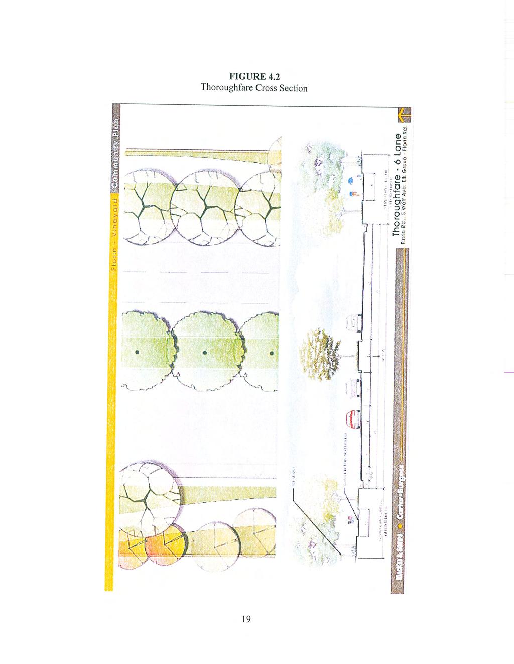
106
107
108
109
110
111

112
113 ACKNOWLEDGEMENTS Sacramento County Board of Supervisors Roger Dickinson, District 1 Jimmie Yee, District 2 Susan Peters, Vice Chair, District 3 Roberta MacGlashan, District 4 Don Nottoli, District 5 Planning and Community Development Robert Sherry, Planning Director Tricia Stevens, Principal Planner Surinder Singh, Senior Planner Consultants Roy Brewer, Brewer Lofgren, LLC Bruce Walters, MacKay and Somps REVISED PUBLIC REVIEW DRAFT, 3/10/10 - Draft notes or comments = blue italics - Joint CPAC Recommended Changes = green italics - Planning Dept Recommended Changes where different than CPAC = red italics
114 TABLE OF CONTENTS 1.0 INTRODUCTION POLICY PLAN LAND USE SUMMARY RESIDENTIAL LAND USE COMMERCIAL LAND USE INDUSTRIAL LAND USE OPEN SPACE & SCHOOLS DESIGN GUIDELINES CIRCULATION ADMINISTRATION APPENDICES A. CLIMATE CHANGE MEASURES... A-1 B. MITIGATION MONITORING & REPORTING PROGRAM.... B-1 C. GENERAL PLAN CONSISTENCY... C-1 (appendices to be added prior to final approval.)
115 LIST OF EXHIBITS & TABLES FIGURES 1.1 LOCATION MAP LAND USE PLAN (JOINT CPAC) LAND USE PLAN (PLANNING) PARKS PLAN DETENTION BASIN / OPEN SPACE ILLUSTRATIVE SCHOOLS PLAN GATEWAYS & ENTRIES PLAN PRIMARY COMMUNITY GATEWAYS SECONDARY COMMUNITY GATEWAYS VILLAGE ENTRIES COMMUNITY SIGNAGE SOUNDWALL THEME SPLIT RAIL FENCE THEME GREEN STREETS FRAMEWORK PLAN THOROUGHFARE & ARTERIAL STREET SECTIONS COLLECTOR STREET- DIVIDED SECTION PARKWAY I SECTION PARKWAY II SECTION PRIMARY RESIDENTIAL- SEPARATED AND ATTACHED SIDEWALK MINOR RESIDENTIAL SECTION PEDESTRIAN & BICYCLE TRAIL PLAN PEDESTRIAN & BICYCLE TRAIL SECTION TABLES 3.1 LAND USE SUMMARY (JOINT CPAC) LAND USE SUMMARY (PLANNING) SINGLE FAMILY RESIDENTIAL DEVELOPMENT STANDARDS OPEN SPACE OWNERSHIP, MAINTENANCE, & FUNDING
116
.")
117 Introduction 1.1 purpose and intent In 1999, the Sacramento County Board of Supervisors initiated a community planning program for the Florin-Vineyard area, also known as the Gap area. The term Gap has been used to refer to this area because it is located between the existing urban area to the west of Elk Grove- Florin Road and a comprehensively planned urban area to the east (i.e., North Vineyard Station and Vineyard Springs). The goal of this planning process is to provide a vision for the orderly and systematic urbanization of the study area through the establishment of a preferred land use plan and a facilities finance aerial view of Florin and Elk Grove-Florin Roads with existing Post Office in foreground element based upon this plan. Preservation and protection of the rural character of existing agricultural-residential neighborhoods is one of the primary objectives in the planning process. Other objectives include clustering of commercial uses at major intersections, providing appropriate locations for multifamily uses, preserving wetlands, and considering public use/ transportation options for the California Central Traction Railroad tracks. The preferred land use plan shows the existing agricultural-residential neighborhoods protected by a variety of agricultural-residential and transitional land use designations. Several new urban growth areas are shown along thoroughfares and at major intersections throughout the study area. The architectural and site design guidelines included in Section 8 are intended to help guide development of this area and lessen the potential for land use conflicts. A circulation framework plan and green streets proposal for street sections within the plan area provide for both vehicular and alternative modes of transportation. Other documents have been prepared as part of the community plan process. These are support documents that are separate from this community plan document and are available at the Sacramento County Planning & Community Development Department or Department of Environmental Review. These documents include the following; - Certified Environmental Impact Report & related Appendices, - Florin Vineyard Gap Community Plan Preliminary Drainage Study, - Sanitary Sewer Master Plan for the Florin Vineyard Gap Community Plan, - Master Water Study for the Florin Vineyard Community Plan, - Florin Vineyard Community Plan Public Facilities Financing Plan. Florin-Vineyard Community Plan

118 Introduction 1.2 setting The Florin-Vineyard Community Plan area covers approximately 3,766 acres and is located within the community planning areas of both Vineyard and South Sacramento. The boundaries of the Florin-Vineyard Community Plan (see Figure 1.1) are generally Elder Creek Road on the north, Bradshaw Road on the east, the Churchill Downs neighborhood to the south, and the Union Pacific Railroad tracks on the west. The Florin Vineyard Community Plan area includes approximately 670 parcels as of There are several established ranchette neighborhoods in this area. A total of 556 dwelling units exist as of 2002, and based on the 2000 Census, this represents a population of approximately 1,690 residents. The area is also bisected by Elder and Gerber Creeks, the Central California Traction Railroad track, and several overhead transmission lines and associated easements. Its lack of continuity is perhaps one of the biggest obstacles to a comprehensive planning effort. The large number of property owners, existing development patterns, and diverse opinions on appropriate urban development makes the Florin Vineyard Community Plan a unique area. Figure 1.1 Location Map Florin-Vineyard Community Plan
119

120 Policy Plan 2.1 policy plan In March, 2002, the Board of Supervisors approved formation of a Citizens Advisory Committee (CAC) for the Florin-Vineyard Community Plan. The CAC held ten workshops to discuss a number of land use issues within the plan area. The CAC expressed ideas and concerns for development within the plan area. Planning Department staff prepared policy text that was reviewed and accepted by the CAC. These policies, with modifications, have been recommended by the County Planning Commission and approved by the Board of Supervisors as a part of this Community Plan Document. The following vision, objectives, and policies apply to development in the Florin-Vineyard Community Plan. example of small strawberry farms in the area 2.2 VISION Provide for a high quality, clean, safe, long-lasting sustainable community that develops in an orderly and systematic manner with adequate public infrastructure and services. 2.3 OBJECTIVES 1. Establish a center focus that combines commercial, residential, civic and cultural re sources. 2. Allow for continued agricultural-residential land uses to help preserve existing rural communities. 3. Provide a diversity of housing types, including a mix of sizes, types, and price ranges. 4. Promote an efficient, balanced and safe transportation system to ensure mobility for all. 5. Provide adequate sites for open space, parks, trails and greenbelts. 6. Mitigate crime by incorporating crime prevention techniques in the design of all new projects including increased visibility and integration. 7. Implementation of County code enforcement programs to prevent blight within the area. Florin-Vineyard Community Plan
121 Policy Plan 2.4 residential (Policy Numbers to be revised with final version) Policy FV-1 Encourage a variety of lot sizes and housing types to promote social and economic diversity, and to promote greater variation visibly for neighborhoods. Policy FV-2 community. Ensure an adequate mix of housing affordability dispersed throughout the Policy FV-3 Promote policies to cite duplexes for all corner lots in single-family subdivisions to achieve a better integration of housing types throughout the community. Duplexes and half-plexes shall be located on corner lots. A use permit is not required for duplexes or halfplex lots that are being proposed to satisfy the County s Affordable Housing Ordinance. Policy FV-4 Encourage larger lots for residential uses along the boundary common to any neighborhood of a lower density. Policy FV-5 For any new residential subdivision, provide assurance (e.g., larger/deeper lots, recorded setback line, or CC&Rs) that any two-story (or greater height) structure can be set back at least 100 feet from the boundary common to an existing neighborhood of a lower density. Policy FV-6 Promote residential development that will result in a diverse streetscape in terms of housing types, building setbacks, and building height. Policy FV-7 The street pattern for new residential areas should be simple in design, and should provide multiple points of access (vehicles, pedestrians and bicyclists) to nearby commercial areas, parks, schools and public transit. Policy FV-8 For any new residential subdivision, provide the Planning Department with an analysis of circulation in the larger neighborhood, and demonstrate how the proposed subdivision will contribute to and enhance circulation for area residents (vehicles, pedestrians and bicyclists). Policy FV-9 Pedestrian and bicycle trails/pathways should be located within open space areas to the extent feasible. 2.5 commercial Policy FV-10 Promote mixed use concepts that capitalize on synergies between and among different types of land uses (e.g., residential and office). Policy FV-11 Encourage the elimination of barriers to pedestrian access between different types of complementary land uses. Policy FV-12 Promote commercial centers in new neighborhoods that are integrated into and physically connect with those adjacent neighborhoods. Florin-Vineyard Community Plan
122 Policy Plan Policy FV-13 Promote the incorporation of plazas and open spaces into commercial development that will provide for public gatherings and outdoor uses such as farmers markets. Policy FV-14 Encourage commercial architecture and building design that promotes pedestrian and various forms of multi-modal access. Policy FV-15 Promote commercial uses that cater to nearby residents, in locations where they are easily accessible for pedestrians, and those that will help create a more active and vibrant pedestrian environment (e.g., theaters, restaurants, outdoor cafes, and farmers markets). Policy FV-16 Promote pedestrian-friendly, human-scale commercial development that provides safe and pleasant places for people. Policy FV-17 Encourage screening of visibly large or tall structures such as water tanks or cellular facilities, by either locating them in areas seen by few people, or hidden by placement on the roof of a commercial building, or integrated into the building s design and architecture. 2.6 industrial Policy FV-18 Encourage larger lots for industrial uses along the boundary common to any residential or agricultural-residential neighborhood. Policy FV-19 For any new industrial subdivision, provide assurance (e.g., larger/deeper lots, recorded setback line, or CC&Rs) that any structure can be set back at least 100 feet from the boundary common to an existing residential or agricultural- residential neighborhood. Policy FV-20 Outdoor industrial storage areas should be located at least 50 feet from the boundary common to an existing residential or agricultural-residential neighborhood, and this setback area should be landscaped. Policy FV-21 Any new industrial development should either connect (extend as necessary) to public water and sewer, or provide assurance (e.g., bond, installation of dry lines, or record an agreement to connect) to connect at some future date. Policy FV-22 Any new industrial development should comply with appropriate fire prevention measures, including an adequate water supply for necessary fire flows. Policy FV-22(a) Promote the use of the industrial area along Elder Creek Road for future employment, office and business uses. Florin-Vineyard Community Plan
123 Policy Plan 2.7 open space Policy FV-23 Residential development adjacent to drainage parkways should avoid providing an excessive number of back-up lots, and should provide front-on street and open ended cul-de-sacs whenever possible. Policy FV-24 Improvements to drainage parkways should be consistent with the most recently approved plans and/or improvements (downstream or upstream) in terms of width, landscaping, and pedestrian access. Policy FV-25 Promote the construction of a network of pedestrian/bicycle trails within the study area, particularly within the electrical transmission corridor that runs north- south through the study area, near the alignment of Waterman Road. Policy FV-26 Residential development adjacent to the electrical transmission corridor (running north-south through the study area, near the alignment of Waterman Road) should avoid providing an excessive number of back-up lots, and should provide front-on streets and open ended cul-de-sacs whenever possible. In addition, residential fencing separating yard areas from this electrical transmission corridor should be an open design to allow viewing of the corridor. Policy FV-27 Identify a funding source that would allow for the Southgate Recreation and Park District to take ownership and assume maintenance responsibility for the electrical transmission corridor running north-south through the study area, near the alignment of Waterman Road. Policy FV-28 Ensure no net loss of vernal pool acreage, and/or values and functions, and mitigate any loss in relation to the values of quality of habitat. Policy FV-29 Evaluate feasible on-site alternatives in the environmental review process that reduce impacts on vernal pools and provide effective on-site preservation in terms of minimum management requirements, effective size, and evaluation criteria. Policy FV-29(a) Pedestrian and bicycle trails/pathways should be located within open space areas to the extend feasible. Open space areas should include an adequate buffer around preserve areas adjacent to residential lots and/or streets to allow for pedestrian and bicycle trail/pathway improvements. 2.8 streetscape Policy FV-30 Prominent entry subdivision signage and landscape treatment is encouraged at project entry points to provide a greater sense of neighborhood identity. Policy FV-31 Median landscaping is encouraged for all thoroughfares, arterials, and collector streets. Policy FV-32 All wood fences and masonry walls should be screened with trees and shrubs. Chain-link fencing is discouraged. Open-type fencing (e.g., wrought-iron fencing) should be Florin-Vineyard Community Plan
124 Policy Plan Policy FV-34 Landscaped corridors should be included adjacent to the right-of-way on both sides of all thoroughfares, arterials, and collector streets. The width of this corridor should be a minimum of 25 feet on both sides of thoroughfare and arterial streets, and 15 feet on both sides of collector streets. Policy FV-35 Pedestrian facilities along thoroughfare and arterial streets should include a 6- foot wide sidewalk, separated by the curb by a variable width planter that includes trees. Pedestrian facilities shall conform to the standards contained in the document and design requirements of the County Improvement standards. Sidewalks should be linear within the corridor and meandering sidewalks avoided to the extent possible. Policy FV-36 Project circulation design shall be consistent with the Green Streets Framework Plan, Street Sections, and Bicycle and Trail System found in the Transportation Section of this Plan. Policy FV-37 Street lights shall be provided on all streets within the Plan area in accordance with Sacramento County Improvement Standards. Energy efficient and decorative lighting standards above County requirements is encouraged where practicable. 2.9 Public Facilities Policy FV-38 Construction of school sites within the Florin Vineyard Community Plan shall be consistent with the following elements; a. Provide the number, type, design, and location of school facilities consistent with the Elk Grove Unified School District Master Plan. b. New elementary school sites should be designated adjacent to existing or proposed neighborhood or community park sites and be designed to promote joint use of both facilities. c. Provide bikeways or pedestrian facilities to link school sites with residential areas. These facilities shall connect to the overall trail system and green street concepts planned within the planning area. Policy FV-38(a) Prior to approval of a final map for any residential subdivision map in the Florin Vineyard Gap Community Plan area, the applicant shall obtain written confirmation from the Superintendant of Grove Unified School District ( EGUSD ) or his/her designee that school enrollment impacts have been or will be adequately mitigated through the reservation (per California Government Code Section and 66480) of a school site or sites or through other measures. The reserved site or sites must be in a location and configuration acceptable to the EGUSD, consistent with the conceptual school site locations identified on Exhibit 7.3 of this plan, and, to the extent practicable, consistent with the school siting policies set forth Section 7.4. Policy FV-39 Park facilities and sites shall be provided consistent with the Southgate Recreation & Park District standards and policies. Park sites within the Community Plan shall be consistent with the following elements; a. Parkland dedication shall be determined in accordance with Sacramento County Title 22 requirements; Florin-Vineyard Community Plan
125 Policy Plan b. Parks shall be located and sized to meet the recreational needs of the plan area and surrounding neighborhood; c. Parks should be bordered on at least two sides by streets, preferably three, in order to facilitate public access and visibility; d. Whenever possible, park sites should be located adjacent to public facilities such as schools, libraries, fire stations, and open space corridors. Joint use agreements should be encouraged. In such instances, recreation amenities, including play equipment and athletic fields, should be shared to minimize cost; e. Park sites adjacent to stormwater detention and/or treatment facilities are encouraged. In these cases, a pedestrian trail system should be included within the two facilities. Consideration for joint-use of park and recreation facilities within the stormwater facilities should be included early in the project design phase. Policy FV-40 The drainage parkway of Elder Creek and Gerber Creek as identified on the land use plan shall be designed as natural-appearing corridors serving to enhance wetlands and riparian habitats, act as natural flood water detention areas, and function as water quality enhancement features. The drainage parkways shall be designated to permit the growth of vegetation that does not impede the design flow characteristics. Periodic clearing is allowed to maintain channel function. At least one side of the drainage parkway shall have a single-loaded street with front-on lots toward the corridor. Backup lots along the drainage parkway is discouraged. Florin-Vineyard Community Plan
126

127 Land Use Summary 3.1 land use summary The plan provides for the ultimate development of the approximately 3,766 acre study area, including 12,066 dwelling units in a wide range of types and densities, retail commercial, industrial, business and commercial uses, parks and open space, and schools. Following are some of the key features of the plan: A primarily residential community served by the necessary services (e.g., commercial services, parks, and schools), and public infrastructure. A range of residential and agriculturalresidential densities to help provide a aerial view of the Caselman Road/ Carlisle Avenue area better transition between some of the existing and proposed neighborhoods, and to provide for a wide range of housing types and densities. Commercial and/or mixed use centers at major intersections that will help provide retail commercial shopping and employment opportunities for area residents and create community focus areas. Open space dispersed throughout the community to serve both active and passive recreational needs. School, park, and other public facilities to serve the needs of the community. A railroad corridor identified for possible future public transit use or a pedestrian/ bicycle trail. A network of drainage parkways that is part of a larger, county wide solution to area wide flooding. A network of pedestrian and bicycle pathways within designated roadways, drainage parkways, and open space areas. Land use policies and design guidelines that will help guide development and lessen the potential for land use conflicts. 3.2 land use plan The adopted land use plan applies to all properties within the Florin Vineyard Community Plan and supersedes the existing South Sacramento and Vineyard Community Plans. Land use areas shown are based on a GIS parcel base. Actual property lines and land use areas may vary. Where inconsistencies occur, the Planning Department staff shall determine land use lines using more accurate information as described in Section 3.3. Figure 3.1, Land Use Plan, shows the location, types and intensities of land uses within the plan area. Table 3.1, Land Use Summary, includes an accounting of the land use designations by acreage and potential dwelling yield. Florin-Vineyard Community Plan
128 Land Use Summary ************************************************************************************************ JOINT CPAC RECOMMENDS THE FOLLOWING LAND USE PLAN AND TABLE. Community Plan Area Community Plan Area RD 5-7 P RD 7-12 RD 3-5 RD-10 (MHP) BP OS RD 3-5 RD-20 RD-20 OS RD 3-5 M1(SM)(F) LEGEND AR 2-5 AR 1-2 RD-20 RD 7-12 RD-10(MHP) RD 5-7 RD 3-5 RD 2-3 LC, SC, GC BP M-1 IR Open Space RD-10 (MHP) P AR 2-5 AR 2-5 SC RD 3-5 RD-20 P RD 2-3 AR 1-2 AR 1-2 MIXED USE P Neighborhood or Mini Park CP Community Park RD 3-5 RD 3-5 SC RD 3-5 RD 7-12 RD 3-5 P RD 5-7 RD 3-5 RD 5-7 RD 3-5 P RD 3-5 RD 3-5 P RD 5-7 GC RD 3-5 RD 5-7 RD 3-5 RD 5-7 RD 3-5 RD-20 RD 3-5 RD 3-5 P LC OS RD 3-5 RD 3-5 RD 3-5 RD 3-5 RD 5-7 RD 3-5 SC RD 3-5 P RD 3-5 RD 3-5 M-1(F) M-1 GC OS SC BP RD-20 RD 3-5 AR 1-2 RD 2-3 SC RD 2-3 RD 2-3 RD feet CP AR 1-2 AR 1-2 M-1 AR 1-2 LC AR 2-5 AR 2-5 AR 2-5 OS M-1 OS RD 3-5 OS M-1(F) AR 1-2 OS M-1 AR 1-2 M-1(SM) M-1(SM) AR 1-2 Figure 3.1 Land Use Plan Note: Total units shown use an assumed density that may vary with individual projects. Factors such as location, street design, utilities and drainage improvements will determine actual density yields. Florin-Vineyard Community Plan
129 Land Use Summary Allowed Assumed Land Use Type Density Acres Units Density (du/ac) AR to 5 ac/du AR to 2 ac/du RD to 3 du/ad RD to 5 du/ac 1, , RD to 7 du/ac , RD to 12 du/ac RD-10(MHP) 10 du/ac RD to 20 du/ac Residential Subtotal 2, ,008.4 M1 1,092.1 IR 0.0 GC 10.2 SC LC 20.9 BP 13.3 Open Space 98.1 Major Roads & CTRR Grand Total 3, ,008.4 Table 3.1 Land Use Summary Florin-Vineyard Community Plan
130 Land Use Summary ******************************************************************************************************************** PLANNING DEPARTMENT RECOMMENDS THE FOLLOWING LAND USE PLAN AND TABLE. RD 3-5 RD-10 (MHP) RD 3-5 Community Plan Area Community Plan Area M-1(SM) M-1(SM)(F) GC RD 3-5 OS LEGEND AR 2-5 AR 1-2 RD-20 RD 7-12 RD-10(MHP) RD 5-7 RD 3-5 RD 2-3 Commercial BP M-1 IR Open Space GC RD 3-5 RD 5-7 RD 5-7 RD 3-5 P RD 5-7 OS P RD 5-7 RD 3-5 RD 2-3 AR 1-2 AR 1-2 AR 2-5 BP RD-20 RD 3-5 AR 2-5 OS RD 2-3 MIXED USE RD-20 RD 3-5 RD 3-5 RD 3-5 CP RD 3-5 RD 3-5 RD 3-5 M-1 RD 5-7 RD 3-5 RD 7-12 RD 5-7 RD 7-12 RD-20 RD 7-12 RD 5-7 BP RD-20 LC SC LC RD-20 RD 3-5 RD 7-12 RD-20 RD 7-12 RD 3-5 RD 3-5 RD 3-5 OS SC RD-20 RD 3-5 RD 5-7 SC RD 3-5 RD-20 RD 5-7 RD 2-3 RD 3-5 RD 3-5 OS RD 3-5 OS RD 3-5 OS AR 1-2 RD 3-5 SC AR 1-2 RD 2-3 RD 5-7 SC RD-20 RD-10 (MHP) RD feet M-1 P P P RD 5-7 RD 5-7 RD 3-5 P P P M-1 M-1(SM) M-1(SM) M-1(SM)(F) IR(SM) IR(SM)(F) IR(SM) P Neighborhood or Mini Park CP Community Park Figure 3.2 Land Use Plan Note: Total units shown use an assumed density that may vary with individual projects. Factors such as location, street design, utilities and drainage improvements will determine actual density yields. Florin-Vineyard Community Plan
131 Land Use Summary Allowed Assumed Land Use Type Density Acres Units Density (du/ac) AR to 5 ac/du AR to 2 ac/du RD to 3 du/ad RD to 5 du/ac 1, , RD to 7 du/ac , RD to 12 du/ac RD-10(MHP) 10 du/ac RD to 20 du/ac , Residential Subtotal 2, ,541.7 M IR GC 10.2 SC LC 18.5 BP 13.3 Open Space 98.1 Major Roads & CTRR Grand Total 3, ,541.7 Table 3.2 Land Use Summary Florin-Vineyard Community Plan
132 Land Use Summary 3.3 calculation of land USE The Florin-Vineyard Community Plan does not include specific dwelling unit allocations for each property. Instead, the designated land use is applied to each property and determined on a case by case basis. To determine the allowable dwelling units per this Community Plan, the following method shall be applied; 1. Land use designations from the Sacramento County GIS parcel base is applied to the subject property using best available boundary information. In cases where the GIS base and boundary information differ, a best fit method shall be applied using known road centerlines or property corners. 2. Areas of land use designations are calculated from the boundary information and multiplied with either of two densities described below to determine project specific dwelling unit calculation. A. If a project does not propose density averaging described in Section 3.4, then the maximum density shown in the applicable Density Range shall apply. For example, a project with a RD 3-5 designation shall use the maximum density of 5 du/ac density for calculation. B. If a project proposes density averaging described in Section 3.4, then the Assumed Densities shown on Table 3.1 shall be applied. For example, a project with a portion designated RD 3-5 shall use the assumed density of 4.5 du/ac for calculation. For the purposes of this Section, single family residential land use area is based on gross acreage. In such instances, the acreage includes land to the centerline of the adjacent existing or planned roadways. Land use areas for multi-family, commercial, office and industrial shall be based on net of existing or planned public roadways. Project applications shall be reviewed by Planning Department staff against the above land use calculation method to determine consistency with the approved Florin Vineyard Community Plan Land Use Map. 3.4 density averaging Generally, residential development will occur within the density ranges specified in Table 3.1. However, in order to promote housing diversity and accommodate housing on sites with unusual physical conditions, landowners may elect to deviate from the density range in accordance with the following provisions described below. A density averaging proposal shall not exceed the total calculation of land use described in Section 3.3. An exception is allowed for affordable housing density bonus described in Section 3.6. Density averaging is limited to a maximum of one dwelling unit per acre increase above the specified land use designation or range. In cases where identified land use designation is a range, the one category increase may be applied to the high end of the range. For example, the maximum allowable density in an area designated RD 3-5 would be RD-6. Florin-Vineyard Community Plan
133 Land Use Summary Densities lower than the range shown in Table 3.1 for single family residential land use are also permitted up to a maximum of one dwelling unit per acre lower than the specified land use designation or range. For example, the minimum allowable density in an area designated RD 3-5 would be RD-2. An exception applies to parcels created to preserve existing houses within a proposed subdivision. In this case, if a minimum 1-acre lot is proposed, a minimum density of 1 du/ac shall be allowed only for that lot. Density averaging proposals shall be made with application of a rezone or other application what requires approval by the Board of Supervisors. An exhibit illustrating and tabulating any proposed density averaging shall be submitted to the County concurrent with any corresponding tentative map or development application. Density averaging done in accordance with this section is deemed consistent with the Florin-Vineyard Community Plan and is permitted without a community plan amendment. 3.5 affordable housing - land use consistency Development of affordable housing is required in Chapter of the County Code. The Ordinance requires 15% of a project to meet affordable housing criteria. The Ordinance allows a number of options to meet the affordable housing requirements including onsite construction, land dedication of multi-family land to the Sacramento Housing & Redevelopment Agency (SHRA), or payment of in-lieu fees. Each development project may choose from affordable housing options, within certain limits. If a project proposes to build on-site multi-family units or dedicate land to SHRA, a site must be zoned RD-20. Typically, these sites are 4 to 10 acres in size and are located along major roadways. Since each project must meet the requirements of Chapter 22.35, such sites may be located on land that is not designated RD-20 in Figure 3.1, Land Use Plan. As a result, an affordable housing site with RD-20 zoning may be allowed on any land use designation of RD 2-3 or above and shall be considered consistent with the Florin-Vineyard Community Plan. In these cases, the proposed affordable housing site should be located consistent with General Plan policies and Affordable Housing Ordinance requirements. This provision does not apply to multi-family residential projects with market-rate housing. 3.6 affordable housing - density bonus A density bonus for affordable housing is allowed in Chapter of the County Code. The formula for calculating a density bonus is established by State law and is based on amount and type of proposed affordable housing. A density bonus of 15% to 30% is possible in many cases. This density bonus may be applied anywhere within a proposed project. For example, a density bonus from an affordable multi-family portion of a project may be applied to other single-family portions of the project. An affordable housing density bonus may result in housing types with densities above that shown in Figure 3.1 Land Use Plan. In these cases, such land uses shall be considered consistent with the Florin-Vineyard Community Plan. Florin-Vineyard Community Plan
134 Land Use Summary 3.7 underlying community plan land use designation Lands subject to dedication and/or reservation as park and school sites are assumed to have an underlying community plan land use designation which is compatible with surrounding uses. In the event a park or school site is ether reduced in size or eliminated due to a documented change in the controlling agencies plans, a lessening of dedication requirement, or other reason approved by the Board of Supervisors, the underlying land use designation shall apply and is permitted without a community plan amendment. 3.8 CODE ENFORCEMENT The Florin Vineyard Gap area consists of several older neighborhoods that may be in need of rehabilitation and structural improvement. The Code Enforcement Division of the County s Department of Neighborhood Services is the designated entity for enforcing local and state adopted codes and ordinances to ensure compliance for safe living in the unincorporated area of the County. The Code Enforcement Division currently offers a comprehensive program to protect a property owner s investment, promote public health and welfare, and enhance the quality of life in Sacramento County. Code Enforcement staff works to achieve voluntary compliance through notification and education. When necessary, staff will use legal procedures including boarding structures, removing junk and rubbish and junk vehicles, civil citations, criminal citations and demolition of dangerous buildings. The newly enacted Rental Housing Inspection Program provides a more regulated approach to insuring safe rental properties within unincorporated Sacramento County. Florin-Vineyard Community Plan
135

136 Residential Land Use 4.1 residential land use The Florin Vineyard Community Plan includes a mix of housing densities from agriculturalresidential to multi-family residential. Single family residential densities from 2 to 12 dwelling units per acre allow a range of housing types within the planning area. RD-20 land use allows for higher density uses located within community focus areas and along major roadways. Generally, the higher residential density land uses are oriented along the major roadways and toward the Community Focus Areas with lower densities further away. 4.2 AGRICULTURAL-RESIDENTIAL LAND USE The agricultural-residential land uses are intended to preserve existing uses and allow continued agricultural-residential uses in the future. These areas include the Bar Du Lane/ Rogers Road area between Waterman Road and Bradshaw Road, and the Lealand Avenue area east of Elk Grove-Florin Road. Conversion of these areas to urban uses is possible in the future but should only be considered in a comprehensive fashion. Sacramento County has adopted a Right to Farm Ordinance to implement measures to protect farming activities in these areas. Utility services to agricultural-residential uses may be limited to individual well and septic. Public water service may be extended to these areas for lots generally less than 2 acres in size. 4.2 zone classifications The zone classifications on residential property within the Plan area are those of the standard Sacramento County Zoning Ordinance. Zone classifications that may be applied by rezone action to properties within the Plan area shall be consistent with the Community Plan designations. Florin-Vineyard Community Plan
137 Residential Land Use 4.3 development standards ****************************************************************************************************** (JOINT CPAC DEPARTMENT RECOMMENDS THE FOLLOWING TEXT) The development standards for areas designated residential or agricultural-residential as shown on Figure 3.1 are described in Chapter 5, Article 1 of the Sacramento County Zoning Ordinance. One exception to County Zoning standards is the setback for fencing in the residential designations. Fence setbacks in the residential designations shall supersede the County Zoning Code and shall be subject to the following; Fence setbacks Side street setback, for any size fence Front setback- fences above 4 feet in height. Front setback- open fences and 4 feet high or lower. 5 feet 20 feet 0 feet Florin-Vineyard Community Plan
138 Residential Land Use 4.3 development standards ******************************************************************************************************* PLANNING DEPARTMENT RECOMMENDS THE FOLLOWING TEXT The development standards for classifications RD-3 through RD-10 in the Plan area shall be those shown on Table 4.1 and supersede the Sacramento County Zoning Code. Other residential zoning classifications shall be those contained in Chapter 5, Article 1 of the Sacramento County Zoning Ordinance. RD-3 RD-4 RD-5 RD-7 RD-10 LOT DIMENSIONS (min.) Lot Area (sq. ft) (1) 9,000 7,000 5,200 3,800 3,200 Area, Corner (sq. ft) 9,000 7,000 6,000 4,500 4,000 Width 65' 60' 52' 35' 35' Public Street Frontage (2) 55' 50' 45' 30' 30' Width, Corner (2) 70' 65' 60' 45' 45' Depth (3) 110' 100' 95' 60' 60' SETBACKS (min) Front, Living Area (4)(5) 20' 20' 15' (6) 15' (6) 15' (6) Front Porch (5) 20' 20' 10' 10' 10' Front Garage (7) 20' 20' 20' (8) 20' (8) 20' (8) Side, Interior (4) 5' 5' (9) 5' (9) 5' (9) 5' (9) Side, Street- Attached (1) 15' 12.5' 12.5' 10' 10' Side, Street- Detached 12.5' 12.5' 12.5' 8.5' 8.5' Side, Total Bldg Separation (9) 10' 10' 10' 10' 10' Rear, Living Area (4) 20' 20' 15' 10' 10' Rear, Ancillary Unit (10) 5' 5' 5' 5' 5' Detached Garage (11) 5' 5' 0' 0' 0' Fence, Side Street (12) 5' 5' 5' 5' 5' Fence, Front (13) 20' 20' 15' 15' 15' PUE Adjacent to R/W (14) 12.5' 12.5' 12.5' 10' 10' NOTES: (1) The minimum half-plex lot area is 3,000 sq.ft. for interior lots and 4,000 sq.ft. for corner lots. Half-plex lots have no minimum lot dimension requirements. (2) The public street frontage for lots fronting on a curved street of the curved portion of a cul-de-sac or elbow may be measured along an arc located within the front 50 feet of the lot. (3) The minimum lot depths listed herein supersede the minimum lot depth provisions in the Zoning Code. (4) Architectural projections are allowed to extend two (2) feet into the required interior side yard and rear yard setbacks. Architectural projections are also allowed to extend two (2) feet into required 20-foot front yard setbacks. Architectural projections include eaves, bay windows (cantilevered and extending from the foundation), fireplaces, media bays, and architectural box-outs. Rear yard projections are allowed pre Zoning Code, Section (b). (5) Vehicular visibility requirements must be met. (6) May be reduced to 10 feet where adjacent to detached sidewalk. (7) Where swing driveways are used, the front yard garage setback may be reduced to 15 feet. (8) Driveway length may be reduced to 19 feet where automatic roll-up doors are used. (9) Zero-lot line units are permitted where the total building separation requirement is met. (10) Ancillary units have the same front, side, and street sideyard setback requirement as the primary unit. If attached, the required rear yard is the same as for the primary unit. If detached, the separation from the primary unit is governed by the Uniform Building Code and the Uniform Fire Code. Ancillary units may be placed above attached or detached garages. One (1) on-site parking space is required per unit in addition to the two (2) garage and two (2) driveway spaces required for the primary unit. (11) Side and rear setback dimension. (12) Required for any height fences. (13) Required for fences above 4 feet in height. Zero setback allowed for open fencing and 4 feet or below. (14) Applies to attached sidewalk. Can be reduced with detached sidewalk. (15) Refer to Sacramento County Zoning Code for other development standards. Table 4.1 Single Family Residential Development Standards Florin-Vineyard Community Plan
139 Residential Land Use 4.4 permitted uses Permitted uses within areas designated as residential land uses as shown in Figure 3.1, Land Use Plan, are those uses that are permitted in accordance with the zoning for the property in existence on the date this plan was adopted and those permitted uses described in Chapter 1, Article 1 of the Sacramento County Zoning Ordinance for the AR-2, AR-1, RD-1, RD-2, RD-3, RD-4, RD-5, RD-7, RD-10, RD-15, RD-20, and RD-25 zoning classifications, subject to the special conditions specified and contained herein. Notwithstanding, the permitted uses associated with the zoning on property in existence when this plan is adopted remains in effect until the property is rezoned. Florin-Vineyard Community Plan
140

141 Commercial Land Use 5.1 commercial land use The Florin Vineyard Community Plan includes a limited amount of commercial and business/professional land use primarily for the convenience of future residents of the Community Plan and nearby areas. Commercial development designated within the Plan area is not intended to meet all of the regional commercial needs of the Plan area residents and is not intended to include major shopping and employment opportunities for the larger South County area. Instead, the Plan provides a limited percentage of the total land area for commercial uses. The planned commercial uses will serve the frequently recurring needs of area residents for commercial goods and services. The approximate 147 acres of commercial use is distributed among five main areas within the Plan area. Each commercial area is located at the intersection of major roadways. These areas will be easily accessible to possible future public transit routes. The main commercial areas, located at major intersections, are spaced at least one mile apart and provide reasonable spacing to serve the surrounding community. The Plan includes higher density residential land uses around the commercial areas to create community focus areas and maintains appropriate transitions of land use density. These areas are an important part of the community themes for the Florin Vineyard Community Plan. Additional discussion of community themes can be found in Section 8.5 of this Plan. 5.2 zone classifications The Zone Classification that may be applied by rezone action to properties within the Plan area designated Commercial or Business/Professional on the land use plan includes Shopping Center (SC). Limited Commercial (LC), General Commercial (GC) and Business/ Professional (BP). The Floodplain (F) combining zone classification must be applied to property that is subject to flooding. These zoning classifications on property within the Plan area, and in existence at the date of this plan adoption, are consistent with Commercial and Business/ Professional land use designation in this Plan. Other commercial, business/professional, and/or residential zone classifications may be found consistent with the Commercial or Business/Professional land use designations in the land use plan if those classification are used for mixed use development and are found to be consistent with General Plan and Community Plan policies. Determination of such consistency shall be recommended by Planning Department staff and approved by the County Board of Supervisors. Florin-Vineyard Community Plan
142 Commercial Land Use 5.3 development standards The development standards for areas designated Commercial or Business/Professional as shown on Figure 3.1, Land Use Plan, are described in Title III, Chapter 15 of the Sacramento County Zoning Ordinance. 5.4 permitted uses Permitted uses for areas designated Commercial or Business/Professional as shown in Figure 3.1, Land Use Plan, are those that are permitted in accordance with the zoning for property in existence on the date this plan was adopted and those permitted uses described in Title II, Chapter 25 of the Sacramento County Zoning Ordinance, subject to the special conditions specified and contained herein. Notwithstanding the permitted uses associated with the zoning on property in existence when this plan is adopted remains in effect until the property is rezoned. 5.5 commercial/ residential mixed uses It is the intent of this Plan to allow for mixed use development within the Plan area where appropriate opportunities apply. The commercial and multifamily areas shown in Figure 3.1, Land Use Plan, particularly at the Community Focus Areas, are likely candidates since they are located at major roadway intersections, however other mixed use development locations are possible within the Plan area. Mixed use development of retail, office, employment and residential uses, both vertically and horizontally integrated, is a way to create active, urban environments that creates a sense of place and encourages more pedestrian uses within the larger neighborhood. Important design features of mixed use development such as building placement, public space, and pedestrian-friendly streets help to create a more livable environment. To accommodate and encourage this type of development, the land use plan designates several sites for mixed Use centers with a land use overlay. The development of mixed use development is encouraged within the Florin Vineyard Community Plan but is not mandatory. Location and design of a mixed use project should be considered in relation to the surrounding land use context and may not be appropriate in all of the designated commercial areas. The land use plan designates the following two sites for mixed use development- northeast corner of Florin and Bradshaw Roads, and southeast corner of Gerber and Elk Grove-Florin Roads. On these sites, subsequent review of development plans shall place o strong emphasis on mixed use concepts to create a sense of place and encourage pedestrian activity. Mixed use development proposals, and needed general plan amendment and rezone entitlements, shall be considered consistent with the Florin Vineyard Community Plan, provided the project is consistent with the policies of this Plan and the County General Plan, and is compatible with the existing and future neighborhood. Florin-Vineyard Community Plan
143

144 Industrial Land Use 6.1 industrial land use The northeast portion of the Plan area is designated Light Industrial (M-1) and Industrial Reserve (IR). Existing land uses at the time of plan adoption includes a mix of plant nurseries and other agricultural use, residential-agricultural sites, light industrial uses, electrical substation and transmission lines. This area of the Plan is also constrained by the Elder Creek floodplain, wetland resources, and an aggregate resource overlay. The area also lacks major sewer and water services. The ability to develop large industrial areas in the northeast portion of the Plan area is unlikely due to the number of constraints described above. The Jackson Road Visioning Plan concept map shows a mix of residential use and neighborhood centers. Some additional industrial development is possible but will likely be limited in size and scope. For these reasons, the industrial land uses in this plan should be considered a transition land use with possible conversion to other land uses in the future. 6.2 zone classifications The Zone Classification that may be applied by rezone action to properties within the Plan area designated Light Industrial and Industrial Reserve on the land use plan includes Light Industrial (M-1), Industrial Office Park (MP) and Industrial Reserve (IR). The Floodplain (F) combining zone classification must be applied to property that is subject to flooding. The Surface Mining (SM) combining zone classification is applied to specified properties. These zoning classifications on property within the Plan area, and in existence in the date of this plan adoption, are consistent with the Light Industrial or Industrial Reserve land use designation in this Plan. 6.3 development standards The development standards for areas designated Light Industrial and Industrial Reserve as shown in Figure 3.1, Land Use Plan, are described in Title III, Chapter 25 of the Sacramento County Zoning Ordinance. Florin-Vineyard Community Plan
145 Commercial Land Use 6.4 permitted uses Permitted uses for areas designated Light Industrial and Industrial Reserve as shown on Figure 3.1, Land Use Plan, are those that are permitted in accordance with the zoning for property in existence on the date this plan was adopted and those permitted uses described in Title II, Chapter 30 of the Sacramento County Zoning Ordinance, subject to the special conditions specified and contained herein. Notwithstanding the permitted uses associated with the zoning on property in existence when this plan is adopted remains in effect until the property is rezoned. 6.5 future use of industrial lands As noted in Section 6.1, the long term viability of industrial uses for all of the lands designated in the Land Use Plan is questionable due to existing land uses and physical constraints. Some portions of the designated industrial area may be considered for a change of land use in the future. If that occurs, property owners will be invited to participate in any future master planning efforts to re-examine land uses within this area. Florin-Vineyard Community Plan
146

147 Open Space & Schools 7.1 parks and parkways This section of the Florin Vineyard Community Plan describes the park and open space system, which includes active parks, passive open space and natural areas, and parkways with off-street trails. The Land Use Plan shown in Figure 3.1 does not show specific park locations or sizes. Instead it shows the general locations of park sites proposed within concurrently processed tentative maps and a community park site proposed by Southgate Recreation and Park District. Two community parks are anticipated within the plan area to serve the larger community recreational needs. These park facilities are usually larger than 10 to 15 acres in size and may include various playfields, picnic facilities, community center buildings, and possibly pool and aquatic facilities. One possible community park location is on the west side of Gardner Avenue south of the existing church. This facility would connect and add to the existing Florin Community History Center and Sunrise Florin Park located on Fletcher Farm Drive to the west. A second community park is anticipated in the area east of Hedge Avenue, either north or south of Florin Road. This facility would serve community park needs for the eastern portion of the Plan area. Several neighborhood parks are anticipated in the Plan area. These type of parks are usually 5 to 10 acres in size and may include playfields, playgrounds, court game areas, and picnic facilities. These parks serve residents within a radius of about 2/3 mile to 1 mile and meet the more immediate recreational needs of the neighborhood. One or more neighborhood parks should be included in the larger blocks of residential development in the Plan area. Exact location and design of neighborhood parks is subject to more detailed project layouts and is to be determined with individual subdivision applications. Small Mini-parks should also be included in project designs where appropriate. These parks are typically less than 5 acres in size and may include a children s play area, picnic tables, shade structures walkways and landscaping. Mini-parks are intended to provide a green space in areas of higher residential densities where a larger neighborhood park is not feasible. Parks and open space within the Florin Vineyard Community Plan will be owned and maintained by the Southgate Recreation & Park District. Park facilities proposed within the Plan area must be reviewed by Southgate to insure consistency with the overall park and recreational needs of the community. Acceptance of parkland dedications is subject to approval by the Southgate Recreation and Park District s Board of Directors. Planning and construction of park and recreation facilities are usually completed by Southgate. Park construction is usually done after the basic site improvements are constructed as part of the subdivision improvements. Turn-key park development by subdividers can be done, subject to Southgate approval. Florin-Vineyard Community Plan
148 Open Space & Schools Community Plan Area Community Plan Area P CP P P P P 4 5 P 7 P P P CP feet NOTE: Calculation based on residential densities proposed in the land use plan at a level of service at 5 acres of parkland per 1,000 people. Estimated parkland acreage for each quadrant to be used as a guide in reviewing individual development applications. All numbers are subject to change. Neighborhood or Mini Park (proposed within concurrent projects) Community Parks Figure 7.1 Parks Plan Florin-Vineyard Community Plan
149 Open Space & Schools Sacramento County s and Southgate s parkland dedication standard of 5.0 acres per 1000 persons is used with this Plan. Per-unit dedication factors for single family and multi family land uses is included in Section of the Sacramento County Land Development Ordinance (Title 22). Park dedication can be applied to the range of park types described above. In some cases, a portion of the green street parkways, such as the 35-foot wide parkways planned for Gardner and Hedge Avenues (and potentially Florencia Lane) can be applied to the park dedication requirement. Medium density and multi-family projects may include private park facilities or on-site recreational facilities such as pools, tot-lots and club houses. These private facilities may be eligible for credit toward park dedication requirements per Sacramento County Title 22. Figure 7.1, Parks Plan, illustrates estimated parkland dedication required for nine identified quadrants within the Plan area. The estimated parkland calculation is based on residential densities proposed in the adopted land use plan at a standard of 5.0 acres per 1,000 persons. The estimated parkland acreage required for each quadrant should be considered a guide in reviewing individual development applications. Actual acreage of parkland will vary depending on the size and location of proposed development. For example, smaller projects will likely pay parkland dedication in-lieu fees, while larger projects will likely dedicate land. Figure 7.1 shows park sites proposed within concurrently processed development projects and a community park proposed by Southgate. However additional park locations have note yet been identified for the remaining areas within the Plan area. Instead, parkland dedication requirements have been estimated for each quadrant. This is to allow flexibility in park site location as development occurs, and not predispose a park site use on particular properties. Parkways within the Plan area are focused along the Gerber Creek and Elder Creek drainage corridors and the 400 to 600 wide powerline corridor east of Waterman Road and south of Gerber Road. These parkways will include pedestrian/bicycle trails with limited landscaping. The width of these parkways will vary based on regulatory agency requirements and the area of open space dedicated. Parkways along the two drainage corridors and powerlines should be designed to be accessible to the adjoining land uses. Single loaded streets, open cul-de-sacs, or other open design features should be included along these parkways. Landscaping within these parkways should be visually interesting and natural in appearance with drought tolerant plantings. Section of this Plan describes bicycle/pedestrian paths within these parkway corridors. A 10-foot paved path is planned within certain sections of the parkways described above. 7.2 detention and treatment basins A number of stormwater detention and treatment basins are proposed within the Plan area as part of the Florin Vineyard Drainage Master Plan. Detention basins are planned at the western end of three separate drainage sheds within the Plan area and range in size from 4 to 10 acres in size. Stormwater treatment basins are smaller (as little as one acre) and are more distributed in the Plan area. Location and design of these facilities are determined at the tentative subdivision map level and are not shown on the Florin Vineyard Land Use Plan. Florin-Vineyard Community Plan
150 Open Space & Schools The stormwater detention basins create an excellent opportunity to create additional open space within the community. Siting and design of detention basins should incorporate the surrounding neighborhood and provide passive open space opportunities where feasible. Stormwater detention basins within the Plan area should attempt to incorporate the following features: Detention basins should be located adjacent to active park facilities where possible to create a larger total open space area for the neighborhood. Paths within adjacent parks should connect into the detention basin area. Design of joint use facilities is encouraged to combine the needs of stormwater detention and active recreational areas. Joint use detention/park areas can include active sports fields but is limited to open turf or landscape areas with minimal hardscape or park improvements. Sacramento County Water Resources Division s guidance manual for detention/park joint use facilities provides more information. Single-loaded streets should be included at least one or two sides of a detention basin to create open access to the area. Single loaded street sections do not need sidewalks on along the detention frontage if a separate path is included with the open space. Sufficient area should be provided top of bank around the detention basin to allow for a pedestrian path, a post & cable or other fencing, and limited landscaping. Typically an area from 30 to 50 feet from top of bank is adequate setback for open space around the basin. A minimum setback of approximately 20 feet should be used where no trail is planned. A 10-foot pedestrian path of asphalt-concrete should be included within the top of bank area with connections to adjacent roadways at key intersections. A pedestrian path should be of sufficient distance to encourage passive open space use but does not necessarily need to encircle the basin. Varied shape and slopes of the basin should be designed to create a visually interesting open space area. Limited landscaping within the top of bank area including native drought tolerant trees and natural grasses. Shrubs and groundcover should be limited to an area 10 feet from a single loaded street. Benches and security lighting features should be incorporated into detention basin designs where feasible. Depending on size of the basin and alignment of pedestrian paths, benches or security lighting may be appropriate to provide a more desirable and safe pedestrian environment. An illustration of possible stormwater detention basin and open space design that includes some of the above features is shown in Figure 7.2. Florin-Vineyard Community Plan

151 Open Space & Schools Figure 7.2 Detention Basin/ Open Space Illustrative Water quality treatment basins are typically much smaller than detention basins. It may not be practical to include some measures described above such as paths, adjacent parks, varied shapes, or large setbacks. Where possible treatment basins should include single loaded streets and limited landscaping within the top of bank area. Florin-Vineyard Community Plan
152 Open Space & Schools 7.3 wetlands and natural open space Several areas within the Plan area may be preserved as open space for purpose of protecting wetland areas. Exact size, location and configuration of wetland preserve areas are determined on a project by project basis and is not shown in the Florin Vineyard Community Plan. Wetland preserve areas are regulated by State and Federal resource agencies and wetland permit requirements determine layout, ownership and ongoing maintenance. Wetland preserves are typically restricted to public access but still serve as a passive open space area for the community. Wetland preserves proposed within the Florin Vineyard Community Plan should include sufficient buffers between urban uses and wetlands, and single loaded streets or open neighborhood design. Sufficient area within wetland buffers should be provided to allow for pedestrian and bicycle trail/pathway improvements where feasible. 7.4 SCHOOL FACILITIES The Florin Vineyard Community Plan is within the Elk Grove Unified School District (EGUSD), the boundaries of which cover a large portion of south Sacramento County. There are no schools within the Plan area at the time of plan adoption. Nearest schools include Maeda Beitzel Elementary in the Vintage Park subdivision south of Gerber Road, Mary Tsukamoto Elementary located west of Elk Grove-Florin Road and south of the Caselman-Carlisle area. Florin Elementary is located west of the Plan area and south of Florin Road, and Sierra Enterprise is located north of Fruitridge Road along Hedge Ave. The Plan area is within three middle school/high school attendance boundaries at the time of plan adoption, however these boundaries are subject to change on an annual basis. Based upon student generation rates, EGUSD has determined that four elementary school sites are needed within the Plan area. There may be a need for a joint high school/middle school site in the plan area if residential development occurs as envisioned by the community plan. Siting of schools within the Plan area is constrained by setbacks from railroad, powerline corridors, gas stations, and liquor sale locations and other factors. Major roadways within the Plan area create quadrants for logical elementary school sites. The four needed elementary school sites have been identified for the following general areas: North- North of Florin Road, east of South Watt Avenue and west of the industrial area, South- South of Gerber Road, east of Elk Grove-Florin Road, and west of the Waterman Road extension, West- West of Elk Grove-Florin Road, north of Gerber Road, and south of Florin Road, East- East of Elk Grove-Florin Road, north of Gerber Road, and south of Florin Road. Note that the Caselman-Carlisle area and the Bar Du Lane/Rogers Road area are not included in potential school siting areas described above. Specific elementary school sites are not shown on Figure 3.1, Land Use Plan, and do not apply to particular properties within the Plan area. Instead, they are generally described in the four quadrant areas shown on the Schools Plan (See Figure 7.3). This is to allow flexibility in school site location as development occurs within the Plan, and not predispose a school land use Florin-Vineyard Community Plan
153 Open Space & Schools Community Plan Area Community Plan Area feet Based on the range of development capacities of the Florin Vineyard Community Plan, up to five elementary school sites will be required to meet the future educational demand of the project area. An elementary school shall be located in each of the four sub-areas shown on this exhibit. An additional high school/middle school site shall be located within the Plan area. Each site shall meet the school siting criteria and is subject to approval by Elk Grove Unified School District. Figure 7.3 School Plan Florin-Vineyard Community Plan
154 Open Space & Schools on particular properties. However identification of school sites should be addressed via the subdivision map process for individual projects. Elementary school siting should be resolved prior to recordation of final maps for projects generating a demand for school facilities. Detailed school location and configuration within projects is subject to EGUSD policies including those described in policy FV-38 and FV-38(a) contained with the Policy Plan section. 7.5 OPEN SPACE MANAGEMENT Open space within the Plan area can take many forms, from parks and wetland buffers to small landscape strips along separated sidewalks. Ownership, maintenance responsibility and funding for maintenance vary depending on the type of open space area. Table 7.1 shows these aspects to open space areas within this Plan. Component Ownership Responsibility Funding Source Major Roadways Landscape Corridors SGR&P SGR&P L&L Dist. or M-R Dist Sidewalks SGR&P SGR&P L&L Dist. or M-R Dist Soundwalls SGR&P SGR&P L&L Dist. or M-R Dist Medians County County L&L Dist. Interior Roadways Landscape Corridors SGR&P SGR&P L&L Dist. or M-R Dist Soundwalls SGR&P SGR&P L&L Dist. or M-R Dist Detached Sidewalks County County Prop. Tax Landscape Strips Private Private Private Attached Sidewalks County County Prop. Tax Drainage Corridors Channel Sections SGR&P SCWA Utility Fund Detention/Water Quality SCWA SCWA Utility Fund Buffer Areas SGR&P SGR&P L&L Dist. or M-R Dist Trails SGR&P SGR&P L&L Dist. or M-R Dist Misc Open Space Powerline Corridors SGR&P SGR&P L&L Dist. or M-R Dist Wetland Preserves TBD TDB TBD Parks SGR&P SGR&P L&L Dist. or M-R Dist Schools EGUSD EGUSD School Taxes Notes: SGP&R = Southgate Recreation & Park Dist SCWA = Sacramento County Water Agency EGUSD = Elk Grove Unified School District L&L Dist. = Landscape & Lighting Assessment District M-R Dist = Mello-Roos Financing District Private = Adjacent private property owner Table 7.1 Open Space Ownership, Maintenance, & Funding Florin-Vineyard Community Plan
155 Open Space & Schools 7.6 zone classifications The Zone Classification that may be applied by rezone action to properties within the Plan area designated Open Space on the land use plan includes Recreation ( O ). The (F) combining zone classification must be applied to property that is subject to flooding. Zoning for parks, drainage channels and buffer areas, drainage detention & treatment basins, and wetlands and other open space areas should be zoned Recreation ( O ). Small parks, generally 3 acres & smaller, landscape corridors, parkways, & paseos, and powerline corridors should be zoned consistent with surrounding zone classifications. Property that is identified for school facilities shall include a zoning classification that is compatible with the surrounding land uses. In the event the area shown for school facility is either reduced in size or eliminated, the underlying zone classification shall apply without the need for a rezone. If property is designated for school facilities on Figure 3.1, Land Use Plan, it is assumed that there is an underlying community plan designation that is compatible with the surrounding land uses. 7.7 development standards and permitted uses The development standards for Recreation ( O ) zoning classifications in the Plan area are described in Chapter 20, article 3 of the Sacramento County Zoning Ordinance. Florin-Vineyard Community Plan
156
157 Design Guidelines 8.1 Introduction Design Guidelines within the Florin Vineyard Community Plan are intended to insure quality development and implement land use policies found in this Community Plan and the Sacramento County General Plan. This chapter of the Community Plan shall supplement, not override, adopted County-wide design guidelines such as the Interim Multifamily Design Guidelines and the Commercial and Mixed Use Community Design Guidelines. 8.2 single family residential design guidelines (Detailed information is on hold until County staff releases draft County-wide SFR Design Guidelines. Content below may change with release of this information.) INTRODUCTION NEIGHBORHOOD ORGANIZATION BUILDING DIVERSITY BUILDING FORM & MASSING BUILDING ORIENTATION & STREET DESIGN BUILDING SETBACKS TO AG-RES AND OTHER AREAS BUILDING STYLES MATERIALS, COLORS, & FINISHES PARKING & GARAGE PLACEMENT RESIDENTIAL FENCING LANDSCAPING AGRICULTURAL RESIDENTIAL USES (AR 2-5 & AR 1-2) Florin-Vineyard Community Plan

158 Design Guidelines 8.3 multifamily residential design guidelines INTRODUCTION The County adopted Interim Multifamily Design Guidelines shall apply to areas designated RD 7-12 and RD-20 on the Florin Vineyard Community Plan land use map or other areas of the plan proposed for multifamily housing. This includes small lot single family housing (7 to 12 du/ac. typical density), attached and detached townhouses (12 to 18 du/ac. typical density), and apartment/condominium housing (18 & above du/ac typical density). The Interim Multifamily Design Guidelines establishes context type standards for projects and relates project densities, setbacks, and building mass to the surrounding land use context. INTERIM MULTIFAMILY DESIGN GUIDELINES (INCLUDES ATTACHED AND DETACHED RESIDENTIAL PROJECTS) C O U N T Y O F S A C R A M E N T O F I N A L D R A F T A D O P T E D M A Y 2 8, Since the adopted Guidelines sufficiently cover potential design issues in the Florin Vineyard Community Plan, they are incorporated with this Plan area. A limited number of special circumstances apply in Florin Vineyard Community Plan and are discussed in the sections below CONTEXT TYPE APPLIED TO COMMUNITY PLAN, EXCEPTIONS TO THE GUIDELINES The County Interim Multifamily Design Guidelines Section 1.6 describes Community Context Types for proposed projects and addresses project design in relation to the surrounding community. The guidelines describe three typical community context that applies to Category I, II, and III project types. The determined Context Type establishes development standards including density, setback, and building height. The Florin Vineyard Community Plan contains a large range of land uses both within and adjacent to the Plan area. Several areas within the adopted Plan area are designated for agricultural-residential land uses. However in the future, these areas may choose to change to more intense land uses. It is possible that surrounding land uses such as agricultural or industrial may change land use designations in the future either via individual applications or new community planning efforts. For these reasons, it is possible that the Context Type standards found in the Interim Multifamily Design Guidelines may require site designs that are rendered unnecessary with a land use change to adjacent properties. Further, the Context Type standards may require multifamily densities or development standards that are not consistent with General Plan or Community Plan goals and policies. Based upon these circumstances, it is recognized that the Context Type development standards found in the Interim Multifamily Design Guidelines may not apply to all projects in the Florin Vineyard Community Plan and exceptions to the requirements may be approved based upon particular circumstances of individual projects DESIGN REVIEW PROCESS Multifamily design guidelines shall be implemented through the standard development plan review process in Sacramento County. Projects should be reviewed in relation to the Interim Multifamily Design Guidelines, the Florin Vineyard Community Plan, and other applicable documents. Florin-Vineyard Community Plan
159 Design Guidelines 8.4 COMMERCIAL/ MIXED USE design guidelines INTRODUCTION The County adopted Commercial and Mixed-use Community Design Guidelines shall apply to areas designated Commercial, BP, M-1 and IR on the Florin Vineyard Community Plan land use map or other areas of the plan that are proposed for commercial or industrial development. The adopted guidelines cover areas of site and architectural design, signage, and village centers. Since the adopted Guidelines sufficiently cover potential design issues in the Florin Vineyard Community Plan, they are incorporated with this Plan area. A limited number of special circumstances apply in Florin Vineyard Community Plan and are discussed in the sections below. Community Design Guidelines Think as a District Commercial and Mixed-use Sacramento County Expecting Better Design Creating a Sense of Place Making Things Better for Pedestrians Prepared by: Sacramento County Planning and Community Development Department Assisted by: RACESTUDIO Adopted September 26, COMMUNITY FOCUS AREAS The two major intersections of Florin / Elk Grove-Florin and Gerber / Elk Grove-Florin Road create community focus areas and opportunities for creating community themes as discussed in Section 8.5 below. The majority of commercial land use designations in this Plan are located at these intersections. It is important to incorporate design features within commercial projects that help create community identity and focus for this portion of south Sacramento County. The adopted Commercial and Mixed-use Community Design Guidelines includes a section on village center districts and many of the guidelines in this section apply to in-fill and mixed-use commercial projects and may not apply to commercial projects in this Plan area. However, parts of this section, such as streetscape and landscape, lighting, may be applied to commercial projects within the two community focus areas where appropriate. Gerber / Elk Grove-Florin Road- The two commercial land use designations at this intersection shown on Exhibit 3.1, Land Use Plan, provide a strong sense of place for this part of the community. Site plans for development of these commercial areas should incorporate the following design elements; Corners should be designed consistent with the Primary Community Gateway features described in Section and should include a major pedestrian connection developed to connect the two properties. Any building pads developed at the corner should be related strongly to the corner with any supporting parking placed in the rear or side. A major access point to both sites along Gerber Road shall be developed approximately 1,000 feet east of the intersection with Elk Grove-Florin Road. This access point shall provide for both vehicle and a major pedestrian crossing between the two sites. The public and private property space along Gerber Road from the Elk Grove- Florin Road intersection to the access point approximately 1,000 feet east should be developed as a major landscape element giving special identity to this node. Landscape trees within the median strip and along the private property frontage should be consistent. Continuous double row of trees should be used where possible. Tree types should maximize decorative character and also provide visibility of the commercial building facades. Florin-Vineyard Community Plan
160 Design Guidelines Some building or landscape elements shall be provided near this crossing on each parcel to reinforce the sense of connection between the two properties. Common elements such as street, parking, pedestrian lighting, seating, arbors and kiosks, trash receptacles should be coordinated for both parcels to provide some joint design continuity and relationship. The main commercial buildings developed on the two properties should provide for a major focus on Gerber Road with the intent that the two developments appear to relate strongly to each other and create a unified community focus area. Large parking areas shall be broken up into outdoor rooms using landscaping and required tree cover in a strong design pattern. Some pedestrian paths from Gerber Road to the main commercial areas shall be emphasized with landscape or constructed elements. Building facade designs should have some consistent relationship to the overall community focus area but each property need not replicate the other. The same applies to development within each property OTHER COMMERCIAL AREAS Other areas of commercial land use, particularly along Bradshaw Road, are more isolated and adjacent to other adopted planning areas. The viability of creating community focus in these areas is limited. Quality design principals should be applied and the commercial districts section of the Commercial and Mixed-use Community Design Guidelines appropriately applies in these cases INDUSTRIAL USES The industrial land use designations in this Plan are limited in intensity and may be converted to other land uses in the future. The adopted Commercial and Mixed-use Community Design Guidelines do not specifically address industrial development. Instead, Zoning Ordinance requirements apply. Development of industrial projects shall be consistent with policies of this Plan and the County General Plan. Design review of industrial projects should consider the possible land use conversion of other industrial lands within the Plan DESIGN REVIEW PROCESS Commercial and Mixed-use design guidelines shall be implemented through the standard development plan review process in Sacramento County. Projects should be reviewed in relation to the adopted Commercial and Mixed-use Community Design Guidelines, the Florin Vineyard Community Plan, other applicable documents. Florin-Vineyard Community Plan
161 Design Guidelines 8.5 community themes INTRODUCTION The Florin Vineyard Community Plan area is fragmented in shape and is bounded on several sides by previously approved planning areas. However the Community Plan maintains community structure with the major roadway alignments including South Watt Avenue, Florin Road, Gerber Road, Elk Grove-Florin Road, and Bradshaw Road. These major roadways create identity for the community. For example, the design of landscape and walls along each of these major roadways will establish identity for various parts of the community. In addition, the intersections of Florin / Elk Grove-Florin and Gerber/Elk Grove-Florin create community focus areas in the Florin Vineyard Community Plan. The intent of this portion of the document is to establish standards and guidelines that will create identity for the major roadways and focus areas within the Plan area. The County adopted Commercial and Mixed Use Design Guidelines includes a section on village center districts. Many principals described in this section, such as streetscape and landscape, lighting, and signage apply to creating community themes described in this section and should be applied where appropriate MAJOR ROADWAY STREETSCAPES The design of major roadway streetscapes (4-lane and larger) is an essential visual and physical element to create visual interest throughout the community. Major roadway streetscape includes median, landscape and other pedestrian amenities such as seating, lighting and pedestrian furniture. The guidelines presented here work concurrently with the roadway designs seen in Section 9.0, Circulation. Consistency with the major roadway streetscape theme is an important factor. Design of the streetscape for Elk Grove-Florin Road, for example, should be consistent within major road segments to insure compatibility of individual development projects within the Plan area. Major roadway segments can be defined by intersections with other major roadways. For example, Elk Grove-Florin Road could have three streetscape themes, one below the intersection of Gerber Road, between Gerber and Florin Roads, and north of Florin Road. Not all streetscape segments must be different, and not all segments must be the same. Rather, a range of streetscapes should be used where appropriate for the particular circumstances of each segment. Streetscape compatibility with surrounding existing or planned projects in important. For example, the Gerber Road corridor has the planned North Vineyard Station Specific Plan to the north, and Elk Grove-Florin Road (south of Gerber Road) has the existing Tamarindo and Vintage Park subdivisions. This community plan document does not include detailed streetscape themes described above. Rather, this document includes design guideline concepts that will be applied as projects proceed to the construction design phase. It is premature to define design details with community plan adoption when questions such as phasing, timing, and design trends can change over time. Instead, the design of major roadway streetscape segments should be established prior to approval of construction drawings for development projects within a particular segment. Florin-Vineyard Community Plan
162 Design Guidelines GATEWAYS & ENTRIES Community gateways provide a sense of arrival to neighborhoods and define boundaries between areas of greater and lesser intensity. The Florin Vineyard Community is integrated into a mix of surrounding existing or planned neighborhoods. As such, creation of community gateways at the Plan area boundaries is not appropriate. For example, the southern portion of Elk Grove-Florin Road has segments in and out of the Plan area and a community gateway would be confusing. Instead, community gateway statements at the major intersections of Elk Grove-Florin/Gerber Roads, and Elk Grove-Florin/Florin Roads better defines the community areas and corresponds with the community focus areas described in other Section of this Plan. Primary project entries are anticipated along the major roadways and will vary in number and location along each segment. Primary entries may include or exclude medians as appropriate. Primary entries should be treated with similar materials, colors, and forms as the landscape theme established for the major roadway segment. Figure 8.1 illustrates location of primary and secondary community gateways. Possible village entries and corridor walls are also shown. Landscape design plans and specifications for primary and secondary community gateways, village entries, and corridor walls and fencing shall be reviewed and approved by Southgate Recreation and Park District, if they are to be owned and/or maintained by the District. Florin-Vineyard Community Plan
163 Design Guidelines Figure 8.1 Gateways and Entries Plan Florin-Vineyard Community Plan

164 Design Guidelines Primary community gateways are located at the two community focus areas within the Plan. They define the two key points of the Florin Vineyard community and maintain the highest level of identification. As a visual focus point, primary community gateways include a vertical element of stone clad pilaster and landscape elements to define a portal to the community. The primary community gateways should be designed to meet the following criteria: Primary community gateways will use consistent materials, colors, and forms that provide visual continuity to the area. The ground plane will be highlighted with colored and textured paving integrated with the gateway landscape design. Stone clad pilaster shall include community signage as described in Section of this plan. Project specific signage may be included on monumentation walls. Lighting and artistic elements may be integrated into the gateway monuments to help create quality visual character. Include art in public places, preferably oriented toward history of the Vineyard community, where possible. Figure 8.2 shows the primary community gateway elements to be applied at the major intersections identified in Exhibit 8.1. Figure 8.2 Primary Community Gateways At the intermediate level, secondary community gateways identify transitions between neighborhoods and contribute to establishing an overall community theme. Secondary gateways are located at major intersections away from the to community focus areas. These gateways include the same design theme as the primary community entries but contain less focused vertical element and landscaping detail. Primary gateways should define the immediate neighborhood but not distract from the primary community gateways found at the community focus areas. Figure 8.3 illustrates the secondary community gateway concept. Florin-Vineyard Community Plan


165 Design Guidelines Figure 8.3 Secondary Community Gateways Village entries are used at intersections of major roadways and residential project entries. Intersections with collector streets or primary residential streets will use the village entry element. These entries will define residential neighborhoods and include quality landscape design that is consistent with the primary and secondary community gateways. Village entries have the option to include an entry island. Depending on intersection design and need for left-hand turn pockets, the feasibility of an entry island will vary. No community signage is needed at village entries. Neighborhood signage is appropriate on the low stone wall. Figure 8.4 shows the village entry concept. Figure 8.4 Village Entries Florin-Vineyard Community Plan

166 Design Guidelines MONUMENTATION & SIGNAGE The primary and secondary community gateways described above should be attractive to the viewer and establish a distinct identity for the community. Gateway monumentation and signage should be compatible at each corner of the major intersections with similar materials, colors, and forms. The Florin Vineyard community has a history founded in agricultural practices. Dominated by grapes and later by strawberry crops, the area s strong history should be recognized in the community monumentation. To implement this, consistent community signage will be included in the stone clad pilaster at the primary and secondary community gateways. Figure 8.5 shows three options for community signage. This signage shall be included with the stone clad pilaster in the primary and secondary community gateways. Figure 8.5 Community Signage Project signage is appropriate within the primary and secondary community gateways to establish project identification. Commercial and residential monument signage should be located on the monumentation wall and not conflict with other elements of the community gateway. Illuminated project signage is prohibited. Additional project signage may occur further from the major intersection, preferably near a project driveway SOUNDWALLS & FENCING Soundwalls and fencing define an important part of the streetscape. Soundwalls and fencing along major roadways within the Plan area shall be designed consistently and complement landscape design within the corridors. Soundwalls along major roadways shall include split faced block of masonry, precast concrete Proto II System or similar material, and split faced block pilaster on minimum 150 foot spacing. Graffiti-resistant coatings shall be used. Color shall be Basalite Standard Tan, D345 or equivalent. Wall manufacturer and/or color can deviate from those described in this plan, however any alternatives shall be consistent with the guidelines within this Plan. Figure 8.6 illustrates the required design elements for soundwalls. Soundwalls should incorporate breaks at street intersections (with appropriate wraparound), open-end cul-de-sacs, and park, trail, or open space access points. Florin-Vineyard Community Plan


167 Design Guidelines Figure 8.6 Soundwall Theme A split rail fence shall be used at the primary community gateways. Short segments of split rail fence are encouraged at other locations within secondary community gateways and village entries or landscape corridors to continue the fencing theme throughout the community. Figure 8.7 shows the split rail fence theme with low-end pilaster. Figure 8.7 Split Rail Fence Theme Soundwalls shall comply with standards found in County Code Section , Soundwalls Adjacent to Streets, and height requirements found in the Florin Vineyard Community Plan Environmental Impact Report (EIR) or subsequent environmental documents. Soundwalls and fencing within landscape corridors to be owned and/or maintained by Southgate Recreation and park District shall comply with the District s improvement requirements. Florin-Vineyard Community Plan
168 Design Guidelines Soundwalls along major roadways may be avoided next to medium density residential and high density residential projects where on-site building mass or patio wall construction allows for appropriate noise mitigation. This variation creates variety along the major roadway streetscape and increased visual interest. For security reasons, a 6-foot tubular metal fence may be needed along the rear of landscape corridor to define the public and private space. Fences shall be placed along property lines to avoid any potential nuisance or property owner dispute LANDSCAPE CORRIDORS & PLANTINGS Landscape corridors along major roadways within the Plan area shall be designed consistently as described above. Each of the five major roadways in the Plan area should be designed with a consistent landscape theme of primary and secondary street trees. Major roadways (4-lane and 6-lane) will include a 25-foot landscape setback on both sides of the street and a 12-foot planted median. Landscape corridors will include deciduous and evergreen trees and drought-tolerant shrubs and groundcovers. Rows of shade trees with drought-tolerate shrubs and groundcovers should be planted in the major road medians. Use of irrigated turf is limited to that of an accent or entry statement. Design of major roadway landscape corridors will be maintained by the Southgate Recreation & Park District. Landscape design plans for these corridors must be consistent with these guidelines, and meet the operations and maintenance needs of Southgate COMMUNITY STREET LIGHTING Lighting levels within the Plan area shall meet requirements of the Sacramento County Improvement Standards. Lighting along roadways shall be sufficient to create safe pedestrian and bicycle use. Energy efficient street lighting shall be used as required by the Climate Change Plan approved as part of this Community Plan. Street lighting standards for poles and lights are set forth in the County Improvement Standards. Typical standards for local residential streets include 20 foot poles with luminaries on top. These standards may be amended to include additional options for more decorative lighting standards. Decorative street lighting poles and luminaires are strongly encouraged. Examples of decorative street lighting include posts with smooth or ribbed steel, post arms, and luminaires using acorn, teardrop or el camino style heads. Florin-Vineyard Community Plan
169
170 Circulation 9.1 overview This section describes the planned roadway network, pedestrian and bicycle network, transit facilities and services for the Florin Vineyard Community Plan. The design of these facilities are critical components of the Community Plan and affect the quality and character of the community. The Florin Vineyard Community Plan circulation system is founded on the 1-mile grid of existing County roadways. These include Florin Road, Gerber Road, Elk Grove-Florin Road, South Watt Ave, and Bradshaw Road. This grid system sets the foundation for a finer grid system of collector and primary residential streets. Policy FV-7 encourages a local street pattern within subdivisions that provide multiple points of access within a neighborhood and to surrounding commercial areas, parks, schools, and public transit. Surrounding circulation facilities play an important role in the Florin Vineyard Community Plan structure. Bradshaw Road, a planned thoroughfare, connects Florin Road to Gerber Road and connects the eastern fingers of the Plan area. Waterman Road is planned to curve north-south through North Vineyard Station and aids in overall circulation. The Gerber Creek and Elder Creek corridors continue through North Vineyard Station and create east-west trail corridors. The mulit-powerline corridor east of Waterman Road runs through both Florin Vineyard Community Plan and North Vineyard Station and provides a north-south open space corridor. Finally, the California Central Traction Railroad traverses both planning areas and serves as both a circulation constraint and future trail opportunity. The Plan Area includes Gerber Creek and Elder Creek corridors within the eastern and central portions. These creek corridors are planned to include a trail system that connects with neighborhood streets. This system is also part of the adjacent North Vineyard Station Specific Plan. The plan boundary includes several tentative map applications processed concurrent with the Community Plan. These maps establish local street patterns internal to the project and provide street stubs to adjacent properties. Sufficient and logical street stubs are important to allow for interconnected street patterns in the future. Areas of the plan without concurrent tentative maps will need to continue the street patterns to insure consistency and connectivity. Florin-Vineyard Community Plan
171 Circulation 9.2 green streets framework plan Early in the community plan process Southgate Recreation & Park District staff floated a circulation concept that was refined in conjunction with the Owners Group into what was coined the Green Streets Framework Plan. This plan included collector streets with landscape corridors, street hierarchy for internal subdivision streets, and pedestrian and bicycle paths of movement. The Green Streets plan continued with the system established in the adjacent North Vineyard Station Specific Plan. The primary element of Green Streets are two north-south Parkway I streets, Gardner Avenue and Hedge Avenue. These streets are spaced 3/4 to 1 mile east and west of Elk grove-florin Road, and serve as collector or primary residential roads to the surrounding neighborhoods. Both of these corridors are planned to terminate at the south end into the Gerber Creek and Elder Creek drainage corridors and open space trails. An additional system of primary Parkway II streets is included in the Green Streets Plan. These streets form a smaller grid pattern within the neighborhood blocks and provide for enhanced streets encouraging pedestrian and bicycle movement. The combination of major thoroughfare/arterial roadways, collectors, Parkway I and Parkway II streets creates an appropriate hierarchy of street types and street patterns that creates connectivity within the many urban community blocks. During the community review of the plan, it was evident that there is strong support for the construction of separated sidewalks to promote a strong walking environment within the plan area. Consistent with Sacramento County Improvement Standards, all collectors, arterials, and thoroughfares will have separated sidewalks. The plan also separated sidewalks for streets designated as Parkway I and Parkway II. In addition, separated sidewalks can be considered as an option during the review of development projects consisting of residential type streets. Figure 9.1 shows the Green Streets Framework Plan for major roadways, Parkway I and II streets, and existing and planned signalized intersections. The exhibit also shows surrounding facilities in the North Vineyard Station Specific Plan and outside areas. The exhibit includes subdivision layouts and local street patterns based on applications that may have been revised or withdrawn. In addition some schools and parks as shown may be changed. Figure 9.1 also shows existing signalized intersections and future signals that are conceptual and subject to change with future project review. For this reason, the Green Streets Framework Plan shows a conceptual street pattern, hierarchy and signalized intersections, not specific alignments or locations. Florin-Vineyard Community Plan

172 Circulation Figure 9.1 Green Streets Framework Plan Florin-Vineyard Community Plan


173 Circulation 9.3 street sections The Community Plan includes proposed street sections consistent with the intent of the Sacramento County Improvement Standards. Sections shown in Figure 9.2 for Thoroughfare and Arterial roadways serve as the major backbone for the circulation framework and are intended to match County Standards. Figure 9.2 Thoroughfare & Arterial Street Sections The Collector- Divided section shown in Figure 9.3 applies to the northern portion of Hedge Avenue from Florin Road to Elder Creek Road. This two-lane divided roadway is part of the Green Streets Framework Plan and includes 35-foot landscape on the east side and 15 landscape corridor on the west. The median divide allows for the anticipated higher traffic volumes along this section of Hedge Avenue and creates increased landscape amenity. Figure 9.3 Collector Street - Divided Section Florin-Vineyard Community Plan
. Parkway I includes Class 2 striped bike lanes.")

174 Circulation The Parkway I section applies to portions of Gardner Avenue and Hedge Avenue south of Florin Road and is a key ingredient to the Green Streets Framework Plan (See Figure 9.4). The roadway section is based on the 42-foot wide Primary Residential right-of-way (back of curb). Parkway I includes Class 2 striped bike lanes. The parkway section includes a 35 landscape space with a 10-foot linear walkway. This green space runs north-south through the community and connects at the south end with the Gerber Creek/Elder Creek open space corridors. The parkway is located on the west side of Gardner Avenue and east side of Hedge Avenue. These are the same sides as planned elementary school and park sites shown on the Framework Plan. Connecting these public spaces with the north-south corridors is a key ingredient of the Green Streets Framework Plan. Other side of the street is intended for front-on and/or side-on lots with a separated walk and enhanced 8-foot mow strip with street trees. On-street parking is proposed on the residential side of the Parkway I section but is prohibited on the parkway side. Florencia Lane (south of Gerber Road) is designated a Parkway II roadway. Ultimate designation of Florencia Lane is subject to change. If a school and/or park facility is located along the alignment of Florencia Lane, then Florencia shall be designated for as a Parkway I roadway. Figure 9.4 Parkway I Section The Parkway II section is shown in Figure 9.5 and serves as a primary street cross-connecting between larger streets in the neighborhood. For example, the Parkway II section cross connects the area between Garner Avenue, Elk Grove-Florin Road, and Hedge Avenue. The roadway section is again based on the 42-foot wide Primary Residential right-of-way (back of curb). Class III bike lanes are intended on these lower traffic volume roadways. Enhanced landscaping on each side includes a 6-foot separated sidewalk and a 7-foot mow strip with street trees. Figure 9.5 Parkway II Section Florin-Vineyard Community Plan

175 Circulation Primary Residential streets provide local circulation within neighborhoods that have greater traffic volumes and usually connect with the larger streets described above. Two types of Primary Residential street sections are included in this Plan. Figure 9.6 shows a Primary Residential Street with separated sidewalk. This section is intended to be used for Primary Residential streets that form a backbone of neighborhood circulation and should include the feature of a separated sidewalk. This street section adds to the Green Streets Framework Plan at the next level of street hierarchy. Figure 9.6 also shows a Primary Residential street section with attached sidewalk. This section applies to streets that meet the Primary Residential traffic volume criteria but due do not need a separated sidewalk. Class III bike lanes are intended on these two roadways. Specific application of these two types of Primary Residential streets is more detailed than shown in the Green Streets Framework Plan and should be determined at the tentative subdivision map review stage. Figure 9.6 Primary Residential - Separated and Attached Walk The Minor Residential street section is shown in Figure 9.7 and is consistent with the intent of Sacramento County Improvement Standards for local public streets. This section is used for all local residential streets with low traffic, pedestrian, and bicycle volumes. Florin-Vineyard Community Plan

176 Circulation Figure 9.7 Minor Residential 9.4 PEDESTRIAN AND bicycle trail system Providing a safe and inter-connected pedestrian and bicycle system within the Florin Vineyard Community Plan is an important part of the community design. A viable and sustainable plan for pedestrian and bicycle circulation is critical to achieving goals of the County General Plan and this Community Plan. A series of pedestrian and bicycle trail paths is a related part of the Green Streets Framework Plan described above. Figure 9.8, Pedestrian and Bicycle Trail Plan shows the Bicycle and Trail Plan for the Florin Vineyard area. Also included in Figure 9.8 are pedestrian and bicycle trail facilities approved as part of the North Vineyard Station Specific Plan. Florin-Vineyard Community Plan
177 CITY of Circulation Community Plan Area Community Plan Area SACRAMENTO SACRAMENTO COUNTY CP P P P P P P P P feet LEGEND On-site Off-site Class I Bike Trail (off street) & Class II Bike Lane (on-street striped) Class II Bike Lane (on-street striped) Class III Bike Route (on-street/non-striped) Ped. & Bike Trail- Class 1 ( Ped. & Bike Trail (potential) planned future Ped. & Bike Crossing Ped. & Bike Crossing (potential) P Park Sites- concurrent projects Figure 9.8 Pedestrian and Bicycle Trail Plan Florin-Vineyard Community Plan
178 Circulation PEDESTRIAN/bicycle paths along roadways Pedestrian/bicycle paths within the Community Plan follow the street hierarchy described above. The highest level includes major thoroughfare and arterial roadways within the Plan area. These four and six lane roadways include a Class II bicycle path and an 6-foot pedestrian path within the landscape corridor. These segments form a 1-mile grid pattern in the greater Vineyard area. These major roadways typically serve longer distance commuter bicycle use that favors Class II bicycle paths over a combined pedestrian/bicycle paths within landscape corridors. The intent is to separate the commuter bicyclist with pedestrians and recreational bicyclists. The next level of pedestrian/bicycle paths are the Green Streets, Gardner Avenue and Hedge Avenue shown in the Parkway I street section (Figure 9.4). These streets form major northsouth connections through the community and tie into Gerber Creek/Elder Creek open space corridors. These roadways include both a Class II bicycle path within the roadway and a 10 joint use path inside a 35 landscape corridor. Similar to the major roadways, this design allows for both commuter and recreational bicycle use in separate paths. Joint pedestrian/ bicycle use of the 10 path is anticipated to be neighborhood or community level. Parkway II streets (shown in Figure 9.5) provide pedestrian and bicycle paths in the form of Class III bicycle paths and separate sidewalks. These paths interconnect within neighborhoods from major roadways to the Parkway I roads. These corridors include fronton residential lots and lower traffic volumes, thus smaller bicycle and pedestrian separation is appropriate. Figure 9.8 includes Ped. & Bike Trail (potential) in several areas of the plan. These paths are a second tier below the Class 1 bike lanes or pedestrian walkways. These paths are intended to provide a basic path of movement through an area and can consist of a normal attached, or detached, sidewalk along roadways adjacent to an open space area. Where no roadway is proposed, a minimum 6 foot asphalt path should be used. Two Class 1 Ped. & Bike Trails are shown outside the plan area in the North Vineyard Station Specific Plan and include the south side of Gerber Creek from the Champions Golf Course east to Passallis Lane and along the Central Traction Railroad. These connections are not currently included in the North Vineyard Station circulation or open space plans, but should be included in future improvements, if feasible. Ped. & Bike Crossings shown in Figure 9.8 are shown at two levels. Yellow crossing symbols illustrate ped & bike crossings at known road intersection locations. Orange (potential) Ped. & Bike Crossing symbols identify general areas for roadway crossings, but exact location and configuration need to be refined once intersection locations and adjacent project layouts are defined open space trails Trails within the Florin Vineyard Community Plan are focused on the Gerber/Elder Creek open space corridors which run along the east side of the plan boundary and then west near Gerber Road. An integral part of the system are the trails approved as part of the North Vineyard Station Specific Plan. These trails are shown in Figure 9.8, Pedestrian-Bicycle Trail Plan, and run Florin-Vineyard Community Plan

179 Circulation along the east side of Elder Creek, connecting to Florin Road at the railroad tracks, and south side of Gerber Creek, connecting to Gerber Road via 1 Street, within North Vineyard Station. The Florin Vineyard Community Plan adds to this system by connecting to the Elder Creek path via McCoy Avenue out to Elk Grove-Florin Road, then south to Gerber Creek on the west side. A trail is planned along the north side of Gerber Creek west to Gardner Avenue. This trail system connects Gardner Avenue with Hedge Avenue which is part of the Green Streets Framework Plan. Another trail is planned along the powerline corridor east of Waterman Road and south of Gerber Road. This corridor is 400 to 600 wide and is defined by three 230KV electric transmission lines. A 10 pedestrian/bike path is planned running north-south within the open space corridor shown on the Land Use Plan. This path connects north of Gerber Road in the North Vineyard Station area. A pedestrian/bike trail is shown along Elder Creek within the industrial area north of Florin Road. A general connection should be made along this corridor, however exact location and configuration with surrounding land use is subject to change based on ultimate land uses and proposed development projects in this area. Off-street pedestrian/bike trails within the Florin Vineyard Community Plan shall consist of a 10 asphalt path with 2-foot shoulders on each side as shown on Figure 9.9. Figure 9.9 Pedestrian/Bicycle Trail Section 9.5 transit system Public transit services within the Florin Vineyard Community Plan area will be provided by Sacramento Regional Transit District (RT). RT operates the light rail service along Folsom Boulevard, located approximately 3 miles north of the Plan area boundary. At the time of Plan adoption, RT does not provide transit service within the Plan area, however services are anticipated along the major roadways. Local and express bus service along Bradshaw and Elk Grove-Florin Road is anticipated in the future. Local bus service on Gerber Road and Florin Road should be anticipated. Florin-Vineyard Community Plan
180 Circulation The Sacramento County General Plan (2007 draft) identifies transit facilities within the Plan area. Bus Rapid Transit (BRT) routes are planned with mixed use lanes on Elk Grove-Florin Road and Florin Road. BRT with exclusive lanes is planned along Bradshaw Road. Transit facilities within the Plan area will include bus stops and shelters located at intersections of major roadways. These major intersections correspond with community focus areas described in the Design Guidelines section of this Plan. Increased densities of commercial and residential land uses will promote transit use to and from these areas. Intersections of major roadways and neighborhood entries should also include bus stops. The exact location and design of transit facilities is to be determined with review of individual development applications. The Land Use Plan includes increased densities within 1/4 mile of Elk Grove-Florin Road which will encourage transit use. 9.6 railroad facilities The Central California Traction Company (CCTC) railroad bisects the plan area from the northwest to southeast. The tracks are at grade (not elevated) and typically consist of a 100 foot wide right-of-way corridor. At grade crossings of all public roadways exist along this rail line. Use of this line has varied historically. At time of Plan adoption, this line is used for freight car storage. No trains were running along this line. The CCTC tracks create a constraint to local circulation within neighborhoods. Particularly in the area north of Florin Road, the CCTC tracks limit roadway connections that would interconnect neighborhoods on the east and west side of the tracks. Future use of the CCTC railroad line is uncertain. Continued use as a freight rail line is possible but is unlikely unless demand increases with industrial land to the north within the City of Sacramento. The California High Speed Rail Authority has identified a possible route from Downtown Sacramento south to Merced and Los Angeles that includes the CCTC railroad line. However no decisions have been made and the Sacramento route is planned for later phases of this high speed rail project. At the other end of the spectrum, the Central Valley Rails to Trails Foundation has identified the CCTC route from Elder Creek Road south to Lodi as a possible conversion to pedestrian, bicycle, and equestrian trails. The CCTC railroad line is shown as a future ped. & bike trail in Figure 9.8. This is consistent with trail designations in the County-wide Bicycle Master Plan. The Florin Vineyard Community Land Use Plan covers the above range of railroad uses. If freight train operations occur, soundwalls and buffers will be needed for residential development along the right-of-way. Project designs similar to approved projects in North Vineyard Station will be needed in this case. Possible high-speed rail use would require noise and buffering beyond the capability of adjacent properties due on the routing question and long timeline for possible construction. Added measures will likely be required from any high-speed rail proposals. A possible trail system would best complement the surrounding neighborhoods. Placement of parks and other future, possible connections to the CCTC tracks will allow for trail connections, should the rails to trails effort become a reality. Florin-Vineyard Community Plan
181
182 Administration 10.1 development application review Development within the Plan area is subject to approval of subsequent entitlements by the County. Subsequent approvals may include but are not limited to rezones, tentative subdivision maps, conditional use permits, variances, and development plan reviews. Individual project applications will be reviewed to determine consistency with the Florin Vineyard Community plan and other regulatory requirements. Individual development projects within the Plan area are subject to review and approval of subsequent entitlements by the County of Sacramento. Application and processing requirements shall be in accordance with the Sacramento County Zoning Code and other regulations, unless otherwise modified by this Community Plan. All subsequent development projects, public improvements, and other activities shall be consistent with this Community Plan and all other applicable County policies and standards. In approving subsequent projects and permits, the County may impose conditions as reasonable and necessary to ensure that the project complies with the Community Plan and other applicable plans and regulations. Individual development applications may be filed with the County after approval of the Community Plan. The exception is applications filed within the two windows for concurrent processing as provided for in adopted Resolution County staff will review subsequent applications for consistency with the Community Plan. Applications must demonstrate consistency with policy language, land use designations and circulation plans, development standards and design guidelines, other relevant implementation documents environmental review County staff will review all individual project applications to ensure compliance with CEQA requirements. The Environmental Impact Report (EIR) for the Florin Vineyard Community Plan serves as the base environmental document for subsequent entitlements. Development applications will be reviewed on a project-by-project basis to determine applicability of the Community Plan EIR. In general, if it is determined that a subsequent project is consistent with the Community Plan, review of project environmental impacts will incorporate consideration of Section of the CEQA Guidelines for determining the type of environmental document for the project. Environmental review of subsequent projects will include use of the Community Plan EIR and use tiering of environmental documents per Section of the CEQA Guidelines. The mitigation monitoring and reporting program adopted for the Community Plan will be applied to all individual project applications as determined necessary. Additional mitigation measures may be required and adopted for each individual application. Florin-Vineyard Community Plan
183 Administration 10.3 major and minor amendments An amendment to the community plan may be initiated by a property owner s application or at the direction of the Board of Supervisors. Amendments shall be consistent with the requirements of the Sacramento Zoning Code and California Government Code. Community Plan amendments shall not require a concurrent general plan amendment unless it is determined by the Planning Department that he proposed amendment would specifically conflict with the general plan. Amendments to an adopted Specific Plan can be categorized as either minor or major. This determination is to be made by the Planning Director or his/her designee. Those amendments considered major will be processed as discretionary entitlement applications similar to specific plan amendments. Minor amendments can re reviewed and acted upon by the Planning Director with appeals directed to the Planning Commission and Board of Supervisors. Amendments to the Community Plan can include but are not limited to changing land use designations, design criteria, development standards, or policies. The Planning Director shall determine the limits and applicability of any proposed amendment to the Community Plan. Major community plan amendments to the Community Plan may include but are not limited to: Significant changes to the distribution of land uses which may substantially affect the key planning concepts set forth in this Community Plan. Significant changes to the arterial street system that would substantially alter the land use or circulation concepts set forth in this Community Plan. Changes to the design guidelines and/or development standards which, if adopted, would substantially change the physical character of the Plan Area as envisioned by the Community Plan. Minor community plan amendments may be reviewed and acted upon by the County Planning Director or Zoning Administrator, and shall be considered minor when it is determined that it does not have a significant impact on the character of the Plan. Decisions of the Planning Director or Zoning Administrator may be appealed to the appropriate review authority in accordance with standard appeal procedure. The Planning Director shall make a written determination as to whether or not a requested amendment is minor based upon the following criteria: That the proposed adjustments to the design guidelines or development standards are offset by the merits of the proposed design and not significantly change the anticipated physical characteristics, goals, and intent of the Community Plan; Proposed changes to the alignment of major or smaller streets would not substantially alter the land use or circulation concepts set forth in the Community Plan; Proposed changes to land use diagram shapes or to the alignment of collector or secondary streets would maintain the general land use pattern and/or provide an improved circulation system consistent with the intent and direction of the goals and policies of the Community Plan; Florin-Vineyard Community Plan
184 Administration The proposed change is not expected to increase environmental impacts beyond the levels identified in the EIR; The proposed change would not result in an increase in the total maximum number of units approved in the Community Plan and will comply with the criteria for modifications of land use diagram and density adjustments; and No formal application or environmental review is required for minor community plan amendments. No hearings with the Planning Commission or Board of Supervisors is required unless the findings of the Planning Director or Zoning Administrator is appealed mitigation monitoring CEQA requires all State and local agencies to establish and monitor programs for projects approved by a public agency whenever approval involves adoption of either a mitigated negative declaration or specified findings related to environmental impact reports. For Sacramento County, the appropriate department for establishing and maintaining this program is the Department of Environmental Review (DERA). The Mitigation Monitoring and Reporting Program (MMRP) is indented to satisfy the requirements of CEQA as they relate to the final EIR prepared by DERA for the Florin Vineyard Community Plan. This monitoring program is intended to be used by County staff and project developers in ensuring compliance with adopted mitigation measures during project implementation. The MMRP for the Florin Vineyard Community Plan is incorporated into this document as an appendix. Florin-Vineyard Community Plan

185
186
187

188

189

190

191

192
Development Guidelines - Florin-Vineyard Community Plan Administrative Draft
 TABLE OF CONTENTS 1.0 INTRODUCTION... 1-1 1.1 Purpose and Intent... 1-1 1.2 Setting... 1-1 1.3 Land Use Summary... 1-3 2.0 RESIDENTIAL LAND USES... 2-1 2.1 Residential Densities... 2-1 2.2 Existing Neighborhood
COUNTY OF SACRAMENTO Inter-Departmental Correspondence
 COUNTY OF SACRAMENTO Inter-Departmental Correspondence For the Agenda of December 10, 2003 To: From: BOARD OF SUPERVISORS PLANNING AND COMMUNITY DEVELOPMENT DEPARTMENT Subject: WORKSHOP ON THE FLORIN-VINEYARD
COUNTY OF SACRAMENTO CALIFORNIA
 COUNTY OF SACRAMENTO CALIFORNIA Control No.: 2007-0075 Type: GPB-CZB-ZOB TO: FROM: SUBJECT: BOARD OF SUPERVISORS COUNTY PLANNING COMMISSION PLANNING AND COMMUNITY DEVELOPMENT DEPARTMENT OLD FLORIN TOWN
Planning Commission Staff Report June 5, 2008
 Owner/Applicant Taylor Village Sacramento Investments Partners, LP c/o Kim Whitney 1792 Tribute Road #270 Sacramento, CA 95815 Staff Recommendation Planning Commission Staff Report Project: File: Request:
Glenborough at Easton Land Use Master Plan
 Implementation 114 9.0 IMPLEMENTATION 9.1 OVERVIEW This chapter summarizes the administrative procedures necessary to implement the proposed land use plan, infrastructure improvements, development standards,
Joint Study Session of the Sutter County. March 2, 2009
 Joint Study Session of the Sutter County Board of Supervisors and Planning Commission March 2, 2009 CURRENT APPLICATION General Plan Amendment Specific Plan Specific Plan Appendices Utility Plans Transit/AQ
COUNTY OF SACRAMENTO CALIFORNIA PLANNING COMMISSION REPORT
 COUNTY OF SACRAMENTO CALIFORNIA PLANNING COMMISSION REPORT TO: FROM: SUBJECT: COUNTY PLANNING COMMISSION DEPARTMENT OF COMMUNITY DEVELOPMENT GROWTH AREA PLANS UPDATE CONTACT: Cindy Storelli, Principal
AWH REPORT OF THE PLANNING AND DEVELOPMENT DEPARTMENT FOR APPLICATION FOR REZONING ORDINANCE TO PLANNED UNIT DEVELOPMENT
 AWH REPORT OF THE PLANNING AND DEVELOPMENT DEPARTMENT FOR APPLICATION FOR REZONING ORDINANCE TO PLANNED UNIT DEVELOPMENT MAY 8, 2014 The Planning and Development Department hereby forwards to the Planning
Executive Summary. NY 7 / NY 2 Corridor
 Executive Summary NY 7 / NY 2 Corridor Transportation and Land Use Study December 2005 Prepared for: Town of Colonie Capital District Transportation Committee Prepared by: Introduction: Land use decisions
Staff Report and Recommendation
 Community Planning and Development Planning Services 201 W. Colfax Ave., Dept. 205 Denver, CO 80202 p: 720.865.2915 f: 720.865.3052 www.denvergov.org/cpd TO: City Council Neighborhoods and Planning Committee
Planning Commission Staff Report March 15, 2007
 Planning Commission Staff Report Project: Request: Madeira East Tentative Subdivision Map, Design Review for Subdivision Layout & Abandonment of Easements Location: Phase IV of the Laguna Ridge Specific
S A C R A M E N T O C O U N T Y JACKSON HIGHWAY & GRANT LINE EAST VISIONING STUDY
 JACKSON HIGHWAY & GRANT LINE EAST S A C R A M E N T O C O U N T Y P L A N N I N G D E P A R T M E N T SUMMARY AND WORKBOOK November 19, 2008 History of the Visioning Study Sacramento County has two growth
DISCUSSION ON VACAVILLE S2 INVESTORS PROPERTY IN URBAN RESERVE
 Agenda Item No. 9C April 25, 2017 TO: FROM: SUBJECT: Honorable Mayor and City Council Attention: Jeremy Craig, Interim City Manager Barton Brierley, AICP, Community Development Director (Staff Contact:
Dwelling Units Max 12 dwelling units per acre/min 8 dwelling units per acre. Development Mix 80% non residential/20% residential
 13. OSTEEN LOCAL PLAN Background: The Osteen Local Plan area is located in southwest Volusia County along the SR 415 corridor between Lemon Bluff Road and Acorn Lake Road and includes 3,990 acres. The
4.1.3 LAND USE CATEGORIES
 4.1.3 LAND USE CATEGORIES a. City Center District The City Center District incorporates the existing character and mix of uses in downtown Belmont to encourage redevelopment and new development in keeping
Ten Mile Creek Planning Area
 PLANNING AREA POLICIES TEN MILE CREEK Ten Mile Creek Planning Area Location and Context The Ten Mile Creek Planning Area ( Ten Mile Creek area ) is located south of the current Boise AOCI, generally south
COMMUNITY DEVELOPMENT SERVICES PLANNING AND BUILDING DEPARTMENT PLACERVILLE OFFICE:
 COMMUNITY DEVELOPMENT SERVICES PLANNING AND BUILDING DEPARTMENT http://www.edcgov.us/devservices/ PLACERVILLE OFFICE: LAKE TAHOE OFFICE: 2850 Fair Lane Court, Placerville, CA 95667 924 B Emerald Bay Rd.
The transportation system in a community is an
 7 TRANSPORTATION The transportation system in a community is an important factor contributing to the quality of life of the residents. Without a sound transportation system to bring both goods and patrons
Jackson Highway Master Plans
 Jackson Highway Master Plans West Jackson Highway Master Plan (PLNP2008-00240) Jackson Township Specific Plan (PLNP2011-00095) NewBridge Specific Plan (PLNP2010-00081) Mather South Community Master Plan
3.10 LAND USE SETTING PROJECT SITE EXISTING LAND USE DESIGNATIONS AND ZONING. General Plan Land Use Designations.
 This section of the Draft EIR addresses the existing land uses on and adjacent to the project site and discusses the potential impacts of the proposed project on existing land uses. Key issues addressed
7700 College Town Drive, Suite Ninth Street, Suite 212 Sacramento, CA Sacramento, CA 95814
 ACKNOWLEDGEMENTS/PROJECT TEAM: Property Owners Representative: The Hodgson Company John Lambeth 7700 College Town Drive, Suite 220 1025 Ninth Street, Suite 212 Sacramento, CA 95826 Sacramento, CA 95814
A. WHAT IS A GENERAL PLAN?
 I. Introduction A. WHAT IS A GENERAL PLAN? A general plan is the planning guideline for the future of a city. It contains goals and policies which regulate urban development, the protection of the natural
PART 1: PROJECT SUMMARY. The application is Attachment A. The site plan is Attachment B.
 Belleterre Subdivision Sketch Plan Town Board 8.7.17 Belleterre Subdivision Sketch Plan PART 1: PROJECT SUMMARY Applicant: Bowman Development Project Size: +/- 20.85 acres Parcel Number: 01115104 and 01115121
Gold Line Bus Rapid Transit Transit Oriented Development (BRTOD) Helmo Station Area Plan
 Helmo Station Area Plan") Appendix F Gold Line Bus Rapid Transit Transit Oriented Development (BRTOD) Helmo Station Area Plan Introduction and Purpose of the Plan The Gold Line Bus Rapid Transit facility is an eleven-mile dedicated
Appendix F Gold Line Bus Rapid Transit Transit Oriented Development (BRTOD) Helmo Station Area Plan Introduction and Purpose of the Plan The Gold Line Bus Rapid Transit facility is an eleven-mile dedicated
VANDEN MEADOWS SPECIFIC PLAN TABLE OF CONTENTS Page 1.0 INTRODUCTION SUMMARY Schools Foxboro Parkway
 0 VANDEN MEADOWS SPECIFIC PLAN TABLE OF CONTENTS Page 1.0 INTRODUCTION 6 1.1. SUMMARY 6 1.1.1. Schools 11 1.1.2. Foxboro Parkway 11 1.1.3. Improvements to Leisure Town Road 11 1.1.4. New Neighborhood Park
Review of Opportunity Area C Draft Comprehensive Plan and Draft BOS Follow-On Motions. Special Working Group Meeting March 4, 2015
 Review of Opportunity Area C Draft Comprehensive Plan and Draft BOS Follow-On Motions Special Working Group Meeting March 4, 2015 The slides that follow identify where the draft Comprehensive Plan has
CHAPTER 2 SUMMARY 1. PROJECT SUMMARY DATA
 CHAPTER 2 SUMMARY This is an Initial Study format used to determine, pursuant to CEQA Guidelines Section 15177, whether a project 1) is within the scope of a Master EIR (MEIR), 2) may result in additional
Natomas Vision Plan and PLNP
 Natomas Vision Plan 20030171 and PLNP2014-00172 Department of Community Development Planning and Environmental Review Leighann Moffitt Sub-Agenda 1. Staff Presentation Leighann Moffitt, County Planning
PLANNING COMMISSION. Submitted
 PLANNING COMMISSION City Hall 1275 Main Street El Centro, CA 92243 Submitted PLANNING COMMISSION ACTION ITEM (1844) Meeting: 05/10/16 12:00 AM Department: Community Development Category: Public Hearing
Land Use element LAND USE POLICY AREAS ESTATE AND RURAL RESIDENTIAL AREAS/RURAL SHELDON AREA OLD TOWN ELK GROVE
 Land Use element Land Use is often considered the heart of the General Plan. The statement of future land uses describes how the City believes it should develop in the future where housing, shopping, open
14 October 10, 2012 Public Hearing APPLICANT: MPB, INC
 14 October 10, 2012 Public Hearing APPLICANT: MPB, INC PROPERTY OWNER: MUNDEN & ASSOCIATES, LP STAFF PLANNER: Karen Prochilo REQUEST: Conditional Change of Zoning (AG-1 & AG-2 to Conditional O-2) ADDRESS
REQUEST Current Zoning: O-15(CD) (office) Proposed Zoning: TOD-M(CD) (transit oriented development mixed-use, conditional)
 (office) Proposed Zoning: TOD-M(CD) (transit oriented development mixed-use, conditional)") Rezoning Petition 2016-117 Zoning Committee Recommendation January 4, 2017 REQUEST Current Zoning: O-15(CD) (office) Proposed Zoning: TOD-M(CD) (transit oriented development mixed-use, conditional) LOCATION
Rezoning Petition 2016-117 Zoning Committee Recommendation January 4, 2017 REQUEST Current Zoning: O-15(CD) (office) Proposed Zoning: TOD-M(CD) (transit oriented development mixed-use, conditional) LOCATION
SPECIFIC PLAN Requirements
 CITY OF LANCASTER PLANNING DEPARTMENT 44933 Fern Avenue, Lancaster, California 93534 (661) 723-6100 SPECIFIC PLAN Requirements Purpose The purpose of a specific plan is to provide for the logical development
Southeast Policy Area Community Plan
 Southeast Policy Area Community Plan In November 2003, the City Council adopted the General Plan for the City of Elk Grove. The General Plan is the City s overarching policy document indicating how the
North Fair Oaks Community Plan Summary and Information
 North Fair Oaks Community Plan Summary and Information WHAT IS THE NORTH FAIR OAKS COMMUNITY PLAN? The North Fair Oaks Community Plan is part of the San Mateo County General Plan, and establishes policies
BROOKHILL NEIGHBORHOOD MODEL ZONING MAP AMENDMENT PREFACE TO APPLICATION
 BROOKHILL NEIGHBORHOOD MODEL ZONING MAP AMENDMENT PREFACE TO APPLICATION June 15, 2015 Revised: August 1, 2016 I. VISION Brookhill is a proposed community based upon the principles of Albemarle County
Secrest Short Cut and Monroe Expressway Small Area Plan AUGUST 29, 2018
 Secrest Short Cut and Monroe Expressway Small Area Plan AUGUST 29, 2018 Background and Process Monroe Expressway will be open by the end of 2018 Union County and Indian Trail identified a need to revisit
Outline Plan in Belvedere (Ward 9) at Street SE, LOC (OP)
 at Street SE, LOC (OP)") 2018 October 04 Page 1 of 12 EXECUTIVE SUMMARY This outline plan application was submitted by B&A Planning Group on 2016 July 15, on behalf of Tristar Communities Inc. for 50.14 hectares (123.89 acres)
2018 October 04 Page 1 of 12 EXECUTIVE SUMMARY This outline plan application was submitted by B&A Planning Group on 2016 July 15, on behalf of Tristar Communities Inc. for 50.14 hectares (123.89 acres)
Tyvola & Archdale Transit Station Area Plan. May 15, 2008
 Tyvola & Archdale Transit Station Area Plan First Public Meeting May 15, 2008 Presentation Outline 1. Purpose and Process 2. Station Area Overview 3. Plan Recommendations Vision Land Use Transportation
REPORT OF THE PLANNING AND DEVELOPMENT DEPARTMENT FOR APPLICATION FOR REZONING ORDINANCE TO PLANNED UNIT DEVELOPMENT AUGUST 18, 2016
 REPORT OF THE PLANNING AND DEVELOPMENT DEPARTMENT FOR APPLICATION FOR REZONING ORDINANCE TO PLANNED UNIT DEVELOPMENT AUGUST 18, 2016 AWH The Planning and Development Department hereby forwards to the Planning
PLAN ELEMENTS WORKSHOP. April 5, 2016
 PLAN ELEMENTS WORKSHOP April 5, 2016 needs more housing. But there is no one-size fits-all solution. Every neighborhood has its own character. In some places, density is not only appropriate it is badly
ARTICLE 6: Special and Planned Development Districts
 ARTICLE 6: Special and Planned Development Districts 6-10 Traditional Neighborhood Development (TND) District 6-10.10 Purpose and Intent The Traditional Neighborhood Development (TND) District provides
Section 9 NEIGHBORHOOD DESIGN
 Section 9 NEIGHBORHOOD DESIGN City of Lancaster Comprehensive Plan D u n k i n, S e f k o & A s s o c i a t e s, I n c. NEIGHBORHOOD DESIGN INTRODUCTION There are many ways in which a neighborhood can
URBAN DESIGN BRIEF. 2136&2148 Trafalgar Road. Town of Oakville
 URBAN DESIGN BRIEF 2136&2148 Trafalgar Road Town of Oakville Prepared By: METROPOLITAN CONSULTING INC For 2500674 Ontario Inc November 2016 TABLE OF CONTENTS Page No. 1.0 Introduction/Description of Subject
LAND USE AMENDMENT CORNERSTONE (WARD 3) 60 STREET NE AND COUNTRY HILLS BOULEVARD NE MAP 26NE BYLAW 22D2017
 60 STREET NE AND COUNTRY HILLS BOULEVARD NE MAP 26NE BYLAW 22D2017") Page 1 of 14 EXECUTIVE SUMMARY This Land Use Amendment application covers an area of 43.76 hectares ± (108.14 acres ±) located in northeast Calgary, bound by Country Hills Boulevard NE to the south and
Page 1 of 14 EXECUTIVE SUMMARY This Land Use Amendment application covers an area of 43.76 hectares ± (108.14 acres ±) located in northeast Calgary, bound by Country Hills Boulevard NE to the south and
Chapter 1.0 Introduction
 Chapter 1.0 Introduction 1.1 Background The North Metro commuter rail line is part of the RTD FasTracks regional transit system expansion program to build more than 100 miles of rail transit throughout
9 th Street Sub Area Plan
 9 th Street Sub Area Plan In the 1990 s, when the Township prepared the last Master Plan, the 9 th Street corridor was studied as part of a larger 9 th Street Focus Area that included the West Main Street
RESOLUTION NO. R Refining the route, profile and stations for the Downtown Redmond Link Extension
 RESOLUTION NO. R2018-32 Refining the route, profile and stations for the Downtown Redmond Link Extension MEETING: DATE: TYPE OF ACTION: STAFF CONTACT: Capital Committee Board PROPOSED ACTION 09/13/2018
S C O P E O F W O R K A P R I L
 white flint 2 sector plan S C O P E O F W O R K A P R I L 2 0 1 2 MONTGOMERY COUNTY PLANNING DEPARTMENT M-NCPPC MontgomeryPlanning.org 1 white flint 2 sector plan Scope of Work abstract This scope of work
VANDEN MEADOWS SPECIFIC PLAN TABLE OF CONTENTS Page 1.0 INTRODUCTION SUMMARY Schools Foxboro Parkway
 VANDEN MEADOWS SPECIFIC PLAN TABLE OF CONTENTS Page 1.0 INTRODUCTION 6 1.1. SUMMARY 6 1.1.1. Schools 11 1.1.2. Foxboro Parkway 11 1.1.3. Improvements to Leisure Town Road 11 1.1.4. New Neighborhood Park
Complete Neighbourhood Guidelines Review Tool
 Complete Neighbourhood Guidelines Review Tool Prepared By: City of Regina Planning Department October 2014 Page 1 of 14 Community Development Review Checklist for Secondary Plans and Concept Plans The
The West Vaughan Employment Area Secondary Plan Policies
 Part 2: The West Vaughan Employment Area Secondary Plan Policies 2.1 General Policies It is the policy of Council: 2.1.1. That the West Vaughan Employment Area (the WVEA), identified on Schedule 1, will
COMMUNITY DESIGN. GOAL: Create livable and attractive communities. Intent
 COMMUNITY DESIGN Intent An attractive, well-designed County will attract quality development, instill civic pride, improve the visual character of the community, and create a strong, positive image for
CITY OF PUYALLUP. Background. Development Services
 CITY OF PUYALLUP Development Services 333 South Meridian Puyallup WA 98371 To: City Council From: Katie Baker, AICP, Planning Division Re: South Hill Neighborhood Plan Adoption Date: (Meeting date: February
Asbury Chapel Subdivision Sketch Plan
 Asbury Chapel Subdivision Sketch Plan PART 1: PROJECT SUMMARY Applicant: NVR Inc. Project Size: +/- 76.13 acres Parcel Numbers: 02101112,02116101,02116112, 02116113 Current Zoning: Transitional Residential
Baumgarten MPUD. Exhibit 3 Evaluation Criteria
 Pursuant to LDC subsections 10.02.13 B, 10.02.08 F and Chapter 3 G. of the Administrative Code, staff s analysis and recommendation to the Planning Commission, and the Planning Commission s recommendation
Date: April 10, 2017 City Council Work Session April 24, 2017: Status Report on the Comprehensive Plan Update and Transportation Master Plan
 AGENDA REPORT To: From: By: Honorable Mayor and City Council Members Warren Hutmacher, City Manager Sharon Ebert, Director Community Development Date: April 10, 2017 Agenda: City Council Work Session April
TREASURE COAST REGIONAL PLANNING COUNCIL M E M O R A N D U M. To: Council Members AGENDA ITEM 5I
 TREASURE COAST REGIONAL PLANNING COUNCIL M E M O R A N D U M To: Council Members AGENDA ITEM 5I From: Date: Subject: Staff December 12, 2008 Council Meeting Local Government Comprehensive Plan Review Town
APPENDIX C SPECIAL PLANNING AREAS
 SPECIAL PLANNING AREAS There are five Special Planning Areas (SPAs) on the Land Use Diagram (Figure LU-2). The SPAs are areas with significant new growth potential that require more detailed subsequent
CHAPTER 7: Transportation, Mobility and Circulation
 AGLE AREA COMMUNITY Plan CHAPTER 7 CHAPTER 7: Transportation, Mobility and Circulation Transportation, Mobility and Circulation The purpose of the Transportation, Mobility and Circulation Chapter is to
North Oakville East Parks Facilities Distribution Plan. November, 2009
 North Oakville East November, 2009 POLICY CONTEXT 1) Purpose a) The purpose of this document is to be a guide for the location, configuration, design and development of the parks system for the North Oakville
Land Use Element. policy areas are discussed in this Element:
 Land Use Element Land Use is often considered the heart of the General Plan. The statement of future land uses describes how the City believes it should develop in the future where housing, shopping, open
COLVER ROAD INDUSTRIAL CONCEPT PLAN
 COLVER ROAD INDUSTRIAL CONCEPT PLAN A CONCEPTUAL LAND USE AND TRANSPORTATION PLAN FOR TA-4 AN URBAN RESERVE AREA OF THE CITY TALENT City of Talent Adopted by City Council Resolution No., June, 2015 PART
Parks, Trails, and Open space Element
 Parks, Trails, and Open space Element Parks, Trails, and Open Space element Parks, Recreation, and Open Space are important components of the quality of life desired by the residents of Elk Grove. This
Planned Residential Neighborhoods Land Use Goals
 Planned Residential Neighborhoods Land Use Goals Issue: Guidelines that provide for diverse high quality residential areas that include a variety of housing styles and layouts are needed. Goal 1: Create
Southeast Policy Area Community Plan
 City of Southeast Policy Area Community Plan Planning Department July 9, 2014 In November 2003, the City Council adopted the General Plan for the City of. The General Plan is the City s overarching policy
Rezoning Petition Pre-Hearing Staff Analysis April 16, 2018
 Rezoning Petition 2018-015 Pre-Hearing Staff Analysis April 16, 2018 REQUEST LOCATION Current Zoning: R-4 (single family residential) and UR-2(CD) (urban residential, conditional) Proposed Zoning: UR-2(CD)
The Illinois Department of Transportation and Lake County Division of Transportation. Route 173, including the Millburn Bypass
 The Illinois Department of Transportation and Lake County Division of Transportation welcome you to this Public Hearing for U.S. Route 45 from Illinois Route 132 to Illinois Route 173, including the Millburn
Mitchell Ranch South MPUD Application for Master Planned Unit Development Approval Project Narrative. Introduction
 Mitchell Ranch South MPUD Application for Master Planned Unit Development Approval Project Narrative Introduction Mitchell Ranch South is a proposed single family (detached) residential development on
Mill Woods Town Centre Proposed Rezoning LDA
 Mill Woods Town Centre Proposed Rezoning LDA15 0649 The City of Edmonton has received an application for rezoning and an amendment to the Mill Woods Station Area Redevelopment Plan (ARP) for the Mill Woods
4.0 INTRODUCTION TO THE ENVIRONMENTAL ANALYSIS AND ASSUMPTIONS USED
 The following is an introduction to the environmental analysis of project-specific and cumulative impacts and general assumptions used in the analysis. The reader is referred to the individual technical
CHARLES PUTMAN CHARLES PUTMAN AND ASSOCIATES, INC
 MEMORANDUM CHARLES PUTMAN & ASSOCIATES, INC. LAND DEVELOPMENT CONSULTANTS PLANNING ZONING PERMITTING 4722 NW Boca Raton Boulevard, Suite C-106 Boca Raton, Florida 33431 Phone: 561/994-6411 FAX: 561/994-0447
SAN RAFAEL GENERAL PLAN 2040 INTRODUCTION AND OVERVIEW
 SAN RAFAEL GENERAL PLAN 2040 INTRODUCTION AND OVERVIEW Steering Committee Presentation February 14, 2018 Purpose of General Plan Guide land use and development decisions Coordinate transportation, infrastructure,
Proposed Comprehensive Plan Strategies DRAFT for discussion June 28, 2017
 Proposed Comprehensive Plan Strategies DRAFT for discussion June 28, 2017 Land Use Rural Areas Refine the Farm and Forest area (FF) Update FF boundaries to account for existing lots less than five acres
3.1 community vision. 3.3 required plan elements
 Chapter 3 Community Form 3.1 community vision 3.2 Parks & landscaping concepts 3.3 required plan elements D R A F T 20 Community Form Chapter 3 3.0 Community form 3.1 community vision The Specific Plan
Transportation. Strategies for Action
 Transportation A major priority for the Overlake Neighborhood is to develop a multimodal transportation system. To achieve this system, a balance has to be found among travel, circulation and access needs;
Public may provide comments on the GDP within the next two weeks (December 24)
") 25/70 General Development Plan (GDP) Public Meeting Wednesday, December 10, 2014 6:00 8:00 P.M. District 1 Police Station Community Room 1311 W 46th Ave, Denver, CO 80211 Council Woman Montero: This particular
25/70 General Development Plan (GDP) Public Meeting Wednesday, December 10, 2014 6:00 8:00 P.M. District 1 Police Station Community Room 1311 W 46th Ave, Denver, CO 80211 Council Woman Montero: This particular
ESTABLISH AN EFFICIENT TOWN CENTER
 ESTABLISH AN EFFICIENT TOWN CENTER 4 Overview Lisbon residents are proud of the history of Newent and at the same time recognize its current importance as a centralized location for a variety of municipal
Vision Statement for the Town of Flower Mound Master Plan The Town of Flower Mound Master Plan furthers the established community based vision to:
 Vision Statement for the The furthers the established community based vision to: Preserve the country atmosphere and natural environment that makes Flower Mound a unique and desirable community; Mitigate
Silver Line CPAM UPDATE. Transportation and Land Use Committee October 14, 2016
 Silver Line CPAM UPDATE Transportation and Land Use Committee October 14, 2016 Purpose Recap Project History and Map Changes Provide Overview of CPAM Components Discuss Transportation Impacts Discuss Fiscal
COUNTY OF SACRAMENTO CALIFORNIA. PLNP Jackson Township Specific Plan. Workshop And Initiation of Environmental Review Process
 COUNTY OF SACRAMENTO CALIFORNIA #102 For the Agenda of: June 18, 2013 Timed: 2:00 PM To: From: Subject: Supervisorial District(s): Board of Supervisors Department of Community Development PLNP2011-00095.
City of Grande Prairie Development Services Department
 City of Grande Prairie Development Services Department ROYAL OAKS NORTH OUTLINE PLAN OP-07-03 NW 35-71-6 W6M May 7, 2007 Royal Oaks North Outline Plan TABLE OF CONTENTS 1.0 INTRODUCTION........ 3 1.1 Purpose
REZONING GUIDE. Zone Map Amendment (Rezoning) - Application. Rezoning Application Page 1 of 3. Return completed form to
 - Application. Rezoning Application Page 1 of 3. Return completed form to") Zone Map Amendment (Rezoning) - Application COMMUNITY PLANNING & DEVELOPMENT REZONING GUIDE Rezoning Application Page 1 of 3 PROPERTY OWNER INFORMATION* CHECK IF POINT OF CONTACT FOR APPLICATION Property
Zone Map Amendment (Rezoning) - Application COMMUNITY PLANNING & DEVELOPMENT REZONING GUIDE Rezoning Application Page 1 of 3 PROPERTY OWNER INFORMATION* CHECK IF POINT OF CONTACT FOR APPLICATION Property
ELMVALE ACRES SHOPPING CENTRE MASTER PLAN
 ELMVALE ACRES SHOPPING CENTRE MASTER PLAN Contents 1.0 INTRODUCTION... 2 2.0 LOCATION... 2 3.0 EXISTING CONTEXT... 2 4.0 VISION & GUIDING PRINCIPLES... 2 5.0 LAND USE AND BUILT FORM... 4 5.1 St. Laurent
Land Use Amendment in Southwood (Ward 11) at and Elbow Drive SW, LOC
 at and Elbow Drive SW, LOC") 2018 November 15 Page 1 of 10 EXECUTIVE SUMMARY This land use amendment application was submitted by Rick Balbi Architect on 2017 August 31 on behalf of Sable Developments Ltd, and with authorization from
2018 November 15 Page 1 of 10 EXECUTIVE SUMMARY This land use amendment application was submitted by Rick Balbi Architect on 2017 August 31 on behalf of Sable Developments Ltd, and with authorization from
Northwest Rail Corridor and US 36 BRT Development Oriented Transit Analysis 4.4 STATION AREA FINDINGS
 4.4 STATION AREA FINDINGS Each station is different, and each one requires a separate set of recommendations based on the vision for the site. This section outlines an initial TOD strategy and recommendations
2. Form and Character. 2.1 Introduction. 2.2 The Downtown Addition Plan. 2.1 Introduction
 2.1 Introduction 2.1 Introduction This section of the Specific Plan describes and illustrates the desired form, character and uses of the Downtown Addition and explains the underlying design principles.
KEIZER STATION PLAN INTRODUCTION
 KEIZER STATION PLAN INTRODUCTION Planning for this area began in 1987 when the Keizer Comprehensive Plan established the Chemawa Activity Center and McNary Activity Center. The first Chemawa Activity Center
OP Council Resolution June 16, Planning and Development Services
 OP-08-01 Council Resolution June 16, 2008 Planning and Development Services Kingsgate Landing Outline Plan Table of Contents 1.0 Introduction 1 1.1 Purpose of Plan 1 1.2 Plan Area Location 1 1.3 Ownership
City Of Sparks Planning Commission Item
 Page 1 of 12 City Of Sparks Planning Commission Item Meeting Date: May17, 2012 Subject: PCN12009, Public Hearing, Consideration and possible action on a Master Plan Amendment and Rezoning request to change
Further input invited as Colchester Growth Strategy nears final phase
 IUE 3 / NOVEMBER 2015 Further input invited as Colchester Growth trategy nears final phase trathcona County is seeking public feedback as it enters the final phase of work on a Growth Management trategy
Major Subdivision Sketch Plan Checklist
 This checklist provides specific requirements that are apart of the Sketch process. The entire process is described by the Huntersville Subdivision Review Process which details all the submittal and resubmittal
Description of Preferred Alternative
 Chapter 2 Description of Preferred Alternative 2.1 Introduction This chapter of the programmatic Sammamish Town Center Sub-area Plan Final EIS provides a more detailed description of the Preferred Alternative
2025 COMPREHENSIVE PLAN PASCO COUNTY, FLORIDA
 GOAL FLU 6: PASADENA HILLS FUTURE LAND USE: PASADENA HILLS AREA PLAN GOALS, OBJECTIVES, AND POLICIES PASADENA HILLS AREA PLAN: OVERVIEW The Pasadena Hills Area Plan Goals, Objectives, and Policies are
Municipal Development Plan Update Urban Service Area and Hamlets
 ENCLOSURE 1 Municipal Development Plan Update Urban Service Area and Hamlets Priorities Committee January 24, 2017 MUNICIPAL DEVELOPMENT PLAN UPDATE SHAPING OUR FUTURE MDP Update - Agenda MDP Update Public
RECREATION AND OPEN SPACE ELEMENT GOALS, OBJECTIVES, AND POLICIES
 RECREATION AND OPEN SPACE ELEMENT GOALS, OBJECTIVES, AND POLICIES Goal 7 To provide park facilities, recreation programs, and open space resources that are safe, adequate, and accessible to all City residents,
DRAFT Civic Center Station Area Plan. Executive Summary
 DRAFT Civic Center Station Area Plan Executive Summary This project is funded in part through the Metropolitan Transportation Commission s Station Area Planning Program. The preparation of this report
NOTICE OF PREPARATION OF AN ENVIRONMENTAL IMPACT REPORT AND SCOPING MEETING FOR THE LAND PARK COMMERCIAL CENTER PROJECT
 NOTICE OF PREPARATION OF AN ENVIRONMENTAL IMPACT REPORT AND SCOPING MEETING FOR THE LAND PARK COMMERCIAL CENTER PROJECT PUBLIC COMMENT PERIOD November 12, 2015 to December 14, 2015 INTRODUCTION The City
September 25th, 2018 $2000 fee pd CC
 2.7267 acres 2018I-00075 September 25th, 2018 $2000 fee pd CC Rezoning Review Criteria Analysis - Map Amendment Application Number: 2018I-00075 805 W. 38 th Avenue October 19, 2018 (amd.) September 17,
Department of Community Development. Planning and Environmental Review Division Revised Notice of Preparation
 Department of Community Development Michael J. Penrose, Acting Director Divisions Building Permits & Inspection Code Enforcement County Engineering Economic Development & Marketing Planning & Environmental