SECTION 3.0 Project Description
|
|
|
- Constance Horn
- 5 years ago
- Views:
Transcription
1 SECTION 3.0
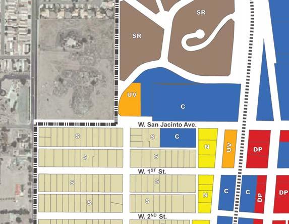
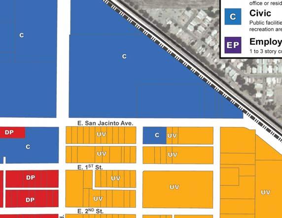
2 3.0 PROJECT DESCRIPTION 3.1 PROJECT LOCATION AND SETTING PROJECT LOCATION The proposed Perris Downtown Specific Plan (DTSP) project (project) is located in the City of Perris, California. The City of Perris is located in Riverside County along Interstate 215 (I-215), southeast of the City of Riverside; refer to Exhibit 3-1, Regional Vicinity. Downtown Perris is bounded by I-215 on the north, Ellis Avenue on the south, Redlands Avenue on the east, and A Street on the west; refer to Exhibit 3-2, Project Location and Exhibit 3-3, Project Aerial. PROJECT SETTING (EXISTING CONDITIONS) The Perris DTSP area encompasses approximately 730 acres and represents the original 1886 townsite along the railroad. The DTSP area consists of commercial uses and professional offices along D Street and 4th Street, with residential uses surrounding the commercial/office core. Residential land uses consist of a mix of single- and multiple-family dwelling units. Light industrial uses are located within the southeast portion of the DTSP area. The DTSP area also contains several prominent uses including the Civic Center (i.e., City Hall, Senior Center, and Library), Metrolink Station (to begin operating in 2013), Train Depot, Southern Hotel, and Perris Valley Museum. Several buildings within the Downtown have recently undergone or are currently undergoing façade improvements through the City s Façade Improvement Program. Table 3-1, Summary of Existing Uses, identifies existing development within the Downtown. As indicated in Table 3-1, the Perris DTSP area contains approximately 1,345,356 square feet (s.f.) of non-residential uses (commercial/office, public facility, and light industrial) and 1,582 dwelling units. Additionally, approximately acres within the DTSP area are currently vacant. Exhibit 3-4, Existing General Plan Land Uses, illustrates the DTSP s existing General Plan land use designations. Circulation within the DTSP area is based on a traditional grid system. The main arterial streets used to access the Downtown are 4th Street (State Route 74 (SR-74)) and D Street. A portion of D Street has been improved with streetscape enhancements including streetlights, paving, benches, street trees, and public art. Land uses within the surrounding area include the I-215 Freeway, which forms the north/northeast boundary of the project area, residential and school uses to the west and northwest, industrial uses and Perris Valley Airport to the south, and commercial uses and vacant land (a majority of which is designated as New Perris Specific Plan) to the east. June
3 Victorville Apple Valley 18 SAN BERNARDINO COUNTY Hesperia Lucerne Valley Lake Arrowhead Rancho Cucamonga 66 ORANGE COUNTY 5 Ontario Norco Corona 74 San Juan Capistrano San Clemente PA C I F I C Rialto USMC Camp Pendleton Oceanside Riverside Lake Elsinore Carlsbad San Bernardino Loma Linda 60 Moreno Valley 215 Murrieta 76 PERRIS Vista 78 Sun City Yucaipa 10 Temecula 79 Hemet 79 Big Bear Lake 38 Escondido Banning Idyllwild Anza 79 Santa Ysabel 62 Palm Springs Warner Springs Desert Hot Springs 111 Yucca Valley Cathedral City Rancho Mirage Twentynine Palms RIVERSIDE 10 COUNTY Palm Desert Indian Wells Indio Coachella La Quinta Mecca S Borrego Springs SALTON SEA 86 O C E A N - Project Site Del Mar La Jolla Encinitas 5 Poway Mira Mesa 805 Santee 52 San Diego 94 Ramona 78 SAN DIEGO COUNTY Alpine 8 Julian 79 Pine Valley IMPERIAL COUNTY Ocotillo 8 NOT TO SCALE 06/11 JN PERRIS DOWNTOWN SPECIFIC PLAN ENVIRONMENTAL IMPACT REPORT Regional Vicinity Exhibit 3-1

4 NOT TO SCALE 06/11 JN PERRIS DOWNTOWN SPECIFIC PLAN ENVIRONMENTAL IMPACT REPORT Project Location Exhibit 3-2


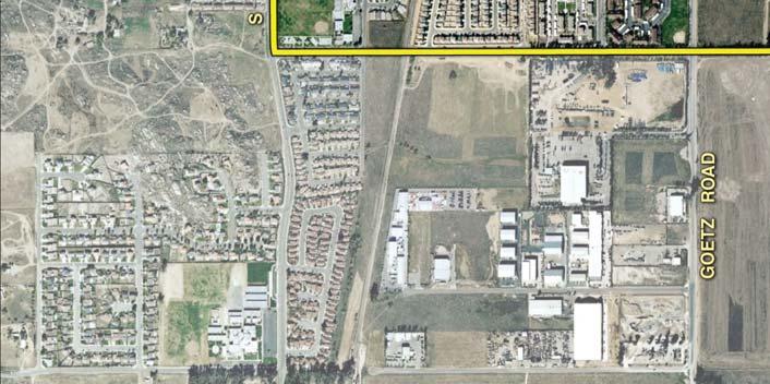
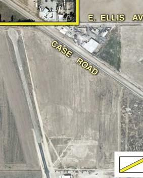
5 NOT TO SCALE 06/11 JN PERRIS DOWNTOWN SPECIFIC PLAN ENVIRONMENTAL IMPACT REPORT Project Aerial Exhibit 3-3

6 NOT TO SCALE 06/11 JN PERRIS DOWNTOWN SPECIFIC PLAN ENVIRONMENTAL IMPACT REPORT Existing General Plan Land Uses Exhibit 3-4
7 Land Use Table 3-1 Summary of Existing Uses Acreage Dwelling Units Square Feet Single-Family Residential Multiple-Family Residential Commercial/Office ,146 Public Facilities ,725 Light Industrial ,485 Vacant Roads/Railroad Total ,582 1,345, BACKGROUND AND HISTORY 1993 PERRIS DOWNTOWN SPECIFIC PLAN The current Perris Downtown Specific Plan was adopted on March 6, Its concept was to provide for the revitalization and refocusing of the Downtown environment that would compliment and enhance the City s existing development and amenities. The Perris DTSP is arranged into the following seven geographic areas referred to as Districts : Gateway District (an Anchor District); Mercado District (an Anchor District); Downtown Promenade District; Town Center District; and Neighborhood Districts I, II, and III. Each District defines zoning, architectural, and landscaping features. Additionally, the DTSP identified a Focus Area, which comprises the southern section of the Downtown Promenade District, adjacent to the Mercado District. This Focus Area defines in greater detail zoning, architectural, and landscape design guidelines. The Plan focuses on comprehensive land use designations ranging from residential uses, strategic commercial and retail sites, open space and parks, regional commuter rail facilities, public facilities, and a comprehensive vehicular circulation system. 1 A specific level of development intensity was determined for each District, based on land use intensity, economics, and variable market conditions. As indicated in the 1993 DTSP Table III-1, Cumulative Development Intensity, the 1993 Specific Plan was forecast to involve approximately 3,089 dwelling units and 2.1 million square feet of non-residential development, including public facilities, commercial, professional office, and industrial, at buildout. 1 The Land Use Plans for the various Districts are illustrated in 1993 DTSP Figures III-2, III-11, III-14, III-17, III-19, III-22, and III-23. June
8 RELEVANT PLANS AND ACTIONS As the Downtown area changed, a number of other plans were developed, including the Downtown D Street Development Plan in 2004 and Compass Blueprint Perris Station Demonstration Project in Additionally, DTSP amendments were approved in 2005 (Specific Plan Amendment ) and 2007 (Specific Plan Amendment ). The following provides a brief overview of each plan/action: Downtown D Street Development Plan. The 2004 Downtown D Street Development Plan is part of a long-range concept to revitalize and improve Downtown Perris. The Development Plan includes improvements along D Street to create a shopping and dining district that retains its historical charm while attracting residents and visitors. The Gateway Project consists of widening the intersection of D Street and San Jacinto Avenue to the ultimate General Plan street dimensions. Enhancements include decorative paving, lighting, landscaping, and new monument signs in front of City Hall, among other improvements within the area. Specific Plan Amendment Specific Plan Amendment involved amending the DTSP by adding a new land use district (i.e., Village Walk District) and applying the new district to approximately 25 acres located on the northeast corner of Perris Boulevard and Commercial Street, within DTSP Neighborhood III (Tentative Tract Map No for a 127-lot residential subdivision). The Specific Plan Amendment also changed the subject site s zoning from R-7 and Light Industrial to MFR-14/Planned Development (PD) Overlay Zone. Additionally, the Amendment established new development regulations and design guidelines governing the use of the land within the Village Walk District. Compass Blueprint. In 2001, the Southern California Association of Governments (SCAG) started a regional visioning process to develop a strategy for regional growth that would accommodate growth while providing for livability, mobility, prosperity, and sustainability. The Compass Blueprint strategy promotes a stronger link between region-wide transportation and land use planning and encourages creative, forwardthinking, and sustainable development solutions that fit local needs and support shared regional values. The implementation phase of Compass Blueprint involved a series of Compass Blueprint Demonstration Projects, including the Perris Station Demonstration Project, completed in November The demonstration project evaluated how the Perris Metrolink and bus station can be integrated with the Downtown and how the larger Downtown area can start to transition to a mixed-use environment with multi-modal transit services and a pedestrian urban design focus. The recommendation report provided a vision for the Perris Station area including urban design guidance and policy recommendations to amend the Downtown Specific Plan and address transit agency plans for parking and bus service. Specific Plan Amendment Specific Plan Amendment involved amending the DTSP by applying the Commercial Land Use with Residential Overlay (CLURO) zone to eight parcels ( , -004, -005, -006, -015, -016, -020, and - 021) located east of D Street, between 10th and 11th Streets within Block 4 of the DTSP Mercado District. The parcels were zoned Commercial Neighborhood and R-14 June
9 Residential. The CLURO zoning allows for the mixing of commercial and residential land uses on these parcels. Summary of Relevant Plans and Actions. In consideration of the relevant plans and actions described above, the current DTSP is forecast to involve approximately 2,853 dwelling units and 2,378,607 square feet of non-residential development at buildout. PERRIS DOWNTOWN SPECIFIC PLAN UPDATE With the changing community and future operation of the Metrolink Station, the City of Perris initiated an update to the 1993 Perris Downtown Specific Plan in The purpose of the Perris DTSP update was to create a cohesive plan for Downtown Perris that created an authentic identity and unique sense of place, while responding to changing community dynamics. The DTSP provides the framework for quality planning, and establishes development standards and design criteria to implement the community s vision. The planning process for the Perris DTSP update included three distinct phases. Phase 1 involved a review of existing documents and information, background and data research, site reconnaissance and visual observations, and a two-day Strengths, Weaknesses, Opportunities, and Threats (SWOT) analysis of the Downtown businesses, including an intercept survey and an informational booth at the annual Rods to Rails. The initial phase of the planning process, which occurred from April to July 2008, allowed the design team to build a baseline understanding of Downtown Perris. Phase 2 of the process involved an intensive Community Immersion, including a business and property owner s kick-off meeting, a visioning workshop, and design charrette. Over a two-day period, Perris business owners, property owners, residents, and stakeholder groups worked to develop a vision for the Downtown area. Based on input received during the Community Immersion process, a Draft Vision Plan was developed to graphically display the vision for Downtown Perris. The Vision Plan, as well as other draft concepts, were presented at a community-wide workshop held on November 18, Phase 3 involved preparation of the Draft Perris Downtown Specific Plan, which included a revised Vision Plan, Regulating Code, Design Guidelines, and Implementation Program for the Specific Plan area. The Draft Plan was then reviewed at a Planning Commission hearing and recommendations from the Planning Commission were forwarded to the City Council for their review. Vision Plan Using the design concepts that resulted from the design charrette in Phase 2, eight character areas were formed to represent desired uses for the Downtown. Following is a description of the character areas: Rock Castle. The intent of the Rock Castle Character Area is to preserve the area surrounding the Rock Castle, and the structure itself, which is symbolic of Perris historical connection to agriculture and that serves as a gateway to Downtown Perris. June
10 Development of large lot, one- to two-story detached dwellings would be allowed to compliment the Rock Castle. Civic Center. The Civic Center Character Area includes City Hall, Senior Center, Library, and other civic buildings. The intent is to develop a campus-like atmosphere with parks, plazas, and open spaces. The Civic Center area is an icon and provides the community with a centralized location for people to gather. The potential for public parking areas are also envisioned for this area. Residential. The intent of the Residential Character Area is to maintain and enhance the existing residential neighborhoods, and provide residential transition areas between low density residential areas and more intense land uses. Preservation of the existing neighborhoods, including one and two story detached houses, is a main priority. Transition areas are proposed to provide a buffer between commercial corridors and allow for two to three story duplexes, triplexes, courtyard housing, flats, and row houses. Urban Village. The intent of the Urban Village Character Area is to allow for mixed-use and multi-unit residential buildings with first floor ancillary commercial uses within walking distance of Downtown and the Metrolink Station. The Urban Village is envisioned to include an interior pedestrian paseo that provides access to Downtown and the adjacent commercial district. Building heights would range from three to five stories, with parking provided on the streets, as well as in parking structures and surface lots behind buildings. 4th Street Corridor. The 4th Street Corridor Character Area is intended to create an auto-oriented corridor with an emphasis on a more commercial frontage streetscape that caters to the vehicular traffic that travels along 4th Street (SR-74). The 4th Street Corridor would include new and existing buildings with heights ranging from one to three stories. New buildings would be built to the sidewalk to enhance the public realm and support pedestrian activity along the corridor. Primary uses would be retail, office, and commercial uses, with opportunities for mixed use buildings where appropriate. Parking would be accessed through shared driveways and/or alleys. Downtown Promenade. The Downtown Promenade Character Area is the heart of Perris and the center of culture and commerce for the Downtown area. The Promenade provides for a connection to the past through the variety of historic structures, including the re-opening of the Train Depot and the Bank of Perris, and through a variety of vibrant retail, restaurant, service, entertainment, and residential uses. New or refurbished buildings would range in height from one to three stories and would be designed to address the sidewalk. The Downtown Promenade would extend to 6th Street and include a public plaza area adjacent to 2nd Street and the new Metrolink Station. Parking would be provided on the streets and to the rear of buildings. Mercado. The Mercado Character Area extends south of 6th Street along D Street to 10th Street and is envisioned to expand upon the cultural diversity of the area. This area includes a mix of buildings from one to three stories surrounding a system of paseos and common public spaces with wide sidewalks and arcades. Retail, restaurants, or entertainment on the ground floor with office or residential above provides an opportunity June
11 for a variety of businesses, including opportunities for local artisans. The public spaces would be used for a range of functions including festivals, outdoor markets, shopping, and dining. A plaza square is proposed at the intersection of D Street and 10th Street to provide an anchor to the southern portion of the Main Street environment. The plaza square is envisioned to include enhanced paving and would expand when vehicle entries are closed for special events. The plaza square would be framed by a variety of three- to five-story mixed use buildings with restaurants and retail on the ground floor. The community park proposed along the area s northeast corner is envisioned to include an outdoor amphitheater, garden, and tot lot. Employment Plaza. The intent of the Employment Plaza Character Area is to provide an employment center, with new and existing one- to three-story commercial or light industrial uses. Large lot parcels would be encouraged to incorporate campus designs with ample employee amenities and parking towards the center or to the rear. 3.3 PROJECT CHARACTERISTICS The Perris DTSP serves as a planning and regulatory link between the City of Perris General Plan and individual, project level development within the DTSP area. The Perris DTSP provides area-specific land use regulations and development guidelines within the Downtown. More specifically, the Perris DTSP establishes a Regulating Code, which contains the development specifications, regulations, and design standards and guidelines for all development projects within the DTSP area. The Regulating Code focuses attention on the form, placement, and appropriate use of buildings. Within the Regulating Code, a Regulating Plan has been developed, establishing nine planning areas referred to as Transects. The Regulating Plan is a plan or map that designates how site and building design standards apply to individual properties; refer to Exhibit 3-5, Regulating Plan. Within the Perris DTSP, the Regulating Plan illustrates which transect a specific property is located and allowed building type(s) for that property. Standards and guidelines for each building type are provided within the Development Specifications and Design Standards and Guidelines sections of the Regulating Code. The development specifications address site design, building mass and height, façade design, and allowed uses within the building type. The design standards and guidelines apply to all buildings within the Perris DTSP and address building facades, materials and colors, windows, roofs, signs, mechanical equipment, landscaping, lighting, outdoor space, paseos, forecourts, courtyards, and plazas. Standards are also provided within the Regulating Code for general streetscape, sidewalk amenities, sidewalk dining, intersections and crosswalks, and alleys, as well as specific street standards for D Street, local streets, and neighborhood streets. The Perris DTSP Regulation Plan establishes the following nine transects: Semi-Rural The Semi-Rural transect allows one- to two-story detached houses on extra-large lots. Land uses within the transect are restricted to residential. June


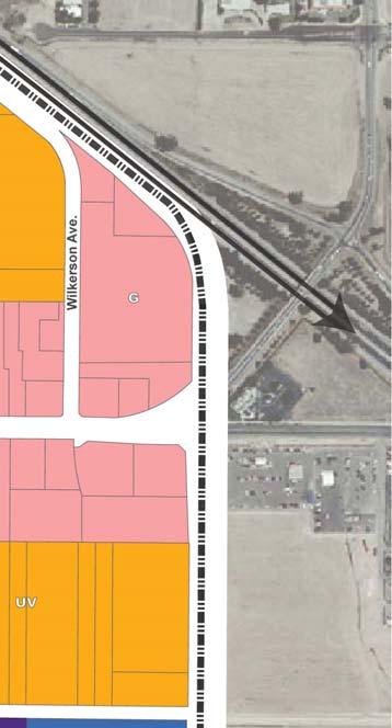
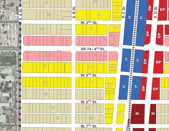
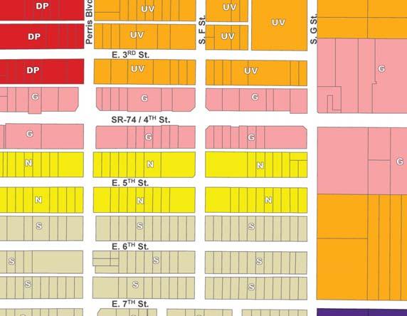

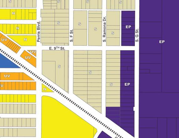
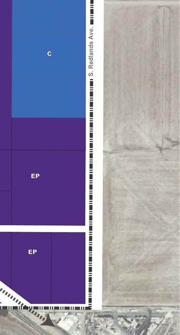

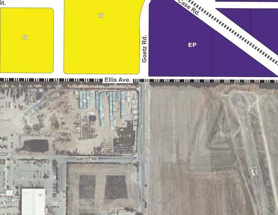
12 06/11 JN PERRIS DOWNTOWN SPECIFIC PLAN ENVIRONMENTAL IMPACT REPORT Regulating Plan Exhibit 3-5
13 This page intentionally left blank. June
14 Suburban The Suburban transect allows one- to two-story houses and duplexes with small side yards and larger rear yards. Land uses within the transect are restricted to residential. Garage access and service access via alleys are encouraged. The intent of the area is to maintain and enhance existing residential neighborhoods and provide residential transition areas between low-density residential areas and more intense land uses. Preservation of the existing neighborhoods is a main priority. Neighborhood The Neighborhood transect allows one- to three-story detached houses, duplexes, triplexes, courtyard housing, flats, and rowhouses. In addition to residential uses, neighborhood serving commercial and office uses are allowed. Garage access and service access via alleys are encouraged. Similar to the Suburban transect, the intent of the area is to maintain and enhance existing residential neighborhoods and provide residential transition areas between low-density residential areas and more intense land uses. Preservation of the existing neighborhoods is a main priority. Urban Village The Urban Village transect allows three- to five-story stacked flats, rowhouses, courtyard housing, live-work, and mixed-use commercial block buildings. In addition to residential uses, neighborhood serving commercial on the ground floor with residential uses above are allowed. 4th Street Gateway The 4th Street Gateway transect allows one- to three-story commercial block buildings at or near sidewalk, liner buildings, stacked flats, and courtyard buildings. In addition to residential uses, the transect allows for primarily retail, service, and office land uses, with opportunities for mixed-use where appropriate. Access via alleys are encouraged. Plaza Mercado The Plaza Mercado transect allows one- to three-story commercial block buildings fronting a common public space area with retail, restaurant, or entertainment on the ground floor and office or residential uses above. Downtown Promenade The Downtown Promenade transect allows one- to three-story commercial block buildings, liner buildings, stacked flats, or courtyard buildings with retail, restaurant, and entertainment uses on the ground level and office or residential uses on upper levels. Civic The Civic transect allows for public facilities, public parking, public spaces, passive and active open space, and recreation areas that provide a campus-like atmosphere. Employment Plaza The Employment Plaza transect allows one- to three-story commercial or industrial uses that require large lots. Table 3-2, Development Plan Buildout Summary, identifies the maximum buildout potential for each of the Transects within Downtown Perris. As indicated in Table 3-2, the DTSP would allow a maximum of 852,056 s.f. of retail uses, 1,878,642 s.f. of office uses, 450,725 s.f. of public facility uses, and 4,946 dwelling units (single- and multiple-family) in the Downtown. June
15 Transect Table 3-2 Development Plan Buildout Summary Residential (dwelling units) Retail (square feet) Office/Light Industrial 1 (square feet) Public Facilities (square feet) Semi-Rural Suburban Neighborhood Urban Village 2, th Street Gateway , ,304 0 Plaza Mercado 88 73,958 22,187 0 Downtown Promenade , ,629 0 Civic ,725 Employment Plaza 0 0 1,242,522 0 Total 4, ,056 1,878, , Light Industrial uses are allowed within the Employment Plaza Transect. When compared to existing conditions, the Perris DTSP would allow for: A net increase of 3,364 dwelling units; A net increase of 301,910 s.f. of commercial retail uses; A net increase of 1,878,642 s.f. of office/light industrial uses; and A net decrease of 344,485 s.f. of industrial uses. Project components also include the following: Community Facilities. The Perris DTSP provides the opportunity to develop a variety of public facilities to enhance the Downtown area and provide for community meeting places. Some of the community facilities envisioned within the general vicinity of the Main Street are enhanced plaza areas and convertible streets adjacent to the Metrolink Station and Mercado. In addition, a community park is envisioned within the Mercado with an outdoor amphitheater, garden, and tot lot. Circulation Plan. The Circulation Plan within the Downtown area provides the extension of the Main Street environment along D Street and enhances pedestrian safety. The roadway network includes cross-sections to address a more pedestrian-friendly environment and enhanced opportunities for linkages with the Metrolink Station, the proposed park within the Mercado, and the existing Foss Field. Downtown Parking Plan. The Perris DTSP area would include a variety of parking opportunities through incorporation of various design solutions from providing on-site commercial and residential parking opportunities (including tuck under and structured parking facilities) to coordinating a multi-agency approach to parking facilities. June
16 Downtown Water System Plan. Based on the anticipated increase in demand, currentday fire-flow standards, and the age of the existing infrastructure, upgrades to the system are recommended through modeling water infrastructure improvements. Coordination with Eastern Municipal Water District (EMWD) would be necessary to verify potential system upgrades. Downtown Wastewater System Plan. The vast majority of flows from the DTSP area collect at the 15-inch system in G Street. The anticipated wastewater system pipeline upgrade areas include E Street, San Jacinto Avenue, 3rd Street west of C Street, C Street north of 3rd Street, 4th Street east of G Street, G Street, 7th Street east of Perris Boulevard, Redlands Avenue south of 7th Street, and Ellis Avenue east of G Street. It is noted that current industry standards call for the minimum size of gravity sewers for public systems to be 8-inch diameter. 3.4 PROJECT GOALS AND OBJECTIVES The Perris DTSP project seeks to achieve project specific goals, as well as contribute to achieving the goals established by the Perris General Plan. The following goals and objectives have been identified for the proposed project: Provide a mix of uses within the Downtown including residential, retail, office, and public/civic uses that will encourage a variety of activities in the Downtown. Preserve historic structures and the overall historic character of the Downtown. Preserve and enhance existing residential neighborhoods and provide transition areas between existing neighborhoods and commercial corridors. Provide opportunities for the existing Civic Center to serve as a central location for public gathering with parks, plazas, and open spaces. Create a plaza square at the intersection of D Street and 10th Street and a community park with an outdoor amphitheater. Create an auto-oriented corridor along 4th Street with a commercial frontage streetscape that caters to vehicular traffic. Provide opportunities for new employment uses, including commercial and light industrial development in campus designs with employee amenities. Provide a mix of uses (including multi-unit residential with first floor ancillary commercial uses) within walking distance of Downtown and the future Metrolink Station. Provide a pedestrian-friendly and enhanced streetscape environment with attractive storefronts, landscaping and sidewalks, as well as public plazas and paseos that will encourage people to walk and utilize local transit. June
17 Develop vacant and underutilized sites with a variety of uses and intensities that can be supported by market conditions. Provide consistent and compatible development within the Downtown through the establishment of specifications, regulations, and guidelines. 3.5 PHASING It is anticipated that the proposed Perris DTSP project would be implemented over several years based upon market conditions. For analysis purposes, this EIR utilizes a buildout year of AGREEMENTS, PERMITS, AND APPROVALS The City of Perris, as the Lead Agency for future development and improvements within the DTSP area, has discretionary authority over the proposed project that includes, but is not limited to, the following: Specific Plan Amendment ( ). Recommendation by the City Planning Commission and adoption of the proposed Amendment to the Perris Downtown Specific Plan by the City Council is required. Environmental Review. A certified (EIR) required by CEQA, as described in Section 2.0, Introduction and Purpose. A recommendation for certification by the City Planning Commission is required for this EIR. The EIR would then be presented to the City Council for certification. Additional environmental review for future uses is not anticipated, but will be evaluated on a case-by-case basis. General Plan Amendment ( ). Recommendation by the City Planning Commission and approval by the City Council to amend the General Plan to allow for the development of up to 4,946 dwelling units, 852,056 square feet of retail, and 1,878,614 square feet of office/light industrial and to designate the proposed Perris DTSP area to Perris Downtown Specific Plan on the Perris General Plan Land Use Map. Site Plan Review. Individual site plans within the DTSP area would be subject to review of plans and approval by the City. Conditional Use Permits. Development of certain uses may require approval of a conditional use permit by the City Planning Commission. Tentative Parcel or Tract Maps and Master Plans. Individual tentative parcel or tract maps and master plans may also be processed at a future time for smaller parcels with particular development characteristics or needs. Grading Permits. Future grading for development within the DTSP area would be subject to the review of grading plans and issuance of grading permits by the City. June
18 Building Permits. Future construction of structures within the DTSP area would be subject to the review of architectural plans and approval of building permits by the City. June
19 This page intentionally left blank. June
3.0 Project Description
 3.0 Project Description 3.0 PROJECT DESCRIPTION 3.1 PROJECT LOCATION AND SETTING PROJECT LOCATION The proposed Downtown Lancaster Specific Plan Project (project) is located in the City of Lancaster, California.
CHAPTER 1. Ms. Guajardo s Class - Central Elementary CH 1 1
 INTRODUCTION CHAPTER 1 Ms. Guajardo s Class - Central Elementary CH 1 1 1.1 SETTING South Centre City is a linear corridor south of Downtown Escondido paralleling Centre City Parkway and South Escondido
2. Form and Character. 2.1 Introduction. 2.2 The Downtown Addition Plan. 2.1 Introduction
 2.1 Introduction 2.1 Introduction This section of the Specific Plan describes and illustrates the desired form, character and uses of the Downtown Addition and explains the underlying design principles.
Policies and Code Intent Sections Related to Town Center
 Policies and Code Intent Sections Related to Town Center The Town Center Vision is scattered throughout the Comprehensive Plan, development code and the 1994 Town Center Plan. What follows are sections
Mark-up of the effect of the proposed Bronte Village Growth Area OPA No.18 on the text of section 24, Bronte Village, of the Livable Oakville Plan
 Mark-up of the effect of the proposed Bronte Village Growth Area OPA No.18 on the text of section 24, Bronte Village, of the Livable Oakville Plan Notes: This document is provided for information purposes
Lehigh Acres Land Development Regulations Community Planning Project
 Lehigh Acres Land Development Regulations Planning Effort Summary In July, 2010 Commissioner Frank Mann invited the Lehigh Acres community to start discussing how to achieve their recently adopted community
4.1.3 LAND USE CATEGORIES
 4.1.3 LAND USE CATEGORIES a. City Center District The City Center District incorporates the existing character and mix of uses in downtown Belmont to encourage redevelopment and new development in keeping
PINE CURVE REZONING. Property does not meet criteria for open space preservation and is not a candidate for a park
 PINE CURVE REZONING BACKGROUND Purchased as two parcels in 2001 and 2002 Annexed and Zoned Greater Downtown District Historic Center September 25, 2002 and October 7, 2002 WHAT THE PROJECT IS AND IS NOT
Carlsbad Village Redevelopment Concept Summary of Features
 Carlsbad Village Redevelopment Concept Summary of Features Calthorpe Associates November 5, 2003 The Redevelopment Concept illustrates a vision for the future of Carlsbad Village. The overall vision of
FUTURE LAND USE ELEMENT
 FUTURE LAND USE ELEMENT GOAL I: To create and sustain a great place to live, play, and prosper Objective 1: The City of Ocala shall incorporate the principles and strategies of the Ocala 2035 Vision into
Town Center (part of the Comprehensive Plan)
") Town Center (part of the Comprehensive Plan) Mercer Island Town Center Looking North (2014) In 1994, a year-long process culminated in a set of design guidelines and code requirements for the Town Center
Town Center (part of the Comprehensive Plan) Mercer Island Town Center Looking North (2014) In 1994, a year-long process culminated in a set of design guidelines and code requirements for the Town Center
A. Background Summary of Existing Challenges and Potential Possibilities. 1. Summary of Existing Assets and Potential Opportunities
 A. Background 1 A Main Street Master Plan Study was performed and completed in October of 2007. The study was initiated to review current land uses and development patterns along Main Street, from Parrish
4. ENVIRONMENTAL IMPACT ANALYSIS 7. LAND USE AND PLANNING
 4. ENVIRONMENTAL IMPACT ANALYSIS 7. LAND USE AND PLANNING 4.7.1 INTRODUCTION The following analysis discusses the consistency of the Proposed Project with the corresponding land use and zoning designations
Prosperity Hucks Area Plan. Transportation and Planning Committee May 11, 2015
 Prosperity Hucks Area Plan Transportation and Planning Committee May 11, 2015 Presentation Outline 1. Background and Location 2. Community Dialog Process 3. Activity Center Recommendations 4. Wedge Recommendations
URBAN DESIGN BRIEF. 2136&2148 Trafalgar Road. Town of Oakville
 URBAN DESIGN BRIEF 2136&2148 Trafalgar Road Town of Oakville Prepared By: METROPOLITAN CONSULTING INC For 2500674 Ontario Inc November 2016 TABLE OF CONTENTS Page No. 1.0 Introduction/Description of Subject
Land Use. Hardware Street Vendor Mixed-Use
 Land Use Definition Land Use is the way a piece of real estate is utilized. Existing, proposed, and adopted land uses all play a role in the planning process. Once a land use plan is adopted, the next
Community Design Plan
 Gardena General Plan 2006 Authority While the is not a required element of a General Plan, it is included because improving the community appearance and image is paramount to the overall quality of life
3.0 PROJECT DESCRIPTION
 3.0 PROJECT DESCRIPTION 3.1 BACKGROUND Under California law (Government Code Section 65300 et seq.), every city and county is required to have a general plan. The general plan is to be comprehensive and
PINE CURVE REZONING. BACKGROUND Purchased as two parcels in 2001 and 2002
 BACKGROUND Purchased as two parcels in 2001 and 2002 WHAT THE PROJECT IS AND IS NOT A Rezoning establishes the land use standards for Annexed and Zoned Greater Downtown District Historic Center September
3. Project Description
 3.1 PROJECT LOCATION The Platinum Triangle (herein after also referred to as the Project Area ) is located at the confluence of the Interstate 5 (I-5 Freeway) and the State Route 57 (SR-57 Freeway), in
GENERAL PLAN AND ENVIRONMENTAL IMPACT REPORT
 City of Menifee HEARING DRAFT GENERAL PLAN AND ENVIRONMENTAL IMPACT REPORT City Council November 2013 PURPOSE OF MEETING Overview of GP Process Overview of required and optional GP elements Receive direction
HISTORIC TOWN CENTER MASTER PLAN CITY COUNCIL PRESENTATION APRIL 3, 2012
 HISTORIC TOWN CENTER MASTER PLAN CITY COUNCIL PRESENTATION APRIL 3, 2012 REQUESTED CITY COUNCIL ACTIONS Certification of the Final Program Environmental Impact Report (PEIR); and, Approval of General Plan
Gold Line Bus Rapid Transit Transit Oriented Development (BRTOD) Helmo Station Area Plan
 Helmo Station Area Plan") Appendix F Gold Line Bus Rapid Transit Transit Oriented Development (BRTOD) Helmo Station Area Plan Introduction and Purpose of the Plan The Gold Line Bus Rapid Transit facility is an eleven-mile dedicated
Appendix F Gold Line Bus Rapid Transit Transit Oriented Development (BRTOD) Helmo Station Area Plan Introduction and Purpose of the Plan The Gold Line Bus Rapid Transit facility is an eleven-mile dedicated
ELMVALE ACRES SHOPPING CENTRE MASTER PLAN
 ELMVALE ACRES SHOPPING CENTRE MASTER PLAN Contents 1.0 INTRODUCTION... 2 2.0 LOCATION... 2 3.0 EXISTING CONTEXT... 2 4.0 VISION & GUIDING PRINCIPLES... 2 5.0 LAND USE AND BUILT FORM... 4 5.1 St. Laurent
A. WHAT IS A GENERAL PLAN?
 I. Introduction A. WHAT IS A GENERAL PLAN? A general plan is the planning guideline for the future of a city. It contains goals and policies which regulate urban development, the protection of the natural
REDLANDS TRANSIT VILLAGES SPECIFIC PLAN
 REDLANDS TRANSIT VILLAGES SPECIFIC PLAN CITY COUNCIL STUDY SESSION JANUARY 4, 2019 Redlands Blvd. Eureka St. Orange St. State St. Citrus Ave. Vine St. GENERAL PLAN TRANSIT VILLAGES WE ARE HERE SPECIFIC
Metro. Activity Center Design Guidelines. Recommendations For Developing Focused, Mixed-Use Commercial/Residential Centers
 Metro Activity Center Design Guidelines Recommendations For Developing Focused, Mixed-Use Commercial/Residential Centers Metro Activity Centers What is a MAC? Legacy, the adopted guide for the future growth
City of Farmington. Downtown Plan. Amendment to the 1998 Master Plan Adopted October 11, 2004
 City of Farmington Amendment to the 1998 Master Plan Adopted October 11, 2004 Introduction Planning Background 1 Scope and Components of the Plan Amendment 2 Concept Introduction 3 Plan Concepts 3 Conceptual
DRAFT Land Use Chapter
 Stevens Creek Urban Village DRAFT 1 18 17 Land Use Chapter INTRODUCTION This Land Use Chapter describes how the Stevens Creek Urban Village will accommodate the growth that is planned for it in the Envision
A P P E N D I X B - O P P O R T U N I T Y S I T E S
 A P P E N D I X B - O P P O R T U N I T Y S I T E S OPPORTUNITY SITES As listed in the Land Use Element, the City has identified 15 Opportunity Sites expected to be the focus of change and revitalization
FLORIN ROAD CORRIDOR Site Plan and Design Review Guidelines Checklist
 FLORIN ROAD CORRIDOR Site Plan and Design Review Guidelines Checklist Applicant s Name: Project Address: Phone: Email: Applicant shall fill out the design guidelines checklist for all guidelines applicable
A Vibrant Downtown. Chapter 5 Cary Public Art Opportunities 31
 A Vibrant Downtown Cary s vision for Downtown is a unique, vibrant, dynamic, pedestrian friendly location; a regional destination and a place to live, work, and recreate, according to the 2001 Town Center
Wadsworth Boulevard S TAT I O N A R E A P L A N
 Wadsworth Boulevard S TAT I O N A R E A P L A N City of Lakewood Adopted November, 2006 The Vision The City of Lakewood s overall vision is to transform the area around the light rail station into a mixed-use
12600 S Existing Conditions
 STUDY AREA BOUNDARY Study Area Boundary Study Area Context The District Riverton Meadows Vista Station Mountain View Village Market Center 2 Mile Radius 12600 S Existing Conditions 12600 S is a river of
DENVER DESIGN DISTRICT GDP
 DENVER DESIGN DISTRICT GDP Urban Design Standards and Guidelines November 17, 2008 Amended February 3, 2016 City and County of Denver CF Property Management, Inc. C/O Denver Design District - Starboard
Draft Memorandum #1: Goals and Vision for Revitalization
 Keizer Revitalization Plan Draft Memorandum #1: Goals and Vision for Revitalization Submitted to: City of Keizer April 12, 2018 (revised) Prepared By: Angelo Planning Group and Otak, Inc. Project No. 17482.A
Table of Contents. Elm Avenue Improvement Plan City of Waco, Texas. Introduction 1. Existing Context 1 Figure 1 2.
 Table of Contents Introduction 1 Existing Context 1 Figure 1 2 Plan Guidelines 3 Future Urban Form 4 The West-End 4 Main Street 6 The East-End 7 Figure 2 9 Public Improvement Recommendations 7 General
Hockessin Community Redevelopment Plan
 Hockessin Community Redevelopment Plan 3.1 Introduction The Community Redevelopment Plan for the Village of Hockessin is the result of the people s vision for a distinct village center that serves as the
SECTION TWO: Urban Design Concepts
 SECTION TWO: Urban Design Concepts The Gardnerville Plan for Prosperity shapes economic opportunities presented by regional growth. The Urban Design Concepts provide policies and concepts for land use,
AMITY STATION Revised Concept Plan Review West Rosemary Street Chapel Hill, NC September 27, 2016
 AMITY STATION Revised Concept Plan Review West Rosemary Street Chapel Hill, NC September 27, 2016 DEVELOPER'S PROGRAM Introduction This is a request for review of a Revised Concept Plan by Chapel Hill
PORT WHITBY COMMUNITY
 PORT WHITBY COMMUNITY SECONDARY PLAN UPDATE COMMUNITY IMPROVEMENT PLAN URBAN DESIGN GUIDELINES September 2015 DRAFT PROPOSED AMENDMENT NUMBER # to the Whitby Official Plan PURPOSE: The intent of this Amendment
ARLINGTON COUNTY, VIRGINIA
 ARLINGTON COUNTY, VIRGINIA County Board Agenda Item Meeting October 15, 2005 DATE: September 28, 2005 SUBJECT: Request to Advertise the adoption of the 2005 Clarendon Sector Plan C. M. RECOMMENDATION:
Implementation Guide Comprehensive Plan City of Allen
 Implementation Guide 2030 Comprehensive Plan City of Allen DRAFT 2015 Implementation Guide Allen 2030 Comprehensive Plan INTRODUCTION The Comprehensive Plan serves as a guide for the growth and development
North Downtown Specific Plan MEMORANDUM
 North Downtown Specific Plan MEMORANDUM MEETING DATE: November 13, 2017 TO: Members of the North Downtown Specific Plan Advisory Committee FROM: Jeanine Cavalli, Senior Planner SUBJECT: Materials for the
City of Long Beach. creating vibrant and exciting places
 City of Long Beach creating vibrant and exciting places Land Use Element Urban Design Element Overview of the two draft General Plan elements Discuss areas of change Economic goals of the plans Case study
DRAFT ROOSEVELT ROAD. District Recommendations. Figure 5.23 The Roosevelt Road Corridor
 CHAPTER 5 Figure 5.23 The Road Corridor Road will develop as a mixed-use corridor, emphasizing regional retail, west of the river and mixed-use development east of the river. KEY RECOMMENDATIONS 1. High
Regency Developments. Urban Design Brief. Holyrood DC2 Rezoning
 Regency Developments Urban Design Brief Holyrood DC2 Rezoning Stantec Consulting Ltd. 7-31-2017 1. Overview Regency Developments intends to rezone the lands located at 8510 and 8511 93 Avenue, within the
Westwind Developments Ltd. PIONEER LANDS AREA STRUCTURE PLAN - PROPOSED AMENDMENT
 FEBRUARY 2013 TABLE OF CONTENTS 1.0 BACKGROUND... 1 1.1 Amendment... 1 2.0 LOCATION & CONTEXT... 2 2.1 Land Ownership... 2 3.0 POLICY CONTEXT... 3 3.1 Municipal Development Plan... 3 3.2 Capital Region
SYRINGA VALLEY SPECIFIC PLAN NARRATIVE
 SYRINGA VALLEY SPECIFIC PLAN NARRATIVE Introduction With this application, Pleasant Valley South LLC ( Pleasant Valley ) seeks the City of Boise s approval of a new Specific Plan Ordinance to be added
URBAN DESIGN BRIEF 181 Burloak Drive, Oakville
 URBAN DESIGN BRIEF 181 Burloak Drive, Oakville February 2017 Our File: 1730B 230-7050 WESTON ROAD / WOODBRIDGE / ONTARIO / L4L 8G7 / T: 905 761 5588/ F: 905 761 5589/WWW.MHBCPLAN.COM TABLE OF CONTENTS
Pedestrian and Bike Bridge LOGO
 6.2.2 Pedestrian and Bike Bridge The proposed pedestrian and bike crossing re-envisions the existing bridge at Pismo Creek on Cypress Street. The bridge is currently underutilized by vehicular through
Staff Report to the North Ogden City Planning Commission
 Staff Report to the North Ogden City Planning Commission SYNOPSIS / APPLICATION INFORMATION Application Request: Concept review on a legislative application to rezone land located at approximately 1750
Transportation. Strategies for Action
 Transportation A major priority for the Overlake Neighborhood is to develop a multimodal transportation system. To achieve this system, a balance has to be found among travel, circulation and access needs;
Sheridan Boulevard S TAT I O N A R E A P L A N S H E R I D A N B O U L E VA R D S TAT I O N A R E A P L A N
 Sheridan Boulevard S TAT I O N A R E A P L A N 1 City of Lakewood Adopted November, 2006 S H E R I D A N B O U L E VA R D S TAT I O N A R E A P L A N The Vision The City of Lakewood s overall vision is
2.0 AREA PLANS. Lakeside Business District. Lakeside Business District Land Use Categories:
 Lakeside Business District Lakeside Business District Land Use Categories: Campus Commercial Campus Commercial means a mixture of uses which includes corporate offices, office parks, hotels, commercial,
LAND USE OVERVIEW WHAT YOU WILL FIND IN THIS CHAPTER
 LAND USE WHAT YOU WILL FIND IN THIS CHAPTER Information about the City s expected population and employment growth. Description and capacity of existing and future land use designations. Policies that
Lower Merion Commercial Districts Issues and Characteristics Handbook November 2013
 Lower Merion Commercial Districts Issues and Characteristics Handbook November 2013 DRAFT TOWNSHIP-WIDE VISION: To maintain and enhance commercial areas to complement the surrounding high-quality residential
Land Use Amendment in Southwood (Ward 11) at and Elbow Drive SW, LOC
 at and Elbow Drive SW, LOC") 2018 November 15 Page 1 of 10 EXECUTIVE SUMMARY This land use amendment application was submitted by Rick Balbi Architect on 2017 August 31 on behalf of Sable Developments Ltd, and with authorization from
2018 November 15 Page 1 of 10 EXECUTIVE SUMMARY This land use amendment application was submitted by Rick Balbi Architect on 2017 August 31 on behalf of Sable Developments Ltd, and with authorization from
The Village. Chapter 3. Mixed Use Development Plan SPECIFIC PLAN
 The Village SPECIFIC PLAN Chapter 3 3.1 INTRODUCTION 3.1.1 Purpose This Chapter describes the development regulations applicable to the Mixed-Use and Transit Center Planning Areas. These form-based regulations
ITEM #8. Regional Smart Growth Program. Regional Smart Growth Program. Presentation Overview. Coast Highway Vision and Stategic Plan.
 Regional Smart Growth Program Economic Development Commission What is Smart Growth? Adopted as part of the Regional Comprehensive Plan (RCP) RCP provides vision for region based on Smart Growth and sustainability
ENVIRONMENTAL SETTING
 II. ENVIRONMENTAL SETTING EXISTING CONDITIONS The 208.87-acre Project site is located in the western portion of the City (refer to Figures II-1 and II-2). The Project site comprises Assessor s Parcel Number
burlington mobility hubs study Downtown Burlington Mobility Hub
 burlington mobility hubs study Downtown Burlington Mobility Hub Draft Precinct Plan Workbook PIC #3, September 7, 2017 downtown mobility hub objectives City staff and their consultants are proposing an
City of Del Mar. Del Mar Resort Specific Plan Environmental Impact Report Notice of Preparation
 City of Del Mar Del Mar Resort Specific Plan Environmental Impact Report Notice of Preparation Date: September 9, 07 To: From: Subject: State Clearinghouse, Responsible Agencies, Trustee Agencies, Interested
TRANSIT ORIENTED DEVELOPMENT PINELLAS COUNTY MPO LIVABLE COMMUNITIES INITIATIVE PINELLAS COUNTY COMPREHENSIVE PLAN AMENDMENTS
 PINELLAS COUNTY MPO LIVABLE COMMUNITIES INITIATIVE MODEL LAND DEVELOPMENT CODE TRANSIT ORIENTED DEVELOPMENT PINELLAS COUNTY COMPREHENSIVE PLAN AMENDMENTS MPO Livable Communities Initiative Goal: Improve
ARTICLE 6: Special and Planned Development Districts
 ARTICLE 6: Special and Planned Development Districts 6-10 Traditional Neighborhood Development (TND) District 6-10.10 Purpose and Intent The Traditional Neighborhood Development (TND) District provides
 Community Workshop #2 December 4, 2014 Team Tonight s Agenda 6:00 pm Welcome! 6:05 pm The Future of Downtown Tustin Ideas, Strategies and Recommendations 6:35 pm Questions and Comments 6:50 pm Open
URBAN DESIGN BRIEF URBAN DESIGN BRIEF 721 FRANKLIN BLVD, CAMBRIDGE August 2018
 URBAN DESIGN BRIEF URBAN DESIGN BRIEF 721 FRANKLIN BLVD, CAMBRIDGE August 2018 DESIGN BRIEF CONTENTS PART A 1.0 INTRODUCTION 2.0 DESCRIPTION & ANALYSIS OF SITE CONTEXT 3.0 DESIGN CONSTRAINTS AND OPPORTUNITIES
1.0 VISION STATEMENT. December 6, PRINCIPLES
 Vision Statement Lincoln Regional Airport 1.0 VISION STATEMENT 1.1 City LOCATION of AND OVERVIEW The Easton Lincoln Place Land Use Master Plan identifies the principles, goals, policies, and standards
Page 1 of 19 URBAN DESIGN FRAMEWORK FOR BOLTON STREET WATERFORD
 Page 1 of 19 URBAN DESIGN FRAMEWORK FOR BOLTON STREET WATERFORD 1.0 Introduction: The relocation of the City Council stores and depot from Bolton Street creates an exciting opportunity for development
3.0 LAND USE PLAN. 3.1 Regional Location. 3.2 Existing Conditions Existing Uses. Exhibit Regional Location Map
 3.0 LAND USE PLAN 3.1 Regional Location The Anaheim Resort Specific Plan (ARSP) area is located in the City of Anaheim, which is 35 miles southeast of downtown Los Angeles and 7 miles northwest of Santa
appendix and street interface guidelines
 appendix five: building and street interface guidelines appendix 5 building and street interface guidelines BOULEVARDS Boulevards are generally characterized by higher levels of traffic movement at higher
III. PROJECT DESCRIPTION
 III. PROJECT DESCRIPTION LOCATION AND BOUNDARIES The City of Manhattan Beach is located in the South Bay region of Los Angeles County, California, approximately 2 miles south of the Los Angeles International
2.0 PROJECT DESCRIPTION
 2.0 PROJECT DESCRIPTION The proposed project involves the redevelopment of an approximately 6.3-acre site in the City of Long Beach with a mixed-use village center project. This section describes the project
hermitage town center
 hermitage town center A Community Vision prepared by Strada for The City of Hermitage and The Mercer County Regional Planning Commission January 2007 table of contents introduction 3 design principles
CHAPTER 3 VISION, GOALS, & PLANNING PRINCIPLES. City of Greensburg Comprehensive Plan. Introduction. Vision Statement. Growth Management Goals.
 CHAPTER 3 VISION, GOALS, & PLANNING PRINCIPLES Introduction The Greensburg Comprehensive Plan is intended as a working community document. A combination of long and short-term goals, this document is intended
SECTION ONE: INTRODUCTION. introduction
 introduction 1 INTRODUCTION Since it was first established in 1843 as a trading post for the Hudson s Bay Company, Victoria has evolved into a Provincial capital city that is recognized across Canada and
Good Design Guidelines for Downtown. Preliminary Findings and Recommendations
 Good Design Guidelines for Downtown Preliminary Findings and Recommendations City Council Meeting - February 5, 2017 Advisory Committee Team: Larry Paul: Planning Commission /Architect Bruce Bagnoli: Business
Civic Center District
 Civic Center District The Civic Center district is the civic and social heart of Warrenville, containing such public buildings as the City Hall, Warrenville Public Library, Police Station, Park District
EXHIBIT A. Tax Increment Reinvestment Zone No. 1 (Town Center) First Amended Project Plan 1
 First Amended Project Plan 1") EXHIBIT A Tax Increment Reinvestment Zone No. 1 (Town Center) First Amended Project Plan 1 1 As amended by Resolution No. 2008-02-001(TR1R) of the Tax Increment Reinvestment Zone No.1, and approved to
EXHIBIT A Tax Increment Reinvestment Zone No. 1 (Town Center) First Amended Project Plan 1 1 As amended by Resolution No. 2008-02-001(TR1R) of the Tax Increment Reinvestment Zone No.1, and approved to
DESIGN REVIEW COMMITTEE AGENDA ITEM
 DESIGN REVIEW COMMITTEE AGENDA ITEM AGENDA DATE: AUGUST 2, 2017 TO: THRU: FROM: SUBJECT: Chair Imboden and Members of the Design Review Committee Anna Pehoushek, Assistant Community Development Director
TEMPLE MEDICAL & EDUCATION DISTRICT
 City of Temple, Texas TEMPLE MEDICAL & EDUCATION DISTRICT 1 Description. The City of Temple joined in partnership with key public and private entities to jointly promote education and medical activities
EXISTING COMPREHENSIVE PLAN
 EXISTING COMPREHENSIVE PLAN Town Center Land Use Element: V. LAND USE POLICIES Town Center Mercer Island's business district vision as described in "Your Mercer Island Citizen-Designed Downtown" was an
Planning Charlotte s Future. Planning Committee June 21, 2016
 Planning Charlotte s Future Planning Committee June 21, 2016 Charlotte s Vision Livable city Vibrant economy Thriving natural environment Diverse population Choices for housing, education, employment Safe
2. INTRODUCTION 2.1 AUTHORITY 2.2 PURPOSE AND INTENT 2.3 SITE LOCATION
 2. INTRODUCTION 2.1 AUTHORITY The City of Gardena initiated and prepared the Artesia Corridor Specific Plan pursuant to the provisions of California Government Code, Title 7, Division 1, Chapter 3, Article
2136 & 2148 Trafalgar Road Town of Oakville Region of Halton
 PLANNING JUSTIFICATION REPORT 2136 & 2148 Trafalgar Road Town of Oakville Region of Halton Zoning By-Law Amendment Application 2500674 Ontario Inc. November 2016 Table of Contents Page 1.0 Location/Summary
City Center Specific Plan Amendments And Background Report City of Richmond. PLANNING COMMISION FINAL DRAFT January, 2001
 City Center Specific Plan Amendments And Background Report City of Richmond PLANNING COMMISION FINAL DRAFT January, 2001 TABLE OF CONTENTS Page LIST OF TABLES... LIST OF FIGURES... INDEX... OVERVIEW...
Presentation of the Staff Draft. July 17, 2014 SSRVP Team, Area 3
 Presentation of the Staff Draft July 17, 2014 SSRVP Team, Area 3 Presentation Overview Introduction Plan Framework Plan Recommendations Implementation Next Steps and Request for Public Hearing on September
3.1 community vision. 3.3 required plan elements
 Chapter 3 Community Form 3.1 community vision 3.2 Parks & landscaping concepts 3.3 required plan elements D R A F T 20 Community Form Chapter 3 3.0 Community form 3.1 community vision The Specific Plan
Section 3.0 Project Description
 Section 3.0 Project Description 3.0 PROJECT DESCRIPTION 3.1 PROJECT LOCATION AND SETTING PROJECT LOCATION Regionally, the Old Town Yucca Valley Specific Plan Area (SPA) is located near the western end
7Page 91 CLEMMONS COMMUNITY COMPASS 7 COMMUNITY CHARACTER
 7 Community Character The beauty of Clemmons won t necessarily be a reflection of our past, but our future. This quote from Comprehensive Plan Steering Committee member Wayne Dodson captures the essence
Table L-1 Summary Action Strategy. Action Item Timing Status Responsible Agency
 CHAPTER 4: CIRCULATION ELEMENT ISSUE #1: MAJOR THOROUFARES AND TRANSPORTATION ROUTES A balanced transportation system for Fontana is provided that meets the mobility needs of current and future residents
North Fair Oaks Community Plan Summary and Information
 North Fair Oaks Community Plan Summary and Information WHAT IS THE NORTH FAIR OAKS COMMUNITY PLAN? The North Fair Oaks Community Plan is part of the San Mateo County General Plan, and establishes policies
Strategic Growth Area #1 Northampton Boulevard Corridor Area
 Strategic Growth Area #1 Northampton Boulevard Corridor Area Description Strategic Growth Area #1 has established itself as a major employment center in Southside Hampton Roads. Opportunities exist to
PUBLIC OPEN HOUSE SEPTEMBER 8 TH, 2010 CITY OF LETHBRIDGE DEVELOPMENT SERVICES
 PUBLIC OPEN HOUSE SEPTEMBER 8 TH, 2010 CITY OF LETHBRIDGE DEVELOPMENT SERVICES INTRODUCTION Why is the City creating the West Lethbridge Employment Centre Area Structure Plan? West Lethbridge Urbanization
VICTORIA DOWNTOWN DEVELOPMENT PLANNING
 VICTORIA DOWNTOWN DEVELOPMENT PLANNING A Vision & Guide for the Future Downtown Victoria thrives as a center for the community, offering a great mix of entertainment, culture, business, and recreational
Clairtrell Area Context Plan
 Clairtrell Area Context Plan March 2005 Urban Development Services City Planning Contents 1. Introduction... 4 2. Development Structure... 6 2.1 Streets... 7 2.1.1 Sheppard Avenue and Bayview Avenue...
City of Nogales General Plan
 Open Space, Parks, Recreation and Trails City of Nogales General Plan Residents of Nogales place a high priority in the development of a comprehensive system of open space, parks, recreation and trails
Chapter 1.0 Introduction
 Chapter 1.0 Introduction 1.1 Background The North Metro commuter rail line is part of the RTD FasTracks regional transit system expansion program to build more than 100 miles of rail transit throughout
Derry Green Corporate Business Park
 Town of Milton Derry Green Corporate Business Park Urban Design Guidelines BMI/Pace - June 2010 Draft 3 Prepared by: Brook McIlroy Planning + Urban Design / Pace Architects Suite 300-51 Camden Street Toronto,
THE 355/270 CORRIDOR:
 THE 355/270 CORRIDOR: Strategic Ideas for Sustaining a Livable Work Place Project Summary ACCESS LIFE DESIGN HEALTH WORK Montgomery County Planning Department The Maryland-National Capital Park and Planning