JOHN KING BLVD. DESIGN CONCEPT PLAN
|
|
|
- Isabel Quinn
- 5 years ago
- Views:
Transcription


1 ROCKWALL JOHN KING BLVD. DESIGN CONCEPT PLAN City of Rockwall, Texas August 2009 TOWNSCAPE, Inc.
2 ACKNOWLEDGEMENTS CITY COUNCIL Bill Cecil, Mayor David Sweet, Mayor Pro Tem Mark Russo Glen Farris Cliff Servier Matt Scott Margo Nielsen STAFF Julie Couch, CM Rick Crowley, ACM Chuck Todd Dir PW Robert LaCroix, Planning Director Brad Griggs, Parks & Recreation CONSULTANT TEAM Townscape, Inc. Kimley Horn Associates
3 TABLE OF CONTENTS 1. BACKGROUND & INTRODUCTION ISSUES AND OPPORTUNITIES DESIGN CONCEPT AND PALETTE DESIGN ELEMENTS ACCESS POLICIES IMPLEMENTATION...30
4

5 BACKGROUND & INTRODUCTION JOHN KING BLVD. DESIGN CONCEPT PLAN 1. BACKGROUND & INTRODUCTION John King Blvd. is a City initiated, funded and constructed roadway. Named for an exceptional City leader, statesman and former Councilman, it was conceived to provide bypass traffic relief to Texas highway 205 which penetrates downtown, and to provide access and structure for developing properties on the east side of the City. architect for each specific application. The quality of construction of the physical elements is paramount. They will provide a timeless legacy to the community aging with grace and beauty for all to enjoy. The design concept for this corridor is intended to evoke and enhance an image of the City of Rockwall that has evolved through the Comprehensive Plan, development standards and development approvals over recent years. From the outset, it was determined that this concept would provide the City with a kit of parts and clear direction on how they could be applied to this specific corridor. A side benefit is that elements of this design concept are flexible enough to be used to meet identity and enhancement needs throughout the City along other roadway corridors, entries, hike and bike trails and such. It is anticipated that the elements for John King Blvd. would be detailed by a landscape 1

6 2. ISSUES AND OPPORTUNITIES 2. ISSUES AND OPPORTUNITIES OBSERVATIONS The strongest enhancement concepts for John King Boulevard should build on the existing landscape character, both natural and manmade, that the roadway traverses. It must also recognize the likely character of future land uses, and build upon existing branding efforts throughout the city so that a cohesive community character continues to emerge and strengthen through these efforts. Townscape s field observations and analysis of aerial photos and planning documents recognized the following attributes as significant cues and inspiration for enhancement concepts. Several wooded creeks and drainage ways cross the boulevard at fairly regular intervals. These wooded bottoms are the most dramatic landscape feature of the corridor. Their visual impact can be heightened and the corridor made more interesting extending the character of these woods into the boulevard parkways and medians at the crossings, reinforcing the character of the creeks and creating a visual rhythm for the roadway traveler. Prairie uplands with broad, rolling slopes and long views occur between the wooded bottoms. The dominant visual character here is of prairie grasses sparsely studded with lower-growing tree species. Gateway identity opportunities exist where John King Boulevard begins at North Goliad, at South Goliad, and on both sides of Interstate 30. Key intersections offer opportunities to create pulse points along the driver s path with enhanced paving and plantings, and to provide seating and shade for trail users. Future land uses, as presently zoned or called for in the Comprehensive Plan, can cue related design treatments. For example, more structured, formal plantings and material finishes would be appropriate at commercial and mixed-use intersections, while more naturalistic arrangements might be used in rural/future residential areas that have yet to be developed. Existing community icons and branding efforts, including the Rockwall County Courthouse, existing limestone gateway walls, and the Rockwall Technology Park entrances all share a consistent look of native limestone, the classic Times Roman font and drought tolerant plantings that are appropriate to carry forward into new designs. Newer additions such as the Harbor Place development and the newest murals at I-30 and 205 have introduced a pale yellow color into the townscape that can enhance plain concrete abutments along the roadway. 2


7 2. ISSUES AND OPPORTUNITIES 3


8 2. ISSUES AND OPPORTUNITIES 4


9 2. ISSUES AND OPPORTUNITIES 5


10 2. ISSUES AND OPPORTUNITIES 6


11 2. ISSUES AND OPPORTUNITIES Prairie Uplands 7


12 2. ISSUES AND OPPORTUNITIES Wooded Bottoms 8

13 JOHN KING BLVD. DESIGN CONCEPT PLAN 2. ISSUES AND OPPORTUNITIES 9
14 JOHN KING BLVD. DESIGN CONCEPT PLAN 2. ISSUES AND OPPORTUNITIES 10
15 3. DESIGN CONCET AND PALLETTE 3. DESIGN CONCEPT AND PALETTE John King Boulevard provides opportunities for enhancement and placemaking that can be a strong reflection of Rockwall s history, culture, natural landscape and values, and an important investment in furthering the city s position as a first-tier home and business location. To realize this potential, these impressions must be translated into usable architectural terms, and guided by overarching concepts that tie the individual parts together into a perceivable and pleasing whole. GUIDING CONCEPTS Build on the Strengths of the Existing Landscape. Heighten the visual impact of the wooded bottoms and prairie uplands by emulating and enhancing those landscape types in the medians and parkways. Unity with Variety. Consistent architectural and planting materials, colors, sign fonts, and related elements will lend overall unity to the road corridors. While unity is desirable, sameness is not. Varying configurations to fit the unique characteristics of individual sites will allow this consistent palette to be interpreted in slightly different yet complementary designs, providing variety within a unified whole. Pulse Points. The wooded bottoms crossings and major intersection enhancements will act as pulse points in the driving experience, punctuating the boulevard corridor with sophisticated design forms and eyecatching detail at regular intervals, producing a pleasing and predictable visual rhythm in the driving experience. Quality and Timelessness. The design forms for John King Boulevard should be rooted in Rockwall s strong landscape and heritage, while coexisting comfortably with new development, never looking dated. High quality of materials and construction should be a defining characteristic of new enhancement projects. PALETTE OF FORMS AND MATERIALS Austin limestone block Native fossil limestone Cast stone Times Roman font Pale cream/yellow concrete stain Native and drought-tolerant trees, shrubs and grasses in bold, rhythmic patterns Freestanding horizontal limestone walls Vertical landmarks and focal points Sailboat icon or city logo repeated in architectural elements Pure geometries; timeless classic forms 11

16 4. DESIGN ELEMENTS 12

17 3. DESIGN CONCEPT AND PALETTE 13
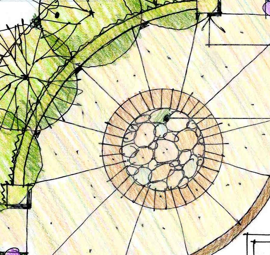
18 4. DESIGN ELEMENTS 4. DESIGN ELEMENTS ROADWAY ENHANCEMENT CONCEPT DIAGRAM The Roadway Enhancements Concept diagrams identify locations for the boulevard character zones, and key architectural and landscape architectural elements, which collectively comprise a family of related design treatments to lend character and a distinct Rockwall image to the boulevard corridor. MEDIANS AND PARKWAYS DESIGN ELEMENTS The median and parkway design concepts reflect the character zones in which they are located: The Wooded Bottoms: These areas are intended to appear as extensions of the vegetation in the natural wooded creeks and drainage ways that are spanned by the boulevard. Accordingly, planting arrangements should be tight, informally grouped masses of native and adapted riparian canopy and understory trees designed to emulate the character of the creek vegetation. These tree masses are to be set in native ornamental grasses to minimize the need for maintenance. The Prairie Uplands: In these areas lower growing tree species native (or adapted and of similar character to the natives) to the rolling hills of eastern Rockwall County would be arranged to emulate the sparser tree cover of the surrounding uplands. These informal tree groupings would also be set in masses of native ornamental grasses, minimizing maintenance needs. The concepts illustrated reflect accurate roadway dimensions and indicate that trees should not be planted in the median areas where future roadway expansion is likely to occur. The illustrated plant materials and their design arrangements are indicative of the size and character appropriate for the character zones in which they occur; subsequent detailed planting plans will make specific plant species recommendations that take into account sitespecific horticultural conditions and established project budgets. KEY ENHANCED INTERSECTIONS Special intersection enhancements are proposed for three key intersections (shown in purple on the Enhancements diagram). The adjacent boulevard medians would be planted with three or more formal groupings of matching canopy trees set in beds of ornamental grasses. The three or more tree groupings should be separated by conventional turf, such as Bermuda to create a visual pattern and rhythm that signals the intersection for the approaching motorist. As the median narrows to accommodate its turn lane, the median plantings would transition to ornamental grasses and drought-tolerant shrubs. Small paved plaza areas with seat-height limestone walls would anchor each corner of the intersection, providing visual interest for motorists as well as informal seating and shade for trail users and other pedestrians and cyclists. GATEWAY IDENTITY Due to the wide variation in site size and configuration at potential gateway sites, the kit of parts approach, utilizing a combination of limestone walls, the vertical trailblazer monument pylon, canopy or ornamental trees and broad masses of drought tolerant shrubs and grasses can be used to great effect. This will result in a family of gateway designs comprised of the same key elements, but arranged in unique compositions to best fit their particular site configuration and topography. 14
19 4. DESIGN ELEMENTS TRAIL REST STOPS Shaded rest areas are shown in preliminary locations on the Enhancements diagram, spaced roughly one mile apart on both sides of the boulevard. This results in a rest area along the boulevard about every half mile. The key design elements shown in the prototype design consist of a shaded shelter of limestone and architectural metal, a seat-height wall for informal seating, a waste receptacle and a drinking fountain with dog dish. The edges should be enhanced with boulders and drought tolerant plantings as shown. EXPOSED CONCRETE WALLS Low exposed concrete headwalls visible from the travel lanes of the boulevard should be colored with the same pale yellow concrete stain utilized for the new John King Boulevard bridge spanning Phelps Branch. This subtle color change will be helpful in tying disparate elements of the corridor together and giving the boulevard design a finished appearance. 15

20 4. DESIGN ELEMENTS Roadway Landscape Concepts 16

21 4. DESIGN ELEMENTS 17

22 4. DESIGN ELEMENTS 18

23 4. DESIGN ELEMENTS 19

24 4. DESIGN ELEMENTS Intersection Enhancements 20

25 4. DESIGN ELEMENTS 21

26 4. DESIGN ELEMENTS 22

27 4. DESIGN ELEMENTS Placemaking Elements 23

28 4. DESIGN ELEMENTS Gateway Pylon Concept North Bypass South Bypass Bypass (2) 24

29 4. DESIGN ELEMENTS 25
30 4. DESIGN ELEMENTS 26

31 4. DESIGN ELEMENTS 27

32 4. DESIGN ELEMENTS 28
33 5. ACCESS POLICIES 5. ACCESS POLICIES 29

34 6. IMPLEMENTATION 6. IMPLEMENTATION This concept design represents a long term vision for enhancement of the corridor. It will not likely be built within a short time horizon. INCORPORATE TRAIL SYSTEM INTO THE THOROUGHFARE PLAN Nationally as well as within the Metroplex region, communities are realizing that multimodal access such as bicycle and pedestrian trails are an important ingredient to becoming sustainable. This is reflected in the new LEED-ND (Neighborhood Development) standards. The trail system should therefore be added to the Thoroughfare Plan in order to ensure continuity of the system. COST SHARING OF ENHANCEMENTS As a general rule, developments make improvements to the curb line which would include sidewalk/trails and landscaping elements of this plan. Notable exceptions would be Landmark Pylons and trailhead washroom facilities. The City should provide landscaping within the median except when development requires additional median cuts in accordance with the City adopted standards. CITY ENHANCEMENT PRIORITIES The highest visual impact improvement would be landscaping the medians in the Wooded Bottoms area as a first priority. This could be followed by additional landscaping of medians and the introduction of gateway pylons. QUALITY STRUCTURAL FEATURES A qualified landscape architect should be engaged to provide final design and detailed specifications for all structural elements including wall, pylons, corner plazas and amenity pockets. The quality of design and construction of these elements is vital to building upon an image rooted in the heritage of the community. 30
Hidden Pointe Landscape Master Plan. June, archi terra
 Hidden Pointe Landscape Master Plan June, 2006 t h e archi terra g r o u p 1 Table of Contents Background Purpose and Goals of the Master Plan Master Plan Process Existing Conditions Entrance Hidden Pointe
GREENING THE BOULEVARD Master Plan Concepts for Venice Boulevard between Lincoln and Sawtelle
 GREENING THE BOULEVARD Katherine Spitz Associates Inc. 4212½ Glencoe Avenue Marina Del Rey, CA 90292 310 574 4460 Fax 574 4462 January 2008 Table of Contents Overview Proposed Design Improvements Illustration
The Vision. Photo provided by The Minervini Group. 46 Vision, Objectives & Strategies
 Vision, Objectives & Strategies The is the public framework and guide for future development of the Grand Traverse Commons. The establishes public polices for infrastructure, the preservation of natural
Community Design Plan
 Gardena General Plan 2006 Authority While the is not a required element of a General Plan, it is included because improving the community appearance and image is paramount to the overall quality of life
Section4 Design Vision & Implementation Plan
 Section4 Design Vision & Implementation Plan W Woodschurch Rd 4.1 Design Focus Areas The Framework Plan is simply the starting point for directing the design and implementation of a wide range of transportation
PUBLIC RIGHT-OF-WAY IN THIS CHAPTER PUBLIC REALM
 PUBLIC RIGHT-OF-WAY This section provides design guidelines for improvements in the public right-of-way. The public right-of-way refers to streets, sidewalks, non-vehicular thoroughfares, parks and greenways
PIKE PINE RENAISSANCE: ACT ONE. October 19, 2017
 PIKE PINE RENAISSANCE: ACT ONE October 19, 2017 WATERFRONT SEATTLE PROGRAM PROJECT INTRODUCTION Pike and Pine streets, between First and Melrose avenues Pedestrian and streetscape improvements Budget:
ANCHOR TO ANCHOR. Rescale the street to create an iconic boulevard.
 ANCHOR TO ANCHOR Rescale the street to create an iconic boulevard. UR NE ER UV GO NE LA OBJECTIVES 1. Maintain appropriate traffic flow and prioritize commercial curb access 2. Mark gateways at the street
Johnson Street Bridge Public Realm Update
 Johnson Street Bridge Public Realm Update August 20, 2015 Background Johnson Street Bridge Replacement Project impacts a diverse range of stakeholders In addition to a new bridge, the project also includes
Potential Green Infrastructure Strategies May 6, 2015 Workshop
 Potential Green Infrastructure Strategies May 6, 2015 Workshop Background The City of Cortland is developing the Tioughnioga Urban Headwaters Green Infrastructure Action Plan with funding from the National
Table of Contents. Elm Avenue Improvement Plan City of Waco, Texas. Introduction 1. Existing Context 1 Figure 1 2.
 Table of Contents Introduction 1 Existing Context 1 Figure 1 2 Plan Guidelines 3 Future Urban Form 4 The West-End 4 Main Street 6 The East-End 7 Figure 2 9 Public Improvement Recommendations 7 General
V. Gateways GATEWAYS / V-1
 V. GATEWAYS / V-1 Many of Chesapeake s gateways are located on highways and call for bold and attractive designs that motorists can understand, appreciate, and enjoy. can also take the form of natural
KASPER. City of Georgetown, Texas PUD Planned Unit Development. December 30, 2015 Revised January 27, 2016
 KASPER City of Georgetown, Texas PUD Planned Unit Development December 30, 2015 Revised January 27, 2016 Applicant: Sentinel Land Company, LLC 4910 Campus Drive Newport Beach, CA Prepared by: SEC Planning
The Anaheim Resort Public Realm Landscape Program. City of Anaheim. Adopted September 1994 (94R-239)
") Public Realm Landscape Program City of Anaheim Adopted September 1994 (94R-239) Amendment No. 1 October 1996 (96R-178) Amendment No. 2 June 1999 (99R-137) Amendment No. 3 February 2001 (2002R-56) Amendment
Public Realm Landscape Program City of Anaheim Adopted September 1994 (94R-239) Amendment No. 1 October 1996 (96R-178) Amendment No. 2 June 1999 (99R-137) Amendment No. 3 February 2001 (2002R-56) Amendment
Subarea 5 Southern Gateway. Vision. Mobility The proposed street network will create developable blocks that are scaled appropriately for the area.
 southern gateway 194 Southern Gateway extends south of I-435 to 123 rd Street and includes the area past the Blue Valley Parkway division. This area is adjacent to major office centers such as the College
CHAPTER 5 Public Realm Improvements
 5.1 OVERVIEW This chapter focuses on the public realm, that is, spaces within and directly adjacent to public rights-of-way (ROWs), including streets, Oso Creek, the rail corridor, and the freeway edge.
section five BEAUTIFICATION PLAN
 section five BEAUTIFICATION PLAN BEAUTIFICATION PLAN Section Five Beautification Plan The goal of the Beautification Plan is to improve the Route 8-Sunnyland Corridor in terms of aesthetics and to create
4. INDUSTRIAL 53 CASTLE ROCK DESIGN
 4. INDUSTRIAL 53 CASTLE ROCK DESIGN CASTLE ROCK DESIGN 54 4. INDUSTRIAL Overview Well-designed and attractive industrial centers are the product of blending economic realities with both functional and
Campus Identity & Design Guidelines
 WSU RFP 7840-GC23215 Exhibit E Campus Identity & Design Branding Specification Washington State University Tri-Cities Campus Campus Identity & Design Guidelines G G L O architecture I interior design I
SAN RAFAEL GENERAL PLAN 2040 INTRODUCTION AND OVERVIEW
 SAN RAFAEL GENERAL PLAN 2040 INTRODUCTION AND OVERVIEW Steering Committee Presentation February 14, 2018 Purpose of General Plan Guide land use and development decisions Coordinate transportation, infrastructure,
5.0 WAYFINDING STREETSCAPE DESIGN MASTER PLAN 55
 OVERVIEW 57 SIGN TYPE A: GATEWAY 57 SIGN TYPES B & C: WAYFINDING KIOSKS & BOLLARDS 58 SIGN TYPES D: POLE MOUNTED ELEMENTS 59 SIGN TYPE E: LARGE-SCALE TYPOGRAPHIC INSTALLATION 60 SIGN TYPE F: VERTICAL CHOPSTICKS
Chapter 14 Streetscape Improvements
 This chapter presents streetscape design concepts for key streets and gateways in the Downtown Specific Plan area. This chapter is organized as follows: 14 Streetscape Improvements 14.1 Streetscape Treatments
Seneca Meadows. Block 4 Locate office, technology, and medical development adjacent to I Screen views of garage structures from I-270.
 Seneca Meadows Seneca Meadows has an industrial park in its southern end and a mixed-use employment area planned for the north end. The district benefits from extensive I-270 visibility, stream valley
OVERVIEW OF PLANS FOR THE JEFFERSON COUNTY COUNTRYSIDE FARM In the Context of Quality Place Characteristics
 OVERVIEW OF PLANS FOR THE JEFFERSON COUNTY COUNTRYSIDE FARM In the Context of Quality Place Characteristics By Steve Grabow, Professor and Community Development Educator University of Wisconsin-Extension,
Lambeth Main Street Streetscape Improvements
 Lambeth Main Street Streetscape Improvements Open House October 5th, 2017 Agenda 1. Introduction 2. Project Background 3. Context 4. Project Objectives 5. Design Principles & Approach 6. Streetscape Design
7Page 91 CLEMMONS COMMUNITY COMPASS 7 COMMUNITY CHARACTER
 7 Community Character The beauty of Clemmons won t necessarily be a reflection of our past, but our future. This quote from Comprehensive Plan Steering Committee member Wayne Dodson captures the essence
Glenn Highway MP DSR. Landscape Narrative
 Glenn Highway MP 34-42 DSR Landscape Narrative Project Landscape Goals The Glenn Highway MP 34-42 Project extends through a variety of landscape types typical to the Matanuska-Susitna Valley. In general,
City of Farmington. Downtown Plan. Amendment to the 1998 Master Plan Adopted October 11, 2004
 City of Farmington Amendment to the 1998 Master Plan Adopted October 11, 2004 Introduction Planning Background 1 Scope and Components of the Plan Amendment 2 Concept Introduction 3 Plan Concepts 3 Conceptual
SDOT DCLU. Director s Rule Seattle Design Guidelines for Link Light Rail, Beacon Hill Station. City of Seattle
 SDOT DCLU Director s Rule 11-2003 Applicant: Page Supersedes: City of Seattle Department of Transportation (SDOT) Department of Design, Construction and Land Use (DCLU) 1 of 10 Publication: 7/3/03, 8/29/02*
Figure Example of out door dining in the public right-of-way.
 Section 2 Core Area Goal 2.2.1 To maintain and enhance the character of existing streets in the Downtown Area. Character Figure 2.2.1 Example of out door dining in the public right-of-way. A. Provide street
SUBCHAPTER 4-B GUIDELINES FOR THE B-3 COMMERCIAL CHARACTER AREA
 1 SUBCHAPTER 4-B GUIDELINES FOR THE B-3 COMMERCIAL CHARACTER AREA Downtown Bozeman should be the location of buildings of greatest height and intensity in the community. The following guidelines apply
Wayfinding. North Gateway: Integrate a vertical gateway marker on the west side of Ward Street at the south corner of Vernon Street.
 3.3.6.2 Wayfinding Existing Conditions Wayfinding signage is important to direct visitors and tourists to different locations in the downtown. A significant part of the wayfinding signage in the downtown
Route 1 Corridor Study
 Route 1 Corridor Study Westbrook, Connecticut A Vision for the Connecticut Shoreline Public Informational Meeting July 28, 2015 Lower Connecticut River Valley Council of Governments Fitzgerald & Halliday,
Elliot Park 2. Neighborhood Master Plan. Historical Perspective
 Elliot Park 2 Neighborhood Master Plan Historical Perspective August 2002 Early History Development patterns and the growth of Minneapolis largely grew out of the city s historical response to its geography.
II. SINGLE FAMILY RESIDENTIAL
 II. SINGLE FAMILY RESIDENTIAL Castle Rock is made up of numerous individually built houses and subdivision tracts that have been developed during the past century. Some of the tracts are diverse in architectural
Corridor Identity. Section 9. Introduction. Corridor Guiding Principles
 Corridor Identity An attractive and healthy community is a critical element of a quality place, and the design of quality places is a balance between environmental, economic, and social considerations.
Making TOD Work in the Heart of Suburban Sprawl
 Making TOD Work in the Heart of Suburban Sprawl Rocky Mountain Land Use Institute March 6, 2009 Speakers Ben Herman, FAICP, Principal Clarion Associates Darcie White, AICP, Principal Clarion Associates
URBAN DESIGN BRIEF. 2136&2148 Trafalgar Road. Town of Oakville
 URBAN DESIGN BRIEF 2136&2148 Trafalgar Road Town of Oakville Prepared By: METROPOLITAN CONSULTING INC For 2500674 Ontario Inc November 2016 TABLE OF CONTENTS Page No. 1.0 Introduction/Description of Subject
BROOKHILL NEIGHBORHOOD MODEL ZONING MAP AMENDMENT PREFACE TO APPLICATION
 BROOKHILL NEIGHBORHOOD MODEL ZONING MAP AMENDMENT PREFACE TO APPLICATION June 15, 2015 Revised: August 1, 2016 I. VISION Brookhill is a proposed community based upon the principles of Albemarle County
ILLUSTRATIVE DESIGN GUIDELINES FOR OFFICE DEVELOPMENT
 The purpose of this guide is to provide a helpful illustration of the objectives and action strategies contained in the Comprehensive Plan concerning the promotion of high-quality office buildings within
Courthouse Square Planning & Urban Design Study. Courthouse Square Working Group #13 October 15, 2014
 Courthouse Square Planning & Urban Design Study Courthouse Square Working Group #13 October 15, 2014 1 Courthouse Square Process Working Group Community Courthouse Square Advisory Groups & Civic Associations
Welcome. Community Consultation Meeting November 28, Review and discuss the Bathurst Quay Neighbourhood Plan Framework
 Welcome Community Consultation Meeting November 28, 2016 Why Are We Here Today? Review and discuss the Bathurst Quay Neighbourhood Plan Framework Review and discuss an Action Plan for Implementation Next
Jewel. Platte. of the. Plattsmouth Main Street Landscape Architecture by HDR
 Jewel of the Platte Plattsmouth Main Street Landscape Architecture by HDR Plattsmouth, Nebraska is a historic community of 6,500 residents located along the west bank of the Missouri River, just south
Safe Routes to School & Master Plans Walkable and Livable Communities Institute
 Safe Routes to School & Master Plans Walkable and Livable Communities Institute Safe Routes to School & Master Plans If you fail to plan, you plan to fail. Why SRTS How Webinar Goal: Advance SRTS in Michigan
The following principles guide the development of goals and strategies to protect and promote these amenities:
 OPEN SPACE/PARKS/TRAILS/RECREATION GOALS/STRATEGIES Cherry Hills Village is a living environment that offers low density development, open areas, public scenic vistas, public trails and public parks. This
Hamilton Road Corridor Streetscape Master Plan. Open House October 4 th, 2017
 Hamilton Road Corridor Streetscape Master Plan Open House October 4 th, 2017 Agenda 1. Introductions Agenda Overview 2. Project Background 3. Existing Conditions 4. Strengths, Weaknesses, Opportunities
HE VISION. Building a Better Connected Place
 HE VISION Building a Better Connected Place WALK INTO THE FUTURE. Life in Cranberry, 2030 Here s what our residents told us they wanted to see in their community by 2030: The Cranberry of 2030 is a place
Town Center (part of the Comprehensive Plan)
") Town Center (part of the Comprehensive Plan) Mercer Island Town Center Looking North (2014) In 1994, a year-long process culminated in a set of design guidelines and code requirements for the Town Center
Town Center (part of the Comprehensive Plan) Mercer Island Town Center Looking North (2014) In 1994, a year-long process culminated in a set of design guidelines and code requirements for the Town Center
New Street Proposed Redevelopment Architecture & Urban Design Brief
 2130 2136 New Street Proposed Redevelopment Architecture & Urban Design Brief Prepared By: Cynthia Zahoruk Architect Inc. 3077 New Street, Burlington, ON, L7N 1M6 TABLE OF CONTENTS Background and Objective
242 neighborhoods NEIGHBORHOOD 4: JORDAN AVENUE CORRIDOR
 NEIGHBORHOOD 4: JORDAN AVENUE CORRIDOR Aerial View of Jordan Avenue Corridor EXISTING CHARACTER The Jordan Avenue Corridor is the portion of North Jordan Avenue that extends north from East Third Street
Corridor Enhancements
 Corridor Enhancements Safety is MoDOT s first priority in widening and rebuilding I-70 across the state of Missouri. MoDOT also understands that the interstate - and its interchanges and overpasses - are
Derry Green Corporate Business Park
 Town of Milton Derry Green Corporate Business Park Urban Design Guidelines BMI/Pace - June 2010 Draft 3 Prepared by: Brook McIlroy Planning + Urban Design / Pace Architects Suite 300-51 Camden Street Toronto,
AESTHETIC APPEARANCE. Design Guidelines for Grade-Separated Pedestrian, Cyclist and Equestrian Structures
 III. AESTHETIC APPEARANCE The aesthetic qualities of a grade-separated structure are as important as the specific design criteria. For example, a structure may be constructed to the exact criteria set
RZC Public View Corridors and Gateways
 RZC 21.42 Public View Corridors and Gateways 21.42.010 Purpose 21.42.020 Scope and Authority 21.42.030 Administration 21.42.040 Gateways Design 21.42.050 Unidentified Public Views 21.42.060 Identification
ROME WATERFRONT VILLAGE PROJECT NARRATIVE January 25, 2018
 January 25, 2018 The Rome Waterfront Village project is intended to foster the revitalization of the area between South James Street and Erie Boulevard north of the Erie Canal as well as improve public
Figure 3-1: Public Realm Plan
 3 Public Realm Figure 3-1: Public Realm Plan 3.1 Public Realm Concept The public realm concept for the Little Mountain site integrates a clear and accessible movement network with public spaces for social
4.500 Preston Road Overlay District
 Section 4.500 Preston Road Overlay District 2004 Zoning Ordinance 4.500 Preston Road Overlay District (ZC 98-29; Ordinance No. 98-9-12) 4.501 Purpose To provide appropriate design standards for the use
VILLAGE OF SKOKIE Design Guidelines for Mixed-Use Districts NX Neighborhood Mixed-Use TX Transit Mixed-Use CX Core Mixed-Use
 VILLAGE OF SKOKIE Design Guidelines for Mixed-Use Districts NX Neighborhood Mixed-Use TX Transit Mixed-Use CX Core Mixed-Use TABLE OF CONTENTS CHAPTER 1 SITE DESIGN Purpose 1 CHAPTER 2 SITE DESIGN Streetscape
I-70 Corridor Enhancement Plan
 i - Table of Contents Table of Contents Chapter I Overview Chapter II Bridge and Roadway Improvements Chapter III Landscape Enhancements Chapter IV Riparian Corridors Chapter V Showcase Missouri Plan Chapter
SDOT DPD. SDOT Director s Rule DPD Director s Rule DCLU DR SED DR of 7 CITY OF SEATTLE
 SDOT SDOT Director s Rule 2-07 DPD Applicant: CITY OF SEATTLE Page 1 of 7 Supersedes: DCLU DR 11-93 SED DR 93-4 Seattle Department of Transportation (SDOT) Department of Planning and Development (DPD)
New-Cast Mixed-use Development Proposal King Street West, Newcastle, Ontario
 URBAN DESIGN BRIEF New-Cast Mixed-use Development Proposal King Street West, Newcastle, Ontario TABLE OF CONTENTS: 1.0 Executive Summary 2.0 Creating Vibrant and Sustainable Urban Places: Excerpts from
APPENDIX K WINDSOR OFFICIAL PLAN
 CEAA ENVIRONMENTAL ENVIRONMENTAL IMPACT ASSESSMENT AMBASSADOR BRIDGE ENHANCEMENT PROJECT Replacement Span and Plaza Expansion APPENDIX K WINDSOR OFFICIAL PLAN Avalon Consulting Professionals of Ontario,
Sierra Springs Regional Commercial Master Site Plan Airdrie, Alberta Hopewell Development Corporation Project No May 26, 2010
 Sierra Springs Regional Commercial Master Site Plan Airdrie, Alberta Hopewell Development Corporation Project No. 205-077 May 26, 2010 TABLE OF CONTENTS Purpose... 2 Master Site Plan Guidelines... 3 Overall
URBAN DESIGN BRIEF URBAN DESIGN BRIEF 721 FRANKLIN BLVD, CAMBRIDGE August 2018
 URBAN DESIGN BRIEF URBAN DESIGN BRIEF 721 FRANKLIN BLVD, CAMBRIDGE August 2018 DESIGN BRIEF CONTENTS PART A 1.0 INTRODUCTION 2.0 DESCRIPTION & ANALYSIS OF SITE CONTEXT 3.0 DESIGN CONSTRAINTS AND OPPORTUNITIES
Table L-1 Summary Action Strategy. Action Item Timing Status Responsible Agency
 CHAPTER 4: CIRCULATION ELEMENT ISSUE #1: MAJOR THOROUFARES AND TRANSPORTATION ROUTES A balanced transportation system for Fontana is provided that meets the mobility needs of current and future residents
COMMERCIAL & INDUSTRIAL DESIGN GUIDELINES CITY OF RANCHO CUCAMONGA PLANNING DIVISION
 COMMERCIAL & INDUSTRIAL DESIGN GUIDELINES CITY OF RANCHO CUCAMONGA PLANNING DIVISION INTRODUCTION These guidelines were prepared in response to the needs of many users: developers, property owners, architects,
RONALD REAGAN. Corridor Design Guidelines HENDRICKS COUNTY, INDIANA
 i. Table of Contents ii. Section 1: Introduction Section 2: Materials 1 Purpose of the Design Guidelines... 1-2 Design Implementation... 1-2 Introduction to the Parkway Enhancements... 1-4 2 Material Selection...
Design Guidelines for the Route 30 Corridor Master Plan: Subdivision and Land Development Elements
 Design Guidelines for the Route 30 Corridor Master Plan: Subdivision and Land Development Elements East Whiteland Township- Chester County, PA Prepared by: Draft: May 7, 2018 Design Guidelines for the
VEHICULAR AND PEDESTRIAN CIRCULATION
 This perspective sketch communicates the intended character and quality of a proposed streetscape design. Locate benches near a major intersection where people tend to gather. Seating and lighting provide
GUIDING PRINCIPLES IN THIS CHAPTER
 GUIDING PRINCIPLES The guiding principles and design concepts in this chapter work together with the Chapel Hill 2020 Comprehensive Plan to support new public places that can be enjoyed by all while also
The Emerald Bracelet Dallas, Texas. October 2005
 The October 2005 TABLE OF CONTENTS: Tab I Project Summary Master Illustrative Plan Tab II Woodall Rodgers Freeway Segment Tab III U.S. Highway 75 Segment Tab IV Interstate Highway 30 Segment Tab V Interstate
A larger version of this map is located on the last page of this PDF.
 MAP Committee Input McLoughlin Area Draft Vision Map A larger version of this map is located on the last page of this PDF. 1. The map above is intended to portray a vision for the McLoughlin area. It highlights
City of Long Beach. creating vibrant and exciting places
 City of Long Beach creating vibrant and exciting places Land Use Element Urban Design Element Overview of the two draft General Plan elements Discuss areas of change Economic goals of the plans Case study
MASTER PLAN QUEEN ST. WEST BIA
 QUEEN ST. WEST BIA MASTER PLAN QUEEN ST. WEST BIA EXECUTIVE COMMITTEE IN ASSOCIATION WITH PMA LANDSCAPE ARCHITECTS LTD. SWEENY STERLING FINLAYSON & CO ARCHITECTS INC. FUGITIVE GLUE MARCH 2013 4.5.4 PLAZA
Urban Design & Placemaking
 Urban Design & Placemaking What is Urban Design? Urban Design is the discipline of creating equitable, vibrant, and sustainable places with distinct identities. The profession pulls from other built environment
The open space system should provide connective elements, relate to natural resources, and enhance the suburban character of the landscape..
 The open space system should provide connective elements, relate to natural resources, and enhance the suburban character of the landscape.. Mixed-use and infill development should maintain or enhance
Toronto Complete Streets Guidelines
 Toronto Complete Streets Guidelines 108 110 7.1 Green Infrastructure Design Principles 112 7.2 Context-Sensitive Green Streets 114 7.3 Key Green Street Elements Green infrastructure refers to natural and
Appendix A COMMUNITY IMPROVEMENT PLAN DESIGN GUIDELINES
 Appendix A COMMUNITY IMPROVEMENT PLAN DESIGN GUIDELINES INTRODUCTION The continuous and desirable improvement of Arnprior requires a clear understanding of what is envisioned for the Town. These Design
Comprehensive Plan ADOPTED APRIL 2014
 Comprehensive Plan ADOPTED APRIL 2014 8 8. Outstanding Recreational & Cultural Opportunities We are proud of our community s parks and recreation system. Our community will ensure that the legacy of our
Project Goal. RRRC Living Towns Planning Workshp. Town of Halifax Revitalization Project. Dynamic Planning & Management Duo: July 12, 2006
 Project Goal Town of Halifax Revitalization Project RRRC Living Towns Planning Workshp July 12, 2006 Town of Halifax Halifax County *** Revitalization Project Goal*** To create Economic Opportunity and
Draft Memorandum #1: Goals and Vision for Revitalization
 Keizer Revitalization Plan Draft Memorandum #1: Goals and Vision for Revitalization Submitted to: City of Keizer April 12, 2018 (revised) Prepared By: Angelo Planning Group and Otak, Inc. Project No. 17482.A
4.1 AESTHETICS AND VISUAL QUALITY
 SCOPE AND METHODOLOGY 4.1 AESTHETICS AND VISUAL QUALITY This section evaluates the potential impacts to aesthetics and visual quality. Aesthetics refers to visual resources and the quality of what can
Good Design Guidelines for Downtown. Preliminary Findings and Recommendations
 Good Design Guidelines for Downtown Preliminary Findings and Recommendations City Council Meeting - February 5, 2017 Advisory Committee Team: Larry Paul: Planning Commission /Architect Bruce Bagnoli: Business
A. Background Summary of Existing Challenges and Potential Possibilities. 1. Summary of Existing Assets and Potential Opportunities
 A. Background 1 A Main Street Master Plan Study was performed and completed in October of 2007. The study was initiated to review current land uses and development patterns along Main Street, from Parrish
UNIVERSITY TOWN NEIGHBOURHOODS 5.5 HOUSING MELBOURNE CAMPUS MASTER PLAN 2014
 5.5 169 EXISTING CONDITIONS & VISION NEIGHBOURHOOD VISION The provision of on-campus housing into the future will continue to be an important element of the La Trobe University experience. A long-term
CHAPTER 3. Design Standards for Business, Commercial, Industrial, Recreational and Institutional Uses
 CHAPTER 3 Design Standards for Business, Commercial, Section Number Title Ordinance Number Date of Ordinance 16-3-1 Applicability 2006-11 2008-04 07-01-08 16-3-2 Uniform Standards for Architectural Design
Bow to Bluff Public Realm Plan Design Update
 Bow to Bluff Public Realm Plan Design Update December 017 Great public spaces encourage people to gather, recreate, explore and discover. Introduction The City of Calgary is planning to improve the corridor
STREETSCAPE IMPROVEMENTS - RECOMMENDATIONS
 STREETSCAPE IMPROVEMENTS - RECOMMENDATIONS Figure 4.3.1- A map of all of the recommended streetscape improvements. The key component of downtown s public realm, apart from its public spaces, is its street
Policies and Code Intent Sections Related to Town Center
 Policies and Code Intent Sections Related to Town Center The Town Center Vision is scattered throughout the Comprehensive Plan, development code and the 1994 Town Center Plan. What follows are sections
CHAPTER 7: VISION AND ACTION STATEMENTS. Noble 2025 Vision Statement
 CHAPTER 7: VISION AND ACTION STATEMENTS This chapter presents the vision, policy and action statements that transform the comprehensive planning study, an analysis of Noble s past, future trends and community
People who are members of historically disenfranchised racial, ethnic, cultural, and other identity groups are encouraged to apply.
 CALL TO ARTISTS REQUEST FOR QUALIFICATIONS CITY OF TACOMA MUNICIPAL ART PROGRAM East 64 th Streetscape, Tacoma, WA APPLICATION DEADLINE October 10, 2018, 11:59pm BUDGET $72,000, all-inclusive SUMMARY The
CENTERS AND CORRIDORS
 INITIAL DESIGN STANDARDS AND GUIDELINES for CENTERS AND CORRIDORS City of Spokane Planning Services Third Floor, City Hall 808 W. Spokane Falls Blvd. Spokane, WA 99201-3329 (509) 625-6300 www.spokaneplanning.org
1 st now. Design Elements. iii STREET TREES PATTERNED CROSSWALKS SPECIAL SIDEWALK PAVING. First Street ELEMENTS TRANSIT SHELTER / LANTERN
 Design Elements A framework for Design Elements has been developed in response to Project Restore s vision and goals for the First Street Corridor. Guided by the principles good urban design and smart
urban design Introduction
 ACHIEVE SP RI NGF I ELD.3 Introduction Urban Design Areas Design Areas are areas within Springfield that have a unique and recognizable character that is different from other areas in the community. The
Standards (R-3) Figure B-11: R-3 Residential Standards Exhibit
 Figure B-11: R-3 Residential Standards Exhibit") Avila Ranch Avila Ranch Specific Plan Development Standards High Medium Density - High Residential Density Residential Lot and Building Lot and Standards Building (R-3) Standards (R-3) EXAMPLES These sketches
Avila Ranch Avila Ranch Specific Plan Development Standards High Medium Density - High Residential Density Residential Lot and Building Lot and Standards Building (R-3) Standards (R-3) EXAMPLES These sketches
Our Legacy Projects DOWNTOWN JACKSONVILLE MASTER PLAN
 DOWNTOWN JACKSONVILLE MASTER PLAN A major component of our master plan is the creation of a strong and accessible open space and recreation system. The four most vital links in that system are our legacy
Chapter 5: Mixed Use Neighborhood Character District
 5: Mixed Use Neighborhood Character District 5.1 Introduction The Mixed Use Neighborhood character district acts as a transition or bridge between the State Route 89A District s commercial area to the
The Lemay Branding and Streetscape Plan: Streetscape Plan March 24, 2011
 The Lemay Branding and Streetscape Plan: Streetscape Plan March 24, 2011 This page intentionally left blank Table of Contents Page 1.0 Executive Summary... 1 2.0 Project Process... 5 2.1 Streetscape Goals...
hermitage town center
 hermitage town center A Community Vision prepared by Strada for The City of Hermitage and The Mercer County Regional Planning Commission January 2007 table of contents introduction 3 design principles
Chapter 1: Introduction
 Chapter 1: Introduction The Penn Avenue Community Works Corridor Vision and Implementation Framework presents an integrated communitybased vision and a coordinated, long-term implementation framework for