STONY PLAIN ROAD urban design vision
|
|
|
- Maximillian Black
- 5 years ago
- Views:
Transcription


1 STONY PLAIN ROAD urban design vision June 2012
2

3 There is magic to great streets. We are attracted to the best of them not because we have to go there but because we want to be there. -Allan B. Jacobs, Great Streets, 1993
4 Table of Contents Executive Summary Part One: Introduction-A Vision for the Future 1.1 Purpose of the Urban Design Vision Project Area Relationship to Other Initiatives Relevant Planning Documents Key Challenges and Opportunities Vision and Strategic Priorities How this Vision was Prepared...15 Part Two: Area Analysis 2.1 Historic Context Existing Land Use and Zoning Character Areas and Built Form Pedestrian Environment Transportation and Parking LRT and Public Transit Parks and Open Spaces...29 Part Three: Urban Design Vision 3.1 Vision Statement General Urban Design Recommendations...33 Land Use and Density...34 Pedestrian Realm...34 Built Form and Architecture...35 Roadway System...36 Transit System...37 Parking, Access and Loading...37 Bicycle Amenity...37 Parks and Open Spaces...38 Public Art...38 Design for a Winter City...39 Crime Prevention Through Environmental Design...39 Sustainability...40
5 3.3 Precinct Specific Urban Design Recommendations...41 Pedestrian-oriented Mixed-use Main Street...43 Town Centre Transit Oriented Development...49 Jasper Gates Transit Oriented Development...55 Destination Walkable Commercial...59 High Quality Medium Density Residential...64 Redeveloped Commercial Anchor...69 Prestige Commercial and Employment...73 Part Four: Implementation 4.1 Implementation Area redevelopment planning process Streetscape Improvements General Stony Plain Road (149 Street 158 Street) Stony Plain Road (158 Street 170 Street) Street Parks and Open Spaces Town Square Concept Public Plaza Pedestrian and Cycling Connections Public Transit On-street Parking Utility Improvements Additional Neighbourhood Investment Façade Improvement Program Development Incentive Fund Program Neighbourhood Renewal Appendix Appendix A: Sun Shadow Studies...95 Appendix B: Consultation February 7, Appendix C: Consultation March 25, Appendix D: Consultation June 15,
 within the Stony Plain Road Corridor.")


6 EXECUTIVE SUMMARY The purpose of the Urban Design Vision for Stony Plain Road is to: Establish an integrated and long term vision to guide future public and private developments in the area to achieve high quality and functional design, and Inform the preparation of the Jasper Place Area Redevelopment Plan (ARP) within the Stony Plain Road Corridor. The future ARP will take precedence over the design recommendations outlined in this Vision, which may be partially or wholly integrated into the ARP as it proceeds. The Vision will: 1. Determine the best future uses in the area; 2. Provide urban design recommendations that respect and enhance the rich history of the area; 3. Support the future integration of the LRT system; 4. Provide guidance relating to the implementation of this vision, and 5. Enhance the Stony Plain Road corridor as a vital entrance corridor connecting Edmonton s west end and the downtown core. The Vision make a series of recommendations related to key planning and design principles. Develop Stony Plain Road as a transitoriented, mixed-use urban village; Implement streetscape improvements including wider sidewalks, trees, pedestrian lighting and street furniture. A key focus is improving the pedestrian experience between 149 Street and 158 Street; Encourage extensive north-south pedestrian movement with crosswalks and pedestrian priority signage at key intersections; Maintain on-street parking opportunities, where feasible; Encourage pedestrian-oriented, mixed-use development along Stony Plain Road, up to a maximum of four to six storeys; Create a pedestrian friendly interface between the future LRT line and the pedestrian realm. This includes shared surface design for LRT and vehicular movement, a central alignment for the LRT and split station platforms to allow for ease of pedestrian crossing; Create a public gathering space that is highly connected to the pedestrian shopping street and to the surrounding neighbourhoods; Celebrate Edmonton s role as a winter city through seasonal festivals, lighting schemes, colour and environmentally-sensitive design; Create a community for everyone, including families, working professionals, seniors and students by fostering a vibrant public realm with a variety of activities, public spaces and opportunities for interaction; and Encourage and promote green building and sustainable design practices, quality architecture and urban design in the area. 6 EXECUTIVE SUMMARY
7 PART ONE: INTRODUCTION A Vision For The Future 7 PART ONE: INTRODUCTION
8 1.1 PURPOSE OF THE URBAN DESIGN VISION Revitalization efforts have been ongoing in the Stony Plain Road area, beginning in 2004, by the City of Edmonton s Community Services, with assistance from Sustainable Development. Throughout this process, the City has held a number of charrettes, working sessions, interviews and open houses in the study area asking people about their aspirations for the future of Stony Plain Road. This document represents the application of the information gathered in these consultations into a guiding vision for future investment in the area. The Urban Design Vision is intended to guide and coordinate planning and investment activities within the Stony Plain Road area, including but not limited to: The Urban Design Vision addresses desired future character, land use and urban design considerations along Stony Plain Road and in the surrounding area. It also provides guidance for the future integration of the west LRT line. The Vision acknowledges the dual role of the Stony Plain Road corridor as a vital entrance corridor connecting Edmonton s west end and the downtown core, as a destination retail street and as a residential community. A well-designed public environment, including parks, streets, squares, transit, bicycle amenity and architecture will help to ensure the ongoing success of the area. The Vision will help to guide future investment in the area so that it may fully contribute to community building and positive renewal. Jasper Place Neighbourhood Revitalization; Neighbourhood Renewal and Roadway Rehabilitation; Area redevelopment planning process for Britania Youngstown, Canora, Glenwood, West Jasper Plance and Stony Plain Road Corridor area; LRT Planning along Stony Plain Road and; Streetscape Improvements 8 PART ONE: INTRODUCTION

9 1.2 PROJECT AREA The project study area, shown in red, is referred to as the Stony Plain Road Corridor. It extends along Stony Plain Road from 149 Street to 170 Street, including the areas north and south of Stony Plain Road between 100 Avenue and 102 Avenue. The project area intersects portions of four neighbourhoods: Britannia Youngstown Canora Glenwood West Jasper Place 9 PART ONE: INTRODUCTION
10 1.3 RELATIONSHIP TO OTHER INITIATIVES The Urban Design Vision for Stony Plain Road is being developed in coordination with a number City of Edmonton initiatives. These include: Community Services Jasper Place Revitalization Sustainable Development Transportation Services Infrastructure Services Area redevelopment planning process for Britannia-Youngstown, Canora, Glenwood, West Jasper Place and the Stony Plain Road Corridor Façade Improvement Program Development Incentive Program LRT Planning (On-going) Streetscape Improvement Plan ( ) - Consultant Team West Jasper Place Roadway Renewal ( ) Canora Roadway Renewal ( ) 10 PART ONE: INTRODUCTION
11 1.4 RELEVANT PLANNING DOCUMENTS Relevant City of Edmonton planning documents include: The Way We Grow, Municipal Development Plan (2010) The Way We Move, Transportation Master Plan (2009) The Way We Green, Environmental Strategic Plan (2011) The Way We Live, Edmonton s People Plan (2010) Proposed Walkability Strategy for Edmonton West LRT Lewis Estates to Downtown Recommended Concept Plan (2011) Canora Neighbourhood Improvement Plan (1972) Jasper Place Revitalization Strategy (2009) Project for Public Spaces Charrette and Report (2008) 100 Avenue Planning Study (1986) Britannia-Youngstown Planning Study (1983) Residential Infill Guidelines (2009) Transit Oriented Development Guidelines (2012) Stony Plain Road BRZ Strategic Plan (2007) 11 PART ONE: INTRODUCTION

12 1.5 KEY CHALLENGES AND OPPORTUNITIES The study area is faced with a number of challenges and opportunities. These include: 1. Land Use Challenges: Existing zoning limits future mixed-use and higher density development. The character and desired land use in the area have changed since the 100 Avenue Planning Study was competed in Opportunities: Up-zoning can encourage higher density development and new investment along the LRT alignment. Implementation of a comprehensive Urban Design Vision and an area redevelopment planning process can guide and encourage pedestrian-oriented development along the corridor. Future integration of the LRT can be supported through rezoning. 2. Pedestrian Environment Challenges: Narrow, cluttered sidewalks discourage walking and contribute to a negative image of the area. Intersections are often unfriendly to pedestrians and can make crossing Stony Plain Road difficult. Lack of greenery along streets makes pedestrians feel exposed. Opportunities: A new streetscape improvement initiative is underway to address the pedestrian realm through widened sidewalks and new streetscape treatments, where feasible. Rezoning and the future integration of the LRT will encourage walkable, mixeduse development along the corridor. 12 PART ONE: INTRODUCTION


13 3. Transportation Challenges: Conflict currently exists between different modes of transportation. The Transit Centre is outdated and is not pedestrian-friendly. Opportunities: With the planning of the LRT, there is an opportunity to integrate all modes of transportation. There is an opportunity to incorporate bicycle facilities, such as sheltered bicycle racks at key locations along Stony Plain Road. There is an opportunity to improve connections to MacKinnon Ravine and the bicycle network through signage and an extension of the shared use pathway system. 4. Public Spaces Challenges: Butler Memorial Park is under used and lacks adequate surveillance. Public spaces lack programming and positive activities. Opportunities: With the planning of the LRT along Stony Plain Road, there is an opportunity to expand and improve public spaces close to the LRT platforms and Transit Centre. A Town Square concept that incorporates a new Transit Centre and public space could be considered Residents are passionate about their community and desire access to high-quality, well designed and well programmed public spaces. 5. Business and Retail Challenges: Many building facades are in disrepair or lack transparency for pedestrians. Large, unattractive signage predominates. Retail often under performs and there is an over-concentration of pawn shops, adult stores and services. Potential loss of on-street parking along Stony Plain Road. Opportunities: Façade Improvement Program, offered by Sustainable Development, is available to qualifying business properties. Development Incentive Program, offered by Sustainable Development, is available to qualifying properties and encourages mixed-use developments. New signage bylaw is underway. Increased density, pedestrian and transit users will support a variety of retail types. 13 PART ONE: INTRODUCTION
14 Ten Strategic Priorities were derived from discussions at the workshops, open houses, Ten Strategic charrettes Priorities and committee were derived meetings from held discussions between 2008 at and the workshops, They are: open houses, charrettes and committee meetings held between 2008 and They are: 1. Provide wide sidewalks with a variety of streetscape elements to enhance the pedestrian experience and to encourage extensive pedestrian traffic. 1.6 VISION AND STRATEGIC PRIORITIES The Stony Plain Road Corridor is in a prime position to reclaim its role as a walkable, diverse urban village. High quality urban design along the Corridor will help encourage the vibrant success of the area and will reinforce Stony Plain Road s role as the gateway to the Downtown from the west. 2. Create an easily accessible destination by foot, bike, public transit and vehicle. Acknowledge and enhance Stony Plain Road s dual role as a destination and as a gateway to Downtown. 3. Create a community for everyone, including families, working professionals, seniors and students by creating a vibrant public realm with a variety of activities, public spaces and opportunities for interaction. 4. Encourage and promote quality architecture and urban design in the area. 5. Enhance the connection to the North Saskatchewan River valley through improved wayfinding and an extended, marked pedestrian and bicycle pathway. 6. Celebrate Edmonton s role as a winter city through seasonal festivals, lighting schemes, colour and environmentally-sensitive design. 7. Create a public gathering space that is highly connected to the pedestrian shopping street and to the surrounding neighbourhoods. 8. Maintain on-street parking opportunities to support local businesses and to provide a buffer between pedestrians and vehicular traffic. 9. Encourage and promote green building and sustainable design practices, to help create a livable, walkable and sustainable community along Stony Plain Road and in the surrounding area. 10. Ensure the future LRT line becomes an asset to the village character proposed for Stony Plain Road. Ensure the creation of a pedestrian friendly interface with the future LRT line and stations. 14 PART ONE: INTRODUCTION


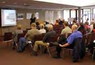
15 1.7 HOW THIS VISION WAS PREPARED Key Stakeholder Interviews Key property owners within the Stony Plain Road study area were interviewed and their vision for the future of their property was discussed. The Office of Great Neighbourhoods also sponsored a series of telephone and on-line surveys, including 400 residential surveys, 100 business surveys, 202 on-site shopper surveys and 272 online workbook surveys. The following groups were also invited to consult about the Urban Design Vision: Jasper Place Revitalization Steering Committee Jasper Place Building Group Business Revitalization Zone Executive Director and Members West Jasper Place, Canora, Britannia Youngstown and Glenwood Community Leagues Design Charrettes and Open Houses Several Design Charrettes and Open Houses were held on: October 6-26, 2006 May 10, 2007 November 6, 2007 March 6-12, 2007 May 22, 2008 April-May 2008 February 7, 2009 March 25, 2009 June 15, 2011 Discussions with City Staff City staff are working together to ensure the success of all public projects. On-going discussions are taking place between: Sustainable Development Community Services Transportation Services Infrastructure Services 15 PART ONE: INTRODUCTION


16 Consultation Process We asked many People about their aspirations and we built upon the results of all feedback. 16 PART ONE: INTRODUCTION
17 PART TWO: AREA ANALYSIS 17 PART TWO: AREA ANALYSIS

18 2.1 HISTORIC CONTEXT The Town of Jasper Place became a part of the City of Edmonton on August 17, At the time of its amalgamation, it was the largest town in Canada with a population of 38,000 people. The town fell within an area bounded by 149th Street to the east, 170th Street to the west, the North Saskatchewan River to the south and 118th Avenue to the north. During the 1930s, the population grew as many Edmontonians moved to the Town of Jasper Place in order to escape high taxes in the city. Many residents worked in Edmonton and, by the 1940s, the trolley line extended to the modern 149th Street, close enough to Jasper Place to allow returning workers to walk the rest of the way home. Following the discovery of oil near Leduc in 1947, the population of Edmonton swelled and Jasper Place absorbed some of the overflow population growth. Jasper Place continued to grow and, in the early 1960s, it expanded several of its schools, began construction of a sports centre, and commenced planning for the Meadowlark Park Centre. Unfortunately, such projects placed the town deeply in debt and, with the province refusing to grant extra funds, a plebiscite was held in which residents voted in favor of amalgamation with Edmonton. 18 PART TWO: AREA ANALYSIS


19 19 PART TWO: AREA ANALYSIS
20 2.2 EXISTING LAND USE AND ZONING Existing Land Use The existing land use contains a mixture of commercial and low to medium density residential units. Institutional uses include Grant MacEwan University and Westlawn Memorial Cemetery. Residential development consists of single family homes and walk-up apartment blocks in varying condition. Figure depicts the existing land use. Existing Zoning The east portion of Stony Plain Road, between 149 Street and 157 Street, is currently zoned CB1 (Low Intensity Business Zone) which allows for development of low intensity commercial, office and service uses along arterial roadways that border residential areas. This zone allows a maximum FAR of 2.0 and a maximum height of 12.0 m or three storeys. Where the first storey is commercial, residential uses are permitted up to a maximum FAR of 1.5. The west portion of Stony Plain Road, between 157 Street and 170 Street, is predominantly zoned CB2 (General Business Zone) which allows for businesses requiring large sites with good visibility and accessibility along, or adjacent to, major public roadways. This zone generally allows a maximum FAR of 3.5 and a maximum height 14.0 m or four storeys. Where the first storey is commercial, residential uses are permitted up to a maximum FAR of 2.0. The majority of residential sites to the north and south of Stony Plain Road between 102 Avenue and 100 Avenue are zoned RA7 (Low Rise Apartment Zone). This zone allows for the development of low rise apartments at densities of 125 units/ha, a maximum FAR of 1.3 and a maximum height of 14.0 m or 4 storeys. There is a pocket of RF1 zoning between 158 Street and 161 Street, north of 100 Avenue. This zone is intended to provide primarily for single detached housing and secondary suites under certain conditions. From 166 Street to 169 Street, north of 100 Avenue, there is an area zoned for light industrial use. Figure depicts the existing zoning. 20 PART TWO: AREA ANALYSIS

21 2.2.1 EXISTING LAND USE 21 PART TWO: AREA ANALYSIS *Information current as of July 14, 2011

22 2.2.2 EXISTING ZONING 22 PART TWO: AREA ANALYSIS *Information current as of July 14, 2011


23 2.3 CHARACTER AREAS AND BUILT FORM 1. Pedestrian Oriented Commercial Stony Plain Road, from 149 Street to 158 Street, is lined with predominantly one and two storey commercial buildings. This area is home to a number of pawn shops, adult stores and cash stores which do not serve the local community. Buildings setbacks range from 0 m to 12 m along a 20 m road right of way. There is great variation in terms of building character, quality and condition. Sidewalk widths average 2.0 m and are often cluttered and of varying quality and condition. In its current state, the pedestrian environment is inadequate to support increased pedestrian-oriented commercial development. 2. Auto-oriented Commercial Stony Plain Road, from 158 Street to 170 Street, is lined with predominantly single-storey, autooriented commercial. This area is home to a number of automotive repair shops, which serve both the neighbourhood and district patrons. The majority of these businesses have driveways, parking lots and garages at the front of the buildings. The buildings are setback an average of 10 m - 15 m along a 20 m road right of way. 3. Mixed Residential To the south of Stony Plain Road along 100 A Avenue, between 156 Street and 163 Street, is a mixture of single family residential and commercial development. Many of the businesses in this area are located in single storey commercial-style buildings and, in some cases, in converted single family dwellings. Residential setbacks apply. 23 PART TWO: AREA ANALYSIS


24 4. Stable Medium Residential To the north and south of Stony Plain Road is stable medium-density residential development. These residential buildings are primarily two to four storey walk-up apartments of varying condition. 5. Commercial Anchor The Stony Plain Road study area is book-ended by two large anchor commercial developments, Mayfield Common to the west and Jasper Gates to the east. These commercial complexes consist primarily of internally-oriented, single-storey, large format retail with large parking areas. These anchor commercial developments draw visitors from outside the neighbourhood, serving as focal destination points. 6. Light Industrial/Commercial Between 166 Street and 169 Street, south of Stony Plain Road, development consists predominantly of light industrial/commercial buildings. These buildings are primarily internally-oriented, one and two storey commercial and industrial uses surrounding large parking areas. This area may serve as an employment destination for the neighbourhood and district. 24 PART TWO: AREA ANALYSIS

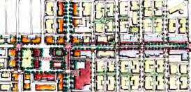
25 2.3.1 EXISTING CHARACTER AREAS Avenue 4 2 Stony Plain Road Street Street Avenue 156 Street Street The study area has been divided into seven existing character areas. These include: Pedestrian-oriented Commercial Auto-oriented Commercial Mixed Residential Stable Medium Density Residential Commercial Anchor Light Industrial/Commercial 25 PART TWO: AREA ANALYSIS


26 2.4 PEDESTRIAN ENVIRONMENT Assets A number of key assets provide Stony Plain Road with a solid framework to develop into a vibrant, sustainable pedestrian shopping street. It is the gateway to downtown Edmonton from the west and is one of a series of shopping anchors between the City Centre Mall and West Edmonton Mall. Previous public realm improvements provide a solid base to build upon in a new streetscape improvement plan. Stony Plain Road is home to a diverse mixture of building types, many of which are prime opportunities for redevelopment and participation in the Façade Improvement and Development Incentive Fund Programs. Issues The sidewalk widths along Stony Plain Road average 2.0 m, are often cluttered and in varying condition. Private walks are often in disrepair. Steps, snow and ice, newspaper boxes and other barriers limit circulation and wheelchair access on what would otherwise be considered adequate sidewalks. Numerous travel lanes and traffic which often moves quickly create an unfriendly environment for pedestrians. The intersections at 149 Street and 170 Street are especially problematic, fostering vehicular rather and pedestrian priority. The above issues are exacerbated by a lack of pedestrian-level lighting, street trees and building façade transparency. Many businesses along Stony Plain Road have covered their windows and there is little sense of having eyes on the street. From an aesthetic point of view, the streetscape improvements that were built in the 1990s have reached the end of their life cycle and require updating and renewal. Planting street trees and other landscaping would help to reinforce the pedestrian character of Stony Plain Road and would help soften the interface between pedestrians and vehicles. A streetscape improvement plan is beimg completed as part of the Jasper Place Revitalization project. In its current state, the pedestrian environment along Stony Plain Road does not encourage pedestrian-oriented commercial development. 26 PART TWO: AREA ANALYSIS


27 2.5 TRANSPORTATION AND PARKING Assets Along Stony Plain Road, there is an extensive number of surface parking lots. The street is typically fast-moving with high volumes of vehicular commuter traffic. On-street parking is currently available along portions of Stony Plain Road. Stony Plain Road has the potential to provide a series of activity hubs along a transportation corridor, with access on foot, by car, by bus and, eventually, by LRT. Issues A number of conflicts currently exist between the various roles of Stony Plain Road; a transit corridor, vehicular commuter corridor and pedestrian shopping street. A four-lane road with relatively high speed traffic creates an uncomfortable environment for pedestrians to walk, cross and shop. On-street parking is currently limited along Stony Plain Road and is generally available on an offpeak basis. The success of Stony Plain Road as a vibrant shopping street is greatly affected by the amount of parking provided. It would not be favourable to the commercial area to decrease or remove on-street parking in the future. Attempts should be made to maintain, if not increase, available parking for consumers where feasable. The freeflow nature of 100 Avenue limits connectivity between the commercial development and the communities of Glenwood and West Jasper Place. Consideration needs to be given to the pedestrian crossings along 100 Avenue to facilitate safe connections between the commercial development to the north and the residential development to the south. 27 PART TWO: AREA ANALYSIS


28 2.6 LRT AND PUBLIC TRANSIT Assets Along Stony Plain Road, there is extensive public transit service, including a large Transit Centre and several curb-side bus stops. Numerous bus routes serve the area, transporting passengers to all areas of the city, with express buses to downtown and West Edmonton Mall. Issues The Transit Centre has limited access to and through the site on foot or in wheelchairs. Additionally, there is a lack of visibility to the Transit Centre from Stony Plain Road, making it difficult to locate. The Transit Centre may be redeveloped in the future, at which time it could be integrated with the future LRT platform at 156 Street and Stony Plain Road. Transit shelters and other infrastructure need to be updated. 28 PART TWO: AREA ANALYSIS


29 2.7 PARKS AND OPEN SPACES Assets Stony Plain Road is home to Butler Memorial Park, a small pocket park located at the intersection of four neighbourhoods and adjacent to a busy Transit Centre. This park is in a prime position to be redeveloped into a major public space when the Transit Centre is redesigned. Westlawn Cemetery may provide a substantial green connection between the residential communities, the anchor commercial development at Mayfield Common and the main street in the future. There is a safe shared use pathway along 100 Avenue that connects the West Jasper Place neighbourhood to the River Valley trail system via MacKinnon Ravine. Issues The Stony Plain Road study area currently has few active public open spaces and parks. Butler Memorial Park is currently under used, lacks natural surveillance and programming. It, therefore, attracts many undesirable activities. Westlawn Cemetery is privately owned, however, with cooperation from the owner, it may provide an opportunity for nearby residents to access the space for walks and respectful recreation. Improvements can also be made to the interface between the cemetery and the public realm to emphasize the open, green character of the block. While the proximity of Stony Plain Road to MacKinnon Ravine is an asset, the 100 Avenue shared use pathway lacks visible signage and natural surveillance and is, therefore, under utilized as a link to the Ravine system and the downtown. With proper wayfinding tools, Stony Plain Road could be marketed as a pedestrian and bicycle corridor, connecting to the city s extensive trail system. Furthermore, there is a lack of bicycle infrastructure, such as bicycle racks, along Stony Plain Road. Such amenities should be focused around the Transit Centre and main shopping anchors. Assets 29 PART TWO: AREA ANALYSIS
30
31 Streets and their sidewalks, the main public places of a city, are its most vital organs. Think of a city and what comes to mind? Its streets. Jane Jacobs, author of Death and Life of Great American Cities, 1961 PART THREE: URBAN DESIGN VISION 31 PART THREE: URBAN DESIGN VISION
32 3.1 VISION STATEMENT The Urban Design Vision is the product of extensive consultation in and analysis of the Stony Plain Road study area. The Vision is developed to parallel and support the ten strategic priorities for the area, as outlined in section 1.6. Key planning and design principles of the Urban Design Vision include: Develop Stony Plain Road as a transitoriented, mixed-use urban village; Implement Streetscape improvements, including wider sidewalks, trees, pedestrian lighting and street furniture. A key focus is improving the pedestrian experience between 149 Street and 158 Street; Encourage extensive north-south pedestrian movement with crosswalks and pedestrian priority signage at key intersections; Maintain on-street parking opportunities, where possible; Encourage pedestrian-oriented, mixed-use development along Stony Plain Road, up to a maximum of four to six storeys; Create a pedestrian friendly interface between the future LRT line and the pedestrian realm. This includes shared surface design for LRT and vehicular movement, a central alignment for the LRT and split station platforms to allow for ease of pedestrian crossing; Create a public gathering space that is highly connected to the pedestrian shopping street and to the surrounding neighbourhoods; Celebrate Edmonton s role as a winter city through seasonal festivals, lighting schemes, colour and environmentally-sensitive design; Create a community for everyone, including families, working professionals, seniors and students by fostering a vibrant public realm with a variety of activities, public spaces and opportunities for interaction; and Encourage and promote green building and sustainable design practices, quality architecture and urban design in the area. 32 PART THREE: URBAN DESIGN VISION
33 3.2 GENERAL URBAN DESIGN RECOMMENDATIONS The purpose of this section is to provide general urban design recommendations for new developments along Stony Plain Road and within the study area. This section identifies general development and design recommendations for: Land Use and Density; Pedestrian Realm; Built Form and Architecture; Roadway System; Transit System; Parking, Access and Loading; Bicycle Amenity; Parks and Open Spaces; Public Art; Design for a Winter City; Crime Prevention Through Environmental Design (CPTED); and Sustainability. 33 PART THREE: URBAN DESIGN VISION


34 Land Use and Density The Vision for the Stony Plain Road study area includes medium density, low to mid rise developments containing a range of scales and uses. The area should contain a mixture of retail, commercial and residential development in buildings that average four storeys. Where appropriate, higher density development may be located in close proximity to the Transit Centre and future LRT platforms. Street-level retail will be focussed along Stony Plain Road. Retail uses are most successful when located on a street with moderate levels of drive-by traffic, adequate curb-side parking, uninterrupted retail uses on both sides of the street and a quantity of retail that is sufficient to draw shoppers from other areas. Neighbourhoodserving retail, cafes, restaurants and professional offices are appropriate along Stony Plain Road. Mixed-use developments will be encouraged along Stony Plain Road, with residential uses on the upper floors and retail at street level. Some office and commercial developments will be appropriate. Ground floor residential is appropriate within certain Medium Density Residential areas. Commercial and civic anchors are encouraged at intervals along the street. These include the Jasper Gates Shopping Centre, the redeveloped Transit Centre, Butler Memorial Park and the commercial anchor at Mayfield Common. Together, these anchors serve as bookends that help attract and retain visitors to the area and support infill investment. Pedestrian Realm Essential elements of a pedestrian-friendly public realm include continuous, wide sidewalks lined with trees, pedestrian-oriented lighting, places to sit and mingle, slow-moving traffic, and safe pedestrian crossings at key corners that are in line with the sidewalk. Where possible, canopy-forming street trees should be provided at 10 m intervals to buffer pedestrians from the vehicular realm and provide a visual softening to the built environment. Pedestrian oriented lighting should be provided. Additional lighting may be provided in the form of building flood lighting, landscaping flood lighting and seasonal lighting. To reduce visual and physical clutter, where possible, all utilities should be located underground. 34 PART THREE: URBAN DESIGN VISION


35 Directional pedestrian signage should be incorporated providing directions and distances to key destinations including Grant MacEwan University, the Transit Centre, Butler Memorial Park, shopping, MacKinnon Ravine and other attractions. Development should be designed to maximize pedestrian activity on the streets. Direct and safe pedestrian routes, including marked pedestrian crossings, should be provided to major destinations in surrounding areas, including public transit facilities. Built Form and Architecture The built form within the Stony Plain Road study area should be compact, walkable and distinctive. Buildings should showcase high-quality architecture, timeless materials and sustainable building technologies. Building Placement and Orientation Along Stony Plain Road, a minimum 3.0 m setback will be required. Buildings should be oriented to maximize pedestrian access to sunlight. Specific side-street setbacks are outlined in Section 3.3: Precinct Specific Urban Design Recommendations. Consistent maximum setbacks encourage buildings to be placed near the street, resulting in an efficient use of land. Ground-floor uses are oriented toward the pedestrian realm which adds to the vitality and safety of the street. On residential streets, a consistent setback provides a semi-private transition and separation between those traveling along public boulevards and those residing in adjacent buildings. Building Height and Massing Buildings along Stony Plain Road should average four storeys or 14.0 m, unless otherwise specified in Section 3.3: Precinct Specific Urban Design Recommendations. Building heights along Stony Plain Road should be a minimum of two and one half storeys or 8.6 m. Development up to 6 storeys or 20.0 m may be appropriate on the north side of Stony Plain Road near the Transit Centre and future LRT platforms at the discretion of the Development Officer. 35 PART THREE: URBAN DESIGN VISION


36 Structured parking should be wrapped with retail and/or commercial uses at the ground floor. Architectural treatments should be applied to above-grade storeys to screen parking. Structured parking should be indistinguishable from other commercial uses along Stony Plain Road. Active Streetfronts All buildings along Stony Plain Road require active frontages with doorways and windows oriented to the street with a consistent setback to establish a continuous street edge. Parking lots in front of buildings should not be allowed. All commercial and residential tenants should have their own entrances. Building design and orientation should encourage pedestrian activity in the following ways: The maximum frontage facing Stony Plain Road should not exceed m. Where a frontage exceeds m, or the consistent development pattern for the surrounding area, the front façade of the building should be designed to break the appearance into sections or modules consistently sized with other buildings in the immediate vicinity. Building entrances should address the main street and should be clearly visible and architecturally expressed; Building corners should be articulated through changes in scale, materials or other unique architectural treatments; Overhead weather protection in the form of awnings and canopies should be encouraged on all buildings; Commercial ground floor units should contain public or semi-public uses and should be visually transparent; Residential ground floor units should have direct, elevated individual entrances facing the main street; and Residential units should feature individual doorways, stoops, porches and windows, where possible. Roadway System Best practices in urban design associated with successful pedestrian commercial shopping streets strive to attain an allocation of approximately 40% of the right of way for pedestrian use, with approximately 60% dedicated to roadway. Stony Plain Road could be reconfigured for wider sidewalks while maintaining parallel parking during off-peak hours. When the LRT is introduced, this configuration would change to one west-bound lane, one east-bound lane and a parking lane, where possible. 36 PART THREE: URBAN DESIGN VISION


37 Transit System The effectiveness of transit is significantly impacted by the character and nature of surrounding development. In order to support transit ridership, residential density should be increased within the study area, particularly near the proposed LRT platforms and the existing Transit Centre. Any increase in density must be appropriate to the context of the area in both form and character, and should contribute to the pedestrian environment in a positive manner. The proposed LRT should operate on a shared right of way with the vehicular traffic. Efforts should be made to minimize any pedestrianvehicular-lrt barriers. Parking, Access and Loading In order to maximize the beneficial effects of parking, consideration should be given to the following: On-street parking be provided on at least one side of Stony Plain Road, where feasble; Private parking be provided underground or at the rear of buildings, with access from the lane; Access to service bays, loading, underground parking and surface parking should be at the interior of the block, off the rear lane; and Parking requirements may be reduced for residential and commercial buildings adjacent to the future LRT platforms. Bicycle Amenity An extensive network of bicycle amenities should be provided within a 1.5 Km radius of the Transit Centre and proposed LRT platforms. These paths should run parallel to the transit lines, periodically coming to a T at the Transit Centre or LRT platform. Designated bicycle paths should not necessarily run on the same right of way as the tracks. They should be a minimum of 1.5 m in width. Additionally, an enhanced pedestrian and bicycle connection should be incorporated at 149 Street, linked to the 100 Avenue shared use pathway to enhance the connection of Stony Plain Road to MacKinnon Ravine and the urban parkland network. Bicycle parking should be located at each LRT platform and at the Transit Centre, as close as practical to the platforms. Where possible, bicycle parking should be sheltered. 37 PART THREE: URBAN DESIGN VISION


38 Parks and Open Spaces With its proximity to the river valley and potential for future redevelopment, the Stony Plain Road area has an opportunity to introduce new open spaces and to connect to existing park and public space systems. There are four main interventions necessary to enhance and redevelop the parks and open spaces within the study area. These include: Improve connections to the North Saskatchewan River valley via the MacKinnon Ravine; Redevelop Butler Memorial Park, if feasable, into an urban plaza where it can serve as a gathering place, a venue and/or a commemorative plaza; Program a series of community cultural and social activities in Butler Memorial Park and other public open spaces as a first step toward redeveloping these spaces as civic centres and public gathering spaces; and Develop new green/open spaces, particularly near future LRT platforms, as opportunities arise. Family-oriented housing should be located adjacent to, or within walking distance of, parks and open spaces, where possible. Public Art The inclusion of high-quality, diverse public art helps to shape and define a community, express its history and draw visitors into its boundaries. Public art must be included, in accordance with the City s Public Art Policy, on all qualifying capital projects within the project area. Public art should also be encouraged as part of private developments. 38 PART THREE: URBAN DESIGN VISION


 All new development and streetscape initiatives should comply with Crime Prevention Through Environmental Design (CPTED) principles.")
39 Design for a Winter City All new development and streetscape improvements within the study area should give appropriate consideration to the winter climate in the following ways: Consider the prevailing winter winds during site design to provide protection from the elements and avoid the creation of adverse microclimatic effects; Orient buildings to maximize pedestrian access to sunlight, particularly along Stony Plain Road; Provide protection from the elements by way of awnings, canopies and well-designed transit shelters; Provide a variety of lighting types and sources to enhance the appearance of the shopping street during the winter months; Consider snow storage and removal in streetscape design; Create a landscaping or streetscape buffer to provide some protection to pedestrians from vehicular spray from rain, snow or slush; and Encourage the use of colour through landscaping, building materials, public art and streetscape elements which are attractive year round. Crime Prevention Through Environmental Design (CPTED) All new development and streetscape initiatives should comply with Crime Prevention Through Environmental Design (CPTED) principles. CPTED deters criminal activity through natural surveillance (visibility, positive social activities), natural access control (entry and exit points, fences), and natural boundaries (clear ownership, clearly marked private spaces). Specific CPTED strategies include: Clean up graffiti as soon as possible; Use decorative landscaping, murals, and lights to discourage tagging of buildings; Select trees that will allow for sightlines; Encourage neighbourhood activities, including block parties and park programming; Ensure streets are pedestrian friendly; Influence behaviours with bright, motivating, reflective colours on backgrounds; 39 PART THREE: URBAN DESIGN VISION


40 Increase visibility with lights and sightlines; Keep signs in good repair; Redesign space to increase sightlines and to reduce hiding areas; Clear transitional zones from public to private spaces; and Relocate gathering areas to places with the best natural sightlines and access control. Sustainability All new development within the study area should strive to meet sustainability guidelines, as set out in The Way We Green. Sustainable development may be achieved in the following ways: Emphasis should be placed on the development and use of transit systems, including bus and LRT lines; Create a pedestrian-friendly environment to encourage walkability; Showcase and test sustainable initiatives such as, but not limited to, a range of low impact development features such as permeable surfaces, bioswales and rain gardens, low water landscaping, renewable energy/efficient street lighting, interpretive signage, etc. that aim to highlight the connections between ecosystems, infrastructure, and the urban environment; Encourage high-quality, environmentally sustainable developments intended for longterm use; and Contribute to a socially sustainable community by providing housing for a range of household types, sizes, ages and incomes in accordance with appropriate City policies. 40 PART THREE: URBAN DESIGN VISION
41 3.3 PRECINCT SPECIFIC URBAN DESIGN RECOMMENDATIONS The purpose of this section is to provide precinct-specific design recommendations for new developments along Stony Plain Road and within the study area. This section identifies specific development and design recommendations for: Character; Land Use and Density; Pedestrian Realm; Built Form and Architecture; Roadway System; Transit System; Parking, Access and Loading; Bicycle Amenity; and Parks and Open Spaces. 41 PART THREE: URBAN DESIGN VISION

42 3.3.1 PROPOSED CHARACTER AREAS Avenue Stony Plain Road Future LRT Alignment Street 163 Street 100 Avenue 156 Street 149 Street The study area has been divided into seven distinct precincts, as elements of the Urban Design Vision. These are: Pedestrian-oriented Mixed-use Main Street Town Centre Transit Oriented Development Jasper Gates Transit Oriented Development Destination Walkable Commercial High Quality Medium Density Residential Redeveloped Commercial Anchor Prestige Commercial and Employment 42 PART THREE: URBAN DESIGN VISION

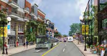
43 1 Pedestrian-oriented Mixed-use Main Street Located at the heart of the study area, the Pedestrian-oriented Mixed-use Main Street precinct occupies the area between 151 Street and 155 Street along Stony Plain Road. This precinct should be the focus of higher density residential, retail and employment uses. Character The Pedestrian-oriented Mixed-use Main Street precinct should have a distinct, recognizable character. Buildings should provide a continuous, vibrant frontage along Stony Plain Road. Streetscape and public realm improvements will contribute to the creation of a pedestrianfriendly public realm through the incorporation of wider sidewalks, pedestrian-oriented lighting, landscaping, crosswalks and street furniture. The combination of a pedestrian-oriented public realm, a consistent streetwall, ground floor, pedestrian-oriented retail and the future urbanstyle LRT system will contribute to the creation of a vibrant, walkable shopping district. Land Use and Density The area along Stony Plain Road from 151 Street to 155 Street should accommodate higher density pedestrian-oriented commercial development. Along Stony Plain Road and on large development sites, 4 storey buildings with ground floor retail and residential uses on the upper floors are recommended. Neighbourhood-serving retail, cafes and restaurants are recommended commercial uses in this area. Pedestrian Realm Provide continuous sidewalks of 3.0 m width within the public ROW before LRT implementation, and at 2.25 m width within the public ROW with future LRT. Sidewalks should be lined with canopy-forming street trees at approximately 10 m intervals to buffer pedestrians from the vehicular realm and provide a visual softening to the built environment. Existing Conditions Provide pedestrian-oriented lighting, spaced approximately 20 m apart. Built Form and Architecture Building Placement and Orientation Buildings should be placed along Stony Plain Road to create a well defined streetwall with consistent setbacks. Front building face setback should be 3.0 m to allow for a total sidewalk width of 6.0 m before LRT implementation (see illustration on page 46) and total width of 5.25 m with future LRT (see illustration on page 48) that includes 3.0 m building setback. Occasional setbacks of greater than 3.0 m may be allowed to accommodate pedestrian-oriented uses, including sidewalk cafes, landscaping and architectural features. Buildings should be oriented to maximize access to sunlight along Stony Plain Road. 43 PART THREE: URBAN DESIGN VISION

44 Proposed Ground Floor Uses Proposed Upper Floor Uses Proposed Front Building Face Setbacks Note: For illustration purposes only Transit Centre location and configuration to be further explored through the Jasper Place Area Redevelopment Plan process 44 PART THREE: URBAN DESIGN VISION


45 Building Height and Massing Maximum building heights of 4 storeys or 14.0 m. Development up to 6 storeys or 20.0 m may be appropriate on the north side of Stony Plain Road at the discretion of the Development Officer. Apartment housing should be encouraged on the upper storeys of buildings with commercial development at grade. Active Streetfronts Within the Pedestrian-oriented Mixed-use Main Street precinct, 70% transparency at 1.5 m above grade is desirable. Maintain the fine-grained character of Stony Plain Road. The maximum frontage along Stony Plain Road should not exceed m. Where a frontage exceeds m, or the consistent historic development pattern for the street, the front façade of the building shall be designed to break the appearance into sections or modules consistently sized with other buildings on the shopping street. All entries to retail, residential and commercial units should face the main street. Multiple commercial tenants should each have their own entry. Residential units located above ground floor retail should have a dedicated entry to the lobby facing onto the main street. Access to sunlight along Stony Plain Road should be taken into consideration when buildings are designed. Stepbacks may be necessary to allow for sunlight penetration. Parking, Access and Loading Wherever possible, on-street parking should be preserved within the Pedestrian-oriented Mixed-use Commercial precinct. 45 PART THREE: URBAN DESIGN VISION

46 Proposed Vision Stony Plain Road-Cross Section Looking West before LRT Implementation 151 St St. For illustration purposes only 46 PART THREE: URBAN DESIGN VISION

47 47 Proposed Vision Stony Plain Road Looking East PART THREE: URBAN DESIGN VISION For illustration purposes only

48 48 Proposed Vision Stony Plain Road-Cross Section Looking West with Future LRT 151 St St. PART THREE: URBAN DESIGN VISION For illustration purposes only

49 2 Town Centre Transit Oriented Development Located at the intersection of four neighbourhoods, the Town Centre Transit Oriented Development precinct, between 155 Street and 158 Street along Stony Plain Road, is home to the Jasper Place Transit Centre, a future LRT platform, retail development, a university campus and a public park. Future development in this area should reinforce the town centre character and should contribute to a vibrant, accessible and timeless public gathering space. Character The Town Centre Transit Oriented Development precinct should become a vibrant hub of activity, accessible by transit, foot, bicycle or car. Surrounding development should be distinctive, creating a series of landmarks by which visitors can orient themselves. Activity could focus around a central public square, with buildings fronting onto the main street and the square. The combination of a Transit Centre, future LRT platform, public plaza, university campus and commercial development will contribute toward the creation of a vibrant, walkable town centre. Land Use and Density The Town Centre area, at the intersection of Stony Plain Road and 156 Street should accommodate higher density pedestrian-oriented commercial development. The area between Stony Plain Road and 100 Avenue should accommodate medium density multiple family housing, including row housing and quality low rise apartments. The Transit Centre and future LRT platform should be well connected to enable transit riders to comfortably transfer between the bus and LRT systems, while providing opportunities to linger and engage in the area during their transfer. Additional potential land uses within the Civic Centre area could include civic uses such as a Existing Conditions gathering place, public library, cultural centre, recreation facility, or a market. Pedestrian Realm Provide continuous sidewalks of 1.5 m width within the public ROW and at a total width of 4.5 m including the 3.0 m building setback. This wide sidewalk should be lined with canopy-forming street trees at approximately 10 m spacing to buffer pedestrians from the vehicular realm and provide a visual softening to the built environment. Provide pedestrian-oriented lighting, spaced approximately 20 m apart. Provide safe intersections with marked pedestrian crossings that are in line with the sidewalks, future LRT platform and Transit Centre, where appropriate. Provide special paving in crosswalks to emphasize the pedestrian right of way. 49 PART THREE: URBAN DESIGN VISION
.")


50 Built Form and Architecture Building Placement and Orientation Buildings should be placed along Stony Plain Road and around the perimeter of the public square in such a manner that creates a well defined frontage with consistent setbacks. Front building face setback should be 3.0 m to allow for a total sidewalk width of 4.5 m (see illustration on page 53). Occasional setbacks of greater than 3.0 m may be permitted at the discretion of the Development Officer to accommodate pedestrian-oriented uses, including sidewalk cafes, landscaping and architectural features. Buildings should be oriented and stepped back, where necessary, to maximize pedestrian access to sunlight from the park and along Stony Plain Road. Transit Centre and LRT buildings and structures should be well integrated into their sites, with access from all sides. Building Height and Massing Maximum building heights of 4 storeys or 14.0 m. Development up to 6 storeys or 20.0 m may be appropriate on the north side of Stony Plain Road, adjacent to the Transit Centre. Access to sunlight from the public park and along Stony Plain Road should be taken into consideration when buildings are designed. Stepbacks may be necessary to allow for sunlight penetration. Active Streetfronts For buildings facing Stony Plain Road and onto the park, 70% transparency at 1.5 m above grade is desirable. All entries to retail, residential and commercial units should face Stony Plain Road or the public park. Multiple commercial tenants should each have their own entry. Ground floor residential units should have individual, elevated entrances onto the main street. Transit System Transit ridership is impacted by the character and nature of surrounding development, therefore development proposals in the Town Centre precinct should focus on walkable, transit-oriented uses and designs. Transit Centre and LRT buildings and structures should be well integrated into their sites, with access from all sides. Provide adequate signage and bus schedules to direct transit riders. Incorporate an information kiosk with a community events calendar and space for event postings into the Transit Centre or plaza. Where possible, vehicular travel lane widths may be reduced to preserve on-street parking. A convenient connection between the Transit Centre and future LRT platform should be provided. 50 PART THREE: URBAN DESIGN VISION


51 Proposed Ground Floor Uses Proposed Upper Floor Uses Proposed Front Building Face Setbacks Note: For illustration purposes only Transit Centre location and configuration to be further explored through the Jasper Place Area Redevelopment Plan process 51 PART THREE: URBAN DESIGN VISION


52 Parking, Access and Loading Any private parking provided in the Town Centre precinct should be located underground or at the centre of blocks, with access from the rear lane. All loading should take place at the rear of buildings, with access off the lane. On-street parking should be added on 100 Avenue between 155 and 158 Streets. Bicycle Amenity Bicycle parking should be located at the proposed LRT platform and Transit Centre, as close as practical to the platforms. Where possible, bicycle parking should be sheltered. Bicycle access and amenities should be provided in the park. A public open space with retail edges should be located adjacent to the Transit Centre and future LRT platform where it can serve as a gathering place, a venue for markets or festivals, and an overflow for transit patrons during peak travel periods. Relocating or reconfiguring Butler Memorial Park could be an option, this would require further exploration. Buildings should front onto the park, where possible, to increase natural surveillance and vibrancy of the space. Trees, sheltered areas and a mixture of hard and soft landscaping will all contribute to creating an attractive space for gathering, waiting and celebrating. 52 Parks and Open Spaces Programming for Butler Memorial Park should be considered in order to increase its vibrancy and use as a public gathering space and activity centre. PART THREE: URBAN DESIGN VISION

53 53 Proposed Vision Stony Plain Road-Cross Section Looking West 155 St St. PART THREE: URBAN DESIGN VISION For illustration purposes only

54 Proposed Vision Stony Plain Road & 156 St. Intersection looking West 54 PART THREE: URBAN DESIGN VISION For illustration purposes only


55 3 Jasper Gates Transit Oriented Development Located on the north and south sides of Stony Plain Road between 149 Street and 151 Street, the Jasper Gates Transit Oriented Development precinct is a commercial anchor home to major retailers and service providers. An LRT platform is proposed to be located on Stony Plain Road at this location, in addition to existing transit and vehicular access. Character The Jasper Gates Transit Oriented Development precinct should be home to unique, destination retail, commercial and office uses. By extending the existing roadway network through the site and orienting new development toward the pedestrian realm, Jasper Gates will be able to transform into a unique shopping and commercial destination that is highly accessible via transit, foot, bicycle and car. Residential units above ground floor retail will provide a base population that will help support unique, neighbourhood-serving businesses, as well as provide a larger ridership for the existing bus system and future west LRT line. With careful consideration, new infill development can be created where the large parking lot is currently located, creating a destination shopping centre around a central public plaza. This combination of transit stops, including a future LRT platform, public plaza, residential infill and destination commercial development will contribute toward the creation of a vibrant, accessible transit oriented development. Land Use and Density The Jasper Gates Transit Oriented Development precinct should accommodate higher density commercial and mixed-use developments. Currently, large expanses of surface parking dominate the site, surrounded by single storey large retail development. Infill development should be considered, including an access roadway through the site. Neighbourhood-serving and destination retail, eating and drinking establishments and professional offices are appropriate commercial uses in this anchor development. Pedestrian Realm 150 Street has the potential to be extended through the anchor commercial site to integrate and promote the fine-grained character of surrounding development-future vision opportunity. Provide continuous sidewalks along Stony Plain Road at 1.5 m in width within the public ROW and at a total width of 4.5 m including the 3.0 m building setback. The sidewalk should be lined with street trees spaced approximately 10 m apart. Provide continuous sidewalks of 4.25 m width within the public ROW along side streets (see illustration on page 58) Provide pedestrian-oriented lighting, spaced approximately 20 m apart. 55 PART THREE: URBAN DESIGN VISION
 - 151 Street: 0.0 m (no setback) - 100 Avenue: 3.")


56 Built Form and Architecture Building Placement and Orientation Buildings should be oriented such that active retail uses front onto Stony Plain Road or new interior roadways. Minimum front building face setback from the Property line: - Stony Plain Road: 3.0 m Street: 3.0 m Street: 0.0 m (no setback) Street: 0.0 m (no setback) Avenue: 3.0 m Infill development should take place in the existing parking areas along an interior northsouth through road, to create a well-defined frontage with consistent setbacks. LRT platform should be well integrated with surrounding areas. Building Height and Massing Maximum building heights of 4 storeys or 14.0 m. Development up to 6 storeys or 20.0 m appropriate adjacent to the future LRT platform. Access to sunlight along Stony Plain Road and along interior streets should be taken into consideration when buildings are designed. Stepbacks may be necessary to allow for sunlight penetration. Transit System Transit shelters and the future LRT platform should be well integrated into their sites, with pedestrian access from all sides. Transit ridership is impacted by the character and nature of surrounding development, therefore development proposals in the Jasper Gates shopping centre should focus on walkable, transit-oriented uses and designs. Parking, Access and Loading Access to parking and servicing should be provided from the interior of the block off the rear lane. Bicycle Amenity Sheltered bicycle parking should be located in close proximity to the future LRT platform. Create a more pedestrian-friendly environment at the intersection of 149 Street and Stony Plain Road Connections for bicycles and pedestrians should be enhanced between the Jasper Gates shopping centre, the multi-use pathway along 100 Avenue and MacKinnon Ravine. Parks and Open Spaces An urban plaza should be located close to the future LRT platform. Trees, sheltered areas and a mixture of hard and soft landscaping will contribute to creating a clean, quiet and usable space for gathering, waiting and meeting. Buildings should front onto the streets and a future interior plaza, where possible, to increase natural surveillance and vibrancy of the space. 56 PART THREE: URBAN DESIGN VISION


57 Proposed Ground Floor Uses Proposed Upper Floor Uses Proposed Front Building Face Setbacks For illustration purposes only 57 PART THREE: URBAN DESIGN VISION

58 Proposed Vision Jasper Gates-Side Street Looking North 58 PART THREE: URBAN DESIGN VISION For illustration purposes only

59 4 Destination Walkable Commercial The Destination Walkable Commercial precinct, between 158 Street and 167 Street along Stony Plain Road, should contain neighbourhood and region-serving destination retail, commercial and employment uses. Character The Destination Walkable Commercial precinct should have a distinct, recognizable character. Eventually, it may become part of the Pedestrianoriented Mixed-use Main Street precinct. Where new development occurs, buildings should be built up to a consistent 3.0 m setback. Parking lots in front of buildings should not be allowed. Buildings should be consistently built to their allowable maximum heights to encourage a sense of enclosure and continuous commercial frontage along Stony Plain Road. Streetscape and public realm improvements will contribute to the quality of the public realm and encouraging pedestrian activity through the incorporation of wider sidewalks, improved street and pedestrian-oriented lighting, landscaping, crosswalks and street furniture. Land Use and Density Over time, commercial focus should shift from vehicle-oriented retail and repair shops, to pedestrian-friendly region and neighbourhoodserving destination retail and commercial. Pedestrian Realm Within the Destination Walkable Commercial precinct, provide continuous sidewalk of 1.5m width within the public ROW where a turning lane is required and at a total sidewalk width of 4.5 m including the 3.0 m building setback. Provide canopy-forming street trees at approximately 10 m intervals, where possible. Overhead weather protection in the form of awnings and canopies should be encouraged on all buildings along Stony Plain Road. Provide safe, signalized intersections with corner crossings in line with the sidewalks. Provide pedestrian-oriented lighting, spaced approximately 20 m apart. Curb cuts should be minimized or eliminated, where possible. Where possible, limit vehicular accesses to two per block face. Built Form and Architecture Building Placement and Orientation Buildings should be placed along Stony Plain Road in such a manner that creates a well defined streetwall with consistent setbacks. Front building face setback should be 3.0m to allow for a total sidewalk width of 4.5m where a turning lane is required (See illustration on page 62), or 6.0 m in width without a turning lane. The wide sidewalk will provide adequate space for pedestrian activities and landscaping. 59 PART THREE: URBAN DESIGN VISION


60 Proposed Ground Floor Uses Proposed Upper Floor Uses Proposed Front Building Face Setbacks 60 PART THREE: URBAN DESIGN VISION For illustration purposes only

61 Existing Typical Section 158 Street Street Building Height and Massing Maximum building heights of 4 storeys or 14.0 m. Apartment housing or office uses should be appropriate on the upper storeys of buildings with retail/commercial development at grade. Active Streetfronts Within the Destination Walkable Commercial precinct, a minimum of 50% transparency at 1.5 m above grade is acceptable. The maximum frontage facing Stony Plain Road should not exceed m. Where a frontage exceeds m, or the consistent development pattern for the surrounding area, the front façade of the building shall be designed to break the appearance into sections or modules consistently sized with other buildings in the immediate vicinity. All entries to retail, commercial and office units should face the main street. Office uses located above ground floor retail should have an individual entry to the lobby facing on to the main street. Access to sunlight along Stony Plain Road should be taken into consideration when buildings are designed. Stepbacks may be necessary to allow for sunlight penetration. Transit System Transit shelters should be well integrated into their sites to encourage walkability and transit ridership. Parking, Access and Loading Where possible, on-street parking should be preserved. Additional private parking should be located underground or at the centre of blocks, with access from the rear lane. All loading should take place at the rear of buildings, with access from the back lane. Bicycle Amenity Bicycle parking should be provided at intervals along Stony Plain Road to encourage active transportation and walkability 61 PART THREE: URBAN DESIGN VISION

62 Proposed Vision Stony Plain Road-Cross Section Looking West (with a turning lane where required) 158 St St. 62 Note: No change to the existing land use berween 163 St. and 167 St. on the North side. PART THREE: URBAN DESIGN VISION For illustration purposes only
 For illustration purposes only 63 PART THREE: URBAN DESIGN")
63 Proposed Vision Stony Plain Road looking West (without a turning lane) For illustration purposes only 63 PART THREE: URBAN DESIGN VISION

64 5 High Quality Medium Density Residential Existing stable mature residential areas to the north and south of the Stony Plain Road corridor will provide the foundation for the High Quality Medium Density Residential precincts. Future development in these precincts will expand the existing base population, helping support unique, neighbourhood-serving businesses, as well as providing a larger ridership for the existing bus system and future west LRT line. Character The High Quality Medium Density Residential precinct should be compact, walkable and distinctive. Buildings should consist of a combination of walk-up apartments, townhouses and stacked row houses, using high quality materials and designed to address the street. New development should be appealing to a variety of ages and demographics, from families to seniors. Land Use and Density The High Quality Medium Density Residential precinct should maintain its medium density residential character. Intermittent, home-based commercial development may be permitted along 100 A Avenue as a discretionary use. More intense commercial uses should be concentrated along Stony Plain Road. Pedestrian Realm Within the High Quality Medium Density Residential precinct, continuous 4.25 m sidewalks within the public ROW should be provided (see illustration on page 67). Provide landscaped boulevards, lined with canopy-forming street trees at 10 m intervals. Provide pedestrian-oriented lighting, spaced no more than 20 m apart. Provide street furniture and pedestrian amenities where feasible. Discourage fenced front yards as these inhibit visibility and pedestrian interaction. Built Form and Architecture Building Placement and Orientation Where possible, all townhouse and stacked row house units should be set back 3.0 m. Walk-up apartments should be set back 5.0m. Provide active residential frontages through the use of individual, elevated unit entrances and at-grade features including porches, stoops, staircases and projections/recesses. Building Height and Massing Maximum building heights of 4 storeys or 14.0 m. Building fronts should be articulated to reflect individual unit sizes. Active Streetfronts To the north and south of Stony Plain Road, medium density walk-up apartments, townhouses and stacked row housing is appropriate up to a maximum of four storeys or 14.0 m. Buildings of more than 2 storeys should step back at the second storey. 64 PART THREE: URBAN DESIGN VISION


65 Proposed Ground and Upper Floor Uses Proposed Front Building Face Setbacks Note: For illustration purposes only Transit Centre location and configuration to be further explored through the Jasper Place Area Redevelopment Plan process 65 PART THREE: URBAN DESIGN VISION


66 Residential buildings should contain a mixture of one, two and three bedroom units in order to serve a variety of demographics. For residential units, a minimum of 50% transparency above the first finished grade is desirable. Parking, Access and Loading Maintain on-street parking on 100 Avenue between 158 and 163 Street and add on-street parking on 100 Avenue between 152 and 155 Streets. All parking for residential units should be provided underground or at the interior of blocks, accessed via the rear lane. Parking requirements may be reduced for developments within 400 m of the Transit Centre or future LRT platforms, or for development involved in universal bus-pass, car-share or other related programs. Bicycle Amenity Bicycle parking should be provided in all walk-up apartment buildings and new residential developments. Parks and Open Spaces Where possible, family-oriented residential buildings should be built within 3 blocks of a neighbourhood park. 66 PART THREE: URBAN DESIGN VISION

67 Proposed Vision Residential Street-Cross Section Looking North 67 PART THREE: URBAN DESIGN VISION For illustration purposes only

68 Proposed Vision Residential Street For illustration purposes only 68 PART THREE: URBAN DESIGN VISION

69 6 Redeveloped Commercial Anchor Located north of Stony Plain Road between 167 Street and 170 Street, the Mayfield Common shopping plaza is a commercial anchor home to a number of major retailers. Character The Mayfield Common shopping plaza should be home to unique, destination retail, commercial and office uses. By incorporating a combination of surface and underground parking into all new developments, dividing the site with one or more through roads and infilling the large expanses of parking, the area could be transformed into a commercial destination that is highly accessible via transit, bicycle, foot and car. Land Use and Density Infill commercial development should be considered on this site along an interior roadway and 4 storey buildings (maximum) with ground floor retail and commercial/office uses on the upper floors. Destination retail, restaurants, cafes and professional offices are appropriate commercial uses in this anchor development. Pedestrian Realm Along Stony Plain Road, provide continuous sidewalks of 1.5 m width within the public ROW where a turning lane is required and at a total sidewalk width of 4.5 m including the 3.0 m building setback. Provide safe pedestrian pathways through existing parking areas and along the interior roadway to provide pedestrian access. Provide pedestrian-oriented lighting, spaced approximately 20 m apart. Provide pedestrian refuge points for crossing Stony Plain Road at 170 Street and at points where the road is greater than 4 lanes in width. Curb extensions, a minimum of 6 m in length, could be used to minimize roadway crossing distances. Built Form and Architecture Building Placement and Orientation Where possible, buildings should be oriented such that active retail uses front onto Stony Plain Road. Buildings should be placed along Stony Plain Road, 170 Street and future interior roadways in such a manner that creates a well-defined, continuous streetwall. Front building face setback: - Stony Plain Road: 3.0 m - Interior roads: 0.0 m (no setback) Building Height and Massing Maximum building heights of 4 storeys or 14.0 m. Access to sunlight along interior roadways should be taken into consideration when buildings are designed. Stepbacks may be necessary to allow for sunlight penetration. 69 PART THREE: URBAN DESIGN VISION


70 Active Streetfronts All new developments along Stony Plain Road should front onto the main street, not onto the internal parking areas. A minimum of 50% transparency is desirable at 1.5 m above grade along Stony Plain Road and interior roads. Infill development should be located on the existing parking lot, with underground or structured parking to accommodate the loss of spaces. The front façades of buildings should be designed to break the appearance into pedestrian-oriented sections or modules. Transit System Transit shelters should be well integrated into their sites, with pedestrian access from all sides. Transit should be located adjacent to, or within close walking distance of, retail storefronts. In the future, transit access could be encouraged within the shopping centre along the new interior roadway to increase accessibility and encourage transit ridership. Parking, Access and Loading Future parking should preferably be located underground, where possible. Access to underground parking and servicing should be accessed off the lane at the rear of the building. Any parking structures should be wrapped in retail uses at grade and should be indistinguishable from commercial and retail uses. Bicycle Amenity Sheltered bicycle parking should be located within the shopping plaza. Connections for bicycles and pedestrians should be created between Mayfield Common and the shared use pathway along 100 Avenue. Provide adequate signage to direct bicycle traffic safely to and through the shopping plaza with maps and distances to the downtown, river valley and destinations in the west end. Parks and Open Spaces A public plaza should be provided near Stony Plain Road where it can serve as a gathering place and an overflow for transit patrons during peak travel periods. Trees, sheltered areas and a mixture of hard and soft landscaping will contribute to creating a clean, quiet and usable space for gathering, waiting and meeting. 70 PART THREE: URBAN DESIGN VISION


71 Proposed Ground Floor Uses Proposed Upper Floor Uses Proposed Front Building Face Setbacks For illustration purposes only 71 PART THREE: URBAN DESIGN VISION

72 Proposed Vision Mayfield Commons/Side Street-Cross Section Looking North 72 PART THREE: URBAN DESIGN VISION For illustration purposes only

73 7 Prestige Commercial and Employment Located south of Stony Plain Road between 167 Street and 170 Street, the Prestige Commercial and Employment precinct is designed to accommodate employment uses, including offices and commercial retail developments. Character The Prestige Commercial and Employment precinct should be home to street-oriented light industrial and employment uses. It should be accessible via public transit, bicycle and car. Land Use and Density Ground floor commercial uses are appropriate on sites with direct access to an arterial or collector road and should be supported by curbside parking. Large-scale stand-alone retail and autooriented uses are not appropriate for this location. Pedestrian Realm A width of 4.25 m sidewalk should be provided along 167, 168, and 169 Streets (see illustration on page75). Street trees, pedestrian lighting and other pedestrian amenities should be provided, where possible. Built Form and Architecture Building Placement and Orientation Buildings facing side streets should have a maximum setback of 6.0 m. Building Height and Massing Maximum building heights of 4 storeys or 14.0 m along Stony Plain Road. Maximum building heights of 3 storeys or 12.0 m south of Stony Plain Road and on interior roadways. Where possible, the front façades of buildings should be designed to break the massing of the building into pedestrianoriented sections or modules. Active Frontages Buildings should be placed with their fronts facing onto Stony Plain Road, 100 Avenue, 167 Street, 168 Street, 169 Street and 170 Street in such a manner that creates a welldefined streetwall. Where possible, all entries to commercial units should front onto the main street. Multiple commercial tenants should each have their own entry. Parking, Access and Loading Parking for prestige commercial uses should be predominantly on-street, where feasible. Bicycle Amenity Sheltered bicycle parking should be located within the employment centre. Provide adequate signage to direct bicycle traffic safely to and through the area with maps and distances to the downtown, river valley and destinations in the west end. 73 PART THREE: URBAN DESIGN VISION


74 Proposed Ground Floor Uses Proposed Upper Floor Uses Proposed Front Building Face Setbacks 74 PART THREE: URBAN DESIGN VISION For illustration purposes only

75 Proposed Vision Prestige Commercial Side Street-Cross Section Looking North 75 PART THREE: URBAN DESIGN VISION For illustration purposes only
76
77 PART FOUR: IMPLEMENTATION 77 PART FOUR: IMPLEMENTATION


78 4.1 IMPLEMENTATION A key component of the Urban Design Vision for Stony Plain Road is the physical improvement of the existing public realm. Each street within the study area contributes to the overall character, quality and livability of the corridor. In order to establish a transit-oriented, pedestrian-oriented mixed use district, it is imperative that future development be carefully planned and that this development fits within the objectives of the area. Coordinating public and private investment activities will help maximize resources and encourage revitalization of the area. Where possible, public investment should be leveraged to encourage private investment along Stony Plain Road. Examples of public investment include streetscape improvements, the future West LRT line, improvements to the Transit Centre, Butler Memorial Park redevelopment, Grant MacEwan University and City-owned buildings. 78 PART THREE: URBAN DESIGN VISION
79 4.2 AREA REDEVELOPMENT PLANNNING PROCESS The Stony Plain Road Urban Design Vision is one of a number of projects that are a result of the Jasper Place Revitalization Strategy (approved by Council in 2009). The Urban Design Vision will be implemented through an area redevelopment planning process. An Area Redevelopment Plan (ARP) is a statutory document and must be approved by Council at a Public Hearing. A Public Involvement Plan and project schedule will be developed to guide this process. 79 PART FOUR: IMPLEMENTATION


80 4.3 STREETSCAPE IMPROVEMENTS General The intent of this section is to illustrate streets that adequately balance the needs of pedestrians, cyclists, transit riders and drivers, while supporting an active commercial, retail and residential community. The following general objectives are applicable to all streetscape improvements that are intended to create livable, walkable communities: 1. Require a minimum 3.0 m setback for all buildings along Stony Plain Road. 2. Provide generous sidewalks that are free of obstructions and universally accessible. Sidewalk widths may range from 2.0 m on a residential street to 4.5 m along the mixed-use retail main street. 3. Streets should be lined with canopy-forming street trees at approximately 10 m intervals. 4. Pedestrian-oriented street lighting should be provided at approximately 20.0 m intervals. 5. Amenities, including bicycle racks and street furniture, should be provided in a manner that compliments the character of the precinct. Once public realm improvements are complete, a maintenance program should be undertaken to ensure the ongoing care of the street. The community, in collaboration with the City, should lead by example in terms of the maintenance, security and cleanliness of its commercial main streets. The following streetscape improvement concepts illustrate the urban design vision both for streetscape improvements and for future development build-outs in the Stony Plain Road study area. 80 PART FOUR: IMPLEMENTATION


81 81 Stony Plain Road (149 Street 158 Street) Intent A Consultant Team has been retained to develop a Streetscape Improvement Plan that includes: An overall Streetscape Concept Plan for the project area along Stony Plain Road between 149 and 158 Streets. The Concept Plan includes the design treatment of elements such as on-street parking, sidewalks, street crossings, pedestrian lighting, landscaping, street furnishings, way-finding/signage, public art, etc. Preliminary Streetscape Design along Stony Plain Road identifying all the above design elements for the blocks between 149 and 158 Streets. Detailed Streetscape Design Drawings along Stony Plain Road identifying all the above design elements and suitable for construction tendering for the blocks between 149 and 158 Streets. PART FOUR: IMPLEMENTATION Principles Maintain on-street parking, where possible. Rebalance the street toward the optimal 60:40 vehicle right-of-way to pedestrian right-ofway to help foster a pedestrian-oriented, comfortable public realm. Improve the pedestrian-oriented mixed-use main street character by providing continuous sidewalks a minimum of 4.5 m in width. Encourage maximum height build-outs for new developments to provide a sense of enclosure and to rebalance the street toward the ideal 1:2 height to width ratio. Improve the pedestrian crossing conditions at 149 Street through curb extensions, pedestrian refuges and traffic calming measures. Maximize sunlight opportunities within the shopping area. Where space is limited, encourage wider sidewalks and patio opportunities only on the north side of the street. Provide safe intersections with corner crossings in line with the sidewalks. Scramble intersections may be considered at select locations. Require new developments to incorporate overhead weather protection, including canopies and awnings, for pedestrians. Provide pedestrian-oriented lighting at approximately 20 m intervals. Where possible, provide canopy-forming street trees at approximately 10 m intervals. Incorporate public art elements at intervals along the street.


82 Stony Plain Road (158 Street 170 Street) Intent To create a pedestrian-friendly, multi-modal destination commercial street that may eventually become part of the Pedestrianoriented Mixed-use Main Street precinct. Principles Improve the pedestrian realm by providing wide, continuous sidewalks, a minimum of 4.5 m in width. Buildings should be set back 3.0 m to provide a sense of enclosure and to create a continuous streetwall. Encourage maximum height build-outs for new developments to develop a sense of enclosure for pedestrians and to rebalance the street toward the ideal 1:2 height to width ratio. Provide safe intersections with corner crossings in line with the sidewalks. Limit vehicular curb cuts to two per block face. Require new developments to incorporate overhead weather protection, including canopies and awnings, for pedestrians. Provide pedestrian-oriented lighting at approximately 20 m intervals. Where possible, provide canopy-forming street trees at approximately 10 m intervals. Encourage on-street and side street parking to support local businesses. Improve the pedestrian crossing conditions at 170 Street through curb extensions, pedestrian refuges and traffic calming measures. 82 PART FOUR: IMPLEMENTATION


83 Stony Plain Road and 156 Street Intersection Intent To create a pedestrian-friendly, transitoriented town centre that connects LRT, bus, institutional uses and retail, and that may eventually become part of the Pedestrianoriented Mixed-use Main Street commercial area. Principles Improve the pedestrian realm by providing wide, continuous sidewalks, a minimum of 3.0 m in width. Buildings should be set back 3.0 m to provide a sense of enclosure and to create a continuous streetwall. Encourage retail development to spread south along 156 Street to provide a connection between the commercial areas along Stony Plain Road and 100 Avenue. Encourage residential development to spread north along 156 Street to provide a connection between the mixed-use and medium density residential areas. Provide safe intersections with corner crossings in line with the sidewalks, especially adjacent to the Transit Centre and future LRT platform. Require new developments to incorporate overhead weather protection, including canopies and awnings, for pedestrians. Provide pedestrian-oriented lighting at approximately 20 m intervals. Where possible, provide canopy-forming street trees at approximately 10 m intervals. 83 PART FOUR: IMPLEMENTATION


84 4.4 PARKS AND OPEN SPACES A great public space gives meaning and identity to residents and visitors alike. These spaces are the centres of the cultural and social lives of a community, where people both experience and teach others about their cultural heritage and civic pride. Public spaces serve as economic catalysts, impacting their surroundings through design and programming as part of a greater civic district. While existing recreation facilities and green spaces are located to the north and south of Stony Plain Road within the adjacent neighbourhoods, there are opportunities to create gathering spaces at intervals along the main street. There are two general types of open spaces proposed: Town Square Public Plaza Within these open spaces are opportunities for public art, historic interpretation, programming, seating and play areas. Further detail design studies should be undertaken to improve the environment within and adjacent to Butler Memorial Park and as part of the future redevelopment of the anchor commercial areas. 84 PART FOUR: IMPLEMENTATION


85 Town Square Concept Intent To create an urban park adjacent to the Transit Centre and future LRT platform to serve as a gathering place, a venue for markets or festivals, and/or an overflow for transit patrons during peak travel periods Principles The park should be easily accessible by foot, bicycle or transit. Adjacent crosswalks should be well marked with lights timed for pedestrians. Traffic should be slow-moving and transit stops should be located nearby. Adjoining streets should incorporate treelined boulevards and wide sidewalks. If feasible, Butler Memorial Park could be relocated adjacent to the future LRT platform and form part of the Town Square. Adjacent civic and retail buildings should front onto the park, where possible, to increase natural surveillance and vibrancy of the space. A prominent, vertical element such as a clock tower, should be included to create a focal point and landmark within the newly created town centre. A major work of public art should be incorporated into the design of the park. Historic information may be included in the form of plaques, engravings or works of art. Programming and establishment of a management structure for the redeveloped town square is a key ingredient for its longterm success. 85 PART FOUR: IMPLEMENTATION


86 Public Plaza Intent To create an urban plaza to serve as a gathering place, a resting area for shoppers and an overflow for transit patrons during peak travel periods. A significant work of public art should be incorporated into the design of the public plaza. The plaza should be versatile and should accommodate a range of uses in a variety of seasons. Principles Adjoining streets are to incorporate wide sidewalks and tree-lined boulevards. The urban plaza at Jasper Gates should be located on Stony Plain Road. The urban plaza at Mayfield Common should be close to, though not directly on Stony Plain Road. Trees, sheltered areas and ample seating may contribute to creating a clean, quiet and usable space for gathering, relaxing and waiting. Adjacent buildings should front onto the plaza, where possible, to increase natural surveillance and vibrancy of the space. 86 PART FOUR: IMPLEMENTATION

87 4.5 PEDESTRIAN AND CYCLING CONNECTIONS Accessibility and walkability are critical to the creation of a vibrant, sustainable community. Offering people a variety of transportation options, including walking, cycling and public transit, in addition to vehicular access allows an area to function at a variety of speeds and scales. Pedestrian Environment To encourage walkability, it is imperative to provide continuous, wide sidewalks for pedestrians. Within the Pedestrian-oriented Mixed-use Main Street precinct, sidewalks should be a minimum of 4.5 m in width. Pedestrianoriented lighting and canopy-forming street trees should be provided at regular intervals. Crosswalks To encourage active transportation, it is important to provide safe intersections with crossings in line with the sidewalks. Signalized crosswalks could be provided at regular intervals along Stony Plain Road. Where there are more than 4 lanes of traffic, a centre refuge could be provided for pedestrians. Bicycle Network To encourage cycling, designated bicycle paths or bicycle lanes may be provided parallel to, though not necessarily along, Stony Plain Road. There is an existing shared use pathway along 100 Avenue for this purpose. Links to this pathway from Stony Plain Road should be incorporated via signage and protected north-south pathways. Furthermore, secure, sheltered bicycle parking should be located as close as practical to the Transit Centre, major shopping destinations and future LRT platforms. The Stony Plain Road study area is a gateway to the MacKinnon Ravine, an entrance to one of the largest stretches of urban parkland in the world and home to a number of designated walking and cycling trails. Incorporating adequate signage, including walking and cycling times and distances would encourage use of this system and would highlight the connections between the Stony Plain Road area and the city s urban parkland network. 87 PART FOUR: IMPLEMENTATION


88 4.6 PUBLIC TRANSIT With plans for the future west LRT line underway and the potential future rehabilitation of the Jasper Place Transit Centre, opportunities to incorporate and promote public transportation in the study area are extensive. Bus stops and future LRT platforms should be well designed and accessible from all sides. Crosswalks should be provided at all major transit stops to provide safe crossing opportunities for pedestrians and transit riders. 88 PART FOUR: IMPLEMENTATION


89 4.7 ON-STREET PARKING On-street parking contributes significantly to the creation of sustainable, pedestrian-oriented shopping districts. Surface parking lots contradict the principles of walkability and transit-oriented development. Parking principles for the study area include: Provide at least one lane of parallel parking along Stony Plain Road, preferably along the north side of the street. Any surface parking should be located at the rear of buildings, with access off the lane. New, large-scale developments should incorporate underground parking. Provide angle and/or parallel parking along the north-south side streets. Every effort should be made to preserve onstreet parking within the Pedestrian-oriented Mixed-use Main Street precinct. Add on-street parking on 100 Avenue between 152 and 158 Street. 89 PART FOUR: IMPLEMENTATION


90 4.8 UTILITY IMPROVEMENTS Servicing requirements for the area include sanitary, storm, water, power, gas, telephone and cable television. Every effort should be made to coordinate services and reduce clutter along Stony Plain Road. Additional design interventions may include: Wherever possible, all overhead wires should be placed underground. The exception to this is the catenary system for the future LRT line. Potential to provide precinct-specific designs for manhole covers, as a contribution to public art in the area. Provide power sources at the bases of street trees in order to support seasonal lighting, where possible. 90 PART FOUR: IMPLEMENTATION


91 4.9 ADDITIONAL NEIGHBOURHOOD INVESTMENT Façade Improvement Program The Façade Improvement Program encourages commercial building owners to invest in façade renovations and storefront improvements for their building through grants to cover a portion of renovation costs. A grant can match up to 50% of eligible costs to a maximum of $30,000 per façade. These projects create a more interesting, appealing environment on the street to attract people and businesses to the area. Help building owners attract and retain tenants. Build civic pride among the local business community. Contribute to the quality of life of residents, workers and visitors. Promote the marketability of the local business area. This program is intended to: Make city streets a more inviting and interesting place to walk and shop. 91 PART FOUR: IMPLEMENTATION


 $12,000 per new dwelling to a maximum of 36 new")
92 Development Incentive Fund Program The City of Edmonton s Development Incentive Program is a grant-funding program intended to assist in the revitalization of specific main street commercial areas in the city called Enterprise Areas. Property owners in these Enterprise Areas may be eligible for funds to invest in new development, redevelopment, and/or conversion of their properties (see table at right). Property owners must meet the program guidelines to qualify and funding will be designated on a first-come, first-served basis. Development Type Multi-unit residential development (residential only) Multi-unit residential development (mixed-use projects) Interior improvements for new retail and commercial businesses New retail and commercial development Reimbursement Grant $7,000 per new dwelling to a maximum of 36 dwellings (minimum of 10 new dwellings created) $12,000 per new dwelling to a maximum of 36 new dwellings, with dwellings located above eligible ground floor retail and commercial uses Up to 50% of construction costs for interior improvements to a maximum of $15,000 per retail and commercial use building 5% of the total construction value to a maximum of $40,000 per new retail and commercial use building 92 PART FOUR: IMPLEMENTATION


93 Neighbourhood Renewal The City of Edmonton s Neighbourhood Renewal Program is focused on the renewal and rebuilding of roads, sidewalks, and streetlights throughout the City. A key aspect of the renewal program is ensuring Edmonton s neighbourhood infrastructure is in good condition. Condition ratings are used to select neighbourhoods for the Neighbourhood Renewal Program. Every year, one-quarter of the City s local roads are inspected for the condition of the pavement, curbs and sidewalks. Sidewalk problems may include trip hazards, cracks, and surface damage. Road problems may include cracks, potholes, ruts, distortion and raveling. Canora and West Jasper Place are scheduled for reconstruction between 2011 and PART FOUR: IMPLEMENTATION
94
95 APPENDIX A 95 APPENDIX A


96 September 21 at 10 am September 21 at 4 pm APPENDIX A: SUN SHADOW STUDIES A series of sun shadow studies were completed to analyze the impact of increased height on sunlight penetration along Stony Plain Road. Development heights of 4 storeys on the north and south sides of the street are shown to have minimal impact on access to sunlight for pedestrians. In order to preserve this access to sunlight, any development above 4 storeys should be located on the north side of the street only. December 21 at 10 am December 21 at 4 pm March 21 at 10 am March 21 at 4 pm June 21 at 10 am June 21 at 4 pm 96 APPENDIX A
Urban Design Manual PLANNING AROUND RAPID TRANSIT STATIONS (PARTS) Introduction. Station Study Areas
 Introduction. Station Study Areas") 111111 PLANNING AROUND RAPID TRANSIT STATIONS (PARTS) Introduction The ION rapid transit system will link Waterloo, Kitchener and Cambridge through a central transit corridor (CTC). There are a number
111111 PLANNING AROUND RAPID TRANSIT STATIONS (PARTS) Introduction The ION rapid transit system will link Waterloo, Kitchener and Cambridge through a central transit corridor (CTC). There are a number
Regency Developments. Urban Design Brief. Holyrood DC2 Rezoning
 Regency Developments Urban Design Brief Holyrood DC2 Rezoning Stantec Consulting Ltd. 7-31-2017 1. Overview Regency Developments intends to rezone the lands located at 8510 and 8511 93 Avenue, within the
URBAN DESIGN BRIEF URBAN DESIGN BRIEF 721 FRANKLIN BLVD, CAMBRIDGE August 2018
 URBAN DESIGN BRIEF URBAN DESIGN BRIEF 721 FRANKLIN BLVD, CAMBRIDGE August 2018 DESIGN BRIEF CONTENTS PART A 1.0 INTRODUCTION 2.0 DESCRIPTION & ANALYSIS OF SITE CONTEXT 3.0 DESIGN CONSTRAINTS AND OPPORTUNITIES
(DC1) Direct Development Control Provision DC1 Area 4
 Direct Development Control Provision DC1 Area 4") . General Purpose (DC) Direct Development Control Provision DC Area 4 The purpose of this Provision is to provide for an area of commercial office employment and residential development in support of the
. General Purpose (DC) Direct Development Control Provision DC Area 4 The purpose of this Provision is to provide for an area of commercial office employment and residential development in support of the
JASPER PLACE. Area Redevelopment Plan
 JASPER PLACE Area Redevelopment Plan Executive Summary Jasper Place is an established community where people live, work and play. The Jasper Place Area Redevelopment Plan (ARP) provides a tool to help
East Bayshore Road Neighbourhood
 East Bayshore Road Neighbourhood Northridge Property Management Urban Design Brief 3195 East Bayshore Road City of Owen Sound January 2016 East Bayshore Road Neighbourhood Northridge Property Management
Policies and Code Intent Sections Related to Town Center
 Policies and Code Intent Sections Related to Town Center The Town Center Vision is scattered throughout the Comprehensive Plan, development code and the 1994 Town Center Plan. What follows are sections
Highland Village Green Design Guidelines
 Highland Village Green Design Guidelines Publishing Information Title Highland Village Green Design Guidelins Author The City of Calgary Status DRAFT - Proposed document subject to changes Additional Copies
EXISTING COMPREHENSIVE PLAN
 EXISTING COMPREHENSIVE PLAN Town Center Land Use Element: V. LAND USE POLICIES Town Center Mercer Island's business district vision as described in "Your Mercer Island Citizen-Designed Downtown" was an
Town Center (part of the Comprehensive Plan)
") Town Center (part of the Comprehensive Plan) Mercer Island Town Center Looking North (2014) In 1994, a year-long process culminated in a set of design guidelines and code requirements for the Town Center
Town Center (part of the Comprehensive Plan) Mercer Island Town Center Looking North (2014) In 1994, a year-long process culminated in a set of design guidelines and code requirements for the Town Center
appendix and street interface guidelines
 appendix five: building and street interface guidelines appendix 5 building and street interface guidelines BOULEVARDS Boulevards are generally characterized by higher levels of traffic movement at higher
Mark-up of the effect of the proposed Bronte Village Growth Area OPA No.18 on the text of section 24, Bronte Village, of the Livable Oakville Plan
 Mark-up of the effect of the proposed Bronte Village Growth Area OPA No.18 on the text of section 24, Bronte Village, of the Livable Oakville Plan Notes: This document is provided for information purposes
URBAN DESIGN BRIEF. 2136&2148 Trafalgar Road. Town of Oakville
 URBAN DESIGN BRIEF 2136&2148 Trafalgar Road Town of Oakville Prepared By: METROPOLITAN CONSULTING INC For 2500674 Ontario Inc November 2016 TABLE OF CONTENTS Page No. 1.0 Introduction/Description of Subject
Complete Neighbourhood Guidelines Review Tool
 Complete Neighbourhood Guidelines Review Tool Prepared By: City of Regina Planning Department October 2014 Page 1 of 14 Community Development Review Checklist for Secondary Plans and Concept Plans The
Clairtrell Area Context Plan
 Clairtrell Area Context Plan March 2005 Urban Development Services City Planning Contents 1. Introduction... 4 2. Development Structure... 6 2.1 Streets... 7 2.1.1 Sheppard Avenue and Bayview Avenue...
Lambeth Main Street Streetscape Improvements
 Lambeth Main Street Streetscape Improvements Open House October 5th, 2017 Agenda 1. Introduction 2. Project Background 3. Context 4. Project Objectives 5. Design Principles & Approach 6. Streetscape Design
Table of Contents. Elm Avenue Improvement Plan City of Waco, Texas. Introduction 1. Existing Context 1 Figure 1 2.
 Table of Contents Introduction 1 Existing Context 1 Figure 1 2 Plan Guidelines 3 Future Urban Form 4 The West-End 4 Main Street 6 The East-End 7 Figure 2 9 Public Improvement Recommendations 7 General
The University District envisions, in its neighborhood
 Envisioning the University District Link Light Rail in Seattle s neighborhoods CIY OF SEALE CONCEP-LEVEL SAION AREA PLANNING RECOMMENDAION RESOLUION # 30165 EXHIBI L Vision 08.2000 he University District
hermitage town center
 hermitage town center A Community Vision prepared by Strada for The City of Hermitage and The Mercer County Regional Planning Commission January 2007 table of contents introduction 3 design principles
ELMVALE ACRES SHOPPING CENTRE MASTER PLAN
 ELMVALE ACRES SHOPPING CENTRE MASTER PLAN Contents 1.0 INTRODUCTION... 2 2.0 LOCATION... 2 3.0 EXISTING CONTEXT... 2 4.0 VISION & GUIDING PRINCIPLES... 2 5.0 LAND USE AND BUILT FORM... 4 5.1 St. Laurent
Westwind Developments Ltd. PIONEER LANDS AREA STRUCTURE PLAN - PROPOSED AMENDMENT
 FEBRUARY 2013 TABLE OF CONTENTS 1.0 BACKGROUND... 1 1.1 Amendment... 1 2.0 LOCATION & CONTEXT... 2 2.1 Land Ownership... 2 3.0 POLICY CONTEXT... 3 3.1 Municipal Development Plan... 3 3.2 Capital Region
LAND USE AMENDMENT DOWNTOWN COMMERCIAL CORE (WARD 7) MACLEOD TRAIL SE AND 5 AVENUE SE BYLAW 254D2017
 MACLEOD TRAIL SE AND 5 AVENUE SE BYLAW 254D2017") Page 1 of 10 EXECUTIVE SUMMARY This Land Use Amendment application seeks to redesignate a full downtown block (currently the YWCA site) from a Direct Control based on the CM-2 District (Land Use Bylaw
Page 1 of 10 EXECUTIVE SUMMARY This Land Use Amendment application seeks to redesignate a full downtown block (currently the YWCA site) from a Direct Control based on the CM-2 District (Land Use Bylaw
5.1 Site Plan Guidelines
 5. Community Core Guidelines Development of the Community Core will take place by plan of subdivision and site plan approval. It will occur in a phased manner that will reflect the timing of residential
QUEEN-RIVER SECONDARY PLAN
 34 QUEEN-RIVER SECONDARY PLAN 34. QUEEN RIVER SECONDARY PLAN 1. INTRODUCTION The Queen-River area is approximately 6.4 hectares and is located at the eastern edge of the Downtown as shown on Map 34-1.
URBAN DESIGN BRIEF Gordon Street City of Guelph. Prepared on behalf of Ontario Inc. March 25, Project No. 1507
 URBAN DESIGN BRIEF 1131 Gordon Street City of Guelph Prepared on behalf of 1876698 Ontario Inc. March 25, 2016 Project No. 1507 423 Woolwich Street, Suite 201, Guelph, Ontario, N1H 3X3 Phone (519) 836-7526
[PLANNING RATIONALE] For Site Plan Control and Lifting of Holding Zone By-Law 101 Champagne Avenue. May 23, 2014
![[PLANNING RATIONALE] For Site Plan Control and Lifting of Holding Zone By-Law 101 Champagne Avenue. May 23, 2014](/thumbs/75/71599615.jpg "[PLANNING RATIONALE] For Site Plan Control and Lifting of Holding Zone By-Law 101 Champagne Avenue. May 23, 2014") [PLANNING RATIONALE] For Site Plan Control and Lifting of Holding Zone By-Law 101 Champagne Avenue May 23, 2014 Contents 1.0 Introduction... 2 2.0 Site Context... 2 2.1 Adjacent Uses... 2 Figure 1: Site
[PLANNING RATIONALE] For Site Plan Control and Lifting of Holding Zone By-Law 101 Champagne Avenue May 23, 2014 Contents 1.0 Introduction... 2 2.0 Site Context... 2 2.1 Adjacent Uses... 2 Figure 1: Site
GUIDELINES. Transit Oriented Development. Approved by Edmonton City Council on February 15, 2012 in tandem with City Policy C565
 Transit Oriented Development GUIDELINES Prepared by the City of Edmonton Sustainable Development and Transportation Services Departments Approved by Edmonton City Council on February 15, 2012 in tandem
FRUITVALE TRANSIT VILLAGE (Phase 2) Residential Project
 Residential Project") FRUITVALE TRANSIT VILLAGE (Phase 2) Residential Project DEVELOPER: SIGNATURE PROPERTIES ARCHITECT: HKIT ARCHITECTS April 23, 2010 TABLE OF CONTENTS 3 Vision 4 Description of Site 5 Guiding Concepts 6
FRUITVALE TRANSIT VILLAGE (Phase 2) Residential Project DEVELOPER: SIGNATURE PROPERTIES ARCHITECT: HKIT ARCHITECTS April 23, 2010 TABLE OF CONTENTS 3 Vision 4 Description of Site 5 Guiding Concepts 6
New-Cast Mixed-use Development Proposal King Street West, Newcastle, Ontario
 URBAN DESIGN BRIEF New-Cast Mixed-use Development Proposal King Street West, Newcastle, Ontario TABLE OF CONTENTS: 1.0 Executive Summary 2.0 Creating Vibrant and Sustainable Urban Places: Excerpts from
PUBLIC RIGHT-OF-WAY IN THIS CHAPTER PUBLIC REALM
 PUBLIC RIGHT-OF-WAY This section provides design guidelines for improvements in the public right-of-way. The public right-of-way refers to streets, sidewalks, non-vehicular thoroughfares, parks and greenways
Buildings may be set back to create small plazas provided that these setbacks do not substantially disrupt the street wall s continuity.
 6-22 Community Design Street Walls and Street-front Setbacks The siting of buildings will play a critical role in establishing the character and sense of place for the District. Siting buildings at the
WELCOME and introduction
 1 WELCOME and introduction Mobility Hub Locations within Burlington STUDY OVERVIEW STUDY OBJECTIVES The City of Burlington is developing four Area Specific Plans, one for each of Burlington s Mobility
4.0 Design Guidelines For The Village Centre. South fields Community Architectural Design Guidelines Town of Caledon
 4.0 Design Guidelines For The Village Centre 4.0 Design Guidelines for the Village Centre The Village Centre is the focal point of the entire South Fields Community and is designed as a traditional commercial
Derry Green Corporate Business Park
 Town of Milton Derry Green Corporate Business Park Urban Design Guidelines BMI/Pace - June 2010 Draft 3 Prepared by: Brook McIlroy Planning + Urban Design / Pace Architects Suite 300-51 Camden Street Toronto,
Welcome to the Oakridge Centre Open House
 Welcome to the Oakridge Centre Open House Why is the City hosting this event? This open house is to inform you of a rezoning application submitted to the City of Vancouver to amend the existing CD-1 (Comprehensive
Metro. Activity Center Design Guidelines. Recommendations For Developing Focused, Mixed-Use Commercial/Residential Centers
 Metro Activity Center Design Guidelines Recommendations For Developing Focused, Mixed-Use Commercial/Residential Centers Metro Activity Centers What is a MAC? Legacy, the adopted guide for the future growth
DRAFT Northeast Quadrant of Kipling Avenue and Highway 7 DRAFT AUGUST 29, Goals Land Use. The goals of this Plan are to:
 AUGUST 29, 2017 12.15 Northeast Quadrant of Kipling Avenue and Highway 7 12.15.1 Goals 12.15.2 Land Use The goals of this Plan are to: 12.15.2.1 General Provisions: a) Ensure the development of a compact
V. Vision and Guiding Principles
 V. Vision and Guiding Principles The Master Plan for the Powers Ferry Corridor seeks a foundation in the desires of the community. At times, various elements of the community offered opposing viewpoints,
The Five Components of the McLoughlin Area Plan
 The Five Components of the McLoughlin Area Plan This documents contains the complete language of the five components of the McLoughlin Area Plan: The Vision Statement The Values The Guiding Principles
City of Farmington. Downtown Plan. Amendment to the 1998 Master Plan Adopted October 11, 2004
 City of Farmington Amendment to the 1998 Master Plan Adopted October 11, 2004 Introduction Planning Background 1 Scope and Components of the Plan Amendment 2 Concept Introduction 3 Plan Concepts 3 Conceptual
DRAFT. October Wheaton. Design Guidelines
 October 2011 DRAFT Wheaton Design Guidelines 2 Draft - Design Guidelines - Wheaton Sector Plan Contents 04 Section 1: Introduction 06 Section 2: Context 08 Section 3: Design Guidelines 09 Goal 1: Create
CONTENTS 8.0 LAND USE 8.1 GENERAL LAND USE 8.2 RESIDENTIAL 8.3 MIXED USE 8.4 COMMERCIAL 8.5 EMPLOYMENT LANDS
 8-2 Land Use 8.0 LAND USE CONTENTS 8.1 GENERAL LAND USE 8.1.1 Uses provided for in all Land Use Designations 8.1.2 Uses prohibited in Hazardous Lands, Hazardous Sites and Special Policy Areas 8.1.3 Uses
Hockessin Community Redevelopment Plan
 Hockessin Community Redevelopment Plan 3.1 Introduction The Community Redevelopment Plan for the Village of Hockessin is the result of the people s vision for a distinct village center that serves as the
ARLINGTON COUNTY, VIRGINIA
 ARLINGTON COUNTY, VIRGINIA County Board Agenda Item Meeting October 15, 2005 DATE: September 28, 2005 SUBJECT: Request to Advertise the adoption of the 2005 Clarendon Sector Plan C. M. RECOMMENDATION:
Downtown Streetscape Manual & Built Form Standards
 City of Guelph Downtown Streetscape Manual & Built Form Standards July 2014 Prepared by Brook McIlroy Inc. in association with Unterman McPhail Associates and McCormick Rankin Inc. City of Guelph Downtown
DRAFT. 10% Common Open Space
 % OF CHARLOTTE IS CATEGORIZED AS A. LAND USES : Placeholder map displaying location of Place Type GOALS: Accommodate XX% of future growth. Provide a concentration of primarily commercial and civic activity
Wide asphalt driveway abutting school property. garage built with incompatible materials, too close to park. incompatible fencing materials
 Wide asphalt driveway abutting school property incompatible fencing materials garage built with incompatible materials, too close to park Lack of plantings as a buffer between private property and open
FLORIN ROAD CORRIDOR Site Plan and Design Review Guidelines Checklist
 FLORIN ROAD CORRIDOR Site Plan and Design Review Guidelines Checklist Applicant s Name: Project Address: Phone: Email: Applicant shall fill out the design guidelines checklist for all guidelines applicable
Planning Board Briefing
 Planning Board Briefing Why Now? The Sector Plan Implementation Chapter States: Before Stage 1 begins, the following must occur: Approval of the Sectional Map Amendment. Approval of the Greater Lyttonsville
VILLAGE OF SKOKIE Design Guidelines for Mixed-Use Districts NX Neighborhood Mixed-Use TX Transit Mixed-Use CX Core Mixed-Use
 VILLAGE OF SKOKIE Design Guidelines for Mixed-Use Districts NX Neighborhood Mixed-Use TX Transit Mixed-Use CX Core Mixed-Use TABLE OF CONTENTS CHAPTER 1 SITE DESIGN Purpose 1 CHAPTER 2 SITE DESIGN Streetscape
Neighborhood Districts
 NEIGHBORHOOD DISTRICTS SEVEN MAIN DISTRICTS Neighborhood Districts While the Development Plan provides a broad-scale overview of the neighborhood, this section focuses on uses and relationships at the
PROPOSED REDEVELOPMENT OF THE GLEN ABBEY GOLF CLUB. STREETSCAPE DESIGN STUDY (excerpt from the Urban Design Brief) TOWN OF OAKVILLE.
 TOWN OF OAKVILLE.") PROPOSED REDEVELOPMENT OF THE GLEN ABBEY GOLF CLUB STREETSCAPE DESIGN STUDY (excerpt from the Urban Design Brief) TOWN OF OAKVILLE OCTOBER, 2016 for 2.4.2 STREETS Streets are the single largest component
PROPOSED REDEVELOPMENT OF THE GLEN ABBEY GOLF CLUB STREETSCAPE DESIGN STUDY (excerpt from the Urban Design Brief) TOWN OF OAKVILLE OCTOBER, 2016 for 2.4.2 STREETS Streets are the single largest component
The transportation system in a community is an
 7 TRANSPORTATION The transportation system in a community is an important factor contributing to the quality of life of the residents. Without a sound transportation system to bring both goods and patrons
1 INTRODUCTION Purpose Project Background PROJECT CONTEXT Background The Capital City Downtown Plan...
 Attachment 3 Contents CONTENTS 1 INTRODUCTION... 3 Purpose... 3 Project Background... 3 2 PROJECT CONTEXT... 9 Background... 9 The Capital City Downtown Plan... 9 The LRT Expansion Plan - LRT Downtown
Transportation. Strategies for Action
 Transportation A major priority for the Overlake Neighborhood is to develop a multimodal transportation system. To achieve this system, a balance has to be found among travel, circulation and access needs;
PLAN ELEMENTS WORKSHOP. April 5, 2016
 PLAN ELEMENTS WORKSHOP April 5, 2016 needs more housing. But there is no one-size fits-all solution. Every neighborhood has its own character. In some places, density is not only appropriate it is badly
4- PA - LD - LIVELY DOWNTOWN. LD - Background
 4- PA - LD - LIVELY DOWNTOWN LD - Background The downtown has been the service centre for the community since the city s inception and the area continues to supply people with their personal services,
Land Use Amendment in Southwood (Ward 11) at and Elbow Drive SW, LOC
 at and Elbow Drive SW, LOC") 2018 November 15 Page 1 of 10 EXECUTIVE SUMMARY This land use amendment application was submitted by Rick Balbi Architect on 2017 August 31 on behalf of Sable Developments Ltd, and with authorization from
2018 November 15 Page 1 of 10 EXECUTIVE SUMMARY This land use amendment application was submitted by Rick Balbi Architect on 2017 August 31 on behalf of Sable Developments Ltd, and with authorization from
TALL BUILDING GUIDELINES
 TALL BUILDING GUIDELINES Urban Design Guidance for the Site Planning and Design of Tall Buildings in Milton May, 2018 A Place of Possibility Contents 1.0 INTRODUCTION 1 1.1 What is a Tall Building? 2
A. Background Summary of Existing Challenges and Potential Possibilities. 1. Summary of Existing Assets and Potential Opportunities
 A. Background 1 A Main Street Master Plan Study was performed and completed in October of 2007. The study was initiated to review current land uses and development patterns along Main Street, from Parrish
Official Plan Review: Draft Built Form Policies
 PG.30.1 REPORT FOR ACTION Official Plan Review: Draft Built Form Policies Date: May 15, 2018 To: Planning and Growth Management Committee From: Chief Planner and Executive Director, City Planning Division
Corridor Transformation Strategy
 Corridor Transformation Strategy County Road 22 Special Planning Area Design Guidelines January 2012 D14-06017 Corridor Transformation Strategy County Road 22 Special Planning Area Corridor Design Guidelines
The Project. In 2013, construction was completed between 100 Street and 102 Street.
 The Project Jasper Avenue New Vision (JANV) is a major catalyst project identified in the Capital City Downtown Plan (2010) between 92 Street and 109 Street, including the streets half a block north and
A. WHAT IS A GENERAL PLAN?
 I. Introduction A. WHAT IS A GENERAL PLAN? A general plan is the planning guideline for the future of a city. It contains goals and policies which regulate urban development, the protection of the natural
SUBJECT: Waterfront Hotel Planning Study Update TO: Planning and Development Committee FROM: Department of City Building. Recommendation: Purpose:
 Page 1 of Report PB-23-18 SUBJECT: Waterfront Hotel Planning Study Update TO: Planning and Development Committee FROM: Department of City Building Report Number: PB-23-18 Wards Affected: 2 File Numbers:
WHAT WE HEARD REPORT - Summary Bonnie Doon Mall Redevelopment Application (LDA )
") WHAT WE HEARD REPORT - Summary Bonnie Doon Mall Redevelopment Application (LDA18-0184) PROJECT ADDRESS: 1 Bonnie Doon Shopping Centre NW, 8420 85 Street NW & 8715 85 Street NW PROJECT DESCRIPTION: Rezoning
WHAT WE HEARD REPORT - Summary Bonnie Doon Mall Redevelopment Application (LDA18-0184) PROJECT ADDRESS: 1 Bonnie Doon Shopping Centre NW, 8420 85 Street NW & 8715 85 Street NW PROJECT DESCRIPTION: Rezoning
C. Westerly Creek Village & The Montview Corridor
 C. Westerly Creek Village & The VISION Community Vision When the goals of the city are achieved Westerly Creek Village, a distinctive community defined by Montview Boulevard and Westerly Creek, is a strong
DOWNTOWN GEORGETOWN PLANNING STUDY
 DOWNTOWN GEORGETOWN PLANNING STUDY Community Workshop #3 Thursday, May 4, 08 The Planning Partnership OVERVIEW OF STUDY, PROCESS & MILESTONES We are here PURPOSE OF THE STUDY To develop a clear vision
In surveys, Dallas residents say what they want to change most
 NEIGHBORHOODS ELEMENT In surveys, Dallas residents say what they want to change most in the city is its appearance they want it to look beautiful, with trees and pedestrian-friendly neighborhoods. The
Agenda. 7 Wright Crescent Urban Design Study. Public Meeting and Urban Design Workshop. 1 INTRODUCTION AND BACKGROUND (City of Kingston)
") Urban Design Study Public Meeting and Urban Design Workshop October 02, 2013 Agenda 1 INTRODUCTION AND BACKGROUND (City of Kingston) 2 URBAN DESIGN STUDY PRESENTATION (Antonio Gomez-Palacio, DIALOG) 3
Urban Design Study Public Meeting and Urban Design Workshop October 02, 2013 Agenda 1 INTRODUCTION AND BACKGROUND (City of Kingston) 2 URBAN DESIGN STUDY PRESENTATION (Antonio Gomez-Palacio, DIALOG) 3
HIGHLAND VILLAGE GREEN URBAN DESIGN PRINCIPLES/GUIDELINES
 URBAN DESIGN GUIDING PRINCIPLES/GUIDELINES CONTEXT/CHARACTER The City of Calgary s Municipal Development Plan (MDP), Transit-Oriented Development (TOD) Policy Guidelines and Main Street/Corridor policy
Welcome. Community Consultation Meeting November 28, Review and discuss the Bathurst Quay Neighbourhood Plan Framework
 Welcome Community Consultation Meeting November 28, 2016 Why Are We Here Today? Review and discuss the Bathurst Quay Neighbourhood Plan Framework Review and discuss an Action Plan for Implementation Next
38 Queen s University Campus Master Plan Part 1
 38 Queen s University Campus Master Plan Part 1 46 The Campus at the City Scale Chapter 4 The Campus at the City Scale 39 Queen s is an urban University centrally located in Kingston. Decisions made by
Shared Principles and Emerging Plan Directions
 Shared Principles and Emerging Plan Directions Introduction Since the Fairfield Neighbourhood planning process launched in June 2016, we have heard from many residents, businesses, groups and other people
Site Planning. 1.0 Site Context. 2.0 Pedestrian Circulation Systems. Pag e 2-23
 The following photographs from throughout the country illustrate key urban design principles. Photographs are provided to illustrate the overall urban design concepts described in Chapter 1 of the Downtown
DALY CITY VISIONING PROCESS COMMUNITY WORKSHOP 3 MAY 8, 2008
 DALY CITY VISIONING PROCESS COMMUNITY WORKSHOP 3 MAY 8, 2008 PROCESS General Plan - a statement of the community s values, vision and aspirations for now and into the future... Timeframe LONG TERM - 2030
SECTION TWO: Overall Design Guidelines
 SECTION TWO: Overall Design Guidelines This section provides overall design principles and guidelines for the Gardnerville Mixed-use Overlay. They provide criteria for mixed-use places consisting of residential,
4.1.3 LAND USE CATEGORIES
 4.1.3 LAND USE CATEGORIES a. City Center District The City Center District incorporates the existing character and mix of uses in downtown Belmont to encourage redevelopment and new development in keeping
CHAPTER 3 VISION, GOALS, & PLANNING PRINCIPLES. City of Greensburg Comprehensive Plan. Introduction. Vision Statement. Growth Management Goals.
 CHAPTER 3 VISION, GOALS, & PLANNING PRINCIPLES Introduction The Greensburg Comprehensive Plan is intended as a working community document. A combination of long and short-term goals, this document is intended
6. DOWNTOWN. The Downtown Element focuses on supporting and expanding the vitality and enhancement of Downtown Chico as the City s central core.
 VISION In 2030, Downtown Chico is the heart of the community and the center of cultural activity. Engaging and active at the street level, it is a multi-story, mixed-use hub, with specialty retail, restaurants,
WEST LOOP DESIGN GUIDELINES CHECKLIST
 WEST LOOP DESIGN GUIDELINES CHECKLIST Section 1.0 General Strategies 1.1 DESIGN EXCELLENCE: ENCOURAGE HIGH QUALITY AND INNOVATIVE DESIGN OF NEW BUILDINGS WITHIN THE WEST LOOP WITHOUT BEING PRESCRIPTIVE
This Review Is Divided Into Two Phases:
 Semiahmoo Town Centre Review The purpose of this review: To review the Semiahmoo Town Centre Concept Plan, originally approved in 1993, to ensure that this centre will continue to serve the needs of South
LUNDY S LANE COMMUNITY IMPROVEMENT PLAN STUDY
 PUBLIC INFORMATION MEETING #2 October 12, 2016 LUNDY S LANE COMMUNITY IMPROVEMENT PLAN STUDY AGENDA 5:00 to 5:30pm: Open House 5:30 to 6:15pm: Presentation 6:15 to 7:00pm: Individual paced workshop with
Building Great Neighbourhoods. Strathcona
 Building Great Neighbourhoods Strathcona March 21, 2018 Becky Redford Project Manager, Planning & Design Building Great Neighbourhoods Integrated Infrastructure Services Welcome and Purpose To provide
Figure 3-1: Public Realm Plan
 3 Public Realm Figure 3-1: Public Realm Plan 3.1 Public Realm Concept The public realm concept for the Little Mountain site integrates a clear and accessible movement network with public spaces for social
*** DRAFT 2 FOR PUBLIC REVIEW ***
 6.7 The area is generally bounded by the Red Hill Valley Parkway to the west, Lake Avenue to the east, the Queen Elizabeth Way (QEW) to the north, and by the properties just south of Queenston Road to
YONGE STEELES CORRIDOR SECONDARY PLAN. Young + Wright / IBI Group Architects Dillon Consulting Ltd. GHK International (Canada) Ltd.
 Ltd.") PART A: PREAMBLE 1.0 PURPOSE The purpose of this Secondary Plan is to provide a development framework for intensification of the Yonge/ Steeles corridor including the north side of Steeles Avenue West
PART A: PREAMBLE 1.0 PURPOSE The purpose of this Secondary Plan is to provide a development framework for intensification of the Yonge/ Steeles corridor including the north side of Steeles Avenue West
Public Consultation Summary: Lakeview Place Making Workshop January 30, 2008.
 Page 1 of 11 Public Consultation Summary: Lakeview Place Making Workshop January 30, 2008. 1.0 Introduction: On January 30, 2008 the City of Mississauga, in conjunction with the consulting team of Brook
Midtown Greenway Land Use and Development Plan Executive Summary
 Midtown Greenway Land Use and Development Plan Executive Summary Introduction The Midtown Greenway Land Use and Development Plan sets policy direction for land use and development in the Midtown Greenway
McCowan Precinct Plan Study Background & Deliverables
 1 DRAFT & WITHOUT PREJUDICE McCowan Precinct Plan Study Background & Deliverables In September, 2011, City Planning (Scarborough District) began a study of an area within the Scarborough Centre, identified
INSTITUTIONAL USE DESIGN COMPATIBILITY TECHNIQUES
 INSTITUTIONAL USE DESIGN COMPATIBILITY TECHNIQUES INTRODUCTION Community institutions are an important part of the character and vitality of neighborhoods in Forsyth County. Institutional uses include
SUBCHAPTER 4-B GUIDELINES FOR THE B-3 COMMERCIAL CHARACTER AREA
 1 SUBCHAPTER 4-B GUIDELINES FOR THE B-3 COMMERCIAL CHARACTER AREA Downtown Bozeman should be the location of buildings of greatest height and intensity in the community. The following guidelines apply
1.4 TRANSIT VISION 2040 FROM VISION TO ACTION THEME 1: PUTTING TRANSIT AT THE CENTRE OF COMMUNITIES. Fully integrate transit with community design
 TRANSIT VISION 2040 FROM VISION TO ACTION TRANSIT VISION 2040 defines a future in which public transit maximizes its contribution to quality of life with benefits that support a vibrant and equitable society,
Bourne Downtown Site Planning
 Prepared for: The Town of Bourne, MA In Cooperation with: Bourne Financial Development Corporation Prepared by:, Inc. June 24, 2009 Table of Contents Introduction and Summary... 1 Site Existing Conditions...
Establish a network of streetscaped vehicle and pedestrian routes that connect within and outside the Plan area.
 This Plan s urban design goals are to create an urban scale, walkable community with connections to transit, parks, and services and with amenities and facilities for residents and employees. The 1992
GO Station Mobility Hubs: Draft Precinct Plans. Committee of the Whole July 12, 2018
 GO Station Mobility Hubs: Draft Precinct Plans Committee of the Whole July 12, 2018 Purpose of this Workshop Present Draft Precinct Plans for the 3 GO Station Mobility Hubs Continue the conversations that
New Street Proposed Redevelopment Architecture & Urban Design Brief
 2130 2136 New Street Proposed Redevelopment Architecture & Urban Design Brief Prepared By: Cynthia Zahoruk Architect Inc. 3077 New Street, Burlington, ON, L7N 1M6 TABLE OF CONTENTS Background and Objective
Mill Woods Town Centre Proposed Rezoning LDA
 Mill Woods Town Centre Proposed Rezoning LDA15 0649 The City of Edmonton has received an application for rezoning and an amendment to the Mill Woods Station Area Redevelopment Plan (ARP) for the Mill Woods
Plan Framework Report. Attachment A
 Plan Framework Report Attachment A Uptown-Douglas Corridor Plan - Plan Framework Report Contents Introduction... 1 Planning Process... 3 Project Objectives... 4 Vision... 5 Community Values... 6 Structural
FORMER CANADIAN FORCES BASE (CFB) ROCKCLIFFE SECONDARY PLAN. Official Plan Amendment XX to the Official Plan for the City of Ottawa
 ROCKCLIFFE SECONDARY PLAN. Official Plan Amendment XX to the Official Plan for the City of Ottawa") FORMER CANADIAN FORCES BASE (CFB) ROCKCLIFFE SECONDARY PLAN Official Plan Amendment XX to the Official Plan for the City of Ottawa 1 INDEX THE STATEMENT OF COMPONENTS PART A THE PREAMBLE PAGE Purpose...
FORMER CANADIAN FORCES BASE (CFB) ROCKCLIFFE SECONDARY PLAN Official Plan Amendment XX to the Official Plan for the City of Ottawa 1 INDEX THE STATEMENT OF COMPONENTS PART A THE PREAMBLE PAGE Purpose...