DEVELOPMENT PLAN FOR PLANNED DEVELOPMENT AREA NO. ~:S THE MUSEUM OF FINE ARTS, BOSTON BOSTON, MASSACHUSETTS. Dated: April 27, 2004
|
|
|
- Arron Cross
- 5 years ago
- Views:
Transcription
1 . I! DEVELOPMENT PLAN FOR PLANNED DEVELOPMENT AREA NO. ~:S THE MUSEUM OF FINE ARTS, BOSTON BOSTON, MASSACHUSETTS Dated: April 27, 2004 Development Plan: Pursuant to Section 3-IA and Article 80C of the Zoning Code of the City of Boston, Massachusetts (the "Code"), this plan constitutes a Planned Development Area Development Plan (the "Plan") for renovation and expansion of existing improvements on an approximately 13.6 acre (592,416 square feet) site in the Fenway area of Boston (the "Site"). The Site is located within a Planned Development Area Overlay District measuring approximately acres (61 7,300 square feet) in area and described in Exhibit A attached hereto (the "PDA Districf'). The Site and PDA District are depicted on the Site Plan attached hereto as Exhibit B. The Site consists of ten (10) parcels of land owned by the Trustees of the Museum of Fine Arts, Boston (the "Proponent"). The Proponent intends to renovate and expand the existing Museum of Fine Arts, Boston (the "Museum"), School of the Museum of Fine Arts (the "School"), and related improvements on the Site in multiple phases, all as more fully described below (the "Project"). This Plan sets forth information on the proposed development of the Site including the proposed location and appearance of structures, open spaces and landscaping, proposed uses of the area, densities, proposed traffic circulation, parking and loading facilities, access to public transportation, and proposed dimensions of structures. This Plan consists of I 4 pages of text plus attachments designated Exhibits A through F. All references to this Plan contained herein shall pertain only to such pages and exhibits. Developer: The Proponent, the Trustees of the Museum of Fine Arts, Boston, is a charitable institution created by special act of the Massachusetts legislature in 1870 for the purpose of"the preservation and exhibition of works of art, of making, maintaining and exhibiting collections of such works, and of affording instruction in the fine arts." The Proponent has an address at the Museum of Fine Arts, Boston, 465 Huntington Avenue, Boston, Massachusetts Members of the Project team are identified on Exhibit C attached hereto. The Proponent has filed a Disclosure Statement in the form required by Section 80B-8 of the Code with the BRA. Site Description/Project Area: The Site is approximately 13.6 acres in area and consists often (I 0) parcels ofland owned by the Proponent. The Museum and two GSDOCS
2 surface parking lots with a total of 259 parking spaces are located on a single parcel approximately 11.7 acres in size and bounded by Huntington A venue to the south, Forsyth Way to the east, The Fenway to the north,.and Museum Road to the west (the "Museum Parcel"). The address of the Museun:J Parcel is 465 Huntington Avenue. The School and a structured parking facility with a total of 485 parking spaces (the "MFA Garage") are located on nine contiguous parcels approximately 1.9 acres in area in the aggregate to the west of the Museum across Museum Road (the "School/Garage Parcel"). The School/Garage Parcel is bounded by a residential development to the south, Museum Road to the east, Evans Way to the north, and Louis Prang Street to the west. The addresses of these nine parcels are 10 Museum Road; 20 Museum Road; 26 Museum Road; 230 The Fenway; 59 Louis Prang Street; 61 Louis Prang Street; 63 Louis Prang Street; 65 Louis Prang Street; and 67 Louis Prang Street. The Museum currently includes approximately 533,500 square feet of floor area devoted to art galleries; exhibit space; art storage; an auditorium used for lectures, film screenings, concerts and other performances; curatorial, conservation, and research facilities; uses accessory to the foregoing uses including offices for Museum staff, catering uses, restaurant and bar uses with entertainment, gift shops, retail and wholesale sale of museum- and arts-related merchandise, educational studios, classrooms and study rooms, a seminar and meeting room, libraries, public relations uses and offices, and computer and technical support uses and offices; and related uses, including accessory and ancillary parking (the "Museum Uses"). The maximum height of the Museum is currently approximately 86 feet. The School currently includes approximately 110,000 square feet of floor area devoted to classroom and instructional space; studios; galleries and exhibition space; trade studios and classrooms for woodworking, carpentry, welding, painting, machine work, pottery, and electronics; uses accessory to the foregoing uses including offices for faculty and staff, an auditorium, an art supply store, a library, seminar rooms, a cafeteria, and storage for customary school materials; and related uses, including accessory and ancillary parking (the "School Uses"). The maximum height of the School is currently approximately 53 feet. The maximum height of the MFA Garage is currently approximately 73 feet. Throughout this Plan, all references to "floor area" shall refer to "gross floor area" as defined in the Code, and all references to ''heighf' shall refer to "height of building" as defined in the Code. The Site is currently located in an H-1 zoning district (the "H-1 District"). The Site is also located in the Fenway Interim Planning Overlay District (the "Fenway JPOD"), the Institutional Overlay District, and the Restricted Parking Overlay District. The BRA, working with the Fenway Planning Task Force, recently completed a planning review for the Fenway area, culminating in a report entitled "East Fenway Neighborhood Draft Strategic Plan" submitted to the BRA in November, 2002 (the "Strategic Plan"). This plan recommends permanent re-zoning for an area including the Site that would GSDOCS :23 AM 2-
3 supersede the Fenway IPOD, and would designate the Site a zoning subdistrict in which Planned Development Areas ("PDAs") are permitted. A draft of the re-zoning that would implement the reconnnendations set forth in the Strategic Plan was issued in October, 2003 (the "Draft Zoning"). The Draft Zoning designates the Site as a Museum of Fine Arts Cultural Facilities Subdistrict (the "Cuitural Facilities Subdistrict"), in which PDAs are permitted (a portion of the Site would also be located in a Greenbelt Protection Overlay District). The re-zoning process is proceeding simultaneously with the submission and review of this Plan. Once this Plan is approved, any proposed project, and the Site and any improvements on the Site, that have received a Certification of Consistency shall be deemed to be in compliance with the requirements of underlying zoning, including such proposed Cultural Facilities Subdistrict and Greenbelt Protection Overlay District (once adopted) and the Fenway IPOD (until superseded by the proposed re-zoning). The Museum is included in the Inventory of Historic and Archaeological Assets ofthe Commonwealth. The Museum has also been determined by the Boston Landmarks Commission and the Massachusetts Historical Connnission to be individually eligible for "listing in the State and National Registers of Historic Places. General Description of Proposed Development: The Project includes renovation and expansion of the Museum and School, including new construction of up to 551,000 square feet of floor area. The Project also includes landscaping improvements, construction of an underground parking and loading facility, and other Site improvements. The various components of the Project are shown on the plans and other materials attached hereto as Exhibit D (collectively, the "Project Materials"). As described in more detail below, the Project is intended as a phased development. Anticipated work in each phase ofthe Project is sunnnarized as follows: 1. PhaseOne Phase one of the Project (''Phase One") includes demolition of up to 72,500 square feet of existing space, rehabilitation and refurbishment of up to 85,000 square feet of existing space, and construction of up to 169,000 square feet of new space in the Museum, together with landscaping and other Site improvements. A plan showing the limits of work in Phase One is attached hereto as Exhibit E-1. It is anticipated that Phase One will include the following: A new freestanding steel and glass enclosure will be constructed to sit within the East Courtyard of the Museum and extend as far as the sidewalk on Forsyth Way. This enclosure, known as the "jewel box", will be the first piece of the glazed "crystal spine" running the full length of the Museum (east-west). This enclosure and the "crystal spine" will measure not more than 75 feet in height. GSDOCS /27/ :23 AM..3-
4 A new East Wing with gallery, staff and educational space will be constructed at the east side of the Museum. The new East Wing will include an expansive central building within the "crystal spine" flanked by two smaller pavilions. The pavilions will measure not more than 70 feet in height. The entrance to the Museum on The Fenway will be re-opened. This re-opening will contribute to the reinstatement of the strong central axis at the heart of the Museum, which extends from the Huntington A venue entrance at the south to The Fenway entrance at the north. Various landscaping features will enhance the area around The Fenway entrance. Educational facilities in the Museum will be expanded. The facilities will include a 160-seat state-of-the-art film theater, seminar room, and a studio arts classroom and workshop with accessory offices. Additional galleries, courtyard areas, and administrative offices in the Museum will be refurbished, and building facilities will be upgraded to provide climate control for new and renovated space. Landscaping will be improved along Forsyth Way and in other areas around the Site. Conservation and research studios a1ld workshops in the Museum will be enhanced and enlarged.. Retail shops and restaurant/cafe uses in the Museum will be enhanced and enlarged. 2. Subsequent Phases Subsequent phases of the Project ("Subsequent Phases") include demolition of up to 14,500 square feet of existing space, renovation and refurbishment of up to 535,000 square feet of existing space, and construction of up to 382,000 square feet of new space. A plan showing the limits of work in Subsequent Phases is attached hereto as Exhibit E- 2. It is anticipated that Subsequent Phases will include the following: A new freestanding steel and glass enclosure will be constructed to sit within the West Courtyard of the Museum, similar to the courtyard to be constructed within the East Courtyard as part of Phase One (see above). This enclosed courtyard will complete the centralized circulation pattern of the Museum, provide additional space for special exhibition galleries, and establish a formal entrance to various galleries. Additional galleries, exhibition space, and wings of the Musuem will be renovated and refurbished. The renovations will improve life-safety systems GSDOCS /27/ :23 AM -4-
5 ' (including the addition of sprinklers to currently non-sprinklered areas) and provide new egress stairs. A new underground parking and loading facility will be constructed on the south side ofthe Site. The facility will include up to 410 parking spaces, and have entrance and exit ramps for passenger vehicles and delivery trucks off Museum Road. The parking and loading facility is described in more detail below. The Huntington A venue entrance to the Museum will be renovated. Renovations will integrate the Museum entrance and pedestrian plaza, create seating areas flanking the front entrance, provide a gently sloping ramp access to the entrance for handicap access, and include other landscaping improvements. The White Wing and West Wing will be renovated and expanded to include a new wing on the west side of the Museum. It is envisioned that the new wing will include art galleries and exhibition space, as well as a new restaurant and restaurant terrace overlooking the Back Bay Fens. A new Study Center will be constructed on the west side of the Museum. The Study Center will support curatorial, library, conservation, research, and collection storage functions. The School will be renovated and expanded, and landscaping will be improved around the SchooL Landscaping will be extended and enhanced in various areas around the Museum, including the area where surface parking lots are currently located (such lots will be decommissioned after construction of the underground parking facility). Proposed Location and Appearance of Structures: Under the Draft Zoning, there are no requirements for street wall height or setback above street wall height, minimum lot size, minimum lot width, minimum lot frontage, or minimum front or side yards in the Cultural Facilities Subdistrict. The minimum rear yard for lots abutting residential subdistricts is 20 feet. The proposed location, dimensions, and appearance of the structures on the Site after completion of the Project are shown on the Project Materials attached hereto as Exhibit D (the limits of work on Phase One and Subsequent Phases are shown on Exhibit E-1 and E-2, respectively). The final location and appearance of these structures may change during final BRA design review of the Project, or as a result of review by other govermnental agencies and authorities. Use Allocation: After completion of the Project, the Museum will continue to be used for all existing Museum Uses as well as a film theater, study center, and studio arts classroom and workshop. After completion of the Project, the School will continue to be used for all existing School Uses. Certain ofthe Museum Uses and School Uses will be expanded and/or relocated. The existing parking lots and MFA Garage and, after completion of the Subsequent Phases, the new underground parking garage will be used GSDOCS~ /27/ :23 AM -5-
6 as they are currently used for employee, volunteer, and visitor parking, and for the other uses described in this Plan. Densitv of Structures: Pursuant to Article 13, Table B of the Code, the applicable maximum Floor Area Ratio (FAR) in the H-1 District is 1.0. As noted above, the Draft Zoning would re-zone an area including the Site as a Cultural Facilities Subdistrict (a portion of the Site would also be located in the Greenbelt Protection Overlay District as indicated above) with a maximum FAR of 4.0 in which PDAs with a maximum FAR of5.0 are permitted. The current FAR on the Museum Parcel is approximately 1.04, and the current FAR on the School/Garage Parcel is approximately After completion of the Project, the FAR on the Museum Parcel is anticipated to be 2.12 and will not exceed 2.2, and the FAR on the School/Garage Parcel is anticipated to be 4.23 and will not exceed 4.3. Height of Structures: Pursuant to Article 13, Table B of the Code, there is no maximum building height in the H -1 District. The maximum building height in the proposed Cultural Facilities Subdistrict is 75 feet, and the maximum building height for PDAs in the Cultural Facilities Subdistrict is 90 feet. The maximum existing building height on the Museum Parcel is approximately 86 feet, and the maximum existing building height on the School/Garage Parcel is approximately 73 feet. The maximum building height of new construction in connection with the Project is anticipated to be 75 feet and will not exceed 80 feet on the Museum Parcel and the School/Garage Parcel (not including unoccupied space devoted to rooftop mechanical equipment). Development Schedule: As indicated above, the Project is intended as a phased development. The Proponent currently estimates that construction of Phase One will commence in 2005 and will be completed in The Subsequent Phases will commence as soon thereafter as fund raising efforts by the Proponent pennit, but in no eventlater than 10 years after completion of Phase One. The delay or non-completion of any phase or portion of the Project included in each phase will not affect the compliance or consistency of any other phase or portion of the Project with this Plan. The Museum and School are expected to remain open during all phases of construction. Approvals: The Project has completed Large Project Review under Article 80B of the Code, and has completed review under the Massachusetts Enviromnental Policy Act (MEPA). In accordance with MEPA regulations and Article SOB of the Code, the two impact reviews were coordinated. The Proponent submitted a Project Notification Form and an Enviromnental Notification Form to the BRA and MEPA Office of the Executive Office of Enviromnental Affairs (the "MEPA Office"), respectively, on July 15,2001. On October 15, 2001 the BRA issued a Scoping Detennination outlining the issues to be studied in a Draft Project Impact Report (PIR). On October 9, 2001 the MEPA Office issued a Certificate outlining issues to be studied in a Draft Enviromnental Impact Report (EIR). GSDOCS /27/ :23 AM -6-
7 The Proponent submitted a Draft EIR/PIR to the BRA and MEP A Office in March, On June 13, 2002 the BRA issued a Preliminary Adequacy Determination outlining issues to be studied in a Final PIR, and on June 7, 2002 the MEP A Office issued a Certificate outlining issues to be studied in a Final EIR. On June 16, 2003 the Proponent submitted a Final EIR/PIR to the BRA and MEP A Office. On, 2004 the BRA issued a Final Adequacy Determination (the "Determination") for the Project. The Detennination states, inter alia, that the Proponent has satisfied the Site Plan component of Article 80B. On October 2, 2003 the MEPA Office issued its Certificate for the Project, finding that the Final EIR adequately and properly complies with MEP A and that no further review under MEP A is required. Several other local and state pennits and approvals are anticipated to be required for the Project. Urban Design Context and Objectives: The Site occupies a unique location in the Fenway area of Boston. The south side of the Site fronts on an active cultural and educational area along Huntington Avenue: Symphony Hall, the Huntington Theater, and the New England Conservatory of Music (Jordan Hall) are located east of the Site, the campuses ofnortheastem University and the Wentworth Institute of Technology are. located south of the Site across Huntington Avenue, and the Massachusetts College of Art and the Isabella Stewart Gardner Museum are located west of the Site. By contrast, the north side of the Site fronts on the Back Bay Fens, part of the Emerald Necklace Park System. The Muddy River runs through the Fens directly across The Fenway from the Site, and various walking paths and other recreational areas within the Back Bay Fens are located near the Site. The primary urban design objective of the Project is to complement and bridge the more formal, active character of Huntington Avenue and the parks and recreational areas of the Back Bay Fens. A central feature of the Project is the re-establishment of the entrances on Huntington Avenue and The Fenway as the principal public entrances to the Museum. These entrances will animate and increase pedestrian activity along Huntington Avenue and The Fenway, and encourage visitors to continue their visit beyond the Museum to the paths and recreational areas in the Back Bay Fens. The Project's landscaping improvements will further strengthen the connectivity of the Museum with Huntington Avenue to the south and Back Bay Fens to the north. The area between the entrance to the Museum and Huntington Avenue will remain as an active public space, and will include additional landscaping, outdoor sculpture, and other recreational features to encourage pedestrian activity along Huntington Avenue. Similarly, the re-opened public entrance to the Museum on The Fenway will include active public spaces and landscaping that complement and highlight the landscaping and recreational features of the Fens.. Improvements in this area will include a sculpture garden on the Museum Parcel and a fountain and other water features. Renovations to the Museum itself will further enhance the area and draw visitors to the Museum and surrounding areas. The Project will add significant new space for GSDOCS /27/ :23 AM -7-
8 galleries and exhibits, enclose and improve existing courtyards within the Museum, include a multi-purpose auditorium and fihn theater, classrooms, and other educational facilities, improve and expand restaurant and cafe uses, and feature a beautiful "crystal spine" that will unite various building elements and serve as a signature architectural element of the Museum. The Project will solidizy the Museum's status as a "pendant jewel" ofthe Emerald Necklace Park System and attract additional residents, visitors, and students to this area of the City. The design of the Project has been extensively reviewed during Large Project Review, review of this Plan, and other City review processes. Compliance ofthe Project with this Plan shall constitute compliance of the Project with the Design Guidelines set forth in Section of the Draft Zoning. Consistency with Strategic Plan: As indicated above, recent planning review of the area around the Site culminated in preparation of the Strategic Plan. The Project will comport with the various goals and objectives as set forth in the Stategic Plan: I. Land Use Goals and Objectives The land use goals and objectives set forth in the Stategic Plan include retaining and preserving the historic and architectural features of the neighborhood while encouraging progress and development; maintaining and strengthening the existing land use character of particular areas of the neighborhood; and enhancing open space and parks. The Project will preserve the historic and architectural features of the Museum by restoring the simplicity and logic of the original plans for the Museum by the renowned architect, Guy Lowell. At the same time, the Project will encourage innovative new development including the beautiful ')ewe! boxes" and "crystal spine" rurming the full length of the Museum. The Project wiii re-open The Fenway entrance to the Museum and enhance the connectivity between the Museum and Back Bay Fens, and improve landscaping features on the Site. 2. Goals and Objectives for Institutions Goals and objectives for Institutions set forth in the Stategic Plan include strengthening the identity of the "Avenue of the Arts" cultural district; supporting transit programs and shared solutions to transportation issues; and expanding community relations programs. The Project will strengthen the identity of the cultural district by expanding and enhancing one of the great cultural and arts attractions in the city. The Project will include numerous transportation improvements to be coordinated with the Boston Transportation Department and neighborhood groups. The Project will allow the Museum to continue and expand its commitment to educational and community programming. GSDOCS :23 AM. a.
9 3. Housing and Economic Goals and Objectives Housing and economic goals set forth in the Strategic Plan include supporting development of affordable housing; and encouraging sympathetic and effective development. In accordance with Section 80B-7 of Article 80 of the Code, the Proponent will make a housing contribution grant to the Neighborhood Housing Trust. The Project will also contribute to the vibrancy of the Fenway area, which in tum will make the area a more desirable place to live and work.., 4. Transportation Goals and Objectives Transportation goals and objectives set forth in the Strategic Plan include increasing pedestrian safety; improving transit access, level of service, and traffic flow; developing neighborhood parking solutions; and encouraging use of alternative modes of transportation. As described below, the Project will have a minimal impact on traffic in the area, in particular since the Museum and School are very well served by public transportation and most vehicle trips are not during peak hours. Nonetheless, the Project will include numerous traffic mitigation measures to be coordinated with the Boston Transportation Department and neighborhood groups. 5. Urban Design Goals and Objectives Urban design goals and objectives set forth in the Strategic Plan include beautifying the neighborhood; protecting and enhancing the underlying historic character of the area; improving maintenance of neighborhood parks and streets; and re-affirming the presence and vitality of one of the City's premier cultural landmarks. As indicated above, the Project will restore the simplicity and logic of the original plans for the Museum while at the same time introducing beautiful new architectural el.ements. The Project will also enhance the connectivity between the Museum and Back Bay Fens by improving landscaping features and encouraging pedestrian activity along Huntington Avenue and The Fenway. Open Space and Landscaping: The Project will include considerable new landscaping and open space to enhance the appearance of the Site and strengthen the Museum's connectivity with Huntington A venue and the Back Bay Fens. After completion of the Project, including the underground parking and loading facility, it is anticipated that there will be a small net increase in landscaped space on the Site. The Project includes landscaping on the Site and just beyond the boundaries of the Site along the streets surrounding the Site. The area between the re-opened northern entrance to the Museum and The Fenway will be substantially renovated and improved (portions of this area are beyond the boundaries of the Site and not located in the PDA District). It is currently anticipated that this area will include a tree grove with seating and a mix of plantings and landscape features. It is anticipated that the Museum Parcel will include sculpture displays as well. GSDOCS :23 AM. g.
10 The area will also include a fountain and other water features to enliven the area and highlight the Museum's proximity to the Back Bay Fens. The effect of the landscaping will be to animate this side of the Museum and provide a welcoming connection between the Museum and Back Bay Fens. The area between the southern entrance to the Museum and Huntington A venue will remain as an important open area on the Site. The lawn in this area will be maintained, and in Subsequent Phases landscaping will be improved and additional seating installed in this area. This area will include a grand paved walkway that may be used for outdoor events. Plantings and landscaping will be improved at the east side of the Site along Forsyth Way (portions of this area are beyond the boundaries of the Site and are not located in the PDA District). In Subsequent Phases, when the underground parking and loading facility is completed and the surface parking Jots east of Museum Road are decommissioned, a new lawn and planting area will be established along Museum Road near the northwest corner of the Museum, and landscaping will be enhanced along the full length of Museum Road. The ramps on Museum Road leading to the underground parking garage will be screened at ground level with appropriate plantings. Proposed Traffic Circulation: Currently, vehicles access the Site from Huntington A venue and Museum Road. A curb cut on Huntington Avenue leads to a small surface parking lot and loading dock near the southwest comer of the Museum. Another curb cut leads to Museum Road, a two-lane, one-way street that runs from Huntington Avenue to The Fenway. From Museum Road, vehicles can tum left into the lvif A Garage or right into the West Wing drop-off circle or the surface parking lot at the northwest corner of the Museum. Vehicles exiting the Site from these parking areas travel north along Museum Road, tum right onto The Fenway, and continue along The Fenway or tum right onto Forsyth Way to return to Huntington Avenue. Traffic circulation patterns will not change significantly as a result of the Project. Museum Road will remain a two-lane, one-way street extending from Huntington Avenue to The Fenway, and vehicles will continue to access the Site from Huntington Avenue and exit the Site by driving along Museum Road and (except as noted below) tuming right onto The Fenway. As indicated above, in Subsequent Phases an underground parking and loading facility with up to 410 parking spaces will be constructed on the south side of the Site. Upon completion of this facility, the surface parking lots east of Museum Road will be decommissioned (the MFA Garage will continue to be used as it is currently used for employee, volunteer, and visitor parking). At this time, most passenger vehicles and delivery trucks will tum right from Museui:n Road to a ramp leading to the new underground parking and loading facility. Passenger vehicles and delivery trucks will exit the underground parking and loading facility on the same ramp, turning right onto Museum Road and continuing north to the intersection with The Fenway. GSDOCS /27/ :23 AM -10-
11 In order to avoid truck traffic on The Fenway, a parkway, the Proponent has proposed making Evans Way, which connects to The Fenway at the intersection with Museum Road, two-way for the short distance :from Museum Road to Louis Prang Street for trucks only. This arrangement is shown on the plan attached hereto as Exhibit F. Trucks would then be able to drive west along Evans Way, proceed south on Louis Prang Street to Ruggles Street, and from there proceed to the Southeast Expressway or tum left onto Huntington Avenue to reach the I-90 on-ramps at Copley Square. This proposal requires approval by the City of Boston Parks Department and Department of Public Works. If the proposal is not ultimately approved, trucks would exit the Site by the same route as other vehicles. A study of vehicle trips generated by the Project and analysis of nearby intersections is included in the Final EIR/PIR. Traffic impacts of the Project are expected to be minimal. The Museum does not generate significant vehicles trips during peak hours since the Museum currently opens at 1 Oarn, closes after 5pm several days each week, and experiences staggered arrivals and departures by visitors and employees. In addition, as sununarized below, the Site is well served by public transportation. Nonetheless, the Proponent is committed to implementing various mitigation measures to minimize any traffic impacts related to the Project. These mitigation measures will be coordinated with the Boston Transportation Department and will focus on parking management, demand management, and construction management measures appropriate to the Museum use. Parking and Loading Facilities: As indicated above, the Site currently includes the.mf A Garage witha85 parking spaces, a small surface parking lot near the southwest corner of the Museum with 59 spaces, and a surface parking lot near the northwest corner of the Museum with 200 spaces. The current parking ratio, therefore, is approximately 1.16 spaces per 1,000 square feet of floor area in the Museum and School. During Phase One, these parking areas will remain in use in their current configurations. Upon completion ofthe underground parking and loading facility in Subsequent Phases, use of the surface parking lots east ofmuseum Road will be discontinued. The underground parking and loading facility will include up to 41Q ~paces and)11clude access ramps on Museum Road. The li,1fa(}arage will continue to be used for employee and volunteer parking and overflow visitor parking. After completion of the Project, including the underground parking garage, the parking ratio will be approximately 0.81 spaces per 1,000 square feet of floor area in the Museum and School. The loading docks for the Museum are currently located at the southwest corner of the Museum, accessible by a curb cut from Huntington Avenue to the surface parking lot at the southwest corner of the Museum. During Phase One, these loading docks will remain in use in their current configuration. Upon completion of the underground parking and loading facility in Subsequent Phases, the loading docks will be relocated to the underground facility. The ramp for the underground loading docks will be immediately to the north of the ramp for visitor parking. To eliminate confusion between the loading and parking ramps, the ramp to the underground loading docks will be appropriately signed and gated. The new underground loading docks will expand GSDOCS :23 AM -11-
12 capacity, security, and climate control for general loading and art deliveries, while removing these functions from public view. The Proponent has also addressed the need for parking spaces for school buses visiting the Museum. The Museum recently re-configured the surface parking lot at the northwest comer of the Site to accommodate 12 buses. When the underground parking and loading facility is constructed and this surface parking lot is decommissioned, the underground facility will also accommodate 12 buses. The proposed parking spaces may be used for parking accessory or ancillary to any use described in or approved by this Plan, including parking for the Museum Parcel on the School/Garage Parcel and parking for the School/Garage Parcel on the Museum Parcel. The location and design of the parking spaces are shown on the Project Materials attached hereto as Exhibit b. Access to Public Transportation: The Site is well served by MBTA transit :fucilities. The MBTA Green Line and Orange Line subways are both within walking distance of the Site. Closest to the Site is the Green Line E branch, which includes a stop directly in front of the Site just north ofthe intersection of Huntington Avenue and Museum Road. This subway line runs between the Lechmere and Heath Street ~tations (the MBTA has recently begun design work to restore service to the Arborway/Forest Hills area as well), and connects with the Red Line subway at Park Street, Blue Line subway at Government Center, Orange Line subway via walkways at Haymarket and North Station, and the new Silver Line bus line at Boylston Street. The Orange Line runs to the southeast of the Site and can be accessed at Ruggles Station near the intersection of Tremont Street and Ruggles Street, a five-minute walk from the Site. The Orange Line runs between the Oak Grove and Forest Hills stations, and connects with the Red Line subway at Downtown Cros,sing, Blue Line subway at State Street, Green Line subway via walkways at Haymarket and North Station, and the new Silver Line bus line at various stops downtown. Ruggles Station also serves as a stop on the commuter rail, with service to Roslindale, West Roxbury, Hyde Park, Needham, Walpole, and other outlying areas. In addition, 15 MBTA bus routes service the area around the Site. Most of the bus lines tenninate at Ruggles Station. Rush-hour frequencies range from 3 to 3 0 minutes, with service provided to a large number of cross-town destinations including UMass Boston, Sullivan Square, Central Square, Ashmont, Mattapan, Forest Hills, and others locations. The #39 bus operates frequently between Back Bay and Forest Hills stations and runs parallel to the Green Line along Huntington Avenue (this line will likely be discontinued when the extension of the Green Line E branch to Forest Hills is complete). Public Benefits: This Plan conforms to the plan for the geographic area in which the Site is located and to the general plan for the City as a whole. The Project's compliance with the Stategic Plan is described in detail above. GSDOCS /27/ :23 AM
13 In addition, nothing in this Plan will be injurious to the neighborhoods. surrounding the Project or otherwise detrimental to the public welfare, weighing all the benefits and burdens. The Project has been reviewed by the BRA under the Large Project Review provisions of Article 80B of the Code, and has been reviewed under MEPA. In the course of these review processes, the impacts of the Project upon the surrounding neighborhoods and upon the public welfare generally have been fully addressed, and appropriate mitigation has been proposed and incorporated into the Project. The Museum currently sponsors extensive progranuning with Boston's public schools and colleges. Current programming includes free admission after school hours to youths 17 years and younger, Teen-to-Teen Art Talks, Evenings for Educators, the School Vacation Week Adventures program, and the Fifth Grade Program. The Museum also sponsors community open houses on Columbus Day, Martin Luther King Day, and Memorial Day, Gallery Talks, a Children's Room and Family Place, guided tours for people who are blind and visually impaired, American Sign Language tours for visitors who are deaf and hard of hearing, guided tours for adults with developmental disabilities, chamber music series and concerts in the courtyard, a Community Employment Outreach program, an alliance with the National Center for Afro-American Artists, numerous art classes, workshops, film programs, and lecture series, and numerous volunteer programs. The Project will significantly strengthen the Museum's mission to exhibit, preserve, study, and restore works of art representing the world's cultures throughout c time, and to provide art education through the School and other programs and activities. The Project is also expected to provide the following public benefits: /. Urban Design The Project will restore the simplicity and logic ofthe original plans for the Museum by the renowned architect Guy Lowell; add a signature architectural feature running the length of the Museum in the beautiful ')ewe! boxes" and "crystal spine", designed by Pritzker Prize-winning architect Sir Norman Foster of Foster and Partners, Ltd.; re-open The Fenway entrance to the Museum and enhance the connectivity between the Museum and Back Bay Fens; and, in Subsequent Phases, relocate parking and loading facilities underground. 2. Landscaping Improvements The Project will increase and enhance landscaping features on the Site and along the streets that surround the Site. As indicated above, the area between the re-opened northern entrance to the Museum and The Fenway will include a mix of plantings and landscaping improvements to increase the connectivity between the Museum and Back Bay Fens. Plantings and landscaping will be improved at the east side of the Site along Forsyth Way, and in Subsequent Phases a new lawn and planting area will be established along Museum Road. The Proponent will be responsible for maintenance oflandscaping improvements in the public right of way along Forsyth Way and The Fenway. GSDOCS /27/200410:23 AM -13-
14 3. Economic Impact In accordance with Section 80B-7 of Article 80 of the Code, the Proponent will make both a housing contribution grant and a jobs contribution grant to the Neighborhood Housing Trust and the Neighborhood Jobs Trust in accordance with a Development Impact Project Agreement to be entered into with the City of Boston. The amount ofthe grants will be set forth in the Development Impact Project Agreement; it is currently estimated that the housing contribution grant for the Project will be approximately $3,238,180 and the jobs contribution grant for the Project will be approximately $649,440. In addition, the Project will increase the Museum's economic impact by generating additional patrons and visitors to the Museum and surrounding cultural destinations, thereby stimulating the local economy and providing new tax revenues. 4. Employment The Project will create approximately 70 new permanent jobs, in the curatorial and conservation, visitor services, and community outreach departments. In addition, the Project will create approximately 2,200 construction-related jobs during construction of the Project. A Boston Residents Construction Employment Plan will be submitted in accordance with the Boston Jobs Policy. 5. Transportation Although the Project will have a minimal impact on traffic in the area, the Proponent will increase its employee MBTA pass subsidy to 35 percent, and will implement additional traffic mitigation and demand management measures in accordance with a Transportation Access Plan. Agreement. 6. Quality oflife The Project will have a less tangible but equally important impact on quality of life. The Project will improve the City's human capital base through extensive programming with Boston's public schools and colleges, and add to the City's creative economy and desirability as a place to live, work, and visit. 7. Sustainable Design The Proponent intends to include sustainable design elements in the Project to the extent.feasible. Such elements will help to minimize the impacts of the Project on the enviromnent. GSDOCS /27/ :23 AM
15 LIST OF EXHIBITS Exhibit A Exhibit B Exhibit C ExhibitD Exhibit E-1 Exhibit E-2 ExhibitF Legal Description Plan of Site List of Project team members Project Materials Plan showing limits of work in Phase One Plan showing limits of work in Subsequent Phases Roadway Plan -15- GSDOCS /27/ :23AM
16 EXHIDITA LEGAL DESCRIPTION OF PDA OVERLAY DISTRICT A parcel of land with buildings thereon located in Boston, County of Suffolk, Commonwealth of Massachusetts, described as follows: Beginning at the most westerly intersection of Huntington Avenue and Forsyth Way, thence; S 61 36'23" W, feet, along the northwesterly sideline of Huntington Avenue to Museum Road, thence; N 59 28'37" W, feet, along the northeasterly sideline of Museum Road, to a point, thence; S '23" W, feet, partially through Museum Road, to a point, thence; N 59 28'37" W, feet, to a point, thence; S '23" W, feet, to a point, thence; S 59 28'37" E, 7.63 feet, to a point, thence; S 30 31'23" W, feet, to the northeasterly sideline of Louis Prang Street, thence; N 59 28'37" W, feet, along the northeasterly sideline of Louis Prang Street, to a point, thence; Along a curve to the right with a radius of20.00 feet and a length of31.42 feet to a point, thence; N '23" E, feet, through Museum Road, to a point, thence; Along a curve to the right with a radius of feet and a length of27.95 feet to a point, thence; N 61 36'23" E, feet, to a curve along Forsyth Way, thence; Along a curve to the right with a radius of feet and a length of feet to a point, thence; S 28 23'37" E, feet, along the southwesterly sideline of Forsyth Way to the point ofbegimring. ~16- GSDOCS /27/ :23 AM
17 Containing 617,276 square feet± acres -17- GSDOCS /27/ :23 AM
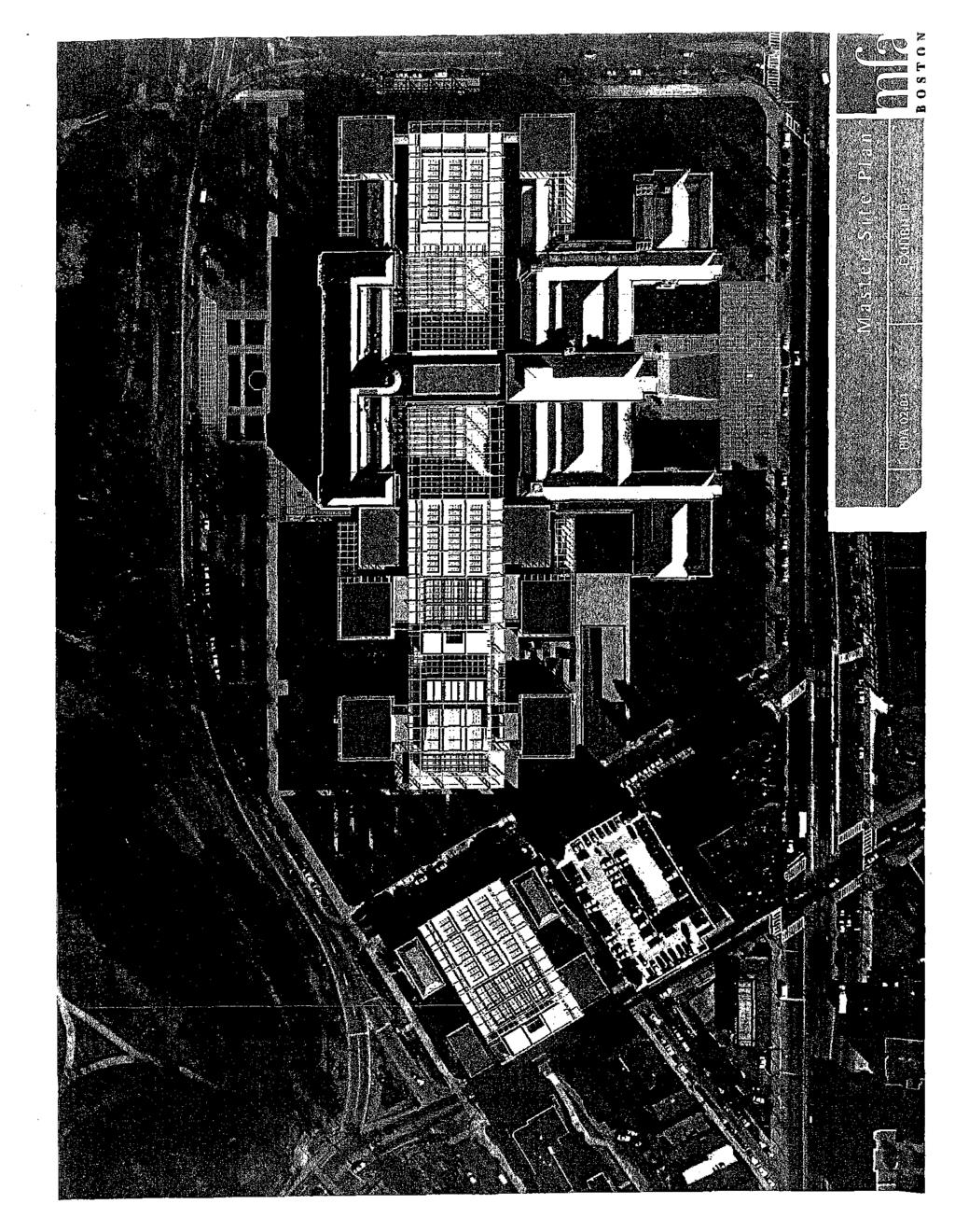
18 EXHIBITB [See attached plan] GSDOCS~ ~ 1 04/27/ :23 AM

19 -~ / ' r-----~ -- 1 / //1,--) ::Y//_-;;_~;_::>_--~. I \ :::=:::=:=:::-c::..:.::::::::c :::::::::"::;:~~;~=:~=-~~~ : / -- -/ 8 I { / / ~ :~ \ / /... \ '~ / //~'l 0 Q y I ~ "' ~ I I ~- ' /,. _..-" (J ld......::... - _,.,..- ~ ::.----""' --..::::::::::::::::::::-..::::.::~---- LYo~ [_!)&] ~.[n vll u.~-~~~h U 0 0 G I 6' % "tf ~ r -j I, J PDA Overlay District MFA Property Line Huntington Avenue o,. f!!_.---~ fl "0 [ < ~
20 EXHIBITC PROJECT TEAM Proponent: Design Architect: Architect: Landscape Architect: Museum of Fine Arts 465 Huntington Avenue Boston, MA (617) Malcolm Rogers, Ann and Graham Gund Director John Stanley, Deputy Director for Operations Sally K. O'Hare, Project Manager Foster and Partners, Ltd. Riverside Three 22 Hester Road London, SW11 4AN United Kingdom +44 (20) Lord Foster Spencer de Grey Michael Jones CBT/Childs Bertman Tseckares Inc Canal Street Boston, MA (617) Richard Bertman Christos Coios Chad Reilly Gustafson Guthrie Nichol Pier 55, Floor Alaskan Way Seattle, WA (206) Kathryn Gustafson Marcia West Rodrigo Abela -19- GSDOCS /27/ :23 AM
21 Legal Counsel: Environmental Consultant: Civil Engineer: Stormwater and Groundwater Consultant: Transportation Consultant: Goulston & Storrs, P.C. 400 Atlantic A venue Boston, MA (617) Matthew J. Kiefer Adam Hundley Epsilon Associates, Inc. 150 Main Street Maynard, MA (978) Cindy Schlessinger Will Donham Allen Johnson Judith Nitsch Engineering, Inc. 186 Lincoln Street, Suite 200 Boston, MA Contact: John Schmid Eggleston Environmental 55 Old Coach Road Sudbury, MA (978) Lisa Eggleston Howard/Stein-Hudson 38 Chauncy Street Boston, MA (617) Jane Howard Thomas Stokes Mechanical, Electrical and Plumbing Engineer: SEI Companies 88 Black Falcon Avenue, Suite 210 Boston, MA (617) Robert Gracilieri Peter DiPerna ~20- GSOOCS /27/200410:23AM
22 Structural Engineer: Construction Manager: Wind Consultant: Lighting Designer: Code Consultant: Acoustic Consultant: Weidlinger Associates, Inc. One Broadway, 11th Floor Cambridge, MA (617) AbdulHagh Peter Quigley George B.H. Macomber One Design Center Place Boston, MA ( 617) John Henderson DanLenyo Frank Durgin, PE 19 Payson Road Belmont, MA (617) George Sexton and Associates 2121 Wisconsin Avenue, NW Suite Washington, DC (202) George Sexton David Tozer Hughes Associates Inc. 2 Mount Royal A venue, Suite 420 Marlborough, MA (508) Eric Cote Acentech 33 Moulton Street Cambridge, MA Contact: Carl Rosenberg -21- GSDOCS /27/200410:23 AM
23 EXHIBITD See attached plans and materials -22- GSDOCS /27/200410:23AM

24

25 v / ~ --- a > $: "'..<:: ~ J? ~
![[[] 6 DJJ](/docs-images/86/94095077/images/26-0.jpg)
26 [[] 6 DJJ

27
28
29 \ \\ \ ' ' ' \ \
30 z 0... ' '._ =:.:j i : ~ u I.! -... I -~-)1,.!.' ;., l.-' p->.,. I -/' //_../_/.- ' /,...-- i i I I ' / I I
31
32 [].-_.,..._-_.,. " 'c '", ' (,-~ 1,L lr -1 ' ', ' '" I~ ''" ),, ( -'1~..:.- c, c' c, l!:.tlt><'i''''~== I. ",.,, ' ~ '''
33 tf = = jl " ~-JC-lL'c-',' '',, ',( ",, '' e, ' I,,~~L,L ''_::::H r- '.. -=..::r!l,, " '~,, " ",, ~i==::»=r:::::::::;: -.., 11 I, ' I I " 11.::::1"'~=lllil_:'l-' I J L------
34 EXHIBITS E 1 and E-2 See attached plans -23- GSDOCS /27/ :23 AM
 <> / - - ~~_,-' \.. \ -...--'if f ~ --~- -=---=---- -. --,, rc ) j,., ~,,,.,--- ~ _. _..\".1'\"\" ' 1'',...-~--- Ll -\:_} - _;.;...,, ' ' \.!:.---~-- ~ ~.")
35 '"." ;\ ()..>::::::~ \~,- } ~ /;( I -"~- ~--_...-. _ -~ (. (-'~ / t'~} '----'\..:J - -- 'J-- l. ~ - -._/ ~~/ n,"' -- :.- -_ -- \ '?F.---:.:: 0 - -~=:_--=:.c.:~~~~~!:~;:~: >>-~?~J :~\! ~~--- ' / ~(J' ---r<~ --~- - ~- '?, n:) <> / - - ~~_,-' \.. \ 'if f ~ --~- -=---= ,, rc ) j,., ~,,,.,--- ~ _. _..".1'"" ' 1'',...-~--- Ll -\:_} - _;.;...,, ' ' \.!:.---~-- ~ ~... "J/ ""~--!' "',.,- r4~~... '}:->"' ,.-~.,.--~-;;;;--= -;~ "7Y (.}..._ - - jl ==-,.._ J.->' <(,_/,...,; "\ P- ---r=<j' t,.,\ i- ~- T" C ;,.--;..-,- -~. -_/'\_,--,*-:;\:;_,, 0 /t-_:;_v_<;((_'-"if(j'';'~)(--:;~. :.lr0' \.~ -"'{-:"}...-[jg"f~ -, (J <'0: ~(:_;/_:.2v' :~': ~T-,.;::. ~~--- :.=--<1:; ~~tit ~:~----::~ n;,,';;': -.:.i-::. : ~. I ' 7 ' --,. V./: JV;, / \.:../ -}-,_._/ ') ' I L- ' ['.:-_-_._- --~~= /'-._ r.-.:.: ~\-~/< "'l. i ~ ~.LJ..~:."M ~"'~ f_...!;r-,;,,0~ Ac<,co;;_;;-~~--""'>- 'c/'<f ','..Ab;,;":~l '}-,' }1 1 ~~. 4:f' : p',''i;-::"'- ', - lj ---' --_-,~-... -_"'----:---; 2..._./ 0~~~./- "\, --y-l:""i'-4"'3-.j,.;..:,:_il (:''".:' )-~1-., / ----" -----=.:...--=-- ~----=-- ~! VA<~-~,. ~-- r r ~:,d 0 Refurbishment'"-=±; -":~ nfartnf. ~ ~ ~-~ -'-~ <~L..:.,.:_/ J~~)~~~ - SJ~~? ( -=- :-r... -~~~- D ' J / ~ /..c'~ _:'>, a o / //\ - ~ ~ Note: All existing trees in fenway are intended to remain -
.")
36 ' '. _; \' ----~"\ :J eo<(, V ~~-~:.: --~: '.~-~~== ::/~~- / 1/kst Expansion =~~~,: ~;;:0::??~~~g ::::,: -~. ---~.-~- ----_;~~~~~:~~~~~:~:~~';-=~~:-~:: ~=: ~ -~;~:--"--,;~"-~--~C~ ~:-~~i:~_:::; -~---.. _ D _, '-- - Q 0,-. / - -,., _j'--j\.:j' \. i\_:/(~'\~---_--,._.n~: ---,i'~.,_-,-:; r' "" Y'-- '., - ' ' _-"---_._-...--_---_ -_ /~ ~~ ~~:~~~~~~,~~~~~ v ----._). y/< ~--- ') /~---~';-;-- ~ Note:
37 EXHIBITF See attached plan -24- GSDOCS /27/ :23 AM
38 0 Stop Line G Crosswalk Double Yellow Center Line MUSEUMJfJ FINE ART~ ~ Parking Garage Huntington Street Not to Scale N A
39 MEMORANDUM APRIL 27, 2004 TO: FROM: SUBJECT: BOSTON REDEVELOPMENT AUTHORITY AND MARK MALONEY, DIRECTOR THOMAS MILLER, ACTING DIRECTOR OF ECONOMIC DEVELOPMENT JAY RUSSO, DEPUTY DIRECTOR FOR DEVELOPMENT REVIEW KEITH CRAIG, PROJECT MANAGER PUBLIC HEARING TO CONSIDER THE MUSEUM OF FINE ARTS PLANNED DEVELOPMENT AREA DEVELOPMENT PLAN AND DEVELOPMENT IMPACT PROJECT FOR THE MUSEUM OF FINE ARTS MASTER PLAN PROJECT SUMMARY: This memorandum requests that the Boston Redevelopment Authority ("BRA") approve the Museum of Fine Arts ("MFA") master plan project as a Development Impact Project within the meaning of Section 80B-7 of the Boston Zoning Code ("Code"), approve the Planned Development Area ("PDA") Development Plan, and authorize the Director to: (1) issue an Adequacy Determination pursuant to Section 80B-5.5(c) of the Code approving the Final Project Impact Report; (2) issue a Certification of Compliance, pursuant to Section 80B-6 of the Code, upon successful completion of Article 80 Large Project Review; (3) issue a Certification of Consistency, pursuant to Section 80C-8 of the Code, upon successful completion of Article 80 PDA Review; ( 4) and petition the Boston Zoning Commission to: (i) amend "Map 1, Boston Proper," in substantial accord with the map amendment presented to the BRA at its hearing on April27, 2004; (ii) approve the PDA Development Plan and establishment of a PDA in substantial accord with the PDA Development Plan presented to the BRA at its hearing on April27, 2004; and (iii) amend the Code with respect to Article 27Q, Fenway Interim Planning Overlay District, in substantial accord with the text amendment presented to the BRA at its hearing on April27, 2004; and (5) take all actions and execute all documents deemed necessary and appropriate by the Director in connection with the foregoing, including, without limitation, executing and delivering a Boston Residents Construction Employment Plan, a Development Impact Project Agreement, and a Cooperation Agreement. INTRODUCTION The MFA, located at 465 Huntington Avenue, includes approximately 533,500 square feet of floor area devoted to art galleries, exhibit space, an auditorium, restaurant and bar uses with entertainment, art storage, libraries, curatorial, conservation, and research facilities, offices for KC/MFA 4124/1
40 1\!F A staff, public relations uses and offices, educational studios, classrooms and study rooms, computer and technical support uses and offices, and related uses. The School of the MFA ("SMF A") includes approximately II 0,000 square feet of floor area devoted to classroom and idstructional space, studios, a library, galleries and exhibition space, an art supply store, an auditorium, seminar rooms, trade studios and classrooms, and related uses. The MFA proposes a multi-phase development project ("Proposed Project" or "Master Plan Project"). The Proposed Project includes renovation and expansion of the MFA and the SMFA, including new construction of up to 551,000 square feet of floor area. The Proposed Project also includes landscaping improvements, construction of an underground parking ( 410 parking spaces) and loading facility, and other site improvements. As mentioned above and described in more detail below, the Proposed Project is intended as a phased development. Anticipated work in each phase of the Proposed Project is summarized as follows: 1. PhaseOne Phase one ofthe Master Plan Project includes demolition of up to 72,500 square feet of existing space, rehabilitation and refurbishment of up to 85,000 square feet of existing space, and construction of up to 169,000 square feet of new space in the MFA, together with landscaping and other site improvements (collectively, "Phase One"). It is anticipated that Phase One will include the following: A new free-standing steel and glass enclosure will be constructed to sit within the East Courtyard of the MFA and extend as far as the sidewalk on Forsyth Way. This enclosure, known as the ')ewe! box", will be the first piece of the glazed "crystal spine" running the full length of the MFA (from east to west). This enclosure and the "crystal spine" will measure not more than 75 feet in height. A new East Wing with gallery, staff and educational space will be constructed at the east side of the MFA. The new East Wing will include an expansive central building within the "crystal spine" flanked by two smaller pavilions. The pavilions will measure not more than 70 feet in height. The entrance to the MFA on The Fenway will be re-opened. This re-opening will contribute to the reinstatement of the strong central axis at the heart of the MFA, which extends from the Huntington A venue entrance at the south to The Fen way entrance at the north. Various landscaping features will enhance the area around The Fenway entrance. Educational facilities in the MFA will be expanded. Galleries, courtyard areas, and administrative offices in the MFA will be refurbished, and building facilities will be upgraded to provide climate control for new and renovated space. Landscaping will be improved along Forsyth Way and in other areas around the site. Conservation and research studios and workshops in the MFA will be enhanced and enlarged. Retail shops and restaurant/cafe uses in the MFA will be enhanced and enlarged. 2. Subsequent Phases Subsequent phases of the Master Plan Project include demolition of up to 14,500 square feet of existing space, renovation and refurbishment of up to 535,000 square feet of existing space, and KG/MFA 4124/2
41 co~struction of up to 3S2,000 square feet of new space (collectively, "Subsequent Phases"). It is anlicipated that Subsequent Phases will include the following: A new freestanding steel and glass enclosure will be constructed to sit within the West Courtyard of the MFA, similar to the courtyard to be constructed within the East Courtyard as part of Phase One. This enclosed courtyard will complete the centralized circulation pattern of the MFA, provide additional space for special exhibition galleries, and establish a formal entrance to various galleries. Galleries, exhibition space, and wings of the MFA will be renovated and refurbished. A new underground parking and loading facility will be constructed on the south side of the site. The facility will include up to 41 0 parking spaces, and have entrance and exit ramps for passenger vehicles and delivery trucks from Museum Road. The Huntington A venue entrance to the MFA will be renovated. The White Wing and West Wing will be renovated and expanded to include a new wing on the west side of the MFA. It is envisioned that the new wing will include art galleries and exhibition space, as well as a new restaurant and restaurant terrace overlooking the Back Bay Fens. A new Study Center will be constructed on the west side of the MFA. The Study Center will support curatorial, library, conservation, research, and collection storage functions. The SMF A will be renovated and expanded, and landscaping will be improved around the SMFA. Landscaping will be extended and enhanced in various areas around the MFA, including the area where surface parking lots are currently located (such lots to be decommissioned after construction of the underground parking facility). PROJECT REVIEW The Proposed Project is undergoing Large Project Review pursuant to Article SOB ofthe Code. The MFA submitted a Project Notification Form ("PNF") to the BRA on July 15, On October 15,2001, the BRA issued a Scoping Determination outlining the issues to be studied in a Draft Project Impact Report ("DPIR"). In March 2002, the MFA submitted the DPIR to the BRA. The DPIR included analyses of transportation, enviromnental protection, urban design, historic resources, and infrastructure. In addition, the DPIR included responses to the comment letters received during the public comment period. On June 13, 2002, the BRA issued a Preliminary Adequacy Determination ("PAD") requesting further analysis in a Final Project Impact Report ("FPIR"). On June 16, 2003, the MFA submitted the FPIR to the BRA. The public comment period on the FPIR ended on September 23, The Master Plan Project is also undergoing PDA Review pursuant to Article SOC of the Code. The MFA submitted a PDA Development Plan to the BRA on February 23, The public comment period on the PDA Development Plan ended April S, The PDA Development Plan provides information on the Master Plan Project including the proposed location and appearance of structures, open spaces and landscaping, proposed uses for the area, densities, KG/MFA 4124/3
42 proposed traffic circulation, parking and loading facilities, access to public transportation, and proposed dimensions of structures. 'Ib.e Proposed Project has been presented and discussed at numerous public meetings and forums, vvhich included neighborhood groups and organizations, institutional abutters, elected officials, and the Fenway Planning Task Force. The Proposed Project has also received significant Impact Advisory Group ("lag") review and input. 'Ib.e Proposed Project comes within the jurisdiction, pursuant to Article 28 of the Code, of the Boston Civic Design Commission ("BCDC"), which approved the Proposed Project at its full commission meeting on March 4, B~sed upon the foregoing, the PNF, DPIR, and FPIR, together with the subsequent actions and submissions by the MFA, adequately result in the satisfactory identification, analysis, and mitigation of expected impacts of the Proposed Project. EAST FENWAY NEIGHBORHOOD STRATEGIC PLAN The BRA, working with the Fenway Planning Task Force, has recently completed a planning review of the Fenway area, cuhninating in a report entitled "East Fenway Neighborhood Strategic Plan" ("Plan"). The Plan recommends permanent rezoning for the Fenway area. A draft of the rezoning was issued in October The draft designates the MFA site as a Cultural Facilities Subdistrict in which PDAs are permitted. In addition to being consistent with the draft rezoning, the Master Plan Project is also consistent with the intents of the various goals and objectives of the Plan, including the goals and objectives of appropriate land use, strengthening institutions and the economy, increasing housing opportunities, improving transportation, and ensuring quality urban design. Since East Fenway rezoning is not yet complete, the current Article 27Q, Fenway Interim Planning Overlay District, prohibition on PDA' s will be lifted on the Proposed Project site. PUBLIC BENEFITS In addition to continuing and expanding the numerous commitments, as outlined in the DPIR and FPIR, that the MFA has in educational and community programming, the Proposed Project will bring many benefits to the city of Boston. The MFA, pursuant to Article 80B-7 of the Code, will be responsible for development impact project exactions of approximately $3.2 million to the Neighborhood Housing Trust, based on $7.18 per square foot of gross floor area in excess of one hundred thousand square feet, and approximately $650,000 to the Neighborhood Jobs Trust, based on $1.44 per square foot of gross floor area in excess of one hundred thousand square feet. Construction of the Proposed Project will contribute to the local economy by providing approximately 2,200 construction-related jobs during the course of the Proposed Project's multiphase construction period and will provide 70 permanent jobs in the curatorial and conservation, visitor services, and community outreach departments. In an effort to continue to strengthen the MFA's community relations, the MFA will hire a full-time public outreach director. To further the MF A's community outreach efforts, the MFA has committed $25,000 to each of the KCIMFA 4124/4
43 :f~llowing connnunity resources: the Fenway Community Health Center At-Risk Youth Program, t"le Friends of Puddingstone Park, and the Justine LiffEndowment Fund. In addition to these direct financial benefits, the Proposed Project will: strengthen and expand current arts programming to Boston residents and schools; restore the MFA to its original plan by architect Guy Lowell; implement several green building design elements; increase and enhance landscaping features in and around the MFA site, including, but not limited to, sidewalk improvements, streetscape plantings, and lighting improvements; develop a signage program to aid wayfinding to/from Ruggles Station; convene a design charette for Forsyth Way improvements; and implement additional transportation demand management measures, including increasing the employee transit pass subsidy from 25% to 35% and contributing $20,000 to a Fenway area transportation management association fund. CONCLUSION It is recommended that the BRA approve the MFA Master Plan Project as a Development Impact Project within the meaning of Section 80B-7 of the Code, approve the PDA Development Plan, and authorize the Director to: (1) issue an Adequacy Determination pursuant to Section 80B- 5.5(c) of the Code approving the FPIR; (2) issue a Certification of Compliance, pursuant to Section 80B-6 of the Code, upon successful completion of Article 80 Large Project Review; (3) issue a Certification of Consistency, pursuant to Section 80C-8 of the Code, upon successful completion of Article 80 PDA Review; (4) and petition the Boston Zoning Commission to: (i) amend "Map 1, Boston Proper," in substantial accord with the map amendment presented to the BRA at its hearing on April27, 2004; (ii) approve the PDA Development Plan and establishment of a PDA in substantial accord with the PDA Development Plan presented to the BRA at its hearing on April 27, 2004; and (iii) amend the Code with respect to Article 27Q, Fenway Interim Plarming Overlay District, in substantial accord with the text amendment presented to the BRA at its hearing on April27, 2004; and (5) take all actions and execute all documents deemed necessary and appropriate by the Director in connection with the foregoing, including, without limitation, executing and delivering a Boston Residents Construction Employment Plan, a Development Impact Project Agreement, and a Cooperation Agreement. Appropriate votes follow: VOTED: That the Boston Redevelopment Authority ("BRA") hereby finds and determines that the proposed Museum of Fine Arts ("MFA") master plan project ("Proposed Project"), as described in the Draft Project Impact Report ("DPIR") and the Final Project Impact Report ("FPIR"), along with the subsequent actions and submissions by the MFA, conforms to the general plan for the City of Boston as a whole, and that nothing in such Proposed Project will be injurious to the neighborhood or otherwise detrimental to the public welfare; and further VOTED: That the Director be, and hereby is, authorized to issue an Adequacy Determination, pursuant to Section 80B-5.5(c) of the Boston Zoning Code ("Code"), approving the Proposed Project, subject to BRA design review, and KC/MFA 4124/5
44 finds that the actions and submissions by the MFA are sufficient and adequately result in the identification, analysis and mitigation of expected impacts of the Proposed Project; and further VOTED: That the Director be, and hereby is, authorized to execute a Development Impact Project Agreement for the Proposed Project in accordance with Article 80, Section 80B-7 of the Code; and further VOTED: That the Director be, and hereby is, authorized to issue a Certification of Compliance for the Proposed Project pursuant to Section 80B-6 of the Code after the Director has determined that the Proposed Project complies with (a) the conditions of the Adequacy Determination, and (b) to the extent applicable, the following provisions of the Code: (i) Section SOB-7: Development Impact Project Exactions; (ii) Section 80B-8: Disclosure of Beneficial Interests; (iii) Section 80C-8: Planned Development Area Review: Certifications; and (iv) Article 28: Boston Civic Design Commission; and further VOTED: That, in connection with the Planned Development Area ("PDA") Development Plan ("Development Plan") presented at a public hearing duly held at the offices of the BRA on April27, 2004, and after consideration of evidence presented at, and in connection with, the hearing and in connection with the Proposed Project described in the Development Plan, the BRA finds, with respect to the Development Plan, that (a) the Development Plan, when approved by the Zoning Commission, will not be for a location or proposed project for which PDAs are forbidden by the underlying zoning; (b) the Proposed Project complies with any provisions of the underlying zoning that establish use, dimensional, design, or other requirements for Proposed Projects in PDAs; (c) the Development Plan complies with any provisions of the underlying zoning that establish planning and development criteria, including public benefits, for PDAs; (d) the Development Plan conforms to the plan for the district, subdistrict, or similar geographic area in which the PDA is located, and to the general plan for the city as a whole; (e) on balance, nothing in the Development Plan will be injurious to the neighborhood or otherwise detrimental to the public welfare, weighing all the benefits and burdens; and (f) the Development Plan adequately and sufficiently satisfies all other development plan criteria and specifications for a PDA as set forth in the Code; and further VOTED: That, pursuant to the provisions of Section 3-1A.a and Article SOC of the Code, the BRA hereby approves the Development Plan and authorizes the Director to petition the Boston Zoning Commission to: (1) approve the Development Plan; (2) amend "Map 1, Boston Proper,"; and (3) amend the Code with respect to Article 27Q, Fen way Interim Planning Overlay District, all in substantial accord with the map and text amendments presented to the BRA at its hearing on April27, 2004; and further KG/MFA 4124/6
45 VOTED: That the Director be, and hereby is, authorized to issue a Certification of Consistency for PDA Review when the Director finds that: (a) the Proposed Project is described adequately in a Development Plan applicable to the Proposed Project's location; (b) the Proposed Project is consistent with the Development Plan; and (c) the Development Plan has been approved by the BRA and the Boston Zoning Commission in accordance with the applicable provisions of Section 3-IA.a and Article 80C, PDA Review; and further VOTED: That the Director be, and hereby is, authorized to execute and deliver any and all documents deemed necessary and appropriate by the Director in connection with the Proposed Project, including, without limitation, a Boston Residents Construction Employment Plan, and a Cooperation Agreement. KG/MFA 4124/7
46 Exhibit A Site Plan KG/MFA
47 Map Amendment Application No. 496 Planned Development Area No. 63 Museum of Fine Arts Boston Redevelopment Authority on behalf of the Museum of Fine Arts Maps 1, Boston Proper TO THE ZONING COMMISSION OF THE CITY OF BOSTON: The Boston Redevelopment Authority, acting under Section 3-1A of the Boston Zoning Code, hereby petitions the Zoning Commission to approve the Development Plan for Planned Development Area No. 63 with due consideration of the findings of the Boston Redevelopment Authority adopted on April 27, 2004, and to amend "Map 1, Boston Proper," of the series of maps entitled "Zoning Districts City of Boston," dated August 15, 1962, as amended, as follows: 1. By adding the designation "D", indicating a Planned Development Area overlay district, to an area in the Fenway section of Boston measuring approximately acres in area and bounded generally by Evans Way and the southern boundary of land of the Boston Parks Department to the north; Forsyth Way to the east; Huntington Avenue, Museum Road and the southern boundary of land of the Museum of Fine Arts to the south; and Louis Prang Street to the west. Said area is more particularly described in Appendix A attached hereto and is further shown on Appendix B attached hereto. Petitioner: By: Address: Boston Redevelopment Authority Mark Maloney, Director City Hall/9 1 h Floor Boston. MA Tel. No.: Date: (617) , ext as authorized by the BRA Board on April 27, 2004.
48 ,. Exhibit A Property Description A parcel of land with buildings thereon located in Boston, County of Suffolk, Commonwealth of Massachusetts, described as follows: Beginning at the most westerly intersection of Huntington Avenue and Forsyth Way, thence; S 61 36'23" W, feet, along the northwesterly sideline of Huntington Avenue to Museum Road, thence; N 59 28'37" W, feet, along the northeasterly sideline of Museum Road, to a point, thence; S 30 31'23" W, feet, partially through Museum Road, to a point, thence; N 59 28'37" W, feet, to a point, thence; S 30 31'23" W,21.00feet, to a point, thence; S 59 28'37" E, 7.63 feet, to a point, thence; S 30 31'23" W, feet, to the northeasterly sideline of Louis Prang Street, thence; N 59 28'37" W, feet, along the northeasterly sideline of Louis Prang Street, to a point, thence; Along a curve to the right with a radius of feet and a length of feet to a point, thence; N '23" E, feet, through Museum Road, to a point, thence; Along a curve to the right with a radius of feet and a length of feet to a point, thence; GSDOCS
49 N 61 36'23" E, feet, to a curve along Forsyth Way, thence; Along a curve to the right with a radius of20.00 feet and a length of feet to a point, thence; S 28 23'37" E, feet, along the southwesterly sideline of Forsyth Way to the point of beginning. Containing 617,276 square feet± acres GSDOCS~
50 EXHIBITB See attached plan showing the PDA Overlay District boundaries GSDOCS

51 Forsych Way r-r i! I I I, /I I I I!' I!I. 1 /!!i II ll I' I' " II I I " f ' o I H I I o 1 o I , :::;::::I ::::::_:::::::::~:::::::::: :::::::; I :::: :":::::::: ::::::: :..,-- \ \ ' , ' ', ~ ' "\ ' J ( ' (.... ' --., I. i. l
Museum of Fine Arts, Boston unveils Design Concepts of Master Site Plan
 Press release 14 February 2002 Museum of Fine Arts, Boston unveils Design Concepts of Master Site Plan Today, the Museum of Fine Arts, Boston unveiled the architectural designs of its comprehensive Master
Hudson Group North America LLC
 Hudson Group North America LLC Mr. John Palmieri, Director Boston Redevelopment Authority One City Hall Square Boston, MA 02201 August 30, 2010 RE: 120 Kingston Street Development, Notice of Project Change
AMENDED AND RESTATED DEVELOPMENT PLAN FOR THE SPORTS FACILITY PROJECT WITHIN PLANNED DEVELOPMENT AREA NO. 87 BOSTON LANDING
 AMENDED AND RESTATED DEVELOPMENT PLAN FOR THE SPORTS FACILITY PROJECT WITHIN PLANNED DEVELOPMENT AREA NO. 87 BOSTON LANDING GUEST STREET, LIFE STREET AND ARTHUR STREET BRIGHTON AREA OF BOSTON DATED: August
Community Task Force Meeting June 19, Planned Development 500 Huntington WENTWORTH INSTITUTE OF TECHNOLOGY
 Community Task Force Meeting June 19, 2013 Planned Development Area @ 500 Huntington WENTWORTH INSTITUTE OF TECHNOLOGY Meeting Agenda INTRODUCTIONS WENTWORTH 2010 2020 IMP PROJECT APPROVAL PROCESS oplanned
Institutional Master Plan The Arnold Arboretum of Harvard University
 Institutional Master Plan The Arnold Arboretum of Harvard University Submitted to: Boston Redevelopment Authority One City Hall Square Boston, MA 02201 Submitted by: The Arnold Arboretum of Harvard University
Mill Conversion Overlay District Zoning Bylaw Amendment
 Mill Conversion Overlay District Zoning Bylaw Amendment To see if the Town will vote to amend the Zoning By-Law by adding a new Section 13, Mill Conversion Overlay District, and by amending Sections 2.1,
CHARLES PUTMAN CHARLES PUTMAN AND ASSOCIATES, INC
 MEMORANDUM CHARLES PUTMAN & ASSOCIATES, INC. LAND DEVELOPMENT CONSULTANTS PLANNING ZONING PERMITTING 4722 NW Boca Raton Boulevard, Suite C-106 Boca Raton, Florida 33431 Phone: 561/994-6411 FAX: 561/994-0447
Policies and Code Intent Sections Related to Town Center
 Policies and Code Intent Sections Related to Town Center The Town Center Vision is scattered throughout the Comprehensive Plan, development code and the 1994 Town Center Plan. What follows are sections
THE GEORGE WASHINGTON UNIVERSITY MOUNT VERNON CAMPUS
 THE GEORGE WASHINGTON UNIVERSITY MOUNT VERNON CAMPUS CAMPUS PLAN AMENDMENT AND FURTHER PROCESSING APPLICATION: PRE-HEARING SUBMISSION PELHAM REPLACEMENT PROJECT FILED WITH THE ZONING COMMISSION OF THE
The subject site plan amendment proposes the following revisions to the approved site plan:
 PROPOSED AMENDMENT The subject site plan amendment proposes the following revisions to the approved site plan: 1. The building footprint was modified to accommodate the revised architectural design. 2.
Institutional Overlay Zone (IOZ) Regulatory Framework
 Regulatory Framework") Institutional Overlay Zone (IOZ) Regulatory Framework Approved by Portland City Council November 20, 2017 APPLICABILITY All development proposed by Maine Medical Center (MMC) within the boundary of the
Institutional Overlay Zone (IOZ) Regulatory Framework Approved by Portland City Council November 20, 2017 APPLICABILITY All development proposed by Maine Medical Center (MMC) within the boundary of the
SUBJECT: PREDEVELOPMENT PLAN REVIEW OF PROJECT LOCATED AT E. COLORADO BOULEVARD (PASEO COLORADO)
") TO: FROM: Honorable Mayor and City Council Planning & Community Development Department SUBJECT: PREDEVELOPMENT PLAN REVIEW OF PROJECT LOCATED AT 260-400 E. COLORADO BOULEVARD (PASEO COLORADO) RECOMMENDATION:
TO: FROM: Honorable Mayor and City Council Planning & Community Development Department SUBJECT: PREDEVELOPMENT PLAN REVIEW OF PROJECT LOCATED AT 260-400 E. COLORADO BOULEVARD (PASEO COLORADO) RECOMMENDATION:
STAFF REPORT TO COUNCIL PLANNING AND DEVELOPMENT
 DATE: April 29, 2013 STAFF REPORT TO COUNCIL PLANNING AND DEVELOPMENT 1100 Patricia Boulevard, Prince George, B.C., V2L 3V9 TO: FROM: SUBJECT: MAYOR AND COUNCIL JESSE DILL, PLANNER Development Variance
MIXED-USE VILLAGE OVERLAY FLOATING DISTRICT
 MIXED-USE VILLAGE OVERLAY FLOATING DISTRICT Zoning regulations developed by committee to the Planning Board for the Town of DeWitt, NY Issue date: 13 July 2017 revised 3/12/2018, revised 4/26/2018, 5/9/2018
COUNTY COUNCIL OF PRINCE GEORGE'S COUNTY, MARYLAND, SITTING AS THE DISTRICT COUNCIL ORDER AFFIRMING PLANNING BOARD DECISION, WITH AMENDED CONDITIONS
 Case No. Applicant: Dawn Limited Partnership COUNTY COUNCIL OF PRINCE GEORGE'S COUNTY, MARYLAND, SITTING AS THE DISTRICT COUNCIL ORDER AFFIRMING PLANNING BOARD DECISION, WITH AMENDED CONDITIONS IT IS HEREBY
Land Use Amendment in Southwood (Ward 11) at and Elbow Drive SW, LOC
 at and Elbow Drive SW, LOC") 2018 November 15 Page 1 of 10 EXECUTIVE SUMMARY This land use amendment application was submitted by Rick Balbi Architect on 2017 August 31 on behalf of Sable Developments Ltd, and with authorization from
2018 November 15 Page 1 of 10 EXECUTIVE SUMMARY This land use amendment application was submitted by Rick Balbi Architect on 2017 August 31 on behalf of Sable Developments Ltd, and with authorization from
WHEREAS, after consideration of the evidence presented at the public hearing on January 14, 2010, the Prince George's County Planning Board finds:
 R E S O L U T I O N WHEREAS, the Prince George s County Planning Board has reviewed DDS-600 requesting a departure for the location of two loading spaces without driveway access along Toledo Terrace in
City of Farmington. Downtown Plan. Amendment to the 1998 Master Plan Adopted October 11, 2004
 City of Farmington Amendment to the 1998 Master Plan Adopted October 11, 2004 Introduction Planning Background 1 Scope and Components of the Plan Amendment 2 Concept Introduction 3 Plan Concepts 3 Conceptual
Residential Commons at Barry s Corner. Boston civic design commission February 5, 2013
 Residential Commons at Barry s Corner Boston civic design commission February 5, 2013 TABLE OF CONTENTS project summary 3 PROJECT site 4 PLANNING APPROACh 6 Parcel Diagams 6 Design Principles 8 Street
CRYSTAL CITY BLOCK PLAN # CCBP- G 1 DRAFT
 CRYSTAL CITY BLOCK PLAN # CCBP- G 1 DRAFT BLOCK G (Metro Market Square block) Long Range Planning Committee Meeting January 29, 2018 1 1. Introduction 2 1. LRPC Meeting Purpose Review of proposed Crystal
PLAN ELEMENTS WORKSHOP. April 5, 2016
 PLAN ELEMENTS WORKSHOP April 5, 2016 needs more housing. But there is no one-size fits-all solution. Every neighborhood has its own character. In some places, density is not only appropriate it is badly
Allston Brighton Boston College Task Force Meeting. Brighton Marine Health Center March 27, 2013
 Allston Brighton Boston College Task Force Meeting Brighton Marine Health Center March 27, 2013 Presentation Overview 6:30-6:35 Introductions & Announcements 6:35-6:40 Overall Project and Review Schedule
Executive Summary General Plan Amendment Initiation
 Executive Summary General Plan Amendment Initiation HEARING DATE: AUGUST 6, 2015 Date: July 30, 2015 Case No.: 2011.0409PCA Project Address: 925 Mission Street and various parcels (aka 5M ) Existing Zoning:
Mark-up of the effect of the proposed Bronte Village Growth Area OPA No.18 on the text of section 24, Bronte Village, of the Livable Oakville Plan
 Mark-up of the effect of the proposed Bronte Village Growth Area OPA No.18 on the text of section 24, Bronte Village, of the Livable Oakville Plan Notes: This document is provided for information purposes
Table of Contents. Elm Avenue Improvement Plan City of Waco, Texas. Introduction 1. Existing Context 1 Figure 1 2.
 Table of Contents Introduction 1 Existing Context 1 Figure 1 2 Plan Guidelines 3 Future Urban Form 4 The West-End 4 Main Street 6 The East-End 7 Figure 2 9 Public Improvement Recommendations 7 General
CHAPTER 12 IMPLEMENTATION
 CHAPTER 12 IMPLEMENTATION The 2010 Town of Denton Comprehensive Plan is intended to capture a vision of the future of Denton. As such, it provides a basis for a wide variety of public and private actions
SUBJECT: PREDEVELOPMENT PLAN REVIEW OF PROJECT LOCATED AT 2632 EAST WASHINGTON BOULEVARD ('ST. LUKE MEDICAL CENTER')
") TO: FROM: Honorable Mayor and City Council Planning & Community Development Department SUBJECT: PREDEVELOPMENT PLAN REVIEW OF PROJECT LOCATED AT 2632 EAST WASHINGTON BOULEVARD ('ST. LUKE MEDICAL CENTER')
TO: FROM: Honorable Mayor and City Council Planning & Community Development Department SUBJECT: PREDEVELOPMENT PLAN REVIEW OF PROJECT LOCATED AT 2632 EAST WASHINGTON BOULEVARD ('ST. LUKE MEDICAL CENTER')
GREENFORD HALL & ADJOINING LAND
 GREENFORD HALL & ADJOINING LAND CONTENTS 1. Introduction 1. Introduction 2. Urban Context 2.1 The Site and Surroundings 2.2 Urban Context Map 2.3 Access and Movement 3. Planning Context 3.1 Planning History
Stuart Street Planning Study Development Review Guidelines to supplement Back Bay Downtown IPOD (1987) October 15, Preface
 October 15, Preface") Stuart Street Planning Study Development Review Guidelines to supplement Back Bay Downtown IPOD (1987) October 15, 2015 Preface Background The Stuart Street Planning Study area, bound by St. James Avenue
Stuart Street Planning Study Development Review Guidelines to supplement Back Bay Downtown IPOD (1987) October 15, 2015 Preface Background The Stuart Street Planning Study area, bound by St. James Avenue
Town Center. Block 5 Existing multifamily residential units are expected to remain.
 Area Guidelines Germantown s districts should be developed as distinct communities with unique features that are supported through the guidelines. The guidelines not only help distinguish these districts
LANGAN LANDSCAPE ARCHITECTURE + PLANNING FOR COLLEGES & UNIVERSITIES
 LANGAN LANDSCAPE ARCHITECTURE + PLANNING FOR COLLEGES & UNIVERSITIES CONTACT Philadelphia Pennsylvania 1818 Market Street Suite 3300 Philadelphia PA 19103 215.845.8900 215.845.8901 ST. JOSEPH'S UNIVERSITY
RESIDENTIAL DISTRICTS
 RESIDENTIAL DISTRICTS The residential district standards have been revised to reflect on-the-ground conditions, while continuing to respect the use patterns established within the neighborhoods. This will
17.11 Establishment of Land Use Districts
 17.11 Establishment of Land Use Districts 17.11.010 Purpose. To promote the health, safety, and general welfare of City residents and those who come to South Salt Lake to work, exchange commerce and recreate.
Planning Districts INTRODUCTION
 INTRODUCTION To facilitate detailed examination of development prospects for all areas of the community, Delano has been divided into 14 planning districts. The location of these planning districts is
A. INTRODUCTION B. PROJECT LOCATION
 Chapter 1: Project Description A. INTRODUCTION The Lower Manhattan Development Corporation (LMDC), a subsidiary of the New York State Urban Development Corporation, doing business as the Empire State Development
PLANNING REPORT CITY OF EAGAN. APPLICANT: Cedar Grove Hospitality, LLC HEARING DATE: December 18, 2014
 PLANNING REPORT CITY OF EAGAN REPORT DATE: December 8, 2014 CASE: 19-PA-11-11-14 APPLICANT: Cedar Grove Hospitality, LLC HEARING DATE: PROPERTY OWNER: The Flats at Cedar APPLICATION DATE: Nov. 21, 2014
[PLANNING RATIONALE] For Site Plan Control and Lifting of Holding Zone By-Law 101 Champagne Avenue. May 23, 2014
![[PLANNING RATIONALE] For Site Plan Control and Lifting of Holding Zone By-Law 101 Champagne Avenue. May 23, 2014](/thumbs/75/71599615.jpg "[PLANNING RATIONALE] For Site Plan Control and Lifting of Holding Zone By-Law 101 Champagne Avenue. May 23, 2014") [PLANNING RATIONALE] For Site Plan Control and Lifting of Holding Zone By-Law 101 Champagne Avenue May 23, 2014 Contents 1.0 Introduction... 2 2.0 Site Context... 2 2.1 Adjacent Uses... 2 Figure 1: Site
[PLANNING RATIONALE] For Site Plan Control and Lifting of Holding Zone By-Law 101 Champagne Avenue May 23, 2014 Contents 1.0 Introduction... 2 2.0 Site Context... 2 2.1 Adjacent Uses... 2 Figure 1: Site
The University District envisions, in its neighborhood
 Envisioning the University District Link Light Rail in Seattle s neighborhoods CIY OF SEALE CONCEP-LEVEL SAION AREA PLANNING RECOMMENDAION RESOLUION # 30165 EXHIBI L Vision 08.2000 he University District
PUBLIC HEARING. DRAFT Environmental Impact Statement. Matthews Memorial Baptist Church Washington, DC October 18, National Capital Region
 National Capital Region DRAFT Environmental Impact Statement PUBLIC HEARING Matthews Memorial Baptist Church Washington, DC October 18, 2007 Introduction Welcome and team introduction Hearing procedures
Gas Works Site Land-Use Study
 City of New Westminster Background Context 2 Neighbourhood Context 3 Program Elements 4 Proposed Site Planning Approach 5 Design Rationale 10 Design Elements 11 Phasing 21 C o n t e n t s b a c k g r o
AMENDED AND RESTATED DEVELOPMENT PLAN For PLANNED DEVELOPMENT AREA NO. 78. SEAPORT SQUARE PROJECT South Boston. Dated: November 16, 2017
 AMENDED AND RESTATED DEVELOPMENT PLAN For PLANNED DEVELOPMENT AREA NO. 78 SEAPORT SQUARE PROJECT South Boston Dated: November 16, 2017 I. Development Plan In accordance with Sections 3-1A and 80C-3 of
8 October 14, 2015 Public Hearing
 8 October 14, 2015 Public Hearing APPLICANT & PROPERTY OWNER: PRICE S HOLDINGS, LLC STAFF PLANNER: Karen Lasley REQUEST: A. Conditional Use Permit (Automobile Repair Garage) B. Change in Nonconforming
SUBJECT: ZONE CHANGE TO DESIGNATE A LANDMARK DISTRICT OVERLAY FOR THE CRAWFORDS VISTA LANDMARK DISTRICT
 Report TO: FROM: CITY COUNCIL CITY MANAGER DATE: FEBRUARY 7,2005 SUBJECT: ZONE CHANGE TO DESIGNATE A LANDMARK DISTRICT OVERLAY FOR THE CRAWFORDS VISTA LANDMARK DISTRICT RECOMMENDATION It is recommended
12 January 12, 2011 Public Hearing APPLICANT: TAILWIND DEVELOPMENT GROUP,LLC PROPERTY OWNER: CITY OF VIRGINIA BEACH
 12 January 12, 2011 Public Hearing APPLICANT: TAILWIND DEVELOPMENT GROUP,LLC PROPERTY OWNER: CITY OF VIRGINIA BEACH STAFF PLANNER: Faith Christie REQUEST: Conditional Change of Zoning (from PD-H1 Planned
Welcome. Walk Around. Talk to Us. Write Down Your Comments
 Welcome This is an information meeting introducing the applications for proposed redevelopment of the Yorkdale Shopping Centre site at 3401 Dufferin Street and 1 Yorkdale Road over the next 20+ years,
RESOLUTION NO. R Refining the route, profile and stations for the Downtown Redmond Link Extension
 RESOLUTION NO. R2018-32 Refining the route, profile and stations for the Downtown Redmond Link Extension MEETING: DATE: TYPE OF ACTION: STAFF CONTACT: Capital Committee Board PROPOSED ACTION 09/13/2018
TOWN COUNCIL / PLANNING COMMISSION
 Workshop #3 TOWN COUNCIL / PLANNING COMMISSION January 20, 2011 Consultant Team In Attendance Tonight BMS Design Group Nevada City and San Francisco Michael Smiley, AICP, ASLA Partner-in-Charge Nancy L.
September 25th, 2018 $2000 fee pd CC
 2.7267 acres 2018I-00075 September 25th, 2018 $2000 fee pd CC Rezoning Review Criteria Analysis - Map Amendment Application Number: 2018I-00075 805 W. 38 th Avenue October 19, 2018 (amd.) September 17,
The underlying goals of the study and resultant zoning recommendations are to:
 Stuart Street Planning Study Advisory Group Proposed Zoning Recommendations to replace Back Bay Downtown IPOD (1987) DRAFT OCT 20, 2009 Preface Background The Stuart Street Planning Study area, bound by
Developer s Program. The Station at East 54
 Developer s Program The Station at East 54 Existing Conditions The Station at East 54 is proposed for a 1.12 acre site at the northeast corner of Hamilton Road and Prestwick Road, tucked between the East
3. Project Description
 3.1 PROJECT LOCATION The Platinum Triangle (herein after also referred to as the Project Area ) is located at the confluence of the Interstate 5 (I-5 Freeway) and the State Route 57 (SR-57 Freeway), in
Rezoning Petition Zoning Committee Recommendation August 1, 2017
 Rezoning Petition 2017-090 Zoning Committee Recommendation August 1, 2017 REQUEST LOCATION SUMMARY OF PETITION PROPERTY OWNER PETITIONER AGENT/REPRESENTATIVE COMMUNITY MEETING STATEMENT OF CONSISTENCY
FUTURE LAND USE ELEMENT
 FUTURE LAND USE ELEMENT GOAL I: To create and sustain a great place to live, play, and prosper Objective 1: The City of Ocala shall incorporate the principles and strategies of the Ocala 2035 Vision into
EMERYVILLE PLANNING COMMISSION STAFF REPORT
 EMERYVILLE PLANNING COMMISSION STAFF REPORT Agenda Date: Report Date: April 19, 2012 TO: FROM: SUBJECT: Planning Commission Planning and Building Department Miroo Desai, Senior Planner (ECCL) (UPDR12-001)
ARTICLE IX SPECIAL PERMIT USES
 ARTICLE IX SPECIAL PERMIT USES All special permit uses cited in Article IX and Attachment A of this Ordinance or any other Section of this Ordinance shall be subject to Site Plan Review. The procedures
St. Kevin s Area Planning Collaborative
 Table of Contents page 2 EXECUTIVE SUMMARY 3 MISSION STATEMENT 4 NEIGHBORHOOD CONTEXT 6 STREET CHARACTER 7 SITE PARAMETERS 9 COMMUNITY CHARRETTE - VISIONING GROUP TABLE 1 11 GROUP TABLE 2 12 GROUP TABLE
City Council Special Meeting AGENDA ITEM NO. C.
 City Council Special Meeting AGENDA ITEM NO. C. DATE: 01/04/2019 TO: Honorable Mayor and City Council Members SUBJECT: Transit Villages Specific Plan project Study Session (Development Services Director
Planning Commission Staff Report June 5, 2008
 Owner/Applicant Taylor Village Sacramento Investments Partners, LP c/o Kim Whitney 1792 Tribute Road #270 Sacramento, CA 95815 Staff Recommendation Planning Commission Staff Report Project: File: Request:
4.0 Future Land Use Element
 4.0 The Florida Agricultural and Mechanical University (FAMU) represents existing and proposed development patterns within the campus boundaries to be coordinated and not conflict with the adjacent areas
Technical Appendix L, University Community Plan Town Center
 Technical Appendix L, University Community Plan Town Center Table of Contents L.1 Executive Summary L.2 Merced County University Community Plan, 2004 Findings L.2.1 Visioning L.2.2 UCP Goals, Objectives
1617TREMONT.COM REDEVELOPMENT OPPORTUNITY LONGWOOD MEDICAL AREA // MISSION HILL BOSTON, MASSACHUSETTS DOWNTOWN BOSTON SEAPORT BACK BAY SOUTH END
 REDEVELOPMENT OPPORTUNITY LONGWOOD MEDICAL AREA // MISSION HILL BOSTON, MASSACHUSETTS DOWNTOWN BOSTON SEAPORT BACK BAY SOUTH END FENWAY LONGWOOD MEDICAL AREA 1617TREMONT.COM EXECUTIVE SUMMARY Boston Realty
LAND USE AMENDMENT DOWNTOWN COMMERCIAL CORE (WARD 7) MACLEOD TRAIL SE AND 5 AVENUE SE BYLAW 254D2017
 MACLEOD TRAIL SE AND 5 AVENUE SE BYLAW 254D2017") Page 1 of 10 EXECUTIVE SUMMARY This Land Use Amendment application seeks to redesignate a full downtown block (currently the YWCA site) from a Direct Control based on the CM-2 District (Land Use Bylaw
Page 1 of 10 EXECUTIVE SUMMARY This Land Use Amendment application seeks to redesignate a full downtown block (currently the YWCA site) from a Direct Control based on the CM-2 District (Land Use Bylaw
The Corporation of the TOWN OF MILTON
 Report to: From: Chair & Members of the Administration & Planning Standing Committee W.F. Mann, Director of Planning and Development Date: April 16, 2012 PD 022-12 (Z19/11) Subject: Technical Report Proposed
A Vibrant Downtown. Chapter 5 Cary Public Art Opportunities 31
 A Vibrant Downtown Cary s vision for Downtown is a unique, vibrant, dynamic, pedestrian friendly location; a regional destination and a place to live, work, and recreate, according to the 2001 Town Center
ELECTION DISTRICT: PRINCESS ANNE
 D3 April 10, 2013 Public Hearing APPLICANT: HOLLOMON- BROWN FUNERAL HOME, INC. PROPERTY OWNER: HOLLOMON- BROWN FUNERAL HOME, INC. & TIDEWATER CEMETERY CORP. STAFF PLANNER: Karen Prochilo REQUEST: Conditional
Chapter Master Planned Communities (MPC) District
 District") Sections 14.53.010 Purpose and Intent 14.53.020 Applicability 14.53.030 Procedure 14.53.040 MPC Standards 14.53.050 Required Findings 14.53.010 Purpose and Intent Chapter 14.53 Master Planned Communities
Sections 14.53.010 Purpose and Intent 14.53.020 Applicability 14.53.030 Procedure 14.53.040 MPC Standards 14.53.050 Required Findings 14.53.010 Purpose and Intent Chapter 14.53 Master Planned Communities
Bloor St. W. Rezoning - Preliminary Report
 STAFF REPORT ACTION REQUIRED 1638-1644 Bloor St. W. Rezoning - Preliminary Report Date: April 1, 2008 To: From: Wards: Reference Number: Toronto and East York Community Council Acting Director, Community
PROPOSED DEVELOPMENT CONCEPTS
 MEMORANDUM To Planning and Zoning Commission From Sally Vecchio, Ass t Town Mgr, Community Development Date November 9, 2011 Re Revised Lot 61 Design Concept work session SUMMARY Bob Ballard and Rick Daugherty
Windsor Locks Transit-Oriented Development Planning Grant Request. Project Background
 Windsor Locks Transit-Oriented Development Planning Grant Request Project Background Downtown Windsor Locks runs along Main Street in the vicinity of the intersection of Routes 159 and 140. The current
7-PARKS, OPEN SPACE & PUBLIC ART
 7-s, Open Space & Public Art 7-PARKS, OPEN SPACE & PUBLIC ART This chapter provides recommendations for the expansion of new parks, plazas and open space that serve the many user groups targeted for downtown.
Mayor Leon Skip Beeler and Members of the City Commission. Anthony Caravella, AICP, Director of Development Services
 CITY COMMISSION BRIEFING & Planning Board Report For Meeting Scheduled for June 7, 2012 Inner Room Cabaret Site Plan/Architectural Review Downtown Overlay District/Primary Downtown Area Site Plan Consent
TO: CITY COUNCIL DATE: MARCH 23,2009
 Report TO: CITY COUNCIL DATE: MARCH 23,2009 FROM: CITY MANAGER SUBJECT: MASTER DEVELOPMENT PLAN AMENDMENT FOR PASADENA CHRISTIAN SCHOOL AT 1515 NORTH LOS ROBLES AVENUE AND GENERAL PLAN AMENDMENT AND ZONE
1296 Kennedy Road - Zoning Amendment Application - Preliminary Report
 STAFF REPORT ACTION REQUIRED 1296 Kennedy Road - Zoning Amendment Application - Preliminary Report Date: January 15, 2016 To: From: Wards: Reference Number: Scarborough Community Council Acting Director,
ARLINGTON COUNTY, VIRGINIA
 ARLINGTON COUNTY, VIRGINIA County Board Agenda Item Meeting October 15, 2005 DATE: September 28, 2005 SUBJECT: Request to Advertise the adoption of the 2005 Clarendon Sector Plan C. M. RECOMMENDATION:
KEIZER STATION PLAN INTRODUCTION
 KEIZER STATION PLAN INTRODUCTION Planning for this area began in 1987 when the Keizer Comprehensive Plan established the Chemawa Activity Center and McNary Activity Center. The first Chemawa Activity Center
Rezoning Petition Pre-Hearing Staff Analysis May 21, 2018
 Rezoning Petition 2017-205 Pre-Hearing Staff Analysis May 21, 2018 REQUEST Current Zoning: MUDD-O (mixed use development district, optional) Proposed Zoning: MUDD-O SPA (mixed use development district,
AN ORDINANCE THE COUNCIL OF THE CITY OF PHILADELPHIA HEREBY ORDAINS:
 AN ORDINANCE Amending Title 14 of The Philadelphia Code, entitled Zoning and Planning, by amending Section 14-507, entitled /CDO, Central Delaware Riverfront Overlay District, under certain terms and conditions.
City of Ann Arbor Page 1
 City of Ann Arbor Text File 301 E. Huron St. Ann Arbor, MI 48104 http://a2gov.legistar.com/cal endar.aspx Agenda # Introduced: Version: 3/3/2014 Current Status: Passed 5 Matter Type: Resolution Resolution
The principal elements of the NTC Strategic Vision plan are as follows.
 The proposed project would improve the NTC site plan, circulation, visitor amenities, and landscaping, and would include construction of two new stadiums to replace the existing Louis Armstrong Stadium
2035 General Plan Update and Belmont Village Specific Plan. Joint Study Session with the City Council and Planning Commission April 12, 2016
 2035 General Plan Update and Belmont Village Specific Plan Joint Study with the City Council and Planning Commission April 12, 2016 Agenda 1. Welcome and Introductions 2. General Plan Update Status of
Welcome to the Oakridge Centre Open House
 Welcome to the Oakridge Centre Open House Why is the City hosting this event? This open house is to inform you of a rezoning application submitted to the City of Vancouver to amend the existing CD-1 (Comprehensive
Downtown Lead Revitalization Project Final Recommendations. Three Proposed Options for the Revitalization of Downtown Lead
 Downtown Lead Revitalization Project Final Recommendations Three Proposed Options for the Revitalization of Downtown Lead November 1, 2011 Three Proposed Options for the Revitalization of Downtown Lead
ANC 2A Presentation. November 9, 2006
 ANC 2A Presentation November 9, 2006 Introduction & Overview Applicants Boston Properties and KSI Services (project developers) The George Washington University (land owner) 2.66 acre site (former GW hospital
Moreno Valley College: Conceptual Master Planning - Site Analysis Lasselle Street, Moreno Valley, CA 92551
 Master Plan Architect School Name Moreno Valley College District Riverside Community College District Architecture and Urban Design 5898 Blackwelder Street Ground Floor Culver City, CA 90232 T: 310.559.5720
Gold Line Bus Rapid Transit Transit Oriented Development (BRTOD) Helmo Station Area Plan
 Helmo Station Area Plan") Appendix F Gold Line Bus Rapid Transit Transit Oriented Development (BRTOD) Helmo Station Area Plan Introduction and Purpose of the Plan The Gold Line Bus Rapid Transit facility is an eleven-mile dedicated
Appendix F Gold Line Bus Rapid Transit Transit Oriented Development (BRTOD) Helmo Station Area Plan Introduction and Purpose of the Plan The Gold Line Bus Rapid Transit facility is an eleven-mile dedicated
Learning Places Fall 2016 Chin/Swift. SITE REPORT 2 [Part A: Manhattan, NY] LINCOLN CENTER
![Learning Places Fall 2016 Chin/Swift. SITE REPORT 2 [Part A: Manhattan, NY] LINCOLN CENTER](/thumbs/76/73594809.jpg "Learning Places Fall 2016 Chin/Swift. SITE REPORT 2 [Part A: Manhattan, NY] LINCOLN CENTER") Learning Places Fall 2016 Chin/Swift SITE REPORT 2 [Part A: Manhattan, NY] LINCOLN CENTER STEDROY BRAND 30 TH.09.2016 INTRODUCTION The scope of this activity was to observe Lincoln Center to understand
Learning Places Fall 2016 Chin/Swift SITE REPORT 2 [Part A: Manhattan, NY] LINCOLN CENTER STEDROY BRAND 30 TH.09.2016 INTRODUCTION The scope of this activity was to observe Lincoln Center to understand
1071 King Street West Zoning Amendment Application - Preliminary Report
 STAFF REPORT ACTION REQUIRED 1071 King Street West Zoning Amendment Application - Preliminary Report Date: August 9, 2012 To: From: Wards: Reference Number: Toronto and East York Community Council Director,
Rezoning Petition Final Staff Analysis October 2, 2018
 Rezoning Petition 2017-205 Final Staff Analysis October 2, 2018 REQUEST Current Zoning: MUDD-O (mixed use development district, optional) Proposed Zoning: MUDD-O SPA (mixed use development district, optional,
REGIONAL ACTIVITY CENTER
 DRAFT REGIONAL ACTIVITY CENTER 70 EAST BENCH MASTER PLAN DRAFT 06 Introduction The East Bench Regional Activity center is comprised of large educational, research, medical, and employment centers. These
MEMORANDUM. DATE: March 15, Chairman and Members Community Redevelopment Agency. Leif J. Ahnell, C.P.A., C.G.F.O. Executive Director
 MEMORANDUM DATE: March 15, 2019 TO: FROM: Chairman and Members Community Redevelopment Agency Leif J. Ahnell, C.P.A., C.G.F.O. Executive Director SUBJECT: Camino Square, IDA No. CRP-16-02, located at 171
LOS ANGELES CITY PLANNING DEPARTMENT STAFF REPORT
 LOS ANGELES CITY PLANNING DEPARTMENT STAFF REPORT LOS ANGELES CITY PLANNING COMMISSION CASE NO: CPC 2006-9374 CRA CEQA: Exempt DATE: December 21, 2006 Location: Valley Plaza and Laurel Plaza TIME: after
Sec Development design approval and procedures.
 Sec. 27-185. Development design approval and procedures. (a) Design approval; when required; submission of application. (1) Required. Any property owner or agent thereof proposing to erect a building or
UAA School of Engineering Parking Garage Master Plan Amendment. 1. Purpose
 UAA School of Engineering Parking Garage Master Plan Amendment 1. Purpose Since the UAA campus master plan was drafted in 2003, adopted in 2004, and amended in 2009 a number of significant changes regarding
Establish a network of streetscaped vehicle and pedestrian routes that connect within and outside the Plan area.
 This Plan s urban design goals are to create an urban scale, walkable community with connections to transit, parks, and services and with amenities and facilities for residents and employees. The 1992
150 Seaport Boulevard BCDC Project Summary Booklet
 150 Seaport Boulevard BCDC Project Summary Booklet Submitted by Cronin Holdings LLC March 30, 2016 150 SEAPORT BOULEVARD PROJECT SUMMARY Project Proponent: Project Proponent: Architect: Landscape Architect:
ARTICLE 6: Special and Planned Development Districts
 ARTICLE 6: Special and Planned Development Districts 6-10 Traditional Neighborhood Development (TND) District 6-10.10 Purpose and Intent The Traditional Neighborhood Development (TND) District provides
RESOLUTION NO. WHEREAS, the proposed Master Plan for Villa Esperanza (VE), located at 2116
, located at 2116") RESOLUTION NO. A RESOLUTION OF THE CITY COUNCIL OF THE CITY OF PASADENA APPROVING A MASTER PLAN FOR VILLA ESPERANZA WHEREAS, the proposed Master Plan for Villa Esperanza (VE), located at 2116 Villa Street
RESOLUTION NO. A RESOLUTION OF THE CITY COUNCIL OF THE CITY OF PASADENA APPROVING A MASTER PLAN FOR VILLA ESPERANZA WHEREAS, the proposed Master Plan for Villa Esperanza (VE), located at 2116 Villa Street
DENVER DESIGN DISTRICT GDP
 DENVER DESIGN DISTRICT GDP Urban Design Standards and Guidelines November 17, 2008 Amended February 3, 2016 City and County of Denver CF Property Management, Inc. C/O Denver Design District - Starboard
Humber Bay Shores Precinct Plan Final Report
 STAFF REPORT ACTION REQUIRED Humber Bay Shores Precinct Plan Final Report Date: May 21, 2010 To: From: Wards: Reference Number: Etobicoke York Community Council Director, Community Planning, Etobicoke
ARLINGTON COUNTY, VIRGINIA
 ARLINGTON COUNTY, VIRGINIA County Board Agenda Item Meeting of April 23, 2019 DATE: April 12, 2019 SUBJECT: SP #413 SITE PLAN AMENDMENT to permit a fixed bar in a private outdoor café space with associated