150 Seaport Boulevard BCDC Project Summary Booklet
|
|
|
- Gertrude Lynch
- 5 years ago
- Views:
Transcription


1 150 Seaport Boulevard BCDC Project Summary Booklet Submitted by Cronin Holdings LLC March 30, 2016
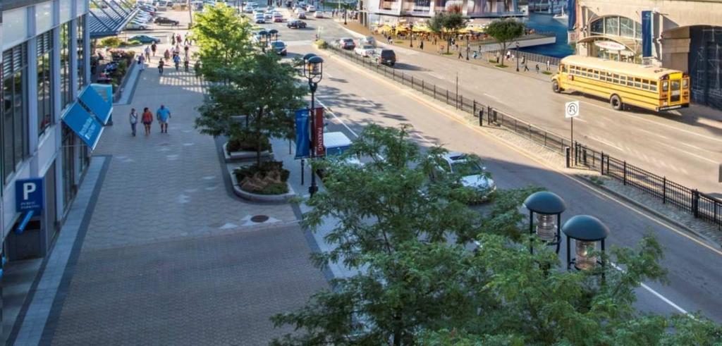
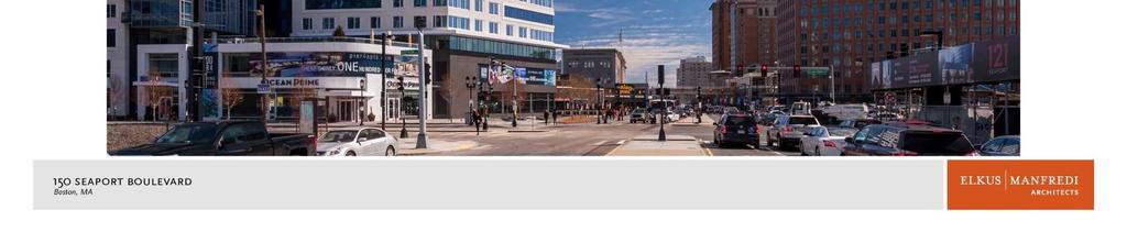
2 150 SEAPORT BOULEVARD PROJECT SUMMARY Project Proponent: Project Proponent: Architect: Landscape Architect: The Project is located on Seaport Boulevard in the South Boston Waterfront District. Cronin Holdings LLC 250 Northern Avenue Boston, MA Elkus-Manfredi Architects Carol R Johnson Expanded Project Notification Form Submission Date: March 30, 2016 Project Location: Located in the South Boston Waterfront District, the site is in a prominent area at the interchange of the Interstates 90 and 93. Until recently, it was one of the few developed waterfront sites in the area. Over the past 15 years the neighborhood has changed dramatically and the Project Site is now surrounded by new developments with a mix of uses including residential, office, hotel and retail. The proposed redevelopment of this Project Site will continue this transformation by expanding a now revitalized neighborhood and providing the link between the Fan Pier/Pier Four developments and the mixed use waterfront areas to the southeast, including The World Trade Center, The Fish Pier, and Liberty Wharf. The proximity to public transit makes the area an ideal location for transit oriented development. The Project Site is a 15-minute walk to South Station, a transportation hub that provides access to the MBTA Red Line, Silver Line, and seven commuter rail branches. In addition, the MBTA Silver Line Courthouse and World Trade Center stations are located approximately a quarter-mile from the site. Several MBTA local and express bus routes operate near the proposed site as well. Routes 4, 448, 449, and 459 bus lines have stops on Seaport Boulevard adjacent to the Seaport Hotel, approximately 0.15 miles from the site. The Route 7 bus line runs along Summer Street, which is approximately a quarter-mile away from and runs parallel to Seaport Boulevard. In addition, through its unique location, water taxi, ferry and BHC shuttles are located adjacent to the Project Site which will round out the many transportation options for residents and visitors to the Project. Proposed Project: The Project as shown in the table below, will be a signature 283,700 square feet, 250 feet tall, twentytwo story mixed use building that will include approximately 124 residential units and 10,700 square feet of restaurant space on the ground and second floors. Included with the new building is a three level below grade, garage containing approximately 179 parking spaces to serve both the residents and retail/restaurant on the Project Site. The residential units will vary in size including, studio, one bedroom, two bedroom and three bedroom units. Secured bike storage for the residences will be included within the building.
3 Summary of Project Dimensions: Project Element Residential Retail/ Restaurant Total Gross Floor Area* Parking Vehicles Height* Approximate Dimension 273,000 square feet Approximately 124 residential units Library and Fitness Spa Supporting Functions 10,700 square feet Retail/Restaurant Supporting Functions 283,700 square feet 179 spaces (below grade) 22 stories / 250 feet Zoning: The Project site is located within the Fort Point Waterfront sub-district within the Harborpark Zoning District pursuant to Article 42E of the Boston Zoning Code and within the South Boston Inner Harbor subdistrict of the South Boston Waterfront Interim Planning Overlay District. The Fort Point Waterfront is shown on Map 4A/4B of the City of Boston Zoning Maps. In addition, the Project site is within the Restricted Parking Overlay District. The Project site is located in an area in which Planned Development Area (PDA) designations are allowed. The Project Proponent intends to seek approval for a Planned Development Area Development Plan for the proposed project, as currently allowed under Section 3-1A.a of the Code and as allowed under Section 27P-16 and Section 42E-15 of Article 42. Such zoning allows PDA s in order to: establish a more flexible zoning law and encourage large-scale private development, while ensuring high-quality design by providing planning and design controls; to provide a secure economic base for the downtown services, industrial and waterfront economy and to encourage development which knits together the surrounding neighborhoods. The proposed Project building will have a height of 250 feet, a floor area ratio in excess of 4, and 37% open space. The dimensional requirements for the Project will be set forth in a development plan. The PDA and the development plan after public comment and review are subject to approval by the BRA Board, the Zoning Commission and the Mayor. Upon the approval and the establishment of the PDA, the Project will be governed by the development plan. Urban Design: After decades of underdevelopment, South Boston s Seaport District is now being recognized as the next great neighborhood in the city of Boston. The Seaport has been transformed from an area dominated by surface parking lots and warehouses to the site of numerous recently completed development projects along with several others currently underway. The parking lots and warehouses have been replaced by new office buildings, condominiums, retail stores, and restaurants creating a vibrant and exciting new urban fabric. At this time very few undeveloped or unimproved areas exist in the district. One of the remaining sites is 150 Seaport Boulevard. Currently, the site of 150 Seaport Boulevard is home to two, one and two-story, restaurant and entertainment venues; the Atlantic Beer Garden and the Whiskey Priest. These restaurants and bars are functional. However, they exist within outdated structures that are inconsistent with the neighborhood s
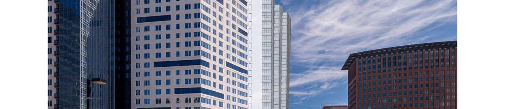
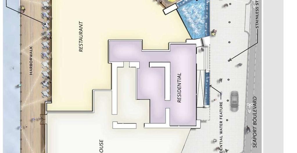
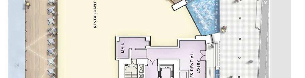
4 changing context. As new development in the Seaport has blossomed, the existing use and structures have become increasingly incongruous. The project site is an important gateway location to the district and the city. Highly visible from both the Harbor and the exit ramp from Interstate 90 makes it an ideal location for not just a building, but an iconic building. Numerous passenger vessels dock at the adjacent Commonwealth Pier, making the location one of the first major properties that passengers see upon arrival to Boston. Similarly, the site is at the east coast terminus of the transcontinental Highway 90, making the building one of the first buildings that visitors and Bostonians will see upon their entry to the city. From downtown, after passing over the Moakley Bridge into the Seaport district, the building will anchor the corridor of development running from the Channel down Seaport Boulevard. The residential and restaurant programming is an ideal combination of uses that will dramatically improve the site s character, refine the overall pedestrian experience, and support the desired sustainable design goals. The proposed Project will be located in an urban setting where the existing infrastructure is readily accessible and easily adapted for new construction. The height of the proposed residential building will be comparable to the surrounding buildings. The slender shape and form will provide a much needed contrast to squat, box-like buildings currently lining Seaport Boulevard. The building edges have been carefully designed to open up the vista and draw the viewer s eyes to the Boston Harbor. Ultimately, this new slender, elegant structure will be a dynamic and beautiful addition to the Boston skyline. The benefits to the public realm will not be limited to the new project site. They will extend beyond its borders to enrich and strengthen the neighborhood. Improvements to surrounding sidewalks, seating areas, and public spaces are equally important to the success of the proposed development. The Project will enhance public access to the waterfront by providing the missing connection of the Boston Harborwalk between Pier 4 and The World Trade Center encouraging the community to experience the water as well as the land. Height, Massing, Character and Materials: One of the BRA s planning objectives for the Seaport District was to maintain and enhance the connection to the harbor and encourage people to experience the water as well as the land. It is this very principle that has driven the massing, design, and character of 150 Seaport Boulevard and it is the main principle behind the project s urban design goals. A major component of the City s waterfront revitalization program was the creation of a Harborwalk. The Harborwalk re-establishes the shoreline from Dorchester to East Boston, by creating a continuous public walkway along the water s edge. The site currently does not have a Harborwalk, nor does it have any open space for public use along the water. 150 Seaport Boulevard has committed to creating not only a Harborwalk but generous amounts of open space for public enjoyment. The ground level plan will occupy approximately half of that area, leaving the remainder of the site open. The Harborwalk will run along the edge of the building site on both the north and east sides. This new exterior space will be enhanced with the incorporation of new site furnishings such as custom seating, planters, shade structures, trash/recycling bins, bollards, railings, lighting and bike racks. This public walkway will not only have a connection to the water, but will also follow the edge of two stories of restaurant and outdoor eating areas. The new restaurant will be primarily glass facades and will open up to the exterior; further activating the building edge and incorporating seating elements for both pedestrians and restaurant patrons. The existing restaurant on the site currently utilize an expansive upper deck seating area and front patio, allowing patrons to dine outside during the warmer months of the year. Preserving and enhancing this idea, the new restaurant will have expanded outdoor seating on both levels that will wrap from the front of the building to the back, further enhancing the connection between inside and outside. These two levels of restaurant will maintain an urban scale that will promote and enhance connectivity to the pedestrian realm.
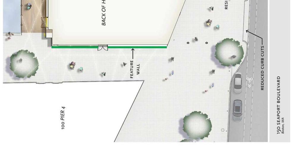
5 The remaining programmatic uses at the building s lower levels are a small residential lobby and residential services, a loading dock, two discreet parking elevators and mechanical space. These uses are tucked along the western side of the building away from the primary public open spaces. Beyond programmatic uses, the building massing is both inspired and shaped by its connection with the water. The sail-like layered massing which slightly protrudes out over the sidewalk to the south has been stepped up, away from the sidewalk to maintain a comfortable walking condition beneath the building and to graciously emphasize the directionality of the building massing towards the Harbor. The main building massing move occurs along the northern and eastern sides of the site. At ground floor, the building peels away from the sidewalk edge, revealing the harbor beyond and giving approximately 1,800 square feet of additional open space along the waterfront to public use. To further emphasize the movement towards the water, the building gently curves away in a sweep of serrations. These serrated curves extend upwards to 250, and twist 90 degrees, creating a series of sweeping glass sails facing the harbor. The project will align with the new urban fabric of the Seaport district in its basic parameters of height, scale and materiality. However, 150 Seaport Boulevard will distinguish itself among its neighbors as a distinct, signature gateway tower. The building is ideally located at the eastern terminus of Interstate 90, and at a key entry point into the harbor via passenger ships. The site is meant to be a landmark, and the design is suited to make it a memorable one. The Public Realm: The Proponent seeks to make significant upgrades to Seaport Boulevard and its adjacent sidewalks within the PDA. Seaport Boulevard will be realigned to allow for a bike lane and an off-street valet zone. This will slightly reduce the width of the street and will in turn reduce the speed of traffic. Additionally, street improvements and re-alignment will reduce the overall width of the existing median; helping to minimize the existing barrier between the two sides of the boulevard, reduce crossing time and encouraging The intent of the development recommends making improvements to the existing sidewalks. A generous and barrier free pedestrian zone will knit seamlessly into the two adjacent parcels facilitating flow along Seaport Boulevard while providing access to the Harborwalk. Enhancement of this pedestrian zone will be through the introduction of new street trees, paving, bollards, bike racks, trash receptacles, and lighting. Entrances to the residences, restaurant and Harborwalk have been carefully designed to make the spaces feel unified and integrated. This continuous outdoor space is energized by display windows, canopies, signage and outdoor seating. The design also includes a new Harborwalk on the north and east side of the property. The waterfront edge will feature new stainless steel and wood guardrails and custom lighted pylons to enliven the experience and create a sense of destination. Access to the Harborwalk from the southeast is accented by a sculptural water feature, overhead string lights, and two-story dining which continues around the waterside edge. Outdoor seating and plantings also add to the experience. Access to the boardwalk from the west is activated by the introduction of a textural feature wall which will display art installations from the Society of Arts and Crafts. Further enhancements of this area will be achieved with plant materials and lighting. Overall pedestrian experience of this project will create a distinct and memorable experience that residents and visitors alike can name, identify with and return to. Project Benefits: The project will transform an underutilized gateway parcel, previously omitted in the Seaport District planning process, into a lively mixed use, architecturally significant residential and commercial building. In addition to providing much needed housing and other direct and indirect economic benefits, the project will contribute significantly to the vitality of the neighborhood with public realm improvements that will provide a safe pedestrian friendly environment. Specific Public Benefits include:
6 Providing a Mixed-Use Environment Creating residential and civic uses increases the variety of activity for a greater number of hours during the day and into the evening. Upon successful completion, the new development enhances the overall safety and comfort of the public. Improving Pedestrian Environment Completing and enhancing the streetscape along Seaport Boulevard, improving and expanding sidewalks, increasing façade transparency and providing ground floor retail and restaurant space refines this block s link to its surroundings. Completing the Boston Harborwalk Providing direct access to the waterfront by connecting the City of Boston s pedestrian waterfront walkway between Pier 4 and The World Trade Center and allow for an uninterrupted Harborwalk along this entire stretch of the waterfront. Creating a Distinctive Architectural Design Creating a dynamic addition to Boston s urban fabric, the building will become an important visual landmark along the waterfront and a reflection of Boston s creative image and high quality standards. Advancing Sustainable Design and Climate Change Preparedness Achieving all targets for environmental and sustainable design with the anticipated goal of attaining a silver rating through the U.S. Green Building Council s Leadership in Energy and Environmental Design (LEED) system. The Project will include multiple approaches to providing resiliency against future flooding, rising sea levels and changes in energy delivery. Promoting Boston s Affordable Housing Objectives Developing much need affordable housing and complying with the Mayor s Inclusionary Development Policy for construction of residential property within the City of Boston. Increasing Employment Opportunities Providing the greater Boston community with approximately 400 construction jobs and 200 permanent jobs that are anticipated through completion of this project. Enhancing Property Tax Revenue Increasing revenue for the City of Boston with approximately three million in new annual property tax receipts that will be generated through completion of this project. Promoting Transit-Oriented Development Maximizing residential development in an area with new and expanded transit access minimizes automobile use and the potential impacts on surrounding roadways. Several transit stations, bus lines and harbor transit boats exist within the vicinity of the proposed development. Advancing Smart Growth Principles Focusing density into areas supported by existing infrastructure promotes and reinforces community vitality in addition to reinforcing development and continuing the momentum of expanding the Seaport neighborhood.
7 Inspiration
8 Inspiration
9 Massing Development
10 Site Pan

11 View from B Street


12 View looking towards Seaport Boulevard


13 View looking toward Northern Avenue


14 View from Seaport Boulevard

15 View of the Harborwalk

16 Context Photographs View looking towards Northern Avenue


17 Context Photographs View looking toward Downtown

18 Landscape Plan

19 Site Accessible Routes


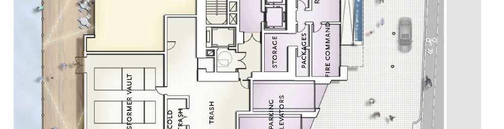
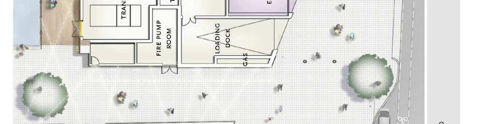
20 Ground Floor Plan
Table of Contents. Elm Avenue Improvement Plan City of Waco, Texas. Introduction 1. Existing Context 1 Figure 1 2.
 Table of Contents Introduction 1 Existing Context 1 Figure 1 2 Plan Guidelines 3 Future Urban Form 4 The West-End 4 Main Street 6 The East-End 7 Figure 2 9 Public Improvement Recommendations 7 General
V. Gateways GATEWAYS / V-1
 V. GATEWAYS / V-1 Many of Chesapeake s gateways are located on highways and call for bold and attractive designs that motorists can understand, appreciate, and enjoy. can also take the form of natural
City of Farmington. Downtown Plan. Amendment to the 1998 Master Plan Adopted October 11, 2004
 City of Farmington Amendment to the 1998 Master Plan Adopted October 11, 2004 Introduction Planning Background 1 Scope and Components of the Plan Amendment 2 Concept Introduction 3 Plan Concepts 3 Conceptual
Policies and Code Intent Sections Related to Town Center
 Policies and Code Intent Sections Related to Town Center The Town Center Vision is scattered throughout the Comprehensive Plan, development code and the 1994 Town Center Plan. What follows are sections
Bourne Downtown Site Planning
 Prepared for: The Town of Bourne, MA In Cooperation with: Bourne Financial Development Corporation Prepared by:, Inc. June 24, 2009 Table of Contents Introduction and Summary... 1 Site Existing Conditions...
AMENDED AND RESTATED DEVELOPMENT PLAN FOR THE SPORTS FACILITY PROJECT WITHIN PLANNED DEVELOPMENT AREA NO. 87 BOSTON LANDING
 AMENDED AND RESTATED DEVELOPMENT PLAN FOR THE SPORTS FACILITY PROJECT WITHIN PLANNED DEVELOPMENT AREA NO. 87 BOSTON LANDING GUEST STREET, LIFE STREET AND ARTHUR STREET BRIGHTON AREA OF BOSTON DATED: August
2.0 THE PLATINUM TRIANGLE VISION
 2.0 THE PLATINUM TRIANGLE VISION The envisions an exciting future for the area surrounding Angel Stadium of Anaheim, the Honda Center and The Grove of Anaheim. 2.1 Planning Principles In order to further
WATERFRONT DISTRICT DESIGN STANDARDS
 WATERFRONT DISTRICT DESIGN STANDARDS 20.25.080 WATERFRONT DISTRICT A. Purpose. This section is intended to implement The Waterfront District Subarea Plan by: 1. Creating a safe, vibrant mixed-use urban
PROPOSED WATERFRONT DISTRICT DESIGN STANDARDS
 PROPOSED WATERFRONT DISTRICT DESIGN STANDARDS 20.25 DESIGN REVIEW. 20.25.080 WATERFRONT DISTRICT A. Purpose. This section is intended to implement The Waterfront District Subarea Plan by: 1. Creating a
Residential Commons at Barry s Corner. Boston civic design commission February 5, 2013
 Residential Commons at Barry s Corner Boston civic design commission February 5, 2013 TABLE OF CONTENTS project summary 3 PROJECT site 4 PLANNING APPROACh 6 Parcel Diagams 6 Design Principles 8 Street
PLAN ELEMENTS WORKSHOP. April 5, 2016
 PLAN ELEMENTS WORKSHOP April 5, 2016 needs more housing. But there is no one-size fits-all solution. Every neighborhood has its own character. In some places, density is not only appropriate it is badly
Town Center. Block 5 Existing multifamily residential units are expected to remain.
 Area Guidelines Germantown s districts should be developed as distinct communities with unique features that are supported through the guidelines. The guidelines not only help distinguish these districts
(DC1) Direct Development Control Provision DC1 Area 4
 Direct Development Control Provision DC1 Area 4") . General Purpose (DC) Direct Development Control Provision DC Area 4 The purpose of this Provision is to provide for an area of commercial office employment and residential development in support of the
. General Purpose (DC) Direct Development Control Provision DC Area 4 The purpose of this Provision is to provide for an area of commercial office employment and residential development in support of the
Draft Downtown Waterfront Municipal Harbor Plan
 7/20/2016 Draft Downtown Waterfront Municipal Harbor Plan FRAMEWORK MHP BACKGROUND & GOALS AMPLIFICATIONS, SUBSTITUTE PROVISIONS, & OFFSETS CHAPTER 91 LONG-TERM LICENSE FEES PREPARING FOR CLIMATE CHANGE
The transportation system in a community is an
 7 TRANSPORTATION The transportation system in a community is an important factor contributing to the quality of life of the residents. Without a sound transportation system to bring both goods and patrons
AMENDED AND RESTATED DEVELOPMENT PLAN For PLANNED DEVELOPMENT AREA NO. 78. SEAPORT SQUARE PROJECT South Boston. Dated: November 16, 2017
 AMENDED AND RESTATED DEVELOPMENT PLAN For PLANNED DEVELOPMENT AREA NO. 78 SEAPORT SQUARE PROJECT South Boston Dated: November 16, 2017 I. Development Plan In accordance with Sections 3-1A and 80C-3 of
appendix and street interface guidelines
 appendix five: building and street interface guidelines appendix 5 building and street interface guidelines BOULEVARDS Boulevards are generally characterized by higher levels of traffic movement at higher
THE NEIGHBORHOOD TODAY
 THE NEIGHBORHOOD TODAY CORE AREA VISION How are we Good Urbanism A Site s DNA thinking about Elements of great Unique elements urban communities embedded in a place the site and design? ELEMENTS LIKE:
WEST LOOP DESIGN GUIDELINES CHECKLIST
 WEST LOOP DESIGN GUIDELINES CHECKLIST Section 1.0 General Strategies 1.1 DESIGN EXCELLENCE: ENCOURAGE HIGH QUALITY AND INNOVATIVE DESIGN OF NEW BUILDINGS WITHIN THE WEST LOOP WITHOUT BEING PRESCRIPTIVE
DRAFT. October Wheaton. Design Guidelines
 October 2011 DRAFT Wheaton Design Guidelines 2 Draft - Design Guidelines - Wheaton Sector Plan Contents 04 Section 1: Introduction 06 Section 2: Context 08 Section 3: Design Guidelines 09 Goal 1: Create
FRUITVALE TRANSIT VILLAGE (Phase 2) Residential Project
 Residential Project") FRUITVALE TRANSIT VILLAGE (Phase 2) Residential Project DEVELOPER: SIGNATURE PROPERTIES ARCHITECT: HKIT ARCHITECTS April 23, 2010 TABLE OF CONTENTS 3 Vision 4 Description of Site 5 Guiding Concepts 6
FRUITVALE TRANSIT VILLAGE (Phase 2) Residential Project DEVELOPER: SIGNATURE PROPERTIES ARCHITECT: HKIT ARCHITECTS April 23, 2010 TABLE OF CONTENTS 3 Vision 4 Description of Site 5 Guiding Concepts 6
2017 Downtown Waterfront District Municipal Harbor Plan & Public Realm Activation Plan Supplement - February 16, 2018
 Harbor Garage and New England Aquarium Throughout the Downtown Waterfront planning process and the state s consultation sessions protections and assurances for the New England Aquarium s ongoing operations
3.0 URBAN DESIGN. December 6, OVERVIEW
 Urban Design 3.0 URBAN DESIGN December 6, 2007 3.1 OVERVIEW The highly urban character of Easton Place is defined by the overall design of the community. The following sections provide an overview of the
SDOT DPD. SDOT Director s Rule DPD Director s Rule DCLU DR SED DR of 7 CITY OF SEATTLE
 SDOT SDOT Director s Rule 2-07 DPD Applicant: CITY OF SEATTLE Page 1 of 7 Supersedes: DCLU DR 11-93 SED DR 93-4 Seattle Department of Transportation (SDOT) Department of Planning and Development (DPD)
The Village of Shirlington
 The Village of Shirlington Suburban Smart Growth Without Rail Transit July 2018 Agenda History (1940 to present) Attributes and Outcomes Lessons Learned Setting the Stage Arlington County Arlington is
M i s s i o n B a y W a t e r f r o n t
 114 M i s s i o n B a y W a t e r f r o n t Character of the Area: The Mission Bay Waterfront extends from Pier 48 at China Basin Channel to 18th Street in the Central Basin. This area of the waterfront
Subarea 4 Indian Creek. Vision The combination of park networks and transportation amenities make Subarea 4 the greenest hub in the Corridor.
 indian creek 180 extends south from 101st Street to I-435. The I-435 and Metcalf intersection is one of the primary intersections in the Kansas City Metro Area. The area includes several residential neighborhoods
Downtown Waterfront Municipal Harbor Plan Advisory Committee
 Downtown Waterfront Municipal Harbor Plan Advisory Committee Waterfront Activation and Programming Subcommittee November 1, 2013 1 Our Process 1. Solicit Ideas and Public Input a. Through charrettes Charrette
Mark-up of the effect of the proposed Bronte Village Growth Area OPA No.18 on the text of section 24, Bronte Village, of the Livable Oakville Plan
 Mark-up of the effect of the proposed Bronte Village Growth Area OPA No.18 on the text of section 24, Bronte Village, of the Livable Oakville Plan Notes: This document is provided for information purposes
A. Background Summary of Existing Challenges and Potential Possibilities. 1. Summary of Existing Assets and Potential Opportunities
 A. Background 1 A Main Street Master Plan Study was performed and completed in October of 2007. The study was initiated to review current land uses and development patterns along Main Street, from Parrish
EXISTING COMPREHENSIVE PLAN
 EXISTING COMPREHENSIVE PLAN Town Center Land Use Element: V. LAND USE POLICIES Town Center Mercer Island's business district vision as described in "Your Mercer Island Citizen-Designed Downtown" was an
R STREET CORRIDOR NEIGHBORHOOD Site Plan and Design Review Supplemental Guidelines Checklist
 R STREET CORRIDOR NEIGHBORHOOD Site Plan and Design Review Supplemental Guidelines Checklist Applicant s Name: Project Address: Phone: Email: Applicant shall fill out the design guidelines checklist for
City of Long Beach. creating vibrant and exciting places
 City of Long Beach creating vibrant and exciting places Land Use Element Urban Design Element Overview of the two draft General Plan elements Discuss areas of change Economic goals of the plans Case study
3.3. Urban Structure Defining a New Hierarchy of Routes and Spaces >Images
 Section 3.0 I The Masterplan Framework 18 >Images Examples of high quality routes and spaces 3.3. Urban Structure The success of any masterplan lies in a clear definition of the future urban structure
Pedestrian and Bike Bridge LOGO
 6.2.2 Pedestrian and Bike Bridge The proposed pedestrian and bike crossing re-envisions the existing bridge at Pismo Creek on Cypress Street. The bridge is currently underutilized by vehicular through
Chelsea Creek Municipal Harbor Plan
 Chelsea Creek Municipal Harbor Plan Public Meeting #1 June 11th, 2018 1 Presentation outline I. Introduction: Why are we doing this plan? II. Evolution of Chelsea Creek III. State of Chelsea Creek IV.
VICTORIA DOWNTOWN DEVELOPMENT PLANNING
 VICTORIA DOWNTOWN DEVELOPMENT PLANNING A Vision & Guide for the Future Downtown Victoria thrives as a center for the community, offering a great mix of entertainment, culture, business, and recreational
The Village. Chapter 3. Mixed Use Development Plan SPECIFIC PLAN
 The Village SPECIFIC PLAN Chapter 3 3.1 INTRODUCTION 3.1.1 Purpose This Chapter describes the development regulations applicable to the Mixed-Use and Transit Center Planning Areas. These form-based regulations
Community Design Plan
 Gardena General Plan 2006 Authority While the is not a required element of a General Plan, it is included because improving the community appearance and image is paramount to the overall quality of life
Urban Design & Placemaking
 Urban Design & Placemaking What is Urban Design? Urban Design is the discipline of creating equitable, vibrant, and sustainable places with distinct identities. The profession pulls from other built environment
Chapter 1: Introduction
 Chapter 1: Introduction The Penn Avenue Community Works Corridor Vision and Implementation Framework presents an integrated communitybased vision and a coordinated, long-term implementation framework for
2.1 Location and Size
 2.0 Context 7 2.1 Location and Size The Saanich Penninsula The study area is centrally located within the Town boundaries on the east side of Highway 17, which runs through Sidney in a north-south direction.
Today Land & People. Northeast Nampa Gateway District. Employment. Land Use Characteristics. Demographics. Current Zoning
 Today Land & People Employment Major employers include Saint Alphonsus, the College of Western Idaho, the Auto Mall, Sorrento Lactalis and Walmart. 3,004 jobs in 2010 (COMPASS-CIM 2040 TAZ data) 4,345
Gold Line Bus Rapid Transit Transit Oriented Development (BRTOD) Helmo Station Area Plan
 Helmo Station Area Plan") Appendix F Gold Line Bus Rapid Transit Transit Oriented Development (BRTOD) Helmo Station Area Plan Introduction and Purpose of the Plan The Gold Line Bus Rapid Transit facility is an eleven-mile dedicated
Appendix F Gold Line Bus Rapid Transit Transit Oriented Development (BRTOD) Helmo Station Area Plan Introduction and Purpose of the Plan The Gold Line Bus Rapid Transit facility is an eleven-mile dedicated
URBAN DESIGN BRIEF URBAN DESIGN BRIEF 721 FRANKLIN BLVD, CAMBRIDGE August 2018
 URBAN DESIGN BRIEF URBAN DESIGN BRIEF 721 FRANKLIN BLVD, CAMBRIDGE August 2018 DESIGN BRIEF CONTENTS PART A 1.0 INTRODUCTION 2.0 DESCRIPTION & ANALYSIS OF SITE CONTEXT 3.0 DESIGN CONSTRAINTS AND OPPORTUNITIES
ELK GROVE TOWN CENTER DESIGN GUIDELINES
 ......... ELK GROVE TOWN CENTER DESIGN GUIDELINES LAGUNA RIDGE SPECIFIC PLAN... June 2008 ............ DESIGN GUIDELINES Table of Contents Contents Section A: Town Center Overview...1 A.1. Purpose and
The Master Plan Framework
 The Master Plan Framework The East Harbour Master Plan advances the development of 60 acres of former industrial lands east of the Don River. The Master Plan outlines a vision for a vibrant, transit-oriented
Ivywild On The Creek PRELIMINARY CREEK DISTRICT MASTER PLAN
 Ivywild On The Creek PRELIMINARY CREEK DISTRICT MASTER PLAN Introduction: Rejuvenating an extraordinary Creekside neighborhood THE CREEKSIDE DISTRICT The Ivywild On The Creek Neighborhood District Master
ROSSLYN GATEWAY URBAN DESIGN MANUAL JULY 15, 2011 REVISED JANUARY 30, KOHN PEDERSEN FOX ASSOCIATES PC. All rights reserved.
 ROSSLYN GATEWAY URBAN DESIGN MANUAL JULY 15, 2011 REVISED JANUARY 30, 2012 OVERVIEW Rosslyn Gateway is mixed-use development located at the Virginia landing of the Francis Scott Key Bridge in Rosslyn,
chapter DESIGN GUIDELINES NEW RIVER MASTER PLAN REPORT
 chapter DESIGN GUIDELINES NEW RIVER MASTER PLAN REPORT .76 DESIGN GUIDELINES An Overview design guidelines NEW RIVER MASTER PLAN Design Guidelines can transform the image of a city. Specific, design-based
Carlsbad Village Redevelopment Concept Summary of Features
 Carlsbad Village Redevelopment Concept Summary of Features Calthorpe Associates November 5, 2003 The Redevelopment Concept illustrates a vision for the future of Carlsbad Village. The overall vision of
FLORIN ROAD CORRIDOR Site Plan and Design Review Guidelines Checklist
 FLORIN ROAD CORRIDOR Site Plan and Design Review Guidelines Checklist Applicant s Name: Project Address: Phone: Email: Applicant shall fill out the design guidelines checklist for all guidelines applicable
Town Center (part of the Comprehensive Plan)
") Town Center (part of the Comprehensive Plan) Mercer Island Town Center Looking North (2014) In 1994, a year-long process culminated in a set of design guidelines and code requirements for the Town Center
Town Center (part of the Comprehensive Plan) Mercer Island Town Center Looking North (2014) In 1994, a year-long process culminated in a set of design guidelines and code requirements for the Town Center
Buildings may be set back to create small plazas provided that these setbacks do not substantially disrupt the street wall s continuity.
 6-22 Community Design Street Walls and Street-front Setbacks The siting of buildings will play a critical role in establishing the character and sense of place for the District. Siting buildings at the
PUBLIC RIGHT-OF-WAY IN THIS CHAPTER PUBLIC REALM
 PUBLIC RIGHT-OF-WAY This section provides design guidelines for improvements in the public right-of-way. The public right-of-way refers to streets, sidewalks, non-vehicular thoroughfares, parks and greenways
Chapter 4. Linking Land Use with Transportation. Chapter 4
 Chapter 4 Linking Land Use with Transportation Chapter 4 59 Chapter 4 Linking Land Use with Transportation Community Design and Transportation Program Introduction Since the 1950s, the predominant development
Sheridan Boulevard S TAT I O N A R E A P L A N S H E R I D A N B O U L E VA R D S TAT I O N A R E A P L A N
 Sheridan Boulevard S TAT I O N A R E A P L A N 1 City of Lakewood Adopted November, 2006 S H E R I D A N B O U L E VA R D S TAT I O N A R E A P L A N The Vision The City of Lakewood s overall vision is
A Vibrant Downtown. Chapter 5 Cary Public Art Opportunities 31
 A Vibrant Downtown Cary s vision for Downtown is a unique, vibrant, dynamic, pedestrian friendly location; a regional destination and a place to live, work, and recreate, according to the 2001 Town Center
DRAFT ROOSEVELT ROAD. District Recommendations. Figure 5.23 The Roosevelt Road Corridor
 CHAPTER 5 Figure 5.23 The Road Corridor Road will develop as a mixed-use corridor, emphasizing regional retail, west of the river and mixed-use development east of the river. KEY RECOMMENDATIONS 1. High
EcoVerde MADISON TO DOWNTOWN TO BEACH. Legend Highway Major Connection Major Street Local Street Proposed Access. Response to Tropicana Field RFP
 EcoVerde TO BEACH 275 16th Street North 16th Street South 13th Street North 13th Street South 11th Street North 11th Street South 1st Avenue North Central Avenue 1st Avenue South TO DOWNTOWN 2nd Avenue
Hudson Group North America LLC
 Hudson Group North America LLC Mr. John Palmieri, Director Boston Redevelopment Authority One City Hall Square Boston, MA 02201 August 30, 2010 RE: 120 Kingston Street Development, Notice of Project Change
Corridor Vision. 1Pursue Minnehaha-Hiawatha Community Works Project. Mission of Hennepin County Community Works Program
 1Pursue Minnehaha-Hiawatha Community Works Project Minnehaha-Hiawatha Community Works is a project within the Hennepin Community Works (HCW) program. The mission of the HCW program is to enhance how the
Rosslyn Plaza PDSP (SP #422) SPRC Staff Presentation
 SPRC Staff Presentation") Rosslyn Plaza PDSP (SP #422) SPRC Staff Presentation ote Guiding Principles included in this document are taken from the latest working draft of the Guiding Principles dated. The illustrations included
Rosslyn Plaza PDSP (SP #422) SPRC Staff Presentation ote Guiding Principles included in this document are taken from the latest working draft of the Guiding Principles dated. The illustrations included
400 West Georgia Street Urban Design Panel. Public Realm
 400 West Georgia Street Urban Design Panel Public Realm Public Benefits The main benefit in regards to the proposed development at 400 West Georgia Street will be to increase density of Commercial Office
CHAPTER 3. Design Standards for Business, Commercial, Industrial, Recreational and Institutional Uses
 CHAPTER 3 Design Standards for Business, Commercial, Section Number Title Ordinance Number Date of Ordinance 16-3-1 Applicability 2006-11 2008-04 07-01-08 16-3-2 Uniform Standards for Architectural Design
ARLINGTON COUNTY, VIRGINIA
 ARLINGTON COUNTY, VIRGINIA County Board Agenda Item Meeting October 15, 2005 DATE: September 28, 2005 SUBJECT: Request to Advertise the adoption of the 2005 Clarendon Sector Plan C. M. RECOMMENDATION:
CITY OF MERCER ISLAND DESIGN COMMISSION STAFF REPORT
 CITY OF MERCER ISLAND DESIGN COMMISSION STAFF REPORT Agenda Item: 2 March 9, 2011 Project: Description: Applicant: DSR11-004 The applicant is requesting approval to replace the existing exterior wood framed
THE 355/270 CORRIDOR:
 THE 355/270 CORRIDOR: Strategic Ideas for Sustaining a Livable Work Place Project Summary ACCESS LIFE DESIGN HEALTH WORK Montgomery County Planning Department The Maryland-National Capital Park and Planning
DRAFT. 10% Common Open Space
 % OF CHARLOTTE IS CATEGORIZED AS A. LAND USES : Placeholder map displaying location of Place Type GOALS: Accommodate XX% of future growth. Provide a concentration of primarily commercial and civic activity
DRAFT City of Titusville 2040 Comprehensive Plan Future Land Use, Housing, and Transportation Elements April 16, 2018
 DRAFT City of Titusville 2040 Comprehensive Plan Future Land Use, Housing, and Transportation Elements April 16, 2018 Prepared by Canin Associates for the City of Titusville About the Comprehensive Plan:
Complete Neighbourhood Guidelines Review Tool
 Complete Neighbourhood Guidelines Review Tool Prepared By: City of Regina Planning Department October 2014 Page 1 of 14 Community Development Review Checklist for Secondary Plans and Concept Plans The
Clairtrell Area Context Plan
 Clairtrell Area Context Plan March 2005 Urban Development Services City Planning Contents 1. Introduction... 4 2. Development Structure... 6 2.1 Streets... 7 2.1.1 Sheppard Avenue and Bayview Avenue...
Lehigh Acres Land Development Regulations Community Planning Project
 Lehigh Acres Land Development Regulations Planning Effort Summary In July, 2010 Commissioner Frank Mann invited the Lehigh Acres community to start discussing how to achieve their recently adopted community
Wadsworth Boulevard S TAT I O N A R E A P L A N
 Wadsworth Boulevard S TAT I O N A R E A P L A N City of Lakewood Adopted November, 2006 The Vision The City of Lakewood s overall vision is to transform the area around the light rail station into a mixed-use
SUBCHAPTER 4-B GUIDELINES FOR THE B-3 COMMERCIAL CHARACTER AREA
 1 SUBCHAPTER 4-B GUIDELINES FOR THE B-3 COMMERCIAL CHARACTER AREA Downtown Bozeman should be the location of buildings of greatest height and intensity in the community. The following guidelines apply
Civic Center District
 Civic Center District The Civic Center district is the civic and social heart of Warrenville, containing such public buildings as the City Hall, Warrenville Public Library, Police Station, Park District
Lynn Housing Authority and Neighborhood Development. Washington Street Gateway District Plan A p r i l
 Lynn Housing Authority and Neighborhood Development Washington Street Gateway District Plan A p r i l 2 0 0 8 rendering of sagamore hill from lynnway pedestrian overpass table of contents project area
Lynn Waterfront Master Plan
 Lynn Waterfront Master Plan Public Meeting #2 December 10th, 2018 1 Project Schedule Update September 26, 2018 December 10, 2018 Development of the Master Harbor Plan Amendment and Revised Waterfront Master
4.9 Mendocino Avenue Corridor Plan Design Guidelines
 4.9 Mendocino Avenue Corridor Plan Design Guidelines The Mendocino Avenue Corridor Plan addresses the area between College Avenue and Steele Lane. Mendocino Avenue is a busy arterial that runs parallel
VISION AND GUIDING DESIGN PRINCIPLES
 pleasure point commercial corridor VISION AND GUIDING DESIGN PRINCIPLES Public Draft November 26, 2018 County of Santa Cruz with assistance from MIG CONTENTS PART I: INTRODUCTION AND VISION... 3 Community
124 Subarea Visions. Vision Plan. A. Nelessen Associates, INC I Visioning I Planning I Urban Design
 Subareas 124 Subarea Visions The next seven sections describe specific recommendations tailored to each subarea. Each subarea is discussed separately except for certain aspects of 95th Street and Antioch
1 October Dear Citizens of Charlotte and Mecklenburg County,
 1 October 2011 Dear Citizens of Charlotte and Mecklenburg County, As co-chairs of the Center City 2020 Vision Plan Steering Committee, we are proud to present the Center City 2020 Vision Plan, which sets
Eastern Terminus TECHNICAL MEMORANDUM CENTRAL BROWARD EAST-WEST TRANSIT ANALYSIS BROWARD COUNTY, FLORIDA
 Eastern Terminus TECHNICAL MEMORANDUM CENTRAL BROWARD EAST-WEST TRANSIT ANALYSIS BROWARD COUNTY, FLORIDA FINANCIAL PROJECT ID NUMBER 411189-2-22-01 FLORIDA DEPARTMENT OF TRANSPORTATION DISTRICT 4 Prepared
Neighborhood Districts
 NEIGHBORHOOD DISTRICTS SEVEN MAIN DISTRICTS Neighborhood Districts While the Development Plan provides a broad-scale overview of the neighborhood, this section focuses on uses and relationships at the
Public input has been an important part of the plan development process.
 Lakewood s Comprehensive Plan recognizes that transportation helps shape the community, and that the way the community provides for the safe and efficient movement of people affects the character of the
Planning Districts INTRODUCTION
 INTRODUCTION To facilitate detailed examination of development prospects for all areas of the community, Delano has been divided into 14 planning districts. The location of these planning districts is
[PLANNING RATIONALE] For Site Plan Control and Lifting of Holding Zone By-Law 101 Champagne Avenue. May 23, 2014
![[PLANNING RATIONALE] For Site Plan Control and Lifting of Holding Zone By-Law 101 Champagne Avenue. May 23, 2014](/thumbs/75/71599615.jpg "[PLANNING RATIONALE] For Site Plan Control and Lifting of Holding Zone By-Law 101 Champagne Avenue. May 23, 2014") [PLANNING RATIONALE] For Site Plan Control and Lifting of Holding Zone By-Law 101 Champagne Avenue May 23, 2014 Contents 1.0 Introduction... 2 2.0 Site Context... 2 2.1 Adjacent Uses... 2 Figure 1: Site
[PLANNING RATIONALE] For Site Plan Control and Lifting of Holding Zone By-Law 101 Champagne Avenue May 23, 2014 Contents 1.0 Introduction... 2 2.0 Site Context... 2 2.1 Adjacent Uses... 2 Figure 1: Site
3.1 community vision. 3.3 required plan elements
 Chapter 3 Community Form 3.1 community vision 3.2 Parks & landscaping concepts 3.3 required plan elements D R A F T 20 Community Form Chapter 3 3.0 Community form 3.1 community vision The Specific Plan
Denton. A. Downtown Task Force
 2 Public Involvement Early and ongoing public involvement was solicited so that the public had ample opportunity to help direct the DTIP s concepts and implementation strategies. The residents of Denton
Somers Point Master Plan
 Somers Point Master Plan Progress Report and Public Meeting August 20, 2014 Master Plan Reexamination Municipal Land Use Law require that all municipalities reexamine their master plan every ten years.
WELCOME and introduction
 1 WELCOME and introduction Mobility Hub Locations within Burlington STUDY OVERVIEW STUDY OBJECTIVES The City of Burlington is developing four Area Specific Plans, one for each of Burlington s Mobility
The Anaheim Resort Public Realm Landscape Program. City of Anaheim. Adopted September 1994 (94R-239)
") Public Realm Landscape Program City of Anaheim Adopted September 1994 (94R-239) Amendment No. 1 October 1996 (96R-178) Amendment No. 2 June 1999 (99R-137) Amendment No. 3 February 2001 (2002R-56) Amendment
Public Realm Landscape Program City of Anaheim Adopted September 1994 (94R-239) Amendment No. 1 October 1996 (96R-178) Amendment No. 2 June 1999 (99R-137) Amendment No. 3 February 2001 (2002R-56) Amendment
Preci nct P l ans Figure 56 Campus Aerial Photo, 2008 CAL STATE EAST BAY, HAYWARD CAMPUS MASTER PLAN
 9 Precinct Plans This section contains a detailed discussion of the planning and design concepts for specific areas or precincts of the Cal State East Bay Hayward campus. The Precinct Plans pertain to
Trinity Uptown - Peripheral Zones University Drive/ Jacksboro Highway Zone March 31, 2008
 Trinity Uptown - Peripheral Zones University Drive/ Jacksboro Highway Zone March 31, 2008 TRINITY UPTOWN CHARACTERISTICS Desirable density Residential and mixed uses Active waterfront Public spaces Pedestrian
7Page 91 CLEMMONS COMMUNITY COMPASS 7 COMMUNITY CHARACTER
 7 Community Character The beauty of Clemmons won t necessarily be a reflection of our past, but our future. This quote from Comprehensive Plan Steering Committee member Wayne Dodson captures the essence
Forest Hills Improvement Initiative A Partnership for Building a Better Community. Use & Design Guidelines September 23, 2008
 Forest Hills Improvement Initiative A Partnership for Building a Better Community City of Boston Thomas M. Menino, Mayor Emerging Community Vision p. 2 Site Use & Design Guidelines p. 3 to 21 Arborway
Workshop 3. City of Burlington Waterfront Hotel Planning Study. September 14, The Planning Partnership
 Workshop 3 City of Burlington Waterfront Hotel Planning Study September 14, 2017 The Planning Partnership The Waterfront Hotel Planning Study 01 The Brant & Lakeshore Planning Study will establish a Strategic
/05 Architectural Response
 /05 Architectural Response 5.1 Inspiration Stacked Boxes (Artist : Rachael Whiteread) Cubism ( Architect : Le Corbusier) 52 1133 Melville Rezoning Submission Patterns ( Textile Artist : Annie Albers) Overlapping
VILLAGE OF SKOKIE Design Guidelines for Mixed-Use Districts NX Neighborhood Mixed-Use TX Transit Mixed-Use CX Core Mixed-Use
 VILLAGE OF SKOKIE Design Guidelines for Mixed-Use Districts NX Neighborhood Mixed-Use TX Transit Mixed-Use CX Core Mixed-Use TABLE OF CONTENTS CHAPTER 1 SITE DESIGN Purpose 1 CHAPTER 2 SITE DESIGN Streetscape
This Review Is Divided Into Two Phases:
 Semiahmoo Town Centre Review The purpose of this review: To review the Semiahmoo Town Centre Concept Plan, originally approved in 1993, to ensure that this centre will continue to serve the needs of South