The New Mexico Opportunity Mapping Project
|
|
|
- Erick Jackson
- 5 years ago
- Views:
Transcription
1 The New Mexico Opportunity Mapping Project Elaine Kohrman 1, Joe Zebrowski 2, Susan Rich 3 1 United States Forest Service, Cibola National Forest 2 New Mexico Highlands University, New Mexico Forest and Watershed Restoration Institute 3 New Mexico State Forestry, Forest and Watershed Health Office
2 Topics Background The Opportunity Map Landscape Assessment Tool Concept Demonstration of a prototype tool

3 New Mexico Opportunity Mapping Project WHAT IS IT? On-line database of landscape risks, values, and treatments. Any agency/org/person can enter project information Maps and data available at various scales Any agency/org/person can access maps and data through the All About Watersheds portal
4

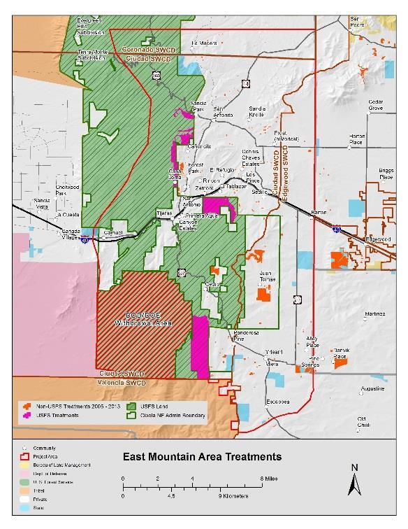
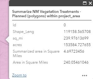
5 CWPP Example
6 New Mexico Opportunity Mapping Project WHY DO WE NEED IT? New Mexico s natural landscapes are vulnerable to drought, fire, disease, and other threats New Mexico s communities and economies rely on these landscapes Restoration resources are scarce Difficult to determine where needs are greatest Efforts are collaborative and cross boundaries
7 New Mexico Opportunity Mapping Project WHAT ARE POTENTIAL USES? 1. Multiple agencies coordinate their planning and funding to achieve a larger scale of impact, and to view accomplishments across ownerships. 2. Emergency managers can understand risks to forests and watersheds and gaps in efforts to protect communities, infrastructure and water supplies 3. Agencies and collaborative groups get a picture of where projects on other ownerships have taken place to improve their own planning, funding decisions and reporting on outcomes. 4. Agencies and collaborative groups determine if they are proposing projects in areas with important values at risk or that have been identified as a high priority in a pre-existing plan or report. 5. Agencies and collaborative groups zero in on a specific landscape where they are working to keep track of past projects, leverage funding, and plan connectivity of their future work.


8 New Mexico Opportunity Mapping Project WHAT ARE POTENTIAL USES? 1. Multiple agencies coordinate their planning and funding to achieve a larger scale of impact, and to view accomplishments across ownerships.


9 New Mexico Opportunity Mapping Project WHAT ARE POTENTIAL USES? 2. Emergency managers can understand risks to forests and watersheds and gaps in efforts to protect communities, infrastructure and water supplies.


10 New Mexico Opportunity Mapping Project WHAT ARE POTENTIAL USES? 3. Agencies and collaborative groups get a picture of where projects on other ownerships have taken place to improve their own planning, funding decisions and reporting on outcomes.


11 New Mexico Opportunity Mapping Project WHAT ARE POTENTIAL USES? 4. Agencies and collaborative groups determine if they are proposing projects in areas with important values at risk or that have been identified as a high priority in a pre-existing plan or report. Wildfire Hazard Potential Watershed Condition Class and Assessment Surface Drinking Water Importance


12 New Mexico Opportunity Mapping Project WHAT ARE POTENTIAL USES? 5. Agencies and collaborative groups zero in on a specific landscape where they are working to keep track of past projects, leverage funding, and plan connectivity of their future work.


 Natural Resources")

13 New Mexico Opportunity Mapping Project WHO IS WORKING ON IT? New Mexico Energy Minerals and Natural Resources Department, Forestry Division (NMSF) USDA Forest Service, Southwest Region (USFS) Natural Resources Conservation Service (NRCS) New Mexico Forest and Watershed Restoration Institute (FWRI) The Nature Conservancy (TNC)
14 New Mexico Opportunity Mapping Project WHAT THE PROJECT ELEMENTS? 1. NM Vegetation Treatment Database. Developed by FWRI, this database has information about vegetation treatments planned and completed since The database can be viewed at using the interactive map at Status: database is completed and data is continually being added. 2. NM Landscape Assessment Viewer Tool. This tool is in development. It will allow users to explore existing data layers created, and priorities established, by various agency sources and agency collaborative planning processes. Status: a mock-up of the tool is under review with final completion date contingent upon funding. 3. Upload Tool for the Database. This tool will allow new information to be added to the database by project managers. Status: Funded. Estimated completion July NM Landscape Assessment Reporting Tool. The user interface is planned as the final phase of the project allowing users to generate the maps and summary assessment data valuable in collaborative watershed planning and reporting. Status: a proposed budget is being developed so that funding can be secured for the download tool; a mock-up of the tool is under review with final completion date contingent upon funding.
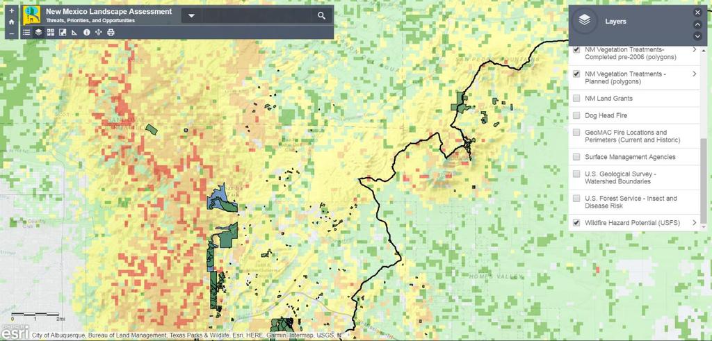
15 Landscape Assessment Tool WHAT IS THE LANDSCAPE ASSESSMENT TOOL? Displays and summarizes landscape characteristics from multiple geographic databases User friendly interface Curated One-stop for locating and viewing information A concept (based in reality) Enhances collaboration by providing a common view of landscape threats, priorities, and opportunities.
16 Landscape Assessment Tool WHAT DO WE HAVE TO WORK WITH NOW? Several disparate mapping databases created and managed by State and Federal Agencies Well designed and thought out Complex to use Judgement of land managers and local population Understand their lands View is often fragmented by jurisdiction
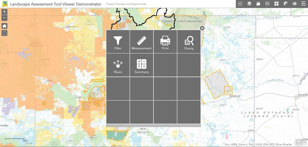
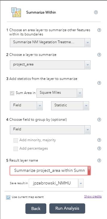
17 Landscape Assessment Tool HOW WILL THE LANDSCAPE ASSESSMENT TOOL WORK? Web-based portal to multiple layers of landscape assessment. On-line tools for generating summaries of information based on user-defined areas Collaboration areas Planning areas Treatment proposals
18
19
20
21
22

23 First draft of concept: Viewer
24

25 First draft of concept: not shared yet Reporting
26
27

28 There s an app for that!!!
29

30 Demonstration Viewer not shared yet Reporting
31
32
33
34
35
36
37
38 The New Mexico Opportunity Mapping Project Elaine Kohrman 1, Joe Zebrowski 2, Susan Rich 3 1 United States Forest Service, Cibola National Forest 2 New Mexico Highlands University, New Mexico Forest and Watershed Restoration Institute 3 New Mexico State Forestry, Forest and Watershed Health Office jpzebrowski@nmhu.edu

39 Mapmaking Migraines or We sure could have used the Opportunity Map for that! 2017 New Mexico WUI Summit March 31, 2017


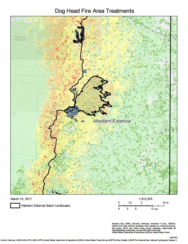
40 Assignment: Organize field tour for Washington officials. Identify and map all projects in the Santa Fe Fireshed.

41 What we needed Map of projects in all stages, all jurisdictions - Completed - Underway - Planned

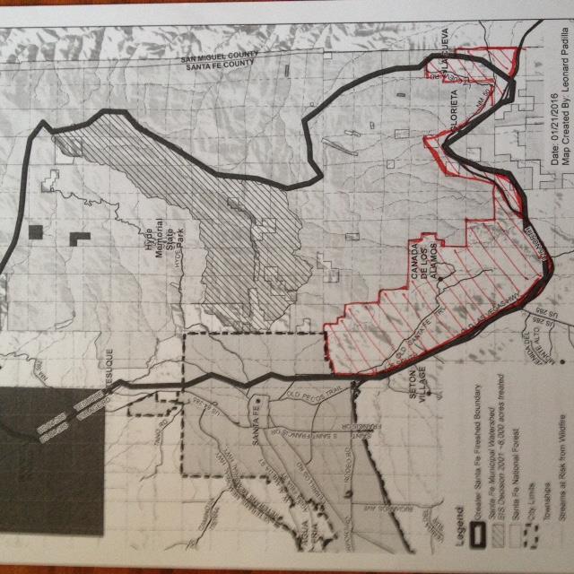
42 What we had


43 What to do?


44 What it took

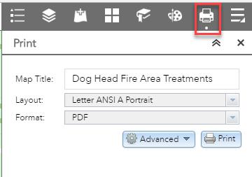
45 How it could have happened: Search. Click. Download. Insert. Format. Done.

46 Coordinating projects across a landscape? The Opportunity Map will make it easier and faster to do.

47 Questions? Feedback? Send us your input! Joe Zebrowski: Susan Rich:


48 Opportunity Mapping Project Many uses Simplifies work Please share your data! Insert pic from tour

49 Susan Rich, New Mexico State Forestry
STAFF REPORT SAUSALITO CITY COUNCIL
 STAFF REPORT SAUSALITO CITY COUNCIL MEETING DATE: January 8, 2019 AGENDA TITLE: LEAD DEPARTMENT: Southern Marin Fire District Lessons Learned Update Report Southern Marin Fire District, Fire Chief Chris
Fire Adapted Communities Background
 www.fireadapted.org Fire Adapted Communities Background 2005 Quadrennial Fire Review promoted Fire Adapted Human Communities as solution to escalating suppression costs, structure losses, fatalities 2009
SOUTH SANTA CLARA COUNTY FIRE PROTECTION DISTRICT INTRODUCTION
 ANNEX 2. SOUTH SANTA CLARA COUNTY FIRE PROTECTION DISTRICT INTRODUCTION The South Santa Clara Fire Protection District (SSCFPD) encompasses approximately 320 square miles of unincorporated areas in the
COMMUNITY WILDFIRE PROTECTION PLAN POWELL RIVER REGIONAL DISTRICT
 COMMUNITY WILDFIRE PROTECTION PLAN POWELL RIVER REGIONAL DISTRICT OUTLINE Introduction/Background Information CWPP Planning Structure Brief Overview of the WRMS Results Recommendations/Action Plan INTRODUCTION
2014 South Atlantic LCC
 2014 South Atlantic LCC Annual Report 1 Allie Stewart, U.S. FWS The South Atlantic LCC s 2014 Annual Report this year of progress and accomplishments is dedicated to South Atlantic LCC Coordinator, Ken
Using the PNW Herbaria web site to study Washington s flora: tools, tips and tricks
 Using the PNW Herbaria web site to study Washington s flora: tools, tips and tricks Ben Legler University of Washington blegler@uw.edu http://www.pnwherbaria.org/ Alaska British Columbia Idaho Montana
Middle Mississippi River. Regional Corridor
 Middle Mississippi River St. Louis District Regional Corridor Lessons Learned from a Collaborative Planning Study Brian Johnson US Army Corps of Engineers 12 th Biennial Governor s Conference on the Management
Title: Project Lead: Abstract: Promoting Landscape Stewardship Through Interactive Interpretation.
 Title: Promoting Landscape Stewardship Through Interactive Interpretation. Project Lead: Tanya M. Quist, Asst. Professor, School of Plant Sciences and UA Campus Arboretum Director. Contact information:
Green Infrastructure Planning for Sustainability and Resiliency
 Green Infrastructure Planning for Sustainability and Resiliency Linking Lands and Communities in the Land-of-Sky Region SAMAB Conference - November 18, 2010 www.linkinglands.org Linda Giltz, AICP, Regional
Together we work to remember our past, enrich our present, and inform future generations.
 1 For nearly half a century, Heritage Toronto's Historical Plaques program has commemorated key people, places, and events in Toronto's past. These plaques help us explore our rich cultural, natural, archaeological,
Final Report for work performed from July 1, 2008 to June 30, 2009
 Propagation Database for Home Gardeners: developing access to the extensive propagation records of the University of California Botanical Garden at Berkeley Final Report for work performed from July 1,
Regional Open Space Conservation Plan Putting the Plan into Action
 Regional Staff Committee June 21, 2018 Regional Open Space Conservation Plan Putting the Plan into Action Comments on the draft Include more discussion of urban open space Benefits, challenges to maintaining/increasing
for Biosphere Reserves
 Sustainable Tourism in Biosphere Reserves in Central and Eastern Europe Tourism Management Plans for Biosphere Reserves Ecological Tourism in Europe - E.T.E. e.v. Page 1 What is a Tourism Management Plan?
Network Chapter Leader Handbook and Other Updates from the October Advisory Board Meeting
 Volume 51 September/October 2018 Welcome to the September/October Network Pulse Newsletter. The Network Advisory Board is excited to announce the release of the Draft Community Leader Handbook and some
1 Introduction. 4 Environmental Integrity. 7 Community Facilities
 2037: A CALL TO ACTION 2017 COMPREHENSIVE PLAN EXECUTIVE SUMMARY is the purpose of the Q: What Comprehensive Plan? The comprehensive plan serves as a guide for the community s physical, social, and economic
DFPC s Toolbox. Colorado Fire Prediction System (CO-FPS)
") DFPC s Toolbox Colorado Fire Prediction System (CO-FPS) Wildfire in Colorado 68% of Colorado s forested lands are under federal jurisdiction The Wildland-Urban Interface in Colorado is currently 1.1 million
DFPC s Toolbox Colorado Fire Prediction System (CO-FPS) Wildfire in Colorado 68% of Colorado s forested lands are under federal jurisdiction The Wildland-Urban Interface in Colorado is currently 1.1 million
INTEGRATING PROTECTED AREAS INTO THE WIDER LANDSCAPE, SEASCAPE AND RELATED SECTORS. An Overview
 INTEGRATING PROTECTED AREAS INTO THE WIDER LANDSCAPE, SEASCAPE AND RELATED SECTORS An Overview USING AN EXAMPLE FROM NORTHEAST US Relationship of IPAWLS guide to other planning and assessment processes
SCORP THE 2019 STATEWIDE COMPREHENSIVE OUTDOOR RECREATION PLAN EXECUTIVE SUMMARY
 THE 2019 STATEWIDE COMPREHENSIVE OUTDOOR RECREATION PLAN EXECUTIVE SUMMARY SCORP Statewide Comprehensive Outdoor Recreation Plan 1 December 11, 2018 Dear Fellow Coloradans, It gives me great pleasure to
An Introduction to the Far North Land Use Strategy
 An Introduction to the Far North Land Use Strategy December, 2013 Ministry of Natural Resources Table of Contents PREFACE... 3 About the Far North... 3 Evolution of Land Use Planning in the Far North...
Local Growth Planning in North Central Green Line Communities
 2018 April 30 Page 1 of 6 EXECUTIVE SUMMARY This report outlines a high-level scope for local growth planning for north central Green Line communities. The catalyst for this review is the significant investments
Town of Peru Comprehensive Plan Executive Summary
 Town of Peru Comprehensive Plan Executive Communities that plan grow by choice, not by chance. A plan makes growth thoughtful, understandable, and predictable. A plan shows that a community is managing
APPENDIX 2-PIONEER/VOLCANO FIRE SAFE PLANNING PROCESS
 APPENDIX 2-PIONEER/VOLCANO FIRE SAFE PLANNING PROCESS CONTENTS 2. Pioneer/Volcano Planning Unit Fire Safe Planning Process... 50 2.1. Planning Area Boundaries... 50 2.2. Process and Plan Development...
Regional Open Space Conservation Plan Putting the Plan into Action
 Regional Open Space Conservation Plan Putting the Plan into Action Growth Management Policy Board July 5, 2018 Study area Regional Open Space Network Regional Trails: 339 miles Conservation Needs Not in
Mitigation Action Plan City of Mebane
 Mitigation Action Plan The Mitigation Action Plan for the is divided into two subsections: 7.1 Status of Previously Adopted Mitigation Actions 7.2 New 2015 Mitigation Actions 7.1 Status of Previously Adopted
13 Extending the Esri Enterprise Licence Agreement
 Clause 13 in Report No. 10 of Committee of the Whole was adopted, without amendment, by the Council of The Regional Municipality of York at its meeting held on May 21, 2015. 13 Extending the Esri Enterprise
Goal 4. The DNR demonstrates operational excellence and continuous improvement in service to citizens. The Challenge
 The DNR demonstrates operational excellence and continuous improvement in service to citizens. The Challenge DNR operations must adapt to an increasingly changing and diverse world. Rapid developments
Photo by Carlton Ward Jr. Executive Summary
 Photo by Carlton Ward Jr. Executive Summary The Cooperative Conservation Blueprint (Blueprint) is a multi-partner strategic conservation process developed by the Florida Fish and Wildlife Commission (FWC)
Summary of Action Strategies
 Strategic Action Plan 6 Summary of Action Strategies Action Strategy Categories: 1. Organization and Management 2. Implementation 3. Marketing and Promotion This chapter summarizes all of the action strategies
AZ-NM TRIBAL PERSPECTIVES OF EXCESS HORSES ON TRIBAL RANGELANDS
 AZ-NM TRIBAL PERSPECTIVES OF EXCESS HORSES ON TRIBAL RANGELANDS Alvin L. Medina Ecologist PURPOSE Role AZ Section-SRM Native Range Committee 3/11/11 Role SRM Native Range Initiative Feb 2010 SRM commitment
Workshop #1 Outcomes. The Planning Partnership
 Workshop #1 Outcomes The Planning Partnership 1 Background Review Planning Provincial Policy Statement Greenbelt Plan Places to Grow: Growth Plan York Region Official Plan York Region Draft Official Plan
North District What we heard
 What we heard Vision to 2056 and Priorities Governance and implementation Infrastructure and funding The vision for a metropolis of three cities, and the 30 minute city. Feedback emphasised: That for the
A new view on building protection. Cerberus DMS makes building protection smarter, easier and more flexible. Answers for infrastructure.
 A new view on building protection Cerberus DMS makes building protection smarter, easier and more flexible. Answers for infrastructure. Safety made easier. As an easy-to-use system with a single point
The Teacher is In! School Siting Tools You Can Use
 The Teacher is In! School Siting Tools You Can Use New Partners for Smart Growth Conference January 30, 2015 Regina Langton Senior Policy Analyst EPA Office of Sustainable Communities 1300 Constitution
California Landscape Conservation Cooperative
 californialcc.org California Landscape Conservation Cooperative Debra Schlafmann, Coordinator October 19, 2016 Landscape Conservation Cooperatives There are 22 LCCs http://lccnetwork.org/ LCC Map Landscape
c. DTAH Toronto Complete Streets Guidelines
 c. DTAH Toronto Complete Streets Guidelines 164 166 C.1 Project Delivery Process 168 C.5 This section provides a summary of the overarching process for delivering street projects in Toronto. The conclusion
Land Use Regional Planning in Alberta Collaborating with Stakeholders
 Land Use Regional Planning in Alberta Collaborating with Stakeholders Trevor Lema, Land & Integrated Management Planner September 2018 Overview Why Regional Planning? An Integrated Perspective Integrated
Western Pennsylvania Conservancy Clairton & Harrison Community Greening Assessment Projects Request for Proposals July 2018
 Western Pennsylvania Conservancy Clairton & Harrison Community Greening Assessment Projects Request for Proposals July 2018 Proposal Information The Western Pennsylvania Conservancy (WPC) is seeking proposals
SANTA CLARA COUNTY FIRE DEPARTMENT CENTRAL FIRE PROTECTION DISTRICT INTRODUCTION
 ANNEX 1. SANTA CLARA COUNTY FIRE DEPARTMENT CENTRAL FIRE PROTECTION DISTRICT INTRODUCTION ORGANIZATION AND JURISDICTION The Santa Clara County Fire Department (SCCFD) (also known as the Santa Clara County
INTERMOUNTAIN WEST JOINT VENTURE Strengthening Alliances for Conservation
 INTERMOUNTAIN WEST JOINT VENTURE Strengthening Alliances for Conservation THE PEOPLE OF THE IWJV The people of the Intermountain West are our greatest asset. We, at the IWJV, believe in forging productive,
Environmental Hazards and Risk Management
 Terms of Reference for ESPON-INTERACT Thematic Study Environmental Hazards and Risk Management Environmental hazards and risk management/preventions are important elements in the discussion of future Structural
6.0 CARSON COLONY VOLTAIRE CANYON
 6.0 CARSON COLONY VOLTAIRE CANYON FUEL HAZARD: MODERATE COMMUNITY RISK: HIGH The Carson Colony-Voltaire Canyon neighborhood is located to the west of Curry Street, bounded on the north by the Humboldt
Green Infrastructure Resources for Coastal Flood Risk Management
 Natural Floodplain Functions Alliance (NFFA) WEBINAR SERIES PRESENTS: Green Infrastructure Resources for Coastal Flood Risk Management Maria Honeycutt, PhD, CFM Lauren Long Tashya Allen NFFA Webinars Hosted
Managing our Landscapes Conversations for Change
 Managing our Landscapes Conversations for Change Frequently Asked Questions The new State Government is committed to a significant reform program that will change the way natural resources are managed.
NASSAU COUNTY TOWN HALL NEW YORK & CONNECTICUT SUSTAINABLE COMMUNITIES. A Unique Bi-State Partnership to Improve Jobs, Housing and Transportation
 NASSAU COUNTY TOWN HALL NEW YORK & CONNECTICUT SUSTAINABLE COMMUNITIES A Unique Bi-State Partnership to Improve Jobs, Housing and Transportation Police Headquarters Auditorium Mineola, NY December 9 th,
City of Tacoma Planning and Development Services
 Agenda Item D-1 City of Tacoma Planning and Development Services To: Planning Commission From: Elliott Barnett, Planning Services Division Subject: Application #2014-08 Open Space Element Update Meeting
Oroville Area Urban Greening Plan. Joint Meeting of the Oroville Planning, Park, and Arts Commissions October 12, 2015
 Oroville Area Urban Greening Plan Joint Meeting of the Oroville Planning, Park, and Arts Commissions October 12, 2015 Project Team Lead Agency Butte County Department of Development Services Claudia Stuart,
Introduction. Chapter 1. Purpose of the Comprehensive Plan Plan Organization Planning Process & Community Input 1-1
 Chapter 1 Introduction Lakewood 2025: Moving Forward Together Purpose of the Comprehensive Plan Plan Organization Planning Process & Community Input 1-1 Purpose of the Comprehensive Plan The Comprehensive
FREEDOM S WAY GIS INVENTORY
 APPENDIX F FREEDOM S WAY GIS INVENTORY Freedom s Way National Heritage Area (FWNHA) is required by its enabling legislation to prepare an inventory of natural, historical, and recreational resources within
2018 Northampton Township Comprehensive Plan
 2018 BUCKS COUNTY, PENNSYLVANIA What is a? A comprehensive plan is a municipality s main policy document that details the collective vision for the future, the historic, environmental, and cultural facilities
ESSENTIAL PUBLIC FACILITIES
 ESSENTIAL PUBLIC FACILITIES PURPOSE This section contains guidelines and policies which outline a process and define a set of criteria to be used to identify sites for development of facilities classified
Overview. Executive Summary. Solution Description CHAPTER
 CHAPTER 1 Executive Summary In large and complex urban environments, it is critical for decision makers to reduce the time from detection of an incident to response by first responders. Additionally, it
AC2000 Security Hub Security and Event Management System
 AC2000 Security Hub Security and Event Management System Features that make a difference: Centralised central alarm management application for Access Control, Video, Fire, Intruder and Building Management
Countywide Green Infrastructure
 Montgomery County s Countywide Green Infrastructure F U N C T I O N A L M A S T E R P L A N The Maryland National Capital Park and Planning Commission INFRASTRUCTURE An underlying base or foundation especially
Comprehensive solutions for greater safety and security Answers for infrastructure.
 Fire Safety & Security Comprehensive solutions for greater safety and security Answers for infrastructure. Combining fire and security expertise to deliver a higher level of safety and security Meeting
Cent$ible Power Users Manual
 Users Manual Welcome to Cent$ible Power Thank you for your participation in the Cent$ible Power pilot program. Your involvement is greatly appreciated. As a program participant, you are on the cutting
FINAL REPORT Elvenia J. Slosson Endowment Fund Grant
 FINAL REPORT Elvenia J. Slosson Endowment Fund 2007-08 Grant Project Title Geographic Information System (GIS) for the Demonstration Gardens at the UC Davis Arboretum Principal Investigators Steven Greco,
Marketing to Builders and Homeowners
 Marketing to Builders and Homeowners Kanawha Extension Office Tuesday, June 7th, 2011 Charleston, West Virginia Harry W. Watt Business Improvement Specialist Wood Products Extension NC State University
Green Infrastructure Mapping Exercise
 Green Infrastructure Mapping Exercise One Water Summit March 3, 2017 Mead Mier Sustainability Coordinator, Watershed Planning Lead Josh Pope GIS Manager Pima Association of Governments Outline What is
A Better Way to Support Wildland Fire Suppression
 A Better Way to Support Wildland Fire Suppression John Varner USDA Forest Service jvarner@fs.fed.us FIRE INCIDENT MAPPING TOOLS PURPOSE To have a workable ArcGIS mapping extension that utilizes a personal
Commercial Launch Site Addendum to Wetland Mitigation Plan. Revision 2. April 25, SpaceX Proprietary
 Commercial Launch Site Addendum to Wetland Mitigation Plan Revision 2 April 25, 2017 SpaceX Proprietary Contents 1.0 Project Information... 1 1.1 Background... 1 2.0 Compensatory Mitigation... 2 2.1 Goals
THE VALUE IS IN THE SOFTWARE
 Max Gutberlet September 27, 2017 THE VALUE IS IN THE SOFTWARE How Honeywell Saves You Money THE SCOPE OF TODAYS PRESENTATION 1 Honeywell PowerSpring Light-weight Meter Data Collection fully integrated
LANDSCAPE CHARACTER ASSESSMENT
 THE COUNTY DURHAM LANDSCAPE CHARACTER ASSESSMENT FOREWORD The landscape of County Durham is one of great contrast and diversity. From the North Pennines in the west to the Durham Coast in the east it contains
Town of Lyons Parks Flood Recovery Planning Process. Photograph courtesy of Ed Bruder
 Town of Lyons Parks Flood Recovery Planning Process Photograph courtesy of Ed Bruder Lyons Parks and Recreation Flood Recovery Update 1. Meadow Park Phase II - Project PW20B1 Estimated Completion: Summer
CHAPTER 1 Introduction
 CHAPTER 1 Introduction From sea to summit, Lane County covers almost 4,800 square miles of diverse Oregon landscape. Stretching from the Pacific Ocean through the Coastal Range, the Willamette Valley to
Source: Albemarle County Community Development 2010
 Source: Albemarle County Community Development 2010 GROWTH MANAGEMENT GOAL: Albemarle County s Development Areas will be attractive, vibrant areas for residents and businesses, supported by services, facilities,
Plan Overview. Manhattan Area 2035 Reflections and Progress. Chapter 1: Introduction. Background
 Plan Overview The Manhattan Urban Area Comprehensive Plan (the Comprehensive Plan) is a joint planning initiative of the City of Manhattan, Pottawatomie County, and Riley County. The 2014 Comprehensive
ArcGIS Online at Philadelphia Water Department
 ArcGIS Online at Philadelphia Water Department ESRI Public Sector Conference December 2017 Jessica Gould, GISP Megan Clarkin, AICP, LEED Green Associate Tim Smith We provide the City with integrated water,
Highlands Region Stormwater Management Program Guidance
 DRAFT Highlands Region Stormwater Management Program Guidance Release Date: January 2016 Abstract This guidance document provides an overview of the Highlands Stormwater Management Program. It is intended
NEW REGIONAL OFFICIAL PLAN HIGH LEVEL PROCESS & FRAMEWORK
 NEW REGIONAL OFFICIAL PLAN HIGH LEVEL PROCESS & FRAMEWORK Why A New Official Plan Originally the role of Regionally Planning and content of Regional Official Plan (1970s) primarily focused on protecting
The Green Infrastructure Plan Requirement: shifting from gray to green infrastructure June 14, 2016
 The Green Infrastructure Plan Requirement: shifting from gray to green infrastructure June 14, 2016 Connie Goldade Community Design + Architecture Green Infrastructure (GI) Requirements Develop a Green
Copyright 2017, Oracle and/or its affiliates. All rights reserved.
 Copyright 2017, Oracle and/or its affiliates. All rights reserved. A Better Procurement User Experience with PeopleSoft Fluid UI, Navigation Collections and Homepages Reconnect 2017 Session # 100970 Bob
Mesa Verde: The History Of The Ancient Pueblo Settlement By Jesse Harasta, Charles River Editors READ ONLINE
 Mesa Verde: The History Of The Ancient Pueblo Settlement By Jesse Harasta, Charles River Editors READ ONLINE Taos Pueblo was first settled at some point in the 13th or 14th century, The Ancestral Puebloans
LOW-RESIDENCY CERTIFICATE IN CREATIVE PLACEMAKING
 LOW-RESIDENCY CERTIFICATE IN CREATIVE PLACEMAKING September 2018-June 2019 BE THE CHANGE Educate, engage and empower your community through arts and culture Creative placemaking is an exciting new way
PA Conservation Explorer. June 2015
 PA Conservation Explorer June 2015 Topics for today Current Conservation Tools PA Conservation Explorer Conservation Planning PNDI Environmental Review Next Steps Current Conservation Tools Current Planning
SF REC & PARK STANYAN STREET IMPROVEMENT. Supervisor London Breed District 5. Project Manager Dan Mauer Recreation and Parks Department
 SF REC & PARK STANYAN STREET IMPROVEMENT PLANNING PRESENTATION WEDNESDAY, OCTOBER 19, 2016 Supervisor London Breed District 5 Project Manager Dan Mauer Recreation and Parks Department Design Team William
SOUTHWEST CORRIDOR EXTENSION. Environmental Evaluation and Basic Engineering Results PUBLIC MEETING/OPEN HOUSE November 18, 2009
 SOUTHWEST CORRIDOR EXTENSION Environmental Evaluation and Basic Engineering Results PUBLIC MEETING/OPEN HOUSE November 18, 2009 AGENDA I. Welcome/Introductions II. Project Review and Status III. Environmental
PSRC REVIEW REPORT & CERTIFICATION RECOMMENDATION
 PSRC REVIEW REPORT & CERTIFICATION RECOMMENDATION KITSAP COUNTY COUNTYWIDE PLANNING POLICIES July 2, 2012 BACKGROUND A major emphasis of the Washington State Growth Management Act (GMA) is the need to
Regional Open Space Conservation Plan. Regional Staff Committee January 18, 2018
 Regional Open Space Conservation Plan Regional Staff Committee January 18, 2018 Schedule We are here Task 1 - Stakeholder Input & Work Plan Dev. v z 2016 2017 2018 Oct Nov Dec Jan Feb Mar Apr May Jun Jul
TOWN OF BETHLEHEM MEETING SUMMARY LOCAL WATERFRONT REVITALIZATION PROGRAM UPDATE
 TOWN OF BETHLEHEM LOCAL WATERFRONT REVITALIZATION PROGRAM UPDATE MEETING SUMMARY Purpose: LWRP Update Public Workshop #3 Date and Time: October 24, 2017, 6:00 pm - 8:00 pm Location: Town Hall, 445 Delaware
Describing the Integrated Land Management Approach
 Describing the Integrated Land Management Approach ISBN No. 978-0-7785-8902-0 (Online Edition) Pub No. I/422 What is Integrated Land Management? Integrated land management (ILM) is the strategic, planned
Public Hearing April 12, Information as of April 12, 2018
 Public Hearing April 12, 2018 Meeting Agenda California Environmental Quality Arts District Act (CEQA) Project Area Overview Project Background & Description Draft Environmental Impact Report (DEIR) Next
Green Infrastructure Policies and Ordinances
 Green Infrastructure Policies and Ordinances October 23, 2013 By Karen Firehock, Green Infrastructure Center 2013 Georgia Urban Forest Council s 23 rd Annual Conference The mission of the nonprofit Green
Ontario Invasive Plant Council
 Ontario Invasive Plant Council Ontario Invasive Plant Council What is the problem? How it all began 2007 AGM Highlights from the framework Mission statement Objectives What has the council be up to? Council
COASTAL CONSERVANCY. Staff Recommendation March 25, 2004 LOS ANGELES GREEN VISION PLAN. File No.: Project Manager: Marc Beyeler
 COASTAL CONSERVANCY Staff Recommendation March 25, 2004 File No.: 04-014 Project Manager: Marc Beyeler RECOMMENDED ACTION: Authorization to disburse up to $50,000 to the University of Southern California
Streets for People, Place-Making and Prosperity. #TOcompletestreets
 COMPLETE STREETS FOR TORONTO Streets for People, Place-Making and Prosperity COMPLETE STREETS: A NEW APPROACH A Complete Streets design approach considers the needs of all users people who walk, bicycle,
Boulder County Comprehensive Drilling Plan Surface Owner Meeting. Thursday, Oct. 19, 2017
 Boulder County Comprehensive Drilling Plan Surface Owner Meeting Thursday, Oct. 19, 2017 Contact Crestone Crestone Peak Resources Quick Facts www.crestonepeakresources.com cdpboulder@crestonepr.com (720)
CITIZEN PARTICIPATION FOR BETTER URBAN GREEN SPACES
 CITIZEN PARTICIPATION FOR BETTER URBAN GREEN SPACES This policy brief illustrates the resources citizens can bring to green space planning and management, while also providing guidelines for how to design
Quarterly Report & Code Evaluation
 A New Zoning Code for a 21st Century Los Angeles To create livable communities, encourage sustainable development and foster economic vitality, we need a modern and user-friendly zoning code we need to
Zagreb. Strategic planning. City of Zagreb City Office of Strategic Planning and Development of the City
 Zagreb http://www.zagreb.hr/ Strategic planning Through ZAGREBPLAN a vision of Zagreb was defined: City of Zagreb as an urban incubator of sustainable concepts, entrepreneurship and new values City of
GREEN NETWORK APPLICATIONS IN ESTONIA
 GREEN NETWORK APPLICATIONS IN ESTONIA Kalev Sepp, Tuuli Veersalu, Martk Külvik Estonian University of Life Sciences 1 WHY? BACKGROUND - POLITICAL By adopting the Pan-European Biological and Landscape Diversity
FIRE AND LIFE SAFETY EDUCATOR II NFPA 1035, Chapter 5, 2015 Edition
 Official Skill Sheets for Practical Skills Evaluation Ontario, Canada NFPA 1035, Chapter 5, 2015 Edition National Fire Protection Association Standard for Fire and Life Safety Educator Professional Qualifications
LRPC VISION GOALS-OBJECTIVES-STRATEGIES
 ENVIRONMENT: Wooded surroundings, meandering creeks and natural beauty allow residents to enjoy the benefits of living in a low-density village setting with quick and easy access to the offerings of the
Philadelphia Water Department, Green Infrastructure Implementation Graduate Internship Opportunities Summer 2017
 PHILADELPHIA WATER 1101 Market Street Philadelphia, Pennsylvania 19107-2994 Debra McCarty, Commissioner Philadelphia Water Department, Green Infrastructure Implementation Graduate Internship Opportunities
4 ESF 4 Firefighting
 4 ESF 4 Firefighting THIS PAGE LEFT BLANK INTENTIONALLY ESF 4 Firefighting Table of Contents 1 Purpose and Scope... ESF 4-1 2 Policies and Agreements... ESF 4-1 3 Situation and Assumptions... ESF 4-2 3.1
CANADIAN GUIDE FOR GREENER ROADS AND SUSTAINABILITY CONSIDERATIONS FOR BRIDGES GUIDE 2016 CANADIAN CONSULTING ENGINEERING AWARDS
 CANADIAN GUIDE FOR GREENER ROADS AND SUSTAINABILITY CONSIDERATIONS FOR BRIDGES GUIDE 2016 CANADIAN CONSULTING ENGINEERING AWARDS SUSTAINABILITY CONSIDERATIONS PROJECT TITLE PAGE Member Firm Submitting
Enhancing our Nation s Wildfire Management Capabilities Through Application of NASA Science and Technology
 Enhancing our Nation s Wildfire Management Capabilities Through Application of NASA Science and Technology Vince Ambrosia Earth Science Division. Biospherics Branch NASA-Ames Research Center 2nd Annual
STREETSCAPE MANUAL ONLINE TRAINING SESSION 2: Searching the Manual
 TRAINING SESSION 2: The Urban Design Streetscape Manual is a reference tool developed to help implement City policy and guide the design, construction and maintenance of streetscape improvements in Toronto.
Rosslyn Highlands Park + Coordinated Open Spaces Plan (Plan Adoption) County Board Meeting September 24, 2016
 County Board Meeting September 24, 2016") Rosslyn Highlands Park + Coordinated Open Spaces Plan (Plan Adoption) County Board Meeting September 24, 2016 BACKGROUND The County Board shall consider adoption of the proposed Rosslyn Highlands Park
Rosslyn Highlands Park + Coordinated Open Spaces Plan (Plan Adoption) County Board Meeting September 24, 2016 BACKGROUND The County Board shall consider adoption of the proposed Rosslyn Highlands Park
Conservation by Design: Promoting Resilient Coastal Wetlands & Communities. GreatLakesLCC.org
 Conservation by Design: Promoting Resilient Coastal Wetlands & Communities Brent Schleck The Baldwin Group - NOAA Office for Coastal Management ASFPM 6/22/16 GreatLakesLCC.org Overview 2 Great Lakes coastal
Presentation Outcomes
 Green Infrastructure Rappahannock-Rapidan Living Lands Planning Workshop September 17, 2009 Presentation Outcomes Define green infrastructure principles and concepts (video). How are green infrastructure