PA Conservation Explorer. June 2015
|
|
|
- Sherman Carter
- 5 years ago
- Views:
Transcription


1 PA Conservation Explorer June 2015

2 Topics for today Current Conservation Tools PA Conservation Explorer Conservation Planning PNDI Environmental Review Next Steps


3 Current Conservation Tools

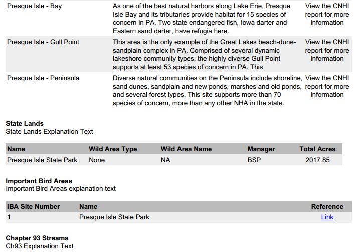
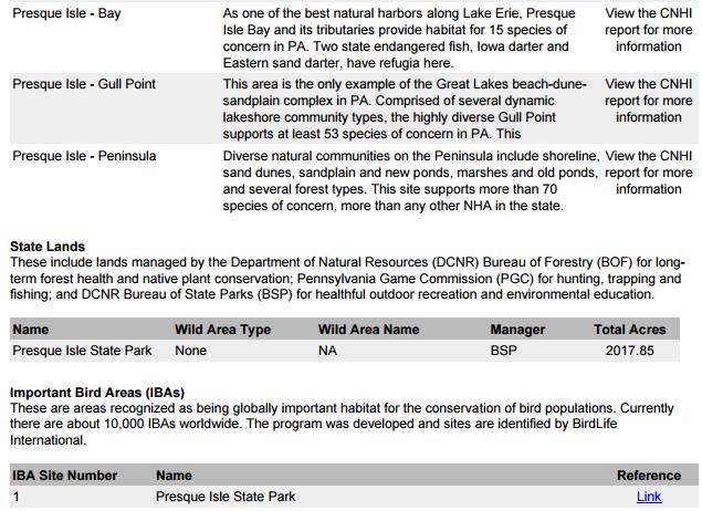
4 Current Planning Tool County Natural Heritage Inventories & Interactive Map View entire report by county Click to get individual area reports Limited threatened and endangered species information

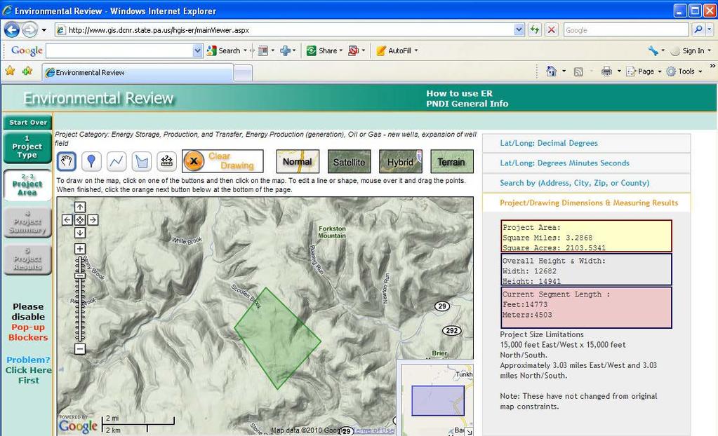
5 PNDI Environmental Review Tool First of its kind launched in Model for other states that followed, AZ, VA, NC, LA Pennsylvanians conduct 50,000 online searches per year. Majority No Impact An effective screening tool for projects. Quickly screens projects for potential impacts to T/E species Existing tool nearing end of lifespan as software and technology age.
6
7 Usage PNDI Screenings and Further Coordination Potential Impacts No Impact
: Surveys requested by DCNR, FBC, PGC")
8 Usage ~ 50,000: Total number of Screenings ~ 67%: No Coordination Required or No Species in vicinity ~ 33%: Further Coordination Required or Species in vicinity ~ 16,600: PNDI screenings in connection with DEP permitting programs ~ 2% ( ): Surveys requested by DCNR, FBC, PGC


9 Planned Improvements

10 Combine Planning & Review 2 Tools in 1
11 Goals Tool to support conservation and project planning Improved user and administrative capabilities Improved access to PA s conservation information Protect species from disturbance or potential impacts

12 PA Conservation Explorer Conservation Planning & PNDI Environmental Review Tool Conservation Planning & Environmental Review o View PA s conservation information for land-use and conservation planning Anyone can view and create maps of conservation areas, statuses and values. Access to Conservation Planning is open to all users o Perform a PNDI Environmental Review and obtain a PNDI receipt Perform online screenings for potential impacts to threatened, endangered, special concern species and resources.
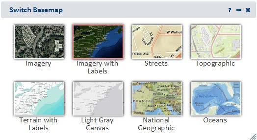
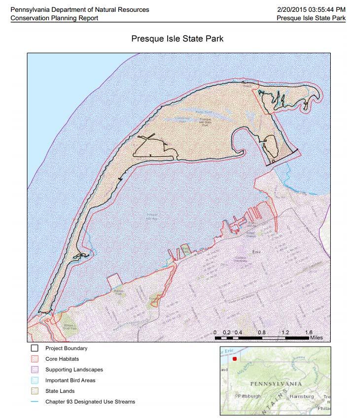
13 Mapping Enhancements


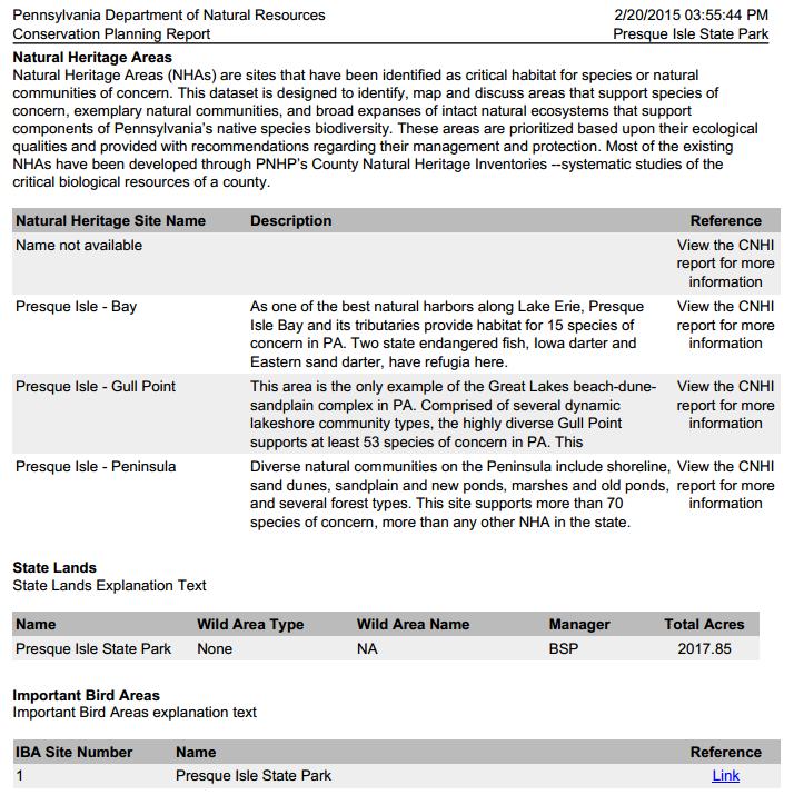
14 Mapping Enhancements Presque Isle State Park
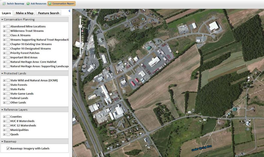
15
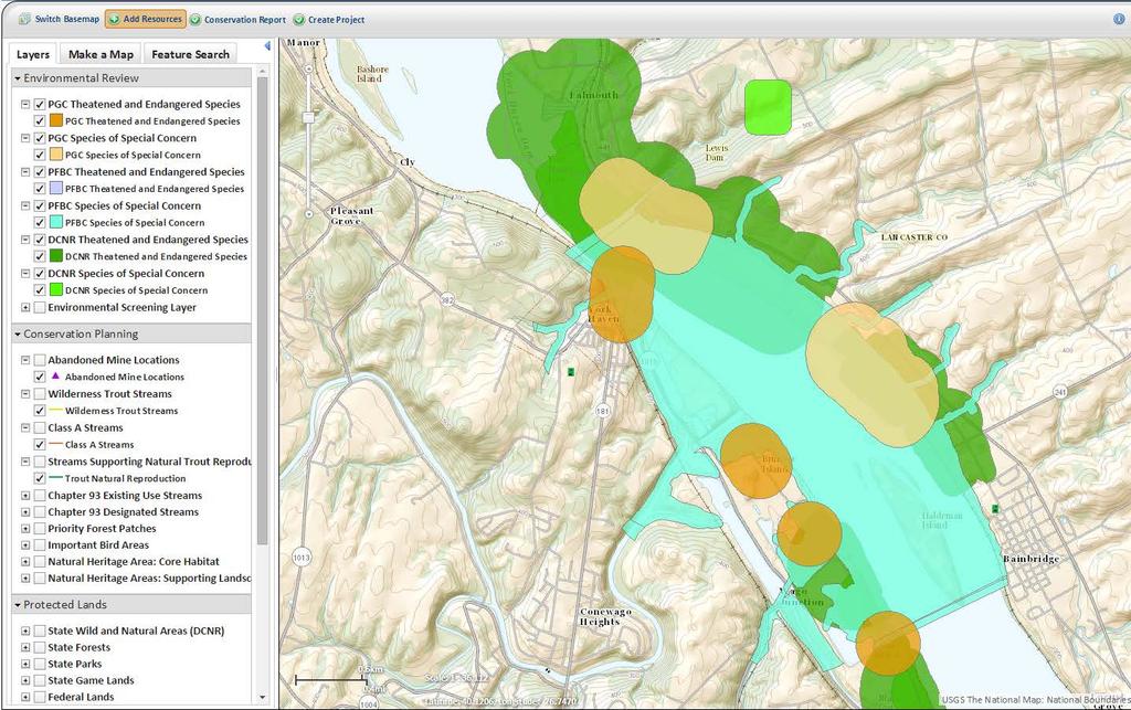
16 Conservation Planning
17 Conservation Planning Purpose: Conservation Planning & Project Assessments Open access: No login required View Conservation Information (no PNDI info) Landscape Level Assessments Obtain Planning Reports Choose from 11 Base maps Add Your Own Data Layers

18 Visible Information

19 Access to Conservation Information Summer 2015

20 Access to CNAI Report
21 Conservation Planning Report Select area Receive Conservation Report


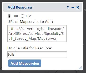
22 Add Your Own Map Resources


23 Conservation Planning Municipal and County planning Landscape-level project planning Grant planning Conservation assessments Site assessments Conservation planning layers
24 PNDI Environmental Review
25 PNDI Environmental Review Purpose: Project-Specific Screening Register, Data Sharing & Login Required Fee Access for PNDI Screening & PNDI Receipt View PNDI Species Habitat Info & Conservation Layers Submit Project Materials Via Tool

26

27 Environmental Review Visible Polygons
28 Environmental Review

29 Environmental Review Visible Polygons & Non-T&E Names
30
31 Proposed PNDI Receipt Fee Proposed PNDI Fee To recoup administrative costs of tool and data mgmt Ensure sustainability of PNDI tool and information $40/PNDI Receipt No cost option to users obtain review directly from agencies, rather than tool T&E Names will be displayed on PNDI Receipt
32
33

34 Project Receipt Summary results of the PNDI screening are displayed in the receipt.

35 **Names of sensitive species hidden

36 Project Upload Upload Maps and Supporting Documents Users can upload project documents if there is a potential impact User to have a shorter project review timeline Agencies would access info from site for review
37 Improvements Summary of Enhancements Administrative functions Improved ability to make tool changes, upgrades and fixes Conservation Planning Clicking conservation info on/off Conservation Reports Visual Species Habitat Info Public: see conservation information for planning Environmental Review: users register see visible species habitat for the review process Updated species polygons: Move from the use of mostly Generic species buffers vs Species Habitat-based polygons Improved ability to see areas of potential habitat conflict/impact Project Submission Submit to agencies via tool

38 Next Steps Next Steps Obtain feedback from users November 2015: Roll out Trainings for users throughout
Pennsylvania Conservation Explorer Conservation Planning and PNDI Environmental Review. September 29, 2015 Greg Podniesinski Kent Taylor
 Pennsylvania Conservation Explorer Conservation Planning and PNDI Environmental Review September 29, 2015 Greg Podniesinski Kent Taylor Current Conservation Planning Tool County Natural Heritage Inventories
Apply & Pay for Building Permits on Accela Citizen Access
 Apply & Pay for Building Permits on Accela Citizen Access Permit Types Citizen Access online applications can ONLY be used for RESIDENTIAL appliance REPLACEMENT permits and reroof permits that do NOT require
Summary of Action Strategies
 Strategic Action Plan 6 Summary of Action Strategies Action Strategy Categories: 1. Organization and Management 2. Implementation 3. Marketing and Promotion This chapter summarizes all of the action strategies
Overview of Southwestern Pennsylvania Commission s (SPC) 2040 Long Range Transportation Plan (LRTP)
 2040 Long Range Transportation Plan (LRTP)") Overview of Southwestern Pennsylvania Commission s (SPC) 2040 Long Range Transportation Plan (LRTP) Presented to Pennsylvania Agency Coordination Meeting May 27, 2015 Doug Smith & Ryan Gordon 1 Southwestern
Overview of Southwestern Pennsylvania Commission s (SPC) 2040 Long Range Transportation Plan (LRTP) Presented to Pennsylvania Agency Coordination Meeting May 27, 2015 Doug Smith & Ryan Gordon 1 Southwestern
ArcGIS Online at Philadelphia Water Department
 ArcGIS Online at Philadelphia Water Department ESRI Public Sector Conference December 2017 Jessica Gould, GISP Megan Clarkin, AICP, LEED Green Associate Tim Smith We provide the City with integrated water,
Using ANM Mobile CHAPTER
 CHAPTER 19 Date: 3/22/13 This chapter describes Cisco ANM Mobile, which allows you to access your ANM server or ANM Virtual Appliance and manage your devices using a mobile device such as an iphone or
design on demand
 Winning project - New Idea phase The following brief will be based on the project below BOA One & Only by BOA-DESIGN Summary The second phase of by Electrolux and Desall.com, is aimed at developing further
FORM 3150-PM-BWEW0036A Joint Application for Pennsylvania
 FORM 3150-PM-BWEW0036A Joint Application for Pennsylvania Water Obstruction and Encroachment Permit and U.S. Army Corps of Engineers Section 404 Permit ATTACHMENT 1 GENERAL INFORMATION FORM (GIF) AND SUPPLEMENTAL
Tackling Difficult SEQR Topics
 Presented by Nan Stolzenburg AICP CEP and Don Meltz AICP Tackling Difficult SEQR Topics COMMUNITY CHARACTER, HISTORIC/ARCHAEOLOGICAL RESOURCES & HABITATS/ENDANGERED SPECIES Training Agenda Introductions
Municipal Obligations Archaeological Heritage Screening. Heritage Conservation Branch Ministry of Parks, Culture and Sport November 14, 2018
 Municipal Obligations Archaeological Heritage Screening Heritage Conservation Branch Ministry of Parks, Culture and Sport November 14, 2018 Legislative Authority: The Heritage Property Act, 1980 Impact
Conservation Corridor Base and Thematic Maps
 Conservation Corridor Base and Thematic Maps August 20, 2010 This project is funded in part by the Virginia Coastal Zone Management Program at the Department of Environmental Quality through Grant #NAO9NOS4190163
BRAHMS. BRAHMS stores data and images from herbaria, field surveys, botanic gardens, seed banks and literature. The system is used to:
 BRAHMS BOTANICAL RESEARCH AND HERBARIUM MANAGEMENT SYSTEM BRAHMS stores data and images from herbaria, field surveys, botanic gardens, seed banks and literature. The system is used to: catalogue and curate
Plat Requirements CHECKLIST FOR SITE PLAN REVIEW
 This checklist is to be used as a guide for complying with the Town of Hollis Site Plan Regulations. It is to be used for each individual site plan review application submitted. Applicants are encouraged
Rapid Transit Implementation Working Group
 Rapid Transit Implementation Working Group October 12, 2017 1 Agenda 1. Consultation Update 2. Technical Work Update 3. LTC Rapid Transit Integration 4. Next Steps 2 Consultation Update 3 Consultation
Rapid Transit Implementation Working Group September 14, 2017
 Rapid Transit Implementation Working Group September 14, 2017 BACKGROUND Council approved the Rapid Transit Master Plan and Updated Business Case on July 25, 2017. Approval of the RTMP confirmed the BRT
Western Pennsylvania Conservancy Clairton & Harrison Community Greening Assessment Projects Request for Proposals July 2018
 Western Pennsylvania Conservancy Clairton & Harrison Community Greening Assessment Projects Request for Proposals July 2018 Proposal Information The Western Pennsylvania Conservancy (WPC) is seeking proposals
DISCUSSION TOPIC: ST JOHNS RIVER & ITS TRIBUTARIES (BPII) 2030 COMPREHENSIVE PLAN POLICES AND REGULATORY FRAMEWORK
 2030 COMPREHENSIVE PLAN POLICES AND REGULATORY FRAMEWORK") DISCUSSION TOPIC: ST JOHNS RIVER & ITS TRIBUTARIES (BPII) 2030 COMPREHENSIVE PLAN POLICES AND REGULATORY FRAMEWORK St. John s River & Its Tributaries Issue Summary: The St. Johns River is an important
DISCUSSION TOPIC: ST JOHNS RIVER & ITS TRIBUTARIES (BPII) 2030 COMPREHENSIVE PLAN POLICES AND REGULATORY FRAMEWORK St. John s River & Its Tributaries Issue Summary: The St. Johns River is an important
Cent$ible Power Users Manual
 Users Manual Welcome to Cent$ible Power Thank you for your participation in the Cent$ible Power pilot program. Your involvement is greatly appreciated. As a program participant, you are on the cutting
Developing a Master Plan. By LH-PA, City of Sunnyvale, & Anderson Brulé Architects
 2016 Developing a Master Plan By LH-PA, City of Sunnyvale, & Anderson Brulé Architects Steve Emslie Regional Director Lighthouse Public Affairs Katherine Rivard Project Manager Design Practice Leader Anderson
Spring Creek Canyon. A Master Plan, Management Plan and Implementation Effort. Balancing the Demands on a Nationally Significant Resource
 A Master Plan, Management Plan and Implementation Effort Balancing the Demands on a Nationally Significant Resource 2010 PPA Conference - Lancaster Background Spring Creek is an internationally renowned
STREETSCAPE MANUAL ONLINE TRAINING SESSION 2: Searching the Manual
 TRAINING SESSION 2: The Urban Design Streetscape Manual is a reference tool developed to help implement City policy and guide the design, construction and maintenance of streetscape improvements in Toronto.
STREETSCAPE MANUAL ONLINE TRAINING SESSION 2: Searching the Manual
 TRAINING SESSION 2: The Urban Design Streetscape Manual is a reference tool developed to help implement City policy and guide the design, construction and maintenance of streetscape improvements in Toronto.
Together we work to remember our past, enrich our present, and inform future generations.
 1 For nearly half a century, Heritage Toronto's Historical Plaques program has commemorated key people, places, and events in Toronto's past. These plaques help us explore our rich cultural, natural, archaeological,
The New Mexico Opportunity Mapping Project
 The New Mexico Opportunity Mapping Project Elaine Kohrman 1, Joe Zebrowski 2, Susan Rich 3 1 United States Forest Service, Cibola National Forest 2 New Mexico Highlands University, New Mexico Forest and
2. Analysis. DRAFT Gerald Richards & Pleasantview Park Master Plan
 DRAFT Gerald Richards & Pleasantview Park Master Plan 19 Historic Features According to the National Register of Historic Places and the National Historic Landmarks Program, there is nothing of national
Preparation of territorial planning documents for Plateliai lake area: problems, solutions
 ZENONAS GULBINAS Nature Heritage Fund/Lithuanian University of Educational Sciences, Vilnius, Lithuania Preparation of territorial planning documents for Plateliai lake area: problems, solutions Sustainable
One River Environmental Assessment. Welcome!
 One River Environmental Assessment Welcome! One River Environmental Assessment Welcome to the One River Environmental Assessment Public Information Centre. Please explore each presentation area to learn
The Landscape Project. New Jersey Department of Environmental Protection Division of Fish and Wildlife Endangered and Nongame Species Program
 The Landscape Project New Jersey Department of Environmental Protection Division of Fish and Wildlife Endangered and Nongame Species Program New Jersey is One of the smallest states in the country Yet
TO BE COMPLETED BY APPLICANT
 Planning Division #200-2564 Shaughnessy Street Port Coquitlam BC V3C 3G4 Tel 604.927.5442 Fax 604.927.5404 Email planning@portcoquitlam.ca Application for Watercourse Development Permit Watercourse Development
The scope of the plan will focus on the Prospect Heights Slough and Hillcrest Lake as one entity.
 Plan for Prospect Heights Natural Resources Commission Plan for Improved Public Access and Enjoyment of the Prospect Heights Slough and Hillcrest Lake July 23, 2018 The City Council has requested the Natural
Jacksons Hill Master Plan
 About this document This document forms Appendix 2 of the Jacksons Hill Master Plan Phase 1 Community Engagement Report. The report was prepared by CrowdSpot for the VPA and provides an analysis of the
Minnesota Department of Natural Resource - Natural Resource Guidance Checklist Conserving Natural Resources through Density Bonuses
 Minnesota Department of Natural Resource - Natural Resource Guidance Checklist Conserving Natural Resources through Density Bonuses NRDB Why Use Density Bonuses & This Checklist Local units of government
SRP Profile Directions
 NJ-GeoWeb Home Page (figure 1) SRP Profile Directions 1. Launch NJ-Geo Web Home Page at http://www.nj.gov/dep/gis/geowebsplash.htm If needed, use the Tutorial button on the NJ-GeoWeb main screen for NJ-GeoWeb
City of Missoula and Missoula County Open Space Planning Open House
 City of Missoula and Missoula County Open Space Planning Open House FEBRUARY 6, 2018 The following slides contain the display board content from the open house. Please use boards to answer questions in
Ontario Invasive Plant Council
 Ontario Invasive Plant Council Ontario Invasive Plant Council What is the problem? How it all began 2007 AGM Highlights from the framework Mission statement Objectives What has the council be up to? Council
MEMORANDUM OF BOG TURTLE HABITAT INVESTIGATION
 MEMORANDUM OF BOG TURTLE HABITAT INVESTIGATION 410-728-2900 Fax: 410-728-3160 www.rkk.com To: From: CC: U.S. Fish and Wildlife Service, Pennsylvania Fish and Boat Commission Jennifer A Ottenberg Miller,
STORM SEWER OUTFALLS AND CONNECTING OUTFALL CHANNELS. General Submission Requirements
 COMPLETE APPLICATION CHECKLIST Jan 2016 STORM SEWER OUTFALLS AND CONNECTING OUTFALL CHANNELS The following checklist has been compiled to assist the applicant in preparing their application for approval
GREEN WEDGE MANAGEMENT PLAN
 DRAFT PLAN AVAILABLE FOR COMMENT CITY OF GREATER DANDENONG PROJECT UPDATE The City of Greater Dandenong has prepared a Draft Management Plan for the municipality s Green Wedge. The plan provides a clear
4-H SOIL & WATER PROJECT UPDATE. Indiana 4-H. Youth Education
 4-H SOIL & WATER Indiana 4-H Youth Education PROJECT UPDATE PRESENTATION OUTLINE Project Background What, Why, How? Who are the Partners? What is 4-H Youth Education? Project Goals How will 4-H Implement?
DRAFT MAP AMENDMENT FLU 04-4
 DRAFT MAP AMENDMENT FLU 04-4 SW 24 TH AVENUE ROADWAY CORRIDOR The University of Florida participates with the Metropolitan Transportation Planning Organization (MTPO) in its responsibilities for the continuing,
Lawrencetown Beach & Rainbow Haven Beach
 Lawrencetown Beach & Rainbow Haven Beach Public Engagement Session Wednesday, September 27 th, 2017 6:00pm 8:00pm Cole Harbour Place 51 Forest Hills Pkwy, Dartmouth Agenda Welcome & Introductions Overview
Standards and Safety Update
 Standards and Safety Update Presented By: Michael J. Johnston Executive Director Standards and Safety, NECA Update Objectives Update on NFPA 70E and NECA Safety products Update on NECA S National Electrical
WETLANDS PROTECTION ACT REFERENCE MANUAL
 WETLANDS PROTECTION ACT REFERENCE MANUAL Table of Contents 1. Wetlands Protection Program a. Wetlands Protection Act: M.G.L. c.131, 40: http://www.mass.gov/legis/laws/mgl/131-40.htm b. Restricted Wetlands:
Whole Kids Foundation Extended Learning Garden Grant Application - USA In Partnership with FoodCorps
 Whole Kids Foundation Extended Learning Garden Grant Application - USA In Partnership with FoodCorps *All information is collected online, this is a copy of the questions asked. This is an opportunity
Bristol Marsh Heritage Conservancy
 Bristol Marsh Heritage Conservancy The Pennsylvania Environmental Council (PEC) protects and restores the natural and built environments through innovation, collaboration, education and advocacy. PEC believes
ARLINGTON COUNTY, VIRGINIA. County Board Agenda Item Meeting of June 16, 2018
 ARLINGTON COUNTY, VIRGINIA County Board Agenda Item Meeting of June 16, 2018 DATE: June 7, 2018 SUBJECT: Z-2604-18-1 Rezoning from R-6 and R-5 Single Family Residential Districts to S-3A Special District
Community Meeting #1: Project Kick Off
 Community Meeting #1: Project Kick Off November 17, 2015 What are 3 things you like about Downtown Gilroy that you want to hold onto in the future? Please write them down and share with us! Tonight s Meeting
APP Function Introduction
 APP Function Introduction IOS/Android Bluetooth 4.1 INMOTION TECHNOLOGIES CO., LTD April, 2015 1 / 29 Content Content... 2 1. General Information... 4 1.1. About this manual... 4 1.2. Related Conventions...
Proposed St. Vital Transmission Complex
 Proposed St. Vital Transmission Complex Round 2 Preferred Route for the St. Vital to Letellier Line What is it? Manitoba Hydro is proposing construction of two 230-kilovolt (kv) transmission lines to improve
PLANNED UNIT DEVELOPMENT & PLANNING APPROVAL STAFF REPORT Date: April 4, 2013
 PLANNED UNIT DEVELOPMENT & PLANNING APPROVAL STAFF REPORT Date: April 4, 2013 NAME LOCATION The North American Islamic Trust, Inc. 63 East Drive (East side of East Drive, 400 South of Old Shell Road, and
MASTER PLAN for the EARL NEWHOUSE WATERFRONT
 MASTER PLAN for the EARL NEWHOUSE WATERFRONT on RESERVOIR POND - CANTON, MA Community Meeting #2 - Thursday, January 11 th PROJECT INTRODUCTION Project Goals: To prepare a MASTER PLAN which develops the
DESIGN GUIDELINES FOR LARGE SIDEWALK PATIOS ON CITY PROPERTY AND SAMPLE DRAWINGS
 DESIGN GUIDELINES FOR LARGE SIDEWALK PATIOS ON CITY PROPERTY AND SAMPLE DRAWINGS For additional information: Phone: 3-1-1 (outside Vancouver, 604-873-7000) E-mail: street.activities@vancouver.ca or Visit
APPENDIX 1: SCOPED ENVIRONMENTAL IMPACT STATEMENT (EIS) FORM
 FORM") APPENDIX 1: SCOPED ENVIRONMENTAL IMPACT STATEMENT (EIS) FORM This form is intended for use by applicants (primarily private landowners) who need to conduct a Scoped EIS in support of minor development
APPENDIX 1: SCOPED ENVIRONMENTAL IMPACT STATEMENT (EIS) FORM This form is intended for use by applicants (primarily private landowners) who need to conduct a Scoped EIS in support of minor development
Vaughan Metropolitan Centre (VMC) Black Creek Renewal CLASS ENVIRONMENTAL ASSESSMENT
 Black Creek Renewal CLASS ENVIRONMENTAL ASSESSMENT") PUBLIC INFORMATION CENTRE Vaughan Metropolitan Centre (VMC) Black Creek Renewal Wednesday, May 10, 2017 6:00 p.m. to 8:00 p.m. Add photo Project Management, Environmental Assessment, Stormwater Management
PUBLIC INFORMATION CENTRE Vaughan Metropolitan Centre (VMC) Black Creek Renewal Wednesday, May 10, 2017 6:00 p.m. to 8:00 p.m. Add photo Project Management, Environmental Assessment, Stormwater Management
MOBILE CITY PLANNING COMMISSION LETTER OF DECISION. October 22, 2010
 MOBILE CITY PLANNING COMMISSION LETTER OF DECISION Archbishop of Mobile 400 Government St. Mobile, AL 36602 Re: Case #SUB2010-00075 (Subdivision) 3650 Springhill Avenue (Northwest corner of Springhill
Inventory and Assessment of Stormwater Infrastructure
 Inventory and Assessment of Stormwater Infrastructure Identifying and Assessing Stormwater Infrastructure Before an assessment can be completed, stormwater infrastructure must be located and identified
presentations the week of the final exams. Anyone who misses the appointment will receive a grade of zero.
 CS 116 Section 4 PROJECT Spring 2016 Grade: Up to 12 points. Rules: To be worked on individually. Must be presented to the instructor in person in order to be graded. Similar projects will both receive
Tutorial: How to Download and Install Lumberyard v or greater
 Tutorial: How to Download and Install Lumberyard v1.9.0.0 or greater This tutorial walks you through the steps in downloading and installing the Lumberyard engine onto your computer, we will also cover
TOWN OF BETHLEHEM MEETING SUMMARY LOCAL WATERFRONT REVITALIZATION PROGRAM UPDATE
 TOWN OF BETHLEHEM LOCAL WATERFRONT REVITALIZATION PROGRAM UPDATE MEETING SUMMARY Purpose: LWRP Update Public Workshop #3 Date and Time: October 24, 2017, 6:00 pm - 8:00 pm Location: Town Hall, 445 Delaware
FOR AGENCY MEETING OF: AGENDA ITEM NO.: URBAN RENEWAL AGENCY BOARD STEVEN POWERS, EXECUTIVE DIRECTO#
 FOR AGENCY MEETING OF: AGENDA ITEM NO.: March 14, 2016 4.2(a) TO: THROUGH: FROM: SUBJECT: URBAN RENEWAL AGENCY BOARD STEVEN POWERS, EXECUTIVE DIRECTO# KRISTIN RETHERFORD, DIRECTOR '!(/L/ URBAN DEVELOPMENT
STAFF REPORT ACTION REQUIRED
 STAFF REPORT ACTION REQUIRED Residential Demolition Application 595 Vaughan Road Date: December 15, 2011 To: From: Wards: Reference Numbers: North York Community Council Director and Deputy Chief Building
Yadkin River Greenway Feasibility Study Fact Sheet Village of Clemmons, Town of Lewisville, Town of Bermuda Run
 Fact Sheet Village of Clemmons, Town of Lewisville, Town of Bermuda Run Project Background The Yadkin River Greenway Feasibility Study is a joint project with the Village of Clemmons, the Town of Bermuda
Electrolux Reseller FAQs
 Electrolux Reseller FAQs Why is Electrolux instituting a Reseller Authorization Program? Electrolux takes our brand and market position very seriously and desires to protect and promote our valued Authorized
INTER-AGENCY COORDINATION MEETING
 Virginia Department of Transportation INTER-AGENCY COORDINATION MEETING Joint Permit Application DEQ COE VMRC I. VDOT PROJECT INFORMATION PERMIT #: PRE-APP#: Route: VDOT Project Number: City/County: Contract
How does the Program Work?
 Is your school interested in participating in a dynamic program that supports the development of a Schoolyard Habitat program at your school in association with a local National Wildlife Refuge? If so,
KEY FEATURES EASY ACCESS. Through web browser for both clients and administrators CLIENT MONITORING. Not dependent on access to site network
 Remote Monitoring of All Sites in One Tool Monitor energy and performance on multiple sites Statistics on energy produced Instant status overview KPI (Key Performance Indicators) Alarms Detect underperforming
ITS Concept Development Activity Descriptions
 ITS Concept Development Activity Descriptions October 2015 Procedures are subject to change without notice. Check the NJDOT website to ensure this is the current version. Table of Contents Concept Development
City of Bonney Lake Allan Yorke Park. MASTER PLAN SUMMARY REPORT June 30, 2016
 City of Bonney Lake Allan Yorke Park MASTER PLAN SUMMARY REPORT June 30, 2016 TABLE OF CONTENTS INTRODUCTION PUBLIC INVOLVEMENT PROCESS MASTER PLAN North Park Central Park South Park East Park Field Development
Installing ProSeries software for stand-alone use
 Welcome to ProSeries tax software For information about this topic... Look here... Getting ready Page 1 Installing ProSeries software for stand-alone use Page 1 Setting up the ProSeries program Page 3
Raystown Lake Master Plan Revision. Public Meeting April 25 & 26, 2018 How does the revision process work?
 Raystown Lake Master Plan Revision Public Meeting April 25 & 26, 2018 How does the revision process work? What is a Master Plan? The Master Plan is the strategic land use management document that guides
PLAN IMPLEMENTATION MATRIX
 SUMMARY OF PROGRAMMATIC RECOMMENDATIONS AND ACTION STEPS This chart summarizes all programmatic recommendations and action steps in the 2014-2019 Pennsylvania Outdoor Recreation Plan. Partners included
Magnolia virginiana var. virginiana
 Magnolia virginiana var. virginiana APGA USFS Tree Gene Conservation Joseph Rothleutner (Lincoln Park Zoo) Andrew Bunting (Chicago Botanic Garden) Peter Zale (Longwood Gardens) Tony Aiello (Morris Arboretum)
Exhibit 16 Stormwater Management and Erosion & Sedimentation Control
 TYPE S1 TYPE S1 TYPES S2 and S2A Exhibit 16 Stormwater Management and Erosion & Sedimentation Control EXHIBIT 16 STORMWATER MANAGEMENT & EROSION AND SEDIMENTATION CONTROLS Motherhouse Senior Housing Subdivision
CANADIAN GUIDE FOR GREENER ROADS AND SUSTAINABILITY CONSIDERATIONS FOR BRIDGES GUIDE 2016 CANADIAN CONSULTING ENGINEERING AWARDS
 CANADIAN GUIDE FOR GREENER ROADS AND SUSTAINABILITY CONSIDERATIONS FOR BRIDGES GUIDE 2016 CANADIAN CONSULTING ENGINEERING AWARDS SUSTAINABILITY CONSIDERATIONS PROJECT TITLE PAGE Member Firm Submitting
Once Upon a Gravel Pit: Reconnecting Floodplain through Aggregate Extraction
 Once Upon a Gravel Pit: Reconnecting Floodplain through Aggregate Extraction 5 th International Conference on Natural Channel Systems September 26, 2016 1 The Story of Snyder s Flats Historical influences
The Director of Development Planning and Manager of Urban Design and Cultural Heritage recommends:
 HERITAGE VAUGHAN COMMITTEE APRIL 26, 2017 LOT LINE ADJUSTMENT AND DEMOLITION OF GARAGE 376 STEGMAN S MILL ROAD - KLEINBURG-NASHVILLE HERITAGE CONSERVATION DISTRICT, DESIGNATED UNDER PART V, ONTARIO HERITAGE
NJDEP Stormwater Initiatives: MS4s & GIS
 NJDEP Stormwater Initiatives: MS4s & GIS Mid-Atlantic Geospatial Transportation Users Group GIS Day - November 5, 2015 NJ Department of Environmental Protection Bureau of Nonpoint Pollution Control Kyra
This presentation has been developed by the Sustainable Sites Initiative for general audiences
 This presentation has been developed by the Sustainable Sites Initiative for general audiences Copyright 2011 by the Sustainable Sites Initiative. All rights reserved. 2011 2010 Sustainable Sites Initiative
Letter of Notification For East Lima Station Expansion Project
 Letter of Notification For East Lima Station Expansion Project PUCO Case No. 18-0906-EL-BLN Submitted to: The Ohio Power Siting Board Pursuant to Ohio Administrative Code Section 4906-6-05 Submitted by:
AMENDMENT NO. 30 TO THE OFFICIAL PLAN OF THE TOWN OF MILTON
 AMENDMENT NO. 30 TO THE OFFICIAL PLAN OF THE TOWN OF MILTON Subject: Boyne Survey Secondary Plan and Related Official Plan Amendments The following text and schedules constitute Amendment No. 30 to the
WASHINGTON COUNTY OREGON
 WASHINGTON COUNTY OREGON LONG RANGE PLANNING DIVISION North Bethany Subarea Stream Corridors: Existing Regulations In Oregon, there is a distinct difference between the land use rules that apply in rural
Title: Project Lead: Abstract: Promoting Landscape Stewardship Through Interactive Interpretation.
 Title: Promoting Landscape Stewardship Through Interactive Interpretation. Project Lead: Tanya M. Quist, Asst. Professor, School of Plant Sciences and UA Campus Arboretum Director. Contact information:
Rocky Areas Project Guidance HABITAT
 Rocky Areas Project Guidance HABITAT Introduction Rocky habitats are surface areas dominated by exposed rock, such as mountain peaks, inland cliffs, buttes and rocky outcrops. In many cases, rocky areas
TOWNSHIP OF LOGAN SOIL & FILL IMPORTATION AND PLACEMENT APPLICATION SUBMITTAL CHECKLIST
 TOWNSHIP OF LOGAN SOIL & FILL IMPORTATION AND PLACEMENT APPLICATION SUBMITTAL CHECKLIST Applications: 5 copies of application - Applicant will reproduce the copies at his/her costs. The Township Clerk
Scope of Work Urban Design Review Framework Monitoring Program Item #7.1
 1.0 Background The Urban Design Review Framework (Framework) project (PUD2017-0601) explored design review protocols and processes, and proposed revisions to achieve better built outcomes. In 2017 July,
Introduction to Environmental Health & Safety (EH&S) Services
 Services") THE UNIVERSITY OF NORTH CAROLINA AT WILMINGTON MEMORANDUM TO: FROM: SUBJECT: DATE: New Faculty Member Deb Tew, Interim Director Environmental Health and Safety (EH&S) Introduction to Environmental Health
THE UNIVERSITY OF NORTH CAROLINA AT WILMINGTON MEMORANDUM TO: FROM: SUBJECT: DATE: New Faculty Member Deb Tew, Interim Director Environmental Health and Safety (EH&S) Introduction to Environmental Health
NUCLEAR REGULATORY COMMISSION. [Docket No ; NRC ] Exemption Requests for Special Nuclear Material License SNM-362,
![NUCLEAR REGULATORY COMMISSION. [Docket No ; NRC ] Exemption Requests for Special Nuclear Material License SNM-362,](/thumbs/79/79309667.jpg "NUCLEAR REGULATORY COMMISSION. [Docket No ; NRC ] Exemption Requests for Special Nuclear Material License SNM-362,") This document is scheduled to be published in the Federal Register on 04/13/2012 and available online at http://federalregister.gov/a/2012-08917, and on FDsys.gov [7590-01-P] NUCLEAR REGULATORY COMMISSION
This document is scheduled to be published in the Federal Register on 04/13/2012 and available online at http://federalregister.gov/a/2012-08917, and on FDsys.gov [7590-01-P] NUCLEAR REGULATORY COMMISSION
General Permit Information: Proposed Building Use: Commercial- Labor & Material Cost Code Edition:
 PERMIT APPLICATION **Please complete the first two (2) sections and any other relevant sections** Property Information: Property/Site Location: Lot Size: Tax Parcel #: Zoning District: Existing Impervious
Friends and Family Test
 Friends and Family Test 2014-2016 Friends and Family Test This guide will provide you with information on: Participating in the service Manually entering data for the indicators Activity and achievement
F2. Draft Archaeological and Cultural Heritage Net Effects Analysis & Comparative Evaluation Report
 F2. Draft Archaeological and Cultural Heritage Net Effects Analysis & Comparative Evaluation Report Clean Harbors Canada Inc. Lambton Landfill Expansion Environmental Assessment Draft Archaeological and
City of Tacoma Planning and Development Services
 Agenda Item D-1 City of Tacoma Planning and Development Services To: Planning Commission From: Elliott Barnett, Planning Services Division Subject: Application #2014-08 Open Space Element Update Meeting
Wacker Neuson Instruction Guide: Revision 6
 6/29/2015 Wacker Neuson Instruction Guide: Revision 6 Table of Contents Contents Table of Contents... 0 Wacker Neuson Vision & Values... 2 Customer Services Information... 3 Locating the Dealer Service
SECTION 4(f) DE MINIMIS DOCUMENTATION
 DE MINIMIS DOCUMENTATION") SECTION 4(f) DE MINIMIS DOCUMENTATION Illinois Route 60/83 IL 176 to the intersection of IL 60 (Townline Road) Lake County P-91-084-07 Mundelein Park and Recreation District Project Limit SECTION 4(f)
SECTION 4(f) DE MINIMIS DOCUMENTATION Illinois Route 60/83 IL 176 to the intersection of IL 60 (Townline Road) Lake County P-91-084-07 Mundelein Park and Recreation District Project Limit SECTION 4(f)
Esri Maps for MicroStrategy: Tips and tricks Chaka Clarke & Constantinos Papantoniou
 Esri Maps for MicroStrategy: Tips and tricks Chaka Clarke & Constantinos Papantoniou Esri UC 2016 Demo Theater Esri Maps for MicroStrategy: Tips and tricks Esri Maps for MicroStrategy brings location analytics
Arizona's On-line Environmental Review Tool Search ID: Project Name: Sands Ranch 1 Date: 11/17/2008 3:57:05 PM.
 Project Location The Department appreciates the opportunity to provide in-depth comments and project review when additional information or environmental documentation becomes available. Special Status
City of Elmhurst. Wireless Radio Network
 Wireless Radio Network Demographics Total population 45,000 Single family homes 12,000 Area of Coverage 12 square miles 2 Fire Stations 1 Police Department Hospital Organization Chart Organizational Chart
Morro Shoulderband Snail Protocol Survey Report for the Parcel at 3093 Beachcomber Drive, Morro Bay, San Luis Obispo County, California
 Morro Shoulderband Snail Protocol Survey Report for the Parcel at 3093 Beachcomber Drive, Morro Bay, San Luis Obispo County, California Prepared for: John K. Construction Inc. Prepared by: SWCA Environmental
A. General Information
 Important: When filling out forms on the computer, use only the tab key to move your cursor - do not use the return key. Massachusetts Department of Environmental Protection A. General Information 1. Project
Inventory and Assessment of Stormwater Infrastructure
 Inventory and Assessment of Stormwater Infrastructure Rutgers Cooperative Extension Water Resources Program and New Jersey Department of Environmental Protection Jeremiah Bergstrom, ASLA, LLA (e) jbergstrom@envsci.rutgers.edu
The Art and Science of Stormwater Retrofitting
 The Art and Science of Stormwater Retrofitting April 9, 2008 Michael Novotney, Center for Watershed Protection Deb Caraco, Center for Watershed Protection Dan Frisbee, City of Charlottesville, Virginia