Swartland Munisipaliteit / Municipality
|
|
|
- Alan Anderson
- 5 years ago
- Views:
Transcription

1 Swartland Munisipaliteit / Municipality Swartland Suid / South Area Plan Abbotsdale, Kalbaskraal, Chatsworth & Riverlands WYKE / WARDS 4 & 7 AREAPLAN VIR 2017/ MEI 2017 AREA PLAN FOR 2017/ MAY 2017

2 1
3 Inhoud 1 Inleiding en doel van die plan 1.1 Algemeen 1.2 Struktuur van dokument 1.3 Demografiese opsomming van die Swartland munisipale area 1.4 Opstel van die areaplanne 1.5 Die GOP en areaplanne 2 Dorpe in die area 2.1 Riverlands & Chatsworth (a) Historiese agtergrond (b) Ontwikkelingsperspektief (c) Dienste: Kapasiteit en agterstande 2.2 Kalbaskraal & Abbotsdale (a) Historiese agtergrond (b) Ontwikkelingsperspektief (c) Dienste: Kapasiteit en agterstande 3 Wyksbesonderhede 3.1 Wyk 4 (a) Wyksbeskrywing (b) Wyksbevolking (c) Wyksraadslid (d) Lede van Wykskomitee (e) Wyk se belangrikste prioriteite per GOP doelwit (f) Wyksversoeke vir die 2018/2019 finansiële jaar 3.2 Wyk 7 (a) Wyksbeskrywing (b) Wyksbevolking (c) Wyksraadslid (d) Lede van Wykskomitee (e) Wyk se belangrikste prioriteite per GOP doelwit (f) Wyksversoeke vir die 2018/2019 finansiële jaar Contents 1 Introduction and purpose of the plan 1.1 General 1.2 Structure of document 1.3 Demographic summary of the Swartland municipal area 1.4 Compilation of the area plans 1.5 The IDP and area plans 2 Towns in the area 2.1 Riverlands & Chatsworth (a) Historical background (b) Development perspective (c) Services: Capacity and backlogs 2.2 Kalbaskraal & Abbotsdale (a) Historical background (b) Development perspective (c) Services: Capacity and backlogs 3 Ward detail 3.1 Ward 4 (a) Ward description (b) Ward population (c) Ward councillor (d) Members of Ward committee (e) Ward s most important priorities per IDP goal (f) Ward requests for the 2018/2019 financial year 3.2 Ward 7 (a) Ward description (b) Ward population (c) Ward councillor (d) Members of Ward committee (e) Ward s most important priorities per IDP goal (f) Ward requests for the 2018/2019 financial year 2
4 4. Ruimtelike Ontwikkelingsraamwerk voorstelle 4.1 Riverlands 4.2 Sone voorstelle vir Riverlands 4.3 Chatsworth 4.4 Sone voorstelle vir Chatsworth 4.5 Kalbaskraal 4.6 Sone voorstelle vir Kalbaskraal 4.7 Abbotsdale 4.8 Sone voorstelle vir Abbotsdale Bylae: Bylae 1: Plaaslike Ruimtelike Ontwikkelingsvoorstelle Bylae 2: Munisipale begroting 2017/ Spatial Development Framework proposals 4.1 Riverlands 4.2 Zone proposals for Riverlands 4.3 Chatsworth 4.4 Zone proposals for Chatsworth 4.5 Kalbaskraal 4.6 Zone proposals for Kalbaskraal 4.7 Abbotsdale 4.8 Zone proposals for Abbotsdale Annexures: Annexure 1: Local Spatial Development Proposals Annexure 2: Municipal budget 2017/2018 3
5 1 INLEIDING EN DOEL VAN DIE PLAN 1 INTRODUCTION AND PURPOSE OF THE PLAN 1.1 ALGEMEEN 1.1 GENERAL Area-gebaseerde beplanning is n inisiatief wat die oorhoofse GOP proses komplementeer deur te fokus op gemeenskappe. Gemeenskappe in hierdie konteks word verteenwoordig deur nedersettings (dorpe) en wyke. Omdat wyke dikwels gemeenskappe of nedersetting wat in die praktyk as 'n eenheid funksioneer, geografies verdeel, het Swartland besluit om primêr op sinvolle geografiese areas te fokus en terseldertyd wyksbeplanning in ag te neem sodat wyke nie afgeskeep word nie. Om dit te bewerkstellig word n aantal wyke vir elke areaplan gekombineer. Die volgende vyf beplanningsareas is geïdentifiseer: Noord: Moorreesburg, Koringberg en Ruststasie (Wyke 1 en 2) Oos: Riebeek-Wes, Riebeek Kasteel en Ongegund (Wyke 3 en 12) Wes: Darling en Yzerfontein (Wyke 5 en 6) Suid: Abbotsdale, Chatsworth, Riverlands en Kalbaskraal (Wyke 4 en 7) Sentraal: Malmesbury (Wyke 8, 9, 10 en 11 en klein gedeeltes van wyke 4, 7 en 12) As sulks is hierdie n benadering wat geïntegreerde ontwikkelingsbeplanning op n sub-munisipale vlak aanspreek. Daar is dus vyf beplanningsareas; elk met sy eie Areaplan dokument. Vier van die vyf beplanning areas verteenwoordig twee wyke elk, terwyl Malmesbury vier wyke verteenwoordig. Die belangrikheid van wyke en wykskomitees word aangespreek in die tweede gedeelte van elke areaplan. Dit bevat ook die gemeenskapsinsette en die resultate van die publieke vergaderings wat in daardie betrokke wyke gehou is. 1.2 STRUKTUUR VAN DOKUMENT 1.2 STRUCTURE OF DOCUMENT Wanneer beplanning en gemeenskapsbetrokkenheid op plaaslike vlak voorgelê word, word inligting per dorp en wyk aangebied (soos uitgespel in die vorige paragraaf). Dit kan n uitdaging wees omrede dit die natuurlike vloei van n GOP proses vanaf gemeenskapsdeelname tot implementeringsplanne onderbreek. Nietemin, om struktuur te behou word alles wat met n dorp verband hou, saam gegroepeer in die dorp gedeelte, en alles wat met n wyk verband hou, word in die wyk gedeelte saamgevat. Area-based planning is an initiative that complements the IDP process by focusing and zooming in on communities. Communities in this sense are represented by settlements and wards. Because wards are often demarcated in a way that divides areas that in reality function as a unit, Swartland decided to adopt an approach that in the first place focuses on sensible geographical areas, simultaneously considering ward planning so that wards are not neglected. To achieve this, a number of wards are combined for each area plan. The following five planning areas were identified: North: Moorreesburg, Koringberg and Ruststasie (Wards 1 and 2) East: Riebeek West, Riebeek Kasteel and Ongegund (Wards 3 and 12) West: Darling and Yzerfontein (Wards 5 and 6) South: Abbotsdale, Chatsworth, Riverlands and Kalbaskraal (Wards 4 and 7) Central: Malmesbury (Wards 8, 9, 10 and 11 and small portions of wards 4, 7 and 12). As such, it is an approach that represents an effort to address integrated development planning at a sub-municipal level. There are therefore five planning areas; each with its own Area Plan document. Four of the five plans represent two wards each, while Malmesbury town represents four wards. The importance of the role of the wards and ward committees is addressed in the second section of each Area Plan. It also contains the community inputs and the results of the public meetings pertaining to those wards. When presenting planning and community participation at local level, information is presented per town and per ward (as mentioned in the previous paragraph). This can be challenging as it interrupts the natural flow from analysis and community participation towards projects. To maintain clarity, however, everything that can be linked to a town was grouped in the town section, and everything linked to a ward approach, is presented in the ward section. 4
6 1.3 DEMOGRAFIESE OPSOMMING VAN DIE SWARTLAND MUNISIPALE AREA / DEMOGRAPHIC SUMMARY OF THE SWARTLAND MUNICIPAL AREA Total municipal area Demographics (Stats SA, 2016 Community Survey) km² Population: Younger than 34: 61% Households: Education (2016 Socio-economic profile, PGWC) Poverty (2016 Socio-economic profile, PGWC) Literacy rate 2011: 78.0% Matric pass rate 2015: 86.5% Number of schools: 31 Schools with libraries: 17 Access to basic services (Stats SA, 2016 Community Survey, minimum service level) Households with no income: 10.4% Households with low income (R1 - R4200 pm): 39.5% Piped water: 92.8% Refuse removal: 83.5% Electricity: 98.7% Sanitation: 96.2% Economy [Municipal Economic Review and Outlook (MERO), 2016] Employment (2016 Socio-economic profile, PGWC) Average annual GDP growth : 4.4% Average annual employment growth : 1.2% Three largest sectors according to GDPR contribution, 2015 (MERO, 2016) Commercial services: 34.0% Manufacturing: 22.5% Government and Community, Social and Personal Services: 18.1% Health, 2015/2016 (2016 Socio-economic profile, PGWC) Primary health care facilities: 14 Immunisation rate: 89.0% Maternal mortality ratio (per live births): 0 Total registered patients receiving ART: 1854 Teenage pregnancies - delivery rate to women U/18: 7% Safety and security % change between 2015 and 2016 in number of reported cases (2016 Socio-economic profile, PGWC) Residential burglaries: -8.1% Driving under the influence: -29.9% Drug-related crime: -3.0% Murders: -0.6% Sexual offences: -15.5%
7 1.4 OPSTEL VAN DIE AREAPLANNE 1.4 COMPILATION OF THE AREA PLANS Die Munisipaliteit, in samewerking met die wykskomitees, het begin met die opstel van die areaplanne wat al 12 wyke dek. Vergaderings is gehou met al 12 wyke om hulle kwessies en top vyf prioriteite te bepaal. Die vergaderings het op die volgende datums plaasgevind: 30 Januarie 2017 Wyke 1 en 2 31 Januarie 2017 Wyke 3 en Februarie 2017 Wyk 7 02 Februarie 2017 Wyk 4 06 Februarie 2017 Wyke 8 en Februarie 2017 Wyke 5 en 6 08 Februarie 2017 Wyke 9 en 11 Die rol van die wyke en wykskomitees is ingebou in die proses, aangesien die tweede gedeelte van elke areaplan die wykskomiteelede en die beplanning waarby hulle betrokke was verteenwoordig. Tydens die vergaderings is daar aan die teenwoordige persone geleentheid gegee om die belangrikste prioriteite van die betrokke wyke te identifiseer, ten opsigte van die vyf GOP strategiese doelwitte. Die prioriteite wat tydens die vergaderings geïdentifiseer is, is einde Maart 2017 aan die verskeie wykskomitees terugbesorg om die vyf belangrikste prioriteite per GOP strategiese doelwit te verifieer, soos aangedui in punt 3.1(d) van die area plan. Die areaplanne is einde Mei 2017 gefinaliseer en aan die raad voorgelê vir goedkeuring. 1.5 DIE GOP EN AREAPLANNE Die vyf areaplanne sluit die volgende in: 'n begrip van sosiale diversiteit in die gemeenskap, die bates, kwesbaarhede en voorkeure van die verskillende sosiale groepe; 'n ontleding van die dienste wat beskikbaar is vir hierdie groepe, asook die sterkpunte, swakpunte, geleenthede en bedreigings wat die gemeenskap in die gesig staar; 'n konsensus oor die prioriteite vir die betrokke wyke; en identifisering van projekte vir die GOP. Areaplanne help om te verseker dat die GOP meer gerig en relevant is vir die aanspreek van die prioriteite van alle groepe, insluitend die mees kwesbare goepe. Areaplanne bied aan wykskomitees 'n sistematiese The Municipality together with the ward committees commenced with the compilation of area plans covering all 12 wards. Meetings were held with all 12 ward committees to determine their issues and top five priorities. The meetings were held on the following dates: 30 January 2017 Wards 1 and 2 31 January 2017 Wards 3 and February 2017 Ward 7 02 February 2017 Ward 4 06 February 2017 Wards 8 and February 2017 Wards 5 and 6 08 February 2017 Wards 9 and 11 The role of the wards and ward committees is built into the process, as the second section of each area plan represents the ward committee members and the planning they have been involved with. During the meetings the persons present were given the opportunity to identify the main priorities of the relevant wards, in respect of the five GOP strategic objectives. The priorities that were identified during the meetings were returned to the various ward committees by the end of March 2017 to verify the five main priorities per GOP strategic objective, as stated in paragraph 3.1(d) of the area plan. The area plan was finalized end of May 2017 and submitted to the council for approval. 1.5 THE IDP AND AREA PLANS The five area plans include the following: an understanding of social diversity in the community, the assets, vulnerabilities and preferences of these different social groups; an analysis of the services available to these groups, as well as the strengths, weaknesses, opportunities and threats facing the community; a consensus on priorities for the relevant wards; and identification of projects for the IDP. Area plans help to ensure that the IDP is more targeted and relevant to addressing the priorities of all groups, including the most vulnerable. Area plans provide ward committees with a systematic planning and 6
8 beplanning- en implementeringsinstrument om hul rolle en verantwoordelikhede uit te voer. Hulle vorm die basis vir 'n dialoog tussen die Munisipaliteit en wykskomitees ten opsigte van die identifisering van prioriteite en begrotingsversoeke en sal ook gebruik word deur wykskomitees vir deurlopende monitering en evaluering deur die jaar. Area planne vorm deel van die GOP en bevat inligting wat gebruik word om die langtermyn Munisipale strategie te definieer. Die informasie is egter op n geditaleerde vlak en word nie in die GOP gedupliseer nie. 2 DORPE IN AREA 2 TOWNS IN THE AREA implementation tool to perform their roles and responsibilities. They form the basis for dialogue between the Municipality and ward committees regarding the identification of priorities and budget requests and will also be used by ward committees for ongoing monitoring and evaluation throughout the year. Area plans are part and parcel of the IDP and contain information used in defining the Municipality s long term strategy. The information is however on a detail level and not duplicated in the IDP. 2.1 RIVERLANDS EN CHATSWORTH 2.1 RIVERLANDS AND CHATSWORTH (a) Historiese agtergrond (a) Historical background Riverlands Gedurende die vroeë negentiende eeu het die Amerikaanse Metodiste Episkopale Kerk n plaas, bekend as Micheal Heyns Kraal, aangeskaf en n dorp gestig. Kopers van heinde en ver het erwe hier aangeskaf. Dienste en infrastruktuur wat aan kopers beloof is, is egter nooit geïnstalleer nie en het tot grootskaalse ontevredenheid gelei. Die dorp Riverlands (soos dit genoem sou word, alhoewel die geregistreerde naam Chatsworth was) het as gevolg hiervan nooit tot stand gekom nie. n Gedeelte van die gebied is deur die Departement van Natuurbewaring, Kaapse Provinsiale Administrasie, van die SA Vervoerdienste gekoop, aangesien dit as n ekologies sensitiewe gebied beskou word. Die Riverlands Natuurreservaat is op die area tot stand gebring. Tans bestaan daar twee dorpe ongeveer 3km van mekaar af binne die area bekend as Groter Chatsworth. Die dorpe staan bekend as Chatsworth en Riverlands met beide die areas wat geklassifiseer word as nedersettings deur die Ruimtelike Beplanningskategorieë. Chatsworth Chatsworth het sy ontstaan rondom die bestaande kerk wat dateer uit die jaar 1900 en n skool wat gevolg het in Die kerk en skool is nog steeds die fokuspunt van die dorp. Chatsworth is aanvanklik deur n privaat ontwikkelaar gekoop wat weer later erwe aan individue verkoop het. Die meerderheid van die erwe in Chatsworth is dan ook in privaat besit. Riverlands het in die vroeë 1900 s ontstaan rondom die NG Sendingkerk en Riverlands During the early nineteenth century the Methodist Episcopolian Church purchased a farm named Micheal Heyns Kraal and established a town. Buyers from near and far obtained erven here. Services and infrastructure which were promised to buyers were never installed and lead to large scale of dissatisfaction. The town Riverlands (as it would have been named, although the registered name was Chatsworth) as a result of this, never developed. A portion of the area was purchased by the Department of Nature Conservation, Cape Provincial Administration, from SA Transport Services, seeing that it was considered an ecological sensitive area. Riverlands Nature reserve was established on this area. Currently there are two towns approximately 3km s from each other within the area known as Greater Chatsworth. The towns are known as Chatsworth and Riverlands, both areas are classified as settlements in terms of the Spatial Planning Category. Chatsworth Chatsworth originated around the existing church dating back to 1900 with a school that followed in The church and school are still the focus point of the town. Chatsworth was initially bought by a private developer who at a later stage sold erven to individuals. The majority of the erven in Chatsworth are privately owned. Riverlands originated in the early 1900 s around the DR Missionary Church 7
9 die skool, op grond wat deur Spoornet aangekoop is. Riverlands se naam is baie gepas aangesien die dorpie deurkruis word deur n waterloop wat in die Swartrivier invloei wat oor dele van die dorp geleë is. Die dorp is redelik geïsoleer met beperkte dienste met n groot nood in terme van swak lewensomstandighede, wat toegeskryf kan word aan n hoë bevolkingsgroei, werkloosheid en ander armoede verwante omstandighede. (b) Ontwikkelingsperspektief Riverlands: Gedurende die laat 1900 s het die spoorweë n area langs Chatsworth bekom om n skool en kerk vir die informele inwoners te bou. Riverlands het tot stand gekom om te dien as n waterpunt vir verbygaande treine. Riverlands vorm deel van die Weskus Biosfeer soos dit in 2000 deur UNESCO geproklameer is om nie net die inherente kwaliteit van die Weskus se skoonheid te erken nie, maar ook die plaaslike inwoners se lewensbenadering. Chatsworth: Gedurende die vroeë 19de eeu het n Amerikaanse kerk die plaas Michiel Heynskraal bekom waarna n dorp daarop gevestig is. Kopers van oral het erwe gekoop, maar die dienste en infrastruktuur wat belowe is het nooit gerealiseer nie. Gevolglik is die dorp nooit amptelik gestig nie. Die naam is geregistreer as Chatsworth alhoewel die gemeenskap dit Riverlands wou noem. Voorbereidings vir die bou van die Morris Brown Kapel het in 1890 begin op n gedeelte grond wat deur Mnr Isak Arendse geskenk is. Die kerk het n groot pilaar van ondersteuning vir die hele gemeenskap van Chatsworth gevorm. In 1906 is n skool vir standerds 1-8 by die kerk begin and the school, on the land that was purchased by Spoornet. Riverlands name is suitable because the town is bisected by a water course which flows into the Swartriver. The town is reasonably isolated with limited services and a great need in terms of poor circumstances of living conditions, which can be attributed to a high population growth, unemployment and other poverty related circumstances. (b) Development perspective Riverlands: During the late 1900's the railways obtained an area next to Chatsworth to build a school and church for the informal residents. Riverlands was formed to serve as a water service point for passing trains. Riverlands forms part of the West Coast Biosphere as proclaimed by UNESCO in 2000 to acclaim not only the inherent quality of the West Coast's beauty, but also the local community's approach to life. Chatsworth: During the early 19th century, an American church obtained the farm Michiel Heynskraal and subsequently a town was established on it. Buyers from all over purchased erven, but the services and infrastructure that were promised never realized. Subsequently the town was never officially established. The name was registered as Chatsworth although the community wanted to call it Riverlands. Preparations for the building of the Morris Brown Chapel started in 1890 on a portion of land that was donated by Mr Isak Arendse. The church formed a great pillar of support for the whole community of Chatsworth. In 1906, a school for grades 1-8 was started at the church. (c) Dienste: Kapasiteit en agterstande (c) Services: Capacity and backlogs Riool Spoelrioolstelsel in Chatsworth moet verleng word. Rioolsuiweringsaanleg moet opgegradeer word. Stormwater Formele stelsel is beperk tot behuisingsprojekte en 5de Laan Chatsworth. Gereelde oorstromings van wonings en erwe. Opgradering van stormwater infrastruktuur in Chatsworth. Sewerage Sewage systems must be extended Waste Water Treatment Works must be upgraded Storm water Formal system is limited to housing projects and 5th Avenue Chatsworth. Regular flooding of residences and erven. Upgrading of storm water infrastructure in Chatsworth. 8
10 Water Sekondêre Chlorinering moet by reservoirs geïmplimenteer word Tekort in reservoir stoor kapasiteit, nuwe reservoir moet gebou word Grootmaatverspreidingsnetwerk kan nie die aanvraag tydens spitsmaande voorsien nie Watertoevoer is onder druk as gevolg van onwettige verbindings en die onnodige vermorsing van water Strate Opgradering van grondpaaie Bou van n busroete in Chatsworth Elektrisiteit Eskom is die elektrisiteits voorsieningsowerheid Water Secondary Chlorination at reservoirs must be implemented Shortfall in reservoir storage capacity; new reservoir must be constructed Bulk supply system cannot supply in the demand during peak months Water supply is under pressure due to illegal connections and wastage of water Streets Gravel roads needs to be upgraded Construction of a bus route in Chatsworth Electricity Eskom area of supply 2.2 KALBASKRAAL EN ABBOTSDALE 2.2 KALBASKRAAL AND ABBOTSDALE (a) Historiese agtergrond (a) Historical background Kalbaskraal is in 1898 op die plaas Spes Bona gestig as gevolg van 'n spoorwegkruising tussen Kaapstad, Darling en Malmesbury. Kalbaskraal is n klein dorpie met n ongestruktureerde landelike voorkoms en n bevolking van sowat 100 mense. Abbotsdale is geleë suidwes van Malmesbury op die oewers van die Dieprivier. Hierdie klein landelike dorpie is ontwikkel op die plaas Olyphantsfontein wat in 1856 deur Biskop Gray gekoop is vir die oprigting van n sending van die Kerk van die Provinsie van SA. Die dorpie het sy naam te danke aan n sekere Mnr Abbot wat met die omnibus van Kaapstad geaffilieer was. Tans is daar meer as 2000 inwoners wat hoofsaaklik in Malmesbury, Atlantis en die Kaapse Metropool werk. (b) Ontwikkelingsperspektief (b) Development perspective Sedert die afname in die gebruik van spoorvervoer het ekonomiese groei begin stagneer met gepaardgaande armoede- en werkloosheidsprobleme. Die dorpie, op sigself beskou, het 'n baie lae groeipotensiaal en beskik nie oor 'n wesenlike ekonomiese basis nie. Weens sy ligging naby aan Durbanville funksioneer dit as 'n residensiële/slaapdorp vir die Metropool eerder as vir die Swartland area. Baie van die inwoners werk in Kaapstad of Atlantis en pendel op 'n daaglikse basis vanaf Kalbaskraal. Kalbaskraal was established in 1898 on the farm Spes Bona as a result of a railway crossing between Cape Town, Darling and Malmesbury. Kalbaskraal is a small village with an unstructured, rural appearance and a population of about 100 people. Abbotsdale is located south-west of Malmesbury on the banks of the Diep River. This small residential rural town was developed on the farm Olyphantsfontein which was bought in 1856 by Bishop Gray for the purpose of erecting a mission for the Church of the Province of SA. The town owes its name to a certain Mr Abbot who was affiliated to the omnibus of Cape Town. Currently there are more than 2000 inhabitants who find their employment mainly in Malmesbury, Atlantis and the Cape Metropole. Since the reduction of rail transport, economic development has stagnated in the settlement, with consequent unemployment and poverty problems. The town has virtually no intrinsic economic base and very little growth potential on its own merit. Because of its location close to Durbanville, it functions as a residential/dormitory town for the Metropole rather than for the Swartland region. Many of the residents work in Cape Town or Atlantis and commute on a daily basis from Kalbaskraal. 9
11 As gevolg van interaksie met die Metropool vaar die ekonomiese sektor van die werkende inwoners, vervoer en markpotensiaal van die dorp baie goed en plaas dit Kalbaskraal in 'n "medium" ontwikkelingsklas, gelys 52ste (alhoewel die kwalitatiewe groeipotensiaal as baie laag beskou word). Menslike behoeftevlakke word as "medium" beskou (76ste gelys) wat op wydverspreide armoede in die dorp dui en grootskaalse sosiale kapitaalinvestering word aanbeveel. Because of its Metropolitan interaction the economic sector of the working residents, transport and market potential of the town performs very well, and puts Kalbaskraal in a medium development class, ranked 52nd (although the qualitative growth potential is perceived to be very low). Human needs levels are registered as medium (ranked 76th) indicating widespread poverty in the settlement and major social capital investment is recommended. (c) Dienstekapasiteit en agterstande (c) Services capacity and backlogs Riool Spoelrioolstelsel in Kalbaskraal is beperk en moet uitgebrei word Stormwater Geen formele stormwater dreineringstelsel, uitgesluit lae-koste behuisingsuitbreidings Water Reservoir kapasiteit moet verhoog word vir nuwe ontwikkelings Sekondêre Chlorinering moet by reservoirs geïmplimenteer word Strate Grondpaaie moet opgradeer word Elektrisiteit Eskom is die elektrisiteits voorsieningsowerheid Sewerage Sewage system in Kalbaskraal is limited and should be expanded Storm water No formal storm water drainage system, excluding low cost housing extensions Water Reservoir capacity must be increased for new developments Secondary Chlorination at reservoirs Streets Gravel roads needs to be upgraded Electricity Eskom is the electricity supply authority 10

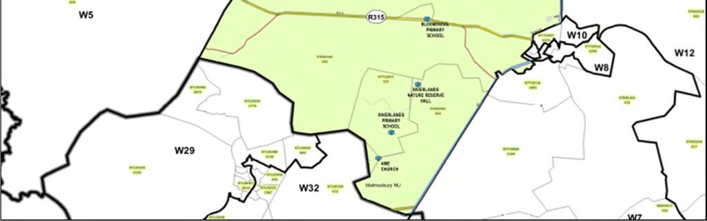
12 3 WYKSBESONDERHEDE 3 WARD DETAIL 3.1 WYK WARD 4 11
13 (a) WYKSBESKRYWING: Mount Royal golf landgoed (Malmesbury), Riverlands, Chatsworth, sowel as omringende landelike gebied noord-wes, wes en suid-wes van Malmesbury. (b) WYKSBEVOLKING 2016: (5 901 Stedelik, Landelik) (a) (b) WARD DESCRIPTION: Mount Royal golf estate (Malmesbury), Riverlands, Chatsworth, as well as the rural area north-west, west and south-west of Malmesbury. WARD POPULATION 2016: (5 901 Urban, Rural) (c) WYKSRAADSLID: Basil Stanley (c) WARD COUNCILLOR: Basil Stanley (d) LEDE VAN DIE WYKSKOMITEE / MEMBERS OF THE WARD COMMITTEE Sektor / Sector Lid / Member Adres / Address Dorp/Town Voorkeur Tel Nr Preferred Tel No Epos / Sosiale / Maatskaplike Ontwikkeling Kariema Bruiners Hutchinsonlaan 268 Chatsworth (+27) Jeugontwikkeling / Opvoeding Chantal Joy Brown Milnerstraat 1775 Chatsworth (+27) cje8706@gmail.com Munisipale dienslewering Johannes Cupido / infrastruktuur Eerstelaan 885 Chatsworth (+27) Ekonomiese ontwikkeling Jacobus Martin /Werkskepping Coetzee 1760 York Street Chatsworth (+27) Sport / Ontspanning Richard Jooste 881 Malmesbury Chatsworth (+27) rjooste07@gmail.com Kultuur / Toerisme / Omgewing Landbou- en landelike ontwikkeling (landelike dienslewering) Gesondheid / Welsyn Landbou- en landelike ontwikkeling (landelike dienslewering) Andrew Solomons John Farao Cyril John Moore Street Posbus 39 6 Arend Street Posbus Riverlands 4de Laan & Hutchinsonstraat 499 Riverlands (+27) vincorprojects@gmail.com Riverlands (+27) jfarao@sahra.org.za Chatsworth (+27) cyrilmoore17@gmail.com Julian Susan Maans Queenstraat 521 Chatsworth (+27) maansjulian@gmail.com Gemeenskapsveiligheid Frederick Mitchell 5de Laan 377 Chatsworth (+27) (e) WYK SE BELANGRIKSTE PRIORITEITE PER GOP DOELWIT / WARD S MOST IMPORTANT PRIORITIES PER IDP GOAL Die onderstaande prioriteite is verkry uit werksessies wat vanaf 30 Januarie 2017 to 8 Februarie 2017 in die onderskeie wyke gehou is. Persone wat die werksessies bygewoon het is die geleentheid gebied om per GOP doelwit op kaartjies neer te skryf wat vir hulle die belangrikste prioriteite is. Dié wat die meeste voorgekom het is hieronder gelys. The following priorities were obtained from workshops held in the respective wards from the 30 th of January to the 8 th of February Individuals attending the workshops were given the opportunity to write down the most important priorities per IDP goal. The most prevalent priorities are listed below. 12
14 Mense / People: 1. Werkskepping / Job creation 2. Meer wyksvergaderings / More ward meetings 3. Jeugontwikkelingsprogramme / Youth development programs 4. Ontspaningsfasiliteite / Recreational facilities 5. Dwelm rehabilitasie sentrum / Drug rehabilitation centre. Ekonomie / Economy: 1. Ondersteun entrepreneurskap/ Support entrepreneurship 2. Opleidingsgeleenthede / Training opportunities. 3. Petroport ontwikkeling / Petroport development 4. Ondersteun en bemark plaaslike besighede / Support and promote local businesses 5. Bevorder gemengde gebruike / Recommend mix use development Omgewing / Environment: 1. Beter beligting / More lighting 2. Parke moet opgeknap word / Parks must be renovated 3. Benodig meer bome / Need more trees. 4. Oop plotte moet opgekap word / Renovation of vacant plots 5. Verwydering van rondloper diere / Removal of stray animals. Instellings / Institutions : 1. Satelliet polisiestasie / Satellite police station 2. Biblioteek / Library 3. Opgradering van die kliniek / Upgrading of the clinic 4. Hoërskool / High school 5. Sport en ontspanningsgeriewe / Sport and recreation Dienste / Services: 1. Teer hoofstraat / Tar main road 2. Verlaag elektrisiteitstariewe / Reduce electricity tariffs 3. Better gesondheidsdienste / Beter health services. 4. Vuillisverwydering / Refuse removal 5. Skoonmaak van stormwaterstelsels / Cleaning of storm water systems (f) WYKSVERSOEKE VIR DIE 2018/2019 FINANSIËLE JAAR / WARD REQUESTS FOR THE 2018/2019 FINANCIAL YEAR Versoeke/Requests 1. Riverlands: konstruksie van n sokkerveld met gepaardgaande fasiliteite: R / Riverlands: construction of a soccer field with associated facilities: R * Daar word R per jaar oor 'n periode van 5 jaar begroot vir projekte in die onderskeie wyke. * R is budgeted annually over a period of 5 years for projects in the different wards 13


15 3.2 WYK WARD 7 14
16 (a) WYKSBESKRYWING: Kalbaskraal, Abbotsdale asook omringende landelike gebied suid en suid-oos van Malmesbury. (a) WARD DESCRIPTION: Kalbaskraal, Abbotsdale as well as the rural area south and south-east of Malmesbury. (b) WYKSBEVOLKING 2016: ( Stedelik, Landelik) (b) WARD POPULATION 2016: ( Urban, Rural) (c) WYKSRAADSLID: Valery McQuire (c) WARD COUNCILLOR: Valery McQuire (d) LEDE VAN DIE WYKSKOMITEE / MEMBERS OF THE WARD COMMITTEE Sektor / Sector Lid / Member Adres/ Address Dorp/Town Voorkeur Tel Nr Preferred Tel No Epos / Landbou- en landelike ontwikkeling (landelike dienslewering) Ismael Griffiths Posbus 409 Malmesbury (+27) Gemeenskapsveiligheid Roger C Levendall Langstraat 505 Abbotsdale (+27) Jeugontwikkeling / Opvoeding Christiaan Lewis Thembelillestraat 604 Kalbaskraal (+27) Paulina Onverwacht Kloofstraat 70 Abbotsdale (+27) paulinewhites24@gmail.com Ekonomiese Ontwikkeling / Werkskepping Beverley D Peters Leeubekkiestraat 14 Abbotsdale (+27) beverlypeters669@gmail.com Sosiale / Maatskaplike Ontwikkeling Charmaine Stallard Spoorwegstraat 158 Abbotsdale (+27) charmstallard@gmail.com Munisipale dienslewering Elizabeth Daniëls / infrastruktuur Rivierstraat 310 Kalbaskraal (+27) Johannes Uys Van Rozenburg Plaas der Westhuizen Posbus 3 Malmesbury (+27) uys@cornergate.com Sport / Ontspanning Reginald Fry Boltneystraat 1 Abbotsdale (+27) (e) WYK SE BELANGRIKSTE PRIORITEITE PER GOP DOELWIT / WARD S MOST IMPORTANT PRIORITIES PER IDP GOAL Die onderstaande prioriteite is verkry uit werksessies wat vanaf 30 Januarie 2017 to 8 Februarie 2017 in die onderskeie wyke gehou is. Persone wat die werksessies bygewoon het is die geleentheid gebied om per GOP doelwit op kaartjies neer te skryf wat vir hulle die belangrikste prioriteite is. Dié wat die meeste voorgekom het is hieronder gelys. The following priorities were obtained from workshops held in the respective wards from the 30 th of January to the 8 th of February Individuals attending the workshops were given the opportunity to write down the most important priorities per IDP goal. The most prevalent priorities are listed below. 1. Werkskepping / Job creation 2. Behuising / Housing 3. Meer wyksvergaderings / More ward meetings Mense / People: 15
17 4. Ontspaningsfasiliteite / Recreational facilities 5. Internet geriewe / Internet facilities. Ekonomie / Economy: 1. Ondersteun entrepreneurskap/ Support entrepreneurship 2. Behoefte aan n supermark / In need of a super market 3. Ruimte vir stalletjies / Space for informal trading. 4. Besigheids opleiding / Business training, 5. Bevorder industriele nodus / Promote industrial hub. Omgewing / Environment: 1. Beter beligting / More lighting 2. Parke moet opgeknap word / Parks must be renovated 3. Benodig meer bome / Needs more trees. 4. Spoedwalle in residensiële areas / Speed bumps in residential areas. 5. Bemark groentetuine / Promote vegetable gardens. Instellings / Institutions : 1. Opgradering van die kliniek / Upgrading of the clinic 2. Beter polisie dienste / Better police services 3. Biblioteek / Library 4. Kleuterskool / Crèche 5. Sport en ontspanningsgeriewe / Sport and recreation Dienste / Services: 1. Herstel van straatligte / Repairing of streetlights 2. Verlaag elektrisiteitstariewe / Reduce electricity tariffs 3. Sypaadjies / Sidewalks 4. Vuillisverwydering / Refuse removal 5. Skoonmaak van stormwaterstelsels / Cleaning of storm water systems (f) WYKSVERSOEKE VIR DIE 2018/2019 FINANSIËLE JAAR / WARD REQUESTS FOR THE 2018/2019 FINANCIAL YEAR Versoeke/Requests 1. Abbotsdale : Konstruksie van n sokkerveld met gepaardgaande fasiliteite: R / Abbotsdale : Construction of a Soccer field with associated facilities: R Reservoir by die Groendak huisies in Aandblom straat is n probleem. (Ursula Griffiths) 3. Skoolstraat/Kloofstraat Abbotsdale is n probleem daar is nie sypaadjies nie. (Ursula Griffiths) 4. Meer sigbare wetstoepassong. (Ursula Griffiths) 16
18 5. Projekte,werkskeppingsgeleenthede vir die jeug. (Rdl. V. McQuire) 6. Beligting vir die kleinhoewes se paaie in Kalbaskraal. (Rdl. V. McQuire) 7. Gemeenskapsaal of multipurpose centre virgin Kalbaskraal. (Rdl. V. McQuire) 8. Meer vullisdromme of houers in Kalbaskraal of 'n volwaardige vullisverwyderingsdiens. (Rdl. V. McQuire) * Daar word R per jaar oor 'n periode van 5 jaar begroot vir projekte in die onderskeie wyke. * R is budgeted annually over a period of 5 years for projects in the different wards 17
19 4 RUIMTELIKE ONTWIKKELINGSRAAMWERK VOORSTELLE Die Swartland Ruimtelike Ontwikkelingsraamwerk (ROR) is 'n dokument wat die nodige riglyne beleid uiteensit om ruimtelike ontwikkeling in die munisipale gebied te lei in 'n gewenste en volhoubare wyse. Die toekomstige groei, ontwikkeling en grondgebruik beplanning in die munisipale gebied moet gebaseer wees op die visie en beginsels wat ooreengekom is om ruimtelike uitdagings / probleme aan te spreek en om die skepping en ondersteuning van geïntegreerde, volhoubare en leefbare omgewings deur die skepping en ondersteuning te verseker van sosio-ekonomiese geleenthede. 4 SPATIAL DEVELOPMENT FRAMEWORK PROPOSALS The Swartland Spatial Development Framework (SDF) is a document that sets out the necessary policy guidelines to guide spatial development in the municipal area in a desirable and sustainable manner. The future growth, development and land use planning in the municipal area must be based on the vision and principles that was agreed upon to address spatial challenges/problems and to ensure the creation and support of integrated, sustainable and liveable environments through the creation and support of socio economic opportunities. 18

20 4.1 RIVERLANDS 19
21 4.2 Sone voorstelle vir Riverlands Verwys na die kaart op die voorafgaande bladsy: Die dorpsgebied van Riverlands is in agt sones (areas met gemeenskaplike kenmerke) ingedeel. Die grondgebruike soos aanbeveel vir die onderskeie sones van Riverlands is soos volg: 4.2 Zone proposals for Riverlands Refer to the map on the previous page: The urban area of Riverlands is divided into eight zones (areas with common features) and the recommended land uses for the different zones are listed in the table below: A RIVERLANDS LAND USE ZONES Zone A has a residential character with larger properties on the northern periphery. Limited infill opportunities. Low Density Residential Uses Medium Density Residential Uses High Density Residential Uses Secondary Educational Uses (i.e. Crèches/day care) Institutional Uses (i.e. Schools, places of instruction) Professional Services (i.e. Office blocks) Business Uses (i.e. shop, supermarket and service station) Secondary Business Uses (i.e Café, house shops, small offices and home occupation) Churches Institution Guest houses Authority Sport/Recreational Facilities Industrial/Service Trade & Industries B Zone B consists of institutional uses such as schools and sport fields as well as supporting transport service (taxi/bus stop) C D Zone C has a high density residential character with limited supporting commercial uses. Allow for supporting social infrastructure Zone D comprises the core of the town and areas directly surrounding the core. Flats along Activity streets Only Service trade 20
22 RIVERLANDS LAND USE ZONES 21 Low Density Residential Uses Medium Density Residential Uses High Density Residential Uses Secondary Educational Uses (i.e. Crèches/day care) Institutional Uses (i.e. Schools, places of instruction) Professional Services (i.e. Office blocks) Business Uses (i.e. shop, supermarket and service station) Secondary Business Uses (i.e Café, house shops, small offices and home occupation) Churches Institution Guest houses Authority Sport/Recreational Facilities Industrial/Service Trade & Industries E Zone E is an individual site where an industry currently operates. F Zone F is the area southeast of the access road where business functions occur and where formalisation is required. G Zone G is the area located to the southeast of the access road where informal residential functions mainly occur and where formalisation is required. Area along the activity corridor can be utilised for light industrial and service industry uses H Zone H include an informal small farmer settlement area identified as Vetkoekheuwel outside the urban edge along the Swart River. Area need to be formalised with provision of formalised access road, infrastructure and securing of land tenure. Along Activity street Only Service trade & light industries Only Service trade Service trade & light industries
23 4.3 CHATSWORTH 22
24 4.4 Sone voorstelle vir Chatsworth Verwys na die kaart op die voorafgaande bladsy: Die dorpsgebied van Chatsworth is in agt sones (areas met gemeenskaplike kenmerke) ingedeel en die grondgebruike soos aanbeveel vir die onderskeie sones volg in die onderstaande tabel: 4.4 Zone proposals for Chatsworth Refer to the map on the previous page: The urban area of Chatsworth is divided into eight zones (areas with common features) and the recommended land uses for the different zones are listed in the table below: CHATSWORTH LAND USE ZONES A Zone A is a new high density residential area with a conservation area on the northern periphery. B C D E Zone B has a low density residential character with mixed commercial uses along activity streets. Allow for infill residential development. Zone C is a low density residential area with mixed commercial uses along activity streets. Include a sport field on the southern periphery. Zone D support the Central Business district with various mixed uses including commercial and residential uses. Zone E is an area where the expansion of residential and supporting social services are proposed. Low Density Residential Uses Medium Density Residential Uses High Density Residential Uses Secondary Educational Uses (i.e. Crèches/day care) Flats along Activity street Flats along Activity street Institutional Uses (i.e. Schools, places of instruction) Professional Services (i.e. Office blocks) Business Uses (i.e. shop, supermarket and service station) At node Secondary Business Uses (i.e. Café, house shops, small offices and home occupation) Churches Institution Guest houses Authority Sport/Recreational Facilities Industrial/Service Trade & Industries 23
25 CHATSWORTH LAND USE ZONES 24 Low Density Residential Uses Medium Density Residential Uses High Density Residential Uses Secondary Educational Uses (i.e. Crèches/day care) Institutional Uses (i.e. Schools, places of instruction) Professional Services (i.e. Office blocks) Business Uses (i.e. shop, supermarket and service station) Secondary Business Uses (i.e. Café, house shops, small offices and home occupation) Churches Institution Guest houses Authority Sport/Recreational Facilities Industrial/Service Trade & Industries F Zone F is an area that is proposed for service industries to create more jobs as well as the possible establishment of a school. G Zone G is located to the north of the access road, outside the urban edge. This area is earmarked for an integrated Community node for the provision of social services that will serve both Chatsworth and Riverlands to support the integration between the communities. The existing sewerage restricts other uses in the area. H Support and activity corridor and node at the entry to town. Allow for mixed uses along the activity corridor including commercial, service trade and light industries. Multipurpose Community centre New Cemetery Sport Only Service trade & light industries Only Service trade & light industries

26 4.5 KALBASKRAAL 25
27 4.6 Sone voorstelle vir Kalbaskraal Verwys na die kaart op die voorafgaande bladsy: Die dorpsgebied van Kalbaskraal is in nege sones (areas met gemeenskaplike kenmerke) ingedeel en die grondgebruike soos aanbeveel vir die onderskeie sones volg in die onderstaande tabel: 4.6 Zone proposals for Kalbaskraal Refer to the map on the previous page: The urban area of Kalbaskraal is divided into nine zones (areas with common features) and the recommended land uses for the different zones are listed in the table below: A B C D KALBASKRAAL LAND USE ZONES Zone A is identified as the industrial node of Kalbaskraal with potential for recreational node. Zone B is a low and medium density residential area with supportive community services. Zone C mainly has a low density residential character along Diep River. The prescribed minimum erf sizes are 1000m². Zone D is a low density residential area with limited potential for densification. The prescribed minimum erf sizes are 1000m². Low Density Residential Uses Medium Density Residential Uses High Density Residential Uses Secondary Educational Uses (i.e. Crèches/day care) Institutional Uses (i.e. Schools, places of instruction) Professional Services (i.e. Office blocks) Business Uses (i.e. shop, supermarket and service station) Secondary Business Uses (i.e. Café, house shops, small offices and home occupation) Churches Institution Guest houses Authority Sport/Recreational Facilities Industrial/Service Trade & Industries Home occupation Nurseries Nurseries 26
28 KALBASKRAAL LAND USE ZONES 27 Low Density Residential Uses Medium Density Residential Uses High Density Residential Uses Secondary Educational Uses (i.e. Crèches/day care) Institutional Uses (i.e. Schools, places of instruction) Professional Services (i.e. Office blocks) Business Uses (i.e. shop, supermarket and service station) Secondary Business Uses (i.e. Café, house shops, small offices and home occupation) Churches Institution Guest houses Authority Sport/Recreational Facilities Industrial/Service Trade & Industries E Zone E is a proposed expansion area earmarked for low density residential development. The prescribed minimum erf sizes as 1000m². Sport Facility F Zone F is a high density residential area (subsidized housing). G Zone G is the Central Business District where mixed uses should mostly be encouraged. H Zone H is a high density residential area (subsidized housing). I Zone I has a residential character consisting of densification opportunities since located around the CBD. Tourism Facility Sport fields Nurseries
29 4.7 ABBOTSDALE 28
30 4.8 Sone voorstelle vir Abbotsdale Verwys na die kaart op die voorafgaande bladsy: Die dorpsgebied van Abbotsdale is in twaalf sones (areas met gemeenskaplike kenmerke) ingedeel en die grondgebruike soos aanbeveel vir die onderskeie sones volg in die onderstaande tabel: 4.8 Zone proposals for Abbotsdale Refer to the map on the previous page: The urban area of Abbotsdale is divided into twelve zones (areas with common features) and the recommended land uses for the different zones are listed in the table below: A B ABBOTSDALE LAND USE ZONES Zone A is a mixed use precinct around the N7 interchange and new access route to Abbotsdale. Zone B is part of the town s activity corridor where mostly commercial and other compatible functions are supported to enhance the node. Zone B include a restructuring zone for the provision of social housing. Low Density Residential Uses Medium Density Residential Uses High Density Residential Uses Along Activity streets Along Activity streets Secondary Educational Uses (i.e. Crèches/day care) Institutional Uses (i.e. Schools, places of instruction) Professional Services (i.e. Office blocks) Business Uses (i.e. shop, supermarket and service station) Secondary Business Uses (i.e. Café, house shops, small offices and home occupation) Churches Institution Guest houses Authority Expansion of Cemetery Sport/Recreational Facilities Industrial/Service Trade & Industries Service trade & industries C D Zone C has a low density residential character with infill development opportunities. Allow for the development of a public recreational node with formalised picnic areas along the Diep River interface. Zone D has a high density residential character which includes existing and subsidized housing development with a secondary business node. Allow for supporting social and neighbourhood Along Activity streets Along Activity streets At node Recrea tion node along the river 29
31 E F G H I ABBOTSDALE LAND USE ZONES orientated commercial services. Zone E has a low density residential character along the Diep River. Allow for densification and infill residential development. Allow for supporting social and neighbourhood orientated commercial services. Zone F is a node on the eastern bank of the Diep River that supports sport and commercial uses as well as higher density residential uses. Zone G has a low density residential character with infill development opportunities on the northern periphery. Zone H provides opportunities for service industries, transport uses and industrial development along the Old Cape Road between Malmesbury and Abbotsdale. Zone I provides opportunities for residential expansion and lower density rural living opportunities to provide for a transition zone between agricultural area and urban area. Low Density Residential Uses Medium Density Residential Uses High Density Residential Uses Along Activity streets Secondary Educational Uses (i.e. Crèches/day care) Institutional Uses (i.e. Schools, places of instruction) Along Activity streets Professional Services (i.e. Office blocks) Business Uses (i.e. shop, supermarket and service station) Secondary Business Uses (i.e. Café, house shops, small offices and home occupation) Churches Institution Guest houses Authority Sport/Recreational Facilities Sport facilities Sport fields & Recrea -tion At node Industrial/Service Trade & Industries Light industries and service trade & industries 30
32 ABBOTSDALE LAND USE ZONES 31 Low Density Residential Uses Medium Density Residential Uses High Density Residential Uses Secondary Educational Uses (i.e. Crèches/day care) Institutional Uses (i.e. Schools, places of instruction) Professional Services (i.e. Office blocks) Business Uses (i.e. shop, supermarket and service station) Secondary Business Uses (i.e. Café, house shops, small offices and home occupation) Churches Institution Guest houses Authority Sport/Recreational Facilities Industrial/Service Trade & Industries J In Zone J allow for small farmer settlement within the sterilised setback area around the Highlands Landfill site. This zone also allow for the expansion of the landfill site. No residential uses are proposed in this area K Zone K is an existing low density residential area. No expansion of the area due to the sterilised setback around the Highlands Landfill site. L Zone L covers the surrounding open space along the Diep River as well as developable land along the river between Malmesbury and Abbotsdale where low density rural living uses are proposed. The area next to the N7 is proposed for mixed uses including industrial, transport and service industries. Proposed development of public space along the Diep River by establishing picnic spots, hiking trails and bike routes. Along Activity streets Along Diep River Service trade & industries Light industries and service trade & industries
33 BYLAE 1: PLAASLIKE RUIMTELIKE ONTWIKKELINGSVOORSTELLE ANNEURE 1: LOCAL SPATIAL DEVELOPMENT PROPOSALS RIVERLANDS: Rural Settlement: Improve the mobility of local communities to allow better access to economic opportunities. Themes(T) and Strategies(S) T1 S5 T1 S5 T5 S12 T1 S1 T1 S5 T5 S12 Proposals Actions Connectivity Roads: Maintain and support the upgrade of the local movement Municipality to take pro-active role in liaising with Provincial and network including Riverlands Avenue as main activity route and National roads departments to have insight in the upgrading or route through town to the Riverlands Reserve. surrounding road networks including Riverlands Avenue that runs through Riverlands and provide access to the town off the N7, and the N7 as main route. Activity Streets (Spatial Integration): Support the development of mixed uses along the activity corridor Upgrading and beautification of Riverlands Avenue as the main along Riverlands Avenue and along identified internal activity activity corridor in Riverlands. Utilise the entry points to town as streets as identified on movement network plan to support social focal points and use tree planting, street furniture and and economic integration. pedestrian walkways to increase visual quality of the town. Beautification of main activity corridor and entry to Riverlands. Support the development of a taxi rank/bus stop in front of Introduce elements on road to reduce speed of passing vehicles school site to increase mobility of local community and provide to increase safety along this route. Use of raised pedestrian them access to economic opportunities in surrounding area. crossings and raised area around an intersection to ensure people reduce speed. Concentrate and support development of higher order uses along identified activity streets to support integration and spatial justice. Increase individual mobility of residents with provision of adequate public transport facilities. Consider Railway transport as possible alternative public transport system for the people of the Greater Chatsworth area. Pedestrian and Bicycle routes: Improve mobility in town with the provision of accessible and safe pedestrian walkways (surfaced with shaded areas and provide adequate lighting) and cycle paths. Improve accessibility of sidewalks, road crossings and pedestrian walkways for disabled people in accordance with national standards. Development of a safe and functional pedestrian walkway in town as well as between Riverlands and Chatsworth to allow for spatial integration. 32
Swartland Munisipaliteit / Municipality
 Swartland Munisipaliteit / Municipality Swartland Sentraal / Central Area Plan Malmesbury WYKE / WARDS 8, 9, 10 & 11 AREAPLAN VIR 2017/2018 25 MEI 2017 AREA PLAN FOR 2017/2018-25 MAY 2017 1 Inhoud 1 Inleiding
Provincial Gazette Provinsiale Koerant
 The Province of Mpumalanga Die Provinsie Mpumalanga Provincial Gazette Provinsiale Koerant EXTRAORDINARY BUITENGEWOON (Registered as a newspaper) (As n nuusblad geregistreer) NELSPRUIT Vol. 24 24 NOVEMBER
MULTI-NODAL TRANSPORT INTERCHANGE HUB M A R A B A S T A D
 MULTI-NODAL TRANSPORT INTERCHANGE HUB M A R A B A S T A D University of Pretoria FIG A_Thesis intervention placed in the Integrated Urban Design Framework for Marabastad framework by Aziz Tayob MULTI-NODAL
14.5 HOPEFIELD: (REFER PLAN 39 AND PLAN 40)
") URBAN DYNAMICS WESTERN CAPE INC. 248 14.5 HOPEFIELD: (REFER PLAN 39 AND PLAN 40) FIGURE 83: LOCALITY - HOPEFIELD Within the context of the Saldanha Bay Municipal area, Hopefield, an historical agricultural
URBAN DYNAMICS WESTERN CAPE INC. 248 14.5 HOPEFIELD: (REFER PLAN 39 AND PLAN 40) FIGURE 83: LOCALITY - HOPEFIELD Within the context of the Saldanha Bay Municipal area, Hopefield, an historical agricultural
Hi-Performance Sport Centre Centurion
 Hi-Performance Sport Centre Submitted in fulfilment of part of the requirements for the degree of Master of Architecture in the Faculty of Engineering, Built Environment and Information Technology, University
MATZIKAMA MUNICIPALITY WYK 1/WARD1 WYKSPLAN/WARD PLAN LUTZVILLE & LUTZVILLE- WES MEI 2016/MAY 2016
 MATZIKAMA MUNICIPALITY WYK 1/WARD1 WYKSPLAN/WARD PLAN LUTZVILLE & LUTZVILLE- WES MEI 2016/MAY 2016 0 1 INHOUDSOPGAWE CONTENTS 1. INLEIDING EN DOEL VAN WYKSPLAN 1. INTRODUCTION AND PURPOSE OF WARD PLAN
Performance of Rootstock Cultivars in the Avocado Phase II Evaluation Programme: 1997
 South African Avocado Growers Association Yearbook 1998. 21:13-18 Performance of Rootstock Cultivars in the Avocado Phase II Evaluation Programme: 1997 A.D. Sippel, C.W. Matsha & Z. Bijzet ARC-lnstitute
WORCESTER/WYZERSDRIFT UPGRADE OF 20.7KM OF MAIN ROAD 298 BASIC ASSESSMENT (REF: 16/3/1/1/B2/32/1090/12) COMMENTS ON THE BID, ADVERT AND REGISTRATION
 COMMENTS ON THE BID, ADVERT AND REGISTRATION") WORCESTER/WYZERSDRIFT UPGRADE OF 20.7KM OF MAIN ROAD 298 BASIC ASSESSMENT (REF: 16/3/1/1/B2/32/1090/12) ON THE BID, ADVERT AND REGISTRATION (CRR January & February 2013) Comments have been received from
WORCESTER/WYZERSDRIFT UPGRADE OF 20.7KM OF MAIN ROAD 298 BASIC ASSESSMENT (REF: 16/3/1/1/B2/32/1090/12) ON THE BID, ADVERT AND REGISTRATION (CRR January & February 2013) Comments have been received from
SOCIO-ECONOMIC MOVEMENT ENVIRONMENT INFRASTRUCTURE TOWN PLANNING
 Table 7: SWOT Analysis SWOT ANALYSIS SOCIO-ECONOMIC MOVEMENT ENVIRONMENT INFRASTRUCTURE TOWN PLANNING STRENGTHS HIGH COMMUTER POPULATION DENSITY MAJORITY OF POPULATION BETWEEN AGE OF 15 & 34 LARGE AVAILABLE
Irmé van Zyl Privaat Posbus 567, Upington Jangroentjieweg 4, Keidebees, Upington
 Irmé van Zyl Privaat Posbus 567, Upington 8800 Jangroentjieweg 4, Keidebees, Upington 8801 ibvanzyl@telkomsa.net 072 222 6194 086 624 0306 Afrikaans Ek is geïnterreseerd in die projek Ja, die visuele impak
The planning and development of childfriendly green spaces in urban South. Africa
 The planning and development of childfriendly green spaces in urban South Africa Z Goosen 22095128 Dissertation submitted in fulfillment of the requirements for the degree Magister Artium Scientiae in
Official Plan Review
 Official Plan Review Summary Report - The Built Environment August 2014 Part 1: Introduction Planning for a healthy, prosperous and sustainable community is an important goal for our municipality. From
Further studies on leaf blackening of proteas
 Further studies on leaf blackening of proteas By Anton Ferreira Thesis presented in partial fulfillment of the requirements for the degree of Master in Science in Agriculture in the Department of Horticultural
UDF PLANS AND GUIDELINES
 UDF PLANS AND GUIDELINES 5 Land Use Land Use Development Plan Plan no. 3 Land Use Development Mixed Use Retail / Leisure Residential Civic and Institutional Proposed Zoning Table Development Edges Plan
Town of Peru Comprehensive Plan Executive Summary
 Town of Peru Comprehensive Plan Executive Communities that plan grow by choice, not by chance. A plan makes growth thoughtful, understandable, and predictable. A plan shows that a community is managing
ESTABLISHMENT OF A 300MW WIND FARM AND ASSOCIATED INFRASTRUCTURE ON A SITE NEAR KLEINZEE, NORTHERN CAPE PROVINCE DEA Ref No.
 NOTICE OF ENVIRONMENTAL IMPACT ASSESSMENT PROCESS PUBLIC PARTICIPATION PROCESS ESTABLISHMENT OF A 300MW WIND FARM AND ASSOCIATED INFRASTRUCTURE ON A SITE NEAR KLEINZEE, NORTHERN CAPE PROVINCE DEA Ref No.
An a t o m y 101: A Hu m a n An a t o m y Ce n t r e. by Janes Botha
 An a t o m y 101: A Hu m a n An a t o m y Ce n t r e at the Tshwane District Hospital: Pretoria by Janes Botha University of Pretoria ABSTRACT Abstract Interior design has a social responsibility. To facilitate
Outline of Presentation
 LUSAKA CITY COUNCIL 2 nd Annual IGC Cities Conference Making Cities work for growth London School of Economics (LSE) United Kingdom. 28 th 29 th January 2016 Presenter: Alex Mwansa Town Clerk Lusaka City
Rappid K POTASSIUM POLYPHOSPHATE KALIUM POLIFOSFAAT FERTILIZER GROUP 1 MISSTOF GROEP 1
 Rappid K POTASSIUM POLYPHOSPHATE KALIUM POLIFOSFAAT Composition/ Samestelling: Phosphorus (P) Fosfor 76 g/kg Potassium (K) Kalium 133 g/kg SG 1.3 to 1.38 @ 20⁰ C Product ph: 6.50 7.00 FERTILIZER GROUP
Cape Environmental Assessment Practitioners (Pty) Ltd
 Ltd") Cape Environmental Assessment Practitioners (Pty) Ltd Reg. No. 2008/004627/07 VAT No 4720248386 Telephone: (044) 874 0365 1 st Floor Eagles View Building Facsimile: (044) 874 0432 5 Progress Street, George
Cape Environmental Assessment Practitioners (Pty) Ltd Reg. No. 2008/004627/07 VAT No 4720248386 Telephone: (044) 874 0365 1 st Floor Eagles View Building Facsimile: (044) 874 0432 5 Progress Street, George
ONTWERP GRAAD
 ONTWERP EKSAMENRIGLYNE GRAAD 12 2009 Hierdie riglyne bestaan uit 21 bladsye. Ontwerp/V2 2 DoE/Eksamenriglyne 2009 NSC INLEIDING Die nuwe Nasionale Kurrikulum het 'n hele aantal uitdagings vir onderwysers
Forestry and pastures. Marangatu Sementes
 Forestry and pastures Marangatu Sementes ATTENTION MANAGEMENT STANDARDS & INSTRUCTIONS This is a perishable product and requires special care. The following procedures are suggested: 1)
Edward R. Sajecki Commissioner of Planning and Building
 Corporate Report Clerk s Files Originator s Files CD.03.POR DATE: TO: FROM: SUBJECT: Chair and Members of Planning and Development Committee Meeting Date: February 27, 2012 Edward R. Sajecki Commissioner
13 THORNHILL YONGE STREET STUDY IMPLEMENTATION CITY OF VAUGHAN OPA 669 AND TOWN OF MARKHAM OPA 154
 13 THORNHILL YONGE STREET STUDY IMPLEMENTATION CITY OF VAUGHAN OPA 669 AND TOWN OF MARKHAM OPA 154 The Planning and Economic Development Committee recommends the adoption of the recommendations contained
Planning Districts INTRODUCTION
 INTRODUCTION To facilitate detailed examination of development prospects for all areas of the community, Delano has been divided into 14 planning districts. The location of these planning districts is
YONGE STEELES CORRIDOR SECONDARY PLAN. Young + Wright / IBI Group Architects Dillon Consulting Ltd. GHK International (Canada) Ltd.
 Ltd.") PART A: PREAMBLE 1.0 PURPOSE The purpose of this Secondary Plan is to provide a development framework for intensification of the Yonge/ Steeles corridor including the north side of Steeles Avenue West
PART A: PREAMBLE 1.0 PURPOSE The purpose of this Secondary Plan is to provide a development framework for intensification of the Yonge/ Steeles corridor including the north side of Steeles Avenue West
Growing urban ecosystems: A food market in Menlyn
 Growing urban ecosystems: A food market in Menlyn by Fransa van Zyl STUDY LEADER: Marga Viljoen Jacques Laubsher STUDIO MASTER: Jacques Laubsher University Of Pretoria 2011 Submitted in partial fulfilment
WELCOME and introduction
 1 WELCOME and introduction Mobility Hub Locations within Burlington STUDY OVERVIEW STUDY OBJECTIVES The City of Burlington is developing four Area Specific Plans, one for each of Burlington s Mobility
HARTENBOS NORTH (population: Census 2011)
") 5.8 HARTENBOS NORTH (population: + 184 Census 2011) Figure 5.8.1.1 Hartenbos North: Aerial photograph CNdV africa (Pty) Ltd DRAFT CONCEPTUAL DEVELOPMENT FRAMEWORK REPORT page 439 5.8.1 SPATIAL ANALYSIS,
5.8 HARTENBOS NORTH (population: + 184 Census 2011) Figure 5.8.1.1 Hartenbos North: Aerial photograph CNdV africa (Pty) Ltd DRAFT CONCEPTUAL DEVELOPMENT FRAMEWORK REPORT page 439 5.8.1 SPATIAL ANALYSIS,
VILLAGE OF BOLTON HERITAGE CONSERVATION DISTRICT PLAN
 Page 1 1. INTRODUCTION AND BACKGROUND 1.1 THE PROJECT VILLAGE OF BOLTON HERITAGE CONSERVATION DISTRICT PLAN TERMS OF REFERENCE The Town of Caledon (Town) is a large, predominantly rural municipality with
6 Growth Management Challenges and Opportunities
 6 Growth Management Challenges and Opportunities The Town has established a goal of attaining a 50% participation rate with respect to employment opportunities versus residential population. The Town s
Complete Neighbourhood Guidelines Review Tool
 Complete Neighbourhood Guidelines Review Tool Prepared By: City of Regina Planning Department October 2014 Page 1 of 14 Community Development Review Checklist for Secondary Plans and Concept Plans The
CITY OF LANGLEY OFFICIAL COMMUNITY PLAN BYLAW, 2005, NO APPENDIX II - REGIONAL CONTEXT MAP
 CITY OF LANGLEY OFFICIAL COMMUNITY PLAN BYLAW, 2005, NO. 2600 APPENDIX II - REGIONAL CONTEXT MAP ± Legend Agricultural Mixed Employment Industrial Conservation & Recreation Regional City Centre Urban Containment
Grow Your Own Vegetables. Kweek Jou Eie Groente
 Grow Your Own Vegetables Kweek Jou Eie Groente Dora du Plessis 2010 Dora du Plessis www.goodbugs.co.za dora@goodbugs.co.za 082 635 0215 Compost Trench-beds A compost trench-bed is an inexpensive way of
TOWNSHIP REPLANNING: THE CASE OF INK CASE STUDY
 TOWNSHIP REPLANNING: THE CASE OF INK CASE STUDY OVERVIEW Background Origins of the INK project Local context Problem statement Intervention logic City scale spatial planning context Results Lessons learned
ELK GROVE GENERAL PLAN VISION
 2-1 CHAPTER 2: 2-2 CREATING OUR The Community Vision for Elk Grove, expressed through a Vision Statement and a series of Supporting Principles, is a declaration of the kind of community that Elk Grove
Northern Territory Compact Urban Growth Policy
 Northern Territory Compact Urban Growth Policy A Reference Policy Document to clause 2.7 (Reference to Policy) of the NT Planning Scheme May 2015 Table of Contents 1 Policy Setting... 3 1.1 Context for
Planning Primer Legislative Background, Policy Documents and Development Review Processes. Presented by: Planning Services Date: April 6, 2017
 Planning Primer Legislative Background, Policy Documents and Development Review Processes Presented by: Planning Services Date: April 6, 2017 Agenda Legislative Background 7:30 to 8:00 pm Questions 8:00
SCARBOROUGH SUBWAY EXTENSION. Scarborough Subway Extension. Final Terms of Reference
 Scarborough Subway Extension Final Terms of Reference 1 1.0 Introduction and Background 1.1 Introduction Toronto City Council recently confirmed support for an extension of the Bloor-Danforth Subway from
Smart Growth Development Checklist
 2004 Smart Growth Development Checklist Smart Growth Development Checklist Corporation of the City of New Westminster Guide and manage growth in a manner which is consistent with the principles of sustainable
WORCESTER/WYZERSDRIFT UPGRADE OF 20.7KM OF MAIN ROAD 298 BASIC ASSESSMENT (REF: 16/3/1/1/B2/32/1090/12) COMMENTS ON THE BID, ADVERT AND REGISTRATION
 COMMENTS ON THE BID, ADVERT AND REGISTRATION") WORCESTER/WYZERSDRIFT UPGRADE OF 20.7KM OF MAIN ROAD 298 BASIC ASSESSMENT (REF: 16/3/1/1/B2/32/1090/12) ON THE BID, ADVERT AND REGISTRATION (CRR January to August 2013) Comments have been received from
WORCESTER/WYZERSDRIFT UPGRADE OF 20.7KM OF MAIN ROAD 298 BASIC ASSESSMENT (REF: 16/3/1/1/B2/32/1090/12) ON THE BID, ADVERT AND REGISTRATION (CRR January to August 2013) Comments have been received from
A BLUEPRINT FOR BROCKTON A CITY-WIDE COMPREHENSIVE PLAN
 A BLUEPRINT FOR BROCKTON A CITY-WIDE COMPREHENSIVE PLAN Public Meeting October 2016 1 Plan Summary and Discussion Public Meeting May 4 2017 City of Brockton Bill Carpenter, Mayor Department of Planning
K. SMART ASSOCIATES LIMITED
 Planning Justification Report Zoning By-Law Amendment 185 King Street North Waterloo, Ontario April 7th, 2017 Project Reference Number 16-245 K. SMART ASSOCIATES LIMITED CONSULTING ENGINEERS AND PLANNERS
Introduction. Chapter 1. Purpose of the Comprehensive Plan Plan Organization Planning Process & Community Input 1-1
 Chapter 1 Introduction Lakewood 2025: Moving Forward Together Purpose of the Comprehensive Plan Plan Organization Planning Process & Community Input 1-1 Purpose of the Comprehensive Plan The Comprehensive
page 258 THE OLIFANTS RIVER VALLEY
 page 258 THE OLIFANTS RIVER VALLEY page 259 page 260 5.10 VREDENDAL (population: ± 20 400) (IDP 2012-2017) 5.10.1 SPATIAL ANALYSIS, see Figures 5.101.1 Sub-regional location Vredendal is located at the
Brampton. Secondary Plan. Review. Bram West. A New Direction in Planning & Public Consultation
 Brampton Bram West Secondary Plan Review A New Direction in Planning & Public Consultation Introduction The Bram West Secondary Plan Review offers an important opportunity for the community to define a
SECTION ONE: INTRODUCTION. introduction
 introduction 1 INTRODUCTION Since it was first established in 1843 as a trading post for the Hudson s Bay Company, Victoria has evolved into a Provincial capital city that is recognized across Canada and
CITY CLERK. Parkland Acquisition Strategic Directions Report (All Wards)
") CITY CLERK Clause embodied in Report No. 10 of the, as adopted by the Council of the City of Toronto at its meeting held on November 6, 7 and 8, 2001. 10 Parkland Acquisition Strategic Directions Report
CITY CLERK Clause embodied in Report No. 10 of the, as adopted by the Council of the City of Toronto at its meeting held on November 6, 7 and 8, 2001. 10 Parkland Acquisition Strategic Directions Report
Corridor Vision. 1Pursue Minnehaha-Hiawatha Community Works Project. Mission of Hennepin County Community Works Program
 1Pursue Minnehaha-Hiawatha Community Works Project Minnehaha-Hiawatha Community Works is a project within the Hennepin Community Works (HCW) program. The mission of the HCW program is to enhance how the
ELMVALE ACRES SHOPPING CENTRE MASTER PLAN
 ELMVALE ACRES SHOPPING CENTRE MASTER PLAN Contents 1.0 INTRODUCTION... 2 2.0 LOCATION... 2 3.0 EXISTING CONTEXT... 2 4.0 VISION & GUIDING PRINCIPLES... 2 5.0 LAND USE AND BUILT FORM... 4 5.1 St. Laurent
Figure 1- Site Plan Concept
 Figure 1- Site Plan Concept Parking will be provided underground on three levels at rate of 1.0 space/ unit; this rate includes all visitors parking. MMM Group has prepared a parking assessment (April,
1.0 Purpose of a Secondary Plan for the Masonville Transit Village
 Report to Planning and Environment Committee To: Chair and Members Planning & Environment Committee From: John M. Fleming Managing Director, Planning and City Planner Subject: Masonville Transit Village
The protection of the agricultural resources of the Province;
 PART II INTRODUCTION An Official Plan is a policy document, which is intended to serve as the basis for making land use decisions and managing change in any municipality in Ontario. According to the Planning
CDAC. Update: Downtown Dartmouth Update: CDAC July 25 th Motion
 CDAC Update: Downtown Dartmouth Update: CDAC July 25 th Motion 2018-10-24 Downtown Dartmouth Plan Open House October 22, 2018 6:00 pm Open House 6:30 pm Presentation + Q&A 7:20 pm Open House 8:30 pm Close
Draft Western District Plan
 Powered by TCPDF (www.tcpdf.org) Draft Western District Plan Submission_id: 31440 Date of Lodgment: 15 Dec 2017 Origin of Submission: Online Organisation name: Goodman Property Services Australia Pty Ltd
The Corporation of the TOWN OF MILTON
 Report to: From: Chair & Members of the Administration & Planning Standing Committee W.F. Mann, Director of Planning and Development Date: April 16, 2012 PD 022-12 (Z19/11) Subject: Technical Report Proposed
PART 1. Background to the Study. Avenue Study. The Danforth
 The Danforth 1.1/ Study Purpose & Key Municipal Goals 1.2/ The Local Advisory Committee 1.3/ The Project Team 1.4/ Study Process/Summary of Method 1.5/ Summary of Consultation 1.1 Study Purpose and Key
5 TOWN OF MARKHAM OFFICIAL PLAN AMENDMENT NO. 144 MILLIKEN MAIN STREET SECONDARY PLAN
 5 TOWN OF MARKHAM OFFICIAL PLAN AMENDMENT NO. 144 MILLIKEN MAIN STREET SECONDARY PLAN The Planning and Economic Development Committee recommends the following: 1. The communication from Brendan O Callaghan,
Regional Context Statement
 Regional Context Statement REGIONAL CONTEXT STATEMENT 3. REGIONAL CONTEXT STATEMENT In 1995, the Provincial Government passed into law the Growth Strategies Act. The purpose of this provincial initiative
SECTION ONE North East Industrial Zone Design Guide Palmerston North City Council June 2004
 SECTION ONE North East Industrial Zone Design Guide Palmerston North City Council June 2004 young heart easy living 1 Preface Industrial areas are a very important component of the economic well-being
PHASE 1 ARCHAEOLOGICAL IMPACT ASSESSMENT THE PROPOSED SWARTLAND SHOPPING MALL
 10 ( PHASE 1 ARCHAEOLOGICAL IMPACT ASSESSMENT THE PROPOSED SWARTLAND SHOPPING MALL Remainder Farm Tweefontein No. 696, Erf 2654 (Portion of Erf 327), Erf 9215 (Portion of Erf 2654) & Portion of Erf 327
Organic Agricultural Chemical Products
 Organic Agricultural Chemical Products 2018/08/07 & 8 - Berakah Presentation at Agri Gauteng Expo 2018 (09:30; 11:30; 13:30) sales@berakahbizdev.co.za +27 87 802 2397 (Berakah HQ) +27 86 615 7278 (Fax)
SUBJECT: Proposed Downtown Mobility Hub Precinct Plan and Proposed Official Plan Policies
 Page 1 of Report PB-81-17 SUBJECT: Proposed Downtown Mobility Hub Precinct Plan and Proposed Official Plan Policies TO: FROM: Committee of the Whole Planning and Building Department Report Number: PB-81-17
Community Open House March 26 th, 2018
 Community Open House March 26 th, 2018 Open House Agenda 1. Overview of Planning Process What we heard 2. Future Land Use Policy 3. Priority Growth Areas 4. Plan Elements Making it happen What is a Comprehensive
3. Endorse the LRT vision in transforming Surrey into Connected-Complete-Livable communities, and more specifically, the official vision statement:
 CORPORATE REPORT NO: R038 COUNCIL DATE: February 20, 2017 REGULAR COUNCIL TO: Mayor & Council DATE: February 16, 2017 FROM: General Manager, Engineering FILE: 8740-01 SUBJECT: Surrey Light Rail Transit
Transforming Saint John s Urban Heart -
 Transforming Saint John s Urban Heart - How Innovative Community Engagement Inspires a Bold Municipal Plan for a More Sustainable and Compact Saint John 2012 NNECAPA Conference - Brunswick, ME October
THE CORPORATION OF THE TOWN OF OAKVILLE BY-LAW NUMBER
 THE CORPORATION OF THE TOWN OF OAKVILLE BY-LAW NUMBER 20012-08530 A by-law to adopt an amendment to the Official Plan of the Oakville Planning Area (Official Plan Amendment 198) Land North of Dundas Street.
Public Open House. Overview of the Downtown Plan Official Plan Amendment April 23, 2018
 Public Open House Overview of the Downtown Plan Official Plan Amendment April 23, 2018 1 A 25-Year Plan for Downtown To ensure growth contributes positively to Toronto s Downtown as a great place to live,
WELCOME. The Yonge-Eglinton area has experienced significant growth and change in the last decade.
 WELCOME DID YOU KNOW? MIDTOWN IS REPRESENTED BY 3 CITY COUNCILLORS: WARD 16 EGLINTON-LAWRENCE WARD 22 ST. PAUL S WARD 25 DON VALLEY WEST Midtown in Focus: Building a Livable Yonge-Eglinton The Yonge-Eglinton
This page has been intentionally left blank.
 This page has been intentionally left blank. Chapter 3 3-2 3. Employment 3.A Niagara Economic Gateway 3.A.1 General The Niagara Economic Gateway comprises: a) The Gateway Economic Zone which includes all
EXECUTIVE SUMMARY DRAFT CHAPTER 1 INTRODUCTION EXECUTIVE SUMMARY
 CHAPTER 1 EXECUTIVE SUMMARY INTRODUCTION Through the joint efforts of the City of Tulsa planning staff and the Land Services division of Indian Nations Council of Governments (INCOG), the Berryhill Land
Report to: Development Services Committee Report Date: April 24, 2017
 SUBJECT: Cornell Rouge National Urban Park Gateway - Report on Design Charrette and Next Steps PREPARED BY: Lilli Duoba, MES, MCIP, RPP, Manager, Natural Heritage (ext. 7925) REVIEWED BY: Marg Wouters,
4 RESIDENTIAL ZONE. 4.1 Background
 4 RESIDENTIAL ZONE 4.1 Background The residential areas within the City are characterised by mainly lowrise dwellings sited on individual allotments. Past architectural styles, settlement patterns and
Public Participation in Urban Planning Case of Lilongwe, Malawi
 Lilongwe City Council Public Participation in Urban Planning Case of Lilongwe, Malawi PRESENTED AT THE LILONGWE INTERNATIONAL MAYORS FORUM(LIMF). 16 TH TO 18 TH May, 2018. Dr. Desmond W. Bikoko, Ph.D LILONGWE
The Integrated Transport Plan: Non-motorised Transport in the City of Cape Town (1979) 1
 1") Integrating the Bicycle in Comprehensive Policies The Integrated Transport Plan: Non-motorised Transport in the City of Cape Town (1979) 1 The 1980-1985 Transport Plan for Cape Town Metropolitan Transport
Integrating the Bicycle in Comprehensive Policies The Integrated Transport Plan: Non-motorised Transport in the City of Cape Town (1979) 1 The 1980-1985 Transport Plan for Cape Town Metropolitan Transport
Sustainably Repositioning Greyfield Sites. Greyfield Sites Anywhere
 Sustainably Repositioning Greyfield Sites Jim Constantine Looney Ricks Kiss Architects Todd Poole 4ward Planning Greyfield Sites Anywhere Pennsylvania Chapter American Planning Association Conference 2009
A Growing Community Rural Settlement Areas
 Town of Huntsville Official Plan Review - POLICY BACKGROUND PAPER A Growing Community Rural Settlement Areas BACKGROUND: In addition to the fully municipally-serviced Urban Settlement Area and the Hidden
Further input invited as Colchester Growth Strategy nears final phase
 IUE 3 / NOVEMBER 2015 Further input invited as Colchester Growth trategy nears final phase trathcona County is seeking public feedback as it enters the final phase of work on a Growth Management trategy
HUMOX. A concentrated Liquid Soil Conditioner made from renewable plant-derived organic matter containing fulvic acid.
 HUMOX A concentrated Liquid Soil Conditioner made from renewable plant-derived organic matter containing fulvic acid. FERTILIZER GROUP 2 / MISSTOF GROEP 2 Registration number B 4769 Act 36 of 1947 Registrasienommer
Concord Community Reuse Project Goals and Guiding Principles. Overarching Goals (OG)
") Concord Community Reuse Project Goals and Guiding Principles Overarching Goals (OG) No priority is implied by the order of presentation of the goals and guiding principles. Overarching goals for the Concord
Concord Community Reuse Project Goals and Guiding Principles Overarching Goals (OG) No priority is implied by the order of presentation of the goals and guiding principles. Overarching goals for the Concord
Urban, Economic and Social Development Plan (PDUES) For the Marconi Alexandra, Atlantic, Beaumont, De Castelnau Sectors
 For the Marconi Alexandra, Atlantic, Beaumont, De Castelnau Sectors") Urban, Economic and Social Development Plan (PDUES) For the Marconi Alexandra, Atlantic, Beaumont, De Castelnau Sectors Public Consultation Information Session March 11 & 13, 2013 1 Presentation Plan 1.
Urban, Economic and Social Development Plan (PDUES) For the Marconi Alexandra, Atlantic, Beaumont, De Castelnau Sectors Public Consultation Information Session March 11 & 13, 2013 1 Presentation Plan 1.
URBAN DESIGN BRIEF URBAN DESIGN BRIEF 721 FRANKLIN BLVD, CAMBRIDGE August 2018
 URBAN DESIGN BRIEF URBAN DESIGN BRIEF 721 FRANKLIN BLVD, CAMBRIDGE August 2018 DESIGN BRIEF CONTENTS PART A 1.0 INTRODUCTION 2.0 DESCRIPTION & ANALYSIS OF SITE CONTEXT 3.0 DESIGN CONSTRAINTS AND OPPORTUNITIES
Variation No 1: Dundalk & Environs Development Plan Core Strategy
 Variation No 1: Dundalk & Environs Development Plan 2009-2015 Core Strategy Adopted on 29 th August 2011 CONTENTS Page Section 1 1.0 Synopsis 1 1.1 Background Document 1 1.2 Variation of Dundalk and Environs
2040 LUP is a part of the Comprehensive Plan and carries the same legal authority. Economic Challenges
 1.1. Guiding Anchorage s Growth Where will new residents settle over the next two decades? Where will people work, shop, and play? Will there be enough room to grow? How will Anchorage look? Will growth
Chapter 3 Core Strategy
 Chapter 3 Core Strategy 3.0 Introduction The core strategy sets out how the development objectives in the Development Plan are consistent with the National Spatial Strategy and the Regional Planning Guidelines.
Recent UN and EU Sustainable Development Policies (Post 2015): What challenges for city planning and governance
: What challenges for city planning and governance") Recent UN and EU Sustainable Development Policies (Post 2015): What challenges for city planning and governance Europe at a crossroads: the challenge for future sustainable development 20 July 2016 Roudaina
Recent UN and EU Sustainable Development Policies (Post 2015): What challenges for city planning and governance Europe at a crossroads: the challenge for future sustainable development 20 July 2016 Roudaina
ESTABLISH AN EFFICIENT TOWN CENTER
 ESTABLISH AN EFFICIENT TOWN CENTER 4 Overview Lisbon residents are proud of the history of Newent and at the same time recognize its current importance as a centralized location for a variety of municipal
SUMMARY. An Attractive, Competitive and Sustainable GREATER MONTREAL. Draft Metropolitan Land Use and Development Plan. April 2011
 April 2011 Draft Metropolitan Land Use and Development Plan GREATER MONTREAL An Attractive, Competitive and Sustainable SUMMARY Message from the Chair I am pleased to introduce this draft of the Metropolitan
PLAN ELEMENTS WORKSHOP. April 5, 2016
 PLAN ELEMENTS WORKSHOP April 5, 2016 needs more housing. But there is no one-size fits-all solution. Every neighborhood has its own character. In some places, density is not only appropriate it is badly
SOIL DEPTH: THE THIRD DIMENSION
 South African Avocado Growers Association Yearbook 1988. 11:23-24 SOIL DEPTH: THE THIRD DIMENSION R O BARNARD 1 and M J SLABBERT 2 1 Department of Soil Science and Plant Nutrition, University of Pretoria,
3. VISION AND GOALS. Vision Statement. Goals, Objectives and Policies
 Vision Statement Queen Creek s interconnected network of parks, trails, open spaces and recreation opportunities provide safe and diverse activities and programs that sustain its unique, small town, equestrian
CITY OF UNION CITY MINUTES GENERAL PLAN ADVISORY COMMITTEE
 CITY OF UNION CITY MINUTES GENERAL PLAN ADVISORY COMMITTEE WEDNESDAY, MARCH 4, 2015, 6:30 P.M. IN THE CITY COUNCIL CONFERENCE ROOM OF CITY HALL 34009 ALVARADO-NILES BLVD., UNION CITY, CALIFORNIA Attachment
28. Coolaney-Rockfield Mini-Plan
 28. Coolaney-Rockfield Mini-Plan 28. Coolaney-Rockfield Mini-Plan Community facilities Community facilities in Coolaney-Rockfield consist of a primary school, crèche, community centre, sports field and
Volume 2: Implementation Plan
 Volume 2: Implementation Plan February 25 th 2002 Implementation Introduction This document outlines the steps that should be taken to implement the Washington Heights Neighborhood Plan. The City Council
9 CITY OF VAUGHAN OFFICIAL PLAN AMENDMENT NO BOCA EAST INVESTMENTS LIMITED
 9 CITY OF VAUGHAN OFFICIAL PLAN AMENDMENT NO. 631 - BOCA EAST INVESTMENTS LIMITED The Planning and Economic Development Committee recommends the adoption of the recommendations contained in the following
MAYFIELD WEST SECONDARY PLAN PHASE 2
 MAYFIELD WEST SECONDARY PLAN PHASE 2 Public Open House #3 February 25, 2010 Draft Preferred Land Use Scenario TOWN OF CALEDON PLANNING & DEVELOPMENT DEPARTMENT Open House Agenda TOWN OF CALEDON 1. Welcome
CONTENTS 2.0 A FRAMEWORK FOR SUSTAINABLE GROWTH 2.1 MANAGING SUSTAINABLE GROWTH THE VISION TO GOALS AND OBJECTIVES 2.3 MARKHAM STRUCTURE
 2 A Framework for Sustainable Growth 2.0 A FRAMEWORK FOR SUSTAINABLE GROWTH CONTENTS 2.1 MANAGING SUSTAINABLE GROWTH THE VISION TO 2031 2.2 GOALS AND OBJECTIVES 2.2.1 Protecting the Natural Environment
Kibworth Harcourt. Introduction. Introduction
 Introduction Introduction Welcome to this public exhibition on the proposals for the delivery of new homes on land at The Kibworths. The purpose of today s exhibition is to give you the opportunity to
South of Eastern Strategic Direction Status Update
 STAFF REPORT ACTION REQUIRED South of Eastern Strategic Direction Status Update Date: July 10, 2014 To: From: Planning and Growth Management Committee Chief Planner and Executive Director, City Planning
The Urban Regeneration of Historic Cairo Towards a Management Plan for Conservation and Regeneration The UNESCO technical assistance project
 The Urban Regeneration of Historic Cairo Towards a Management Plan for Conservation and Regeneration The UNESCO technical assistance project Daniele Pini Department of Architecture, University of Ferrara