Land Use. 3. Fringe Development Pattern: What land use pattern should the City seek to achieve on its perimeter?
|
|
|
- Cassandra Walters
- 5 years ago
- Views:
Transcription
1 The Land Use Chapter provides guidance for public and private decisions about the future use of land and the structures built upon the land. The chapter addresses all land currently within the City, as well as land presently outside of the City, but which may be annexed into the City in the foreseeable future or which may influence the growth of the City. The purpose of the chapter is to encourage the orderly development of Eau Claire, create an attractive and efficient urban environment for the benefit of the larger urban area, and protect the City s capacity for the future expansion of its tax base. The chapter includes both a map of the preferred land use pattern, and the set of related objectives and policies needed to achieve the desirable long-term future for the Eau Claire community. The key provisions of the other chapters of the Comprehensive Plan critical to the physical development of Eau Claire are integrated into the Land Use policies. The Land Use Chapter translates the community vision for future growth into a recommended physical pattern of neighborhoods, commercial and industrial areas, roads, and public facilities. Land Use policies seek to influence the location, type, amount, and timing of future growth through private real estate development, public investment in infrastructure and community facilities, and conservation of natural areas. In addition, the chapter policies are intended to ensure that the environment and other long-term public interests are given adequate consideration, and to prevent or mitigate the negative effects of incremental, ad hoc, and laissez-faire market decisions. The Land Use Chapter will be used by the City in making decisions about annexations, private development proposals, and the location, size, and timing of public improvements. The chapter will also be the basis for preparing more specific sub-area or sketch plans for smaller subsections of the community, such as residential neighborhoods, business districts or key perimeter future growth areas. The chapter objectives and policies will be implemented through intergovernmental agreements with adjacent government jurisdictions, through the City s Zoning and Subdivision Ordinances, and through the administration of those ordinances by the City Council, Plan Commission, and City staff. However, the Land Use Chapter should not be construed as a final blueprint for specific site development, nor a prospective zoning map. The identification of preferred land uses does not imply that rezoning a specific area is immediately appropriate. While the Zoning and Subdivision Ordinances must be consistent with the Comprehensive Plan, the rezoning process is separate from the planning process and must consider the timing of zoning decisions, availability of similar land, and the impact of the rezoning decision on other City goals, objectives, and policies. Comprehensive Plan 2-1 Adopted 27 September 2005
2 Key Issues 1. Regional Coordination of Growth: What should the City of Eau Claire do to encourage other jurisdictions to support land use planning and zoning policies that result in cost-effective and compact urban development in the metropolitan area, rather than patterns of low density, unsewered, semi-urban lots? 2. Sanitary Sewer System Control: What should the City of Eau Claire do to ensure more effective coordination of annexations, sewer service extensions, and timely urban development? What adjustments should the City seek in the Urban Sewer Service Area Boundary to accommodate jurisdictional boundary changes and projected future growth areas? 3. Fringe Development Pattern: What land use pattern should the City seek to achieve on its perimeter? 4. Downtown: What should the City do to promote intensive redevelopment of the Downtown and attract more office, housing, medical services, entertainment, and mixed-use buildings? 5. Waterfronts: What should be the order of priority for the public acquisition of land along the waterfronts for public open space, parks, flood storage, and trails? What should the City do to provide or require public access to the waterfront during property redevelopment? 6. New Neighborhood Design: What should the City do to encourage that new residential developments be designed with many of the features of the older neighborhoods, such as sidewalks, street trees, a mixture of housing types, a mixed-use core, narrow streets, short front setbacks, and garages located to the rear? 7. Retail Commercial Growth: What should the City do to ensure sufficient land is appropriately planned and zoned for future retail business development? What should the City to identify future locations for major retail developments in different community quadrants? 8. Arterial Road Corridors: What strategies should the City and the County pursue to protect the traffic function of arterial roads, particularly those on the perimeter of the community, and to maintain their good appearances? Goal and Objectives Goal: Establish and maintain a land use pattern that achieves a desirable balance among quality of life, economic growth, protection of natural resources, and efficient delivery of public services. Adopted 27 September Comprehensive Plan
3 Objective 1 Sustainable Growth: Grow by investing in established areas, carefully planning new neighborhoods, providing attractive public amenities, and protecting environmental resources. Objective 2 Planned Land Use Map: Regulate land use to ensure consistency with the Planned Land Use Map and the objectives and policies of the Comprehensive Plan. Objective 3 Perimeter and Regional Growth: Achieve compact and cost-effective perimeter growth for the long-term future. Objective 4 Residential Neighborhoods: Reinforce or create neighborhoods with a diversity of housing, attractive public spaces, compatible land uses, and a sense of identity. Objective 5 Riverfronts and Stream Corridors: Guide waterfront land use to parks, open space, housing, offices, and similar land uses that are compatible with the rivers. Objective 6 Major Roadway Corridors: Plan land use along the major road corridors in a manner supportive of the functional classification of the road. Objective 7 Environmental Resources: Safeguard and improve environmental features as a means of promoting sustainable urban development, revitalization and quality of life. Objective 8 Redevelopment: Restore underutilized urban and waterfront properties to viable commercial, residential or recreational opportunities. Objective 9 Economic Development: Provide an adequate and balanced inventory of planned and zoned locations for future growth needs for industrial, office, and retail. Objective 10 Inappropriate Land Use: Reduce land use conflicts through redevelopment of blighted, vacant or underutilized properties, enhanced buffering or screening, and improved building and site design. Objective 11 Municipal Expansion: Seek to maintain a well-planned and fiscally sound community by continuing to expand municipal boundaries to include areas identified for future urban development. Objective 12 Public Infrastructure Investments: Encourage state and local investments in public facilities and infrastructure that are consistent with the principles of Smart Growth and the objectives of the Comprehensive Plan. Objective 13 Regional Planning: Build land use planning relationships in the greater Chippewa Valley region that support the principles of Smart Growth and that help accomplish the Comprehensive Plan. Objective 14 Land Use Implementation: Use the Comprehensive Plan as the basis for reviewing development applications, making utility and road investments, amending the Zoning and Subdivision Ordinances, and preparing neighborhood or sub-area plans. Comprehensive Plan 2-3 Adopted 27 September 2005
4 Land Use Policies Objective 1 Sustainable Growth Grow by investing in established areas, carefully planning new neighborhoods, providing attractive public amenities, and protecting environmental resources. A central idea in the Comprehensive Plan is that existing residential neighborhoods and established business areas should be maintained or renewed as new investments occur in fringe locations. Growth on the perimeter of the City should be compact and adjacent to prior development, and some new housing or business should occur as redevelopment. Over the next twenty years the community will face many opportunities to reshape or intensify certain locations that have emerged as activity centers. Whether employment nodes or shopping centers, they are locations that need a new purpose. Policies: 1. Compact and Contiguous Growth: Guide growth in Eau Claire to locations either contiguous to, or within presently urbanized areas. Land use should be either urban and compact, or rural and very low density. This would serve to: Promote efficient use of serviced land; Promote continued investment in older areas; Limit public and private expenses; Protect sensitive environmental resources; Preserve rural character and prime farmland; Conserve nearby fringe areas for future urbanization when public sewer and water service become available; Reduce driving; Enable increased use of transit and bicycling; Preserve the distinction between urban and rural areas; Create a stronger sense of neighborhood and community. 2. New Neighborhoods: Include in new neighborhoods a variety of types of housing (both detached and attached), local streets sized to encourage appropriately slow traffic speeds, street trees and sidewalks, parks and greenways within walking distance, and small commercial areas that accommodate not just cars but also bicyclists and pedestrians. (Refer to the Physical Character Chapter for further policy direction.) 3. Infill and Reinvestment: Provide various incentives for the re-use or more intensive use of locations that were not previously developed, locations that have been built upon but cleared, and locations that are underutilized or highly deteriorated. Some part of the future growth in jobs and housing will be captured in the older parts of the City to keep those areas vital and to use prior public investments. Incentives may include planning and zoning, buying, preparing and reselling property, and improving roads, utilities, and parks. Prime locations for infill and Adopted 27 September Comprehensive Plan
5 redevelopment activity include the riverfronts, the Downtown and its edges, portions of the older residential neighborhoods, and portions of the major road corridors such as Hastings Way, Clairemont Avenue, or Hendrickson Drive. 4. Older Neighborhoods: Keep existing neighborhoods, including residential and commercial areas, attractive and economically vital by providing quality streets, parks, street trees, fire, police and other public services, by enforcing local ordinances related to maintenance and upkeep, by assisting redevelopment, and by ensuring the quality design and construction of infill development and redevelopment is consistent and compatible with the existing neighborhood. 5. Activity Centers: Work to intensify the pattern of land use in those parts of the City identified as activity centers. In those areas, apply zoning, infrastructure improvements, and development incentives to create higher density development, particularly employment, shopping, and multi-family housing which are served by transit, major roads, and bicycle routes. Activity centers are priority areas where the City will seek to encourage infill growth, use infrastructure efficiently, reduce auto trips, and create diverse, interesting urban locations. Primary activity centers include: County Courthouse District Historic Waterfront District North Barstow District Luther-Midelfort (Mayo) Medical Center District Multi-campus complex area of the University of Wisconsin-Eau Claire upper campus, Chippewa Valley Technical College, Sacred Heart Hospital, Marshfield Clinic, nearby medical offices and commercial buildings Oakwood Mall vicinity Gateway Business Park South Point Shopping Center area 6. Guiding Growth with Public Infrastructure: Use public investments to support new growth and encourage continuous reinvestment in established areas. In the growth neighborhoods, roads such as Cameron Street, Jeffers Road, and Prill Road will be improved for access and identity. Across the City, the proposed system of parkways and greenways will be used to help keep neighborhoods attractive and sustain property values. (Refer also to the Parks System and the Utilities Chapters for further policy direction.) 7. Maintaining Growth Forecasts: Work with Chippewa and Eau Claire Counties and the Eau Claire Area School District to update the City s twenty-year forecast of population, households, and jobs for the sake of planning roads, utilities, parks, and schools. The City should also periodically update its projections for housing and land use needs based on actual population growth and building construction. 8. Leadership on Regional Land Use: Continue to participate in and initiate discussions with community groups and area jurisdictions about sensible land use planning consistent with Smart Growth principles. The City should encourage local jurisdictions in the Eau Claire-Chippewa Falls metropolitan area to develop a Comprehensive Plan 2-5 Adopted 27 September 2005
6 consistent regional perspective on the future, and should convene initial meetings of community and government stakeholders to discuss Smart Growth issues and to begin to develop a statement of Smart Growth principles to guide future growth in the Eau Claire-Chippewa Falls metropolitan area. (See also Objective 2, Smart Growth Cooperation, in the Intergovernmental Cooperation Chapter). 9. Annexation: Use annexation as a key implementation technique in creating a compact, attractive, and sustainable urban area distinct from the rural areas of adjacent towns. (See also Objective 3 and 11, Perimeter and Regional Growth and Municipal Expansion in this chapter and Objective 5, Boundary Change, in the Intergovernmental Cooperation Chapter). Objective 2 Planned Land Use Map Regulate land use to ensure consistency with the Planned Land Use Map and the objectives and policies of the Comprehensive Plan. A community s future land use map is intended to identify sufficient areas for future land development to accommodate at least twenty years of forecast growth in population, jobs, and housing. The Land Use Map should also illustrate additional potential development areas to convey the longer-term expectations of the community beyond the twenty-year planning horizon and to provide sufficient market flexibility and choice. The Planned Land Use Map, Figure 2-1, provides sufficient land within the Urban Sewer Service Area to meet the growth needs of the community through Development decisions regarding specific tracts and parcels will be initiated through the workings of the area development market and driven primarily by private investors. To the extent possible, the City will seek to guide the sequencing and staging of land development in the City s perimeter to be consistent with the Planned Land Use Map and the Public Utilities Staging Plan (discussed later in this chapter). As shown in Table 2-1, Forecast of Land Needs, the City forecasts a need for approximately 4,200 acres of land for urban development during the 2005 to 2025 period. Approximately 50% of that increase would be required to meet the housing needs for the projected population increase and evolving trends in household formation. Adopted 27 September Comprehensive Plan
7 Table 2-1 Forecast of Land Needs, 2005 to 2025, City of Eau Claire Total Housing Units Growth 1,735 1,735 1,735 2,100 7,305 DU/Net Acre % Acreage for Detached Units ,753 Acreage for Attached Units Total Net Housing Acreage ,118 Total Acreage Needed Assuming Housing = 50% 4,237 % Residential Acres (net) ,118 Retail & Service Acres Industrial & Office Acres Other Acres ,143 Total Development Acres ,008 1,008 1,008 1,214 4,238 Factor for Market Choice ,118 Total USSA Acres Needed 1,511 1,511 1,511 1,821 6,355 Rate of households growth (347 per year) equals rate of the 1990s. Rate of acreage annexed annually equals that of the 1990s (179 acres per year) Other acres include street and road ROW, parks, floodplain, wetlands, schools and other public lands. Land use percentage based on Table 3-7 (Analysis of Conditions Report) USSA: Urban Sewer Service Area Policies: 1. Planned Land Use Map and Categories: Use the Planned Land Use Map shown by Figure 2-1 and the land use categories further defined in Table 2-2 as the general pattern of future continued physical development for the City of Eau Claire. Table 2-2 provides a more detailed description of each category, along with criteria to evaluate the appropriateness of specific uses relative to each land use category. The land use patterns and future public building locations shown on the map are generalized and do not represent precise demarcations on the ground nor specific sites. These public building location generalizations are not intended to imply any future construction, but to serve as an illustrative example for the region. Consequently, the City will use the Planned Land Use Map in conjunction with related objectives and policies in the Comprehensive Plan in reviewing rezoning and development proposals, plats, site plans, annexation petitions, and other requests regarding future land use. However, major departures from the Planned Land Use Map will be considered only in the context of an amendment to the Comprehensive Plan. The City will generally allow rezonings to more intensive land uses consistent with the Planned Land Use Map, provided adequate safeguards are made to assure the more intense development will not adversely affect the use and enjoyment of nearby land uses as a result of excessive traffic, noise or light, by unattractive site planning, or by excessive or unwarranted impact on the natural environment. Comprehensive Plan 2-7 Adopted 27 September 2005

8 Iw 29 Iw 29 Is Ie Chippewa River Iw! Am Ip K¼ Dells Pond! Claire R iver Id Eau Lake Altoona K¼ Ib IË Iw Ij J:\Maps\4738\mxd\ConceptPlan_NewNums\figure2-1.mxd ?è K¼ Chippewa?¾ River?¾ Ia!"c$ Ie?ï! Proposed Urban Sewer Service Area Boundary Planned Land Use Future Neighborhood Low Density Housing Medium & High Density Housing Commercial Mixed Use Downtown Light Industry General Industry School Public Facility Park Golf Course Agriculture or Very Low Density Housing! Potential School Location Figure 2-1 Planned Land Use
9 Table 2-2 Planned Land Use Map Categories and Proposed Zoning Map Categories Land Use Map Categories Future Neighborhood Low Density Housing Medium and High Density Housing Traditional Neighborhood Development Medium Intensity Retail, Office or Housing Land Uses Future Neighborhood indicates locations where housing and supportive commercial and non-residential development are expected to occur. The arrangement of residential densities and types will be determined through future sub-area plans. The City intends that there be a mixture of types of housing in these locations. (Refer to Residential Neighborhoods Objective 4 in this Chapter.) The Low Density Housing category includes single-family housing, two-family housing plus low-density attached housing. Allowable densities range from approximately 2.5 to 6 housing units per gross acre, with lot sizes in the range of 6,000 square feet and up. Includes places of worship. Small-lot detached houses, duplexes, townhouses, 4-, 6- and 8-unit buildings with individual exterior entrances, and all forms of apartment buildings are included in this category. The housing is located where there is good traffic access, between Low-Density Housing and non-residential land uses, and at high-amenity locations such as the greenways or parkways. The density is expected to be greater than 6 housing units per net acre. Includes places of worship. Locations for traditional neighborhood development are not shown on the Land Use Plan map but are allowed in all locations planned for housing. A zoning district for traditional neighborhoods exists in the zoning ordinance, and the City would like to see developers apply to use it. This mix-use category indicates that a variety of commercial and/or mid- or high-density housing may be appropriate at major intersections and along certain road corridors. It is not possible in this plan to indicate exactly which land parcels should be designated for each of these land uses; that determination should be made as the zoning maps are refined and as development applications come forward. Since these land uses may have differing impacts on adjacent low-density housing and on traffic generation, the site planning guidelines of this plan and the regulations of the zoning ordinance must be observed during the site planning process. Consistent with the plan policy of generally increasing the compactness of urban development, housing may be combined in the same building or closely integrated on the Potential Zoning Districts Any Residential zoning districts; C-1A, C-1 and C-2 Districts; School; Public Facilities; Park. R-1, One-Family District R-2, One- and Two-Family District RM, Mixed Residential District R-3, Low-Rise Multiple-Family District R-4, High-Rise Multiple-Family District Traditional Neighborhood Development (TND) New zoning district would be needed Comprehensive Plan 2-9 Adopted 27 September 2005
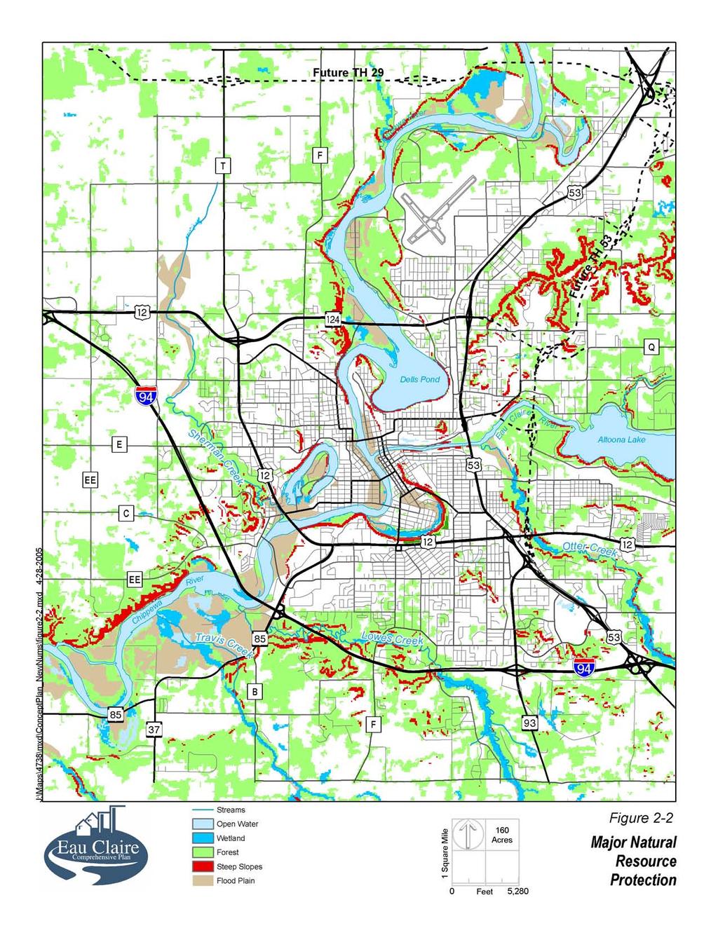
10 Land Use Map Categories Commercial Downtown Light Industrial, Business Park and Offices General Industry, Transportation and Utilities Schools Public Facility Land Uses same site with retail or office. (See Residential Neighborhoods Objective 4 in this Chapter.) Businesses providing retail trade or services for individuals or businesses. Includes hospitals. This land use category allows and promotes high-intensity office, retail, housing, hospitality, conference and public land uses, preferably in mixed-use buildings with strong pedestrian orientations. Office buildings, office-showroom, light industrial buildings and manufacturing-related warehousing in landscaped campus settings with hidden truck docks and no outdoor storage are allowed in this category. This category is intended to be a more attractive alternative to conventional light industrial areas. This category includes industry that involves railroad service, heavy truck traffic, extensive outdoor storage, noise or odors, and the handling of raw materials. It also includes railroad yards, outdoor truck parking, the power substation and the sewage treatment plant. Includes public and private schools and colleges. Locations of future public schools shown on Figure 2-1, Planned Land Use, are only conceptual. All future schools in the City s Extraterritorial Review Area must be in locations that can be served by sewer and water lines from Eau Claire. This category includes public buildings and public facilities other than schools and cemeteries. Potential Zoning Districts C-1A C-1 C-2 C-3 CBD District I-1, Light Industrial District New business park zoning district I-2, Heavy Industrial District P, Public Properties District P, Public Properties District Park Public parks. Locations of future parks shown on Figure 2-1, Planned Land Use, are only conceptual. P, Public Properties District Golf Course Private golf courses. R-1, One-Family District 2. Water Resource Protection: Continue to protect the function and integrity of streams, flood plains and wetlands during the site plan and subdivision review process by applying the City Zoning Ordinance requirements regarding flood plains and shoreland-wetlands. Figure 2-2, Major Natural Resource Protection, illustrates the approximate location of these features. Precise locations of these and other natural features will be Adopted 27 September Comprehensive Plan
11 determined during review of development applications using detailed site surveys and field inspections. 3. Steep Slope and Woodland Protection. Increase and formalize City protection of steep slopes (in excess of 20%) and major wooded areas. The City should prepare and adopt an ordinance regulating changes to steep slopes, as well as a separate ordinance regulating alterations to major wooded areas. Figure 2-2 indicates the general locations of steep slopes and major woodlands. 4. Realign Urban Sewer Service Boundary: Seek to realign and expand the City s existing Urban Sewer Service Boundary as identified in the 2010 Chippewa Falls- Eau Claire Urban Sewer Service Plan to reflect the boundary shown in Figure 2-3, Growth Management Areas. The existing sewer service boundary was established in 1990 and should be adjusted to reflect the incorporation of the Village of Lake Hallie and the deletion of the village from the City s future service area. Realignment of the City s Urban Sewer Service Boundary as shown in Figure 2-3 is necessary to provide sufficient area to meet the City s projected future growth needs and preserve sensitive environmental areas such as flood plains, wetlands, and steep slopes, and provide adequate market flexibility and choice. Objective 3 Perimeter and Regional Growth Achieve compact and cost-effective perimeter growth for the long-term future. A critical planning issue facing Eau Claire is how to ensure that the City s urban extension is compact, cost-efficient, and designed for lasting value. The policies for the objective on perimeter and regional growth provide the framework within which the City will work to achieve perimeter growth that is as compact as possible and proceeds outward in a staged fashion. The policies seek to address perimeter growth both through setting minimum standards for non-sewered development and providing planning incentives for desirable growth patterns. Traditionally, the City has used zoning and subdivision regulations to ensure that there is sufficient land in the exterritorial area, and especially in the Urban Sewer Service Area, to accommodate the continued growth of the City and maintain its economic vitality as the central city in the metropolitan region. This approach focuses on limiting nonsewered development in the Extraterritorial Review Area. However, a second aspect of managing perimeter growth is how to attract appropriate development to the recommended locations for future growth. It is in the City s interests, as well as that of the broader metropolitan area, that future growth in the metropolitan area be orderly and compact, provide better access with less traffic, minimize land consumption, and preserve open space and natural resource areas. A growth management strategy that relies only on preventing the less desirable development will result in development patterns being shaped by the State of Wisconsin s annexation policies. Comprehensive Plan 2-11 Adopted 27 September 2005
12
13 The most striking characteristic of the annexations to the City and the subsequent developments that have occurred over the past 25 years is that as a result of the state annexation law most annexations have involved small parcels of less than 10 acres which have tended to occur in a disjointed pattern at multiple locations in the City s periphery. Designing, coordinating, and building utility extensions to serve piecemeal, small area developments is much more expensive for the City than planning for larger tracts of 50 acres or more. Moreover, the upfront challenges and costs for prospective developers to assemble, annex, plan, rezone, and design larger tracts to meet the standards of quality urban density development increasingly dissuade many from even considering the effort. Consequently, the Comprehensive Plan policies identified below take a more comprehensive approach to perimeter growth by both establishing minimum development standards to prevent inefficient development and initiating growth incentives to attract and direct appropriate development, including commercial, industrial, multi-family, and single-family residential, to the preferred growth locations in the extraterritorial area. The City s growth management initiatives in this regard will seek to combine joint planning, extraterritorial zoning, intergovernmental agreements, and targeted sharing of City revenues derived from the development of annexed properties. Policies: 1. Growth Management Areas: Manage growth in and around Eau Claire using the following growth management areas: Existing Urban Area Urban Sewer Service Area Extraterritorial Review Area Rural Area Figure 2-3, Growth Management Areas, illustrates the approximate location of the four growth management areas as of the effective date of the Comprehensive Plan. The Existing Urban Area represents the actual area contained within the corporate boundaries of the City of Eau Claire. The boundaries of the Urban Sewer Service Area are approved by the Wisconsin Department of Natural Resources and designate the area beyond the Eau Claire corporate limits that the City anticipates eventually could be served by the City s wastewater treatment facility. The Extraterritorial Review Area is the area within three miles of the City s corporate boundaries in which the City exercises subdivision review authority under State law to regulate the creation of new parcels through platting or certified survey map and ensure uses of land compatible with the Comprehensive Plan. The Rural Area includes the unincorporated areas beyond the Extraterritorial Review Area threemile boundary and generally maintained for very low rural residential or agriculture uses, or as provided for in a cooperative boundary plan agreement. The City will prepare and adopt long-range plans for land use, roads and the sequential extension of City sewer and water lines in the Existing Urban Area and the Urban Sewer Service Area. The City will seek the cooperation of the counties and adjacent town and village governments to accomplish mutually beneficial growth management objectives consistent with the Comprehensive Plan. Those objectives include compact and well-designed urban edge growth, the economic Comprehensive Plan 2-13 Adopted 27 September 2005

14 93 J J City of Chippewa Falls 29 Rural Area Future Village of Lake Hallie P Town of Wheaton F Chippewa River 53 OO Extraterritorial Review Area Village of Lake Hallie T T Chippewa County Eau Claire County Future 53 Town of Seymour EE Q 12B Extraterritorial Review Area QS CC Dells Pond E City of Eau Claire Eau Claire River Altoona Lake QQ EE TT Town of Union 53 City of Altoona KK Graphis/Archives/2005Support/4738EauClaire/Eau-Claire_Concept Alts.qxd Rural Area Extraterritorial Review Area City of Eau Claire EE Proposed Urban Sewer Service Area Extraterritorial Review Area C Town of Brunswick City or Town Boundary (as of May 2005) 85 B Chippewa River 37 II F F Town of Washington IA AA Extraterritorial Review Area II I SS Rural Area Figure 2-3 Growth Management Areas
15 extension of City utilities and roads, and the preservation of nearby rural land use and productive farmland from premature development. 2. Existing Urban Area: Seek to maximize infill development in the Existing Urban Area. The City will encourage infill development in Existing Urban Area locations because these locations are already fully serviced by public facilities, are generally within one mile of an existing neighborhood park, and are within the City s developable area as designated in the Comprehensive Plan. 3. Non-sewered Development: (a)require a minimum ten-acre lot size for the creation of new lots in the Urban Sewer Service Area and Extraterritorial Review Area, unless a lesser minimum lot size is allowed through a cooperative boundary plan agreement, or an exception is granted as provided below in this section. The minimum lot size is established in order that compact and cost-effective urban development in the City s perimeter may be achieved through and beyond the twenty-year planning horizon of the Comprehensive Plan. The density standard serves to protect the future capacity of the City to expand its tax base and secure economic growth, and also to help preserve working farms and rural development patterns until the time that the land is converted to urban use. In addition, limiting the extent of non-sewered residential development in the City s Extraterritorial Review Area will assist in protecting the City s future capacity to provide development locations for construction of affordable housing. (b)for any buildable lot of record as of the effective date of the Comprehensive Plan, one house would be allowed provided applicable requirements for sewage treatment, water well, and access were met. (c)(1)to provide greater flexibility in lot design, the City may provide for exceptions to the 10-acre minimum lot size through the City s subdivision review process for developments complying with the subdivision regulations and meeting the following additional criteria: The average density of the overall parcel is at least 10 acres per lot; Each lot meets the health code requirements for on-site sewage treatment and private water wells; The proposed lot layout for the overall parcel locates houses on building sites that have the least impact on environmentally sensitive areas and are less well-suited for farming and agricultural uses; The remainder of the overall parcel not developed with lots and roads require a conservation easement precluding further development until such time as urban sanitary sewer service is available and utilized; and The proposed lot layout for the overall parcel provides for the future efficient re-subdividing for urban densities and the cost-effective and orderly extension of public streets and utilities. For example, a 40-acre parcel meeting the above criteria may be able to create 4 one-acre lots for initial development, leaving 36 acres for subsequent development once sewers could be extended. Comprehensive Plan 2-15 Adopted 27 September 2005
16 (2)In addition, the City may also provide exceptions to the 10-acre requirement through cooperative boundary plan agreements establishing the provision of on-site wastewater treatment facilities for developments meeting the following criteria: The average density of the overall parcel is not greater than 3 acres per lot; Each residential lot is at least 8,000 square feet and no larger than 20,000 square feet in size; Each lot is served by sewer service connected to a COMM 83, Wisconsin Administrative Code, compliant common on-site wastewater treatment facility. All sewer main, trunk and lateral lines meet City of Eau Claire standards for such facilities; Each lot is served by an approved private, non-community or community water supply system. All water lines meet City of Eau Claire standards for such facilities; The remainder of the overall parcel not developed with lots and roads, and areas containing common on-site wastewater treatment facilities, water supply facilities, or stormwater management BMPs require a conservation easement precluding further development until such time as urban sanitary sewer service is available and utilized. The proposed lot layout for the overall parcel locates houses on building sites that have the least impact on environmentally sensitive areas and are less well-suited for farming and agricultural uses; and The proposed lot layout for the overall parcel provides for the future efficient re-subdividing for urban densities and the cost-effective and orderly extension of public streets and utilities. For example, a 40-acre parcel meeting the above criteria may be able to create thirteen 8,000 to 20,000 square foot lots for initial development served by common on-site wastewater treatment and water supply technologies, while leaving the remainder of the parcel in conservation easement for subsequent urban development once sewers could be extended. (3)Exceptions to the 10-acre minimum lot size may also be provided through an intergovernmental agreement (under Section of Wisconsin Statutes) between the City and Town for areas that are already highly divided into semi-rural lots and which would be cost prohibitive for the City to serve with City utilities. An example would be the existing residential area in the Town of Washington, west of Lowes Creek Road and south of Interstate 94. (4)Exception to the 10-acre minimum lot size may also be provided through intergovernmental agreements between the City and county and/or town establishing a transfer of development rights program. A transfer of development rights program would establish a formal process by which development rights could be transferred from one parcel in a sending district to another parcel in one or more receiving districts. Transfer of development rights is essentially a marketbased technique that encourages the voluntary transfer of growth from areas designated as "sending areas" (where a community would like to see less or no development) to areas designated as "receiving areas" (where a community would like to see more development). The sending areas can be environmentally sensitive lands, open space, agricultural areas, wildlife habitats, historic landmarks, or any other places of importance to the community, while the receiving areas are places Adopted 27 September Comprehensive Plan
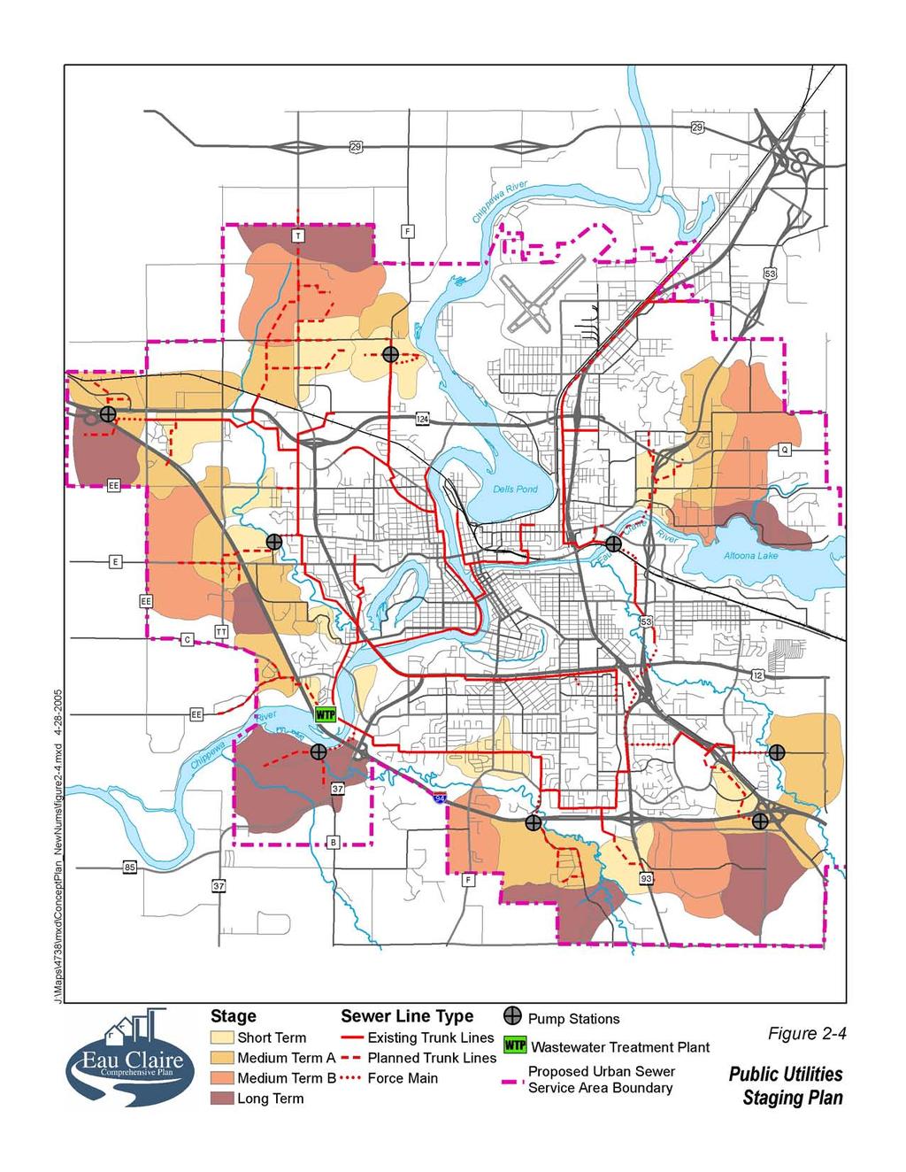
17 appropriate for additional development because they are close to jobs, shopping, schools, transportation, and urban services. (d)to assist in establishing the intergovernmental agreements and exceptions identified above, the City will work with individual towns to draft and execute a memorandum of understanding expressing the intent of both jurisdictions to work towards a more formal intergovernmental agreement and identifying a process and mutual items of concern to be addressed. (See also the Intergovernmental Cooperation Chapter, Policy 12, Intergovernmental Memorandum of Understanding.) 4. Extraterritorial Review Criteria: Include the following criteria as part of the City s requirements for approval of subdivisions or certified survey maps in the Extraterritorial Review Area: The proposal should be consistent with the City s officially mapped roads, utilities, drainage, and parks. The proposed land use should be in conformance with the City s Comprehensive Plan. The proposed residential density should be in conformance with the City s Comprehensive Plan or with intergovernmental agreements for the area. The proposal should be consistent with any land use plan for the area jointly prepared by the City and town. The proposed development of land should allow for the reasonable and cost efficient re-subdividing of the land into urban density sewered lots. The proposed design for roads, utilities and drainage should be consistent with City standards. The spacing of proposed driveways and public street intersections should conform with the City s access management standards. The proposed development should allow for the eventual extension of an interconnected public street system. The proposal should be consistent with the City s standards for the protection of slopes, wooded areas, and water quality. 5. Commercial or Industrial Development: Allow subdivision of lots for new commercial or industrial development in the Urban Sewer Service Area or Extraterritorial Review Area only upon annexation and connection to City sewer and water lines, or through a cooperative boundary plan agreement. The City may grant exceptions to this policy through the subdivision review process for agricultural service businesses and businesses that need large amounts of open, unimproved land. 6. Rural Area: Acknowledge that the towns and counties will regulate land uses in the Rural Area. 7. Orderly Annexations: Approve annexation proposals consistent with the Comprehensive Plan. (See also Objective 11, Municipal Expansion, in this Chapter.) 8. Utilities Staging Plan: Extend sanitary sewer and water lines according to the preferred general order of priority indicated by Figure 2-4, Public Utilities Staging Plan. The four levels of major sewer extensions are: Comprehensive Plan 2-17 Adopted 27 September 2005
18
19 Short Term: Areas that are not presently served but only require minor extensions of trunk sewer or can be easily served by lateral lines. Medium Term A: Areas that are not currently served but are expected to receive development pressure and a need for trunk line service to accommodate development during the next five years. Medium Term B: Areas that are not currently served but are expected to receive development pressure and a need for trunk line service to accommodate development during the next 5 to 10 years. Long Term: Areas that may need trunk sewer service for anticipated urban development but are not anticipated to be served for ten years or more. Amend the Public Utilities Staging Plan prior to the next major update of the Comprehensive Plan if: Development occurs faster than anticipated in a given location; or The land development market indicates a strong preference for change and is willing to compensate the City for additional facility costs incurred in making the change. The City will notify adjacent towns of proposed amendments to the Public Utilities Staging Plan. 9. Implementation: Seek to use one or more of the following techniques and methods as may be most appropriate to achieve the City s perimeter growth objective: Intergovernmental agreements Joint planning for future land use Joint extraterritorial zoning Extraterritorial subdivision review in conjunction with official mapping of roads, utility lines, surface water drainage facilities, and Comprehensive Plan land use recommendations Amendments to the boundary of the Urban Sewer Service Area through the updating of the Chippewa Falls/Eau Claire Urban Sewer Service Plan for 2010 Approval of annexation petitions that represent planned, orderly growth Conformance with the Public Utilities Staging Plan for sewer and water extensions 10. Environmental Protection: Protect or restore sensitive or unique natural resources such as flood plains, steep slopes, major wooded areas, major vistas, streams, wetlands, water quality, shorelines, and riverbanks through regulation and/or City investment. 11. Protection of Prime Farmland: Minimize the loss of prime farmland from premature conversion to nonagricultural uses. The City of Eau Claire will seek to protect those areas identified by appropriate federal or state agencies as prime farmland by promoting compact urban development and discouraging large-lot sprawl outside its borders. Comprehensive Plan 2-19 Adopted 27 September 2005
20 12. Extraterritorial Zoning: Seek to enter into intergovernmental agreements to establish extraterritorial zoning for designated areas in the Urban Sewer Service Area. The City s intent in seeking to establish extraterritorial zoning districts is to provide for the orderly and consistent development of future growth areas that are anticipated to be developed to urban densities and incorporated into the City within the twenty-year planning horizon of the Comprehensive Plan. Extraterritorial zoning districts will be identified through joint planning efforts of the City and the town. Wisconsin Statutes allows the City to exercise zoning regulation within its Extraterritorial Review Area through adoption of an extraterritorial zoning ordinance in accordance with the process and procedures described in the statutes. Under the state statutes, a joint extraterritorial zoning committee of citizen members of the City Plan Commission and town members appointed by town boards would be created to prepare the extraterritorial zoning ordinance and establish the zoning districts and regulations. The joint committee would hold public hearings on the proposed regulations and an opportunity to be heard would be provided to representatives of the town board and any person in the town for which the regulations were proposed. The six-member extraterritorial zoning committee would have to approve the proposed ordinance by a favorable vote of a majority of the six members of the committee before the ordinance could be forwarded to the City Council for consideration of adoption. 13. Encouraging Smart Growth: Foster the implementation of the Comprehensive Plan through voluntary joint planning efforts with the counties and towns for larger undeveloped tracts of land in the Urban Sewer Service Area. The intent would be to prepare sub-area plans for sewer service basins and identify future land use, street networks, general location and sizing of utilities, and areas to preserve from development. The sub-area plans would be consistent with the following Smart Growth principles: Mix land uses; Take advantage of existing community assets; Create a range of housing opportunities and choices; Foster walkable close-knit neighborhoods; Promote distinctive, attractive communities with a strong sense of place, including the rehabilitation and use of historic buildings; Preserve open space, farmland, natural beauty, and critical environmental areas; Strengthen and encourage growth in existing communities; Provide a variety of transportation choices; Make development decisions predictable, fair and cost-effective; Encourage citizen and stakeholder participation in development decisions. The City should seek to complete a joint planning effort as the foundation and basis for consideration of establishing extraterritorial zoning districts and intergovernmental agreements for revenue sharing. 14. Infrastructure Investments: Seek to enter into intergovernmental agreements either through Wisconsin Statutes, Sec or Sec , to provide for the targeted construction of lift stations and trunk lines in the Urban Sewer Service Adopted 27 September Comprehensive Plan
21 Areas as a joint intergovernmental strategic investment to attract and direct development to selected perimeter growth locations jointly identified by the City and adjacent towns. Such agreements should be pursued only after completion of joint planning efforts between the City and towns to prepare a detailed land use plan for a specific growth area. The detailed components of the agreements should be crafted by the jurisdictions involved based on the characteristics and shared development needs for the area. Such intergovernmental agreements for infrastructure investments should include the following provisions: Extraterritorial zoning will be established for the designated area. The upfront municipal cost for any sewer lift stations or truck lines in the designated area will be incurred by the City of Eau Claire. The town will approve and authorize the City to construct any agreed upon lift station and/or trunk lines, along with the necessary easements for such improvements. Town properties cannot be connected to the lift station and trunk line until annexed to the City or until such time as may be specified in an approved cooperative boundary plan agreement for the area. For infrastructure investment areas addressed through intergovernmental agreements established under Sec , and to encourage orderly and timely annexation of parcels suitable for compact urban development, the City will commit to making a revenue sharing payment for a fixed and limited number of years to the town based on a percentage of the property tax revenue derived by the City from the subsequent development of the annexed area. The City will seek to negotiate the amount and terms of revenue sharing based on a reasonable and equitable consideration of the overall terms of the intergovernmental agreement, the type of development taking place, and the construction costs and the relative public service costs incurred by both the City and the town following annexation of the area. For example, in instances where the City and town agree to share in the initial provision of public services or where the City s initial service costs would not be excessive, the City could provide a revenue-sharing payment to the town equal to 80% of the City s share of paid property tax revenue from an annexed parcel in year 1 following the annexation; 60% in year 2; 40% in year 3; and 20% in year 4; and 0% thereafter. The amount of payment, years of payment, and starting date of the revenue sharing payment could be negotiated, but the City s intent would be to provide a revenue sharing payment based on property tax revenue generated as the parcel is developed, not simply as vacant land. Objective 4 Residential Neighborhoods Reinforce or create neighborhoods with a diversity of housing, attractive public spaces, compatible land uses, and a sense of identity. Creating attractive new neighborhoods and maintaining the better qualities of the older neighborhoods are aims that support the objective of sustainable growth. In addition, properly accommodating some townhouses and apartments in each district or neighborhood can help support these housing options avoiding the deleterious effects of inappropriate design. Comprehensive Plan 2-21 Adopted 27 September 2005
22 Policies: 1. Compact Growth: Encourage new neighborhood development that is generally more compact and dense than recent past patterns. Design each new neighborhood to include both detached and attached forms of housing. 2. Variety within Each New Neighborhood: Encourage in each major neighborhood a range of housing types, densities, and building configurations, including singlefamily detached, townhouses, apartments, and more specialized types, such as senior housing or live-work units. (A major neighborhood is defined as approximately one square mile in size or as demarcated by major geographic features, such as a highway or river.) During the review of planned developments, give favorable consideration to applications that include two or more types of housing without overlooking other legitimate concerns. Amend the several districts of the Zoning Ordinance that allow multiple-family housing so as to limit the number of attached units of each type (apartments, row houses, back-to-back townhouses, etc.) in each development project. Suggested limits are: 150 apartments, 100 townhouses, 50 duplexes. It is expected that the development industry will continue to respond with proposals that include more than one type of housing in the larger projects, resulting in neighborhood variety. Locate attached and multi-family housing in transitional spaces between commercial and single-family areas, and at high-amenity locations near streams, parks, parkways and greenways. When combining housing types, it is preferable for the transition between types to occur at the rear rather than the front (i.e., across a courtyard or parking area rather than across the street). To assist in implementing this policy, the City should prepare preliminary neighborhood sub-area plans which identify a general street layout, pedestrian connections, desirable parks and open spaces, utility needs, land uses, and potential zoning categories. 3. Links to Previously Established Neighborhoods: Link new neighborhoods visually and functionally to the established portions of Eau Claire via street connections, bicycle facilities and, where possible, the greenway and parkway systems. 4. Neighborhood Planning: Continue to implement the recommendations of adopted neighborhood plans consistent with the Comprehensive Plan. The City should continue to prepare and update specific plans for residential neighborhoods and commercial districts where a need for additional guidance is identified. The City s neighborhood planning process engages the residents and strives to protect neighborhoods from such factors as: excessive traffic, blighted properties, or land use incompatibilities. The neighborhood plans outline strategies to address those issues and capitalize on opportunities to enhance the neighborhoods. Adopted 27 September Comprehensive Plan
CHAPTER 3 VISION, GOALS, & PLANNING PRINCIPLES. City of Greensburg Comprehensive Plan. Introduction. Vision Statement. Growth Management Goals.
 CHAPTER 3 VISION, GOALS, & PLANNING PRINCIPLES Introduction The Greensburg Comprehensive Plan is intended as a working community document. A combination of long and short-term goals, this document is intended
Planning Districts INTRODUCTION
 INTRODUCTION To facilitate detailed examination of development prospects for all areas of the community, Delano has been divided into 14 planning districts. The location of these planning districts is
CHAPTER 12 IMPLEMENTATION
 CHAPTER 12 IMPLEMENTATION The 2010 Town of Denton Comprehensive Plan is intended to capture a vision of the future of Denton. As such, it provides a basis for a wide variety of public and private actions
Chapter 10 IMPLEMENTATION RECOMMENDATIONS
 Chapter 10 IMPLEMENTATION RECOMMENDATIONS The recommended land use plan presented in the previous chapter provides a design for the attainment of the urban and rural development and open space preservation
The transportation system in a community is an
 7 TRANSPORTATION The transportation system in a community is an important factor contributing to the quality of life of the residents. Without a sound transportation system to bring both goods and patrons
EXECUTIVE SUMMARY DRAFT CHAPTER 1 INTRODUCTION EXECUTIVE SUMMARY
 CHAPTER 1 EXECUTIVE SUMMARY INTRODUCTION Through the joint efforts of the City of Tulsa planning staff and the Land Services division of Indian Nations Council of Governments (INCOG), the Berryhill Land
CHAPTER 7: VISION AND ACTION STATEMENTS. Noble 2025 Vision Statement
 CHAPTER 7: VISION AND ACTION STATEMENTS This chapter presents the vision, policy and action statements that transform the comprehensive planning study, an analysis of Noble s past, future trends and community
4.1.3 LAND USE CATEGORIES
 4.1.3 LAND USE CATEGORIES a. City Center District The City Center District incorporates the existing character and mix of uses in downtown Belmont to encourage redevelopment and new development in keeping
ARTICLE 6: Special and Planned Development Districts
 ARTICLE 6: Special and Planned Development Districts 6-10 Traditional Neighborhood Development (TND) District 6-10.10 Purpose and Intent The Traditional Neighborhood Development (TND) District provides
Dwelling Units Max 12 dwelling units per acre/min 8 dwelling units per acre. Development Mix 80% non residential/20% residential
 13. OSTEEN LOCAL PLAN Background: The Osteen Local Plan area is located in southwest Volusia County along the SR 415 corridor between Lemon Bluff Road and Acorn Lake Road and includes 3,990 acres. The
PORT WHITBY COMMUNITY
 PORT WHITBY COMMUNITY SECONDARY PLAN UPDATE COMMUNITY IMPROVEMENT PLAN URBAN DESIGN GUIDELINES September 2015 DRAFT PROPOSED AMENDMENT NUMBER # to the Whitby Official Plan PURPOSE: The intent of this Amendment
LAND USE ELEMENT. Purpose. General Goals & Policies
 LAND USE ELEMENT Purpose This Land Use Element contains the goals and policies necessary to support the City s responsibility for managing land resources and guiding development through implementing regulations,
Woodburn Comprehensive Plan Growth Management Goals and Policies
 Goal Woodburn Comprehensive Plan Growth Management Goals and Policies G-1. The City's goal is to manage growth in a balanced, orderly and efficient manner, consistent with the City s coordinated population
SECTION II SECTION II STATEMENT OF GOALS, OBJECTIVES, PRINCIPLES, ASSUMPTIONS, POLICIES AND STANDARDS
 STATEMENT OF GOALS, OBJECTIVES, PRINCIPLES, ASSUMPTIONS, POLICIES AND STANDARDS 1 2 STATEMENT OF GOALS, OBJECTIVES, PRINCIPLES, ASSUMPTIONS, POLICIES AND STANDARDS INTRODUCTION The New Jersey Municipal
RECREATION AND OPEN SPACE ELEMENT GOALS, OBJECTIVES, AND POLICIES
 RECREATION AND OPEN SPACE ELEMENT GOALS, OBJECTIVES, AND POLICIES Goal 7 To provide park facilities, recreation programs, and open space resources that are safe, adequate, and accessible to all City residents,
Chapter 2: Vision, Goals and Strategies
 Chapter 2: Vision, Goals and Lake Elmo Today & Tomorrow Comprehensive Plan 2040 2 VISION, GOALS & STRATEGIES - DRAFT 4-6-2018 INTRODUCTION Comprehensive Plan Purpose Perhapse the most important objective
OVERVIEW OF PLANS FOR THE JEFFERSON COUNTY COUNTRYSIDE FARM In the Context of Quality Place Characteristics
 OVERVIEW OF PLANS FOR THE JEFFERSON COUNTY COUNTRYSIDE FARM In the Context of Quality Place Characteristics By Steve Grabow, Professor and Community Development Educator University of Wisconsin-Extension,
CONTENTS 8.0 LAND USE 8.1 GENERAL LAND USE 8.2 RESIDENTIAL 8.3 MIXED USE 8.4 COMMERCIAL 8.5 EMPLOYMENT LANDS
 8-2 Land Use 8.0 LAND USE CONTENTS 8.1 GENERAL LAND USE 8.1.1 Uses provided for in all Land Use Designations 8.1.2 Uses prohibited in Hazardous Lands, Hazardous Sites and Special Policy Areas 8.1.3 Uses
2040 LUP is a part of the Comprehensive Plan and carries the same legal authority. Economic Challenges
 1.1. Guiding Anchorage s Growth Where will new residents settle over the next two decades? Where will people work, shop, and play? Will there be enough room to grow? How will Anchorage look? Will growth
General Location Annex, Rezone & Preliminary Plat Lansdowne Addition, Unit Three
 NEWFOUNDLAND I-5 Agricultural District Subject Site SUNDANCE ANDERSON Single Family Residential CHRISTY PUD Agricultural District Highway Business General Location Annex, Rezone & Preliminary Plat Lansdowne
2.0 AREA PLANS. Lakeside Business District. Lakeside Business District Land Use Categories:
 Lakeside Business District Lakeside Business District Land Use Categories: Campus Commercial Campus Commercial means a mixture of uses which includes corporate offices, office parks, hotels, commercial,
COLVER ROAD INDUSTRIAL CONCEPT PLAN
 COLVER ROAD INDUSTRIAL CONCEPT PLAN A CONCEPTUAL LAND USE AND TRANSPORTATION PLAN FOR TA-4 AN URBAN RESERVE AREA OF THE CITY TALENT City of Talent Adopted by City Council Resolution No., June, 2015 PART
THREE-STEP DESIGN PROCESS FOR OPEN SPACE SUBDIVISIONS
 00216106.DOC NMA/RRK 1/30/14 THREE-STEP DESIGN PROCESS FOR OPEN SPACE SUBDIVISIONS Open space subdivisions, sometimes called cluster developments, maintain a significant portion of a development site in
A Growing Community Rural Settlement Areas
 Town of Huntsville Official Plan Review - POLICY BACKGROUND PAPER A Growing Community Rural Settlement Areas BACKGROUND: In addition to the fully municipally-serviced Urban Settlement Area and the Hidden
CHAPTER 4 FUTURE LAND USE AND URBAN SERVICES DISTRICTS
 CHAPTER 4 FUTURE LAND USE AND URBAN SERVICES DISTRICTS Introduction This chapter discusses how Benzie County should grow and change in the future. A community can grow and change in many different ways.
VILLAGE OF CLEMMONS PLANNING BOARD DRAFT STAFF REPORT
 VILLAGE OF CLEMMONS PLANNING BOARD DRAFT STAFF REPORT PETITION INFORMATION Docket # C-226 Staff Megan Ledbetter Petitioner(s) JBJH Properties, LLC Owner(s) JBJH Properties, LLC Subject Property 5892-49-1766
implementation10 Village of Greendale Comprehensive Plan: Greendale, Wisconsin. Revisiting a Greenbelt Community
 implementation10 Village of Greendale Comprehensive Plan: 2010 - Village of Greendale Comprehensive Plan: 2010 - Implementation The recommendations of this Plan must be implemented by the Village of Greendale,
Municipal Plan*Assessment
 Municipal Plan*Assessment This tool was developed to assist in reviewing municipal master plans and in determining if these plans are consistent with smart growth principles, neighboring municipal plans,
S A C R A M E N T O C O U N T Y JACKSON HIGHWAY & GRANT LINE EAST VISIONING STUDY
 JACKSON HIGHWAY & GRANT LINE EAST S A C R A M E N T O C O U N T Y P L A N N I N G D E P A R T M E N T SUMMARY AND WORKBOOK November 19, 2008 History of the Visioning Study Sacramento County has two growth
Official Plan Review
 Official Plan Review Summary Report - The Built Environment August 2014 Part 1: Introduction Planning for a healthy, prosperous and sustainable community is an important goal for our municipality. From
4 Sustainability and Growth Management
 4 Sustainability and Growth Management Introduction Traditionally, has assumed growth and development with limited consideration for the long-term negative social, environmental or economic impacts on
Section 9 NEIGHBORHOOD DESIGN
 Section 9 NEIGHBORHOOD DESIGN City of Lancaster Comprehensive Plan D u n k i n, S e f k o & A s s o c i a t e s, I n c. NEIGHBORHOOD DESIGN INTRODUCTION There are many ways in which a neighborhood can
Town Center (part of the Comprehensive Plan)
") Town Center (part of the Comprehensive Plan) Mercer Island Town Center Looking North (2014) In 1994, a year-long process culminated in a set of design guidelines and code requirements for the Town Center
Town Center (part of the Comprehensive Plan) Mercer Island Town Center Looking North (2014) In 1994, a year-long process culminated in a set of design guidelines and code requirements for the Town Center
Rural Land Use Designations Kittitas County December 6, 2007 Draft
 KITTITAS COUNTY COMMUNITY DEVELOPMENT SERVICES 411 N. Ruby St., Suite 2, Ellensburg, WA 98926 CDS@CO.KITTITAS.WA.US Office (509) 962-7506 Fax (509) 962-7682 Rural Land Use Designations Kittitas County
Gold Line Bus Rapid Transit Transit Oriented Development (BRTOD) Helmo Station Area Plan
 Helmo Station Area Plan") Appendix F Gold Line Bus Rapid Transit Transit Oriented Development (BRTOD) Helmo Station Area Plan Introduction and Purpose of the Plan The Gold Line Bus Rapid Transit facility is an eleven-mile dedicated
Appendix F Gold Line Bus Rapid Transit Transit Oriented Development (BRTOD) Helmo Station Area Plan Introduction and Purpose of the Plan The Gold Line Bus Rapid Transit facility is an eleven-mile dedicated
Cumberland Region Tomorrow is a private, non-profit, citizen based regional organization working with Greater Nashville Regional Council
 Cumberland Region Tomorrow is a private, non-profit, citizen based regional organization working with Greater Nashville Regional Council and others in the public and private sectors, dedicated to planning
Draft CHAPTER TWO THREE LAND USE PLAN
 CHAPTER TWO THREE LAND USE PLAN LAND USE PLAN The basic intent of the comprehensive planning process is to provide a well-founded and coordinated decision-making framework to guide both public and private
Preliminary Plan Framework: Vision and Goals
 Preliminary Plan Framework: Vision and Goals Draft: May 2015 Introduction Since the Town of Milliken s comprehensive plan was last updated in 2010, the community was heavily impacted by the 2013 flood,
17.11 Establishment of Land Use Districts
 17.11 Establishment of Land Use Districts 17.11.010 Purpose. To promote the health, safety, and general welfare of City residents and those who come to South Salt Lake to work, exchange commerce and recreate.
City of Heath. Town Center Concept
 In the give-and-take of getting projects designed, financed, and approved, the famous refrain from the film Field of Dreams is heard often: if you build it, they will come. From the perspective of the
This page intentionally blank.
 This page intentionally blank. Parks, Recreation, and Open Space Chapter Relationship to Vision Vision Parks, Recreation and Open Space Chapter Concepts County Government. County government that is accountable
PSRC REVIEW REPORT & CERTIFICATION RECOMMENDATION
 PSRC REVIEW REPORT & CERTIFICATION RECOMMENDATION KITSAP COUNTY COUNTYWIDE PLANNING POLICIES July 2, 2012 BACKGROUND A major emphasis of the Washington State Growth Management Act (GMA) is the need to
Joint Meeting City Council and the Plan Commission. September 1st, 2015
 Joint Meeting City Council and the Plan Commission September 1st, 2015 1 The City Plan Commission shall recommend a City Plan for the physical development of the City Article IX Section 2 of the City of
QUEEN-RIVER SECONDARY PLAN
 34 QUEEN-RIVER SECONDARY PLAN 34. QUEEN RIVER SECONDARY PLAN 1. INTRODUCTION The Queen-River area is approximately 6.4 hectares and is located at the eastern edge of the Downtown as shown on Map 34-1.
Planning & Zoning Commission Staff Report
 Planning & Zoning Commission Staff Report Meeting Date: May 26, 2015 Drafted by: Katherine Harrison-Rogers CASE # Z2886 PROJECT NAME: APPLICANT/ REPRESENTATIVE: Shawna Runyan PROPERTY OWNER: 1840 (previously
E. RURAL COMMERCIAL/INDUSTRIAL PARK MODEL
 E. RURAL COMMERCIAL/INDUSTRIAL PARK MODEL 1. PURPOSE The purpose of the Rural Commerce/Industrial Park Model is to provide parameters within which a grouping of business buildings with parking, loading
Appendix A. Planning Processes. Introduction
 1 Planning Processes Introduction This appendix outlines a number of planning processes which are used in the Auckland Region to support the effective management of development in the region s rural and
SUMMERSIDE / MT. CARMEL REINVESTMENT CORRIDOR COMMUNITY DEVELOPMENT STRATEGY
 SUMMERSIDE / MT. CARMEL REINVESTMENT CORRIDOR COMMUNITY DEVELOPMENT STRATEGY FEBRUARY 2013 I. Location of the Summerside/Mt. Carmel Reinvestment Corridor The Summerside/Mt. Carmel Reinvestment Corridor
Major Subdivision Sketch Plan Checklist
 This checklist provides specific requirements that are apart of the Sketch process. The entire process is described by the Huntersville Subdivision Review Process which details all the submittal and resubmittal
This chapter describes the purpose of the Plan, introduces how the Plan is organized and provides contextual background for the Plan.
 Chapter 1: INTRODUCTION Purpose of a Comprehensive Plan The 2040 Comprehensive Plan establishes Medina s vision as a community and sets goals and objectives which guide future decisions and policies. The
Hibbing. Land Use. Hibbing Comprehensive Plan 8.1. Land Use
 Hibbing 8.1 Introduction 8.3 Information and Assessment 8.5-8.14 Recommendations 8.15-8.17 Implementation 8.18-8.19 8.2 Introduction Although land use was not identified as a discrete goal during the community
To ensure that resources will be available to provide a consistent level of public services to the community.
 Future Land Use Plan The land use plan is one of the most prominent chapters in the Stillwater Comprehensive Plan. It provides a visual representation of what the community is expected to look like in
Definitions. Average Daily Traffic Demand (ADT): The actual number or projected number of cars that pass a point in a 24-hour period.
: The actual number or projected number of cars that pass a point in a 24-hour period.") Definitions Access Management: A combination of physical techniques and transportation policies used to control the flow of traffic between roads and the surrounding lands. Alternative City Form Scenarios:
Definitions Access Management: A combination of physical techniques and transportation policies used to control the flow of traffic between roads and the surrounding lands. Alternative City Form Scenarios:
Ridgefield and the Growth Management Act
 1 2 Ridgefield and the Growth Management Act 3 Why Do We Plan History of Planning in Ridgefield Washington experiences rapid growth in the late 1980 s that began to change the perceived quality of life.
LAND USE OVERVIEW WHAT YOU WILL FIND IN THIS CHAPTER
 LAND USE WHAT YOU WILL FIND IN THIS CHAPTER Information about the City s expected population and employment growth. Description and capacity of existing and future land use designations. Policies that
USA Addition of South & East Side Residential Parcels. USA Deletion of a Town of Christiana Parcel. Conversion from USA to Limited Service Area
 Village of Rockdale Village of Rockdale 148 Water Street Cambridge, WI 53523 Phone 608.423.1497 Fax 608.423.9694 Urban Service Area (USA) Amendment USA Addition of South & East Side Residential Parcels
Implementation Guide Comprehensive Plan City of Allen
 Implementation Guide 2030 Comprehensive Plan City of Allen DRAFT 2015 Implementation Guide Allen 2030 Comprehensive Plan INTRODUCTION The Comprehensive Plan serves as a guide for the growth and development
CITY OF COLWICH COMPREHENSIVE PLAN LAND USE LAND USE 1
 LAND USE LAND USE 1 WHAT YOU WILL FIND IN THIS CHAPTER: Discussion of today s conditions and tomorrow s projections Discussion of challenges and opportunities Discussion of the environmental quality goals,
ARLINGTON COUNTY, VIRGINIA
 ARLINGTON COUNTY, VIRGINIA County Board Agenda Item Meeting October 15, 2005 DATE: September 28, 2005 SUBJECT: Request to Advertise the adoption of the 2005 Clarendon Sector Plan C. M. RECOMMENDATION:
NEW CASTLE COUNTY S ZONING DISTRICTS
 NEW CASTLE COUNTY S ZONING DISTRICTS This is general information about New Castle County s zoning districts. The information included is by no means exhaustive or complete. Before designing plans to develop
Section 4 BUILDING THE MASTER PLAN
 The Master Plan 33 Section 4 BUILDING THE MASTER PLAN Figure 4:1. A collaborative effort characterized the two design workshops sponsored by DISC to create hypothetical Master Plans for the Towers Property
IMPLEMENTATION STRATEGIES. In This Chapter. Goals & Strategies 182 Project List 183 Future Land Use 186 CHAPTER 11 IMPLEMENTATION STRATEGIES
 In This Chapter Goals & Strategies 182 Project List 183 Future Land Use 186 11 IMPLEMENTATION STRATEGIES NORTH AUGUSTA, SC 2017 COMPREHENSIVE PLAN 179 Individual commitment to a group effort that is what
INTRODUCTION. b. The extent to which such problems and objectives have been reduced or have increased subsequent to such date.
 INTRODUCTION INTRODUCTION The Municipal Land Use Law directs a Planning Board to prepare a Periodic Reexamination Report every six years that identifies and describes the following: a. The major problems
3. VISION AND GOALS. Vision Statement. Goals, Objectives and Policies
 Vision Statement Queen Creek s interconnected network of parks, trails, open spaces and recreation opportunities provide safe and diverse activities and programs that sustain its unique, small town, equestrian
EXHIBIT A. Tax Increment Reinvestment Zone No. 1 (Town Center) First Amended Project Plan 1
 First Amended Project Plan 1") EXHIBIT A Tax Increment Reinvestment Zone No. 1 (Town Center) First Amended Project Plan 1 1 As amended by Resolution No. 2008-02-001(TR1R) of the Tax Increment Reinvestment Zone No.1, and approved to
EXHIBIT A Tax Increment Reinvestment Zone No. 1 (Town Center) First Amended Project Plan 1 1 As amended by Resolution No. 2008-02-001(TR1R) of the Tax Increment Reinvestment Zone No.1, and approved to
COMMISSION ACTION FORM
 ITEM #: 6 DATE: 09-06-17 COMMISSION ACTION FORM REQUEST: Introduction and Initial Review of Proposed Amendments to the Ames Urban Fringe Future Land Map for the North Growth Gap Area BACKGROUND INFORMATION:
Selected Area Study. Vision Plan Draft
 East Polk County Selected Area Study Draft 10.30.08 Contents Guiding Principles...4 Context Conclusions...5 Current Context...8 Scenarios...9 Scenario: Status Quo...10 Scenario: Connected & Directed Growth...12
AWH REPORT OF THE PLANNING AND DEVELOPMENT DEPARTMENT FOR APPLICATION FOR REZONING ORDINANCE TO PLANNED UNIT DEVELOPMENT
 AWH REPORT OF THE PLANNING AND DEVELOPMENT DEPARTMENT FOR APPLICATION FOR REZONING ORDINANCE TO PLANNED UNIT DEVELOPMENT MAY 8, 2014 The Planning and Development Department hereby forwards to the Planning
Chapter 13: Implementation Plan
 Implementation A. Introduction The Implementation Plan, in table form on the following pages, provides a summary of all the Action Items recommended in Chapters 2 through 12. The table also indicates which
Draft Stillwater 2030 Comprehensive Plan- Goals and Policies
 Draft Stillwater 2030 Comprehensive Plan- Goals and Policies Instructions- Review each goal and policy and discuss with group any changes, deletions for additions to the list using your groups pen. Keep
6 PORT SYDNEY SETTLEMENT AREA
 Section 6 Port Sydney Page 61 6 PORT SYDNEY SETTLEMENT AREA 6.1 Basis and Principles Village of Port Sydney Waterfront Community Existing Services 6.1.1 Port Sydney is an historic settlement that has developed
Comprehensive Plan. Faribault, Minnesota. Hoisington Koegler Group Inc. Claybaugh Preservation Architecture Inc. Howard R. Green Company Bonz/REA
 Comprehensive Plan Faribault, Minnesota Adopted by the Faribault City Council July 8, 2003 prepared for: prepared by: Hoisington Koegler Group Inc. Claybaugh Preservation Architecture Inc. Howard R. Green
Baumgarten MPUD. Exhibit 3 Evaluation Criteria
 Pursuant to LDC subsections 10.02.13 B, 10.02.08 F and Chapter 3 G. of the Administrative Code, staff s analysis and recommendation to the Planning Commission, and the Planning Commission s recommendation
Bourne Downtown Site Planning
 Prepared for: The Town of Bourne, MA In Cooperation with: Bourne Financial Development Corporation Prepared by:, Inc. June 24, 2009 Table of Contents Introduction and Summary... 1 Site Existing Conditions...
CHAPTER 7: Transportation, Mobility and Circulation
 AGLE AREA COMMUNITY Plan CHAPTER 7 CHAPTER 7: Transportation, Mobility and Circulation Transportation, Mobility and Circulation The purpose of the Transportation, Mobility and Circulation Chapter is to
Hockessin Community Redevelopment Plan
 Hockessin Community Redevelopment Plan 3.1 Introduction The Community Redevelopment Plan for the Village of Hockessin is the result of the people s vision for a distinct village center that serves as the
Urban Planning and Land Use
 Urban Planning and Land Use 701 North 7 th Street, Room 423 Phone: (913) 573-5750 Kansas City, Kansas 66101 Fax: (913) 573-5796 Email: planninginfo@wycokck.org www.wycokck.org/planning To: From: City Planning
SECTION UNIFIED DEVELOPMENT ORDINANCE SECTION Part 1 Ordinance. ARTICLE 1 Zoning Districts
 SECTION 1-100 UNIFIED DEVELOPMENT ORDINANCE SECTION 1-300 Part 1 Ordinance SECTION 1-100. Introduction. ARTICLE 1 Zoning Districts Crystal Lake strives to maintain a balance of various land uses for a
Town of Portola Valley General Plan. Nathhorst Triangle Area Plan
 Town of Portola Valley General Plan Amended December 10, 1997 Table of Contents Introduction... 1 Planning Area... 1 Objectives... 2 Principles... 2 Standards... 4 Description... 4 Community Commercial...
Improve Neighborhood Design and Reduce Non Point Source Water Pollution
 HOW TO Planning Guide Improve Neighborhood Design and Reduce Non Point Source Water Pollution This document was funded by a grant from the New Hampshire Coastal Program with funding from the National Oceanic
DRAFT MAP AMENDMENT FLU 04-4
 DRAFT MAP AMENDMENT FLU 04-4 SW 24 TH AVENUE ROADWAY CORRIDOR The University of Florida participates with the Metropolitan Transportation Planning Organization (MTPO) in its responsibilities for the continuing,
Warren County/Bowling Green Focus 2030 Comprehensive Plan VOLUME 1 INDEX
 Appendix 5: Index VOLUME 1 INDEX A Aesthetics ES-6, FLU-15, FLU-17, FLU-24, NCR-7 Agricultural Base FLU-18, FLU-20 Agricultural Centers, Rural FLU-11 Agricultural District NCR-17-NCR-18 Agricultural Economy
Concord Community Reuse Project Goals and Guiding Principles. Overarching Goals (OG)
") Concord Community Reuse Project Goals and Guiding Principles Overarching Goals (OG) No priority is implied by the order of presentation of the goals and guiding principles. Overarching goals for the Concord
Concord Community Reuse Project Goals and Guiding Principles Overarching Goals (OG) No priority is implied by the order of presentation of the goals and guiding principles. Overarching goals for the Concord
7Page 1 CLEMMONS COMMUNITY COMPASS 1 PLAN OVERVIEW
 1 Plan Overview WHAT IS I THE CLEMMONS COMMUNITY COMPASS? The Clemmons Community Compass is our community s comprehensive plan. It serves as our blueprint and provides direction for the future of the Village
A BLUEPRINT FOR BROCKTON A CITY-WIDE COMPREHENSIVE PLAN
 A BLUEPRINT FOR BROCKTON A CITY-WIDE COMPREHENSIVE PLAN Public Meeting October 2016 1 Plan Summary and Discussion Public Meeting May 4 2017 City of Brockton Bill Carpenter, Mayor Department of Planning
The following rules shall be used to determine the precise location of any zone boundary shown on the Official Zoning Map of Auburn:
 ARTICLE III. ESTABLISHMENT OF ZONING DISTRICTS Section 300. Establishment of Zoning Districts. The City of Auburn, Alabama is hereby divided into zoning districts of such number and character as are necessary
3.10 LAND USE SETTING PROJECT SITE EXISTING LAND USE DESIGNATIONS AND ZONING. General Plan Land Use Designations.
 This section of the Draft EIR addresses the existing land uses on and adjacent to the project site and discusses the potential impacts of the proposed project on existing land uses. Key issues addressed
TRANSPORTATION AND LAND USE
 CHAPTER 10 TRANSPORTATION AND LAND USE Transportation and land use are intimately linked. The expansion of a highway typically spurs housing, employment growth and land development in the communities that
DISCUSSION ON VACAVILLE S2 INVESTORS PROPERTY IN URBAN RESERVE
 Agenda Item No. 9C April 25, 2017 TO: FROM: SUBJECT: Honorable Mayor and City Council Attention: Jeremy Craig, Interim City Manager Barton Brierley, AICP, Community Development Director (Staff Contact:
DEVELOPMENT FRAMEWORK POST 2030 LAND USE PLAN INTRODUCTION
 INTRODUCTION Oak Grove s Comprehensive Plan identifies a future Metropolitan Urban Service Area (MUSA). The Metropolitan Council does not anticipate extending utilities to this area prior to 2030. The
This page has been intentionally left blank.
 This page has been intentionally left blank. Chapter 3 3-2 3. Employment 3.A Niagara Economic Gateway 3.A.1 General The Niagara Economic Gateway comprises: a) The Gateway Economic Zone which includes all
Living in Albemarle County s Urban Places
 Living in Albemarle County s Urban Places ALBEMARLE COUNTY, VIRGINIA A Closer Look at Albemarle s Approach to Managing Growth and Creating Quality Urban Environments www.albemarle.org Page 2 Living in
CITY OF PUYALLUP. Background. Development Services
 CITY OF PUYALLUP Development Services 333 South Meridian Puyallup WA 98371 To: City Council From: Katie Baker, AICP, Planning Division Re: South Hill Neighborhood Plan Adoption Date: (Meeting date: February
WATERFORD Plan of Preservation, Conservation and Development Supplement Part 1 - Policy Element
 WATERFORD 2012 Plan of Preservation, Conservation and Development 2015 Supplement Part 1 - Policy Element Effective June 11, 2015 2015 Plan Update GOAL To respond to the evolving land use needs and continually
Arlington, Virginia is a worldclass
 EXECUTIVE S U M M A RY Arlington maintains a rich variety of stable neighborhoods, quality schools and enlightened land use policies, and received the Environmental Protection Agency s highest award for
IMPLEMENTING SOMERSET COUNTY S INVESTMENT FRAMEWORK
 IMPLEMENTING SOMERSET COUNTY S INVESTMENT FRAMEWORK SMART CONSERVATION THROUGH SMART GROWTH NJ LAND CONSERVATION RALLY March 22, 2014 Laurette Kratina, PP, AICP, Supervising Planner Somerset County Planning
RESIDENTIAL DISTRICTS
 RESIDENTIAL DISTRICTS The residential district standards have been revised to reflect on-the-ground conditions, while continuing to respect the use patterns established within the neighborhoods. This will
Best Practices Appendix: Waterfront Communities
 Redevelopment Ready Communities Best Practices Appendix: Waterfront Communities revised September 2014 Waterfront RRC defined The purpose of these additional criteria is to provide waterfront communities
North Fair Oaks Community Plan Summary and Information
 North Fair Oaks Community Plan Summary and Information WHAT IS THE NORTH FAIR OAKS COMMUNITY PLAN? The North Fair Oaks Community Plan is part of the San Mateo County General Plan, and establishes policies
DISCUSSION TOPIC: ST JOHNS RIVER & ITS TRIBUTARIES (BPII) 2030 COMPREHENSIVE PLAN POLICES AND REGULATORY FRAMEWORK
 2030 COMPREHENSIVE PLAN POLICES AND REGULATORY FRAMEWORK") DISCUSSION TOPIC: ST JOHNS RIVER & ITS TRIBUTARIES (BPII) 2030 COMPREHENSIVE PLAN POLICES AND REGULATORY FRAMEWORK St. John s River & Its Tributaries Issue Summary: The St. Johns River is an important
DISCUSSION TOPIC: ST JOHNS RIVER & ITS TRIBUTARIES (BPII) 2030 COMPREHENSIVE PLAN POLICES AND REGULATORY FRAMEWORK St. John s River & Its Tributaries Issue Summary: The St. Johns River is an important